47
ANNEX E ENVIRONMENT
| Date post: | 29-Jun-2018 |
| Category: |
Documents |
| Upload: | dangnguyet |
| View: | 214 times |
| Download: | 0 times |

ANNEX E ENVIRONMENT

- i -
ANNEX E ENVIRONMENT
Table of Contents
Page
E.1. Environmental Issues ................................................................................................. E - 1
1.1 General........................................................................................................... E - 1
1.2 Land Use Control in Coast Region.................................................................. E - 3
1.3 Afforestation Programme ................................................................................ E - 9
1.4 Other Environmental Issues............................................................................. E - 11
E.2. Preliminary Environmental Assessment (IEE) and Protective Measures ....................... E - 16
2.1 Objectives ...................................................................................................... E - 16
2.2 Preliminary Environment Impact Assessment (IEE) .......................................... E - 16
2.3 Protective Measures for the Conservation of Environment................................ E - 21
List of Tables
Table E.1.1 List of Antiquities in Coast Region.............................................................. ET - 1
Table E.2.1 Report Requirements for Preliminary Assessment ....................................... ET - 2
Table E.2.2 Check List for Screening............................................................................ ET - 3
Table E.2.3 Check List for Scoping.............................................................................. ET - 6
Table E.2.4 Overall Evaluation...................................................................................... ET - 9
Table E.2.5 Definition of Environmental Impact Categories............................................ ET - 11
Table E.2.6 Recommended Chemicals for Vegetables................................................... ET - 16
Table E.2.7 Health Facilities in Coast Region................................................................ ET - 17
Table E.2.8 Ration of Population over No. of Health Centres and Dispensaries.............. ET - 17
Table E.2.9 Ten (10) Motives for Admission to Hospital............................................... ET - 18
Table E.2.10 Main Motives Leading to Death................................................................. ET - 18
Table E.1.11 Ten (10) Main Motives for Death............................................................... ET - 18
Table E.1.12 Main Motives for Consultation................................................................ ET - 19
Table E.1.13 Ten (10) Motives for Consultation.............................................................. ET - 19
Table E.1.14 Transmitted Diseases................................................................................. ET - 19

E - 1
ANNEX E ENVIROEMENT
E.1 ENVIRONMENTAL ISSUES
1.1 General
The Government of Tanzania has well understood that development and
environmental conservation should not be perceived as separate or conflicting
challenges. To address the pressing issues of natural resource use and environmental
management, the Government has undertaken a policy and strategy formulation
process including an action plan that provides the context for a first step long-term
national approach to environmental sustainability. The overall goal of the policy is to
achieve sustainable development as to maximize the long-term welfare of both
present and future generations of the country. The following objectives follow from
this goal:
(a) to ensure sustainable and equitable use of resources without degrading the
environment or risking health and safety.
(b) to prevent and control degradation of land water, vegetation and air.
(c) to conserve and enhance natural and man-made heritage, including the
biological diversities.
(d) to improve the condition and productivity of degraded areas including rural
and urban settlements so that anyone can live in safe, healthful, productive
and aesthetically pleasant surroundings.
(e) to raise people awareness and understanding of the essential links between
environment and development and to promote individual and community
participation in environmental action.
(f) to promote international cooperation on the environmental agenda, and
expand the country participation to relevant bilateral, sub regional, regional,
and global organizations and programs, including implementation of
conventions.
The action plan to implement the environmental policy includes specific activities
ministries and concerned agencies need to take, to play their part. Ministries with
central roles are Natural Resources and Tourism, Agriculture, Water, Energy and
Minerals; Lands Health; Education; and Science and Technology. The Planning
Commission, Prime Ministries’ office, the universities, research institutions and
NGOs also have important tasks in this effort. However, the Directorate of
Environment under the Vice-President Office has the key-coordinating role,

E - 2
providing guidance for all environmental actions through environmental planning
and formulation of programs, and publishing annual progress report on the
implementation progress. The National Environment Management Council (NEMC),
in its advisory role to Government will be responsible for developing the enabling
context for the implementation of the plan, particularly in monitoring environmental
problems and developing the information system relevant both for problem
definition and for policy and strategy refinement overtime. NEMC will also keep
under review the progress of implementation at the district level, maintain a dialogue
with that level, and submit to Government proposals on strategy and policy
measures to support smooth implementation.
1) Legislative Aspects and International Cooperation
Although, there is an environmental policy and an action plan to implement that
policy, there is not yet a bill or concrete legislation package setting up the
institutional and legal frameworks necessary to fully back up the implementation of
the policy. Such legislation is being worked out and is due to come out sometimes in
the year 2000. However, the NEMC has prepared an EIA procedure and guidelines,
which involves stakeholders, district authorities and Government officials, and
advise developers to follow this EIA procedure.
With regard to the existing legislation related to environmental management,
numerous laws and decrees relate to the conservation and management of natural
resources. Among these, different acts and codes include land tenure system, forest
conservation, hunting, air, waste and water, mining, fishery, etc.
At the international level, Tanzania has signed several global, regional and
multilateral Conventions among which the followings can be cited: Protection of
World Cultural Heritage, Ramsar on wetlands, Biological diversity, Climatic change,
UN Convention on sea rights, Lusaka Agreement on Co-operative enforcement
operations directed at illegal trade in wild fauna and flora, African Convention on
the conservation of nature and natural resources, Convention for the protection,
management and development of the marine and coastal environment of the Eastern
African Region, Basel Convention on toxic wastes and their disposal, International
Convention on desertification, Vienna Convention on the protection of the Ozone
layer, Montreal Agreement on substances affecting the Ozone layer, Bonn
Convention on the conservation of migratory species of the wild fauna, Convention
on International Trade in Endangered Species of Wild Fauna and Flora (CITES) and
many more.

E - 3
Within the framework of international cooperation, much analysis has been done on
environmental issues for Tanzania, most notably on issues of desertification and
land degradation. Many actors are involved in assisting the Government address a
broad agenda of environmental challenges, namely, UNEP, UNCED, UNDP, the
World Bank, WWF and IUCN.
1.2 Land Use Control in Coast Region
Various types of land use exist in Coast Region, which includes agriculture, forestry,
grazing land requirements and human settlements. The region has a total area of 32,
407 km2.
1) Cultivated Land
The region has 319,000 ha of land suitable for annual crops. There are some 118,000
smallholder farms in the region, with 112, 000 ha planted with annual crops. The
large farms have a total area of 105,333 ha. Small farmers hold the land they
cultivate from mainly customary land tenure systems, which include inheritance,
allocation by the village heads, and investment in clearing.
2) National Parks
Coast Region has no terrestrial National Park. The nearest National Park is Mikumi
found in Morogoro Region, absent 123 km from Morogoro Town, on the highway
towards Iringa. The Park harbours diverse flora and fauna including heards of
Elephants, Buffaloes, Wildbeasts, Impalas, Hartebeasts, Lions, Leopards, etc. Bird
life is also enormous.
3) Nature Reserves
Two types of reserve exist in Tanzania: Game Reserves and Forest Reserves. In both
cases Director of Forestry and Beekeeping (DFOB) in case of Forest Reserve and
Director of Game/Wildlife (DW) in case of Game Reserves strictly control residence
and utilization within these areas.
4) Game Reserves
Coast Region has a single Game Reserve within its boundary: Saadani Game
Reserve located in Bagomoyo. Its area is 300 km2. It is an excellent site for beach
activities due to the Indian Ocean bordering it in the Eastern side. The Reserve is
important for its variety of herbivores including: Elephants, Buffaloes, Elands,
Hartebeests, Wildebeests, Bushbucks, Reedbucks, Warthogs and Bushpigs. Primates
including Monkeys, Baboons, Bushbabys, etc. are also present. Different species of

E - 4
birds including Hammer Kops, Helmeted Guinea Fowls, Francolins, Spurfowls,
Quails, Lesser bustards Plovers, Sandgrouses, Pigeons, Doves, Wood-doves,
Cuckoos, Rollers, Ground-hornbills, Owls, Night-jars, Wood Peckers, Honey-guides
swiffs and other species under the order of Passeriformese can be seen.
Wami River originating from Morogoro Region borders the Reserve on the South
Eastern side and harbours varieties of not only fresh water fishes but also one of
largest Mammals, the Hippotames, largest water reptiles, the Nile Crocodile and
water birds.
Apart from Saadani Game Reserve, Coast Region covers a part of Selous Game
Reserve. The latter is found within five (5) Regions (Namely Coast, Morogoro,
Lindi, Mtwara and Ruvuma) with nine (9) districts (Namely Kisarawe, Morogoro,
Rufiji, Kuosa, Mahenge, Kilwa, Nachingwea,Tunduru and Tongea).
The Reserve covers an area of 50,000 km2 and is one of the largest Reserves in the
World. It harbors diverse fauna and flora. Some large animals include Elephants,
Elands, Buffaloes, Hippos, Wildebeests, Hartebeests, Impalas, Warthogs, Bushpigs,
Porcupines Aardvarks, Bushbucks, Reedbucks, Waterbucks, Hares, Velvet Monkeys,
Bushbabys, Baboons, Crocodiles (Crocodilus Niloticus), lions, Hyaenas, Leopards,
Wild cats, Great and Lesser Kudus, Sable Antelopes, Pulru, Black Rhinoceros,
Giraffes, Steinboks, Dikdiks, etc. Birds and snakes of different species are also
present.
The Reserve is famous for Tourist hunting whereby tourists are allowed to take their
trophies after paying foreign money during hunting trips.
However, the Northern part of the Reserve is exclusively used for visual and
photographic tourism. Hence, luxurious camps have been developed by investors to
cater for tourists’ services
The Selous Game Reserve was declared a ‘World Heritage Site’ by the United
Nations in 1982
5) Forest Reserves
The forests are those classified as coastal forests. Most of these forests have been
completely cleared like the Mkuranga sacred forest grove, and turned into farmlands,
some of which have later been abandoned to develop into coastal bush land.

E - 5
The important forest reserves in the region include Vikindu, Kazimzumbwi, Pugu, in
Kisarawe; Kisiju in Mkuranga; Kiwengoma, Mchungu and Kikale in Rufiji. These
forests are important in having some endemic or medicinal plants species. The
Zaraninge/Kiono Forest Reserve in Bagamoyo district served also as a Game
Reserve.
Coast Region has 35 Forest Reserves covering a total area of more than 2,880 km2
(288, 000 ha) divided in districts as follows: 1) Bagamoyo – Six (6) F/Reserves
covering a total of 34,973 ha; 2) Kibaha – One (1) F/Reserve with a total of 31, 930
ha; 3) Kisarawe – Six (6) F/Reserves with a total of 49,001 ha; 4) Mafia – One (1)
F/Reserve (Mangroves) with a total of 4,047 ha; 5) M’Kuranga – One (1) F/Reserve
with a total of 1,599 ha; 6) Rufiji – Twenty (20) F/Reserves with a total of 166,634
ha.
The Reserves were set aside primarily for safeguarding of catchment areas,
biodiversities and prevention of erosion on vulnerable areas.
7) Other Land Uses
Other types of land use exist, like grazing-land requirements derived from various
types of livestock present in the region, and land for settlement
8) Historical Remains and Archeological Sites, Important Scenery/Landscape for
Tourist or Religion
The antiquities resources of Tanzania encompass archaeological sites, historic towns,
monuments and artefacts or relics. In the Coast Region however, there are no
antiquities sites listed as a World Heritage, but towns with historical quarters exist in
all the districts of the region (see Table E.1.1). These towns are mainly located in the
coastline, which has experienced in the past several human settlements that left
behind an important amount of monuments and relics from the prehistoric era or
even from a more recent era.
The Region has consequently spectacular areas for tourists particularly along the
coast.
Bagomoyo District Headquarters found along the coast of Indian Ocean is the town
with interesting phenomena: 1) it is an archaeological site where human history and
development can be learned from Arab-Slavery era, German and British rules.
Bagamoyo was a centre of 19th Century notorious Slave trade, the last destination in
Africa where most captives saw before being sold and shipped to Arabian and
E - 6
Persian Gulf. Kaole Ruins located 2 – 3 km from Bagamoyo town tells a lot about
Arabs; 2) it has an ancient architectural Monument which depicts human ability to
design; 3) it has got a number of comparable beaches which has attracted investors
in developing tourist hotels.
Apart from Bagamoyo town, Saadani Game Reserve found within the same district
offers a combination of animals and beach area where a lot of tourist undertakings
can be carried out. Saadani is also an international breeding site for marine turtles.
Another area of tourist importance is Mafia Island, which covers one of the finest
complexes of estuarine mangrove, coral reef and marine channel ecosystem in the
World. The Island provided home to some of the highest diversity of marine species
including coral reefs, fish, mangroves, sea grass, algae and growth form of sponges.
The island provides feeding grounds for wading birds including some of the most
important nesting areas for Open-billed stork and Fish Eagles. In addition, the island
harbours one of the largest colonies and probably the newest subspecies of the fruit
Bat, Pteropus Comorensis, in the coastal areas of the West Indian Ocean.
Furthermore, the island’s Coral reefs offer some of the best snorkelling and scuba
diving in the region.
Despite these resources, tourism has not been fully developed. The island is
accessible either by means of water or air. Its communication facilities are extremely
poor. The air’s trip is poorly developed, therefore seasonal. In addition only few can
afford it. Water transport is cheaper and therefore affordable by mass. Its safety is
questionable due to outmoded vessels being used. Consequently both water and air
navigations are unreliable making tourism least important undertaking.
Despite the shortcomings, tourists frequent the island and are served by best
facilities offered by Mafia Island Lodge and several tourist camps like Kirasi,
Dolphin and others.
Of recent development, Mafia Island Marine Park has been developed. Unlike other
National Parks in Tanzania, which are terrestrial and used exclusively for visual,
photography, camping, site seeing and scientific research, the Park also offers
utilization of the resources within the Park on sustainable basis. The good point is
that it involves local communities and other stakeholders within the area in decision-
making and sharing benefits derived from the Park.

E - 7
Another area of tourist importance is Selous Game Reserve (already mentioned
above). The mass of land offers tourist activities of all forms, - sport hunting, site
seeing, photographic hunting, boating, etc.
Rufiji Delta found on the month of Rufiji River where it enters the ocean offers
excellent spectacular site. It is a site of largest tidal (Mangrove) forest on the eastern
Coast of Africa. These mangroves support an extensive inter-tidal fishery, provide
nursery grounds for a nationally important prawn industry, and produce large
quantities of mangrove poles for export. Over 150,000 people inhabit the Delta and
floodplain, the majority of whom subsist on fishing, cultivation and extraction of
forest, woodland and wetland products.
9) Locations of Environmentally Vulnerable Areas
a) Mangrove Forests
These are found along the Coast on four of the total six districts of the Region: 1)
Rufiji District – The forest covers 40,460 ha; 2) Mafia District – The forest covers
4,047 ha: 3) M’Kuranga District – The forest covers 3,448 ha; 4) Bagamoyo District
– The forest covers 1,499 ha.
Note that according to Forest Ordinance Cap 389 of 1959, Mangroves are Forest
Reserves and cannot be used without the consent of Director of Forestry and
Beekeeping (DFOB).
b) Coral Reefs
Bagamoyo and Mafia Island have considerable marine water areas with coral and
coral reefs. This is justified by incidences of dynamiting in the area. The details can
be obtained from fishery department.
c) Wetlands
Three important rivers are found within the region. The rivers are:
- Wami River whose water flows across many parts of Bagamoyo.
- Ruvu River flows across Kibaha and Bagamoyo districts.
- Rufiji River flows across Rufiji district.
They form wetlands, which are used mainly for paddy and fishery. These rivers have
good population of Nile crocodiles and Hippos (Hippopotamus Amphibius)

E - 8
10) Endangered and Valuable Animals and Plant Species
① Black Rhinoceros: Rarely seen but found in Selous Game Reserve and is one of
the endangered species
② Wild dogs: These have been spotted in recently developed ‘’WAMI-MBIKI
Community based Conservation Area found in both Bagamoyo and Morogoro
Districts. Pack of about 30 animals has been encountered and listed as an
endangered species
③ African Elephant: Also an endangered species. Herds of them are found in
Kibaha, Rufiji, Bagamoyo and Kisarawe Districts
④ Nile Crocodile: Found in rivers of Wami, Rufiji and Ruvu. The population is
considerably high. The reptile is listed under vulnerable species
⑤ Pangolins: Listed under endangered species. Found all over the Region
⑥ Plant Species: Little information is available on plant species, but the
information contained in CFR Program – Status reports for 11 Coastal Forests in
Coast Region may be of paramount importance in understanding biodiversity
endemism of flora and fauna in those areas. The followings give a brief detail
concerning some of the forests.
The Vikindu Forest Reserve is important in having some endemic plant species
such as Warbargia elongata and the rare Tristema schliebenii. Some important
medicinal plants include Parinari curatellifolia, Secamone parvifolia, Uapaca
kirkii, Voacanga spp., Cissampelos pareira and Clerodendrum spp. The forest
covers an area of 4,486 ha, which has been extensively logged and re-planted
with exotic trees such as Eucalyptus and Cassia siamea. The local people
remove some of the indigenous trees and shrubs remaining along the rivers and
water for timber, poles and charcoal. It is estimated that 86,000 sacks of charcoal
find their way to the markets in Dar es Salaam and villages surrounding Vikindu
every month.
The Pugu Forest Reserve is important in having up to 15 plant species endemic
or nearly endemic to the reserve. Four rare plant species are only found there and
Kenya’s coastal forests. The Pugu Forest Reserve covers an area of 2,410 ha,
which consist of 185.56 ha of Open Forest, 1575.47 ha of Closed Forest, 201.34
ha of Grassland and 398.63 ha of Plantation The remaining canopy is dominated
by Manilkara sulkata, Diospyros sp. nov, Diospyros verrucosa, Lecaniodiscus sp
nov.
The Kisiju Forest Reserve is important in having over ninety different species
of plants, with no endemic taxa, but probably with two rare species i.e. Xylopia
spp and Oxyanthus spp. The forest covers an area of 200 ha.
The Kiwengoma Forest Reserve canopy is dominated by Khaya senegalensis,
Scorodophloeus fischeri and Milicia excelsa. Some endemic taxa include

E - 9
Tessmannia densiflora, Baikiae ghesquiereana and the African violet Saintpaulia
ionatha. The vegetation of the forest is secondary having been cleared and
cultivated over the past 100 years. The forest area covers 10 to 25 km2 on the
Matumbi massif.
1.3 Afforestation Programme
Deforestation is a big problem in Coast Region as it is in the country as a whole. But
the problem is compounded here as compared to other regions because this region
surrounds Dar es Salaam, the biggest commercial city in the country having the
highest number of immigrants from other regions. The majority of Dar es Salaam
population depends on wood fuel for their cooking, putting much pressure on the
forests in the nearby Coast Region. Charcoal making is a major source of income in
the region. This charcoal finds its way to Dar es Salaam where there is good market
for it.
To remedy the problem, the Government had established the Ruvu National
Afforestation Project between 1965 and 1984 for softwood and hardwood. This
project saw a total of 576 ha planted, with softwood trees covering 433 ha while
hardwood covered the remaining 143 ha. This project covered 0.7% of the total area
planted under the National Afforestation Project (79,249 ha). This project was
started to cater for timber poles and wood-fuel as the natural forests were being
exploited for construction timber and other uses.
A Village Afforestation Programme was designed and launched in 1967/70 with the
aim of planting and growing as many trees as possible by individuals, institutions,
industries and village communities through people participation. The program also
meant to improve wood productivity in the rural areas in order to alleviate the fuel-
wood and environment degradation problems.
Agro-forestry, a system of inter-cropping trees with other crops, is another important
component of the program.
The following tables estimate the trees planted under the programme.

E - 10
Areas and Classification of Managed Forests by 1990Area in HectaresRegion
Productive ProtectiveTotal (ha)
Coast (Pawni) 242,417,9 43,880.0 286,297.9
Source: Forest Division Data Bank, Gazzetment index.
Areas of Local Authority Managed Forestry by 1990Region Productive Forest (ha) Protective Forest (ha)
Coast (Pwani) 87,988.0 –
Source: Forest and Bee-keeping Division Index
National Afforestation Project (in ha)Area planted
Region Project Year of planting Softwood Hardwood Total
Coast (Pwani) Ruvu 1965 – 1984 433 143 576
Village Forestry Tree Planting from 1975 – 1990 (ha) – Coast RegionPlanted Proposed Planted
1975 1976 1977 1978 1979 1980 1981 1982 1983 1984 1985 1986 1987 1988 1989 1990– – – 148 233 70 56 303 151 97 116 139 No
recordNorecord
– 62
NB: Planting space at 2.5m X 2.5m = 1,600 trees/ha
Source: Forest Division Annual Reports
1) Other Current Responses
The WWF is currently involved in a community-based afforestation project around
various forests in the country. The project deals with the conservation of the remaining
patches of lowland forest in Coast Region. The project focuses on (1) protection and
(2) development of sustainable alternatives to the current over-exploitation of forest
resources. The different districts concerned are: Rufiji, M’Kuranga around Vikindu
F/Reserve, Bagamoyo around Zaraninge Forest and Mafia around Mlola Forest.
Legislative responses create legal limits on exploitation of the forestry resource by
requiring licenses to harvest and/or sell any plant materials, from both public and

E - 11
private lands. Limits depend on the intended use of the materials.
While some planting of woodlots has taken place these still only about 150,000 ha
some of which are of exotic species for wood products. This total represents a rough
estimate of the annual losses of woodland. The revised Tanzania Forestry Action Plan
(1993) has begun to address some of the issues involved, but much remains to be
done.
1.4 Other Environmental Issues
1) Environmental Impact Assessment in Tanzania
According to the ‘’ Environment Impact Assessment Procedure’’ issued by the
National Environmental Council (NEMC), all projects proposal or concept should be
registered with the NEMC through special application form known as
‘’Environmental Assessment Registration Forms’’. The forms are available at
NEMC offices, Environmental Units of sectoral ministries and municipal council
offices, districts, and at Tanzania Investment Centre (TIC).
After registration, the NEMC will classify the project into one of the following four
decisions:
l Full EIA required
l Preliminary Assessment Required (same as IEE)
l EIA not required
l Project Proposal Rejected (Stop)
Within a period of 30 days after submission of EIA registration form NEMC submits
a screening report to the proponent (be it government or private developer).
Screening is the classification of the proposal to determine the level at which the
environmental assessment will be carried out.
The following figure shows the procedure of EIA in Tanzania
E - 12
Preliminary EIA Required
No EIA
Required
SR
Draft EIS
Revised EIS
PER
EIA Required
Public Hearing Required
Public Hearing Report PER, SR EIS
EIS / PER Not Approved
EIS / PER Approved
ER
EAR
DR
EIS Revision
PER for full EIA
REGISTRATION
REVIEW
PRELIMINARY ASSESSMENT
IMPACT ASSESSMENT Scoping TOR
EIA Study
SCREENING
PERMITTING DECISION
EIS FINALIZED
EP ISSUED
IMPLEMENTATION
MONITORING
AUDITING
DECOMMISSIONING
PUBLIC HEARING
EP DECLINED
EIS Revision
NEMC Action
Proponent Action
Public Action
NEMC Decision
SR Screening Report
PER Preliminary Environmental Report
TOR Terms of Reference
EIS Environmental Impact Statement
EP Environmental Permit
ER Environmental Report
EAR Environmental Auditing Report
DR Decommissioning Report
EIA Procedure in Tanzania

E - 13
Yes
No
Yes No
a) Screening Guidelines
Screening is the process of classifying a proposal to determine the level at which
environmental assessment will be carried out. It is the first stage conducted by
NEMC in the impact assessment process after registration of a project proposal.
The screening procedure (Figure below) can lead to one of the following decisions:
l Environment Impact Assessment (EIA) is required when the project is
known to have significant adverse environmental impacts.
l Preliminary environmental assessment (IEE) is required where the project
may have environmental impacts.
l Environmental Impact Assessment is not necessary where the project is
unlikely to cause significant environmental impacts.
l No further consideration at all for projects contravening government
policies or other legal obligations.
All Projects
Projects on Mandatory
List
Projects not onMandatory list
Is project located inESA ? Uncertainty as to
need for EIA
PreliminaryAssessment or IEE
Does the Project Pass
Submit Project toReview
Proponent UndertakeEIA
Screening procedure
EIA is Required

E - 14
EIA is mandatory for projects that are known from previous experience to have the
potential of causing significant impacts on the environment. For agricultural projects,
the following criteria require an EIA:
l Cultivating natural and semi-natural not less than 50 ha
l Water management projects for agriculture (drainage, irrigation)
l Large scale mono-culture (cash and food crops)
l Pest control projects (i.e. tsetse, army worm, quelea quelea, locusts, rodents,
weeds), etc.
l Fertilizer and nutrient management
l Agricultural programs necessitating the resettlement of communities
l Introduction of new breeds of crops
EIA is not mandatory for all other developments/undertaking that are either less
likely to have serious adverse consequences or are not located within or near
Environmentally Sensitive/critical Areas (ESAs) (ESAs are listed in the table below).
Horticulture is listed as one project for which EIA may not be mandatory. For such
projects NEMC will conduct a screening process to determine whether EIA is
required or the project is to be exempted from an assessment. Where there is
uncertainty, a preliminary assessment, equivalent to IEE, will be done to assist in the
decision making process.
The investigation is undertaken by the proponent to obtain enough information to
determine whether or not there will be significant impacts. Preliminary assessment
may be based on existing information and may require extra information to be
gathered from the field.
A systematic identification, description and assessment of environmental and socio –
economical impacts of the project is made. Preliminary assessment should proceed
along the following steps:
l Description of the project characteristics
l Boundaries of the affected area
l Identification of impacts on local environment and socio-economic impacts
l Evaluation of the significance of impacts
l Consideration of possibilities of modification of the project design
(mitigation measures) or the need for a full EIA.
E - 15
ENVIRONMENTALLY SENSITIVE AREAS (ESAs) AND ECOSYSTEMS
1. Areas prone to natural disasters (geological hazards, floods, rain – storms, earthquakes,landslides, volcanic activity, etc.).
2. Wetlands:(Flood plains, swamps, lakes, rivers etc). Water bodies characterized by one or anycombination of the following conditions.
(a) Tapped for domestic purposes; brick making;(b) Within the controlled and/or protected areas;(c) Which support wildlife and fisheries activities;(d) Used for irrigated agriculture, livestock grazing
3. Mangrove swamps characterized by one or any combination of the following conditions:
(a) With primary pristine and dense growth;(b) Adjoining mouth of major river systems;(c) Near or adjacent to traditional fishing grounds;(d) Which act as natural buffers against shore erosion strong winds and storm floods
4. Areas susceptible to erosion e.g.(a) Hilly areas with critical slopes(b) Unprotected or bare lands
5. Areas of importance to threatened cultural groups.6. Areas with rare/endangered/or threatened plants and animals.7. Areas of unique socio – cultural, history, archaeological, or scientific importance and areas
with potential tourist value.8. Polluted area9. Area subject to desertification and bush fires.10. Coastal areas and Marine ecosystems: -
u Coral reefu Islandsu Lagoons and estuariesu Continental shelvesu Beach fronts etc.u Inter – tidal zones
11. Areas declared as: -National park, Watershed reserves, forest reserves, wildlife reserves and sanctuaries, sacredareas wildlife corridors, hot – spring areas.
12. Mountainous areas water catchment areas and recharge areas of aquifer.(Flood plains, swamps, lakes, rivers etc). Water bodies characterized by one or any combinationof the following conditions.13. Areas classified as prime agricultural lands or rangelands.14. Green belts or public open spaces in urban areas.15. Burial sites and graves
The above is to be reviewed periodically.

E - 16
E.2 PRELIMINARY ENVIRONMENTAL ASSESSMENT (IEE)
AND PROTECTIVE MEASURES
2.1 Objectives
The objective of preliminary assessment is to show whether the development will
have significant impact or not. The report must therefore show whether it is
necessary to conduct a full impact Assessment or if the identified impacts can be
mitigated to the extent that their impacts are reduced to insignificant levels.
A national analysis has identified six major environmental problems for Tanzania,
which are: a) land degradation; b) lack of accessible, good quality water for both
urban and rural inhabitant; c) environmental pollution; d) loss of wild life habitats
and biodiversity; e) deterioration of aquatic systems; and (f) deforestation. Therefore,
EIA may be mandatory for a great number of projects that are likely to induce
harmful effects on the environment. According to the NEMC’s EIA criteria, a small
scale horticulture development project is counted as a project for which EIA may not
be mandatory, but a preliminary assessment equivalent to IEE will be done to assist
in the decision making process either exempting the project from an assessment or
determine whether EIA is required.
2.2 Preliminary Environmental Impact Assessment (IEE)
In view of the facts related above, a preliminary assessment has been carried out
based on the field works and the evaluation of the collected data and information.
The assessment was prepared following the ‘’Report Requirements for Preliminary
Assessment’’ defined by NEMC (Table E.2.1) and using the JICA screening and
scoping procedures and the category of environmental impacts as a reference (Table
E.2.2 – 2.5). The results have to be submitted to the appraisal of the NEMC before
project implementation.
This project, which is to promote horticulture including some tree crops
development on a small scale in the whole Coast Region, will mainly put emphasis
on the improvement of the existing conditions (existing horticultural lands) through
land consolidation, whereas farmland readjustment plots or lots may involve
eventually small land clearing (few acres), and through strengthening of farmers
groups to help alleviate/and or eradicate poverty. Horticultural lands are located
either along rivers where vegetable growing takes place after the harvest of wet
season rice, or in depression areas down valleys close to a water source such a pond

E - 17
or open small surface well, or on hills where fruit crops are mixed with food crops
such as cassava, maize, etc. The improvements foreseen in this project are not
expected to induce major harmful impacts on the environment as the implementation
sites are already under exploitation and the expected scale of development is very
small. Consequently EIA would not be required; instead some protective measures
regarding these impacts are proposed. The following summarizes the main issues of
interest regarding these impacts. The table at the end of the chapter re evaluates
some issues that are of importance for this project.
1) Impacts on the Natural and Socio-economic Environment
a) Impacts on the Soil
A controlled and improved watering system as will be planned in this project would
not cause a brutal and irreversible modification of the soils. However, more regular
and more intensive watering can locally create, namely on salty soils, drainage and
salinization problems. While on well-drained soils more intensive cropping systems
can deplete them of their nutrients. This fertility loss, when not compensated by a
supply of nutrients, can in the long run create an unfavourable evolution of soil
structure due namely to the low organic matter content.
b) Impacts on the Water Sources
In agriculture farmers use all kind of inputs to optimise the production conditions.
Fungicides and pesticides are very important in protecting plants against diseases
and insect pests. Manure and fertilizers are even more important in providing to the
plants complementary nutrient sources. The application of these inputs is not
without inconveniences and will induce some impacts on the environment. Though
chemical fertilizer, fungicide and pesticide are utilized in very small amounts as
most vegetable growing farmers cannot afford them, their application might increase
with this project as farmers will be more organized and will be provided with more
means to enable them to purchase these inputs. Presently farmers use manure as
organic fertilizer and cut cost on fungicide and pesticide by producing vegetable on
the dry season to minimize diseases and pests. For tree crops such as cashew nut, on
the other hand, fungicide such as sulfur powder is used intensively to boost yields.
Furthermore, several agro-chemicals are recommended for vegetables treatment in
Tanzania (see Table E.2.6). Several others are supplied through various bilateral
cooperations and include organophosphorus and organochlorine compounds and
carbamate for the fight against locusts and birds. Some of these products such as
blue copper and sulphur powder are quite toxic and can be greatly harmful when
used unwisely. The potential effects of these inputs on the environment is described

E - 18
below:
(1) Effects of pesticides
Given the function of these products (kill virus, bacteria and insects) it is evident
that a non-controlled distribution will have an important impact on the environment.
As these products can dissolve easily in water, they can contaminate it at high
concentration and imperil the fauna in contact with the water, namely fishes and
birds living of the fishes and drinking the water. As regard to human and animal
health, dermal contact, inhalation and ingestion have to be considered.
These effects are related to the mode of dispersion, which can be:
i) dispersion by water
This mode is important because these products are soluble. The distribution can take
place through runoff or infiltration in the soil. Distribution in the soil is related to
permeability, length of the treatment and the amount of water.
ii) dispersion by the crops
The amount of chemical products absorbed by the plants at the roots system may
add to the products absorbed externally. The danger for human lies mainly when
consuming the fruits and vegetables.
iii) dispersion by wind
At the time of pesticide application the loss of products is as much as important as
the wind speed is high and the radius of dispersion outside the treated plants is big.
The result is not only a useless waste of the product but an immediate danger to
sensitive beings (useful insects, animals, children, etc.) in the immediate vicinity of
the treated plots.
iv) dispersion by manipulation and direct contact
The application on the field is accompanied by several manipulations of the product,
which is transferred from its initial packaging to the spraying equipment. As a result
there is a direct pollution of external parts (hands, face, feet, etc.) of the body of the
workers and the material and equipment.
(2) Effects of fertilizers
Contrary to the toxic effects of pesticides and fungicides, fertilizers are not
specifically dangerous for the environment. Their impact is indirect in such that they
benefit not only to cultivated crops but also to other plants, weeds, algae and fishes
feeding on these algae. At high concentrations in water, fertilizers can cause the
proliferation of algae along with an important consumption of oxygen affecting the
degree of clearness and transparency of water through eutrophication. This situation
would affect the development of specific fauna and would particularly kill fishes,
and namely birds that have to see their pray in order to feed.

E - 19
c) Impacts on Vegetation
Construction works, in case small clearing and tilling are carried out can impact on
the vegetal cover and biodiversity through the exploitation of pastureland and
natural forests bordering the project sites. Afforestation and tree species
diversification around vegetable gardens should be encouraged and generalized as
one conservation measure.
d) Impacts on Health
A 1998 epidemiological study carried out by the Regional Medical Office (Please
refer to Tables E.2.7 – A2.14) in Kibaha shows an increase of malaria, which led the
list in all districts in the 10 motives for consultation, admission to hospital and death.
Diarrhoeic related illnesses, though in the increase compared to 1996 and 1997,
accounted only for 7% of the motives for consultation, behind anaemia, respiratory
related illnesses including pneumonia, and 5% of the motives for death behind TB,
anaemia, and respiratory related illnesses. Intestinal bilharzia is low in the list and
accounted for only 3% of the motives for consultation among the 10 major diseases.
Respiratory related illnesses are expected to rise in the future following the increase
of agrochemicals, namely pesticide and fungicides. Malaria remains alarming due to
its exponential increase. Cholera occurs annually in the area and could be endemic
if appropriate hygienic measures are not taken regarding drinking water, toilet, etc.
e) Socio-economic Impacts
On an economical viewpoint, there will be certain positive direct impacts such as:
¨ The increase in the net income of the growers
¨ The improvement of the nutritional condition of the populations due to the
increase availability of vegetable and cash to get other food crops.
¨ The increase availability of fresh vegetables due to the intensive gardening
of women groups
The negative economic effects come from:
¨ The risk for the growers to contract debts when there is a decrease in
production due to technical or organisational problems or due to a
consecutive lack of water related to a prolonged and generalized drought.
¨ The risk to contract debts following a decrease in price due to market
fluctuations
The socio-economic positive effects will reside in the setting of a dynamic
organisational structure constituted by the farmers or growers groups. This will
induce a sense of solidarity among members of a group.

E - 20
The negative effects come from:
¨ The necessity to require the support of external institutions or suppliers
for the promotion of horticultural crops creating a relationship of
dependence between farmers and suppliers who are more informed of
market mechanisms.
¨ The individualization of the debt and problems related to its payment
creating the risk that persons without link with the grower may acquire
rights to his/her detriment.
Overall, there will be positive and negative effects. Among these effects some will
be durable and some can be reversible. The measures to take will consist in
consolidating positive durable effects and correcting negative ones. The corrective
measures for environmental conservation will then be to put emphasis on the
components affected by the development. The Table of the Matrix of Impact on
Environment below summarizes the corrective measures, which are discussed later.
E - 21
MATRIX OF IMPACT ON ENVIRONMENT
Meaningof Impacts
Importance of Impacts
Significant
Period and Impacts
Posit.
Neg.
Corrective Measures
Nonsignif. Less Moder High
JICACategoryof Envir.ImpactsRef.#
A. Construction PeriodChanges in Vegetation ◯ Afforestation ◯ 22Erosion due to clearing ◯ Flat areas and wind break ◯ 30
B. Operational PeriodHUMAN ASPECTS 3, 12Integration in credit system ◯ ◯ Judicious choice of credit
system◯
Development of farmers senseof solidarity
◯ Reinforcement of farmersgroups
3
Improvement of food self-sufficiency and income
◯ ◯ 3
Risk of debts contracting byfarmers
◯ Crop intensification andpromotion of groups indynamic economic role
◯ 3, 12
Relationship of dependence offarmers
◯ Promotion of group in dynamiceconomic role
◯ 3, 12
Health problems related topesticides and fungicides andwater
◯ Monitored used ofrecommended products andImprovement of health system
◯ 14, 16,17
EFFECTS ON WATER1/ Pesticides 14, 17, 43a) Surface water quality,including closed water bodies
◯ Monitoring water qualityAnd use of recommendedproducts
◯
b) Groundwater quality ◯ Sampling and observation ofground water
◯
2) Fertilizers 14, 17, 43a) Surface water quality,including closed water bodies
◯ Monitoring water qualityAnd extension of applicationtechniques
◯
b) Groundwater quality ◯ Monitoring water qualityAnd extension of applicationtechniques
◯
EFFECTS ON SOIL1/ Pesticides ◯ Use of recommended products ◯ 14, 17,32,
332) Fertilizers ◯ 14, 17, 32,
33,3) Salinization and Alcanization ◯ Carry out observations and
sampling analysis◯ 31
EFFECTS ON AIR1/ Pesticides ◯ Monitoring application and use
of recommended products◯ 47
2.3 Protective Measures for the Conservation of Environment
In accordance with the community participation approach developed through this
study, measures for the protection of environment can be effectively disseminated
using a model development approach where, at the local level, conservation
techniques are taught to farmers through trials and demonstration in a station or
pilot farm similar to the one proposed in a different paragraph in the text. Farmers
should have the responsibility for the operation and maintenance of the proposed
farm. To establish and provide the integrated conservation measures for the farmers,
the pilot farm should be operated with the cooperation of other sectors involved at
E - 22
the district and regional levels, especially those dealing with environment, forest
and health. At the national level, environmental measures should be integrated parts
of the policy of environmental protection defined by the Government that is in
charge of conception, planning, monitoring and control of the environmental policy.
The measures of environmental conservation/protection referred to in the above are
already summarized in the table depicting the matrix of impact on environment and
relate mainly to both the natural and socio-economic environments, which include
potential land degradation through erosion and vegetation loss, impacts related to
the increase use of agrochemical and a series of other issues that will be dealt with
through the monitoring and mitigation measures proposed below.
1) Natural effects
a) Improvement of Vegetation and the Ligneous Cover
A village afforestation program similar to the one launched in 1967/70 with the aim
of planting and growing as many trees as possible by individuals, institutions,
industries and village communities through people participation should be
developed in the framework of this project implementation and promoted in the
demonstration or trials planned in the study. The program should also mean to
improve wood productivity around all villages included in the project in order to
alleviate the fuel-wood and environment degradation problems.
Agro-forestry should also be another important component of the program.
The installation of windbreak should be encouraged especially around vegetable
gardens to limit soil erosion.
All these activities can only be carried out through the full involvement and
participation of the communities on the one hand, and through the production of
plants in village nurseries on the other. Consequently, some nursery specialists
should be trained.
b) Improvement of Water Quality and Soils
(1) Water Quality
Corrective measures related to the use of agrochemicals are based on the negative
impacts occurring from the projected increase use of these products.
A/ Pesticides
Products of higher toxicity such as some organochlorine compounds and those with
lesser toxicity as some organophosphorus compounds, which would exceed the
norms prescribed by OMS or which are not properly registered under the Tropical

E - 23
Pesticide Research Institute (TPRI) should be traced with the collaboration of the
institute and systematically banned by the organization managing the project.
Farmers should first get an authorization for the use of their pesticides. They should
give the date, name and the dose. The application must be strictly controlled.
Some measures of caution include:
- use of protective equipment
- minimization of the losses by undertaking the application when there is no wind
and in the absence of rain if possible (no risk of runoff)
- minimization of dispersion by washing the body and cleaning the spraying
material at the site in an isolated pan.
B/ Fertilizers
On poor soils, the effects caused by fertilizers would be positive and result in an
increase of nutrients content of the soils. However, it is proposed to include in the
plan some type of training on fertilizer application methods to avoid over dosage
and potential discharge in water through runoff.
① River water
The type and quantity of pesticides used by farmers should be monitored. Pesticides
constitute a health risk for anybody working in the area of application as long as the
products can be disseminated by water. The monitoring of pesticides application
should be a common interest, and it is proposed that farmers groups, with the help
of the organization managing the project, create a monitoring unit through which
each farmer has to declare the quantities and types of pesticides he/she has utilized
and consult each time it is deemed necessary to exceed the dose habitually
prescribed.
The population living in the area must be informed of the kind of risks they incur
with pesticides and particularly with the domestic use of water from ponds or rivers
in order to mitigate these risks.
Data on concentration observed as a result of analysis carried out in the area must be
made available to the farmers groups and used to inform the public.
Fertilizer application should be monitored the same way as pesticides even though
their toxicity is minor. Their negative effects include water eutrophication and
proliferation of aquatic plants. Farmers should be trained in the correct use of
fertilizers, namely through good land preparation. The farmers groups should take
charge of this training and sensitise individual members in the correct management
of fertilizer use; this would consequently result in a substantial saving for them.

E - 24
② Underground water
Taking into consideration the small risks to contaminate underground water, the
measures proposed above concerning river water would be largely enough to
mitigate any risk of contaminating underground water.
(2) Soil
Salinisation/alcalinisation: it is proposed to flush the paddy field plots where
vegetables are grown after rice at the end of the dry season. This is particular true
for vertisols where the salt concentrations are relatively high. Flushing may be
efficient, even though vegetables are presently cultivated without it every year after
paddy.
Loss of soil fertility:
- adequate application of fertilizer and manure
- organization or improvement of the credit system for the acquisition of
fertilizers
- introduction of manure collecting pits for better conservation of nitrogen and
organic matter
c) Socio-economic Effects
The planned horticulture development ultimately aims at improving the
communities’ living standards. These communities will participate only when they
foresee their well being into it. Therefore, the measures to take along that line
consist in:
i. helping them to better manage their production spaces through the provision
of the necessary responsibilities for that.
ii. making accessible to them the new production techniques and production
means.
iii. ensuring them the conditions for the diversification of their production in
order to reach food as well as income security.
This supposes that farmers have to be very well trained and be able to adequately
manage the means of production by themselves. On an economic standpoint,
options to reduce operation costs or economize on the use of given inputs have to be
necessarily examined. It means reducing the quantity of inputs used without
reducing production, which can be done when the calendar and modality of
application of these inputs are respected by the book. This reduction has 2
advantages:
¨ a positive impact on the natural environment;
¨ a positive impact on the socio-economic environment.

E - 25
d) Measures Related to Health
(1) Disease Prevention and Fight against Vectors
Disease prevention and fight against vectors can be carried out through spraying and
pulverization. The organochlorine compounds that have been the main fighting tools
against malaria are cheaper but present some toxicity risk relatively high, making
their use as domestic insecticides no more applicable. Some organophosphorus
compounds such as Fenthion, Fenitrothion can be used as insecticides by
pulverization in anti- malaria campaign. They are less toxic for human and fishes.
There are several other organophosphorus compounds presenting very low toxicity
with a high LD50 value (quantity of product necessary to kill 50% of a population
under study) that can be used in the fight against malaria. Some other measures
include:
- use of molluscicide plants: numerous plants present some molluscicide
characteristics; their use can be considered.
- use of predators such as larva eating fishes
- drainage of permanent and semi permanent reservoirs
- deflection of vectors by setting housings away from shelters for domestic
animals; mosquitoes will be taking their daily blood feeding with the animals
(animal shelters established between villages and larva sites)
(2) Extension and Sensitization at Village Level
These are necessary namely concerning the mechanical prophylactic measures to
take regarding the fight against vectors, the dangers of bathing in infected water of
ponds or the preparation of re-hydration salts in case of diarrhea.
(3) Logistics for Health Centers and Dispensaries
Logistics need to be reinforced to allow the centres to adequately carry out the
allocated tasks and prevent the spread of diseases. In addition, an adequate supply
for medicine that can be easily out of stock should be ensured: quinine, injection
materials, serum, anti-parasites, antibiotics, etc.

List of Tables
Table E.1.1 List of Antiquities in Coast Region.............................................................. ET - 1
Table E.2.1 Report Requirements for Preliminary Assessment ....................................... ET - 2
Table E.2.2 Check List for Screening............................................................................ ET - 3
Table E.2.3 Check List for Scoping.............................................................................. ET - 6
Table E.2.4 Overall Evaluation...................................................................................... ET - 9
Table E.2.5 Definition of Environmental Impact Categories............................................ ET - 11
Table E.2.6 Recommended Chemicals for Vegetables................................................... ET - 16
Table E.2.7 Health Facilities in Coast Region................................................................ ET - 17
Table E.2.8 Ration of Population over No. of Health Centres and Dispensaries.............. ET - 17
Table E.2.9 Ten (10) Motives for Admission to Hospital............................................... ET - 18
Table E.2.10 Main Motives Leading to Death................................................................. ET - 18
Table E.1.11 Ten (10) Main Motives for Death............................................................... ET - 18
Table E.1.12 Main Motives for Consultation................................................................ ET - 19
Table E.1.13 Ten (10) Motives for Consultation.............................................................. ET - 19
Table E.1.14 Transmitted Diseases................................................................................. ET - 19
* * *
ET - 1
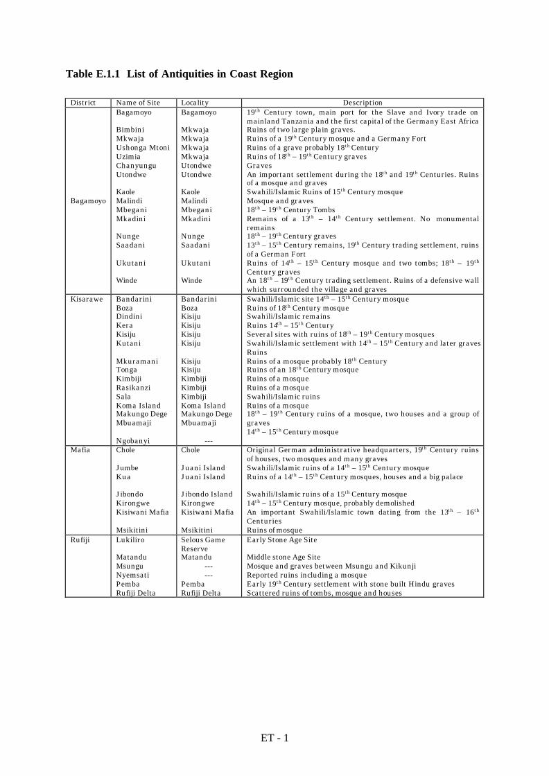
Table E.1.1 List of Antiquities in Coast Region
District Name of Site Locality Description
Bagamoyo
Bagamoyo
BimbiniMkwajaUshonga MtoniUzimiaChanyunguUtondwe
KaoleMalindiMbeganiMkadini
NungeSaadani
Ukutani
Winde
Bagamoyo
MkwajaMkwajaMkwajaMkwajaUtondweUtondwe
KaoleMalindiMbeganiMkadini
NungeSaadani
Ukutani
Winde
19th Century town, main port for the Slave and Ivory trade onmainland Tanzania and the first capital of the Germany East AfricaRuins of two large plain graves.Ruins of a 19th Century mosque and a Germany FortRuins of a grave probably 18th CenturyRuins of 18th – 19th Century gravesGravesAn important settlement during the 18th and 19th Centuries. Ruinsof a mosque and gravesSwahili/Islamic Ruins of 15th Century mosqueMosque and graves18th – 19th Century TombsRemains of a 13th – 14th Century settlement. No monumentalremains18th – 19th Century graves13th – 15th Century remains, 19th Century trading settlement, ruinsof a German FortRuins of 14th – 15th Century mosque and two tombs; 18th – 19th
Century gravesAn 18th – 19th Century trading settlement. Ruins of a defensive wallwhich surrounded the village and graves
Kisarawe BandariniBozaDindiniKeraKisijuKutani
MkuramaniTongaKimbijiRasikanziSalaKoma IslandMakungo DegeMbuamaji
Ngobanyi
BandariniBozaKisijuKisijuKisijuKisiju
KisijuKisijuKimbijiKimbijiKimbijiKoma IslandMakungo DegeMbuamaji
---
Swahili/Islamic site 14th – 15th Century mosqueRuins of 18th Century mosqueSwahili/Islamic remainsRuins 14th – 15th CenturySeveral sites with ruins of 18th – 19th Century mosquesSwahili/Islamic settlement with 14th – 15th Century and later gravesRuinsRuins of a mosque probably 18th CenturyRuins of an 18th Century mosqueRuins of a mosqueRuins of a mosqueSwahili/Islamic ruinsRuins of a mosque18th – 19th Century ruins of a mosque, two houses and a group ofgraves14th – 15th Century mosque
Mafia Chole
JumbeKua
JibondoKirongweKisiwani Mafia
Msikitini
Chole
Juani IslandJuani Island
Jibondo IslandKirongweKisiwani Mafia
Msikitini
Original German administrative headquarters, 19th Century ruinsof houses, two mosques and many gravesSwahili/Islamic ruins of a 14th – 15th Century mosqueRuins of a 14th – 15th Century mosques, houses and a big palace
Swahili/Islamic ruins of a 15th Century mosque14th – 15th Century mosque, probably demolishedAn important Swahili/Islamic town dating from the 13th – 16th
CenturiesRuins of mosque
Rufiji Lukiliro
MatanduMsunguNyemsatiPembaRufiji Delta
Selous GameReserveMatandu
------
PembaRufiji Delta
Early Stone Age Site
Middle stone Age SiteMosque and graves between Msungu and KikunjiReported ruins including a mosqueEarly 19th Century settlement with stone built Hindu gravesScattered ruins of tombs, mosque and houses

ET - 2
Table E.2.1 Report Requirements for Preliminary Assessment
The objective of preliminary assessment is to show whether the development will have
significant impact or not.
The report must therefore show whether it is necessary to conduct a full impact Assessment or
if the identified impacts can be mitigated to the extent that their impacts are reduced to
insignificant levels.
In the preliminary assessment report, it is important to provide summary statements of ‘no
impact’ based on the identified ‘environmental characteristics’.
Where the preliminary assessment indicates that the development will have no impacts on the
environment, it is essential for the consultant and the proponent to indicate their own
commitment to such statements, in such a way, they take responsibility for the finding of no
significant impacts.
If the preliminary assessment reveals obvious impacts, then these may be usefully presented
in a table to assist reviewers and other decision-makers. Where, it is found necessary to
provide additional (specialist) information to justify further the presence or absence of
impacts, this can be done in an attachment(s).
The elements necessary for inclusion in initial Assessment report would therefore be:
l Name or title of proposal
l Proponent
l Location
l Main findings
l Conclusion, backed with reasons for the particular finding.
l Consultant(s) name including, qualification/ relevant experience, contact
(address/phone/fax/E-mail No.).

Table E.2.2 Checklist for Screening
I. Social Environment Category of Evaluation Evaluation Basis Environmental Impact Yes No Unk.
(1) Socio-economic issues (Unk.= Unknown) (1)-1 Social issues
1 Planned residential settlement __ X __ Not applicable
2 Involuntary resettlement __ X __ Not applicable
3 Substantial changes in way of __ __ X Positive and negative changes will belife observed in the project areas
4 Conflict among communities and __ X __ Not applicablepeoples
5 Impact on native peoples __ X __ Development concerns all social groupsof the areas, who undoubtly need it
(1)-2 Demographic issues6 Population increase __ __ X Increase of living standard and income are
expected7 Drastic change in population __ X __ Ancient villages exist; composition has
composition stayed the same despite new developments (1)-3 Economic activities
8 Changes in basis of economic __ X __ Not expectedactivities
9 Occupational change and loss of __ X __ Not expectedjob opportunity
10 Increase in income disparities __ X __ Not expected
(1)-4 Institutional and custom related issues11 Adjustment & regulation of water __ X __ Not expected
of fishing (riparian) right12 Changes in social and institu- __ __ X Depends on what is planned in the
tional structures project13 Changes in existing institutions __ X __ Based on survey results in similar projects
and custom(2) Health and sanitary issues14 Increased use of agrochemicals X __ __ Augmentation possible with intensification
15 Outbreak of endemic diseases __ X __ Not applicable
16 Spreading of epidemic diseases __ __ X Malaria is spread out; cholera occurs yearlypossibly from contamination and water
17 Residual toxicity of agrochemicals X __ __ Possible in depressional areas withoutwithout drainage outlet
18 Increase in domestic and other __ X __ Not applicablehuman wastes
(3) Cultural asset issues19 Impairment of historic remains and __ X __ No known remains exist in project areas
cultural assets
ET - 3

Table E.2.2 Checklist for Screening (continued)I. Social Environment (continued) Category of Evaluation Evaluation Basis Environmental Impact Yes No Unk.
20 Damage to aesthetic sites __ X __ No known remains exist in project areas
21 Impairment of buried assets __ X __ No known remains exist in project areas
II. Natural Environment Category of Evaluation Evaluation Basis Environmental Impact Yes No Unk.
(4) Biological and ecological issues22 Changes in vegetation X __ __ Expected if extension applies
23 Negative impacts on important or __ __ X No clear evidence of existence of importantindigenous fauna and flora fauna and flora in project sites
24 Degradation of ecosystems with __ __ X No clear evidence of existence of importantbiological diversity fauna and flora in project sites
25 Proliferation of exotic and/or __ X __ Not applicablehazardous species
26 Destruction of wetlands and __ X __ Not applicablepeat land
27 Encroachment into tropical rain __ X __ Not applicableforests and wild lands
28 Destruction or degeneration of __ X __ Not applicablemangrove forests
29 Degradation of coral reefs __ X __ Not applicable
(5) Soil and land resources (5)-1 Soil resources30 Soil erosion X __ __ Possible if no measures taken
31 Soil salinization __ __ X Possible in some soils with the intensification planned
32 Deterioration of soil fertility __ __ X Possible if use of agrochemicals is notmonitored
33 Soil contamination by agrochemi- __ __ X Use not significant but is expected to cals and others increase with intensification
(5)-2 Land resources34 Devastation or desertification of __ X __ Not expected
land35 Devastation of hinterland __ X __ Not expected
36 Ground subsidence __ X __ Not expected
(6) Hydrology, water quality and air (6)-1 Hydrology37 Changes in surface water __ X __ Not expected
hydrology
ET - 4

Table E.2.2 Checklist for Screening (continued)II. Natural Environment (continued) Category of Evaluation Evaluation Basis Environmental Impact Yes No Unk.
38 Change in ground water hydrology __ X __ Not expected
39 Inundation and flooding __ X __ Not expected
40 Sedimentation __ X __ Not expected
41 Riverbed degradation __ X __ Not expected
42 Impediment of inland navigation __ X __ Not expected
(6)-2 Water quality and temperature43 Water contamination and detrio- __ __ X Pesticide and fungicide should be properly
ration of water quality monitored44 Water eutrophication __ X __ Not expected
45 Sea water intrusion __ X __ Not expected
46 Change in temperature of water __ X __ Not expected
(6)-3 Atmosphere47 Air pollution __ __ X Possible if proper measures not taken with
pesticides and fungicides
Overall Evaluation X __ __ Preliminary assessment of potential (Necessity of IEE, EIA) impacts necessry to decide on EIA
ET - 5

Table E.2.3 Checklist for Scoping
1) Applicable development activities : Irrigation; Drainage; Land clearing and leveling; Sea/swamp reclamation; Land consolidation; New land settlement; Dam and reservoir; Substantial change in farming system
2) Applicable development type : New project or Rehabilitation
3) Applicable environmental sensitive area : Arid and semi-arid lands; Tropical rain forests; Wild lands; Wetlands; Peatlands, Coastal zones; Mangrove forests; Coral reefs; Mountainous, steep sloped, erodible or devastated lands; Closed water bodies in upstream or downstream (Irrelevant items in the above are deleted)
I. Social Environment Category of Evaluation Evaluation Basis Environmental Impact A B C D
1 Planned residential settlement X Not applicable
2 Involuntary resettlement X Not applicable
3 Substantial changes in way of X Positive and negative changes will be observed in life project sites
4 Conflict among communities and X Not applicablepeoples
5 Impact on native peoples X Development concerns all social groups of thearea
6 Population increase X Increase of living standards and income areexpected
7 Drastic change in population X Not expectedcomposition
8 Changes in bases of economic X Not expectedactivities
9 Occupational change and loss of X Not expectedjob opportunity
10 Increase in income disparities X Not expected
11 Adjustment & regulation of water X Not expectedor fishing (reparian) rights
12 Changes in social and institutional X Depends on what is planned in the projectstructures
13 Changes in existing institutions X Based on survey results in similar projectsand customs
14 Increase use of agrochemicals X Augmentation possible with intensification
15 Outbreak of endemic diseases X Not applicable
ET - 6

Table E.2.3 Checklist for Scoping (continued)
I. Social Environment (continued) Categories of Evaluation Evaluation Basis Environmental Impact A B C D
16 Spreading of epidemic diseases X Malaria is very much spread out; cholera also occursyearly seemingly related to contamination, not water
17 Residual toxicity of agrochemicals X Possible in closed water bodies in the valleys
18 Increase in domestic and other X Not applicablehuman wastes
19 Impairment of historic remains X No known remains in project sitesand cultural assets
20 Damage to aesthetic sites X No known remains in project sites
21 Impairment of buried assets X No known remains in project sites
II. Natural Environment Category of Evaluation Evaluation Basis Environmental Impact A B C D
22 Changes in vegetation X Expected if clearing applies
23 Negative impacts on important or X No clear evidence of existence in project sites, butindigenous fauna and flora particular attention to pay to vicinity
24 Degradation of ecosystems with X No clear evidence of existence in project sites, butbiological diversity particular attention to pay to vicinity
25 Proliferation of exotic and/or X Not expectedhazardous species
26 Destruction of wetlands and X Not expectedpeatlands
27 Encroachment into tropical rain X Not expectedforests and wild lands
28 Destruction or degeneration of X Not expectedmangrove forests
29 Degradation of coral reefs X Not expected
30 Soil erosion X Possible without conservation measures
31 Soil salinization X Possible in some soils with salt problems
32 Deterioration of soil fertility X Possible if used of agrochemicals not monitored
33 Soil contamination by agro- X Their use is unsignificant now, but excepted to chemicals and others increase with development
34 Devastation or desertification of X Not expectedland
35 Devastation of hinterland X Not expected
ET - 7

Table E.2.3 Checklist for Scoping (continued)
II. Natural Environment (continued) Categories of Evaluation Evaluation Basis Environmental Impact A B C D
36 Ground subsidence X Not expected
37 Changes in surface water X Not expectedhydrology
38 Changes in groundwater X Not expectedhydrology
39 Inundation and flooding X Not expected
40 Sedimentation X Not expected
41 Riverbed degradation X Not expected
42 Impediment of inland navigation X Not expected
43 Water contamination and deterioration X Pesticides and fungicides should be properlyof water quality monitored
44 Water eutrophication X Not expected
45 Sea water intrusion X Not expected
46 Changes in temperature of water X Not expected
47 Air pollution X Possible if proper measures not taken with pesticides and fungicides
1) Evaluation of SEI : Applicable columns with following impact degree are marked with "X" (SEI : Significant Environmental Impact) A : The subject SEI is unquestionably induced by the project B : The subject SEI is likely to be induced by the project C : There is no possibility of the subject SEI being induced by the project D : The SEI is not fully known
2) Potential impact, etc., are filled in referring to "Significant Environment Impact and Issues"
ET - 8

Table E.2.4 Overall Evaluation
I. Social Environment Category of Overall Necessary Study Items Environmental Impact Evaluation
14 Increase use of B Estimation of the use of agrochemicals in the newagrochemicals development
17 Residual toxicity of B Study regarding the light use of agrochemicalsagrochemicals
3 Substantial changes in way D Estimation of the positive and negative changes inof life the project areas
6 Population increase D Estimation of population increase in the projectareas and surrounding
12 Changes in social and D Study of new social and institutional structures as institutional structures related to the project
16 Spreading of epidemic D Study related to the improvement of communitydiseases health and means to control the disease vectors
1) Overall evaluation : Applicable columns with the following impact degree are marked with "X"
(SEI : Significant Environmental Impact)
A : The subject SEI is unquestionably induced by the project
B : The subject SEI is likely to be induced by the project
C : There is no possibility of the subject SEI being induced by the project
D : The SEI is not fully known
Table E.2.4 Overall Evaluation continued)
II. Natural Environment Category of Overall Necessary Study Items Environmental Impact Evaluation
22 Changes in vegetation B Study of vegetation in the cleared areas andsurroundings
ET - 9

30 Soil erosion B Conservation plan to improve and control erosionproblems
31 Soil salinization B Detailed study of the soils in the areas
32 Deterioration of soil B Study regarding soil fertility conservationfertility
33 Soil contamination by B Study regarding the appropriate use of agrochemicalsagrochemicals and others and elaboration of a practical guide
47 Air pollution B Study regarding the appropriate use of agrochemicalsand elaboration of a practical guide
23 Negative impacts on important D Field study and evaluation of impacts on speciesindigenous fauna and flora
24 Degradation of ecosystems with D Field study and evaluation of impacts on speciesbiological diversity
43 Water contamination and D Monitoring and control of water qualitydeterioration of water quality
1) Overall Evaluation : Applicable columns with the following impact degree are marked with "X"
(SEI : Significant Environmental Impact)
A : The subject SEI is unquestionably induced by the project
B : The subject SEI is likely to be induced by the project
C : There is no possibility of the subject SEI being induced by the project
D : The SEI is not fully known
ET - 10

Tab
le E
.2.5
D
efin
itio
n o
f E
nvi
ron
men
tal
Imp
act
Cat
egor
ies
I.
Soc
ial
En
viro
nm
ent
Cat
egor
y of
En
viro
nm
enta
l Im
pact
D
efin
itio
n(1
) S
ocio
-eco
nom
ic i
ssu
es(1
)-1
Soc
ial
issu
es1.
Pla
nn
ed r
esid
enti
al s
ettl
emen
t
2.In
volu
nta
ry r
eset
tlem
ent
3.S
ubs
tan
tial
ch
ange
s in
way
of
life
4.C
onfl
ict
amon
g co
mm
un
itie
s an
dpe
ople
s
5. I
mpa
ct o
n n
ativ
e pe
ople
s
(1)
New
lan
d se
ttle
men
t im
plem
ente
d in
agr
icu
ltu
ral
and
rura
l de
velo
pmen
t pr
ojec
ts s
uch
as
lan
dcl
eari
ng
and
leve
lin
g, s
ea/s
wam
p re
clam
atio
n a
nd
irri
gati
on d
evel
opm
ent.
(2)N
ew la
nd
sett
lem
ent
exem
plif
ied
by t
he
esta
te p
roje
ct a
ppro
ach
wit
h s
ettl
emen
t sc
hem
es f
orn
omad
, lan
dles
s fa
rmer
s or
sh
ifti
ng
cult
ivat
or
For
ced
rese
ttle
men
t to
mov
e in
hab
itan
ts a
way
fro
m t
hei
r or
igin
al d
wel
lin
g pl
aces
in
are
a th
atw
ill b
e in
un
date
d as
par
t of
dev
elop
men
t pr
ojec
ts
Ch
ange
in t
he
way
of
life
of
the
affe
cted
peo
ple,
an
d in
par
ticu
lar
chan
ges
in t
he
role
of
wom
en in
fam
ily
and
soci
ety
brou
ght
abou
t by
agr
icu
ltu
ral
and
rura
l de
velo
pmen
t
Fri
ctio
n d
ue
to c
onfl
icti
ng
inte
rest
s be
twee
n b
enef
icia
ries
an
d n
on-b
enef
icia
ries
, peo
ple
in f
avor
of
and
thos
e ag
ain
st d
evel
opm
ent,
new
set
tler
s an
d h
ost
peop
le, p
eopl
e in
volv
ed in
dev
elop
men
t an
dou
tsid
ers,
peo
ple
in a
pro
ject
are
a an
d th
ose
affe
cted
in t
he
surr
oun
ded
area
Adv
erse
eff
ects
of
deve
lopm
ent
on l
ocal
com
mu
nit
ies
com
pose
d pa
rtly
or
enti
rely
of
indi
gen
ous
peop
les
(in
clu
din
g tr
ibal
gro
ups
), l
ow-c
aste
gro
ups
, eth
nic
min
orit
ies,
or
nom
ads
(1)-
2 D
emog
raph
ic i
ssu
es
6. P
opu
lati
on i
ncr
ease
7.
Dra
stic
ch
ange
in
pop
ula
tion
com
posi
tion
Sig
nif
ican
t po
pula
tion
in
crea
se i
n a
pro
ject
or
surr
oun
din
g ar
ea d
ue
to d
evel
opm
ent
Dra
stic
ch
ange
in
pop
ula
tion
com
posi
tion
in
a p
roje
ct o
r su
rrou
ndi
ng
area
du
e to
dev
elop
men
t
(1)-
3 E
con
omic
act
ivit
ies
8.
Ch
ange
s in
bas
es o
f ec
onom
ic
ac
tivi
ties
For
ced
or in
volu
nta
ry r
eloc
atio
n o
f ec
onom
ic b
ases
or
mea
ns
such
as
farm
lan
d, f
ish
ing
grou
nds
,et
c., u
nde
r a
proj
ect
due
to la
nd
acqu
isit
ion
, ch
ange
s in
lan
d u
se r
egu
lati
on, a
nd
dete
rior
atio
n o
rde
plet
ion
of
base
s or
mea
ns
for
econ
omic
act
ivit
ies
ET - 11

Tab
le E
.2.5
D
efin
itio
n o
f E
nvi
ron
men
tal
Imp
act
Cat
egor
ies
I. S
ocia
l E
nvi
ron
men
t (c
onti
nu
ed)
Cat
egor
y of
En
viro
nm
enta
l Im
pact
Def
init
ion
9. O
ccu
pati
onal
ch
ange
an
d lo
ss o
fjo
b op
port
un
ity
10. I
ncr
ease
in in
com
e di
spar
itie
s
For
ced
or in
volu
nta
ry o
ccu
pati
onal
ch
ange
du
e to
lan
d ac
quis
itio
n a
nd
loss
or
dete
rior
atio
n o
fm
ean
s or
bas
es o
f ec
onom
ic a
ctiv
itie
s ; i
t in
clu
des
loss
of
job
oppo
rtu
nit
ies
due
to f
arm
mec
han
izat
ion
Incr
ease
in in
com
e di
spar
itie
s am
ong
grou
ps b
rou
ght
abou
t by
dev
elop
men
t ; i
t im
plie
s re
lati
veim
pove
rish
men
t of
th
e ec
onom
ical
ly w
eak
(1)-
4 I
nst
itu
tion
al a
nd
cust
om r
elat
ed i
ssu
es11
. Adj
ust
men
t an
d re
gula
tion
of
wat
er o
r fi
shin
g (r
ipar
ian
) ri
ghts
12
.Ch
ange
s in
soc
ial a
nd
inst
itu
-ti
onal
str
uct
ure
13. C
han
ges
in e
xist
ing
inst
itu
tion
san
d cu
stom
s
Adv
erse
dev
elop
men
t ef
fect
s on
wat
er o
r fi
shin
g (r
ipar
ian
) ri
ghts
an
d n
eces
sary
adj
ust
men
ts o
rre
gula
tion
s to
rec
tify
th
e sa
me
Ch
ange
s in
soc
ial
and
inst
itu
tion
al s
tru
ctu
res
as a
res
ult
of
esta
blis
hm
ent
of n
ew, o
r m
odif
icat
ion
of e
xist
ing,
ru
ral
orga
niz
atio
ns
cau
sed
by d
evel
opm
ent
Ch
ange
s in
exi
stin
g in
stit
uti
ons
and
cust
oms
invo
lved
in
or
indu
ced
by d
evel
opm
ent
acti
viti
es
(2)
Hea
lth
an
d sa
nit
ary
issu
es14
. In
crea
ses
use
of
agro
chem
ical
s
15. O
utb
reak
of
ende
mic
dis
ease
s
16. S
prea
din
g of
epi
dem
ic d
isea
ses
17. R
esid
ual
tox
icit
y of
agr
o-ch
emic
als
18. I
ncr
ease
in d
omes
tic
and
oth
er
hu
man
was
tes
Incr
ease
s u
se o
f ch
emic
al p
esti
cide
s du
e to
in
ten
sifi
cati
on o
f ag
ricu
ltu
re ;
intr
odu
ctio
n o
f h
igh
-yi
eldi
ng
vari
etie
s an
d n
ew c
rops
an
d ir
riga
tion
dev
elop
men
t
Spr
eadi
ng
of e
nde
mic
dis
ease
s as
a r
esu
lt o
f th
e ad
vers
e ef
fect
s of
dev
elop
men
t
Spr
eadi
ng
of e
pide
mic
dis
ease
s at
trib
uta
ble
to t
he
adve
rse
effe
cts
of d
evel
opm
ent
Acc
um
ula
tion
in
th
e n
atu
ral
envi
ron
men
t (s
oil,
wat
er, e
tc.)
of
agro
chem
ical
s or
ch
emic
alsu
bsta
nce
s w
ith
hig
h r
esid
ual
tox
icit
y su
ch a
s or
gan
o-ch
lori
c in
sect
icid
es, e
tc.
Incr
ease
in
dom
esti
c an
d ot
her
hu
man
was
tes
due
to t
he
con
sequ
ence
s of
dev
elop
men
t su
ch a
spo
pula
tion
incr
ease

Tab
le E
.2.5
D
efin
itio
n o
f E
nvi
ron
men
tal
Imp
act
Cat
egor
ies
I.
Soc
ial
En
viro
nm
ent
(con
tin
ued
)C
ateg
ory
of E
nvi
ron
men
tal I
mpa
ct
Def
init
ion
(3)
Cu
ltu
ral
asse
t is
sues
19. I
mpa
irm
ent
of h
isto
ric
rem
ain
san
d cu
ltu
ral a
sset
s
20. D
amag
e to
aes
thet
ic s
ites
21. I
mpa
irm
ent
of b
uri
ed a
sset
s
Dir
ect
or i
ndi
rect
im
pair
men
t or
des
tru
ctio
n o
f si
tes,
str
uct
ure
s, a
nd
rem
ain
s of
arc
hae
olog
ical
,h
isto
rica
l, re
ligi
ous,
cu
ltu
ral,
or a
esth
etic
val
ue
as r
esu
lt o
f de
velo
pmen
t
Dir
ect
or i
ndi
rect
neg
ativ
e ef
fect
s on
aes
thet
ic f
eatu
res
as a
res
ult
of
deve
lopm
ent
Impa
irm
ent
or d
estr
uct
ion
of
buri
ed a
sset
s du
e to
dev
elop
men
t ac
tivi
ties
II.
Nat
ura
l E
nvi
ron
men
tC
ateg
orie
s of
En
viro
nm
enta
l Im
pact
Def
init
ion
(4)
Bio
logi
cal
and
ecol
ogic
al i
ssu
es22
. Ch
ange
s in
veg
etat
ion
23. N
egat
ive
impa
cts
on im
port
ant
orin
dige
nou
s fa
un
a an
d fl
ora
24.D
egra
dati
on o
f ec
osys
tem
s w
ith
biol
ogic
al d
iver
sity
25.P
roli
fera
tion
of
exot
ic a
nd/
orh
azar
dou
s sp
ecie
s
26.D
estr
uct
ion
of
wet
lan
ds a
nd
peat
lan
ds
Dir
ect
or i
ndi
rect
det
erio
rati
on o
r de
grad
atio
n o
f ve
geta
tion
du
e to
dev
elop
men
t ac
tivi
ties
incl
udi
ng
rem
oval
of
vege
tati
on c
over
, alt
erat
ion
of
lan
d u
se, e
ncr
oach
men
t on
for
est,
alt
erat
ion
of
envi
ron
men
tal c
ondi
tion
s, e
tc.
Adv
erse
eff
ects
on
im
port
ant
or i
ndi
gen
ous
anim
al a
nd
plan
t sp
ecie
s d
ue
to d
estr
uct
ion
of
orch
ange
s in
hab
itat
s
Deg
rada
tion
of
ecos
yste
ms
wit
h b
iolo
gica
l di
vers
ity
refe
rs t
o th
e va
riet
ies
of b
iolo
gica
l re
sou
rces
and
livi
ng
orga
nis
ms.
Bio
logi
cal
dive
rsit
y is
th
e ch
arac
teri
stic
s of
wil
d sp
ecie
s an
d n
atu
ral
ecos
yste
ms
that
all
owa
them
to
wit
hst
and
exte
rnal
str
ess
Intr
odu
ctio
n o
f pa
thog
enic
age
nts
or
spre
adin
g of
haz
ardo
us
spec
ies
due
to c
reat
ion
of
envi
ron
men
t co
ndi
tion
to
thei
r pr
opag
atio
n
Ext
inct
ion
of
wet
lan
ds o
r pe
atla
nds
du
e to
dir
ect
dest
ruct
ion
cau
sed
by d
evel
opm
ent
acti
viti
essu
ch a
s la
rge-
scal
e ea
rth
fil
lin
g ; o
r ex
tin
ctio
n d
ue
to i
ndi
rect
eff
ects
su
ch a
s dr
yin
g an
dde
com
posi
tion
du
e to
ch
ange
s in
hyd
rolo
gica
l reg
ime
ET - 13

Tab
le E
.2.5
D
efin
itio
n o
f E
nvi
ron
men
tal
Imp
act
Cat
egor
ies
II.
Nat
ura
l E
nvi
ron
men
t (c
onti
nu
ed)
Cat
egor
y of
En
viro
nm
enta
l Im
pact
D
efin
itio
n27
.En
croa
chm
ent
into
tro
pica
l rai
nfo
rest
s an
d w
ild
lan
ds
28.D
estr
uct
ion
or
degr
adat
ion
of
man
grov
e fo
rest
s
29.D
egra
dati
on o
f co
ral
reef
s
Dec
reas
e or
dis
appe
aran
ce o
f tr
opic
al r
ain
for
ests
du
e to
dir
ect
and
indi
rest
eff
ects
of
deve
lopm
ent
Dis
appe
aran
ce o
f m
angr
ove
fore
sts
attr
ibu
tabl
e to
dir
ect
dest
ruct
ion
or
dete
rior
atio
n o
fsu
ppor
tin
g en
viro
nm
enta
l co
ndi
tion
s
En
croa
chm
ent
due
to d
irec
t de
stru
ctio
n, o
r da
mag
e to
an
d de
teri
orat
ion
of
the
supp
orti
ng
envi
ron
men
t ca
use
d by
sed
imen
tati
on, e
tc.
(5)
Soi
l an
d la
nd
reso
urc
es(5
)-1
Soi
l re
sou
rces
30.S
oil e
rosi
on
31.S
oil s
alin
izat
ion
32.D
eter
iora
tion
of
soil
fer
tili
ty
33.S
oil c
onta
min
atio
n b
y ag
ro-
chem
ical
s an
d ot
her
s
Was
hin
g or
blo
win
g aw
ay o
f so
il f
rom
th
e ea
rth
su
rfac
e by
th
e ac
tion
of
wat
er o
r w
ind
Ph
enom
ena
in w
hic
h s
olu
ble
salt
s ac
cum
ula
te in
th
e su
rfac
e la
yer
of s
oils
an
d cr
op g
row
th is
con
sequ
entl
y ad
vers
ely
affe
cted
Det
erio
rati
on o
f so
il p
rodu
ctiv
ity
due
to l
each
ing
and
deco
mpo
siti
on o
f n
utr
ien
ts, n
utr
ien
tab
sorp
tion
by
plan
ts, s
urf
ace
soil
ero
sion
, sal
iniz
atio
n, f
ailu
re in
soi
l man
agem
ent,
etc
.
Acc
um
ula
tion
of
agro
chem
ical
s in
soi
l w
ith
hig
h r
esid
ual
tox
icit
y
(5)-
2 L
and
reso
urc
es34
. Dev
asta
tion
or
dese
rtif
icat
ion
of
l
and
35. D
evas
tati
on o
f h
inte
rlan
d
36. G
rou
nd
subs
iden
ce
Det
erio
rati
on o
f la
nd
prod
uct
ivit
y or
des
erti
fica
tion
cau
sed
by a
rtif
icia
l or
nat
ura
l im
pact
s
Dev
asta
tion
of
area
su
rrou
ndi
ng
a pr
ojec
t ar
ea a
s a
resu
lt o
f se
con
dary
or
indi
rect
impa
cts
ofde
velo
pmen
t
Set
tlem
ent
of
grou
nd
cau
sed
by
the
deh
ydra
tion
or
dryi
ng
of
wet
lan
ds,
peat
sw
amps
, or
recl
amat
ion
lan
ds, o
r ex
cess
ive
expl
oita
tion
of
grou
ndw
ater

Tab
le E
.2.5
D
efin
itio
n o
f E
nvi
ron
men
tal
Imp
act
Cat
egor
ies
II.
Nat
ura
l E
nvi
ron
men
t (c
onti
nu
ed)
Cat
egor
y of
En
viro
nm
enta
l Im
pact
Def
init
ion
(6)
Hyd
rolo
gy,
wat
er q
ual
ity
and
air
(6)-
1 H
ydro
logy
37.C
han
ge i
n s
urf
ace
wat
erh
ydro
logy
38.C
han
ge i
n g
rou
ndw
ater
hyd
rolo
gy
39.I
nu
nda
tion
an
d fl
oodi
ng
40.S
edim
enta
tion
41.R
iver
bed
degr
adat
ion
42.I
mpe
dim
ent
of i
nla
nd
nav
igat
ion
Alt
ern
atio
n o
f ri
ver
disc
har
ge o
r w
ater
leve
l as
the
effe
cts
of r
eser
voir
con
stru
ctio
n,
irri
gati
on w
ater
in
take
, or
drai
nag
e
Ch
ange
in
gro
un
dwat
er r
ech
arge
mec
han
ism
or
grou
ndw
ater
tab
le c
ause
d by
in
filt
rati
on o
fir
riga
ted
wat
er a
nd
expl
otat
ion
of
grou
ndw
ater
Ove
rflo
win
g of
a r
iver
on
to t
he
surr
oun
din
g la
nd
or t
he
surf
ing
of s
ea w
ater
on
to
the
coas
tal l
and.
Inu
nda
tion
or
floo
din
g ar
e ca
use
d by
incr
ease
d ri
ver
or r
un
-off
dis
char
ge o
r po
or w
ater
man
agem
ent
Set
tlem
ent
of t
ran
spor
ted
sedi
men
t in
riv
ers,
est
uar
ies,
an
d re
serv
oirs
Deg
rada
tion
of
rive
rbed
s in
low
er b
asin
are
as d
ue
to in
su
ffic
ien
t se
dim
ent
load
to
mai
nta
inri
verb
ed le
vel
Adv
erse
impa
cts
on n
avig
atio
n d
ue
to d
evel
opm
ent
acti
vity
(6)-
2 W
ater
qu
alit
y an
d te
mpe
ratu
re43
.Wat
er c
onta
min
atio
n a
nd
detr
io-
rati
on o
f w
ater
qu
alit
y
44.W
ater
eu
trop
hic
atio
n
45. S
ea w
ater
in
tru
sion
46.C
han
ge in
tem
pera
ture
of
wat
er
Det
erio
rati
on o
f w
ater
qu
alit
y du
e to
dev
elop
men
t ac
tivi
ties
Acc
um
ula
tion
in
wat
er o
f n
utr
itiv
e so
lubl
e sa
lts
such
as
nit
rate
an
d ph
osph
ate
Intr
usi
on o
f a
salt
wat
er w
adge
alo
ng
a ri
verb
ed
Adv
erse
impa
ct o
f lo
w ir
riga
tion
wat
er t
empe
ratu
re o
n c
rops
(6)-
3 A
tmos
pher
e47
. Air
pol
luti
onD
iffu
sion
of
agro
chem
ical
s an
d sa
nd
dust
an
d od
orif
erou
s pa
rtic
les
such
as
exh
aust
fro
m v
ehic
les
and
mac
hin
ery
into
th
e ai
r

Tab
le E
.2.6
R
ecom
men
ded
Ch
emic
als
for
Veg
etab
les
Prod
ucts
’ nam
eT
rade
nam
e(s)
Man
ufac
ture
r(s)
(Acu
te o
ral)
Tox
icity
LD
50(m
g/kg
)C
hem
ical
gro
up
A/
Inse
ctic
ides
1. L
ambd
a -
cyla
hoth
rin
Kar
ate,
Gre
nade
ZE
NE
CA
Der
mal
, 243
Pyre
thro
id2.
Del
tam
ethr
inD
ecis
Rou
sel -
Ucl
afD
erm
al, 1
35 –
500
0Py
reth
roid
3. P
irim
iphu
s - m
ethy
lA
ctel
licZ
EN
EC
AD
erm
al, 2
050
Org
anop
hosp
horu
s4.
Car
bofu
ran
Furu
dan;
FM
C C
arbo
dan
Cur
ater
rM
akht
eshi
m –
Aga
nB
ayer
Der
mal
, 8 –
14
Car
bam
ate
5. P
hosp
ham
idon
Dim
ecro
nC
iba
- Gei
gyD
erm
al, 1
7 –
30O
rgan
opho
spho
rus
6. P
rofe
nofo
sSe
lecr
on; C
urac
ron
Cib
a - G
eigy
Der
mal
, 350
Org
anop
hosp
horu
s7.
Dic
hlor
vos
Nog
os; N
uvan
Ded
evap
– D
edev
apV
apon
a –
Vap
ona
DD
VP
Cib
a –
Gei
gyB
ayer
Shel
lT
rivia
l nam
e
Der
mal
, 50
– 80
Org
anop
hosp
horu
s
B/
Fu
ngi
cid
es8.
Man
coze
bD
ithan
e M
45M
anza
rite
Cri
tox
Mic
ene
Von
doze
b
Roh
m &
Haa
sD
u-Po
ntSi
paSi
pcam
Elf
Ato
chem
Der
mal
, 750
00C
arba
mat
e
9. M
etal
axyl
& M
anco
zeb
Rid
omil
Cib
a - G
eigy
Der
mal
– M
etal
axyl
, 633
Der
mal
– M
anco
zeb,
500
0N
ot
amon
g co
mm
on
know
nch
emic
al g
roup
s10
. Pro
pine
bA
ntra
col
Bay
erD
erm
al, 1
000
Car
bam
ate
11. C
oppe
r hyd
roxi
deK
ocid
eG
riff
inD
erm
al, 1
000
Inor
gani
c12
. Chl
orot
halo
nil
Bra
vo; d
acon
ilC
loro
toca
ffor
aB
omba
rdie
r
Ferm
anta
ASC
, Bio
scie
nce
Cor
p.C
affa
ro S
PAU
nive
rsal
Cro
p Pr
otec
tion
Der
mal
, > 1
0,00
0O
rgan
ochl
orin
e
13. T
riad
imef
onB
ayle
ton
Bay
erD
erm
al, 1
000
Not
am
ong
com
mon
kn
own
chem
ical
gro
ups
14. C
upri
c hy
drox
ide
(red
)C
ham
pion
Agr
ivet
Der
mal
, 100
0In
orga
nic
15. C
oppe
r oxy
chlo
ride
(gre
en to
blu
e –
gree
n po
wde
r)C
obox
Cop
rant
olC
upro
Caf
faro
Perc
oppe
r
BA
SF; C
upra
vit;
Bay
erC
iba-
Gei
gy; R
ecop
; San
doz
Caf
faro
; C
upro
kylt;
U
nive
rsal
C
rop
Prot
ectio
nC
hem
olim
pex
Hun
gari
an T
radi
ng C
o.
Der
mal
, 700
– 8
00In
orga
nic
Sour
ce: M
inis
try
of A
gric
ultu
re &
Coo
pera
tives
, Pla
nt P
rote
ctio
n D
epar
tmen
t
ET - 16

Tab
le E
.2.7
Hea
lth
Fac
ilit
ies
in C
oast
Reg
ion
Hos
pita
lB
edH
ealth
Cen
ters
Dis
pens
arie
s
Dis
tric
tPu
blic
Para
stat
alN
GO
Priv
ate
Publ
icPa
rast
atal
Tot
alN
o.B
edPu
blic
Para
stat
alPr
ivat
eT
otal
Bag
amoy
o1
00
900
904
6019
203
42K
ibah
a0
10
023
123
12
415
211
28K
isar
awe
10
012
00
120
232
130
215
Maf
ia1
00
150
015
00
09
01
10M
kura
nga
00
00
00
250
125
219
Ruf
iji1
10
105
100
205
482
414
146
Tot
al4
20
465
331
796
1422
810
931
20
Tab
le E
.2.8
Rat
io o
f P
opu
lati
on o
ver
No.
of
Hea
lth
Cen
tres
an
d D
isp
ensa
ries
Dis
tric
tPo
pula
tion
(Pro
ject
ed)
Hea
lthC
ente
rsR
atio
Dis
pens
arie
sR
atio
Bag
amoy
o22
0,46
84
1:55
,117
421:
5249
Kib
aha
99,2
322
1:49
,616
281:
3544
Kis
araw
e99
,525
21:
49,7
6315
1:66
35M
afia
47,0
780
-10
1:47
08M
kura
nga
146,
154
21:
73,0
7719
1:76
92R
ufiji
173,
317
41:
43,3
3046
1:37
68T
otal
785,
774
141:
56,1
2816
01:
4911
Sour
ce: M
edic
al R
epor
t 199
8 by
Reg
iona
l Med
ical
Off
ice
to R
AS,
Coa
st R
egio
n
*Not
e: T
he h
ealth
log
istic
s of
Coa
st R
egio
n in
clud
e 26
vehi
cles
(10
out
of
orde
r),
16 m
otor
cycl
es (
5
out o
f or
der)
ET - 17

ET - 18
Table E.2.9 Ten (10) Motives for Admission to HospitalMotives Bagamoyo Kibaha Kisarawe Mafia Rufiji 1998 1997 1996Malaria 1,886 3,009 14,650 1,056 380 20,981 10,235 3,792Anaemia 446 1,128 2,791 177 4,542 4,805 640U.R.T.I. 308 108 2,304 206 11 2,937 822 167Diarrhoea 531 147 2,303 186 114 3,281 1,794 680PTB 185 357 485 20 60 1,107 2,694 399Pneumonia 778 577 412 110 149 2,026 2,166 1,380Deliveries 1,919 26 1,945SevereMalnutrition 136 16 152 382
AIDS R.C. 45 171 59 275 231 220UTI 162 188 108 8 466PID 125 21 146Peptic Ulcers 7 7SkinInfection
39 39
Fractures 301 301Worms 20 20 414Hepatitis 77 77STD 28 28Hypertension 81 81
Table E.2.10 Main Motives Leading to DeathMotives Bagamoyo Kibaha Kisarawe Mafia Rufiji 1998 1997Malaria 22 63 31 10 7 133 162TB 12 59 19 0 5 95 75Anaemia 19 34 13 0 14 80 84Diarrhoea 3 4 8 0 6 21 47Pneumonia 15 12 0 3 2 32 47AIDS R.C. 14 35 0 0 0 49 62Card.Vas. Disease 9 0 0 0 0 9 0Hypertension 3 8 0 0 0 11 23ARI (Acute Resp. Infect.) 2 8 0 0 2 12 0Other Diagnosis 6 0 2 9 2 19 19PEM 2 2 4 23Fractures 0 0 35Cholera 2 0 2Hepatitis 2 2U.T.I. 1 0
Table E.2.11 Ten (10) Main Motives for DeathDisease Death %
MalariaTBAnaemiaARCPneumoniaDiarrhoealARIHypertensionCardio Vas. DiseaseFracturesTotal
1339566493221121196
434
3122
15.211..3
7.44.82.72.5
21.4100

ET - 19
Table E.2.12 Main Motives for Consultation
Motives Bagamoyo Kibaha Kisarawe Mafia Mkuranga Utete 1998 1997 1996Malaria 60,221 301,384 45,674 18,681 53,165 107,439 586,564 428,796 316,104ARI 18,949 25,163 24,120 6,672 16,993 26,721 118,619 171,670 111,327Diarrhea 11,335 28,925 15,711 2,800 9,072 16,407 84,250 85,267 85,394Eye Disease 7,300 7,134 6,810 1,854 9,428 17,221 49,747 44,440 48,635Anemia 13,144 108,658 6,614 1,618 6,454 14,937 151,425 77,423 71,355Worms 14,909 16,803 6,955 1,645 10,168 13,948 64,428 66,338 56,545Pneumonia 9,682 65,548 5,753 1,870 5,775 14,567 103,195 66,536 32,251Skin Infect. 8,110 8,551 3,822 1,612 5,551 10,277 37,923 41,331 33,455Accident 2,880UTI 2,975 26,499 2,735 768 32,977 54,620 2,443Non Infect.Gastr.
6,074
SurgicalConditions 5,760 1,135 6,803 9,223 22,921
GenitalDischarge
32,391
NutritionalDisorder
8,568
Total 152,385 588,665 121,074 38,655 123,409 236,814 1,252,049 1,068,812 766,077
Table E.2.13 Ten (10) Main Motives for Consultation
Disease Patients %12345678910
MalariaAnaemiaAcute Respiratory CPneumoniaDiarrhoealHelminthsEye DiseaseSkin InfectionU.T.I. (Urinary T. I)Surgical ConditionsTotal
586,564151,425118,613103,19584,25064,42849,74737,92332,97722,921
1,252,049
46.812.89.4
86.7
53.9
32.61.8100
Table E.2.14 Transmitted Diseases
Cholera Yellow Fever Dogbites TyphoidDistrict Contracted Deaths Contracted Deaths Contracted Deaths Contracted DeathsBagamoyo 313 24 0 0 16 0 0 0Kibaha 84 4 0 0 50 0 0 0Kisarawe 0 0 0 0 0 0 0 0Mafia 0 0 0 0 0 0 0 0Mkuranga 0 0 0 0 0 0 0 0Rufiji 414 13 0 0 6 0 14 0Total 1998 811 41 0 0 72 0 0 0Total 1997 1,796 187 12 0 12 0 105 0Total 1997 0 0 69 0 69 0 0 0


