i ANNUAL REPORT FOR THE WESTERN SNOWY PLOVER AT SAN LUIS OBISPO COAST DISTRICT IN 2015 Submitted by California State Parks San Luis Obispo Coast District 750 Hearst Castle Road San Simeon, CA 93452 Recovery Permit #TE-082237-6.3
Survey Area ................................................................................................................... 2
Hearst San Simeon State Park (CA-69 through CA-77) ............................................ 2 Villa Creek Beach (CA-78) ........................................................................................ 3 Morro Strand State Beach (CA-80) ........................................................................... 4 Sandspit (CA-81) ........................................................................................................ 4
Wintering WSP ........................................................................................................... 15 Hearst San Simeon State Park ................................................................................. 15
Villa Creek Beach .................................................................................................... 16 Morro Strand ........................................................................................................... 16 Sandspit .................................................................................................................... 16
Breeding Window Survey........................................................................................... 17 Hearst San Simeon State Park ................................................................................. 17
Villa Creek Beach .................................................................................................... 18 Morro Strand ........................................................................................................... 18 Sandspit .................................................................................................................... 18
Banded WSP ................................................................................................................ 18 Hearst San Simeon State Park ................................................................................. 19
Villa Creek Beach .................................................................................................... 20 Morro Strand ........................................................................................................... 20
Hearst San Simeon State Park ................................................................................. 22 Villa Creek Beach .................................................................................................... 22 Morro Strand ........................................................................................................... 23
Sandspit .................................................................................................................... 23 Nest and Egg Numbers ............................................................................................... 24
Nesting Habitat Substrate: Overview ..................................................................... 25 Hearst San Simeon State Park ................................................................................. 26 Villa Creek Beach .................................................................................................... 26
Hearst San Simeon State Park ................................................................................. 39 Villa Creek Beach .................................................................................................... 39 Morro Strand ........................................................................................................... 39 Sandspit .................................................................................................................... 39
Hearst San Simeon State Park ................................................................................. 40
Villa Creek Beach .................................................................................................... 40 Morro Strand ........................................................................................................... 40
Predator Presence Across District Beaches ............................................................ 41 Hearst San Simeon State Park ................................................................................. 43
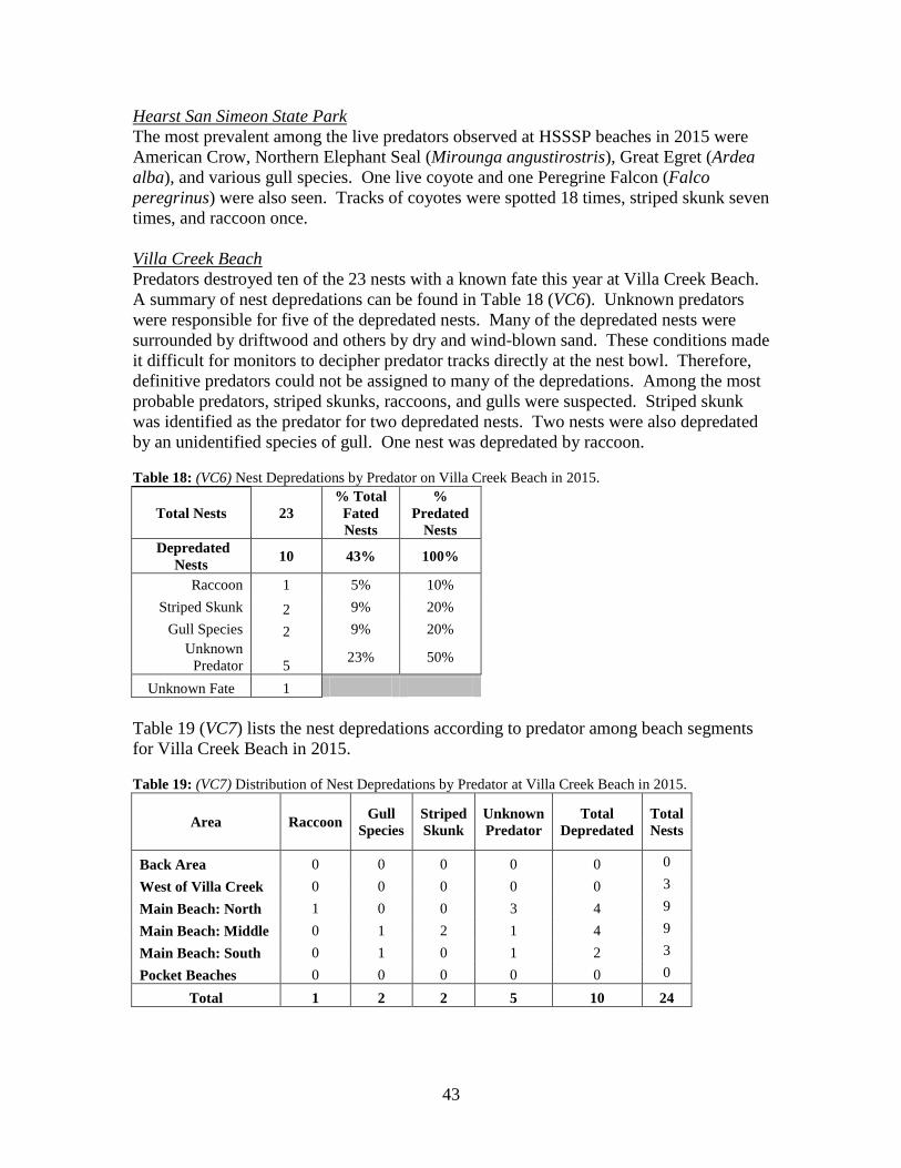
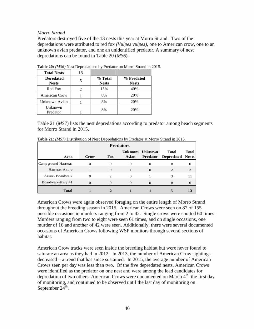
Villa Creek Beach .................................................................................................... 43 Morro Strand ........................................................................................................... 46
Sandspit .................................................................................................................... 49 Human Activities/Recreation ..................................................................................... 51
Hearst San Simeon State Park ................................................................................. 51
Villa Creek Beach .................................................................................................... 51
Table 1: (BWS1) District WSP Breeding Window Survey Population 2002-2015. ......................................17
Table 2: (VC1) Number of Nests Found by Month at Villa Creek Beach 2004-2015. .................................27 Table 3: (VC2) Nest Fates and Percentages for Villa Creek Beach in 2015. ................................................27 Table 4: (VC3) Nest Distribution and Fate at Villa Creek Beach in 2015. ...................................................28 Table 5: (VC4) Distribution of Nests at Estero Bluffs State Park 2001-2015...............................................28 Table 6: (VC5) Number of Nests by Days Incubated at Villa Creek Beach in 2015. ...................................29 Table 7: (MS1) Number of Nests Found by Month on Morro Strand 2004-2015.........................................30 Table 8: (MS2) Nest Fates and Percentages at Morro Strand in 2015. .........................................................31 Table 9: (MS3) Nest Distribution and Fate at Morro Strand in 2015. ...........................................................31 Table 10: (MS4) Distribution of Nests at Morro Strand 1993-2015. ............................................................32 Table 11: (MS5) Number of Nests Hatched by Days Incubated at Morro Strand in 2015. ..........................32 Table 12: (SS1) Number of Nests Found by Month at the Sandspit 2004-2015. ..........................................34 Table 13: (SS2) Nest Fates and Percentages for the Sandspit in 2015. .........................................................35 Table 14: (SS3) Nest Distribution and Fate at the Sandspit in 2015. ............................................................36 Table 15: (SS4) Distribution of Nests on the Sandspit 2000-2015. ..............................................................37 Table 16: (SS5) Number of Nests Hatched by Days Incubated at the Sandspit in 2015. ..............................37 Table 17: (Depredation 1) Number of Days Mammalian Predators Detected Across District Beaches 2015.
.......................................................................................................................................................................41 Table 18: (VC6) Nest Depredations by Predator on Villa Creek Beach in 2015. .........................................43
iv
Table 19: (VC7) Distribution of Nest Depredations by Predator at Villa Creek Beach in 2015. ..................43 Table 20: (MS6) Nest Depredations by Predator on Morro Strand in 2015. .................................................46 Table 21: (MS7) Distribution of Nest Depredations by Predator at Morro Strand in 2015. .........................46 Table 22: (SS6) Nest Depredations by Predator on the Sandspit in 2015. ....................................................49 Table 23: (SS7) Distribution of Nest Depredations by Predator at the Sandspit in 2015. .............................49
FIGURES
Figure 1: Number of Days Mammalian Predators Detected Across District Beaches 2015.........................42 Figure 2: Number of Days Avian Predators Detected Across District Beaches 2015. .................................42 Figure 3: Number of Days Mammalian Predators Detected on Villa Creek Beach 2015. ...........................45 Figure 4: Number of Days Avian Predators Detected on Villa Creek Beach 2015. .....................................45 Figure 5: Number of Days Mammalian Predators Detected on Morro Strand 2015. ...................................47 Figure 6: Number of Days Avian Predators Detected on Morro Strand 2015. .............................................48 Figure 7: Number of Days Mammalian Predators Detected on the Sandspit 2015. .....................................50 Figure 8: Number of Days Avian Predators Detected on the Sandspit 2015. ...............................................50
APPENDICES
Appendix 1 Site Maps
Appendix 2 Nest Card Example
Appendix 3 WSP Population Census Data on District Beaches October 2014-September 2015
Appendix 4 Banded WSP with Known Origins Observed on District Beaches October 2014-
February 2015
Appendix 5 Banded WSP with Known Origins Observed on District Beaches March-September
2015
Appendix 6 Breeding Window Survey Census 2002-2015
Appendix 7 Injured and Dead WSP on District Beaches October 2014-September 2015
Appendix 8 2015 Salvaged WSP and Eggs
Appendix 9 Number of Nests Found by Month on District Beaches 2004-2015
Appendix 9a Nest Initiation and Last Hatch Dates Summary for District Beaches
Appendix 9b Number of Active Nests through Progressive Weeks of the 2015 Breeding Season
Appendix 9c Number of Failed Nests through Progressive Weeks of the 2015 Breeding Season
Appendix 9d Summary of Nest Fates at District Beaches 2001-2015
Appendix 9e Total Nests Hatched on District Beaches 2001-2015
Appendix 9f Nests Hatched per Month on District Beaches 2005-2015
Appendix 9g 2015 Nest Location Maps
Appendix 10 2015 Floated Egg Data for District Beaches
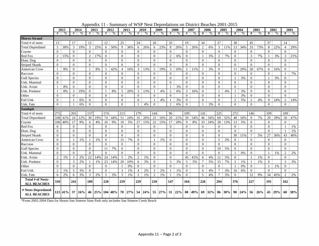
Appendix 11 Summary of WSP Nest Depredations on District Beaches 2001-2015
Appendix 12 Exclosed vs. Unexclosed Nest Fate on Morro Strand 2003-2015
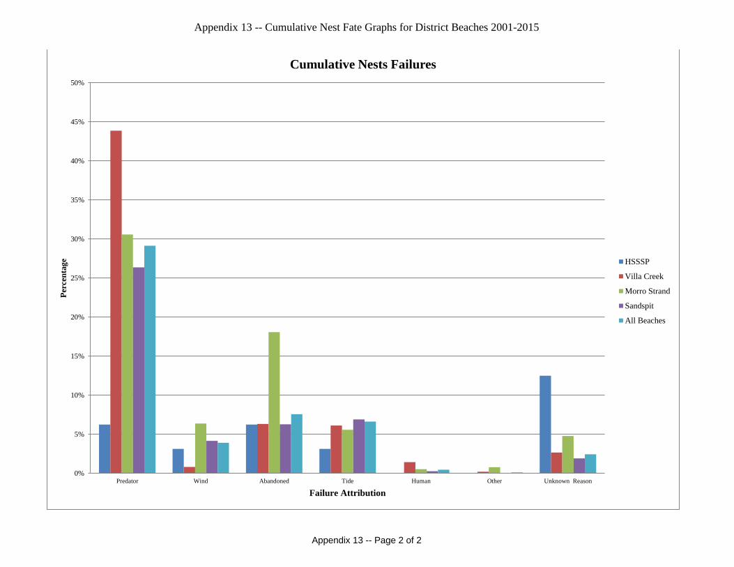
Appendix 13 Cumulative Nest Fate Graphs for District Beaches 2001-2015
1
INTRODUCTION
This report summarizes the nesting activity during the 2015 breeding season of the
Western snowy plover (WSP) (Charadrius nivosus nivosus) in California State Parks
(CSP) San Luis Obispo Coast District (District) at Hearst San Simeon State Park
(HSSSP), Villa Creek Beach within Estero Bluffs State Park (EBSP), Morro Strand State
Beach (Morro Strand), and the Sandspit within Montana de Oro State Park (MDO)
(Appendix 1). At each beach, nesting activity was monitored from March 3rd
through
September 24th
. The current management within the District for the WSP consists of
monitoring breeding and wintering activities, habitat protection through symbolic fencing
and signage, predator management, public outreach and education, enforcing CSP
regulations, and habitat enhancement through exotic plant eradication.
The District’s goals and objectives for WSP management follow those of the System-
wide Management Guidelines developed by CSP Natural Resources Division. During the
2015 breeding season, the District also continued to implement “Western Snowy Plover
Conservation Guidelines” which were developed by the District. The main goal is to
achieve an increase in breeding adult WSP and provide long-term protection of breeding
and wintering WSP and their habitat.
Nest numbers, nest distribution, nest fates, and current management measures are
discussed within this report. Additionally, this report includes future management
recommendations to enhance WSP survival and reproductive success. These activities
were conducted under permits from the United States Fish and Wildlife Service
(USFWS), as well as, from the California Department of Fish and Wildlife (CDFW).
USFWS Recovery Permit Number TE-082237-6.3 was issued to CSP with Nicholas
Franco, District Superintendent, as the principle officer. Authorized individuals listed on
the permit are Lisa Andreano, Charlotte Bailey, Brian Barandon, Virginia Brown, Sarah
Bull,Vincent Cicero, Jeff Ebner, Woodrow Eggers, Matthew Fresquez, Danielle Guest,
Margaret Harrington, Jodi Isaacs, Raven Lukehart, Regena Orr, Bonnie Phillips, Allen
Potthoff, John Sayers, Taryn Schingler-Kinney, Lauren Seguy, Gregory Smith, and
Michael Walgren. CDFW Scientific Collecting Permit Number SC-13063 was issued to
the District with Nicholas Franco, District Superintendent, as the Principle Scientific
Investigator. WSP responsibilities including training, oversight, adequate supervision,
and reporting were delegated to Regena Orr for the CDFW permit. Individuals working
under the Principle Scientific Investigator on the permit are Lisa Andreano, Charlotte
Bailey, Brian Barandon, Vincent Cicero, Jeff Ebner, Matthew Fresquez, Jodi Isaacs,
Raven Lukehart, Regena Orr, Allen Potthoff, John Sayers, Lauren Seguy, Taryn
Schingler-Kinney, and Michael Walgren.
2
METHODS
Survey Area
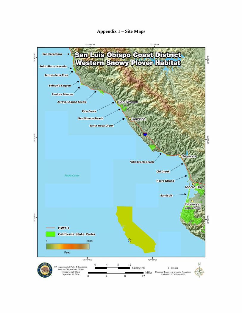
The beaches monitored by the District during the 2015 WSP breeding season are located
along 45 miles of coastline in San Luis Obispo County, California. All of the beaches are
within the USFWS Recovery Unit Five for the WSP.
Hearst San Simeon State Park (CA-69 through CA-77)
The beaches within HSSSP stretch 18 miles from the San Luis Obispo County line south
to Cambria (Appendix 1). The beaches north of San Simeon Creek Beach were acquired
by CSP in 2005. Some of these beaches have little visitation compared to the other
beaches within the District. HSSSP encompasses the first eight beaches listed below.
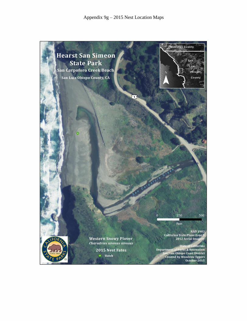
San Carpoforo Creek Beach (CA-69)
The northernmost beach in the District, San Carpoforo Creek Beach, falls under joint
jurisdiction of the United States Forest Service and CSP. WSP utilize approximately a
one eighth mile stretch of a wide, fairly level area which is a mixture of sand and
cobblestone substrate. The general nesting area is bordered to the north and east by San
Carpoforo Creek, creating a small sandspit. East of the creek is a sandy area with sparse
vegetation. Beyond the creek on the north end of the beach is a large sandy area littered
heavily with driftwood and low growing vegetation which adjoins a steep, densely
vegetated hill that slopes up to Highway One. The west side is bordered by ocean. The
San Carpoforo Creek beach area is highly dynamic depending upon tides and creek level.
Point Sierra Nevada (CA-71)
The beach at Point Sierra Nevada is approximately one half mile long and fairly narrow
with marginal habitat. The beach is bordered by rocky bluffs to the north and south, a
wide dune area to the east, and the ocean to the west.
Arroyo de la Cruz (CA-72)
Arroyo de la Cruz is a fairly wide, approximately one quarter mile long mostly sand
beach with cobblestone areas. It is bordered by Arroyo de la Cruz Creek to the north
early in the season and bluffs later in the season, when the creek no longer flows out to
the ocean. To the south is a heavily vegetated area along steeply sloping bluffs.
Sidney’s Lagoon (also known as Arroyo de la Corral) (CA-73)
The main beach is a fairly level area less than one eighth mile long. It is bordered on the
north by a small pocket beach and a grassy hill. The south end is bordered by rocky
outcroppings. The beach slopes down to a seasonal drainage which borders the east side.
The drainage runs along Highway One.
Piedras Blancas (CA-74)
This narrow sandy beach is approximately half a mile in length, bordered to the north by
bluff and rocks and to the east by coastal scrub. The beach narrows at a small drainage to
3
become dune backed. The south end of this beach is bordered by rocky outcroppings and
to the west by ocean.
Arroyo Laguna (CA-75)
This approximately one mile long beach was divided into two sections for convenience.
The northern section (Arroyo Laguna North) is bordered to the north by Arroyo Laguna
Creek, rocky outcroppings and bluffs. To the east of this section of beach is grassland.
The southern section (Arroyo Laguna South) is a wide sandy beach backed by dunes.
Near the south end of this section Oak Knoll Creek flows to the ocean during the rainy
season.
San Simeon Creek Beach (CA-77)
This approximately one quarter mile long beach is bounded by coastal bluffs to the south,
ocean to the west, San Simeon Creek to the north, and a small unnamed tributary to the
east. Highway One runs above the eastern edge of the site.
Santa Rosa Creek Beach
Santa Rosa Creek Beach is approximately a half mile in length. This beach is bounded by
coastal bluffs to the north and south and by the Santa Rosa Creek lagoon on the eastern
side.
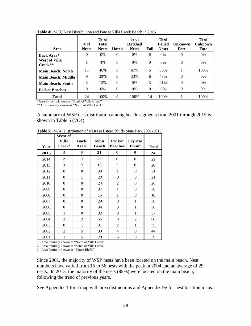
Villa Creek Beach (CA-78)
Villa Creek Beach is located north of the town of Cayucos along Highway One
(Appendix 1). It is situated at the northern boundary of EBSP and is one third of a mile
in length. Villa Creek runs through the northwestern portion of the property. A large
rocky outcropping sits to the west of the creek mouth with a small sandy beach area that
develops later in the breeding season as the creek flow diminishes. This area is referred
to as “West of Villa Creek” and has occasionally been used for nesting. Near the east
bank of the creek are mudflats and annual grassland. This area is referred to as the “back
area” and has been used for nesting in prior years. A sandy beach and a small sandspit
border the south side of the creek mouth. The main section of beach used for nesting
consists of dark, medium grained sand on a narrow sloping beach, which is widest at the
north and south ends. The beach is backed by driftwood, coastal scrub, and some low
coastal foredunes. This area is also considered part of the “back area.” During the
nesting season, change in beach topography and width were frequently noticed from
week to week due to the effects of wind, rain, tide, and surf.
Public access to Villa Creek Beach is from a parking lot adjacent to Highway One with a
one-quarter mile connector trail to the Bluff Trail and Villa Creek Beach.
Immediately south of Villa Creek Beach are two pocket beaches backed by bluffs and
bordered on the north and south by rocky outcroppings. The northern pocket beach is
slightly larger than the southern. Both can be influenced by tide. These pocket beaches
have been used in past years as nesting sites by WSP. Although WSP pairs were
occasionally spotted on the northern pocket beach, no nests were found in 2015.
4
In addition to Villa Creek Beach, another portion of EBSP, Cayucos Point, has been used
as a nesting site in previous years, although no nests have been found since 2008.
Cayucos Point is north of San Geronimo Creek and is located approximately one and a
half miles south of Villa Creek Beach. This is a small sandy bluff backed beach with
offshore rocks and a rock reef.
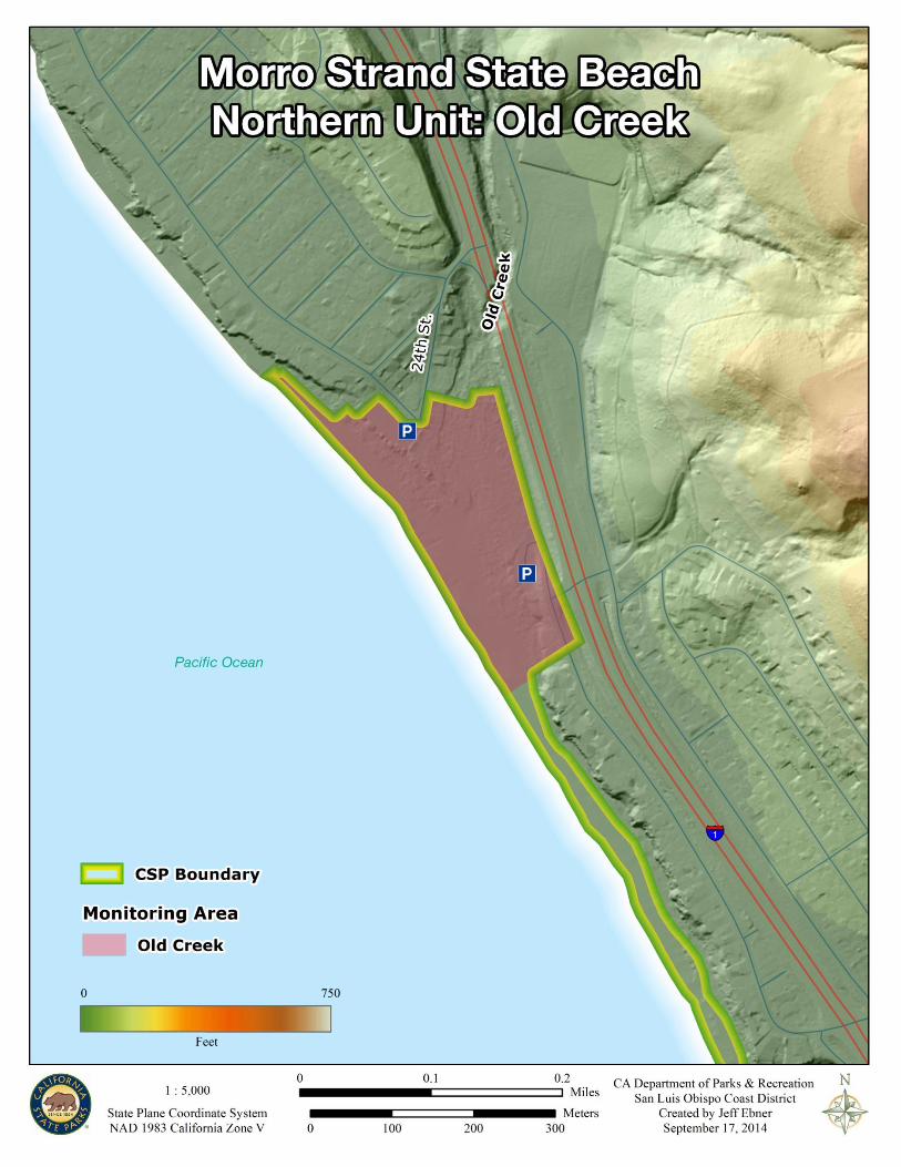
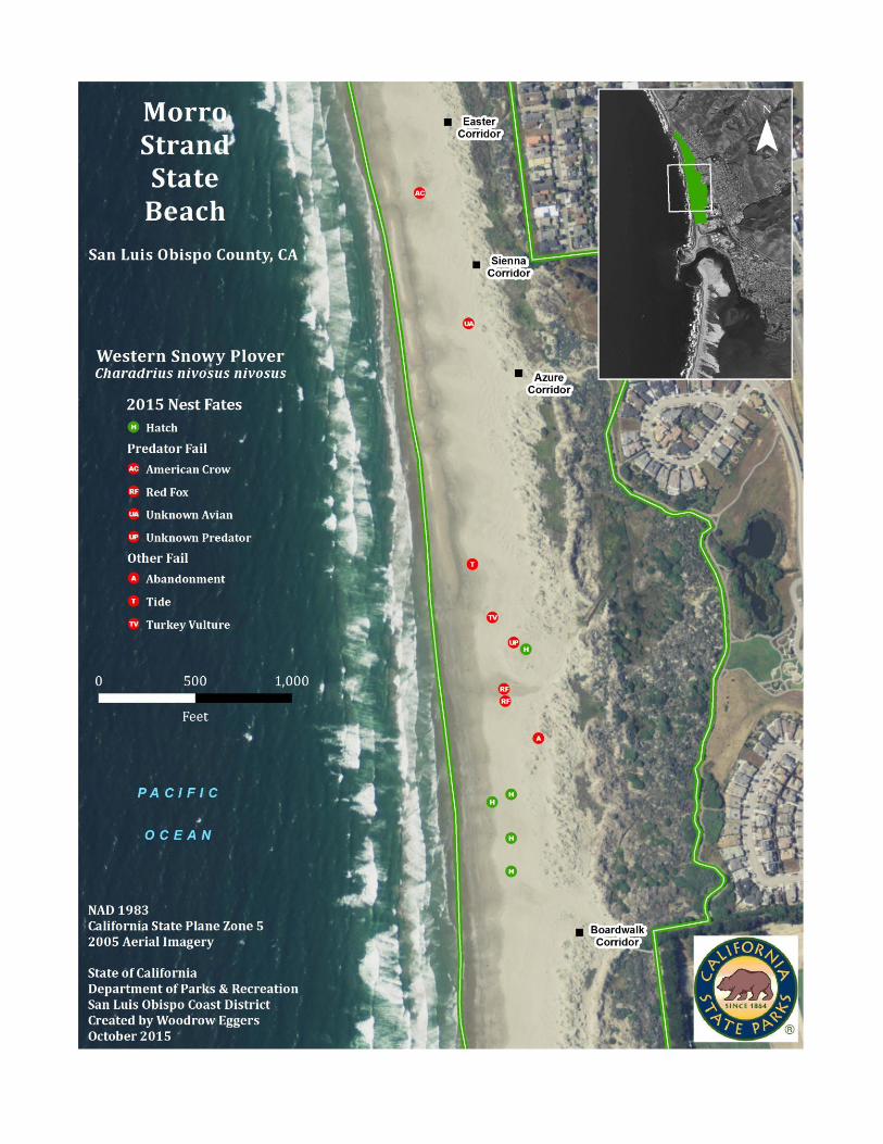
Morro Strand State Beach (CA-80)
Morro Strand is comprised of two units with the northern unit located three miles north of
the City of Morro Bay (City) and the southern unit located within the City (Appendix 1).
The northern unit of Morro Strand, referred to as Old Creek, is approximately one and a
third miles in length. WSP sporadically have wintered at Old Creek but have not been
known to nest there. Most of the beach is a narrow strip backed by steep bluffs topped
with houses. The main beach is approximately a quarter mile in length and is backed by
two parking lots with coastal salt marsh and a small riparian area between them. To the
northwest and southeast of the main beach are houses. Old Creek runs through the
middle of the beach.
The southern unit is approximately two miles long, extending from the area adjacent to
the Morro Strand Campground south to the CSP boundary west of Highway 41. This
area was monitored during the 2015 breeding season. WSP habitat on Morro Strand is
broken up into four sections separated by ten beach access corridors spread throughout
the length of the beach. The Campground section has corridors located at the
campground kiosk, the north bathroom, the south bathroom, and the southern end of the
campground. The Beach Tract segment has a row of houses backing the foredunes and
access corridors located at Hatteras Street, Easter Street, Sienna Street, and Azure Street.
The Cloisters section entails the area from the Azure Street access, which is adjacent to
the Cloisters housing development, south to the boardwalk beach access. This section is
broken up into approximately equal halves by a seasonal drainage referred to as North
Playa. The High School section extends from the Boardwalk Corridor to the CSP
boundary west of Highway 41.
The Campground and Beach Tract sections consist of flat sandy beach backed by low
foredunes vegetated by non-native ice plant (Carpobrotus spp.) and sea rocket (Cakile
maritima) and native sand verbena (Abronia spp.) and beach bur (Ambrosia
chamissonis). The Cloisters and High School sections consist mostly of flat sandy beach
with areas of small to medium size cobbles. The dunes along this stretch of beach are
vegetated mostly with a mixture of native plants. Efforts continue to eradicate non-native
species. See the Habitat Enhancement section within Current Management for
information on the non-native species eradication efforts at Morro Strand.
Sandspit (CA-81)
The Sandspit is a barrier dune system located between the Pacific Ocean and the Morro
Bay Estuary within the communities of Morro Bay and Baywood/Los Osos. The
Sandspit falls under joint jurisdiction of the City and CSP, with a small portion being
privately owned. With exception to the small privately owned segment, the northernmost
5
mile of beach is City property, while the remaining southern area is within MDO
(Appendix 1). Although the CSP boundary has not always been demarcated clearly, CSP
still manages the habitat in this area by installing symbolic fencing and signage.
Therefore, the nests found on the private property are included with the CSP nest
numbers.
The length of the contiguous beach from the northern tip of the Sandspit to the southern
end at Hazard Canyon is approximately five and a half miles. The northernmost half mile
of the Sandspit contains two jetties, which protect the Morro Bay Harbor entrance. This
section of beach, called Jetty Beach, is backed by a sparsely vegetated plateau consisting
of large areas of dredge spoils containing coarse rocks, stones, pebbles, shells, and sand.
South of Jetty Beach the majority of the Sandspit consists of a sandy beach with low,
sparsely vegetated foredunes that are backed by higher, more stabilized, densely
vegetated dunes. Large barren sand sheets are scattered throughout the dune system. In
contrast, the southernmost mile of beach is backed by steep sandy bluffs reaching
approximately 75-100 feet above sea level. On the eastern edge (bayside), the Sandspit
landscape is made up of large, barren sand sheets and provides little suitable habitat for
WSP. Thus, the bayside of the Sandspit was not monitored this season.
The Sandspit has seven rescue markers at roughly half mile intervals starting at Rescue
Marker One, located near Army Road in the south and ending at Rescue Marker Seven,
located just before the South Jetty in the north. When monitoring, these markers are used
to divide the beach into smaller areas in order to better analyze the data collected.
Southern access to the Sandspit consisted of five symbolically fenced access trails within
MDO. Northern access to the Sandspit consists of three access corridors (one on CSP
property and two on City property) linking the east (bay) side to the west (beach) side.
These three corridors, as well as the northern tip of the Sandspit, are often accessed by
boat, canoe, kayak, and surfboard.
Monitoring
The beaches within HSSSP were monitored approximately once per week from the
beginning of March until the end of July.
Beginning March 3rd
, monitoring was conducted five to seven days a week at Villa Creek
Beach, Morro Strand, and the Sandspit. Nest searches were conducted three times a
week inside the symbolic fencing and two to four times a week outside of the fencing.
This was the fourth year monitoring was conducted on the weekends. Monitoring
occurred 28 times on the weekends between April 25th
and August 16th
. Weekend
monitoring was conducted outside the symbolic fencing primarily to have a greater CSP
presence on the beaches during the busier summer months. Beginning September 1st,
monitoring was reduced to two days per week, since there were no more active nests.
6
All WSP monitors were trained by USFWS authorized individuals. Monitoring was
conducted in the morning or early afternoon from approximately 8:00 am to 2:00 pm.
Portions of EBSP were walked once a week to check pocket beaches for WSP nests and
breeding activity. The Sandspit was monitored by two people to allow for adequate
coverage. To accomplish this, the Sandspit was divided into north and south sections,
which enabled each monitor to be responsible for only one portion. This division
occurred between Rescue Marker Three and Four at a location referred to as “Rocky
Mounds”. The back dune area on the westernmost side of the Sandspit was checked
weekly for WSP nests and breeding activity. The back dune monitoring was conducted
on one of the days when the regular monitoring was performed from outside the symbolic
fence. Monitoring was done on foot with the use of binoculars.
Monitoring activity included observing adult WSP behavior, locating scrapes and nests,
mapping nest locations utilizing Global Positioning System (GPS) technology, tracking
nests to determine their fate, floating nests found at completed clutches, recording nesting
habitat substrate, recording evidence and observations of predator and human activity,
recording evidence and observations of chicks and fledglings, and repairing/maintaining
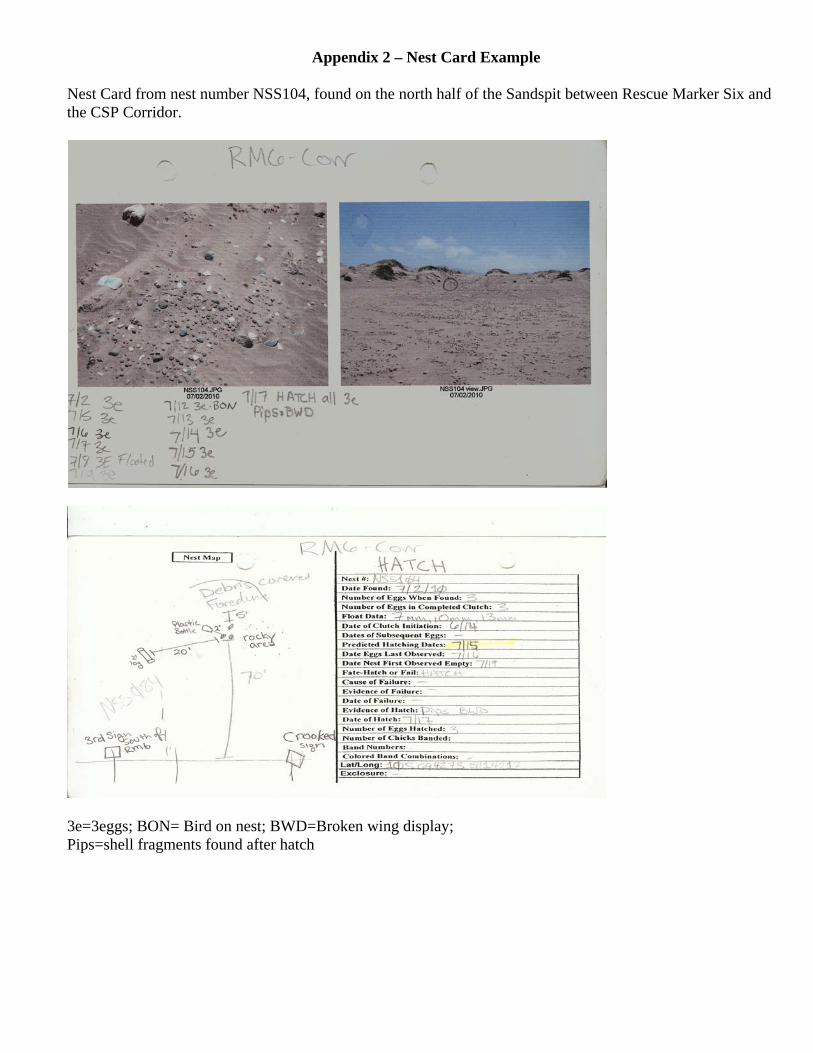
signs and symbolic fencing. All data (including photographs of the nest and nest location
maps) were recorded on a nest card for each nest found (Appendix 2) and entered into
computer databases. Monthly population censuses were conducted to determine numbers
of WSP on District beaches throughout the year. See Appendix 3 for population census
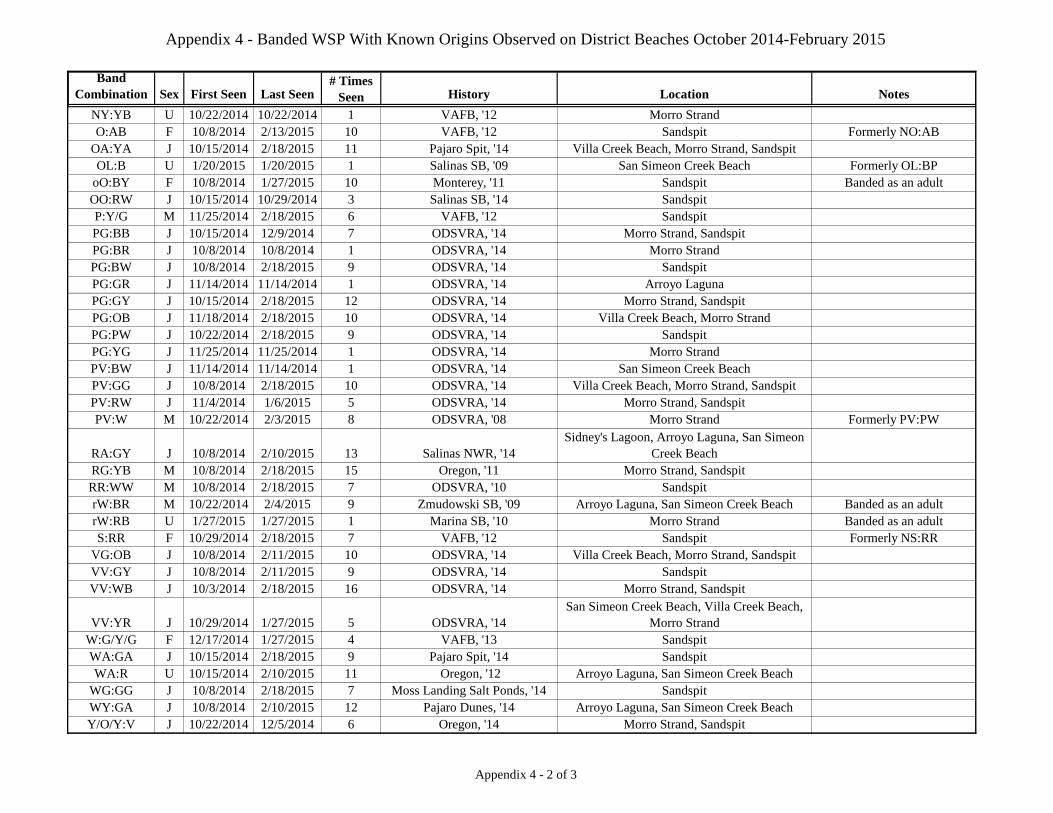
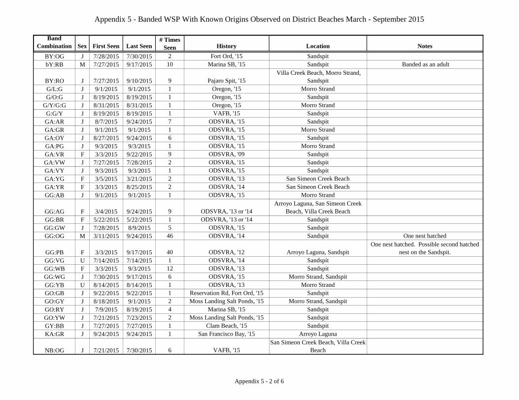
data from October 2014 through September 2015. Color leg band combinations were
recorded and sent to Frances Bidstrup of Point Blue Conservation Science (Point Blue
was originally founded as the Point Reyes Bird Observatory Conservation Science). See
Appendices 4 and 5 for a list of the band combinations observed and their histories.
“Procedures for handling injured, sick, or dead WSP (including chicks and eggs)” for the
District were followed again this year.
Nesting Habitat Substrate
Beginning in 2013, WSP monitors documented descriptive substrate variables of habitat
used by WSP for nests located within the District.
When a nest was found, the substrates were recorded according to a standardized in-field
substrate data survey. First, percentage estimates of the three most prevalent substrates
surrounding the nest bowl within a one meter radius were entered. Then, if vegetation
was present, individual species and height range were specified. Next, the location of the
nest on the beach – lower, middle, upper, or back dunes – was documented. Annotation
of the topographic relief of the area within 0.76 meters (30 inches) surrounding the nest
followed. Topographic relief was described in the following terms: flat (surface is overall
flat), concave (surface is an overall bowl formation), convex (surface is an overall hill
formation), or hummocks (surface consists of a series of small mounds). Proceeding
further, the distance to the nearest active nest in feet was calculated when other nests in
the area were known to be active. The distance between the newly discovered nest and
the closest active nest was determined by measuring between the GPS coordinates of the
two nesting sites, using the map containing the GPS points and the distance/bearing tool,
both located in the Garmin Map Source software program. Finally, any other distinctive
7
features or significant information about the nest bowl habitat was reported. The data
was collected quickly in order to limit disturbance to nesting WSP.
In addition, WSP monitors surveying on the north Sandspit and the south Sandspit
intermittently performed descriptive evaluations of substrate variables at random
locations within the WSP habitat. Another WSP monitor performed the same assessment
at a random location on either Villa Creek Beach or Morro Strand. WSP monitors
actively surveying in-habitat were notified at a random time. At the physical location of
each individual WSP monitor at the time of random notification, the same substrate
recording procedures cited above were followed. Precautions were taken when gathering
data so that minimal disturbance to WSP was a higher priority. Therefore, monitors had
the discretion to abort random point data collection in order to minimize reactive
behavior from WSP.
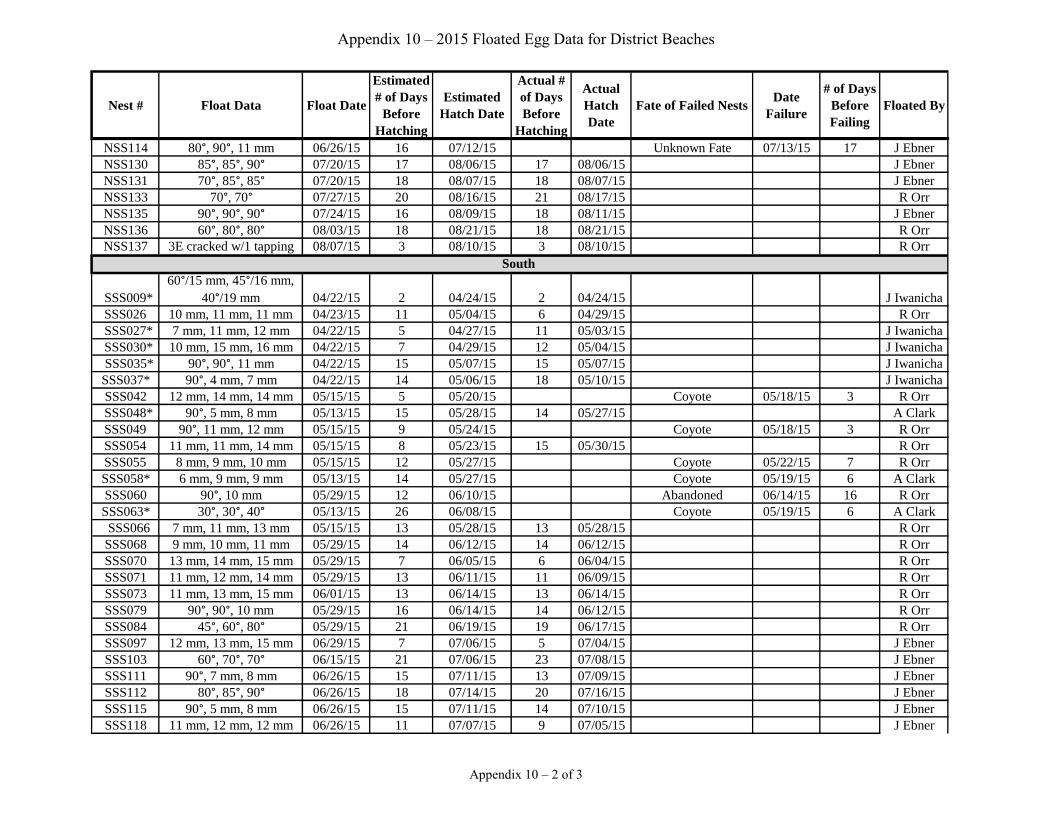
Floating Nests
In order to determine the estimated hatch date (EHD) for a nest discovered with a
completed clutch, the process of egg “floating” was employed. This process can be
described as follows: First, eggs were checked for signs of cracks that appear before
hatching. If cracks were found, or the chick inside an egg was heard tapping on the shell
or peeping, the floating process was discontinued, as such an egg would be in a late
development stage very near hatching. Otherwise, an egg was carefully placed in a small,
clear container of clean, tepid water. If an egg was completely submerged, a
measurement was taken of the angle of the longitudinal axis of the egg to a horizontal
line. If the egg was floating with any part of it exposed above water, a measurement was
taken of the diameter of the exposed portion. Back at the office, these measurements
were compared to a chart of float measurements corresponding to stages of embryo
growth developed for the WSP to determine an EHD. The process was carried out
directly or closely supervised by a person permitted to float eggs. As an essential part of
the process every effort was made to collect data in minimal time, while exercising the
necessary care to ensure that eggs were not damaged.
Determining Nest Fate
During the 2015 breeding season, the District followed USFWS Recovery Unit Five draft
protocols for determining nest hatch success. In order to decrease the proportion of nests
assigned an “unknown fate”, it is extremely important to determine the clutch completion
date. The clutch completion date is the day the third egg is laid. After clutch completion
the parents begin incubating the eggs, and most clutches hatch 28 afterwards. The modal
clutch size is three eggs, with a range of two to four. A scrape was considered a nest if it
contained at least one egg. A nest containing two or more eggs and with an indication of
incubating activity (WSP tracks, nest lining, adult nearby) was considered active.
There are three possible nests fates as determined by Recovery Unit Five.
a) Hatch- Pips/chicks in the nest or indirect evidence suggesting hatch.
b) Fail- Direct evidence of loss, predation, or eggs gone before expected hatch date.
c) Unknown- Eggs gone and no physical sign of fate.
8
A “Hatch” designation was the most definitive, especially if evidence of a hatch was
observed. This included chicks in the nest or its immediate vicinity, or pips found in an
empty nest bowl. A nest with at least one hatched egg was considered a successful hatch.
If pips or chicks were not present, other indications were used in their absence, including
flattened scrapes, distracting adults, eggshell halves nearby, or “brooding tracks”.
However, several of these indications had to be present to constitute solid evidence for a
hatch. In such cases, the monitor evaluated all of the evidence to reach a reasonable
conclusion of hatch or fail.
The “Fail” designation was more complicated, but if the expected hatch date was known,
any interval less than 26 days was considered “Fail” unless there was physical evidence
to the contrary. Nests could “Fail” through wildlife predation, abandonment, tide, wind
or from an unknown cause. Nests were confirmed to “Fail” by wildlife predation when
avian or mammalian tracks were found at the nest bowl and all the eggs in the nest were
gone, or if eggshell pieces or fluid was found in the nest bowl. Nests were considered
abandoned if the eggs were still visible, but no WSP tracks or adults were noted near the
nest for two weeks. Single or “dropped” eggs that were not found in a recognizable
scrape were not considered to be a potential nest. Tide losses were determined when
nests went missing below the high tide line and eggs were found scattered in the wrack.
A nest was considered lost due to wind when the eggs became significantly buried by
sand in one day and there was no evidence of further incubation. Nests could also “Fail”
through an unknown cause where there is no direct evidence of any source that led the
eggs to be missing.
Additionally, an “Unknown Fate” could be assigned to the nest if there was not
unambiguous support for either “Hatch” or “Fail”. Nests were considered as “Unknown
Fate” if the predicted hatch date was unknown and there was no physical evidence of its
fate or if at least one egg disappeared after 26 days of incubation. Also, an “Unknown
Fate” could be selected if a nest showed evidence suggestive of both “Hatch” and “Fail”
but neither one could be conclusively chosen.
While it was tempting to minimize the number of “Unknown Fate” nests by using the
terms “Probable Hatch” and “Probable Fail,” these designations were too subjective and
could not be assigned objectively. As a result, fate designations were only categorized as
“Hatch” or “Fail”, or “Unknown Fate”.
Current Management
Habitat Protection
By the first week of March, the main District beaches with WSP nesting habitat were
symbolically fenced above the high tide line to demarcate the area reserved for nesting.
Fencing was installed at San Simeon Creek Beach and San Carpoforo Creek Beach on
April 2nd
and April 23rd
respectively. These two beaches were the only beaches in
HSSSP to be symbolically fenced. The fences consisted of metal eye-posts strung with
polypropylene rope and/or jute rope. Signs were placed at regular intervals along the
length of the fencing informing the public of the closed WSP nesting habitat. Beige signs
9
were used at Villa Creek Beach to lessen the impact on the scenic view shed. The
corridors at Morro Strand and the Sandspit had yellow signs, so these access points could
be clearly seen from a distance. Regulatory signs were posted at CSP beach access
corridors stating that dogs were prohibited. Additionally, “No kite flying” signs were
posted at the access points to San Simeon Creek Beach, Villa Creek Beach, Morro
Strand, and the Sandspit, with the detailed posted order at the kiosks. All beaches had
corridors at the main access points which allowed for continued public recreation.
Fencing for San Simeon Creek Beach and San Carpoforo Creek Beach was removed on
August 26th
and May 7th
respectively. Symbolic fences were removed between
September 28th
and October 1st for Villa Creek Beach, Morro Strand, and the Sandspit
with assistance from California Conservation Corps crew members.
Maps displaying current location and nearby beach access corridors were placed on the
bayside of the Sandspit at the accessible landing spots. Red flags were also placed on the
bayside at corridor entrances so that kayakers coming from the east side of the bay could
navigate toward a corridor. Additionally, maps designating the corridor entrances were
given to the local kayak concessions.
Habitat Enhancement
Symbolically fencing WSP habitat not only protects WSP nests, it also allows native
vegetation to expand into areas that would otherwise be trampled. Thus, erosion of sand
into areas such as the Morro Bay estuary is minimized, and WSP breeding areas are
stabilized.
Restoration efforts to prevent the spread of non-native ice plant and European beach
grass (Ammophila arenaria) onto the foredunes and beach were continued this year at
Morro Strand. The ongoing program has provided and continues to provide more WSP
nesting habitat. Of the 90 acres of coastal dune habitat, less than one acre of beach grass
and ice plant remain. From October 2014 through September 2015, a contractor combed
the site treating isolated non-native plants with herbicide. Volunteers spent over 180
hours cultivating native plants in the greenhouse, planting the greenhouse grown
specimens in treated areas, and hand pulling specific non-native plants from the habitat.
CSP staff monitored effectiveness of treatment, guided restoration efforts, and collected
several pounds of native seed. Native plant recruitment is high where non-native
competition has been removed. In previously planted areas, a variety of native species
are now dominant where it once was a monoculture of invasive species.
Habitat restoration at Morro Strand is currently funded by a grant from the CDFW Office
of Spill Prevention and Response and will continue through June 2016. Further herbicide
treatment and native planting will continue for the duration of the grant. Although the
acreage of European beach grass and ice plant is low, the sparse and discrete distribution
of the remaining populations renders restoration a labor intensive job. Staff will continue
to monitor the site, treat scattered populations of invasive species, and seed and plant
treated areas with native plants.
10
In June 2012, an ice plant control project was initiated in the Morro Dunes Natural
Preserve within MDO. Approximately 140 acres, found between the Sandspit day use
parking lot and Army Road, have been treated with herbicide. This effort is part of a
larger exotic plant control project targeting key invasive species throughout the Morro
Dunes Natural Preserve. The bulk of the remaining ice plant predominately grows in the
foredunes, covering open sandy areas that have potential to be WSP breeding habitat.
Following herbicide treatment, the dead ice plant thatch rapidly breaks down, but the
treated area is vulnerable to regrowth. Herbicide treatment of the foredunes occurred
strictly from October 2014 through February 2015 to avoid the WSP breeding season.
During the breeding season, herbicide treatment occurred in the back dunes, well outside
the WSP habitat. Herbicide treatment this year was principally follow-up to inhibit
regrowth after major treatment in prior years. It is expected that more open sandy area
will result from this project and thus, will provide more WSP habitat.
Predator Management
Monitors determined the presence of potential predators through either direct observation
or by tracks. Due to a lack of funding, predator control was not available during most of
the WSP breeding season. Once funding was in place, United States Department of
Agriculture (USDA) Wildlife Services was contacted, when predator control was deemed
necessary. USDA Wildlife Services spent 76 hours on predator removal activities within
the District between July 22nd
and August 28th
. Species removed this year were two
coyotes (Canis latrans), one raccoon (Procyon lotor), and one striped skunk (Mephitis
mephitis).
Traditionally, ten foot by ten foot single nest exclosures were used in an attempt to
enhance hatch rate success on Morro Strand. Protocol dictates that all exclosures be
monitored regularly for effectiveness. By mid-season 2014, it was clear that exclosures
were ineffective in promoting hatching success, so their use was discontinued for the
remainder of that season. Exclosures were not used on any District beach in 2015. See
the Depredation section for more information.
Another useful predator reduction method was removing trash from the beach. In 2015,
the Environmental Center of San Luis Obispo (ECOSLO) in collaboration with Morro
Bay Beautiful and Surfrider Foundation coordinated three volunteer tsunami debris
cleanups on the Sandspit. On January 24th
, 80 volunteers removed almost 300 pounds of
trash. The second tsunami cleanup was held on April 25th
. Because this second date was
within the active WSP breeding season, two WSP monitors addressed the group before
volunteers went out to the beach regarding WSP activity and the need to respect the
habitat fencing. WSP monitors were also on the beach addressing volunteer questions,
helping with general trash collection, and gathering larger items. Sixty-one volunteers
removed 105 pounds of trash and recyclables. In addition, WSP monitors removed one
truckload of debris from the Sandspit. The third tsunami cleanup was on July 25th
.
Again, two WSP monitors addressed the group before volunteers began collecting trash
and were on the beach to assist with the event. Thirty-seven volunteers removed 90
pounds of trash and recyclables. Again, WSP monitors removed an additional truckload
of debris.
11
On August 1st, the Morro Bay Yacht Club sponsored a “Fun Float” trash cleanup on the
Sandspit. Sixteen volunteers collected approximately eight bags of trash plus several
large items from the bay side of the Sandspit.
The 31st annual statewide Coastal Cleanup was held on September 19
th. Coastal Cleanup
Day is California’s largest volunteer event and has been coordinated in San Luis Obispo
County by ECOSLO since 2005. Two WSP monitors were available during the cleanup
on the Sandspit to monitor activities, act as an information resource, and assist as needed.
Monitors debriefed the approximately 25 volunteers about the habitat restrictions, WSP,
and safety precautions. Monitors hauled one truckload of refuse, including nearly 500
pounds of trash and 38 pounds of recyclable material from the Sandspit. Other District
beaches with WSP habitat included in the cleanup were San Simeon Creek Beach, Santa
Rosa Creek Beach, EBSP, and Morro Strand.
In addition, at the time of symbolic fencing installation and removal, CSP employees
removed approximately two truckloads of miscellaneous trash off of the beaches.
An updated “Predator Management Plan” for the District is currently being developed.
The existing “Interim Predator Management Plan” was created in 2003.
Enforcement
Throughout the WSP breeding season monitors maintain a strategic alliance with CSP
Rangers designed to maintain healthy lines of communication and expedite coordination
of resources when collaboration is necessary. CSP Rangers frequently attended the
weekly WSP meetings to discuss enforcement issues, management, and upcoming events.
Rangers, WSP monitors, and other CSP staff also attend bi-weekly safety meetings where
each group shares information on safety issues germane to the well-being of CSP.
In the field, CSP Rangers patrol a broad area including beaches harboring WSP habitat.
While beach patrolling, Ranger vehicle activity is restricted to the wet sand area with a
speed of less than ten miles per hour. While WSP monitors are in the field, they often
encounter violations of regulations which also represent threats to the WSP. WSP
monitors and volunteers contacted visitors who were violating park regulations, and if
necessary, CSP Rangers were contacted. These illegal activities included dogs on the
beach, trespassing, vandalism, and kite flying. Occasionally, those follow-up contacts
with Rangers will result in the offender receiving a citation. If a WSP monitor
discovered a nest disturbed by direct human intervention, a Ranger was contacted, who
then investigated the incident and filed a report that would be forwarded to the USFWS
and CDFW.
On July 4th
, WSP monitors assisted Rangers in enforcement of regulations, such as
trespassing, illegal fireworks, kite flying, and dogs on beach.
12
Of the many public safety incidents throughout the year, Rangers were called by WSP
monitors for ten dogs on the beach, six cases of trespassers in the closed WSP habitat,
and one illegal camp.
There were two episodes in which Rangers addressed emergent problems. In response to
chronic combined dog and human trespasses just south of the Boardwalk Corridor, a
Ranger manned a sunrise stake-out on March 21st and again on March 26
th. The action
resulted in one citation, one warning, and the recurrent trespasses were dramatically
reduced this year over last year. The second episode began on June 8th
, when a path was
discovered freshly cut through vegetation starting at the back fence between Easter and
Sienna Corridors. The path was closely accessible to a house which had been frequently
noted as the source of trespasses in the past. Rangers contacted occupants of the house,
as well as, a rental agent. After the Ranger contact, the frequency of trespasses from that
location was reduced.
Information/Education
For the 2015 WSP season, efforts were engaged to inform and educate the public and
CSP staff and volunteers about the WSP and how they can help protect this species.
Pamphlet holders at Morro Strand and the Sandspit parking lot were stocked throughout
the season with the “WSP: Sharing the Beach” brochures provided by CSP headquarters,
and “dog-on-leash” brochures provided by Morro Coast Audubon Society (MCAS). The
informational kiosk at the Morro Strand Campground also displayed WSP educational
information. Each campground kiosk, as well as, the mobile California sea otter
(Enhydra lutris) educational trailer, which was stationed at Morro Rock every weekend
during the summer, was provided with a WSP information binder. Additionally, six WSP
interpretive panels were in place at the main access corridors at Villa Creek Beach,
Morro Strand, and MDO.
This was the tenth year of displaying children’s art signs along the symbolic fencing at
WSP nesting sites within the District. This MCAS sponsored project involved several
beach land owners, as well as, children from the community whose artwork emphasized
the WSP.
During the 2015 WSP breeding season, WSP monitors and volunteers staffed a WSP
educational exhibit. The anchoring feature of the exhibit was a portable interpretive
display panel with attractive color pictures and informational diagrams depicting the
WSP life cycle, the WSP recovery program, and encouraging park users to share the
beach respectfully with the WSP. In addition to the integrated panel, the exhibit included
several other features. For hands on activities, there were several binders with pictures –
some simply depicting samples of WSP on local beaches and others challenging the
visitor to find hidden nests and chicks and camouflaged adult WSP. Another hands-on
opportunity was provided alongside an interpretive display box containing a simulated
WSP nest among authentic wrack, shells, and sand. Guests were provided a container of
sand, fake WSP eggs, and a variety of authentic beach detritus and encouraged to create
their own version of a WSP nest. Additionally, a color-by-numbers WSP coloring page,
13
which could be colored on the spot or taken home, was distributed to interested young
artists. A variety of WSP brochures, posters, and other CSP informational material were
also available for visitors to take home. The portable exhibit was active a total 47 hours
over 24 days between May 23rd
and August 16th
. On seven occasions, it was set up near
the kiosk at the entry of Morro Strand day use area and campground for a total of 14
hours. Fifteen times, for a combined 30 hours, it was located at the Morro Rock parking
lot adjacent to the mobile sea otter educational exhibit operated by CSP docents. Overall,
the booth served 547 guests including 382 adults and 165 children.
Visitor outreach also occurred through numerous contacts between WSP monitors and
the public while out on District beaches. The public often approached monitors with
questions about WSP activity, as well as, various other topics. Overall, monitors spoke
with 243 members of the public on Morro Strand, 256 on the Sandspit, 143 on Villa
Creek Beach, and 16 at HSSSP. See the Human Activities section for more information
on public contacts.
In 2015, Central Coast State Parks Association refreshed the supply dog leashes with “I
State Parks” printed on them. WSP monitors handed the dog on leash walking areas
brochure out to visitors on the beach, if they had a dog with them. They also handed out
a leash if the dog was not on a leash, and the canine companion was not in possession of
a leash. In 2015, WSP monitors recorded handing out 22 brochures and two leashes to
people contacted with dogs on the beach. Brochures and leashes were also given to
people not in violation of regulations who were seeking information regarding
regulations.
Two WSP educational presentations were given to a total of 20 attendees at the Morro
Bay Winter Bird Festival in January of 2015. WSP educational presentations were also
given to MDO docents, Maintenance staff, Natural Resources staff, campground kiosk
attendants, and Rangers.
At the Atascadero High School Career Fair on May 14th
, a WSP monitor addressed
approximately 325 students regarding CSP’s WSP recovery program and career
opportunities within CSP.
On June 20th
, two WSP monitors and one volunteer staffed a WSP educational booth at
the Summer Solstice Family Day at Morro Bay State Park. The display included a craft
for creating WSP chicks, passive and interactive WSP displays, and informational WSP
brochures and posters. Seventy-nine family members, including 46 adults and 33
children, attended the booth, and 30 WSP chicks were created by young artists.
In June of 2015, WSP monitors in collaboration with docents offered four Junior Ranger
programs on the topic of WSP. The programs hosted 60 people including 41 children and
19 adults.
On July 4th
, two volunteers and five CSP employees roamed Morro Strand from 11:00 am
to 9:30 pm to inform beach users of CSP regulations and answer questions. Although the
14
City of Morro Bay did not hold a fireworks display, the town of Cayucos presented a
fireworks program which was viewable from Morro Strand. CSP presence on Morro
Strand reduced the incidents of illegal fireworks and foot traffic inside symbolically
fenced habitat. The Sandspit was monitored by one CSP employee during the day, and
Villa Creek Beach was checked periodically between 11:00 am and 6:00 pm by CSP
employees. Monitors were also on the beaches from July 3rd
through July 7th
.
WSP were among the topics discussed by Morro Bay Museum of Natural History docents
on approximately 140 interpretive walks, information desk shifts, and Nature Center
programs throughout the year.
The District has been and will continue to be involved with the WSP Working Group for
USFWS Recovery Unit Five through attendance at meetings and being involved with the
range-wide electronic mailing list which connects all WSP interested parties together
through email. The WSP Coordinator also assists Recovery Unit Five by coordinating
the winter and breeding window surveys. These efforts facilitate consistent WSP
management methodologies and reporting throughout the range.
Volunteer Efforts
Overall, WSP recovery program volunteers contributed 312 hours of service. Sixty-eight
percent of these hours were devoted to WSP monitoring, 18% to WSP recovery program
meetings, 7% to beach use surveys, 5% to training, 2% to outreach, and 1% to fencing.
One experienced volunteer monitored WSP activity on Villa Creek Beach and Morro
Strand independently. This individual volunteered approximately 32 hours towards the
District WSP program. The volunteer is listed as an authorized individual on the District
recovery permits. She has been with the District for 11 years and is an immeasurable
benefit to the program in terms of providing continuity, a positive role model, and
building cohesive morale among all staff members. Other volunteers engaged in
supervised monitoring on District beaches a total of 180 hours. The total WSP
monitoring hours contributed by volunteers was 212 hours.
One volunteer with experience and training on topics including WSP life history, how to
conduct recreational use surveys without disturbing WSP, and how to contact Rangers to
report violations logged 22 hours performing recreational use surveys. The purpose of
the survey is to monitor type, intensity, and distribution of recreational uses.
On June 20th
, two WSP monitors and one volunteer staffed a WSP educational booth at
the Summer Solstice Family Day at Morro Bay State Park. For details on this event, see
the Information/Education section. The project included five volunteer hours.
On July 4th
, one volunteer was at Morro Strand for one and a half hours in the evening
notifying Rangers of violations. Another volunteer patrolled Morro Strand and Villa
Creek Beach for seven hours alongside CSP personnel after helping at the WSP
information exhibit for one hour.
15
One volunteer provided help installing and removing symbolic fencing for a total of four
hours on Morro Strand.
Seven volunteers contributed at meetings for a total of 55 hours to keep updated on the
WSP recovery program. In addition, seven volunteers participated in a total of 15 hours
of WSP recovery related training.
In 2015, ECOSLO coordinated three volunteer tsunami debris cleanups on the Sandspit.
On January 24th
, 80 volunteers removed almost 300 pounds of trash over three hours. On
April 25th
, 61volunteers removed 105 pounds of trash over three hours. On July 25th
, 37
volunteers removed 90 pounds of trash and recyclables in three hours.
On August 1st, the Morro Bay Yacht Club sponsored a “Fun Float” trash clean-up on the
Sandspit. Sixteen volunteers collected approximately eight bags of trash plus several
large items from the bay side of the Sandspit.
The 31st annual statewide Coastal Cleanup was held on September 19
th. See the Predator
Management section for more information on this cleanup. ECOSLO reported that
across 28 sites throughout the county, 981 volunteers cleaned up approximately 5,436
pounds of trash and recyclables from over 56 miles of coastline and waterways.
RESULTS
Wintering WSP
The beaches of the District continue to provide high quality wintering habitat for WSP
with approximately 340 WSP wintering here. To monitor wintering numbers, population
censuses were conducted on District beaches from October 2014 through February 2015
(Appendix 3). One of the January censuses was also part of the range-wide winter
window survey.
Hearst San Simeon State Park
San Carpoforo Creek Beach
Nine population censuses were conducted during the non-breeding/winter season at San
Carpoforo Creek Beach. No WSP were seen on any of the visits.
Point Sierra Nevada
Seven population censuses were conducted during the non-breeding/winter season at
Point Sierra Nevada. No WSP were seen on any of the visits.
16
Arroyo de la Cruz
Seven population censuses were conducted during the non-breeding/winter season at
Arroyo de la Cruz. No WSP were seen on any of the visits.
Sidney’s Lagoon
Ten population censuses were conducted during the non-breeding/winter season at
Sidney’s Lagoon. Eighteen WSP were observed on the first winter census in October.
No WSP were seen during the other nine censuses.
Piedras Blancas
Eight population censuses were conducted during the non-breeding/winter season at
Piedras Blancas. No WSP were seen on any of the visits.
Arroyo Laguna
Thirteen population censuses were conducted during the non-breeding/winter season at
Arroyo Laguna. An average of 45 WSP was seen at Arroyo Laguna during this period,
and numbers of WSP ranged from 0 to 125.
San Simeon Creek Beach
Fourteen population censuses were conducted during the non-breeding/winter season at
San Simeon Creek Beach. An average of 78 WSP was seen on San Simeon Creek Beach
during this period. According to the censuses, numbers of WSP ranged from 1 to 157.
Santa Rosa Creek Beach
Seven population censuses were conducted during the non-breeding/winter season at
Santa Rosa Creek Beach. No WSP were seen on any of the visits.
Villa Creek Beach
Nineteen population censuses were conducted during the non-breeding/winter season at
Villa Creek Beach. An average of 36 WSP was seen on Villa Creek Beach during this
period. According to the censuses, numbers of WSP ranged from 12 to 68.
Morro Strand
Northern Unit – Old Creek:
Nine population censuses were conducted during the non-breeding/winter season at Old
Creek. No WSP were seen on any occasion.
Southern Unit – Morro Strand:
Eighteen population censuses were conducted during the non-breeding/winter season.
An average of 69 WSP was seen on Morro Strand during this period. According to the
censuses, numbers of WSP ranged from 0 to 113.
Sandspit
Fifteen population censuses were conducted during the non-breeding/winter season. An
average of 119 WSP was seen during this period on the CSP portion of the Sandspit.
Numbers of WSP ranged from 29 to 214 on the days the censuses were conducted
17
Breeding Window Survey
To monitor breeding season numbers, population censuses were conducted on District
beaches from March through September 2015 (Appendix 3). One of the May censuses
was also part of the annual range-wide window survey count of the United States Pacific
Coast breeding population of WSP. While the window survey does not represent a total
count of WSP, it does provide an index of population size. The results of the breeding
window survey for District beaches are listed in Table 1 (BWS1) Graphical depiction of
WSP population numbers for all District beaches are illustrated in Appendix 6.
Table 1: (BWS1) District WSP Breeding Window Survey Population 2002-2015.
YEAR HSSSP
Beaches
Villa
Creek
Beach
Morro
Strand Sandspit
District
Total
2002 3 38 19 56 116
2003 0 30 23 114 167
2004 3 31 21 203 258
2005 12 33 21 181 247
2006 15 23 24 100 162
2007 4 17 17 84 122
2008 1 12 17 59 89
2009 NS* 16 18 97 131
2010 1 14 16 89 120
2011 0 17 9 114 140
2012 2 13 2 113 130
2013 9 11 7 101 128
2014 10 16 12 105 132
Average 5 21 16 109 149
*No survey
In 2015, the District was invited to take part in a WSP survey detection analysis being
conducted by USFWS. The effort is being undertaken in order to help find the most cost
effective method of monitoring WSP on the west coast. The effort required repeat
surveys of the same beaches within ten days of the initial range-wide breeding window
survey. Within the District, this effort was undertaken at Villa Creek Beach, Morro
Strand, and the Sandspit.
Hearst San Simeon State Park
San Carpoforo Creek Beach and Arroyo Laguna are the only two HSSSP beaches with
breeding numbers listed in the USFWS Recovery Plan. According to the USFWS
Recovery Plan, the combined breeding bird management potential for San Carpoforo
Creek Beach and Arroyo Laguna is 16 adults. On May 19th
, the range-wide breeding
18
window survey determined the minimum number of WSP adults seen across all HSSSP
beaches was one adult seen at San Carpoforo Creek Beach.
Villa Creek Beach
According to the USFWS Recovery Plan, the breeding bird management potential for
Villa Creek Beach is 25 adults. On May 19th
, the range-wide breeding window survey
determined the minimum number of WSP adults was eight males and eight females.
Three additional surveys were conducted at Villa Creek Beach as part of the survey
detection analysis. The minimum number of breeding adults ranged from 12 to 16 during
these surveys.
Morro Strand
According to the USFWS Recovery Plan, the breeding bird management potential on the
CSP portion of Morro Strand is 30 adults. On May 19th
, the range-wide breeding window
survey determined the minimum number of adults was two males and three females.
Four additional surveys were conducted at Morro Strand as part of the survey detection
analysis. The minimum number of breeding adults ranged from two to five during these
surveys.
Sandspit
According to the USFWS Recovery Plan, the breeding bird management potential on the
CSP portion of the Sandspit is 82 adults. On May 19th
, during the range-wide breeding
window survey 151 adults (70 males, 71 females, and ten unidentified adults) were
observed. Three additional surveys were conducted on the Sandspit as part of the survey
detection analysis. The minimum number of breeding adults ranged from 130 to 155
during these surveys.
Banded WSP
Although banding is not currently performed in the District, banded WSP from other
locations were often observed on District beaches. Color leg band combinations were
recorded and sent to Frances Bidstrup of Point Blue. From October 2014 through
September 2015, banded birds were observed on 1,667 occasions across District beaches.
From these 1,667 sightings, 216 unique band combinations were observed. Seventy-
three unique combinations were sighted over the winter season (October 2014 through
February 2015), and 190 were seen during the breeding season (March through
September 2015). Forty-five of the 216 banded birds were seen during both the winter
and breeding seasons. The locations where these 216 WSP were banded are as follows:
Oceano Dunes State Vehicular Recreation Area (ODSVRA) (74), Vandenberg Air Force
Base (VAFB) (40), Pajaro Spit (17), Marina State Beach (SB) (16), Oregon (15), Fort
Ord Dunes State Park (SP) (10), Moss Landing Salt Ponds (9), Salinas SB (6),
Zmudowski SB (6), Salinas National Wildlife Refuge (NWR) (5), San Francisco NWR
(5), Monterey Bay Aquarium (4), Clam Beach (2), Monterey area beaches (2), Sunset SB
questions on topics not just related to the WSP and the recovery program but a variety of
additional topics.
Villa Creek Beach
Recreational activity observed by WSP monitors at Villa Creek Beach during the 2015
breeding season included beachcombing, surfing, kayaking, and bird watching with
walking, photography, and fishing being the most prevalent activities. WSP protection
measures to eliminate pedestrian access through nesting habitat continued this year.
Former trails continued to be fenced off, and “Do Not Enter” signs were clearly posted.
There were 135 documented incidents of human foot traffic inside the habitat, although
the actual number of people entering the habitat could be higher due to the difficulty of
deciphering individual footprints. The highest number of incidents, 51 (38%), occurred
on the North Pocket Beach. On the main beach, most foot traffic trespassers were on the
southern and northern portions of the beach with relatively few incursions in the middle.
When possible, trespassers were contacted and informed about rules and regulations
regarding trail closures and educated about the WSP. Monitors witnessed 12 individuals
inside the WSP habitat on seven separate episodes. Ten were contacted. All seven
events were classified as positive with trespassers leaving the habitat immediately at the
request of the WSP monitors. On June 3rd
, an individual was observed sleeping in the
52
habitat. Rangers were contacted. During the follow-up by the Rangers, it was determined
the individual had several outstanding warrants, so the individual was arrested.
Fifty-six additional public contacts were noted at EBSP either with individuals or groups
of up to 12 people. At total of 143 members of the public were encountered overall.
WSP monitors answered questions on topics not just related to the WSP and the recovery
program but a variety of additional topics.
Villa Creek Beach was monitored on days surrounding the Independence Day holiday.
On July 4th
, CSP employees patrolled intermittently in the afternoon. WSP monitors
counted 38 beach users on Villa Creek Beach around 3:30 pm. There were two
trespassers on the pocket beach, who left when asked to do so by the CSP employee.
There was one dog on leash on the entry path. The owner was advised of regulation and
left immediately.
Acts of vandalism on Villa Creek Beach were very rare. The events included a fire on
the beach, a dismantled CSP regulatory sign, and a driftwood fort inside the symbolically
fenced habitat.
Morro Strand
Morro Strand is easily accessible to local residents and visitors and has the highest level
of recreational use of all District beaches. From March through September, a volunteer
counted 1,023 beach users (with no habitat trespassers) in 19 recreational survey hours.
Although these surveys indicated higher rates of beach usage on weekend days, there
were significant levels of beach activity on weekdays, as well. Recreational activity
observed included beachcombing, picnicking, jogging, illegal dog walking, horseback
riding, biking, fishing, surfing, swimming, bird watching, sunbathing, playing ball and
Frisbee. Stationary activities accounted for 44%, walking/jogging 32%, and water
activities 14% of beach recreation. Combined the three classes of activities accounted for
90% of beach activities.
There were 1,387 documented incidents of human foot traffic inside the symbolically
fenced habitat. Twice foot traffic passed near an active nest. There were seven sets of
bicycle tracks, four drag marks from various objects, and three instances where the foot
traffic was accompanied by sand graffiti. Monitors also found evidence of digging,
traces of blankets, and various toys inside the symbolically fenced habitat. Foot traffic
was not evenly distributed among the sections. Most infractions occurred on the northern
sections with 41% found near the Campground and 24% found between the Hatteras and
Azure Corridors. The highest number of foot traffic infractions during any one month
occurred in June, with 24% of the yearly infractions. The next highest month was August
with 19% of the infractions. Approximately 10% of infractions occurred during each of
the months from March through May. The actual number of people entering the habitat
could be higher due to the difficulty of deciphering individual footprints when individuals
entered the habitat at the same location or in large quantities.
53
On June 5th
, a path was discovered that had been cut from the back fencing between
Easter Street Corridor and Sienna Street Corridor, through vegetation, and onto the dunes
leading to the beach. The path had been established near the rear entrance of a house on
Beachcomber Street associated with frequent foot traffic and chronic trespassing in past
years. Rangers attempted to contact the owners of the house and succeeded in contacting
a rental agent. On July 4th
, a public contact with house renters revealed that the house
rental book recommended the path be used for access to the beach. Although the owners
were not contacted directly after the Ranger contact with the rental agent and the public
contact with a vacation renter, trespasses originating in that area from that house
diminished.
Trespassing was also indicated by other forms of trace evidence. Domestic dog tracks
accompanied the foot traffic on 14 occasions. In 2014, there were 64 such incidents and
60 involved a set of highly distinctive footprints usually accompanied by two sets of dog
tracks. These most often appeared between the Highway 41 Corridor and Boardwalk
Corridor. Also in 2014, a motion activated camera installed in the habitat for the purpose
of identifying passing wildlife captured images of a woman with one dog on leash that
matched the footprint pattern. This distinctive pattern was seen four times in early March
of 2015 and then abruptly ceased. One similar set of dog plus foot traffic prints was
identified in August and another in September. The remaining sets of the dog plus
human trespasses were dissimilar.
Monitors witnessed 31 individuals trespassing in the WSP habitat across 13 incidents.
Twenty-nine of either the trespassers or supervising guardians were contacted by
monitors. Two were contacted by Rangers. Ten of the 13 contacts were positive, three
were neutral, and none were negative. On 13 occasions people outside the habitat were
requested to remove items they had attached to the symbolic fence.
There were 118 additional public contacts at Morro Strand either with individuals or
groups of up to nine people. One hundred twenty-four of all contacts were considered
positive. Seven were considered neutral, and none were classified as negative. As part of
the public contact WSP monitors answered questions, provided information about various
aspects of the WSP recovery program, informed beach users of beach regulations, and
discussed various additional topics. Several times the contact was initiated in order to
express appreciation of the work accomplished by CSP personnel.
A Superintendent’s Posted Order was posted at the kiosks that states that no person shall
operate, fly, release, or cause to be operated, flown, or released any size kite, or other
device, free flying, or by remote control within or 300 feet adjacent to the symbolically
fenced WSP habitat. Regulatory signs stating that kite flying is not allowed were placed
at each access corridor to Morro Strand. Volunteers observed three kite flyers during
recreational use surveys. WSP monitors observed only one kite flying incident. A
Ranger, who was on the beach nearby, contacted the group, and the kite was taken down.
Starting in 2009, a sandwich board with a “No Dogs on Beach” sign was placed at the
southern CSP boundary near the high tide line. Since the sign is not a permanent
installation, its condition was checked on a daily basis throughout the season. This sign
54
established a more visible City/CSP boundary marker to lessen confusion about the
change in regulations. (Dogs are allowed on leash on City beaches.) Permanent, “No
Dogs on Beach,” signs cannot be positioned closer to the water due to the fluctuating
tides. Maps were also placed at the kiosks at the north and south ends of Morro Strand
which differentiated areas of where dogs are and are not allowed. In 2011, another
sandwich board sign was added near the entrance to the beach at the Highway 41
Corridor. This sign illustrates with arrows the City/CSP boundary and in which direction
“dogs on leash” are allowed. In 2014, a third sandwich board with “No Dogs on Beach”
signs was placed at the northern end of Morro Strand.
The sandwich boards were prominent, but they were not always noticed by visitors to
Morro Strand. When these beachgoers were contacted, they often apologized and then
complied with the regulation. That is, the sign was usually respected when noticed.
Nonetheless, the sandwich boards were the subject of mild vandalism on four occasions
in 2015.
Despite posted signs, volunteers counted six dog walkers with eight dogs; five of the
dogs were on leash, and three dogs were off leash. Monitors contacted dog owners 98
times. Overall, dog contacts involved 166 people and 112 dogs. Forty-three of the dogs
were off leash. Of the contacts, 79 were rated as positive, 17 were rated as neutral, and
two were rated as negative. Monitors also observed 13 sets of dog owners with a total of
14 dogs who were not contacted verbally. Five of these dogs were on leash, and nine
were off leash. Usually, these dog owners would see the WSP monitor and then leave the
beach immediately. Additionally, 55 sets of dog tracks were observed along the beach
and 75 sets in the WSP habitat. There were ten instances of positive public contact in
which dog owners inquired about dog regulations while approaching a beach access point
or while enjoying the beach without the dog. Other beach walkers reported informing
dog owners of CSP’s “no dogs on beach” rule. See the Information/Education section for
information about the distribution of dog information brochures and leashes.
Morro Strand was frequently used by equestrians accessing the beach at the Highway 41
entrance. Volunteers spotted 31 equestrians across six occasions. CSP monitors counted
113 equestrians on horseback and fourteen horses being led on 45 occasions. Equestrians
often rode along the shore, slowly in the wet sand; however, in 17 cases the horses were
either galloping, cantering or being ridden at a fast pace. Very few horses were ridden
near the symbolic fencing. On one occasion horse tracks lead up to the habitat, where the
rider dismounted and urinated into the habitat.
Morro Strand was monitored on all days around the July 4th
holiday. One to two
monitors were on the beach on the 4th
of July from noon until 5:00 pm. After 5:00 pm
until about 9:30 pm, three monitors and two volunteers were on the beach to answer
questions, ensure visitors were following CSP regulations, and monitor WSP activity.
The City did not have a fireworks display this year, which led to fewer violations than
previous years. Monitors still made 11 dog contacts, six public contacts, four trespass
contacts, one fireworks contact, and one open fire contact.
55
Occasionally acts of vandalism occurred on Morro Strand. Symbolic fencing was
vandalized on 17 occasions. In most cases either rope was cut or eye poles bent. Signage
was vandalized on five occasions.
The “Miracle Miles for Kids” run organized by Family Care Network, with a course
spanning the beach from Morro Rock to Cayucos Pier, was held on May 9th
. The
Frequently Asked Questions list for the run included notification that dogs were not
allowed, as well as, information on WSP, and a request to keep the beaches clean.
Almost all official race participants were well behaved. Two sets of participants were
accompanied by non-bibbed participants with dogs. Both were intercepted at the
Highway 41 Corridor and advised on how to rejoin the race beyond North Point. There
were seven public contacts during the race time period. All contacts were positive. Per
race organizers, the race had 1,569 registered participants, hundreds of non-registered
participants, and 250+ staff and volunteers throughout the course and post-race party.
Extraneous to the race, there was one dog contact at the Highway 41 Corridor and one
public contact involving trespassers into the habitat, which were resolved positively.
The “Morro Bay Bands on the Run” event, sponsored by the Morro Bay High School
Music Boosters, was held on May 23rd
. There were three races included in the event: a
5K run, a 10K run, and a half marathon. The routes of all races included sections of
Morro Strand. WSP monitors went to the staging area before warm ups and met with the
race coordinator. The coordinator accepted WSP brochures and displayed them
prominently at the registration table. The event website informed participants that dogs
could not participate in the beach portion of the race. During the race, all participants
were observed as following CSP regulations with no incidents of participants crossing
into WSP habitat or running with dogs. During the race, four public contacts and three
dog contacts were made, all involving non-participants and resulting in positive or neutral
outcomes. Per the event website, 119 runners participated in the 5K, 82 runners
participated in the 10K, and 47 runners participated in the half marathon.
On July 18th
, the “Brian Waterbury Memorial Rock to Pier Fun Run” and “Rock 'n
Around the Pier Half Marathon” were held simultaneously with routes of both races
extending through Morro Strand. Two WSP monitors were present at various points
along Morro Strand throughout the races to ensure that the participants stayed on the wet
sand, followed CSP regulations, and caused no disturbance to WSP. During the race, two
participants were intercepted at the border of the City beach and Morro Strand with a dog
on leash. Once informed of the dog regulations and how to rejoin the race using streets
and walkways, they elected to drop out of the race and return to the City beach. Times
were recorded for 895 Rock-to-Pier participants and 210 half marathon runners.
Sandspit
Due to the lack of access points, the Sandspit experiences a lower intensity of
recreational activity compared to other District beaches. The types of recreational
activity observed on the Sandspit include walking, beachcombing, horseback riding,
jogging, picnicking, fishing, surfing, illegal dog walking, kayaking, and sand-boarding.
56
The highest concentration of recreational activities occurred at the south end of the
Sandspit. Equestrians and pedestrians gained access to the beach from the Hazard Reef
Trail, American Canyon Trail, Sandspit Trail, Rim Trail, Army Road, and Shark’s Inlet
Corridor. The main pedestrian access point is the Sandspit Trail. This trail is popular
with first time park visitors and is a regular route for surfers to access the ocean.
In 2015, WSP monitors witnessed 18 trespass violations involving 37 violators. Five
trespass incidents occurred on the north Sandspit, while 13 trespass incidents occurred on
the southern half. When possible, trespassers were contacted by WSP monitors. This
year, 25 violators were contacted by WSP monitors. Six of these violators appeared to be
walking directly towards a WSP nest and were prevented from further approaching the
nest by a WSP monitor. The majority of trespassers who were not contacted were either
too far away from the monitor or ran away from the monitor.
Paddlers (i.e., kayakers, stand-up paddle boarders, and boaters) reached the Sandspit from
various mainland launching areas. Maps were given to local kayak concessionaires, so
they could inform their customers of the beach access corridors. Large red flags were
placed on the bayside corridor entrances to guide kayakers to the non-restricted points of
access. The flags were visible from most of the kayak launching areas on the mainland.
In addition, laminated maps attached to posts and symbolic fencing were placed on the
bayside of the Sandspit at the restricted landing spots. These maps informed individuals
of their current location and the location of beach access corridors nearby. However,
patterns of foot traffic indicated that people sometimes ignored signs and continued west
to the beach through WSP habitat. Of the 37 trespassers observed in the habitat, nine
(24%) were paddlers who crossed from the bayside to the ocean.
The presence of footprints found within the habitat was also used as a measurement for
determining the number of restricted area violators. In 2015, monitors recorded 659
incidents of foot traffic inside the WSP habitat, with 75% of these incidents occurring on
the southern half of the Sandspit. The actual number of violators could be higher, as
individual footprints are often difficult to count at locations where more than one person
has entered the habitat. Additionally, soft sand and wind often obscure individual
footprints making them hard to differentiate and count. On five occasions, trespassers
walked within a foot of an active nest.
Monitors made 28 dog contacts on the Sandspit in 2015. Two dog contacts occurred on
the north half of the Sandspit, and 26 occurred on the south half. Monitors were able to
personally contact the owner of the dogs on 24 occasions. The other four dogs and their
owners were too far away to be contacted. Furthermore, one dog was found tied to a
driftwood log with no owner nearby. In this instance, a Ranger was contacted and a
citation was given to the owner, who had been surfing and did not exit the water when
WSP monitors originally approached the dog. Dog tracks were also observed 24 times
inside the habitat and 15 times outside the habitat. The dog tracks were often
accompanied by human tracks.
57
Only one violator of the kite restriction rule was observed this year. One group of two
people was found flying a kite on the southern half of the Sandspit. They were directed
towards the Hazards Reef area and reacted positively when informed of the rule.
During the breeding season, 355 horses were sighted by WSP monitors. Forty-one were
seen on the northern half of the Sandspit, and 314 were seen on the southern half. Three
horses and their riders were found inside the habitat and escorted outside; all other horses
were sighted outside of the habitat. On multiple occasions riders were witnessed being
thrown from their horses, but no emergencies were ever reported. On several of these
events, the horse traveled a considerable distance before the rider was able to capture it,
but in all witnessed events the rider-less horse stayed outside of the ropes designating
WSP habitat.
Several forms of vandalism occurred on the Sandspit in 2015. These included four
incidences where the symbolic fencing rope was deliberately broken or cut, four
incidences of fence poles being removed, and one incident where poles were bent. There
were several incidences of signs found missing, bent, or defaced. In one incident, a post
holding a “no dogs” and “no horses” sign was dug up and dragged into the WSP habitat.
In another incident, the large wooden “Sandspit” sign denoting the parking lot for beach
access was stolen. Evidence of three illegal campfires was also observed.
On July 4th
, one monitor observed the Sandspit for four hours between 2:20 pm and 6:20
pm. The highest number of beachgoers observed at any given time was 60. Illegal activity
was expected, but no incidences of campfires, fireworks, kite flying, dog walking, or
trespassing were witnessed. However, two groups of footprints were observed inside the
habitat the following Monday. One group was comprised of two people and a dog, and
the second group consisted of approximately 11 people.
CONCLUSIONS
In 2015, San Luis Obispo Coast District continued to work towards reaching its WSP
recovery goals. The range-wide breeding window survey determined the minimum
number of WSP adults on District beaches were 81 males, 82 females, and ten
unidentified adults. The first nest was found on March 13th
. The first hatch occurred on
April 15th
. The last nest was found on August 7th
. The last hatch occured on August
24th
. The peak period of nesting for the District occurred during the week ending on June
26th
with 62 active nests. The 2015 breeding season hatched 140 of 303 known fate
clutches, for a 46% hatch rate. Seven nests had unknown fates this season. The total
number of nests at 310 was above the average of 224. The hatch rate was 2% below the
average of 48% (Appendix 9d). Three hundred seventy-three chicks hatched from the
140 successful nests. The main cause of nest failure was depredation. The main
predators were varied according to specific beaches. The most frequent depredation at
Villa Creek Beach was by an unknown predator followed by striped skunk and gull. At
58
Morro Strand, the main cause of nest depredation was red fox, and at the Sandspit, coyote
was the foremost predator (Appendix 11). All of the depredations combined accounted
for 41% of the nest fates – much higher than the average of 29%. Seven percent of the
nests were abandoned. Tidal wash destroyed 4%. Two percent of the nests were lost due
to wind and to either unknown or other reasons.
Appendix 13 provides a graphical representation of cumulative nest fate percentages on
District beaches from 2001 through 2015. By combining data from the last 15 years, it is
apparent that HSSSP has by far the highest overall hatch rate at 69%. The Sandspit has
the second highest overall hatch rate (50%), followed by Villa Creek Beach (37%) and
then Morro Strand (32%). By far the most successful beach in terms of productivity is the
Sandspit with 2,547 nests and 50% hatching. Villa Creek Beach had slightly more nests
than Morro Strand, 490 versus 376. Examination of nest failures reveals that WSP at
District beaches are vulnerable to the same threats. However, it is notable that at Villa
Creek Beach the loss from depredation is higher (44%), while the depredation rate at
other beaches is close to the overall average of 29%. Morro Strand has had the most
nests in the District lost to abandonment with 18% lost over the past 15 years; far above
the District average of 8%. Failed nests at HSSSP are most often due to unknown causes
(13%) because of reduced monitoring efforts on those beaches.
There were 44 confirmed fledges on District beaches in 2015. The lack of individual
WSP identification precludes determining fledging success on the Sandspit, so the actual
numbers of fledges is most likely much larger. Due to the fact that there are relatively
few nests at Villa Creek Beach and Morro Strand, the likelihood of observing fledglings
was much greater than on the Sandspit. The first fledgling observed on District beaches
was on May 18th
, and the last was on September 22nd
. The length of the District breeding
period was 193 days.
Funding for the 2015 WSP season was provided by CSP Natural Resources Maintenance
funding, MDO mitigation funds, and District Home Base funding. Approximately,
$62,000 was spent on the WSP program this season. This amount does not include the
WSP Coordinator’s time.
Other than the banded WSP, the 2015 WSP annual report does not include WSP data
from the City property.
Future Management
Following in non-prioritized order is what the District would like to accomplish with
future WSP management efforts. These objectives may change and be prioritized
depending on available funding. In order to maintain and improve nest success for future
years, it is important to maintain and improve the management of the WSP program. The
goal of increasing the numbers of breeding adult WSP and providing long term protection
of breeding and wintering WSP and their habitat is a priority for the District.
59
1. Continue monitoring efforts during the breeding and non-breeding seasons. Maintain
a core of permitted monitors who possess field experience within the District.
Continue managing for the protection of nesting and wintering habitat for WSP and
other shorebirds.
2. Continue symbolic fencing and sign installation along WSP nesting habitat to keep
recreation out of closed areas and control access points during the breeding season.
Continue installing brightly colored WSP signs at the access corridors on District
beaches to make the corridors more visible.
3. Continue to move towards fulfilling USFWS WSP Recovery Plan management
recommendations.
4. Continue predator management control actions to remove problematic species.
Continue utilizing wildlife cameras at appropriate locations to determine target
species responsible for predations of nests and adult WSP.
5. Continue informational training on WSP for CSP staff and volunteers at the
beginning of the WSP season and at the beginning of summer.
6. Continue cooperation with agencies and others using vehicles on the beach to keep
vehicle use on wet sand, at a slow speed, and as infrequent as possible for the
protection of breeding and wintering WSP and other shorebirds.
7. Ensure all corridors, facilities, and actions are compliant with Americans with
Disabilities Act and California Environmental Quality Act guidelines.
8. Maintain involvement with range-wide and Recovery Unit Five recovery efforts for
the WSP.
9. Complete the Predator Management Plan for the District.
10. Continue including CSP Ranger staff in weekly WSP meetings to increase
communication and coordination within the District for achieving our WSP recovery
goals.
11. Continue to visit other WSP areas to learn about how other programs are managed
and monitored.
12. Provide monitors with necessary training to “float eggs” so that approximate hatch
dates can be determined.
13. Continue enforcement of CSP regulations throughout the year. Continue daily
vehicle patrols by CSP Ranger staff to enforce rules and regulations affecting WSP
habitat (i.e., dogs on beach, illegal fires, people inside closed nesting habitat, and kite
60
flying or kite boarding). Increased patrols will give the public a sense of authoritative
presence on the beach.
14. Continue exotic plant removal program to create more WSP habitat.
15. Continue to investigate remedies with the City for the removal of American Crows
from Morro Strand.
16. Expand the volunteer outreach program to target beach users before they enter the
beach. People are more likely to cooperate with closures, if they are informed.
17. Continue to expand outreach programs, such as the educational booth at Morro Rock
and the Morro Strand Campground, educating beach users throughout the summer.
18. Increase communications with Morro Bay High School regarding beach use
restrictions and project objectives during the WSP nesting season.
19. Continue with increased staff and volunteers for July 4th
to prevent disturbance to
nesting WSP and to educate visitors.
20. Continue having a WSP informational binder at the campground kiosks to aid in
educating the campers.
21. Continue installing “no dog” signs close to the mean high tide line at the southern and
northern boundaries of Morro Strand to inform dog owners that dogs are not allowed
past this point.
22. Inform Coast Mounted Assistance, horse rental agencies, and any other local horse
groups before the WSP season starts about the rules and regulations for equestrians
on the beaches. Have WSP informational flyers available for equestrians.
23. Continue marking corridors on the east side (bayside) of the Sandspit utilizing
signage, and flags marking the corridors and continue to provide accurate maps to the
kayak rental businesses.
24. Continue partnership with the City in assisting them with their fence installation and
removal.
25. Create permanent corridor fencing along Morro Strand similar to the one installed at
the Morro Strand Campground using posts and cables.
26. Provide training to monitors on how to operate wildlife cameras near WSP nests with
minimal disturbance to WSP.
Appendiix 1 – Site MMaps
Appendix 2 – Nest Card Example Nest Card from nest number NSS104, found on the north half of the Sandspit between Rescue Marker Six and the CSP Corridor.
3e=3eggs; BON= Bird on nest; BWD=Broken wing display; Pips=shell fragments found after hatch
Appendix 3 – WSP Population Census Data on District Beaches October 2014-September 2015
Appendix 6 - Breeding Window Survey Census 2002 - 2015
Villa Creek Beach
Morro Strand
Sandspit
District Total
Average
Appendix 7 – Injured and Dead WSP on District Beaches October 2014-September 2015
Date Location Sex Age Band Combo Nest Description of Injury Actions taken Comments
10/22/2014 Sandspit U Unknown Chunk of tar adhered to right leg None Ran and foraged normally
11/14/2014 San Simeon Creek Beach U UnknownString wrapped around lower part of left leg; leg swollen above and
below string. Did not use leg.None
3/11/2015 Villa Creek Beach M AdultLeft foot deformed - two toes
curled under and one sticking upNone Flew, ran, and foraged fine
3/17/2015 Sandspit M Adult WR:-- Right leg amputated in 2013 NoneAppeared unaffected. Observed again on
6/9/15. This bird has been sighted in previous years. Fledged in 2008 from Fort Ord Dunes.
3/17/2015 Sandspit M Adult Limping; holding left leg up None
4/28/2015 Villa Creek Beach U Chick VC03 Found dead 3 feet from nest bowlDeposited at Santa Barbara Natural History Museum
No apparent cause of death
5/19/2015 Sandspit U Unknown Small patch of tar on chest None Appeared unaffected5/27/2015 Sandspit F Adult Chunk of tar dangling from chest None Paired. Appeared unaffected.
6/4/2015 Sandspit U ChickSSS047 or
SSS044Chick found dead with mangled left
legDeposited at Santa Barbara Natural History Museum
Either hatched with deformed leg or was injured shortly after hatch. Chick appeared to have died within a few hours previous to its
discovery. Found in the foredunes approximately 90 ft from its nestbowl.
8/12/2015 Sandspit M Adult PG:BW Small patch of tar on chest NoneBehaved normally. Observed again on 9/3/15
with its chest free of tar. Fledged in 2014 from ODSVRA.
9/8/2015 Sandspit U UnknownRight leg tucked up against body at
an abnormal angle None
9/24/2015 Sandspit U Unknown Dangling right leg None Likely the same bird observed on 9/8/15
9/24/2015 Sandspit F Adult PG:OBStray feather wedged under band
on right legNone
Appeared unaffected. Re-sighted on 10/6/15 with no feather under band. Fledged in 2014
from ODSVRA.
Appendix 7 - Page 1 of 1
Appendix 8 -- 2015 Salvaged WSP and Eggs
Nest # Date Collected Nest Initiation UTM Nest Fate Cause of Failure Fate Date # of Eggs Collected By Comments
VC01 4/28/2015 3/25/2015 10 S 684425 3925927 Fail Abandoned 4/15/2015 3 R Orr
VC06 5/6/2015 4/17/2015 10 S 684526 3925858 Fail Abandoned 4/27/2015 2 R Orr
VC16 5/19/2015 5/13/2015 10 S 684463 3925904 Fail Abandoned 5/19/2015 1 R Orr
VC20 6/4/2015 5/29/2015 10 S 684196 3926028 Fail Abandoned 6/4/2015 1 R Orr
Appendix 9d – Summary of Nest Fates at District Beaches 2001-20152001*2006 2005 2004* 2003*2008 200720122013 2011 2002*2010 20092015 2014
* Numbers for 2001-02 include Sandspit City property. HSSSP was not monitored in 2001 and 2002-04 numbers only include San Simeon Beach **Includes take by equestrians
* Numbers for 2001-02 include Sandspit City property. HSSSP was not monitored in 2001 and 2002-04 numbers only include San Simeon Beach **Includes take by equestrians
6. Three crows found inside exclosures & red fox tracks often seen around exclosures.
0
Number adults entangled in net top
1
3
Nests hatched(1)
Nests depredated
Failed, abandoned
2
0
Failed, other causes
5
# of nests unexclosed, % of total nests:
1
5. Great-horned Owl found inside exclosure.
0
6
0
0
10
0
5
0 0
0
0
0
0
2
112
00
1
1
18 3 6
0 0
3. Red fox circling exclosures. Began adding "wings" and "spikes" to some exclosures.
1 0
50
2 5
1
Exclosure Type: None.
2
0
Failed, other causes
01
3
0
9 5
30
9 1
8
1
8
4. Red-tailed Hawk perching on exclosures & changed net top to 1"x1".
02 0 0
NOTES
00Unknown fate
1. Nests hatching at least one chick.
33
0
2
0
0
0 0
2. Nest depredation with exclosures occurred after the nests had failed due to either wind or abandonment. Adult found dead inside exclosure 30 days after being abandoned; suspect predation
but the cause of death could not be determined to due to the high level of decomposition and dehydration of the carcass.
1
3
0
0
5
5
1
2
0
0
2
3
3 1
5
0
0
00
6
01
0
4
3
1
Appendix 13 -- Cumulative Nest Fate Graphs for District Beaches 2001-2015
Appendix 13 -- Page 1 of 2
0%
10%
20%
30%
40%
50%
60%
70%
80%
HSSSP Villa Creek Morro Strand Sandspit All Beaches
Per
cen
t H
atc
hed
Location
% Nests Hatched
Appendix 13 -- Cumulative Nest Fate Graphs for District Beaches 2001-2015
Appendix 13 -- Page 2 of 2
0%
5%
10%
15%
20%
25%
30%
35%
40%
45%
50%
Predator Wind Abandoned Tide Human Other Unknown Reason