109
ANNUAL REPORT OF SMALL GAME UPLAND GAME BIRDS MIGRATORY GAME BIRDS FURBEARER WILD TURKEY & FALCONRY HARVEST 2015 __________________________________

ANNUAL REPORT
OF SMALL GAME
UPLAND GAME BIRDS MIGRATORY GAME BIRDS
FURBEARER WILD TURKEY
& FALCONRY HARVEST
2015 __________________________________


ANNUAL REPORT
OF
SMALL GAME UPLAND GAME BIRDS
MIGRATORY GAME BIRDS FURBEARER
WILD TURKEY &
FALCONRY HARVEST
2015
For the Biological Year June 1, 2015 to May 31, 2016
Wyoming Game and Fish Department July 15, 2016 Prepared by Gail Sheridan, Harvest Survey Coordinator Wildlife Division, Statewide Wildlife and Habitat Management


Overview Information
Job Completion Report Investigations Project 12015 Five-Year License Sales Trend for Small & Upland Game 42015 Small Game, Upland Game Bird, Migratory Game Bird and Wild Turkey
Five-Year Harvest Trend by Species/Species Group 4
Small Game, Upland Game Bird & Migratory Game Bird Harvest Survey
2015-2016 Small Game, Upland Game Bird & Migratory Game Bird Harvest Survey (form) 5Table I: 2015-2016 Cottontail Rabbit Harvest Estimates 9Table II: 2015-2016 Snowshoe Hare Harvest Estimates 9Table III: 2015-2016 Squirrel Harvest Estimates 9Table IV: 2015 Pheasant Harvest Estimates 10Table V: 2015-2016 Chukar Partridge Harvest Estimates 10Table VI: 2015-2016 Gray Partridge Harvest Estimates 10Table VII: 2015 Ruffed Grouse Harvest Estimates 11Table VIII: 2015 Dusky (Blue) Grouse Harvest Estimates 11Table IX: 2015 Sage-Grouse Harvest Estimates 11Table X: 2015 Sharp-tailed Grouse Harvest Estimates 11Table XI: 2015 Mourning Dove Harvest Estimates 12Table XII: 2015 Duck Harvest Estimates 13Table XIII: 2015 Early Geese Harvest Estimates 13Table XIV: 2015 Regular Geese Harvest Estimates 14Table XV: 2015 Annual Combined Geese Harvest Estimates 14Table XVI: Small Game, Upland Game Bird and Migratory Game Bird Ten-Year
Comparison 2006-2015 15Table XVII: 2015 Small Game & Game Bird License Data Summary 16Chapter 11 - Upland Game Bird and Small Game Hunting Seasons 17Chapter 14 - Late Migratory Game Bird Hunting Seasons 26Chapter 14 - Late Migratory Game Bird Hunting Seasons - Emergency Rule 35Chapter 39 - Early Migratory Game Bird Hunting Seasons 44
Sandhill Crane Harvest Survey
2015 Sandhill Crane Harvest Survey (form) 51Table I: Wyoming Rocky Mountain Population of Sandhill Crane Harvest/Hunter Activity 2015 52Table II: Rocky Mountain Populations of Greater Sandhill Cranes Harvested and Hunter
Activity During the Limited Quota and Early Season in Wyoming Ten-YearComparison 2006-2015 53
Chapter 39 - Early Migratory Game Bird Hunting Seasons (refer to page 44)
Light Goose Conservation Order Harvest Survey
2016 Light Goose Conservation Order Harvest Survey Letter & Questions 55Table I: 2016 Light Goose Conservation Order Harvest and Hunter Activity 57Table II: Light Goose Conservation Order Ten-Year Comparison 2007-2016 58Chapter 48 - Light Goose Conservation Order 59
……………………………….……………………………..
i
………………………………………………………………………………….
………………………………………………………………………………….
………………………………………………………………
……………………………………………………………..…………………………………………………….
…………………………………………………………..
…………………………………………….
…………………………….
…………………………………….…………………………………….
………………………………………………….……………………………
…………………………………………………
…………………………………………………………
Table of Contents
………………………………………………………………..
…………………………………………………
..…………..
…………………………………………..
……….……………………………………………………………………
…………………………………………………..…………………………………………………..
……………………………………………………………..………………………………………………………………..
…………………………………………………………………….……………………………………………………………..
…………………………………………………..……………………………………………………
…………………………………………………………..…………………………………………………..

Furbearer Trapper
2015-2016 Furbearer Trapper/Hunter Survey (form) 632015-2016 Bobcat Harvest Report (form) 65Table I: Furbearer Ten-Year License Sales Summary 2006-2015 67Table II: Furbearer Ten-Year Survey Response Rate and Effort Data Summary 2006-2015 67Table III: Furbearer Ten-Year Hunter/Trapper and Harvest Summary 2006-2015 67Table IV: Furbearer Ten-Year License Sales Summary - Bobcat Only 2006-2015 68Table V: Bobcat Ten-Year Harvest Summary 2006-2015 68Table VI: Badger Harvest Estimates 2015-2016 69Table VII: Beaver Harvest Estimates 2015-2016 69Table VIII: Marten Harvest Estimates 2015-2016 70Table IX: Mink Harvest Estimates 2015-2016 70Table X: Muskrat Harvest Estimates 2015-2016 71Table XI: Weasel Harvest Estimates 2015-2016 71Table XII: Furbearer License Data Summary 2015-2016 72Table XIII: Bobcat License Data Summary 2015-2016 72Table XIV: 2015-2016 CITES Tagging/Bobcat Harvest Statistics 73Table XV: 2015-2016 Bobcat Harvest by Area and Method of Take 73Table XVI: 2015-2016 Bobcat Harvest by Age and Gender 73Chapter 4 - Furbearing Animal Hunting or Trapping Seasons 74
Fall and Spring Wild Turkey Harvest Surveys
2015 Fall Turkey Survey (form) 832016 Spring Turkey Survey (form) 85Table I: Wild Turkey Harvest Statewide 87Table II: Wild Turkey Ten-Year Comparison of Statewide Harvest 2006-2015 88Table III: 2015 Fall Wild Turkey Harvest, Hunting Pressure, Hunter Success by Hunt Area 90Table IV: 2016 Spring Wild Turkey Harvest, Hunting Pressure, Hunter Success by Hunt Area 91Table V: 2015 Fall Wild Turkey License Data Summary 92Table VI: 2016 Spring Wild Turkey License Data Summary 92Chapter 20: Wild Turkey Fall and Spring Hunting Seasons 93
Falconry Harvest
Falconry Hunting/Harvest Report (form) 95Table I: Resident Falcon Harvest 2015-2016 98Table II: Nonresident Falcon Harvest 2015-2016 100
Appendices
Small Game, Upland Game Bird, Furbearer and Bobcat Management Areas Map 103
……………………………………………………………………….…………………………………………………………………
……………………………………………………………
………………………
……………………………………………………………………..
…………………………………………………………….……………………………………………………
……………………………………………………..………………………………………….
………………………………………
……………………………………………………………………………………………………
……………………………………………….
………………………………………………………………………………………………………………….…………………………………………………………….
………………………….
……………………………………………………………………………
…………………………………………………………….……………………………………………………………………….
…………………………………………………………….……………………………………………………………….
…………………………………………………………….
ii
………………………………………………………
………………………..………………………
…………………………………………………………..
…………………………………………………
……………
……………………………………………….
……….

JOB COMPLETION REPORT INVESTIGATIONS PROJECT
STATE OF WYOMING
NAME: SMALL GAME, UPLAND GAME BIRD, MIGRATORY GAME BIRD, WILD TURKEY, FURBEARER AND FALCONRY HARVEST SURVEYS
PROJECT NUMBER W-27-R-45
PREPARED BY: Gail Sheridan, Harvest Survey Coordinator; Bob Lanka, Statewide Wildlife and Habitat Management Supervisor; Steve Tessmann, Staff Biologist
Period Covered: June 1, 2015 to May 31, 2016
ABSTRACT:
This report summarizes harvests from the 2015-2016 hunting seasons for small game, upland game birds, migratory game birds, wild turkeys, and furbearers and harvest taken by falconers. Harvest estimates were obtained by surveying licensed hunters and trappers via the internet, mailed questionnaires or mandatory reporting. Significant changes to the number of management areas and species surveyed are also detailed in the report.
OBJECTIVES:
1. Estimate small game, upland game bird, migratory game bird, wild turkey, and furbearer harvests.
2. Estimate total days spent hunting each species; the average days expended per harvest (hunter effort); and huntersuccess.
PROCEDURES: Prior to 1982 harvest and effort were reported based on counties. Beginning in 1982, data from all species except waterfowl, wild turkey and furbearers were reported based on 46 small and upland game management areas. Furbearer harvest was reported statewide through the 1999-2000 season. During the 2000-2001 season furbearer harvest was reported based on the 46 small and upland game management areas. Due to a very low response rate, only bobcat harvest was reported from the furbearer trapper survey from the 2001-2002 season through the 2004-2005 season. Bobcat harvest was reported based on six management areas. Beginning with the 2005-2006 season and until 2010-11, furbearer harvest other than bobcat was again reported based on the 46 management areas. Waterfowl harvest has been reported based on drainages and wild turkey harvest is reported based on wild turkey hunt areas.
Management area boundaries have changed through the years and some areas have been combined. In all instances the level of detail in the harvest survey has been much finer than the department’s ability to manage hunters and harvest. In order to simplify harvest reporting by the hunter and present data at a scale more appropriate for management purposes, the 2010-2011 harvest survey was simplified as follows:
1. The 46 management areas were consolidated to match the six bobcat area boundaries for all species exceptmigratory game birds, wild turkeys and sage-grouse (see table below).
2. Since the 2004 biological year (6/1/04 – 5/31/05) sage-grouse annual reports have been written for eachLocal Working Group (LWG) area. The boundaries of the LWGs were delineated in Wyoming’s July 2003sage-grouse conservation plan. In order to align harvest data collection with the way the harvest is reportedin annual reports, sage-grouse harvest areas were modified to match LWG boundaries. For purposes of theharvest survey the LWG areas are indicated with letters rather than numbers to avoid confusion with the sixareas used to report most other harvest. Areas closed to sage-grouse hunting by regulation are also shownon the survey instrument.
3. Migratory game bird management areas remain unchanged.4. Coots, rail and snipe were removed from the migratory game bird survey. The Department defers to data
collected by the USF&WS Harvest Information Program (HIP) at the state and flyway level for thesespecies.
1

5. For wildlife defined by Wyoming Statute as a “Predatory Animal” (coyote, raccoon, red fox, skunk and others), the Wyoming Game and Fish Commission has no statutory authority to require a license or set seasons (harvest is legal year round), bag limits (unlimited take is allowed), or limit method of take. Previous surveys only reported take of predatory animals by persons holding a trapping license. Consequently, the reported harvest was only a subset of actual harvest as there was no means to estimate legal take by unlicensed hunters. However, the data did provide a useful index to population trends based on harvest effort. These species were dropped from the furbearer harvest survey.
6. Bobcats were also removed from the harvest survey. Bobcats are listed in Appendix II of the Convention on International Trade in Endangered Species Treaty (CITES) due to their similarity of appearance to endangered spotted cats. CITES requires that bobcats must be individually tagged to identify legal harvest for purposes of commerce. Under this provision all bobcat trappers have been required to present their pelts for mandatory tagging in Wyoming since July 1, 1990. Historically, the department has relied on both CITES tagging data and the harvest survey to fulfill our CITES reporting requirement. From 1977-1978 through 1991-1992, only harvest survey data were used. During those years, raw harvest survey data were not extrapolated to estimate harvest by those that did not respond to the survey and those that were not sampled. Beginning with the 1992-1993 season and through the 2002-2003 season the department reported data obtained from both the harvest survey and the CITES tagging records. Throughout this period the two survey methods produced differing estimates of bobcat harvest, trapping/hunting effort and trapper numbers. The CITES tagging data were obtained from all successful bobcat trappers whereas the furbearer harvest survey provided data from a sample of trappers who respond to the mail survey and included both successful and unsuccessful trappers/hunters. Because of declining response rates (only 26% of license holders surveyed responded to the 2010-2011 survey), the discrepancy in reported harvest between the two methods increased (i.e. the harvest reported through the harvest survey was an increasingly smaller proportion of the known harvest documented through mandatory CITES reporting. Since the 2003-2004 season, only the number of pelts tagged with CITES tags have been reported in the CITES report. Because the CITES report provides a more realistic harvest estimate (census), bobcats were dropped from the furbearer harvest survey.
7. Attempts to estimate trapper effort have been problematic because a trapping license allows the take of all wildlife defined by Wyoming Statute as a furbearing animal (badger, beaver, bobcat, marten, mink, muskrat and weasel). In addition, trap and snare sets are not species specific so it was impossible to allocate days of effort to individual species. Over the years various survey questions were devised to improve estimates of species-specific effort, but the more complex surveys produced questionable results and likely contributed to the decline in response rates. In some years no questions were asked regarding effort. The 2010-2011 survey reinstated effort questions with the goal of estimating statewide trap nights, snare nights and hunter days for those holding a furbearer license.
The harvest survey for the 2015-16 season was conducted as follows: Emails containing the link to the online survey were sent to license holders who offered their email addresses during the license purchase process and hard copies were mailed to a random sample of daily, annual, pioneer and lifetime small game and game bird license holders who did not provide email contacts. All holders of fall and spring turkey licenses and furbearer licenses were surveyed. Samples were stratified according to license type and area as applicable. All holders of early crane hunting permits were surveyed. Some license holders were removed from the sample pools after NCOA and CASS mailing address cleansing programs were run to eliminate invalid addresses. A mandatory reporting requirement applies to holders of Light Goose Conservation Order permits and falconers. The extrapolation procedure used to estimate harvest statistics was similar for all species or species groups.
SMALL GAME, UPLAND GAME BIRD, FURBEARER MANAGEMENT AREAS NEW MANAGEMENT AREA (beginning 2010) OLD MANAGEMENT AREAS (1982-2009)
1 1-2 2 11-13, 15-17, 19-21 3 32, 35-44, 46 4 3-7, 10, 25 5 22-24, 26-31, 34 6 8, 9, 14, 18, 33, 45
2
Beginning in 2014, pheasant and wild turkey harvest is reported by hunt area as described in the regulations (Pheasant Hunt Areas 1, 2, 5, 7, 8, 9 & 11 and Wild Turkey Hunt Areas 1-5). Beginning in 2015, Pheasant hunters were asked to report effort and harvest and effort in Area 8 (Springer/Bump Sullivan) for the period after the Springer Permit Pheasant Season only. Effort and harvest during the Springer Permit Pheasant Season is collected during a mandatory check-in and check-out process. Check station data were added to harvest survey estimates for the period after the permit hunt in order to estimate total harvest and effort for Area 8. Also beginning in 2015, wild turkey hunters had the opportunity to report effort and harvest for up to three licenses now allowed by regulation (Chapter 20, Section 2.b.). Finally, in an effort to develop an estimate of the number of days those who trap and/or snare were physically in the field, a question was added to the furbearer survey asking how many days were spent in the field checking traps or snares.
3

SMALL AND UPLAND GAME 5-YEAR ANNUAL LICENSE CATEGORIES TOTAL AVERAGEAnnual Game Bird Resident 7,430 7,596 6,945 6,792 10,573 39,336 7,867
Annual Small Game Resident 1,533 1,393 1,653 1,734 2,459 8,772 1,754
Annual Game Bird/Small Game Resident 7,953 8,603 8,891 9,617 10,573 45,637 9,127 Nonresident 1,738 1,893 1,898 2,111 2314 9,954 1,991 Total 9,691 10,496 10,789 11,728 12,887 55,591 11,118
Daily Game Bird/Small Game Resident 927 884 1,073 932 979 4,795 959 Nonresident 4,977 4,925 4,186 4,687 5516 24,291 4,858 Total 5,904 5,809 5,259 5,619 6,495 29,086 5,817
Resident Lifetime Licenses - Cumulative Sales1
Game Bird/Small Game/Cons Stamp2 52 63 69 78 90 Game Bird/Small Game2 140 172 209 219 231 Game Bird/Small Game/Fishing3 1,250 1,332 1,425 1,478 1,555 Game Bird/Small Game/Fish/Cons Stamp4 6,541 6,915 7,351 7,723 8,170 Pioneer Game Bird/Small Game/Fishing5 19,057 20,806 22,473 24,066 25,775 Veteran Pioneer Game Bird/Small Game/Fishing6 1,209 1,456 1,702 1,976 2,264
5-YEAR ANNUALTOTAL AVERAGE
Geese 21,732 31,993 30,861 29,147 20,822 134,555 26,911Crane 161 134 74 74 104 443 89Duck 47,387 50,233 53,296 30,456 49,744 231,116 46,223Pheasant 29,463 29,405 31,752 38,322 38,347 167,289 33,458Chukar 4,658 5,429 3,199 6,223 12,534 32,043 6,409Gray Partridge 6,019 5,779 1,741 2,461 6,174 22,174 4,435Dusky (Blue) Grouse 7,669 10,837 8,741 9,419 8,451 45,117 9,023Ruffed Grouse 3,140 7,259 4,472 6,623 9,420 30,914 6,183Sage-Grouse 10,120 9,869 5,726 7,094 10,498 43,307 8,661Sharp-tailed Grouse 3,315 2,192 1,182 1,535 3,929 12,153 2,431Mourning Dove 23,607 28,402 23,485 27,791 24,873 128,158 25,632Wild Turkey 6,406 7 3035 2,778 2,958 3,531 8,771 1,754Cottontail Rabbit 11,802 13,025 16,416 35,910 70,521 147,674 29,535Snowshoe Hare 205 193 282 416 1,248 2,344 469Squirrel 1,186 1,532 1,011 1,069 1,462 6,260 1,252
2First sold in 20043First sold in 19964First sold in 19975First available in 1943 and first included in this survey in 20146First sold in 1997 and first included in this survey in 2014
2015
1Lifetime license combination holders who have small and upland game privileges were included in this survey for the first time in 2005. The change in sampling strategy to include lifetime license holders may account for some significant changes in annual harvest reports.
2012SPECIES 2011 20142013
7Beginning with the 2011 report, wild turkey is now reported by biological year (June through May). The 2011 turkey harvest number includes spring 2011 harvest (2,831), fall 2011 (1,108), and spring 2012 (2,467).
2015 FIVE-YEAR LICENSE SALES TREND FOR SMALL AND UPLAND GAME
SMALL GAME, UPLAND GAME BIRD, MIGRATORY GAME BIRD AND WILD TURKEYFIVE-YEAR HARVEST TREND BY SPECIES/SPECIES GROUP
2011 2012 2013
2015
2014 2015
4

Please respond online or by mail before April 1, 2016
Your ONLINE Password is:
Even if you did not hunt or were unsuccessful, we need to hear from you. Our biologists use the results of this survey to monitor populations and recommend hunting seasons.
Please complete the survey ONLINE, as that saves us considerable expense for postage and data entry. Go to wgfd.wyo.gov/HarvestSurvey/ and use the ONLINE Password provided below to access your survey.
If you are unable to complete your survey online, use the enclosed envelope to return this completed form.
If you have questions contact Gail Sheridan, Harvest Survey Coordinator, at 307-777-4567 or email: [email protected].
Next Page
WGFD
Statewide Wildlife &
Habitat Management
5400 Bishop Blvd
Cheyenne, WY 82006
Q1. Did you hunt Small Game, Upland Game Birds or Migratory Game Birds during the 2015 season that spanned from
September 1, 2015 to March 1, 2016? (Check one box)
Yes No (If "No,” your survey is complete. Thank you.)
PRIVATE LANDS PUBLIC WILDLIFE ACCESS PROGRAM
Q3. If “Yes,” how many days did you spend hunting PLPW walk-in areas? (Enter number here)
Q5. Please rate your satisfaction with your PLPW walk-in area experience using the scale below:
1=Very Dissatisfied 2=Dissatisfied 3=Neutral 4=Satisfied 5=Very Satisfied
(Enter number here)
Q2. During the 2015-2016 hunting season, did you use any of the Private Lands Public Wildlife (PLPW) walk-in areas? (Check one box)
Yes No (If “No,” skip to Q6.)
Q4. How many PLPW walk-in areas did you hunt? (Enter number here)
WYOMING GAME AND FISH DEPARTMENT SMALL GAME, UPLAND GAME BIRD AND
MIGRATORY GAME BIRD HARVEST SURVEY
5

SAGE-GROUSE HUNTING
Q6 Did you hunt SAGE-GROUSE during the 2015 season? Yes No (If “No,” skip to Q8.)
Q7 Referring to the sage-grouse map above, please enter the management areas you hunted most (B-H), number bagged, and number
of days hunted for up to 3 areas.
Q8 Did you hunt PHEASANT during the 2015 season?
Yes No (If “No,” skip to Q11.)
Sage-grouse
1st Area Letter
2nd Area Letter
3rd Area Letter
# Bagged
# Bagged
# Bagged
# of Days Hunted
# of Days Hunted
# of Days Hunted
PHEASANT HUNTING
Pheasant
1st Area Number
2nd Area Number
3rd Area Number
# Bagged
# Bagged
# Bagged
# of Days Hunted
# of Days Hunted
# of Days Hunted
Q10 Referring to the pheasant map above, please enter the hunt areas you hunted most (1, 2, 5, 7, 9, or 11), number bagged, and number
of days hunted for up to 3 areas.
Next Page
PLEASE DO NOT REPORT BIRDS HARVESTED AT PRIVATE BIRD FARMS
Q9 Did you hunt pheasant in Area 8 (Springer/Bump Sullivan)
between November 7 and November 20?
Pheasant
Area 8
between
Nov 7
& Nov 20
# Bagged
# of Days Hunted
Yes No (If “No,” skip to Q10.)
6

SMALL GAME, UPLAND GAME BIRDS & MOURNING DOVE HUNTING
Small Game, Upland Game Bird & Mourning Dove Management Areas
Q11 Did you hunt SMALL GAME, UPLAND GAME BIRDS, or MOURNING DOVES during the 2015 season?
Yes No (If “No,” skip to Q12.)
Q12 Referring to the management areas map above, please enter the management areas you hunted most (1-6), number bagged, and
number of days hunted for up to 3 areas.
Cottontail
Rabbit
1st Area Number
2nd Area Number
# Bagged
# Bagged
# of Days Hunted
# of Days Hunted
3rd Area Number
# Bagged
# of Days Hunted
Snowshoe
Hare
Squirrel
Blue Grouse
Ruffed
Grouse
Sharp-tailed
Grouse
Chukar
Partridge
Gray
Partridge
Mourning
Dove
PLEASE DO NOT REPORT BIRDS HARVESTED AT PRIVATE BIRD FARMS
Next Page
7

Thank you for your help with this important survey! Note: Individual responses to survey questions are confidential and are only used for WGFD harvest reports.
Comments: Feel free to attach a sheet of paper with any comments you would like to share with the Wyoming Game & Fish Dept.
(WGFD). Please include the hunt area as well as the species hunted with your comments.
DUCK & GOOSE HUNTING
Waterfowl Management Areas
Q13 Did you hunt DUCKS or GEESE during the 2015 season? Yes No (If “No,” your survey is complete.)
Q14 Referring to the waterfowl management areas map above, please enter the management areas you hunted most (1A-5I),
number bagged, and number of days hunted for up to 3 areas.
Ducks
1st Area Number
2nd Area Number
3rd Area Number
# Bagged
# Bagged
# Bagged
# of Days Hunted
# of Days Hunted
# of Days Hunted
Q14a
Early Goose
Season (Sept 1 -
Sept 8)
1st Area Number
2nd Area Number
3rd Area Number
# Bagged
# Bagged
# Bagged
# of Days Hunted
# of Days Hunted
# of Days Hunted
Q14b
Answer Q13b only if you hunted geese between September 1 and September 8.
Regular Goose
Season (beginning
Sept 26 or Oct 3)
1st Area Number
2nd Area Number
3rd Area Number
# Bagged
# Bagged
# Bagged
# of Days Hunted
# of Days Hunted
# of Days Hunted
Q14c
Answer Q13c only if you hunted geese during the regular season beginning September 26 or October 3.
8
MANAGEMENT AREA
HUNTERS HARVEST DAYS
1 126 1129 4282 1017 8936 33653 1139 11256 43544 2625 33903 107505 1117 7343 54936 901 7954 3080
SPECIES TOTAL 6,925 70,521 27,470
MANAGEMENT AREA
HUNTERS HARVEST DAYS
1 43 484 2992 30 49 983 76 138 2244 149 339 7965 90 224 6206 19 14 40
SPECIES TOTAL 407 1,248 2,077
MANAGEMENT AREA
HUNTERS HARVEST DAYS
1 43 38 842 51 265 3893 87 343 3394 83 183 2205 154 396 14186 41 237 199
SPECIES TOTAL 459 1,462 2,649
TABLE I
TABLE II
TABLE III
HARVEST ESTIMATES
2015-2016 COTTONTAIL RABBITHARVEST ESTIMATES
2015-2016 SNOWSHOE HAREHARVEST ESTIMATES
2015-2016 SQUIRREL
9

HUNT AREA HUNTERS HARVEST DAYS1 3,104 13,212 13,3952 712 2,996 2,9815 1,236 4,863 4,1347 1,518 5,838 4,195
8*
3,280 7,726 6,0908
(Springer Special Permitted
Oct 22 - Nov 6)
989 2,147 989
8(Springer Walk On
Oct 22 - Nov 6)
701 1,148 701
9 904 3,560 2,22211 775 3,713 2,121
SPECIES TOTAL 13,219 45,203 36,828
MANAGEMENT AREA
HUNTERS HARVEST DAYS
2 1,396 7,400 5,3383 237 754 9094 45 53 665 39 38 1086 422 4,289 2,906
SPECIES TOTAL 2,139 12,534 9,327
MANAGEMENT AREA
HUNTERS HARVEST DAYS
1 56 192 1672 694 2,647 3,1113 582 1,992 2,6714 12 196 515 91 240 2466 173 907 809
SPECIES TOTAL 1,608 6,174 7,055
2015 PHEASANTTABLE IV
TABLE V
TABLE VI
HARVEST ESTIMATES
2015-2016 GRAY PARTRIDGEHARVEST ESTIMATES
2015-2016 CHUKAR PARTRIDGEHARVEST ESTIMATES
10
(Post-Springer Permit Hunt Nov 7 - Nov 20)
* These estimates of HUNTERS, HARVEST and DAYS wererevised on 2/13/2018. Accuracy of these estimatesmay be low as potential faults in the data collectionmethod were found.
x SPECIES TOTAL revised on 2/13/2018 to reflect HUNT AREA 8 revisions.
MANAGEMENT AREA
HUNTERS HARVEST DAYS
1 886 4,517 4,6622 135 498 8633 266 288 8844 869 2,412 4,6476 281 736 1,669
SPECIES TOTAL 2,437 8,451 12,725
MANAGEMENT AREA
HUNTERS HARVEST DAYS
1 378 684 1,9342 541 1,486 2,1253 642 2,345 2,2804 884 1,734 3,8835 908 2,221 3,8516 343 950 1,856
SPECIES TOTAL 3,696 9,420 15,929
MANAGEMENT AREA
HUNTERS HARVEST DAYS
B 411 729 947C 228 314 400D 500 1,205 1,129E 737 2,158 1,846F 380 837 889G 1,586 4,479 4,057H 457 776 963
SPECIES TOTAL 4,299 10,498 10,231
MANAGEMENT AREA
HUNTERS HARVEST DAYS
3 840 3,360 3,0495 256 556 8526 28 13 308
SPECIES TOTAL 1,124 3,929 4,209
TABLE VII
2015 RUFFED GROUSE
2015 SHARP-TAILED GROUSEHARVEST ESTIMATES
HARVEST ESTIMATES
2015 DUSKY (BLUE) GROUSEHARVEST ESTIMATES
2015 SAGE-GROUSEHARVEST ESTIMATES
TABLE VIII
TABLE IX
TABLE X
11
MANAGEMENT AREA
HUNTERS HARVEST DAYS
1 44 380 1562 255 2,691 8633 251 3,561 1,0644 233 1,576 7505 950 10,460 3,0876 362 6,205 1,011
SPECIES TOTAL 2,095 24,873 6,931
2015 MOURNING DOVEHARVEST ESTIMATES
TABLE XI
12

HUNTERS HARVEST DAYS1A Missouri - Little Powder River 332 3,265 1,6711B Tongue - Little Bighorn - Powder River 337 1,597 8941C Central North Platte River 823 7,019 4,5142A Lower Platte River 981 7,654 4,4172B South Platte River 84 733 2813A Upper North Platte River 347 3,087 1,7644A Big Horn River Basin 1,048 8,797 5,0394B Yellowstone River - YNP 26 80 394C Wind River Basin 579 4,989 2,5614D Sweetwater River 18 50 1065A Snake River 260 2,542 1,2435B Upper Green River Basin 271 2,297 1,3625C Salt River 243 2,435 1,5825D Lower Bear River 50 320 1405E Great Divide Basin 21 101 1565F Lower Green River Basin 344 2,326 1,1505G Ham's Fork - Black Fork 235 1,524 9685H Upper Bear River 123 818 3345I Little Snake 24 110 72
6,146 49,744 28,293
HUNTERS HARVEST DAYS5A Snake River 83 284 1635B Upper Green River Basin 37 24 1065C Salt River 45 88 1055D Lower Bear River 15 36 395E Great Divide Basin 0 0 05F Lower Green River Basin 101 231 2195G Ham's Fork - Black Fork 82 132 2005H Upper Bear River 11 63 515I Little Snake 0 0 0
374 858 883
TABLE XII
TABLE XIII
HARVEST ESTIMATES
2015 DUCKHARVEST ESTIMATES
MANAGEMENT AREA
SPECIES TOTALS
2015 EARLY GEESE
MANAGEMENT AREA
SPECIES TOTALS
13

HUNTERS HARVEST DAYS1A Missouri - Little Powder River 199 712 9961B Tongue - Little Bighorn - Powder River 135 322 3851C Central North Platte River 418 1,380 1,9752A Lower Platte River 1,619 11,041 7,1862B South Platte River 101 561 3933A Upper North Platte River 77 256 6994A Big Horn River Basin 717 4,433 3,1964B Yellowstone River - YNP 16 22 304C Wind River Basin 376 2,126 1,4664D Sweetwater River 9 39 955A Snake River 126 378 6655B Upper Green River Basin 111 136 4915C Salt River 86 257 5045D Lower Bear River 22 78 545E Great Divide Basin 13 7 1395F Lower Green River Basin 200 593 9375G Ham's Fork - Black Fork 102 243 5975H Upper Bear River 29 123 1275I Little Snake 2 0 4
4,358 22,707 19,939
HUNTERS HARVEST DAYS1A Missouri - Little Powder River 199 712 9961B Tongue - Little Bighorn - Powder River 135 322 3851C Central North Platte River 418 1,380 1,9752A Lower Platte River 1,619 11,041 7,1862B South Platte River 101 561 3933A Upper North Platte River 77 256 6994A Big Horn River Basin 717 4,433 3,1964B Yellowstone River - YNP 16 22 304C Wind River Basin 376 2,126 1,4664D Sweetwater River 9 39 955A Snake River 209 662 8285B Upper Green River Basin 148 160 5975C Salt River 131 345 6095D Lower Bear River 37 114 935E Great Divide Basin 13 7 1395F Lower Green River Basin 301 824 1,1565G Ham's Fork - Black Fork 184 375 7975H Upper Bear River 40 186 1785I Little Snake 2 0 4
4,732 23,565 20,822
TABLE XIV
TABLE XV
2015 ANNUAL COMBINED GEESEHARVEST ESTIMATES
MANAGEMENT AREA
SPECIES TOTALS
2015 REGULAR GEESEHARVEST ESTIMATES
MANAGEMENT AREA
SPECIES TOTALS
14
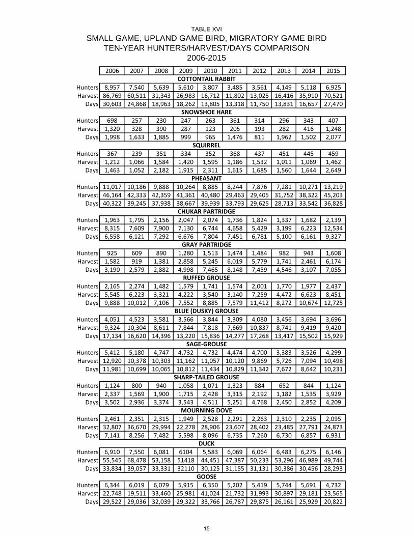
2006 2007 2008 2009 2010 2011 2012 2013 2014 2015
Hunters 8,957 7,540 5,639 5,610 3,807 3,485 3,561 4,149 5,118 6,925Harvest 86,769 60,511 31,343 26,983 16,712 11,802 13,025 16,416 35,910 70,521
Days 30,603 24,868 18,963 18,262 13,805 13,318 11,750 13,831 16,657 27,470
Hunters 698 257 230 247 263 361 314 296 343 407Harvest 1,320 328 390 287 123 205 193 282 416 1,248
Days 1,998 1,633 1,885 999 965 1,476 811 1,962 1,502 2,077
Hunters 367 239 351 334 352 368 437 451 445 459Harvest 1,212 1,066 1,584 1,420 1,595 1,186 1,532 1,011 1,069 1,462
Days 1,463 1,052 2,182 1,915 2,311 1,615 1,685 1,560 1,644 2,649
Hunters 11,017 10,186 9,888 10,264 8,885 8,244 7,876 7,281 10,271 13,219Harvest 46,164 42,333 42,359 41,361 40,480 29,463 29,405 31,752 38,322 45,203
Days 40,322 39,245 37,938 38,667 39,939 33,793 29,625 28,713 33,542 36,828
Hunters 1,963 1,795 2,156 2,047 2,074 1,736 1,824 1,337 1,682 2,139Harvest 8,315 7,609 7,900 7,130 6,744 4,658 5,429 3,199 6,223 12,534
Days 6,558 6,121 7,292 6,676 7,804 7,451 6,781 5,100 6,161 9,327
Hunters 925 609 890 1,280 1,513 1,474 1,484 982 943 1,608Harvest 1,582 919 1,381 2,858 5,245 6,019 5,779 1,741 2,461 6,174
Days 3,190 2,579 2,882 4,998 7,465 8,148 7,459 4,546 3,107 7,055
Hunters 2,165 2,274 1,482 1,579 1,741 1,574 2,001 1,770 1,977 2,437Harvest 5,545 6,223 3,321 4,222 3,540 3,140 7,259 4,472 6,623 8,451
Days 9,888 10,012 7,106 7,552 8,885 7,579 11,412 8,272 10,674 12,725
Hunters 4,051 4,523 3,581 3,566 3,844 3,309 4,080 3,456 3,694 3,696Harvest 9,324 10,304 8,611 7,844 7,818 7,669 10,837 8,741 9,419 9,420
Days 17,134 16,620 14,396 13,220 15,836 14,277 17,268 13,417 15,502 15,929
Hunters 5,412 5,180 4,747 4,732 4,732 4,474 4,700 3,383 3,526 4,299Harvest 12,920 10,378 10,303 11,162 11,057 10,120 9,869 5,726 7,094 10,498
Days 11,981 10,699 10,065 10,812 11,434 10,829 11,342 7,672 8,642 10,231
Hunters 1,124 800 940 1,058 1,071 1,323 884 652 844 1,124Harvest 2,337 1,569 1,900 1,715 2,428 3,315 2,192 1,182 1,535 3,929
Days 3,502 2,936 3,374 3,543 4,511 5,251 4,768 2,450 2,852 4,209
Hunters 2,461 2,351 2,315 1,949 2,528 2,291 2,263 2,310 2,235 2,095Harvest 32,807 36,670 29,994 22,278 28,906 23,607 28,402 23,485 27,791 24,873
Days 7,141 8,256 7,482 5,598 8,096 6,735 7,260 6,730 6,857 6,931
Hunters 6,910 7,550 6,081 6104 5,583 6,069 6,064 6,483 6,275 6,146Harvest 55,545 68,478 53,158 51418 44,451 47,387 50,233 53,296 46,989 49,744
Days 33,834 39,057 33,331 32110 30,125 31,155 31,131 30,386 30,456 28,293
Hunters 6,344 6,019 6,079 5,915 6,350 5,202 5,419 5,744 5,691 4,732Harvest 22,748 19,511 33,460 25,981 41,024 21,732 31,993 30,897 29,181 23,565
Days 29,522 29,036 32,039 29,322 33,766 26,787 29,875 26,161 25,929 20,822
SAGE-GROUSE
SMALL GAME, UPLAND GAME BIRD, MIGRATORY GAME BIRD
GOOSE
TABLE XVI
TEN-YEAR HUNTERS/HARVEST/DAYS COMPARISON2006-2015
MOURNING DOVE
DUCK
SHARP-TAILED GROUSE
COTTONTAIL RABBIT
SNOWSHOE HARE
SQUIRREL
PHEASANT
CHUKAR PARTRIDGE
GRAY PARTRIDGE
BLUE (DUSKY) GROUSE
RUFFED GROUSE
15

Valid Licenses*
Resident 37,105Nonresident 7,989
Total 45,094
*Includes lifetime, veteran and pioneer licenses
TABLE XVII
23,914 9,714 40.6%
18,064 6,914 38.3%5,850 2,800 47.9%
SMALL GAME & UPLAND GAME BIRD &MIGRATORY GAME BIRD
License Data Summary2015-2016
Number SurveyedNumber Usable
(hunters and nonhunters)Response Rate
(# Usable/# Surveyed)
16
WYOMING GAME AND FISH COMMISSION
CHAPTER 11
2015 UPLAND GAME BIRD AND SMALL GAME HUNTING SEASONS
Section 1. Authority. This regulation is promulgated by authority of W.S. § 23-1-302 and § 23-2-105(d).
Section 2. Hunting Regulations.
(a) Bag and Possession Limit. Only one (1) daily bag limit of each species of upland game birds and small game may be taken per day regardless of the number of hunt areas hunted in a single day. When hunting more than one (1) hunt area, a person’s daily and possession limits shall be equal to, but shall not exceed, the largest daily and possession limit prescribed for any one (1) of the specified hunt areas in which the hunting and possession occurs. (b) Evidence of sex and species shall remain naturally attached to the carcass of any upland game bird in the field and during transportation. For pheasant, this shall include the feathered head, feathered wing or foot. For all other upland game bird species, this shall include one fully feathered wing. (c) Nontoxic shot shall be required for hunting upland game birds and small game with a shotgun on all of the lands in the Springer and Table Mountain Wildlife Habitat Management Areas and on all national wildlife refuges open for hunting. No person shall possess shot shells loaded with shot other than nontoxic shot while hunting upland game birds or small game on all lands in the Springer and Table Mountain Wildlife Habitat Management Areas, and on national wildlife refuges. (d) Required Clothing. Any person hunting pheasants within the boundaries of any Wyoming Game and Fish Commission Wildlife Habitat Management Area, or on Bureau of Reclamation Withdrawal lands bordering and including Glendo State Park, shall wear in a visible manner at least one (1) outer garment of fluorescent orange color which shall include a hat, shirt, jacket, coat, vest or sweater.
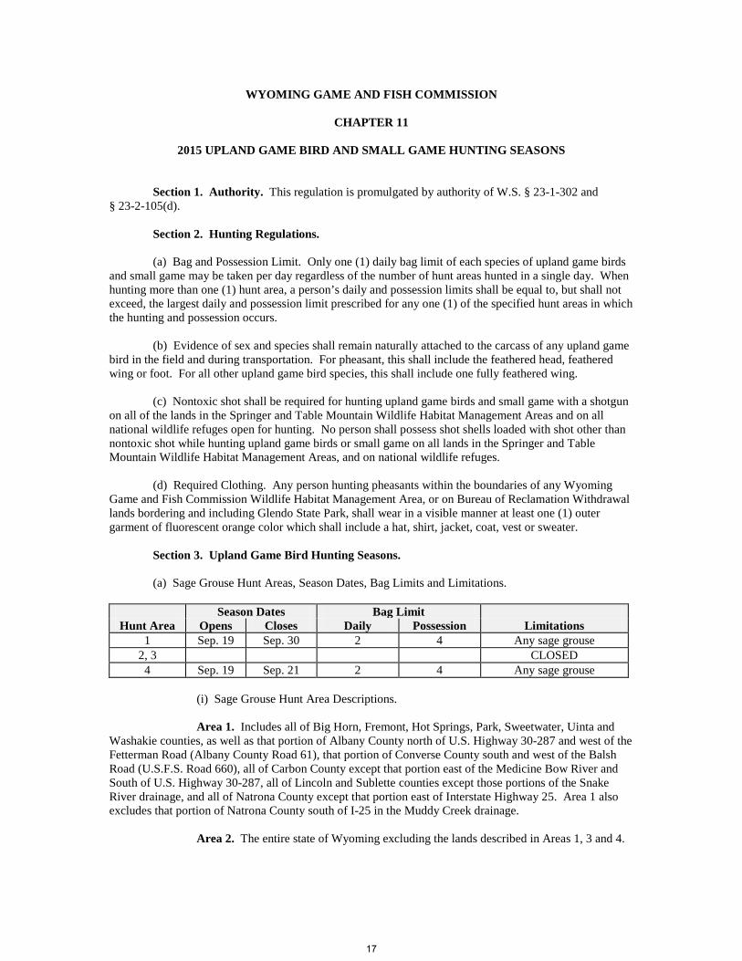
Section 3. Upland Game Bird Hunting Seasons. (a) Sage Grouse Hunt Areas, Season Dates, Bag Limits and Limitations.
Season Dates Bag Limit
Hunt Area Opens Closes Daily Possession Limitations 1 Sep. 19 Sep. 30 2 4 Any sage grouse
2, 3 CLOSED 4 Sep. 19 Sep. 21 2 4 Any sage grouse
(i) Sage Grouse Hunt Area Descriptions. Area 1. Includes all of Big Horn, Fremont, Hot Springs, Park, Sweetwater, Uinta and Washakie counties, as well as that portion of Albany County north of U.S. Highway 30-287 and west of the Fetterman Road (Albany County Road 61), that portion of Converse County south and west of the Balsh Road (U.S.F.S. Road 660), all of Carbon County except that portion east of the Medicine Bow River and South of U.S. Highway 30-287, all of Lincoln and Sublette counties except those portions of the Snake River drainage, and all of Natrona County except that portion east of Interstate Highway 25. Area 1 also excludes that portion of Natrona County south of I-25 in the Muddy Creek drainage. Area 2. The entire state of Wyoming excluding the lands described in Areas 1, 3 and 4.
17

Area 3. All lands in the Snake River drainage within Lincoln, Sublette and Teton counties. Area 4. Beginning at the intersection of the Sheridan-Big Horn County line with the Wyoming-Montana state line; easterly along said state line to the Rocky Point Road in Crook County; southerly along said road to the “D” Road; southerly along said road to Interstate Highway 90; easterly along said highway to U.S. Highway 16 at Moorcroft; southeasterly along said highway to U.S. Highway 85 at Newcastle; southerly along said highway to the Weston-Niobrara-Campbell-Converse-Natrona-Johnson County lines; westerly along said county lines to the Washakie-Johnson-Big-Horn-Sheridan County lines; northerly then northwesterly along said county lines to the Wyoming-Montana state line. (b) Blue Grouse Hunt Areas, Season Dates, Bag Limit and Limitations.
Season Dates Bag Limit Hunt Area Opens Closes Daily Possession Limitations
1 Sep. 1 Nov. 30 3 9 Any blue grouse (i) Blue Grouse Hunt Area Description.
Area 1. The entire state of Wyoming. (c) Ruffed Grouse Hunt Areas, Season Dates, Bag Limits and Limitations.
Season Dates Bag Limit Hunt Area Opens Closes Daily Possession Limitations
1 Sep. 1 Nov. 30 3 9 Any ruffed grouse (i) Ruffed Grouse Hunt Area Description. Area 1. The entire state of Wyoming. (d) Partridge Hunt Areas, Season Dates, Bag Limit and Limitations.
CHUKAR PARTRIDGE Season Dates Bag Limit
Hunt Area Opens Closes Daily Possession Limitations 1 Oct. 1 Jan. 31 5 15 Any chukar partridge
GRAY PARTRIDGE
Season Dates Bag Limit Hunt Area Opens Closes Daily Possession Limitations
1 Oct. 1 Jan. 31 5 15 Any gray partridge (i) Partridge Hunt Area Description. Area 1. The entire state of Wyoming.
18

(e) Sharp-Tailed Grouse Hunt Areas, Season Dates, Bag Limit and Limitations.
Season Dates Bag Limit
Hunt Area Opens Closes Daily Possession Limitations 1 Sep. 1 Dec. 31 3 9 Any sharp-tailed grouse
(i) Sharp-Tailed Grouse Hunt Area Description. Area 1. That portion of Wyoming east of the Continental Divide.
19
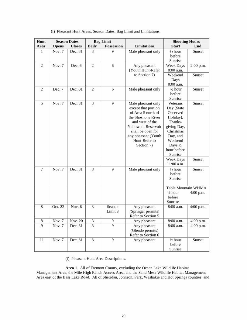
(f) Pheasant Hunt Areas, Season Dates, Bag Limit and Limitations. Hunt Area
Season Dates Opens Closes
Bag Limit Daily Possession
Limitations
Shooting Hours Start End
1 Nov. 7 Dec. 31 3 9 Male pheasant only ½ hour before Sunrise
Sunset
2 Nov. 7 Dec. 6 2 6 Any pheasant (Youth Hunt-Refer
to Section 7)
Week Days 8:00 a.m.
2:00 p.m.
Weekend Days
8:00 a.m.
Sunset
2 Dec. 7 Dec. 31 2 6 Male pheasant only ½ hour before Sunrise
Sunset
5 Nov. 7 Dec. 31 3 9 Male pheasant only except that portion of Area 5 north of
the Shoshone River and west of the
Yellowtail Reservoir shall be open for
any pheasant (Youth Hunt-Refer to
Section 7)
Veterans Day (State Observed Holiday), Thanks-
giving Day, Christmas Day, and Weekend Days ½
hour before Sunrise
Sunset
Week Days 11:00 a.m.
Sunset
7 Nov. 7 Dec. 31 3 9 Male pheasant only ½ hour before Sunrise
Sunset
Table Mountain WHMA ½ hour 4:00 p.m.
before Sunrise
8 Oct. 22 Nov. 6 3 Season Limit 3
Any pheasant (Springer permits) Refer to Section 5
8:00 a.m. 4:00 p.m.
8 Nov. 7 Nov. 20 3 9 Any pheasant 8:00 a.m. 4:00 p.m. 9 Nov. 7 Dec. 31 3 9 Any pheasant
(Glendo permits) Refer to Section 6
8:00 a.m. 4:00 p.m.
11 Nov. 7 Dec. 31 3 9 Any pheasant ½ hour before Sunrise
Sunset
(i) Pheasant Hunt Area Descriptions. Area 1. All of Fremont County, excluding the Ocean Lake Wildlife Habitat Management Area, the Mile High Ranch Access Area, and the Sand Mesa Wildlife Habitat Management Area east of the Bass Lake Road. All of Sheridan, Johnson, Park, Washakie and Hot Springs counties, and
20
all of Big Horn County excluding lands in the Yellowtail Wildlife Habitat Management Area north of U.S. Highway 14A. Area 2. All lands in the Ocean Lake Wildlife Habitat Management Area, the Mile High Ranch Access Area and all lands in the Sand Mesa Wildlife Habitat Management Area east of the Bass Lake Road. Area 5. All of the lands included in the Yellowtail Wildlife Habitat Management Area north of U.S. Highway 14A. Area 7. All of Goshen County excluding Hunt Area 8.
Area 8. All of the lands included in the Springer/Bump-Sullivan Wildlife Habitat Management Area. Area 9. All Bureau of Reclamation Withdrawal lands bordering and including Glendo State Park and the adjoining Department Private Lands/Public Wildlife Walk-in Area. Area 11. The entire State of Wyoming excluding the lands described in Areas 1, 2, 5, 7, 8 and 9.
(ii) Closed Areas. (A) The Ocean Lake Wildlife Habitat Management Area in Fremont County shall be closed during the period of December 15 through March 10 to all human presence within one-half (1/2) mile of the aerator on the ice and as marked by signs on Wyoming Game and Fish Commission lands around the aerator. Wyoming Game and Fish Department administrative access shall be allowed during this period. (B) The Downar Bird Farm and Springer Headquarters in Goshen County shall be closed to pheasant hunting as marked by signs. (C) Pond Number 1 and adjacent lands on the Table Mountain Wildlife Habitat Management Area in Goshen County, as marked by colored signs and posts, shall be closed to pheasant hunting after November 20. (D) The Sheridan Bird Farm in Sheridan County shall be closed to pheasant hunting, except during hunts sponsored and supervised by the Wyoming Game and Fish Department. Section 4. Pheasant Special Management Permit. A pheasant special management permit shall be required of any person, except those exempted in this section, who participates in the hunting of pheasants in those areas listed in subsection (a) of this section. Owners of lands enrolled in the Private Lands/Public Wildlife Walk-In Access Program, and members of their immediate families (landowner’s spouse, parents, grandparents, or lineal descendants and their spouses) are exempt from the requirement to obtain a pheasant special management permit when they are hunting pheasants on the deeded land of the landowner. The pheasant special management permit shall be in possession of any person while hunting pheasants, and shall be immediately produced for inspection upon request from any authorized Department representative. Any person purchasing a pheasant special management permit for the purpose set forth in this section shall validate the permit by signing that person’s name in ink across the face of the permit. Hunters who acquire a pheasant special management permit through the Electronic Licensing Service (ELS) shall not be required to meet the signature provision of this section. The permit shall be available at Headquarters, Department Regional Offices and designated license selling agents.
21
(a) Pheasant Special Management Permit Areas. A pheasant special management permit shall be required to hunt pheasants in the areas listed in this subsection: (i) Bud Love Wildlife Habitat Management Area in Johnson County. (ii) Glendo State Park; including all Bureau of Reclamation Withdrawal lands bordering the Park and the adjoining Department Private Lands/Public Wildlife Walk-In Area in Platte County. (iii) Ocean Lake Wildlife Habitat Management Area and the Mile High Ranch Access Area in Fremont County. (iv) Springer Wildlife Habitat Management Area in Goshen County. (v) Table Mountain Wildlife Habitat Management Area in Goshen County. (vi) Yellowtail Wildlife Habitat Management Area, excluding any private lands included within the Yellowtail Wildlife Habitat Management Area, in Bighorn County. (vii) All lands in the Sand Mesa Wildlife Habitat Management Area east of the Bass Lake Road in Fremont County. (viii) All lands opened to the hunting of pheasants that are enrolled in the Department’s Private Lands/Public Wildlife Walk-In Access Program, excluding Walk-In Access Areas in Big Horn, Fremont, Hot Springs, Park and Washakie counties on which pheasants are not released by the Department. (ix) All State lands in Johnson and Sheridan counties. (x) Welch Ranch Management Area in Sheridan County.
Section 5. Springer Permit Pheasant Season. There shall be a Springer permit pheasant season in Hunt Area 8 beginning October 22 through November 6. In order to participate in this season, a person shall possess and present upon request a valid Springer permit, a valid bird license and conservation stamp (unless otherwise exempted by state statute) and a pheasant special management permit. Persons born on or after January 1, 1966, shall possess and present upon request a hunter safety certificate. The Springer permit shall only be valid for the day printed on the permit by the Department.
(a) Application for Springer Permits. Applications shall be submitted through the Electronic Licensing Service (ELS) beginning August 15 and shall be accepted until 12:00 midnight September 15. A drawing shall be utilized to determine successful applicants. Only youths may apply for Springer permits for youth only hunt days as set forth in Section 5 (c) of this Chapter. A drawing shall be utilized to determine successful applicants. A person shall only submit a single application. Successful applicants shall be notified by mail of their hunting date and furnished a set of special instructions. (b) Issuance of Springer Permits. A maximum of one hundred twenty (120) permits shall be issued to successful applicants in the drawing for each day of the Springer permit pheasant season. A maximum of one hundred twenty (120) hunters shall be allowed to hunt at any one time during the Springer permit pheasant season. When a hunter checks out of the Springer Check Station, the Department may issue a permit to another person at the check station. If all one hundred twenty (120) permits for a single day have not been issued by the Department, or if the check station attendants are advised that a permitted hunter will not participate, the Department may issue a permit to another person at the check station on a first-come, first-served basis, not to exceed a maximum of one hundred twenty (120) permitted hunters. Permitted hunters may begin hunting at 8:00 a.m. Hunters who are issued permits through the drawing must check in at the check station by 9:00 a.m. on the date their permit is valid. Permits that are unclaimed after 9:00 a.m. shall be issued to other hunters on a first-come, first-served basis.
22

(c) Youth Only Hunt Days. Only youths shall be allowed to take pheasants on the youth hunt
days. Youths under the age of fourteen (14) shall be accompanied by an adult. No adult shall take any pheasant during the youth only hunt days. The youth only hunt days are October 24 and November 1. (d) Springer Check Station. The Springer Check Station is located one and one-quarter (1-1/4) miles west of U.S. Highway 85 on the south boundary of the Springer Wildlife Habitat Management Area. The hours of operation of the check station shall be from 7:00 a.m. to 4:30 p.m. daily during the Springer permit pheasant season. Persons participating in the Springer permit pheasant season shall check in at the check station prior to hunting. Prior to leaving the Springer permit pheasant area, each hunter shall check out at the check station by 4:30 p.m. on the same day that the hunter registered and shall accurately report all harvested pheasants and return all special hunt materials to the check station. (e) Parking Assignment. Parking lot assignments and tags shall be issued by the Department for each vehicle utilized by hunters. Parking lot tags shall be displayed in a visible manner in each vehicle. All vehicles shall be parked in assigned parking lots.
Section 6. Glendo Permit Pheasant Season. Glendo permits shall be required to hunt pheasants in Hunt Area 9 on each Friday, Saturday and Monday during the open season in November. Glendo permits are not required to hunt pheasants in Hunt Area 9 on other days during the open season. A person shall possess and present upon request a valid Glendo permit (on those days required), a valid bird license, a pheasant special management permit and conservation stamp (unless otherwise exempted by state statute). (a) Youth Only Hunt Days. Youth only hunt days shall be November 8, 15, 22 and 29. Only youths shall be allowed to take pheasants on youth hunt days. Youths under the age of fourteen (14) shall be accompanied by an adult. No adult shall take any pheasant during the youth only hunt days. No Glendo permit is required for youths to hunt on youth only hunt days. (b) Application for Glendo Permits. Applications shall be submitted through the ELS beginning August 15 and shall be accepted until 12:00 midnight September 15. A drawing shall be utilized to determine successful applicants. A person shall only submit a single application. No person shall apply for and receive more than one (1) Glendo permit in a calendar year. Successful applicants shall be notified by mail of their hunting date and furnished a set of special instructions. (c) Issuance of Glendo Permits. A maximum of sixty (60) permits shall be issued in the drawing for each day a permit is required. The Glendo permit shall only be valid for the day printed on the permit by the Department.
Section 7. Sand Mesa and Yellowtail Wildlife Habitat Management Areas Youth Pheasant Hunt. The youth only hunt day is November 21. Only youths shall be allowed to take pheasants on this date. Youths under the age of fourteen (14) shall be accompanied by an adult. No adults shall take any pheasant during the youth only hunt day. The youth hunt shall take place on all lands included in the Sand Mesa Wildlife Habitat Management Area east of the Bass Lake Road, and all lands included in the Yellowtail Wildlife Habitat Management Area north of the Shoshone River.
23

Section 8. Small Game Hunting Seasons. Small Game Species, Seasons Dates, Bag Limits and Limitations.
Season Dates Bag Limit
Species Opens Closes Daily Possession Limitations Cottontail Rabbit Sep. 1 Mar. 1 10 20 Any cottontail rabbit Snowshoe Hare Sep. 1 Mar. 1 4 8 Any snowshoe hare Red, Gray and Fox Squirrel
Sep. 1 Mar. 1 10 20 Any red, gray or fox squirrel
(i) Small Game Hunt Area Description. Area 1. The entire state of Wyoming. Section 9. Archery Regulations. Upland game birds and small game may be taken with archery equipment in accordance with limitations set forth in this Chapter. Section 10. Upland Game Bird and Small Game Falconry Seasons.
(a) Upland Game Birds may be taken with falcons in accordance with Section 3 of this Chapter. Persons hunting with falcons may take any pheasant.
(b) The falconry season shall open September 1 and close March 1 in those hunt areas listed in
Section 3 of this Chapter and Subsection 10(c) of this Chapter. (c) Closed Areas.
Pheasant Hunt Area Limitations 8, 9 Closed to falconry hunting
(d) The daily bag and possession limits for upland game birds other than sage grouse, shall be as
set forth in Section 3 of this Chapter. The daily bag limit shall be one (1) sage grouse and the possession limit shall be two (2) sage grouse.
(e) Persons taking sage grouse with falcons shall respond to Wyoming Game and Fish
Department surveys requesting harvest information.
24

(f) Small game animals may be taken with falcons in accordance with the open seasons in the table below.
Species
Falconry Season Dates
Bag Limit
Limitations Opens Closes Daily Possession Cottontail Rabbit Sep. 1 Mar. 1 10 20 Any cottontail rabbit
Mar. 2 Aug. 31 1 2 Any cottontail rabbit Snowshoe Hare Sep. 1 Mar. 1 10 20 Any snowshoe hare
Mar. 2 Aug. 31 1 2 Any snowshoe hare Red, Gray and Fox Squirrel
Sep. 1 Mar. 1 10 20 Any red, gray or fox squirrel
Mar. 2 Aug. 31 1 2 Any red, gray or fox squirrel
WYOMING GAME AND FISH COMMISSION
By: ______________________________________ Charles C. Price, President
Dated: April 22, 2015
25

WYOMING GAME AND FISH COMMISSION
CHAPTER 14
LATE MIGRATORY GAME BIRD HUNTING SEASONS
Section 1. Authority. This regulation is promulgated by authority of W.S. § 23-1-302 and § 23-2-105(d). Section 2. Hunting Regulations. (a) Federal Regulations. 16 USC 703-711 and 718a; 50 CFR 10 and 50 CFR 20, revised as of October 1, 2014, which do not include any later amendments or editions of the incorporated matter, governing the hunting, taking and possession of migratory birds and migratory game birds, the requirement for a valid federal migratory bird hunting and conservation stamp and the requirement for state participation in the National Harvest Information Program, are adopted as regulations of the Wyoming Game and Fish Commission. Violations of these federal statutes and regulations shall be violations of the Commission regulations. A copy of Title 50 of the Code of Federal Regulations can be viewed at Department Regional Offices.
(i) Automatic loading, pump, or repeating shotguns shall be plugged to admit no more than one (1) shell in the chamber and two (2) shells in the magazine. (ii) Federal Migratory Bird Hunting and Conservation Stamp. A federal duck stamp is required for persons sixteen (16) years of age and older to hunt ducks, geese and mergansers, but a federal duck stamp is not required to hunt coots, sandhill cranes, crows, mourning doves, rail or snipe. Federal duck stamps shall be signed in ink across the face of the stamp and shall be in possession of the hunter while in the field. (iii) National Migratory Bird Harvest Information Program. Each licensed hunter who hunts migratory game birds shall complete a current Wyoming validation for the National Harvest Information Program (HIP) and shall obtain a Wyoming HIP permit. This requirement also applies to holders of pioneer and lifetime hunting licenses. Each licensed hunter engaged in the act of hunting doves, ducks, geese, mergansers, coots, rails, cranes or snipe shall be in possession of a Wyoming HIP permit and shall immediately produce said permit upon request from any authorized Department representative. Each person obtaining a HIP permit for the purpose set forth in this section shall validate the permit by signing the person’s name in ink across the face of the permit. HIP permits expire on June 30 each year. HIP permits are not transferrable to other states. A separate validation is required from each state in which you hunt. Wyoming HIP permits shall be available only on the Department website. (b) Evidence of Species. One fully-feathered wing or the feathered head shall remain naturally attached to the carcass as a means of identification of migratory game birds, except mourning doves, in the field and while the birds are being transported. (c) Nontoxic Shot Restrictions.
(i) No person shall hunt ducks, geese, mergansers or coots while possessing shot shells loaded with shot other than nontoxic shot.
(d) Species and Hunt Areas, Season Dates, Bag Limit and Limitations. (i) For information regarding rail, snipe, sandhill crane and early Canada goose seasons, refer to Chapter 39, Early Migratory Game Bird Hunting Seasons.
26

(ii) Pacific Flyway
Species and Hunt Areas
Season Dates
Opens Closes
Closed Areas Section 3
Subsections
Bag Limit
Daily Possession PACIFIC FLYWAY
DUCKS and MERGANSERS*
Sep. 26 Jan. 8 d, e
7** 21**
COOTS
Sep. 26 Jan. 8 d, e 15 45
DARK GEESE Sep. 26 Dec. 31 d, e 3 9
* In the Pacific Flyway, the scaup season shall be closed except on the Special Youth Waterfowl Hunting Days and during the period September 26 through December 20 when the daily bag for scaup ducks shall be three (3) and shall be counted as part of the aggregate bag limit for ducks. ** The daily bag limit of seven (7) ducks and mergansers may include any combination of species with the following restrictions:
• no more than two (2) hen mallards; • no more than two (2) pintails; • no more than two (2) canvasbacks; • no more than two (2) redheads; and, • no more than three (3) scaup during the dates scaup may be taken.
(iii) Central Flyway Zones. The Central Flyway is divided into two (2) zones for the 2015-2016 season. Refer to the season dates for the zone in which you are hunting. (A) ZONE C1 shall include Big Horn, Converse, Goshen, Hot Springs, Natrona, Park, Platte and Washakie counties, and Fremont County excluding those portions south or west of the Continental Divide.
(B) ZONE C2 shall include Albany, Campbell, Crook, Johnson, Laramie,
Niobrara, Sheridan and Weston counties; and that portion of Carbon County east of the Continental Divide.
27
(iv) Central Flyway
Species and Hunt Areas
Season Dates
Opens Closes
Closed Areas Section 3
Subsections
Bag Limit
Daily Possession LIGHT GEESE Oct. 3 Dec. 31 b
a after Nov. 20 c after Nov. 14
10 30
Jan. 31 Feb. 14 a, b, c 10 30 ZONE C1
DUCKS Oct. 3 Oct. 21 b 6** 18**
Oct. 31 Jan. 16 b a after Nov. 20 c after Nov. 14
6** 18**
MERGANSERS Oct. 3 Oct. 21 b 5*** 15***
Oct. 31 Jan. 16 b a after Nov. 20 c after Nov. 14
5*** 15***
COOTS Oct. 3 Oct. 21 b 15 45
Oct. 31 Jan. 16 b a after Nov. 20 c after Nov. 14
15 45
DARK GEESE All counties in Zone C1 except Goshen and Platte counties
Oct. 3 Oct. 21 5 15
Oct. 31 Nov. 29 c after Nov. 14 5 15 Dec. 5 Jan. 29 c 5 15 DARK GEESE Goshen and Platte counties*
Oct. 3 Oct. 21 b 2 6
Nov. 21 Feb. 14 a, b 4 12 *For Bump-Sullivan Managed Goose Hunt information, see Section 6.
28

Species and Hunt Areas
Season Dates
Opens Closes
Closed Areas Section 3
Subsections
Bag Limit
Daily Possession ZONE C2
DUCKS
Sep. 26 Dec. 6 6** 18**
Dec. 12 Jan. 5 6** 18**
MERGANSERS Sep. 26 Dec. 6 5*** 15***
Dec. 12 Jan. 5 5*** 15***
COOTS
Sep. 26 Dec. 6 15 45
Dec. 12 Jan. 5 15 45
DARK GEESE
Sep. 26 Dec. 6 5 15
Dec. 12 Jan. 13 5 15
**The daily bag limit of six (6) ducks may include any combination of species with the following restrictions:
• no more than five (5) mallards of which not more than two (2) shall be
hens; • no more than two (2) pintails; • no more than three (3) wood ducks; • no more than two (2) canvasbacks; • no more than two (2) redheads; and, • no more than three (3) scaup. • two (2) blue-winged teal may be taken in addition to the regular limit of six
(6) ducks during the following dates: - Zone C1: October 3 – October 18 - Zone C2: September 26 – October 11
*** The daily bag limit of five (5) mergansers shall not include more than two (2) hooded mergansers. (e) Special Youth Waterfowl Hunting Days. In the Pacific Flyway and in Zone C2 of the Central Flyway, the special youth waterfowl hunting days are September 19-20, 2015. In Zone C1 of the Central Flyway, the special youth waterfowl hunting days are September 26-27, 2015. Only persons fifteen (15) years of age and younger may take ducks, mergansers, coots and geese (light geese cannot be taken in the Pacific Flyway) on the special youth waterfowl hunting days, subject to the following conditions: (i) All youth hunters shall be accompanied in the field by an adult at least eighteen (18) years of age. (ii) No more than four (4) youths shall be supervised by any one (1) adult. (iii) The adult shall not take ducks, coots, mergansers or geese, but may participate in other open seasons.
29
(iv) All license and stamp requirements, daily bag limits, species and sex restrictions, shooting hours and other regulations that apply to the regular duck and goose seasons, as defined for each flyway, shall apply during the special youth waterfowl hunting days. Exceptions: The additional blue-winged teal limit does not apply on the youth waterfowl hunting days. In Goshen and Platte counties, the daily bag limit for dark geese shall be four (4) on the youth waterfowl hunting days. (v) The areas described in Section 3(b), (d) and (e) shall be closed to hunting during youth days. Section 3. Description of Closed Areas. The areas described in this Section shall be closed for the species and dates specified in the tables in Section 2 and Section 5. (a) Goshen County (i) Hawk Springs Reservoir. Beginning where the east fence of the Union Pacific Railroad right-of-way meets the south fence enclosing Hawk Springs Reservoir; due east along said fence to Goshen County Road 51; northerly along said road to the access road to the northeast dam of the reservoir; southwesterly along said road to the northeast dam and the fence enclosing the reservoir; northwesterly along said fence to the second gate; southwesterly from said gate to the northwest corner of the fence enclosing the reservoir; southerly along said fence to the beginning point. (ii) Springer Reservoir. Beginning on U.S. Highway 85 at the George Marlatt farmhouse; westerly along the fence between the farm land and the pasture land to the west end of the west pump lake and Bump-Sullivan Ditch; southerly along said ditch to the Wyoming Game and Fish Department's Springer Wildlife Habitat Management Area (WHMA); westerly then southerly along the Springer WHMA boundary to Parking Area 3; southeasterly along the reservoir access road to the Game and Fish Department buildings; due south from said buildings across the Whispering Wings LLC property to the Fullmer Family Trust pasture fence; westerly along said fence to Goshen County Road 37; southerly along said road to Goshen County Road 42; easterly along said road to U.S. Highway 85; northerly along said highway to the George Marlatt farmhouse. See Section 6 regarding portions of the Springer WHMA that are outside the area described above. (iii) Pond No. 1 Table Mountain Wildlife Habitat Management Area. Pond No. l and adjacent lands as marked by colored signs and posts. (iv) Miller Lake (Glomill Reservoir). Miller Lake and all lands within three hundred (300) yards of the normal high water line. (v) North Platte River. That portion of the North Platte River and all lands within three hundred (300) yards of each bank of said river located between the two river crossings of Wyoming Highway 157.
(b) Platte County (i) Festo Lake. Festo Lake and all lands within three hundred (300) yards of the normal high water line shall be closed to all migratory game bird hunting. (ii) Wheatland Reservoir No. 1. Wheatland Reservoir No. 1 and all lands within three hundred (300) yards of the normal high water line shall be closed to hunting.
(c) Fremont County (i) Ocean Lake. The waters of Ocean Lake and the Wyoming Game and Fish Commission lands within approximately one-half (1/2) mile of the aeration system on the north side of the
30

lake shall be closed to migratory game bird hunting beginning November 15 through December 31 and January 1 through March 10 of each year. Beginning December 15 through March 10, the area shall be closed to all human presence, except for Wyoming Game and Fish Department administrative access, within one-half (1/2) mile of the aerator on the ice and as marked by signs on Wyoming Game and Fish Commisson lands around the aerator.
(d) Sweetwater County (i) Eden Reservoir. Eden Reservoir and all lands within three hundred (300) yards of the normal high water line shall be closed to all migratory game bird hunting.
(e) Lincoln County (i) Palisades Reservoir. Beginning at the junction of the McCoy Creek Road and U.S. Highway 89; northerly on U.S. Highway 89 for one and six-tenths (1.6) miles to the Palisades Reservoir high water line; westerly along said high water line to the Wyoming - Idaho state line; south along said state line to the McCoy Creek Road; southeasterly along the McCoy Creek Road to U.S. Highway 89 shall be closed to all migratory game bird hunting. Section 4. Shooting Hours. Except as provided in Section 4(a), shooting hours for all migratory game birds shall be as determined from the shooting hours table in Section 4(b). (a) Within the following areas: Goshen County north of Wyoming Highway 313 and County Road 28; that portion of Platte County west of Interstate Highway 25; and that portion of Platte County south of Wyoming Highway 160 (Gray Rocks Road) and Riverview Road (Platte County Road 271). Shooting hours for dark geese shall be from one-half (1/2) hour before sunrise to 1:00 p.m., except on the dates listed in subsections (i), (ii) and (iii), when shooting hours shall be from one-half (1/2) hour before sunrise to sunset as determined from the shooting hours table in subsection 4(b) – Area D. (i) October 3 through October 21. (ii) All Saturdays and Wednesdays from November 21 through December 31. (iii) All Saturdays, Sundays and Wednesdays from January 1 through the close of the dark goose season.
31

(b) 2015-2016 Shooting Hours Table. This table (including adjustments for daylight savings time) lists the official shooting hours adopted by the Wyoming Game and Fish Commission for migratory game bird hunting. (Do not use tables from other sources.)
ST = Starting Time QT = Quitting Time
AREA A AREA B AREA C AREA D ST QT ST QT ST QT ST QT September 1-7 6:17 7:49 6:11 7:43 6:03 7:35 5:57 7:29 8-14 6:24 7:37 6:18 7:31 6:10 7:23 6:04 7:17 15-21 6:32 7:24 6:26 7:18 6:18 7:10 6:12 7:04 22-30 6:41 7:09 6:35 7:03 6:27 6:55 6:21 6:49 October 1-7 6:50 6:56 6:44 6:50 6:36 6:42 6:30 6:36 8-14 6:58 6:44 6:52 6:38 6:44 6:30 6:38 6:24 15-21 7:06 6:32 7:00 6:26 6:52 6:18 6:46 6:12 22-31 7:17 6:19 7:11 6:13 7:03 6:05 6:57 5:59 November *1-7 6:27 5:08 6:21 5:02 6:13 4:54 6:07 4:48 8-14 6:36 5:00 6:30 4:54 6:22 4:46 6:16 4:40 15-21 6:44 4:54 6:38 4:48 6:30 4:40 6:24 4:34 22-30 6:54 4:48 6:48 4:42 6:40 4:34 6:34 4:28 December 1-7 7:03 4:45 6:57 4:39 6:49 4:31 6:43 4:25 8-14 7:10 4:45 7:04 4:39 6:56 4:31 6:50 4:25 15-21 7:15 4:47 7:09 4:41 7:01 4:33 6:55 4:27 22-31 7:19 4:52 7:13 4:46 7:05 4:38 6:59 4:32 January 1-7 7:20 4:58 7:14 4:52 7:06 4:44 7:00 4:38 8-14 7:19 5:06 7:13 5:00 7:05 4:52 6:59 4:46 15-21 7:16 5:13 7:10 5:07 7:02 4:59 6:56 4:53 22-31 7:09 5:25 7:03 5:19 6:55 5:11 6:49 5:05 February 1-7 7:01 5:36 6:55 5:30 6:47 5:22 6:41 5:16 8-14 6:52 5:45 6:46 5:39 6:38 5:31 6:32 5:25
*Start Mountain Standard Time AREA A - Lincoln, Sublette, Sweetwater, Teton, Uinta counties AREA B - Big Horn, Fremont, Hot Springs, Park, Washakie counties AREA C - Albany, Campbell, Carbon, Converse, Johnson, Natrona, Sheridan counties AREA D - Crook, Goshen, Laramie, Niobrara, Platte, Weston counties Section 5. Falconry Seasons. Migratory game birds may be taken by the use of trained raptors in the possession of properly licensed falconers during the regular hunting season set forth in Section 2 and special extended falconry seasons in accordance with the limitations in this Section, Section 4, Section 3 and Section 2(a) and (b) and the closures identified in Section 2(d). (a) Falconry Bag and Possession Limits. The daily bag limit shall not exceed three (3) migratory game birds in the aggregate nor shall the possession limit exceed nine (9) migratory game birds in the aggregate for falconry during the regular hunting season or special extended falconry seasons. The
32

falconry bag and possession limits are not in addition to the bag and possession limits listed in Section 2(d) and (e).
Species and Hunt Areas
Season Dates
Opens Closes
Closed Areas
AGGREGATE Bag Limit
Daily Possession ZONE C1 Central Flyway, Ducks, Mergansers and Coots
Sep. 26 Sep. 27 Limitations in Sections 2 and 3 shall apply
3** 9**
Oct. 22 Oct. 29
ZONE C2 Central Flyway, Ducks, Mergansers and Coots
Sep. 19 Sep. 25 Dec. 7 Dec. 9
Pacific Flyway, Ducks, Mergansers and Coots
Sep. 19 Sep. 20
**The daily bag and possession limits, singly or in the aggregate, may include any species and sex of ducks, geese, coots, mergansers, rail, snipe and mourning doves when seasons for these species are open. Section 6. Bump-Sullivan Managed Goose Hunt. Nineteen (19) numbered pits/blinds shall be available each day during the dark goose hunting season and shall be occupied on a first-come, first-served basis within the Bump-Sullivan Managed Goose Hunt Area in Goshen County. From November 21, 2015, through February 14, 2016, hunting during dark goose shooting hours shall only be allowed from pits/blinds except as noted below. Maps of pits/blinds shall be posted at the Springer Check Station one and one-quarter (1-1/4) miles west of Highway 85 on Goshen County Road 42, and at the established parking areas. The check station shall not be operated during the 2015-2016 goose hunting season. Hunters shall not be required to register or obtain a goose special management permit to participate in the Bump-Sullivan Managed Goose Hunt. If the Department determines the water level in Bump-Sullivan Reservoir has receded beyond ethical shooting distances from blinds 1-12, hunters shall be allowed to hunt from any location between the blind they have occupied and the water’s edge. In such an event, the Department shall post signs at the parking spot for each pit/blind. (a) Selection of pits/blinds. Hunters and hunting parties shall occupy pits/blinds by parking one vehicle directly in front of the post that is marked with the corresponding number of the pit/blind. Vehicles shall not be parked overnight to reserve a pit/blind. Vehicles shall also not be parked in front of the numbered post of a pit/blind other than the one the hunting party is occupying.
(b) Access to pits/blinds. Hunters shall only park in the established parking areas. No more than two (2) vehicles per pit/blind shall be allowed in the parking lots. No person shall drive a vehicle beyond the established parking areas during the goose and duck hunting seasons, except for Department administrative access. Hunters may use a non-motorized cart, watercraft or toboggan to transport decoys and other gear to and from the pit/blind. Hunters shall not change pits/blinds except by returning to the parking area and moving their vehicle to the numbered post corresponding to the new pit/blind.
33

(c) Leaving pits/blinds. Hunters may arrive at and depart from pits/blinds at any time, but while hunting, hunters shall remain at the pit/blind at all times except hunters may leave to arrange decoys, retrieve downed birds or to return to the parking lot. (d) Condition of pits/blinds. Hunters shall not damage or modify pits/blinds or use staples or nails to attach objects. It is permissible to move natural cover such as driftwood around or against the outside of a blind or pit. At the end of the hunt, all doors and lids shall be closed. (e) Commercial operations. No person shall conduct a commercially guided or outfitted hunt on the Bump-Sullivan Managed Goose Hunt area. (f) Trash removal. Hunters shall remove all trash or litter, including spent shell casings. (g) The Bump-Sullivan Managed Goose Hunt Area is open to light goose hunting during the Light Goose Conservation Order. Only the Bump-Sullivan Managed Goose Hunt Area including the portion of the Springer Wildlife Habitat Management Area south of Goshen County Road 42 is open to light goose hunting. Participants shall be required to park only in the established parking locations. Pits/blinds shall be occupied on a first-come, first-served basis, however participants are not required to hunt from the established pits or blinds. There shall be no registration requirement. Participants shall comply with all requirements set forth in Chapter 48, Light Goose Conservation Order.
WYOMING GAME AND FISH COMMISSION
By: ____________________________________ Charles C. Price, President
Dated: November 5, 2015
34

WYOMING GAME AND FISH COMMISSION
CHAPTER 14
LATE MIGRATORY GAME BIRD HUNTING SEASONS
EMERGENCY RULE
(Emergency Rules are no longer in effect 120 days after filing with the Secretary of State.)
Section 1. Authority. This regulation is promulgated by authority of W.S. § 23-1-302 and § 23-2-105(d). Section 2. Hunting Regulations. (a) Federal Regulations. 16 USC 703-711 and 718a; 50 CFR 10 and 50 CFR 20, revised as of October 1, 2014, which do not include any later amendments or editions of the incorporated matter, governing the hunting, taking and possession of migratory birds and migratory game birds, the requirement for a valid federal migratory bird hunting and conservation stamp and the requirement for state participation in the National Harvest Information Program, are adopted as regulations of the Wyoming Game and Fish Commission. Violations of these federal statutes and regulations shall be violations of the Commission regulations. A copy of Title 50 of the Code of Federal Regulations can be viewed at Department Regional Offices.
(i) Automatic loading, pump, or repeating shotguns shall be plugged to admit no more than one (1) shell in the chamber and two (2) shells in the magazine. (ii) Federal Migratory Bird Hunting and Conservation Stamp. A federal duck stamp is required for persons sixteen (16) years of age and older to hunt ducks, geese and mergansers, but a federal duck stamp is not required to hunt coots, sandhill cranes, crows, mourning doves, rail or snipe. Federal duck stamps shall be signed in ink across the face of the stamp and shall be in possession of the hunter while in the field. (iii) National Migratory Bird Harvest Information Program. Each licensed hunter who hunts migratory game birds shall complete a current Wyoming validation for the National Harvest Information Program (HIP) and shall obtain a Wyoming HIP permit. This requirement also applies to holders of pioneer and lifetime hunting licenses. Each licensed hunter engaged in the act of hunting doves, ducks, geese, mergansers, coots, rails, cranes or snipe shall be in possession of a Wyoming HIP permit and shall immediately produce said permit upon request from any authorized Department representative. Each person obtaining a HIP permit for the purpose set forth in this section shall validate the permit by signing the person’s name in ink across the face of the permit. HIP permits expire on June 30 each year. HIP permits are not transferrable to other states. A separate validation is required from each state in which you hunt. Wyoming HIP permits shall be available only on the Department website. (b) Evidence of Species. One fully-feathered wing or the feathered head shall remain naturally attached to the carcass as a means of identification of migratory game birds, except mourning doves, in the field and while the birds are being transported. (c) Nontoxic Shot Restrictions.
(i) No person shall hunt ducks, geese, mergansers or coots while possessing shot shells loaded with shot other than nontoxic shot.
35

(d) Species and Hunt Areas, Season Dates, Bag Limit and Limitations. (i) For information regarding rail, snipe, sandhill crane and early Canada goose seasons, refer to Chapter 39, Early Migratory Game Bird Hunting Seasons. (ii) Pacific Flyway
Species and Hunt Areas
Season Dates
Opens Closes
Closed Areas Section 3
Subsections
Bag Limit
Daily Possession PACIFIC FLYWAY
DUCKS and MERGANSERS*
Sep. 26 Jan. 8 d, e
7** 21**
COOTS
Sep. 26 Jan. 8 d, e 15 45
DARK GEESE Sep. 26 Dec. 31 d, e 3 9
* In the Pacific Flyway, the scaup season shall be closed except on the Special Youth Waterfowl Hunting Days and during the period September 26 through December 20 when the daily bag for scaup ducks shall be three (3) and shall be counted as part of the aggregate bag limit for ducks. ** The daily bag limit of seven (7) ducks and mergansers may include any combination of species with the following restrictions:
• no more than two (2) hen mallards; • no more than two (2) pintails; • no more than two (2) canvasbacks; • no more than two (2) redheads; and, • no more than three (3) scaup during the dates scaup may be taken.
(iii) Central Flyway Zones. The Central Flyway is divided into two (2) zones for the 2015-2016 season. Refer to the season dates for the zone in which you are hunting. (A) ZONE C1 shall include Big Horn, Converse, Goshen, Hot Springs, Natrona, Park, Platte and Washakie counties, and Fremont County excluding those portions south or west of the Continental Divide.
(B) ZONE C2 shall include Albany, Campbell, Crook, Johnson, Laramie,
Niobrara, Sheridan and Weston counties; and that portion of Carbon County east of the Continental Divide.
36
(iv) Central Flyway
Species and Hunt Areas
Season Dates
Opens Closes
Closed Areas Section 3
Subsections
Bag Limit
Daily Possession LIGHT GEESE Oct. 3 Dec. 31 b
a after Nov. 20 c after Nov. 14
10 30
Jan. 31 Feb. 14 a, b, c 10 30 ZONE C1
DUCKS Oct. 3 Oct. 21 b 6** 18**
Oct. 31 Jan. 16 b a after Nov. 20 c after Nov. 14
6** 18**
MERGANSERS Oct. 3 Oct. 21 b 5*** 15***
Oct. 31 Jan. 16 b a after Nov. 20 c after Nov. 14
5*** 15***
COOTS Oct. 3 Oct. 21 b 15 45
Oct. 31 Jan. 16 b a after Nov. 20 c after Nov. 14
15 45
DARK GEESE All counties in Zone C1 except Goshen and Platte counties
Oct. 3 Oct. 21 5 15
Oct. 31 Nov. 29 c after Nov. 14 5 15 Dec. 5 Jan. 29 c 5 15 DARK GEESE Goshen and Platte counties*
Oct. 3 Oct. 21 b 2 6
Nov. 21 Feb. 14 a, b 4 12 *For Bump-Sullivan Managed Goose Hunt information, see Section 6.
37

Species and Hunt Areas
Season Dates
Opens Closes
Closed Areas Section 3
Subsections
Bag Limit
Daily Possession ZONE C2
DUCKS
Sep. 26 Dec. 6 6** 18**
Dec. 12 Jan. 5 6** 18**
MERGANSERS Sep. 26 Dec. 6 5*** 15***
Dec. 12 Jan. 5 5*** 15***
COOTS
Sep. 26 Dec. 6 15 45
Dec. 12 Jan. 5 15 45
DARK GEESE
Sep. 26 Dec. 6 5 15
Dec. 12 Jan. 13 5 15
**The daily bag limit of six (6) ducks may include any combination of species with the following restrictions:
• no more than five (5) mallards of which not more than two (2) shall be
hens; • no more than two (2) pintails; • no more than three (3) wood ducks; • no more than two (2) canvasbacks; • no more than two (2) redheads; and, • no more than three (3) scaup. • two (2) blue-winged teal may be taken in addition to the regular limit of six
(6) ducks during the following dates: - Zone C1: October 3 – October 18 - Zone C2: September 26 – October 11
*** The daily bag limit of five (5) mergansers shall not include more than two (2) hooded mergansers. (e) Special Youth Waterfowl Hunting Days. In the Pacific Flyway and in Zone C2 of the Central Flyway, the special youth waterfowl hunting days are September 19-20, 2015. In Zone C1 of the Central Flyway, the special youth waterfowl hunting days are September 26-27, 2015. Only persons fifteen (15) years of age and younger may take ducks, mergansers, coots and geese (light geese cannot be taken in the Pacific Flyway) on the special youth waterfowl hunting days, subject to the following conditions: (i) All youth hunters shall be accompanied in the field by an adult at least eighteen (18) years of age. (ii) No more than four (4) youths shall be supervised by any one (1) adult. (iii) The adult shall not take ducks, coots, mergansers or geese, but may participate in other open seasons.
38

(iv) All license and stamp requirements, daily bag limits, species and sex restrictions, shooting hours and other regulations that apply to the regular duck and goose seasons, as defined for each flyway, shall apply during the special youth waterfowl hunting days. Exceptions: The additional blue-winged teal limit does not apply on the youth waterfowl hunting days. In Goshen and Platte counties, the daily bag limit for dark geese shall be four (4) on the youth waterfowl hunting days. (v) The areas described in Section 3(b), (d) and (e) shall be closed to hunting during youth days. Section 3. Description of Closed Areas. The areas described in this Section shall be closed for the species and dates specified in the tables in Section 2 and Section 5. (a) Goshen County (i) Hawk Springs Reservoir. Beginning where the east fence of the Union Pacific Railroad right-of-way meets the south fence enclosing Hawk Springs Reservoir; due east along said fence to Goshen County Road 51; northerly along said road to the access road to the northeast dam of the reservoir; southwesterly along said road to the northeast dam and the fence enclosing the reservoir; northwesterly along said fence to the second gate; southwesterly from said gate to the northwest corner of the fence enclosing the reservoir; southerly along said fence to the beginning point. (ii) Springer Reservoir. Beginning on U.S. Highway 85 at the George Marlatt farmhouse; westerly along the fence between the farm land and the pasture land to the west end of the west pump lake and Bump-Sullivan Ditch; southerly along said ditch to the Wyoming Game and Fish Department's Springer Wildlife Habitat Management Area (WHMA); westerly then southerly along the Springer WHMA boundary to Parking Area 3; southeasterly along the reservoir access road to the Game and Fish Department buildings; due south from said buildings across the Whispering Wings LLC property to the Fullmer Family Trust pasture fence; westerly along said fence to Goshen County Road 37; southerly along said road to Goshen County Road 42; easterly along said road to U.S. Highway 85; northerly along said highway to the George Marlatt farmhouse. See Section 6 regarding portions of the Springer WHMA that are outside the area described above. (iii) Pond No. 1 Table Mountain Wildlife Habitat Management Area. Pond No. l and adjacent lands as marked by colored signs and posts. (iv) Miller Lake (Glomill Reservoir). Miller Lake and all lands within three hundred (300) yards of the normal high water line. (v) North Platte River. That portion of the North Platte River and all lands within three hundred (300) yards of each bank of said river located between the two river crossings of Wyoming Highway 157.
(b) Platte County (i) Festo Lake. Festo Lake and all lands within three hundred (300) yards of the normal high water line shall be closed to all migratory game bird hunting. (ii) Wheatland Reservoir No. 1. Wheatland Reservoir No. 1 and all lands within three hundred (300) yards of the normal high water line shall be closed to hunting.
(c) Fremont County (i) Ocean Lake. The waters of Ocean Lake and the Wyoming Game and Fish Commission lands within approximately one-half (1/2) mile of the aeration system on the north side of the
39

lake shall be closed to migratory game bird hunting beginning November 15 through December 31 and January 1 through March 10 of each year. Beginning December 15 through March 10, the area shall be closed to all human presence, except for Wyoming Game and Fish Department administrative access, within one-half (1/2) mile of the aerator on the ice and as marked by signs on Wyoming Game and Fish Commisson lands around the aerator.
(d) Sweetwater County (i) Eden Reservoir. Eden Reservoir and all lands within three hundred (300) yards of the normal high water line shall be closed to all migratory game bird hunting.
(e) Lincoln County (i) Palisades Reservoir. Beginning at the junction of the McCoy Creek Road and U.S. Highway 89; northerly on U.S. Highway 89 for one and six-tenths (1.6) miles to the Palisades Reservoir high water line; westerly along said high water line to the Wyoming - Idaho state line; south along said state line to the McCoy Creek Road; southeasterly along the McCoy Creek Road to U.S. Highway 89 shall be closed to all migratory game bird hunting. Section 4. Shooting Hours. Except as provided in Section 4(a), shooting hours for all migratory game birds shall be as determined from the shooting hours table in Section 4(b). (a) Within the following areas: Goshen County north of Wyoming Highway 313 and County Road 28; that portion of Platte County west of Interstate Highway 25; and that portion of Platte County south of Wyoming Highway 160 (Gray Rocks Road) and Riverview Road (Platte County Road 271). Shooting hours for dark geese shall be from one-half (1/2) hour before sunrise to 1:00 p.m., except on the dates listed in subsections (i), (ii) and (iii), when shooting hours shall be from one-half (1/2) hour before sunrise to sunset as determined from the shooting hours table in subsection 4(b) – Area D. (i) October 3 through October 21. (ii) All Saturdays and Wednesdays from November 21 through December 31. (iii) All Saturdays, Sundays and Wednesdays from January 1 through the close of the dark goose season.
40

(b) 2015-2016 Shooting Hours Table. This table (including adjustments for daylight savings time) lists the official shooting hours adopted by the Wyoming Game and Fish Commission for migratory game bird hunting. (Do not use tables from other sources.)
ST = Starting Time QT = Quitting Time
AREA A AREA B AREA C AREA D ST QT ST QT ST QT ST QT September 1-7 6:17 7:49 6:11 7:43 6:03 7:35 5:57 7:29 8-14 6:24 7:37 6:18 7:31 6:10 7:23 6:04 7:17 15-21 6:32 7:24 6:26 7:18 6:18 7:10 6:12 7:04 22-30 6:41 7:09 6:35 7:03 6:27 6:55 6:21 6:49 October 1-7 6:50 6:56 6:44 6:50 6:36 6:42 6:30 6:36 8-14 6:58 6:44 6:52 6:38 6:44 6:30 6:38 6:24 15-21 7:06 6:32 7:00 6:26 6:52 6:18 6:46 6:12 22-31 7:17 6:19 7:11 6:13 7:03 6:05 6:57 5:59 November *1-7 6:27 5:08 6:21 5:02 6:13 4:54 6:07 4:48 8-14 6:36 5:00 6:30 4:54 6:22 4:46 6:16 4:40 15-21 6:44 4:54 6:38 4:48 6:30 4:40 6:24 4:34 22-30 6:54 4:48 6:48 4:42 6:40 4:34 6:34 4:28 December 1-7 7:03 4:45 6:57 4:39 6:49 4:31 6:43 4:25 8-14 7:10 4:45 7:04 4:39 6:56 4:31 6:50 4:25 15-21 7:15 4:47 7:09 4:41 7:01 4:33 6:55 4:27 22-31 7:19 4:52 7:13 4:46 7:05 4:38 6:59 4:32 January 1-7 7:20 4:58 7:14 4:52 7:06 4:44 7:00 4:38 8-14 7:19 5:06 7:13 5:00 7:05 4:52 6:59 4:46 15-21 7:16 5:13 7:10 5:07 7:02 4:59 6:56 4:53 22-31 7:09 5:25 7:03 5:19 6:55 5:11 6:49 5:05 February 1-7 7:01 5:36 6:55 5:30 6:47 5:22 6:41 5:16 8-14 6:52 5:45 6:46 5:39 6:38 5:31 6:32 5:25
*Start Mountain Standard Time AREA A - Lincoln, Sublette, Sweetwater, Teton, Uinta counties AREA B - Big Horn, Fremont, Hot Springs, Park, Washakie counties AREA C - Albany, Campbell, Carbon, Converse, Johnson, Natrona, Sheridan counties AREA D - Crook, Goshen, Laramie, Niobrara, Platte, Weston counties Section 5. Falconry Seasons. Migratory game birds may be taken by the use of trained raptors in the possession of properly licensed falconers during the regular hunting season set forth in Section 2 and special extended falconry seasons in accordance with the limitations in this Section, Section 4, Section 3 and Section 2(a) and (b) and the closures identified in Section 2(d). (a) Falconry Bag and Possession Limits. The daily bag limit shall not exceed three (3) migratory game birds in the aggregate nor shall the possession limit exceed nine (9) migratory game birds in the aggregate for falconry during the regular hunting season or special extended falconry seasons. The
41

falconry bag and possession limits are not in addition to the bag and possession limits listed in Section 2(d) and (e).
Species and Hunt Areas
Season Dates
Opens Closes
Closed Areas
AGGREGATE Bag Limit
Daily Possession ZONE C1 Central Flyway, Ducks, Mergansers and Coots
Sep. 26 Sep. 27 Limitations in Sections 2 and 3 shall apply
3** 9** Oct. 22 Oct. 29
ZONE C2 Central Flyway, Ducks, Mergansers and Coots
Sep. 19 Sep. 25 Dec. 7 Dec. 9
Pacific Flyway, Ducks, Mergansers and Coots
Sep. 19 Sep. 20
**The daily bag and possession limits, singly or in the aggregate, may include any species and sex of ducks, geese, coots, mergansers, rail, snipe and mourning doves when seasons for these species are open. Section 6. Bump-Sullivan Managed Goose Hunt. Nineteen (19) numbered pits/blinds shall be available each day during the dark goose hunting season and shall be occupied on a first-come, first-served basis within the Bump-Sullivan Managed Goose Hunt Area in Goshen County. From November 21, 2015, through February 14, 2016, hunting during dark goose shooting hours shall only be allowed from pits/blinds except as noted below. Maps of pits/blinds shall be posted at the Springer Check Station one and one-quarter (1-1/4) miles west of Highway 85 on Goshen County Road 42, and at the established parking areas. The check station shall not be operated during the 2015-2016 goose hunting season. Hunters shall not be required to register or obtain a goose special management permit to participate in the Bump-Sullivan Managed Goose Hunt. If the Department determines the water level in Bump-Sullivan Reservoir has receded beyond ethical shooting distances from blinds 1-12, hunters shall be allowed to hunt from any location between the blind they have occupied and the water’s edge. In such an event, the Department shall post signs at the parking spot for each pit/blind. (a) Selection of pits/blinds. Hunters and hunting parties shall occupy pits/blinds by parking one vehicle directly in front of the post that is marked with the corresponding number of the pit/blind. Vehicles shall not be parked overnight to reserve a pit/blind. Vehicles shall also not be parked in front of the numbered post of a pit/blind other than the one the hunting party is occupying.
(b) Access to pits/blinds. Hunters shall only park in the established parking areas. No more than two (2) vehicles per pit/blind shall be allowed in the parking lots. No person shall drive a vehicle beyond the established parking areas during the goose and duck hunting seasons, except for Department administrative access. Hunters may use a non-motorized cart, watercraft or toboggan to transport decoys and other gear to and from the pit/blind. Hunters shall not change pits/blinds except by returning to the parking area and moving their vehicle to the numbered post corresponding to the new pit/blind.
42

(c) Leaving pits/blinds. Hunters may arrive at and depart from pits/blinds at any time, but while hunting, hunters shall remain at the pit/blind at all times except hunters may leave to arrange decoys, retrieve downed birds or to return to the parking lot. (d) Condition of pits/blinds. Hunters shall not damage or modify pits/blinds or use staples or nails to attach objects. It is permissible to move natural cover such as driftwood around or against the outside of a blind or pit. At the end of the hunt, all doors and lids shall be closed. (e) Commercial operations. No person shall conduct a commercially guided or outfitted hunt on the Bump-Sullivan Managed Goose Hunt area. (f) Trash removal. Hunters shall remove all trash or litter, including spent shell casings. (g) The Bump-Sullivan Managed Goose Hunt Area is open to light goose hunting during the Light Goose Conservation Order. Only the Bump-Sullivan Managed Goose Hunt Area including the portion of the Springer Wildlife Habitat Management Area south of Goshen County Road 42 is open to light goose hunting. Participants shall be required to park only in the established parking locations. Pits/blinds shall be occupied on a first-come, first-served basis, however participants are not required to hunt from the established pits or blinds. There shall be no registration requirement. Participants shall comply with all requirements set forth in Chapter 48, Light Goose Conservation Order.
WYOMING GAME AND FISH COMMISSION
By: ____________________________________ Charles C. Price, President
Dated: August 5, 2015
43

WYOMING GAME AND FISH COMMISSION
CHAPTER 39
EARLY MIGRATORY GAME BIRD HUNTING SEASONS Section 1. Authority. This regulation is promulgated by authority of W.S. § 23-1-302 and § 23-2-105(d). Section 2. Hunting Regulations. (a) Federal Regulations. 16 USC 703-711 and 718a; 50 CFR 10, 50 CFR 20 revised as of October 1, 2014, which do not include any later amendments or editions of the incorporated matter, governing the hunting, taking and possession of migratory birds and migratory game birds, the requirement for a valid migratory bird hunting and conservation stamp and the requirement for state participation in the National Harvest Information Program are adopted as regulations of the Wyoming Game and Fish Commission. Violations of these federal statutes and regulations shall be violations of the Commission regulations. A copy of Title 50 of the Code of Federal Regulations can be viewed at Department Regional Offices. (i) Automatic loading, pump, or repeating shotguns shall be plugged to admit no more than one (1) shell in the chamber and two (2) shells in the magazine. (ii) Federal Migratory Bird Hunting and Conservation Stamp. A federal duck stamp is required for persons sixteen (16) years of age and older to hunt ducks, geese and mergansers, but a federal duck stamp is not required to hunt coots, sandhill cranes, crows, mourning doves, rail or snipe. (iii) National Migratory Bird Harvest Information Program. Each licensed hunter who hunts migratory game birds shall complete a current Wyoming validation for the National Harvest Information Program (HIP) and shall obtain a Wyoming HIP permit. This requirement also applies to holders of pioneer and lifetime hunting licenses. Each licensed hunter engaged in the act of hunting doves, ducks, geese, mergansers, coots, rails, cranes or snipe shall be in possession of a Wyoming HIP permit and shall immediately produce said permit upon request from any authorized Department representative. Each person obtaining a HIP permit for the purpose set forth in this section shall validate the permit by signing the person’s name in ink across the face of the permit. HIP permits expire on June 30 each year. HIP permits are not transferrable to other states. A separate validation is required from each state in which you hunt. Wyoming HIP permits shall be available only on the Department’s website at http://wgfd.wyo.gov. (b) Evidence of Species. One fully-feathered wing or the feathered head shall remain naturally attached to the carcass as a means of identification of migratory game birds, except mourning doves, in the field and while the birds are being transported. (c) Nontoxic Shot Restrictions. (i) No person shall hunt, ducks, geese, mergansers or coots while possessing shot shells loaded with shot other than nontoxic shot. (d) Limited Quota Sandhill Crane Permits. Persons may apply for limited quota sandhill crane permits on the Department’s website at http://wgfd.wyo.gov between 8:00 a.m. July 1 and 12:00 midnight July 31, 2015. Party applications shall be accepted. Maximum party size shall be two (2). Party applications shall specify the same hunt area preference.
44
(e) General Sandhill Crane Permits. Permits to hunt in the general sandhill crane season (Hunt Area 7) shall be available only on the Department’s website at http://wgfd.wyo.gov after August 1. (f) Species, Hunt Areas and Limitations, Season Dates, Shooting Hours, Closed Areas, and Bag Limit. (i) Mourning Dove, Rail and Snipe – Statewide
MOURNING DOVE, RAIL AND SNIPE
Species, Hunt Areas and Limitations
Season Dates
Shooting
Hours
Closed Areas Section 3
Subsections
Bag Limit
Opens Closes Daily Possession MOURNING DOVE - STATEWIDE
Sep. 1 Nov. 9 See Sec. 4 b, d, e 15 45
SORA AND VIRGINIA RAIL - STATEWIDE
Sep. 1 Nov. 9 See Sec. 4 b, d, e
25
75
SNIPE – STATEWIDE
Sep. 1 Dec. 16 See Sec. 4 b, d, e a - after Nov.
20 c - after Nov.
14
8
24
(ii) Sandhill Crane – Central and Pacific Flyways (see Section 6 for hunt area descriptions)
LIMITED QUOTA SANDHILL CRANE SEASONS
Hunt Areas and Limitations
Permit Quota
Season Dates
Shooting
Hours
Closed Areas Section 3
Subsections
Season
Bag Limit Opens Closes Hunt Area 1 – Limited quota permits
20 Sep. 1 Sep. 8 See Sec. 4 1
Hunt Area 2 – Limited quota permits
20 Sep. 1
Sep. 8 See Sec. 4 e 1
Hunt Area 3 – Limited quota permits
45 Sep. 1 Sep. 8 See Sec. 4 d 1
Hunt Area 4 – Limited quota permits
60 Sep. 19 Oct. 11 See Sec. 4 1
Hunt Area 5 – Limited quota permits
10 Sep. 1 Sep. 8 See Sec. 4 1
Hunt Area 6 – Limited quota permits
60 Sep. 19 Oct. 11 See Sec. 4 1
GENERAL SANDHILL CRANE SEASON
Hunt Areas
and Limitations
Season Dates
Shooting
Hours
Closed Areas Section 3
Subsections
Bag Limits
Opens Closes Daily Possession Hunt Area 7 – Permit required
Sep. 19 Nov. 15 See Sec. 4 b 3 9
45

(iii) Early Canada Goose – Pacific Flyway
EARLY CANADA GOOSE – ANY CANADA GOOSE OR CACKLING GOOSE
Hunt Areas and Limitations
Season Dates
Shooting
Hours
Closed Areas Section 3
Subsections
Bag Limit
Opens Closes Daily Possession Pacific Flyway – All counties except Teton County
Sep. 1 Sep. 8 See Sec. 4 d, e
2
6
Teton County Sep. 1 Sep. 8 See Sec. 4 3 9 (g) Permits. All persons, regardless of age, hunting sandhill cranes shall possess a permit valid for the area in which they are hunting. No person shall apply for or receive more than one (1) limited quota permit to hunt sandhill cranes. A person may also obtain a permit valid for the general sandhill crane season in Hunt Area 7. (h) Tagging Sandhill Cranes. When a sandhill crane is killed under a limited quota permit, the permittee shall detach, sign and date the proper coupon and attach the coupon to the carcass before leaving the site of kill. The coupon shall remain on the crane carcass at all times until the meat undergoes processing, except that during transportation of the carcass the coupon may be removed to prevent its loss. If the coupon is removed for transportation of the carcass, it must be in possession of the person accompanying the carcass at all times. When dating a carcass coupon, the entire wedge or block shall be cut out for the date and the month of kill. The carcass coupon shall be attached to the carcass of a crane in such a manner as to be plainly visible. Sandhill cranes killed during the general crane season in Hunt Area 7 are not required to be tagged. Section 3. Description of Closed Areas. The areas described in this Section shall be closed for the species and dates specified in the tables in Section 2 and Section 5.
(a) Goshen County (i) Hawk Springs Reservoir. Beginning where the east fence of the Union Pacific Railroad right-of-way meets the south fence enclosing Hawk Springs Reservoir; due east along said fence to Goshen County Road 51; northerly along said road to the access road to the northeast dam of the reservoir; southwesterly along said road to the northeast dam and the fence enclosing the reservoir; northwesterly along said fence to the second gate; southwesterly from said gate to the northwest corner of the fence enclosing the reservoir; southerly along said fence to the beginning point. (ii) Springer Reservoir. Beginning on U.S. Highway 85 at the George Marlatt farmhouse; westerly along the fence between the farm land and the pasture land to the west end of the west pump lake and Bump-Sullivan ditch; southerly along said ditch to the Wyoming Game and Fish Department's Springer Wildlife Habitat Management Area (WHMA); westerly then southerly along the Springer WHMA boundary to Parking Area 3; southeasterly along the reservoir access road to the Game and Fish Department buildings; due south from said buildings across the Whispering Wings LLC property to the Fulmer family trust pasture fence; westerly along said fence to Goshen County Road 37; southerly along said road to Goshen County Road 42; easterly along said road to U.S. Highway 85; northerly along said highway to the George Marlatt farmhouse. Also that portion of the Springer WHMA south of Goshen County Road 42. (iii) Pond No. 1 Table Mountain Wildlife Habitat Management Area. Pond No. l and adjacent lands as marked by colored signs and posts. (iv) Miller Lake (Glomill Reservoir). Miller Lake and all lands within three hundred (300) yards of the normal high water line.
46
(v) North Platte River. That portion of the North Platte River and all lands within three hundred (300) yards of each bank of said river located between the two river crossings of Wyoming Highway 157.
(b) Platte County (i) Festo Lake. Festo Lake and all lands within three hundred (300) yards of the normal high water line shall be closed to all migratory game bird hunting. (ii) Wheatland Reservoir No. 1. Wheatland Reservoir No. 1 and all lands within three hundred (300) yards of the normal high water line shall be closed to hunting.
(c) Fremont County (i) Ocean Lake. The waters of Ocean Lake and the Wyoming Game and Fish Commission lands within approximately one-half (1/2) mile of the aeration system on the north side of the lake shall be closed to migratory game bird hunting beginning November 15 through December 31 and January 1 through March 10 of each year. Beginning December 15 through March 10, the area shall be closed to all human presence, except for Wyoming Game and Fish Department administrative access, within one-half (1/2) mile of the aerator on the ice and as marked by signs on Commisson lands around the aerator.
(d) Sweetwater County (i) Eden Reservoir. Eden Reservoir and all lands within three hundred (300) yards of the normal high water line shall be closed to all migratory game bird hunting. (ii) Seedskadee National Wildlife Refuge. All lands within Seedskadee National Wildlife Refuge shall be closed to goose hunting during the early Canada goose season.
(e) Lincoln County (i) Palisades Reservoir. Beginning at the junction of the McCoy Creek Road and U.S. Highway 89; northerly on U.S. Highway 89 for 1.6 miles to the Palisades Reservoir high water line; westerly along said high water line to the Wyoming-Idaho state line; southerly along said state line to the McCoy Creek Road; southeasterly along the McCoy Creek Road to U.S. Highway 89 shall be closed to all migratory game bird hunting.
47
Section 4. Shooting Hours. Shooting hours for the hunting of all migratory game birds shall be as determined from the shooting hours table in this section. (a) 2015 Shooting Hours Table. This table (including adjustments for daylight savings time) lists the official shooting hours adopted by the Wyoming Game and Fish Commission for the taking of migratory game birds. (Do not use tables from other sources.)
ST = Starting Time QT = Quitting Time
AREA A AREA B AREA C AREA D ST QT ST QT ST QT ST QT
September 1-7 6:17 7:49 6:11 7:43 6:03 7:35 5:57 7:29 8-14 6:24 7:37 6:18 7:31 6:10 7:23 6:04 7:17 15-21 6:32 7:24 6:26 7:18 6:18 7:10 6:12 7:04 22-30 6:41 7:09 6:35 7:03 6:27 6:55 6:21 6:49 October 1-7 6:50 6:56 6:44 6:50 6:36 6:42 6:30 6:36 8-14 6:58 6:44 6:52 6:38 6:44 6:30 6:38 6:24 15-21 7:06 6:32 7:00 6:26 6:52 6:18 6:46 6:12 22-31 7:17 6:19 7:11 6:13 7:03 6:05 6:57 5:59 November *1-7 6:27 5:08 6:21 5:02 6:13 4:54 6:07 4:48 8-14 6:36 5:00 6:30 4:54 6:22 4:46 6:16 4:40 15-21 6:44 4:54 6:38 4:48 6:30 4:40 6:24 4:34 22-30 6:54 4:48 6:48 4:42 6:40 4:34 6:34 4:28 December 1-7 7:03 4:45 6:57 4:39 6:49 4:31 6:43 4:25 8-16 7:11 4:45 7:03 4:39 6:57 4:31 6:51 4:25
*Start Mountain Standard Time AREA A - Lincoln, Sublette, Sweetwater, Teton, Uinta counties AREA B - Big Horn, Fremont, Hot Springs, Park, Washakie counties AREA C - Albany, Campbell, Carbon, Converse, Johnson, Natrona, Sheridan counties AREA D - Crook, Goshen, Laramie, Niobrara, Platte, Weston counties Section 5. Falconry Seasons. Migratory game birds may be taken by the use of falcons during the regular hunting season and special extended seasons in accordance with the limitations in this Section, Section 4, Section 3, Section 2 (a), (b) and (g) and the closures identified in Section 2 (f). No person shall be in possession of any firearm while hunting with a falcon.
48
(a) Falconry Bag and Possession Limits. The daily bag limit shall not exceed three (3) migratory game birds in the aggregate nor shall the possession limit exceed nine (9) migratory game birds in the aggregate for falconry during the open hunting season or special extended falconry season. The falconry bag and possession limits are not in addition to the bag and possession limits listed in Section 2, Hunting Regulations.
FALCONRY
Species and Hunt Areas
Season Dates
Open Hours
Closed Areas
AGGREGATE Bag Limit
Opens Closes Daily Possession Mourning Doves - Statewide
Sep. 1 Nov. 9 See Sec. 4
Limitations in Sections 2 and 3 shall apply
3** 9**
Sora Rail, Virginia Rail and Snipe - Statewide
Sep. 1 Dec. 16
Dark Geese - Pacific Flyway
Sep. 1 Sep. 8
**The daily bag and possession limits, singly or in the aggregate, may include any species and sex of ducks, geese, coots, mergansers, rail, snipe and mourning doves when seasons for those species are open. Section 6. Hunt Area Descriptions. General and Limited Quota Sandhill Crane Areas. (i) Area 1. All of the Bear River and Ham’s Fork River drainages in Lincoln County. (ii) Area 2. All of the Salt River drainage in Lincoln County south of the McCoy Creek Road. (iii) Area 3. All lands within the Bureau of Reclamation’s Eden Project in Sweetwater County. (iv) Area 4. All lands within the Bureau of Reclamation’s Riverton and Boysen Unit boundaries; those lands within Boysen State Park south of Cottonwood Creek, west of Boysen Reservoir, and south of U.S. Highway 20-26; and all non-Indian owned fee title lands within the exterior boundaries of the Wind River Reservation, excluding those lands within Hot Springs County. (v) Area 5. All of Uinta County. (vi) Area 6. All of Big Horn, Hot Springs, Park and Washakie counties. (vii) Area 7. All of Campbell, Converse, Crook, Goshen, Laramie, Niobrara, Platte and Weston counties.
WYOMING GAME AND FISH COMMISSION
By: ______________________________________ Charles C. Price, President Dated: April 22, 2015
49


Please respond online or via mail by October 15, 2015.
Please complete the survey ONLINE, as that saves us considerable expense for postage and data entry. Go
to wgfd.wyo.gov/Hunting/HarvestSurvey and use the ONLINE Password provided above to access your survey. If you are unable to complete your survey online, use the
enclosed envelope to return this completed form. If you have questions or prefer to complete it over the
phone, contact Gail Sheridan, Harvest Survey Coordinator, at 307-777-4567 or email: [email protected]
WYOMING GAME AND FISH DEPARTMENT LIMITED QUOTA SANDHILL CRANE HARVEST SURVEY
Your ONLINE Password is:
WGFD Statewide Wildlife & Habitat Management
Program 5400 Bishop Blvd
Cheyenne, WY 82006
Note: These questions pertain to your limited quota license only. If you also had an Area 7 crane permit, you will receive a separate survey for that permit.
Each year the Wyoming Game & Fish Department conducts harvest surveys to help set hunting seasons. Your participation provides key data we need to manage game populations. Your response is important even if you were unable to hunt this year.
Name:___________________________________________________________________________________________
Address:_________________________________________________________________________________________
City:_______________________________________________ State:_____ Zip Code:__________________________
License Number:_______________________________________________
Q1 Did you hunt the early crane season? ________Yes _________No
Q2 What area did you hunt? (Check One) _____1. Bear/Ham’s Fork River _____2. Salt River (Afton) _____3. Farson/Eden _____4. Riverton Area _____5. Uinta _____6. Big Horn Basin
Q3. Number of days hunted: _________
Q4. Did you harvest a crane? _____Yes _____No
Q5. If you hunted and harvested a crane during the season, was it: (Check One) _____Adult (bright red crown on top of head) _____Juvenile (top of head gray or reddish brown)
Q6. Indicate the number of cranes knocked down but not retrieved: _____
Comments: ________________________________________________________________________________________________ ________________________________________________________________________________________________ ________________________________________________________________________________________________
51

1 2 3 4 5 6Bear River Salt River Farson Riverton Uinta Bighorn
Permits Available 20 20 45 60 10 60 215Permits Issued 20 20 45 60 11 60 216Total Applicants 47 67 127 163 44 176 624Total Responses 14 14 23 30 6 23 110Response Rate 0.70 0.70 0.51 0.50 0.55 0.38 0.51Active Hunters 16 16 33 36 6 57 164# Days Hunted 36 37 51 104 22 125 375Days/Hunter 2.3 2.4 1.5 2.9 4.0 2.2 2.3Adult Harvest 7 7 20 14 2 29 78Juvenile Harvest 3 4 10 6 0 3 26Unretrieved Harvest 0 0 0 0 0 3 3
Total Retrieved Harvest 10 11 29 20 2 31 104Hunter Success 64% 73% 88% 56% 33% 55% 64%Permit Success 50% 57% 65% 33% 17% 52% 48%
52
NOTE: Due to rounding during the derivation of the final estimates, area values may not equal totals.
TABLE I
WYOMING ROCKY MOUNTAIN POPULATION OF SANDHILL CRANE HARVEST/HUNTER ACTIVITY
Projected estimates from harvest questionnaires
Hunt Area
Averages/Total
2015
52
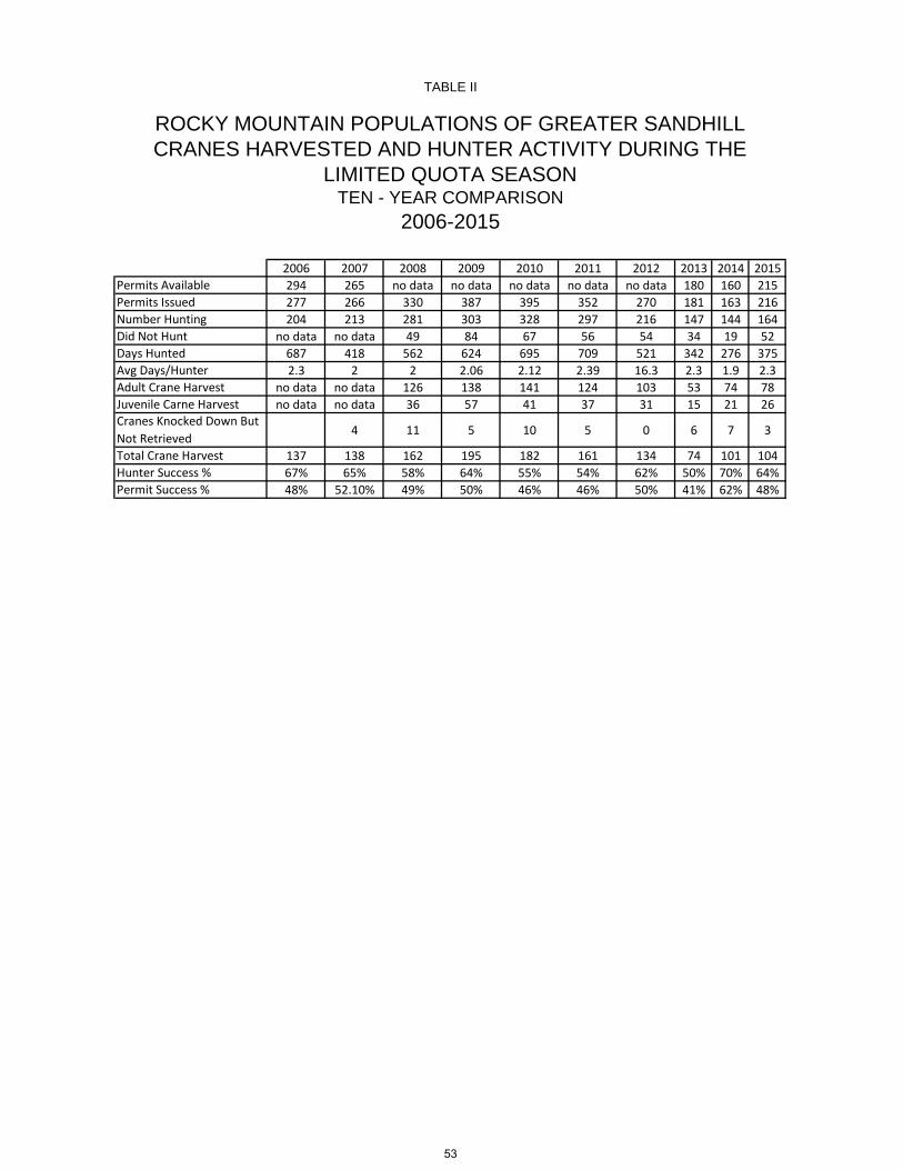
2006 2007 2008 2009 2010 2011 2012 2013 2014 2015Permits Available 294 265 no data no data no data no data no data 180 160 215Permits Issued 277 266 330 387 395 352 270 181 163 216Number Hunting 204 213 281 303 328 297 216 147 144 164Did Not Hunt no data no data 49 84 67 56 54 34 19 52Days Hunted 687 418 562 624 695 709 521 342 276 375Avg Days/Hunter 2.3 2 2 2.06 2.12 2.39 16.3 2.3 1.9 2.3Adult Crane Harvest no data no data 126 138 141 124 103 53 74 78Juvenile Carne Harvest no data no data 36 57 41 37 31 15 21 26Cranes Knocked Down But Not Retrieved 4 11 5 10 5 0 6 7 3
Total Crane Harvest 137 138 162 195 182 161 134 74 101 104Hunter Success % 67% 65% 58% 64% 55% 54% 62% 50% 70% 64%Permit Success % 48% 52.10% 49% 50% 46% 46% 50% 41% 62% 48%
ROCKY MOUNTAIN POPULATIONS OF GREATER SANDHILL CRANES HARVESTED AND HUNTER ACTIVITY DURING THE
LIMITED QUOTA SEASONTEN - YEAR COMPARISON
2006-2015
TABLE II
53

To reference regulations pertaining to sandhill cranes, see “Chapter 39 – Early Migratory Game Bird Hunting Seasons”on page 43.
54

1
WYOMING GAME AND FISH DEPARTMENT
5400 Bishop Blvd. Cheyenne, WY 82006
Phone: (307) 777-4600 Fax: (307) 777-4699
Web site: http://wgfd.wyo.gov
GOVERNOR MATTHEW H. MEAD
DIRECTOR
SCOTT TALBOTT COMMISSIONERS AARON CLARK – President MIKE HEALY – Vice President RICHARD KLOUDA FRED LINDZEY T. CARRIE LITTLE ED MIGNERY CHARLES PRICE
Dear Hunter:
Our records indicate you purchased a 2016 Light Goose Conservation Order Special
Management Permit. Printed on that permit are the instructions to complete your harvest survey
online as soon as you are done hunting. So far, we have not received your online survey
responses. Chapter 48, Section 3(c) of the Wyoming Game and Fish Regulation requires that
you accurately complete the survey by April 22, 2016. You are required to complete this survey
even if you did not hunt or harvest any light geese. Please complete this as soon as possible.
Please go to wgfd.wyo.gov/harvestsurvey/ to complete your survey online. The online
method is the most efficient and cost effective. You will need your SPID number and 2016
Conservation Order License number to access the online survey.
Your SPID Number is: «SPORTSMAN_ID»
Your 2016 Conservation Order License Number is: «PERMIT»
If you are unable to complete this survey online, complete the questions on the back of this letter
and return it in the postage-paid envelope provided.
The survey is required by the U.S. Fish and Wildlife Service in order to closely monitor hunter
participation and the number of light geese taken during the Conservation Order. The biological
information we collect through this survey is essential to measure progress toward population
goals for light geese.
Your participation is appreciated.
Sincerely,
Gail Sheridan
Harvest Survey Coordinator
(307) 777-4567
55

1. Did you hunt Light Geese with your Conservation Order Special Management Permit?
_____Yes _____No (if No, your survey is complete)
2. Number of days you hunted: _____
3. Number of Light Geese you harvested: _____
4. Number of Light Geese knocked down but not retrieved: _____
Thank you for your help with this important study.
56
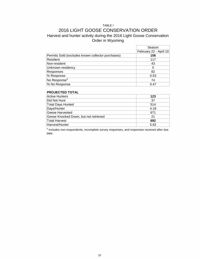
Season February 22 - April 10
Permits Sold (excludes known collector purchases) 156Resident 117Non-resident 43Unknown residency 0Responses 82% Response 0.53No Responsea 74% No Response 0.47
PROJECTED TOTALActive Hunters 123Did Not Hunt 37Total Days Hunted 514Days/Hunter 4.18Geese Harvested 671Geese Knocked Down, but not retrieved 21Total Harvest 692Harvest/Hunter 5.62
Harvest and hunter activity during the 2016 Light Goose Conservation Order in Wyoming
2016 LIGHT GOOSE CONSERVATION ORDER
a Includes non-respondents, incomplete survey responses, and responses received after due date.
TABLE I
57
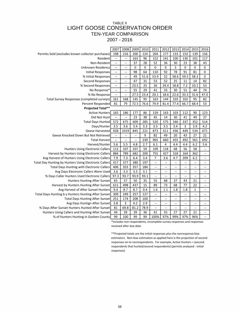
2007 2008 2009 2010 2011 2012 2013 2014 2015 2016Permits Sold (excludes known collector purchases) 198 216 200 124 204 177 133 153 139 156
Resident -- -- 163 96 152 141 100 130 101 117Non-Resident -- -- 37 28 52 36 30 23 38 43
Unknown Residency -- -- 0 0 0 0 3 0 0 0Initial Responses -- -- 98 64 110 92 78 91 81 0
% Initial Responses -- -- 49 51.6 53.9 52 58.6 59.5 58.3 0Second Responses -- -- 47 31 53 52 25 11 14 82
% Second Responses -- -- 23.5 25 26 29.4 18.8 7.2 10.1 53No Response* -- -- 55 29 41 33 30 51 44 74
% No Response -- -- 27.5 23.4 20.1 18.6 22.6 33.3 31.6 47.0Total Survey Responses (completed surveys) 161 168 145 95 163 144 103 102 95 82
Percent Responded 81 79 72.5 76.6 79.9 81.4 77.4 66.7 68.4 53Projected Total**
Active Hunters 165 186 177 86 159 163 103 112 90 123Did Not Hunt -- -- 23 38 45 14 30 41 49 37
Total Days Hunted 572 675 609 285 520 575 346 337 352 514Days/Hunter 3.5 3.6 3.4 3.3 3.3 3.5 3.4 3 3.9 4.2
Geese Harvested 928 1019 845 221 873 611 436 449 534 671Geese Knocked Down But Not Retrieved -- -- -- 9 82 49 20 43 27 21
Total Harvest -- -- -- 230 965 660 455 492 561 692Harvest/Hunter 5.6 5.5 4.8 2.7 6.1 4 4.4 4.4 6.2 5.6
Hunters Using Electronic Callers 113 107 107 59 109 118 68 56 58 --Harvest by Hunters Using Electronic Callers 884 789 682 200 755 427 318 164 362 --
Avg Harvest of Hunters Using Electronic Callers 7.9 7.3 6.4 3.4 7 3.6 4.7 209 6.2 --Total Day Hunting by Hunters Using Electronic Callers 417 377 380 197 -- -- -- -- -- --
Total Days Hunting with Electronic Callers 406 353 357 184 -- -- -- -- -- --Avg Days Electronic Callers Were Used 3.6 3.3 3.3 3.1 -- -- -- -- -- --
% Days Caller Hunters Used Electronic Callers 97.3 93.7 93.9 93.1 -- -- -- -- -- --Hunters Hunting After Sunset 65 57 50 35 55 68 37 43 21 --
Harvest by Hunters Hunting After Sunset 611 498 437 15 89 73 68 77 22 --Avg Harvest of After Sunset Hunters 9.4 8.7 8.7 0.4 1.6 1.1 1.8 1.8 1 --
Total Days Hunting b y Hunters Hunting After Sunset 309 249 257 127 -- -- -- -- -- --Total Days Hunting After Sunset 251 174 208 100 -- -- -- -- -- --
Avg Days Huntign After Sunset 3.8 3 4.2 2.9 -- -- -- -- -- --% Days After Sunset Hunters Hunted After Sunset 81 69.8 81.2 78.9 -- -- -- -- -- --
Hunters Using Callers and Hunting After Sunset 44 39 39 36 41 55 27 27 21 --% of Hunters Hunting in Goshen County 99 100 99 99 100% 97% 99% 97% 96% --
TABLE II
*Includes non-respondents, incomplete survey responses and responses received after due date.
**Projected totals are the initial responses plus the nonresponse bias estimators. Non-bias estimation as applied here is the projection of second responses on to nonrespondents. For example, Active Hunters = (second respondents that hunted/second respondents) (permits analyzed - initial responses)
TEN-YEAR COMPARISONLIGHT GOOSE CONSERVATION ORDER
2007 - 2016
58

WYOMING GAME AND FISH COMMISSION
CHAPTER 48
LIGHT GOOSE CONSERVATION ORDER
Section 1. Authority. This regulation is promulgated by authority of W.S. § 23-1-302(xxii).
Section 2. Definitions. For the purpose of this regulation, definitions shall be as set forth in Title
23, Wyoming Statutes, and the Commission also adopts the following definitions:
(a) “Conservation Order” means an action to reduce the mid-continent population of light geese, which is promulgated in accordance with 50 CFR 20.21 and 50 CFR 21.60, revised as of October 1, 2014, which does not include any later amendments or editions of the incorporated matter. A copy of Title 50 of the Code of Federal Regulations can be viewed at Department Regional Offices. (b) “Dark geese” means Canada goose, cackling goose, white-fronted goose and brant. (c) “Light geese” means snow goose, blue goose and Ross' goose.
Section 3. Licensing, Permitting and Reporting Requirements. (a) Wyoming Game Bird License and Conservation Stamp Requirement. Each person who takes
or attempts to take any light geese under the authority of this regulation shall have in possession a valid Wyoming game bird license and a valid Wyoming conservation stamp (except as otherwise exempted by State statute).
(b) Conservation Order Special Management Permit. A Conservation Order Special Management
Permit shall be in possession of any person participating in the light goose conservation order and shall be immediately produced for inspection upon request of any authorized Department representative. The Conservation Order Special Management Permit shall be validated by signing the person’s name in ink across the face of the permit. Conservation Order Special Management Permits may be purchased online from the Department’s website at http://wgfd.wyo.gov.
(c) Reporting Requirements. Any person who obtains a Conservation Order Special Management
Permit is requested to accurately complete the online survey at the web address provided on the permit no later than April 22, 2016.
(d) Persons are not required to possess a Federal Migratory Bird Hunting and Conservation Stamp
(duck stamp) or Harvest Information Program (HIP) Permit in order to participate in the light goose conservation order.
Section 4. Conservation Order Regulations.
(a) Federal Regulations. 16 U.S.C. 703-712; 16 U.C. 742 a-j; Pub. L. 106-108; Pub. L. 95-616;
92 Stat. 3112 (16 U.S.C. 712(2)); and 50 CFR 20 and 21, revised as of October 1, 2014, which do not include any later amendments or editions of the incorporated matter, governing the taking and possession of migratory birds and migratory game birds, and the conservation order for mid-continent light geese, are adopted as regulations of the Wyoming Game and Fish Commission; except, those portions of 50 CFR 20 and 21, revised as of October 1, 2014, which allow the use of unplugged shotguns during the conservation order are not adopted as regulations of the Commission. Violations of these federal statutes and regulations shall be violations of the Commission regulations. A copy of Title 50 of the Code of Federal Regulations can be viewed at Department Regional Offices.
59

(i) Shotguns shall be the only weapons that can be used to take light geese. Shotguns larger than ten (10) gauge shall not be legal for the take of light geese in Wyoming during the conservation order for mid-continent light geese. Automatic loading, pump, or repeating shotguns shall be plugged to admit no more than one (1) shell in the chamber and two (2) shells in the magazine.
(ii) Recorded or electrically amplified bird calls or sounds, or imitations thereof may be used to take light geese during the dates of the light goose conservation order.
(b) Evidence of Species. One fully feathered wing or the feathered head shall remain naturally attached to the carcass as a means of identification of all light geese in the field and while the birds are being transported.
(c) Nontoxic Shot Restrictions.
(i) No person shall take light geese while possessing shot shells loaded with shot other than nontoxic shot. (d) Species and Hunt Areas, Conservation Order Dates, Shooting Hours, Closed Areas, Bag Limit.
(i) The Central Flyway portion of Wyoming, excluding the closed areas listed in Section 5, is open during the conservation order for mid-continent light geese. The Central Flyway is that portion of Wyoming east of the Continental Divide, excluding the Great Divide Basin. Please refer to the Wyoming Waterfowl Flyway Areas Map in Chapter 14, Late Migratory Game Bird Hunting Seasons.
LIGHT GOOSE CONSERVATION ORDER, CENTRAL FLYWAY Species
and Hunt Areas
Dates of Conservation Order Opens Closes
Shooting
Hours
Closed Areas Section 5
Subsections
Bag Limit
Daily Possession LIGHT GEESE Central Flyway
Feb. 22 Apr. 10 See Sec. 6 a(i), a(ii), b, c, d a(iii) after March
20
20 Unrestricted
(ii) Those areas within the boundaries of the Bump-Sullivan Managed Goose Hunt, including Bump-Sullivan Reservoir, shall be open to the taking of light geese during the light goose conservation order. Pits/blinds shall be occupied on a first-come, first-served basis and shall not be claimed or reserved by leaving personal belongings, including decoys, unattended at the pit/blind at any time. Conservation order participants are not required to possess a Bump-Sullivan managed goose hunt permit or a goose special management registration nor are they required to hunt from a pit/blind during the light goose conservation order. Section 5. Description of Closed Areas. Except as otherwise noted, the areas described in this Section shall be closed for the species and dates specified in the table in Section 4.
(a) Goshen County (i) Springer Reservoir. Beginning on U.S. Highway 85 at the George Marlatt farmhouse; westerly along the fence between the farm land and the pasture land to the west end of the west pump lake and Bump-Sullivan ditch; southerly along said ditch to the Wyoming Game and Fish Department’s Springer Wildlife Habitat Management Area (WHMA); westerly then southerly along the Springer WHMA boundary to Parking Area 3; southeasterly along the reservoir access road to the Game and Fish Department buildings; due south from said buildings across the Whispering Wings LLC property to the
60

Fulmer family trust pasture fence; westerly along said fence to Goshen County Road 37; southerly along said road to Goshen County Road 42; easterly along said road to U.S. Highway 85; northerly along said highway to the George Marlatt farmhouse. (ii) Pond No. 1 Table Mountain Wildlife Habitat Management Area. Pond No. 1 and adjacent lands as marked by colored signs and posts. (iii) Table Mountain Wildlife Habitat Management Area. All of Table Mountain Wildlife Habitat Management Area shall be closed to the taking of light geese after March 20.
(b) Platte County
(i) Festo Lake. Festo Lake and all lands within three hundred (300) yards of the normal high water line shall be closed to all migratory game bird hunting. (ii) Wheatland Reservoir No. 1. Wheatland Reservoir No. 1 and all lands within three hundred (300) yards of the normal high water line shall be closed to hunting.
(c) Fremont County
(i) Ocean Lake. The waters of Ocean Lake and the Wyoming Game and Fish Commission lands within approximately one-half (1/2) mile of the aeration system on the north side of the lake shall be closed to migratory game bird hunting beginning November 15 through December 31 and January 1 through March 10 of each year. Beginning December 15 through March 10, the area shall be closed to all human presence, except for Wyoming Game and Fish Department administrative access, within one-half (1/2) mile of the aerator on the ice and as marked by signs on Commission lands around the aerator.
(d) Pacific Flyway (i) The entire Pacific Flyway portion of Wyoming shall be closed to the taking of light geese during the conservation order for light geese. The Pacific Flyway is that portion of Wyoming west of the Continental Divide, including the Great Divide Basin. Please refer to the Wyoming Waterfowl Flyway Areas Map in Chapter 14, Late Migratory Game Bird Hunting Seasons.
61

Section 6. Conservation Order Shooting Hours. Shooting hours for taking light geese during the light goose conservation order shall be as determined from the shooting hours table in this section.
2016 Conservation Order Shooting Hours Table. This table (including adjustments for daylight
savings time) lists the official shooting hours adopted by the Wyoming Game and Fish Commission for taking light geese during the light goose conservation order. (Do not use tables from other sources.)
ST = Starting Time QT = Quitting Time
AREA B AREA C AREA D ST QT ST QT ST QT February 22-29 6:25 6:28 6:17 6:20 6:11 6:14 March 1-7 6:13 6:37 6:05 6:29 5:59 6:23 8-12 6:03 6:44 5:55 6:36 5:49 6:30 *13-21 6:51 7:53 6:43 7:45 6:37 7:39 22-31 6:34 8:04 6:26 7:56 6:20 7:50 April 1- 7 6:19 8:14 6:11 8:06 6:05 8:00 8-10 6:11 8:19 6:03 8:11 5:57 8:05
*Start Daylight Savings Time AREA B – Big Horn, Fremont, Hot Springs, Park, Washakie counties AREA C – Albany, Campbell, Carbon, Converse, Johnson, Natrona, Sheridan counties AREA D – Crook, Goshen, Laramie, Niobrara, Platte, Weston counties
WYOMING GAME AND FISH COMMISSION
By: ______________________________________ Charles C. Price, President
Dated: April 22, 2015
62

Please complete the survey ONLINE, as that signifi-cantly reduces postage and data entry costs. Go to wgfd.wyo.gov/hunting/harvest-surveys/ and use the ONLINE Password provided above to access your survey.
If you are unable to complete your survey online, use the enclosed envelope to return this completed form.
If you have questions or prefer to complete it over the phone, contact Gail Sheridan, Harvest Survey Coordi-nator, at 307-777-4567 or email: [email protected]
OVER
WYOMING FURBEARER/TRAPPER HUNTER SURVEY
We encourage you to respond online as it significantly reduces postage costs. Please logon to wgfd.wyo.gov/hunting/harvest-surveys/
and use the following password:
Q1. Did you trap, snare or hunt badger, beaver, marten, mink, muskrat, or weasel during the 2015-2016 season? (Check one box)
Yes (If “Yes,” use the map below to answer the questions that follow.)
No (If "No,” your survey is complete.)
Q4. How many trap sets were put out? Note: 2 or more traps in a single set are considered as 1 trap set. (Enter number here)
Q5. How many nights were the above number of trap sets out? (Enter number here)
Q2. Please indicate which species you intended to harvest with any method (trap, snare, or firearm). (Check all that apply):
Badger
Beaver
Marten
Mink
Muskrat
Weasel
Q3. How many days were you in the field to set or check traps or snares? (Enter number here)
Q6. How many snare sets were put out? Note: 2 or more snares in a single set are considered as 1 snare set. (Enter number here)
Q7. How many nights were the above number of snare sets out? (Enter number here)
Q8. How many days did you hunt badger, beaver, marten, mink, muskrat or weasel with a firearm? (Enter number here)
Note: All questions pertain only to trapping/snaring/hunting
Badger, Beaver, Marten, Mink, Muskrat and Weasel. (If you trapped/snared/hunted Bobcats, your information will be recorded when your pelts are tagged.)
63
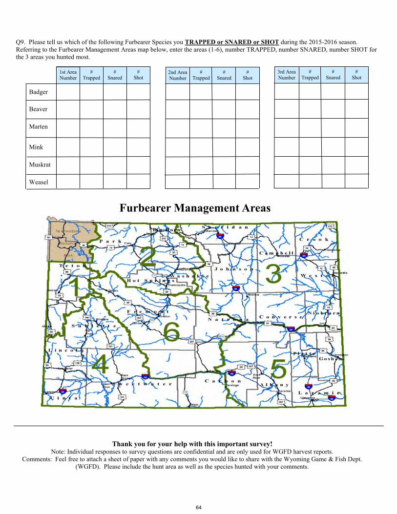
Thank you for your help with this important survey! Note: Individual responses to survey questions are confidential and are only used for WGFD harvest reports.
Comments: Feel free to attach a sheet of paper with any comments you would like to share with the Wyoming Game & Fish Dept.
(WGFD). Please include the hunt area as well as the species hunted with your comments.
# Shot
# Shot
Q9. Please tell us which of the following Furbearer Species you TRAPPED or SNARED or SHOT during the 2015-2016 season.
Referring to the Furbearer Management Areas map below, enter the areas (1-6), number TRAPPED, number SNARED, number SHOT for
the 3 areas you hunted most.
Badger
Beaver
Marten
Mink
Muskrat
Weasel
1st Area Number
# Trapped
# Snared
2nd Area Number
# Trapped
# Snared
# Shot
3rd Area Number
# Trapped
# Snared
Furbearer Management Areas
64

LAST FIRSTNAME NAME
ADDRESS CITY STATE ZIP
Check OneResident 2015 License #
Nonresident 2016 License #
In what management area were the bobcats reported on this form harvested? Please CIRCLE one.
Method of Take = TRAP1. How many trap sets capable of catching bobcats were put out?
(Note: Two or more traps in a single set are considered one trap set).
2. How many nights were the above number of trap sets out?3. How many bobcats were harvested with the above trap sets?
Method of Take = FIREARM1. How many days were bobcats hunted with a firearm?
2. How many bobcats were harvested with a firearm?
Method of Take = MISC (Roadkill, other)
1. How many bobcats were acquired by means other than trapping or
hunting, such as roadkill?
Enter the grand total of trap, firearm and misc harvests here.This number should match the number of tags you issue on the back of this form. If you have more tags for this hunter/trapper than there are spaces on this one sheet, simply use the back side of additional forms and staple them to this form.
HARVEST RECORD
M.I.
1 2 3 4 5 6
BOBCAT HARVEST TODAY'S DATE:
REPORT FORM G & F EMPLOYEE:
TRAPPER/HUNTER RECORD AS IT APPEARS ON THE LICENSE:
65
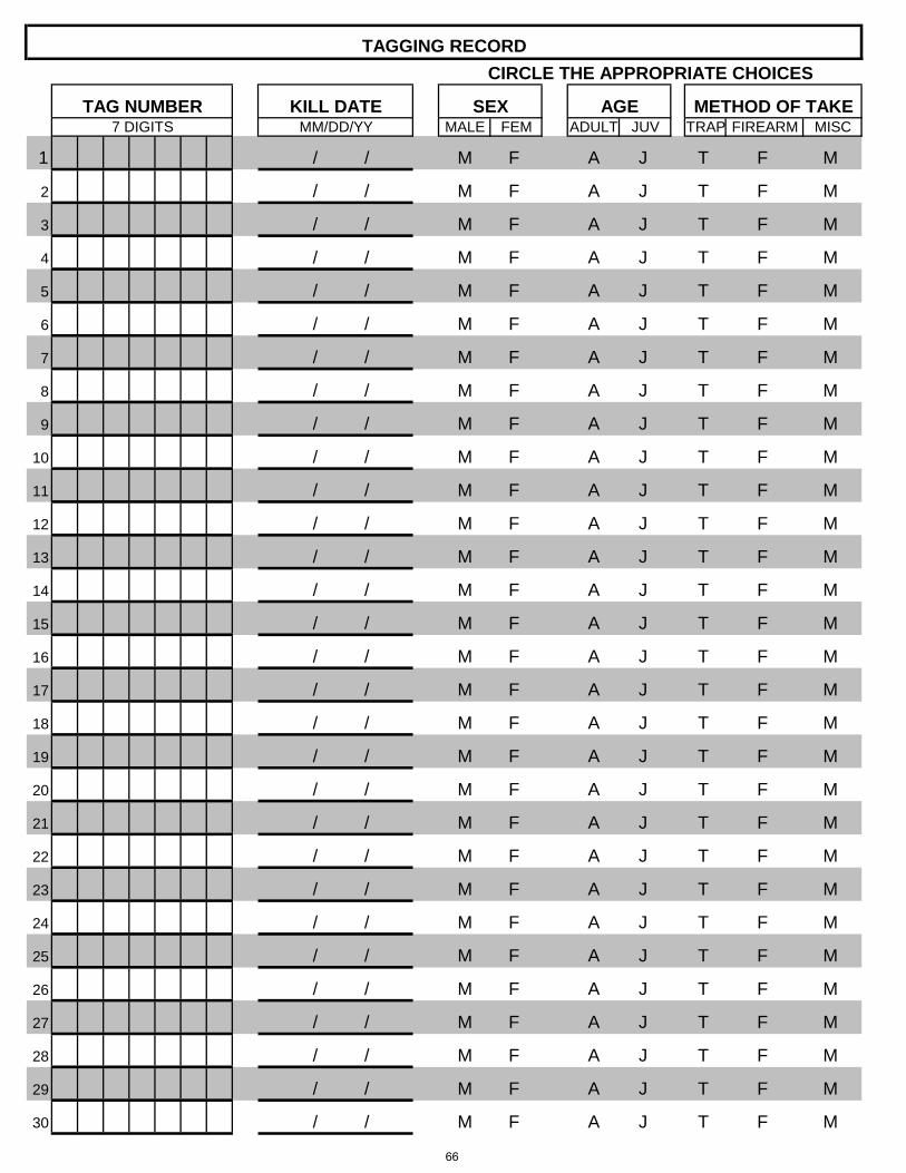
1 / /
2 / /
3 / /
4 / /
5 / /
6 / /
7 / /
8 / /
9 / /
10 / /
11 / /
12 / /
13 / /
14 / /
15 / /
16 / /
17 / /
18 / /
19 / /
20 / /
21 / /
22 / /
23 / /
24 / /
25 / /
26 / /
27 / /
28 / /
29 / /
30 / / M M F A J T F
M
M F A J T F M
M F A J T F
M
M F A J T F M
M F A J T F
M
M F A J T F M
M F A J T F
M
M F A J T F M
M F A J T F
M
M F A J T F M
M F A J T F
M
M F A J T F M
M F A J T F
M
M F A J T F M
M F A J T F
M
M F A J T F M
M F A J T F
M
M F A J T F M
M F A J T F
M
M F A J T F M
M F A J T F
M
M F A J T F M
M F A J T F
M
M F A J T F M
M F A J T F
M
M F A J T F M
M F A J T F
M
M F A J T F M
M F A J T F
TRAP FIREARM MISC
M F A J T F M
7 DIGITS MM/DD/YY MALE FEM ADULT JUV
TAGGING RECORDCIRCLE THE APPROPRIATE CHOICES
TAG NUMBER KILL DATE SEX AGE METHOD OF TAKE
66

2006 2007 2008 2009 2010 2011 2012 2013 2014 2015
2016 (through April 30)
Final Audited License Sales Figures 1
1,623 1,844 1,850 1,902 1,880 1,948 2,340 2,560 2,404 2,274 1,128
2006/07 2007/08 2008/09 2009/10 2010/11 2011/12 2012/13 2013/14 2014/15 2015/162
# of Unique Individuals Holding a Trapping
License11,623 1,844 1,850 1,901 1,878 1,920 1,625 2,454 2,397 2,257
# Surveyed 1,600 1,844 1,840 1,879 1,417 1,411 1,625 2,454 2,397 2,257Percent Useable
Respones Rate -- -- -- 44.5% 24.6% 29.6% 27.0% 31.4% 32.0% 37.7%
Days Afield Checking Traps/Snares
-- -- -- -- -- -- -- -- -- 4,102
Traps Set -- -- -- -- 14,440 7,420 15,440 13,878 12,102 5,844Trap Nights -- -- -- -- 21,790 14,085 30,305 25,662 25,773 9,128Snares Set -- -- -- -- 6,510 2,120 7,150 3,546 4,950 1,496
Snare Nights -- -- -- -- 11,925 6,365 14,640 11,142 11,283 3,072Firearm Days -- -- -- -- 5,395 4,405 2,015 2,691 1,809 1,696
Recreation Days4 -- -- -- -- -- -- -- -- -- 5,798
License Holder Effort3 -- -- -- -- 39,110 24,855 46,960 39,495 38,865 13,8961Number of unique trappers/hunters. Furbearer season spans two license years, i.e. 2015 and 2016. Many trappers/hunters buy a license in both years. The number of unique trappers/hunters represented in this column only reflects an individual once. For example, if an individual purchases a license in 2015 and 2016, the individual is only counted once. 2The harvest survey was revised for 2015/16 survey. See "Surveys & Maps" section.3Effort = trap nights + snare nights + firearm days4Days Afield Checking Traps/Snares + Firearm Days
2006/07 2007/08 2008/09 2009/10 2010/11 2011/12 2012/13 2013/14 2014/15 2015/16
Total Trapper/Hunters 437 383 575 684 700 454 611 499 408 440Total Harvest 1,638 1,633 1,414 1,603 1,003 795 896 563 721 611
Total Trapper/Hunters 296 296 377 437 416 503 479 622 532 363Total Harvest 3,712 3,093 2,910 3,329 2,814 3,306 2,709 3,184 4,626 2,019
Total Trapper/Hunters 109 74 179 248 184 100 120 294 158 145Total Harvest 2,072 2,059 1,287 996 1,268 1,170 1,237 2,988 1,596 966
Total Trapper/Hunters 106 124 157 282 254 180 274 312 206 180Total Harvest 480 530 253 288 244 615 728 563 485 235
Total Trapper/Hunters 238 188 271 398 326 297 383 392 374 347Total Harvest 4,844 2,920 2,595 4,034 3,825 4,987 4,837 5,242 7,354 3,367
Total Trapper/Hunters 72 91 87 209 151 76 123 161 93 40Total Harvest 252 233 19 155 41 56 98 288 168 38
2006-2015
TABLE IIIFURBEARER TEN-YEAR TRAPPER/HUNTER AND HARVEST SUMMARY
2006-2015
BADGER
BEAVER
MARTEN
MINK
MUSKRAT
WEASEL
FURBEARER TEN-YEAR SURVEY RESPONSE RATE AND EFFORT DATA SUMMARY
TABLE IFURBEARER TEN-YEAR LICENSE SALES SUMMARY
2006-2015
1License sales figures reported for the current calendar year reflect sales through April 30 that year. Since furbearer season spans two license years, i.e. 2015 and 2016, licenses sold through April 30 are used to estimate harvest for the 2016 portion of the season.
TABLE II
67

2006 2007 2008 2009 2010 2011 2012 2013 2014 2015
2016 (through March 1,
2016)
Final Audited License Sales Figures 1
1,623 1,844 1,850 1,902 1,880 1,948 2,340 2,560 2,404 2,274 1,002
2006/07 2007/08 2008/09 2009/10 2010/11 2011/12 2012/13 2013/14 2014/15 2015/16Trapper Harvest 3,373 2,751 2,691 1,428 1,411 1,673 1,651 1,423 1,060 1,050
Trap Nights 772,971 673,170 771,279 463,860 515,114 598,298 620,935 505,696 400,404 388,343Trapper Effort
(Nights/Harvest)229.1 244.7 286.6 324.8 365.1 357.6 376.1 355.4 377.7 369.9
Hunter Harvest 229 264 272 165 182 184 209 128 70 105Hunter Days 835 1107 1087 862 770 641 1171 687 315 381Hunter Effort
(Days/Harvest)3.7 4.2 4.0 5.2 4.2 3.5 8.1 7.9 5.8 3.6
Total Trapper/Hunter Harvest
3,602 3,015 2,963 1,593 1,593 1,857 1,860 1,555 1,130 1,164
Total Trapper/Hunter Days Afield
773,806 674,277 772,366 464,722 515,884 598,939 622,106 506,383 400,719 388,724
Overall Effort (Nights + Days)/Total Harvest
214.8 223.6 260.6 291.7 323.8 322.5 332.3 322.3 354.6 334.0
Miscellaneous Bobcats Tagged
15 21 15 16 13 18 12 16 10 8
Total Bobcats Tagged 3,617 3,036 2,978 1,609 1,606 1,875 1,872 1,571 1,140 1,164
FURBEARER TEN-YEAR LICENSE SALES SUMMARY - BOBCAT ONLY2006-2015
TABLE VBOBCAT TEN-YEAR HARVEST SUMMARY
2006-2015
1 License sales figures reported for the current calendar year reflect sales through March 1 that year which is the date the bobcat season closes.
TABLE IV
68

RESIDENT 6 3 3 3 6 3 15 9RESIDENT YOUTH 0 0 0 0 3 3 3 3NONRESIDENT 2 0 2 0 2 0 6 0AREA TOTALS 8 3 5 3 11 6 24 12RESIDENT 11 29 9 0 11 6 31 35AREA TOTALS 11 29 9 0 11 6 31 35RESIDENT 54 151 23 0 31 6 108 157RESIDENT YOUTH 0 0 0 0 3 3 3 3AREA TOTALS 54 151 23 0 34 9 111 160RESIDENT 48 128 29 48 46 26 123 202RESIDENT YOUTH 3 0 3 0 3 3 9 3NONRESIDENT 10 70 5 5 5 10 20 85AREA TOTALS 61 198 37 53 54 39 152 290RESIDENT 34 68 23 0 40 34 97 102NONRESIDENT 2 0 0 0 0 0 2 0AREA TOTALS 36 68 23 0 40 34 99 102RESIDENT 9 3 3 0 11 9 23 12AREA TOTALS 9 3 3 0 11 9 23 12
179 452 100 56 161 103 440 611
RESIDENT 14 125 6 0 6 0 26 125AREA TOTALS 14 125 6 0 6 0 26 125RESIDENT 20 46 9 3 6 0 35 49RESIDENT YOUTH 0 0 0 0 3 6 3 6AREA TOTALS 20 46 9 3 9 6 38 55RESIDENT 31 194 17 9 17 9 65 212AREA TOTALS 31 194 17 9 17 9 65 212RESIDENT 40 721 26 43 26 29 92 793RESIDENT YOUTH 3 68 3 0 3 3 9 71NONRESIDENT 3 80 2 32 2 0 7 112AREA TOTALS 46 869 31 75 31 32 108 976RESIDENT 40 439 20 14 26 34 86 487NONRESIDENT 2 87 0 0 0 0 2 87AREA TOTALS 42 526 20 14 26 34 88 574RESIDENT 23 71 6 3 6 0 35 74RESIDENT YOUTH 3 3 0 0 0 0 3 3AREA TOTALS 26 74 6 3 6 0 38 77
179 1,834 89 104 95 81 363 2,019
TABLE VI
TABLE VII
2015-2016
BEAVERHarvest Estimates
TOTAL HARVESTTRAPPERS
TRAP HARVEST
4
5
6
SPECIES TOTALS
3
SPECIES TOTALS
1
HUNTERS
FIREARM HARVEST
AREA
4
5
6
BADGER Harvest Estimates
AREA FEETYPE
TOTAL TRAPPERS, SNARERS & HUNTERS
TOTAL HARVEST
1
2015-2016
SNARE HARVEST HUNTERS
TOTAL TRAPPERS, SNARERS & HUNTERS
TRAPPERSTRAP
HARVEST SNARERSSNARE
HARVESTFEETYPE
3
2
SNARERS
FIREARM HARVEST
2
69

RESIDENT 14 254 0 0 0 0 14 254NONRESIDENT 5 37 3 0 3 0 11 37AREA TOTALS 19 291 3 0 3 0 25 291RESIDENT 20 316 11 29 9 0 40 345AREA TOTALS 20 316 11 29 9 0 40 345RESIDENT 9 34 0 0 0 0 9 34AREA TOTALS 9 34 0 0 0 0 9 34RESIDENT 17 40 9 0 9 0 35 40NONRESIDENT 8 48 3 0 3 0 14 48AREA TOTALS 25 88 12 0 12 0 49 88RESIDENT 11 91 0 0 0 0 11 91RESIDENT YOUTH 0 0 0 0 3 3 3 3NONRESIDENT 2 0 0 0 0 0 2 0AREA TOTALS 13 91 0 0 3 3 16 94RESIDENT 6 114 0 0 0 0 6 114AREA TOTALS 6 114 0 0 0 0 6 114
92 934 26 29 27 3 145 966
RESIDENT 6 9 3 0 3 0 12 9RESIDENT YOUTH 3 3 0 0 0 0 3 3AREA TOTALS 9 12 3 0 3 0 15 12RESIDENT 14 40 0 0 0 0 14 40AREA TOTALS 14 40 0 0 0 0 14 40RESIDENT 29 51 14 0 14 0 57 51AREA TOTALS 29 51 14 0 14 0 57 51RESIDENT 23 74 9 0 14 6 46 80NONRESIDENT 2 3 0 0 0 0 2 3AREA TOTALS 25 77 9 0 14 6 48 83RESIDENT 14 29 9 0 9 0 32 29NONRESIDENT 2 5 0 0 0 0 2 5AREA TOTALS 16 34 9 0 9 0 34 34RESIDENT 9 9 0 0 0 0 9 9RESIDENT YOUTH 3 6 0 0 0 0 3 6AREA TOTALS 12 15 0 0 0 0 12 15
105 229 35 0 40 6 180 235
TABLE VIII
TABLE IX
2
AREA FEETYPE TRAPPERSTRAP
HARVEST SNARERSTOTAL
HARVEST
Harvest Estimates2015-2016
1
3
2
3
4
6
Harvest Estimates
SNARE HARVEST
FIREARM HARVEST
TOTAL TRAPPERS, SNARERS & HUNTERS
MARTEN
HUNTERS
5
5
4
FIREARM HARVEST
SPECIES TOTALS
SPECIES TOTALS
AREA TRAPPERSTRAP
HARVEST
6
MINK
SNARE HARVEST HUNTERS
TOTAL TRAPPERS, SNARERS & HUNTERSSNARERS
TOTAL HARVEST
1
2015-2016
FEETYPE
70
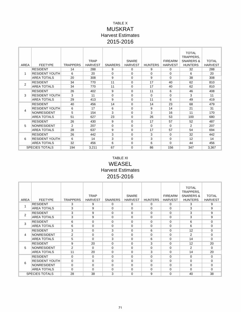
RESIDENT 14 288 9 0 9 0 32 288RESIDENT YOUTH 6 20 0 0 0 0 6 20AREA TOTALS 20 308 9 0 9 0 38 308RESIDENT 34 770 11 0 17 40 62 810AREA TOTALS 34 770 11 0 17 40 62 810RESIDENT 26 402 9 0 11 6 46 408RESIDENT YOUTH 3 11 0 0 0 0 3 11AREA TOTALS 29 413 9 0 11 6 49 419RESIDENT 40 456 14 0 14 23 68 479RESIDENT YOUTH 6 17 6 0 9 14 21 31NONRESIDENT 5 154 3 0 3 16 11 170AREA TOTALS 51 627 23 0 26 53 100 680RESIDENT 26 430 9 0 17 57 52 487NONRESIDENT 2 207 0 0 0 0 2 207AREA TOTALS 28 637 9 0 17 57 54 694RESIDENT 26 442 3 0 3 0 32 442RESIDENT YOUTH 6 14 3 0 3 0 12 14AREA TOTALS 32 456 6 0 6 0 44 456
194 3,211 67 0 86 156 347 3,367
RESIDENT 3 9 0 0 0 0 3 9AREA TOTALS 3 9 0 0 0 0 3 9RESIDENT 3 9 0 0 0 0 3 9AREA TOTALS 3 9 0 0 0 0 3 9RESIDENT 6 0 0 0 0 0 6 0AREA TOTALS 6 0 0 0 0 0 6 0RESIDENT 3 0 3 0 6 0 12 0NONRESIDENT 2 0 0 0 0 0 2 0AREA TOTALS 5 0 3 0 6 0 14 0RESIDENT 9 20 0 0 3 0 12 20NONRESIDENT 2 0 0 0 0 0 2 0AREA TOTALS 11 20 0 0 3 0 14 20RESIDENT 0 0 0 0 0 0 0 0RESIDENT YOUTH 0 0 0 0 0 0 0 0NONRESIDENT 0 0 0 0 0 0 0 0AREA TOTALS 0 0 0 0 0 0 0 0
28 38 3 0 9 0 40 38
TABLE X
TABLE XI
SPECIES TOTALS
SPECIES TOTALS
1
2
4
5
1
3
4
6
2
3
Harvest Estimates
5
6
MUSKRAT
TRAP HARVESTFEETYPE TRAPPERSAREA
FIREARM HARVEST
FIREARM HARVESTTRAPPERS
TRAP HARVEST
2015-2016
TOTAL HARVESTHUNTERS
TOTAL TRAPPERS, SNARERS & HUNTERS
SNARE HARVESTSNARERS
TOTAL TRAPPERS, SNARERS & HUNTERS
2015-2016
WEASELHarvest Estimates
TOTAL HARVESTAREA FEETYPE SNARERS
SNARE HARVEST HUNTERS
71

2015 Licenses
Sold
2016 Licenses
Sold Through April 30, 20161
Licenses Sold2
# of Unique Trapper/ Hunters3
Number Surveyed4
Number Usable
(hunters and nonhunters)
Response Rate
(# Usable/ # Surveyed)
Resident 2051 1038 3,089 2,048 2,048 783 38.2%
Resident Youth 177 76 253 163 163 39 23.9%
Nonresident 46 14 60 46 46 29 63.0%
Total 2274 1128 3,402 2,257 2,257 851 37.7%
1The furbearer harvest survey process begins on this date.2Cumulative licenses sold
2015 Licenses
SoldLicenses
Sold2
# of Trapper/ Hunters That
Reported Harvest
Resident 2051 2,985 265
Resident Youth 177 233 7
Nonresident 46 58 12
Total 2274 3,276 284
1Bobcat season closes on March 12Cumulative licenses sold
TABLE XII
934
56
12
1002
TABLE XIII
BobcatLicense Data Summary
2015-2016
2016 Licenses Sold Through March 1, 20161
4Furbearer Harvest Survey does not ask questions related to bobcat or predator species (coyote, raccoon, red fox, striped skunk)
3Number of unique trappers/hunters. Furbearer season spans two license years, i.e. 2015 and 2016. Many trappers/hunters buy a license in both years. The number of unique trappers/hunters represented in this column only reflects an individual once. For example, if an individual purchases a license in 2015 and 2016, the individual is only counted once.
2015-2016License Data Summary
Furbearer
72

OVERVIEW
SUCCESSFUL LICENSE HOLDERSPERCENT WHO REPORTED BOBCATSTOTAL BOBCATS TAGGED*Furbearer licenses sold in 2015 plus furbearer licenses sold through March 1, 2016, which is the end of bobcat season
TRAPPING ACTIVITYBOBCAT TRAPPERSTRAP HARVESTAVERAGE HARVEST PER TRAPPERTRAP NIGHTS (# traps * nights traps active)AVERAGE TRAP NIGHTS PER TRAPPERAVERAGE TRAP NIGHTS PER HARVEST
HUNTING ACTIVITYBOBCAT HUNTERSFIREARM HARVESTAVERAGE HARVEST PER HUNTERHUNT DAYSAVERAGE HUNT DAYS PER HUNTERAVERAGE HUNT DAYS PER HARVESTMISCELLANEOUS BOBCATS TAGGED
1 023456
AGE CLASSJUVENILEADULTTOTAL
2015-2016 CITES TAGGING/BOBCATHARVEST STATISTICS
RESIDENT NONRESIDENT TOTALLICENSES SOLD* 3,218 58 3,276
1,124 40 1,164
RESIDENT NONRESIDENT TOTAL
272 12 2848.5% 20.7% 8.7%
3.6 3.7 3.6370,435 17,908 388,343
285 10 2951,013 37 1,050
RESIDENT NONRESIDENT TOTAL69 2 71
1,299.8 1,790.8 1,316.4365.7 484.0 369.9
372 9 3815.4 5 5.4
103 2 1051.5 1.0 1.5
AREA TRAP FIREARM MISC
3.6 5 3.68 0 8
TOTAL0 0 0
212 21 0 233
2015-2016 BOBCAT HARVEST BYAREA AND METHOD OF TAKE
3 13396 13 1 110
498 42 2 542124 20 2 146
TABLE XIV
TABLE XV
TABLE XVI
659 326 985742 422 1,164
HARVEST BY AGE AND GENDER
MALE FEMALE TOTAL83 96 179
TOTAL 1,051 105 8 1,164
2015-2016 BOBCAT
121 9
73

WYOMING GAME AND FISH COMMISSION
CHAPTER 4
FURBEARING ANIMAL HUNTING OR TRAPPING SEASONS Section 1. Authority. This regulation is promulgated by authority of W.S. §23-1-302, W.S. §23-2-303, W.S. §23-2-305 and W.S. §23-3-109. Section 2. Definitions. Definitions shall be as set forth in Title 23, Wyoming Statutes, Commission regulations, and the Commission also adopts the following definitions: (a) “Drainage” means all lands within the watershed of a named river or stream, including all tributaries and standing waters which drain into that river or stream. (b) “Green pelt” means the untanned hide or skin of a furbearing animal. (c) “Owner” means the person who physically sets any trap or snare in any fashion that may result in the take of any furbearing or predatory animal. (d) “Quick-kill Body-grip Trap” means a device that closes around the body or head of the animal in such a manner as to almost immediately kill the animal caught. (e) “Snare” means a device consisting of a loop with no mechanical trigger for capturing furbearing or predatory animals. (f) “Leg-hold Trap” means any device using a mechanical trigger that springs the jaws or loop shut for capturing furbearing or predatory animals. (g) “Live Trap” means any device designed to capture or trap a live animal inside a cage or structure. Such traps include, but are not limited to box traps and cage traps. (h) “Trapping” or “trap” means the taking of a furbearing or predatory animal by trap, snare or with a firearm or archery equipment.
(i) “Trap Identification Number” means an identification number assigned to the owner of traps or snares by the Department.
(j) “Week” means the seven (7) day period starting on Monday through the following Sunday. Section 3. Hunting or Trapping Seasons. Species, hunting or trapping areas, season dates and limitations.
Trapping Season Dates Species Area Opens Closes Limitations
Mink 1 Oct. 1 Apr. 30 Any mink Bobcat 1 Nov. 15 Mar. 1 Any bobcat Muskrat 1 Oct. 1 Apr. 30 Any muskrat Weasel 1 Oct. 1 Mar. 31 Any weasel Badger 1 Jan. 1 Dec. 31 Any badger
74

Trapping Season Dates Species Area Opens Closes Limitations
Marten 1 2
Oct. 1 Dec. 1
Mar. 1 Mar. 1
Any marten Any marten
Beaver
1 101 102 103 104 301 302 303 304 305 401 404 405 406 407 408 409 410 411 412 413 414 501 502 503 504 505 606
Oct. 1 Oct. 1 Oct. 1 Oct. 1 Oct. 1 CLOSED CLOSED CLOSED CLOSED CLOSED CLOSED CLOSED CLOSED CLOSED CLOSED Oct. 1 Oct. 1 Oct. 1 Oct. 1 Oct. 1 Oct. 1 Oct. 1 Oct. 1 Oct. 1 CLOSED CLOSED CLOSED CLOSED
Apr. 30 Apr. 30 Apr. 30 Apr. 30 Apr. 30 Apr. 30 Apr. 30 Apr. 30 Apr. 30 Apr. 30 Apr. 30 Apr. 30 Apr. 30 Apr. 30
Any beaver 1 trapper; 5 beaver 1 trapper; 20 beaver 1 trapper; 10 beaver 1 trapper; 25 beaver 1 trapper; 15 beaver 1 trapper; 15 beaver 1 trapper; 15 beaver 1 trapper; 35 beaver 1 trapper; 15 beaver 1 trapper; 30 beaver 1 trapper; 30 beaver 1 trapper; 10 beaver 1 trapper; 10 beaver
Section 4. Furbearing Animal Hunting or Trapping Area Descriptions.
(a) Area and number. (i) All furbearing animals, excluding marten and beaver. Area 1. The entire State of Wyoming, excluding those areas closed in Section 4(b). (ii) Marten. Area 1. The entire State of Wyoming, excluding Area 2 as listed in this subsection and those areas closed in Section 4(b). Area 2. Snowy Range. Beginning at the junction of Interstate Highway 80 and U.S. Highway 287 in the city of Laramie; southerly along U.S. Highway 287 to the Wyoming-Colorado state line; westerly along said line to Wyoming Highway 230 in Carbon County; northerly along said highway to Wyoming Highway 130; northerly along said highway to Interstate Highway 80; easterly along said highway to its junction with U.S. Highway 287. (iii) Beaver.
75

Area 1. The entire State of Wyoming, excluding those limited quota trapping areas listed in this subsection and those areas closed in Section 4(b). Area 101. Ditch Creek. Ditch Creek drainage in Teton County. Area 102. Willow Creek. Willow Creek drainage in Teton and Lincoln Counties. Area 103. Game Creek and Little Horse Creek. Game Creek and Little Horse Creek drainages in Teton County. Area 104. Fall Creek. All of the Fall Creek, Mosquito Creek and Dog Creek drainages on U.S. Forest Service lands in Teton and Lincoln Counties. Area 301. North Tongue River. North Tongue River drainage in Sheridan County. Area 302. South Tongue River. South Tongue River drainage in Sheridan County. Area 303. East Fork of Big Goose Creek. East Fork of Big Goose Creek drainage upstream of Park Reservoir in Johnson County. Area 304. Clear Creek. Clear Creek drainage on U.S. Forest Service lands in Johnson County. Area 305. Crazy Woman Creek. Crazy Woman Creek drainage on U.S. Forest Service lands in Johnson County. Area 401. South Rock Springs. That portion of Sweetwater County south of I-80 between the Green River, Flaming Gorge Reservoir and Wyoming Highway 430. Area 404. Henrys Fork. Henrys Fork River, Louse Creek and Sage Creek drainages on the Wasatch-Cache National Forest in Uinta County. Area 405. Cottonwood Creek. Cottonwood Creek drainage on the Wasatch-Cache National Forest in Uinta County. Area 406. East Fork of Smiths Fork. Drainages of Gilbert Creek and East Fork of Smiths Fork River upstream from Wasatch-Cache National Forest boundary in Uinta County. Area 407. West Fork of Smiths Fork. West Fork of the Smiths Fork River and Willow Creek drainages upstream from Wasatch-Cache National Forest boundary in Uinta County. Area 408. Salt Creek. Salt Creek drainage on U.S. Forest Service lands, Salt Creek Proper and Raymond Creek drainage on public lands in Lincoln County. Area 409. Upper Smiths Fork. Smiths Fork drainage on U.S. Forest Service lands in Lincoln County. Area 410. Hobble Creek. Hobble Creek drainage on U.S. Forest Service lands, Coal Creek, and Saw Mill Creek drainages in Lincoln County. Area 411. Hams Fork River (Hams Fork). Beginning where the Hams Fork River crosses the Bridger-Teton National Forest boundary to where the river crosses U.S. Forest Service Road 062 and all tributaries lying east of the Hams Fork River in Lincoln County.
76

Area 412. South Fork Fontenelle Creek. Beginning where the South Fork of Fontenelle Creek crosses the Bridger-Teton National Forest boundary to its headwaters and all tributaries in Lincoln County, including all of the drainages of the South Fork of Fontenelle Creek upstream from the Bridger-Teton National Forest boundary within Lincoln County. Area 413. Fontenelle Creek. Beginning where Fontenelle Creek crosses the Bridger-Teton National Forest boundary to the confluence of Camp Fire Creek and all tributaries in Lincoln County, including all of the drainages of Fontenelle Creek between the Bridger-Teton National Forest boundary and Camp Fire Creek within Lincoln County. Area 414. LaBarge Creek and South LaBarge Creek (main streams). Beginning where LaBarge Creek crosses the Bridger-Teton National Forest boundary to its headwaters and the main channel of South LaBarge Creek in Lincoln County. LaBarge Creek Proper will be closed one (1) mile each direction from the confluence of Nameless Creek and LaBarge Creek in Lincoln County. Area 501. North Pole Mountain. All of the drainages of Brush Creek, Crow Creek, Lodgepole (Pole) Creek, McKechnie Creek and Horse Creek within the boundaries of the Pole Mountain Division of the Medicine Bow National Forest and north of the Happy Jack Road (Wyoming Secondary Highway 210-U.S.F.S. 722) in Albany County. Area 502. South Pole Mountain. All of the drainages of Brush Creek, Lodgepole (Pole) Creek, Crow Creek and Dale Creek within the boundaries of the Pole Mountain Division of the Medicine Bow National Forest and south of the Happy Jack Road (Wyoming Secondary Highway 210-U.S.F.S. 722) in Albany County. Area 503. Woods Landing. All public lands within Boswell Creek, Eagle Creek, Shellrock Creek, Bear Creek, Jelm Creek and Porter Creek drainages in Albany County. Area 504. Lake Owen. All public lands south and east of U.S.F.S Roads 552 and 540 within Fox Creek, Squirrel Creek, Squaw Creek, Lake Owen Creek and Strain Creek drainages in Albany County. Area 505. Sheep Mountain. All public lands within Fence Creek, Hecht Creek and Buckeye Creek drainages in Albany County. Area 606. East Fork Wind River. All lands within the Spence and Moriarity Wildlife Management Area and the Kirk Inberg/Kevin Roy Wildlife Habitat Management Area in Fremont County. (b) Closed areas.
(i) The following areas shall be closed to the taking of all furbearing animals.
(A) Bighorn Canyon National Recreation Area in Bighorn County; (B) Grand Teton National Park in Teton County; (C) John D. Rockefeller Jr. Memorial Parkway in Teton County; (D) National Elk Refuge in Teton County; and, (E) Rawhide Wildlife Management Area, Springer Wildlife Habitat Management Area and the Table Mountain Wildlife Habitat Management Area in Goshen County shall be closed October 1 through February 15. (ii) The following areas shall be closed to the taking of beaver.
77

(A) Beaver Creek drainage from Wyoming Highway 70 downstream to its confluence with the North Fork of the Encampment River in Carbon County; (B) Cache Creek drainage in Teton County; (C) Cliff Creek drainage in Sublette County; (D) Granite Creek drainage from the Granite Hot Springs swimming pool downstream to the confluence with the Hoback River in Teton and Sublette Counties;
(E) Nameless Creek proper in Lincoln County; (F) Nash Fork drainage south of Wyoming Highway 130 from the Snowy Range Ski Area Road downstream to its confluence with the North Fork of the Little Laramie River in Albany County; (G) South Fork Hog Park Creek drainage from the Colorado/Wyoming state line downstream to its confluence with Hog Park Creek in Carbon County; (H) South Fork Lake Creek and Goetze Creek drainages on the Pennock Mountain Wildlife Habitat Management Area in Carbon County; and, (I) The head of the Rock Creek drainage north and east of the Sand Lake Road (U.S.F.S. Road 101) downstream to its confluence with the South Fork of Rock Creek in Carbon County. (iii) The following areas shall be closed to the taking of Marten. (A) All lands within the Pole Mountain Unit of the Medicine Bow National Forest in Albany County.
Section 5. Common Season Boundary. Wherever a stream or river forms a boundary between two (2) trapping areas with differing seasons for the same furbearing animal, the stream or river channel proper shall open for trapping on the earliest opening date and close on the latest closing date of the two (2) seasons involved.
Section 6. Limited Quota Furbearing Animal Trapping Area Permits. Limited quota trapping areas shall be open only to the person(s) who possesses a furbearing animal trapping permit for the limited quota trapping area and a furbearing animal trapping license. Only the holder of a permit for a limited quota trapping area(s) shall be allowed to trap the limited quota area for the designated species during the trapping season for which the permit is valid. Permit holders shall be determined by a random computer selection. (a) Application for Limited Quota Furbearing Animal Trapping Permits. Applications shall be available from Wyoming Game and Fish Department Regional Offices, the Cheyenne Headquarters Office and game wardens. Any qualified person may submit one (1) application for a limited quota trapping area drawing and may list as many as three (3) choices. (b) When trapping, each permit holder shall present his permit and a valid Wyoming furbearing animal trapping license for inspection upon request to any law enforcement officer empowered to enforce these regulations. (c) Application Date. Applications shall be submitted on a form provided by the Department to the Headquarters Office from July 1 through September 1.
78

(d) Drawing. Only correct and complete applications received in the Headquarters Office during
the application dates shall be entered in the random computer selection. Successful applicants shall be notified by mail.
(e) Leftover Limited Quota Trapping Area Permits. After the regular drawing, applicants may apply for limited quota trapping area permits not issued in the drawing for limited quota furbearing animal trapping areas. Applicants shall apply to the Headquarters Office. Permits shall be issued in the order the applications are processed or until quotas are reached. Submission of an application either through the mail or hand delivered shall not guarantee a permit Section 7. Authorization to Trap. (a) Any person holding a valid Wyoming furbearing animal trapping license shall be authorized to trap furbearing animals in any trapping area specified in the current trapping regulations, excluding those species within limited quota furbearing animal trapping areas requiring a limited quota furbearing animal trapping permit as specified in this regulation and excluding closed areas in Section 4(b) of this regulation. (b) Individuals issued limited quota furbearing animal trapping permits shall contact the game warden listed on the notice for instructions prior to taking furbearing animals authorized by this permit in the limited quota furbearing animal trapping areas. Section 8. Trap and Snare Specifications. (a) All snares used for furbearing or predatory animals shall be equipped with a break-away device located at the point of the snare lock; (b) Break-away devices shall release at two hundred ninety-five (295) pounds of pressure or less; (c) Snare capture loop size shall not exceed twelve (12) inches in diameter measured from side to side; (d) Snares shall be solidly anchored to ensure the break-away device properly functions to release at two hundred ninety-five (295) pounds of pressure or less, and; (i) Snares shall not be anchored to any wire of a fence. (ii) Snares shall not be anchored to any moveable object such as a drag. (e) A quick-kill body-grip trap having a jaw measurement of ten (10) inches or greater when measured vertically at its widest part of the jaw shall not be set, other than on private land, unless the bottom of the quick-kill body-grip trap is partially submerged in water when set. Section 9. Check Period for Leg-Hold Traps, Live Traps, Snares and Quick-Kill Body-Grip Traps.
(a) All leg-hold traps and live traps shall be checked by the owner a minimum of once during each seventy-two (72) hour period.
(b) All snares and quick-kill body-grip traps shall be checked by the owner a minimum of one time each week, except during the initial week the snares or quick-kill body-grip traps were set. Section 10. Mandatory Bobcat Registration. All bobcats harvested in Wyoming shall be registered with the Department by the person taking the bobcat, regardless of the final disposition of the
79

pelt or unskinned carcass. Bobcat pelts may be registered throughout the bobcat season, but registration of pelts shall end at 5:00 p.m. on March 11 of each year. If the registration deadline date occurs on a weekend when the Department Regional Offices are closed, bobcat pelts may be registered on the next business day until 5:00 p.m. Mountain Standard Time. The properly licensed trapper shall present the pelt or unskinned carcass in an unfrozen condition to a game warden or a Department Regional Office. It shall be unlawful to possess an untagged green bobcat pelt after the registration period expires. (a) Before a Wyoming bobcat tag shall be issued, the person taking a bobcat shall provide to the Department at the time of registration, the age and sex of the bobcat, the number of the Department’s bobcat management area in which the bobcat was taken, the date the bobcat was taken, the number of traps that were set, and the number of days traps were set or days hunted with a firearm (i.e. trapping or harvest effort). (b) A Wyoming bobcat tag shall be attached to the pelt or unskinned carcass by an employee of the Department. Wyoming bobcat tags shall be issued free of charge. (c) Any person who makes a false statement on the registration form shall be in violation of this regulation and shall be punishable as provided by Title 23, Wyoming Statutes for violation of Commission regulations. Section 11. Trapping of Non-target Wildlife; Disposition of Furbearing Animals at the Trap Site. (a) All big or trophy game animals, game birds, protected animals or protected birds that are trapped shall be released unharmed. (b) If a big or trophy game animal, game bird, protected animal or raptor is trapped and has been injured in such a way that the injury may result in death of the animal or if the animal has been killed, the trapper shall notify a Department law enforcement officer as soon as is reasonably possible. (c) Furbearing animals that are trapped during a closed season shall be released unharmed. If a furbearing animal is caught during a closed season and injured in such a way that may result in death of the animal or if the furbearing animal has been killed, the trapper shall notify a Department law enforcement officer as soon as is reasonably possible. (d) Furbearing animals legally taken shall be either killed at the trap site or immediately released to the wild. If the trapper holds both a furbearing animal trapping license and a license to capture furbearing animals for domestication, the furbearing animals do not have to be killed at the trap site. Section 12. Use of Dogs. Persons possessing a valid furbearing animal trapping license may use dogs to take bobcats during the bobcat hunting or trapping season. Section 13. Trap Identification Numbers. All traps and snares used for furbearing or predatory animals shall be permanently marked or tagged with the name and address of the owner or the trap identification number assigned to the owner by the Department. (a) A person may apply for a trap identification number from the Department. Each individual shall be issued only one (1) trap identification number for the life of the trapper. Trap identification numbers shall be transferable from one (1) person to another only upon completion of an application and approval by the Department.
(b) Trap identification numbers shall consist of the prefix WY, followed by the last two (2) digits of the calendar year in which the number is issued, followed by a number generated by the Department. A hyphen shall separate the three (3) portions of the number. For example, the first trap identification number
80

issued in calendar year 2001 shall be WY-01-001. Numbers shall be legible, at least one-eighth (1/8) inch in height and affixed to traps in such a manner as to read left to right. The trap identification number shall be stamped on the trap or on a metal tag that is affixed to the trap.
(c) Application for a trap identification number shall include the full name and complete home address of the applicant and shall be submitted on a form provided by the Department. Applications shall be submitted to the Wildlife Division, at the Headquarters Office of the Wyoming Game and Fish Department. (d) Any person who has obtained a trap identification number shall notify the Department by telephoning (307) 777-4686 within thirty (30) days of any change in address. WYOMING GAME AND FISH COMMISSION By: _______________________________________ Charles C. Price, President Dated: July 10, 2015
81


We encourage you to respond online as this method significantly reduces sur-vey costs. Please log on to wgfd.wyo.gov,/Hunting/Harvest-Surveys
and use the following password:
2015 Wyoming Fall Wild Turkey Hunter Survey
Dear Wyoming Fall Wild Turkey License Holder,
Each year the Wyoming Game and Fish Department (WGFD) conducts a Fall Wild Turkey Hunter Survey to estimate harvest, hunter success, and hunter effort to help plan next year’s hunting season. Even if you did not hunt or harvest this year, we need to hear from you, as hunter effort is an important part of our reports. If you are unable to complete the survey online, please complete this form and return it in the postage-paid envelope enclosed. If you have questions about the survey or prefer to complete it over the phone, please contact Gail Sheridan, WGFD’s Harvest Survey Coordinator at [email protected] or (307) 777-4567.
Over
Please respond by January 15, 2016
83
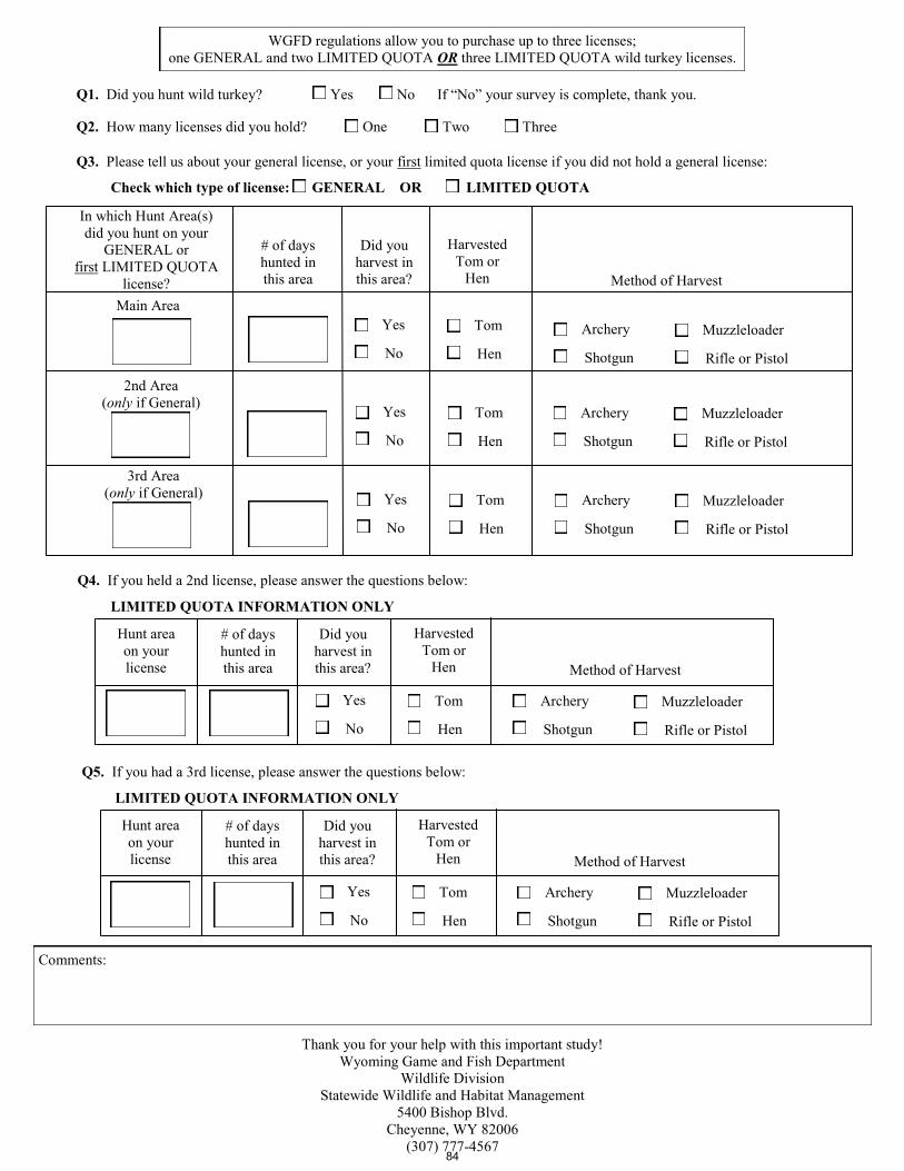
Q1. Did you hunt wild turkey? Yes No If “No” your survey is complete, thank you.
Q2. How many licenses did you hold? One Two Three
Q3. Please tell us about your general license, or your first limited quota license if you did not hold a general license:
Check which type of license: GENERAL OR LIMITED QUOTA
Q4. If you held a 2nd license, please answer the questions below:
LIMITED QUOTA INFORMATION ONLY
Hunt area
on your
license
# of days
hunted in
this area
Did you
harvest in
this area?
Harvested
Tom or
Hen Method of Harvest
Yes
No
Tom
Hen
Archery
Shotgun
Muzzleloader
Rifle or Pistol
Thank you for your help with this important study!
Wyoming Game and Fish Department
Wildlife Division
Statewide Wildlife and Habitat Management
5400 Bishop Blvd.
Cheyenne, WY 82006
(307) 777-4567
Q5. If you had a 3rd license, please answer the questions below:
LIMITED QUOTA INFORMATION ONLY
Hunt area
on your
license
# of days
hunted in
this area
Did you
harvest in
this area?
Harvested
Tom or
Hen Method of Harvest
Yes
No
Tom
Hen
Archery
Shotgun
Muzzleloader
Rifle or Pistol
WGFD regulations allow you to purchase up to three licenses;
one GENERAL and two LIMITED QUOTA OR three LIMITED QUOTA wild turkey licenses.
Comments:
In which Hunt Area(s)
did you hunt on your
GENERAL or
first LIMITED QUOTA
license?
# of days
hunted in
this area
Did you
harvest in
this area?
Harvested
Tom or
Hen Method of Harvest
Yes
No
Tom
Hen
Archery
Shotgun
Muzzleloader
Rifle or Pistol
Main Area
Yes
No
Tom
Hen
Archery
Shotgun
Muzzleloader
Rifle or Pistol
2nd Area
(only if General)
Yes
No
Tom
Hen
Archery
Shotgun
Muzzleloader
Rifle or Pistol
3rd Area
(only if General)
84

,
We encourage you to respond online as this method significantly reduces sur-vey costs. Please log on to wgfd.wyo.govHunting/HarvestSurveys
and use the following password:
2016 Wyoming Spring Wild Turkey Hunter Survey
Dear Wyoming Wild Turkey License Holder,
Each year the Wyoming Game and Fish Department conducts a Spring Wild Turkey Hunter Survey to esti-mate harvest, hunter success, and hunter effort to help plan next year’s hunting season. Even if you did not hunt or harvest this year, we need to hear from you, as hunter effort is an important part of our reports. If you are unable to complete the survey online, please complete this form and return it in the postage-paid envelope enclosed. If you have questions about the survey or prefer to complete it over the phone, please contact Gail Sheridan, WGFD’s Harvest Survey Coordinator at [email protected] or (307) 777-4567.
Over
Please respond by June 1, 2016
85

Q1. Did you hunt wild turkey? Yes No If “No” your survey is complete, thank you.
Q2. How many licenses did you hold? One Two Three
Q3. Please tell us about your general license, or your first limited quota license if you did not hold a general license:
Check which type of license: GENERAL OR LIMITED QUOTA
Q4. If you held a 2nd license, please answer the questions below:
LIMITED QUOTA INFORMATION ONLY
Hunt area
on your
license
# of days
hunted in
this area
Did you
harvest in
this area?
Harvested
Tom or
Hen Method of Harvest
Yes
No
Tom
Hen
Archery
Shotgun
Muzzleloader
Rifle or Pistol
Thank you for your help with this important study!
Wyoming Game and Fish Department
Wildlife Division
Statewide Wildlife and Habitat Management
5400 Bishop Blvd.
Cheyenne, WY 82006
(307) 777-4567
Q5. If you had a 3rd license, please answer the questions below:
LIMITED QUOTA INFORMATION ONLY
Hunt area
on your
license
# of days
hunted in
this area
Did you
harvest in
this area?
Harvested
Tom or
Hen Method of Harvest
Yes
No
Tom
Hen
Archery
Shotgun
Muzzleloader
Rifle or Pistol
WGFD regulations allow you to purchase up to three licenses;
one GENERAL and two LIMITED QUOTA OR three LIMITED QUOTA wild turkey licenses.
Comments:
In which Hunt Area(s)
did you hunt on your
GENERAL or
first LIMITED QUOTA
license?
# of days
hunted in
this area
Did you
harvest in
this area?
Harvested
Tom or
Hen Method of Harvest
Yes
No
Tom
Hen
Archery
Shotgun
Muzzleloader
Rifle or Pistol
Main Area
Yes
No
Tom
Hen
Archery
Shotgun
Muzzleloader
Rifle or Pistol
2nd Area
(only if General)
Yes
No
Tom
Hen
Archery
Shotgun
Muzzleloader
Rifle or Pistol
3rd Area
(only if General)
86
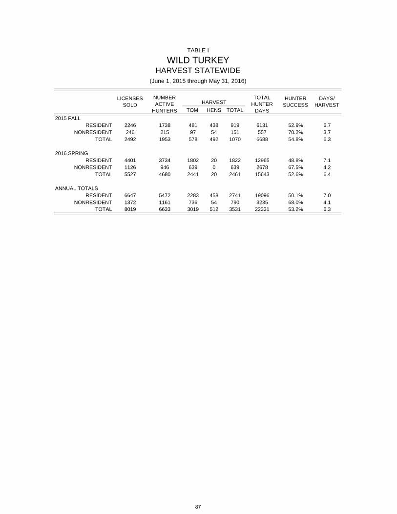
TOM HENS TOTAL2015 FALL
RESIDENT 2246 1738 481 438 919 6131 52.9% 6.7NONRESIDENT 246 215 97 54 151 557 70.2% 3.7
TOTAL 2492 1953 578 492 1070 6688 54.8% 6.3
2016 SPRING RESIDENT 4401 3734 1802 20 1822 12965 48.8% 7.1
NONRESIDENT 1126 946 639 0 639 2678 67.5% 4.2TOTAL 5527 4680 2441 20 2461 15643 52.6% 6.4
ANNUAL TOTALSRESIDENT 6647 5472 2283 458 2741 19096 50.1% 7.0
NONRESIDENT 1372 1161 736 54 790 3235 68.0% 4.1TOTAL 8019 6633 3019 512 3531 22331 53.2% 6.3
TABLE I
TOTAL HUNTER
DAYS
HUNTER SUCCESSHARVEST
DAYS/ HARVEST
WILD TURKEYHARVEST STATEWIDE
(June 1, 2015 through May 31, 2016)
LICENSES SOLD
NUMBER ACTIVE
HUNTERS
87

BIOLOGICAL YEAR 2006/7 2007/8 2008/9 2009/10 2010/11 2011/12 2012/13 2013/14 2014/15 2015/16
VALID LICENSESFALL TOTAL 2,427 2,934 3,226 3,132 2,403 2,319 2,209 1,907 1,969 2,492
RESIDENT 1,937 2,427 2,718 2,538 2,123 2,043 1,969 1,688 1,787 2,246NONRESIDENT 490 507 508 594 280 276 240 219 182 246
SPRING TOTAL 5,799 5,732 5,891 6,826 6,345 5,166 4,947 4,924 5,410 5,527RESIDENT 1,497 4,343 4,442 4,957 4,503 3,885 3,854 3,830 4,330 4,401
NONRESIDENT 4,302 1,389 1,449 1,869 1,842 1,281 1,093 1,094 1,080 1,126
STATEWIDE TOTAL 8,226 8,666 9,117 9,958 93,608 7,485 7,156 6,831 7,379 8,019RESIDENT 3,434 6,770 7,160 7,495 7,159 5,928 5,823 5,518 6,117 6,647
NONRESIDENT 4,792 1,896 1,957 2,463 2,149 1,557 1,333 1,313 1,262 1,372
NUMBER ACTIVE HUNTERSFALL TOTAL 1,982 2,594 2,816 2,457 2,075 1,957 1,849 1,565 1,619 1,953
RESIDENT 1,577 2,128 2,344 2,273 1,826 1,723 1,636 1,390 1,466 1,738NONRESIDENT 405 466 472 184 249 234 213 175 153 215
SPRING TOTAL 5,351 4,765 5,224 5,256 5,783 4,714 4,600 4,138 4,460 4,680RESIDENT 3,923 3,636 3,878 3,439 3,996 3,491 3,389 3,119 3,471 3,734
NONRESIDENT 1,428 1,129 1,346 1,817 1,787 1,223 1,211 1,019 989 946
TOTAL 7,333 7,359 8,040 7,713 7,331 6,671 6,449 5,703 6,079 6,633RESIDENT 5,500 5,764 6,222 5,712 5,265 5,214 5,025 4,509 4,937 5,472
NONRESIDENT 1,833 1,595 1,818 2,001 2,066 1,457 1,424 1,194 1,142 1,161
TOTAL HARVESTFALL TOTAL 1,193 1,741 1,962 1,392 1,298 1,108 987 815 950 1,070
RESIDENT 980 1,379 1,588 1,276 1,106 950 843 696 838 919NONRESIDENT 213 362 374 116 192 158 144 119 112 151
SPRING TOTAL 2,933 3,163 3,145 3,214 2,831 2,467 2,048 1,963 2,008 2,461RESIDENT 1,851 2,169 2,014 1,908 1,696 1,561 1,290 1,320 1,400 1,822
NONRESIDENT 1,082 994 1,131 1,306 1,135 906 758 643 608 639
TOTAL 4,126 4,904 5,107 4,606 4,512 3,575 3,035 2,778 2,958 3,531RESIDENT 2,831 3,548 3,602 3,184 3,014 2,511 2,133 2,016 2,238 2,741
NONRESIDENT 1,295 1,356 1,505 1,422 1,498 1,064 902 762 720 790
TOTAL HUNTER DAYSFALL TOTAL 5,517 6,522 6,755 7,912 5,428 6,135 5,289 5,016 4,993 6,688
RESIDENT 4,424 5,270 5,622 7,147 4,806 5,558 4,698 4,602 4,672 6,131NONRESIDENT 1,093 1,252 1,133 765 622 577 591 414 321 557
SPRING TOTAL 14,521 14,175 15,126 18,355 17,943 14,282 14,194 13,039 15,412 15,643RESIDENT 10,902 11,135 11,765 13,447 12,909 11,143 10,936 10,277 12,545 12,965
NONRESIDENT 3,619 3,040 3,361 4,908 5,034 3,139 3,258 2,762 2,867 2,678
TOTAL 20,038 20,697 21,881 26,267 23,783 20,417 19,483 18,055 20,405 22,331RESIDENT 15,326 16,405 17,387 20,594 18,253 16,701 15,634 14,879 17,217 19,096
NONRESIDENT 4,712 4,292 4,494 5,673 5,530 3,716 3,849 3,176 3,188 3,235
TABLE II
WILD TURKEYTEN-YEAR COMPARISON OF STATEWIDE HARVEST
2006 - 2015
88

TABLE II (Continued)WILD TURKEY TEN-YEAR COMPARISON OF STATEWIDE HARVEST
BIOLOGICAL YEAR 2006/7 2007/8 2008/9 2009/10 2010/11 2011/12 2012/13 2013/14 2014/15 2015/16
HUNTER SUCCESSFALL TOTAL 60.2% 67.1% 69.7% 56.7% 62.6% 56.6% 53.4% 52.1% 58.7% 54.8%
RESIDENT 62.1% 64.8% 67.8% 56.1% 60.6% 55.1% 51.5% 50.1% 57.2% 52.9%NONRESIDENT 52.6% 77.7% 79.2% 63.0% 77.1% 67.5% 67.6% 68.0% 73.2% 70.2%
SPRING TOTAL 57.1% 66.4% 60.2% 61.2% 49.0% 52.3% 44.5% 47.4% 45.0% 52.6%RESIDENT 47.2% 59.7% 51.9% 56.0% 42.4% 44.7% 38.1% 42.3% 40.3% 48.8%
NONRESIDENT 75.8% 88.0% 84.0% 71.9% 63.5% 74.1% 62.6% 63.1% 61.5% 67.5%
TOTAL 56.3% 66.6% 63.5% 59.7% 61.6% 53.6% 47.1% 48.7% 48.7% 53.2%RESIDENT 51.5% 61.6% 57.9% 55.7% 57.3% 48.2% 42.4% 44.7% 45.3% 50.1%
NONRESIDENT 70.6% 85.0% 82.8% 71.1% 72.5% 73.0% 63.3% 63.8% 63.0% 68.0%
DAYS/HARVESTFALL TOTAL 4.6 3.8 3.4 5.7 4.2 5.5 5.4 6.2 5.3 6.3
RESIDENT 4.5 3.8 3.5 5.6 4.4 5.9 5.6 6.6 5.6 6.7NONRESIDENT 5.1 3.5 3.0 6.6 3.2 3.7 4.1 3.5 2.9 3.7
SPRING TOTAL 5.0 4.5 4.8 5.7 6.3 5.8 6.9 6.6 7.7 6.4RESIDENT 5.9 5.1 5.8 7.1 7.6 7.1 8.5 7.8 9.0 7.1
NONRESIDENT 3.3 3.1 3.0 3.8 4.4 3.5 4.3 4.3 4.7 4.2
TOTAL 4.9 4.2 4.3 5.7 5.3 5.7 6.4 6.5 6.9 6.3RESIDENT 5.4 4.6 4.8 6.5 6.1 6.7 7.3 7.4 7.7 7.0
NONRESIDENT 3.6 3.2 3.0 4.0 3.7 3.5 4.3 4.2 4.4 4.1
89

ACTIVE HUNTER HUNTER DAYS/AREA TYPE LICS/HTRS TOM HEN TOTAL SUCCESS DAYS HARVEST SOLD
1 Black Hills General
Resident 577 89 139 228 39.5% 2444 10.72 1936Nonresident 67 26 19 45 67.2% 193 4.29 223
Area Total 644 115 158 273 42.4% 2637 9.66 21592 Central Type 3
Resident 64 13 32 45 70.3% 221 4.91 75Nonresident 3 2 2 4 133.3% 6 0.00 6
General
Resident 300 94 64 158 52.7% 910 5.76 1936Nonresident 39 11 9 20 51.3% 120 6.00 223
Area Total 406 120 107 227 55.9% 1030 4.54 22403 Powder River Type 3
Resident 123 59 29 88 71.5% 298 3.39 139Nonresident 12 8 4 12 100.0% 30 2.50 14
General
Resident 341 125 116 241 70.7% 885 3.67 1936Nonresident 69 41 13 54 78.3% 148 2.74 223
Area Total 545 233 162 395 72.5% 1361 3.45 23124 Bighorn Basin Type 1
Resident 64 18 14 32 50.0% 286 8.94 96Nonresident 3 2 1 3 100.0% 8 2.67 3
Area Total 67 20 15 35 52.2% 294 8.40 995 South Central General
Resident 269 83 44 127 47.2% 1087 8.56 1936Nonresident 22 7 6 13 59.1% 52 4.00 223
Area Total 291 90 50 140 48.1% 1139 8.14 2159
HARVEST
2015BY HUNT AREA
HARVEST, HUNTING PRESSURE, HUNTER SUCCESSFALL WILD TURKEY
TABLE III
90
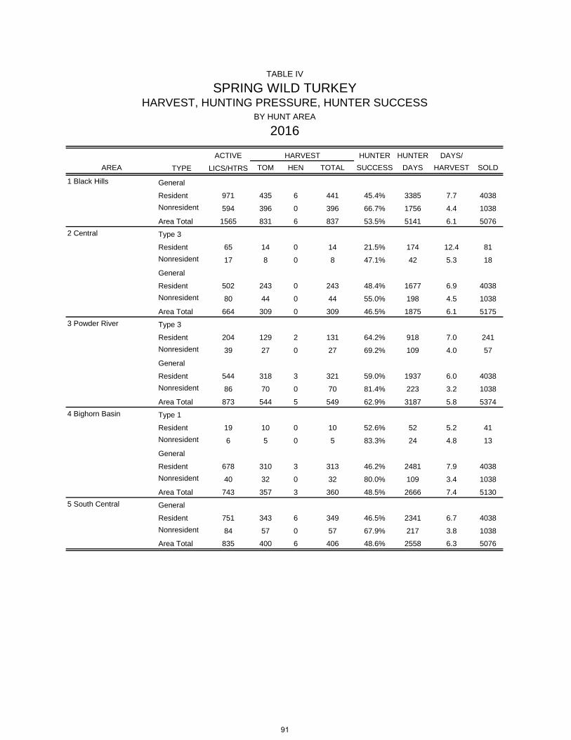
ACTIVE HUNTER HUNTER DAYS/AREA TYPE LICS/HTRS TOM HEN TOTAL SUCCESS DAYS HARVEST SOLD
1 Black Hills General
Resident 971 435 6 441 45.4% 3385 7.7 4038Nonresident 594 396 0 396 66.7% 1756 4.4 1038
Area Total 1565 831 6 837 53.5% 5141 6.1 50762 Central Type 3
Resident 65 14 0 14 21.5% 174 12.4 81Nonresident 17 8 0 8 47.1% 42 5.3 18
General
Resident 502 243 0 243 48.4% 1677 6.9 4038Nonresident 80 44 0 44 55.0% 198 4.5 1038
Area Total 664 309 0 309 46.5% 1875 6.1 51753 Powder River Type 3
Resident 204 129 2 131 64.2% 918 7.0 241Nonresident 39 27 0 27 69.2% 109 4.0 57
General
Resident 544 318 3 321 59.0% 1937 6.0 4038Nonresident 86 70 0 70 81.4% 223 3.2 1038
Area Total 873 544 5 549 62.9% 3187 5.8 53744 Bighorn Basin Type 1
Resident 19 10 0 10 52.6% 52 5.2 41Nonresident 6 5 0 5 83.3% 24 4.8 13
General
Resident 678 310 3 313 46.2% 2481 7.9 4038Nonresident 40 32 0 32 80.0% 109 3.4 1038
Area Total 743 357 3 360 48.5% 2666 7.4 51305 South Central General
Resident 751 343 6 349 46.5% 2341 6.7 4038Nonresident 84 57 0 57 67.9% 217 3.8 1038
Area Total 835 400 6 406 48.6% 2558 6.3 5076
SPRING WILD TURKEYHARVEST, HUNTING PRESSURE, HUNTER SUCCESS
BY HUNT AREA
2016
HARVEST
TABLE IV
91

Valid Licenses*
Resident 2,068Nonresident 241
Total 2,309
*Includes landowner, pioneer and heritage licenses
Licenses*
Resident 4,045Nonresident 996
Total 5,041
*Includes landowner, pioneer and heritage licenses
TABLE V
TABLE VI
FALL WILD TURKEYLicense Data Summary
2015
Number SurveyedNumber Usable
(hunters and nonhunters)Response Rate
(# Usable/# Surveyed)
2015
2,068 795 38.4%241 130 53.9%
2,309 925 40.1%
SPRING WILD TURKEYLicense Data Summary
Number Surveyed
(hunters and nonhunters)p
(# Usable/# Surveyed)
5,041 2,132 42.3%
4,045 1,547 38.2%996 585 58.7%
92
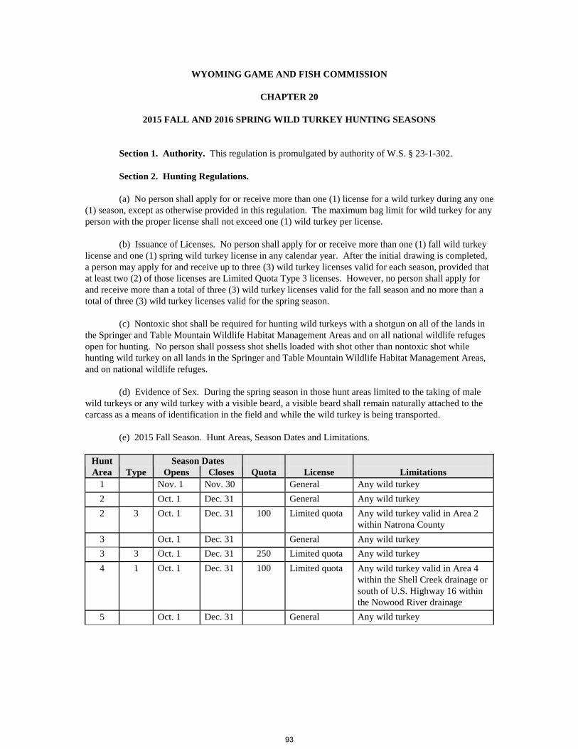
WYOMING GAME AND FISH COMMISSION
CHAPTER 20
2015 FALL AND 2016 SPRING WILD TURKEY HUNTING SEASONS
Section 1. Authority. This regulation is promulgated by authority of W.S. § 23-1-302. Section 2. Hunting Regulations. (a) No person shall apply for or receive more than one (1) license for a wild turkey during any one (1) season, except as otherwise provided in this regulation. The maximum bag limit for wild turkey for any person with the proper license shall not exceed one (1) wild turkey per license. (b) Issuance of Licenses. No person shall apply for or receive more than one (1) fall wild turkey license and one (1) spring wild turkey license in any calendar year. After the initial drawing is completed, a person may apply for and receive up to three (3) wild turkey licenses valid for each season, provided that at least two (2) of those licenses are Limited Quota Type 3 licenses. However, no person shall apply for and receive more than a total of three (3) wild turkey licenses valid for the fall season and no more than a total of three (3) wild turkey licenses valid for the spring season. (c) Nontoxic shot shall be required for hunting wild turkeys with a shotgun on all of the lands in the Springer and Table Mountain Wildlife Habitat Management Areas and on all national wildlife refuges open for hunting. No person shall possess shot shells loaded with shot other than nontoxic shot while hunting wild turkey on all lands in the Springer and Table Mountain Wildlife Habitat Management Areas, and on national wildlife refuges. (d) Evidence of Sex. During the spring season in those hunt areas limited to the taking of male wild turkeys or any wild turkey with a visible beard, a visible beard shall remain naturally attached to the carcass as a means of identification in the field and while the wild turkey is being transported. (e) 2015 Fall Season. Hunt Areas, Season Dates and Limitations.
Hunt Season Dates License
Limitations Area Type Opens Closes Quota
1 Nov. 1 Nov. 30 General Any wild turkey 2 Oct. 1 Dec. 31 General Any wild turkey 2 3 Oct. 1 Dec. 31 100 Limited quota Any wild turkey valid in Area 2
within Natrona County 3 Oct. 1 Dec. 31 General Any wild turkey 3 3 Oct. 1 Dec. 31 250 Limited quota Any wild turkey 4 1 Oct. 1 Dec. 31 100 Limited quota Any wild turkey valid in Area 4
within the Shell Creek drainage or south of U.S. Highway 16 within the Nowood River drainage
5 Oct. 1 Dec. 31 General Any wild turkey
93
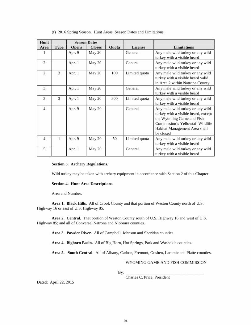
(f) 2016 Spring Season. Hunt Areas, Season Dates and Limitations.
Hunt Season Dates License
Limitations Area Type Opens Closes Quota
1 Apr. 9 May 20 General Any male wild turkey or any wild turkey with a visible beard
2 Apr. 1 May 20 General Any male wild turkey or any wild turkey with a visible beard
2 3 Apr. 1 May 20 100 Limited quota Any male wild turkey or any wild turkey with a visible beard valid in Area 2 within Natrona County
3 Apr. 1 May 20 General Any male wild turkey or any wild turkey with a visible beard
3 3 Apr. 1 May 20 300 Limited quota Any male wild turkey or any wild turkey with a visible beard
4 Apr. 9 May 20 General Any male wild turkey or any wild turkey with a visible beard, except the Wyoming Game and Fish Commission’s Yellowtail Wildlife Habitat Management Area shall be closed
4 1 Apr. 9 May 20 50 Limited quota Any male wild turkey or any wild turkey with a visible beard
5 Apr. 1 May 20 General Any male wild turkey or any wild turkey with a visible beard
Section 3. Archery Regulations.
Wild turkey may be taken with archery equipment in accordance with Section 2 of this Chapter. Section 4. Hunt Area Descriptions. Area and Number. Area 1. Black Hills. All of Crook County and that portion of Weston County north of U.S. Highway 16 or east of U.S. Highway 85. Area 2. Central. That portion of Weston County south of U.S. Highway 16 and west of U.S. Highway 85; and all of Converse, Natrona and Niobrara counties. Area 3. Powder River. All of Campbell, Johnson and Sheridan counties. Area 4. Bighorn Basin. All of Big Horn, Hot Springs, Park and Washakie counties. Area 5. South Central. All of Albany, Carbon, Fremont, Goshen, Laramie and Platte counties.
WYOMING GAME AND FISH COMMISSION
By: ______________________________________ Charles C. Price, President Dated: April 22, 2015
94

FALC
ON
RY
HU
NTI
NG
/HA
RV
EST
REP
OR
T A
s ref
eren
ced
in W
yom
ing
Gam
e an
d Fi
sh D
epar
tmen
t Reg
ulat
ion
C
hapt
er 1
1, S
ectio
n 10
(e)*
__
___
If y
ou d
id n
ot h
unt w
ith a
falc
on d
urin
g th
ese
time
peri
ods,
plea
se c
heck
her
e an
d re
turn
the
surv
ey.
SEPT
EM
BER
20
15
OC
TO
BER
20
15
NO
VE
MBE
R
2015
D
EC
EM
BER
20
15
JAN
UA
RY
20
16
FEB
RU
AR
Y
2016
M
AR
CH
20
16
Spec
ies
Cou
ntie
s Hun
ted
(e.g
. – G
oshe
n)
# of
D
ays
Hun
ted
Tota
l H
arve
st
# of
D
ays
Hun
ted
Tota
l H
arve
st
# of
D
ays
Hun
ted
Tota
l H
arve
st
# of
D
ays
Hun
ted
Tota
l H
arve
st
# of
D
ays
Hun
ted
Tota
l H
arve
st
# of
D
ays
Hun
ted
Tota
l H
arve
st
# of
D
ays
Hun
ted
Tota
l H
arve
st
Sage
Gro
use*
__
____
____
____
_
__
____
____
____
_
__
____
____
____
_
__
____
____
____
_
__
____
____
____
_
To
tal
Blu
e G
rous
e __
____
____
____
_
__
____
____
____
_
__
____
____
____
_
__
____
____
____
_
__
____
____
____
_
To
tal
Ruf
fed
Gro
use
____
____
____
___
__
____
____
____
_
__
____
____
____
_
__
____
____
____
_
__
____
____
____
_
To
tal
*Onl
y sa
ge g
rous
e in
form
atio
n is
requ
ired
by C
omm
issio
n R
egul
atio
n.
Nam
e __
____
____
____
____
____
____
____
____
_ A
ddre
ss _
____
____
____
____
____
____
____
____
__
____
____
____
____
____
____
____
____
____
__
Dat
e: _
____
____
____
95

SEPT
EM
BER
20
15
OC
TO
BER
20
15
NO
VE
MBE
R
2015
D
EC
EM
BER
20
15
JAN
UA
RY
20
16
FEB
RU
AR
Y
2016
M
AR
CH
20
16
Spec
ies
Cou
ntie
s Hun
ted
(e.g
. - G
oshe
n)
# of
D
ays
Hun
ted
Tota
l H
arve
st
# of
D
ays
Hun
ted
Tota
l H
arve
st
# of
D
ays
Hun
ted
Tota
l H
arve
st
# of
D
ays
Hun
ted
Tota
l H
arve
st
# of
D
ays
Hun
ted
Tota
l H
arve
st
# of
D
ays
Hun
ted
Tota
l H
arve
st
# of
D
ays
Hun
ted
Tota
l H
arve
st
Chu
kar
Part
ridg
e __
____
____
____
_
__
____
____
____
_
__
____
____
____
_
__
____
____
____
_
__
____
____
____
_
To
tal
Gra
y Pa
rtri
dge
____
____
____
___
__
____
____
____
_
__
____
____
____
_
__
____
____
____
_
__
____
____
____
_
To
tal
Phea
sant
__
____
____
____
_
__
____
____
____
_
__
____
____
____
_
__
____
____
____
_
__
____
____
____
_
To
tal
Shar
p-ta
iled
Gro
use
____
____
____
___
__
____
____
____
_
__
____
____
____
_
__
____
____
____
_
__
____
____
____
_
To
tal
96
SEPT
EM
BER
20
15
OC
TO
BER
20
15
NO
VE
MBE
R
2015
D
EC
EM
BER
20
15
JAN
UA
RY
20
16
FEB
RU
AR
Y
2016
M
AR
CH
20
16
Spec
ies
Cou
ntie
s Hun
ted
(e.g
. - G
oshe
n)
# of
D
ays
Hun
ted
Tota
l H
arve
st
# of
D
ays
Hun
ted
Tota
l H
arve
st
# of
D
ays
Hun
ted
Tota
l H
arve
st
# of
D
ays
Hun
ted
Tota
l H
arve
st
# of
D
ays
Hun
ted
Tota
l H
arve
st
# of
D
ays
Hun
ted
Tota
l H
arve
st
# of
D
ays
Hun
ted
Tota
l H
arve
st
Cot
tont
ail
Rab
bit
____
____
____
___
__
____
____
____
_
__
____
____
____
_
__
____
____
____
_
__
____
____
____
_
To
tal
Dov
e __
____
____
____
_
__
____
____
____
_
__
____
____
____
_
__
____
____
____
_
__
____
____
____
_
To
tal
Duc
ks
____
____
____
___
__
____
____
____
_
__
____
____
____
_
__
____
____
____
_
__
____
____
____
_
To
tal
Plea
se re
turn
by
Apr
il 15
, 201
6 to
:
Wyo
min
g G
ame
and
Fish
Dep
artm
ent
A
ttn:
Wild
life
Div
isio
n Pe
rmitt
ing
Off
ice
54
00 B
isho
p B
lvd.
Che
yenn
e, W
Y 8
2006
Fax:
307
-777
-465
0
97

County Days Harvest Days Harvest Days Harvest Days Harvest Days Harvest Days Harvest Days HarvestFremont 3 0 10 0 20 0 10 0
Hotsprings 10 0 25 1 25 1 25 1 20 0 3 0Johnson 4 2 4 3Natrona 8 0 8 2 11 1Sublette 8 1 18 6 16 5 10 2
Sweetwater 3 0TOTALS 32 1 65 11 76 10 45 3 20 0 3 0 0 0
Days Hunted 241Harvest 25Hunters 8
County Days Harvest Days Harvest Days Harvest Days Harvest Days Harvest Days Harvest Days HarvestNatrona 4 0 8 1 11 2 4 0
Sheridan 3 1 4 1 5 2TOTALS 4 0 8 1 14 3 8 1 5 2 0 0 0 0
Days Hunted 39Harvest 7Hunters 2
County Days Harvest Days Harvest Days Harvest Days Harvest Days Harvest Days Harvest Days HarvestGoshen 3 0
Sheridan 5 1 30 4 24 3 26 5 23 2TOTALS 5 1 30 4 24 3 29 5 23 2 0 0 0 0
Days Hunted 111Harvest 15Hunters 5
County Days Harvest Days Harvest Days Harvest Days Harvest Days Harvest Days Harvest Days HarvestUinta 20 0
Carbon 20 6TOTALS 40 6 0 0 0 0 0 0 0 0 0 0 0 0
Days Hunted 40Harvest 6Hunters 2
MOURNING DOVESept Oct Nov Dec Jan Feb Mar
Oct Nov Dec Jan Feb
RESIDENT FALCON HARVEST 2015-2016
SAGE-GROUSEMarSept
Feb Mar
GRAY PARTRIDGESept Oct Nov Dec Jan Feb Mar
PHEASANTSept Oct Nov Dec Jan
TABLE I
98

RESIDENT FALCONRY - continued
County Days Harvest Days Harvest Days Harvest Days Harvest Days Harvest Days Harvest Days HarvestSheridan 12 2 24 1 23 1 23 0 28 2TOTALS 12 2 24 1 23 1 23 0 28 2 0 0 0 0
Days Hunted 110Harvest 6Hunters 3
County Days Harvest Days Harvest Days Harvest Days Harvest Days Harvest Days Harvest Days HarvestAlbany 1 0Carbon 20 0 15 0 10 0 10 0 5 0 15 1 1 1
Fremont 1 0 2 1 0 0 2 1 2 2Johnson 19 12 14 8 5 2Laramie 2 0 1 0Natrona 3 1 18 19 6 4
Sheridan 4 1TOTALS 24 1 35 12 29 10 33 21 13 5 19 3 3 1
Days Hunted 156Harvest 53Hunters 5
County Days Harvest Days Harvest Days Harvest Days Harvest Days Harvest Days Harvest Days HarvestFremont 3 0Goshen 2 1 22 9 13 1 3 0Johnson 6 2 30 3 8 2 25 0Sheridan 2 1 15 8 13 7 18 10 4 2
Uinta 30 2Natrona 2 0 9 2 2 0
TOTALS 42 6 76 22 39 10 46 10 4 2 0 0 0 0
Days Hunted 207Harvest 50Hunters 8
7251
71%
MarSept Oct Nov Dec Jan Feb
Dec Jan Feb Mar
% Response
DUCKSSept Oct Nov Dec FebJan
COTTONTAIL RABBIT
Mar
Total RespondedTotal Surveys Mailed
SHARP-TAILED GROUSESept Oct Nov
99

County Days Harvest Days Harvest Days Harvest Days Harvest Days Harvest Days Harvest Days HarvestSheridan 3 0TOTALS 0 0 3 0 0 0 0 0 0 0 0 0 0 0
Days Hunted 3Harvest 0Hunters 1
County Days Harvest Days Harvest Days Harvest Days Harvest Days Harvest Days Harvest Days HarvestCarbon 3 0 2 0Fremont 14 3 2 1 1 0Johnson 4 2Sublette 19 4
Sweetwater 10 14 100 9 10 4 8 2 8 2TOTALS 27 17 127 16 11 4 8 2 8 2 0 0 0 0
Days Hunted 181Harvest 41Hunters 16
County Days Harvest Days Harvest Days Harvest Days Harvest Days Harvest Days Harvest Days HarvestSheridan 3 0TOTALS 0 0 3 0 0 0 0 0 0 0 0 0 0 0
Days Hunted 3Harvest 0Hunters 1
County Days Harvest Days Harvest Days Harvest Days Harvest Days Harvest Days Harvest Days HarvestCarbon 3 1
Fremont 2 0Natrona 3 1
Sweetwater 12 12Uinta 10 4 12 6 12 10
TOTALS 8 2 12 12 0 0 10 4 12 6 12 10 0 0
Days Hunted 54Harvest 34Hunters 5
Mar
NONRESIDENT FALCON HARVEST 2015-2016
PHEASANTSept Oct Nov Dec Jan Feb Mar
Sept Oct Nov Dec Jan Feb
COTTONTAIL RABBITSept Oct Nov Dec Jan Feb Mar
TABLE II
SHARP-TAILED GROUSESept Oct Nov Dec Jan Feb Mar
SAGE-GROUSE
100

NONRESIDENT FALCONRY - continued
County Days Harvest Days Harvest Days Harvest Days Harvest Days Harvest Days Harvest Days HarvestSublette 1 1
Sweetwater 8 3TOTALS 1 1 8 3 0 0 0 0 0 0 0 0 0 0
Days Hunted 9Harvest 4Hunters 2
4724
51%
Mar
Total Surveys MailedTotal Responded
% Response
DUCKSSept Oct Nov Dec Jan Feb
101


SM
ALL
GA
ME
, UP
LAN
D G
AM
E B
IRD
, FU
RB
EA
RE
R &
BO
BC
AT
MA
NA
GE
ME
NT
AR
EA
S
103


