17
ANNUAL REPORT of the STATE GEOLOGIST to the GEOLOGICAL BOARD I July, 1971

ANNUAL REPORT
of the
STATE GEOLOGIST
to the
GEOLOGICAL BOARD
I July, 1971

Iowa Geological Survey
ANNUAL REPORT Volume 42
1 July 1971
Figure 1 shows the table of organization for the Iowa Geological
Survey for this date. Figure 2 shows the functional relationships
of the Survey. During the last year the Survey staff has accom-
plished the following major tasks:
PUBLICATIONS
1. List of Publicatio ns of the Iowa Geological Survey,
43 p.
2. Wate r resources of Southeast Iowa, Water Atlas #4,
R. W. Coble, (in press).
3. Geology and Ground-Water Resourc e s of Cerro Gordo County,
Iowa, Water Supply Bull. #9, H. G. Hershey, K. D. Wahl,
and W. L. Steinhilber, 75 p., 1 map.
4. Geology and Ground-Water Resources of Linn County, Iowa,
Water Supply Bull. #10, R. E. Hansen, 66 p., 2 maps,
1 cross section.
5. Mineral Resources Map of Iowa, (52 x 36 in),
F. H. Dorheim.
6. Stratigraphy of the Upper Devonian Shell Rock Formation
of North-Central Iowa, Report of Investigations #10,
D. L. Koch, 123 p., 1 plate.
7. Bedrock Topographic Map of East-Central Iowa, 2 sheets
(in press) now on open-file status.

Figure l. Staff Organization and Responsibi I ity Assignments
GEOLOGICAL BOARD
Gov. Robert D. Ray, Chairman Dr. Willard L. Boyd Dr. W. Robert Porks IOWA STATE MAP ADVISORY COUNCIL Hon. Lloyd R.S1~ith ..--- Dr.Stanley M. Wawzonek Dr.Stanl ey M.'Aawzonek
Member of the Gcological Board I Or. Samuel J. Tuthill
IOWA GEOLOGICAL SURVEY Secretary Or. Samuel J. Tuthill
Director end Sta~e Geclogist
I Mr. Orville J Vun Eck
I Assistont State Geologist
I R:::.S~ARCH Si AF r (GEOLOGY) RESEARCH STAFF AOt\~iNISTRAllVE ST,\FF
I GF:C: ~~~ ') 'N .:).TER GEOLOGIC R;::SEARCH (REMOTE SENSING)
I Mrs. Wilma V. Gould,
~.k Ped J. Horici<, Chief Mrs. Mary C. Parker, Chief Dr. Jam'3s V. Toranik, Chief Administrative Assistant Dr. Lo<;iGn K. Kuiper Mrs.Jecn C. Prior, (Mrs. Jean C. Prior)
Systems Ar.alyst Sr. Reseorch Geologist Environmental Applications Mr. Earl E. Scheetz,
Mr. Dor win L.E van s Senior Gi;o!oqic Tec hni cian
::cc\0~1.:c G'.::CLOGY Driller (M rs. Mary C. Parker) Mrs. Carol A. Scrnu<!lson, Resources Applications
Mr. Fred H. Dorl":e im , Ch ie f PROJECTS Vacar.t1-
Receptionist-Stenographer SPECIAL
t,~r. Donavan L . Gorden (pert-time consultants) Cons ervation-Agricultural Mr. Charles W. Kithcart,
Sr. Research Geo!cgist Appl ic ations Geologic Technician Dr. Lyle Sendlein
Vacant'- Mr. Raymond R. Anderson,
SU3S!JRF:.CE GC:OLOGY Bedrock Surface Map Draftsmen Dr. Len Dro\<e Junior Scientist
Miss Gladice A. Haut ~.Ir. Donald L. Koch, Chi~f Geomorpholo9y
~.fr. Jeck L. Gilmore, Dr. George McCormick Clerk-Typis t
V.r. B ill y J. Bunker Clay Mini;;ralogy Vacant- C!E:rk-Typist1
R.;secrch Gcc!o g;sts -
1 To be funded by a grant from NASA

Research Cooperative
Programs
U.S. Geological Survey Groundwater (50/50)
U.S. Geological Survey Surface Water (50/50)
U.S. Geological Survey Topographic Mapping :30 IGS/70US)
N.A.S.A. (40 IGS/60US)
w
Geological I
Consultation, Advisory, and Data
Source Services
Iowa Department of Revenue Iowa Water Well Drillers Local and Regional Planning Commissions Iowa Counties and Municipalities Iowa Commerce Commission Iowa Development Commission Office for Planning and Programming Iowa Air Pollution Control Commission Iowa Water Pollution Control Commission Iowa State Deportment of Health
Solid Waste Disposal Division Municipal Water Supply
Iowa Chemical and Technology Review Board Iowa State Hygienic Laboratory Iowa Department of Justice Iowa Natural Resources Council Iowa Department of Soil Conservation Iowa Agricultural Experiment Station State Archaeologist Iowa Highway Commission Iowa Deportment of Mines and Minerals Iowa Department of Agriculture Iowa Preserves Board Iowa Conservation Commission The University of Iowa Iowa State University University of Northern Iowa Iowa Department of Public Instruction U.S. Deportment of Agriculture SCS Iowa Citizens Private Industry Engineering Consultants
Participation in Other
Agencies
Iowa Natural Resources Council S.J. Tuthill - Member and Administrator of Oil and Gas
Iowa State Land Rehabilitation Advisory Council
S.J. Tuthill - Member Iowa State Mop Advisory Council
S. M. Wawzonek- Chairman S.J. Tut hi I I- Secretary
Iowa Conservation Education Council M.C. Porker-Member F. H. Dorheim- Member
Iowa City Chamber of Commerce Environmental Concerns Committee
J.C. Pr ior- Member
0 ......
0 0
Vl c .., < (t
"<

8. Bedrock Topographic Map of Southeast Iowa, 2 sheets (in
press) now on open-file status.
9. Report of Preliminary Interpretation of Aeromagnetic
Survey of Southern Iowa, 0. J Van Eck, 19 p., 2 maps.
10. The Maquoketa Formation (Upper Ordovician) in Iowa,
Miscellaneous Map Series #1, M. C. Parker, 6 maps with text.
CONSULTATIVE, ADVISORY, AND DATA-SOURCE SERVICES
Well Predictions
Predictions for groundwater resources are made on request
for groups or individuals in Iowa. These include replies
to requests for information from 48 citizens, 29 munici
palities, four industries and four other governmental
agencies.
Subsurface Data Collection
The Survey collected 813 sets of well cuttings from
123 cooperating drillers. These samples represent
196,246 feet of drilling and an approximate cost of
acquisition, if we contracted the drilling, of about
$1,178,000 (based on $6.00/ft). These data were ob
tained for only the cost of the sample bags ($1,244)
and travel expenses of our senior geological technician
who collects the samples from the drillers ($422).
Neither of these last two expenses would be obviated if
we contracted the drilling ourselves. The only signifi
cant defect in this form of sample acquisition is that
4

the drilling E:ites are at a location and extended t0
depths determined by the needs of the drillers' client.
This program must be augmented by drilling done by the
Survey for specific research needs.
Well Logging
Five hundred and ten (510) detailed descriptive logs of
well-cutting samples have been made during the past year
(1 July 1970-30 June 1971). The footage represented is
126,980 feet. A formal set of priorities was established
in March by which well samples will be analyzed. The cri
teria for this priority system are:
(1) unusually deep wells,
(2) municipal wells,
(3) areas in which there are other research projects active,
(4) areas in which we have little spacial control, and
(5) gas storage projects. Where drillers indicate ano-
Microfilming
molies or that problems have been encountered, well
logs are prepared for the driller's use.
The program of microfilming our well logs has been com
pleted. These are stored in the State Archives. During
the coming biennium our technical files will be organized
into a microfilm-automatic data processing retrieval system.
This should protect our data bank by affording both a work
ing set and an archive set that will be stored in the State
Archives. At present the vast bulk of our data is in paper
files and is highly susceptible to loss by fire or water.
5

The data are not now readily usable without the direct
participation by staff members by those seeking informa-
tion. The microfilm-ADP system should free staff from
curatorial duties and make their time more available for
research.
Oil and Gas Administrator
Seventy-four drilling permits were issued during the
year. Four of these were oil tests, 10 were gas stor-
age wells, and 60 were stratigraphic tests.
Requests for Information From the General Public
The Survey received about 3,350 requests for geologic
and hydrologic information from the general public.
Category
General Information (largely for school children)
Technical Information (other than well predictions)
Requests for U. S. Geological Survey Topographic Maps
Requests for Iowa Geological Survey Maps and Publications
Lectures to Groups by IGS Staff:
Local 28 State 16 National 0
Field Conferences Conducted by IGS Staff:
Local 8 State 7 National 2
6
No 1970
1,420
115
985
830

Governor's Conference on Environmental Systems 9-12 December 1970, Des Moines, Iowa
A comprehensive discussion of the interrelationships
between environmental systems was conducted under the
leadership of the Geological Board. Fifteen state agen-
cies, eight federal agencies, five institutions of higher
education, 26 industries, and 35 citizens groups were re-
presented. The conference was attended by 198 individuals
all of whom were specifically invited by the governor.
Formal Conferences Attended or Conducted by IGS Staff:
Local 11 State 19 National 18
Consultative Contacts Required Data Analysis Only
Iowa Natural Resources Council Iowa Commerce Commission Iowa State Department of Health Iowa Conservation Commission Iowa State Highway Commission Office for Planning and Programming Iowa Development Commission Iowa Department of Justice Iowa State Hygienic Laboratory State Archaeologist Iowa Dept. of Mines & Minerals Iowa Dept. of Soil Conservation State University & Public Schools Iowa Preserves Board Counties and Cities Federal Agencies (FHA, etc.) Engineering Consultants Water Well Drillers Industry Individual Citizens
7
51 20 20 31 28
2 4
11 26
5 6
15 30
4 75 12 35
270 75
397 1,117
Required Data Acquisition and Analysis
3
2 7
2 2 3
2
17
14
28 80

RESEARCH IN PROGRESS
1. Environmental Geology Plymouth-Woodbury Counties (Dorheim
and Koch). Field and laboratory analysis complete. Prepara
tion of atlas of maps in preparation for printer. Estimated
publication date: September 1971.
Linn County (Prior and Tuthill, formerly included Karsten).
Airphoto analysis completed, but inadequate. Re-design of re
search method was required by the specific stratigraphic con
ditions discovered within the surficial sediments of the region.
Exclusion of this research program from the Governor's budget
reconunendations and prohibitions against replacing Karsten (who
resigned from the staff to continue his education) imposed by
SF 179 have slowed the work and made its completion date some
what indefinite. Field work will be continued this summer and
the program will be targeted for completion by 30 June 1972.
2. Earth Resources Technical Satellite A close interface with
the NASA program has been established. A grant proposal for
$92,826 has been submitted to NASA. Staff training and the
addition of Dr. James v. Taranik as Remote Sensing Supervisor
has been accomplished. Acquisition of equipment has been
initiated. A liaison relationship with 20 state and 2 federal
agencies has been established. Training of these liaison per
sonnel is in progress. Figure 3 shows the organizational struc
ture of the ERTS Remote-Sensing Program in Iowa.
A multispectral photographic and thermal infrared scan
ning mission was flown on the 180-mile stretch of the Mississippi
River between Clinton and Keokuk on 4 June 1971. The purpose
8
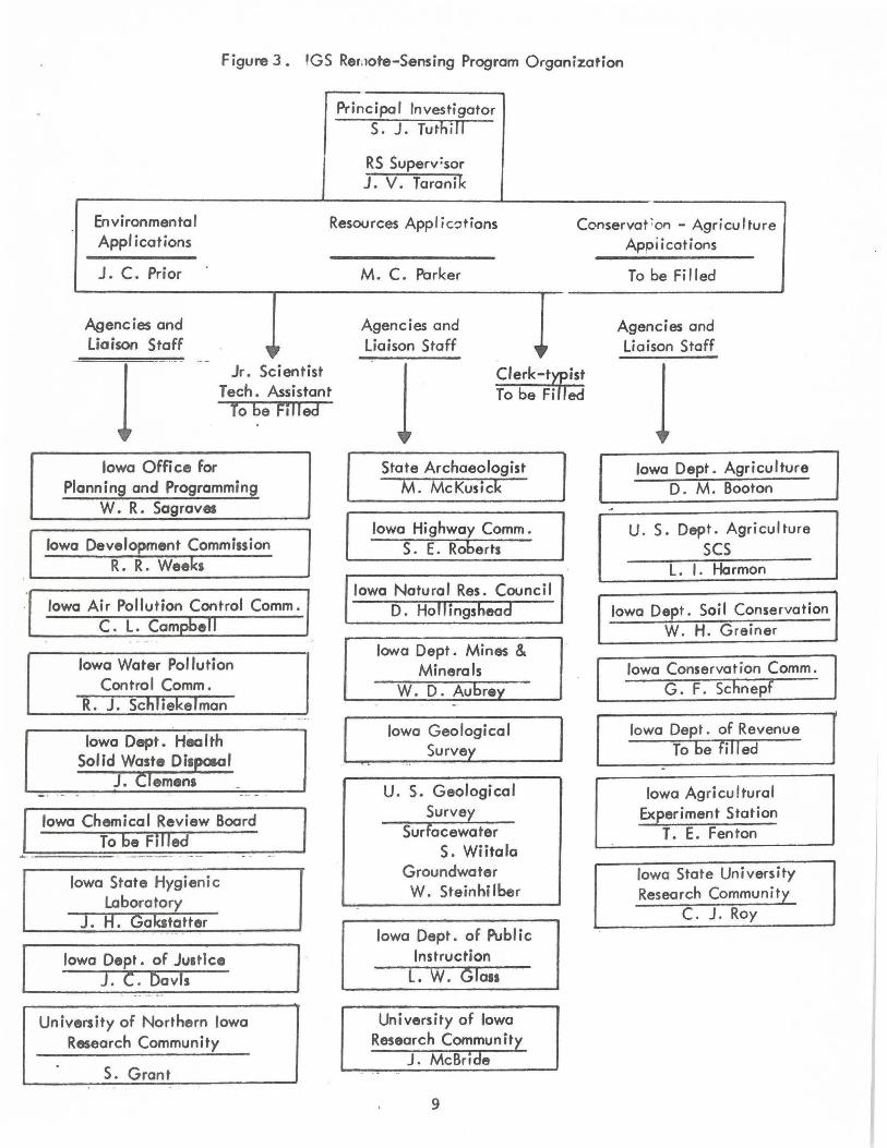
Figure 3. !GS Rer11ote-Sensing Program Organization
~·
Principal Investigator S. J. Tuthill
RS Superv:sor J. V. Taronik
Environmental Resources Appl ic-:itions Conservat ;on - Agriculture Applications
J. C. Prior
Agencies and Liaison Staff 0 - . - ·--
l Jr. Scientist
Tech. Assistant To be Filled
Iowa Office for Planning and Programming
W. R. Sagraves
Iowa Development Commission R. R. Weeks
Iowa Air Pollution Control Comm. C. L. Cam bell
Iowa Water Pollution Control Comm.
R. J. Schliekelman
Iowa Dept. Hea Ith Solid Waste Dispmol
J. Clemens
Iowa Chemical Review Board To be Filled
Iowa State Hygienic Laboratory
) . H. Gakltatter
Iowa Dept. of Justice J. C. Davis
University of Northern Iowa Research Community
S. Grant
M. C. Parker
Agencies and Liaison Staff
~·
l Clerk-trtst To be Fi ed
State Archaeologist M. McKusick
Iowa Highway Comm. S. E. Roberts
Iowa Natural Res. Council D. Ho II i ngshead
Iowa Dept. Mines & Minerals
W. D. Aubre
Iowa Geological Survey
U. S. Geological Survey
Surfacewater S. Wiitala
Groundwater W. Stein hi lber
Iowa Dept. of Public Instruction
L. W. Glass
University of Iowa Research Community
J. McBride
9
Appiications
To be Fi fled
Agencies and liaison Staff
l Iowa Dept. Agriculture
D. M. Booton
U. S . Dept. Agriculture scs
L. I. Harmon
Iowa Dept. Soil Conservation W. H. Greiner
Iowa Conservation Comm. G. F. Schnepf
Iowa Dept. of Revenue To be filled
Iowa Agricultural Experiment Station
T. E. Fenton
Iowa State University Research Community
C. J. Roy

of the mission was t.o ac~uire the remotely sensed imagery
necessary for the development of an isothermal map of the sur
f ace temperature of the river. Commonwealth-Edison Company
of Chicago, Illinois, agreed to fund the data-acquisition
mission and supply the Survey with one copy of all imagery
for unrestricted public use. The Survey organized thirteen
teams that included Iowa State Conservation Commission (29},
Iowa State Hygienic Laboratory (1), University of Iowa De
partment of Engineering (3), u. S. Geological Survey (4),
and Iowa Geological Survey (8) personnel. These teams took
surface temperature, ground atmospheric humidity, and water
samples during the period of the overflight (10:00 a.m. to
4:00 p.m.). This "ground truth" data was acquired in order
to give absolute values to the remotely sensed imagery. The
Conservation Commission supplied boats and boat operators for
the entire project.
The Attorney General's office flew an underflight mission
in a light aircraft to take low altitude oblique color-infrared
photographs of installations along the river. Rental of the
plane was provided by Commonwealth-Edison Company.
This research constitutes the most complete synchronous
thermal evaluation of this portion of the Mississippi River to
date and should provide an extremely useful body of data for the
consideration of the Iowa Water Pollution Control Commission
in its establishment of thermal standards.
Analysis of the imagery will await Dr. Taranik's ar r ival
10

and our acquisition of electronic equipment provided for in
our 1971-73 budget. Publication of a report of this work will
be accomplished by Tuthill and Taranik early in 1972.
3. Automatic Data Processing and Microfilm Records Storage A cost
estimate for converting our present paper file system to micro
film was made at no cost to the Survey by Eastman Kodak Company.
This study was the basis of our budget request that was approved
by the General Assembly. It will be implemented in the period
1971-73.
4. Cold Water Cave A grant proposal was prepared to conduct
16 basic-research programs in and around Cold Water Cave,
Winneshiek County, in May 1970. Preliminary conferences
with the National Science Foundation were accomplished in
June 1970, but actual submittal was held until the Conservation
Commission had obtained a license for us to conduct research.
The Commission experienced great difficulty in obtaining a
license and all activity on our part was held in abeyance except
for four trips to the Cresco area by me to meet with the land
owners and to explain the scientific research we hoped to do.
The delay in obtaining a license was not due to any lack
of diligence on the part of the Conservation Commission staff,
but rather to an excessive caution on the part of the landowners.
The owners attributed their caution to early unofficial negotia
tions by private individuals and members of the Iowa Preserves
Board.
Plans for drilling an access shaft are in preparation.
11

5. Barite Deposit in Fuyette County All field data has been
collected and reduced. The manuscript is being prepared and
will be submitted for publication by 31 August 1971, (Koch
and Gilmore) .
6. Well Survey Preparation to Carbonate Hydrology Study All un
logged well-cutting sample sets from the Cedar Rapids-Charles
City corridor are being processed preparatory to initiation of
the carbonate hydrology research project. Completion of this
work is anticipated by 30 November 1971. Acquisition of well-
head elevation data for these wells is in progress. Completion
of this phase of work is expected by 31 August 1971, (Koch and
Gilmore) .
7. Iowa - The Land This public information report describes the
nature and origin of the land surf aces of Iowa. It is in manu-
script and is expected to be submitted for publication by
30 September 1971. (Prior and Tuthill)
a. Iowa - Minerals of Iowa This is also a public information re-
port. It is a descriptive survey of the minerals reported from
the state and also describes the localities from which they can
be collected. Manuscript preparation is in progress. The com-
pletion data estimated at December 1971. (Horick)
' , 9. Resume of Oil Exploration and Potential The text of this tech-
nical report is complete and will be submitted for publication
in July 1971. (Parker)
10. The Galena Formation All data reduction for four maps has been
completed. Two of the maps have been constructed. Completion of
the project is expected by September 1971. (Parker)
12

11. Cambro~Ordovician li!ells in Iowc. 'l'hi.3 publication will c on -
sist of a series of maps and tabl2s plus a short text that
will serve as a guide to engineers, well drillers, and others
involved in planning the wells drilled to utilize the deep
aquifers of the state. With this publication a municipality
or industry will be able to determine the depth necessary to
drill to reach the deep aquifers at a specific site, the amount
of casing required in construction of the well, the depth at
which the water will stand in the well, and the quality of the
water that will be produced. It will also enable users to esti-
mate the specific capacity of a given well. The estimated date
for submitting this report for publication is November 1971.
(Van Eck)
LONG-RANGE PLAN
It has not been possible to formulate a long-range plan as y~t.
So much of what we can do depended on the action of the Sixty
Fourth General Assembly that we have concentrated our planning
efforts on short-range problems and open-ended programs that re-
define the functions of the Survey in a more modern way. Example s
of the last mentioned above have been the formulating of, exposi-
tion of, and initial implementation of the four new programs.
1. Remote Sensing 2. carbonate Hydrology 3. Open Files System 4. Cold Water Cave Research
13

These programs have required considerable planning that has an
impact on the long-range program of the Survey. The following
outline indicates the general plan framework under which we are
currently operating and from which I expect to complete the Survey
long-range plan.
Time Staff Size
1971-73 21
1973-75 30
1975-77 36
1977-79 40
Development of Functions
Subsurface research reduced. Remote sensing established. Hydrologic research responsibility
more fully shared with u.s.G.S. Modernization of data-retrieval capa-
bilities. Topographic program defined. More active interface with state planning. Surficial geologic research increased. Public information function enlarged. Public involvement in defining the needs
for groundwater plans and management.
Remote Sensing Program refined and enlarged.
Hydrologic research regionalized. Evolution of groundwater plans by dis
tricts. Topographic program strongly supported
(with U.S.G.S.). Environmental Geology Program enlarged. Data dissemination system enlarged. Development of research related to coal
reserves of Iowa and desulphurization of Iowa coal.
Geological Engineering Service established. Hydrologic planning branch established. Establishment of one regional of f ice
(Sioux City) . Remote Sensing Information and Education
function enlarged. Establishment of second regional office
(Mason City) .
Integration of the Public Information, Geological Engineering and Hydrologic Planning functions (refined an<l enlarged as a single research and advisement unit).
14
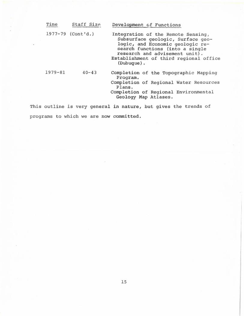
Time Staff SizP.
1977-79 (Cont'd.)
1979-81 40-43
Development of Functions
Integration of the Remote Sensing, Subsurface geologic, Surface geologic, and Economic geologic research functions (into a single research and advisement unit).
Establishment of third regional off ice (Dubuque).
Completion of the Topographic Mapping Program.
Completion of Regional Water Resources Plans.
Completion of Regional Environmental Geology Map Atlases.
This outline is very general in nature, but gives the trends of
programs to which we are now committed.
15

STAFF CHANGES 1970-1971 and PROJECTED STAFF for 1971-1973
The following table summarizes the staff structure for the Survey:
Ending Ending Proj. 30 June 70 30 June 71 30-6-72
Position T.O. vacant Em:elo~ed T.O. Vacant Em:elo~ed T.O.
State Geologist 1 0 1 1 0 1 1
Ass't. St. Geol. 1 0 1 1 0 1 1
Geologist III 0 0 0 0 0 0 1
Geologist II 6 1 5 6 2 4 6
Geologist I 3 0 3 3 1 2 2
Systems Analyst 0 0 0 0 0 0 1
Senior Technician 1 0 1 1 0 1 1
Driller 0 0 0 0 0 0 1
Technician 1 0 1 1 0 1 1
Admin. Ass't. 1 0 1 1 0 1 1
Clerk-Typist III 1 0 1 1 0 1 1
Clerk-Typist I 1 0 1 1 1 0 1
Draftsman 1 0 1 1 0 1 1
Totals: 17 1 16 17 4 13 19
NOTE: One Geologist II, one Geologist I, and one ClerkTypist I will be hired with monies from the IGSNASA grant for Remote Sensing evaluations of the ERTS program.
16
Proj. 30-6-73
T.O.
1
1
l
6
2
1
1
1
1
1
1
1
l ·
19


