25
ANOMOLIES IN DRAINAGE ANOMOLIES IN DRAINAGE SEDIMENTS SEDIMENTS
| Date post: | 08-Feb-2017 |
| Category: |
Education |
| Upload: | pramod-raj |
| View: | 54 times |
| Download: | 0 times |

ANOMOLIES IN DRAINAGEANOMOLIES IN DRAINAGE
SEDIMENTS SEDIMENTS

ContentsContentsIntroductionSpring and Seepage AreasActive Stream Sediments Flood –Plain SedimentsLake SedimentsMarine SedimentsConclusionReference

IntroductionIntroduction Search for ore mineralization involves sampling of
various geological materials like rock, soil, water, sediments occur in various environments.
Systematic sampling of material followed by chemical analyses of material and preparation of geochemical anomaly maps are a pre requisite for exploration of the mineral deposits.
The presentation here pertains to nature of ore anomalies in drainage sediments.

ANOMOLIES IN DRAINAGE ANOMOLIES IN DRAINAGE SEDIMENTSSEDIMENTS
Drainage Sediments include spring and seepage sediments, active string sediments, flood plain sediments, and lake sediments which differ in character of sediments, processes introducing metal and application.
Many drainage systems start in seepages and springs where import and interchange b/w water and sediments may occur.
Sediments in seepage areas and near spring provide strong anomalies and are useful in detailed surveys.

Geochemical anomalies in drainage sediments include: SEDIMENTS IN SPRINGS & SEEPAGE AREAS ACTIVE STREAM SEDIMENTS FLOOD PLAIN SEDIMENTS LAKE SEDIMENTS

SPRING AND SEEPAGE AREASSPRING AND SEEPAGE AREAS The immediate source of the anomalous concentration of
the metal in the soil of seepage areas is the ground water that comes to the surface at these points.
The source of the metal may be somewhere along the route traversed by the ground water.
The route is determined by the pattern of the fissures, and fractures, caverns and high- pressure artesian channels in the bed rock.
Location and form of seepages anomalies is controlled by the local relationship b/w the relief and water table and by the flow of the water within the seepage area.

Edges of organic swamps are especially favorable sites for the development of the seepage anomalies because organic matter of the swamps tend to precipitate ore metals out of the ground water solutions at the points where they first encounter the swamp environment.
As the ground water moves towards the center of the swamp, it becomes progressively impoverished in the metal.

ACTIVE STREAM SEDIMENTSACTIVE STREAM SEDIMENTSMetal in anomalous stream sediments may have reached
its present position by one or more of more of a number of routes: from the erosion and transport of metal-rich soils,
gossans, or other anomalous weathering products that originate very near to the parent ore deposit
from the erosion of clastic material from hydromorphic anomalies in spring and seepage areas or in the upper reaches of the streams
locally precipitated from the stream waters directly on to the clastic particles of the sediments
Primary ore minerals like wolframite, columbite, pyrochlore, cassiterite, or gold are resistant and dense and travel with the heavy mineral fraction of the stream sediment.

Secondary ore minerals( malachite, anglesite, or carnotite, and fragments of anomalous gossan, limonite) are relative friable and become finer in grain size downstream.
Precipitates from stream water (trace minerals and Fe-Mn-oxides or other precipitates containing anomalous elements) coats the surface of clastic grains or occurs as very fine particles that remain in suspension.
Organic material containing ore elements includes plant, degraded organic material from soils near the ore and organic matter formed by biological activity.
A major controlling the contrast of anomalies in stream sediments is the primary contrast at the bedrock source and the extent to which this is dilute with barren material from the surroundings.
The principal factors affecting the persistence of these anomalies are: – The contrast at the source– The input of the metal along the stream course and– Dilution by erosion of the bank material and by
confluence with barren tributaries.

Map of the Ganga river headwaters region showing locations of stream sediment samples (open circles) .

Geochemical anomaly map showing the distribution of uranium. Sampling points are shown as open circles and major rivers are shown in blue lines.
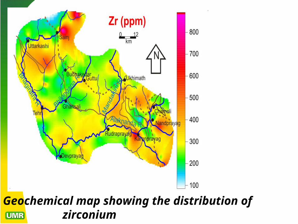
Geochemical map showing the distribution of zirconium
FLOOD –PLAIN SEDIMENTSFLOOD –PLAIN SEDIMENTS The pattern of anomalous metals in flood-plain
sediments will reflect their distribution in the abandoned channels previously followed by the stream.
Flood-plain sediments normally are characterized by a higher proportion of the fine material.
The lateral distribution of anomalous metal across the flood plain varies somewhat depending on local conditions.

LAKE SEDIMENTSLAKE SEDIMENTS Where lakes are abundant, the sediments trapped in them can
constitute a convenient sampling medium for the reconnaissance and detailed stages of exploration.
Metals may reach the lake sediment by a number of routes:As clastic particles washed in by streams or eroded from the
margins of the lake.As elements absorbed to or incorporated within colloidal
organic or inorganic materials entering through streams.As dissolved material entering through streams or in ground
water and later precipitated, adsorbed to suspended particles As incorporated mateial in living matter finally settling to
from bottom sediment. The nature of the lake sediment and occurrence of elements in
it are complex function of the climate, vegetation, depth, area, inflow and outflow of the lake, and geology.

Thermal stratification of the lake water and oxidation-reduction potential in the water in the lake sediment are other factors determining the metal anomaly.
In most lakes larger than about 0.5 Km2, there is a difference between near-shore sediments and center–lake sediments.
The near-shore materials range in size from clay to boulders and reflect the geology and characteristics of the shore and streams, with only minimal sorting and reworking by the lake water.
In contrast, the center-lake sediments are predominantly silt- and clay-size particles, and may contain a high proportion of precipitated or flocculated organic matter. The characteristics of these sediments depend strongly on the nature of the lake and the chemistry of its water.

Fig: lake sediments
Anomalous elements in lakes occur in the following forms :
As substitution for major constituent in minerals of clastic particles
As element incorporated within colloidal and fine particles of organic material formed by flocculation in lake, tissues of plants and animals growth in the lake.
As element adsorbed to surfaces of particles, including flocculated organic material, Fe-Mn-oxides, clay, and other small grains.
As inorganic precipitates formed in the lake.

Major differences in composition are usually observed between near-shore lake sediment and center-lake sediment.
Anomalies that are primarily clastic in origin decay down-drainage mainly by dilution.
The length of anomaly depends on the size of the tributary providing the anomalous sediment and on the bottom topography of the lake.
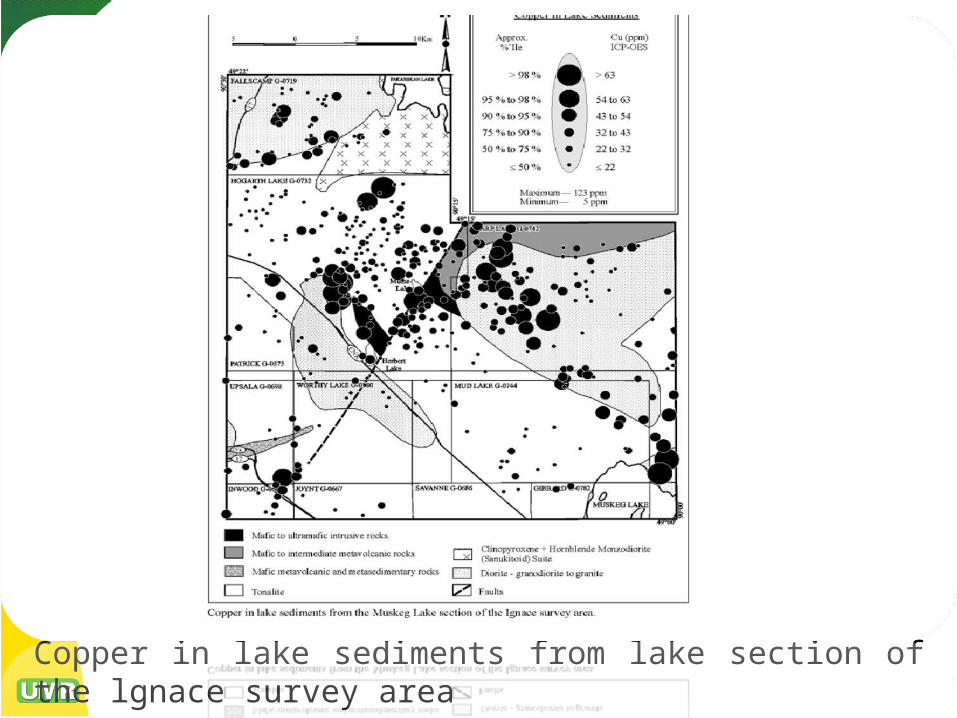
Copper in lake sediments from lake section of the lgnace survey area

MARINE SEDIMENTSMARINE SEDIMENTS Recent years have seen an increasing interest in
exploration and exploration of mineral resources from the continental shelf and ocean floor.
These include Mn nodules on the deep sea floor, muds and brines rich in Mn, Fe, Cu, Zn, Ag, and other metals, phosphorites, heavy minerals (cassiterite, Au, diamond, and other), and sand and gravel.
However, the costs of exploration and production of minerals covered by tens to thousands of meters of depth of water is the limiting factor. Inexpensive techniques for locating and outlining the deposits are obviously needed.

• Sediments, waters and suspended particles have been proven useful in detection of metalliferous sediments of the type found in the red sea and elsewhere near-ocean ridges.
ConclusionConclusion
Drainage sediments are most useful in geochemical reconnaissance surveys for locating ore deposits.
Very large areas can be scanned for mineral potentials using drainage sediments because of the great distances over which anomalies containing sediments are carried by ground and surface waters.

Books: M.Kuzvart and M.Bohmer (1986) Prospecting and
exploration of mineral deposits, Elsevier science publishing company.Inc. Pp.160-168.
Arthur W.Rose, Herbert E.Hawkes, John S.Webb- (1979) Geochemistry in mineral exploration., Academic press.Inc.Ltd. Pp. 384-428.
Web sites: www.google.com www.wikipedia.com http://earthscience.brookscole.com/ree4e
REFERENCEREFERENCE


