70
| Date post: | 09-Mar-2016 |
| Category: |
Documents |
| Upload: | anuko-websites |
| View: | 218 times |
| Download: | 0 times |


About Author
Alfred Memelink is a New Zealand artist who is becoming particularly well known for his streetscape and seascape paintings.
He is largely a self taught artist, having taught himself whilst working at sea as a marine engineer. During the long sea voyages, he often painted the scenes that drifted past his porthole or the exotic ports that his ships visited. With many seagoing adventures now behind him, Alfred now only works part time at sea to allow him to pursue his deep passion for art more fully.
(He can still be found from time to time though filling in as engineer on the little red tug boats darting across the harbour). His special affinity for Wellington, its harbour together with his first hand knowledge of ships and the sea, has provided him with a very special approach to his art. As a subtle symbol of his connection with the sea, one will always find a seagull somewhere in a painting (aside from the albatross that flies under his signature). Alfred’s ability of conveying to the viewer his excitement found in the scenes portrayed, is resulting in a strong local following and is also winning him international recognition. His work is characterised by interesting perspectives with tangible moods and an expressive use of colour.
His current phase in painting ties in closely with Alfred’s love of the sea, inspiration gained from an adventure to Antarctica and his passion for painting everyday scenes of Wellington (yes, even in winter). His recent major solo exhibition was titled “A Summer in Antarctica and Winter In Wellington.” The wonder and grandeur of Antarctica, light and the huge Ross Sea ice sculpture garden in particular just called out to be painted in watercolours. To experience this unique wilderness together with it’s extreme conditions was certainly a privilege and adventure never to be forgotten, he says.
Join the artist on his fascinating journey as he discovers and explores world of Antarctica.
http://www.memelink.co.nz

31 Jan 2008
Departure Wellington
It always feels so good to be sailing out to sea again. I remember what an old salt friend once said to me as we were sailing again after a long port stay. ‘’This is what a ship is meant for, a ship only rusts away when alongside in a port.” There is something special about being at sea - an adventure ahead and a sense of leaving the rat race behind, - just the ship, your shipmates, the sea and me. In a sense, a wonderful form of escapism. There was of course the added excitement of the adventure that lay ahead.
It was a calm sunny late afternoon as I stood at the deck rail and watched the Wellington heads drift past. We were heading for a destination that I never even dreamed of ever heading to. The NIWA Research Vessel (RV) Tangaroa is on its way to the coldest, stormiest and driest end of the earth - Antarctica, a land where it never rains but only snows.

This voyage happens to be one of eleven scientific voyages to both polar regions as part of the International Polar Year (IPY) involving twenty-three countries. Our contribution would be to focus on the Ross Sea region, a New Zealand Dependency.
This special IPY year marks fifty years since the signing of the Antarctic Treaty. This IPY programme began in March 2007 and runs until March 2009, covering two polar summer seasons. This voyage also forms part of the Census of Antarctic Marine Life (CAML), to survey marine life and habitats around Antarctica and to determine its diversity.
The aim of this global scientific programme is to better understand the land and sea environments of the Arctic and Antarctic regions and the effects of climate changes on them. Scientists will colect samples of marine life including viruses, bacteria, plankton, benthic fauna, cephalopods, fish as well as undertake undersea mapping projects. Every bunk on board is occupied - all forty-four of them. Some of the crew I already know, having sailed with them before, but there are many new faces yet to meet, lots of scientific looking people with big scientific beards and very interesting characters. The reason why there are so many scientific personnel on board, twenty-six, in fact, is that the ship will be operating around the clock once it reaches the Ross Sea region. They will be splitting into two, twelve-hour shifts, changing over at midday and midnight. The deck crew will also work 24-7 in two watches, each with four men. I met the ship’s doctor Jenny tonight, taking photos at the deck rails. Jenny is a lively fun person to have on board, as I was soon to discover. It turns out that she is of Dutch heritage, and we think we could form a Dutch club as there are four of us on board. We think this would be good to practice our lingo as we are both a bit rusty on it. It is not usual for ships to carry a doctor these days but because of the sheer remoteness of where we are heading to, Jenny will be there to stitch us up or super-glue our wounds if we need attention.

1 Feb
Heading South The weather today is calm, the sea slight with a rolling swell. We are heading due south and are about directly east off Banks Peninsular. Our engine is running sweat and there is a hive of activity on deck as the scientists and crew prepare their equipment. Everyone is making the most of the relatively warm weather and calm seas and people are still in shorts. It will soon be bitterly cold, I am reminded that any job that isn’t done now will otherwise take twice as long to do down under. There are two engineers on board, myself as chief and Lindsay Battersby as second engineer. Our shifts are slightly different to the crew and scientists. We cover twenty-four hour watches and simply put the main engine to bed and set the engine room alarm system to UMS (unmanned machinery space) when we are not actually in there. We hope with our fingers crossed that things will run smoothly with minimal middle-of-the-night callouts. Our engineering day typically starts with our first inspection rounds at 0730 hours followed by our own private ‘toolbox meeting’ in the engine control room, (really a good excuse for a coffee brew). Our typical day is taken up with repairs, all sorts of maintenance, playing at being plumbers, electricians and general Mr Fixits. At the end of our day’s work in the engine room, we simply do our last rounds, put the engine to bed, so to speak, and switch the alarms over to the duty engineer’s cabin. When not in the engine room, we carry a pager and when this vibrates merrily in our pockets, we jump into our boots, slip into our overalls and slide down the stair rails as fast as we can to attend to whatever the problem might be. The RV Tangaroa “RV” stands for “research vessel”, like SS for steamship, and MV for motor vessel. RV Tangaroa is the New Zealand research vessel operated by NIWA (National Institute of Water and Atmosphere). She is 70 metres long, nearly 14 metres wide and has a 7 metre draft. For the scientific work to be accomplished in the Ross Sea, there are several laboratories on board. The main lab is below deck (on the factory deck). This is where fish caught in the trawls are identified, measured and preserved as samples if required. On the trawl deck there is a dry lab, a plankton lab, and the Benthic Sorting Shed, which is the area where the ‘Benthic Babes’ hang out and where the

sea floor dredgings are brought to for sorting through and identification. Next to this is the Bacteria Lab where Else and Stu do their microscopic stuff. Deep in the bowels of the ship is the Electronic Hub of the ship, the computer room that houses the multi beam echo sounder and other equipment. Equipment on deck include the trawl nets and bottom dredges which bring up the fish samples and benthic things, the DTIS (Deep Tow Imaging System), CTD Rosette (Conductivity, Temperature and Depth Rosette) for bottom core sampling and the MOCNESS (Multiple Opening/Closing Net Environmental Sensor System). I met Max Quinn today from the New Zealand Natural History Film Unit in Dunedin. He is on board to do a documentary on the voyage. He is a very interesting chap with a great sense of humour. It turns out he has affliction for cold documentaries and has some amazing cold experiences under his belt to tell us about. We watched the first of his documentaries - an amazing documentary of the great Alaskan sled dog race. It looks like I will have to get my paints out well before we arrive in Antarctica. I was approached at “smoko” today by Mike, the bosun, and Glenbo, second crew boss. “We hear you paint”, they said. ”Can you do us a painting from photos of our last trip to Antarctica?” ”What will it cost us?” “Sure”, I said and looked forlornly towards my empty beer fridge. I had missed the duty free order when the ship was in port, so there was now every prospect that this two-month trip was going to be a dry one for me. They got the picture and before I had even started the painting, my fridge was filled. My paints and brushes came out and my beer fridge got stocked up. So I was away painting Antarctica before I had even seen it myself.
2 Feb The Southern Ocean Deep down into the Southern Ocean now, the least hospitable ocean in the world and includes all the sea north and around Antarctica – up to latitude 50. The temperature outside is steadily dropping, and so is the barometer. The weather is getting rougher. I am getting used to the ship’s doctor, Jen. She bursts into the mess at 0700 hours for breakfast, and while we are still rubbing off sleepy dust with grumpy greetings of ”morning”, she bursts in full of beans sort of singing a spirited “Good morning” with a smiley face like she is opening a TV morning show. A list goes up on the mess room whiteboard above a jar to put $2 into - not a swear jar but the Iceberg Sweepstake Jar. Apparently we have to guess the latitude where we encounter the first iceberg and the winner gets the jar - with the money in it. Our mascot, a little stuffed emperor penguin given to me by nephews and nieces, came down to the engine room with me this morning, tucked snug in the top pocket of my overalls, and joins us for our kick-off control toolbox (coffee) meeting. The toolbox meeting decides that it would be a good idea to introduce the penguin to the rest of the crew via the ship’s shared computer photo album. After our second coffee it was decided that it would be named after the latitude (in French) of the first iceberg sighted. The first photo shoot of the penguin is shot – story begins – penguin gets discovered as a stowaway hiding in a pipe. After morning muffin and coffee time, Doc Jenny gives us a lecture about the dangers associated with working in the extreme cold temperatures that we are about to encounter. A snap refresher course on hypothermia and we learn how to ensure one lasts longer in the extreme cold. ”Take lots of breaks for hot drinks”, she recommends. (Sounds good to use – more coffee breaks). She hands us a survival pack of lip balm (lips and skin dry out fast in the completely dry air) and sunscreen, (BIG ozone hole over Antarctica we are told). We are informed that there is a big blue shipping container on our foredeck packed with emergency rations for crew, including many ‘one square meals’ and bars of chocolate.
We practice donning the emergency survival suits, and had lots of laughs taking turns trying to get into the cumbersome red floater suits. On my rounds to the Bow Thruster room, I hear honking. No, not ice scraping and bumping against the hull yet but our Captain, Andrew Leachman, practicing his sax in the computer room. Some cool jazz sounds wafting out. Apparently we are due to cross the ACC today so I am told. My understanding is never to cross the ACC as it is a government department. But no, this is apparently a different sort of ACC. This ACC stands for Antarctic Circumpolar Current. This is the main current in the Southern Ocean, a 21,000 km current that travels from west to east right around Antactica, flowing between the Lattitudes of 50 and 60 south. It is also known as the West Wind Drift. The ACC is the biggest current in the world and transports 150 billion litres per second of water at up one kilometre per second. The Southern Ocean is in one of the windiest parts of the planet and its currents are driven mainly by the wind. The wind that blows over the surface of the ocean passes its energy to the water molecules in the ocean, giving the water more kinetic energy. Friction between the sea water and the bottom of the ocean cause the movement of the water or current to slow down. It is the balance between these two forces that stops the currents from getting faster and faster. The ACC is right on the Convergence Zone, this is the line where the colder North Antarctic water creeps below the warmer sub Antarctic sea water. There is a sudden change of water temperature, foggy misty atmosphere. I was told that as soon as we cross into it, the sea temperature would plummet. It sure did, from about 7 degrees to minus 1.5 degrees. We all get issued our cold weather packs, several sets of long johns, short johns, thick socks, many different sorts of gloves, balaclava and special thick felt boots that fit inside gumboots – all serious cold stuff.
3 Feb
Iceberg Ahoy
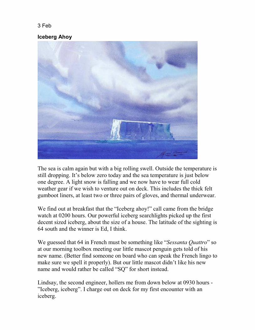
The sea is calm again but with a big rolling swell. Outside the temperature is still dropping. It’s below zero today and the sea temperature is just below one degree. A light snow is falling and we now have to wear full cold weather gear if we wish to venture out on deck. This includes the thick felt gumboot liners, at least two or three pairs of gloves, and thermal underwear. We find out at breakfast that the “Iceberg ahoy!” call came from the bridge watch at 0200 hours. Our powerful iceberg searchlights picked up the first decent sized iceberg, about the size of a house. The latitude of the sighting is 64 south and the winner is Ed, I think. We guessed that 64 in French must be something like “Sessanta Quattro” so at our morning toolbox meeting our little mascot penguin gets told of his new name. (Better find someone on board who can speak the French lingo to make sure we spell it properly). But our little mascot didn’t like his new name and would rather be called “SQ” for short instead. Lindsay, the second engineer, hollers me from down below at 0930 hours - ”Iceberg, iceberg”. I charge out on deck for my first encounter with an iceberg.

Outside it feels like Christmas, lightly snowing and in the grey gloomy mist is my iceberg. This ice block looked huge to me, about the size of a house but apparently it was a little one. Lindsay made me take a photo of it, being my first one; I’ll remember this one he said. As it was too small to warrant a name by the NIC (National Iceberg Centre), I decided to officially name it AM01 (my initials and my first one). A fascination for icebergs was to be born this day and I started to learn about these magnificent pieces of natural sculpture. I discovered that they are timeless but living works of art. An iceberg actually begins as snow. Originally conceived millions of years ago in the middle of Antarctica, it snowed and this snow formed a granular laver called ‘neve’. This is compressed to denser ‘firn’ and as even new layers fall on top, the firn gets compressed yet even further, forcing out more air bubbles. Pure Glacial ice is 200 times denser than fresh snow. In fact the complete layer of ice is so thick and the weight so heavy that it depresses the whole continent by 1km. The build-up of ice over Antarctica is like a giant pancake, and the ice becomes fluid like very slow moving treacle and it so journeys to the sea in a glacier. When the glacier meets the coast it either enters one of the ice shelves or forms and ice tongue out into the sea. At the seaward end of the glacier or ice shelf, the ice, being lighter than seawater, starts to hinge and gets worked on by tidal and storm action. This action causes large chunks to break off, called ‘calving’ and so icebergs are born and set free to the sea to be continually sculptured by nature into beautiful new forms. Icebergs form mostly during the spring and summer, when warmer weather increases the rate of calving. An iceberg floats because it is less dense than water, the density of pure ice is about 920 kg/m³, and that of sea water about 1025 kg/m. Thus usually 7/8 of a new iceberg is underwater with the most dense and heaviest part of it being the core. When the lighter top including more recent snow gets washed off, it becomes even denser and as little as only 1/10 it might show above water. An iceberg can live for many years and during its lifetime, it can tumble and upturn many times as its centre of gravity changes due to the underneath part being sculptured by the sea. 93% of the world's mass of icebergs is found surrounding the Antarctic and if it all melted, it would raise the sea levels by 60 meters.
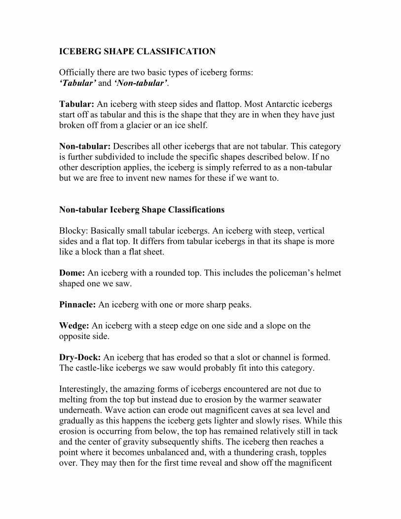
ICEBERG SHAPE CLASSIFICATION Officially there are two basic types of iceberg forms: ‘Tabular’ and ‘Non-tabular’. Tabular: An iceberg with steep sides and flattop. Most Antarctic icebergs start off as tabular and this is the shape that they are in when they have just broken off from a glacier or an ice shelf. Non-tabular: Describes all other icebergs that are not tabular. This category is further subdivided to include the specific shapes described below. If no other description applies, the iceberg is simply referred to as a non-tabular but we are free to invent new names for these if we want to. Non-tabular Iceberg Shape Classifications Blocky: Basically small tabular icebergs. An iceberg with steep, vertical sides and a flat top. It differs from tabular icebergs in that its shape is more like a block than a flat sheet. Dome: An iceberg with a rounded top. This includes the policeman’s helmet shaped one we saw. Pinnacle: An iceberg with one or more sharp peaks. Wedge: An iceberg with a steep edge on one side and a slope on the opposite side. Dry-Dock: An iceberg that has eroded so that a slot or channel is formed. The castle-like icebergs we saw would probably fit into this category. Interestingly, the amazing forms of icebergs encountered are not due to melting from the top but instead due to erosion by the warmer seawater underneath. Wave action can erode out magnificent caves at sea level and gradually as this happens the iceberg gets lighter and slowly rises. While this erosion is occurring from below, the top has remained relatively still in tack and the center of gravity subsequently shifts. The iceberg then reaches a point where it becomes unbalanced and, with a thundering crash, topples over. They may then for the first time reveal and show off the magnificent
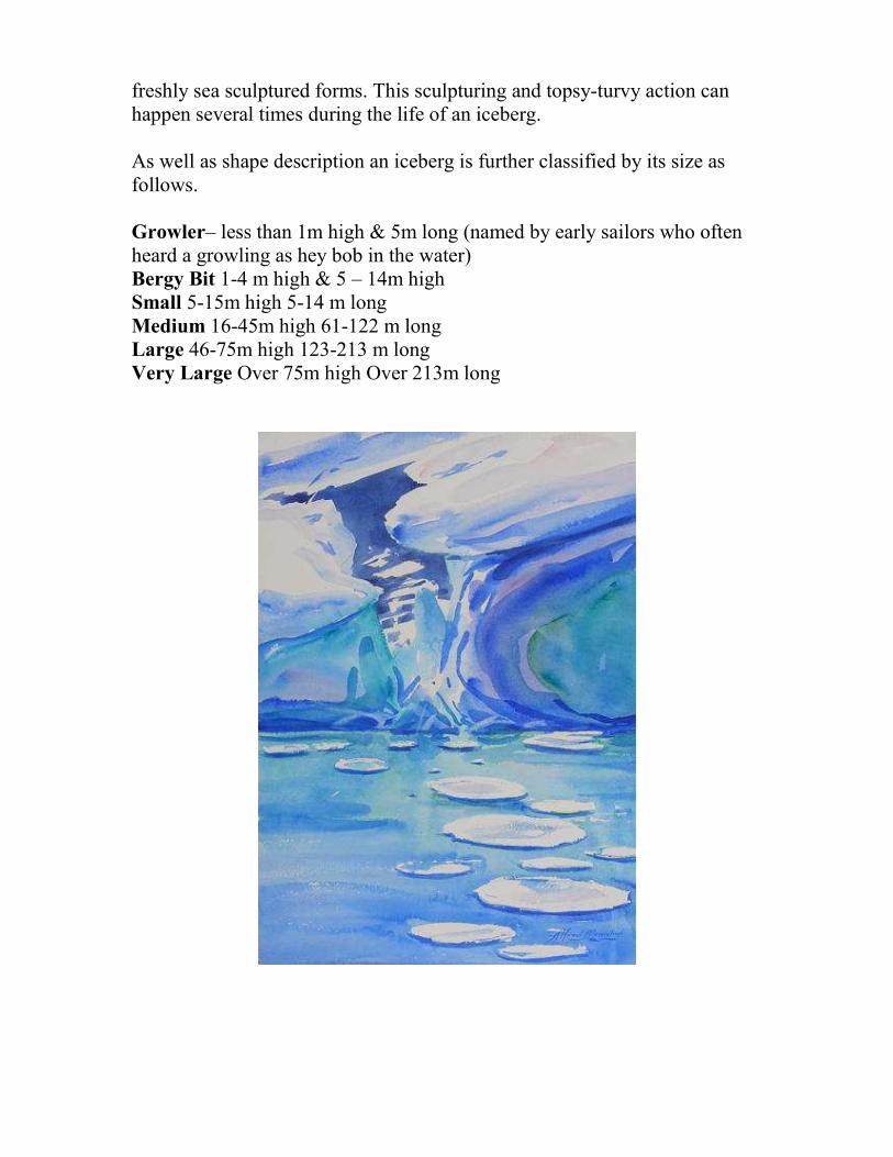
freshly sea sculptured forms. This sculpturing and topsy-turvy action can happen several times during the life of an iceberg. As well as shape description an iceberg is further classified by its size as follows. Growler– less than 1m high & 5m long (named by early sailors who often heard a growling as hey bob in the water) Bergy Bit 1-4 m high & 5 – 14m high Small 5-15m high 5-14 m long Medium 16-45m high 61-122 m long Large 46-75m high 123-213 m long Very Large Over 75m high Over 213m long

4 Feb The Ross Dependency We are now in the top area of the Ross Dependency and the Ross Sea so last night was a calm night finally, and we managed to catch up on some much needed zzzzzz’s. I finished my last watch of the day at midnight and managed shut eye right through until 0700 hours. The Ross dependency is a pie-shaped segment of Antarctica that New Zealand has laid claim to. It is a strange triangular segment with the pointy bit right on the south pole. The top side of the segment boundary is the parallel of latitude 60 south and the sides of the segment are the longitudes 160° east and 150° west, The dependency comprises mostly sea, including the Ross Sea, most of the Ross Ice Shelf but also a bit of dirt on either sides. The Ross Dependancy which, according to wikipedia, takes its name from Sir James Clark Ross who discovered the Ross Sea, and was originally called King Edward VII Land. It covers some 450,000 km² and has a wildly fluctuating population at the bases depending on the season. The Dependency includes most of the Ross Ice Shelf, including Rosevelt island, trapped under the huge ice dome in the ice shelf, Ross Island, Balleny Islands and the small Scott Island. It mentions that it is on New Zealand time, and was entusted to New Zealand in 1923 by Brittain but has NO national anthem? The huge Ross Sea (roughly about the size of Australia) freezes over each winter and ice can be up to three metres thick and the temperature plummet to minus 50 degrees Celsius. Then in summer, with the extra long days and more light, it all breaks up again. And so the cycle continues. The Captain and Scientists will now get several regular and different kinds of satellite photographs of the Ross Sea area. This will allow them to plan the best route through the pack ice to the clear water where the scientists wish to do most of their work and studies. The pack ice has been slow to break up this year, apparently the worst pack ice conditions in 30 years. The scientists seem a bit worried about getting all the work done that they had hoped to. If necessary, they may need to re-plan the survey schedule accordingly. Some satellites that provide these ice maps can even look through the clouds to show the heaviest pack ice zones. To make an ice map RADARSAT, using Synthetic Aperture Radar (SAR), sends microwave energy to the ocean surface and records the reflections in order to track

icebergs. Another type ENVISAT uses Advanced Synthetic Aperture Radar (ASAR). This can detect changes in surface height accurately. Makes me wonder how the early explorers did it without any of this modern technology. They would have had no idea of the ice conditions that lay ahead of them and could only find their way by sending a shivering seaman shimmying up the mast.
5 Feb
Storm
Some heavy seas last night at about 65 degrees South. I got rolled out of my bunk a couple of times and heard some big ‘kathumps’ from the Captain’s cabin next door. It turns out his computer went for a good tumble last night. At breakfast I heard that there was a nice Aurora Australis display last night. I made a pact with the night watch keeper to put me on the shake if they came again tonight. I thought it would be a good challenge to try and paint them in watercolours. I finished my first commission of an iceberg and delivered it to the bosun yesterday. He was stoked. It was a painting from a photo that he won a prize for two years ago. It showed a snowstorm brewing over and a huge tabular

iceberg. More commissions arrived and more swaps negotiated. We entered pack ice later today. The ship’s speed is reduced to about 3 knots as the pack ice thickens and the mates look for fingers of clear water for the ship to pass through. The sea is flat but still there’s a slight swell coming through from the rough seas outside, bobbing the growlers and white islands around. Pack ice is basically large masses of broken up sea ice that can be made up of one, two or three year ice. The ice consists mostly of frozen sea water, sea ice is formed by sea water freezing when its temperature drops below 1.8 degrees. The ship is graunching and groaning and shuddering its way through it all until we can get a patch of clear sea. There is a lot of talk about growlers and I learn that they are the mini icebergs, a little bigger than two-year pack ice. The next size after growlers are “Bergy Bits” and then I think come the Icebergs. I am slowly coming to terms with the new unusual terminology. Antarctica Antartica is Earth’s southernmost continent, surrounded by the Southern Ocean. At 14.4 million km², it is the fifth-largest continent in area and 98% of it is covered by ice. It is the coldest, driest and windiest continent, and has the highest average elevation of all the other continents. Antarctica contains 70% of the world’s water (as ice) - in fact 29 million km3 . If this all melted, it would be enough to raise the sea level by 60 metres. It was thought that the amount of snow falling equates to the rate that icebergs melt, thus keeping the cyle in equilibrian. However this could be changing due to global warming. It is so dry in fact that the continent is technically the largest desert in the world. It dawned on me that we are actually going to the opposite to the Arctic, that is “Anti Arctic”. A bit of research tells me that Antarctica actually comes from the Greek word “antarctikos” meaning opposite to Arctic. Further research shows that between the 15th and 18th century the imagined land was refered to as Terra Australis (Southern Land). Terra means ‘land’ in Latin and ‘Austral’ means

‘southern’. This became “terra Australis ingonita” meaning “the unknown land of the south”. The first confirmed sighting wasn’t until 1820 by the Russian expedition led by Mikhail Petrovich Lazarev. The Antarctic Treaty The Antarctic Treaty was signed in1959 by twelve countries involved in Antarctica, including New Zealand. It was set up to preserve the area, prohibiting military activities and mineral mining. The Treaty supports scientific research and protects the continent's natural wilderness. The Treaty suspended all territorial claims and no nation may enforce sovereignty or territorial claims on the Antarctic. Many more countries have since signed the agreement.


6 Feb 2008 Slow Passage Through Heavy Pack Ice
We are well inside the pack ice barrier now and well inside the Ross Sea, slowly picking our way through narrow fingers of navigable waters between the built up pack ice - where we can find them. The sea temperature has dropped further to minus 1.5 degrees, just above the freezing point of seawater and the engine room bilges are are freezing up.
We have changed over to the next set of double bottom FO bunker tanks which have been diluted with10% kerosene. This was added during bunkering in Wellington so as to avoid the diesel waxing in these extra cold temps.
Looking out of my porthole, it is snowing again and miles of snow-white islands of broken pack ice are drifting by. The occasional one has a sea leopard and lazy seal waving to us with its upturned flipper or small groups of puzzled penguins.
I met Bob, the “Ice Pilot”, today, a special deck officer who has expertise in sailing through ice and years of experience in Antarctic ice navigation under

his belt. He was Captain for many years with Greenpeace on their Antarctic missions. The Tangaroa is not an icebreaker as such, but does have an ‘ice rating’. This ice rating allows it to break through 0.3 metres of year-old sea ice but anything thicker we can simply shove out of our way. However we do limit our ice contact, where-ever possible.
The Ross Ice Shelf itself is about the size of France and like so much of this area was also discovered by James Ross in 1841 and was later named after him. On the 5th of January 1841, a British Admiralty team, led by Ross in the three-masted ships, Erebus and the Terror with specially strengthened wooden hulls, were going through the pack ice in an attempt to determine the position of the South Magnetic Pole. However they soon came up against the edge of the enormous ice shelf. Sir James Clark Ross, remarked at the time ”Well, there's no more chance of sailing through that than through the cliffs of Dover”. Ross, who in 1831 had located the North Magnetic Pole, spent the next two years vainly searching for a sea passage to the South Pole. Both Amundsen and Scott crossed this ice shelf to reach the Pole in 1911. Scott's polar party, which had embarked from Ross Island, later died on the ice shelf during their return trek in 1912. They died in what scientists now believe was a freak cold period. "The new study of the weather on the Ross Ice Shelf, only carried out in the past decade or so, shows Scott really was unlucky. He travelled through an exceptionally cold spell, some 20 degrees Fahrenheit colder than usual."
The Ross Ice Shelf is the largest ice shelf of Antarctica and is about the size of France. The ice shelf is the main outlet for several major glaciers draining the West Antarctic Ice Sheet and contains the equivalent of 5 metres of sea level rise in its above-sea-level ice."
The presence of the shelves actually acts as "breaks" for the glaciers. These shelves serve another important purpose - they moderate the amount of melting that occurs on the glaciers' surfaces. Once their ice shelves are removed, the glaciers will increase in speed due to meltwater affecting it and because of the reduction of braking forces. They may then begin to dump more ice into the ocean than they gather as snow in their catchments thus unbalancing the equilibrium.
The near vertical ice front at the edge, where the ice shelf meets the open

Ross Sea, rises about 30 metres + high above the sea level and is more than 600 km long. The ice mass is about 800 km wide and 970km long. In some places further in on the ice shelf, namely its southern areas, the ice shelf can be almost 750 metres thick with more than 90 percent of the floating ice being below the water level. The Ross Ice Shelf pushes out into the sea at the rate of between 1.5 metres and 3 metres a day. At the same time as the glaciers feed ice into the shelf, the freezing of seawater below the ice mass increases the thickness of the ice.
I have been struggling a little with the watercolours. I think it’s because the atmosphere is so dry. The humidity is in fact zero. It is so dry in fact that the carpets in our cabins tend to shrink. I keep trying. I am now painting the scenes that appear outside my porthole.

7 Feb
Adelie Penguins & Snow Petrels It is hard to believe that we are now actually in the Antarctic. I had another three ‘firsts’ in my life over the last few days. On February 5, my first iceberg, February 6, when I knew we really were in the Antarctic, it had just hit home, and today, February 7, the first time I ever wore long Johns. Yes, it is bitterly cold down here at the moment and we have memelink history in the making. Tonight I found an exciting new way to combat the problems of painting in watercolours in this completely dry atmosphere. My new method is to first draw the outline on the cotton paper, then soak the paper both sides. After letting the excess water drip off and dissipate, it leaves a beautiful damp surface to paint on. Penguins appear on the ice islands we pass, but these ones don’t have the orange nicotine stain under their necks as I was expecting them to have, like the little film stars do in ‘March of The Penguins’. These are pure black and white with little white rings around their eyes.. I am informed that these are actually Adelie penguins not Emperor Penguins as I was expecting. Reading up about them later in my guide – it appears Adelie penguins were named after the wife of French explorer Dumont d’Urville. Though I think they should actually be re-named Butler penguins, they have a habit of standing around on a piece of ice in their white suites and little black dinner jackets. They look up at us like bewildered butlers ready to announce that dinner is served and with their arms flapping behind them as if they are freshening their armpits. Some of the penguins look like they have dipped themselves in syrup and then dived into a vacuum cleaner dust bag; they are half covered in grey fluff. I guess these must be the young ones. This breed of penguins actually have a special claim to fame - they are the breed that feature in Bluebird Chips ads. Adults also like to play a harsh sort of chasing game with the kids, They prefer the kids to chase them for the food that they bring home for them, this way food is not wasted on any weak or unhealthy kids. Around lunchtime we passed a lazy sea leopard on his blood soaked piece of pack ice – he looked like he was having an after lunch nap – he probably one of the “butler” penguins I think.

Saw a beautiful pure white seabird flying alongside the ship this afternoon and discover that they are called snow petrels. Beautiful white plumage with a black beak and black feet. Later I saw a few more gliding over the pack ice and blending in gracefully and adding to the calm. One of the scientists on board, Chazz Marriott, is a brilliant photographer and has so far uploaded some magnificent photos of seabirds onto the ships shared digital photo album. One is of a snow petrel flying low over an iceberg ,the soft shadow it casts over the snowy surface makes for a prize winning photograph. It has been snowing all day and I discovered the design of a snowflake today. The forward portholes of my cabin are sloping. I watch the snowflakes land on the window and grab my glasses and discover that it is all true; each snowflake has amazing and different geometric designs.
8 Feb
Sculptured Icebergs

We are making slow progress, finding our way through the pack ice and progressing in a zigzag pattern at a slow 2 knots. Down below, the noise is amazing as chunks of ice clunk against the ship’s hull. The ship momentarily stops as we come up against a big one. It gradually gives way and lets us through, or else the ship managed to slice through it. More icebergs - the sight is amazing - one can stare at these ice islands for ages. The ice blocks come in all forms, shapes and sizes - thousands of exciting sculptured shapes. The Ross Sea is in fact like a huge Henry Moore sculpture garden. I am enjoying the shapes of them and inspired by their varied colours and lighting. They come in brilliant shades of white, grey, blue and turquoise. The cabin studio is in full swing each evening now. The long light means that I can paint late into the evening. I have fun plans to take the watercolours outside to try to paint, but I know this will be futile, as I know my palette will instantly freeze up on me.
More penguins and seals. I query Bob about the turquoise stains underneath the pack ice. He tells me that this is algae, part of the diet of krill - the source of life for all baleen whales, most penguins and seabirds.
Antarctic krill are shrimp-like invertebrates (fish without back bone). They can grow to a length of 6 cm, weigh up to 2 grams and live in large schools, called swarms, sometimes reaching densities of 10,000–30,000/m3. They are actually designed wrong in that they weigh more than seawater and spend their lives swimming upward. They feed directly on the minute phytoplankton in the top layer of seawater. A year of light ice means more sunlight reaches the sea, more photosynthetic diatoms, and more krill and hence more whale and penguins etc. Krill are the key species in the Antarctic ecosystem. They can live up to 6 years and the female lays about 1000 eggs a year. They are supposedly the world's most abundant life form.
I have taken a few photos of our l’il penguin in the engine room giving us a hand. Actually I just saw a genuine penguin standing on an ice island, looking all confused - head bobbing from side to side as he watched us slip past. Someone yelled out “Whale”. But by the time I got there - it had sounded.
9 Feb
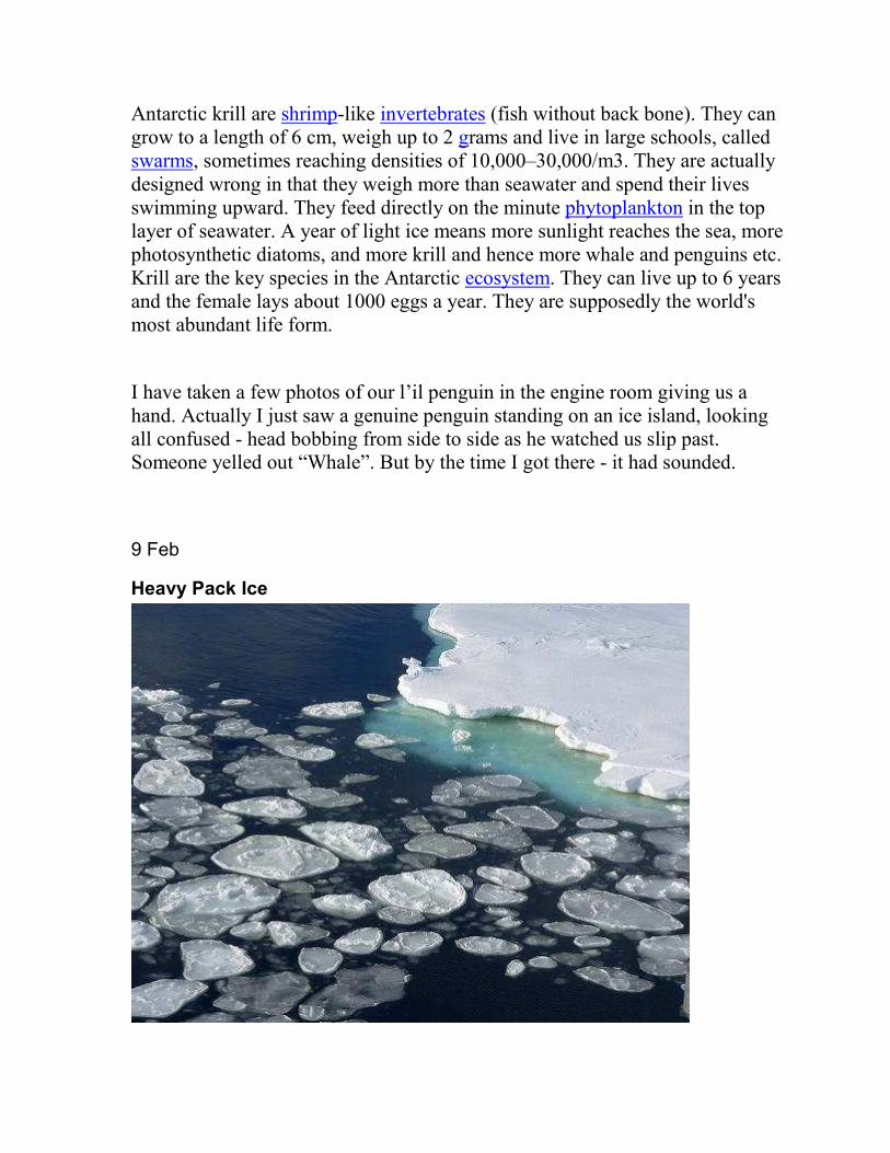
Heavy Pack Ice

We are trudging though the huge amounts of broken pack ice and it’s snowing again. But we are very nearly through to the open Ross Sea that we are trying to get to. To get into this open stretch of water in the Ross Sea, we had to punch through a huge ice dam on the inner edge of the pack ice barrier. This is where storms in the inner Ross Sea have packed up pack ice on top of each other. Apparently it has never been so big, it took us three days to work our way through. Bob, the ice pilot, mentions that he has never known it to be so bad as it is this year. He also mentioned that the current is opposite to what it should be - maybe due to do with global warming. Well, that's partly what we are here doing a study for anyway - not “us” actually, but rather the scientists on board. We are just the “bus drivers”.
It’s hard to believe that it’s summer, except that night never seems to come. On top of it all, we had an eclipse this afternoon. One could just make it out when there was a break in the clouds. I missed most of it though as I was in the engine room at the time.
The days are actually so very long that you actually have to force yourself to turn in at night. Last night when the sun was out, it just seemed to duck below the horizon and then Bob back up again, a few kilometers to the east from where it ducked down, and then another long day began. Fortunately the part of my cabin where my bunk is has no porthole so I can still get a decent sleep.
SQ got lost overboard today, well we presumed she was. I searched everywhere for her and thought she fell overboard from out of my back pocket whilst I was working on the aft deck incubator units. I am sure some of the crew thought it was a conspiracy so that I wouldn’t have to continue with the “SQ sails home” story.
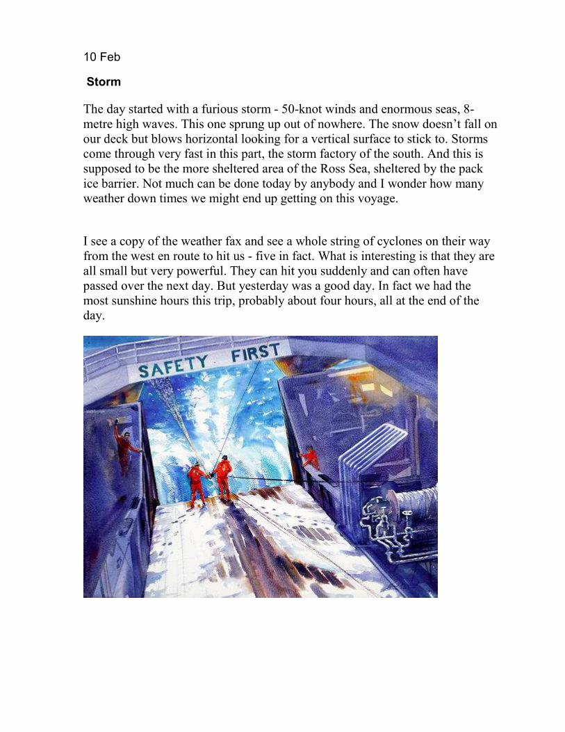
10 Feb
Storm
The day started with a furious storm - 50-knot winds and enormous seas, 8-metre high waves. This one sprung up out of nowhere. The snow doesn’t fall on our deck but blows horizontal looking for a vertical surface to stick to. Storms come through very fast in this part, the storm factory of the south. And this is supposed to be the more sheltered area of the Ross Sea, sheltered by the pack ice barrier. Not much can be done today by anybody and I wonder how many weather down times we might end up getting on this voyage.
I see a copy of the weather fax and see a whole string of cyclones on their way from the west en route to hit us - five in fact. What is interesting is that they are all small but very powerful. They can hit you suddenly and can often have passed over the next day. But yesterday was a good day. In fact we had the most sunshine hours this trip, probably about four hours, all at the end of the day.

11 Feb
After the Storm & On With The Survey
We have just come through the worst of a short and sharp but fairly major storm that struck us without warning yesterday. Although the fury of the snow storm has now passed, we are still rolling around crazily in the storm swell. It is still snowing and the decks and machinery are now almost completely covered with snow. Regardless - the crew and scientists are back on deck, into swing of the survey and carrying on with what they are here for. Midwater sampling trawl goes out and then hauled back in again under the careful and orchestrated direction of the bosun. The crew work hard, they seem to be constantly at it during their 12 hour swings and out in all kinds of weather, rather them than me. I hope we don’t get too many of these storms, as it would account for a good deal of unproductive downtime - not good for our mission. Boy is it cold outside, a few more repairs to be carried out on deck for Lindsay and I. I’d better get my long johns back on, I think. A busy day for us engineers today as well today - some equipment requiring repairs as a result of the rough weather and a few more breakdowns to attend to today - trawls and winches to fix

I am now the proud owner of my first piece of Antarctic real estate - my own prehistoric Antarctic rock. However it just looks like any other rock though. We are about 30 miles off the Sub Antarctic Mountain range but can’t see a dicky bird yet. Hopefully in a day or two we will get a bit closer, I hope. I want to start painting the mountains and sea.
12 Feb
Toothfish
Fortunately, it is calm today but storms whip up very quickly down here. We are very far south in the bottom of the Ross Sea – almost as close as possible by sea to the South Pole. We are steaming off to our next station at the moment. We should get there about 2000 hours then - nets over the side and we do it all again, multi corers taking bed samples and midwater trawl samples. All quite interesting stuff really with all sorts of samples of sea life coming on board. How the hell

anything would want to live in these frigid conditions, I will never know or understand. We caught a huge tooth fish, 32 kilograms, I think, and about 1.3 meters long. The scientists took it down to their lab and dissected it in order to find out how it prefers to dine. They found some nice sized squid and ice fish. Toothfish are also known as Antarctic Cod to Americans and is famous for producing antifreeze glycoprotein that allows it to survive in the ice-laden waters sourounding Antarctica. It has a heartbeat of once every six seconds and research may lead to advances in cardiac medicine involving conditions where human hearts beat slowly during certain medical procedures or fail to beat fast enough due to hypothermia. The tooth fish has been carved up by the scientists in the fish lab and delivered to the galley. Bryan, the cook, gets all excited and starts thinking about how many different ways he can serve it up over the next few days or so. On the menu today is TnT - (Toothfish smoked in Tealeaves). It is a very oily fish with a strong taste - very high in Omega 3 apparently so must be good – I try hard to like it.


13 Feb
Mount Melbourne and Tera Nova Bay On our port side Mt Melbourne 2733m stands out magnificently above Tera Nova Bay and Cape Washington. The mountain is conical and the most prominent mountain in the neighborhood. It is one of the very few volcanoes on Antarctica itself, (most other are on islands) and was named by Ross after the British prime minister in 1830 – 40. Terra Nova bay – between Cape Washington and the Dryglaski Glacier. Named after Ross’s relief ship. A collection of blue and orange buildings here is Italy’s base, the Mario Zucchelli research station. The mountain range is called the Tran Antarctic mountains and tracks all the way from Cape Adare right to the Weddell Sea on the other side. It divides Antarctic into West and East Antarctica and is one of the longest mountain ranges in the world. This mountain range acts like dam and holds back the east Antarctic ice shelf. A magnificent blue iceberg drifts past us while we are on station. Most icebergs are whitish because of their snow and bubble-filled ice. However, some ice can appear bright blue and different shades of green. This is because dense bubble-free ice absorbs only a small proportion of red light from the light spectrum entering it so appears blue. Some icebergs even appear to be layers of liqorire strips with white icing between. These are caused by moraine debris that the glacier has picked up on its way down the glacial path. Toothfish today was raw with wasabi. And for dinner ‘Toothfish Ala Fencepost’ - smoked in wood shavings that Lindsay had specially shaved off using the lathe from an old fence post he had found in the workshop.


14 Feb
A Giant Iceberg – B15J Climbed out on deck from the engine room after a phonecall from the bridge advised me to take a peek across our starboard side. What I saw made me think we were sailing in the English Channel beneath the white cliffs of Dover. Towering over and for as far the eye could see behind us and in front of us were the chilly white cliffs of a massive iceberg. I head up the bridge to see if they have seen it. I am informed that this one actually has a name - B15J - and it turns out that this iceberg is already eight years old. It is 24Nm long, 14 Nm wide, (350square Nm) and is actually grounded. We trawl right in front of this iceberg. Man, it is huge. It looks even bigger than the cliffs of Dover, bigger than Ben-Hur. The stark white cliffs rise 30 to 35 meters above the sea level and they reckon that there would be another 70 to 100 meters below. It is bitterly cold outside, minus 10.5 degrees plus the wind chill factor. Accommodation heating is struggling to keep the interior warm. The patterns on the sides of this iceberg are amazing where pieces have sheared off and where at different times of the day in different light shows all the different forms of them are shown. Naming of Icebergs in Antarctica. This is done by the US National Ice Center (NIC) for any iceberg larger than 10 nautical miles 18km along at least one side. The name starts with a letter A, B, C or D according to which segment of Antarctica it was originally sighted, as follows:
A = Longitude 0-90West (Bellingshausen/Weddell Sea)
B = 90W-180 (Amundsen/Eastern Ross Sea)
C = 180-90E (Western Ross Sea/Wilkesland)
D = 90E-0 (Amery/Eastern Weddell Sea).
Upon first sighting of an iceberg, NIC documents its point of origin, allocates the letter of the quadrant it was found in together with a sequential number assigned to the iceberg. For example B-15 is sequentially the 15th iceberg tracked by the NIC in Antarctica in Quadrant B.
THE HISTORY OF B15 and B15J
It turns out that B15J is the sole surviving remnant of the Iceberg B-15, All the other bits calved off from B15 since have excited the Ros Sea but B15J had stayed stranded most of the time.
Born March 17 2000: B-15, the 15th iceberg tracked in the B quadrant of Antarctica and the world's largest ever recorded iceberg 10,915 square km (about 5 times the area of Lake Taupo) broke off (calved) the Ross Sea Ice Shelf. At the same time the much smaller B16 broke off.
October 9, 2003: B-15A broke into two pieces east northeast of Ross Island in the Ross Sea. The larger iceberg retains B-15A as its name and the smaller iceberg is named B-15J. The east to west circular Ross Sea current took B15A away fom Ross Island Northwards. GPS planted onto iceberg to enable tracking 2004 – 2005: B15A stranded and blocked off the McMurdo Sound.
The blockage prevented the Ross Sea currents and winds from assisting in the 2004–2005 summer break-up of the sea ice in McMurdo Sound. The Sound thus remained iced over and so proved a major obstacle for the annual resupply ships to three research stations and deprived the colonies of Adelie penguins easy access to the sea for food. The colonies were subsequently decimated.
April 2005: B-15A moves on and collides with the Dryglaski Ice Toung; the outlet from David Glacier that flows through Antarctica’s mountainous Victoria Land coastal region. An 8-km² section is broken off. B15J stays behind.
27–28 October, 2005: B15A ran aground off Cape Adare in Victoria Land breaks a small knife-shaped iceberg, B-15K + B-15P, B-15M and B-15N. a storm in Alaska caused an ocean swell that broke B15A into nine pieces. The waves travelled 13,500 km from Alaska to Antarctica over a six-day period.
21 Nov 2006: B-15P, B-15M and B-15N all remnants of B-15A are spotted off the Otago Coastline.


15 Feb Ross Island & Mount Erebus I was put on the shake at 0400 hours this morning by Bob, the ice pilot. Was informed, that Ross Island lay ahead and that the morning light was spectacular on mountains. I clambered up to the bridge and sure enough the 2,460 km² island of three volcanoes lay directly ahead of us and looked just magnificent. Dawn crept up slowly over the eastern end of the island Cape Crozier, where the eastern edge of the Ross ice Shelf meets the Ross Sea. This point is a specially protected area of black volcanic cliff 61–122m high, home to a major emperor penguin rookery. As well as being a major backstop to the Ross Ice Shelf, Ross Island is entirely a volcanic island. The four volcanoes between Cape Crozier on the left to Cape Bird on the right are Mt Terror (3230 m), still hiding under a thick blanket of morning cloud, then Mount Erebus (3794 m), the world’s southern most active volcano, peeking occasionally from behind less cloud and giving off what looked like the odd puff of steam, the smaller Mount Terra Nova followed by Mount Bird (1,765 m), and then back down to the sea at Cape Bird. This is also apparently the only New Zealand Island with out sheep (as the joke goes). The island itself was discovered by Sir James Clark Ross in 1841, and it was later named in honour of him by Robert F. Scott. The two major mountains on the island were named by Ross after his ships HMS Erebus and HMS Terror. Upon seeing Mt Erebus, my thoughts went back to the evening of 28th November,1979 when news came through of the tragedy that occurred on this mountain, Air New Zealand Flight 901 had ploughed into the mountain with the loss of all 257 people on board. This thought cast a shadow on the peacefulness of this setting and upon seeing this notorious mountain for the first time and as a small puff came from the summit. Along the shoreline below Mount Erebus was what looked like a long line of beached, shipping containers. It turns out that they were in fact a line of huge beached tabular icebergs. Mount Erebus (3794m) is the worlds most
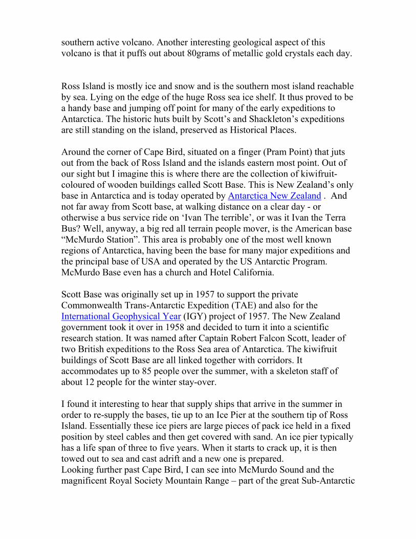
southern active volcano. Another interesting geological aspect of this volcano is that it puffs out about 80grams of metallic gold crystals each day. Ross Island is mostly ice and snow and is the southern most island reachable by sea. Lying on the edge of the huge Ross sea ice shelf. It thus proved to be a handy base and jumping off point for many of the early expeditions to Antarctica. The historic huts built by Scott’s and Shackleton’s expeditions are still standing on the island, preserved as Historical Places. Around the corner of Cape Bird, situated on a finger (Pram Point) that juts out from the back of Ross Island and the islands eastern most point. Out of our sight but I imagine this is where there are the collection of kiwifruit-coloured of wooden buildings called Scott Base. This is New Zealand’s only base in Antarctica and is today operated by Antarctica New Zealand . And not far away from Scott base, at walking distance on a clear day - or otherwise a bus service ride on ‘Ivan The terrible’, or was it Ivan the Terra Bus? Well, anyway, a big red all terrain people mover, is the American base “McMurdo Station”. This area is probably one of the most well known regions of Antarctica, having been the base for many major expeditions and the principal base of USA and operated by the US Antarctic Program. McMurdo Base even has a church and Hotel California. Scott Base was originally set up in 1957 to support the private Commonwealth Trans-Antarctic Expedition (TAE) and also for the International Geophysical Year (IGY) project of 1957. The New Zealand government took it over in 1958 and decided to turn it into a scientific research station. It was named after Captain Robert Falcon Scott, leader of two British expeditions to the Ross Sea area of Antarctica. The kiwifruit buildings of Scott Base are all linked together with corridors. It accommodates up to 85 people over the summer, with a skeleton staff of about 12 people for the winter stay-over. I found it interesting to hear that supply ships that arrive in the summer in order to re-supply the bases, tie up to an Ice Pier at the southern tip of Ross Island. Essentially these ice piers are large pieces of pack ice held in a fixed position by steel cables and then get covered with sand. An ice pier typically has a life span of three to five years. When it starts to crack up, it is then towed out to sea and cast adrift and a new one is prepared. Looking further past Cape Bird, I can see into McMurdo Sound and the magnificent Royal Society Mountain Range – part of the great Sub-Antarctic

mountain range, lit up beautifully by the low morning light. The distant edge of the McMurdo Ice Shelf can just be made out. The airfield for the bases is actually on the ice shelf called Williams Field which allows accessibility by wheeled and ski equipped aircraft all year round. McMurdo Sound supposedly has one of the largest populations of Orcas, probably good penguin feeding. The ice begins to freeze over in March and this mainly breaks up again in December when warm currents start to melt from underneath. I take a bundle of photos with a mind to doing paintings of them this evening. Beaufort Island lies between us and Cape Bird of Ross Island - is approximately 18.4 km² and created by volcanic activity is comprised of basalt. It was named by James Clark Ross in 1841 after Sir Francis Beaufort, hydrographer to the British Royal Navy. The island is one of the most important breeding grounds for birds; there are several penguin colonies on the island, a small colony of breeding Emperor penguins on some sea ice, and a larger Adeleye penguin colony on a raised beach. Later this day we sailed past another big tabular iceberg. This one was in the shape of a maimed and badly listing battleship. I have named this one the “Aircraft carrier” – perhaps a new category for icebergs but officially I think it really falls under the wedge category.

16 Feb The closest point to the South Pole We are probably as far south that is possible to go by ship. This point is the closest point to the South Pole that is possible to reach by ship. One to chalk up for my history book. To mark this occasion of the voyage, the Captain stamps and signs my first day covers with the official ship’s stamp, together with the voyage leader, another trade with Bob, the ice pilot. This first day cover and a map of the Ross Dependency were exchanged for a watercolour painting of the Ross Sea. Thanks Bob, This reminds me that I should really fish out my stamp collection from the attic as I recall having several other Ross Dependency first day covers - Ross Dependency Postage stamps - a bit of history. In 1908, New Zealand Post Office overprinted some 23,500 New Zealand postage stamps with King Edward VII Land ( the original name of the Ross Dependency), for use by the 1908 British Antarctic Expedition. Ernest Shackleton was the first postmaster. In later years, the New Zealand Post Office issued stamps under the name "Ross Dependency". However stamp issues ceased for a time after the Scott Base Post Office closed as part of the 1987 rationalisation, but they were reintroduced again in 1994 due to demand. A very cold wind was blowing from the south and the whole deck is just frozen up. We have been dealing with a load of scientific equipment not working because of systems freezing, so we have been kept on our frozen toes with all that trying to keep things running. The outside air temperature was about minus 13 and with the sea temperature at minus 1.8. I experienced something really amazing today. The sea began to freeze around us this morning and this continued for the rest of the day. Minus 1.8 degrees is the freezing point of seawater when ice crystals start to form. The process of sea freezing is that first a slurry mushy mixture called grease ice or frazil forms and this then starts to form little flat furry edged thingies termed “pancakes”. It is an awesome experience to be sailing through this and It is beautiful to watch the swells softly pass through this milky ice porridge. When sections of it are disturbed, map patterns appear. Once this freezing process starts, the sea can be frozen solid in a couple of days, I am informed.

I skidded my way to the bow to peer over the edge and watch the bow plough through this porridge. The sound is amazing. The effect was topped off with a huge wallowing swell trying to prise itself underneath this layer and the ship trying to work its way through it. We now are making our way back north again, not wishing to be caught in a freezing sea. We have to try to get out of the Ross Sea because the pack ice is closing in on us again and must be out before the sea freezes over properly. This is expected in about a week or so but in the meantime we must continue with more experiments.
17 Feb
Sea Refreezing - Near Ross Ice Shelf


It is bitterly cold down here, so close to the South Pole as we are and near to the edge of the Ross ice Shelf. And no wonder - any wind that blows across an ice shelf as big as France will certainly pick up a mighty chilling bite from it before it hits us. It has been a full on few days here with systems freezing over, jamming because of the bone chilling temperatures, what a busy few days we have had. Machinery that normally enjoys operating in normal sane temperatures, like us, get temperamental and don’t like to function in the cold. Over the last few days we have been slushing through the snow-covered decks trying to jury rig systems to get things going again so that the scientists can carry on with their experiments. Three pairs of socks, double gloved with hand warmers and earmuffs to keep the listening devices warm - all good fun – and of course my long johns on. After our coffee toolbox meeting this morning we had to take to some deck equipment with sledge hammers and big crowbars in order to try and break off the heavy ice that had built up on them overnight. The sea around us is starting to freeze and has turned to a sort of porridge. The term they call this is Frazzle and grease ice. The atmosphere is amazing, the sea is a grey colour and a swell travels under the layer in an amazing magical smooth unbroken motion. Because of the thick top layer, the wind is unable to make little wavelets or cause any waves to crest. It is like the whole sea has been covered with a white blanket. In some areas the surface becomes broken and patterns of world maps appear. The ship is actually mapping the sea floor at this stage and this involves a bit of backtracking on a grid pattern. When we turn on our own wake, we see whale patterns appear where we have broken the porridge surface. Later the Frazzle and grease ice turned to ‘shuga’ and I head to the bow to watch the bow silently slushing through it – the sensation is amazing. The good news is that we are now heading away from the cold South Pole and ‘north to Alaska’ once again again. We have a 200-mile steam right up to the top of the open section of the Ross Sea and closer to the expected track, where we have to get out through the big pack ice barrier again. Satellite images show that it is building up fast but hopefully we will be in time to get through before it all starts gluing together again for the winter. We do have a backstop though in the unlikely case if we might get stuck on the inside - There is an American Icebreaker at McMurdo Sound due to leave on February 22nd. We might always be able to follow her out then if need be.
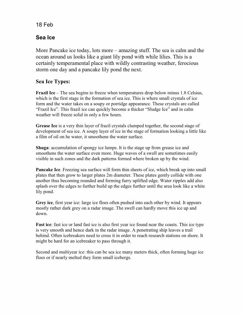
18 Feb Sea Ice More Pancake ice today, lots more – amazing stuff. The sea is calm and the ocean around us looks like a giant lily pond with while lilies. This is a certainly temperamental place with wildly contrasting weather, ferocious storm one day and a pancake lily pond the next. Sea Ice Types: Frazil Ice – The sea begins to freeze when temperatures drop below minus 1.8 Celsius, which is the first stage in the formation of sea ice. This is where small crystals of ice form and the water takes on a soupy or porridge appearance. These crystals are called “Frazil Ice”. This frazil ice can quickly become a thicker “Sludge Ice” and in calm weather will freeze solid in only a few hours. Grease Ice is a very thin layer of frazil crystals clumped together, the second stage of development of sea ice. A soupy layer of ice in the stage of formation looking a little like a film of oil on he water, it smoothens the water surface. Shuga: accumulation of spongy ice lumps. It is the stage up from grease ice and smoothens the water surface even more. Huge waves of a swell are sometimes easily visible in such zones and the dark patterns formed where broken up by the wind. Pancake Ice. Freezing sea surface will form thin sheets of ice, which break up into small plates that then grow to larger plates 2m diameter. These plates gently collide with one another thus becoming rounded and forming furry uplifted edge. Water ripples add also splash over the edges to further build up the edges further until the area look like a white lily pond. Grey ice, first year ice: large ice floes often pushed into each other by wind. It appears mostly rather dark grey on a radar image. The swell can hardly move this ice up and down. Fast ice: fast ice or land fast ice is also first year ice found near the coasts. This ice type is very smooth and hence dark in the radar image. A penetrating ship leaves a trail behind. Often icebreakers need to cross it in order to reach research stations on shore. It might be hard for an icebreaker to pass through it. Second and multiyear ice: this can be sea ice many meters thick, often forming huge ice floes or if nearly melted they form small icebergs.

19 Feb March of the Penguins We watched March of the Penguins this evening after dinner. After watching the movie I formed a different opinion of Skuas, I know what they are really thinking and don’t seem to regard penguins the same way that we do.
20 Feb Sea Pigs
The day ended late with another fiery sunset, the sunrise and sunsets have been magnificent down here - if only it was possible to try capture them as they are on canvas, will give it a try. We had to deal with all sorts of freezing problems today. Scientific experiments fell over because of frozen pipes and hoses. We managed to save the day but with frozen fingers and icicles hanging from our noses. For some of the equipment, frozen plastic pipes had to be cut free from their fittings and thawed out in the engine room. This had to be done carefully as they were so brittle that they could just snap in half. The Benthos girls found some interesting pink and bloated benthos creatures

that crawl along the sea floor and have called them “little pigs”. Amazing creatures about the size of a hand pink with little tails or ears and a little snout that looked just like pigs.
21 Feb 2008
Glacial Erratics & Drop Stones I have been collecting small rocks and stones that have been brought up from the seabed by the bottom trawl. Interestingly there is no consistency about them, there being many different colours and types of rock. John Mitchel our voyage leader, informs me that they are so varied because they have been ‘ice rafted’ from the Antarctic mainland. I learn that they are thus called Glacial Erratics - Glaciers apparently pick up the rocks as they slip slide down the mountain. When the iceberg calves off from the end of an ice tongue or ice shelf, it drifts out to sea and as it gradually melts from the bottom, the rocks that it had picked up on the trip down the mountain drop to the seabed. John pointed out an interesting larger rock our net picked up and one could clearly see heavy scoring where the iceberg or glacier had dragged it along a hard the bottom. Large glacial erratic mysteriously appears in Doc Jenny’s bed in a black bag, Max is investigating further and starts a ‘Who Dun it’ documentary on it – watch this space.
22 Feb 2008
Ross Sea Closing in - Time To Leave The Captain has just decided that we must leave the Ross Sea on Wednesday. At the moment we are in open sheltered sea between the land and the ice pack. The ice pack is starting to close in on us fast and thickening. The sea is freezing fast now. We don’t want to get caught up and trapped on this wrong side of the pack ice barrier. In the meantime, all the studies are carrying on and we are making the most of the fine spell we now have. It’s strange really; there hasn’t been a storm now for two days. There must be something wrong in the weather patterns.

23 Feb
Cape Petrels over Cape Adare
We are just off Cape Adare – the northeast extremity of Victoria land and entrance to the Ross Sea. The cape is 24 miles long and the cape itself is a 300 perpendicular cliff. Antarctica’s largest Adelie Penguin rookery, 250 000 pairs is located here. Dozens of black and white birds called Cape Petrels seem to enjoy following us. They have distinctive black and white patches and were apparently once called Cape Pigeons but they don’t consider themselves as pigeons so it is no longer PC to use this old name.

24 Feb
A spectacular Dawn strikes Mount Herschel A specatuclar dawn over Mount Herschel 3335m.this morning. Mount Herschel is probably the most prominaent feature of the Admiralty Mountain Range in Northern Victoria Land.
25 Feb
Admiralty Mountain Range of Victoria Land Before us lie the Admiralty Mountain Range of Victoria Land – this is ice cover plateau from 50 – 100 miles wide. The coast of Victoria Land is about 800 miles long and runs from Cape Adare to Beardmore Glacier and only broken in a few places by glaciers that run steeply to the sea.

26 Feb
Back Through The Pack Ice Barrier We are on our way again out from the clear patch of the Ross Sea that we have been working in for the past few weeks, between the shoreline and pack ice, back out through the 120 mile wide ice barrier that is separating us from the safe sea. The satellite ice images show that the pack ice surrounding us is building up from the North is thickening very fast now and closing in on this area.
The latest satellite photograph shows narrow gaps between the already freezing sea, which we are trying to aim for and zigzag our escape through. The sound of the ship graunching through this ice is amazing; especially the lower down and more fwd in the ship you go. The Scientists who have cabins down there say the noise is amazing and does not help when trying to sleep through it. The bow just ploughs on through, pushing huge ice islands out of the way, if it can’t break through them, sliding one layer under the next one alongside it. There is a big ridge in the middle of the ice pack, which we might hit later tonight, which is ultra thick; built up by the wind and sea conditions, and hopefully we can do it. Occasionally there is a huge thump and shudder. That’s when we hit the mini icebergs called ‘growlers’.

There is a storm blowing outside of around 40 knots but because of the huge expanse of ice, the storm can’t create any waves. The ship thus just lists over with the wind and ploughs steadily on through. Funny sensation really. I made a copy of the latest weather forecast.
27 Feb 2008
Green Flash - A Converted Green Flash Atheist
I was rubbishing Lindsay after dinner tonight about the so-called green flash that can sometimes ‘supposedly’ appear right on sunset. I informed Lindsay that during my many years at sea, I had watched countless sunsets from the bar but have never ever seen one. I sided with John our voyage leader as ‘The Green Flash Skeptics Society’ and we ganged up against Lindsay. Only a short while later I was photographing the sunset from out of my porthole. I had no sooner taken some photos and put my camera down. Then, blow me days, saw my first evergreen flash developing, a slow green glow around the last edge of the sun as it dipped below the horizon. Wow, I thought, I have seen the light. I picked up my camera to check if I might

have accidentally caught the start of it, and sure enough I had. I immediately resigned for the ‘The Green Flash Skeptics Society’ but even with this proof I still couldn’t convince the voyage leader, so hence there was only one converted that night not two. Investigating further – green flashes are a rare optical phenomena that can occur at the very last moment of sunset or first moment of sunrise where a green ray shoots out from sunset/sunrise point. It typically occurs on unobstructed horizons but can be observed over mountain such as observed above. It is to do with the speed of refracted light traveling through layers of different density air, light moving more slowly though denser air than thinner air above. Light rays also curve slightly, following the curvature of the earth. When light is refracted in the atmosphere, the higher frequency green/blue light curves more than the red/orange rays. Thus right at the last moment of sunset, the green/blue refracted rays are seen by the observer after the red/orange rays have already dipped below the horizon. Although the photo above does not show it too clearly, it should be noted that the photograph was taken just as the flash was starting and the photo has been optically zoomed in.
28 Feb
Poly Cups Dive to 3000m Below Benthos Scientists, Sadie and Nicky handed me a polystyrene cup this morning, but without coffee, and told me to put my artistic skills to good use. “Why?” I said and they explained that if I decorated it, it will be put into a sack together with everybody else’s and attached to the DTIS, dive 3000 meters down in the Abyssal plain. So I just drew on some butler penguins with felt markers and a bit of a Tangaroa portrait. When the DTS was finally down on the bottom, I watched some amazing footage that the camera was transmitting back to the mother ship as it skimmed along bottom filming. Strangely the image of a dust-covered Stella beer bottle stuck in my mind. Sure enough, when the DTIS came back up and was hoisted back on board, my poly coffee cup was the size of a thimble, not even big enough anymore for a short short black. It was a bit crumpled too, musty have got the bends coming back up too fast.

29 Feb
Pancake Ice & Days Closing In

29 Feb The days are getting shorter fast , and pack ice is also closing in fast around our open piece of Ross Sea. I spent some time up the crow’s nest above the bridge with a magnificent view of us picking our way through the ice piles. The gold’s of sunset over the pancake ice creates some beautiful effects for photography. The year has got shorter as well, by two days today, Leap year came and went today but no propositions came through for any of the guys on board.
1 March
Problems with Frozen Equipment
We were kept on our toes the last few days with more things falling over because of the extreme low temperatures. Yesterday the winch system wouldn’t operate and the control airline was found to be blocked with ice. Moisture must have somehow got into the system and frozen in the lines. To top it all off this morning, we couldn’t pump out a sewage tank; we eventually found that the two-inch diameter discharge pipe was frozen solid. No wonder the pump was struggling and had given up trying to suck up a slug of frozen sewage/greywater.
2 March
Storm Yet another storm and horizontal snow, a blizzard really. Antarctica extremely important to the worlds weather system – it really is the storm factory of the great Southern Ocean.

3 March
A double blow – Humpback Whales
Early in the afternoon there was considerable excitement onboard, crew running around the alleyways, grabbing their cameras and charging out onto deck. Very close to the port side of the ship, amongst the pack ice that we were slowly going through, were two magnificent humpback whales - a truly wonderful sight. They seemed to be oblivious to us being there and happily feeding on krill. I tested some positive thinking skills and willed the two whales to blow together for a good photo. Got my camera ready to shoot and waited - and sure enough in no time, they did. I captured this double blow with a sequence shoot. Humpback whales are easy to distinguish, they have a stout body, distinctively long flippers with bumps and lumps upon which barnacles may grow. They are black to blue-black in colour on topside, weigh between 25-30 tonnes, can live for up to 50 years and measure between 12-14m in length, (females generally being larger than the males).

2 March
Ross Sea Sculpture Garden
While slowly zig-zagging through the broken pack ice barrier, I found the amazing shapes of the sculptured ice very inspiring. This scene on a bright Antarctic summers day with pancake ice between the broken and shaped pack ice, made me think of a white lily pond in a sculpture garden. I have been painting nearly every evening whilst on this voyage and it is proving to be a truly inspiring experience, the light and colour experienced is thrilling. I was reminded of a thought I had before leaving New Zealand, when I was packing my paints to take with me.
The thought , ‘Antarctica would be easy to paint - lots
of negative space painting’ I thought ie ‘I would just paint around the edges of the ice and leave the iceberg itself as the white of the paper’, (watercolour painting doesn’t normally use white paint). BUT experience has proved to be everything but, the icebergs show off a kaleidoscope of colours depending on the time of day and how the sun hits it and is reflected, how shadows fall. The colours also depending on the density of the ice, what part of the glacier it originated from.

5 March
‘Swedish Chef’ Iceberg
I nearly got stuck in the doctor’s surgery today – no, I wasn’t fixing anything in there but was nearly super-glued to the surgery table. Doc Jenny had spotted that some skin on my hands was splitting due to the cold and offered to super-glue the wounds closed again. She was a bit worried when my hand got momentarily glued to the surgery table due to stray drops though. Luckily the engine room alarm bleeper in my pocket didn’t go off and I managed to get free. I think I must have been on this trip too long as I saw an iceberg this evening and could swear that it looked like one of the Muppets. I grabbed my glasses to make sure, as it was getting dark, but sure enough, to me anyway, it looked amazingly like the Swedish chef from the Muppet Show. – I thus officially named this one the ‘Swedish Chef’

6 March
The Castle & Antarctic Toothfish
Saw a beautifully crafted iceberg today – it was too small to be given an official name so I named it the Castle, I think this one has got to be my favorite so far on the voyage. This one would actually be classed as a ‘Drydock’ type, as there was a empty section I the center with walls around it. The crew caught another Antarctic toothfish today, 1.3m long weighing 34 kg, this was transported whole to the freezer space to join the giant squid caught the other day, both destined for Te Papa. This is a close relative to the patagonian toothfish, and normally caught around the edges of the Antarctic shelf and in the Ross Sea. To taste - It’s is a very oily fish and comes under various names Mero mad Chilean sea bass, merluza negra and mero. Large adults occasionally exceeding 200 kilograms and thought to live up to fifty years and can reach a length up to 2.3 metres. Another interesting fish that the ‘midwater’ trawls are bring up are the ‘Crocodile Ice Fish’. Interesting fish with gaping pointy mouths surrounded by transparent skin. There was excitement when I found SQ whilst cleaning up in the workshop this afternoon. He had been hiding under the workbench. It turns out he must have fallen out of my pocket when in the workshop and did not drown after all. So looks like the ‘SQ sails home’ story shall continue.

7 March
Scott Island looms out of the storm and mist
Late this afternoon Scott Island loomed out of the mist - a couple of volcanic rocks that jut out of the middle of nowhere.
Scott Island is a small uninhabited island of volcanic origin off the northeastern extremity of Victoria Land. It is only 370 metres long and 180 metres wide, 50m high and covering an area of 4 hectares. Scott island is normally covered by an ice cap and surrounded by precipitous cliffs. There are two small coves with beaches on the island but the rest is made up of high cliffs. Just to the west of the island, Haggitt's Pillar sticks out like a saw thumb - a magnificent volcanic stack reaching over 60 metres above the sea level.
The island was discovered on Christmas Day 1902and landed upon by Captain William Colbeck, commander of the Morning, the relief ship for Captain Robert F. Scott's expedition. He named it Markham Island after Sir Clements Markham, President of the Royal Geographical Society and the architect of the "Discovery".Haggitt's Pillar is named after William Colbeck's mother's family name, Haggitt. However the name was later changed in memory of Robert Falcon Scott. Glen, the bosun, informed me how they had re-mapped this island on the previous voyage of the Tangaroa. It was apparently wrongly charted.
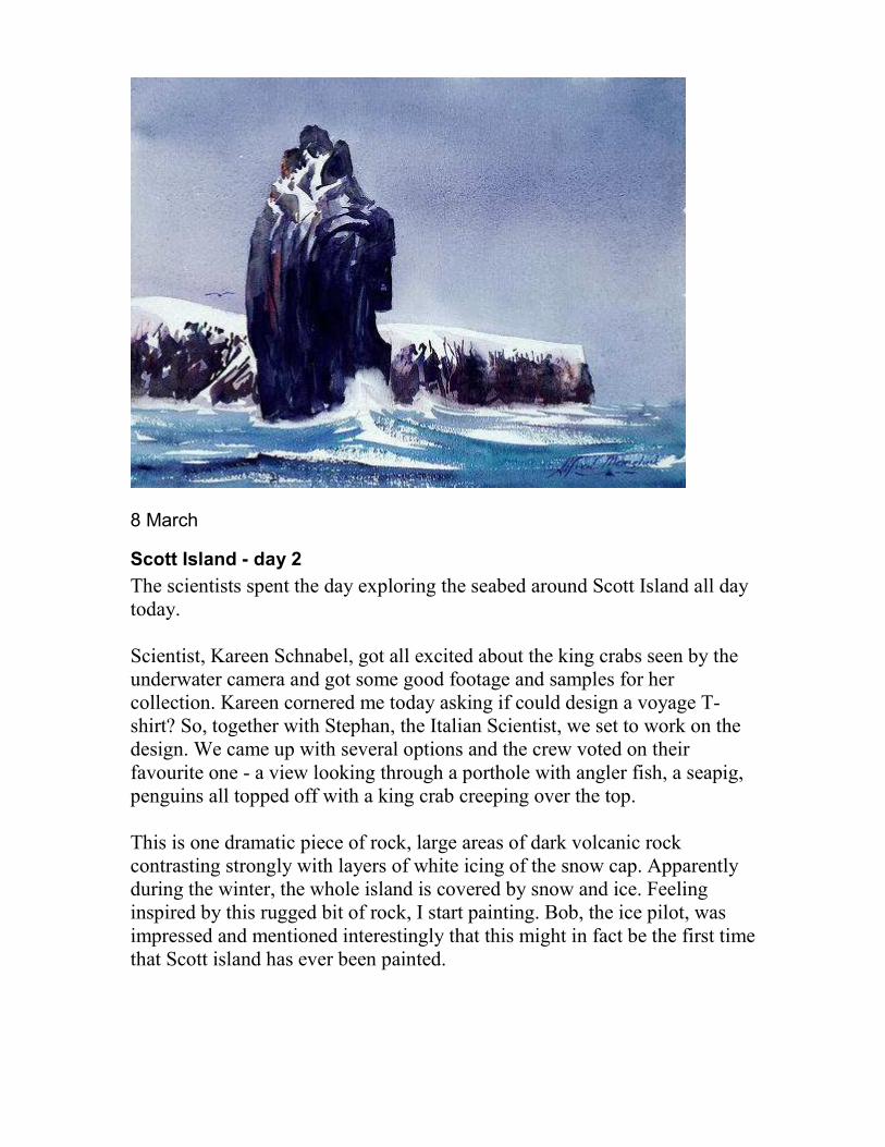
8 March
Scott Island - day 2 The scientists spent the day exploring the seabed around Scott Island all day today. Scientist, Kareen Schnabel, got all excited about the king crabs seen by the underwater camera and got some good footage and samples for her collection. Kareen cornered me today asking if could design a voyage T-shirt? So, together with Stephan, the Italian Scientist, we set to work on the design. We came up with several options and the crew voted on their favourite one - a view looking through a porthole with angler fish, a seapig, penguins all topped off with a king crab creeping over the top. This is one dramatic piece of rock, large areas of dark volcanic rock contrasting strongly with layers of white icing of the snow cap. Apparently during the winter, the whole island is covered by snow and ice. Feeling inspired by this rugged bit of rock, I start painting. Bob, the ice pilot, was impressed and mentioned interestingly that this might in fact be the first time that Scott island has ever been painted.

9 March 2008
The Firemans Helmet
After morning toolnox meeting we passed a beut non tablular iceberg we named the ‘Firemans Helmet’. On station over and mapping the seamounts today. These are especially exciting spots for scientists as they often lead to discoveries of new species. A great variety of corals can be found on the volcanic rocks near the seamount peaks. Also found in abundance around seamounts is plankton which in turn attract the rest of the ecosystem.
10 March 2008
Storm Storm again today and it is snowing. There is a nice clean white blanket on all the deck at the moment and mighty cold again. There are icebergs all around us and I am told we are actually now in iceberg alley, completely surrounded by icebergs. There are some magnificent ones in all shapes and sizes. At dusk I see my favorite one again, which I named ‘the castle’.
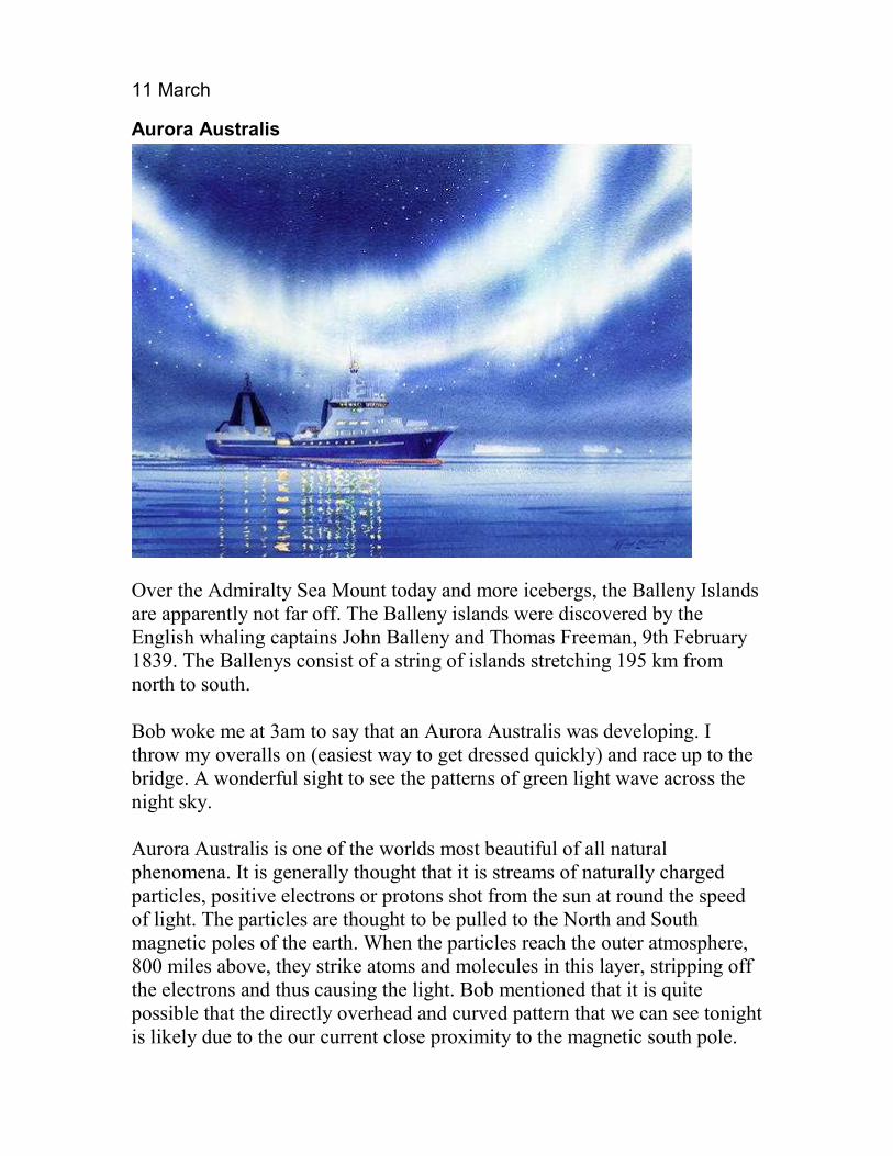
11 March
Aurora Australis
Over the Admiralty Sea Mount today and more icebergs, the Balleny Islands are apparently not far off. The Balleny islands were discovered by the English whaling captains John Balleny and Thomas Freeman, 9th February 1839. The Ballenys consist of a string of islands stretching 195 km from north to south. Bob woke me at 3am to say that an Aurora Australis was developing. I throw my overalls on (easiest way to get dressed quickly) and race up to the bridge. A wonderful sight to see the patterns of green light wave across the night sky. Aurora Australis is one of the worlds most beautiful of all natural phenomena. It is generally thought that it is streams of naturally charged particles, positive electrons or protons shot from the sun at round the speed of light. The particles are thought to be pulled to the North and South magnetic poles of the earth. When the particles reach the outer atmosphere, 800 miles above, they strike atoms and molecules in this layer, stripping off the electrons and thus causing the light. Bob mentioned that it is quite possible that the directly overhead and curved pattern that we can see tonight is likely due to the our current close proximity to the magnetic south pole.

I tried to start a rumour about new species of electric eel that have set up breeding grounds around magnetic south. The negative females just hang around the pole and the more positive males swim towards them in auto pilot mode when they feel like it.
12 March
Tabular Icebergs and Ice Caves
We passed more magnificent icebergs today – huge tabular icebergs with some huge blue caves being carved into their sides at sea level by wave action. I imagine the view being inside one of these caves looking out. Bryan the cook loads up some photos onto the ships shared hard drive photo album, one of them is of his unique kind of iceberg as he imagined seeing from out of his galley porthole, a Ham berg. What will he come up with next?

13 March
Posters appear around the ships notice boards - Camel Awards night – 18th March. It’s to be a tidy affair and we are to wear ties.
Hmm… a tie? – an items I never before ever considered packing into my sea kit bag – I think I will have to make one. A committee has been working very hard to put this night together and it is promising to be a night not to be missed.
I do a quick calculation – dam – my turn to be ‘on the gear’ (on duty) for that particular night.
14 March
And Still More Snow
More Snow and storm - Deck covered again – there is now a heavy layer of ice all over the deck and is quite slippery in places.

15 March
Frozen Equipment The ships side door wouldn’t go down this morning , was completely frozen with layers upon layers of sea ice. Sea spray that had washed over the area and frozen on impact during the previous day’s storm had built a healthy layer. So after our toolbox meeting, it was out with big sledge hammers and big ice picks to break the layers of ice off. Hanging over the side and swinging the hammers and picks with near frozen fingers.
16 March
Yet another storm brewing & rusty spotted kiwi
Yet another storm is brewing and heading our way but we have now changed course to head directly north to try and get out of it’s path. As we steam north I watch the huge waves from the stern and follow the royal albatross gliding on the air currents behind us, truly magnificent to watch. I spot a rusty spotted Kiwi on one of the stern trawl doors – we are heading home.

17 March
The Voyage Home
Sea still rough but we are heading north, not so cold today.

18 March
Camel Awards Night The Big night tonight – the Camel Awards night- official dinner, awards and dance. I still hadn’t made a tie yet so got my paints out and quickly knocked one up, sort of did one in a Kandinsky abstract flavour and paper clipped it ton my shirt collar. Started off with a pre dinner drink in the voyage leaders cabin, but there were too many of us to fit in so this spilled over into the Captains cabin. Someone then blurted out that my cabin was just as big and someone else decided that this being the case, pre dinner drinks would be in my cabin tomorrow night. The galley laid on a specials dinner and this included Bryan's special Haggis, (I think it was the first time I tried it). The mate read our the Robby Burns rendition that goes with carving up a haggis and Captain Andrew piped the Haggis in playing Scotland The Brave, jazz style, on his sax. After the official dinner came the awards, (each award being a special Ross Sea Erratic Stone mounted on a plaque stand. Of course the awards were mainly for bloopers and funnies, lots of laughs and some clever thinking for these. Of course I had pulled the short straw though and is my day on duty - on the gear until 7am so must stay serious.
19 March
An Exhibition At Sea Somehow I had invited the whole ship into my cabin for a pre dinner drink tonight - the last night at sea. (Someone had overheard that my cabin was the largest cabin next to the Captain’s and somehow talked me into thinking this was a good idea).

The big problem to deal with today - how would I get 46 scientists and crew into my cabin? At lunchtime I had one of those bright moments - I would have an exhibition opening of the Antarctic paintings that I had completed on the voyage. So at afternoon smoko I taped them up in my cabin, + down the alleyway outside, had a nice chat with Brian, the cook and he agreed to bring in some nibbles in at about five-ish. I bribed the ‘Dutch club’, Else and Doc Jen to act as doormen, and spread the word that the official opening would be 16:30 hours. It all worked out great, I think the whole ship just managed to cram in somehow with the overflow in the alleyway gallery just outside. Then right on schedule, bang on 1700 hours, Cookie turned up with big plate sausage rolls and a plate of - you guessed it - smoked toothfish. It was a neat event - an enjoyable evening and a neat relaxed way to spend the last night of the voyage together. My fridge was empty once again ready for arrival back home.

20 March
Return to Wellington Weather calm and clear sky, - we are all busy scrubbing down the ship to get it looking good for arrival. A nice wallowing swell in the Cook Strait and up ahead are the green hills of the Wellington heads again. It’s always great to see your homeport again. The end is nigh for what has been an epic voyage. It has opened my eyes to a corner of the world that I had never dreamed of getting to or really shown much interest in but for which I feel as if I have a special connection with now. This last wilderness frontier is truly a magnificent place. After experiencing the magnificence of this last wilderness on earth first hand, learning about and realizing the delicate balance of life that exists there, I have fears for the future of this land. There are serious threats that overshadows this magnificent wonderland and the iceberg sculpture garden, global warming, mans greed for natural resources as well as threats to ecosystems such as overfishing of Toothfish. All efforts be made to ensure sustainability and to ensure that the Ross Dependency will very soon not be another national park of New Zealand but actually part of the Antarctica International nature Park.


