148
16 AUGUST 2015 SINGAPORE ANTIQUE MAPS
| Date post: | 22-Jul-2016 |
| Category: |
Documents |
| Upload: | spink-and-son |
| View: | 232 times |
| Download: | 8 times |

A
NT
IQU
E M
AP
S
1
6 A
UG
US
T 2
01
5
S
ING
AP
OR
E
16 AUGUST 2015
SINGAPORE
ANTIQUE MAPS
© C
op
yri
ght
2015
STAMPS COINS BANKNOTES MEDALS BONDS & SHARES AUTOGRAPHS BOOKS WINES
Spink (Asia) Ptd. Ltd, 360 Orchard Road, # 06-03A International Building, Singapore 238869www.spink.com
Spink 15040 Antique Maps cover.qxp_Layout 1 17/07/2015 13:35 Page 1

GROUP CHAIRMAN AND CEO
Olivier D. Stocker
YOUR SPECIALISTS
STAMPS
UK - Tim Hirsch FRPSL Guy Croton David Parsons Nick Startup Neill GrangerPaul Mathews Dominic Savastano Tom Smith Ian Shapiro (Consultant)
USA - George Eveleth Richard DebneyEUROPE - Guido Craveri Fernando Martínez
CHINA - Tommy Chau Doris LoCOINS
UK - Richard Bishop Tim Robson Jon Mann Barbara Mears John PettUSA - Greg Cole Luke Mitchell Stephen Gol dsmith (Special Consultant)
CHINA - Kin Choi Cheung Paul Pei Po ChowBANKNOTES
UK - Barnaby Faull Andrew Pattison Monica Kruber Thomasina SmithUSA - Greg Cole Stephen Goldsmith (Special Consultant)
CHINA - Kelvin Cheung Paul Pei Po ChowORDERS, DECORATIONS, MEDALS & MILITARIA
UK - Mark Quayle Oliver Pepys John HaywardBONDS & SHARES
UK - Mike Veissid Andrew Pattison Thomasina SmithUSA - Luke Mitchell
EUROPE - Peter ChristenCHINA - Kelvin Cheung
BOOKS
UK - Philip Skingley Jennifer MulhollandAUTOGRAPHS
USA - Greg Cole Stephen Goldsmith (Special Consultant)WINES
CHINA - Guillaume Willk-Fabia Angie Ihlo Fung
YOUR EUROPE TEAM (LONDON - LUGANO)
Chairman’s OfficeCharles Blane
DirectorsTim Hirsch Anthony Spink
Auction & Client Management TeamMira Adusei-Poku Grace Hawkins Rita Ariete Dora Szigeti Tatyana Boyadzhieva
John Winchcombe Tom Mathews Maurizio Schenini
FinanceAlison Bennet Marco Fiori Mina Bhagat Dennis Muriu Hemel Thakore Veronica Morris
IT & AdministrationBerdia Qamarauli Michael Addo Liz Cones Curlene Spencer
Tom Robinson Cristina Dugoni Giacomo Canzi
YOUR AMERICA TEAM (NEW YORK)
Auction Administration and Marketing & DesignAmit Ramprashad
Finance & AdministrationAleena Nieves
AuctioneerLuke Mitchell
YOUR ASIA TEAM (HONG KONG - SINGAPORE)
AdministrationAngie Ihlo Fung Newton Tsang Sue Pui Arthur Chan Doris Lo Gary Tan
Ken Imase [email protected]
BANKNOTES
16 August Banknotes, Bonds & Shares, Coins and Medals of South East Asia sale during the International Exhibition Singapore 15038
27 August The Numismatic Collector’s Series Sale Hong Kong CSS1724/25 September The Numismatic Collector’s Series Sale New York 32229/30 September World Banknotes London 150091 October World Banknotes London 1500914 November The Numismatic Collector’s Series Sale Hong Kong CSS198 December World Banknotes London 15048
SALE CALENDAR 2015/16
The above sale dates are subject to change
Spink offers the following services:– VALUATIONS FOR INSURANCE AND PROBATE FOR INDIVIDUAL ITEMS OR WHOLE COLLECTIONS –
– SALES ON A COMMISSION BASIS EITHER OF INDIVIDUAL PIECES OR WHOLE COLLECTIONS –
STAMPS
15/16 July The Philatelic Collector’s Series Sale New York 15120/21 July The Philatelic Collector’s Series Sale London 15026 16 August Antique Maps Sale during the International Exhibition Singapore 1504016/17 August The “Sentosa” Collection of Straits Settlements, Malayan States, Labuan, North Borneo
and Sarawak sale during the International Exhibition Singapore 1504118 August Stamps and Covers of South East Asia Sale during the International Exhibition Singapore 15027September Autographs, Historical Documents, Ephemera and Postal History London 1503724 September Windward Islands and British Guiana, British Honduras, Cayman Islands and Jamaica
from the Vestey Collection London 1504226 September The Philatelic Collector’s Series Sale Hong Kong CSS146 October The “Fordwater” Collection of New Zealand London 150437 October The Award-Winning Len Jury Collection of New Zealand Postal History, Stationery,
1913 Auckland and 1920 Victory Issues London 1504421 October Great Britain Stamps and Postal History London 15045November The Charles W. Adams Collection of United States and Canada New York 152November The Philatelic Collector’s Series Sale New York 15324/25 November The Philatelic Collector's Series Sale, featuring the John Sussex Collection
of South West Africa,1880-1928 London 1504610 December Bermuda from the Vestey Collection London 1504727/28 January The Philatelic Collector's Series Sale London 16010
COINS
15 July Ancient, British & Foreign Coins and Commemorative Medals London 1500516 August Banknotes, Bonds & Shares, Coins and Medals of South East Asia sale
during the International Exhibition Singapore 1503827 August The Numismatic Collector’s Series Sale Hong Kong CSS1722/23 September Ancient, British & Foreign Coins and Commemorative Medals London 1500624/25 September The Numismatic Collector’s Series Sale New York 32214 November The Numismatic Collector’s Series Sale Hong Kong CSS192/3 December Ancient, British & Foreign Coins and Commemorative Medals London 15007
MEDALS
23 July Orders, Decorations, Campaign Medals & Militaria London 1500216 August Banknotes, Bonds & Shares, Coins and Medals of South East Asia sale
during the International Exhibition Singapore 1503819 November Orders, Decorations, Campaign Medals & Militaria London 15003
BONDS & SHARES
16 August Banknotes, Bonds & Shares, Coins and Medals of South East Asia sale during the International Exhibition Singapore 15038
27 August The Numismatic Collector’s Series Sale Hong Kong CSS1724/25 September The Numismatic Collector’s Series Sale New York 32214 November The Numismatic Collector’s Series Sale Hong Kong CSS1927 November Bonds & Share Certificates of the World London 15019
AUTOGRAPHS
September Autographs, Historical Documents, Ephemera and Postal History London 15037
WINES
15 August An Evening of Selected Rums, Fine Wines, Whiskies and Cognacs during the International Exhibition Singapore SFW15
17 September Whisky, Cognac and Other Spirits Hong Kong SFW1610 December Whisky, Cognac and Other Spirits Hong Kong SFW1715 January Whisky, Cognac and Other Spirits Hong Kong SFW18
Spink 15040 Antique Maps cover.qxp_Layout 1 17/07/2015 13:35 Page 2

Front Cover Illustration: 32 (detail) Back Cover Illustration: 32
ANTIQUE MAPS
Sunday 16 August 2015 in Singapore and on
and/or *
SPINK ON SOCIAL MEDIA
VIEWING OF LOTS
At Spink London
By appointment only until Monday 27 July 2015
At Sands Expo and Convention Centre, Heliconia Ballroom 3405-3406, Level 3:Saturday 15 August 2015 9.00 a.m. to 9.00 p.m.Sunday 16 August 2015 9.00 a.m. to 6.00 p.m..
Please use the QR code to visit our website, view our catalogues and otherpublications and place commission bids. You can download the QR CodeReader for iPhone, Blackberry and Android from App Store on yoursmartphone.
*Spink is pleased to continue to offer our brand new on-line bidding platformSpink Live for no charge through www.spink.com. Please note that bidderswho acquire lots on the-saleroom.com will have a fee of 3% on the hammerprice added to their invoice for using this facility.
The Spink Environment Commitment:Paper from Sustainable Forests and Clean InkSpink has a long history of preserving not only collectables but our planet, too. We are proud to ensure thatour policy of sustainability and conservation keeps up with Spink’s growth, helping improve the environmentfor new generations of collectors.
We insist that our printers source all paper used in the production of Spink catalogues from FSC and/or PEFCsuppliers and use non-hazardous inks. We also ask they hold the environmental standard ISO 14001.
Spink recycle all ecological material used on our premises and we encourage you to recycle your catalogueonce you have finished with it.
TWITTER: @SpinkandSon
INSTAGRAM: Spink_auctions
FACEBOOK: Spink Auctions
YOUTUBE: Spinkauctions
SALE DETAILS
Sunday 16 August 2015 at 6.00 p.m.
In sending commission bids or making enquiries,this sale should be referred to as MAPS - 15040
SALE LOCATION
HELICONIA BALLROOM 3405-3406, Level 3Sands Expo and Convention CentreMarina Bay Sands10 Bayfront AveSingapore 018956tel +65 6688 2557 fax +65 6688 2411(available from 15th August 2015)
To purchase a catalogue:
email: [email protected]
tel: +44 (0)20 7563 4005 fax: +44 (0)20 7563 4037
For more information about Spink services, forthcoming
sales and sales results visit the Spink Website
www.spink.com
Mira [email protected]+44 (0)20 7563 4020 (until 11 August)fax +44 (0)20 7563 4037 (until 11 August)
+65 6688 2557 (from 15 August)fax +65 6688 2411 (from 15 August)
Gary [email protected]+65 6339 8801 (until 13 August)fax +65 6339 0788 (until 13 August)
+65 6688 2557 (from 15 August)fax +65 6688 2411 (from 15 August)
FOR YOUR BIDS
John [email protected]
+44 (0)20 7563 4101
FOR YOUR VAT ENQUIRIES
Newton [email protected]+852 3952 3032 (until 12 August)fax +852 3952 3038 (until 12 August)
+65 6688 2557 (from 15 August)fax +65 6688 2411 (from 15 August)
FOR YOUR INTERNET BIDDING
Veronica [email protected]+44 (0)20 7563 4018
FOR YOUR PAYMENT
YOUR SPINK TEAM FOR THIS SALE
FOR YOUR QUESTIONS ABOUT THE SALE LOTS
Neill [email protected]+44 (0)20 7563 4077
Spink 15040 Antique Maps.qxp_Layout 1 17/07/2015 13:30 Page 1

Spink 15040 Antique Maps.qxp_Layout 1 17/07/2015 13:30 Page 2

WORLD MAPS
3
August 16, 2015 - SINGAPORE
Note: Please note that bidders who acquire lots on the-saleroom.com will have a fee of 3% on the hammer price added to their invoice for using this facility. Spink is pleased to continue to offer our brand new on-line bidding platform
Spink Live for no charge through www.spink.com
SUNDAY 16 AUGUST 2015
Commencing at 6.00 p.m.
1 “1752” Mappemonde ou Description du globe terrestre, by Robert de Vaugondy; 301⁄2 x 20 inches with original outline colour. Copper engraving on watermarked laidpaper.
A beautiful world map in two hemispheres from the 1757 first edition of Giles and DidierRobert de Vaugondy’s famous “Atlas Universal”. The map shows the voyages of Anson in1740, l’Aigle et la Marie, 1738-9, and Galion Na. Seignora - the galleon routes to andfrom Acapulco - Manila, 1743. New Zealand is partially shown, and Nourvelle Hollande(Australia) contains a very strange line on its east coast aptly labeled “Cotes conjectures.”North America is open and empty in the north-west. Australia is shown with partiallyundefined coastlines. Lavish ornamental cartouches.
Usual reinforced central fold and two other vertical folds towards edges. Printed “MAPPE-MONDE” on verso of each side. Good to fine. Photo S$4,000-5,000
1
Spink 15040 Antique Maps.qxp_Layout 1 17/07/2015 13:30 Page 3

Page 4
2 3
WWW.SPINK.COM
ANTIQUE MAPS
2 1766 Mappe-Monde Dressée pour l’Etude de la Géographie, rélativement aux Auteurs lesplus Modernes..., by Desnos; 20 x 151⁄4 inches, old colour.
On stout laid paper, this copper engraved double hemisphere world map is supported bytwo Atlas (or Hercules) figures who are also holding a dedication banner. Unusualcartographic aspects are oddly shaped Alaskan and Australian coasts, based on theincomplete information available at the time, and a large body of water in northwesternNorth America called “Mer de l’Ouest” (Sea of the West).
Usual central fold, some light age marks along the fold and at the very edges of this sheet.Photo S$1,200-1,500
Desnos credits the revisions of the map to Louis Brion de la Tour, who also collaborated withhim on other maps. Little is known about Brion de la Tour except that he held the post ofIngenieur-Geographe du Roi and published a wide range of statistical works and manyatlases
3 1779 A Map the World with the Latest Discoveries, by John Blair; 301⁄2 x 18 inches, hand-coloured.
This large double hemisphere map was issued as an addendum to Blair’s famous tables ofchronology. It reflects the latest exploration discoveries, specially those made by JamesCook during his three expeditions on the Endeavour.
The first voyage in 1768-1771 led to the good delineation of the New Zealand isles andof the Australian west coast, and the correct position of Otaheite (Tahiti).
The second voyage in 1772-1775 dispelled the existence of a large southern continent,Cook crossing the polar circle could not locate any landmass.
The last voyage dispelled the myth of the straight of Anian (also linked to the fablednorthwest passage over and above Canada), and discovered the Sandwich Islands(Hawaii), where he was killed by natives.
Interesting N.W. Coast of America is still based largely on the Russian discoveries andincludes Bering’s coast.
Central fold and two other vertical folds. There is some splitting in the margins. Good tofine. Photo S$2,500-3,000
Spink 15040 Antique Maps.qxp_Layout 1 17/07/2015 13:30 Page 4

5
August 16, 2015 - SINGAPORE
ASIA
4 1579 Indiae Orientalis, Insularumque Adiacientium Typus, by Abraham Ortelius; 211⁄4 x161⁄2 inches, hand-coloured.
Fine example of Ortelius’ map of S.E. Asia, Japan, and the Philippines, etc. The mapincludes beach and other information drawn from Marco Polo. The map also includes aportion of the West Coast of North America, including several mythical names inCalifornia. Based upon Mercator’s world map of 1569. The difficulty of mapping thisarchipelago was such, that for centuries to come maps of this area remain faulty. Sumatraand Java are heavily oversized, and the Philippines are incomplete and without thenorthern island of Luzon. The mermaids, who are beautifying themselves rather thanheeding the whales’ attack on nearby ships, are based on those occurring on DiegoGutierrez map of America. From a French edition of the Atlas “Theatrum OrbisTerrarum”. The privilegium is found in the lower right corner and with French text onverso.
Usual reinforced centre fold, light overall ageing, nevertheless a fine example of this scarcemap. Photo S$7,000-8,000
4
Spink 15040 Antique Maps.qxp_Layout 1 17/07/2015 13:30 Page 5

Page 6
5
WWW.SPINK.COM
ANTIQUE MAPS
5 1606 India Orientalis, by Jodocus Hondius with Latin text on the verso; 223⁄4 x 19 inches,old coloured.
One of the finest early Dutch maps of the region, first published in 1606 as one of the 37new maps engraved for Jodocus Hondius’ expanded Dutch edition of the “MercatorAtlas”. Extending from India to the coasts of Southern China with the Pearl RiverEstuary, Canton and Formosa, it also includes all of the Malay peninsula and Indochina,northern Borneo and the Philippines. The decorative detail includes a large sea monsterand an oriental junk in the Bay of Bengal as well as fine scrollwork title and scalecartouches. One of the most interesting and unusual features of the Southern Malaypeninsula is its dissection in two, the southern part becoming an island just south ofMalacca where it is separated from the rest of the peninsula by a large north-easterlychannel. With two sailing ships and a sea monster.
Reinforced central fold and some light ageing, mostly confined to the margins. Photo S$3,000-3,500
Spink 15040 Antique Maps.qxp_Layout 1 17/07/2015 13:30 Page 6

7
August 16, 2015 - SINGAPORE
6 1690 (c.) Exactissima Asiae Delineatio In Praecipuas Regiones, by Allard bei Covens andMortier; 251⁄4 x 21 inches, old coloured.
Fine map of Asia and the and the Northern tip of Australia, called Hollandia Nova. With a very decorative title cartouche lower left featuring camels, cockatoos and Easternmerchants bartering their wares. Information was taken from Nicolas Witsen’s 6-sheetmap of Tartary from 1687 as noted above the bottom border.
Unfolded but the margin slightly reduced at foot. Photo S$2,000-2,500
7 1719 Nova Asiae Tabula e majori in minorem hanc formam reducta a Ioh. Bapt.Homann, by Christopher Weigel Amsterdam; 171⁄2 x 141⁄4 inches, hand-coloured.
This map was reduced and revised from Homann’s original by Christopher Weigel forinclusion in Johann David Kohler’s 1719 “Schuul und Reisen Atlas”. This map covers allof Asia from the Black Sea to Japan and from Nova Zembla to New Guinea. There is anelaborate allegorical title cartouche in the lower left quadrant illustrating several menbowing to an Asiatic monarch. A leopard surmounts the title area. At the top right, thereare a list of major religious groups. It is likely that the intent was to colour code the mapby religious groups, but this apparently did not a happen.
Usual strengthened centre fold and light soiling, confined to the margins. Photo S$600-800
Cartographically there is much of interest, particularly in East Asia, which at the time waslargely unknown to European cartographers. Japan is attached to Hokkaido, here labeledYedso, which is itself much larger than a malformed but somewhat recognizable Honshu. Justto the east of Yedso (Hokkaido), Homann maps the apocryphal Compagnie Landt. Oftencalled de Gamma Land or Gama, these islands were supposedly discovered in the 17th centuryby a mysterious Spanish navigator known as Jean de Gama. Various subsequent navigatorsclaim to have seen this land, including Maerten de Vries and Cornelis Jansz Coen, but it wasleft to Bering to finally debunk the myth. In 1729, he sailed for three days looking for Juande Gama land but never found it. Thought it may be little more than a mis-mapping ofHokkaido or the Japanese Kuriles, Gama or Compagnie remained on maps for about 50years following Bering’s voyages until the explorations of Cook confirmed the Bering findings.Korea is labeled and appears in a vaguely identifiable peninsular form. New Guinea is onlytentatively rendered suggesting its largely unexplored shores. In the far north, beyond Japan,Asia is truncated indicating that Siberia remained at this point fully unknown. Near thecenter of the map the Capsian Sea (Mare Caspium) appears in circular form according tothe 13th century Kurdish geographer Abu’l Fida.
6 7
Spink 15040 Antique Maps.qxp_Layout 1 17/07/2015 13:30 Page 7

Page 8
8
WWW.SPINK.COM
ANTIQUE MAPS
8 1754 1e Carte de l’Asie, by Jean Palairet; 23 x 203⁄4 inches, uncoloured.
On stout laid paper, this copper engraved map is adorned with an elegant, rococo stylecartouche. This is from Palairet’s greatest work, the “Atlas Méthodique”, a magnificentcartographical demonstration.
Usual central fold with paper reinforcement in the lower margin, small corner crease anda couple of minor wrinkles. Photo S$600-800
Jean Palairet was born in Montauban, France, but emigrated to England where he becamea French tutor to the children of George II. He later wrote several informative books onarithmetic, language, arts and sciences, and geography
9 1755 El Asia con toda la Extension de sus Reinos y Provincias Segun el Sistema de Mr.Hacio, by Pedro Gendron; 251⁄2 x 211⁄4 inches, original outline colour.
Rare separately printed map of Asia, published in Madrid. Unlike most 18th century mapsfrom Spain, which are based upon non-Spanish sources, this map is not based uponFrench sources but is, instead, drawn from German sources, crediting “Mr. Hacio,Profesor de Maematicas, En la Universidad de Wittemberga,” a reference to JohannMatthias Haas, who made maps for the Homann Heirs publishing firm.
Usual reinforced centre fold, crease at upper left corner, some wrinkling in the marginsand light soiling. Photo S$1,200-1,400
10 1757 A New & Accurate Map of Asia Drawn from Actual Surveys and otherwiseCollected from Journal; assisted by the Most approved Modern Maps & Charts, byEmanuel Bowen; 181⁄4 x 15 inches, uncoloured.
Published in “A Complete System of Geography”. Copper engraved map that includes allof Asia through Indonesia and Papua New Guinea. A large island near Japan is namedCompany’s Is. Further east is a large landmass defined by only by its southern shorelinenamed De Gama’s Land after Jean de Gama, the Portuguese explorer who reportedsighting land in the North Pacific. The Sea of Japan is named the Sea of Korea. The Carolines are called New Philippines and are located too far west. Compass rose anddecorative cartouche.
With usual central reinforcement; good to fine. Photo S$1,000-1,200
Spink 15040 Antique Maps.qxp_Layout 1 17/07/2015 13:30 Page 8

9
August 16, 2015 - SINGAPORE
10
9
Spink 15040 Antique Maps.qxp_Layout 1 17/07/2015 13:30 Page 9

Page 10
11
WWW.SPINK.COM
ANTIQUE MAPS
11 1760 Nuova esatta carta dell Asia Formata sulle pui recenti Osservazioni locali, &Astronomichi, by Emanuel Bowen; 21 x 171⁄2 inches, uncoloured.
A rare Italian version of this popular map, showing the mythical Terra di Gamma to theeast of Japan and Korea.
Usual folding creases, some minor wrinkling in the margins. Fine. Photo S$1,000-1,200
Spink 15040 Antique Maps.qxp_Layout 1 17/07/2015 13:30 Page 10

11
August 16, 2015 - SINGAPORE
12 1766 Grande Tartarie Et Isles Du Japon ..., by Louis Brion de la Tour; 103⁄4 x 10 inches,delicate original colours.
Copper engraving on stout laid paper. From “Atlas Méthodique et Elémentaire deGéographie et d’Histoire.....” A striking map of north-eastern Asia, including Japan,Korea, China, Tibet, Turkistan, Kazakstan, Tartarie and Russian Asia, with a verydistinctive Northeast Passage shown. Attractive wash colours. Title cartouche in lowercorner.
Cut from the original page which had text each side. Usual central strengthening, fine.Photo S$600-800
13 1770 A New & Accurate Map of Asia, Drawn from the most approved Modern Maps &Charts, by Thomas Bowen; 181⁄2 x 15 inches, hand-coloured.
This map appeared in “Middleton’s Geography” but shows a largely speculative SouthernAustralian coastline. It has been updated to show Cook’s discoveries in Australasia and thenorthern Pacific.
Folding creases, one with repaired split. Photo S$400-500
13
12
Spink 15040 Antique Maps.qxp_Layout 1 17/07/2015 13:30 Page 11

Page 12
14
15
WWW.SPINK.COM
ANTIQUE MAPS
14 1771 An Accurate Map of Asia from the Latest Improvements by AstronomicalObservances, Engraved by R. Reynolds; 133⁄4 x 9 inches, uncoloured.
For Drake’s Voyages. London. Elaborate cartouche in upper corner.
On laid paper, fine. Photo S$500-600
15 1773 Nieuwe en Naukeurige Kaart van Asia ..., by J. van Jagen; 201⁄2 x 18 inches, hand-coloured. Published by Willem Albert Bachiene.
Map of Asia with relief shown pictorially. The map is of interest for the use of Zee vanKorea, the sea between Korea and Japan.
Usual reinforced central fold; good to fine. Photo S$1,000-1,200
Spink 15040 Antique Maps.qxp_Layout 1 17/07/2015 13:30 Page 12

13
August 16, 2015 - SINGAPORE
16 1776 Map of the European settlements in the East Indies and on the eastern coast ofAfrica including part of Europe, by Thomas Kitchin; 19 x 131⁄2 inches, uncoloured.
Published by T. Cadell according to Act of Parliament. Map of the Eastern hemisphereshowing the direction of prevailing winds and trade routes. Relief shown pictorially. Inset containing the European settlements in the southern part of India.
Usual folding creases, repaired paper splits at left and right. Photo S$600-800
17 1779 An Accurate Map of the East Indies from the Latest Improvements and Regulatedby Astronomical Observations, by Christopher T. Middleton; 14 x 9 inches, uncoloured.
Copper engraving on laid paper. A detailed map of Southeast Asia and India, fromMiddleton’s “Complete System of Geography”. Includes a decorative title cartouche.
Unfolded, tone patch lower right and light water stain just in the lower corner. Photo S$200-250
16
17
Spink 15040 Antique Maps.qxp_Layout 1 17/07/2015 13:31 Page 13

Page 14
18
WWW.SPINK.COM
ANTIQUE MAPS
18 1779 Indie Orientali di qua e di la dal Gange con il loro arcipelago, Venezia, by AntonioZatta. A set of four maps, each 191⁄2 x 151⁄4 inches with original colour.
The four maps cover a large part of Asia from the borders of Afghanistan to Formosa andthe edge of New Guinea. A fine and impressive group. (4). Photo S$800-1,000
Antonio Zatta was a leading European cartographer and publisher, and his “AtlanteNovissimo” (Venice, 1775-1785) was one of the most beautifully produced of all 18th Centuryatlases, with much space devoted to the new discoveries of Captain Cook. Along with hiscontemporary, Giovanni Battista Pasquali, Zatta was responsible for the revival of taste inVenetian fine printing. Famous for his sardonic tone and as something of a controversialist,he was also well known for producing lavish editions of Italian classics and raccolte(collections of poems for special occasions).
Spink 15040 Antique Maps.qxp_Layout 1 17/07/2015 13:31 Page 14

15
August 16, 2015 - SINGAPORE
18
Spink 15040 Antique Maps.qxp_Layout 1 17/07/2015 13:31 Page 15

Page 16
19
20
WWW.SPINK.COM
ANTIQUE MAPS
19 1780 (c.) Asia from the latest authorities, engraved by T. Conder; 10 x 81⁄2 inches,uncoloured.
Copper engraving with ornamental cartouche in the upper corner which includes a cameland palm tree. From a London publication. Japan is shown in a very incorrect outline.This map, with suitable changes in the margin was used by John Payne’s “A New andComplete Universal Geography”, New York, J. Low & Willis, 1798.
The usual two vertical folds, small splits at foot. Photo S$400-500
20 1780 A map of the East Indies, from the best authorities by John Bew; 151⁄4 x 111⁄2 inches,uncoloured.
Folding and other creases, repaired tear at right. Photo S$200-250
Spink 15040 Antique Maps.qxp_Layout 1 17/07/2015 13:31 Page 16

17
August 16, 2015 - SINGAPORE
21 1781 Asia agreeable to the most approved Maps and Charts, By Mr. Kitchen; 171⁄2 x 141⁄4inches, uncoloured.
Copper engraving on laid paper. Kitchin was a prolific English mapmaker of the lateeighteenth century and his maps were used for Millar’s “Popular Geography” in 1781.Much detail is given, compiled from the best sources available in London at the time.Asia, though better known than in earlier, was still a generally mysterious continent toEuropeans.
Vertical folding creases, paper split in the upper margin, just touching the map, a few lightbends. Photo S$600-800
22 1783 (c.) l’Asie divisee en ses Principaux Etats ..., by Jean Janvier; 19 x 131⁄2 inches,original outline colour.
This is a beautiful example of Jean Janvier’s 1762 map of Asia. It covers from Africa andthe Mediterranean east to Bering Strait and south as far as Java and New Guinea. This map is most interesting in its rendering of the largely unexplored extreme north-westof Asia. Yeco or Hokkaido is mapped only speculatively with its western bordersunknown. Shows Sakhalin Island in an embryonic state. A decorative title cartouchedisplaying the riches of the continent appears in the lower right hand quadrant. A finemap of the region. This map was drawn by J. Janvier and included as plate no. 24 in JeanLattre’s “Atlas Moderne”.
Later repaired central fold. fine. Photo S$900-1,100
21
22
Spink 15040 Antique Maps.qxp_Layout 1 17/07/2015 13:31 Page 17

Page 18
23
24
WWW.SPINK.COM
ANTIQUE MAPS
23 1786 Zweiter Theil Der Karte Von Asien Welcher China, Einen Theil Der Tatarei, IndienJenseits Des Ganges, Die Inseln Sumatra, Iava, Borneo, Moluken, Philippinen, und Japonenthœlt, by Franz Anton Schraembl; two maps, each 311⁄2 x 233⁄4 inches, some simpleoutline colour.
These maps were issued in “Allgemeiner grosser Atlas” published by Franz AntonSchraembl. This ambitious atlas with maps based upon the latest discoveries was publishedin Vienna.
The northern map shows some light surface ageing, otherwise fine. (2 maps). Photo S$300-400
24 1787 Les Isles Philippines, celle de Formose, Le Sud de La Chine, Les Royaumes deTunkin de Cochinchine, De Camboge, de Siam des Laos, by Rigobert Bonne; 141⁄2 x 10inches, uncoloured.
From Raynal’s “Atlas de toutes les Parties connues du Globe Terrestre”. A marvelous mapof the region, extending from Formosa to Borneo and from the Philippines to Pegu, andshowing all of Southeast Asia. Inset of Guam and the Marianas.
Usual vertical folds, some small tone spots on the reverse and minor peripheral ageing,otherwise fine. Photo S$600-800
Spink 15040 Antique Maps.qxp_Layout 1 17/07/2015 13:31 Page 18

19
August 16, 2015 - SINGAPORE
25 1790 map of Asia, by Louis Brion de la Tour; 26 x 20 inches, original colouring.
Copper plate engraving on stout blued laid paper; text at each side pasted in place from“Atlas General et Elementaire pour l’Etude de la Geographie et de l’Histoire Moderne”.Very decorative map of Asia including all of Southeast Asia. The map is modeled oncontemporary French sources, notably the work of Robert de Vaugondy. The seas arefilled with a number of sailing ships, and there is a decorative cartouche surrounded injungle with an elephant, peacock and a monitor lizard. An elaborate rococo border.
Usual central reinforcement and a printer’s paper wrinkle in lower left corner. Photo S$600-800
26 1791 Map of the South East Part of Asia for illustrating Dr. Robertson’s historicaldisquisition &c, by T. Kitchen, published by T. Cadell, Strand; 221⁄4 x 15 inches,uncoloured.
This map depicts the knowledge that Ancients had of India and the progress of trade withit prior to the discovery of the passage to India by the Cape of Good Hope.
Usual folds, repair in right margin. Photo S$400-500
25
26
Spink 15040 Antique Maps.qxp_Layout 1 17/07/2015 13:31 Page 19

Page 20
27
28
WWW.SPINK.COM
ANTIQUE MAPS
27 1800 (c.) Asia, anonymous; 101⁄2 x 81⁄2 inches, uncoloured.
A copper engraving with title in simple oval, the coasts are marked with hatching.
Two vertical folds and some light ageing, mostly confined to the edges. Photo S$300-400
28 1856 Asie, published by A. Combette, Paris; 191⁄2 x 14 inches, original outline colour.
From “Atlas Universel Illustre. Geographie et Statistique par V. Levasseur”. Marginillustrations are lavish and of excellent quality showing local heros, products, landscapes,and dress. Country boundaries, towns and cities shown. Major relief shown by hachures.Colour along boundaries and rivers shown. Text shows local statistics, map legend, anddiscusses land, curiosities, personages, products, and commerce. Steel engraving.
Unfolded but with minor bends or wrinkles, one small tone spot. Photo S$400-500
Spink 15040 Antique Maps.qxp_Layout 1 17/07/2015 13:31 Page 20

21
August 16, 2015 - SINGAPORE
29 1858 Asia by G.H. Swanston; 23 x 183⁄4inches, original colour.
Lithograph print published by A.Fullarton & Co. in “The CompanionAtlas to The Gazetteer of the World”,folio number “LXVII”.
Usual central reinforcement,some minor ageing. Photo S$400-500
30 A group of maps of East and South-East Asia with
1834 Birman Empire & Countries South East of theGanges, Henry Teesdale, engraved by John Dower;14 x 18 inches, hand-coloured.
1854 (c.) China and the Birman Empire, EdwardStanford, engraved by J&C Walker, handcoloured;some ageing, particularly around edges.
1860 “India” (and south east Asia) engraved by G.Sherman after a map by J. Wells, published inMcNally’s “System of Geography”. The original is alithographic map, with original hand colouring. S$250-300
29
30
Spink 15040 Antique Maps.qxp_Layout 1 17/07/2015 13:31 Page 21

Page 22
31
WWW.SPINK.COM
ANTIQUE MAPS
CHINA
31 1589 Chinae, olim Sinarum regionis, nova descriptio auctore Ludovico Georgio, byAbraham Ortelius; 23 x 181⁄2 inches, old coloured.
This is the second or third state of this map taken from the first western map of Chinaand first published in Ortelius “Theatrum” in 1584. Based on reports of the Portuguesemap maker Luis de Baruda. With its three lushly designed cartouches and manyillustrations of indigenous shelters, modes of transportation and animals, this is one ofOrtelius’s richest engravings. Spanish text on verso.
Some light tone spotting in the margins. In very fine condition. Photo S$10,000-12,000
Ortelius’ map of China is taken directly from reports of the Portuguese mapmaker Luis Jorgede Barbuda (Ludovicus Georgius) who made a manuscript map of China which reachedOrtelius via Arias Montanus. First published in 1584, Ortelius’ map of China is the earliestprinted map to focus on China and the first to illustrate the Great Wall of China. Tooleyreferred to the map as the standard map of the interior of China for over sixty years.
When this map appeared, it was by far the most accurate representation of China to appearon a printed map. Japan is shown on a curious curved projection reminiscent of Poruguesecharts of the period with Honshu dissected along the line of Lake Biwa. The Great Wall isshown, but only a relatively small section, its length is significantly underestimated. The Tartar “yurts” are dotted across the plains and steppes of Central and East Asia.
The Portuguese Jesuits established a mission in China in 1577. Although the map’sPortuguese maker, Barbuda, was himself not a Jesuit, his sources for the map were PortugueseJesuits. The Chinese characters found in the text on the verso of the map were the firstintroduction to Chinese language for many educated Europeans of the time.
Spink 15040 Antique Maps.qxp_Layout 1 17/07/2015 13:31 Page 22

23
August 16, 2015 - SINGAPORE
32 1655 Pechili sive Peking Imperii Sinarum Provincia Prima, by Johannes Blaeu; 191⁄4 x 151⁄2inches with border trimmed to about three inches, old coloured.
Copper engraving on stout wove paper. From “Novus Atlas Sinensis a Martino MartinioSoc. Iesu Descriptus ...,” Amsterdam. This map includes the cities of Xvntien (Peking),Paoting and others and it is interesting to note that Tiencin (Tientsin) is a smallfortification and includes the coastline of the Gulf of Chihili. Two elaborate cartouches;the scale features two astronomers with globe, the title with important dignitaries and twophoenix.
Reinforced central fold with some light soiling at top. Photo S$6,000-8,000
Volume XI of Blaeu’s superb atlas is the first western atlas of Asia. This volume is based onthe remarkably accurate compilations of the Jesuit Father Martino Martini during histravels between 1643 and 1650. On his return trip to Rome, Martini’s ship was blown offcourse, forcing him to land in Norway. He subsequently made a stop in Amsterdam where hemet Johannes Blaeu, and agreed to assist in the production of the “Atlas Sinensis”. Martinisucceeded in producing very accurate maps of Japan, China, and their provinces, which maybe attributed to Martini’s skill as well as access to Chinese maps during his travels. His mapswere copied extensively for the next century. Of particular note, in Imperii Sinarum andIaponia Regnum, Korea is shown as a peninsula for the first time on a map produced outsideof China. The Jesuit missions are indicated throughout the maps by a cross above the letters“IHS.” The atlas includes a general map of China, fifteen maps of individual Chineseprovinces
32
Spink 15040 Antique Maps.qxp_Layout 1 17/07/2015 13:31 Page 23

Page 24
33
WWW.SPINK.COM
ANTIQUE MAPS
33 1655 Xansi Imperii Sinarum Provincia Secunda, by Johannes Blaeu; 19 x 151⁄2 inches withborder trimmed to about three inches, old coloured.
Copper engraving on stout wove paper. From “Novus Atlas Sinensis a Martino MartinioSoc. Iesu Descriptus ...”, Amsterdam; This map of Shansi province shows the Great Wallrunning along the upper segment, the city of Taiyuen (Taiyanfu). The scale cartouchewith astronomer and globe, the title cartouche with ornamental surround.
Central reinforcement and some minor soiling. Photo S$800-900
34 1655 Xensi Imperii Sinarum Provincia Tertia, by Johannes Blaeu; 19 x 153⁄4 inches withborder trimmed to about three inches, old coloured.
Copper engraving on stout wove paper. From “Novus Atlas Sinensis a Martino MartinioSoc. Iesu Descriptus ...”, Amsterdam. This map of Shensi features a part of the Great Wallrunning through the centre with the cities of Sigan (Sianfu), Kingyang and others. The scale cartouche features a deer, the title cartouche with a soldier and a cherub.
Usual reinforcement; pre-printing paper wrinkle at top. Photo S$600-800
35 1655 Xantung Imperii Sinarum Provincia Quarta, by Johannes Blaeu; 19 x 16 inches withborder trimmed to one and a half to three inches, old coloured.
Copper engraving on stout wove paper. From “Novus Atlas Sinensis a Martino MartinioSoc. Iesu Descriptus ...”, Amsterdam. This map of Shantung features the importantcoastal area at the top of the Yellow Sea, the cities of Cinan (Tsinan), Yencheu, Cingcheuand Tengcheu which appears on an island; the tip of Manchuria with the Liaotungpeninsular and parts of Korea. The title and scale cartouche features four men arguing ordebating.
Reinforced fold with small tear at top. Photo S$2,000-2,200
Spink 15040 Antique Maps.qxp_Layout 1 17/07/2015 13:31 Page 24

25
August 16, 2015 - SINGAPORE
35
34
Spink 15040 Antique Maps.qxp_Layout 1 17/07/2015 13:31 Page 25

Page 26
36
WWW.SPINK.COM
ANTIQUE MAPS
36 1655 Honan Imperii Sinarum Provincia Quinta, by Johannes Blaeu, 191⁄2 x 16 inches withnearly three inch border, old coloured.
Copper engraving on stout wove paper. From “Novus Atlas Sinensis a Martino MartinioSoc. Iesu Descriptus ...”, Amsterdam. This map of the Honan province is centered on theYellow River, Crocei F. Pars, from which Honan derives its name. A legend at rightillustrates towns of various sizes, forts, and the locations of gold, silver, and tin mines. The cities of Caifung (Kaifeng), Honan (Zhengzhou), and Nanyang are well depicted. A strapwork title cartouche incorporates the scale of miles and is flanked by a man andwoman depicting the native dress of the region.
Reinforced down central fold as usual; small split and minor water stain at foot. Photo S$1,000-1,200
37 1655 Suchuen Imperii Sinarum Provincia Sexta, by Johannes Blaeu; 19 x 16 inches withborder trimmed to about three inches, hand coloured.
Copper engraving on stout wove paper. From “Novus Atlas Sinensis a Martino MartinioSoc. Iesu Descriptus ...”, Amsterdam; This map of Szechwan includes the cities of Mahu,Siucheu, Chungking, Chingtu, Xunking and Paoning; the two cartouches featurecolloquial characters.
With the central reinforcement and tear in the upper margin. Photo S$1,400-1,600
38 1655 Huquang Imperii Sinarum Provincia Septima, by Johannes Blaeu; 191⁄2 x 16 incheswith nearly three inch border, old coloured.
Copper engraving on stout wove paper. From “Novus Atlas Sinensis a Martino MartinioSoc. Iesu Descriptus ...”, Amsterdam. This map of the Hubei province is centered on theYangtze River, Kiang Flu Pars. A legend at bottom left illustrates towns of various sizes,forts, and the locations of silver mines. The city of Vuchang (Wuhan) is located along theriver. A strapwork title cartouche incorporates the scale of miles and is flanked by two ricefarmers.
Usual reinforcement down the central fold; small water stain and paper split at foot. Photo S$1,000-1,200
Spink 15040 Antique Maps.qxp_Layout 1 17/07/2015 13:31 Page 26

27
August 16, 2015 - SINGAPORE
38
37
Spink 15040 Antique Maps.qxp_Layout 1 17/07/2015 13:31 Page 27

Page 28
39
WWW.SPINK.COM
ANTIQUE MAPS
39 1655 Kiangsi Imperii Sinarum Provincia Octava, by Johannes Blaeu; 191⁄2 x 16 inches withnearly three inch border, old coloured.
Copper engraving on stout wove paper. From “Novus Atlas Sinensis a Martino MartinioSoc. Iesu Descriptus ...”, Amsterdam. The map with the mountainous areas of Kiangsiwith Nanchang on the edge of Lake Poyang. The elaborate cartouche features fourChinese gentlemen in outdoor clothing.
Usual reinforcement down central fold; some light soiling and split at foot which is justconfined to the margin. Photo S$1,000-1,200
40 1655 Nanking sive Kiangnan Imperii Sinarum Provincia Nona, by Johannes Blaeu; 191⁄2 x 16 inches with border trimmed to 11⁄2 inch, hand coloured.
Copper engraving on stout wove paper. From “Novus Atlas Sinensis a Martino MartinioSoc. Iesu Descriptus ...”, Amsterdam. The map shows this coastal province with its manyrivers and lakes including the main cities of Sucheu (Soochow), Kiangming (Chinkiang).The cartouche with two Chinese scholars.
Fresh and fine. Photo S$2,000-2,500
41 1655 Fokien Imperii Sinarum Provincia Undecima, by Johannes Blaeu; 191⁄4 x 16 incheswith nearly three inch border, old coloured.
Copper engraving on stout wove paper. From “Novus Atlas Sinensis a Martino MartinioSoc. Iesu Descriptus ...”, Amsterdam. Decorative map of Fokien province. The mapfeatures many place names and topographical details, a key to symbols, and two splendidcartouches (mileage scale and title). The delightful title cartouche features three Chineseand a hyena. Part of Taiwan (Formosa) appears in the lower right corner.
Professional reinforcement down the central fold and some light ink transference;otherwise in very fine condition. Photo S$2,000-2,500
Spink 15040 Antique Maps.qxp_Layout 1 17/07/2015 13:31 Page 28

29
August 16, 2015 - SINGAPORE
41
40
Spink 15040 Antique Maps.qxp_Layout 1 17/07/2015 13:31 Page 29

Page 30
42
WWW.SPINK.COM
ANTIQUE MAPS
42 1655 Quantung Imperii Sinarum Provincia Duodecima, by Johannes Blaeu; 191⁄2 x 16inches with nearly three inch border, old coloured.
Copper engraving on stout wove paper. From “Novus Atlas Sinensis a Martino MartinioSoc. Iesu Descriptus ...”, Amsterdam. A map showing the multiple island coastline withthe important island of Hainan, showing the Tropic of Cancer as a red line, the major cityof Quangcheu (Canton), the Island of Macao with it’s church and the peninsula andislands of Hong Kong. The cartouche features a woman walking and a man attendinglotus flowers.
With the usual vertical reinforcement; there is some minor ageing, mostly confined to thereverse. A very popular and important map. Photo S$5,000-6,000
Spink 15040 Antique Maps.qxp_Layout 1 17/07/2015 13:31 Page 30

31
August 16, 2015 - SINGAPORE
43 1655 Quangsi Imperii Sinarum Provincia Decimatertia, by Johannes Blaeu; 191⁄2 x 16inches with nearly three inch border, old coloured.
Copper engraving on stout wove paper. From “Novus Atlas Sinensis a Martino MartinioSoc. Iesu Descriptus ...”, Amsterdam. The map shows the province of Kwangsi with theNan Mountains to the north and the Tropic of Cancer as a thick red line. Gucheu(Wuchow) to the east and Nanning to the south. The elaborate cartouche features twoarchers and two swordsmen.
Usual reinforcement on central fold and some minor soiling. Photo S$600-800
44 1655 Queicheu Imperii Sinarum Provincia Decimaquarta, by Johannes Blaeu; 191⁄2 x 16inches with nearly three inch border, old coloured.
Copper engraving on stout wove pape. From “Novus Atlas Sinensis a Martino MartinioSoc. Iesu Descriptus ...”, Amsterdam. The map shows the province of Kweichow showingthe cities of Kweiyang, Liping and others. Two cartouches, the scale surrounded by twocherubs and the title with swordsman, crossbowman and another.
Usual central reinforcement; fine. Photo S$600-800
43
44
Spink 15040 Antique Maps.qxp_Layout 1 17/07/2015 13:31 Page 31
Page 32
45
46
WWW.SPINK.COM
ANTIQUE MAPS
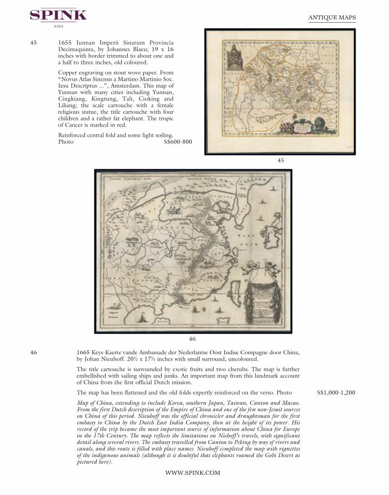
45 1655 Iunnan Imperii Sinarum ProvinciaDecimaquinta, by Johannes Blaeu; 19 x 16inches with border trimmed to about one anda half to three inches, old coloured.
Copper engraving on stout wove paper. From“Novus Atlas Sinensis a Martino Martinio Soc.Iesu Descriptus ...”, Amsterdam. This map ofYunnan with many cities including Yunnan,Cingkiang, Kingtung, Tali, Cioking andLiliang; the scale cartouche with a femalereligious statue, the title cartouche with fourchildren and a rather fat elephant. The tropicof Cancer is marked in red.
Reinforced central fold and some light soiling.Photo S$600-800
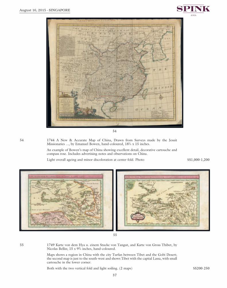
46 1665 Keys-Kaerte vande Ambassade der Nederlantse Oost Indise Compagne door China,by Johan Nieuhoff. 201⁄2 x 171⁄4 inches with small surround, uncoloured.
The title cartouche is surrounded by exotic fruits and two cherubs. The map is furtherembellished with sailing ships and junks. An important map from this landmark accountof China from the first official Dutch mission.
The map has been flattened and the old folds expertly reinforced on the verso. Photo S$1,000-1,200
Map of China, extending to include Korea, southern Japan, Taiwan, Canton and Macao.From the first Dutch description of the Empire of China and one of the few non-Jesuit sourceson China of this period. Nieuhoff was the official chronicler and draughtsman for the firstembassy to China by the Dutch East India Company, then at the height of its power. Hisrecord of the trip became the most important source of information about China for Europein the 17th Century. The map reflects the limitations on Niehoff’s travels, with significantdetail along several rivers. The embassy travelled from Canton to Peking by way of rivers andcanals, and this route is filled with place names. Nieuhoff ccmpleted the map with vignettesof the indigenous animals (although it is doubtful that elephants roamed the Gobi Desert aspictured here).
Spink 15040 Antique Maps.qxp_Layout 1 17/07/2015 13:31 Page 32

33
August 16, 2015 - SINGAPORE
47 1680 (c.) Pecheli, Xansi, Xantung, Honan, Nanking, by Jan Janssonius; 203⁄4 x 181⁄4inches, old coloured on laid paper.
In “Plaga Regni Sinensis in ter Septentrionem ac Orientem Ceciam versus sitaeProvinciae”. This highly decorative map of north-eastern China and Korea, published inone of the last editions of Jan Jansson’s “Atlas Major”. The massive Great Wall of Chinaforms the northern border and the important salt flats are graphically illustrated along thecoast; Beijing assumes the name Xuntien and Shanghai is named Sungkiang. The titlecartouche is in the very distinct auricular style favored in the Netherlands and is flankedby Chinese Mandarins. The other cartouche, containing the scale of miles, is surroundedby cherubs or putti. Three ships sail in the sea between China and Corea (Korea), whichis noted as being a peninsula, two are at battle with each other.
Central reinforcement and a few minor wrinkles and a short tears or splits in the upperand lower margins. A good example of this important map. Photo S$2,000-2,500
The map is based on the groundbreaking work of Martino Martini (1614-61), a legendaryItalian Jesuit missionary and scholar. Martini arrived in Peking in 1644 just as the MingDynasty fell to the Manchurian rebels (who formed the Qing Dynasty). Following in thefootsteps of his fellow Italian Jesuit Mateo Ricci, Martini sought out the very best maps andsurveys of the Chinese Empire. He compiled a series of maps that were by far the most accuratedepictions of China to date. Martini’s suite of 17 maps was first published by Joan Blaeu asthe “Novus Atlas Sinensis”, which accounted for volume 10 of his Atlas Maior (Amsterdam1655). The present edition of one of the most important maps was issued shortly thereafter byBlaeu’s rival Jan Jansson.
47
Spink 15040 Antique Maps.qxp_Layout 1 17/07/2015 13:31 Page 33

Page 34
48
49
WWW.SPINK.COM
ANTIQUE MAPS
48 1692 (c.) Chekiang e Kiangsi, Provincie della China, by Vincenzo Coronelli; 281⁄4 x 19inches, hand-coloured.
From “Corsa Gerographica Universale”. The map is richly adorned with elaborate titleand scale cartouches. Includes the small settlements of Ningao, Hangcheu, Hukewu andKieu Kiang.
Usual strengthened central fold. Fresh and fine. Photo S$600-800
From Coronelli’s set of six maps showing thirteen Chinese provinces, modelled upon the earliermaps by Joan Blaeu and the Jesuit Martino Martini. Vincenzo Coronelli was a Franciscanpriest and renowned mathematician and cartographer. He was appointed officialCosmographer to the Venetian Republic in 1685 and founded the world’s earliest geographicsociety, L’Accademia Cosmografica degli Argonauti.
49 1692 (c.) Chekiang e Kiangsi, Provincie della China, by Vincenzo Coronelli 27 x 191⁄4inches, hand-coloured.
From a different edition of “Corsa, Gerographica Universale”. On stout laid paper.
Usual central strengthening and with some light folding creases. Photo S$600-800
Spink 15040 Antique Maps.qxp_Layout 1 17/07/2015 13:31 Page 34

35
August 16, 2015 - SINGAPORE
50 1692 (c.) Nanking, et Honan Provincie della China by Vincenzo Coronelli; 263⁄4 x 191⁄4inches, hand-coloured.
On stout laid paper, from “Corsa Gerographica Universale”. With two elaboratecartouches and includes the settlements of Sungkiang, Suchew, Chinkiang, Kiangning,Vuhu and Caieung.
Usual central strengthening. Photo S$1,000-1,200
51 1706 D’Oost-Indize Landschappen, Zeen en Eylanden, Door de Portugusen en anderenonekdt en bevaren, by Pieter Vander Aa; 113⁄4 x 8 inches, uncoloured.
Fascinating copper engraved map centered in the Indian Ocean, illustrating the Narrativeof Francisco d’Almeida, the Portugese Viceroy to India, who died in 1510.
The two vertical folding creases and paper wrinkle in top left corner. Fine. Photo S$200-250
50
51
Spink 15040 Antique Maps.qxp_Layout 1 17/07/2015 13:31 Page 35

Page 36
53
52
WWW.SPINK.COM
ANTIQUE MAPS
52 1736 Nuova Carta dell’ Imperio Della China e dei Paesi circonvicini, Amsterdam, ChezIsaac Tirion. 173⁄4 x 14 inches, (123⁄4 x10 inch plate impression), hand-coloured.
Copper plate engraved map on laid paper. Map of China covering an area from Tibet toKamtchatka. The Great Wall is shown as well as the Gobi Desert. The Mare diKamtzchatka, the Korean peninsula and Japan are nicely depicted. Title cartouche lowerright, rose compass and scale border.
Usual central strengthening and numbered page “3” on the reverse. Photo S$600-800
53 1740 (c.) “Regni Sinae vel Sinae PropriaeMappa et Descriptio Gegraphica ex mappisparticularibus quas Sinarum Rex Kanghi operapatrum Missionarium i…R.P. du Halde”, byJohann Matthaus Haas; 211⁄2 x 25 inches andlater hand-coloured.
Highly detailed map of China, extending tothe Gobi Desert in the north and includingFormosa and Hainan Islands, with a largedecorative cartouche and explanatory table.The map is colored by provinces.
With usual central strengthening; light overallageing. Photo S$600-800
Haas was one of the mid-period Homann Heirs,whose cartographic publications were the mostprolific in Germany during the 18th Century.An excellent highly detailed map, based uponthe works of Du Halde and D’Anville.
Spink 15040 Antique Maps.qxp_Layout 1 17/07/2015 13:31 Page 36
37
August 16, 2015 - SINGAPORE
54 1744 A New & Accurate Map of China, Drawn from Surveys made by the JesuitMissionaries ..., by Emanuel Bowen, hand-coloured, 181⁄4 x 15 inches.
An example of Bowen’s map of China showing excellent detail, decorative cartouche andcompass rose. Includes advertising notes and observations on China.
Light overall ageing and minor discoloration at center fold. Photo S$1,000-1,200
55 1749 Karte von dem Hya u. einem Stucke von Tangut, and Karte von Gross Thibet, byNicolas Bellin; 15 x 93⁄4 inches, hand-coloured.
Maps shows a region in China with the city Turfan between Tibet and the Gobi Desert;the second map is just to the south-west and shows Tibet with the capital Lassa, with smallcartouche in the lower corner.
Both with the two vertical fold and light soiling. (2 maps) S$200-250
54
55
Spink 15040 Antique Maps.qxp_Layout 1 17/07/2015 13:31 Page 37

Page 38
57
56
WWW.SPINK.COM
ANTIQUE MAPS
56 1780 (c.) L’Empire de la Chine d’après l’Atlas Chinois avec les Isles du Japon, byRigobert Bonne; 20 x 151⁄2 inches, original outline colour.
Detailed map of China, Korea and the Islands of Japan, showing the Provinces, towns,mountains, rivers, lakes, islands, published in Paris by Jean Lattre. Drawn by R. Bonne in1783 for issue as plate no. 27 in Jean Lattre’s 1783 issue of the “Atlas Moderne”. The map is drawn from d’Anville’s atlas of China and includes a decorative cartouche inthe lower right quadrant which depicts a Chinaman smoking opium and admiring a birdperched in his index finger while relaxing under an umbrella amongst bucolicsurroundings.
On stout laid watermarked paper, usual central reinforcement; good to fine. Photo S$1,000-1,200
57 1780 Carte L’Empire de la Chine, de la Tartarie Chinoise dela Tartarie Chinoise, et du Toyaume de Coree: avec les Islaesdu Japon, by Rigobert Bonne; 10 x 141⁄2 inches, uncoloured.
The atlas was first issued in 1780 with maps engraved byAndre, then reissued in 1783-84 without Andre or Bonne onthe maps, finally reissued in 1820 with the maps re-engravedby Dien. A fine map of China, Korea, Japan and Taiwan,prepared by R. Bonne and included in his “AtlasEcyclopédique”.
On laid paper with horizontal folds; a few tone spots towardsthe right. Photo S$500-600
Rigobert Bonne (1727-1795) was engineer, mathematicianand cartographer, active in Paris. He succeeded Jacques-NicolasBellin as hydrographer at the Depot de la Marine in 1773. Heis most notable for his “Atlas Maritime, Neptune Amériqueseptentrionale, Atlas Ecyclopédique” in two volumes withNicolas Demarest and Bory de St. Vincent.
Spink 15040 Antique Maps.qxp_Layout 1 17/07/2015 13:31 Page 38

39
August 16, 2015 - SINGAPORE
58 1780 (c.) China by T. Jefferys, published by S. and E. Ballard; 10 x 8 inches, uncoloured.Two vertical folding creases and some light peripheral ageing. Photo S$200-250
59 1782 A New Map of China Drawn from Surveys made by order of the Emperor, byThomas Kitchen; 19 x 141⁄2 inches, uncoloured.
Relief shown pictorially.; “Engraved for Millar’s New complete and universal system ofgeography.” Prime meridian: Ferro and London. Decorated title cartouche includesfigures in native dress in front of a pagoda with huge lidded urn holding the title; copperengraving, printed on greyish paper.
With the two vertical folds, good to fine. Photo S$500-600
58
59
Spink 15040 Antique Maps.qxp_Layout 1 17/07/2015 13:31 Page 39

Page 40
60
61
WWW.SPINK.COM
ANTIQUE MAPS
60 1794 A Chart of the South Coast of Haynan by Capt. Haldane, published Laurie andWhittle, London; 361⁄2 x 251⁄4 inches, hand-coloured.
A large nautical chart of the coast from Tinhosa to Guichou on stout paper; someweakness along the central fold. A rare map. Photo S$2,000-2,500
Plate no. 73 from: “The Country Trade East-India pilot, for the navigation of the East-Indies and oriental seas, within the limits of the East-India Company”
61 1794 China, Drawn from the Latest & Best Authorities, by Robert Wilkinson; 131⁄2 x 101⁄2inches, hand-coloured.
Wilkinson’s map covers China in full as well as Korea, Formosa (Taiwan), and parts ofadjacent Japan, Tibet, Vietnam (Tonkin), and Tartary (Mongolia). Colour coding dividesChina into its traditional provinces. The Great Wall of China is also identified. BetweenFormosa and Japan a large island identifies as Liqueo Island is rendered. This is mostprobably a mismapping of the Okinawa in the Ryukyu Archipelago (of which Liqueo is afailed transliteration). This map was engraved by Thomas Conder and issued as plate no.39 in the 1792 edition of Robert Wilkinson’s “General Atlas”.
On stout wove paper, fine. Photo S$500-600
Spink 15040 Antique Maps.qxp_Layout 1 17/07/2015 13:31 Page 40

41
August 16, 2015 - SINGAPORE
62 1795 Impero della China colle isole del Giappone, Antonio Zatta, Venice; 191⁄2 x 141⁄2inches, hand-coloured.
Decorative map of China, Korea and Japan which includes Formosa and part of ChineseTartary. This is the second edition of the map, after the edition dated 1784. The map wasissued in Zatta’s “Atlante Novissimo”, a monumental four volume work and one of thelast great decorative atlases. Photo S$600-800
63 1813 Kaiserthum China by an anonymous map maker (initials only), Vienna, from theAustrian Atlas “Atlas der neuen Geographie”, 23 x 171⁄2 inches, with original colours.
An unusual copper-engraved map of the area from the Aral lake to the Sea of Okhotskshowing parts of todays China, Russia, Mongolia, India, Tibet, Korea and Japan. Lists thecities of Lhasa, Irkutsk, Kathmandu, Ulan Bator (Urga), and many more. Decorated witha large title and a distance scale. Nice hand colouring indicates the different regions. This map is numbered “45B” in the lower corner and it appears that map “45A” was justthe left half.
Good impression, mostly clean with only some light soiling, usual central reinforcementand other folds with a couple of reinforcements. A very scarce map. Photo S$600-800
62
63
Spink 15040 Antique Maps.qxp_Layout 1 17/07/2015 13:31 Page 41

Page 42
64
65
WWW.SPINK.COM
ANTIQUE MAPS
64 1815 China - Drawn and Engraved for Thomson’s NewGeneral Atlas, Edinburgh; 22 x 271⁄2 inches, hand-coloured.
As with all of Thomson’s maps the detailing is amazingshowing all of the different provinces, cities, rivers andmountain ranges. Each province is a different color tomake the borders easier to see. The lower left corner hasa key to the Chinese words used on the map and thedistance key is done in British miles and Chinese Lys.The map also shows Tibet to the west and ChineseTartary to the north.
Usual central reinforcement; other folds and tear on leftside with some peripheral ageing. Photo S$600-800
65 1828 Carte de la partie de la Mer Chine, Maldives, Lombock voyage de la Thetis et del’Esperance, by Ambroise Tardieu; 271⁄2 x 21 inches, uncoloured.
On double-sided sheet contains three maps: “Carte de la partie de la Mer de Chine”,“Carte de L’Atoll Suadiva (Iles Maldives),” Carte d’une partie des iles Kangelang,Longue, Ercke et Lombok”. Rare original lithograph by Ambroise Tardieu, from theFrench circumnavigation under the command by Hyacinthe-Yves Potentien, Baron deBougainville (1781-1846), son of the great explorer Louis de Bougainville; thecircumnavigation was with the frigates la Thetis and l’Esperance.
Some marking around the central fold and a few light stains, mostly confined to thereverse; there is a large split at foot. Photo S$800-1,000
Spink 15040 Antique Maps.qxp_Layout 1 17/07/2015 13:31 Page 42

43
August 16, 2015 - SINGAPORE
66 1842 A map to illustrate the War in China compiled from surveys & sketches of BritishOfficers and other information by James Wyld; 30 x 131⁄2 inches, outline colour.
Map of the Pearl River estuary to Yellow Sea and Peking. Detailed annotations describelocal topography, flora, fauna, internal roads, waterways. Insets depict attack on Canton1841, Peking, Amoy, the attack by British forces on the fortifications in Canton River1841 (with the positions and names of the war ships), and finally Tin-Hai in Chusan.Record of the region records events the led to establishment of Hong Kong as a colonialsettlement.
Some ageing and staining in the upper corners. A rare and important map. Photo S$1,500-1,800
67 1858 China by G.H. Swanston & J. Bartholomew; 23 x 183⁄4 inches, original colour.
Lithograph print published by A.Fullarton & Co. in “The Companion Atlas to TheGazetteer of the World”, folio number “LXVIII”. Insets of the Island of Chusan and theEstuary of the Canton River from Hong Kong to Canton are on bottom right handcorner of map.
Usual central reinforcement, some minor ageing. Photo S$500-600
66
67
Spink 15040 Antique Maps.qxp_Layout 1 17/07/2015 13:31 Page 43

Page 44
68
69
WWW.SPINK.COM
ANTIQUE MAPS
Canton
68 1746 A Plan of the City of Canton on the River Ta Ho, by John Harris, London; 91⁄4 x 151⁄2 inches, uncoloured.
Attractive and detailed plan of Canton, just at the beginning of the China-trade era. This map is one of the earliest European bird’s eye views of Canton at the time of the firstEnglish East India voyages to the Pearl River estuary to trade in tea and later opium. The view from the river shows the two forts off the harbour front with junks. There areseven European galleons in the foreground, and the shoreline is bustling with people,with the armoury and watergate entrances through the city walls. The Tartar quarter isshown in the background with the Fort and Banqueting House. The number key appearsalong the bottom. Published in John Harris’ “Navigantium atque ItinerantiumBibliotheca”, or “Complete Collection of Voyages and Travels”.
Light water stain at left, a few age marks and a couple of tone spots. Photo S$600-800
69 1749 Karte von der Einfahrt des Flusses Canton nach den neuesten Wahrnehmungen, byNicolas Bellin; 91⁄2 x 121⁄4 inches, uncoloured as published.
Copper engraving. This detailed map shows the entrance of the river Canton with itsoffshore islands, among them the Macao, Lintin Island and Lintem Island. The map withengraved mountains, place names and depths in the sea. A fine detailed and interestingmap engraved by Bellin after earlier voyages. Published in the German edition by Schwabein Leipzig of Bellin’s travel books. S$100-150
Spink 15040 Antique Maps.qxp_Layout 1 17/07/2015 13:31 Page 44

45
August 16, 2015 - SINGAPORE
Chusan
70 � 1796 A Chart of the Islands to the southward of Tchu-San on the Eastern Coast of Chinagenerally laid down from one published by Alexander Dalrymple Esq. with additions andalterations, by Sir John Barrow; 151⁄2 x 22 inches, uncoloured.
Map from the atlas of “An Authentic Account of an Embassy from the King of GreatBritain to the Emperor of China” by Sir George Leonard Staunton. With printed notepublished April 12, 1796 by G. Nicol.
On stout paper, some staining or age marks in the right margin. Photo S$1,000-1,200
70
Spink 15040 Antique Maps.qxp_Layout 1 17/07/2015 13:32 Page 45

Page 46
71
72
WWW.SPINK.COM
ANTIQUE MAPS
Foochow
71 1745-47 Fu chew fu, or Hoksyew, Capital of Fo kyen, from Montanus, by J. Basire; 141⁄2 x 81⁄2 inches, uncoloured.
Marked at foot, “Plate 46, o.17, p.38”. A striking panoramic view of the city of Foochowthe capital of the province of Fukien. This engraving was published in Thomas Salmon’s“Universal Gazetteer” in 1791 (after Arnoldus Montanus, the 17th century Dutchteacher and author). A to D places marked on the map are: Suburbs call’d Lamthay;Bridge with 36 Arches; Fresh water River; The Water Gate.
Small repaired tear in the top margin, fine S$120-150
Hanchow
72 1638 engraved plan of “Xuntien alias Quinzay” by Matthaus Merian, Frankfurt; 10 x 7inch on laid paper with three inch border, uncoloured.
Scarce early and unusual plan based upon the magnificent account given by Marco Poloin the late 12th century of the great city of Quinzay. The name is derived from theChinese King-sze meaning “Capital” or great city. The actual name for Quinzay in thisperiod was Lin-ngan, now Hangchow on China’s East coast which was in the 12thcentury the capital of the ruling Sung Dynasty. Marco Polo recounted perhaps with histypical tendency for over-exaggeration its 12,000 bridges, its massive network of canals,its paved roads and its large Lake (Si-hu or Western Lake) some 30 miles in diameter withisland pavilions and palaces upon it. Jansson reproduces this information with fancifulembellishment.
With central reinforcement along fold line. Fine. Photo S$200-250
Spink 15040 Antique Maps.qxp_Layout 1 17/07/2015 13:32 Page 46

47
August 16, 2015 - SINGAPORE
Peking
73 1796 Sketch of the Pay-Ho or White River and of the Road from Pekin to Geho, byGeorge L. Staunton; 16 x 22 inches, uncoloured.
Detailed map of the river from Bejing to the Sea and the road from Bejing to Geho, fromSir George Leonard Staunton’s “An Authentic Account of an Embassy from the King ofGreat Britain to the Emperor of China”; London: G. Nicol, 1796. Fine chart shows thecourse of the Pay-Ho River flowing from Peking to the Gulf of Petcheli, with flatcultivated lands on both sides of the river and many villages and willow trees lining itsbanks. It also shows the Road from Peking to Geho shaded by willow trees & borderedby cultivated fields. The City of Peking is drawn as a fortified block plan with the roadsand river leading to it. Includes a compass rose with fleur-de-lys pointer.
Tone spotting on the map and, in particular, in the right margin. Photo S$250-300
74 �C 1796 A Sketch of a Journey from Zhe-Hol in Tartary by land to Pekin and from thenceby water to Hang-Tchoo-Foo in China, by Sir John Barrow; 22 x 30 inches, uncoloured.
Steel engraved map from the atlas of “An Authentic Account of an Embassy from theKing of Great Britain to the Emperor of China” by Sir George Leonard Staunton, withprinted note published April 12, 1796 by G. Nicol.
Usual reinforced central fold. Some toning and age marks in the margins, mostly at to andfoot. Photo S$1,000-1,200
73 74
Spink 15040 Antique Maps.qxp_Layout 1 17/07/2015 13:32 Page 47

Page 48
75
WWW.SPINK.COM
ANTIQUE MAPS
OTHER EAST ASIAN COUNTRIES
Japan
75 1606 Iaponia, by G. Mercator and J. Hondius; 211⁄4 x 161⁄2 inches, old coloured.
First issued as one of the new maps in the extended “Mercator Hondius Atlas” of 1606.With text on verso. One of the finest early Dutch maps of the region, the map is closelymodelled on the Ortelius-Teixeira outline of 1595 and includes Korea as an elongatedisland and the three principal islands of Japan. Hondius notes that it was not yet certainwhether Korea was an island. The decoration to the map includes sea monsters, a Japanesejunk and a Dutch galleon. Considered a milestone in the cartography of Japan, itremained the standard map of the region until Martini’s map of 1665.
Small tape patches on the reverse from mounting and light soiling, mainly confined to themargins. Photo S$3,000-4,000
Spink 15040 Antique Maps.qxp_Layout 1 17/07/2015 13:32 Page 48

49
August 16, 2015 - SINGAPORE
76 1692 Isola del Giapone e Penisola di Corea ..., Vincenzo Maria Coronelli; 28 x 203⁄4inches, uncoloured.
Important engraved map of Japan and Kora in Coronelli’s typically robust style. Coronelliused Dutch mariners’ charts as well as Jesuit sources. Honshu is depicted on the linesadopted by Martini, but mountain ranges are delineated pictorially. In the Sea of Japan asomewhat Italianate vessel with a large bank of twenty oars is afloat. It is described asbeing used on the route from Nagasaki to Osaka, a distance which it is said to travel intwelve days. An elaborate foliate title cartouche. The map exhibits the fine engraving styleof this coveted Venetian Atlas.
On laid paper with the usual central reinforcement. A few paper faults on some of theedges, fresh. Photo S$6,500-8,000
Coronelli was possibly the best Italian mapmaker of his time. He made globes, including one5 metres in diameter for Louis XIV. From Coronelli’s rare “Atlante Veneto”, one of the mostdecorative and ornate of all 17th Century Atlases.
76
Spink 15040 Antique Maps.qxp_Layout 1 17/07/2015 13:32 Page 49

Page 50
77
WWW.SPINK.COM
ANTIQUE MAPS
77 1744 (c.) Nieuwe Kaart Van’t Keizerryk Japan, na de Nieuste ontdekkingen, uitgegevente Amsterdam door Isaak Tirion; from the maker Guillaume de l’Isle; 201⁄2 x 16 inches, oldcoloured.
Japan is still drawn in an east-west position. At the bottom right, the island of Fatsisio iswritten, “To this island the powerful men of Japan were sent into exile”.
Usual reinforced central fold, small split in lower margin. Photo S$500-600
78 1750 L’Empire Du Japon divise en Sept Principales parties, savoir, Ochio, Quanto,Jetsegen, Jetsen, Jamaisoit, Xicoco ex Ximo, et subdivise en Soixsante et Six Royaumes, byRobert de Vaugondy; 25 x 20 inches, later hand-coloured.
Large map of Japan and Korea with a distinctively French style title cartouche containingtwo small landscapes. The map draws heavily on the previous work of Bellin, but includesa number of improvements to Terre d’ Yedso (Hokkaido) similar to the manuscripts ofEngelbert Kaempfer. The fictitious island of Matsumae is removed and now Matsaki isshown as a part of Yedso. The provinces are clearly outlined and there are many placenames. The eastern part of the Korean peninsula is also shown with a good amount ofdetail. This great map was to influence the cartography of Japan well into the 19thcentury. This is the second state, with the block cartouche around the distance scale.
Reinforced central fold, some creasing or wrinkling. Photo S$1,000-1,200
79 1797 Carte generale des decouvertes, faites en 1787 dans les mers de Chine et de Tartarie,La Pérouse, Jean-Francois de Galaup, comte de from Atlas du voyage de La Pérouse; 22x 31 inches, hand-coloured.
La Pérouse’s important large-scale chart of Northern Japan, Hokaido, the Kuriles, the tipof Kamschatka, and the northern part of Korea. Showing the track of the Perouse from 27May 1787 at Cape Clonard, Isle Dagelet in Korea. His voyage continued along the coastof China, Japan, Sagalin, Hokaido and Kamtschatka on 6 September 1787.
Folding creases and small split in the lower margin. Photo S$1,000-1,200
Spink 15040 Antique Maps.qxp_Layout 1 17/07/2015 13:32 Page 50

51
August 16, 2015 - SINGAPORE
79
78
Spink 15040 Antique Maps.qxp_Layout 1 17/07/2015 13:32 Page 51

Page 52
WWW.SPINK.COM
ANTIQUE MAPS
80 1815 Corea and Japan, from Thomson’s New General Atlas, sheet “No.38”; 28 x 203⁄4inches, original colouring.
A fine steel plate engraving for the new atlas printed by George Ramsay and Company,for John Thomson and Company, Edinburgh; first published 1817. A beautifully craftedmap of Japan and Korea from an interesting period in the history of the country. The mapshows population centers, waterways and topography using the hachuring method toillustrate elevations. Interior information is well represented, with precise engraving. The delicate colouring highlights the information given, making the map both easier toread and pleasing to look at. Altogether, a fine example of early 19th-century Britishcartography.
Usual reinforced central fold; a few imperfections at the margin edges and a couple oflight vertical bends. Photo S$600-800
81 1884 Japon by Jean Migeon; 151⁄2 x 201⁄2 inches, hand-coloured.
A very attractive and detailed late 19th century map of Japan, with an inset of the KurilIslands and a fine decorative vignette of Tokyo. Published in Jean Migeon’s “Nouvel AtlasIllustre Geographie Universelle”, Paris.
A few trivial imperfections, a good steel engraved map. Photo S$600-800
Korea
82 1764 Carte Du Katay ou Empire De Kin ..., by Nicholas Bellin; 131⁄4 x 91⁄2 inches, hand-coloured.
Striking map of Korea and contiguous China, showing peninsula, towns, rivers,mountains, and some notes. Decorative cartouche.
On laid paper, the map has 3 vertical and 3 horizontal folds to fit atlas size, slightlyreduced margin at right, fine. Photo S$600-800
80
Spink 15040 Antique Maps.qxp_Layout 1 17/07/2015 13:32 Page 52

53
August 16, 2015 - SINGAPORE
82
81
Spink 15040 Antique Maps.qxp_Layout 1 17/07/2015 13:32 Page 53

Page 54
83
WWW.SPINK.COM
ANTIQUE MAPS
83 1787 Plan de la partie des iles, ou archipel de Coree, vue au mois de Mai 1787 par lesFregates Francaises la Boussole et l’Astrolabe, by J.F.G. la Perouse; 28 x 23 inches,uncoloured.
La Pérouse’s important chart depicting the discoveries he made in 1787 in the seas ofChina and Tartary. The travels are charted from the Philippines to the south of Taiwanand the Pescadores. The ship swings around the eastern side of the island and goes northto a passage between Korea and Japan. The Ryukyus are disproportionate. Engraved byBouclet and published in the Atlas volume that accompanied the important account of1785 scientific expedition under the command of Comte de Jean Francois Galoup, laPerouse set out with two ships, “Boussole” and “Astrolabe,” to circumnavigate the world.The voyage turned out to be destined to an unfortunate fate. La Perouse stopped inBotany Bay, Australia, where he left letters and his journals. The ships left for France andwere never heard from again. In 1826 the remains of the two vessels were found on anisland north of the New Hebrides.
With the usual folds, fine. Photo S$1,000-1,200
Spink 15040 Antique Maps.qxp_Layout 1 17/07/2015 13:32 Page 54

55
August 16, 2015 - SINGAPORE
Kamchatka
84 1740 (c.) Russian map of Kamchatka, by Laurent (?); 22 x 171⁄4 inches, uncoloured. A rare map which was used by Thomas Jeffreys for his later version of this map.Manuscript “Lord Bruce” on verso.
Folding creases, corner crease in the margin, split in lower margin and light soiling. A rare map. Photo S$4,000-5,000
84
Spink 15040 Antique Maps.qxp_Layout 1 17/07/2015 13:32 Page 55

Page 56
85
WWW.SPINK.COM
ANTIQUE MAPS
Kuril Islands
85 1740 (c.) Russian map of the Kuril Islands, by Laurent (?); 22 x 171⁄4 inches, uncoloured.
This map was used by Bellin for his 1750 map of these islands. Manuscript “Lord Bruce”on verso.
Folding creases and light soiling. Rare. Photo S$4,000-5,000
Spink 15040 Antique Maps.qxp_Layout 1 17/07/2015 13:32 Page 56

57
August 16, 2015 - SINGAPORE
Macau
86 1785 Sketch of the Typa and Macao by James Cook; 9 x 133⁄4 inches, uncoloured.
Detailed chart of Macao and neighboring islands from Cook’s voyages. Outside the topborder there lies fallen armour and a London flag. Bottom outside border is a man’s headadorned with a leaf garland. Includes town plan, soundings, some topography with notesand observations.
On slightly greyish laid paper, angled crease and reinforced edges, slightly reduced at topand bottom. Photo S$500-600
87 1785 Plan du Typa ou de Macao, Plan De La Baye D’Awatwska…Du Kamtschatka andParti Du Japon ou Nipon, by Rigobert Bonne, engraved by Andre; 11 x 161⁄4 inches,uncoloured.
Copper engraving on watermarked laid paper. Detailed maps of Macao, Awatska Islandand part of Japan, which appeared in the French edition of the Official Account of Cook’sVoyages. Includes soundings and other details of each of the Bays.
Usual reinforced central fold, a couple of minor edge stains. Photo S$600-800
86 87
Spink 15040 Antique Maps.qxp_Layout 1 17/07/2015 13:32 Page 57

Page 58
88 89
WWW.SPINK.COM
ANTIQUE MAPS
88 1796 A Plan of the City and Harbour of Macao, A Colony of the Portugueze Situated atthe Southern Extremity of the Chinese Empire, by George Nicol; 22 x 301⁄2 inches,uncoloured.
This large chart gives very fine detail of the town and harbour. Macao is shown with a keyto 36 buildings and places including forts, parishes, colleges, convents and chapels.Terrain is shown as engraved hills and the waters are filled with soundings and notationson type of bottom. The fortified city of Tchinshang is shown well north of Macao. This uncommon map was engraved by B. Braker & Islington.
On stout paper with usual reinforced central fold. Some peripheral age marks. Photo S$1,600-2,000
89 1801 Schets Stad en Haven van Makao, Veelwaard, 141⁄2 x 191⁄2 inches, hand-coloured.
From the 1796 map by Benjamin Baker, A Plan of the city and harbour of Macao: acolony of the Portugueze. Unusual and attractive which includes an impressive amount ofgeographic and topographic detail, with a clearly recognisable detailed city plan andextensive sounding depths.
Small reinforcement on central fold and corner crease. Photo S$600-800
Spink 15040 Antique Maps.qxp_Layout 1 17/07/2015 13:32 Page 58

59
August 16, 2015 - SINGAPORE
Hong Kong
90 1920 Map of Hong Kong and New Territories by Waterlow & Sons; 151⁄2 x 131⁄2 inches,outline coloured.
A pleasant map of Hong Kong and islands showing main roads and railways plus policestations and navigation lights. Folding creases, fresh. Photo S$1,000-1,200
For a map of the War in China, see lot 66
90
Spink 15040 Antique Maps.qxp_Layout 1 17/07/2015 13:32 Page 59

Page 60
91
WWW.SPINK.COM
ANTIQUE MAPS
Malaya
91 1525 Tabula Undecima Asia, published by Iohannes Grieningerus, based on the conceptof Malaya and Indochina by Ptolemy, 2nd century; 201⁄2 x 151⁄2 inches, hand-colouredwith the sea painted in black-blue.
This woodblock is titled “India Extra Gangem” (India beyond the Ganges). The map isdrawn in a revised conical projection and set in a trapezoidal frame and shows the regionof southeast Asia with the Ganges River in the west, the “Sinae” (China) in the east, andsoutheast Asia, the Indian Ocean, and China Sea. Relief is shown pictorially and includesnames of places and natural features. In the margins there are latitudinal notes.Descriptive text in Latin within borders on verso. Appears in the author’s “Geographia”,translated by Willibald Pirckheimer, with annotations by Joannes Regiomontanus.
Usual central reinforcement, unusually fine. Photo S$1,000-1,500
92 1953 Coronation souvenir map of Malaya, Surveyor General, Malaya; 93 x 75 cm., colourprinted map on wooden rollers.
Coronation Souvenir Map of Malaya showing Perlis, Kedah, Kelantan, Perak, Pahang,Trengganu, Selangor, Negri Sembilan, Malacca, Johore and Singapore. With local scenes,occupations and arms of the States around edge. Very scarce S$1,200-1,500
Spink 15040 Antique Maps.qxp_Layout 1 17/07/2015 13:32 Page 60

61
August 16, 2015 - SINGAPORE
Malaya - Malacca
93 1676 de stadt Malacca, by Coenraet Decker and Wouter Schouten; 121⁄2 x 81⁄2 inches,uncoloured.
Copper engraved on laid paper. View of the town and the wharf at Malacca; EastIndiamen with Dutch flags in the foreground amid of local vessels.
Three vertical folds and some light staining, good to fine. Photo S$150-200
94 1727 Le Detroit de Malacca, Dressee sur lesmemoires des plus savans Voyageurs modernes, byPieter Vander Aa; 71⁄2 x 12 inches, hand-coloured.
Copper engraving on laid paper. A finely executedmap of the Straits of Malacca, which appeared inPieter Vander Aa’s monumental “La Galerieagreable du Monde ...” published in Leiden. Themap shows Sumatra from Tanjong Goeree toPulau Singkep and P. Lada (Langkawi) to theStraits of Singapore and Tanjung Pinang. The mapprovides both fine detail and the exquisiteengraving style characteristic of Vander Aa’s work.
Small repair in the upper left corner margin, minorstains in the right margin. The map is now quiterare. Photo S$300-400
94
93
Spink 15040 Antique Maps.qxp_Layout 1 17/07/2015 13:32 Page 61

Page 62
95 96
WWW.SPINK.COM
ANTIQUE MAPS
95 1750 Plan de la Viller et Forteresse de Malaca ..., by Jacques Nicolas Bellin; 73⁄4 x 10inches, old colour. Fortresse de Malacca, better known as A Famosa, is a Portuguesefortress located in Malacca. It is among the oldest surviving European architecturalremains in Asia. The Porta de Santiago, a small gate house, is the only remaining part ofthe fortress still standing. Alfonso de Albuquerque built the fortress around a natural hillnear the sea. Most of the village clustered in town houses inside the fortress walls. AsMalacca’s population expanded it outgrew the original fort and extensions were addedaround 1586. The legend, on the left of the map, tells the names of places marked on thecity. Some age marking, mostly confined to the borders. Photo S$200-250
96 1750 Plan de la Viller et Forteresse de Malaca ..., the Dutch edition by Pierre d’Hondt(publisher), Jacobus van der Schley (direxit); 71⁄2 x 10inches, uncoloured.
Copper engraving on stout laid paper. slightly reduced left margin. Exceptionally freshand fine. Photo S$200-250
Spink 15040 Antique Maps.qxp_Layout 1 17/07/2015 13:32 Page 62

63
August 16, 2015 - SINGAPORE
97 1777-78 The city of Malacca in the East Indies, by Charles Theodore Middleton; 141⁄2 x 81⁄2 inches uncoloured and hand-coloured (left margins slightly trimmed).
Plate from “A New and Complete system of Geography” by Charles TheodoreMiddleton, London; Printed for J. Cooke. Some staining and other age faults. Photo S$200-250
98 An interesting and unusual selection of prints and maps which includes 1599 Theodor deBry print of native inhabitants; 1645 Commelin print of Merchants of Malacca; 1646Jacob Cornellus van Neck Natives of Banda playing a ball game and a Sea Battle of thePortuguese blockade; 1707 two Pieter Vander Aa prints in Twee Ongelukkige Scheeps-Togten na Oost-Indien; 1746 Bellin view of Malacca; 1857 portrait of the Raja of Johore;plus several others. Generally good to fine. A very good group. Photo S$800-1,000
97
98
Spink 15040 Antique Maps.qxp_Layout 1 17/07/2015 13:32 Page 63

Page 64
99
WWW.SPINK.COM
ANTIQUE MAPS
EAST INDIES
99 1780 Carte Des Isles De La Sonde et Des Isles Moluques, by Rigobert Bonne, Geneva;14 x 10 inches, uncoloured.
Plate 15 from “Atlas de toutes les parties connues du globe terrestre, dresse pourl’Histoire philosophique & politique des etabliffemens & du commerce des europeensdans les deux Indes...”. Map of Indonesia showing paths of winds. Relief shownpictorially.
Central fold with some light staining; good. Photo S$400-500
100 1811 (c.) Les Isles de la sonde, Moluque, Philippines, Carolines et Marianes, by Robertde Vaugondy and Delamarche; 173⁄4 x 121⁄4 inches, contemporary outline colour.
Copper engraving of South East Asia, Indonesia, published in “Atlas Portatif deVaugondy”.
Usual central fold, small stain at top of sides and trivial soiling. Photo S$500-600
101 1816 The Islands of the East Indies with the Channels between India, China & NewHolland, by Robert Wilkinson; 131⁄4 x 10³⁄4 inches, original colour.
Map of the East Indies showing the north coast of Australia. Relief shown by hachures.Excellent detail in the Philippines and South East Asia. Robert Wilkinson was active inLondon as a cartographic publisher from 1785 to 1825. He produced a number of niceworks, including a General Atlas and a re-issuance of Bowen & Kitchen’s English Atlas,along with excellent large format separate maps.
Minor ageing around the edges. Photo S$500-600
Spink 15040 Antique Maps.qxp_Layout 1 17/07/2015 13:32 Page 64

65
August 16, 2015 - SINGAPORE
101
100
Spink 15040 Antique Maps.qxp_Layout 1 17/07/2015 13:32 Page 65
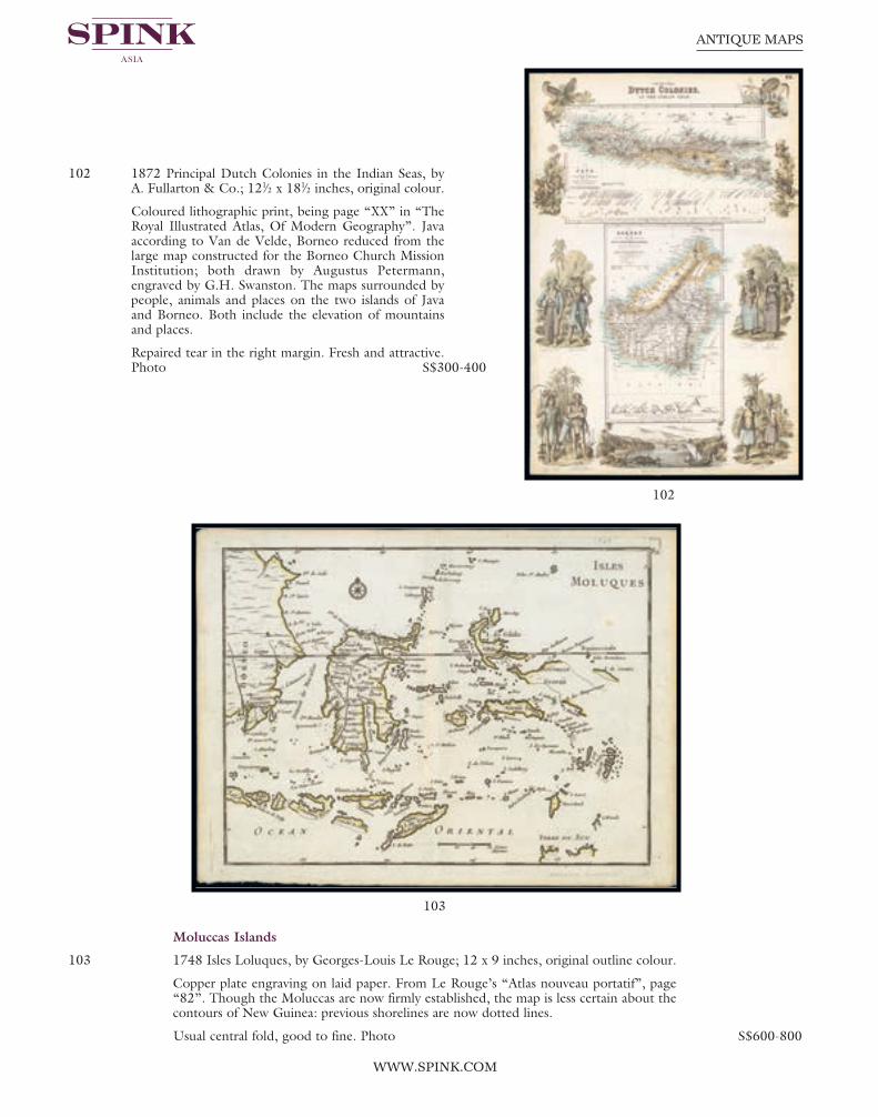
Page 66
102
103
WWW.SPINK.COM
ANTIQUE MAPS
102 1872 Principal Dutch Colonies in the Indian Seas, byA. Fullarton & Co.; 121⁄2 x 181⁄2 inches, original colour.
Coloured lithographic print, being page “XX” in “TheRoyal Illustrated Atlas, Of Modern Geography”. Javaaccording to Van de Velde, Borneo reduced from thelarge map constructed for the Borneo Church MissionInstitution; both drawn by Augustus Petermann,engraved by G.H. Swanston. The maps surrounded bypeople, animals and places on the two islands of Javaand Borneo. Both include the elevation of mountainsand places.
Repaired tear in the right margin. Fresh and attractive.Photo S$300-400
Moluccas Islands
103 1748 Isles Loluques, by Georges-Louis Le Rouge; 12 x 9 inches, original outline colour.
Copper plate engraving on laid paper. From Le Rouge’s “Atlas nouveau portatif”, page“82”. Though the Moluccas are now firmly established, the map is less certain about thecontours of New Guinea: previous shorelines are now dotted lines.
Usual central fold, good to fine. Photo S$600-800
Spink 15040 Antique Maps.qxp_Layout 1 17/07/2015 13:32 Page 66

67
August 16, 2015 - SINGAPORE
INDIA
General
104 1731 Nieuwe Kaart vant Keyzer Ryk van den Grooten Mogol, by Isaak Tirton; 153⁄4 x 143⁄4 inches, old coloured.
A very detailed antique map of the Empire of the Great Mogul, which included India, Sri Lanka, Pakistan and Bangladesh, decorated with a simple compass rose. In Dutch.
Usual folding creases. Fine. Photo S$400-500
105 1793 Neue Karte von dem Keyserthum des Grossen Mogols, zu finden in Altona bey denGebrudern Korte; 163⁄4 x 131⁄2 inches, hand-coloured.
Very similar to the previous map except this is in German and printed on laid,watermarked paper.
Some faults in the margins. Photo S$400-500
104
105
Spink 15040 Antique Maps.qxp_Layout 1 17/07/2015 13:32 Page 67

Page 68
107
106
WWW.SPINK.COM
ANTIQUE MAPS
106 1765 Ad antiquam Indiae geographiamtabula, by J.B.B. d’Anville, Paris; 163⁄4 x213⁄4 inches, hand-coloured.
A map showing India with an inset in thelower part entitled Ptolemaicae Tabulaeshowing the island of Ceylon. D’Anville’smaps have a clarity and directness thatappears very modern. He read widely andincorporated the best available geographicknowledge into his work. The English andothers copied from his maps extensively.
A few spots in the upper margin; fresh.Photo S$100-150
107 1785 Stato del Mogol con l’isole di Ceilan eMaldive, Venezia, by Antonio Zatta; 151⁄2 x 20 inches, old coloured.
A fine map of India and Ceylon, along withthe Maldive Islands. Includes a largedecorative title cartouche. The map wasissued in Zatta’s “Atlante Novissimo”, a monumental 4 volume work and one ofthe last great decorative atlases. Fine. Photo S$400-500
Spink 15040 Antique Maps.qxp_Layout 1 17/07/2015 13:32 Page 68

69
August 16, 2015 - SINGAPORE
108 1786, Presqu’Isle des Indes Orientales, Comprenant l’Indostan ou Empire du Mogol,Differens Royaumes ou Etats, Les Vastes Possessions des Anglais, et les autresEtablissemens Europeens, avec les Grandes Routes, by Robert de Vaugondy; 30 x 22inches, hand-coloured.
This map covers the Indian subcontinent from independent Tartary south to includeCeylon and the Maldives and from Persia east as far as Aracan in the west. It offersextraordinary detail throughout, with numerous notations on matters geographical,historical, and cultural. Shows roads, cities, mountain ranges, lakes and rivers withterritories depicted by outline color. Identifies Delhi (or Jehan Abad), Agra (or EkbarAbad), Bombay, Goa, Calcutta, Pondicherry, and countless other major and minor cities.An inset in the lower right quadrant focuses on the mouths and the course of the RiverGanga or Ganges from Hooghly, south part Calcutta into the Bay of Bengal. The cartouche in a floral frame with illustration of an elephant, trees and church below.
Some staining and scuffing, mainly confined to the margins. Photo S$600-800
108
Spink 15040 Antique Maps.qxp_Layout 1 17/07/2015 13:32 Page 69

Page 70
109
110
WWW.SPINK.COM
ANTIQUE MAPS
109 1788 Neueste Karte von Hindostan, Bengalen etc, etc. Mit der Anzeige der StrassenPaesse, und genauester Eintheilung der Britischen Besitzungen in Ostindien; by F.A.Schraembl and J. Rennell. Four maps making a complete wall chart, each 341⁄2 x 251⁄4inches with original outline colours.
Wall map of the Indian sub-continent after James Rennell, with large title cartouche ofBritannia, native figures, a soldier and a merchant. Published by F. A. Schraembl inVienna after Jacob Rennel.
Fine with occasional light surface dirt. Photo S$500-600
110 1797 Inde Ancienne by E. Mentelle and P.G. Chanlaire; 211⁄4 x 163⁄4 inches, hand-coloured.
From “Atlas Universel de Géographie Physique et Politique, Ancienne et Moderne,Présenté a l’Instruction des Écoles Centrales, Pour les classes de Géographie, d’Histoire,et de Législation”. Numbered “152” on verso. Fine. Photo S$400-500
Spink 15040 Antique Maps.qxp_Layout 1 17/07/2015 13:33 Page 70

71
August 16, 2015 - SINGAPORE
111 1797 Gli Stati del Mogol e la Penisola delle Indie di qua dal Gange delineati sulle ultimeosservazioni. Published by Calcografia camerale, Rome; 18 x 231⁄4 inches, hand-coloured.
The Italian painter and engraver, Giovanni Maria Cassini, produced this splendid map ofas part of his epic three-volume atlas. Mapping of most of south east Asia and surroundingcountries, from Bangladesh in the west to central Borneo in the east, and southern Chinain the north, to Bali in the south. Relief is shown pictorially. On the lower left corner ofthe map is a decorative illustrated cartouche. Published in: “Nuovo Atlante GeograficoUniversale Delineato sulle ultime osservazioni”. Fresh and fine. Photo S$500-600
112 1797 Inde Indostan Bengale &c Partie Septentrionale de la Presqu’isle en deça du Gangeand Inde Partie Méridionale de la Presqu’isle en deça du Gange, by Pierre FrançoisTardieu. Both maps 191⁄2 x 15 inches, outline colour.
With simple title cartouche and mileage scales. From Mentelle’s “Atlas Universel deGeographie Physique et Politique”.
On stout laid paper, fine. Photo. (2 maps) S$600-800
111
112
Spink 15040 Antique Maps.qxp_Layout 1 17/07/2015 13:33 Page 71

Page 72
113
114
WWW.SPINK.COM
ANTIQUE MAPS
113 1812 Charte von Ost-Indien diesseits des Gangesoder Hindostan und Dekan, Weimar, im Verlagedes Grograph Institute; 181⁄4 x 33 inches, outlinedcolour.
This interesting map shows India in the early 19thcentury with the Maldives and Ceylon. In thelower right corner the title cartouche. The mapwith many place names of cities and villages,mountains, etc.
Some age marks, generally confined to themargins. Photo S$200-250
Mogolis
114 1638 Magni Mogolis Imperium, by Willem Blaeu; 25 x 201⁄4 inches, old coloured.
An attractive map of northern part of India, Tibet, Iran to Burma from “Novus Atlas”(Amsterdam) . The travel route from Kabul to Surat is the most prominent feature of themap. Richly decorated with strapwork title and scale of miles cartouches, a dedication withcoat of arms, several sailing ships, along with elephants and camels in the interior. In thelower left hand corner is the coat of arms of D. Johannes Hvydekoper one of the directorsof the Dutch East India Company. The reverse with the text De Groote Mogol in Dutch.
Small splits in the margin at top and foot and some slight wrinkling. On stout paper andfresh. Photo S$400-500
Spink 15040 Antique Maps.qxp_Layout 1 17/07/2015 13:33 Page 72

73
August 16, 2015 - SINGAPORE
115 1639 Magni Mogolis Imperium, by Jan Jansson; 231⁄2 x 183⁄4 inches, old coloured.
A fine example of Jan Jansson’s edition of William Baffin’s map of Mughal Empire, thefirst broadly accurate map of Northern India. This revolutionary map embraces the entireMughal Empire, and extends from Afghanistan and Kashmir in the north, down south tothe middle of the Deccan, and from the mouths of the Indus in the east, to Burma in thewest. While far from scientific, and featuring some obvious inaccuracies (notably, areas inthe upper part of the map are placed way too far to the north), it is the first map ofNorthern India to evince a rough level of planimetric accuracy. The original map onwhich the present edition is predicated was devised by the great English adventurerWilliam Baffin, after information supplied to him by Sir Thomas Roe, England’s firstambassador to the Mughal Empire.
The title cartouche, in the upper left, features the modified seal of the Emperor Jahangir(reigned 1605-27), featuring roundels bearing his name and those of his eight dynasticpredecessors going back to the great Turco-Mongol ruler, Timur (Tamerlane the Great).In the middle is the symbol of the Mughal Empire, featuring a lion at repose in front ofa rising sun. There are depictions of animals with a camel, elephants and large cats. The reverse with text in German.
Large paper split in the upper margin and a few minor age marks. A good example of thisearly map. Photo S$600-800
115
Spink 15040 Antique Maps.qxp_Layout 1 17/07/2015 13:33 Page 73

Page 74
116
WWW.SPINK.COM
ANTIQUE MAPS
116 1720 (c.) Magni Mogolis Imperium, de Novo Correctum et Divisum, by F. de Witt,Amsterdam, J. Covens & C. Mortier; 251⁄2 x 211⁄2 inches, old coloured.
An attractive map of the region bounded by Northern India, Pakistan, Afghanistan andBangladesh and extending inland up the Ganges and Indus Rivers to Tartary and theHimalayas, including Katmandu, Kabul and other legendary cities along the great tradingroute. Extends south to include a large portion of India, including Narsinga, OrixaDecan, etc. Elephants shown roaming the Ganges and Camels east of Kabul. Decorativecartouches featuring putti, and sailing ships. The map was originally issued by de Witt,circa 1690. The Covens & Mortier edition of this map is quite rare.
Some minor soiling but still a fine example of this map. Photo S$600-800
Spink 15040 Antique Maps.qxp_Layout 1 17/07/2015 13:33 Page 74

75
August 16, 2015 - SINGAPORE
117 1740 (c.) Imperii Magni Mogolis sive Indici Padschach, juxta recentiissimas Navigationesaccurata delineato Geographica studio et sumtibus, by Matthias Seutter; 26 x 211⁄2 inches,hand-coloured.
18th century Germany cartography at its finest; this is an absolutely spectacular map ofnorthern India showing the extent of the powerful Mughal Empire in the late 17thcentury, this map details the subcontinent and parts of Central Asia from Persia andKhandhar eastward as far a modern day Burma and Thailand. Extends northward toinclude parts of Tibet and Nepal and southwards as far as the Malabar Coast and the Gulfof Thailand. Cartographically this map is heavily based upon Hondius and Mercator’s17th century of the same region entitled India Orientalis.
Usual central reinforcement and two natural paper wrinkles prior to printing. Fresh andfine. Photo S$800-1,000
117
Spink 15040 Antique Maps.qxp_Layout 1 17/07/2015 13:33 Page 75

Page 76
118
WWW.SPINK.COM
ANTIQUE MAPS
North India
118 1552 Tabula Asiae IX (Northern India & Pakistan), by Sebastian Munster; 151⁄4 x 111⁄2inches, hand-coloured woodblock, the verso illustrated with a decorative colouredwoodcut illustration.
A highly decorative woodcut map by famous mapmaker Sebastian Münster published inhis Ptolemy edition 1552 in Basel at Heinrich Petri. The decorative woodcut bordersverso were probably cut by the famous 16th century woodcutter Hans Holbein.
Important early map of part of Northern India, Pakistan and the Indian Ocean, basedupon the work of Ptolemy. The map is unchanged from the 1540 edition. Munster’sGeographia was a cartographic landmark, including not only Ptolemaic maps, but also anumber of landmark modern maps, including the first separate maps of the fourcontinents, the first map of England and the earliest obtainable map of Scandinavia.Munster dominated cartographic publication during the mid-16th Century.
Reinforced central fold, the colouring is typically garish but still fine. Photo S$400-500
Spink 15040 Antique Maps.qxp_Layout 1 17/07/2015 13:33 Page 76

77
August 16, 2015 - SINGAPORE
Southern India
119 1682 Presqu’Isle de L’Inde deca le Gange, ou sont les Royaumes de Decan, de Golconde,de Bisnagar, et le Malabar by Nicholas Sanson; 121⁄4 x 81⁄2 inches, hand-coloured.
Covers the subcontinent from the Bay of Bengal and the Gulf of Cambay to Ceylon (SriLanka). Offers impressive detail given that the interior of India was largely unknown tothe west until the British survey’s of the late 18th century. The vast Mogul Empire sprawlsacross the northern part of the map. Further south the kingdoms of Deccan, Malabar,Bisnagar, and Golconda, among others, are noted. As an indicator of how just out of dateEuropean knowledge of this region was, most of these kingdoms had fallen to ruin over100 years prior to the publication of this map. The Portuguese enclave of Goa on India’swest coast is noted. In the lower right quadrant there is an inset of the Malabar Coast.The lower left hand quadrant features a curious and speculative depiction of the Maldives.
On laid paper with usual central reinforcement; a couple of minor marks, otherwise fine.Photo S$300-400
120 1719 Carte Nouvelle des Terres de Cucan,de Canara, de Malabar, de Madura, et deCoromandel ..., by Henri Chatelain; 201⁄4 x163⁄4 inches, uncoloured.
The map was published out of Amsterdamcirca 1719 as part of Chatelain’s sevenvolume “Atlas Historique”. The mapshows from Goa and Nelour to thesouthern tip of India in exceptional detail.The Western Ghats mountain range runsthe length of the coast while hills, forestsand indigenous animals are engravedthroughout. Cities, villages, ports, andbays are noted along the coast while theinterior focuses on larger cities andregional divisions. Two text boxes presentthe history of the area and a table presentsa breakdown of the various kingdoms,capitals, and cities within each province.
Usual central reinforcement and with smallmounting tape on the edges. Photo S$300-400120
119
Spink 15040 Antique Maps.qxp_Layout 1 17/07/2015 13:33 Page 77

Page 78
121
122
WWW.SPINK.COM
ANTIQUE MAPS
121 1720 (c.) Carte du Golfe de Bengale, Mer deIndes, et Riviere du Gange, Avec les Pais etIles d’alentour, Savoir les Cotes de Malabar,Cormandel, Ile de Ceylon, Les Maldives ...,by Pieter Vander Aa; 15 x 121⁄2 inches,uncoloured.
Detailed map of the Southern part of Indiawith Ceylon. Good detail along the coasts ofMalabar, Coromandel, the Maldives islandsand the Kingdoms of Visipour, Golconda,Guzaratte, etc. With title and mileagecartouches.
Central fold with small split in the lowermargin, trivial soiling. Photo S$200-250
122 1724 Nieuwe Kaart van Choromandel ende Malabar..., by François Valentyn; 241⁄2 x 22inches, hand-coloured.
The simple title cartouche on the right side states that François Valentyn is themanufacturer, below this is the compass rose. Much detail is given along the coastlines,settlements and principal coastal features are identified. An attractive early map, one of thefew early Dutch maps to focus on the region.
Folding creases, left margin reduced and there is a short tear which just runs into the map;a few age marks and tone or stain spots. Photo S$1,000-1,200
François Valentyn (1666-1727), a missionary, worked at Amboina from 1684 to 1694 and1705 to 1713 and travelled extensively in the VOC’s lands. He is best known for hismonumental history and description, “Oud en Nieuw Oost-Indiën’’ which remains one of themost important primary sources for the East Indies and neighbouring lands
Spink 15040 Antique Maps.qxp_Layout 1 17/07/2015 13:33 Page 78

79
August 16, 2015 - SINGAPORE
123 1733 Peninsula Indiae citra Gangem hoc est Orae celeberrimae Malabar & Coromandelcum adjacente insula non minus celebratissima Ceylon, by the heirs of Homann Erben;21 x 241⁄2 inches, old coloured.
A large and attractive map of Ceylon and the southern part of the Indian Peninsula, withan elaborate cartouche showing an elephant and indigenous people. The map includestowns, roads, rivers, mountains, lakes, etc. An explanation of the map includes notationsof various flags of England, Denmark, France, Holland and Portugal along the coast,delineating the various European trading posts along the southern coastline of India, over20 in all, plus fortified towns.
Usual horizontal reinforcement, slightly reduced at left, otherwise fine. Photo S$3,000-4,000
123
Spink 15040 Antique Maps.qxp_Layout 1 17/07/2015 13:33 Page 79

Page 80
124
125
WWW.SPINK.COM
ANTIQUE MAPS
124 1740 Special-Carte von der halb-insel Indiens dieserts dem Ganges by Christian GottliebLiebe, published by Waysen-Hauses; 19 x 201⁄4 inches, old coloured.
This Dutch map was created by Johann Lucas Niekamp with an elaborate cartouche atright. On stout wove paper, slightly reduced at left with some light overall ageing. Photo S$600-800
125 1780 Carte des Cotes de Malabar et de Coromandel, by Guillaume de l’Isle; 31 x 22inches, original outline colour.
A detailed and attractive map of India and the northern tip of Ceylon. With decorativetitle cartouche and two compass roses. This edition it without title in the top margin andwith the publisher’s details, etc. at foot.
Usual central reinforcement, small split in the top margin and vertical bends in the sidemargins. Photo S$500-600
Spink 15040 Antique Maps.qxp_Layout 1 17/07/2015 13:33 Page 80

81
August 16, 2015 - SINGAPORE
Bay of Bengal
126 1659 Sinus Gangeticus, vulgo Golfo de Bengala nova descriptio, by Jan Jannson; 24 x191⁄4 inches, uncoloured.
This exceptional sea chart of the Bay of Bengal includes the island of Ceylon, easternIndia, Bangladesh, Burma, and a small portion of Sumatra. This later edition of Jansson’smap of the Bay of Bengal is one of the earliest obtainable sea charts to focus on the area.The chart is displayed with a westward orientation and the sea is strapped with rhumblines and adorned by numerous sailing ships and two compass roses. Even moreimpressive is the amount of detail included inland from the coasts. Tilled rice fields, rivers,mountains, forests, villages, and cities fill the map with information and beauty. A formation of putti surrounds the scales of distance at the top of the map. In the lowerright corner, an elaborate title cartouche is flanked by natives of differing origin.
Stout paper with Latin text on verso. Reinforced central fold with some minor wrinkling.Photo S$800-900
126
Spink 15040 Antique Maps.qxp_Layout 1 17/07/2015 13:33 Page 81

Page 82
127
WWW.SPINK.COM
ANTIQUE MAPS
127 1724 Nieuwe Kaart van ‘t Koninkryk Bengale, by Francois Valentyn; 24 x 21 inches,hand-coloured.
Published by Jan van Braam and Gerard onder de Linden, Dordrecht, this folio sizedcopper engraving of the sultanate of Bengal with the delta of the Ganges. Dutch EastIndia Company map depicting the Dutch forts and agricultural areas, produced byFrancois Valentijn. Valentijn was able to access the secret Dutch East Iindia Companyarchives for his work.
Folding creases, some staining and ageing. Photo S$600-800
128 1728 A chart of the Coast of Coromandel and the great Bay of Bengal, by EdmundHalley, Nathaniel Cutler and John Senex; 25 x 21 inches, outline coloured.
A scarce sea chart of the east coast of India, north Ceylon and the coastline towards theeast, from the “Atlas Maritimus & Commercialis ...,” published in London in 1728. This very rare work was a collaborative effort of a number of the leading cartographic andscientific names of the period, including Sir Edmund Halley, John Senex, NathanielCutler, Steven Parker and Daniel Defoe, whose names are frequently associated with thiswork. The sea atlas was developed by Senex and Harris to compete with Mount & Page’swildly popular English Pilot sea series. It was published under the name “Atlas Maritimuset commercialis”, or A general view of the world. While the collaboration was impressive,the atlas never achieved the same commercial success. As such, the maps are quite scarce.
Central fold, light overall ageing and soiling and a few paper imperfections at the edges.Photo S$500-600
129 1750 Nouvelle carte du Royaume de Bengale, by Jacques Nicolas Bellin; 19 x 123⁄4 inches,uncoloured.
A detailed regional map of the Gulf of Bengal and the lower Ganges River. Decorativetitle cartouche. Relief shown pictorially, depth shown by soundings and shows vegetation,settlements, etc. From “Le Petit Atlas Maritime Recueil De Cartes et Plans Des QuatreParties Du Monde. en Cinq”, volume III Asia and Africa.
Dark impression. Printed on heavy paper; small defects at right and with some lightperipheral toning. Photo S$200-250
130 No Lot
Spink 15040 Antique Maps.qxp_Layout 1 17/07/2015 13:33 Page 82

83
August 16, 2015 - SINGAPORE
128
129
Spink 15040 Antique Maps.qxp_Layout 1 17/07/2015 13:33 Page 83

Page 84
132
131
WWW.SPINK.COM
ANTIQUE MAPS
131 1804 Charte von dem Brittischen Reiche an Ganges und den Marattenstaaten in Indien,by Weimar Geographisches Institut; 173⁄4 x 131⁄2 inches, hand-coloured.
An attractive and interesting map of the northern half of India extending north intoNepal, Bhutan and Tibet. Covers in detail the region south of Delhi to about the latitudeof Goa and including the Ganges river and delta. An abundance of detail is providedalthough it is somewhat difficult to relate the names with those of present-day India. An early Weimar issue.
Printed on hand-laid paper with watermark. Folding as issued with binding trim, slightlyreduced at left, only very light ageing S$200-250
Coromandel Coast
132 1758 Coste de Coromandel et les Pays de Tonda.Mandalum et Tanjaor, by Jacques Nicolas Bellin;93⁄4 x 123⁄4 inches, uncoloured.
Titled Theatre de la Guerre dans l’Inde. Tome IIINo.38 for Antoine-François Prevost’s “L’HistoireGenerale des Voyages”, published by Pierre deHondt, The Hague between 1747-1780.
Minor paper faults along the edges S$100-150
Spink 15040 Antique Maps.qxp_Layout 1 17/07/2015 13:33 Page 84

85
August 16, 2015 - SINGAPORE
133 1764 Coste de Coromandel depuis Gondagamas jusqu’a Nurzapour, by Jacques NicolasBellin; 181⁄2 x 123⁄4 inches, uncoloured.
Map of Andhra Pradesh State, India with inset of Mazulipatam from Bellin’s “Le PetitAtlas Maritime Recueil De Cartes et Plans Des Quatre Parties Du Monde”. Decorativetitle cartouche with relief shown pictorially. Depth shown by soundings and includes a listof settlements.
Some trivial damage at top and right edges, good to fine S$100-150
Malabar Coast
134 1740 Carte des Costes de Perse, Gusarat etMalabar, by Jacques Nicolas Bellin; 91⁄2 x 131⁄2inches, uncoloured.
A good engraved map of the Indian Ocean,with the west coast of India, Persia, Maldivesand the eastern tip of Arabia from “l’Histoiregénérale des voyages”. The geographicalfeatures are typical with somewhatexaggerated bays and inlets.
Also the German edition, Karte von denKüsten von Persien, Guzaratte und Malabarfrom Allgemeine Historie der Reisen zuWasser und Lande (Volume 1); folding creasesand peripheral ageing. 9 x 11 inches,uncoloured. (2 maps) S$200-250
134
133
Spink 15040 Antique Maps.qxp_Layout 1 17/07/2015 13:33 Page 85

Page 86
135
136
WWW.SPINK.COM
ANTIQUE MAPS
Indoustan
135 1754 Carte de L’Indoustan ..., by Jacques Nicolas Bellin; 17 x 11 inches, hand-coloured.
With two decorative cartouches, reinforced central fold, fine S$100-120
An attractive map of northern India that appeared in Antoine Francois Prevost d’Exiles’ (orAbbe Prevost’s) multi-volume “Histoire Generale Des Voyages”: ultimately 17 quartovolumes recounting major voyages of discovery and descriptions of far flung parts andincluding around 240 maps, plans and charts of those areas. These maps, plans and chartswere mostly produced by Jacques Nicolas Bellin, the influential French hydrographer. Bellin’swork spans from around 1740 to the 1770s; interestingly he signed his plates in a variety ofstyles - J. Bellin, N. Bellin, N.B., M.B. (Monsieur Bellin) and S.B. (Seigneur Bellin).
Bombay
136 1782 Carte d’une partie des Cotes de l’Inde depuis Bombay jus’qu’a Surate ..., by M dePages Bernard, Paris; 171⁄2 x 111⁄2 inches, uncoloured.
A detailed map of the coast from Bombay to Surate engraved by Bernard. Fine S$100-150
Spink 15040 Antique Maps.qxp_Layout 1 17/07/2015 13:33 Page 86

87
August 16, 2015 - SINGAPORE
Delhi
137 Alt und Neu-Dehly - Le Vieux et Nouveau Delhi, by Franz Xaver von Habermann; 19 x 143⁄4 inches, old coloured.
A scarce perspective view depicting the city of New Delhi, with descriptive text in Germanand French. Photo S$300-400
Pondicherry
138 1750 Plan de la Ville de Pondicheri, byJacques Nicolas Bellin; 91⁄2 x 123⁄4 inches,uncoloured. Fine. Photo S$100-150
138
137
Spink 15040 Antique Maps.qxp_Layout 1 17/07/2015 13:33 Page 87

Page 88
139
140
WWW.SPINK.COM
ANTIQUE MAPS
Ceylon
139 1764 Carte de l’Isle de Ceylan by JacquesNicolas Bellin; 91⁄2 x 121⁄2 inches, uncoloured.
This copper plate engraved chart shows theentire island with excellent detail of villages,rivers, and topography. The towns of Yale,Harcipote, Soffregam, Vellas, Ncavar, Putelanand many more are located. A rococo-styletitle cartouche incorporates a distance scale. Atupper right is “Tome. III. No. 31. Trivialperipheral ageing. Photo S$200-250
Goa
140 1672 Goa by P. Baldaeus; 151⁄2 x 121⁄4, uncoloured.
Map of Goa, with captions in a large cartridge, topped with a panoramic view. Numberedboard: Vol. 3 p. 574. A combined panoramic and bird’s eye-view of Goa, the Portuguesetrading post in India. From Philippus Baldaeus “Naauwkeurige Beschryvinge VanMalabar Choromandel”.
Usual vertical folding crease with a couple of small splits; a couple of other light creases;good. Photo S$400-500
Spink 15040 Antique Maps.qxp_Layout 1 17/07/2015 13:33 Page 88
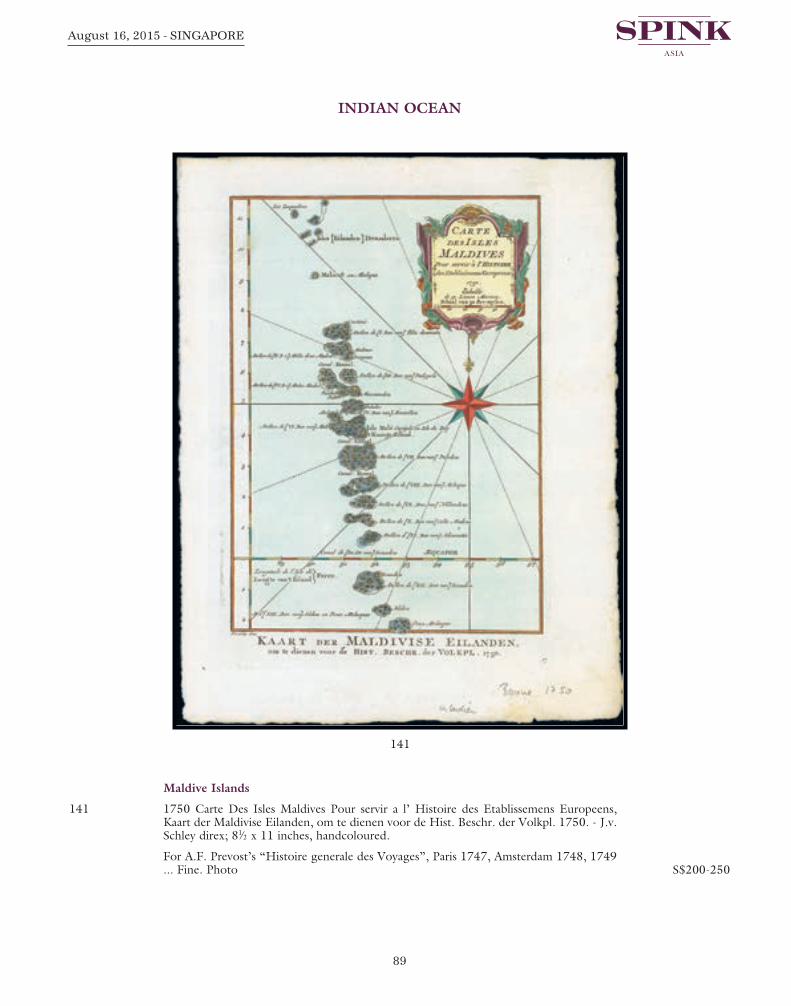
89
August 16, 2015 - SINGAPORE
INDIAN OCEAN
Maldive Islands
141 1750 Carte Des Isles Maldives Pour servir a l’ Histoire des Etablissemens Europeens,Kaart der Maldivise Eilanden, om te dienen voor de Hist. Beschr. der Volkpl. 1750. - J.v.Schley direx; 81⁄2 x 11 inches, handcoloured.
For A.F. Prevost’s “Histoire generale des Voyages”, Paris 1747, Amsterdam 1748, 1749... Fine. Photo S$200-250
141
Spink 15040 Antique Maps.qxp_Layout 1 17/07/2015 13:33 Page 89

Page 90
142
WWW.SPINK.COM
ANTIQUE MAPS
MIDDLE EAST
142 1679 Stato Del Gran Turco diviso ne suoi Beglierbati o Gouerni e ne Principati, che lisono Tributari by Giacomo Giovanni Rossi; 231⁄2 x 181⁄2 inches, original outline colour.
The Turkish Empire, based on Sanson’s map, prepared by Giacomo Cantelli da Vignolaand here engraved by Giorgio Widman for the “Mercurio Geografico”. A scarcedecorative map of the Eastern Mediterranean, Cyprus, Turkey, Arabia, the Black Sea, AsiaMinor and neighboring regions by Cantelli da Vignola and published in Rome by Rossi.The map provides one of the most detailed and up to date treatments of the region.Includes an ornate title cartouche.
Professional reinforcement down the central fold. Fresh and fine S$500-600
143 1687 A Mapp of the Travels and Voyages of the apostles in their mission and in particularof Saint Paul, by Richard Blome; 191⁄4 x 173⁄4 inches, uncoloured.
On stout laid, watermarked paper. The engraver of this map was Richard Palmer. Finelyengraved detailed map covering the whole of the eastern Mediterranean, showing thetravels of the apostles after the death of Christ, with portraits of 13 Saints. Including Italy,Greece, Cyprus. The map contains a dedication to and shield of the Baronet whosupported the making of the map.
Usual reinforced central fold; fine. Photo S$1,000-1,200
144 1719 Estats de L’empire du Grand Seigneur dit Sultan et Ottomans Empereur des Turcs,by J. Chiquet; 101⁄4 x 73⁄4 inches, original outline colour.
From “Le Nouveau et Curieux Atlas Geographique et Historique”, by Jacques Chiquet.This map shows the extent of the Ottoman Empire from the Balkans to Persia, includingall of Arabia and North Africa (an inset map at lower left shows the continuation of theAfrican coast to present day Algeria). There is a short text on map regarding the Nile andits source in Ethiopia. In the bottom left hand corner is a list of Turkish rulers.
Reduced margins and light overall ageing with small stain in lower right corner. Photo S$300-400
Spink 15040 Antique Maps.qxp_Layout 1 17/07/2015 13:33 Page 90
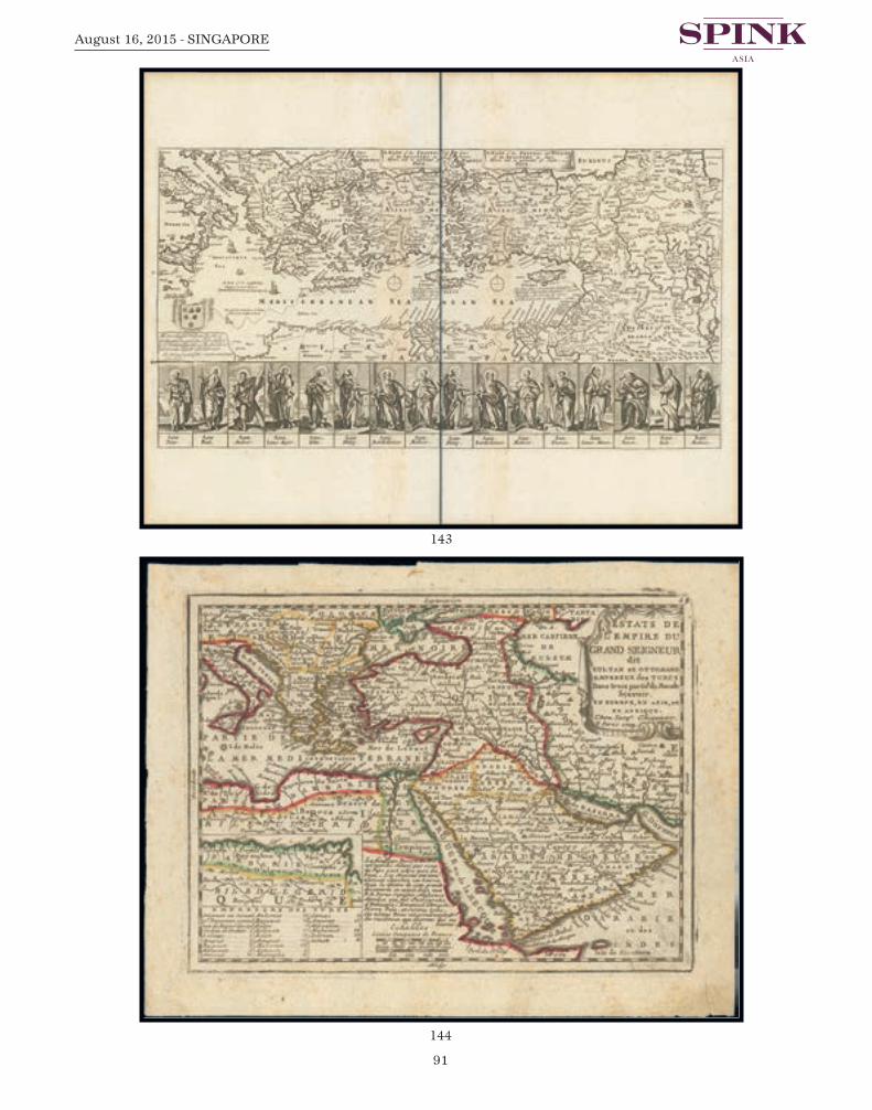
91
August 16, 2015 - SINGAPORE
144
143
Spink 15040 Antique Maps.qxp_Layout 1 17/07/2015 13:33 Page 91

Page 92
145
WWW.SPINK.COM
ANTIQUE MAPS
145 1786 Erster Theil der Karte von Asien welche die Turkei, Arabien, Persien Indien diesseitsdes Ganges und einen Theil der Tatarei enthalt, by F.A. Scharembl, Vienna. Two largemaps, 33 x 25 inches, outlined colour.
A large and detailed map of the Middle East on two sheets. Embellished with a largedecorative title-cartouche. On heavy paper, fine. Photo. (2 maps) S$300-400
146 1791 The First Part of Asia Drawn & Engraved from d’Anville’s two sheet map, by JohnHarrison; 32 x 211⁄4 inches, simple outline colour.
Usual reinforced fold, some light overall ageing, particularly in the central section, buckleand tear in right margin. Photo S$700-900
147 1800 Gli Imperi Antichi Parte Orientale, by Giovanni Maria Cassini; 171⁄2 x 23 inches,uncoloured.
An uncommon two-sheet map, published in the “Nuovo Atlante Geografico Universale”,each with a decorative title cartouche, the first features a wild dog eating a child, thesecond with Egyptian statuary. By Giovanni Maria Cassini, a Somasco monk. He wasgeographer and cartographer but he was also good at engraving architectural items andperspectives.
Usual central folds, fresh and fine. Photo. (2 maps) S$600-800
Spink 15040 Antique Maps.qxp_Layout 1 17/07/2015 13:33 Page 92

93
August 16, 2015 - SINGAPORE
147
146
Spink 15040 Antique Maps.qxp_Layout 1 17/07/2015 13:33 Page 93

Page 94
148
WWW.SPINK.COM
ANTIQUE MAPS
148 1720 (c.) The Turkish empire in Europe, Asia and Africa divided into all its Governments..., by Hermann Moll; 41 x 241⁄2 inches, original outline colour with hand-colouredillustrations.
Printed in London by Hermann Moll, John Bowles, Thomas Bowles, Philip Overton &John King. This map of Europe and the Middle East is printed on two sheets andconjoined. Moll’s large-format map of the Turkish Empire, also covering the wholeMediterranean, first published 1714. There are inset prospects of Constantinople, Smirnaand Jerusalem, and three views of the Holy Sepulcre. Title cartouche and dedication toThomas Vernon (Commissioner of Trade and Plantations).
Repaired down both vertical folds and a couple of repaired tears. There are some stainsand soiling, particularly around the folds. Nevertheless a good example of this rare map.Photo S$5,000-6,000
Spink 15040 Antique Maps.qxp_Layout 1 17/07/2015 13:33 Page 94

95
August 16, 2015 - SINGAPORE
Persia
149 1574 Persici Sive Sophorum Regni Typus, by Abraham Ortelius; 231⁄2 x 151⁄2 inches, hand-coloured.
Ortelius based this fine map of the Persian Empire in part on Gastaldi’s 1564 map of AsiaMinor and on his own 1567 map of Asia. Decorative elements include large strap worktitle cartouche and a distance scale surmounted by a strange bestiary creature. Latin texton verso with page number 49. The map is centered on Persia and it also shows present-day Iraq and Afghanistan, and the Indus River. It is filled with many place names, detailsof the Persian Gulf and very attractive pictorial detail of topography and cities. Marcel vanden Broecke estimates that 100 copies of this map were printed. (Ortelius 167).
On stout laid paper with crossed arrow watermark, usual central reinforcement, some lightsoiling, mostly confined to the edges. Photo S$800-1,000
149
Spink 15040 Antique Maps.qxp_Layout 1 17/07/2015 13:33 Page 95

Page 96
150
WWW.SPINK.COM
ANTIQUE MAPS
150 1626 The Turkish Empire. Newly Augmented, by John Speed; 203⁄4 x 161⁄4 inches, hand-coloured.
A fine example of the Bassett & Chiswell edition of Speed’s map of the Turkish Empireprinted in “Theatre of The World”. One of the most decorative maps of the region issuedin the 17th Century and the first map of the region published in England. Includes 8views of Turkish Cities and 10 costumed figures plus ornate title and scale cartouche.English description on verso.
A little soiled on the reverse and a few edge repairs. A good example of this map. Photo S$4,000-5,000
Spink 15040 Antique Maps.qxp_Layout 1 17/07/2015 13:33 Page 96

97
August 16, 2015 - SINGAPORE
151 1628 Persici Vel Sophorum Regni Typus, by Jodocus Hondius, Amsterdam; 221⁄2 x 19inches, old coloured.
Two elaborate cartouches for title and mileage; with French text on the reverse. On stoutpaper, usual central reinforcement; some overall ageing and paper faults on the edges ofthe margins. Photo S$800-1,000
152 1634 Persia Sive Sophorum Regnum, by Willem Janszoon Blaeu; 24 x 20 inches, hand-coloured.
A decorative map of Persia extending from the Eastern Mediterranean to Tacalistan andthe Indus River and the Dalanguer Mtns and the Cbul Region, with the Red Sea and thePersian Gulf in the South and Caspian and Tartaria in the North. A very detailed andhighly decorative map, with dedication cartouche to Theodor Tholng, senator inAmsterdam with coat of arms above, decorative title cartouche features a Persiansovereign and two soldiers, and sailing ships. French text on verso.
On stout paper, there are a few surface thins in the margins and very light soiling. Photo S$1,000-1,200
151
152
Spink 15040 Antique Maps.qxp_Layout 1 17/07/2015 13:33 Page 97

Page 98
154
153
WWW.SPINK.COM
ANTIQUE MAPS
153 1720 Imperii Persici In Omnes Suas Provincias…, by Johann Baptiste Homann; 24 x 201⁄2inches, original colour.
Detailed map of the region, extending from the Black Sea, Khasikstan and Turkistan inthe north to the Red Sea, Persian Gulf, Euphrates and the Mediterranean in the south,showing almost all of Cyprus. Decorative map, showing cities, mountains, rivers, lakes,roads, etc. Large decorative carouche featuring merchants and wild cats, and smallercartouche showing a hunter on horseback and a brick kiln.
Usual reinforced central fold with small splits at either end, a couple of minor stain spots.Good. Photo S$2,000-2,500
154 1722 Imperii Percici Delineatio, byPetrus Schenk; 241⁄2 x 211⁄4 inches,old coloured.
A rare and detailed map of Persia,divided into coloured provinces. Adrapery in the upper right cornercontains the title cartouche. Aclassical boy carves the title on thebottom left hand side. These wereused to publish the atlas “AtlasContractus” between 1695 and1705.
On stout laid paper, usual centralreinforcement, small hole in topmargin; generally good to fine.Photo S$600-800
Spink 15040 Antique Maps.qxp_Layout 1 17/07/2015 13:33 Page 98

99
August 16, 2015 - SINGAPORE
155 1731 Nieuwe Kaart van ‘T Ryk van Persie, by Isaak Tirion; 171⁄2 x 13 inches, hand-coloured.
A detailed map of Persia and its adjoining countries with Armenia. Reduced right marginwith a segment cut out, leaving a boarder, some age marks in the left margin and at theperipheries. Photo S$200-250
156 1742 Carte de Perse, by Covens & Mortier; 25 x 21 inches, original outline colour. Also titled Nova et accurata imperii Persici delineatio ad usum Serenissimi BurgundiaeDucis.
Covens and Mortier reissued a chart originally made by Guillaume de l’Isle showing thePersian Empire. The depicted area stretching from Crimea to Kashmir and from theCaspian Sea to the Persian Gulf. The detailed representation of towns, villages, rivers andfurther regional conditions, in particular the mapping of the roads, leads to thepresumption that this chart was created for military purposes. French inscriptions, spreadall over the chart, e.g. that the Baloch, inhabitants of south-east Persia, were very militantpeople. The famous flats of Bahrain, where legendary pearls grow, is clearly marked. The title cartouche is in Rococo-style and is decorated with twisting and floral elementsand a royal coat of arms.
Usual reinforced centre fold with repaired split at foot, and other light folds, good to fine.Photo S$1,000-1,200
155
156
Spink 15040 Antique Maps.qxp_Layout 1 17/07/2015 13:33 Page 99

Page 100
157
WWW.SPINK.COM
ANTIQUE MAPS
Arabia
157 1595 Turcici imperii descriptio, this map was published in Antwerp as part of the Latinedition of “Theatrum Orbis Terrarum”; 211⁄2 x 163⁄4 inches, hand-coloured.
The map is based on Ortelius’ own map of Asia, which was derived from the work ofItalian mapmaker Giacomo Gastaldi of 1561. There is Latin text on verso for “Turquie”.It shows a relatively accurate depiction of the Red Sea but a misshapen Persian Gulf andCaspian Sea. While the coastline of the Arabian Peninsula is shown with great detail, manyof the inland place names and their locations are taken from antiquity and legend ratherthan actual reports of exploration. The map is loaded with detail, showing mountainschains, and river systems, as well as numerous villages and important cities, such as Rome,Tripoli, Athens, Constantinople, Cairo, Jerusalem, and Mecca. Decorative elementswithin the map include four sailing ships (two of which are engaged in battle), a seamonster roaming the Black Sea and a strapwork title cartouche supported by two female,winged sea creatures.
The central fold has been reinforced, light overall ageing and occasional trivial peripheraldamage on the edges. Photo S$2,000-2,500
Spink 15040 Antique Maps.qxp_Layout 1 17/07/2015 13:33 Page 100

101
August 16, 2015 - SINGAPORE
158 1669 A Generall Mapp of Arabia, with the Red Sea and Circumjacent lands, by RichardBlome after Sanson; 171⁄2 x 14 inches, outline colour.
This example is from a rare late edition of the map, with a revised cartouche and coat ofarms, with dedication to the Rt. Honorable William Viscount Brouncker of Lyons andBaron Brouncker of Neru Castle in the Kingdom of Ireland. The map demonstrates thenaive engraving style characteristic of 17th Century English engravers, and features anelaborate heraldic cartouche with dedications to Blome’s patrons, sailing ships and seamonsters. Blome’s maps are important in the history of English Cartography.
Two vertical folds, fresh and fine. Photo S$1,000-1,200
158
Spink 15040 Antique Maps.qxp_Layout 1 17/07/2015 13:33 Page 101

Page 102
160
WWW.SPINK.COM
ANTIQUE MAPS
159 1750 (c.) Arabia, by Richard William Seale; 201⁄4 x 15 inches, hand-coloured.
With title cartouche and illustration to the Temple of Mecca. This eighteenth centuryengraver and cartographer, engraved maps in the rococo style of Emanuel Bowen andThomas Kitchen for the Universal Magazine. He produced sea and river charts as well astown and harbour plans as well as the Middlesex county map in the large English Atlas.
Folding creases, good to fine. Photo S$500-600
Palestine
160 1750 Carte de la Terre Sainte Divisee selon les Douze Tribus d’Israel, by JohannChristoph Harenberg; 24 x 201⁄2 inches, the map with original colours but the thecartouches and side map with later hand-colour.
Published in Nuremberg on stout paper, this map covers the coastline from Biblus nuncGibele to the Sirbonis lacus. A map showing the region in Roman times is inset in adecorative scroll at left. The title cartouche is topped with two sides of a shekel coin.Below the cartouche is a scene of the encampment of the Jews with two spies of Mosesbearing the fruit from the Promised Land.
There are some later reinforcements to the central fold and there is some overall stainingand soiling. Photo S$700-900
159
Spink 15040 Antique Maps.qxp_Layout 1 17/07/2015 13:34 Page 102

103
August 16, 2015 - SINGAPORE
Syria
161 1666 Syriae Sive Soriae, Nova et Accurata descriptio, by Erben Janssonius; 231⁄4 x 193⁄4inches, old coloured.
Handsome map of Syria and Lebanon, fully engraved with mountain ranges, forests andcities. Damascus is at the bottom of the map and Edessa (Sanliurfa) is at the top. The coastal cities include Alexandria, Antioch, Tyro, Tripoli, Sidon, and Curco. The mapis embellished with a fine strapwork title cartouche flanked by a shepherd and his flock, ascale of miles held aloft by three cherubs, a sailing ship, compass rose and a sea monster.Latin text on verso. Issued in the two volume “Atlas Contractus”. The original plate waspublished by Johannes Janssonius, but with his death in 1664, this edition was printed byhis son-in-law, Johannes Janssonius van Waesbergen.
Light overall ageing with some small edge faults. Photo S$1,000-1,200
161
Spink 15040 Antique Maps.qxp_Layout 1 17/07/2015 13:34 Page 103

Page 104
162
163
WWW.SPINK.COM
ANTIQUE MAPS
Syria - Damascus
162 1575 Damascus, urbs nobilissima ad Libanum montem Totius Syriae Metropolis, byGeorg Braun and Franz Hogenberg; 201⁄2 x 16 inches, hand-coloured.
A very decorative bird’s eye view of Damascus, published in the Latin edition of “CivitatesOrbis Terrarum”. The staffage in the front represents Syrian inhabitants and inscriptionsrefer to biblical incidents on the town plan. From 1572 to 1590 the publishers issued sixvolumes of this town-atlases in five different languages. These folios became the mostfamous publications in this genre.
Usual central reinforcement, small splits in the upper and lower margins, minor ageing.Photo S$800-1,000
Mecca
163 1725 Prospect von einem Theil der grossen Stadt Mecha, by Johann Bernhard Fischervon Erlach; 211⁄2 x 121⁄2 inches, uncoloured.
A copper engraving on laid paper. A very fine and early view of Mecca, Saudi Arabia, thebirthplace of Muhammad and the location of the Islamic pilgrimage of the Hajj.Numerous locations are identified by a key (keyplate included). Plate from the ‘Entwurfeiner historischen Architektur’ (Outline of Historical Architecture, first published 1721)the first comparative architecture of all periods and nations.
Usual central fold, the margins have been reduces at top and bottom, the lower margin isstrengthened with white tape. Fresh. Photo S$800-1,000
Spink 15040 Antique Maps.qxp_Layout 1 17/07/2015 13:34 Page 104

105
August 16, 2015 - SINGAPORE
Constantinople
164 1493 Serta Etas Mundi (Nuremberg Chronicle), folio CXXX by Anton Koberger; 23 x163⁄4 inches, uncoloured.
Two sheets of incunabula with original woodcut engravings on the front and on thereverse. At the top of the cards CXXIX / to and CXXX / recto text in Gothic charactersand in Latin; in the bottom half of the same facciateampia view of Constantinople inwoodcut; on the other two façades, gothic text in Latin, accompanied by 7 beautifulsilografate cartoons with images of the Empress Helena, the fathers of the Council ofNicaea, heresiarch Arius and four emperors. The sheets are taken from a famousincunabula, imprinted in Nuremberg in 1493 in the original text with Latin: in the sameyear they released the impression with text in German, translated by Georg Alt. The fameof the book is mainly linked to the accompanying illustrative over two thousandwoodcuts, some of which belong to the young Dürer. The magnificent view ofConstantinople, as representations of other cities in the volume, combines conventionalelements of fantasy and other topographic features with reference to reality. The image isplaced in evidence, with a caption, the church of Santa Sofia; interesting is the depictionof a ship in the lower sinstra.
Tape reinforcement to the central fold and there is some light ageing as to be expected,otherwise is a good state of preservation. Photo S$200-250
This page was removed from a book entitled Liber Chronicarum, or ‘Nuremberg Chronicle’,published in 1493 by printer Anton Koberger. One of the most ambitious books produced inthe 15th century with over 1000 woodcut illustrations, the ‘Nuremberg Chronicle’ was alsoone of the earliest books with illustrations designed by artists rather than blockcutters.Koberger commissioned Michael Wolgemut, who ran a large art workshop, to design theillustrations and layout between 1487 and 1491. Wolgemut was helped by his stepson WilhelmPleydenwurff. Woodcut images could be printed on the same page as text because the type usedto print the words and the woodcut image were both in relief, so they could be set together inthe same frame (called a forme) and printed simultaneously. In common with practice at thetime, not all of the images in the Chronicle were original designs, some being copies afterartists like Martin Schongauer, and some being used more than once in the same book. Butwhere earlier woodcut book illustrations were simple outlines the use of light and tone showshow differently an artist responded to the potential of the woodcut medium. Books like this ledto artists such as Albrecht Dürer considering the potential of the woodcut as a medium ofexpression. Dürer trained under Wolgemut between 1486 and 1489 at around the time whenWolgemut received the commission for this book.
164
Spink 15040 Antique Maps.qxp_Layout 1 17/07/2015 13:34 Page 105

Page 106
165
WWW.SPINK.COM
ANTIQUE MAPS
AFRICA
165 1756 L’Afrique, Dressee Sur Les Relations Les Plus Recentes ..., by G. Robert deVaugondy; 26 x 201⁄2 inches, original outline colour.
Copper plate engraving on laid paper. Attractive title cartouche with female native restingunder two palm trees with recumbent lion at her feet. The 1756 edition of “AtlasUniversel” carried this map of Africa which was based on a work of 1749. This examplewas published by Delamarche, with the Vaugondy’s title of Geographe Ord Du Royremoved to follow revolutionary correctness. It has the additional engraving of RiebeksCastel, Constantine, Stellenbos, Drakensteen and Eaux Chauds. The map shows clearlyhow little was known of the interior at this time.
Usual central reinforcement, “AFRIQUE” printed on verso; fine. Photo S$1,200-1,500
Spink 15040 Antique Maps.qxp_Layout 1 17/07/2015 13:34 Page 106
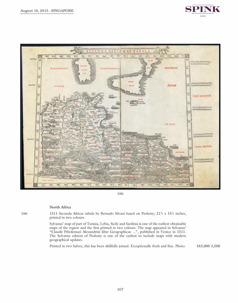
107
August 16, 2015 - SINGAPORE
North Africa
166 1511 Secunda Africae tabula by Bernado Silvani based on Ptolemy; 211⁄2 x 151⁄2 inches,printed in two colours.
Sylvanus’ map of part of Tunisia, Lybia, Sicily and Sardinia is one of the earliest obtainablemaps of the region and the first printed in two colours. The map appeared in Sylvanus’“Claudii Ptholemaei Alexandrini liber Geographicae ...”, published in Venice in 1511.The Sylvanus edition of Ptolemy is one of the earliest to include maps with moderngeographical updates.
Printed in two halves, this has been skillfully joined. Exceptionally fresh and fine. Photo S$3,000-3,500
166
Spink 15040 Antique Maps.qxp_Layout 1 17/07/2015 13:34 Page 107

Page 108
167
WWW.SPINK.COM
ANTIQUE MAPS
Egypt
167 1542 Aphricae Tabula III by Sebastian Munster; 15 x 12 inches, uncoloured. Pages numbered 890 and 891 with Latin text on verso. Printed on laid paper.
A highly decorative map of the region from the Libyan Sea to the Red Sea, includingBabylon, Thebes, the Pillars of Hercules, Hanorum, Alexandria, Memphis, and manyother classical places. The Nile has its origin in Aetheopia Sub Aegypto. Interesting sceneat top of a man being swallowed by a sea monster. The map is based upon classicalPtolemaic information. The map is unchanged from the 1540 edition. Munster’sGeographia was a cartographic landmark, including not only Ptolemaic maps, but also anumber of landmark modern maps, including the first separate maps of the 4 continents,the first map of England and the earliest obtainable map of Scandinavia. Munster isgenerally regarded as one of the three most important map makers of the 16th Century,along with Ortelius and Mercator. He issued his first mapping of Germany in 1529, after which he issued a call for geographical information about Germany to scholarsthroughout the country. The response was better than hoped for, and included substantialforeign material, which supplied him with up to date, if not necessarily accurate maps forthe issuance of his Geographia in 1540.
Two paper mounts on the reverse in the top margin; very fresh and fine S$400-500
Spink 15040 Antique Maps.qxp_Layout 1 17/07/2015 13:34 Page 108

109
August 16, 2015 - SINGAPORE
168 1660 (c.) Egypte moderne dict Chibet aujour-dhuy ..., by Philippe de la Rue; 211⁄2 x 171⁄4inches, hand-coloured.
Printed in chez Pierre Mariette (Paris). Engraved map on laid paper of Egypt and thewestern part of the Arabian Peninsula. Philippe de la Rue is known only by the fifteenmaps of which he is the author, all on the Middle East and all published by Pierre Mariettebetween 1651 and 1653. This map of Egypt is even rarer it is not in the Pastoureau.
Small thin patch where a part of the central reinforcement has been removed, a fewrepaired small tears in the lower margin and some light even ageing. A good example ofthis early map. Photo S$2,500-3,000
168
Spink 15040 Antique Maps.qxp_Layout 1 17/07/2015 13:34 Page 109

Page 110
169
170
WWW.SPINK.COM
ANTIQUE MAPS
169 1694 Patriarchatus Alexandrini Geographicadescriptio, by P. Mortier; 24 x 203⁄4 inches,original outline colour.
An ecclesiastical map showing thePatriarchate of Alexander in Roman times.
Usual reinforced central fold but long splitin the top margin and split at foot.Peripheral toning and brittle paper faults.Photo S$600-800
Southern Africa
170 1561 Africa nuova tavola by Giralamo Ruscelli from Ruscelli’s “La geografia di ClaudioTolomeo”; 113⁄4 x 81⁄2 inches, hand-coloured.
In his map of southern Africa, the Venetian editor and cartographer Ruscelli removes allsymbols and figures and returns to a simple depiction of the geography of the land. The Mountains of the Moon (Monti de Luna) are centrally placed in southern Africa, andthe Nile is born from the outflow of three lakes situated at their base. A number of coastalrivers are identified. Madagascar bears its earlier name, Island of San Lorenzo (Isola de S.Lorenzo), given by Diogo Dias, the Portuguese navigator who first landed there in 1500on the feast day (August 10) of St. Lawrence. The stippled ocean and pimply mountainranges reflect the Italian copperplate style of engraving of the period. Latin text on verso,page number XXII.
On laid paper, usual reinforced central fold, a few small holes near the centre, some whichhave been professionally repaired; trivial ageing, mostly confined to the lower margin. A good example of this scarce map. Photo S$500-600
Spink 15040 Antique Maps.qxp_Layout 1 17/07/2015 13:34 Page 110

111
August 16, 2015 - SINGAPORE
EUROPE
Russia
171 1816 Russia or Muscovy In Europe, by John Bower; two maps being the Norther Part ofand the Southern Part of; each 101⁄2 x 81⁄2 inches, uncoloured.
Produced in “A General Atlas, Being A Collection Of Maps Of The World And Quarters,Their Principal Empires, Kingdoms, &c. Containing Fifty Eight Maps And Charts”,Philadelphia; published by M. Carey, and B. Warner.
Vertical folding creases and some peripheral damage in the margins, fresh. (2 maps) S$200-250
172 1872 Caucausus & Crimea with the NorthernPortions of the Black & Caspian Seas, by A. Fullarton& Co.; 121⁄2 x 181⁄2 inches, original colour.
Full color maps surrounded by depictions of people,animals, and local scenes; from Fullarton’s “WorldAtlas”, plate IX. Clean and fine. Photo S$400-500
172
171
Spink 15040 Antique Maps.qxp_Layout 1 17/07/2015 13:34 Page 111

Page 112
173
WWW.SPINK.COM
ANTIQUE MAPS
Russia - Caspian Sea
173 1542 Tabula Asiae III (Black & Caspian Sea Region) by Sebastian Munster; 143⁄4 x 121⁄2inches, hand-coloured. Pages numbered 570-571 with Latin text on verso.
Excellent example of Munster’s Ptolemaic map of the region between the Black Sea andCaspian Sea extending south to include all of Armenia Major and part of ArmeniaMinoris. Munster’s map shows Noah’s Arc in the Caspian Sea, believed to have come torest in a mountain in Armenia according to the map. Shows Armenia Major, Iberia,Albania, Colchis, Porte Albanie, the Euphratis River, the Tigris, Assyriae, and many otherplace names in the cradle of civilization.
Small repaired hole in the top margin and a couple of minor imperfections. Photo S$600-800
Spink 15040 Antique Maps.qxp_Layout 1 17/07/2015 13:34 Page 112

113
August 16, 2015 - SINGAPORE
174 1721 Carte Marine de la Mer Caspiene, by de l’Isle and van Verden; two maps, each 27 x 201⁄2 inches with simple outline colour.
A seminal production, this is Guillaume de l’Isle’s 1721 map of the Caspian Sea accordingto the surveys of van Verden and S. I. Soimonov. It is the first printed map of the CaspianSea based upon actual survey work. Although other cartographers also copied the work ofvan Verden and Soimonov, de l’Isle was the first, and his mapping is the finest and truestto the original manuscript. The map proper is surrounded by eight inset maps detailvarious gulfs, bays, ports, and rivers. The upper sheet has two large cartouches, the leftbearing the title and dedication to van Verden and the right a description of the map. The right hand cartouche also features two dragons.
Each sheet with the usual reinforced centre fold; fresh and fine. Photo S$2,000-2,500
In 1721 Peter presented the Paris Academie Royale des Sciences with a copy of S. I. Soimonovand Carl Vanverden’s map of the Caspian region. Without further delay, De l’Isle redrewthe map (with great care), translated the inscriptions into French and printed it on separatesheets in reduced size in the Travaux of the Academy. He also included the map in his Atlas.In this way, the exact outline of the Caspian Sea, drawn on the Russian map of 1720, firstappeared in a map prepared in western Europe
174
Spink 15040 Antique Maps.qxp_Layout 1 17/07/2015 13:34 Page 113

Page 114
175
WWW.SPINK.COM
ANTIQUE MAPS
175 1723 Carte des Pays Voisins de la Mer Caspiene ..., by the de l’Isle family; 291⁄2 x 211⁄2inches, outline colour.
An example of Guillaume de L’Isle’s 1723 map of the Caucuses; from the Black Sea toIndependent Tartary and from Russia to Persia, inclusive of the entire Caspian Sea, andthe modern day nations of Georgia, Armenia, Azerbaijan, Kazakhstan, Turkmenistan,Iran, and Turkey. This is one of de l’Isle’s most important and misunderstood maps.Knowledge of the Caucuses and Caspian Sea region was extremely limited in Westerneurope and so de l’Isle composed this map from assortment of sources, many of whom helists in the title cartouche, including the Caspian Sea surveyor van Verden, Persiandiplomats, Georgian aristocratic and religious figures, and various Russian surveys. The result is this remarkably accurate map, a major step forward in the cartographicperspective of the region, and one of the finest maps de l’Isle ever produced. Engraved byMarin for the 1731 issue of de l’Isle’s seminal “Atlas de Geographie”.
Usual reinforced centre fold and printed number 118 on the reverse. Clean and fine.Photo S$1,000-1,200
Spink 15040 Antique Maps.qxp_Layout 1 17/07/2015 13:34 Page 114

115
August 16, 2015 - SINGAPORE
176 1728 Provinciarum Persicarum Kilaniae nempe Chirvaniae Dagestaniae, by JohannBaptist Homann; 243⁄4 x 211⁄2 inches, old coloured.
Southern parts of the Caspian Sea with surrounding areas are depicted in this map whichwas reissued by Johann Christoph Homann in Nuremberg. The manufacturer instructionin the title cartouche indicates Christoph and his father as authors of this map. The copperplate for this reprint, dated 1728, was engraved by Ruprecht Adam Schneider,who worked frequently for the Homann estate, The inset in the upper right corner showsa panorama of Tarki in the Republic of Dagestan. Ivan the Terrible had erected a fortressthere. Mount Ararat is shown, where Noah’s ark came to rest. Very elaborate cartouchesin the lower corners.
Usual reinforced central fold and page number 120 on verso. Good to fine. Photo S$600-800
176
Spink 15040 Antique Maps.qxp_Layout 1 17/07/2015 13:34 Page 115

Page 116
177
WWW.SPINK.COM
ANTIQUE MAPS
177 1730 (c.) Nova et accuratissima Maris Caspii ... ac Regionum Adjacentium Delineatio ...Jussu Invictissimi Principis Petri Alexii Fil. Magni Russorum Imperatoris, by MattheusSeutter; 24 x 21 inches, old coloured.
Showing the Caspian Sea with the large Volga Delta in east orientation. Main towns /countries around the Caspian Sea: Baky / Baku in Aserbaidschan, Astrakhan /Astrakhanskaya of Russia, Kasachstan, Turkmenistan and Ardebil in Iran. Also the majortrading ports and roads are described.
Usual reinforced central fold, in good condition. Photo S$1,000-1,200
178 1735 Nova Maris Caspit et Regionis Usbeck, by Erben Homann; 25 x 22 inches, oldcoloured.
Made by the Viennese printer Johann Peter van Ghelen, in accordance to the surveys ofgeographer Abraham Mass, published by Homann Heirs in Nuremberg. A detailed mapof central Asia centered on the Caspian Sea, Uzbek territory to the east of the Caspianand northern Persia. Highly decorative title cartouche top right featuring various peoples,one on horseback. Cities and town names include; Astrakan, Eriwan, Samarkand,Isphahan and Cabul. Also shows the trade routes.
Central fold and some light soiling; the margins have been slightly reduced S$800-1,000
Spink 15040 Antique Maps.qxp_Layout 1 17/07/2015 13:34 Page 116

117
August 16, 2015 - SINGAPORE
179 1747 A New and Accurate Map of theCaspian Sea, by Emanuel Bowen; 121⁄4 x 19inches, original colour.
From “A Complete System of Geography” byHerman Moll. Handsome map of the landssurrounding Caspian Sea - Astrakhan,Independent Tartary, Persia, Shirwan andothers, title cartouche at upper right. EmanuelBowen was one of the leading Englishmapmakers of the eighteenth-century, andwas unusual in that he was cartographer toboth the French and English Royal Courts.With one decorative cartouche, a compassrose and a mileage scale.
Page reinforcement in the left margins, twosmall holes in the lower margin and someminor peripheral imperfections. Photo S$600-800
179
178
Spink 15040 Antique Maps.qxp_Layout 1 17/07/2015 13:34 Page 117

Page 118
180
WWW.SPINK.COM
ANTIQUE MAPS
Russia - Black Sea
180 1744 Theatre de la Guerre Dans la Petite Tartarie, La Crimee, la Mer Noire, &c..., byGuillaume de l’Isle; 25 x 21inches, original colour.
The map is from a Dutch edition of de l’Isle’s work entitled, “Atlas Nouveau, ContenantToutes Les Parties Du Monde, Ou sont exactement Remarquées les Empires,Monarchies, Royaumes, Etats, Republiques &c. Par Guillaume de l’Isle. PremierGéographe de sa Majesté”. It was published by Covens and Mortier, brothers-in-law whocontinued the firm established by Pierre Mortier. Detailed map focusing on the Black Seawith wonderful detail of the surrounding regions. Shows watershed, villages and cities,mountains. Locates the confluence of the Danube, the walled cities of Tekin (Bender),Ouzi Oczakow (Dziarcrimenda), Taman, Magazin, and numerous forts and villages.
Usual central reinforcement; good to fine. Photo S$1,200-1,500
Spink 15040 Antique Maps.qxp_Layout 1 17/07/2015 13:34 Page 118

119
August 16, 2015 - SINGAPORE
Baltic Coast
181 1720 (c.) Ducatuum Livoniae et Curlandiae cum vicinis Insulis Nova ExhibitioGeographica, by Johann Baptiste Homann; 24 x 211⁄4 inches, old colour.
The northern Baltic coast in this early version. Estonia, Latvia and the fortified settlementsof Derpt and Goldingen. The islands of Hiiumaa and Saaremaa are in the Gulf of Riga.The title cartouche at the top left shows a group of armed putti fighting. A grid bordersthe map for quick reference and the mileage scale is at the bottom right hand side. The interior is very detailed with many lakes, settlements, mountain ranges and swampyareas.
Usual central reinforcement, trivial ink stains in the lower margin. Photo S$1,000-1,200
181
Spink 15040 Antique Maps.qxp_Layout 1 17/07/2015 13:34 Page 119

Page 120
182 183
WWW.SPINK.COM
ANTIQUE MAPS
Norway
182 1781 La Norvegia divisa Nelle sue Provincie Di nuova Projezione, by Antonio Zatta; 151⁄2 x 201⁄4 inches, hand-coloured.
Handsome and detailed Italian map of southern Norway. Fully engraved to show therugged terrain, many fiords and inland waterways. As noted in his Annotazione, thePrefecture of Salten in northern Norway is not included because it was delineated on hisgeneral map of Scandinavia. Decorated with a nautical-themed title cartouche.
Usual central reinforcement, only minor age marks. Photo S$300-400
Sardinia
183 1734 Sardiniae Regnum Et Insula ..., by Erben Homann; 20 x 231⁄2 inches, old colouredwith hand-coloured cartouche.
Copper plate engraving from the atlas “Isolario Geographical descrittione. Historica ...,”published in Nuremberg. A large map of Sardinia alone, with inset view of Cagliari. Witha key in the top right-hand corner to archbishoprics, bishoprics and towns which areknown to have existed since antiquity. Showing fortresses and salt pans, and decoratedwith an elaborate title cartouche, formed of horns of plenty and sheaves of wheat. A goodexample of this detailed and uncommon map.
Usual central reinforcement, slightly reduced margins at right and foot and a little surfacesoiling. Photo S$800-1,000
Spink 15040 Antique Maps.qxp_Layout 1 17/07/2015 13:34 Page 120

121
August 16, 2015 - SINGAPORE
Great Britain
184 1493 Tercia Etas Mundi. Folio XLVI, Anglie Provincia (A English town view), by H.Schedel; single sheet, 10 x 151⁄2 inches, later hand-coloured.
Large woodcut depicting an imaginary English town (235 x 223mm) on verso thegenealogy of King David. Page from the richest illustrated “Incunable”, the famousNuremberg Chronicle, published the year that Columbus returned to Europe afterdiscovering America. In May of 1493 appeared in the Latin language one of the earliestvoluminous books, fully illustrated with 1809 woodcuts printed from 645 woodblocks.
Tape marks on the top edge of verso, otherwise fine. Photo S$500-600
The woodblock cutters were Michael Wolgemut, the well-known teacher of Albrecht Dürer,and his stepson Wilhelm Pleydenwurff. Wohlgemut was Albrecht Dürer’s tutor between 1486-90 and recent scholarship has shown, Albrecht Dürer may also have collaborated, sincesome of the cuts bear a remarkably close resemblance to the Apocalypse illustrations. The printing was carried out under the supervision of the great scholar-printer AntonKoberger, whose printing were famous throughout Europe
184
Spink 15040 Antique Maps.qxp_Layout 1 17/07/2015 13:34 Page 121

Page 122
186
185
WWW.SPINK.COM
ANTIQUE MAPS
185 1617 Yorke Shrowesbury Lancaster Richmont, from ivitates Orbis Terrarum, by Braunand Hogenberg; 231⁄4 x 181⁄4 inches, original colour.
Four views being city plans of York, Shrewsbury and Lancashire and a view of the castleof Richmond. On each side of the four views are four figures in historical dress: Briton /Roman / Saxon / Dane; king and queen / English nobles / English burghers / Englishpeasants. The four views are engraved after views published by Speed in his atlas “The theatre of the empire of Great Britaine, 1611”. Latin text on verso with details ofYork. “Civitates Orbis Terrarum” could be called the first city atlas; published in six partsbetween 1572 and 1617 it encompassed well over 500 plans and views of towns and citiesfrom Europe (predominantly), North Africa, the Near East and the Americas. The townplans of York, Shrewsbury and Lancaster are all based on those of Speed’s county maps.
Reinforced central fold with some splitting in the upper and lower margins; small damagein left margins and light overall toning. Photo S$500-600
186 1710 Magna BritanniaComplectens Angliae,Scotiae Et Hiberniae ..., byJ.B. Homann; 241⁄4 x 211⁄2inches, later hand-coloured.
This is the second plateused for Homann’s map ofthe British Isles this onewith the portrait of KingGeorge II.
Usual centre fold withsome splitting at the top,quite a lot of tone spottingbut this is mostly confinedto the full-size margins.Photo S$1,200-1,500
Spink 15040 Antique Maps.qxp_Layout 1 17/07/2015 13:34 Page 122

123
August 16, 2015 - SINGAPORE
187 1772 Les Isles Britanniques ou sont le royaumes d’Angleterre, by Guillaume de l’Isle;271⁄4 x 21 inches, later hand-coloured.
Published in “Atlas Nouveau, contenant toutes les parties su Monde ...”, by Covens &Mortier, Amsterdam. Relief shown pictorially. Shows counties, settlements, etc. and has alarge illustrated cartouche with Neptune, sea creatures and birds; a scale cartouche in thelower right corner.
With centre fold showing some weakness or splitting in the margins; fresh appearance.Photo S$700-900
Great Britain - London
188 A new pocket plan of the cities of London and Westminster with the borough ofSouthwark comprehending the new buildings and other alterations to the year 1798; 213⁄4 x 111⁄2 inches, limited original colouring.
Several pocket-size maps were produced in the 1700’s and early 1800’s. Copperengraving on laid paper with title in upper left corner and explanation in lower left cornerand numbered “VII” in the top right corner. A very interesting map showing the limitsof the development of the city.
Usual folding creases, deep printing and in remarkably fine condition. Rare. Photo S$1,800-2,200
187
188
Spink 15040 Antique Maps.qxp_Layout 1 17/07/2015 13:34 Page 123

Page 124
189
WWW.SPINK.COM
ANTIQUE MAPS
ATLANTIC OCEAN
St. Helena
189 1596 “Vera effiies et delineatio Insulae Sancta Helena, qua Ortum Occasum, etSeptentrionem spectat, ... “by Ioannes Hugo a Linschoten; 183⁄4 x 121⁄4 inches,uncoloured.
An incredibly decorative engraving of St. Helena on paper. Three elevations provideperspective of the rugged topography. The ocean contains several Portuguese ships. The sheet is then richly embellished with three beautiful compass roses, two elaboratecartouches and angel holding armillary sphere. Beautifully engraved by Baptista aDoetechum.
Light folding creases from insertion in the original book and paper reinforcement downcentral fold; in remarkable condition. Photo S$500-600
This is Linschoten’s second map of St Helena island in the south Atlantic. St Helena was animportant re-supply point for the Portuguese starting from their earliest attempts, in the late1400s, at rounding the Cape of Good Hope and discovering a sea route to the Indies. The island’s later history included being Napoleon’s final place of imprisonment, after hisdefeat at Waterloo. The map shows three detailed views of the island: the town, landing places,etc. This was done as a guide to show how the island looked as approached from the sea; acompass rose below each view provides sailing directions. The safe harbour was on the northernside of the island. A ship in the harbour in bottom view flies the Portuguese standard. Text inLatin and in Dutch. Jan Huygen van Linschoten (1562-1611) was employed as Secretary tothe Portuguese Archbishop of Goa in India from 1583. Here, he had access to manyPortuguese portolans as well as other valuable commercial information. Linschoten returnedto Holland in 1592 and there wrote a history of his years of travel, the Itinerario..., whichincorporated all that he had learned from the Portuguese. This book and the accompanyingmaps provided precise information on the Portuguese sea routes to the East, their re-supplypoints around Africa, and their trading stations in the East. The book had a tremendousinfluence on Dutch expansion in the East and particularly in Java.
Spink 15040 Antique Maps.qxp_Layout 1 17/07/2015 13:34 Page 124

125
August 16, 2015 - SINGAPORE
AMERICA
190 1785 Nieuwe en Algemeene Kaart van America ..., by Willem Albert Bachiene afterEmanuel Bowen; 203⁄4 x 181⁄4 inches, hand-coloured.
Rare Bachiene map, after Bowen; shows conjectural N.W. Coast, Indians, Colonies,mountains, rivers, etc. Nice detail in South America, including mythical lakes, mines, etc.Decorative cartouche.
Reinforced central fold, small paper split at foot. Fresh and attractive. Photo S$2,500-3,000
190
Spink 15040 Antique Maps.qxp_Layout 1 17/07/2015 13:34 Page 125

Page 126
191
WWW.SPINK.COM
ANTIQUE MAPS
North America
191 1757 Amérique Septentrionale, by Robert de Vaugondy; 253⁄4 x 20 inches; originaloutline colour.
Copper plate engraving on thick watermarked laid paper. In Robert de Vaugondy “Atlas Universel”, Paris; Map No. 97. An attractive cartouche with native Americans withtrees and alligator on waterfall.
Reinforced centre fold and two other vertical folds, there are a couple of small paper splits.An attractive map. Photo S$2,000-2,500
Spink 15040 Antique Maps.qxp_Layout 1 17/07/2015 13:34 Page 126

127
August 16, 2015 - SINGAPORE
192 1784 Carte Générale du Canada, de la Louisiane, de la Floride, de la Caroline..., by P.Santini and M. Remondini; 291⁄2 x 201⁄4 inches, uncoloured.
On stout paper, map of the eastern part of the United States and Canada. With inset mapof Hudson and Baffin bays in the lower right corner. This is the Venetian edition ofd’Anville’s map, from “Atlas Universel” printed in 1784. Noteworthy topographical detailis shown, with particular focus on the Great Lakes. Lake Superior is attached to aconvoluted river system reaching across the continent reminiscent of the Riviere Longueof Baron Lahontan’s memoirs. On the Gulf Coast the region of Tecas (Texas) is namedwith a nearby note about the Atac-apa tribe of Indians, who are noted as Antrophages(Cannibals) and Indiens errans. The map was prepared by the Venetian cartographer andpublisher François Santini and first published in Santini’s “Atlas Universel dresse sur lesmeuilleures cartes modernes 1776.” Santini collaborated with Janvier and gives credit tohim on most of his maps. The atlas is effectively an Italian copy of the Robert deVaugondy “Atlas Universel”. In 1784 Santini sold the plates to M. Remondini, whosename appears on this particular example - indicating that this is the second state of themap.
Usual central reinforcement, there is a weakness or split in the lower margins. A fineexample of this popular map. Photo S$3,500-4,000
192
Spink 15040 Antique Maps.qxp_Layout 1 17/07/2015 13:34 Page 127

Page 128
193
WWW.SPINK.COM
ANTIQUE MAPS
SOUTH AMERICA
Northern Coast
193 1785 La Terra Ferma La Gujana Spagnola, Olandese, Frances, E. Portughese E La ParteSettente. Del Bresil, by Antonio Zatta; 20 x 15 inches, hand-coloured.
Marvellous map of Columbia, Venezuela, Ecuador and a large portion of northern Brazil,including the entire Amazon River, plus northern Peru. Includes a large decorative titlecartouche. The map was issued in Zatta’s “Atlante Novissimo” a monumental fourvolume work and one of the last great decorative atlases.
Usual central reinforcement; fine. Photo S$200-250
194 1814 Charte von dem östlichen Theile von Terra Firma oder dem General-Capitanate vonCaracas, by J. B. Poirson; Geographisches Institut (Weimar, Thuringia, Germany); 211⁄2 x171⁄4 inches, simple outline colour.
On thick laid paper, some soiling, mostly confined to the margins. Photo S$200-250
Venezuela
195 1640 (c.) Venezuela cum parte Australi Novae Andalusiae, by Willem Janszoon Blaeu andPeter Schenk in Amsterdam; 231⁄4 x 20 inches, hand-coloured.
Fine example of the rare Peter Schenk edition of Blaeu’s map of Venezuela and the North-eastern part of South America. It includes two decorative cartouches, the title with twoputti, vignettes of various indigenous animals, a compass rose, etc. Latin text on verso.
Usual central reinforcement, four tone or stain spots which show through to the front.Photo S$800-1,000
Spink 15040 Antique Maps.qxp_Layout 1 17/07/2015 13:34 Page 128

129
August 16, 2015 - SINGAPORE
195
194
Spink 15040 Antique Maps.qxp_Layout 1 17/07/2015 13:34 Page 129
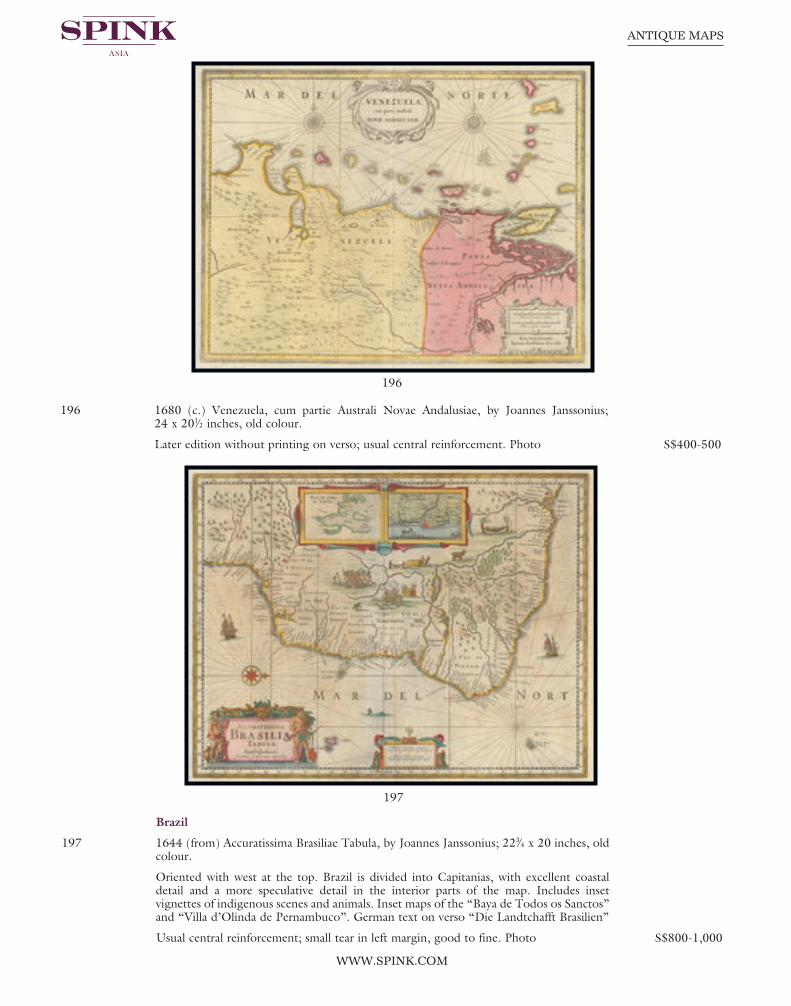
Page 130
196
197
WWW.SPINK.COM
ANTIQUE MAPS
196 1680 (c.) Venezuela, cum partie Australi Novae Andalusiae, by Joannes Janssonius; 24 x 201⁄2 inches, old colour.
Later edition without printing on verso; usual central reinforcement. Photo S$400-500
Brazil
197 1644 (from) Accuratissima Brasiliae Tabula, by Joannes Janssonius; 223⁄4 x 20 inches, oldcolour.
Oriented with west at the top. Brazil is divided into Capitanias, with excellent coastaldetail and a more speculative detail in the interior parts of the map. Includes insetvignettes of indigenous scenes and animals. Inset maps of the “Baya de Todos os Sanctos”and “Villa d’Olinda de Pernambuco”. German text on verso “Die Landtchafft Brasilien”
Usual central reinforcement; small tear in left margin, good to fine. Photo S$800-1,000
Spink 15040 Antique Maps.qxp_Layout 1 17/07/2015 13:34 Page 130

131
August 16, 2015 - SINGAPORE
PACIFIC OCEAN
198 1802 Carte reduite du Grand Ocean compris entre l’Asia et l’Amerique..., by J.B.Poirson; 193⁄4 x 151⁄4 inches, outline colour.
A scarce map of the South Pacific by Poirson. Shows Australia (Nouvelle Hollande) withunfinished coast line. Includes New Zealand, Hawaii, and large parts of the Americas.
Usual reinforced central fold, horizontal fold; fresh and fine. Photo S$600-800
199 1817 Map of the Islands in the Pacific Ocean, by John Thomson; 27 x 211⁄2 inches,original outline colour.
Interesting map of the region bounded by Australia, the Marinanas and the South Pacificfrom Thomson’s “New General Atlas”. Focuses on the area between the Tropic of Cancerand the Tropic of Capricorn, and including some area north and south of the tropics.Shows the Hawaiian Islands (Sandwich Islands), Society Islands, Solomon Islands,Caroline Islands, New Hebrides, Friendly Islands, the eastern part of New Guinea, andthe coast of New South Wales, Australia. Four insets of Owhynee (Big Island of Hawai’i),Karakakooa Bay, Otaheite (Tahiti), and Matavia Bay. Excellent detail along the coast ofAustralia and New Guinea as well. A nice example of this map printed on heavy paper withwide margins. One of the few early 19th century large format commercial atlas maps totreat this area.
Some creasing around the regular central reinforcement, some light overall soiling. Photo S$700-800
198
199
Spink 15040 Antique Maps.qxp_Layout 1 17/07/2015 13:34 Page 131

201
Page 132
WWW.SPINK.COM
ANTIQUE MAPS
French Polynesia
200 1838 Carte groupe des Iles Manga-Reva (Iles Gambier)Levee et dressee par Mr. Vincendon Dumoulin Ingenieurhydrographe de la marine a bord de la corvette L’Astrolabe,by Depot des cartes et plans de la marine, France; 21 x 26inches; uncoloured.
Chart of the Mangareva Islands with relief shown byhachures and bathymetric soundings. Track of Dumontd’Urvilles corvettes shown with inset of Carte de L’ArchipelNouka-Hiva (Iles Marquises) aout et septembre 1838.Central fold, tone spotting. Photo S$500-600
Oceania
201 1860-69 Océanie dressée par A.H. Dufour; gravée par Ch. Dyonnet. Abel Pilon, Editeur... Paris, by Auguste-Henri Dufour; 313⁄4 x 221⁄2 inches, original colour.
In French. Map of Oceania showing ocean currents and European possessions. A superblydetailed nautical chart of the Pacific Ocean showing all of Australia, Indonesia, and Japanas well as most of North America and the west coast of South. Includes five insets:southeastern Australia, New Caledonia, the Marquesas, Tahiti, and the GambierArchipelago (French Polynesia). Relief shown by hachures. In lower left margin: La Lettrepar Guyen. In lower margin: Imp. Geny-Gros, r, de la Montagne S’te. Genevieve, 34,Paris. In upper left margin: Atlas universel Pl. 40. In upper right margin: Geographiemoderne Pl. 31.
Central fold, crease in left side, small splits at top and some bends and a couple of minorage marks. Photo S$1,000-1,200
200
Spink 15040 Antique Maps.qxp_Layout 1 17/07/2015 13:34 Page 132

133
August 16, 2015 - SINGAPORE
202
203
AUSTRALIA
202 1840 Australia engraved by the omnigraph, F.P. Becker & Co. patentees; 101⁄2 x 81⁄4inches, original colour.
Map of Australia showing boundary of South Australia and Lake Torrens. Relief shownby hachures. Some light soiling or ageing. Photo S$300-400
203 1892 Australie by J. Migeon; 21 x 151⁄2 inches, original colour.
From “Nouvel Atlas Illustre Geographie Universelle. Comprenant La Geographie,L’Histoire, L’Administration, La Statistique ...,” page 62. Full colour by country. Relief shown by hachures. Vignette of Sydney. Margin imprints, Grave par L. Smith.Dresse Sous La Direction De J. Migeon Par Ch. Lacoste. Migeon, editeur, imp, r. duMoulin Vert, Paris. Ecrit par A. Bizet. (1892). Fillatreau del. and Barbier sc. (forvignette).
Reinforced central fold, two small splits in the lower margin. Photo S$1,000-1,200
Spink 15040 Antique Maps.qxp_Layout 1 17/07/2015 13:34 Page 133

Page 134
WWW.SPINK.COM
ANTIQUE MAPS
LITERATURE
Malaya
204 1907, Malay Peninsular (Straits Settlements & Federated Malay States), Original Photos.... by C.J. Kleingrothe, Medan, Deli. in original casing.
Cloth-bound portfolio measuring 460x365mm, with title ‘Malay Peninsula’ stamped onfront cover beneath a laid-down photogravure image of a tiger in a trap. The portfoliocontains a separate loose title page, a coloured map of the Straits Settlements and theFederated Malay States dated 1907. Contains 72 lithogravure pages, unusually completeas most examples, including that in the British Library, contain less. Contains Singapore(18 pages), Penang (16 pages), F.M.S. (36 pages) and Malacca and others (2 pages).
Little biographical information has come to light about the elusive Charles J. Kleingrothe,the photographer whose images of the Dutch East Indies and British Malaya are nowhighly sought after collector’s items. In the late 1860s, Kleingrothe worked for G.R.Lambert & Co., a leading photographer of Singapore whose prints had been compiled ina similar though less sumptuous volume years ago. When the plantation economy ofSumatra flourished in the latter half of the 19th century, G.R. Lambert opened a branchof its studios in Medan in 1888, then part of the old Deli Sultanate, for which Kleingrothewas put in charge. His pictorial record of Sumatra plantations of the day are unrivaled andwas probably one of the few sources on this largely-forgotten phase in the history of theisland. When the Medan branch declined and was subsequently wound up during theGreat War in 1916, Kleingrothe too seemed to have disappeared without a trace. Photo S$12,000-15,000
Spink 15040 Antique Maps.qxp_Layout 1 17/07/2015 13:50 Page 134

135
August 16, 2015 - SINGAPORE
204
Spink 15040 Antique Maps.qxp_Layout 1 17/07/2015 13:34 Page 135

Page 136
205
WWW.SPINK.COM
ANTIQUE MAPS
205 1908 Twentieth Century Impressions of British Malaya, abridged edition, Wright andCartwright, Lloyd’s Greater Britain Publishing Company.
A valuable, 285 page snapshot of Malaya, crammed with photos. Some splitting in themargin of the fly sheet, otherwise in very fine condition. A rare and appealing book. Photo S$4,000-5,000
Spink 15040 Antique Maps.qxp_Layout 1 17/07/2015 13:34 Page 136
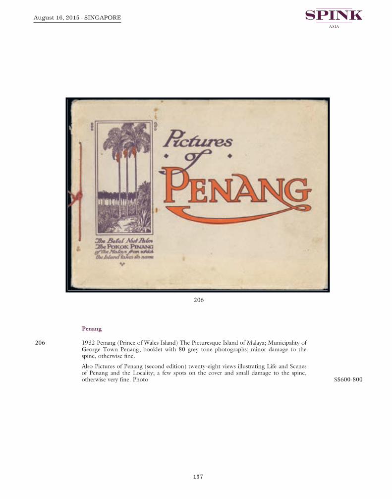
137
August 16, 2015 - SINGAPORE
Penang
206 1932 Penang (Prince of Wales Island) The Picturesque Island of Malaya; Municipality ofGeorge Town Penang, booklet with 80 grey tone photographs; minor damage to thespine, otherwise fine.
Also Pictures of Penang (second edition) twenty-eight views illustrating Life and Scenesof Penang and the Locality; a few spots on the cover and small damage to the spine,otherwise very fine. Photo S$600-800
206
Spink 15040 Antique Maps.qxp_Layout 1 17/07/2015 13:34 Page 137

Page 138
WWW.SPINK.COM
ANTIQUE MAPS
Singapore
207 1955, Colony of Singapore, Master Plan, Report of Survey; board covered withphotographs, maps, plans and an abundance of data.
The Master Plan was first formulated between 1952 and 1955. The colonial governmentof the time saw the need for an overall plan to guide the rapid physical growth thatSingapore was experiencing. It had to solve the acute housing shortage, redevelop the citywhich was known as the Central Area, and improve the living conditions there. The resultwas the first Statutory Master Plan in 1958. It introduced regulated land use for the firsttime, through zoning, density and plot ratio controls. It is a statutory instrument forreserving land for schools, open spaces, infrastructural facilities and other essentialcommunity uses. The Plan included a “green belt” to arrest the further expansion of thecity. It provided for the redevelopment of decaying properties in the Central Area anddesignated new urban areas outside the city. New interconnected towns were alsoplanned. The first Master Plan laid the basis for comprehensive urban planning that hastaken place since then.
Some minor tone spotting on the first page of the index, otherwise in exceptionalcondition. Very scarce and a most interesting historical document. Photo S$1,200-1,500
END OF THE SALE
207
Spink 15040 Antique Maps.qxp_Layout 1 17/07/2015 13:34 Page 138

TEL. HOME ______________________________________________ TEL. OFFICE ____________________________________________
FAX ____________________________________________________ E-MAIL ________________________________________________
SIGNATURE _______________________________________________ VAT NUMBER ___________________________________________
Please indicate the type of card: VISA VISA DEBIT MASTERCARD SWITCH AMERICAN EXPRESS
PAYMENT MADE BY MASTERCARD OR VISA ARE SUBJECT TO A 2% FEE AND AMERICAN EXPRESS 4%
CARD NO: START DATE: ISSUE NO: SECURITY CODE:
SIGNATURE EXPIRY DATE NAME (ON CREDIT CARD)
Please charge all purchases to my card
Do not charge my card. I will arrange to send payment. (Spink will only charge your card should you default on the payment terms agreed)
Please hold my purchased lots for collection Continued ...
– –
– –
– –
– –
– –
– –
– –
– –
– –
– –
– –
– –
– –
– –
– –
– –
– –
– –
– –
– –
– –
– –
– –
– #
– –
– –
– –
– –
– –
– –
– –
– –
– –
– –
– –
– –
– –
– –
– –
– –
– –
– –
– –
– –
– –
– –
– –
– –
– –
– –
– –
– –
– –
– –
– –
– –
SALE TITLE DATE CODE NAME SALE NO.
Antique Maps Sunday 16 August 2015 MAPS 15040at 6.00 p.m.
I request Spink, without legal obligations of any kind on its part, to bid on the following Lots up to the price given below. I understand that if my bid is successful the Purchase Price will be the sum of the final bid and Buyer’s premium as a percentage of the final bid, any GST chargeable, also a fee for bidding on the-saleroom.com onlyand fee for paying by credit card. The Rate of Premium is 20% of the final hammer price of each lot. I understand Spink will pursue me for payment for any successful bid.In addition, I understand and consent that Spink may share my personal details relating to the default with other auction houses and live bidding platforms to protectthemselves from such defaults.
All bids shall be treated as offers made on the Terms and Conditions for Buyers printed in the catalogue. I also understand that Spink provides the service of executingbids on behalf of clients for the convenience of clients and that Spink will not be held responsible for failing to execute bids. If identical commission bids are received forthe same Lot, the commission bid received first by Spink will take precedence. Please note that you will not be notified if there are higher written bids received.
PLEASE PRINT CLEARLY IN BLOCK LETTERS AND ENSURE THAT BIDS ARE IN SINGAPORE DOLLARS
Lot Number(in numerical order)
Price Bid S$(excluding Buyer’s Premium)
Lot Number(in numerical order)
Price Bid S$(excluding Buyer’s Premium)
Lot Number(in numerical order)
Price Bid S$(excluding Buyer’s Premium)
NAME ______________________________________________________
ADDRESS ____________________________________________________
____________________________________________________________
____________________________________________________________
POSTCODE ___________________________________________________
WRITTEN BIDS FORM
This form should be sent or faxed to theSpink auction office in advance of the sale.References for new clients should besupplied in good time to be taken upbefore the sale. Bids received later thanone hour before the start of the sale maynot be processed.
69 Southampton Row, Bloomsbury,London WC1B 4ETtel: +44 (0)20 7563 4005/4020fax: +44 (0)20 7563 4037email: [email protected](available until 12 August)
Spink (Asia) Ptd. Ltd360 Orchard Road,# 06-03A International Building,Singapore 238869tel: +65 6339 8801fax: +65 6339 0788(available until 13 August)
Sale Location:HELICONIA BALLROOM 3405-3406,Level 3Sands Expo and Convention CentreMarina Bay Sands10 Bayfront AveSingapore 018956tel +65 6688 2557 fax +65 6688 2411(available from 15 August 2015)YOU CAN ALSO BID IN REAL TIME ON SPINK LIVE.
JUST VISIT WWW.SPINK.COM, REGISTER AND LOG INTO THE SALE.
Spink 15040 Antique Maps.qxp_Layout 1 17/07/2015 13:50 Page 139

PLEASE PRINT CLEARLY IN BLOCK LETTERS AND ENSURE THAT BIDS ARE IN SINGAPORE DOLLARS
REFERENCES REQUIRED FOR CLIENTS NOT YET KNOWN TO SPINK
TRADE REFERENCES ________________________________________________________________________________________
BANK REFERENCES _____________________________________________________________________________________________________
Lot Number(in numerical order)
Price Bid S$(excluding Buyer’s Premium)
Lot Number(in numerical order)
Price Bid S$(excluding Buyer’s Premium)
Lot Number(in numerical order)
Price Bid S$(excluding Buyer’s Premium)
DATE SALE NO.
Sunday 16 August 2015 15040at 6.00 p.m.
GST of 7% is chargeable on hammerand premium of all lots not exportedoutside of Singapore. In the event thata Spink nominated shipper isinstructed, then any GST refundableunder the Goods and Services Tax Act(Cap 117A) of Singapore will not bepayable by the Buyer to Spink.
BIDDING INCREMENTSBidding generally opens below the low estimate and advances in the following order althoughthe auctioneer may vary the bidding increments during the course of the auction. The normalbidding increments are:Up to S$100 by S$5
S$100 to S$300 by S$10
S$300 to S$600 S$320-S$350-S$380-S$400 etc.
S$600 to S$1,000 by S$50
S$1,000 to S$3,000 by S$100
£3,000 to £6,000 S$3,200-S$3,500-S$3,800-S$4,000 etc.
S$6,000 to S$20,000 by S$500
S$20,000 and up Auctioneer’s discretion
Spink 15040 Antique Maps.qxp_Layout 1 17/07/2015 13:35 Page 140

TERMS AND CONDITIONS FOR BUYERS
2 SPINK ASIA’S ROLE AS AGENT
2.1 All sales undertaken by us either at auction or privately are undertakeneither as agent on behalf of the Seller or from time to time, as principalif we are the owner of the Lot. Please note that even if we are actingas agent on behalf of the Seller rather than as principal, we may havea financial interest in the Lot.
2.2 The contract for the sale of the Lot will be between you and the Seller.
3 BEFORE THE SALE
3.1 Examination of goods
You are strongly advised to examine personally any goods in whichyou are interested, before the auction takes place. Condition reportsare usually available on request. We provide no guarantee to you otherthan in relation to Forgeries, as set out in clause 5.12 of these Termsand Conditions.
3.2 Catalogue descriptions
3.2.1 Statements by us in the catalogue or condition report, ormade orally or in writing elsewhere, regarding the authorship,origin, date, age, size, medium, attribution, genuineness,provenance, condition or estimated selling price of any Lotare merely statements of opinion, and are not to be relied onas statements of definitive fact. Catalogue and webillustrations are for guidance only, and should not be reliedon either to determine the tone or colour of any item or toreveal imperfections. No lot shall be rejected on the groundsof inaccurate reproduction. No lot illustrated in the catalogueand online shall be rejected on the grounds of cancellation,centring, margins, perforation or other characteristicsapparent from the illustration. Estimates of the selling priceshould not be relied on as a statement that this price is eitherthe price at which the Lot will sell or its value for any otherpurpose.
3.2.2 Many items are of an age or nature which precludes theirbeing in perfect condition and some descriptions in thecatalogue or given by way of condition report make referenceto damage and/or restoration. We provide this informationfor guidance only and the absence of such a reference doesnot imply that an item is free from defects or restoration nordoes a reference to particular defects imply the absence of anyothers.
3.2.3 Other than as set out in clause 5.12, and in the absence offraud, neither the Seller nor we, nor any of our employees oragents, are responsible for the correctness of any statement asto the authorship, origin, date, age, attribution, genuinenessor provenance of any Lot nor for any other errors ofdescription or for any faults or defects in any Lot. Everyperson interested should exercise and rely on his ownjudgment as to such matters.
These conditions set out the terms on which we (Spink Asia Pte Limited, 360 Orchard Road, #06-03A International Building, Singapore 238869) contract withyou (Buyer) either as agent on behalf of the Seller or as principal if we are the Seller. You should read these conditions carefully.
1 DEFINITIONS
Buyer’s Premium means the charge payable by you as a percentage of the Hammer Price, at the rates set out in clause 5.1 below;Certificate of Authenticity means a certificate issued by an Expert Committee confirming the authenticity of a Lot;Expert Committee means a committee of experts to whom a Lot may be sent for an extension in accordance with section 3.4;Forgery means a Lot constituting an imitation originally conceived and executed as a whole with a fraudulent intention to deceive as to
authorship, origin, age, period, culture or source where the correct description as to such matters is not reflected by thedescription in the catalogue and which at the date of the auction had a value materially less than it would have had if it had beenin accordance with the description in the catalogue. Accordingly, no Lot shall be capable of being a Forgery by reason of anydamage and/or restoration work of any kind (including re-enamelling);
Hammer Price means the amount of the highest bid accepted by the auctioneer in relation to a Lot;Lot means any item deposited with us for sale at auction and, in particular, the item or items described against any Lot number in any
catalogue;Reserve the amount below which we agree with the Seller that the Lot cannot be sold;Seller means the owner of the Lot being sold by us;Spink Group Spink Asia Pte Limited, Spink and Son Limited, our subsidiaries and associated companies;GST Goods and Services Tax chargeable under the Goods and Services Tax Act (Cap 117A) of Singapore on the supply of goods and
services in Singapore and the importation of goods into Singapore, and any similar replacement or additional tax.
3.3 Your Responsibility
You are responsible for satisfying yourself as to the condition of thegoods and the matters referred to in the catalogue description.
3.4 Extensions – Stamps only
3.4.1 If you wish to obtain an expert opinion or Certificate ofAuthenticity on any Lot (other than a mixed lot or lotcontaining undescribed stamps) you must notify us in writingnot less than forty-eight hours before the time fixed for thecommencement of the first session of the auction. If acceptedby us, such request shall have the same effect as notice of anintention to question the genuineness or description of theLot for the purposes of clause 5.12 (Refund in the case ofForgery) of these Terms and Conditions and the provisions ofclause 5.12 (Refund in the case of Forgery) shall applyaccordingly.
3.4.2 Notice of a request for an expert opinion or Certificate ofAuthenticity must give the reason why such opinion isrequired and specify the identity of your proposed expertwhich will be subject to agreement by us. We reserve theright, at our discretion, to refuse a request for an expertopinion or Certificate of Authenticity including (withoutlimitation) where the proposed expert is not known to us.
3.4.3 If we accept a request for an expert opinion or certificate ofAuthenticity we will submit the Lot to the ExpertCommittee. You acknowledge and accept that the length oftime taken by an Expert Committee to reach an opinion willvary depending on the circumstances and in any event isbeyond our control.
3.4.4 We will not accept a request for an extension on account ofcondition. Any Lot described in the catalogue as having faultsor defects may not be returned even if an expert opinion orCertificate of Authenticity cites other faults or defects notincluded in the catalogue description, other than in the caseof a Forgery.
3.4.5 Should Spink accept a request for an extension under theforegoing provisions of this paragraph, the fact may be statedby the Auctioneer from the rostrum prior to the sale of theLot.
3.4.6 It should be noted that any stamp accompanied by aCertificate of Authenticity is sold on the basis of thatCertificate only and not on the basis of any other descriptionor warranty as to authenticity. No request for an extensionwill be accepted on such a stamp and the return of such astamp will not be accepted.
3.4.7 If you receive any correspondence from the ExpertCommittee in relation to the Lot, including but not limitedto a Certificate of Authenticity, you must provide us withcopies of such correspondence no later than 7 days after youreceive such correspondence.
Spink 15040 Antique Maps.qxp_Layout 1 17/07/2015 13:35 Page 141
4.9 Bidding IncrementsBidding generally opens below the low estimate and advances in thefollowing order although the auctioneer may vary the biddingincrements during the course of the auction. The normal biddingincrements are:
Up to S$100 by S$5S$100-S$300 by S$10S$300-S$600 S$320 - S$350 - S$380 - S$400 etc.S$600-S$1000 by S$50S$1,000-S$3,000 by S$100S$3,000-S$6,000 S$3,200 - S$3,500 - S$3,800 - S$4,000S$6,000-S$20,000 by S$500S$20,000 and up at Auctioneer’s Discretion
4.10 Bidding by the Spink Group4.10.1 We reserve the right to bid on Lots on the Seller’s behalf up
to the amount of the Reserve (if any), which will never beabove the low estimate printed in the auction catalogue.
4.10.2 The Spink Group reserves the right to bid on and purchaseLots as principal.
4.11 The Auctioneer’s DiscretionThe auctioneer has the right at his absolute discretion to refuse any bidto advance the bidding in such manner as he may decide to withdrawor divide any Lot, to combine any two or more Lots and, in the caseof error or dispute, to put an item up for bidding again.
4.12 Successful BidSubject to the auctioneer’s discretion, the striking of his hammermarks the acceptance of the highest bid, provided always that such bidis higher than the Reserve (where applicable), and the conclusion of acontract for sale between you and the Seller.
4.13 After Sale ArrangementsIf you enter into any private sale agreements for any Lot with theSeller within 60 days of the auction, we, as exclusive agents of theSeller reserve the right to charge you the applicable Buyer’s Premiumin accordance with these Terms and Conditions, and the seller acommission in accordance with the terms of the seller’s agreement.
4.14 Return of LotOnce your bid has been accepted for a Lot then you are liable to payfor that Lot in accordance with these Terms and Conditions. If thereare any problems with a Lot then you must notify us within 7 days ofreceipt of the Lot, specifying the nature of the problem. We may thenrequest that the Lot is returned to us for inspection. Save as set out inclause 5.12, the cancellation of the sale of any Lot and the refund ofthe corresponding purchase price is entirely at our sole discretion. Wewill not normally exercise that discretion if the Lot is not received byus in the same condition that it was in at the auction date.
5 AFTER THE AUCTION
5.1 Buyer’s Premium and other chargesIn addition to the Hammer Price, you must pay us the Buyer’sPremium at a rate of 20% of the final Hammer price of each lot, a feeof 3% on the hammer price total for using the-saleroom.com and afee for paying by credit card.
5.2 Goods and Services Tax and any other value added taxAs we remain liable to account for GST on all the Lots, the Buyershall, subject to Clause 5.3 below, pay any and all GST and any othervalue added tax chargeable on any payment to Spink.
5.3 GST RefundsIn the event a Spink nominated shipper is instructed, then any GSTrefundable under the Goods and Services Tax Act (Cap 117A) ofSingapore will not be payable by the Buyer to Spink.
5.4 Payment5.4.1 You must provide us with your full name and permanent
address and, if so requested, details of the bank from whichany payments to us will be made. You must pay the fullamount due (comprising the Hammer Price, the Buyer’sPremium and any applicable GST) within seven days after thedate of the sale.
5.4.2 You will not acquire title to the Lot until all amounts duehave been paid in full. This includes instances where specialarrangements were made for release of Lot prior to fullsettlement.
4 AT THE SALE
4.1 Refusal of admissionOur sales usually take place on our own premises or premises overwhich we have control for the sale, and we have the right, exercisableat our complete discretion, to refuse admission to the premises orattendance at an auction.
4.2 Registration before biddingYou must complete and sign a registration form and provideidentification before making a bid at auction. Please be aware that weusually require buyers to undergo a credit check. If you have not bidsuccessfully with Spink in the past, or you are registering with us forthe first time, we reserve the right to require a deposit of up to 50% ofthe amount you intend to spend. Such deposit will be deducted fromyour invoice should you be successful. If you are unsuccessful atauction, your deposit will be returned by the same means it was paidto Spink. Some lots may be designated, prior to the auction, as“Premium Lots”, which means a deposit may be required beforeplacing a bid on the item for sale. Information will be posted on ourwebsite in such an event.
4.3 Bidding as PrincipalWhen making a bid (whether such bids are made in person or byway of telephone bids operated by Spink, commission or onlineor email bids), you will be deemed to be acting as principal and willbe accepting personal liability, unless it has been agreed in writing, atthe time of registration, that you are acting as agent on behalf of athird party buyer acceptable to us.
4.4 Commission BidsIf you give us instructions to bid on your behalf, by using the formprovided in our catalogues or via our website, we shall use reasonableendeavours to do so, provided these instructions are received not laterthan 24 hours before the auction. If we receive commission bids on aparticular Lot for identical amounts, and at auction these bids are thehighest bids for the Lot, it will be sold to the person whose bid wasreceived first. Commission bids are undertaken subject to othercommitments at the time of the sale, and the conduct of the auctionmay be such that we are unable to bid as requested. Since this isundertaken as a free service to prospective buyers on the terms stated,we cannot accept liability for failure to make a commission bid. Youshould therefore always attend personally if you wish to be certain ofbidding.
4.5 On-line BiddingWe offer internet services as a convenience to our clients. We will notbe responsible for errors or failures to execute bids placed on theinternet, including, without limitation, errors or failures caused by (i)a loss of internet connection by either party for whatever reason; (ii) abreakdown or problems with the online bidding software and/or (iii)a breakdown or problems with your internet connection, computer orsystem. Execution of on-line internet bids on www.spink.com andSpink Live is a free service undertaken subject to other commitmentsat the time of the auction and we do not accept liability for failing toexecute an online internet bid or for errors or omissions in connectionwith this activity. Buyers who acquire lots on the-saleroom.com willhave a fee of 3% on the hammer price added to their invoice for usingthis facility.
4.6 Telephone BidsIf you make arrangements with us not less than 24 hours before thesale, we shall use reasonable endeavours to contact you to enable youto participate in bidding by telephone, but in no circumstances will webe liable to either the Seller or you as a result of failure to do so.
4.7 Currency ConverterAt some auctions, a currency converter will be operated, based on theone month forward rates of exchange quoted to us by Barclays BankPlc or any other appropriate rate determined by us, at opening on thedate of the auction. Bidding will take place in a currency determinedby us, which is usually Singapore Dollars. The currency converter isnot always reliable, and errors may occur beyond our control either inthe accuracy of the Lot number displayed on the converter, or theforeign currency equivalent of Singapore Dollars bids. We shall not beliable to you for any loss suffered as a result of you following thecurrency converter.
4.8 Video imagesAt some auctions there will be a video screen. Mistakes may occur inits operation, and we cannot be liable to you regarding either thecorrespondence of the image to the Lot being sold or the quality ofthe image as a reproduction of the original.
Spink 15040 Antique Maps.qxp_Layout 1 17/07/2015 13:35 Page 142

5.8.2 It is the responsibility of the Buyer to be aware of any ImportDuties that may be incurred upon importation to the finaldestination. Spink will not accept return of any package inorder to avoid these duties. The onus is also on the Buyer tobe aware of any Customs import restrictions that prohibit theimportation of certain collectibles. Spink will not acceptreturn of the Lot(s) under these circumstances. Spink will notaccept responsibility for Lot(s) seized or destroyed byCustoms.
5.8.3 If the Buyer requires delivery of the Lot to an address otherthan the invoice address, this will be carried out at thediscretion of Spink.
5.9 Recommended packers and shippersIf required our shipping department may arrange shipment as youragent. Although we may suggest carriers if specifically requested, oursuggestions are made on the basis of our general experience of suchparties in the past and we are not responsible to any person to whomwe have made a recommendation for the acts or omissions of the thirdparties concerned.
5.10 Remedies for non-payment or failure to collect purchases5.10.1 If you fail to make payment within seven days of your
stipulated payment date set out in your invoice, we shall beentitled to exercise one or more of the following rights orremedies:5.10.1.1 to charge interest at the rate of 2% per month
compound interest, calculated on a daily basis,from the date the full amount is due;
5.10.1.2 to set off against any amounts which the SpinkGroup may owe you in any other transaction theoutstanding amount remaining unpaid by you;
5.10.1.3 we may keep hold of all or some of your Lots orother property in the possession of the SpinkGroup until you have paid all the amounts you oweus or the Spink Group, even if the unpaid amountsdo not relate to those Lots or other property.Following fourteen days’ notice to you of theamount outstanding and remaining unpaid, theSpink Group shall have the right to arrange the saleof such Lots or other property. We shall apply theproceeds in discharge of the amount outstandingto us or the Spink Group, and pay any balance toyou;
5.10.1.4 where several amounts are owed by you to theSpink Group in respect of different transactions, toapply any amount paid to discharge any amountowed in respect of any particular transaction,whether or not you so direct;
5.10.1.5 to reject at any future auction any bids made byyou or on your behalf or obtain a deposit from youbefore accepting any bids.
5.10.2 If you fail to make payment within thirty-five days, we shall inaddition be entitled:5.10.2.1 to cancel the sale of the Lot or any other item sold
to you at the same or any other auction;5.10.2.2 to arrange a resale of the Lot, publicly or privately,
and, if this results in a lower price being obtained,claim the balance from you together with allreasonable costs including a 20% seller’scommission, expenses, damages, legal fees,commissions and premiums of whatever kindassociated with both sales or otherwise, incurred inconnection with your failure to make payment; or
5.10.2.3 when reselling the Lot, place a notice in ourcatalogue stating that you successfully purchasedthe Lot at auction but have subsequently failed topay the Hammer Price of the Lot; or
5.10.2.4 take any other appropriate action as we deem fit.5.10.3 If you fail to collect within fourteen days after the sale,
whether or not payment has been made, you will be required5.10.3.1 to pay a storage charge of S$5 per item per day plus
any additional handling cost that may apply. 5.10.3.2 you will not be entitled to collect the Lot until all
outstanding charges are met, together withpayment of all other amounts due to us.
5.4.3 Payment should be made in Singapore Dollars by one of thefollowing methods:
(i) Direct bank transfer to our account details of which areset out on the invoice. All bank charges shall be met byyou. Please ensure that your client number is noted onthe transfer.
(ii) By cheque or bank draft made payable to Spink (Asia)Pte Limited and sent to Spink at 360 Orchard Road,#06-03A International Building, Singapore 238869.Please note that the processing charges for paymentsmade by cheques or bank drafts drawn on a non-Singapore bank shall be met by you. Please ensure thatthe remittance slip printed at the bottom of the invoiceis enclosed with your payment.
(iii) By Visa or Mastercard. A fee of 2% will be applied.Please be informed that all credit card payments will beprocessed in pound sterling in our London office. Weare not responsible for any foreign exchange losses orfees that you may incur in connection with suchpurchases.
5.4.4 Payments should be made by the registered buyer and not bythird parties, unless it has been agreed at the time ofregistration that you are acting as an agent on behalf of a thirdparty.
5.5 Invoices
Invoices may consist of one or more pages.
5.6 Collection of Purchases
5.6.1 Unless we specifically agree to the contrary, we shall retainitems sold until all amounts due to us, or to the Spink Group,have been paid in full. Buyers will be required to pay for theirlots when they wish to take possession of the same, whichmust be within 7 days of the date of the sale, unless priorarrangements have been made with Spink. Without prioragreement, lots will not be released until cleared funds arereceived with regard to payments made by cheque.
5.6.2 Unless we notify you to the contrary, items retained by us willbe covered in accordance with our policy which is availablefor inspection at our offices from the date of sale for a periodof seven days or until the time of collection, whichever issooner. After seven days or from the time of collection,whichever is the earlier, the Lot will be entirely at your risk.
5.6.3 Our policy will not cover and we are unable to acceptresponsibility for damage caused by woodworm, changes inatmospheric conditions or acts of terrorism.
5.6.4 Lots may be collected from the sale venue the day after theauction and then from our offices at 360 Orchard Road, #06-03A International Building, Singapore 238869 thereafter. Inthe event where a cheque or bank draft payable to Spink(Asia) Pte Ltd has been presented to us, unless we specificallyagree to the contrary, no Lots shall be released before thecheque or bank draft has cleared where such funds have beencredited to our bank account.
5.6.5 All uncollected Lots will be shipped from our office at 360Orchard Road, #06-03A International Building, Singapore238869.
5.7 Notification
We are not able to notify successful bidders by telephone. WhileInvoices are sent out by mail after the auction we do not acceptresponsibility for notifying you of the result of your bid. You arerequested to contact us by telephone or in person as soon as possibleafter the auction to obtain details of the outcome of your bids to avoidincurring charges for late payment.
5.8 Packing and Handling
5.8.1 We shall use all reasonable endeavours to take care whenhandling and packing a purchased Lot but remind you thatafter seven days or from the time of collection, whichever issooner, the Lot is entirely at your risk. Our postage chargesare set out at the back of the catalogue.
Spink 15040 Antique Maps.qxp_Layout 1 17/07/2015 13:35 Page 143

7.4 We are also working closely with third parties (including, for example,other auctioneers and live bidding platforms) and may receiveinformation about you from them.
8 COPYRIGHT8.1 We shall have the right (on a non-exclusive basis) to all images,
illustrations and written materials including photograph, video or anyother product relating to a Lot. All rights in such property will belongto us, and we shall have the right to use it in whatever way we see fit.
9 NOTICESAll notices given under these Terms and Conditions may be servedpersonally, sent by 1st class post, or faxed to the address given to the senderby the other party. Any notice sent by post will be deemed to have beenreceived on the second working day after posting or, if the addressee isoverseas, on the fifth working day after posting. Any notice sent by fax orserved personally will be deemed to be delivered on the first working dayfollowing despatch.
10 ADDITIONAL PROVISIONSThe following provisions of this clause 10 shall apply only if you are actingfor the purposes of your business.10.1 Limitation of Liability
Subject to clause 6, we shall not be liable, whether in tort (includingfor negligence) or breach of statutory duty, contract,misrepresentation or otherwise for any:10.1.1 any special, indirect, consequential or pure economic loss,
costs, damages, charges or expenses.10.2 Severability
If any part of these Terms and Conditions is found by any court to beinvalid, illegal or unenforceable, that part may be discounted and therest of the conditions shall continue to be valid and enforceable to thefullest extent permitted by law.
10.3 Force majeureWe shall have no liability to you if we are prevented from, or delayedin performing, our obligations under these Terms and Conditions orfrom carrying on our business by acts, events, omissions or accidentsbeyond our reasonable control, including (without limitation) strikes,lock-outs or other industrial disputes (whether involving ourworkforce or the workforce of any other party), failure of a utilityservice or transport network, act of God, war, riot, civil commotion,malicious damage, compliance with any law or governmental order,rule, regulation or direction, accident, breakdown of plant ormachinery, fire, flood, storm or default of suppliers or subcontractors.
10.4 Waiver10.4.1 A waiver of any right under these Terms and Conditions is
only effective if it is in writing and it applies only to thecircumstances for which it is given. No failure or delay by aparty in exercising any right or remedy under these Terms andConditions or by law shall constitute a waiver of that (or anyother) right or remedy, nor preclude or restrict its furtherexercise. No single or partial exercise of such right or remedyshall preclude or restrict the further exercise of that (or anyother) right or remedy.
10.4.2 Unless specifically provided otherwise, rights arising underthese Terms and Conditions are cumulative and do notexclude rights provided by law.
10.5 Law and Jurisdiction10.5.1 These Terms and Conditions and any dispute or claim arising
out of or in connection with them or their subject matter,shall be governed by, and construed in accordance with, thelaw of Singapore.
10.5.2 The parties irrevocably agree that the courts of Singaporeshall have non-exclusive jurisdiction to settle any dispute orclaim that arises out of, or in connection with, Terms andConditions or their subject matter.
Postage Charges (signed for, insured mail, including packing)Value PriceUp to S$5000 S$30Above S$5000 S$50Please be informed that the above postage charges apply to packages sentoverseas. Postage is not chargeable for any packages despatched withinSingapore.
Shipments of more than 2kg or volumetric measurement of more than 2kg haveto be sent by courier. Certain countries may incur extra charge when courierservices are required by our insurance policy. For lots sent by courier pleasecontact [email protected] for calculation of any further relevant cost inaddition to the above charges.
5.11 Uses of Default InformationIf you fail to make payment for a Lot in accordance with these Termsand Conditions:5.11.1 We reserve the right to refuse you the right to make bids for
any future auction irrespective of whether previous defaultshave been settled; and
5.11.2 You consent to us disclosing details of such default to otherauctioneers and live bidding platforms, which will includeyour name, address, nature of the default and the date of thedefault.
Auctioneers or live bidding platforms who receive details of thedefault may rely on such information when deciding whether to enterinto a transaction with you in the future.
5.12 Refund in the case of Forgery5.12.1 A sale will be cancelled, and the amount paid refunded to you
if a Lot (other than a miscellaneous item not described in thecatalogue) sold by us proves to have been a Forgery. We shallnot however be obliged to refund any amounts if either (a)the catalogue description or saleroom notice at the auctiondate corresponded to the generally accepted opinion ofscholars or experts at that time, or fairly indicated that therewas a conflict of opinions, or (b) it can be demonstrated thatthe Lot is a Forgery only by means of either a scientificprocess not generally accepted for use until after publicationof the catalogue or a process which at the date of the auctionwas unreasonably expensive or impracticable or likely to havecaused damage to the Lot. Furthermore, you should notethat this refund can be obtained only if the followingconditions are met:5.12.1.1 you must notify us in writing, within seven days of
the auction date, that in your view the Lotconcerned is a Forgery;
5.12.1.2 you must then return the item to us withinfourteen days, in the same condition as at theauction date; and
5.12.1.3 as soon as possible following return of the Lot, youmust produce evidence satisfactory to us that theLot is a Forgery and that you are able to transfergood title to us, free from any third party claims.
5.13.1.4 you must provide to us all evidence obtained byyou that a Lot is a Forgery no later than 7 daysafter you receive such evidence.
5.12.2 In no circumstances shall we be required to pay you any morethan the amount paid by you for the Lot concerned and youshall have no claim for interest.
5.12.3 The benefit of this guarantee is not capable of beingtransferred, and is solely for the benefit of the person towhom the original invoice was made out by us in respect ofthe Lot when sold and who, since the sale, has remained theowner of the Lot without disposing of any interest in it to anythird party.
5.12.4 We shall be entitled to rely on any scientific or other processto establish that the Lot is not a Forgery, whether or not suchprocess was used or in use at the date of the auction.
6 LIABILITYNothing in these Terms and Conditions limits or excludes our liability for:6.1 death or personal injury resulting from negligence; or6.2 any damage or liability incurred by you as a result of our fraud or
fraudulent misrepresentation.
7 USE OF YOUR PERSONAL INFORMATION7.1 We will use the personal information you provide to us to:
7.1.1 process the bids you make on Lots (whether successful orotherwise) and other auction related services we provide;
7.1.2 process your payment relating to a successful purchase of aLot;
7.1.3 arrange for delivery of any Lot you purchase, which willinclude passing your details to shipping providers and, onoverseas deliveries, to customs where they make enquiriesregarding the Lot;
7.1.4 inform you about similar products or services that we provide,but you may stop receiving these at any time by contacting us.
7.2 In accordance with clause 4.2, you agree that we may pass yourinformation to credit reference agencies and that they may keep arecord of any search that they do.
7.3 In accordance with clause 5.11, you agree that where you default onmaking payment for a Lot in accordance with these terms andconditions we may disclose details of such default to other auctioneersand live bidding platforms.
Spink 15040 Antique Maps.qxp_Layout 1 17/07/2015 13:35 Page 144

GROUP CHAIRMAN AND CEO
Olivier D. Stocker
YOUR SPECIALISTS
STAMPS
UK - Tim Hirsch FRPSL Guy Croton David Parsons Nick Startup Neill GrangerPaul Mathews Dominic Savastano Tom Smith Ian Shapiro (Consultant)
USA - George Eveleth Richard DebneyEUROPE - Guido Craveri Fernando Martínez
CHINA - Tommy Chau Doris LoCOINS
UK - Richard Bishop Tim Robson Jon Mann Barbara Mears John PettUSA - Greg Cole Luke Mitchell Stephen Gol dsmith (Special Consultant)
CHINA - Kin Choi Cheung Paul Pei Po ChowBANKNOTES
UK - Barnaby Faull Andrew Pattison Monica Kruber Thomasina SmithUSA - Greg Cole Stephen Goldsmith (Special Consultant)
CHINA - Kelvin Cheung Paul Pei Po ChowORDERS, DECORATIONS, MEDALS & MILITARIA
UK - Mark Quayle Oliver Pepys John HaywardBONDS & SHARES
UK - Mike Veissid Andrew Pattison Thomasina SmithUSA - Luke Mitchell
EUROPE - Peter ChristenCHINA - Kelvin Cheung
BOOKS
UK - Philip Skingley Jennifer MulhollandAUTOGRAPHS
USA - Greg Cole Stephen Goldsmith (Special Consultant)WINES
CHINA - Guillaume Willk-Fabia Angie Ihlo Fung
YOUR EUROPE TEAM (LONDON - LUGANO)
Chairman’s OfficeCharles Blane
DirectorsTim Hirsch Anthony Spink
Auction & Client Management TeamMira Adusei-Poku Grace Hawkins Rita Ariete Dora Szigeti Tatyana Boyadzhieva
John Winchcombe Tom Mathews Maurizio Schenini
FinanceAlison Bennet Marco Fiori Mina Bhagat Dennis Muriu Hemel Thakore Veronica Morris
IT & AdministrationBerdia Qamarauli Michael Addo Liz Cones Curlene Spencer
Tom Robinson Cristina Dugoni Giacomo Canzi
YOUR AMERICA TEAM (NEW YORK)
Auction Administration and Marketing & DesignAmit Ramprashad
Finance & AdministrationAleena Nieves
AuctioneerLuke Mitchell
YOUR ASIA TEAM (HONG KONG - SINGAPORE)
AdministrationAngie Ihlo Fung Newton Tsang Sue Pui Arthur Chan Doris Lo Gary Tan
Ken Imase [email protected]
BANKNOTES
16 August Banknotes, Bonds & Shares, Coins and Medals of South East Asia sale during the International Exhibition Singapore 15038
27 August The Numismatic Collector’s Series Sale Hong Kong CSS1724/25 September The Numismatic Collector’s Series Sale New York 32229/30 September World Banknotes London 150091 October World Banknotes London 1500914 November The Numismatic Collector’s Series Sale Hong Kong CSS198 December World Banknotes London 15048
SALE CALENDAR 2015/16
The above sale dates are subject to change
Spink offers the following services:– VALUATIONS FOR INSURANCE AND PROBATE FOR INDIVIDUAL ITEMS OR WHOLE COLLECTIONS –
– SALES ON A COMMISSION BASIS EITHER OF INDIVIDUAL PIECES OR WHOLE COLLECTIONS –
STAMPS
15/16 July The Philatelic Collector’s Series Sale New York 15120/21 July The Philatelic Collector’s Series Sale London 15026 16 August Antique Maps Sale during the International Exhibition Singapore 1504016/17 August The “Sentosa” Collection of Straits Settlements, Malayan States, Labuan, North Borneo
and Sarawak sale during the International Exhibition Singapore 1504118 August Stamps and Covers of South East Asia Sale during the International Exhibition Singapore 15027September Autographs, Historical Documents, Ephemera and Postal History London 1503724 September Windward Islands and British Guiana, British Honduras, Cayman Islands and Jamaica
from the Vestey Collection London 1504226 September The Philatelic Collector’s Series Sale Hong Kong CSS146 October The “Fordwater” Collection of New Zealand London 150437 October The Award-Winning Len Jury Collection of New Zealand Postal History, Stationery,
1913 Auckland and 1920 Victory Issues London 1504421 October Great Britain Stamps and Postal History London 15045November The Charles W. Adams Collection of United States and Canada New York 152November The Philatelic Collector’s Series Sale New York 15324/25 November The Philatelic Collector's Series Sale, featuring the John Sussex Collection
of South West Africa,1880-1928 London 1504610 December Bermuda from the Vestey Collection London 1504727/28 January The Philatelic Collector's Series Sale London 16010
COINS
15 July Ancient, British & Foreign Coins and Commemorative Medals London 1500516 August Banknotes, Bonds & Shares, Coins and Medals of South East Asia sale
during the International Exhibition Singapore 1503827 August The Numismatic Collector’s Series Sale Hong Kong CSS1722/23 September Ancient, British & Foreign Coins and Commemorative Medals London 1500624/25 September The Numismatic Collector’s Series Sale New York 32214 November The Numismatic Collector’s Series Sale Hong Kong CSS192/3 December Ancient, British & Foreign Coins and Commemorative Medals London 15007
MEDALS
23 July Orders, Decorations, Campaign Medals & Militaria London 1500216 August Banknotes, Bonds & Shares, Coins and Medals of South East Asia sale
during the International Exhibition Singapore 1503819 November Orders, Decorations, Campaign Medals & Militaria London 15003
BONDS & SHARES
16 August Banknotes, Bonds & Shares, Coins and Medals of South East Asia sale during the International Exhibition Singapore 15038
27 August The Numismatic Collector’s Series Sale Hong Kong CSS1724/25 September The Numismatic Collector’s Series Sale New York 32214 November The Numismatic Collector’s Series Sale Hong Kong CSS1927 November Bonds & Share Certificates of the World London 15019
AUTOGRAPHS
September Autographs, Historical Documents, Ephemera and Postal History London 15037
WINES
15 August An Evening of Selected Rums, Fine Wines, Whiskies and Cognacs during the International Exhibition Singapore SFW15
17 September Whisky, Cognac and Other Spirits Hong Kong SFW1610 December Whisky, Cognac and Other Spirits Hong Kong SFW1715 January Whisky, Cognac and Other Spirits Hong Kong SFW18
Spink 15040 Antique Maps cover.qxp_Layout 1 17/07/2015 13:35 Page 2

A
NT
IQU
E M
AP
S
1
6 A
UG
US
T 2
01
5
S
ING
AP
OR
E
16 AUGUST 2015
SINGAPORE
ANTIQUE MAPS
© C
op
yri
ght
2015
STAMPS COINS BANKNOTES MEDALS BONDS & SHARES AUTOGRAPHS BOOKS WINES
Spink (Asia) Ptd. Ltd, 360 Orchard Road, # 06-03A International Building, Singapore 238869www.spink.com
Spink 15040 Antique Maps cover.qxp_Layout 1 17/07/2015 13:35 Page 1


