72
11/18/09 Any information contained in this booklet is for informational purposes only. Policies are subject to change at any time. Copyright © 2008

11/18/09 Any information contained in this booklet is for informational purposes only.
Policies are subject to change at any time. Copyright © 2008

11/18/09 Any information contained in this booklet is for informational purposes only.
Policies are subject to change at any time. Copyright © 2008

PAGE 1 COID DEVELOPMENT HANDBOOK 11/18/09
Any information contained in this booklet is for informational purposes only. Policies are subject to change at any time. Copyright © 2008
COID Development Handbook Table of Contents
I. INTRODUCTION ............................................................................................................................................. 4 1.1 PURPOSE .............................................................................................................................................. 4 1.2. HISTORY OF WATER RIGHTS & EASEMENTS........................................................................................... 4
II. DEFINITIONS ................................................................................................................................................ 6 III. CENTRAL OREGON IRRIGATION DISTRICT EASEMENTS ............................................................. 10
3.1 EASEMENTS ........................................................................................................................................ 10 3.1.1 GENERAL EASEMENT INFORMATION AND APPLICABLE LAW ..................................................................... 10 3.1.2 WATER DELIVERIES AND/OR FACILITIES ................................................................................................. 10 3.1.3 PRIVATE IRRIGATION DELIVERIES...................................................................................................... 11 3.1.4 EASEMENTS AND TRAILS ................................................................................................................... 11 3.1.5 DEVELOPMENT ADJACENT TO EASEMENTS AND NECESSARY GATES ...................................................... 12
IV. DEVELOPING LANDS WITH WATER RIGHTS .................................................................................... 13 4.1. WATER RIGHTS .................................................................................................................................. 13
4.1.1 DEVELOPMENT OF LANDS WITH WATER RIGHTS ................................................................................. 13 4.2 ADJACENT PROPERTIES ....................................................................................................................... 15
4.2.1 WATER DELIVERIES ......................................................................................................................... 15 4.2.2 TAIL WATER .................................................................................................................................... 15
V. DEVELOPMENT AND CONSTRUCTION ON OR NEAR COID EASEMENTS ..................................... 18 5.1 CONSIDERATIONS AND TIMELINESS OF PROJECT................................................................................... 18 5.2 DEVELOPMENT AND CONSTRUCTION STANDARDS ................................................................................ 18 5.3 PROPOSED DEVELOPMENT REVIEW PROCESS AND TIMELINE ................................................................ 19 5.4 PLAN SUBMITTAL ............................................................................................................................... 20
5.4.1 SUBMITTAL CHECKLIST .................................................................................................................... 20 5.4.2 “AS BUILT” DRAWINGS ................................................................................................................... 21 5.4.3 INTRODUCTION MEETING ................................................................................................................. 21 5.4.4 ENGINEERING DESIGN REVIEW ......................................................................................................... 21 5.4.5 CONSTRUCTION OF FACILITIES & NOTICE TO PROCEED ...................................................................... 21 5.4.6 PROJECT COMPLETION .................................................................................................................... 22
5.5 PLATS ................................................................................................................................................ 22 5.6 AGREEMENTS ..................................................................................................................................... 22 5.7 PRE-CONSTRUCTION MEETING ............................................................................................................ 23 5.9 INSPECTIONS ...................................................................................................................................... 23 5.10 TESTING ............................................................................................................................................. 23 5.11 CONSTRUCTION STAKING/SURVEYING ................................................................................................. 24 5.12 STORM WATER SWALES ...................................................................................................................... 24 5.13 BLASTING ........................................................................................................................................... 24
VI. FACILITY PIPING ..................................................................................................................................... 25 6.1 PIPING ................................................................................................................................................ 25 6.2 PIPING REQUIREMENTS ....................................................................................................................... 25
6.2.1 MINIMUM SIZE PIPE ........................................................................................................................ 25 6.2.2 BENDS AND JOINT DEFLECTION ........................................................................................................ 26 6.2.3 DETECTION TAPE/ TONING WIRE ...................................................................................................... 26 6.2.4 ALL WEATHER ACCESS ..................................................................................................................... 26 6.2.5 MEASUREMENT DEVICES .................................................................................................................. 26 6.2.6 GENERAL PIPING NOTES .................................................................................................................. 26
6.3 PIPING EASEMENT/AGREEMENT REQUIREMENTS.................................................................................. 27 6.4 EASEMENT REDUCTIONS ..................................................................................................................... 27 6.5 CENTRAL OREGON IRRIGATION DISTRICT PIPING SPECIFICATIONS ........................................................ 28
PAGE 2 COID DEVELOPMENT HANDBOOK 11/18/09
Any information contained in this booklet is for informational purposes only. Policies are subject to change at any time. Copyright © 2008
VII. CROSSING GUIDELINES ........................................................................................................................ 29 7.1 CROSSING LICENSES ARE REQUIRED FOR ALL NON-DISTRICT CONSTRUCTION INSIDE OF COID EASEMENTS THAT TOUCH OR CONCERN COID EASEMENTS OR FACILITIES. ............................................................................... 29 7.2 MAIN CANAL AND LATERAL CROSSING GUIDELINES ............................................................................ 30
7.2.1 BEFORE BEGINNING CANAL CROSSING: .............................................................................................. 30 7.2.2 DURING CONSTRUCTION OF CANAL CROSSING:.................................................................................. 31 7.2.3 CONCLUSION OF CANAL CROSSING: .................................................................................................. 32
7.3 SUB LATERAL CROSSING GUIDELINES ................................................................................................. 32 7.4 BORING UNDER CANAL....................................................................................................................... 33 7.5 OVERHEAD CROSSINGS ....................................................................................................................... 33 7.5 BRIDGE CROSSINGS ............................................................................................................................ 33 7.6 INSURANCE ........................................................................................................................................ 34
XIII. IRRIGATION CONTRACTS TO BE RECORDED ................................................................................ 35 8.1 CONTRACTS IN GENERAL .................................................................................................................... 35 8.2 IRRIGATION CONTRACT (DEVELOPMENT ADJACENT TO OPEN CANAL) .................................................. 35 8.3 DEVELOPMENT IRRIGATION PLAN (DIP) .............................................................................................. 35
IX. EXHIBITS NEEDED FOR DOCUMENTS ................................................................................................. 36 9.1 PIPING AGREEMENT ............................................................................................................................ 36 9.2 IRRIGATION CONTRACT (INDEMNIFICATION) ........................................................................................ 36 9.3 CROSSING LICENSE ............................................................................................................................. 36 9.4 JOINT ROAD USE AGREEMENT............................................................................................................. 36
X. FEE SCHEDULE .......................................................................................................................................... 37 APPLICABLE STATUTES (QUICK REFERENCE)....................................................................................... 38 APPENDIX “A” DISTRICT’S TYPICALS...................................................................................................... 39
TYPICAL (A) LARGE CANAL CROSSINGS .......................................................................................................... 41 TYPICAL (B) CULVERT CROSSINGS .................................................................................................................. 42 TYPICAL (B) CONTINUED ............................................................................................................................... 43 TYPICAL (C) CANAL CROSSINGS ..................................................................................................................... 44 TYPICAL (D) STRUCTURE DETAILS .................................................................................................................. 45 TYPICAL (E) HORIZONTAL DIRECTIONAL BORE ................................................................................................ 46 CLEAN OUT DETAIL (HDPE SDR-17) ............................................................................................................ 47 CLEAN OUT DETAIL (C-900 OR C-905)........................................................................................................... 48 CLEAN OUT DETAIL (DUCTILE) ...................................................................................................................... 49
APPENDIX “B” DISTRICT DOCUMENT EXAMPLES ................................................................................. 51 CROSSING LICENSE .................................................................................................................................. 53 PIPING EASEMENT ................................................................................................................................... 55 JOINT ROAD USE AGREEMENT ............................................................................................................... 57 IRRIGATION CONTRACT .......................................................................................................................... 59
APPENDIX “C” STORM WATER SWALES ...................................... ERROR! BOOKMARK NOT DEFINED. STORMWATER SWALE EVALUATION REPORT ........................................................ Error! Bookmark not defined. SITE REPORT EXAMPLE 1 .................................................................................. Error! Bookmark not defined. SITE REPORT EXAMPLE 2 .................................................................................. Error! Bookmark not defined.
APPENDIX “D” DEVELOPER IRRIGATION PLAN ..................................................................................... 64 PREAPPLICATION INFORMATION & DATA REQUEST .......................................................................................... 66 APPLICATION GUIDELINES ............................................................................................................................. 68

PAGE 3 COID DEVELOPMENT HANDBOOK 11/18/09
Any information contained in this booklet is for informational purposes only. Policies are subject to change at any time. Copyright © 2008
CENTRAL OREGON IRRIGATION DISTRICT Development & Contractor Information Booklet
The Central Oregon Irrigation District (COID) is one of the largest and oldest irrigation districts in the State of Oregon with operations beginning in 1900. COID provides irrigation water to over 9,000 patrons on over 44,000 acres in Deschutes, Crook and Jefferson counties. COID is a municipal corporation and a special district chartered under Oregon Revised Statutes Chapter 545 and under license and contract with both the state and federal governments. As the pace of change and the value of the land have accelerated over the past decade in Central Oregon, the need to document and provide written District policies to fellow governments, planners, engineers, contractors, architects and patrons has become apparent. COID‟s Board of Directors provides these policies and procedures to inform others of irrigation law and rules. COID‟s boundaries and irrigation system cover hundreds of square miles across multiple counties and municipalities and can be difficult to understand. This Booklet is intended to provide information to the Central Oregon development community regarding COID‟s authorities, policies, procedures and standards associated with development activity in an attempt to avoid unnecessary confusion and delays for everyone involved. This effort is part of a larger effort to fulfill the responsibilities and requirements the District has with city and county governments where it operates. As the policies and procedures of the cities and counties change, these policies will likely change also. I would urge anyone receiving this booklet to read and review the document fully. Many of the policies and standards have been recently refined and familiarity with them may be beneficial. It is anticipated that there will be changes to this booklet over time, and COID will update information accordingly, updates will be available on our website or via e-mail. For more information please call 541-548-6047 or visit our website at http://www.coid.org/. Sincerely yours, Steven C Johnson District Secretary – Manager December 2006

PAGE 4 COID DEVELOPMENT HANDBOOK 11/18/09
Any information contained in this booklet is for informational purposes only. Policies are subject to change at any time. Copyright © 2008
I. INTRODUCTION
Central Oregon Irrigation District (COID) is a quasi-municipal corporation in the state of Oregon. The District provides water for over 44,000 acres within an 180,000 acre area in Central Oregon. More than 700 miles of COID canals provide agricultural and industrial water to the Bend, Redmond, Terrebonne, Powell Butte and Alfalfa areas. In addition, COID provides water to the City of Redmond and numerous subdivisions. In Bend, many parks and schools receive water through the COID system. COID does not provide water for human consumption. However, use of this water for irrigation and industrial purposes frees up other supplies for potable use.
1.1 PURPOSE This manual was developed to guide readers through the design and construction of
facilities on or near COID easements, and provide guidelines for the proper crossing and piping of COID easements and canals. The Policies contained herein apply to the development of irrigated lands or lands containing COID facilities or easements.
1.2. HISTORY OF WATER RIGHTS & EASEMENTS In the late 1800s, Congress passed a set of laws encouraging the colonization of the arid
Western United States. Upon showing that it was possible to irrigate the land sufficiently to sustain agricultural enterprises, 13 states entered into sales contracts with the Secretary of the Interior Department of the United States. These land grants were conditional upon the irrigation companies building the canals and infrastructure that would deliver the water necessary to cultivate and settle the areas. In 1899 the State of Oregon officially adopted this concept and contracted with irrigation companies to operate under specific rights and responsibilities. The irrigation companies delivered water to settlers to cultivate their land and thus gain ownership of those acres from the U.S. Government. The irrigation companies were granted the federal rights of way necessary to maintain and service the lands with water by and through their irrigation systems easements.
The rights of way on COID main canals and large laterals generally reaches 50‟ on each side of the marginal limits of the waterway, or outer edges of the canal berms. In the case of small laterals, COID generally holds 30‟ on each side. However, the right of way varies with the amount of water carried in that part of the system and may have been modified according to need over time. COID‟s rights of way are nonexclusive rights for COID to use the encumbered lands to serve COID patrons with irrigation water. Private owners may also use the land, so long as such use does not interfere with COID‟s use of the subject property. In some instances, COID owns the underyling property as well.
COID is the best source of definitive records and dimensions of the District‟s easements
indexed by parcel. Title reports within the District‟s boundaries cite to the District‟s authority, but do not specify the dimensions of the easements. The surest way to define specific COID easements is to consult COID directly.

PAGE 5 COID DEVELOPMENT HANDBOOK 11/18/09
Any information contained in this booklet is for informational purposes only. Policies are subject to change at any time. Copyright © 2008
All COID easements are reserved for the operations and maintenance of the distribution system. Any encroachments of COID easements, crossings of COID ditches, or other uses of COID roads and ditches require prior written approval from the District. No encroachments, crossings or other uses will be allowed that in any way interfere with the District's use.
PAGE 6 COID DEVELOPMENT HANDBOOK 11/18/09
Any information contained in this booklet is for informational purposes only. Policies are subject to change at any time. Copyright © 2008
II. DEFINITIONS1 Acre Foot: The measurement of water volume; the amount of water necessary to cover an acre of land, one foot deep. Appurtenant: „Belonging to‟. Water rights are appurtenant to a specific piece of ground. Central Oregon Irrigation District is required to keep records of appurtenant water rights. (See also “Dominant Parcel,” “Benefitted Parcel”). Burdened Parcel: The land bearing the burden of an easement (See also Servient Parcel) Canal: A waterway or improved river used to supply water for irrigation. Contiguous: That which touches or connects, including that which only connects or touches a common point; the touching together of two or more tracts of land which lie alongside one another or which touch or connect with one another for any length or distance whatsoever, no matter how finite. Deschutes River Corridor: All property within 100 feet of the ordinary high water mark of the Deschutes River or as defined by Bend‟s Waterway Overlay Zone. Development Irrigation Plan (DIP): A written plan submitted to and approved by the District describing the use of District water rights as part of new development. This may be either a plan to move water on or off the land. See Section IV. Diversion: Man-made structures that are or may be used to deflect or divert water from a river or stream into a conduit or impoundment, or canal. Dominant Parcel: A parcel of real property that has an easement, or a right of use, in another piece of property. (See also, Appurtenant, Benefitted Parcel) Duty: (See Rate & Duty) A measurement increment to determine volume of water properly delivered to a parcel or lot. Easement: A right, such as a right-of-way, afforded a person to make limited use of another's real property. Headgate: Valve comprised of a plate which slides over a canal, lateral, or sublateral opening to measure water delivery. Headgates may be adjusted and locked. Lateral: A partial diversion of a canal, a smaller delivery of water to outlying areas. Lot: A unit of land that is created by a subdivision of land; the result of the division of land into four or more units in one calendar year. 1 For more resources go to The Oregon Administrative Rules contain OARs filed through July 13, 2007, 690-300-0010, or online at http://arcweb.sos.state.or.us/rules/OARS_600/OAR_690/690_300.html

PAGE 7 COID DEVELOPMENT HANDBOOK 11/18/09
Any information contained in this booklet is for informational purposes only. Policies are subject to change at any time. Copyright © 2008
Lot area: The total surface area (measured in square feet of horizontal area) within the boundary lines of a lot. Lot coverage: All areas of a lot or parcel covered that prevent absorption of water by irrigation and resulting plant growth. Lot depth: The horizontal distance between the front and the rear lot or parcel lines. In the case of a corner lot the depth shall be the length of the longest front lot or parcel line. Lot line: Any property line bounding a lot or parcel. Lot line adjustment: The boundary adjustment between lots or parcels by relocation of a common boundary that does not change the number of lots or parcels. Lot of record: A lot or parcel legally formed and recognized by applicable government jurisdiction. Maintain: To cause or allow or continue in existence. When the context indicates, the word shall to preserve and care for a structure, improvement, condition or area to such an extent that it remains attractive, safe, legally compliant, and presentable and carries out the purpose for which it was installed, constructed or required. Open space: Any parcel or area of land (whether or not watered) set aside, designed, or reserved for the public or private use specifically for the purpose of providing places for recreation, conservation or other open space uses. Ordinary high water mark (OHWM): The elevation of bank-full stage of a stream or river; this term may be expertly defined on a particular parcel or lot. Parcel: A unit of land created by a partitioning of land, the result of a division of land into three or less units per year. Plat: A final map, diagram, drawing re-plat, or other writing containing all descriptions, specifications, locations, dedications, provisions, and information concerning a subdivision or partition of land. Point of Delivery: The place at which water is delivered or transferred to the individual user or users from the District facility. Quit Claim: A deed which transfers (conveys) only that interest in the property in which the grantor has title. Rate and Duty of Water for Irrigation: The maximum flow of water in cubic feet per second or gallons per minute (instantaneous rate) and the total volume of water in acre-feet per acre per year that may be diverted for irrigation; a means of measuring water delivery in accordance with Oregon law.
PAGE 8 COID DEVELOPMENT HANDBOOK 11/18/09
Any information contained in this booklet is for informational purposes only. Policies are subject to change at any time. Copyright © 2008
Right-of-way: Land that is owned by the public or a governmental agency or government franchisee for transportation and utility facilities. Riparian Area: An area of land where water (annual, intermittent water, or a high water table) and wet soils influence vegetation, wildlife, and microclimate. Riparian Corridor: An area within and adjacent to a water body or stream that includes water areas, fish and wildlife habitat, wetlands, and riparian vegetation and other resources to be conserved and protected. Within the District this includes but is not limited to the Deschutes River and Tumalo Creek. Servient Parcel: The plot of land which bears the burden of an easement granting use for the benefit of another (appurtenant). (See also Burdened Parcel) Setback: The minimum allowable horizontal distance from a given point or line of reference, such as a property line, to the nearest vertical wall or other element of a building or structure. Sublateral: A diversion or portion of the water contained in a lateral. Summer Irrigation Flows: The average flow of water between May 16-September 15 (season 3). Swale: A storm water facility; a broad, shallow depression used to provide a required volume of on-site storage for storm water, typically utilizing plants that filter and process contaminants. Tail water: The water run-off during irrigation from either flows or storage that travels beyond an irrigators‟ property line onto the land of another or the public. Tract, private/public: A piece of land in an approved partition or subdivision that is set aside in a separate area from the created lots or parcels for dedication to the public, a homeowners‟ association, or other entity (e.g., commonly for open space, recreation, sensitive lands, private streets, etc.). Transfer: The act of conveying or turning over possession of water or water rights to another, in the context of a water transfer. Water-dependent: A use or activity which can be carried out only on, in, or adjacent to water because the use requires access to the water body for water-borne transportation, recreation, energy production, or source of water. Water-related: Uses which are not directly dependent upon access to a water body or stream, but which provide goods or services that are directly associated with water-dependent land or water-way use, and which, if not located adjacent to water, would result in public loss of quality in the goods or services offered. Except as necessary for water-dependent or water-related uses or facilities, residences, parking lots, spoils and dump sites, roads and highways, restaurants, businesses, factories, and trailer parks are not generally considered dependent on or related to water location needs.

PAGE 9 COID DEVELOPMENT HANDBOOK 11/18/09
Any information contained in this booklet is for informational purposes only. Policies are subject to change at any time. Copyright © 2008
Water Right: The requirement of a water user to have an area of irrigation equivalent to the size of water rights. For example, 1.5 acres of water right = 1.5 acres of area being irrigated. Weir: An instrument for measuring water as it is delivered through a slot of standard width with varying height, such as dam placed across a river or canal to raise or divert the water or regulate its flow.

PAGE 10 COID DEVELOPMENT HANDBOOK 11/18/09
Any information contained in this booklet is for informational purposes only. Policies are subject to change at any time. Copyright © 2008
III. CENTRAL OREGON IRRIGATION DISTRICT EASEMENTS
3.1 EASEMENTS
3.1.1 GENERAL EASEMENT INFORMATION AND APPLICABLE LAW
It is unlawful to interfere with COID headgates or use water denied by the Watermaster or other authority (ORS Chapter 540.730 through 540.990). This means that it is unlawful to open, close, change, or interfere with any headgate or water box without authority, or to conduct water into or through a ditch of the person who has been lawfully denied such water rights. No person shall obstruct the use of the works, or prevent “convenient” access thereto. This includes, but is not limited to fencing, storage sheds, and unapproved gates that do not meet with the District standard of electronic gates with automatic openers allowing unlimited District access. The District is, however, willing to work with those who wish to improve lands. The District must maintain its easements, clear and unobstructed, for operations and maintenance of its facility.
3.1.2 WATER DELIVERIES AND/OR FACILITIES
COID‟s system consists of two main canals: the Pilot Butte Canal, which runs north, through Bend, Redmond and Terrebonne; and the Central Oregon Canal, which runs east, through Bend, Alfalfa and Powell Butte. Both canals divert water from the Deschutes River The Pilot Butte Canal, or “PB,” diverts water south of the Mt. Washington Drive bridge in Bend. The Central Oregon Canal, or “CO,” diverts water near the Healy bridge at the south end of Bend.. In general, points of delivery are at the “high point(s)” on each 40-acre tract. It is District policy that all deliveries from COID come from headgates and all deliveries be measured. Ditches beyond the designated delivery points, or points of delivery, are considered private ditches. Because Central Oregon Irrigation District (COID) has both federally and state granted easements for its facilities, easement widths differ throughout the District. Generally speaking, facility margins are maintained at a maximum of 140 feet (this includes the width of the canal). Federally granted easements within the district are maintained at 50 feet on each side of the facility. Due to the variability in their size, it is best to contact the District directly with regards to easement dimensions for any specific location. District
PAGE 11 COID DEVELOPMENT HANDBOOK 11/18/09
Any information contained in this booklet is for informational purposes only. Policies are subject to change at any time. Copyright © 2008
easements or their widths may not be specified on title reports. Title companies usually refer generally to irrigation district easements, policies and regulations to alert readers of such rights on parcels or lots. Deschutes County no longer diagrams District easements on newer tax maps, creating confusion, as easements may or may not appear on title reports that rely on such maps.
New service locations or requests to relocate deliveries from the District‟s irrigation delivery system must be officially requested by the landowner or patron. Requests must be made to the District office and shall be accompanied by a property map of appropriate scale and detail to delineate the desired delivery point from the District‟s system. The District will evaluate the request based upon a variety of factors including but not limited to available water rights, system delivery capacity, property or easement constraints, canal/ditch bank integrity, safety concerns, or adjoining lateral connection options. The District reserves the right to deny service at any location requested, modify requests, require additional construction measures, or to require an alternate option or service location. District easements shall clearly be depicted on plans and include a “COID Easement” label and an easement statement by COID. It is District policy not to share District easements or other right-of-ways with the exception of perpendicular crossings approved by COID. Easement widths shall also be shown on construction plans and plats. The full length of the easement shall be depicted where applicable including over public rights-of-way. The District will quitclaim old easements for ditches that no longer have deliveries if there is no reasonable expectation of any future delivery through the facility. Please see the “Fee Schedule” for current fees.
3.1.3 PRIVATE IRRIGATION DELIVERIES
It is District policy to preserve private irrigation deliveries. Similar to District easements, many private irrigation delivery easements will not show up on county records or title reports. The District will require private deliveries to be implemented into construction plans for subdivisions or land division and shown on plats with a minimum of a 10-foot “Irrigation Easement” labels. Delivery through development to neighboring properties shall meet with District approval. (For Development Preserving Water Rights/Deliveries See Section 4.1.2)
3.1.4 EASEMENTS AND TRAILS
COID has entered into a series of agreements with Bend Metro Parks and Recreation (BMPRD), where COID has agreed to allow the BMPRD to utilize COID easements for trail systems provided the underlying property owners give approval and so long as COID retains full and unfettered access to facilities. BMPRD has many easements recorded that are separate from the Districts. To find out more about Bend Metro Parks and Recreation visit
PAGE 12 COID DEVELOPMENT HANDBOOK 11/18/09
Any information contained in this booklet is for informational purposes only. Policies are subject to change at any time. Copyright © 2008
ttp://bendparksandrec.org/ or call their Planning and Development office at (541) 389-7275.
3.1.5 DEVELOPMENT ADJACENT TO EASEMENTS AND NECESSARY GATES If a development is planned adjacent to a COID easement or facility, the District may require an approved electronic gate to be placed on the developed land to safely restrict public vehicular access to the District‟s easement and facilities. These gate(s) will be funded by the developing “Agent of Change” and approved prior to the District signing construction plans. The developer shall provide drawings or information on the types of gates to be installed and the location upon which they are to be placed. Installation shall be coordinated with COID. The maintenance of the approved gate shall be the responsibility of, or arranged by, the “Agent of Change” to the satisfaction of COID. This may include Homeowners‟ Association responsibilities in the form of modified CCRs. All gates will be installed by a COID approved contractor or professional. The “Agent of Change” assumes all costs associated with the agreement recording costs, installation, maintenance and repairs of the gate. All maintenance and repairs will be the responsibility of the “Agent of Change”. In the event that a gate malfunctions or is not properly maintained, COID has the right to coordinate repairs at the cost to the “Agent of Change”. If the gate is of continuing failure, COID has the right to remove the gate and revoke the gate agreement in its entirety after a ten (10) day notice to the landowner(s). All gates will be equipped with COID standard solar powered units. Where joint road use exists, gates shall have separate open/close frequencies; one for COID and one for the “Agent of Change” if necessary. For safety reasons, gates must be installed at a minimum distance of 70 feet off public right-of-ways to allow for truck and trailer length. Accommodations for emergency services will be given as necessary. All gates shall be 16 foot heavy duty Powder River type or an approved equivalent (decorative gates will be allowed upon approval of the proposed gate.) Gates must be mounted to a 6 inch steel casing posts set in concrete. If the “Agent of Change” requests that a gate be installed the request will be reviewed and evaluated on a case by case basis. COID must evaluate the impact the request will have on COID. The request must not interfere with the COID‟s needs and cannot interfere with the canal infrastructure or future uses of the system. If a request is approved, a gate agreement will be prepared by COID which includes the terms and conditions and must be executed in front of a Notary Public by the “Agent of Change” and a COID representative, being the District Manager or Manager appointed individual. This agreement will be recorded in the appropriate County records and will be appurtenant to “Agent of Change” property. The gate will need to be installed to the aforementioned standards above.
PAGE 13 COID DEVELOPMENT HANDBOOK 11/18/09
Any information contained in this booklet is for informational purposes only. Policies are subject to change at any time. Copyright © 2008
IV. DEVELOPING LANDS WITH WATER RIGHTS
4.1. WATER RIGHTS
4.1.1 DEVELOPMENT OF LANDS WITH WATER RIGHTS The policy contained herein applies to the development of all irrigated lands, or lands containing COID facilities, within the District.
1. Mandatory Water Right Transfers/ Exclusion. Oregon law (ORS 545.101) requires that when a subdivision is platted, if the subdivision has three or more tracts on each acre of land within the subdivision, the subdivision shall be excluded and removed from the District for irrigation at the time that the plat is approved by the appropriate governing body.
2. Exceptions to Mandatory Transfers/Exclusions. There are two exceptions to the rule for mandatory water right transfers/exclusions. Transfer/Exclusion is not required where (1) the District also supplies domestic water approved by the Health Division to the subdivision, or (2) the District agrees to supply water to the subdivision. It is up to the sole discretion of the District whether or not it will agree to supply water to a subdivision. Generally, COID does not provide domestic water.
3. Submission of Subdivision or Partition Plat to District. Oregon law requires that the plat of a proposed subdivision or partition located within the boundaries of the District be submitted to the District and that the District certify whether the water right on the subdivision or partitioned land is to remain on the land, or if it is to be transferred from the land. This District recommends use of a Development Irrigation Plan (DIP) to assist with early planning of such changes. A standard DIP package is supplied in Appendix “D”. At the latest, upon submission of the plat, a meeting shall be held between the Developers/sub-divider and District, for the purposes of (1) determining whether the water right is to be transferred, and (2) determining the necessary conditions of the transfer. COID‟s Board of Directors shall be the final authority as to the transferability and the service conditions. There will be a fee for the submission and review of a plat of a subdivision or partition. Please see the “Fee Schedule” for current fees.
Any lands that are annexed into the City of Redmond “shall remove all irrigation water rights from Property, unless partial use is otherwise approved by the

PAGE 14 COID DEVELOPMENT HANDBOOK 11/18/09
Any information contained in this booklet is for informational purposes only. Policies are subject to change at any time. Copyright © 2008
Redmond City Council and/or Central Oregon Irrigation District (COID). Owner is directed to remove water via sale or transfer to the Deschutes Water Alliance (DWA) Water Bank via the COID. Sale or transfer of water rights to the DWA Water Bank ensures adequate mitigation credit availability to offset the impact of growth within the Deschutes Basin and provides for future growth within the City of Redmond. Removal shall occur prior to the platting of the first phase of development. Alternate methods of removal will require approval of the Director of Public Works”. City of Redmond Annexation Agreement 2008
4. Transfer of Water Rights. Water rights are held in the name of the District and appurtenant to the lands from which the water right is to be transferred. Any proposed transfer shall be subject to the approval of the District and subject to any conditions the District may deem appropriate and necessary for such a transfer. Conditions are imposed to ensure the continuing sustainability and operation of the District for benefit of its patrons and in accordance with State and Federal law and agreements.
4.1.2 DEVELOPMENTS WANTING TO RETAIN WATER RIGHTS
This policy applies to the development of irrigated lands in the District that wish to retain water rights.
1. Delivery System. (See above Easements) If water rights are to be maintained by the development (complete with assignment rights, easements, headgates, designated points of delivery and measuring devices) a delivery system must be installed for each parcel (or lot) for only the area that will be irrigable. The remainder shall be transferred off in accordance with law. Each delivery shall be installed or plans approved with installation estimates paid prior to the District signing construction plans. (As per ORS 545.279, COID will require all new deliveries to be measurable and controlled by a headgate.)
2. Statement of Rights. If quitclaimed water rights are still appurtenant (not approved for transfer by OWRD) at the time of platting, the District will require a water right statement to be placed on the plat that clearly identifies that the water right is appurtenant to the property until the water right transfer is complete. It is the property owner‟s responsibility to contact the office at time of platting to acquire the water rights statements. If there are intentions to use irrigation on developing lands, there may be a requirement for a Development Irrigation Plan (DIP) or an Irrigation Contract will need completed before plans can be signed. (Please see section 7).
3. Partitions. If land is being partitioned and there are to be water rights on one or more parcels with independently approved deliveries installed, there shall be a label on the plat for each parcel representing the acreage amount totals and acres to be irrigated indicated. The District may also require recorded private easements across parcels of no less than 10‟ in width if deliveries are deemed dependent. District signatures will be given
PAGE 15 COID DEVELOPMENT HANDBOOK 11/18/09
Any information contained in this booklet is for informational purposes only. Policies are subject to change at any time. Copyright © 2008
on plans upon completion of plans impacting water rights to these District specifications.
4.2 ADJACENT PROPERTIES
4.2.1 WATER DELIVERIES
All water delivery structures and measuring devises within District easements are the property of the District and under the direct control of the management and staff. Anyone interfering with, adjusting, or in any way tampering with the distribution system is subject to prosecution under the laws of Oregon and the United States.
Serviceability shall be maintained for all water rights that have their water delivered through a developing area. COID requires easement widths that will allow for delivery systems to be maintained and accessible for maintenance at future dates.
Private deliveries may have recorded, implied, or prescriptive easements that give them the right to be maintained with easement shown on plans address such delivery easements. (See above.) It is the responsibility of each patron to obtain necessary easements for delivery beyond the point of delivery and have them recorded at the appropriate county records office.
4.2.2 TAIL WATER
The developing “Agent of Change on properties” adjacent to properties with water rights and possible tail water must take an active role and responsibility ensuring that tail water from developing properties will not generate future problems due to the development. Tail water can be the responsibility of both the owner of the tail water and the developing “Agent of Change.” It is the District‟s position to facilitate plans to address tail water concerns and require construction plans to show that tail water will be controlled. The District will sign construction plans that indicate an approved method of control has been implemented into the design. Signed construction plans by the District in no manner indicate the District is responsible for tail water. The responsibility lies with the developing property owners and adjacent land owner. The District will do its part in controlling tail water by controlling the rate and duty of water delivered to its patrons. The District is not responsible for tail water issues arising from development adjacent to possible tail water.

PAGE 16 COID DEVELOPMENT HANDBOOK 11/18/09
Any information contained in this booklet is for informational purposes only. Policies are subject to change at any time. Copyright © 2008
Design Phase Flow Chart
Introductory meeting outlining scope of project/development, impact on COID facilities, those attending should include the Developers, Agents, and COID
Submit development plan to COID for review
Cover Sheet Site plan and vicinity map at appropriate
scale Detailed site plan Map of applicable drainage area and
drainage way Size and total linear feet of any proposed
irrigation pipe Profile showing the slope of all COID pipes
and canals To scale details for irrigation structures Thrust Calculations and the number of thrust
restraints. Size and characteristics of any utilities
crossing the District
Schedule an introductory meeting with COID and Principals of development
Submit forms, plans, as-built drawings, fees, and any required criteria for review requested by COID
Following COID review, resubmission of plans may be required, any deficiencies must be satisfied
Final Plats submitted Pre-Construction meeting with Developers and COID
PAGE 17 COID DEVELOPMENT HANDBOOK 11/18/09
Any information contained in this booklet is for informational purposes only. Policies are subject to change at any time. Copyright © 2008
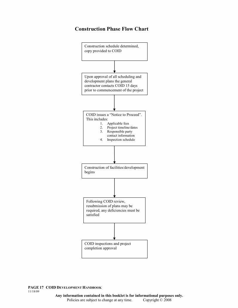
COID issues a “Notice to Proceed”. This includes:
1. Applicable fees 2. Project timeline/dates 3. Responsible party
contact information 4. Inspection schedule
Construction schedule determined, copy provided to COID
Upon approval of all scheduling and development plans the general contractor contacts COID 15 days prior to commencement of the project
Construction of facilities/development begins
Following COID review, resubmission of plans may be required, any deficiencies must be satisfied
COID inspections and project completion approval
Construction Phase Flow Chart

PAGE 18 COID DEVELOPMENT HANDBOOK 11/18/09
Any information contained in this booklet is for informational purposes only. Policies are subject to change at any time. Copyright © 2008
V. DEVELOPMENT AND CONSTRUCTION ON OR NEAR COID EASEMENTS
5.1 CONSIDERATIONS AND TIMELINESS OF PROJECT
Irrigation water fills District canals between approximately April 1 and October 30 each year. In addition, COID schedules winter stock runs every 45 days or so, depending on weather. COID engages in planning primarily in its “off season” between November 1 and March 31. This is also its construction season, since the system is empty most of this time. Irrigation season may begin any time beginning April 1st. Therefore any contract work should be completed prior to April 1st. Any work preventing irrigation from commencing on time may result in contractor/developer/owner liability for each day that irrigation water is not allowed to flow through to a given section. Due to the number of development, crossing, piping, and other land use plans, the District will not review plans to alter deliveries, pipe, or crossings after March 1 or before October 1. Please note: there may also be a winter stock run in late March, so please plan accordingly. Central Oregon Irrigation District easements are permanent, perpetual, and exclusive rights to construct, install, maintain and operate an irrigation conveyance system and all related facilities on the surface and within the subsurface of the easement. In no case shall the easement be less than the toe of fill as determined by COID. No person or entity shall be authorized to construct, erect plant, or install any surface or subsurface structures or facilities (including but not limited to fences and/or storage sheds and/or trees) within the easement without first obtaining prior written approval from COID.
5.2 DEVELOPMENT AND CONSTRUCTION STANDARDS Minimum general standards shall be as set forth in the current American Public Works Association Standards (Oregon Chapter). Other additional standards may also apply, depending on individual site characteristics and needs. The following provisions are minimum construction standards for Central Oregon Irrigation District and are intended as a supplement to the APWA standards.
PAGE 19 COID DEVELOPMENT HANDBOOK 11/18/09
Any information contained in this booklet is for informational purposes only. Policies are subject to change at any time. Copyright © 2008
1. No construction or project that requires District inspection shall commence until the appropriate agreements have been signed, construction plans approved, all associated fees have been paid, and a pre-construction meeting has been held.
2. The Developer, or agent, or owner shall be responsible for any faulty material and workmanship for 24 months from the date of the formal written acceptance of the District, or until some other period as may be agreed by the parties as reselected by individual site characteristics and needs.
3. The Developer, or agent, or owner shall comply with all terms and conditions of applicable governmental rules and regulations pertaining to the work.
4. The design and construction of all proposed facilities shall be in conformance with the District standards and requirements.
5. Workmanship and materials not meeting these specifications shall be deemed a violation of the agreement and may result in an immediate suspension of the Contractor's activities in COID easements or on COID facilities. When an authorized representative of the District suspends the Contractor's activities, all work shall cease on the subject project until the violation is corrected. Only the specific representative that suspended the work or the District Manager or a District authorized agent is authorized to release the project for continuation.
6. Plans and specifications for any work dealing with District easement or facilities, must be submitted to COID for review and approval prior to any construction. The Contractor shall not commence operations on site until the District has approved the plans and issued a “Notice to Proceed,” fees have been paid, and any additional requirements of COID have been completed and all District Agreements have been executed.
5.3 PROPOSED DEVELOPMENT REVIEW PROCESS AND TIMELINE The District may comment on local government notice of land use applications. It is the developer‟s responsibility to contact the notifying local government to receive copies of the District‟s response.
1. Blue Line Copy of Plans: Construction plans are reviewed by COID (Blue line copy). If COID concerns are addressed satisfactorily, fees have been paid, all agreements have been executed, and a clean blue line copy has been provided with the mylar, plans will be signed as soon as possible by the District Manager.
2. Review Period: Once submitted, a maximum of ten business days shall be required for review by the District. Once reviewed, plans shall either be approved as submitted, reviewed with the Design Engineer, or returned with comments. All previously submitted materials and any District comments to facilitate review shall accompany resubmitted plans.
a) If a contact name and number is provided, the District will contact the
specified party to inform them the plans/plat have been signed or inform them of what changes need to be made as soon as reviewed and/or signed. Please do not call to see if the plans/plat has been signed. Plans will be addressed as soon as possible in the order received.
PAGE 20 COID DEVELOPMENT HANDBOOK 11/18/09
Any information contained in this booklet is for informational purposes only. Policies are subject to change at any time. Copyright © 2008
3. COID Records: Plans and Plats shall not be signed unless accompanied by a new, clean, blue line copy for COID records. The copy must be identical to the copy being signed. The copy is for District records of plans/plats signed.
5.4 PLAN SUBMITTAL The Developer or agent shall be responsible for preparation of engineered drawings for the work affecting the District. A Professional Engineer licensed in the State of Oregon shall prepare engineered drawings. Drawings shall be prepared on 24 x 36 sheets following the standard of care for engineered designs in Oregon. Whenever possible, the plans shall show all improvements contemplated for the entire area under development with enough of the surrounding improvements indicated to adequately show how the proposed improvement shall impact the surrounding facilities. The plan is to be submitted by the Developer or owner, or his engineer, to COID for approval. The plan shall be signed by a Registered Professional Engineer and certified by that person to be complete to the best of their abilities. At least one reproducible mylar and clean copy shall be submitted to the District for final approval. An electronic copy of the pertinent drawings shall also be submitted in PDF and AutoCAD format on CD. All Agreements shall be obtained and applicable fees shall be paid as a condition of the issuance of the “Notice to Proceed” prior to authorization by the District to commence construction. No changes or revisions to the approved plans shall be considered effective without the following:
1. The assigned District Inspector may verify and approve the change. The inspector shall note the change on his field drawings, or
2. For significant changes as determined by the District, a blue line copy, a mylar sheet and an electronic file as requested, of the revised sheet noting the revision shall be submitted to the District for approval. The revision shall be noted in a revision box. Revision approval is required prior to construction.
5.4.1 SUBMITTAL CHECKLIST At minimum, the following shall be included, as applicable:
1. Cover Sheet 2. Site plan and vicinity map at appropriate scale 3. Detailed site plan 4. Map of applicable drainage area and drainage way 5. Size and total linear feet of any proposed irrigation pipe 6. Profile showing the slope of all COID pipes and canals 7. Scale details for irrigation structures 8. Thrust calculations and the number of thrust restraints 9. Size and characteristics of any utilities crossing the District facility

PAGE 21 COID DEVELOPMENT HANDBOOK 11/18/09
Any information contained in this booklet is for informational purposes only. Policies are subject to change at any time. Copyright © 2008
10. Developer/owner's name as shown on the County Assessor‟s tax roll, with current mailing address and telephone number
5.4.2 “AS BUILT” DRAWINGS The Developer/owner, or its representative, shall prepare all necessary As-Built drawings. Throughout the development process, the designated inspector shall rely on these representations to insure that development conforms to the approved plan, any approved delimitations need to be noted by the contractor or sent to the Developer/owner, or its representative. Any changes that appear on the “As Built” drawings should be immediately brought to the attention of the Inspector and the Developer/owner, or its representative for review. A final set of As-Built drawings and the revised electronic copy shall be prepared by the Developer and supplied to the District. As-Built‟s not reflecting all changes will be returned to the Developer for revision and resubmission to the District. These drawings will be a requirement for the signing of all plats in which a District facility has been altered.
5.4.3 INTRODUCTION MEETING Developers, engineers and their agents must meet with COID and other principals of development in order for all parties to understand and agree upon District requirements and timelines. During this initial meeting, the scope of the project and the impact on COID facilities is to be discussed. This meeting is should occur as early as possible in the planning and design process to avoid future problems and costs to all parties.
5.4.4 ENGINEERING DESIGN REVIEW The engineer must provide an analysis of the impact the development or construction will have upon COID‟s facilities. Once they are defined, it is likely that a design for new facilities or the replacement of current facilities will be in order. The District will review such plans.
5.4.5 CONSTRUCTION OF FACILITIES & NOTICE TO PROCEED Authorization to start construction shall only be granted by a written “Notice to Proceed.” The general contractor (or other appropriate entity) shall contact COID at least 15 business days prior to commencement of construction to verify project details and obtain a written Notice to Proceed from the district.
Requirements for a Notice to Proceed:
1. Applicable Fees (See Fee Schedule) 2. Project start date 3. Project completion date 4. Project responsible party and information 5. 24-Hour contact information 6. Inspection Schedule 7. Other requirements as needed for site specifics.

PAGE 22 COID DEVELOPMENT HANDBOOK 11/18/09
Any information contained in this booklet is for informational purposes only. Policies are subject to change at any time. Copyright © 2008
5.4.6 PROJECT COMPLETION Once the project is done and a final inspection from COID is complete, the general contractor or other appropriate entity shall provide to COID an electronic copy of the project As-Builts.
5.5 PLATS Final Plats shall be submitted to the District for final approval and signature. A full sized copy shall be submitted to the District with the applicable mylar. When the plan has been produced electronically, the plat shall also be submitted to the District in PDF and AutoCAD format on CD.
The developer shall show on the subdivision plat all existing easements, rights of way and facilities and any roads or crossings, new or existing, which touch, concern, or cross the District's facilities or existing easements. In every case, prior to any construction involving District facilities the developer must have District signoff. The developer shall further develop the subject property in such a manner so as not to adversely affect any of the District's facilities.
In addition to State of Oregon requirements, the final plat shall contain the following language as indicated:
1. For Irrigation Easements – This easement is granted to the Central Oregon Irrigation District and shall be a permanent, perpetual and exclusive right to construct, install, maintain, and operate an irrigation line and all related facilities on the surface and within the subsurface of the easement. No person or entity shall be authorized to construct, erect or install any structures or facilities on the surface or within this easement without first obtaining written approval from the District.
2. For Irrigation Access Easements – This easement is granted to the District and shall be a permanent, perpetual and exclusive right for the use, construction, installation, and maintenance for District vehicular or pedestrian access.
3. Easements and Structures – All monumentation needs to be placed outside district easements. COID easements are for operations and maintenance of District facilities. Monuments within the easement are not the responsibility of COID to replace. A statement needs to be placed on the improvement and plat plans stating that “All Monumentation must be placed outside Central Oregon Irrigation District right-of-way; pins placed inside the right-of-way are not the responsibility of the District to replace.”
As-Built Drawings will be a requirement for the signing of all plats in which District facilities have been altered.
5.6 AGREEMENTS All agreements shall be signed and paid for prior to District‟s signing of construction plans and allowing construction on the associated facility. The District prepares these agreements. It is the responsibility of the Developer/owner, or his/her agent, to submit all
PAGE 23 COID DEVELOPMENT HANDBOOK 11/18/09
Any information contained in this booklet is for informational purposes only. Policies are subject to change at any time. Copyright © 2008
necessary information and to ensure all agreements have been completed prior to plan submittal and start of construction.
5.7 PRE-CONSTRUCTION MEETING A pre construction meeting shall be held following construction drawing approval and prior to “Notice to Proceed” for construction. Before the meeting can be held, agreements must be signed and payment received by the District. The District must have plan copies and acceptable electronic files of the construction plans. Items to be discussed/supplied are:
1. Contractor's work schedule; 2. Inspector assignment; 3. Traffic Control/Public Notification; 4. Subcontractors and suppliers; 5. Materials furnished (i.e. type, brand, etc.) trench backfill-sieve/proctor; 6. Public safety requirements; and 7. No inspections shall be performed until a pre-construction meeting has been held
with the District. At this time, an inspector shall be assigned to the project and all communications, changes, and field decisions shall be coordinated through this inspector. Changes made without inspector approval are violations of District requirements.
5.8 UTILITIES The construction drawings shall show the location of all existing and proposed utilities. The Developer is responsible for the coordination of this work with any other agencies or individuals that may in any way be involved with the construction.
5.9 INSPECTIONS Inspections are the visual observation of construction methods and results. They are made to permit the Engineer to render his or her professional opinion as to whether the Contractor is performing the work in a manner in accordance with the plans. Authorized representatives of the District shall be appointed as inspectors for any or all phases of the work related to the District to ensure that the installation shall conform to District Standards. Any work performed without a required inspection shall be subject to removal at inspector‟s discretion. Inspections shall generally include, but not be limited to, observation of all pipe, location and marking of utilities, construction staking, trench, blocking, no rock point projections, bedding, backfill, pipe alignment is true, fittings tight, inspection of forms and rebar before pouring concrete.
5.10 TESTING Prior to testing any irrigation facilities, all other underground utilities shall be complete and in place. The Developer/owner shall be responsible for obtaining all utility plans from the utility companies and submitting them to the District before commencing testing operations. The intent of this provision is to insure that no District facility has been disturbed by the facilities or operations of utility companies. Pressure testing shall be
PAGE 24 COID DEVELOPMENT HANDBOOK 11/18/09
Any information contained in this booklet is for informational purposes only. Policies are subject to change at any time. Copyright © 2008
performed for all irrigation pipe installations to 125psi and for a working pressure of 100psi.
5.11 CONSTRUCTION STAKING/SURVEYING The purpose of this section is to define the responsibilities for construction surveying. All survey work shall be conducted by or under the supervision of a Registered Professional Land Surveyor or Professional Engineer, licensed in the State of Oregon. The Contractor shall be responsible for providing all construction staking as required to complete the work. The guard stakes should contain the following information:
1. Engineer's station (on back) 2. Offset from line (underlined) 3. Offset from control point (circled) 4. Cut or fill to grade 5. Distance right or left from centerline on curb stakes (on back) 6. Irrigation lines shall be staked to top of pipe by means of an offset line at
the appropriate intervals.
All structures shall be staked to the line and grade as shown on the plans or as directed by the engineer. Property Pins/Monumentation shall not be placed on the property line when line is defined by an open canal or pipe. All pins shall be placed at an offset outside the easement as not to damage the pipe and cause operational and maintenance issues for COID. Any pins placed within the easement area shall not be COIDs responsibility to replace when removed due to operation and maintenance of the facility.
5.12 STORM WATER SWALES COID will require that a full Geotechnical Site Characterization be completed for storm water swales located within the vicinity of a COID facility. This report will determine probability of seepage from the canal into a storm water swale and water seepage from a swale into a COID facility. COID will assume no responsibility for non functioning swales due to water infiltration from our facilities. Please see Appendix “C” for a full report on storm water disposal swales, and an example of a geotechnical analysis.
5.13 BLASTING No blasting within 100‟ of canal centerline will be allowed without prior written approval by the District. Where rock must be removed within the right-of-way, hydro hammering may be used subject to COID review and prior written approval. Should approval for blasting be provided by the District, the Contractor shall submit a blasting plan and conduct a pre blast survey of adjacent structures.
PAGE 25 COID DEVELOPMENT HANDBOOK 11/18/09
Any information contained in this booklet is for informational purposes only. Policies are subject to change at any time. Copyright © 2008
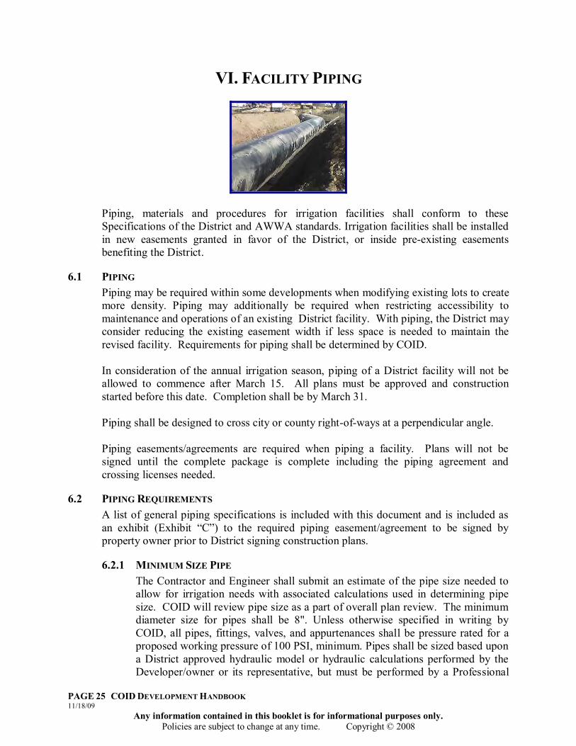
VI. FACILITY PIPING
Piping, materials and procedures for irrigation facilities shall conform to these Specifications of the District and AWWA standards. Irrigation facilities shall be installed in new easements granted in favor of the District, or inside pre-existing easements benefiting the District.
6.1 PIPING Piping may be required within some developments when modifying existing lots to create more density. Piping may additionally be required when restricting accessibility to maintenance and operations of an existing District facility. With piping, the District may consider reducing the existing easement width if less space is needed to maintain the revised facility. Requirements for piping shall be determined by COID. In consideration of the annual irrigation season, piping of a District facility will not be allowed to commence after March 15. All plans must be approved and construction started before this date. Completion shall be by March 31. Piping shall be designed to cross city or county right-of-ways at a perpendicular angle. Piping easements/agreements are required when piping a facility. Plans will not be signed until the complete package is complete including the piping agreement and crossing licenses needed.
6.2 PIPING REQUIREMENTS A list of general piping specifications is included with this document and is included as an exhibit (Exhibit “C”) to the required piping easement/agreement to be signed by property owner prior to District signing construction plans.
6.2.1 MINIMUM SIZE PIPE The Contractor and Engineer shall submit an estimate of the pipe size needed to allow for irrigation needs with associated calculations used in determining pipe size. COID will review pipe size as a part of overall plan review. The minimum diameter size for pipes shall be 8". Unless otherwise specified in writing by COID, all pipes, fittings, valves, and appurtenances shall be pressure rated for a proposed working pressure of 100 PSI, minimum. Pipes shall be sized based upon a District approved hydraulic model or hydraulic calculations performed by the Developer/owner or its representative, but must be performed by a Professional

PAGE 26 COID DEVELOPMENT HANDBOOK 11/18/09
Any information contained in this booklet is for informational purposes only. Policies are subject to change at any time. Copyright © 2008
Engineer. The District will provide maximum and minimum flow rates to the Developer/owner for use in such calculations. In general, no upstream head increase will be allowed to be caused by the installation of a proposed facility.
6.2.2 BENDS AND JOINT DEFLECTION Joint deflection shall be called out in the number of degrees per joint and radius of curvature when several joints in succession are to be deflected. Deflection and pipe bending shall be 75% of the manufacture‟s maximum allowance.
6.2.3 DETECTION TAPE/ TONING WIRE Toning wire shall be placed on top of the pipe in a size no smaller than 10 gauge, and shall run the course of the pipe. Two inch (2”) detection tape shall be installed on all non-metallic main line, non-metallic service line, angled or meandering service lines, and mains and services. The detection tape shall conform to the specifications of the APWA standards. Two courses of detection tape may be required: one on top of the pipe zone material and the second at 18" below sub-grade or ground level depending on pipe depth.
6.2.4 ALL WEATHER ACCESS A paved access path or road sufficient for service equipment to operate without blocking the traveled way shall be constructed if needed. Should such access road be required, it shall be a minimum of 14' in width and shall be surfaced with a minimum of 4" of compacted cinders or aggregate base to allow vehicular access for repairs and maintenance. The road shall be shaped to promote drainage and shall not cause the pooling of storm water. Support facilities such as but not limited to drainage structures, vehicular turnaround, or a pad lockable gate may also be required. Drainage of such surfaces may not be graded toward District facilities if open.
6.2.5 MEASUREMENT DEVICES Every delivery shall be measurable and controllable to the satisfaction of COID. For gravity deliveries, pressurized water shall be suitably de-energized and a concrete box and square notch weir shall be installed per District standards. The Developer/owner or its representative shall be responsible for initially sizing the services to plans and submitting to the District for approval.
6.2.6 General Piping Notes 1. Plans and profiles are required for each piping job. (Please see piping
specifications attached.) 2. Electronic drawings of proposed pipe centerlines shall be provided to the mapping
department of the COID office. 3. Every delivery shall be measurable and controllable. 4. There is a minimum requirement of 18” fill cover for any piping job. Fill shall be
level with ground. Exception may be allowed in some circumstances provided engineer drawing proposal.
5. Construction plans for piping facilities shall include details of cleanouts and all piping structures.
PAGE 27 COID DEVELOPMENT HANDBOOK 11/18/09
Any information contained in this booklet is for informational purposes only. Policies are subject to change at any time. Copyright © 2008
6. Facilities to be piped across existing or future intersections or streets shall cross as close 90 degrees as possible, subject to District review.
7. Construction depicting inlet structures include a trash rack with a minimum slope of 2:1 and no horizontal rails. Wing walls of inlet structures shall angle into the bank at a 45 degree angle and extend no less than 24” into the canal wall, with bentonite packed around the edges with an overlay of riprap. (Please see Appendix “A” for inlet examples.)
6.3 PIPING EASEMENT/AGREEMENT REQUIREMENTS The property owner is the “Grantor” of a new or modified easement to the District. Such document shall be recorded against the servient land in county land records at Grantor‟s expense. The piping easement/agreement shall be prepared by COID with information and exhibits provided by the Developer/owner as follows (Please see Appendix “B” for examples):
1. Centerline description of new pipe easement centered over pipe.(Labeled as Exhibit “A”)
2. All full legal names of property owners holding an interest where pipe shall be located as evidenced by a recent title report. (Note: If there is more than one owner of the property, all interest holding owners shall provide notarized signature after the agreement has been completed by COID. If the property is owned by a corporation, LLC, association, etc., proof of authority for signing member(s) shall be provided to the District.)
3. Plan and profile of pipe including but not limited to elevations, cover, inlet and outlet structures, cleanouts, details, etc. (Labeled as Exhibit “B”).
4. The piping easement/agreement shall be signed and notarized by the property owner(s) prior to COID signing construction plans.
5. All conflicting uses in the subject area of the piping shall be resolved by Developer/owner prior to presentment to District.
It is not the responsibility of COID to make contact with developers and/or engineers to collect all required information needed for completion of piping agreements. All required information shall be provided to the District for review.
See Section IX, 9.1 – 9.4, Exhibits Needed for Documents for all necessary information and Section X, Fee Schedule, of this document for Piping Easement/Agreement fees.
6.4 EASEMENT REDUCTIONS General easement widths may be reduced when piping to District specifications and full easement width is no longer needed for maintenance/repair/use by District. General reductions when piped to District specifications:
Facilities with <5 cfs = 20‟ easement Facilities with 5 – 24.9 cfs = 20‟ plus 10‟ on one accessible side Facilities with 25 cfs and greater = 40‟ easement Main Canal = 50‟ easement
PAGE 28 COID DEVELOPMENT HANDBOOK 11/18/09
Any information contained in this booklet is for informational purposes only. Policies are subject to change at any time. Copyright © 2008
6.5 CENTRAL OREGON IRRIGATION DISTRICT PIPING SPECIFICATIONS
1. The District requires an engineered pipe plan, specifically, construction design including plan and profile views. Pipe shall meet a minimum 100 psi pressure requirement. The District required pipe is HDPE SDR 17 or C-900/5 or equivalent.
2. The District requires the easement to be granted to the District, without any reservation, in perpetuity.
3. Cleanouts are required at every 22.5° and greater and every 250‟. Diameter of riser shall be same diameter as main line pipe unless otherwise approved by COID.
4. Impervious material, (clay or bentonite) to be placed and compacted with optimum moisture around the inlet and outlet structures.
5. There shall be a minimum of 18” of separation between COID pipes and any other utility.
6. Trench section shall have a minimum of 4” of bedding and select material shall continue to a minimum of 12” over pipe. Select material shall be ¾” minus gravel material and a sample shall be provided for approval.
7. 10 gage toning wire will be installed along the entire reach of this piping project for location purposes.
8. 2‟ wide “Irrigation” detection tape will be placed no lower than 18‟ below grade. A second course may be required depending on pipe depth.
9. Landowner shall provide the District with an as-built centerline survey (by a licensed surveyor) of the pipe installation prior to completing the backfill process. The District will also require a hard copy map and electronic drawing.
10. Documentation verifying ownership of parcel where piping is to take place is required prior to piping.
11. A piping fee of $750.00 is required prior to signing to cover review, drafting of the piping agreement, and recording costs. Inspection of installation shall be the responsibility of the Developer/owner. Crossing fees shall be paid prior to signing.
12. It is the responsibility of the Developer/owner to obtain the proper licenses and make sure all associated fees are paid prior to the start of excavation.
13. All work is scheduled with the District so as not to interfere with the monthly stock water runs and completed prior to April 1.
14. There shall be no encroachments to the COID easement without a permit from this office.
15. Any crossings of the COID easement shall be by permit only and shall be recorded at the District‟s office for instructions and associated fees.
16. No structures, fences, trees or shrubs, concrete, or asphalt will be permitted within the easement. Existing structures or improvements are subject to removal or destruction if they may impede District maintenance/repair responsibilities. If structures or improvements are installed, it will be with the understanding that if any damage occurs during maintenance to or replacement of the pipe, the District will not be held liable.

PAGE 29 COID DEVELOPMENT HANDBOOK 11/18/09
Any information contained in this booklet is for informational purposes only. Policies are subject to change at any time. Copyright © 2008
VII. CROSSING GUIDELINES
7.1 CROSSING LICENSES ARE REQUIRED FOR ALL NON-DISTRICT CONSTRUCTION INSIDE OF COID EASEMENTS THAT TOUCH OR CONCERN COID EASEMENTS OR FACILITIES. Crossing license applications shall be submitted and approved prior to COID signing construction plans. Crossing of the COID canals entails risk to the District, patrons, and the public. Risk of crossing rests with applicant. Professional engineering is required and shall include site investigation, design, and course of construction observation, to insure that crossings are appropriately installed. Site particulars shall govern further engineering and/or design work necessitated by location specifics.
1. COID requires that a site investigation by a professional engineer with geotechnical experience is completed before a license is issued.
2. COID shall issue written approval, approval with conditions, or denial of proposed crossing designs. Incomplete applications may be denied if not properly amended.
3. COID may prohibit crossings at its sole discretion. If an approval is granted, a license will be issued by the COID. No work is to begin until the COID has issued a license and received the appropriate fees have been paid in full.
4. COID will require a crossing fee and a review fee for every crossing. It is also required that Pre-Construction meetings take place to review and apply District guidelines to the specific site.
Inspections: Once the information is received and COID has the opportunity to visit the site, COID shall issue written comments. Once approved for construction, the applicant or contractor shall contact the District prior to completion of crossing construction and request final inspection. Notification for inspection shall be made a minimum of one full business day in advance of inspection. Inspection shall be made prior to backfill of underground crossings. Hold Harmless: Applicant of crossings shall agree to hold the COID harmless from any claims or damages arising out of the installation of the described crossing located above, over, or under the COID facility.
PAGE 30 COID DEVELOPMENT HANDBOOK 11/18/09
Any information contained in this booklet is for informational purposes only. Policies are subject to change at any time. Copyright © 2008
7.2 MAIN CANAL AND LATERAL CROSSING GUIDELINES The District requires that every canal crossing shall be designed by a professional engineer with geotechnical experience. Crossing of a COID facility entails significant risk to the District, patrons, and the public. Risk of crossing rests with applicant. Professionals involved in the crossing design shall be responsible for site investigation, design and course of construction observation to insure that the civil and geotechnical works are appropriately installed to prevent canal breach, obstruction, or other canal compromises, and maximize public safety. These guidelines provide only a starting point and site particulars shall govern further engineering and/or design work necessitated by location specifics. It is the responsibility of the crossing applicant to contact and arrange for the appropriate professional engineer. However, such professionals must have the appropriately engineering licenses and sufficient experience in similar work. All associated submittals shall be stamped by the responsible professional(s).
IMPORTANT All canal crossing construction projects need to be completed during the winter season (October 31 through March 31). For more information on stock runs and applicable dates, please visit www.coid.org or call (541) 548-6047. Stock runs are customarily scheduled approximately 45 days apart and are staggered between the Central Oregon and Pilot Butte canal systems.
7.2.1 BEFORE BEGINNING CANAL CROSSING:
1. A Site investigation report must be submitted to COID. The site investigation
report shall describe all pertinent site features, and shall include, but not be limited to, the following:
a) A site plan that illustrates the surrounding topography, the physical
features including (geology, exploration points, and the location of crossing).
b) A profile of the crossing through the canal with emphasis on the critical hydraulic sections in the area of the propose construction.
c) Photographs of site from several angles (i.e. in canal if possible, from each side of canal showing berms, etc.)
d) Canal crossing geotechnical testing if appropriate including seismic refraction, or electro-resistivity tomography.
e) Specific recommendations on types of materials proposed for the reconstruction of the canal.
f) An analysis of both critical and exit gradients and elevation of safety factors if piping is to be included in design.
g) Requirements of the geotechnical construction observation program and related documentation.

PAGE 31 COID DEVELOPMENT HANDBOOK 11/18/09
Any information contained in this booklet is for informational purposes only. Policies are subject to change at any time. Copyright © 2008
2. Preliminary design is to be submitted to COID for review. Each design should be site specific according to the findings in the site investigation.
3. Designs shall include:
a) Construction guidelines in anticipation of the observed and/or suspected soil, rock and residual water seepage conditions;
b) Details and extents of the proposed seepage cut-off walls and blankets, along with requirements concerning preparation for contacts between new and native materials.
4. Designs should consider the following:
a) Benefit of including seepage control measures. b) Replacement soils composed of internally stable materials with low
erosion potential and low permeability. c) Contacts with existing soils or rock carefully prepared, limiting
disturbance to the existing embankment and potential for preferential seepage paths.
5. A crossing license is required for any underground, surface, or overhead crossing
of a COID facility. Contact with COID shall be made to acquire a crossing license. Crossing of the Sub Lateral canals shall follow all previous guidelines as well as the ones specified below unless specifically excluded in writing.
Written request to cross with the following information shall be required to proceed with the crossing:
a) Applicant Name, Address, and Phone Number b) Crossing Address c) Township, Range, Section, Quarter/Quarter, Tax lot number d) Type of crossing desired with details of crossing construction to show
compliance with COID specifications if different than District typical for trench or culver crossings.
6. Fees shall be paid in advance of work. Fees are listed under Section X, Fee
Schedule, section of this document
7.2.2 DURING CONSTRUCTION OF CANAL CROSSING:
1. During the course of the installation work, full-time inspection will be required by the responsible professional and/or his assigned inspector (over which he/she is responsible);
2. All material installations shall be tested by a geotechnical professional licensed to perform such work, and shall be certified to the District by said professional;
PAGE 32 COID DEVELOPMENT HANDBOOK 11/18/09
Any information contained in this booklet is for informational purposes only. Policies are subject to change at any time. Copyright © 2008
3. Critical construction should be aided by qualified quality control personnel verifying that the conditions encountered are in agreement with those anticipated and that the work is performed in accordance with specifications; and
4. Compaction should be based on the Modified rather than the Standard Proctor.
7.2.3 CONCLUSION OF CANAL CROSSING:
1. At the conclusion of the work, the responsible professionals shall provide a written and stamped report to COID providing that the installation was made satisfactorily and in accordance with the design.
2. The report shall include, at minimum:
a) An original site investigation; b) A work plan; c) A cross section of canal; d) A plan view and other appropriate details; e) A series of construction photos from before construction to the conclusion
of construction adequately demonstrating equipment, materials and methods were followed;
f) Certification of material testing and compliance with compaction requirements and necessary related representations specific to the project; and
g) A written narrative stating that the crossing went in substantially as the plans show and provide as-built drawings to show alterations, or detailed description of changed conditions encountered and alternatives made with prior written District approval.
The completed structure should be monitored continuously the first time that it is tested and routinely thereafter by applicant, commensurate with applicant’s assumption of risk for the crossing.
7.3 SUB LATERAL CROSSING GUIDELINES
1. Trench crossings shall be constructed as per District Typical (A). Typical (A) is located in Appendix “A.”
2. Culvert road crossings of open ditches shall be constructed as per District Typical (B). Typical (B) is located in Appendix “A”.
3. Crossings shall be perpendicular to District facilities, wherever feasible. 4. Crossing of piped facilities that are deemed substandard may need to be brought
to current District standards in order for the crossing to proceed. 5. Underground crossings of piped irrigation lines shall go under the District facility
with a minimum of 18” separation and perpendicular to the facility. 6. All subsurface crossings of an open ditch will require the installation of a
Carsonite-type flexible marker to be placed on the ditch bank to identify the location of the identified underground crossing.
7. Crossings for such developments include but are not limited to streets, water lines, sewer lines, utilities, and streets.

PAGE 33 COID DEVELOPMENT HANDBOOK 11/18/09
Any information contained in this booklet is for informational purposes only. Policies are subject to change at any time. Copyright © 2008
8. Multiple crossings within subdivisions may require additional information and/or variance on crossing steps.
9. All work shall be completed between October 31 and April 1 and shall not be in conflict with any winter water runs or interrupt water users delivery of irrigation water. Tentative winter stock water runs are posted on the COID website at www.COID.org. The schedule is a tentative plan, do to uncontrollable events. In addition, crossing main canals and/or piping District facilities shall be started prior to March 15. These restrictions are subject to #10, below.
10. Crossing construction during irrigation season shall only be allowed after District approval, and only in emergency circumstances as determined by District.
11. Crossing license fees may be shared by utilities if within the same trench. It will be the utility companies‟ responsibility to communicate with COID. If crossings are in separate trenches a separate crossing license will be required.
12. Plans and Profiles may be required for crossing to enable COID to ensure acceptable crossing elevations and approved construction.
7.4 BORING UNDER CANAL If boring is proposed as an alternative for canal crossing, items 1-12 of Section 7.3.1 shall be followed as applicable. In particular, the responsible professional shall evaluate and prepare and submit to COID for review a boring plan and design with emphasis on sealing the bore and bore pits. The design should emphasize leaving the canal in a watertight condition as good or better than to the bore and should prevent migration of water into the disturbed areas. Bore depth shall be approved by COID and shall be a minimum of 2-feet below the bottom of future piping installation in the canal. Since boring is not a precise construction method, a safety factor for bore depth should be included in the submitted plan. All boring is subject to approval or denial by COID. All liability for such construction shall be assumed by applicant, including consequential damages.
7.5 OVERHEAD CROSSINGS Overhead crossings shall have a minimum of 18 feet clearance from ground surface. Poles and related objects shall be placed outside of the COID easement.
7.5 BRIDGE CROSSINGS COID written permission must be obtained for any proposed bridge crossing over a COID facility. Any crossing installed without written District permission will be removed immediately at owner‟s expense. The proposed crossing must address a number of issues before COID will consider issuing a crossing license or allowing construction to proceed. The issues include but are not limited to the following:
1. No structure may permanently alter or be placed in the canal unless it improves canal operations and/or safety.
2. No alteration to the canal may change the behavior of the water flow from current conditions unless it improves canal operations and/or safety.
3. Excavating within COID‟s easement must be minimized and returned to present or better structural conditions. This includes, but is not limited to, exploratory excavation, bore holes, trenches, etc…
4. No blasting may occur within the vicinity of the canal (100‟)

PAGE 34 COID DEVELOPMENT HANDBOOK 11/18/09
Any information contained in this booklet is for informational purposes only. Policies are subject to change at any time. Copyright © 2008
5. No impediment of the ditch road will be allowed nor restriction to COID personnel access.
6. These crossings shall not impede the District‟s ability to pipe in the future. 7. A crossing shall provide a minimum of 24” of freeboard from the high water mark
across the canal. If the District is intending to pipe then the structure must allow for 36” of freeboard from the top of the pipe.
8. Any activity or access to the canal associated with either preliminary or tertiary evaluations will require notice and written permission from the District.
9. There must be no ongoing adverse operational or financial impact to COID resulting from such project.
10. To the extent that impact to the canal banks and down slope of the canal banks is being considered, a thorough geo-technical evaluation will be required upstream and downstream of the proposed crossing to identify all issues of impact, including but not limited to the hydraulic conductivity of the soil, the depth to solid rock, the current path of seepage water and a determination made that no alteration of those paths will occur.
7.6 INSURANCE Staff shall require appropriate insurance amounts, provisions, and proof of same, prior to commencement of work, sufficient to protect COID, the public, and unrelated private property owners from direct and consequential liability related to the Project.

PAGE 35 COID DEVELOPMENT HANDBOOK 11/18/09
Any information contained in this booklet is for informational purposes only. Policies are subject to change at any time. Copyright © 2008
XIII. IRRIGATION CONTRACTS TO BE RECORDED
8.1 CONTRACTS IN GENERAL The District requires an “Irrigation Contract” to be completed prior to signing construction plans and/or plats. Irrigation Contracts shall apply when land is divided, developed, or redevelopment. Such actions may impact the function or legal requirements relating to District facilities. (Please note that “Lot” and “Parcel” are synonymous for purposes of this document.)
8.2 IRRIGATION CONTRACT (DEVELOPMENT ADJACENT TO OPEN CANAL) The District requires a contract to be executed and recorded prior to signing construction plans or plats. It is required any time there is development adjacent to an open canal that is not to be piped to District specifications, as well as when piped facilities are impacted. It will provide notice of restricted use within the COID easement, clarify liability, and acknowledge possible changes in delivery methods the District may require for the facility. The District will require exhibits to be provided for the contract. Exhibit “A” – Subject property legal description. Exhibit “B” – Tentative subdivision plat or site plan with District easements and facilities clearly labeled.
8.3 DEVELOPMENT IRRIGATION PLAN (DIP) Planned Developments (2 tax lots or more) requesting COID water rights, for surface or groundwater deliveries, are required to obtain District DIP approval prior to final execution of plans. An evaluation process is necessary to establish effective water management and planning for the Development and the District. The DIP should be considered as a guide to planning water requirements for the Development. It should be noted that the information requested by the District will likely be necessary in order to proceed with water transfer applications to the Oregon Water Resource Department (OWRD), and/or with any local governmental land use proceedings. COID will require a fully executed DIP application be submitted to the District for review. All requested documentation must be included with the application. The review process may take 45 days at which time the District Manager will prepare a written decision with findings. An Irrigation Contract will be prepared by COID encompassing the DIP Decision and recorded in appropriate county records. Developments utilizing water rights should be discussed early. Contact the District offices to schedule a Pre-application Meeting with District Staff.
PAGE 36 COID DEVELOPMENT HANDBOOK 11/18/09
Any information contained in this booklet is for informational purposes only. Policies are subject to change at any time. Copyright © 2008
IX. EXHIBITS NEEDED FOR DOCUMENTS
9.1 PIPING AGREEMENT
1. Exhibit A – Legal Description of pipe, centerline and easements (8.5x11) w/ PE or PLS stamp. (By Applicant)
2. Exhibit A (Cont.) – 8.5x11 Depiction of Piping Project w/ Easements (8.5x11) w/ PE or PLS stamp. (By Applicant)
3. Exhibit B – Piping Specification. (By COID) 4. Exhibit C – C.O.I.D. release map. Drawing depicting area of easement to be quick
claimed to applicant. (By Applicant) NOTE: not all piping agreements will need to include Exhibit C.
5. Current property title report or equivalent ownership verification. (By Applicant)
9.2 IRRIGATION CONTRACT (INDEMNIFICATION)
1. Exhibit A: Property/Parcel legal description (8.5x11) w/ PE or PLS stamp. (By Applicant)
2. Exhibit B – Tentative subdivision w/ PE or PLS stamp. (By Applicant) 3. Current property title report or equivalent ownership verification. (By Applicant)
9.3 CROSSING LICENSE
1. Exhibit A – Legal Description of crossing (8.5x11) w/ PE or PLS stamp. (By Applicant) 2. Exhibit A (Cont.) – Depiction of crossing w/ depth and details (8.5x11). (By Applicant) 3. Exhibit B – Crossing Specification. (By COID) 4. Current property title report or equivalent ownership verification. (By Applicant)
9.4 JOINT ROAD USE AGREEMENT
1. Exhibit A – Legal Description of pipe, centerline and easements (8.5x11) w/ PE or PLS stamp. This shall be provided by the developer, engineer, etc.
2. Current property title report or equivalent ownership verification.
REQUIRED INFORMATION FOR ALL AGREEMENTS For completion of the agreement the District must be provided with the legal owner‟s information including their signing name, their title if applicable, company name if applicable, and authority to sign if entity. If ownership is by two people, then both need to sign. If it is owned by an entity, then the name and title of a signing member needs to be given.

PAGE 37 COID DEVELOPMENT HANDBOOK 11/18/09
Any information contained in this booklet is for informational purposes only. Policies are subject to change at any time. Copyright © 2008
X. FEE SCHEDULE Plan Review and Signature Fees Plan Review and Signature Fee for Plats within District boundaries having no water rights or District Easements…………………………… ….…………………………………………...$450 Plan Review and Signature Fee for Plats within District boundaries having District water rights or easements………………………………….…………….....................$750 Note: There will be an additional $50 fee for each lot over 20 on the same plans. Note: Each phase of a subdivision is charged a separate review and signing fee. A separate piping agreement fee will be charged for each piping project regardless of phase. Piping Easement/Agreements………………………………………….....…………………...$750 Irrigation Contract…………………………………………………………………..................$650 Joint Road Use Agreements……………………………………………………....…...............$500 Easement Vacation Quitclaim…………………………………………………….…...............$500 Crossing Fees Facility < 5 cfs……….………………………………………………………..$450 Facility > 5 cfs………....…………………………….......................................$750 Main Canal……………………………………………………...…...............$2,500 Multiple Crossings within Subdivisions…………………...….…………….$2,500 Note: Overhead crossing fees shall be same as surface or subsurface fees. Note: there will now be a fee for both construction plans and plats. There will also be review fees for construction plans and plat in addition to the piping easement/agreement fees as well as fees for completing and recording Irrigation Contracts.
PAGE 38 COID DEVELOPMENT HANDBOOK 11/18/09
Any information contained in this booklet is for informational purposes only. Policies are subject to change at any time. Copyright © 2008
APPLICABLE STATUTES (QUICK REFERENCE)
Oregon Revised Statutes (ORS) Title 45:
Water Resources: Irrigation, Drainage, Flood Control, Reclamation
Chapter:
536. Water Resources Administration
537. Appropriation of Water Generally
538. Withdrawal of Waters From Appropriation; Special Municipal/County Rights
539. Determination of Water Rights Initiated Before February 24, 1909;
540. Distribution of Water; Watermasters; Change in Use, Transfer or Forfeiture of
Water Rights
541. Watershed Enhancement and Protection; Water Development Projects;
Miscellaneous Provisions on Water Rights; Stewardship Agreements
542. Water Resource Surveys and Projects; Compacts
543. Hydroelectric Projects
543A. Reauthorizing and Decommissioning Hydroelectric Projects
545. Irrigation Districts
547. Drainage Districts
548. Provisions Applicable Both to Drainage Districts and to Irrigation Districts
549. Drainage and Flood Control Generally
551. Diking Districts
552. Water Improvement Districts
553. Water Control Districts
554. Corporations for Irrigation, Drainage, Water Supply or Flood Control
555. Reclamation Projects
558. Weather Modification
Oregon Administrative Rules (OAR) Chapter 690

PAGE 39 COID DEVELOPMENT HANDBOOK 11/18/09
Any information contained in this booklet is for informational purposes only. Policies are subject to change at any time. Copyright © 2008
APPENDIX “A” DISTRICT’S TYPICALS
“Typicals are examples only. Crossings and Structures need to be site specific designed and will need to be approved by
Central Oregon Irrigation District”
*TYPICALS ARE NOT TO SCALE*

PAGE 40 COID DEVELOPMENT HANDBOOK 11/18/09
Any information contained in this booklet is for informational purposes only. Policies are subject to change at any time. Copyright © 2008
This Page Intentionally Left Blank

PAGE 41 COID DEVELOPMENT HANDBOOK 11/18/09
Any information contained in this booklet is for informational purposes only. Policies are subject to change at any time. Copyright © 2008
TYPICAL (A) LARGE CANAL CROSSINGS
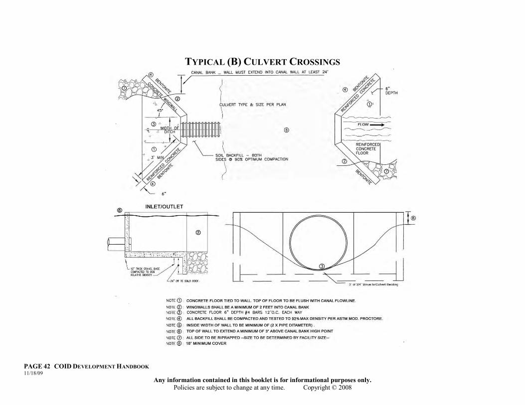
PAGE 42 COID DEVELOPMENT HANDBOOK 11/18/09
Any information contained in this booklet is for informational purposes only. Policies are subject to change at any time. Copyright © 2008
TYPICAL (B) CULVERT CROSSINGS
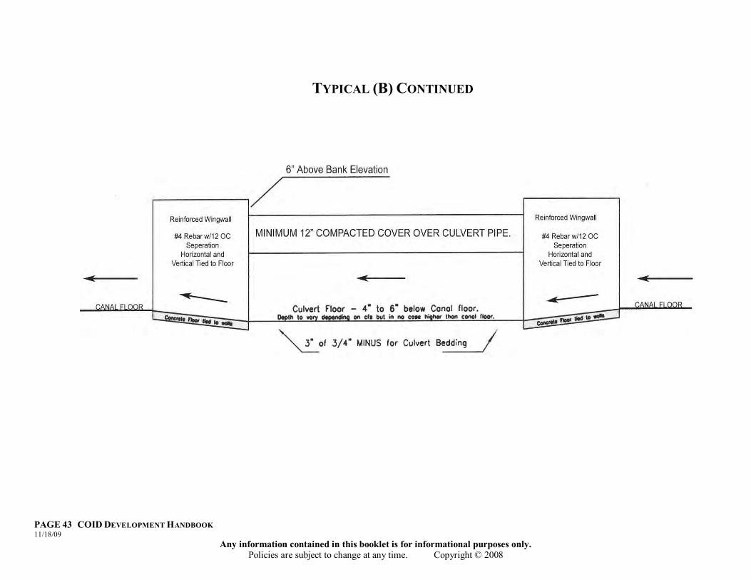
PAGE 43 COID DEVELOPMENT HANDBOOK 11/18/09
Any information contained in this booklet is for informational purposes only. Policies are subject to change at any time. Copyright © 2008
TYPICAL (B) CONTINUED
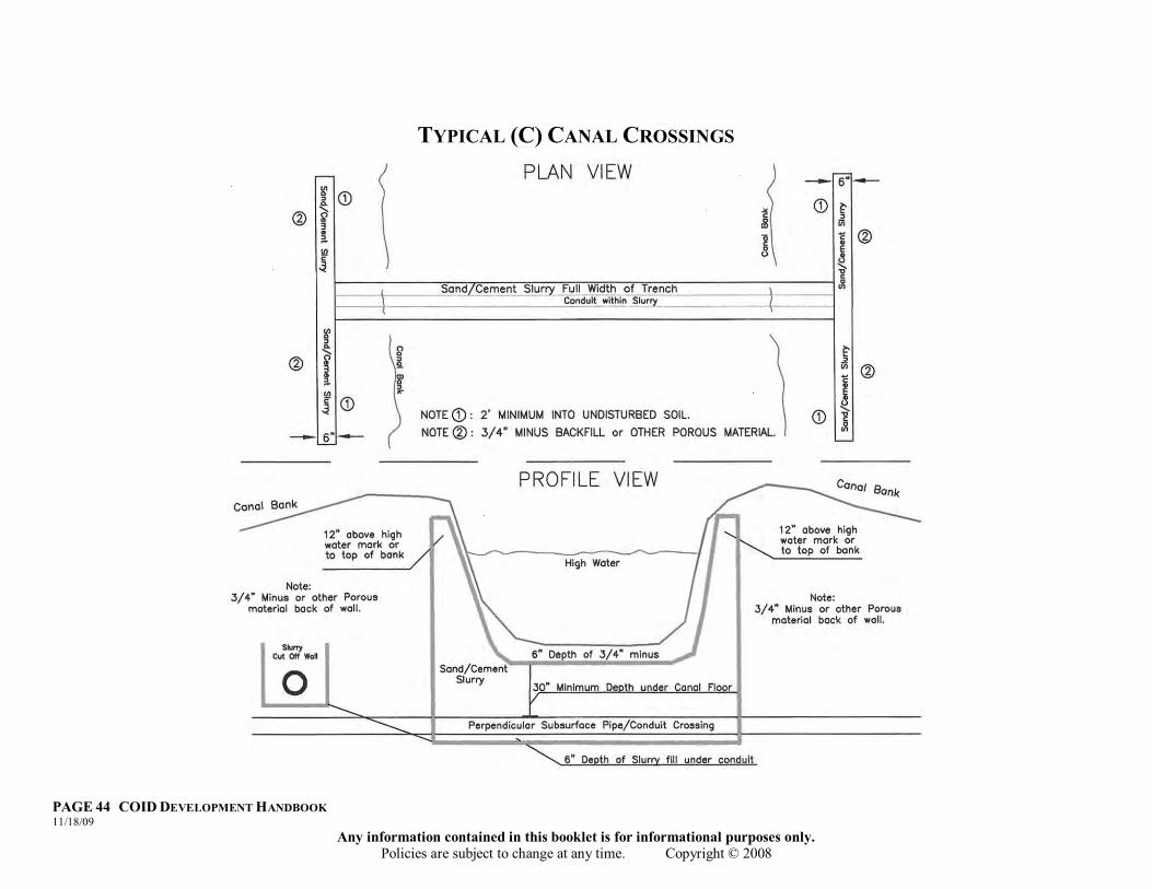
PAGE 44 COID DEVELOPMENT HANDBOOK 11/18/09
Any information contained in this booklet is for informational purposes only. Policies are subject to change at any time. Copyright © 2008
TYPICAL (C) CANAL CROSSINGS
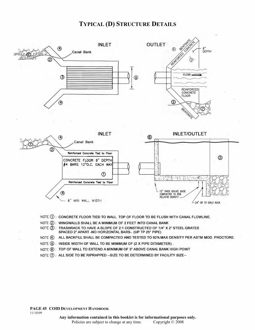
PAGE 45 COID DEVELOPMENT HANDBOOK 11/18/09
Any information contained in this booklet is for informational purposes only. Policies are subject to change at any time. Copyright © 2008
TYPICAL (D) STRUCTURE DETAILS
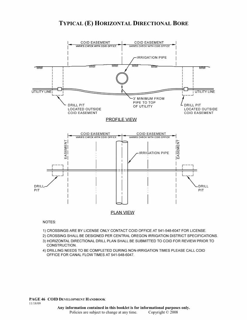
PAGE 46 COID DEVELOPMENT HANDBOOK 11/18/09
Any information contained in this booklet is for informational purposes only. Policies are subject to change at any time. Copyright © 2008
TYPICAL (E) HORIZONTAL DIRECTIONAL BORE

PAGE 47 COID DEVELOPMENT HANDBOOK 11/18/09
Any information contained in this booklet is for informational purposes only. Policies are subject to change at any time. Copyright © 2008
CLEAN OUT DETAIL (HDPE SDR-17)

PAGE 48 COID DEVELOPMENT HANDBOOK 11/18/09
Any information contained in this booklet is for informational purposes only. Policies are subject to change at any time. Copyright © 2008
CLEAN OUT DETAIL (C-900 OR C-905)

PAGE 49 COID DEVELOPMENT HANDBOOK 11/18/09
Any information contained in this booklet is for informational purposes only. Policies are subject to change at any time. Copyright © 2008
CLEAN OUT DETAIL (DUCTILE)

PAGE 50 COID DEVELOPMENT HANDBOOK 11/18/09
Any information contained in this booklet is for informational purposes only. Policies are subject to change at any time. Copyright © 2008
PAGE 51 COID DEVELOPMENT HANDBOOK 11/18/09
Any information contained in this booklet is for informational purposes only. Policies are subject to change at any time. Copyright © 2008
APPENDIX “B” DISTRICT DOCUMENT EXAMPLES
“Documents are examples only. Any changes to the wording will need to be approved by Central Oregon Irrigation
District”

PAGE 52 COID DEVELOPMENT HANDBOOK 11/18/09
Any information contained in this booklet is for informational purposes only. Policies are subject to change at any time. Copyright © 2008
This Page Intentionally Left Blank
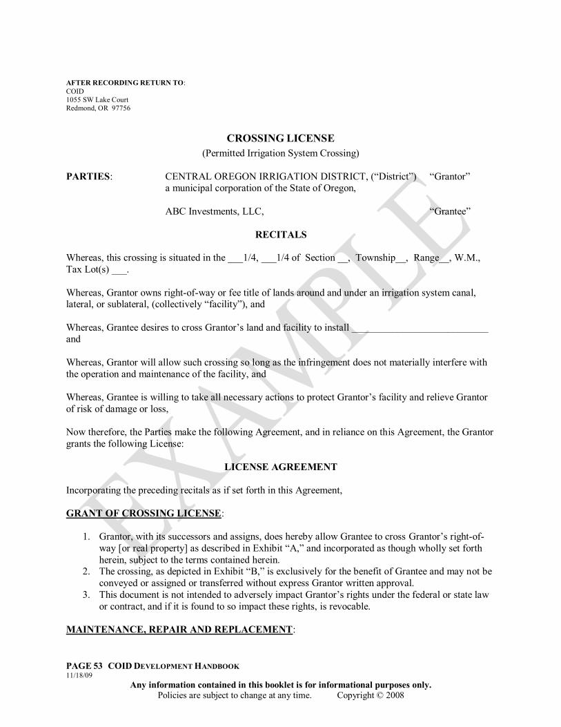
PAGE 53 COID DEVELOPMENT HANDBOOK 11/18/09
Any information contained in this booklet is for informational purposes only. Policies are subject to change at any time. Copyright © 2008
AFTER RECORDING RETURN TO: COID 1055 SW Lake Court Redmond, OR 97756
CROSSING LICENSE (Permitted Irrigation System Crossing)
PARTIES: CENTRAL OREGON IRRIGATION DISTRICT, (“District”) “Grantor”
a municipal corporation of the State of Oregon, ABC Investments, LLC, “Grantee”
RECITALS
Whereas, this crossing is situated in the ___1/4, ___1/4 of Section __, Township__, Range__, W.M., Tax Lot(s) ___. Whereas, Grantor owns right-of-way or fee title of lands around and under an irrigation system canal, lateral, or sublateral, (collectively “facility”), and Whereas, Grantee desires to cross Grantor‟s land and facility to install ___________________________ and Whereas, Grantor will allow such crossing so long as the infringement does not materially interfere with the operation and maintenance of the facility, and Whereas, Grantee is willing to take all necessary actions to protect Grantor‟s facility and relieve Grantor of risk of damage or loss, Now therefore, the Parties make the following Agreement, and in reliance on this Agreement, the Grantor grants the following License:
LICENSE AGREEMENT
Incorporating the preceding recitals as if set forth in this Agreement, GRANT OF CROSSING LICENSE:
1. Grantor, with its successors and assigns, does hereby allow Grantee to cross Grantor‟s right-of-way [or real property] as described in Exhibit “A,” and incorporated as though wholly set forth herein, subject to the terms contained herein.
2. The crossing, as depicted in Exhibit “B,” is exclusively for the benefit of Grantee and may not be conveyed or assigned or transferred without express Grantor written approval.
3. This document is not intended to adversely impact Grantor‟s rights under the federal or state law or contract, and if it is found to so impact these rights, is revocable.
MAINTENANCE, REPAIR AND REPLACEMENT:

PAGE 54 COID DEVELOPMENT HANDBOOK 11/18/09
Any information contained in this booklet is for informational purposes only. Policies are subject to change at any time. Copyright © 2008
1. Grantee shall be responsible for repairing all damages to the facility (including replacing irrigation piping) caused by or resulting from the use, construction, relocation, and/or maintenance of said crossing.
2. Grantee shall be responsible for repairing all damages incurred by third parties that are directly or proximately caused by Grantee‟s errors, acts, or omissions in and around the real property described in Exhibit A.
3. Grantee shall be responsible for relocation, removal or replacement of crossing at Grantee‟s expense, to Grantor‟s standards for operations and maintenance of canal, including, but not limited to, piping of the canal, and specifications noted below.
SPECIFICATIONS: Crossing shall be installed to meet current minimum general standards as
set forth in the current American Public Works Association Standards, and the current City of Redmond Standards and Specifications, Deschutes County Public Works Standards and Specifications, the plans that are on file at the Central Oregon Irrigation District office, and the specifications set forth by the Central Oregon Irrigation District. DATED this ______ day of __________________, 20____. GRANTOR: GRANTEE: CENTRAL OREGON ABC Investments, LLC IRRIGATION DISTRICT By:__________________________ By: _____________________________ Steven C. Johnson, Manager JANE DOE, Member STATE OF OREGON ) )ss. County of Deschutes ) Personally appeared before me this _____ day of _______________, 20____, the above named____________________who is the _____________________ of CENTRAL OREGON IRRIGATION DISTRICT, and acknowledge the foregoing instrument to be their voluntary act and deed on behalf of CENTRAL OREGON IRRIGATION DISTRICT. __________________________ Notary Public for Oregon STATE OF OREGON ) )ss. County of Deschutes ) Personally appeared before me this _______day of ____________, 20____, the above named ____________ who is a member of ABC Investments, LLC, and acknowledge the foregoing instrument to be their voluntary act and deed. AFTER RECORDING RETURN TO:

PAGE 55 COID DEVELOPMENT HANDBOOK 11/18/09
Any information contained in this booklet is for informational purposes only. Policies are subject to change at any time. Copyright © 2008
COID 1055 SW Lake Court Redmond, OR 97756
PIPING EASEMENT PARTIES: CENTRAL OREGON IRRIGATION DISTRICT (“District”) “Grantor”
a municipal corporation of the State of Oregon,
ABC Investments, LLC, “Grantee” GRANT OF EASEMENT: Grantor, its successors and assigns, do hereby grant unto Central Oregon Irrigation District, its successors and assigns, a water pipeline easement as described in Exhibit “A”, and incorporated as though wholly set forth herein. STATEMENT OF PURPOSE: The easement described above is granted to the Central Oregon Irrigation District and shall be a permanent, perpetual and exclusive right to construct, install, maintain and operate an irrigation conveyance system and all related facilities on the surface and within the subsurface of the easement. The width of the easement shall be as described on Exhibit “B”, however, in no case shall the easement be less than the toe of fill as determined by COID. No person or entity shall be authorized to construct, erect or install any surface or subsurface structures or facilities within this easement without first obtaining prior written approval from the Central Oregon Irrigation District. TYPE OF EASEMENT: The easement described above shall be exclusively for the benefit of the District or its assigns and shall perpetually encumber the affected property. This document shall in no way give up any rights granted to the District through the Carey Act. COVENANT NOT TO OVERLOAD AND NOT TO BUILD: Grantor and Grantee understand the danger to the buried pipeline if excessive weights are passed over or placed upon the buried pipeline. Grantor shall not overload the buried pipeline and shall not permit any vehicle or equipment to cross the buried pipeline except at engineered crossings and locations approved by Grantee. Grantor may provide for driveway access over the pipeline approved by Grantee and provided such access shall be constructed in accordance with engineer‟s plans and specifications providing adequate protection for the pipe. Further, Grantor shall not build or allow any structure (including but not limited to fences and/or storage sheds) to be built within the Central Oregon Irrigation Districts easement. If, during repair or maintenance specified below, Grantee damages property or other structures located on any portion of the easement, Grantor will hold Grantee harmless from any damage or claim for damage or repairs. MAINTENANCE, REPAIR AND REPLACEMENT: Grantee shall maintain and repair the water pipeline. Grantor agrees to provide access to Grantee and Grantee‟s equipment for such purpose over and across Grantor‟s real property lying adjacent to the easement. INDEMNITY: Grantor agrees to indemnify and hold Grantee harmless from any claims or damages arising out of the installation of the buried culvert pipe or arising out of the use of the real property located above or adjacent to the buried culvert pipe. COVENANTS RUNNING WITH LAND: The above non-overloading and non-building provisions, maintenance provision and indemnify provision are covenants running with the land and shall be the responsibility of Grantor or any subsequent transferee.

PAGE 56 COID DEVELOPMENT HANDBOOK 11/18/09
Any information contained in this booklet is for informational purposes only. Policies are subject to change at any time. Copyright © 2008
REMEDIES: In addition to all other remedies allowed by law, the parties, their successors and assigns, shall have the right to seek injunctive relief or specific performance for the enforcement of the terms and conditions of this Agreement. BINDING EFFECT: The terms, conditions and provisions of this Agreement shall extend to and be binding upon and inure to the benefit of the heirs, personal representatives and assigns of the parties. ATTORNEY FEE: In case suit or action be instituted upon or in connection with this Agreement, the prevailing party shall be entitled to recover from the losing party such sums as the court may adjudge reasonable as attorney fees and costs in such suit or action, or upon appeal. SPECIFICATIONS: Pipe shall be installed to meet current minimum general standards as set forth in the current American Public Works Association Standards, and the current City of Redmond Standards and Specifications, Deschutes County Public Works Standards and Specifications, the plans that are on file at the District office, and the specifications set forth by the Central Oregon Irrigation District described in Exhibit “B”. RELEASE: This easement is granted to replace COID canal and piping easement/right-of-ways described in Exhibit “C”. COID hereby agrees to abandon its use of said canal and releases and quitclaims all legal rights it has in said easements/right-of-ways for all parts of the easements located within Exhibit “C” upon completion and approval of the new facility described in Exhibit “A”. CROSSINGS: Any crossings of the easement shall be by permit only and shall be recorded with Deschutes County. DATED this ______ day of __________________, 20____. GRANTEE: GRANTOR: CENTRAL OREGON ABC Investments, LLC IRRIGATION DISTRICT By:__________________________ By: _____________________________ Steven C. Johnson, Manager JANE DOE, Member STATE OF OREGON ) )ss. County of Deschutes ) Personally appeared before me this _____ day of _______________, 20____, the above named____________________who is the _____________________ of CENTRAL OREGON IRRIGATION DISTRICT, and acknowledge the foregoing instrument to be their voluntary act and deed on behalf of CENTRAL OREGON IRRIGATION DISTRICT. AFTER RECORDING RETURN TO: COID. 1055 SW Lake Court Redmond, OR 97756
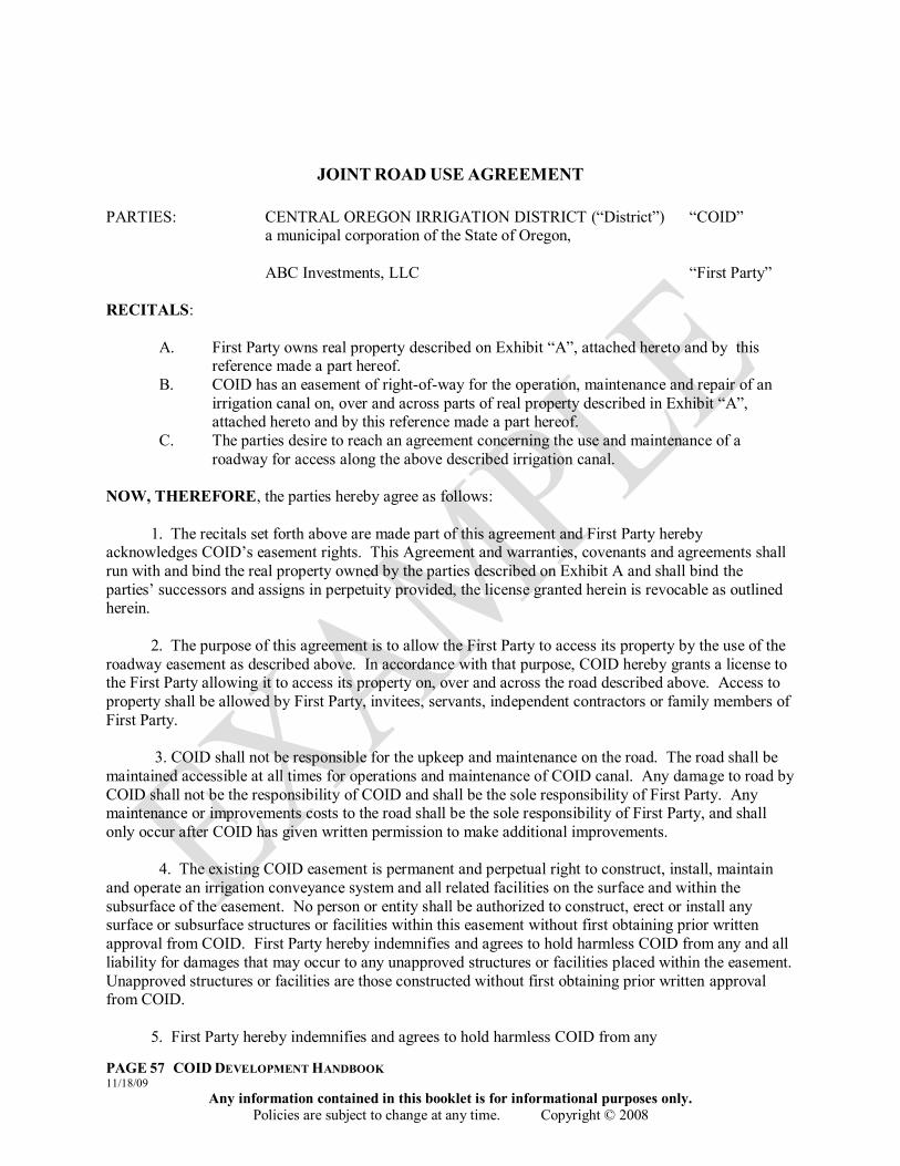
PAGE 57 COID DEVELOPMENT HANDBOOK 11/18/09
Any information contained in this booklet is for informational purposes only. Policies are subject to change at any time. Copyright © 2008
JOINT ROAD USE AGREEMENT PARTIES: CENTRAL OREGON IRRIGATION DISTRICT (“District”) “COID”
a municipal corporation of the State of Oregon,
ABC Investments, LLC “First Party” RECITALS:
A. First Party owns real property described on Exhibit “A”, attached hereto and by this reference made a part hereof.
B. COID has an easement of right-of-way for the operation, maintenance and repair of an irrigation canal on, over and across parts of real property described in Exhibit “A”, attached hereto and by this reference made a part hereof.
C. The parties desire to reach an agreement concerning the use and maintenance of a roadway for access along the above described irrigation canal.
NOW, THEREFORE, the parties hereby agree as follows: 1. The recitals set forth above are made part of this agreement and First Party hereby acknowledges COID‟s easement rights. This Agreement and warranties, covenants and agreements shall run with and bind the real property owned by the parties described on Exhibit A and shall bind the parties‟ successors and assigns in perpetuity provided, the license granted herein is revocable as outlined herein. 2. The purpose of this agreement is to allow the First Party to access its property by the use of the roadway easement as described above. In accordance with that purpose, COID hereby grants a license to the First Party allowing it to access its property on, over and across the road described above. Access to property shall be allowed by First Party, invitees, servants, independent contractors or family members of First Party. 3. COID shall not be responsible for the upkeep and maintenance on the road. The road shall be maintained accessible at all times for operations and maintenance of COID canal. Any damage to road by COID shall not be the responsibility of COID and shall be the sole responsibility of First Party. Any maintenance or improvements costs to the road shall be the sole responsibility of First Party, and shall only occur after COID has given written permission to make additional improvements. 4. The existing COID easement is permanent and perpetual right to construct, install, maintain and operate an irrigation conveyance system and all related facilities on the surface and within the subsurface of the easement. No person or entity shall be authorized to construct, erect or install any surface or subsurface structures or facilities within this easement without first obtaining prior written approval from COID. First Party hereby indemnifies and agrees to hold harmless COID from any and all liability for damages that may occur to any unapproved structures or facilities placed within the easement. Unapproved structures or facilities are those constructed without first obtaining prior written approval from COID. 5. First Party hereby indemnifies and agrees to hold harmless COID from any
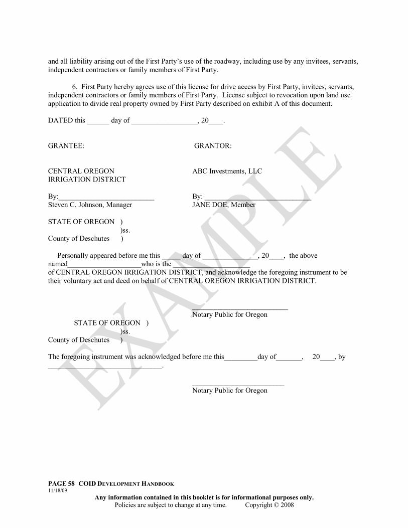
PAGE 58 COID DEVELOPMENT HANDBOOK 11/18/09
Any information contained in this booklet is for informational purposes only. Policies are subject to change at any time. Copyright © 2008
and all liability arising out of the First Party‟s use of the roadway, including use by any invitees, servants, independent contractors or family members of First Party. 6. First Party hereby agrees use of this license for drive access by First Party, invitees, servants, independent contractors or family members of First Party. License subject to revocation upon land use application to divide real property owned by First Party described on exhibit A of this document. DATED this ______ day of __________________, 20____. GRANTEE: GRANTOR: CENTRAL OREGON ABC Investments, LLC IRRIGATION DISTRICT By:__________________________ By: _____________________________ Steven C. Johnson, Manager JANE DOE, Member STATE OF OREGON ) )ss. County of Deschutes ) Personally appeared before me this _____ day of _______________, 20____, the above named____________________who is the _____________________ of CENTRAL OREGON IRRIGATION DISTRICT, and acknowledge the foregoing instrument to be their voluntary act and deed on behalf of CENTRAL OREGON IRRIGATION DISTRICT. __________________________ Notary Public for Oregon STATE OF OREGON ) )ss. County of Deschutes ) The foregoing instrument was acknowledged before me this_________day of_______, 20____, by _______________________________. _________________________ Notary Public for Oregon

PAGE 59 COID DEVELOPMENT HANDBOOK 11/18/09
Any information contained in this booklet is for informational purposes only. Policies are subject to change at any time. Copyright © 2008
After recording return to: CENTRAL OREGON IRRIGATION DISTRICT 2598 N. Hwy 97 Redmond, OR 97756
IRRIGATION CONTRACT
(Development Adjacent to Open Canal) PARTIES: CENTRAL OREGON IRRIGATION DISTRICT (“District”) “COID”
a municipal corporation of the State of Oregon,
ABC Investments, LLC “First Party”
RECITALS: A. First Party owns real property described on Exhibit “A,” attached hereto and by this reference
made a part hereof. The land owned by First Party is currently used for development speculation and is undeveloped at the time of execution of this document.
B. COID is an Oregon municipal corporation formed and operating pursuant to ORS Chapter 545. COID owns and operates the Pilot Butte Canal and the Central Oregon Canal and their lateral systems (“Canal”), which conveys water from the Deschutes River for irrigation of land located within and without the boundaries of the COID, for the generation of hydroelectric power and certain other permitted purposes involving delivery and use of water.
C. COID has maintained the Canal and the head gates and other improvements located on or adjacent to such Canal located within a portion of the Exhibit A real property. COID also has an easement of right-of-way for the operation, maintenance and repair of the Canal on, over and across parts of the Exhibit A real property.
D. COID does not currently deliver water to Exhibit A real property.
E. First Party has filed a request with appropriate local governmental authorities for permission to divide the real property as shown in Exhibit B. First Party plans to call this development Juniper Glen North. Upon completion, this development will increase the use on the subject property and adjacent to the Canal. First Party recognizes and accepts the hazards associated with the open Canal in close proximity to increased use.
F. The parties desire to acknowledge the existing easement for, and the purposes of COID, concerning the safe delivery of irrigation water and guaranteed service to COID patrons in the District. This agreement shall service after the development is approved and shall be recorded in the Deschutes county land records prior to sale of any portion of real property described in Exhibit B, under the terms and conditions described herein, to provide notice of restricted use, clarify liability, and acknowledge possible changes in delivery methods.

PAGE 60 COID DEVELOPMENT HANDBOOK 11/18/09
Any information contained in this booklet is for informational purposes only. Policies are subject to change at any time. Copyright © 2008
AGREEMENT:
NOW, THEREFORE, the parties hereby acknowledge the following:
1. The Recitals set forth above are incorporated into this Agreement as if included herein. 2. First Party hereby acknowledges that COID has existing easement rights under State and Federal
law, including, but not limited to authority under the federal Carey Act, the Desert Lands Act, the Reclamation Act, and the Oregon Revised Statute Chapter 545.
3. This Irrigation Contract shall run with the land and bind the owners of the real property described on Exhibit A, attached hereto and incorporated by reference, and shall bind the parties‟ heirs, successors and assigns in perpetuity, and said Irrigation Contract shall be recorded in the land records of Deschutes County, Oregon, serving as notice to successors and third parties as well.
4. This acknowledges that First Party, its heirs, successors, and assigns, recognize and accept the hazards associated with the open Canal adjacent to the subject property. First Party, its heirs, successors, and assigns hereby indemnifies COID, its agents, successors, or assigns, for any claim, suit or action made against COID to recover for harm or injury which may occur to persons, personal property or real property in the future on or involving the easement property, adjacent properties, or both, depicted in Exhibit B adjacent to the Canal.
5. Further, the parties acknowledge that the servient parcels, property adjacent to the Canal in Exhibit B, are subject to a right-of-way easement benefiting COID for the purpose of operating and maintaining the irrigation system and the Canal located thereon, and will be accessible at all times for ingress and egress over the servient parcel to operate, maintain, construct, erect or install any surface or subsurface structures or facilities necessary to fulfill the purposes of the District in accordance with state and federal law, within the servient parcel. A depiction of the servient parcels are included in Exhibit B, incorporated herein by reference, and include a drawing of the easement area.
6. The parties also acknowledge that COID has the right to pipe this Canal or make other changes to effect the efficient operation of the District, and First Party, its heirs, successors, and assigns, acknowledge that COID may enclose the Canal and that First Party, its heirs, successors, and assigns hereby waive any right to remonstrate such improvement, now or in the future. It is acknowledged by the parties that the Canal may provide some aesthetic benefit to adjacent owners, but that this benefit is incidental to COID‟s purposes as stated in ORS Chapter 545 and as established by the Oregon Legislature and Oregon Administrative Rules from time to time, and that the purposes of COID will govern disposition of the Canal in the future.
DATED this ______ day of __________________, 20____ GRANTEE: GRANTOR: CENTRAL OREGON ABC Investments, LLC IRRIGATION DISTRICT By:__________________________ By: _____________________________
PAGE 61 COID DEVELOPMENT HANDBOOK 11/18/09
Any information contained in this booklet is for informational purposes only. Policies are subject to change at any time. Copyright © 2008
Steven C. Johnson, Manager JANE DOE, Member STATE OF OREGON ) )ss. County of Deschutes ) The foregoing instrument was acknowledged before me on this______day of September, 20_____, by Steven C. Johnson, Manager of the Central Oregon Irrigation District. ______________________________ Notary Public for Oregon STATE OF OREGON ) )ss. County of Deschutes ) The foregoing instrument was acknowledged before me this_________day of September, 20_____, by John Doe, Member, ABC DEVELOPMENT, L.L.C. _______________________________ Notary Public for Oregon

PAGE 62 COID DEVELOPMENT HANDBOOK 11/18/09
Any information contained in this booklet is for informational purposes only. Policies are subject to change at any time. Copyright © 2008

PAGE 63 COID DEVELOPMENT HANDBOOK 11/18/09
Any information contained in this booklet is for informational purposes only. Policies are subject to change at any time. Copyright © 2008

PAGE 64 COID DEVELOPMENT HANDBOOK 11/18/09
Any information contained in this booklet is for informational purposes only. Policies are subject to change at any time. Copyright © 2008
APPENDIX “D” DEVELOPER IRRIGATION PLAN

PAGE 65 COID DEVELOPMENT HANDBOOK 11/18/09
Any information contained in this booklet is for informational purposes only. Policies are subject to change at any time. Copyright © 2008
This Page Intentionally Left Blank
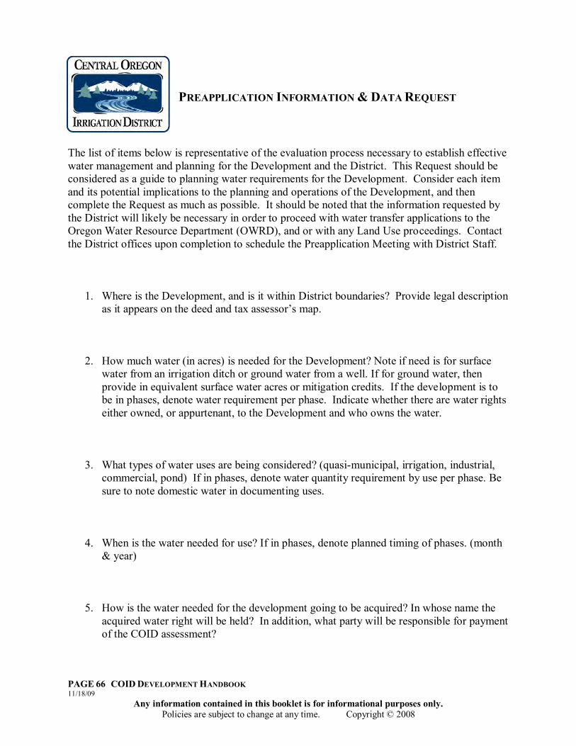
PAGE 66 COID DEVELOPMENT HANDBOOK 11/18/09
Any information contained in this booklet is for informational purposes only. Policies are subject to change at any time. Copyright © 2008
PREAPPLICATION INFORMATION & DATA REQUEST
The list of items below is representative of the evaluation process necessary to establish effective water management and planning for the Development and the District. This Request should be considered as a guide to planning water requirements for the Development. Consider each item and its potential implications to the planning and operations of the Development, and then complete the Request as much as possible. It should be noted that the information requested by the District will likely be necessary in order to proceed with water transfer applications to the Oregon Water Resource Department (OWRD), and or with any Land Use proceedings. Contact the District offices upon completion to schedule the Preapplication Meeting with District Staff.
1. Where is the Development, and is it within District boundaries? Provide legal description as it appears on the deed and tax assessor‟s map.
2. How much water (in acres) is needed for the Development? Note if need is for surface water from an irrigation ditch or ground water from a well. If for ground water, then provide in equivalent surface water acres or mitigation credits. If the development is to be in phases, denote water requirement per phase. Indicate whether there are water rights either owned, or appurtenant, to the Development and who owns the water.
3. What types of water uses are being considered? (quasi-municipal, irrigation, industrial, commercial, pond) If in phases, denote water quantity requirement by use per phase. Be sure to note domestic water in documenting uses.
4. When is the water needed for use? If in phases, denote planned timing of phases. (month & year)
5. How is the water needed for the development going to be acquired? In whose name the acquired water right will be held? In addition, what party will be responsible for payment of the COID assessment?
PAGE 67 COID DEVELOPMENT HANDBOOK 11/18/09
Any information contained in this booklet is for informational purposes only. Policies are subject to change at any time. Copyright © 2008
6. Have you contacted the Deschutes River Conservancy regarding the potential of using
temporary mitigation credits through the Deschutes Water Bank for the Development?
7. What party will be responsible for ensuring beneficial use and managing the water delivery system(s)?
8. Briefly describe how the water for all uses is to be delivered. Descriptions should include wells or COID points of delivery, sprinkler system layouts to all lots, necessary easements, rotations of water use, etc….
9. Has there been any evaluation of present water courses and tail water management? If so, describe below:
10. Other issues or considerations of note with development, including any special points of interest such as designated wetlands or natural hazards.
PAGE 68 COID DEVELOPMENT HANDBOOK 11/18/09
Any information contained in this booklet is for informational purposes only. Policies are subject to change at any time. Copyright © 2008
APPLICATION GUIDELINES
The following information shall be shown on the Development Irrigation Plan Application or provided in the accompanying materials as much as possible. Plan may be considered incomplete unless all such applicable information is provided either in an attachment, exhibit or in narrative.
A. General information required: 1. Proposed name of land division or development, if applicable.
2. Names, addresses and phone numbers of the property owner of record,
authorized agents or representatives, engineer or surveyor, and any assumed business names filed or to be filed with the Corporation Commission by the applicant.
Attachments required:
1. Certified copy of the recorded instrument under which the applicant claims an ownership interest, or copy of a land sales contract which binds the applicant in the event of approval.
2. A Title Report and/or a Subdivision Guarantee prepared within the
previous ninety (90) days by a qualified title company.
3. A copy of a groundwater application submitted to the Oregon Water Resources Department (OWRD) which indicates that the applicant has applied for the intended use of water as applicable. This shall include zone of impact information. Final approval of OWRD shall be required prior to COID approval of transfer. Copy must demonstrate receipt by OWRD.
4. Map of the division (conceptual development plan), including date of
preparation, true north, scale, and gross area of the proposed division. Map shall clearly show proximity to existing COID boundaries and facilities (contact COID offices 541.548.6047 for assistance)
i. Location, names, and widths of existing improved and “unimproved
District canals,” laterals, and related facilities.
ii. Location of any existing features such a section lines, section corners, city and special district boundary lines, and survey monuments.

PAGE 69 COID DEVELOPMENT HANDBOOK 11/18/09
Any information contained in this booklet is for informational purposes only. Policies are subject to change at any time. Copyright © 2008
iii. Location of existing/planned structures, roads, streets, rights of way, railroads, and any specific points of interest such as rock outcroppings, designated wetlands, wooded areas, and natural hazards.
iv. Layout of intended land uses for development, including residential,
commercial, open space, lodging or recreation.
v. Location and direction of water courses, and the location of areas subject to flooding and high water tables, including tail water to or from surrounding properties.
vi. Phasing – show phase lines and dates of proposed development on the
tentative plan.
vii. Location, approximate area, and dimensions of each lot or parcel, and proposed lot or parcel numbers
viii. Location, width, and use or purpose of any existing/planned easement
or right-of-way for utilities, bikeways, and access corridors within and adjacent to the proposed land use division in relationship to COID easements and facilities.
ix. Existing/planned dry wells, sanitary and storm sewer lines, water
mains, septic facilities, culverts, and other underground and overhead utilities on the proposed land division and adjacent public rows.
B. Information/Map concerning proposed Water Management Plan:
1. Planned water facilities to serve the planned area, including facility sizes, general location or routes and how the facilities will tie into adjacent areas and facilities.
2. Location, names, width, typical improvements, cross sections, bridges,
culverts, approximate grades of all proposed streets, roads, and right-of-way and the relationship to all existing and projected streets.
3. Location, width, and purpose of all proposed water transmittals and
relationship to all existing water uses within 500 feet, including surface and groundwater uses.
4. Location, approximate area, and dimensions of any water use proposed
and plans for improvements or development thereof, including required measuring devices.

PAGE 70 COID DEVELOPMENT HANDBOOK 11/18/09
Any information contained in this booklet is for informational purposes only. Policies are subject to change at any time. Copyright © 2008
5. Proposed use, location, approximate area, and dimensions of any point of diversion, pump, storage, or well intended for use within a land division.
6. Source, method, and preliminary plans for domestic and other water
supplies, sewage disposal, storm water disposal and other drainage facility plans, and all utilities relating to water use, including rotations needed and seasonal need differences.
7. Description and location of any proposed common area and community
facility, such as quasi-municipal uses.
8. Proposed deed restrictions including access restrictions or protective covenants if such are proposed to be utilized.


