AP Human Geography--Political Page 1 January, 2015
AP Human Geography Political Geography Introduction In this unit we will study the evolution of the modern state. We will define and identify the concepts of nation
vs. state vs. nation state. Both centripetal and centrifugal forces in modern nations will be discussed: the rise of
nationalism vs. regionalism. Political systems at a variety of scales (local to global), the characteristics of states
(shape, size, location of capital, core vs. periphery), and the types of boundaries and boundary disputes (analysis
of current world crises using above concepts) will also be studied.
Students learn about the nature and significance of the political organization of territory at
different scales. Political patterns reflect ideas of territoriality —how Earth’s surface should be
organized — which in turn affect a wide range of exercises of power over space and boundaries. Two
major themes are the political geography of the modern state and relationships between countries.
Students are introduced to the different forces that shaped the evolution of the contemporary world
map. These forces include the rise of nation-states, especially in Europe; the influence of colonialism
and imperialism; the rise of supranational organizations; and the devolution of states.
Students learn about the basic structure of the political map, including the inconsistencies
between maps of political boundaries and maps of ethnic, cultural, economic, and environmental
patterns. Additionally, students analyze forces that are changing the roles of individual countries in the
modern world, such as ethnic separatism, terrorism, economic globalization, and social and
environmental problems that cross international boundaries (e.g., climate change and acid rain). This
part of the course also focuses on subnational and supranational political units. For example, at the
scale above the state level, attention is directed to regional alliances, such as the North Atlantic Treaty
Organization (NATO), the European Union, the Association of Southeast Asian Nations (ASEAN), and
the North American Free Trade Agreement (NAFTA). At the scale below the state level, students learn
about the ways in which electoral districts, municipalities, indigenous areas, provinces, and
autonomous lands affect political, social, and economic processes. [Course Description: Human Geography, 2015,
The College Board Advanced Placement Program.]
Goals The goals for this section of the course are to:
distinguish between nation, state, nation-state and variations such as a stateless nation;
identify the various shapes which political units can take, and discuss their advantages and
disadvantages
understand the role of core areas and capitals in promoting cohesion and unity in states.
define the various types and classifications of political boundaries, and be able to classify actual
boundaries on a map.
explain types of boundary disputes
identify the factors which foster political integration and state cohesiveness
understand the role that international political systems play in global political geography.
know the issues involved in the United Nations Convention on the Law of the Sea, and identify
potential problems they pose for global economic and political relations.
understand the nature and kinds of regional alliances in the context of global economics and
politics
explain the development of today's world political map in terms of supranationalism and
devolution
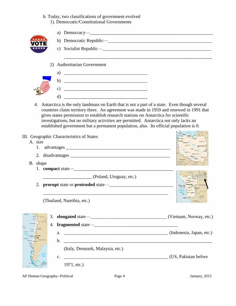
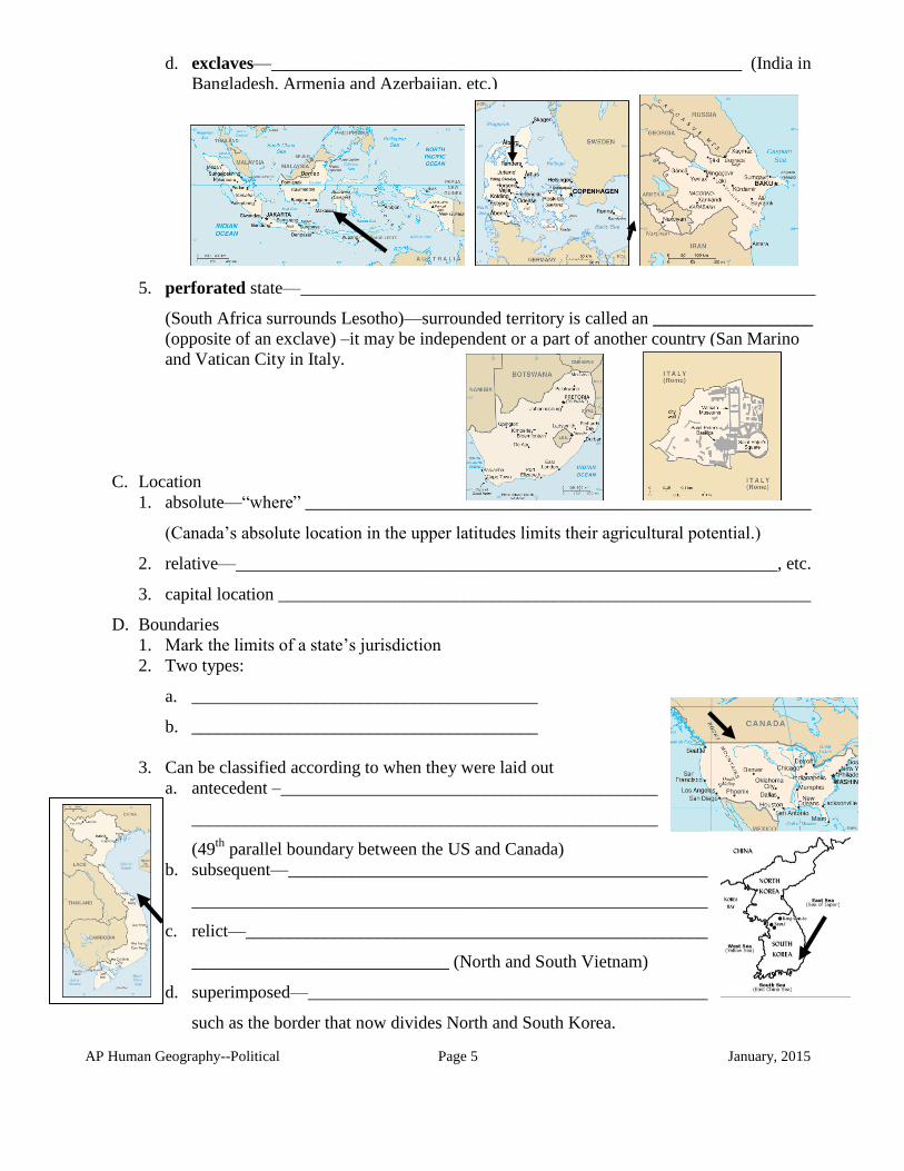
describe the geographic characteristics of states and problems associated with them;
distinguish between types and classifications of boundaries;
analyze contemporary nations in terms of their degree of cohesiveness.
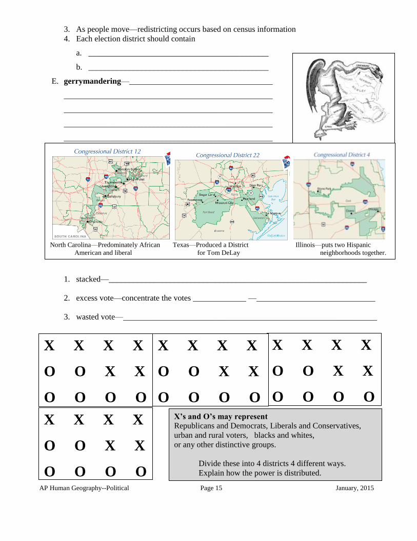
identify the various forms of gerrymandering that are used to influence voting behavior.
AP Human Geography--Political Page 2 January, 2015
Read Chapter 8
Outline Notes I. Definitions
A. State -- A state is ______________________________________________________________
(The term “country” is a synonym for “state.”)
A state must have the following:
An _____________________________________________
A ____________________________ on the Earth’s surface
A permanent _________________________________ and
_____________________________________________ (which means independence from
control of its internal affairs by other states)
________________________by the __________________
B. Nation-- _______________________________________________________
______________________________________________________________
a state can have more than one nation, e.g., Canada
a single nation can be divided among two or more states, e.g. Kurds
C. Nation-State-- ________________________________________________.
Rare, e.g. Japan, Ireland, Denmark and Poland closest examples
D. Binational or multinational state—__________________________________
_____________________________________________________________
E. Stateless nation—_________________________________
—Kurds, Basque, Macedonians, Palestinians
F. Colony—________________________________________
G. Imperialism—___________________________________
________________________________________________
AP Human Geography--Political Page 3 January, 2015
[Colonialism is control of previously
uninhabited or sparsely populated land.]
II. Study of the spatial organization and distribution of political units
A. National Political Systems
1. Earth's surface now completely divided into political units. This is a relatively recent
occurrence.
a. When the US formed in 1776 there were only some _______________ empires,
kingdoms, and countries in the entire world.
b. By the beginning of WWII in 1939 there were only____________________.
2. Today, there are ______________ countries recognized
B. Development of the State Concept
1. Ancient and Medieval States
a. Civilizations developed and evolved in Mesopotamia and the Nile River Valley
b. Various empires formed
c. After the collapse of the Roman Empire the land was divided by estates owed by
competing kings, dukes, barons and other nobles and landowners.
2. Colonies
a. Between 1400’s and 1800’s Europe colonized all over the world.
1) ___________________________________________________________________
2) ___________________________________________________________________
3) ___________________________________________________________________
God—Gold—Glory
b. ________________ had the largest colonial system
c. ________________ was second
3. Modern State
a. First major step was the ______________________ in the emergence of the European
state (signed at the end of the Thirty Years’ of War (1648))
1) ________________________________________________________________
2) _____________________________________________________________ and
3) ___________________________________________________________________
AP Human Geography--Political Page 4 January, 2015
b. Today, two classifications of government evolved
1). Democratic/Constitutional Governments
a) Democracy—_____________________________________________________
b) Democratic Republic—_____________________________________________
c) Socialist Republic—_______________________________________________
________________________________________________________________
2) Authoritarian Government
a) ____________________________________
b) ____________________________________
c) ____________________________________
d) ____________________________________
4. Antarctica is the only landmass on Earth that is not a part of a state. Even though several
countries claim territory there. An agreement was made in 1959 and renewed in 1991 that
gives states permission to establish research stations on Antarctica for scientific
investigations, but no military activities are permitted. Antarctica not only lacks an
established government but a permanent population, also. Its official population is 0.
III. Geographic Characteristics of States
A. size
1. advantages _____________________________________________
2. disadvantages ___________________________________________
B. shape
1. compact state—_____________________________________________
_____________________ (Poland, Uruguay, etc.)
2. prorupt state or protruded state—____________________________
______________________________________________________
(Thailand, Namibia, etc.)
3. elongated state—_________________________________ (Vietnam, Norway, etc.)
4. fragmented state—____________________________________
a. _____________________________________________ (Indonesia, Japan, etc.)
b. ________________________________________________________________
(Italy, Denmark, Malaysia, etc.)
c. _____________________________________________ (US, Pakistan before
1971, etc.)
AP Human Geography--Political Page 5 January, 2015
d. exclaves—_____________________________________________________ (India in
Bangladesh, Armenia and Azerbaijan, etc.)
5. perforated state—__________________________________________________________
(South Africa surrounds Lesotho)—surrounded territory is called an __________________
(opposite of an exclave) –it may be independent or a part of another country (San Marino
and Vatican City in Italy.
C. Location
1. absolute—“where” _________________________________________________________
(Canada’s absolute location in the upper latitudes limits their agricultural potential.)
2. relative—_____________________________________________________________, etc.
3. capital location ____________________________________________________________
D. Boundaries
1. Mark the limits of a state’s jurisdiction
2. Two types:
a. _______________________________________
b. _______________________________________
3. Can be classified according to when they were laid out
a. antecedent –______________________________________________________
______________________________________________________
(49th
parallel boundary between the US and Canada)
b. subsequent—_____________________________________________________
______________________________________________________________________
c. relict—________________________________________________________________
_____________________________ (North and South Vietnam)
d. superimposed—________________________________________________
such as the border that now divides North and South Korea.
AP Human Geography--Political Page 6 January, 2015
4. Boundary Disputes
a. positional or definitional dispute—
____________________________________________
___________________________________________(Argentina and Chile—
water divide and highest peak not always the same) (US and Mexico—Rio
Grande changes its course)
b. territorial or locational disputes—______________________________________________.
Often occurs, though not always, ______________________________________________
_______________________________________________. If one group wants to annex
another state’s territory whose population is ethnically related to that state the expansionism
is called _____________________________.
c. resources (or allocation) boundary disputes—_____________________________________
_________________________________________________________________________
(valuable mineral resources, fertile farmland, rich fishing grounds, etc.) Iraq Vs Kuwait.
d. functional or operational disputes—____________________________________________
_______________________________________________________________(immigration
, movement of traditionally nomadic groups, customs regulations, land use, etc.)
IV. Projection of Power
A. Colonialism __________________________________________________________________
B. Imperialism
_________________________________________________________________________and
C. Decolonization ________________________________________________________________
D. Theories of Geopolitical Power
1. Ratzel’s Organic theory. ______________________________________________________
_________________________________________________________________________
_________________________________________________________________________
_________________________________________________________________________
_________________________________________________________________________
_________________________________________________________________________
AP Human Geography--Political Page 7 January, 2015
2. Halford Mackinder’s Heartland theory. The greatest land power would be sited in
_____________________“_________________________” containing the world’s largest
landmass in both ___________ and ________________. Its _________________ would
provide a base for world conquest, and _________________was the core of that heartland.
Mackinder warned “Who rules __________________________________ commands the
Heartland, who rules the Heartland commands the _______________________________,
who rules the World-Island commands the _____________________________________.”
3. Nicholas Spykman’s Rimland theory. Agreed that _________________was the likely base
for potential world domination, but argued that the ___________________ of the landmass,
not the hearthland, were the key. The continental margins contained dense ____________,
abundant _______________, and had ________________________ both to the seas and to
the continental interior. “Who controls the _______________________ rules Eurasia, who
rules Eurasia controls the destinies of the world.” By the end of WWII the Heartland was
equated with the ______________. To prevent Soviet domination of the World-Island, US
foreign policy was based on the notion of containment of the USSR within its borders by
means of a string of regional alliances in the Rimland. (NATO, CENTO in West Asia and
SEATO in Southeast Asia).
4. What was the domino theory? Adjacent countries are lined up like dominoes; ___________
__________________________________. In the 1960’s we used this theory to explain
and justify US intervention in __________________________________, in the 1980’s in
________________________, and in the 1990’s in __________________________, etc.
AP Human Geography--Political Page 8 January, 2015
V. Changing Nature of Sovereignty
A. State Cohesiveness
Centripetal Forces
(forces that promote unity and stability)
_______________________________________
_______________________________________
_______________________________________
_______________________________________
_______________________________________
Centrifugal Forces
(forces that disrupt, destabilize, and weaken)
______________________________________
______________________________________
______________________________________
______________________________________
______________________________________
1. Nationalism and Regionalism
a. Nationalism is a term that refers to a doctrine or political movement that holds a nation
together—usually defined in terms of ___________________ or___________________
—has the right to constitute an independent or autonomous political community based
on a shared history and common destiny.
b. Regionalism is a political ideology that focuses on the interests of a particular region or
group of regions. Regionalism centers on increasing the region's __________________
______________, either through movements for limited form of autonomy (devolution,
states' rights, decentralization) or through stronger measures for a greater degree of
autonomy (sovereignty, separatism, independence). Regionalists often favor loose
federations or confederations over a unitary state with a strong central government.
2. Location, shatter belts, irrendentism, etc.
a. Location is an important geographic factor when looking at whether a state stays strong
or is pulled apart.
b. Shatter belts occur in regions that are located
_________________________________. Places the smaller, weaker states under stress
and they often fragment or ___________ due to their aggressive neighbors.
c. Irrendentism occurs when one group wants to annex another state’s territory because
the population is ethnically related to that state.
AP Human Geography--Political Page 9 January, 2015
3. Supranationalism refers to associations created by three or more states for their _______
________________________________________________________________________.
(States may lose their individual identity.)
4. Devolution and separatism
a. Devolution is the process where a region _____________ a region demands and gets
political strength and growing autonomy at the expense of the central government.
Three forces
1) ___________ forces—Ethnonationalism—strong ethnic groups within a state wants
their independence.
i.e. French Quebec in Canada; native Inuit in Canada (resulted in the formation the
territory of Nunavut); Basque in Spain; Kurds in Turkey, Iraq, Syria or Iran;
Scotland in the UK; Irish Catholics in Northern Ireland in the UK; Muslims in India
resulting in the formation of Pakistan and Bangladesh; former Yugoslavian state
was broken up into 5 different states in the 1990’s [see Balkanization below] 2) ____________ forces—inequalities in various regions within a state often lead to
movements to divide a state.
i.e. North and South Italy; North and South Korea; Catalonia in Spain.
3) _____________—distance, remoteness, separation, and peripheral location
promotes devolution.
i.e. Tibet in China (P.R. of); two Pakistans; etc.
b. Balkanization is a geopolitical term originally used to describe the process of
fragmentation or division of a region or state into smaller regions or states that are often
hostile or non-cooperative with each other. The term has arisen from the conflicts in the
20th
century Balkans. The first balkanization was embodied in the Balkan Wars, and the
term was reaffirmed in the Yugoslav wars.
B. Supranationalism—International Political Systems
1. United Nations is an international organization whose stated aims are to facilitate
cooperation in international law, international security, economic development, social
progress and human rights issues. The United Nations was founded in 1945 to replace the
League of Nations, in the hope that it would intervene in conflicts between states and
thereby avoid war. There are now 193 United Nations member states.
[Antarctica has no government, political control of Western Sahara is in dispute, and
Taiwan is no longer considered an independent member nation. Vatican City (the Holy See
is a UN observer), the Palestinian territories (Palestine, represented by the Palestine
Liberation Organization, is a UN observer)
AP Human Geography--Political Page 10 January, 2015
2. Law of the Sea—The United Nations Convention on Law of the Sea (UNCLOS) is the
international agreement that defines the rights and responsibilities of nations in their use of
the world's oceans, establishing guidelines for businesses, the environment, and the
management of marine natural resources. The United States has signed the treaty, but the
Senate has not ratified it.
(This replaces the older -- and weaker -- 'freedom of the seas' concept, dating from the 17th
century: national rights were limited to a specified belt of water extending from a nation's
coastlines, usually three nautical miles, according to the 'cannon shot' rule developed by the
Dutch. All waters beyond national boundaries were considered international waters - free to
all nations, but belonging to none of them.)
a. ___________________ waters: Covers all water and waterways on the landward side
of the baseline. The coastal state is free to set laws, regulate use, and use any resource.
Foreign vessels have no right of passage within internal waters.
b. ___________________ waters: Out to 12 nautical miles from the baseline, the coastal
state is free to set laws, regulate use, and use any resource. Fishing, polluting, weapons
practice, and spying are not allowed.
c. Contiguous zone: Beyond the 12 nautical mile
limit there was a further 12 nautical miles or 24
nautical miles from the territorial sea baselines
limit, the contiguous zone, in which a state could
continue to enforce laws regarding activities such as
smuggling or illegal immigration.
d. _________________________________________(EEZ’s):
Extend 200 nautical miles from the baseline. Within
this area, the coastal nation has sole exploitation
rights over all natural resources. The EEZs were
introduced to halt the increasingly heated clashes
over fishing rights, although oil was also becoming
important.
e. _________________________________________:
Continental shelf is defined as natural prolongation
of the land territory to the continental margin’s
outer edge, or 200 nautical miles from the coastal
state’s baseline, whichever is greater. State’s
continental shelf may exceed 200 nautical miles
until the natural prolongation ends, but it may never
exceed 350 nautical miles. States have the right to
harvest mineral and non-living material in the
subsoil of its continental shelf, to the exclusion of
others.
f. _______________________________________ are given a right of access to and from the sea,
without taxation of traffic through transit states.
An International Seabed Authority (ISA) was established to authorize seabed exploration and mining
and collect and distribute the seabed mining royalty outside any state’s territorial waters or EEZ.
AP Human Geography--Political Page 11 January, 2015
C. Regional Alliances
What Are International
Organizations?
A Study of Cooperation
International organizations are
organizations that have developed to encourage
cooperation between countries and people from
around the world.
Why do these organizations exist?
Countries cooperate for many different
reasons. The four main reasons are 1) for trade,
2) to exchange ideas and information, 3) for
protection, and 4) to help improve the conditions
of human life.
Just as many conflicts are a result of
economic reasons, many countries cooperate in
order to encourage trade between the member
countries. By having trade agreements they can
avoid tariff wars and competition between
member countries. Outcomes of trade
agreements could include more open trade
among members, stimulation of growth, creation
of jobs and a raise in the standard of living of the
people.
A second reason countries cooperate is to
encourage the exchange of ideas and
information. Information may include scientific
and technological information, which will help
improve people’s lives, or it could include an
exchange of cultural information such as art,
music, fashion, etc.
A third reason countries cooperate is for
the mutual protection of cooperating countries.
Alliances often form to help make the individual
countries stronger and less of a target to their
enemies. If an enemy knows that there is a
possibility of several countries becoming
involved in the defense of a targeted country,
then they are less likely to attack. Therefore
many alliances are a result of mutual protection.
Who are the members of
international organizations? Obviously one of the things that we
are very interested in World Geography is
which countries are members of the various
international organizations. We are interested
in studying who are allies and who are in
conflict and how this influences our lives in
the United States. We also want to know who
our allies are. Who do we cooperate with and
Where are the international organizations
located? Why? Therefore we are going to
study various international organizations in
this unit.
International organizations
United Nations (UN)
NATO (North Atlantic Treaty
Organization)
Warsaw Pact (no longer active but
important to history)
League of Arab States (The Arab
League)
ASEAN (Association of SE Asian
Nations)
OAU (Organization of African Unity)
The Commonwealth (originally called
the British Commonwealth of Nations) (Continued on next page.)
A final reason for cooperation is to improve
the conditions of human life. International
health organizations would be an example of
this type of cooperation. Member countries
work together to prevent world hunger, help
people around the world in times of disaster,
or to help people to survive the destruction of
war.
Many countries have formed alliances.
Those alliances may be for one or more
reasons. In this unit on Cooperation we will
be discussing many different international
organizations which have formed.
AP Human Geography--Political Page 12 January, 2015
Questions Q2: What is/was its primary purpose (goals)?
Q1: When was the organization established? Q3: What countries belong to the organization?
World Organizations that work with the
United Nations:
FAO (Food and Agriculture
Organization)
IBRD (International Bank for
Reconstruction & Development
(World Bank)
ICAO (International Civil Aviation
Organization)
IFAD(International Foundation for
Agricultural Development)
IMF (International Monetary Fund)
ITU (International Telecommunication
Union)
UNICEF (United Nations Children’s
Fund)
UNESCO (UN Educational, Scientific &
Cultural Org.)
UPU (Universal Postal Union)
WHO (World Health Organization)
WIPO (World Intellectual Property
Organization)
WTO (World Trade Organization)
EU (European Union, European
Communities, the Common Market)
Benelux (Belgium, Netherlands and
Luxembourg)
EFTA (European Free Trade
Association)
OECD (Org. for Economic
Cooperation & Development)
OPEC (Org. of Petroleum Exporting
Countries)
Interpol (International Criminal Police
Org.)
OAS (Organization of American States)
CARICOM (Caribbean Community &
Common Market)
CIS (Commonwealth of Independent States)
G-7 (Group of 7)/G-8
NAFTA (North Atlantic Free Trade
Association)
APEC (Asian Pacific Economic Cooperation)
Amnesty International
Peace Corps
French Foreign Legion
Green Peace
Medicins Sans Frontieres (Doctors without
Borders)
AP Human Geography--Political Page 13 January, 2015
D. Competition and Conflict
1. Reasons
a. ____________________________________—
examples: two Chinas, ISIS, etc.
b. ____________________________________—
examples: Spratly Islands; oil in the Middle East; fishing rights, etc.
c. ____________________________________—
1) Land
2) Boundaries
3) National homelands
4) Strategic locations
examples: Palestine and Israel; Falkland Islands—British and Argentina;
Kashmir—India vs. Pakistan; Suez Canal—Israel and Egypt; etc.
d. ____________________________________—
1) Ethnic
2) Beliefs
3) Race
examples: Muslims vs. Hindus in India; Gang wars in the U.S.; Jews vs.
Muslims in the Middle East; Hutus vs. Tutsis in Rwanda; Fundamentalists
movements; Kurds in Turkey, Syria, Iraq, and Iran etc.
ii. Terrorism—systematic use of violence by a group in order to intimidate a population or
coerce a government into meeting their demands
a. Organized acts that spread fear
1) ______________
2) ______________
3) ______________
4) ______________
5) ______________
e. Bring publicity to their goals an grievances
f. Believe in their cause –willing to die for that cause
[Terrorism has been used for a long time and is not just connected to the Middle East.]
They consider all citizens responsible for their
situations so they target all people. Non-military and
non- political targets are usually hit since they want to
bring fear to the people.
AP Human Geography--Political Page 14 January, 2015
VI. Local and Regional Political Organization, e.g., districting, fragmentation of political power
A. Land Survey Systems
1. Metes and Bounds_________________________________
________________________________________________
________________________________________________
________________________________________________
2. Townships and Range _____________________________
________________________________________________
________________________________________________
________________________________________________
3. French Long Lot _________________________________
________________________________________________
________________________________________________
________________________________________________
B. Zoning ______________________________________________________________________
____________________________________________________________________________
C. Annexation __________________________________________________________________
____________________________________________________________________________
D. Redistricting or reapportionment as populations shift— _______________________________
____________________________________________________________________________
1. Tied to ________________________________________________ of Topeka, Kansas—
“__________________________” in school systems was unconstitutional so had to redraw
school lines.
2. And tied to ___________________________—“_________________________________”
ended overrepresentation of sparsely populated districts (now each district has to have
about the same number of people). Think west Texas vs. east Texas
AP Human Geography--Political Page 15 January, 2015
3. As people move—redistricting occurs based on census information
4. Each election district should contain
a. ____________________________________________
b. ____________________________________________
E. gerrymandering—___________________________________
___________________________________________________
___________________________________________________
___________________________________________________
___________________________________________________
1. stacked—_______________________________________________________________
2. excess vote—concentrate the votes _____________ —_____________________________
3. wasted vote—______________________________________________________________
X X X X
O O X X
O O O O
X X X X
O O X X
O O O O
X X X X
O O X X
O O O O
X X X X
O O X X
O O O O
North Carolina—Predominately African Texas—Produced a District Illinois—puts two Hispanic
American and liberal for Tom DeLay neighborhoods together.
X’s and O’s may represent
Republicans and Democrats, Liberals and Conservatives,
urban and rural voters, blacks and whites,
or any other distinctive groups.
Divide these into 4 districts 4 different ways.
Explain how the power is distributed.