Page 1
AP Human Geography Unit 1—Geography: It’s Nature and Perspectives August, 2015
- 1 -
AP Human Geography Unit 1: Geography: Its Nature and Perspectives
Introduction & Map Skills Review
This unit will establish a definition of geography. We will discuss a brief history of the
discipline and examine some of the frameworks that have been established to help study the
discipline. We will discuss some of the main concepts and define some of the basic vocabulary
used in geography. We will also begin to develop a sense of place as we review map skills.
AP Human Geography emphasizes the importance of geography as a field of inquiry and
introduces students to the concept of spatial organization. Knowing the location of places,
people, and events is a gateway to understanding complex environmental relationships and
interconnections among places and across landscapes.
Geographic concepts emphasized throughout the course are location, space, place, scale
of analysis, pattern, regionalization, and globalization. These concepts are basic to understanding
spatial interaction and spatial behavior, the dynamics of human population growth and migration,
patterns of culture, political control of territory, areas of agriculture production, the changing
location of industry and economic development strategies, and evolving human settlement
patterns, particularly urbanization. Students learn how to use and interpret maps and spatial
data, apply mathematical formulas, and interpret models in order to better understand the world
from a spatial perspective.
The course enables students to consider the regional organization of various phenomena
and encourages geographic analysis in order to understand processes in a changing world. For
example, geographic perspectives on the impact of human activities on the environment, from
local to global scales, include effects on land, water, atmosphere, population, biodiversity, and
climate. These human ecological examples are inherent throughout the course, especially in
topics dealing with population growth, agricultural and industrial practices, and rapid
urbanization. A significant outcome of the course is developing students’ awareness of
geographic methods and the relevance of geospatial technologies to a variety of situations (e.g.,
everyday life, planning and public policy, professional decision making, problem solving at
scales from local to global). [Course Description: Human Geography, 2015,
The College Board, Advanced Placement Program.]
Goals
The goals for this section of the course are to:
develop an understanding and definition of the discipline of geography
describe key concepts related to geography
become familiar with some basic vocabulary
use geography's fundamental tools, including maps, to "see" the world
develop geographical skills such as
how to use and think about maps and spatial data.
how to understand and interpret the implications of associations among phenomena in
places.
how to recognize and interpret at different scales the relationships among patterns and
processes.
how to define regions and evaluate the regionalization process.
how to characterize and analyze changing interconnections among places.
use geographic technologies such as GIS and GPS
Use different sources of geographic information and data.
Page 2
AP Human Geography Unit 1—Geography: It’s Nature and Perspectives August, 2015
- 2 -
Notes
Definition—___________________________________________________________________
_____________________________________________________________________________
______________________________________________________________________________
Study of place—but much more than just “________________________”
--“_________________” places and things are the way they are
--“_________________” their location means in the past, present, and future; and
--“_________________” their location affects other places
Two (or Three) basic subdivisions
Physical Geography—_____________________________________________________.
Human Geography—______________________________________________________;
How places are transformed by human activity.
Environmental Geography—is emerging as a 3rd
subdivision because so many
contemporary issues occur at the _____________________________ of Physical
and Human Geography.
One common thread—_________________________________________
--nearly all geographers are interested in the way places and things are ____________________,
_________________________, and _____________________________ on the surface of Earth.
a.k.a.
Sub
Saharan
Arica
a.k.a.
Latin
America
a.k.a. Australia
and Oceania
Page 3
AP Human Geography Unit 1—Geography: It’s Nature and Perspectives August, 2015
- 3 -
There are various traditions, concepts, themes and standards in geography.
The question of “Where?” has long been a part of the development of Geography as a science.
By the 18th
century modern geography two opposing views emerged:
1. Our physical environment caused human behavior
a. Endorsed by Alexander von Humbolt and Carl Ritter, German geographers.
b. Urged human geographers to use scientific methods of inquiry to apply the laws from
the natural sciences to understanding relationships between the physical environment
and human actions.
c. Concentrated on how the physical environment caused social development
(environmental determinism)
d. Has evolved into the geographic approach emphasizing human-environment
relationships known as cultural ecology
e. Everything in the landscape is interrelated, but physical factors do not necessarily
cause human activities.
f. Modern geographers reject environmental determinism in favor of possibilism.
g. Possibilism: the physical environment may limit some human actions but people have
the ability to adjust to their environment. People can choose a course of action from
many alternatives in the physical environment.
The second school of thought developed during the 19th
century in France. Regional studies
was initiated by Paul Vidal de la Blanche and Jean Brunhes, and later adopted by some
American geographers.
1. Rejected the concept that physical factors determine human actions—said everything is
interrelated
2. Said each place has its own distinctive landscape that results from a unique combination
of social relationships and physical processes.
In 1964, an article by William Pattison identified the 4 traditions of geography as:
1. An earth-science tradition
2. A culture-environment tradition (man-land)
3. A locational tradition (spatial)
4. An area-analysis tradition (area studies)
Then 5 five ways that geographers think about the world were proposed. They are
1. Thinking about space
2. Thinking about place
3. Thinking about regions
4. Thinking about scale
5. Thinking about connections
In the 1980’s the Five Themes of Geography were developed by GENIP (Geography Education
National Implementation Project)
1. __________________________________ 4. __________________________________
2. __________________________________ 5. __________________________________
3. ________________________________________________________________________
Page 4
AP Human Geography Unit 1—Geography: It’s Nature and Perspectives August, 2015
- 4 -
In 1994, a document was written called Geography for Life: The Geography National Standards
1994 and it presented what each American student should know and be able to do in geography
by grades 4, 8, and 12. The eighteen standards were organized under six "essential elements."
They represent the essentials and fundamental ideas of geography.
The geographically informed person knows and understands:
___________________________________________________________
1. How to use maps and other geographic representations, tools, and technologies to
acquire, process, and report information.
2. How to use mental maps (a person's internalized picture of a part of Earth's surface)
to organize information about people places, and environments.
3. How to analyze the spatial organization of people places, and environments on Earth's
surface.
______________________________________
4. The physical and human characteristics of places.
5. That people create regions to interpret Earth's complexity.
6. How culture and experience influence people's perceptions of places and regions.
______________________________________
7. The physical processes that shape the patterns of Earth's surface.
8. The characteristics and distribution of ecosystems on Earth's surface.
______________________________________
9. The characteristics, distribution and migration of human populations.
10. The characteristics, distribution and complexity of Earth's cultural mosaics.
11. The patterns and networks of economic interdependence.
12. The processes, patterns, and functions of human settlement.
13. How the forces of cooperation and conflict among people influence the division and
control of Earth's surface.
______________________________________
14. How human actions modify the physical environment.
15. How physical systems affect human systems.
16. The changes that occur in the meaning, use, distribution, and importance of resources.
_____________________________________
17. How to apply geography to interpret the past.
18. How to apply geography to interpret the present and plan for the future.
Although these organizational methods and frameworks are primarily use for K-12 grades we
will be using some of these concepts throughout the year in order to organize the data from
Human Geography.
Reading Assignment: Read Chapter 1 in the textbook
Read about the history of Geography in the Handout on Carl Sauer—Notes, pp. 19-20
Page 5
AP Human Geography Unit 1—Geography: It’s Nature and Perspectives August, 2015
- 5 -
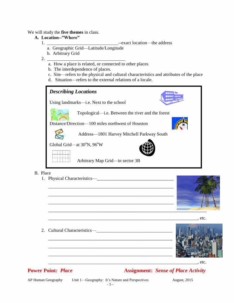
We will study the five themes in class.
A. Location--”Where”
1. _______________________________--exact location—the address
a. Geographic Grid—Latitude/Longitude
b. Arbitrary Grid
2. __________________________________
a. How a place is related, or connected to other places
b. The interdependence of places.
c. Site—refers to the physical and cultural characteristics and attributes of the place
d. Situation—refers to the external relations of a locale.
B. Place
1. Physical Characteristics—___________________________________
_____________________________________________________________________
_____________________________________________________________________
_____________________________________________________________________
_____________________________________________________________________
_________________________________________________________________, etc.
2. Cultural Characteristics—_______________________________________________
_____________________________________________________________________
_____________________________________________________________________
_____________________________________________________________________
_________________________________________________________________, etc.
Power Point: Place Assignment: Sense of Place Activity
Describing Locations
Using landmarks—i.e. Next to the school
Topological—i.e. Between the river and the forest
Distance/Direction—100 miles northwest of Houston
Address—1801 Harvey Mitchell Parkway South
Global Grid—at 30oN, 96
oW
Arbitrary Map Grid—in sector 3B
Page 6
AP Human Geography Unit 1—Geography: It’s Nature and Perspectives August, 2015
- 6 -
C. Human-Environment Interaction
1. How people respond/relate to their environment
2. Explores the effects (+ and -) that occur when people change their environment
3. Not Environmental Determinism: Modern geographers reject environmental
determinism in favor of possibilism.
Possibilism: the physical environment _______________________________________ but
people have the ability to ________________________________their environment.
People can choose a course of action from many alternatives in the physical environment.
4. ________________________________: People change their lives to fit the land.
5. _________________________________: People change the land to meet their needs.
6. _________________________________: People depend on the natural resources.
D. Movement
1. Spatial Interaction
a. Definition--movement of people, materials, and ideas or information across Earth.
b. How?
1) ______________________________________
2) ______________________________________
c. _______________________________________--spread of an idea or invention.
d. Two basic types of diffusion
1) ____________________________________—the transfer of ideas, behaviors,
or articles from one place to another through the migration of those possessing
the feature transported. They take their cultural traits with them. Once the
people migrate those traits may continue, disappear, or change through time.
2) ___________________________________—the spread of ideas, behaviors, or
articles through a culture area or from one culture to neighboring areas through
contact and exchange of information
aa) Hierarchical diffusion—a form of diffusion
in which the spread of an innovation can
__________________________________
___________________________________
__________________________________
___________________________________
___________________________________
Examples ___________________________
__________________________________
Page 7
AP Human Geography Unit 1—Geography: It’s Nature and Perspectives August, 2015
- 7 -
bb. Contagious diffusion—a form of diffusion
that depends on ______________________
___________________________________
__________________________________.
The process of dispersion is centrifugal,
strongly influenced by
____________________, and dependent
on __________________________
between actual and potential adopters of
the innovation.
cc. Stimulus diffusion—if the innovation or idea does ___________________
spread, but local experimentation and eventual changes in ways of doing
things occur _______________________________ between cultures it is
considered diffusion.
2. Regional Variation [Spatial Differentiation]
a. Definition--not all places are centrally located or are easily accessible.
b. People, materials and ideas are spread differently across space.
c. Distance Decay—_______________________________________________________
____________________________________________________________________
d. Cultural and Physical Barriers—___________________________________________
____________________________________________________________________
____________________________________________________________________
e. ___________________________________________—alternative destinations—
some areas can be reached more quickly, more cheaply, and/or easier so ideas and
people spread differently.
3. Spatial Distribution
a. Definition--the spread of people, elements or characteristics
b. Three aspects/parts:
1) Density--_______________________________________.
(How much of something is found in a given area?)
2) Dispersion/Concentration--___________________________________________.
(Where is it found?)
3) Pattern--_________________________________________ (How is it spread?)
[design rather than spacing]
Page 8
AP Human Geography Unit 1—Geography: It’s Nature and Perspectives August, 2015
- 8 -
aa) Linear_________________________________
_______________________________________
_______________________________________
_______________________________________
bb) Centralized or Clustered—_________________
_______________________________________
_______________________________________
_______________________________________
cc) Random—______________________________
_______________________________________
_______________________________________
_______________________________________
E. Regions
1. Definition: _______________________________________________________
2. Why?
3. Four types:
a. ______________ region—a type of region marked by a certain degree of
homogeneity in one or more phenomena; also called a uniform region or
homogeneous region. i.e. Canada, Texas, the Wheat Belt (you can actually
calculate how many acres of land are used to grow wheat—you can “see” the
region), the Corn Belt
b. __________________ region—a region defined by the particular set of activities
or interactions that occur within it, also known as a nodal region [an area
organized around a node or focal point] i.e. the Silicon Valley, where The Eagle
is distributed
Page 9
AP Human Geography Unit 1—Geography: It’s Nature and Perspectives August, 2015
- 9 -
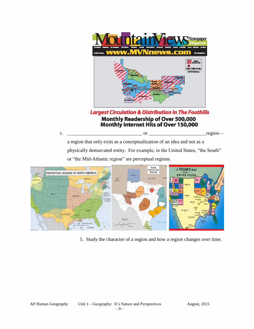
c. ______________________________ or _______________________region—
a region that only exits as a conceptualization of an idea and not as a
physically demarcated entity. For example, in the United States, “the South”
or “the Mid-Atlantic region” are perceptual regions.
5. Study the character of a region and how a region changes over time.
Page 10
AP Human Geography Unit 1—Geography: It’s Nature and Perspectives August, 2015
- 10 -
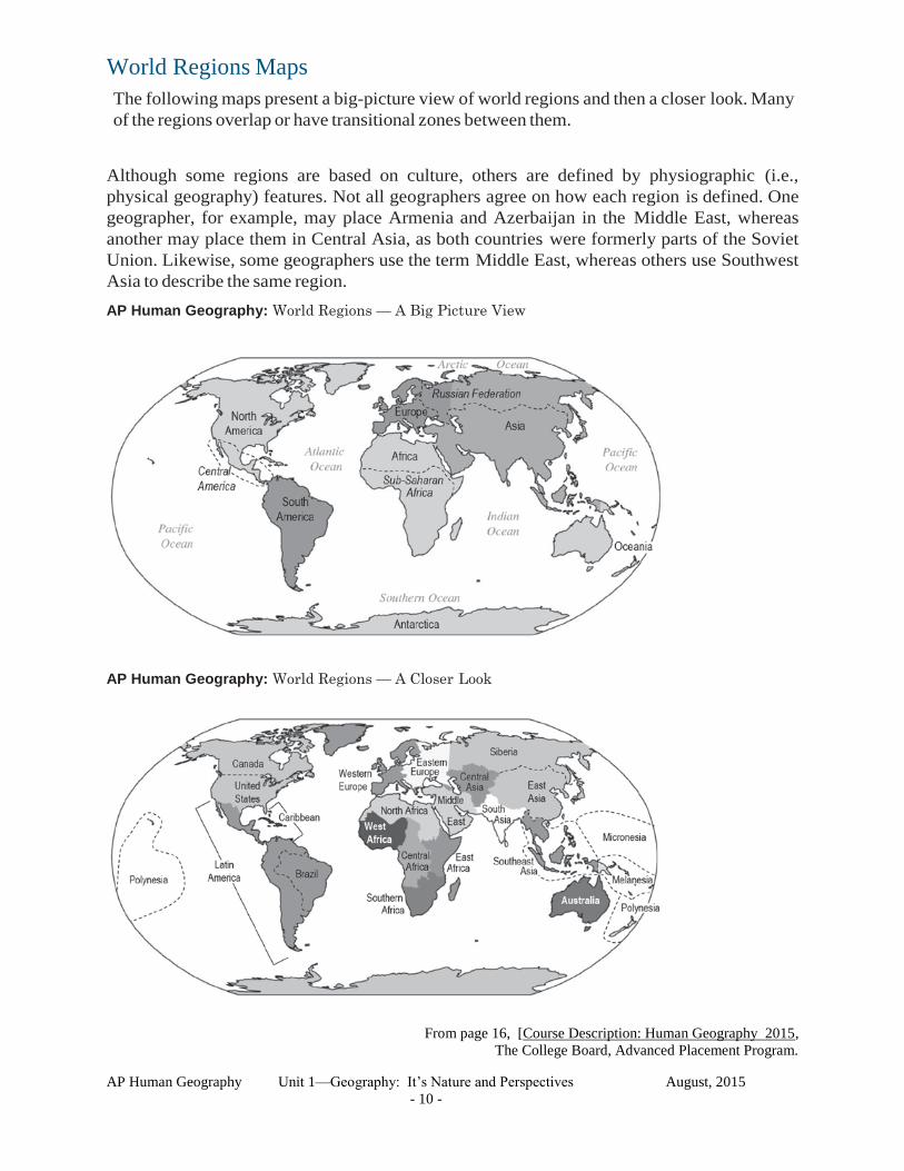
World Regions Maps
The following maps present a big-picture view of world regions and then a closer look. Many
of the regions overlap or have transitional zones between them.
Although some regions are based on culture, others are defined by physiographic (i.e.,
physical geography) features. Not all geographers agree on how each region is defined. One
geographer, for example, may place Armenia and Azerbaijan in the Middle East, whereas
another may place them in Central Asia, as both countries were formerly parts of the Soviet
Union. Likewise, some geographers use the term Middle East, whereas others use Southwest
Asia to describe the same region.
AP Human Geography: World Regions — A Big Picture View
AP Human Geography: World Regions — A Closer Look
From page 16, [Course Description: Human Geography 2015,
The College Board, Advanced Placement Program.
Page 11
AP Human Geography Unit 1—Geography: It’s Nature and Perspectives August, 2015
- 11 -
TOOLS AND METHODS USED TO STUDY GEOGRAPHY
A. Maps
1. Globe--_______________________________________________
2. Map--_________________________________________________
[cartography is the science of map making]
a. _______________________ Maps--visual or verbal maps
b. _______________________ Maps
1) ______________________________ Maps--gives general information about a place
(location, size, distance, political or cultural features, physical features, etc.)
2) ___________________Maps--show more specific information, often on a single
theme or topic. (Population, Economic Maps, Climates, Religions, Languages, etc.)
B. Main Concepts of Standard Maps
“Mental maps should have a TOAD.”
“Standard maps need TOADS or TODALS,
and some maps need s or IGs!”
TODALSIGs
T=Title: What, where and when
O=Orientation: Cardinal and Intermediate Directions
D=Date: When was the map made?
A=Author: Who made the map?
L=Legend: What do the symbols mean?
S=Scale: What is the map distance?
I=Index: Map address of a place.
G=Grid: Locates places on the map.
s=Source: Where is the information from?
C. Additional Information
1. Projection--____________________________________________
a. Three basic kinds of projections
1) Cylindrical Projection--__________________________
________________________________________________
Transverse “Transverse Mercator” Oblique “Oblique Mercator”
Regular “Mercator”
Page 12
AP Human Geography Unit 1—Geography: It’s Nature and Perspectives August, 2015
- 12 -
Pseudocylindrical (or False Cylindrical) projections the longitudinal meridians are curved.
Robinson Sinusoidal Mollweide Goode Homolosine
2) Conic Projection--________________________________________________________
—usually just a portion of the earth.
Lambert Equal-Area Albers Equal-Area
3) Planar or Zenithal Projection--_____________________________________________.
Stereographic Lambert Azimuthal Equal-Area
b. Different Projections produce different types of maps--Four basic types
1) Conformal--___________________________________________________are correct.
[distance, direction, and size are distorted]
2) Equivalent or Equal-Area--____________________________________ are correct
[shapes, distances, and directions are distorted]
3) Equidistance--________________________________________________ are correct.
[shapes, size, and directions are distorted]
4) Azimuthal--__________________________________________________ are correct.
[shapes, size, and distances are distorted]
Page 13
AP Human Geography Unit 1—Geography: It’s Nature and Perspectives August, 2015
- 13 -
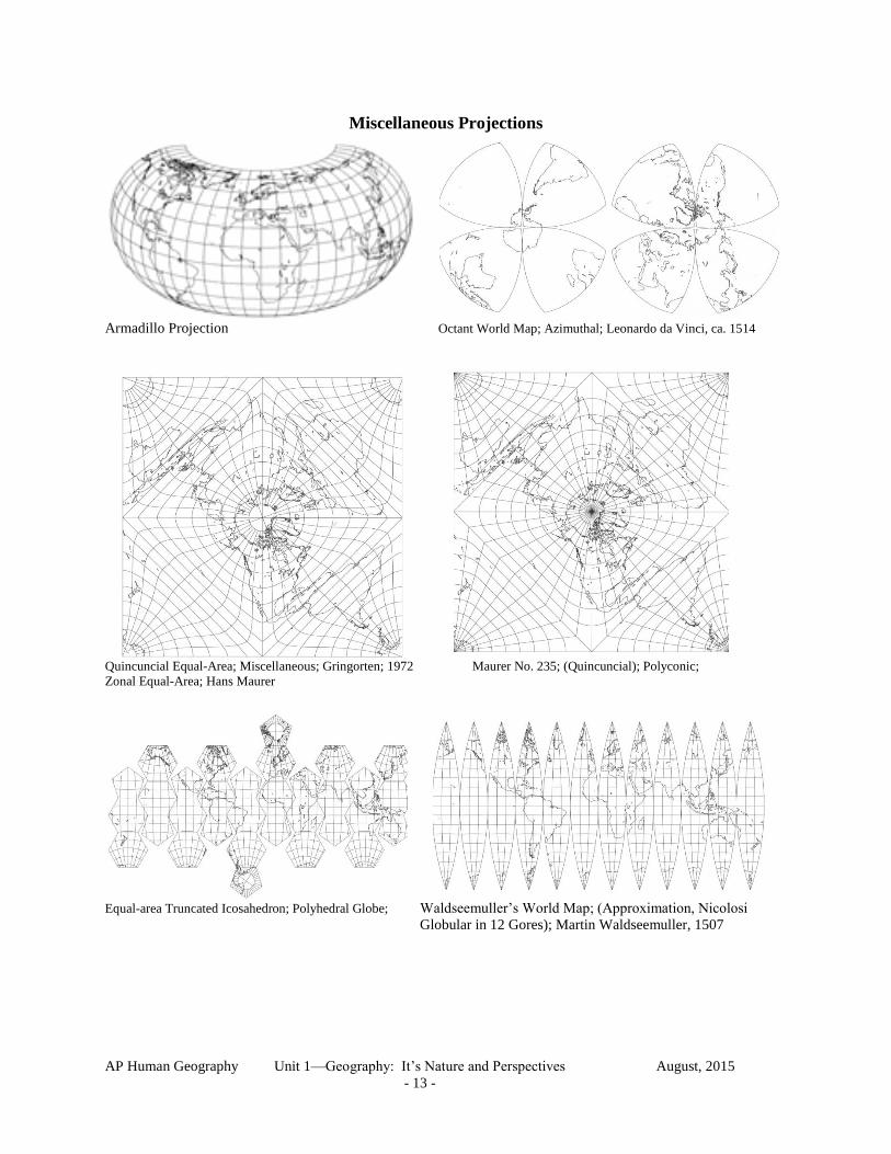
Miscellaneous Projections
Armadillo Projection Octant World Map; Azimuthal; Leonardo da Vinci, ca. 1514
Quincuncial Equal-Area; Miscellaneous; Gringorten; 1972 Maurer No. 235; (Quincuncial); Polyconic;
Zonal Equal-Area; Hans Maurer
Equal-area Truncated Icosahedron; Polyhedral Globe; Waldseemuller’s World Map; (Approximation, Nicolosi
Globular in 12 Gores); Martin Waldseemuller, 1507
Page 14
AP Human Geography Unit 1—Geography: It’s Nature and Perspectives August, 2015
- 14 -
Conformal Tetrahedric projection; Schwarz Conformal projection; (World in a Pentagon);
Laurence Patrick Lee, 1965 Miscellaneous; Conformal; H. A. Schwarz, 1869
Low-error Polyconic; (Non-constrained optimization); Neither Bonne projection; Pseudoconic; Equal-area;
Conformal or Equal-area; Frank Canters; 1989, 2002 Modified Werner projection; Rigobert Bonne, 1752
Tangent Series #2; Pseudocylindrical; Equal-area;
Felix Webster McBryde and Paul D. Thomas, 1949
Berghaus Star; Azimuthal; Neither Conformal or
Equal-area; (Northern Hemisphere is Azimuthal
Equidistant projection) Heinrich Berghaus, 1879
Page 15
AP Human Geography Unit 1—Geography: It’s Nature and Perspectives August, 2015
- 15 -
3. Scale—relationship between ________________________________________________
in cartographic terms —In general terms, it refers to the size of the area studied
a. Three types of cartographic scales
1) ___________________scale 0 (miles) 1
2) ___________________ scale 1inch = 1 mile
3) ___________________ scale 1: 63,360
b. ____________________ scale maps (shows a
large area with little local detail—nation map)
[less than 1:100,000] vs.
_____________________ scale maps (shows a
smaller area in much more detail—city map)
[greater than l:l00,000]
1) _________________________ Scale—shows
less detail— larger area
2) ________________________ Scale—shows
more detail such as buildings are located and
the shallow areas —smaller area
4. Specialized Maps
a. Thematic Maps
1) Isopleth Maps--type of map that uses isolines to _____________________ points (or
places) of _______________________ value
a) Contour Maps--lines connect points with the same ______________________
Page 16
AP Human Geography Unit 1—Geography: It’s Nature and Perspectives August, 2015
- 16 -
b) Barometric Pressure Maps--Isobars connect places where the_______________
is the same
c) Temperature Maps—Isotherms connect places with the same ________________
2) Chorophleth Maps
Page 17
AP Human Geography Unit 1—Geography: It’s Nature and Perspectives August, 2015
- 17 -
3) Proportional Symbol Maps
4) Dot Maps
b. General Information Maps
1) Topographic Maps.
Dot Maps – A thematic map in which a dot is used to
represent some frequency of the mapped variable.
A simple dot map of commercial wireless antennas
in the USA.
Commercial wireless
antennas
Page 18
AP Human Geography Unit 1—Geography: It’s Nature and Perspectives August, 2015
- 18 -
2) Others Simplified maps
c. Contemporary Mapping
1) Remote Sensing—the accusation of data about Earth’s surface from a satellite or
other long distance methods
2) GIS—________________________________________
____________________________ is a high performance computer system that
processes geographic data.
3) GPS__________________________________________ takes signals from a
serious of satellites to pinpoint the current location of a vehicle.
e. Etc.
B. Data Collection
1. Field Work
a. Observing
b. Gathering data
c. Interviewing people
d. etc.
2. Records
a. Books/Histories/Library Research
b. Census Records (official counts) and Summaries
c. Land and Tax Records
d. Air Photos
e. etc.
C. Statistical Analysis
D. Etc.
Page 19
AP Human Geography Unit 1—Geography: It’s Nature and Perspectives August, 2015
- 19 -
Handout The History of Geography and Carl Sauer
“Locomotion should be slow, the slower the better, and should
be often interrupted by leisurely halts to sit on vantage points
and stop at question marks.” [John Leighly, ed. Land and Life.
A Selection From the Writings of Carl Ortwin Sauer. Berkeley and Los Angeles:
University of California Press, 1963.]
This comment was made by Carl O. Sauer, one of the major figures in human geography in the
United States. What was Sauer’s conception of geography? How did that differ from previous
scholars’ views such as Alexander von Humbolt, Carl Ritter, and Friedrich Ratzel? How does
contemporary geography differ from Sauer’s concept of human geography?
1) Sauer’s concept
He was interested in how humans modify physical landscapes over time. He rejected the idea of
environmental determinism for possibilism (human activity is determined not by physical
environments, but by choices humans make). He used the term “landscape” or “cultural
landscape” in preference to “region.
2) Previous concepts
Historically geography was seen as a descriptive regional science. Until the late 18th
century it
was primarily mapping and description. For the first part of the 19th
century academic
disciplines formally emerged at universities and regional descriptions were placed in a larger
conceptual context as encouraged by Vareninus as early as 1650.
Humbolt and Ritter dominated the first part of the 19th
century. Humbolt wanted to investigate
the interaction of the forces of nature (including humans). He tried to account for how things are
related. Ritter also moved from description alone to description and laws. Humbolt and Ritter
are credited for three reoccurring themes—(1) the study of humans and land, (2) the focus on
regions, and (3) the concerns of spatial analysis (the use of general statements to aid the
understanding of specific facts). They were the first in geography to combine regional
descriptions and concept formulation.
By the end of the 19th
century departments of geography began to appear and an emphasis on the
physical environment continued. Physical environments were described first and human
activities related to the physical environment came second.
Ratzel is sometimes regarded as the founder of human geography since his second book focused
on humans using the earth, even though he is best known for another concept. Ratzel is most
associated with the concept of environmental determinism. He wrote about the influence of
physical geography on humans in his first book. This theme would last until the beginning of the
20th
century when it lost favor to possibilism.
Sauer in the US, Videl in France, and Schluter in Germany began to focus on the landscape (an
analysis of humans and the land) in the early 1900’s. This became one of the major themes of
the 20th
century in geography. Regional geography (regional studies) was a second theme. And
a third emphasis that developed was the concept of spatial analysis. During the 1960’s a
quantitative revolution occurred and influenced both the landscape and the regional approaches
to geography.
Page 20
AP Human Geography Unit 1—Geography: It’s Nature and Perspectives August, 2015
- 20 -
3) Today human geography, even though connected to its history, has some new components.
Specifically:
A. Human geography is being distinguished from physical geography and being seen as a
separate component of geography.
B. There has been a revitalized emphasis on regional geography.
C. There has been a revitalization of landscape geography.
D. Spatial analysis is an ongoing component.
E. There is an increase in applied matters.
F. There is an increasing technical content.