STATE OF UTAH DEPARTMENT OF NATURAL RESOURCES DIVISION OF OIL, GAS AND MINING APPLICATION FOR PERMIT TO DRILL 1. WELL NAME and NUMBER Greater Monument Butte 15-2-9-16H 2. TYPE OF WORK DRILL NEW WELL REENTER P&A WELL DEEPEN WELL 3. FIELD OR WILDCAT MONUMENT BUTTE 4. TYPE OF WELL Oil Well Coalbed Methane Well: NO 5. UNIT or COMMUNITIZATION AGREEMENT NAME GMBU (GRRV) 6. NAME OF OPERATOR NEWFIELD PRODUCTION COMPANY 7. OPERATOR PHONE 435 646-4825 8. ADDRESS OF OPERATOR Rt 3 Box 3630 , Myton, UT, 84052 9. OPERATOR E-MAIL [email protected]10. MINERAL LEASE NUMBER (FEDERAL, INDIAN, OR STATE) ML-21839 11. MINERAL OWNERSHIP FEDERAL INDIAN STATE FEE 12. SURFACE OWNERSHIP FEDERAL INDIAN STATE FEE 13. NAME OF SURFACE OWNER (if box 12 = 'fee') 14. SURFACE OWNER PHONE (if box 12 = 'fee') 15. ADDRESS OF SURFACE OWNER (if box 12 = 'fee') 16. SURFACE OWNER E-MAIL (if box 12 = 'fee') 17. INDIAN ALLOTTEE OR TRIBE NAME (if box 12 = 'INDIAN') 18. INTEND TO COMMINGLE PRODUCTION FROM MULTIPLE FORMATIONS YES (Submit Commingling Application) NO 19. SLANT VERTICAL DIRECTIONAL HORIZONTAL 20. LOCATION OF WELL FOOTAGES QTR-QTR SECTION TOWNSHIP RANGE MERIDIAN LOCATION AT SURFACE 1107 FSL 1935 FEL SWSE 2 9.0 S 16.0 E S Top of Uppermost Producing Zone 1107 FSL 1935 FEL SWSE 2 9.0 S 16.0 E S At Total Depth 150 FNL 350 FEL NENE 2 9.0 S 16.0 E S 21. COUNTY DUCHESNE 22. DISTANCE TO NEAREST LEASE LINE (Feet) 150 23. NUMBER OF ACRES IN DRILLING UNIT 320 25. DISTANCE TO NEAREST WELL IN SAME POOL (Applied For Drilling or Completed) 390 26. PROPOSED DEPTH MD: 6272 TVD: 6272 27. ELEVATION - GROUND LEVEL 5520 28. BOND NUMBER B001834 29. SOURCE OF DRILLING WATER / WATER RIGHTS APPROVAL NUMBER IF APPLICABLE 437478 ATTACHMENTS VERIFY THE FOLLOWING ARE ATTACHED IN ACCORDANCE WITH THE UTAH OIL AND GAS CONSERVATION GENERAL RULES WELL PLAT OR MAP PREPARED BY LICENSED SURVEYOR OR ENGINEER COMPLETE DRILLING PLAN AFFIDAVIT OF STATUS OF SURFACE OWNER AGREEMENT (IF FEE SURFACE) FORM 5. IF OPERATOR IS OTHER THAN THE LEASE OWNER DIRECTIONAL SURVEY PLAN (IF DIRECTIONALLY OR HORIZONTALLY DRILLED) TOPOGRAPHICAL MAP NAME Mandie Crozier TITLE Regulatory Tech PHONE 435 646-4825 SIGNATURE DATE 09/30/2010 EMAIL [email protected]API NUMBER ASSIGNED 43013504320000 Permit Manager APPROVAL FORM 3 AMENDED REPORT API Well No: 43013504320000 Received: 9/30/2010 API Well No: 43013504320000 Received: 9/30/2010 FORM 3 STATE OF UTAH DEPARTMENT OF NATURAL RESOURCES AMENDED REPORT DIVISION OF OIL, GAS AND MINING APPLICATION FOR PERMIT TO DRILL 1. WELL NAMeEt rMMoNnUMBnERButte 15-2-9-16H 2. TYPE OF WORK 3. FIELD OR WILDCAT DRILL NEW WELL I REENTER P&A WELL DEEPEN WELL i MONUMENT BUTTE 4. TYPE OF WELL 5. UNIT or COMMUNITIZATION AGREEMENT NAME Oil Well Coalbed Methane Well: NO GMBU (GRRV) 6. NAME OF OPERATOR 7. OPERATOR PHONE NEWFIELD PRODUCTION COMPANY 435 646-4825 8. ADDRESS OF OPERATOR 9. OPERATOR E-MAIL Rt 3 Box 3630 , Myton, UT, 84052 [email protected]10. MINERAL LEASE NUMBER 11. MINERAL OWNERSHIP 12. SURFACE OWNERSHIP (FEDERAL, INDIAN, ORM 8E39 FEDERALI I INDIAN I I STATE I I FEE CI FEDERAL INDIAN STATE I FEEl 13. NAME OF SURFACE OWNER (if box 12 = 'fee') 14. SURFACE OWNER PHONE (if box 12 = 'fee') 15. ADDRESS OF SURFACE OWNER (if box 12 = 'fee') 16. SURFACE OWNER E-MAIL (if box 12 = 'fee') 17. INDIAN ALLOTTEE OR TRIBE NAME 18. INTEND TO COMMINGLE PRODUCTION FROM 19. SLANT (if box 12 = 'INDIAN') MULTIPLE FORMATIONS YES I (Submit Commingling Application) NO ) VERTICAL DIRECTIONAL HORIZONTAL I 20. LOCATION OF WELL FOOTAGES QTR-QTR SECTION TOWNSHIP RANGE MERIDIAN LOCATION AT SURFACE 1107 FSL 1935 FEL SWSE 2 9.0 S 16.0 E S Top of Uppermost Producing Zone 1107 FSL 1935 FEL SWSE 2 9.0 S 16.0 E S At Total Depth 150 FNL 350 FEL NENE 2 9.0 S 16.0 E S 21. COUNTY 22. DISTANCE TO NEAREST LEASE LINE (Feet) 23. NUMBER OF ACRES IN DRILLING UNIT DUCHESNE 150 320 25. DISTANCE TO NEAREST WELL IN SAME POOL 26. PROPOSED DEPTH (Applied For Drilling or Completed) MD: 6272 TVD: 6272 390 27. ELEVATION - GROUND LEVEL 28. BOND NUMBER 29. SOURCE OF DRILLING WATER / WATER RIGHTS APPROVAL NUMBER IF APPLICABLE 5520 BOO1834 437478 ATTACH MENTS VERIFY THE FOLLOWING ARE ATTACHED IN ACCORDANCE WITH THE UTAH OIL AND GAS CONSERVATION GENERAL RULES WELL PLAT OR MAP PREPARED BY LICENSED SURVEYOR OR ENGINEER COMPLETE DRILLING PLAN AFFIDAVIT OF STATUS OF SURFACE OWNER AGREEMENT (IF FEE SURFACE) FORM 5. IF OPERATOR IS OTHER THAN THE LEASE OWNER DIRECTIONAL SURVEY PLAN (IF DIRECTIONALLY OR HORIZONTALLY TOPOGRAPHICAL MAP DRILLED) NAME Mandie Crozier TITLE Regulatory Tech PHONE 435 646-4825 SIGNATURE DATE 09/30/2010 EMAIL [email protected]API NUMBER ASSIGNED APPROVAL I 43013504320000 Permit
Transcript
STATE OF UTAHDEPARTMENT OF NATURAL RESOURCES
DIVISION OF OIL, GAS AND MINING
APPLICATION FOR PERMIT TO DRILL 1. WELL NAME and NUMBER
Greater Monument Butte 15-2-9-16H
2. TYPE OF WORK
DRILL NEW WELL REENTER P&A WELL DEEPEN WELL 3. FIELD OR WILDCAT
MONUMENT BUTTE
4. TYPE OF WELLOil Well Coalbed Methane Well: NO
5. UNIT or COMMUNITIZATION AGREEMENT NAMEGMBU (GRRV)
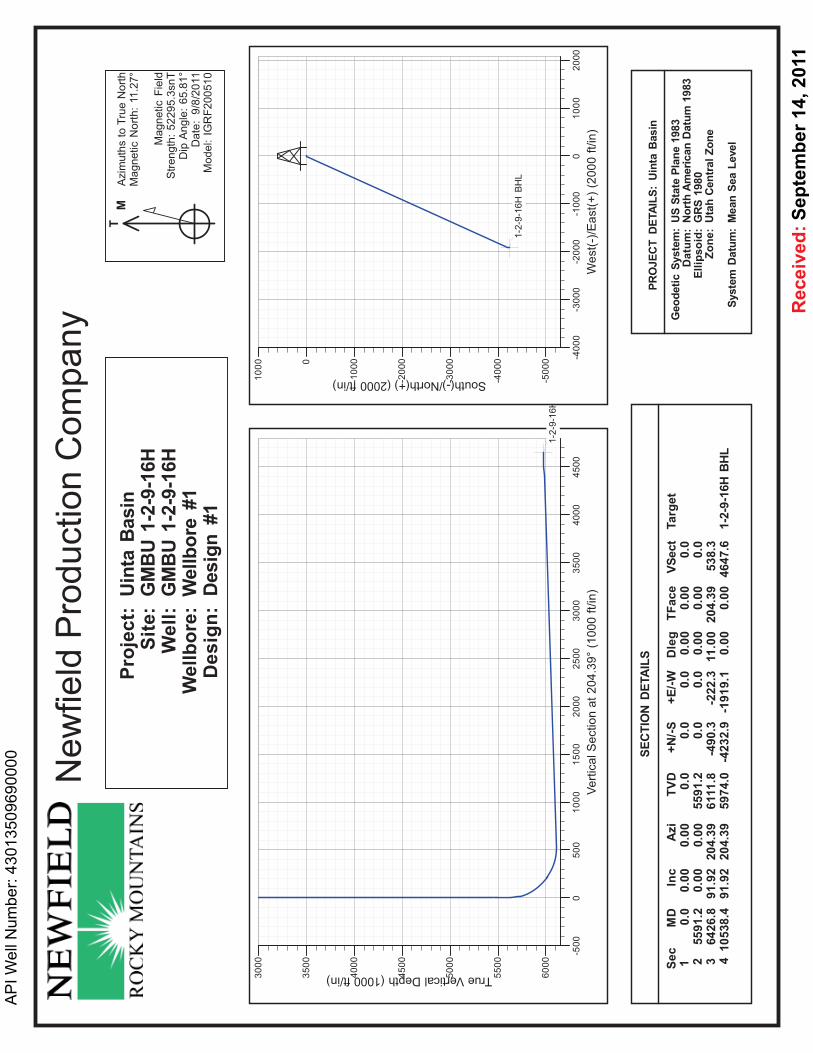
This well is designed as a horizontal in the Basal Carbonate formation, at the base of theGreen River formation. The well will be drilled vertically to a kick off point of 5,670'.Directional tools will then be used to build to 88.15° inclination and the well will belanded in the Basal Carbonate formation. The lateral will be drilled to the proposedbottomhole location, and 5-1/2" production casing will be run to TD. An open holepacker system and sliding sleeves will be used to isolate separate frac stages in the lateral.The casing will be cemented from the top of the curve to surface with a port collar.
1. GEOLOGIC SURFACE FORMATION:
Uinta formation
2. ESTIMATED TOPS OF IMPORTANT GEOLOGIC MARKERS:
Green River 1,550'Target (Basal Carbonate) 6,272'TD 6,272' TVD / 10,274' MD
3. ESTIMATED DEPTHS OF ANTICIPATED WATER, OIL, GAS OR MINERALS:
Green River Formation (Oil) 4,055' - 6,272' TVD
Fresh water may be encountered in the Uinta Formation, but would not be expected below about300'. All water shows and water bearing geologic units shall be reported to the geologic andengineering staff of the Vernal Office prior to running the next string of casing or before pluggingorders are requested. All water shows must be reported within one (1) business day after beingencountered.
All usable (<10,000PPM TDS) water and prospectively valuable minerals (as described by Stateof Utah DOGM representative at onsite) encountered during drilling will be recorded by depth andadequately protected. This information shall be reported to the State of Utah DOGM OfficeOffice.
Detected water flows shall be sampled, analyzed, and reported to the geologic & engineering staffof the Vernal Office. The office may request additional water samples for further analysis. Usageof the State of Utah form Report of Water Encountered is acceptable, but not required.
The following information is requested for water shows and samples where applicable:
Production O' 10,274' 17.0 N-80 LTC 8.3 8.5 - 3.70 2.93 2.225-1/2"
Assumptions:1) Surface casing MASP = (frac gradient + l.0 ppg) - gas gradient2) Production casing MASP (production mode) = reservoir pressure - gas gradient3) All collapse calculations assume fully evacuated casing4) Surface tension calculations assume air weight of casing5) Production tension calculations assumer air weight in vertical portion of hole, plus
50,000 lbs overpull
All casing shall be new.
All casing strings shall have a minimum of 1 (one) centralizer on each of the bottom three (3)joints.
b. Cement DesignHole OH Weight Yield
Job Fill Slurry DescriptionSize Sacks Excess (ppg) (ft3/sk)
Surface Class G wl 2% CaCl2, 0.2512-1/4" 1,000' 15% 15.8 1.17lbs/sk Cello Flake 406
Production Premium Lite IIw/ 3% KCI, 10%7-7/8" 4,055' 15% 15.8 3.26Lead bentonite 248Production 50/50 Poz/Class G wl 3% KCI, 3227-7/8" 1,615' 15% 14.3 1.24Tail 2% bentonite
Actual cement volumes will be calculated from open hole logs, plus 15% excess.
Cement will be pumped through a port cementing collar located at the top of the curve. Thelateral will be left uncemented. The lateral will be isolated with open hole packers.
Waiting On Cement: A minimum of four (4) hours shall elapse prior to attempting anypressure testing of the BOP equipment which would subject the surface casing cement topressure, and a minimum of six (6) hours shall elapse before drilling out of the wiper plug,cement, or shoe is begun. WOC time shall be recorded in the Driller's Log. CompressiveStrength shall be a minimum of 500 psi prior to drilling
'APIWellNo:43013504320000'
CONFIDENTIAL
'APIWellNo:43013504320000'
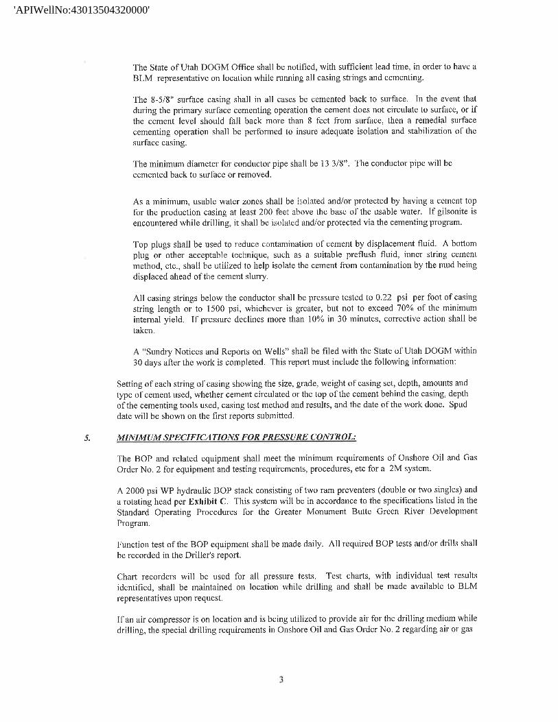
The State of Utah DOGM Office shall be notified, with sufficient lead time, in order to have aBLM representative on location while running all casing strings and cementing.
The 8-5/8" surface casing shall in all cases be cemented back to surface. In the event thatduring the primary surface cementing operation the cement does not circulate to surface, or ifthe cement level should fall back more than 8 feet from surface, then a remedial surfacecementing operation shall be performed to insure adequate isolation and stabilization of thesurface casing.
The minimum diameter for conductor pipe shall be 13 3/8". The conductor pipe will becemented back to surface or removed.
As a minimum, usable water zones shall be isolated and/or protected by having a cement topfor the production casing at least 200 feet above the base of the usable water. If gilsonite isencountered while drilling, it shall be isolated and/or protected via the cementing program.
Top plugs shall be used to reduce contamination of cement by displacement fluid. A bottomplug or other acceptable technique, such as a suitable preflush fluid, inner string cementmethod, etc., shall be utilized to help isolate the cement from contamination by the mud beingdisplaced ahead of the cement slurry.
All casing strings below the conductor shall be pressure tested to 0.22 psi per foot of casingstring length or to 1500 psi, whichever is greater, but not to exceed 70% of the minimuminternal yield. If pressure declines more than 10% in 30 minutes, corrective action shall betaken.
A "Sundry Notices and Reports on Wells" shall be filed with the State of Utah DOGM within30 days after the work is completed. This report must include the following information:
Setting of each string of casing showing the size, grade, weight of casing set, depth, amounts andtype of cement used, whether cement circulated or the top of the cement behind the casing, depthof the cementing tools used, casing test method and results, and the date of the work done. Spuddate will be shown on the first reports submitted.
5. MINIMUM SPECIFICATIONS FOR PRESSURE CONTROL:
The BOP and related equipment shall meet the minimum requirements of Onshore Oil and GasOrder No. 2 for equipment and testing requirements, procedures, etc for a 2M system.
A 2000 psi WP hydraulic BOP stack consisting of two ram preventers (double or two singles) anda rotating head per Exhibit C. This system will be in accordance to the specifications listed in theStandard Operating Procedures for the Greater Monument Butte Green River DevelopmentProgram.
Function test of the BOP equipment shall be made daily. All required BOP tests and/or drills shallbe recorded in the Driller's report.
Chart recorders will be used for all pressure tests. Test charts, with individual test resultsidentified, shall be maintained on location while drilling and shall be made available to BLMrepresentatives upon request.
If an air compressor is on location and is being utilized to provide air for the drilling medium whiledrilling, the special drilling requirements in Onshore Oil and Gas Order No. 2 regarding air or
'APIWellNo:43013504320000'
CONFIDENTIAL
'APIWellNo:43013504320000'
shall be adhered to. If a mist system is being utilized, the requirement for a deduster shall bewaived.
6. TYPE AND CHARACTER15TICS OF THE PROPOSED CIRCULATION MUDS:
From surface to 1000', an air or fresh water system will be used. From 1000' to TD, a fresh wateror brine water system will be utilized. Anticipated maximum mud weight is 9.0 lbs/gal. Ifnecessary to control formation fluids or pressure, the system will be weighted with the addition ofbentonite gel, and if pressure conditions warrant, with barite.
No chromate additives will be used in the mud system on Federal and/or Indian lands without priorState approval to ensure adequate protection of fresh aquifers.
No chemicals subject to reporting under SARA Title III in an amount equal to or greater than10,000 pounds will be used, produced, stored, transported, or disposed of annually in associationwith the drilling, testing, or completing of this well. Furthermore, no extremely hazardoussubstances, as defined in 40 CFR 355, in threshold planning quantities, will be used, produced,stored, transported, or disposed of in association with the drilling, testing, or completing of thiswell.
Hazardous substances specifically listed by the EPA as a hazardous waste or demonstrating acharacteristic of a hazardous waste will not be used in drilling, testing, or completion operations.
7. AUXILIARY SAFETY EQUIPMENT TO BE USED:
8. TESTING, LOGGING AND CORING PROGRAMS:
a. Logging Program:(the log types run may change at the discretion of the geologist)
FDC/CNL/GR/DIL: Top of the curve - 3,200'CBL: A cement bond log will be run from KOP to the cement top of the production casing.
A field copy will be submitted to the Vernal BLM Office.
b. Cores: As deemed necessary.
c. Drill Stem Tests: No DSTs are planned in the Green River.
9. ANTICIPATED ABNORM4L PRESSURE OR TEMPERATURE:
There is no abnormal pressure or temperature expected. Maximum anticipated bottomholepressure will be approximately equal total true vertical depth in feet multiplied by a 0.433 psi/footgradient.
10. ANTICIPATED STARTING DATE AND DURATION OF THE OPERATIONS:
a. Drilling Activity
Anticipated Commencement Date: Upon approval of the site specific APD.Drilling Days: Approximately 18 days.Completion Days: Approximately 12 - 20 days.
b. Notification of
'APIWellNo:43013504320000'
CONFIDENTIAL
'APIWellNo:43013504320000'
The State of Utah DOGM office will be notified at least 24 hours prior to the commencementof spudding the well (to be followed with a Sundry Notice, Form 3160-5), of initiatingpressure tests of the blowout preventer and related equipment, and running casing andcementing of all casing strings. Notification will be made during regular work hours (7:45a.m.-4:30 p.m., Monday - Friday except holidays).
Immediate Report: Spills, blowouts, fires, leaks, accidents, or any other unusual occurrencesshall be promptly reported in accordance with the appropriate regulations, Onshore Orders, orState policy.
No location will be constructed or moved, no well will be plugged, and no drilling orworkover equipment will be removed from a well to be placed in suspended status withoutprior approval from the AO. If operations are to be suspended, prior approval of the AO willbe obtained and notification given to the State of Utah DOGM before resumption ofoperations.
Daily drilling and completion reports shall be submitted to the State of Utah DOGM Office ona weekly basis.
Whether the well is completed as a dry hole or a producer, the "Well Completion andRecompletion Report and Log" (Form 3160-4) will be submitted not later than 30 days aftercompletion of the well or after completion of operations being performed, in accordance with43 CFR 3164. One copy of all logs, core descriptions, core analyses, well test data, geologicsummaries, sample description, and all other surveys or data obtained and compiled during thedrilling, workover, and/or completion operations will be filed with Form 3160-4. Samples(cuttings, fluids, and/or gases) will be submitted when requested by the Authorized Officer(AO).
A completion rig will be used for completion operations after the wells are stimulated to runthe production tubing.. All conditions of this approved plan will be applicable during alloperations conducted with the completion rig.
Operator shall report production data to the MMS pursuant to 30 CFR 216.5 using formMMS/3160. In accordance with Onshore Oil and Gas Order No. 1, a well will be reported onform 3160-6, "Monthly Report of Operations," starting with the month in which operationscommence and continue each month until the well is physically plugged and abandoned. Thisreport will be filed with the State of Utah DOGM Office.
The date on which production is commenced or resumed will be construed for oil wells as thedate on which liquid hydrocarbons are first sold or shipped from a temporary storage facility,such as a test tank, and for which a run ticket is required to be generated, or the date on whichliquid hydrocarbons are first produced into a permanent storage facility, whichever occursfirst; and for gas wells, as the date on which associated liquid hydrocarbons are first sold orshipped from a temporary storage facility, such as a test tank, and for which a run ticket isrequired to be generated, or the date on which gas is measured through permanent meteringfacilities, whichever occurs first.
Should the well be successfully completed for production, the AO will be notified when thewell is placed in a producing status. Such notification will be sent by written communicationnot later than 5 days following the date when the well is placed on production.
Pursuant to Onshore Order No. 7, with the approval of the AO, produced water may betemporarily disposed of into unlined pits for a period of up to 90 days. During this period, anapplication for approval of the permanent disposal method must be submitted to the AO.
'APIWellNo:43013504320000'
CONFIDENTIAL
'APIWellNo:43013504320000'
Pursuant to NTL-4A, lessees or operators are authorized to vent/flare gas during the initialwell evaluation tests, not to exceed 30 days or the production of 50 MMCF of gas, whicheveroccurs first. An application must be filed with the AO and approval received for anyventing/flaring of gas beyond the initial 30 days or authorized test period.
A schematic facilities diagram, as required by 43 CFR 3162.7-5(b.9.d), shall be submitted tothe State of Utah DOGM Office within 60 days of installation or first production, whicheveroccurs first. All site security regulations, as specified in Onshore Oil & Gas Order No. 3, shallbe adhered to. All product lines entering and leaving hydrocarbon storage tanks will beeffectively sealed in accordance with 43 CFR 3162.7-5(b.4).
Well abandonment operations shall not be commenced without the prior approval of the AO.In the case of newly drilled dry holes or failures, and in emergency situations, oral approvalwill be obtained from the AO. A "Subsequent Report of Abandonment", Form 3160-5, will befiled with the Authorized Officer within 30 days following completion of the well forabandonment. This report will indicate placement of the plugs and current status of thesurface restoration. Final Abandonment will not be approved until the surface reclamationwork required by the approved APD or approved abandonment notice has been completed tothe satisfaction of the AO, or the appropriate surface managing agency.
Pursuant to Onshore Oil and Gas Order No. 1, lessees and operators have the responsibility tosee that their exploration, development, production, and construction operations are conductedin a manner which conforms with applicable Federal laws and regulations and with the Stateand local laws, to the extent to which they are applicable, to operations on Federal or Indianlands.
'APIWellNo:43013504320000'
CONFIDENTIAL'APIWellNo:430 13504320000'
T9S, Ri6 E, S. L.B. &M. NßWFIßLDEBOÆ TIONCOMPANYS89 57'E (G.L.O.) 2639.47' (Measured)
WELL LOCATION, 15-2-9-16H, LOCATEDNB970'51"E - 2644.27' (Meas.) NB9¯09'JJ"E (B¤s/s of Beorings) y 797o
AS SHOWN IN THE SW 1/4 SE 1/4 OF'e','assCap
B9r/aOssCap
Cop SECTION 2, T9S, R16E, S.L.B.&M.om / 3 DUCHESNE COUNTY, UTAH.of Ho/e e
LOT 4 LOT 3 LOT 2 LOT 1 / $ TARGET BOTTOM HOLE, 15-2-9-16H,I / 't LOCATED AS SHOWN IN THE NE 1/4
NE 1/4 (LOT 1) OF SECTION 2, T9S,R16E, S.L.B.&M. DUCHESNE COUNTY,
----
¯¯¯¯¯ ¯¯¯¯ ¯¯¯ ¯¯¯
UTAH.
^o
-
~o
MELLLOCA710H: / °-
°
's 15-2-9-16H / ' '¯
ELEV UNGRADED GROUND = 5520.1BAR SCALE N
Note:1. The bottom of hole footages are
1970 / Aluminum 150' FNL & 350' FEL.Brass Cap Cap .
ors
THIS IS TO CERTIFY THA A WASell Head PREPARED FROM FIELD Q, O g, RVEYS
---- - MADE BY ME OR UN W Ol¥¢ THAT1935' THE SAME ARE TRU RECT TH T
I" I OF MY KNOWLEDGE .189377
DR/t.LINGDet a i l W/NDOW 200' CY W.
No Sca/e R STE D LA
797,De a At ISE OAF N .
1910 Brass Cop Brass Co OFBrass Ca
SBB45'44"W -- 262564' (Meas.) SB922'02"W - 2641.41' (Meas.) TRI STATELANDSURVEYING& CONSULTINGS89°54'W-79.90 (G.L.O.) 180 NORTH VERNAL AVE. - VERNAL, UTAH 84078
= SECTION CORNERS LOCATED (435) 781-2501
|15-2-9-16H DATE SURVEYED
BASIS OF ELEV; Elevations are base on (Surface Location) NAD BJ 07-09-10 SURVEYED BY: S.H.
LOCATION: an N.G.S. OPUS Correction. LAT/7UDE = 40 OJ' 20.JS" DATE DRAWN:LAT. 40°04'09.56" LONG. 110°00'43.28"
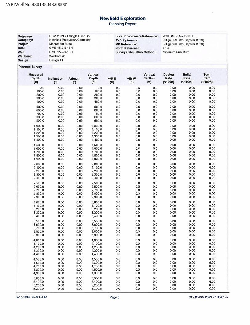
Database: EDM2003.21 Single User Db Local Co-ordinate Reference: Well GMB 15-2-9-16HCompany: Newfield Production Company TVDReference: [email protected] (Capstar #329)Project: Monument Butte MDReference: [email protected] (Capstar #329)Site: GMB 15-2-9-16H North Reference: TrueWell: GMB 15-2-9-16H Survey Calculation Method: MinimumCurvatureWellbore: Wellbore #1Design: Design #1
9/15/2010 4:09:15PM Page 5 COMPASS 2003.21 Build
'APIWellNo:43013504320000'
CONFIDENTIAL
'APIWellNo:43013504320000'
NEWFIELD PRODUCTION COMPANYGREATER MONUMENT BUTTE 15-2-9-16H
AT SURFACE: SW/SE SECTION 2, T9S, Rl6EDUCHESNE COUNTY, UTAH
THIRTEEN POINT SURFACE PROGRAM
l. EXISTING ROADS
See attached Topographic Map "A"
To reach Newfield Production Company well location site Greater Monument Butte 15-2-9-16Hlocated in the SW¼ SE¼ Section 2, T9S, R16E, S.L.B. & M., Duchesne County, Utah:
Proceed southwesterly out of Myton, Utah along Highway 40 - 1.4 miles ± to the junctionof thishighway and UT State Hwy 53; proceed southeasterly - 10.0 miles to it's junctionwith an existingroad to the southwest; proceed southwesterly - 3.3 ± to it's junctionwith an existing road to thenorthwest; proceed northwesterly - 0.1 miles ± to it's junctionwith the beginning of the proposedaccess road to the north; proceed northerly along the proposed access road - 123' ± to theproposed well location.
The highways mentioned in the foregoing paragraph are bituminous surfaced roads to the pointwhere Highway 216 exists to the South, thereafter the roads are constructed with existingmaterials and gravel. The highways are maintained by Utah State road crews. All other roads aremaintained by County crews.
The aforementioned dirt oil field service roads and other roads in the vicinity are constructed outof existing native materials that are prevalent to the existing area they are located in and rangefrom clays to a sandy-clay shale material.
The roads for access during the drilling, completion and production phase will be maintained atthe standards required by the State of Utah, or other controlling agencies. This maintenance willconsist of some minor grader work for smoothing road surfaces and for snow removal.
2. PLANNED ACCESS ROAD
Approximately 123' of access road is proposed. See attached Topographic Map "B".
The proposed access road will be an 18' crown road (9' either side of the centerline) with drainageditches along either side of the proposed road whether it is deemed necessary in order to handleany run-off from normal meteorological conditions that are prevalent to this area. The maximumgrade will be less than 8%.
There will be no culverts required along this access road. There will be barrow ditches andturnouts as needed along this road.
There are no fences encountered along this proposed road. There will be no new gates or cattleguards required.
All construction material for this access road will be borrowed material accumulated duringconstruction of the access road.
3. LOCATION OF EXISTING WELLS
Refer to EXHIBIT
'APIWellNo:43013504320000'
CONFIDENTIAL
'APIWellNo:43013504320000'
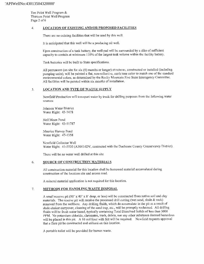
Ten Point Well Program &Thirteen Point Well ProgramPage 2 of 6
4. LOCATION OF EXISTING AND/OR PROPOSED FACILITIES
There are no existing facilities that will be used by this well.
It is anticipated that this well will be a producing oil well.
Upon construction of a tank battery, the well pad will be surrounded by a dike of sufficientcapacity to contain at minimum 110% of the largest tank volume within the facility battery.
Tank batteries will be built to State specifications.
All permanent (on site for six (6) months or longer) structures, constructed or installed (includingpumping units), will be painted a flat, non-reflective, earth tone color to match one of the standardenvironmental colors, as determined by the Rocky Mountain Five State Interagency Committee.All facilities will be painted within six months of installation.
5. LOCATION AND TYPE OF WATER SUPPLY
Newfield Production will transport water by truck for drilling purposes from the following watersources:
Johnson Water DistrictWater Right: 43-7478
Neil Moon PondWater Right: 43-11787
Maurice Harvey PondWater Right: 47-1358
Newfield Collector WellWater Right: 41-3530 (A30414DV, contracted with the Duchesne County Conservancy District).
There will be no water well drilled at this site
6. SOURCE OF CONSTRUCTION MATERIALS
All construction material for this location shall be borrowed material accumulated duringconstruction of the location site and access road.
A mineral material application is not required for this location.
7. METHODS FOR HANDLING WASTE DISPOSAL
A small reserve pit (90' x 40' x 8' deep, or less) will be constructed from native soil and claymaterials. The reserve pit will receive the processed drill cutting (wet sand, shale & rock)removed from the wellbore. Any drilling fluids, which do accumulate in the pit as a result ofshale-shaker carryover, cleaning of the sand trap, etc., will be promptly reclaimed. All drillingfluids will be fresh water based, typically containing Total Dissolved Solids of less than 3000PPM. No potassium chloride, chromates, trash, debris, nor any other substance deemed hazardouswill be placed in this pit. A 16 mil liner with felt will be required. Newfield requests approvalthat a flare pit be constructed and utilized on this location.
A portable toilet will be provided for human
'APIWellNo:43013504320000'
CONFIDENTIAL
'APIWellNo:43013504320000'
Ten Point Well Program &Thirteen Point Well ProgramPage 3 of 6
A trash basket will be provided for garbage (trash) and hauled away to an approved disposal site atthe completion of the drilling activities.
Immediately upon first production, all produced water will be confined to a steel storage tank. Ifthe production water meets quality guidelines, it is transported to the Ashley, Monument Butte,Jonah, and Beluga water injection facilities by company or contract trucks. Subsequently, theproduced water is injected into approved Class II wells to enhance Newfield's secondary recoveryproject.
Water not meeting quality criteria, is disposed at Newfield's Pariette #4 disposal well (Sec. 7, T9SRl9E) or at State of Utah approved surface disposal facilities.
8. ANCILLARY FACILITIES:
There are no ancillary facilities planned for at the present time and none foreseen in the nearfuture.
9. WELL SITE LAYOUT:
See attached Location Layout Sheet.
Fencing Requirements
All pits will be fenced according to the following minimum standards:
a) A 39-inch net wire shall be used with at least one strand of barbed wire on top of the net.
b) The net wire shall be no more than two (2) inches above the ground. The barbed wireshall be three (3) inches above the net wire. Total height of the fence shall be at leastforty-two (42) inches.
c) Corner posts shall be centered and/or braced in such a manner to keep tight at all times
d) Standard steel, wood or pipe posts shall be used between the corner braces. Maximumdistance between any two posts shall be no greater than sixteen (16) feet.
e) All wire shall be stretched, by using a stretching device, before it is attached to the cornerposts.
The reserve pit fencing will be on three (3) sides during drilling operations and on thefourth side when the rig moves off location. Pits will be fenced and maintained untilcleanup.
10. PLANS FOR RESTORATION OF SURFACE:
a) Producing Location
Immediately upon well completion, the location and surrounding area will be cleared ofall unused tubing, equipment, debris, material, trash and junk not required for production.
The reserve pit and that portion of the location not needed for productionfacilities/operations will be recontoured to the approximated natural contours. Weatherpermitting, the reserve pit will be reclaimed within one hundred twenty (120) days
'APIWellNo:43013504320000'
CONFIDENTIAL
'APIWellNo:43013504320000'
Ten Point Well Program &Thirteen Point Well ProgramPage 4 of 6
the date of well completion. Before any dirt work takes place, the reserve pit must haveall fluids and hydrocarbons removed.
b) Dry Hole Abandoned Location
At such time as the well is plugged and abandoned, the operator shall submit asubsequent report of abandonment and the State of Utah will attach the appropriate
surface rehabilitation conditions of approval.
11. SURFACE OWNERSHIP: State of Utah.
12. OTHER ADDITIONAL INFORMATION:
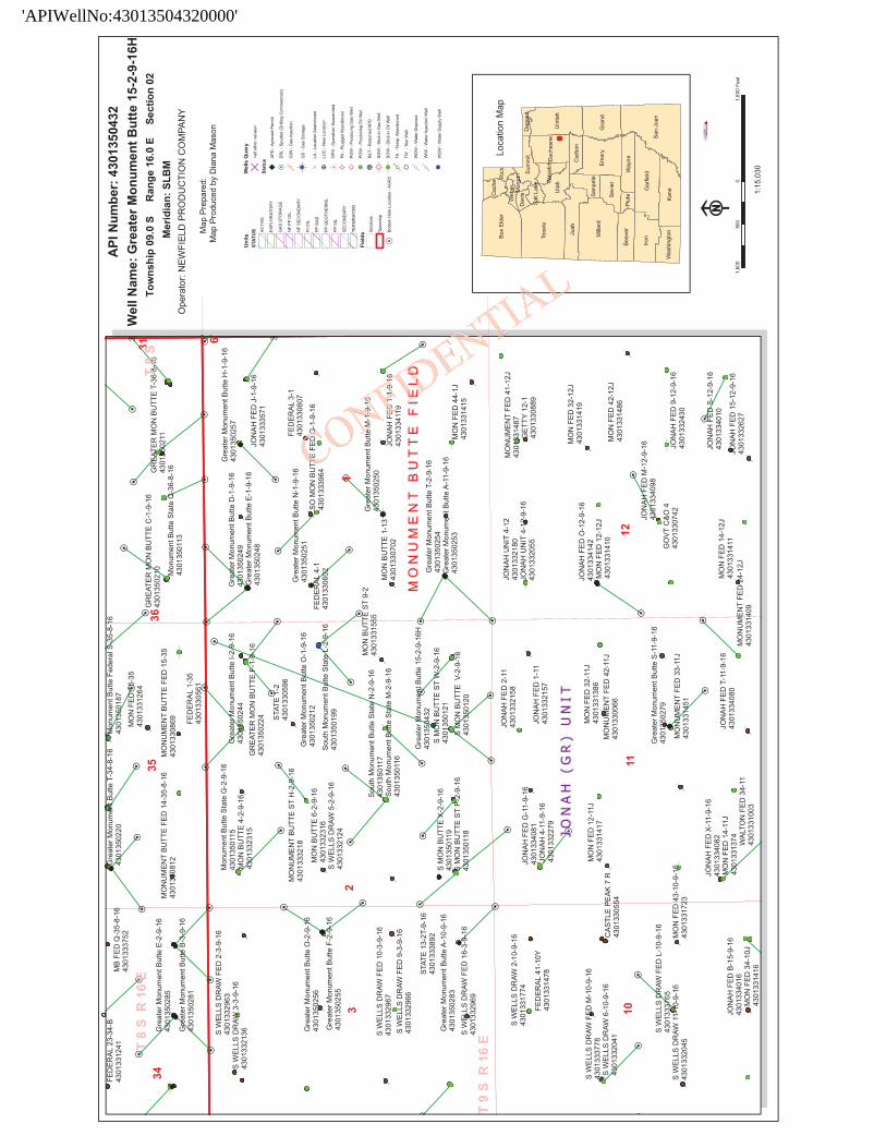
Newfield Production Company requests 123' of planned access road to be granted. Refer toTopographic Map "B". Newfield Production Company requests 109' of surface gas line to begranted. Newfield Production Company requests 17l' of buried water line to be granted.
It is proposed that the disturbed area will be 60' wide to allow for construction of the proposedaccess road, a 10" or smaller gas gathering line, a 4" poly fuel gas line, a buried 3" steel waterinjection line and a buried 3" poly water return line. The planned access road will consist of a 18'permanent running surface (9' either side of the centerline) crowned and ditched in order to handleany run-off from any precipitation events that are prevalent to this area. The maximum grade willbe less than 8%. There will be no culverts required along this access road. There will be turnoutsas needed along this road to allow for increases in potential traffic issues. There are no fencesencountered along this proposed road. There will be no new gates or cattle guards required. Allconstruction material for this access road will be borrowed material accumulated duringconstruction of the access road.
Both the proposed surface gas and buried water lines will tie in to the existing pipelineinfrastructure. Refer to Topographic Map "C." The proposed water pipelines will be buried ina 4-5' deep trench constructed with a trencher or backhoe for the length of the proposal. Theequipment will run on the surface and not be flat bladed to minimize surface impacts to precioustopsoil in these High Desert environments. If possible, all proposed surface gas pipelines will beinstalled on the same side of the road as existing gas lines. The construction phase of the plannedaccess road, proposed gas lines and proposed water lines will last approximately (5) days.
In the event that the proposed well is converted to a water injection well, a Sundry Notice formwill be applied for through the State of Utah DOGM office.
The Archaeological Resource Survey will be forthcoming. The Paleontological Resource Surveyfor this area is attached. Paleontological Resource Survey prepared by, Wade E. Miller, 9/6/10.See attached report cover page, Exhibit "D".
a) Newfield Production Company is responsible for informing all persons in the area whoare associated with this project that they will be subject to prosecution for knowinglydisturbing historic or archaeological sites, or for collecting artifacts. If historic orarchaeological materials are uncovered during construction, Newfield is to immediatelystop work that might further disturb such materials and contact the Authorized Officer.
b) Newfield Production will control noxious weeds along rights-of-way for roads, pipelines,well sites or other applicable facilities. On State administered land it is required that aPesticide Use Proposal shall be submitted and given approval prior to the application ofherbicides or other possible hazardous
'APIWellNo:43013504320000'
CONFIDENTIAL
'APIWellNo:43013504320000'
Ten Point Well Program &Thirteen Point Well ProgramPage 5 of 6
c) Drilling rigs and/or equipment used during drilling operations on this well site will not bestacked or stored on State Lands after the conclusion of drilling operations or at any othertime without State authorization. However, if State authorization is obtained, it is only atemporary measure to allow time to make arrangements for permanent storage oncommercial facilities.
Surface Flow LineNewfield requests 171' of surface flow line be granted. It is proposed that the disturbed area forthe surface flowline will be 30' to allow for construction of up to a 14" bundled pipe consisting of2-2" poly glycol lines and 1-3" production line. Refer to Topographic Map "C" for the proposedlocation of the proposed flow line. Flow lines will be tan and will be constructed using thefollowing procedures:
Clearing and Grading: the proposed flow line will be placed on the surface of the ground. As suchno grading or clearing will be needed. The flow line will be centered staked every 200 feet prior tothe installation. The flow line will be as close to the access road as possible without interferingwith the normal road travel, or road maintenance
Installation for portions along existing roads, lengths of pipe will be laid in the barrow ditch,welded together and moved into place. For lines that go cross-country minimal access will beneeded only for maintenance purpose. It is in the best interest of Newfield Exploration to avoidwet and saturated ground that would cause ruts greater than 3 inches in depth. Disturbed areas willbe reclaimed with in 120 days of the end of the installation.
Additional Surface Stipulations
All lease and/or unit operations will be conducted in such a manner that full compliance is madewith all applicable laws and regulations, Onshore Oil and Gas Orders, the approved plan ofoperations and any applicable Notice to Lessees. A copy of these conditions will be furnished tothe field representative to ensure compliance.
Hazardous Material Declaration
Newfield Production Company guarantees that during the drilling and completion of the GreaterMonument Butte 15-2-9-16H, Newfield will not use, produce, store, transport or dispose 10,000#annually of any of the hazardous chemicals contained in the Environmental Protection Agency'sconsolidated list of chemicals subject to reporting under Title III Superfund Amendments andReauthorization Act (SARA) of 1986. Newfield also guarantees that during the drilling andcompletion of the Greater Monument Butte 15-2-9-16H Newfield will use, produce, store,transport or dispose less than the threshold planning quantity (T.P.Q.)of any extremely hazardoussubstances as defined in 40 CFR 355.
A complete copy of the approved APD, if applicable, shall be on location during the construction
of the location and drilling activities.
Newfield Production Company or a contractor employed by Newfield Production shall contact theState office at (801) 722-3417, 48 hours prior to construction activities.
The State office shall be notified upon site completion prior to moving on the drilling rig.
13. LESSEE'S OR OPERATOR'S REPRENSENTATIVE AND CERTIFICATION:Representative
Name: Tim EatonAddress: Newfield Production
'APIWellNo:43013504320000'
CONFIDENTIAL
'APIWellNo:43013504320000'
Ten Point Well Program &Thirteen Point Well ProgramPage 6 of 6
Route 3, Box 3630Myton, UT 84052
Telephone: (435) 646-3721
CertificationPlease be advised that Newfield Production Company is considered to be the operator of well #15-2-9-16H, SW/SE Section 2, T9S, R16E, Duchesne County, Utah and is responsible under theterms and conditions of the lease for the operations conducted upon the leased lands. Bondcoverage is provided by Bond #B001834.
I hereby certify that the proposed drill site and access route have been inspected, and I am familiarwith the conditions which currently exist; that the statements made in this plan are true and correctto the best of my knowledge; and that the work associated with the operations proposed here willbe performed by Newfield Production Company and its contractors and subcontractors inconformity with this plan and the terms and conditions under whiryh it is approved. This statementis subject to the provisions of the 18 U.S.C. 1001 for the filing offa false state nt.
BUREAU OF LAND MANAGEMENTUtah State OfficeP.O. Box 45155
Salt Lake City, Utah 84145-0155
IN REPLY REFER TO:3160(UT-922)
October 5, 2010
Memorandum
To: Assistant District Manager Minerals, Vernal District
From: Michael Coulthard, Petroleum Engineer
Subject: 2010 Plan of Development Greater MonumentButte Unit, Duchesne and Uintah Counties,Utah.
Pursuant to email between Diana Whitney, Division of Oil, Gas andMining, and Mickey Coulthard, Utah State Office, Bureau of Land Management, the following horizontal wells are planned for calendar year 2010 within the Greater Monument Butte Unit,Duchesne and Uintah Counties, Utah.
This office has no objection to permitting the wells at this time.
bcc: File – Greater Monument Butte UnitDivision of Oil Gas and MiningCentral FilesAgr. Sec. ChronFluid Chron
MCoulthard:mc:10-5-10
File Greater Monument ButteDivision of Oil Gas and MiningCentral Files
Michael L. CoulthardDigitally signed by Michael L. Coulthard DN: cn=Michael L. Coulthard, o=Bureau of Land Management, ou=Branch of Minerals, [email protected], c=US Date: 2010.10.05 13:11:22 -06'00'
'APIWellNo:43013504320000'
CONFIDENTIAL
'APIWellNo:43013504320000'
United States Department of the Interior
BUREAU OF LAND MANAGEMENTUtah State Office
P.O. Box 45155Salt Lake City, Utah 84145-0155
IN FŒPLY FŒFER TO:3160(UT-922)
October 5, 2010
Memorandum
To: Assistant District Manager Minerals, Vernal District
From: Michael Coulthard, Petroleum Engineer
Subject: 2010 Plan of Development Greater MonumentButte Unit, Duchesne and Uintah Counties,Utah.
Pursuant to email between Diana Whitney, Division of Oil, Gas andMining, and Mickey Coulthard, Utah State Office, Bureau of LandManagement, the following horizontal wells are planned forcalendar year 2010 within the Greater Monument Butte Unit,Duchesne and Uintah Counties, Utah.
This well is designed as a horizontal in the Basal oiµte formation, at the base of theGreen River formation. The well will be dril i ally to a kick off point of 5,670'.Directional tools will then be used to bui 5° inclination and the well will belanded in the Basal Carbonate form e lateral will be drilled to the proposedbottomhole location, and 5-1/2" n casing will be run to TD. An open holepacker system and sliding sl be used to isolate separate frac stages in the lateral.The casing will be cemen the top of the curve to surface with a port collar.
1. GEOLOGIC SURFACE FORMATION:
Uinta formation
2. ESTIMATED TOPS OF IMPORTANT GEOLOGIC MARKERS:
Green River 1,550'Target (Basal Carbonate) 6,272'TD 6,272' TVD / 10,274' MD
3. ESTIMATED DEPTHS OF ANTICIPATED WATER, OIL, GAS OR MINERALS:
Green River Formation (Oil) 4,055' - 6,272' TVD
Fresh water may be encountered in the Uinta Formation, but would not be expected below about300'. All water shows and water bearing geologic units shall be reported to the geologic andengineering staff of the State Office prior to running the next string of casing or before pluggingorders are requested. All water shows must be reported within one (1) business day after beingencountered.
All usable (<10,000PPM TDS) water and prospectively valuable minerals (as described by theState of Utah DOGM at onsite) encountered during drilling will be recorded by depth andadequately protected. This information shall be reported to the State Office.
Detected water flows shall be sampled, analyzed, and reported to the geologic & engineering staffof the State Office. The office may request additional water samples for further analysis. Usage ofthe State of Utah form Report of Water Encountered is acceptable, but not required.
The following information is requested for water shows and samples where applicable:
Location & Sampled Interval Date SampledFlow Rate TemperatureHardness
'APIWellNo:43013504320000'
CONFIDENTIAL
T9S,
Ri6
E,S.
L.B
.&M
.N
ENZD
REM
TIO
NC
OM
PMY
S89
57E
(G.L
.O.)
2639
.47'
(Mea
sure
d)W
ELL
LOC
ATI
ON
,15
-2-9
-16H
,LO
CA
TED
ssA
ESC
TSH
OO
NW
NIN
THER
1S6 ,
S.B
&M
./4O
F
DU
CH
ESN
EC
OU
NTY
,U
TAH
.of
Ho/
e
LOT
4LO
T3
LOT
2LO
T1
/TA
RG
ETB
OTT
OM
HO
LE,
15-2
-9-1
6H,
/LO
CA
TED
AS
SHO
WN
INTH
EN
E1/
4N
E1/
4(L
OT
1)O
FSE
CTI
ON
2,T9
S,R
16E,
S.L.
B.&
M.
DU
CH
ESN
EC
OU
NTY
,--
--¯¯
¯¯
UTA
H.
/ g^o
-
~o
NEL
LLO
CA
710H
:/g
e8
8-
°
15-2
-9-1
6H/
2'¯
°'¯
ELEV
UN
GR
AD
EDG
RO
UN
D=
5520
.1m
mB
AR
SCA
LEN
Not
e:1.
The
botto
mof
hole
foot
ages
are
1910
/A
tom
inum
150'
FNL
&35
0'FE
L.B
rass
Cap
iC
ap
ors
THIS
ISTO
CER
TIFY
THA
AW
AS
ell
Hea
dPR
EPA
RED
FRO
MFI
ELD
OR
VEY
S
fHF
MY
OL
DG
R1E
CT
TTH
AT
DR
/t.LI
NG
Det
ai
IW
/ND
OW
2C
YW
.N
oSc
a/e
RST
ED
LAD
ets,"
RIS
TRA
No.
toro
/-eft
STTE
OF
1910
Bro
ssC
opB
rass
Co
Sca4
5'44
"W-
2625
.64'
(Mea
s.)SB
922'
02"W
-26
41.4
1'(M
eas.)
TRIS
TATE
LAN
DSU
RV
EYIN
G&C
ON
SULT
ING
S89°
54'W
-79.
90(G
.L.O
.)18
0N
OR
THV
ERN
AL
AV
E.-
VER
NA
L,U
TAH
8407
8=
SEC
TIO
NC
OR
NER
SLO
CA
TED
(435
)78
1-25
01
|15-2
-9-1
6HD
ATE
SUR
VEY
EDB
ASI
SO
FEL
EV;
Elev
atio
nsar
eba
seon
(Sur
face
Loca
tion)
NA
D81
07-0
9-10
SUR
VEY
EDB
Y:
S.H
.
LOC
ATI
ON
:an
N.G
.S.
OPU
SC
orre
ctio
n.LA
T/7U
DE
=40
°O
J'20
.38"
DA
TED
RA
WN
:D
RA
WN
BY
M.W
LAT.
40°0
4'09
.56
LON
G.
110°
00'4
3.28
LON
G/T
UD
E=
110°
05'
02.8
0"07
-12-
10
(Tris
tate
Alu
min
umC
ap)
Elev
.52
81.5
7'R
EVlS
ED:
SCA
LE:
1"=
1000
'08
-11-
10-
'APIWellNo:43013504320000'
CONFIDENTIAL
NEW
FIEL
DN
ewfie
ldPr
oduc
tion
Com
pany
TMA
rimut
hsto
True
Nor
thPr
ojec
t:M
onum
ent
But
teM
agne
ticN
orth
:11.4
9°
Site
:G
MB
15-2
-9-1
6HR
OC
KY
MO
UN
TAIN
SW
ell:
GM
B15
-2-9
-16H
stre
ngta5
g28.
4n
Wei
lbor
e:W
ellb
ore
#1D
ipA
ngle
:65.8
5°
Des
ign:
Des
ign
#1M
le:
1R2/
F32
0
3000
--
-
15.2
-9-1
6HB
HL
3500
--
--
--
3750
-
4200
--
4000
g900
--
--
--
--
---
2250
-
p.
5000
+.
6300
--
--
-75
0--
T&2-
9-16
HB
HL
7000
--
--
---
--
-0-
-'''I
''ll
''''l''
'I''''I
''''ll'
''I''''
ll'''
13'''
'I''''I
I'''l'C
''I''''
I''''I
''''I'
O70
014
0021
0028
0035
0042
0049
0056
0063
00-1
500
-750
075
015
0022
5030
00V
ertic
alSe
ctio
nat
20.4
8°W
est(-
)/Eas
t(+)
(150
0ft/
in)
SEC
TIO
ND
ETA
ILS
Sec
MD
Inc
Ari
TVD
+N/-S
+El-W
DLe
gTF
ace
VSe
cTa
rget
10.
00.
000.
000.
00.
00.
00.
000.
000.
0PR
OJE
CT D
ETA
ILS:
Mon
umen
tB
utte
256
69.9
0.00
0.00
5669
.90.
00.
00.
000.
000.
03
6404
.488
.15
20.4
861
47.1
432.
816
1.7
12.0
020
.48
462.
1G
eode
ticSy
stem
:U
SSt
ate
Plan
e19
8341
0274
.388
.15
20.4
862
72.0
4056
.215
14.9
0.00
0.00
4329
.915
-2-9
-16H
BH
LD
atum
:N
orth
Am
eric
anD
atum
1983
Ellip
soid
:G
RS
1980
Zone
:U
tah
Cen
tral
Zone
Cre
ated
by:
Han
sW
ychg
ram
Syst
emD
atum
:M
ean
Sea
Leve
1D
ate:
â
â
ââ
ââ
â
â
ââ
ââ
ââ
â â
â
ââ
â
ââ
â
â
ââ
âââ
â
â
ââ
â
â
âââ
â
â
â
â
â
â
â
â
â
â
â
â
ââ
â
â
ââ
â
â
â
â
â
ââ
â
â
â
ââ
â
â
â
ââ
â
â
â
â
â
ââ
â
ââ
â
â
ââ
âââ
â
â
ââ
â
â
âââ
â
â
â
ââ
ââ
ââ
â â
â
â
ââ
âââ
¸
'·
ª
'
·
'
ª
''
ª
'ª
'
·
¸
¸
N
¸
¸
N
¸N
N¸
'¸
·
N
¸
¸
·
'¸ ·
¸
¸
¸N
¸N
'N
·
¸
¸
¸
¸
N
¸
¸
¸
¸
¸
ª
¸
'
¸ ¸
' '
¸
¸
¸
N
¸ N
N
'
ª
¸'
N
¸'
'
¸
¸
N
¸
'
¸¸ N
¸
¸¸
'
¸
¸
N
¸¸
¸
N
¸
¸¸
¸¸
ª
' ¸ '
¸
'¸
·'
¸¸
'
¸
·
' '
¸
·
¸' ¸
'
¸
'
'
'
'
'
'
'
'
'
'
'
'
''
'
'
'
'
'
'
'
''
'
' '
''' '' '
HH
H
''
'
H
' '
!G
reat
er M
onum
ent B
utte
15-
2-9-
16H
43
0135
0432
Gre
ater
Mon
umen
t But
te E
-2-9
-16
4301
3502
85
Gre
ater
Mon
umen
t But
te A
-10-
9-16
4301
3502
83
Gre
ater
Mon
umen
t But
te B
-3-9
-16
4301
3502
81
Gre
ater
Mon
umen
t But
te S
-11-
9-16
4301
3502
79
Gre
ater
Mon
umen
t But
te H
-1-9
-16
4301
3502
57
Gre
ater
Mon
umen
t But
te O
-2-9
-16
4301
3502
56
Gre
ater
Mon
umen
t But
te F
-2-9
-16
4301
3502
55
Gre
ater
Mon
umen
t But
te T
-2-9
-16
4301
3502
54G
reat
er M
onum
ent B
utte
A-1
1-9-
16
43
0135
0253
Gre
ater
Mon
umen
t But
te N
-1-9
-16
4301
3502
51
Gre
ater
Mon
umen
t But
te M
-1-9
-16
4301
3502
50
Gre
ater
Mon
umen
t But
te D
-1-9
-16
4301
3502
49G
reat
er M
onum
ent B
utte
E-1
-9-1
6
43
0135
0248
Gre
ater
Mon
umen
t But
te I-
2-9-
16
43
0135
0244
GR
EATE
R M
ON
BU
TTE
F-1
-9-1
6
4301
3502
24
Gre
ater
Mon
umen
t But
te T
-34-
8-16
4301
3502
20
Gre
ater
Mon
umen
t But
te O
-1-9
-16
4301
3502
12
GR
EATE
R M
ON
BU
TTE
T-3
6-8-
16
4301
3502
11
GR
EATE
R M
ON
BU
TTE
C-1
-9-1
6
4301
3502
10
Sout
h M
onum
ent B
utte
Sta
te L
-2-9
-16
4301
3501
99
Mon
umen
t But
te F
eder
al S
-35-
8-16
4301
3501
87
S M
ON
BU
TTE
ST
W-2
-9-1
6
43
0135
0121
S M
ON
BU
TTE
V-2
-9-1
6
4301
3501
20
S M
ON
BU
TTE
X-2
-9-1
6
4301
3501
19S
MO
N B
UTT
E S
T P-
2-9-
16
4301
3501
18
Sout
h M
onum
ent B
utte
Sta
te N
-2-9
-16
4301
3501
17So
uth
Mon
umen
t But
te S
tate
M-2
-9-1
6 43
0135
0116
Mon
umen
t But
te S
tate
G-2
-9-1
6
43
0135
0115
Mon
umen
t But
te S
tate
Q-3
6-8-
16
43
0135
0113
JON
AH F
ED O
-12-
9-16
4301
3341
42
JON
AH F
ED T
-1-9
-16
4301
3341
19
JON
AH F
ED M
-12-
9-16
4301
3340
98
JON
AH F
ED X
-11-
9-16
4301
3340
82
JON
AH F
ED G
-11-
9-16
4301
3340
81
JON
AH F
ED
T-1
1-9-
16
43
0133
4080
JON
AH
FED
B-1
5-9-
16
43
0133
4016
JON
AH F
ED S
-12-
9-16
4301
3340
10
SO M
ON
BU
TTE
FED
G-1
-9-1
6
43
0133
3964
STAT
E 13
-2T-
9-16
43
0133
3892
S W
ELLS
DR
AW F
ED
M-1
0-9-
16
43
0133
3778
S W
ELLS
DR
AW F
ED
L-1
0-9-
16
43
0133
3765
MB
FED
Q-3
5-8-
16
4301
3337
52
JON
AH F
ED J
-1-9
-16
4301
3335
71
MO
NU
MEN
T BU
TTE
ST
H-2
-9-1
6
4301
3332
18
S W
ELLS
DR
AW F
ED
16-
3-9-
16
43
0133
2969
S W
ELLS
DR
AW F
ED
10-
3-9-
16
43
0133
2967
S W
ELLS
DR
AW F
ED
9-3
-9-1
6
43
0133
2966
S W
ELLS
DR
AW F
ED
2-3
-9-1
6
43
0133
2963
JON
AH F
ED 1
5-12
-9-1
6
4301
3326
27
JON
AH F
ED 9
-12-
9-16
4301
3324
30
MO
N B
UTT
E 6-
2-9-
16
43
0133
2316
MO
N B
UTT
E 4-
2-9-
16
43
0133
2315
JON
AH 4
-11-
9-16
43
0133
2279
JON
AH U
NIT
4-1
2
4301
3321
80JO
NAH
FE
D 2
-11
43
0133
2158
JON
AH F
ED 1
-11
43
0133
2157
S W
ELLS
DR
AW 3
-3-9
-16
43
0133
2136
S W
ELLS
DR
AW 5
-2-9
-16
43
0133
2124
JON
AH U
NIT
4-1
2-9-
16
43
0133
2055
S W
ELLS
DR
AW 1
1-10
-9-1
6
43
0133
2045
S W
ELL
S D
RAW
6-1
0-9-
16
4301
3320
41
S W
ELLS
DR
AW 2
-10-
9-16
43
0133
1774
MO
N F
ED 4
3-10
-9-1
6
43
0133
1723
MO
N B
UTT
E ST
9-2
43
0133
1555
MO
NU
MEN
T FE
D 4
1-12
J
43
0133
1487
MO
N F
ED 4
2-12
J
4301
3314
86
FED
ERAL
41-
10Y
43
0133
1478
MO
NU
MEN
T FE
D 3
3-11
J
43
0133
1451
MO
N F
ED 3
2-12
J
4301
3314
19M
ON
FED
12-
11J
43
0133
1417
MO
N F
ED 3
4-10
J
4301
3314
16
MO
N F
ED 4
4-1J
4301
3314
15
MO
N F
ED 1
4-12
J
4301
3314
11
MO
N F
ED 1
2-12
J
4301
3314
10
MO
NU
MEN
T FE
D 2
4-12
J
43
0133
1409
MO
N F
ED
32-
11J
43
0133
1386
MO
N F
ED 1
4-11
J
4301
3313
74
MO
N F
ED 1
5-35
4301
3312
64
FED
ERAL
23-
34-B
43
0133
1241
WAL
TON
FED
34-
11
4301
3310
03
GE
TTY
12-1
43
0133
0889
MO
NU
MEN
T BU
TTE
FED
15-
35
43
0133
0869
MO
NU
MEN
T BU
TTE
FE
D 1
4-35
-8-1
6
43
0133
0812
GO
VT
C&O
4
4301
3307
42
MO
N B
UTT
E 1-
13
43
0133
0702
FED
ERAL
3-1
43
0133
0607
FED
ERAL
4-1
43
0133
0602
STAT
E 1-
2
4301
3305
96
FED
ERA
L 1-
35
43
0133
0561
CAS
TLE
PEAK
7 R
43
0133
0554
MO
NU
MEN
T FE
D 4
2-11
J
43
0133
0066
MO
NU
ME
NT
BU
TT
E F
IEL
DM
ON
UM
EN
T B
UT
TE
FIE
LD
JO
NA
H (
GR
) U
NI
TJ
ON
AH
(G
R)
UN
IT
12
3
1112
10
3536
3431 6
T 9
S R
16
ET 8
S R
16
ET
8 S
R
Map
Pro
duce
d by
Dia
na M
ason
Map
Pre
pare
d:
Wel
l Nam
e: G
reat
er M
onum
ent B
utte
15-
2-9-
16H
API
Num
ber:
430
1350
432
Tow
nshi
p 09
.0 S
Sect
ion
02R
ange
16.
0 E
Mer
idia
n: S
LBM
F1,
600
01,
600
800
Feet
1:15
,030
Uni
tsST
ATU
S ACTI
VE
EXP
LOR
ATO
RY
GA
S ST
OR
AG
E
NF
PP O
IL
NF
SEC
ON
DA
RY
PI O
IL
PP G
AS
PP G
EOTH
ER
ML
PP O
IL
SEC
ON
DA
RY
TER
MIN
ATED
Fiel
dsSe
ctio
ns
Tow
nshi
p
âBo
ttom
Hol
e Lo
catio
n - A
GR
C
Wel
ls Q
uery
D<a
ll ot
her v
alue
s>
Stat
usAP
D -
Apr
oved
Per
mit
HD
RL
- Spu
ded
(Dril
ling
Com
men
ced)
4G
IW -
Gas
Inje
ctio
n
!*G
S -
Gas
Sto
rage
NLA
- Lo
catio
n A
band
oned
!LO
C -
New
Loc
atio
n
7O
PS
- Ope
ratio
n Su
spen
ded
ªPA
- P
lugg
ed A
band
oned
*PG
W -
Prod
ucin
g G
as W
ell
'PO
W -
Prod
ucin
g O
il W
ell
OR
ET
- Ret
urne
d A
PD
¸SG
W -
Shut
-in G
as W
ell
·SO
W -
Shut
-in O
il W
ell
6TA
- T
emp.
Aba
ndon
ed
"TW
- T
est W
ell
¸W
DW
- W
ater
Dis
posa
l
¸W
IW -
Wat
er In
ject
ion
Wel
l
=*W
SW
- W
ater
Sup
ply
Wel
l
Tooe
le
Milla
rd
Iron
San
Juan
Kane
Juab
Uin
tah
Box
Eld
er
Emer
y
Gar
field
Gra
nd
Uta
h
Beav
erW
ayneD
uche
sne
Sevi
er
Sum
mit
Ric
h
Was
hing
ton
Car
bon
Sanp
ete
Cac
he
Piut
e
Dav
is
Was
atch
Web
er
Dag
gett
Salt
Lake
Mor
gan
Loca
tion
Map
Ope
rato
r: N
EWFI
ELD
PR
OD
UC
TIO
N C
OM
PAN
Y
NNNTT
E F
ED G e
-1-9
-16
FED
T-1
-9-1
96
E EEEL
DDL
DL
D
'APIWellNo:43013504320000'
CONFIDENTIAL
4F3E
OD
1E3R
AL2
3-34
-BM
30FE
D3
5235
-8-1
um8-
16A
3F5e
dera
l
Wel
lN
ame:
AG
reaN
uee
De1
n350
432e 15
-2-9
-16H
3536
GR
EATE
RN
BU
TTE
C-1
-9-1
6G
ERM
ON
BU
TTE
T-36
83
TOW
OSh
ip09
.0S
Ran
ge16
.0E
Sect
ion
0234
reat
3e5rM
8onu
men
tBut
teE-
2-9-
16M
ON
UM
ENT
BU
TTE
FED
14-3
5-8-
16M
ON
UM
ENT
BU
TTE
FED
15-3
543
0135
02,
4301
11M
erid
ian:
SLB
M43
013¥
0812
4301
3308
69' M
onum
ent
But
teSt
ate
36-8
-16
ater
Mon
umen
tB-1
63
*43
0135
0113
Ope
rato
r:N
EWFI
ELD
PRO
DU
CTI
ON
CO
MPA
NY
3013
5028
1FE
DER
AL1
-35
4301
3305
61M
apPr
epar
ed:
SW
ELLS
DR
AÒ
FED
2-3-
9-16
()M
apPr
oduc
edby
Dia
naM
ason
4301
3329
63M
onum
ent
But
teSt
ate
G-2
-9-1
6G
reat
erM
onum
ent
But
teH
-1-9
-16
SW
ELLS
DR
AW
3-3-
9-16
4301
3501
15on
umen
tB
utte
I-2
-16
erM
onum
ent
But
teD
-1-9
-16
4301
3502
57e
4301
3321
36O
NB
UTT
E4-
2-9-
16¶
4302
44e
1350
249
y33
2315
GR
EATE
RM
ON
BU
TT1-
6re
ater
Mon
umen
tB
utte
E-1-
9-16
JON
AH
FED
J-1-
9-16
sTTu
sry
sius
4301
3502
2443
0135
0248
4301
3335
71^c
rivE
stat
us
4M3O
ON
33M
E1N
8TB
UTT
EST
H-
6µ4
3013
3059
6G
reat
erM
onnt
But
teN
-1-9
-16
4F3E
DE3
6LO
37-1
'ei
wen
sini
ectio
n
Gre
ater
Mon
umen
tB
utte
0-2-
9-G
reat
erM
onum
ent
Btte
0-1-
9-16
4301
3502
51es
oass
tora
ge
4301
325
6M
ON
BU
TTE
6-2-
9-16
4301
3502
12FE
DE
4-1
OM
ON
BU
TTE
FEC
DG-1
-9-1
6'^
'oca
tionn
eauc
onse
Gre
ater
Mon
umen
tB
utte
F-2-
16S
4W3
S2D
3 AW
5-2-
9-16
4S30
uthM
O1n
9u9m
entBtte
Stat
-16
4301
330
4301
3339
64to
cN
ewto
4301
3502
5543
0133
2124
seco
0966
^
hM
onum
ent
But
teSt
atN
-2-9
-16
4M30
N33
55
ST9-
2G
13e5
r0M
onum
entB
utte
M-1
-9-1
6se
ctio
SW
ELLS
DR
AW
FED
10-3
-9-1
601
3501
17To
wns
63
4301
3329
67ou
thM
onum
ent
ÌeSt
eM
-2-9
-16
$4M
30N
3302
E1-
13O
NA
HFE
DT-
1-9-
16so
ton
eatio
n-A
oac
so
SW
ELLS
DR
AW
FED
9-3-
9-16
4301
3501
1643
0133
4119
4301
3329
66G
reat
eron
umB
utte
15-2
-9-1
6HM
ON
UM
ENT
BU
TTE
FI E
LD
Gre
ater
Mon
ume
1e
-0-
-1S3
M13
N50
116
4SO
2UTT
-16
30
4301
3502
83M
ON
BU
TTE
STP
-9-1
6N
BU
TTE
V-2
-9-
643
0135
0253
MO
NFE
D44
-1J
4S3W
L2SD
9MW
FED
16-3
413
5011
830
101
2043
0133
1415
JON
AH
FED
2-11
JON
AH
UN
IT4-
12M
ON
UM
ENT
FED
41-1
2Jo
Loca
tion
Map
SW
ELLS
DR
AW
2-10
-9-1
643
0133
2158
4301
3321
8043
0133
1487
4301
3317
74JO
NA
HFE
DG
-11-
9-1
NO
NA
HU
NIT
4-1g
-9-1
6(E
TTY
12-1
sum
mit
FED
ERA
L41-
10Y
4301
3340
81JO
NA
HFE
D1-
1143
0133
2055
4301
3308
89
4301
3314
78N
A3H
42-
-9-1
643
0133
2157
Tooe
leD
uche
snU
tah
Uin
tah
43N
AH
(GR
)U
NIT
MO
NFE
D32
-12J
auab
JON
AH
FED
0-12
-9-1
643
0133
1419
Car
bon
SW
ELLS
DR
AW
FM
-10-
9-16
MO
NFE
D12
-11J
MO
NFE
D32
-11J
4301
3341
42/
SD
1RA
W6-
100-
9-16
C3A
OS1
3LEE
4AK7
R#4
3013
3141
7"
4M30
NU
E6N
6FE6D
42-1
1J4M
30N
3F3E
4D11
02-1
22J'
4M3O
ON
3F3E
D84
62-1
2J
gB
ea
rard
Piut
S
teW
aEm
ery
Gra
nd
JON
EDM
-12-
9-16
Iron
Gar
field
SW
ELLS
AW
FED
L-10
-9-1
6G
reat
erM
onum
ent
But
teS-
11-9
-16
,
433
4098
/sa
nJu
an
4301
35
4301
0279
GO
VT
C&
O4
Was
hing
ton
Kan
eS
WEL
LSD
RA
W11
-9-1
6gM
ON
FED
3-10
-9-1
EM
OEN
TFE
D33
-11J
4301
3307
42JO
NA
HFE
D9-
12-9
-16
$430
1332
045
4301
3317
4301
331
4301
3324
30
JON
AH
FED
X-1
1-9-
16JO
NA
HÈ
-12-
9-16
3N
33F4
EOD 4-
11J
JON
AH
FED
T-11
-9-1
6M
ON
FED
14-1
2J43
0133
4010
JON
AH
FED
B-1
5-9-
1613
3137
443
0133
4080
4301
3314
11Ê)
NA
HFE
D15
-12-
9-16
4301
3340
16,
WA
LTO
NFE
D34
-11
MO
NU
MN
TFED
A4-
12J
4301
3326
271.
600
soo
a1e
ooFe
et
fMO
NFE
D34
-10J
4301
3310
03Ñ
4301
3314
0943
0133
1416
/
'APIWellNo:43013504320000'
CONFIDENTIAL
'APIWellNo:43013504320000'
NEWFIELD PRODUCTION COMPANYGREATER MONUMENT BUTTE 3-32-8-16H
This well is designed as a horizontal in the Basal o e formation, at the base of theGreen River formation. The well will be dril i ally to a kick off point of 5,864'.Directional tools will then be used to bui . inclination and the well will be landedin the Basal Carbonate formation. 1will be drilled to the proposed bottomholelocation, and 5-1/2" production c l be run to TD. An open hole packer systemand sliding sleeves will be u ate separate frac stages in the lateral. The casingwill be cemented from th the curve to surface with a port collar.
1. GEOLOGIC SURFACE FORMATION:
Uinta formation
2. ESTIMATED TOPS OF IMPORTANT GEOLOGIC MAREERS:
Green River 1,715'Target (Basal Carbonate) 6,226'TD 6,226' TVD / 11,049' MD
3. ESTIMATED DEPTHS OF ANTICIPATED WATER, OIL, GAS OR MINERALS:
Green River Formation (Oil) 4,260' - 6,226' TVD
Fresh water may be encountered in the Uinta Formation, but would not be expected below about300'. All water shows and water bearing geologic units shall be reported to the geologic andengineering staff of the State Office prior to running the next string of casing or before pluggingorders are requested. All water shows must be reported within one (1) business day after beingencountered.
All usable (<10,000PPM TDS) water and prospectively valuable minerals (as described byDOGM at onsite) encountered during drilling will be recorded by depth and adequately protected.This information shall be reported to the State Office.
Detected water flows shall be sampled, analyzed, and reported to the geologic & engineering staffof the State Office. The office may request additional water samples for further analysis. Usage ofthe State of Utah form Report of Water Encountered is acceptable, but not required.
The following information is requested for water shows and samples where applicable:
Location & Sampled Interval Date SampledFlow Rate TemperatureHardness
Prepared Helen Sadik-Macdonald Phone: 801 538-5357 Date: December 6,2010by: Div of Oil,Gas & Mining FAX: 801-359-3940 Salt Lake City, Utah
Remarks:Collapse is based on a vertical depth of 1000 ft, a mud weight of 8.33 ppg The casing is considered to be evacuated for collapse purposes.Collapse strength is based on the Westcott, Dunlop & Kemler method of biaxial correction for tension.
Burst strength is not adjusted for tension.
Engineering responsibility for use of thisdesign will be thatof the
'APIWellNo:43013504320000'
CONFIDENTIAL
'APIWellNo:43013504320000'
Well name: 43013504320000 Greater Monument Butte 15-2-9-16HOperator: NEWFIELD PRODUCTION COMPANYString type: Production Project ID:
43-013-50432Location: DUCHESNE COUNTY
Design parameters: Minimum design factors: Environment:Collapse Collapse: H2S considered? No
Mud weight: 8.500 ppg Design factor 1.125 Surface temperature: 74 °FDesign is based on evacuated pipe. Bottom hole temperature: 153 °F
Temperature gradient: 1.40 °F/100ftMinimum section length: 100 ft
Prepared Helen Sadik-Macdonald Phone: 801 538-5357 Date: December 6,2010by: Div of Oil,Gas & Mining FAX: 801-359-3940 Salt Lake City, Utah
Remarks:Collapse is based on a vertical depth of 5670 ft, a mud weight of 8.5 ppg The casing is considered to be evacuated for collapse purposes.Collapse strength is based on the Westcott, Dunlop & Kemler method of biaxial correction for tension.
Burst strength is not adjusted for tension.
Engineering responsibility for use of thisdesign willbe thatof the
ON-SITE PREDRILL EVALUATIONUtah Division of Oil, Gas and Mining
Operator NEWFIELD PRODUCTION COMPANY
Well Name Greater Monument Butte 15-2-9-16H
API Number 43013504320000 APD No 3039 Field/Unit MONUMENT BUTTE
Floyd Bartlett (DOGM), Joe Pippy (Newfield Production Company), Jim Davis and Lavonne Garrison (SITLA).
Regional/Local Setting & Topography
The general area is approximately 12 miles southwest of Myton, Utah in the Castle Peak Draw area of the
Monument Butte oil field. Castle Peak Draw runs in a northeasterly direction and joins Pariette Draw. Pariette Draw
continues in a southeasterly direction about 6 miles and joins the Green River about 6 miles below Ouray Utah.
Pariette Draw contains a perennial stream somewhat consisting of irrigation runoff and seepage. No streams springs
or seeps occur in the immediate area. An occasional pond constructed to store runoff for livestock or wildlife exists.
Drainages are ephemeral only flowing during spring snowmelt or following intense summer rainstorms. Broad flats
or rolling topography intersected by drainages with gentle to sometimes steep side-slopes characterize the area.
Access from Myton, Utah is following State of Utah Hwy. 40 and Duchesne and Uintah County and oilfield
development roads a distance of 14.8 miles. A new road 0.1 miles in length will be required to reach the location.
The proposed State 15-2-9-16 is an oil well to be horizontally drilled. The pad is oriented in a west to east direction
on a flat with a gentle slope to the northeast. It is also north of an existing well and road. A road also exists to the
west. Maximum cuts are 6.4 feet at Pit Corner C and Location Corner 6. Maximum fill is 7.0 feet at Corner 2 which
is on the northeast corner. A shallow swale enters the location on the west near Corner 7 and continues across the
site. It should be diverted to the north around the pad. The road entrance onto the location will be moved from
Corner 6 to between Corners 7 and 8. The selected site has no apparent concerns and appears to be a good location
for constructing a pad, drilling and operating a well.
Both the surface and minerals are owned by SITLA.
Surface Use Plan
Current Surface Use
Grazing
Wildlfe Habitat
New Road Miles Well Pad Src Const Material Surface Formation
0.1 Width 310 Length 400 Onsite UNTA
Ancillary Facilities N
Waste Management Plan Adequate?
Environmental Parameters
Affected Floodplains and/or Wetlands N
Flora / Fauna
12/14/2010 Page 1
'APIWellNo:43013504320000'
CONFIDENTIAL
'APIWellNo:43013504320000'
ON-SITE PREDRILL EVALUATIONUtah Division of Oil, Gas and Mining
Operator NEWFIELD PRODUCTION COMPANYWell Name Greater Monument Butte 15-2-9-16H
API Number 43013504320000 APD No 3039 Field/Unit MONUMENT BUTTELocation: 1/4,1/4 SWSE Sec 2 Tw 9.0S Rng 16.0E 1107 FSL 1935 FELGPS Coord (UTM) Surface Owner
ParticipantsFloyd Bartlett (DOGM), Joe Pippy (Newfield Production Company), Jim Davis and Lavonne Garrison (SITLA).
Regional/Local Setting & TopographyThe general area is approximately 12 miles southwest of Myton, Utah in the Castle Peak Draw area of theMonument Butte oil field. Castle Peak Draw runs in a northeasterly direction and joins Pariette Draw. Pariette Drawcontinues in a southeasterly direction about 6 miles and joins the Green River about 6 miles below Ouray Utah.Pariette Draw contains a perennial stream somewhat consisting of irrigation runoff and seepage. No streams springsor seeps occur in the immediate area. An occasional pond constructed to store runoff for livestock or wildlife exists.Drainages are ephemeral only flowing during spring snowmelt or following intense summer rainstorms. Broad flatsor rolling topography intersected by drainages with gentle to sometimes steep side-slopes characterize the area.Access from Myton, Utah is following State of Utah Hwy. 40 and Duchesne and Uintah County and oilfielddevelopment roads a distance of 14.8 miles. A new road 0.1 miles in length will be required to reach the location.
The proposed State 15-2-9-16 is an oil well to be horizontally drilled. The pad is oriented in a west to east directionon a flat with a gentle slope to the northeast. It is also north of an existing well and road. A road also exists to thewest. Maximum cuts are 6.4 feet at Pit Comer C and Location Corner 6. Maximum fill is 7.0 feet at Comer 2 whichis on the northeast corner. A shallow swale enters the location on the west near Corner 7 and continues across thesite. It should be diverted to the north around the pad. The road entrance onto the location will be moved fromCorner 6 to between Corners 7 and 8. The selected site has no apparent concerns and appears to be a good locationfor constructing a pad, drilling and operating a well.
Both the surface and minerals are owned by SITLA.
Surface Use PlanCurrent Surface UseGrazingWildlfe Habitat
New Road Miles Well Pad Src Const Material Surface Formation0.1 Width 310 Length 400 Onsite UNTA
Ancillary Facilities N
Waste Management Plan Adequate?
Environmental ParametersAffected Floodplains and/or Wetlands N
Flora / Fauna
I
12/14/2010 Page
The site is moderately vegetated. Vegetation is a desert shrub type which includes, shadscale, curly mesquite,
halogeton, mustard weed, rabbit brush, horsebrush, broom snakeweed,globe mallow and spring annuals..
Cattle, prairie dogs, antelope, small mammals and birds.
Soil Type and Characteristics
Shallow sandy loam with some surface rock.
Erosion Issues N
Sedimentation Issues Y
Site Stability Issues N
Drainage Diverson Required? Y
A shallow swale enters the location on the west near Corner 7 and continues across the site. It should be
diverted to the north around the pad.
Berm Required? Y
Erosion Sedimentation Control Required? Y
A shallow swale enters the location on the west near Corner 7 and continues across the site.
Paleo Survey Run? Paleo Potental Observed? N Cultural Survey Run? Y Cultural Resources? N
Reserve Pit
Site-Specific Factors Site Ranking
Distance to Groundwater (feet) 100 to 200 5
Distance to Surface Water (feet) >1000 0
Dist. Nearest Municipal Well (ft) >5280 0
Distance to Other Wells (feet) 300 to 1320 10
Native Soil Type Mod permeability 10
Fluid Type Fresh Water 5
Drill Cuttings Normal Rock 0
Annual Precipitation (inches) 0
Affected Populations
Presence Nearby Utility Conduits Not Present 0
Final Score 30 1 Sensitivity Level
Characteristics / Requirements
A 100’ x 165' x 8' deep reserve pit is planned in an area of cut on the southwest side of the location. A pit
liner is required. Newfield commonly uses a 16-mil liner.
Closed Loop Mud Required? N Liner Required? Y Liner Thickness 16 Pit Underlayment Required? Y
Other Observations / Comments
Floyd Bartlett 10/13/2010
Evaluator Date / Time
12/14/2010 Page 2
'APIWellNo:43013504320000'
CONFIDENTIAL
'APIWellNo:43013504320000'
The site is moderately vegetated. Vegetation is a desert shrub type which includes, shadscale, curly mesquite,halogeton, mustard weed, rabbit brush, horsebrush, broom snakeweed,globe mallow and spring annuals..
Cattle, prairie dogs, antelope, small mammals and birds.
Soil Type and CharacteristicsShallow sandy loam with some surface rock.
Erosion Issues N
Sedimentation Issues Y
Site Stability Issues N
Drainage Diverson Required? YA shallow swale enters the location on the west near Corner 7 and continues across the site. It should bediverted to the north around the pad.
Berm Required? Y
Erosion Sedimentation Control Required? YA shallow swale enters the location on the west near Corner 7 and continues across the site.
Paleo Survey Run? Paleo Potental Observed? N Cultural Survey Run? Y Cultural Resources? N
Reserve Pit
Site-Specific Factors Site Ranking
Distance to Groundwater (feet) 100 to 200 5Distance to Surface Water (feet) >1000 0Dist. Nearest Municipal Well (ft) >5280 0
Distance to Other Wells (feet) 300 to 1320 10Native Soil Type Mod permeability 10
Fluid Type Fresh Water 5Drill Cuttings Normal Rock 0
Characteristics / RequirementsA 100' x 165' x 8' deep reserve pit is planned in an area of cut on the southwest side of the location. A pitliner is required. Newfield commonly uses a 16-mil liner.
Closed Loop Mud Required? N Liner Required? Y Liner Thickness 16 Pit Underlayment Required? Y
Other Observations / Comments
Floyd Bartlett 10/13/2010Evaluator Date / Time
I
12/14/2010 Page
APD No API WellNo Status Well Type Surf Owner CBM
3039 43013504320000 LOCKED OW S No
Operator NEWFIELD PRODUCTION COMPANY Surface Owner-APD
Well Name Greater Monument Butte 15-2-9-16H Unit GMBU (GRRV)
Field MONUMENT BUTTE Type of Work DRILL
Location SWSE 2 9S 16E S 1107 FSL 1935 FEL GPS Coord (UTM) 578176E 4434119N
Geologic Statement of Basis
Newfield proposes to set 300' of surface casing at this location. The depth to the base of the moderately saline
water at this location is estimated to be at a depth of 1,500'. A search of Division of Water Rights records
shows no water wells within a 10,000 foot radius of the center of Section 2. The surface formation at this site is
the Uinta Formation. The Uinta Formation is made up of interbedded shales and sandstones. The sandstones are
mostly lenticular and discontinuous and should not be a major source of useable ground water. However,
ground water in the Uinta Formation should be of sufficient quality and quantity for isolated domestic and
agricultural use and should be protected. Surface casing should be extended to cover the base of the moderately
saline ground water.
Brad Hill
APD Evaluator
10/28/2010
Date / Time
Surface Statement of Basis
The general area is approximately 12 miles southwest of Myton, Utah in the Castle Peak Draw area of the
Monument Butte oil field. Castle Peak Draw runs in a northeasterly direction and joins Pariette Draw. Pariette
Draw continues in a southeasterly direction about 6 miles and joins the Green River about 6 miles below Ouray
Utah. Pariette Draw contains a perennial stream somewhat consisting of irrigation runoff and seepage. No
streams springs or seeps occur in the immediate area. An occasional pond constructed to store runoff for
livestock or wildlife exists. Drainages are ephemeral only flowing during spring snowmelt or following intense
summer rainstorms. Broad flats or rolling topography intersected by drainages with gentle to sometimes steep
side-slopes characterize the area. Access from Myton, Utah is following State of Utah Hwy. 40 and Duchesne
and Uintah County and oilfield development roads a distance of 14.8 miles. A new road 0.1 miles in length
will be required to reach the location.
The proposed State 15-2-9-16 is an oil well to be horizontally drilled. The pad is oriented in a west to east
direction on a flat with a gentle slope to the northeast. It is also north of an existing well and road. A road also
exists to the west. Maximum cuts are 6.4 feet at Pit Corner C and Location Corner 6. Maximum fill is 7.0 feet
at Corner 2 which is on the northeast corner. A shallow swale enters the location on the west near Corner 7 and
continues across the site. It should be diverted to the north around the pad. The road entrance onto the location
will be moved from Corner 6 to between Corners 7 and 8. The selected site has no apparent concerns and
appears to be a good location for constructing a pad, drilling and operating a well.
Both the surface and minerals are owned by SITLA. Jim Davis represented SITLA at the pre-site evaluation.
He had no concerns regarding the proposed site. SITLA is to be contacted for reclamation standards including a
seed mix to be used when re-seeding the disturbed areas.
Ben Williams of the Utah Division of Wildlife Resources was invited to the pre-site. He did not attend.
Floyd Bartlett
Onsite Evaluator
10/13/2010
Date / Time
Application for Permit to Drill
Statement of Basis
12/14/2010 Utah Division of Oil, Gas and Mining Page 1
'APIWellNo:43013504320000'
CONFIDENTIAL
'APIWellNo:43013504320000'I
Application for Permit to DrillStatement of Basis
12/14/2010 Utah Division of Oil, Gas and Mining Page lI
APD No API WellNo Status Well Type Surf Owner CBM3039 43013504320000 LOCKED OW S NoOperator NEWFIELD PRODUCTION COMPANY Surface Owner-APD
Well Name Greater Monument Butte 15-2-9-16H Unit GMBU (GRRV)Field MONUMENT BUTTE Type of Work DRILLLocation SWSE 2 9S 16E S 1107 FSL 1935 FEL GPS Coord (UTM) 578176E 4434119NGeolooic Statement of Basis
Newfield proposes to set 300' of surface casing at this location. The depth to the base of the moderately salinewater at this location is estimated to be at a depth of 1,500'. A search of Division of Water Rights recordsshows no water wells within a 10,000 foot radius of the center of Section 2. The surface formation at this site isthe Uinta Formation. The Uinta Formation is made up of interbedded shales and sandstones. The sandstones aremostly lenticular and discontinuous and should not be a major source of useable ground water. However,ground water in the Uinta Formation should be of sufficient quality and quantity for isolated domestic andagricultural use and should be protected. Surface casing should be extended to cover the base of the moderatelysaline ground water.
Brad Hill 10/28/2010APD Evaluator Date / Time
Surface Statement of BasisThe general area is approximately 12 miles southwest of Myton, Utah in the Castle Peak Draw area of theMonument Butte oil field. Castle Peak Draw runs in a northeasterly direction and joins Pariette Draw. ParietteDraw continues in a southeasterly direction about 6 miles and joins the Green River about 6 miles below OurayUtah. Pariette Draw contains a perennial stream somewhat consisting of irrigation runoff and seepage. Nostreams springs or seeps occur in the immediate area. An occasional pond constructed to store runoff forlivestock or wildlife exists. Drainages are ephemeral only flowing during spring snowmelt or following intensesummer rainstorms. Broad flats or rolling topography intersected by drainages with gentle to sometimes steepside-slopes characterize the area. Access from Myton, Utah is following State of Utah Hwy. 40 and Duchesneand Uintah County and oilfield development roads a distance of 14.8 miles. A new road 0.1 miles in lengthwill be required to reach the location.
The proposed State 15-2-9-16 is an oil well to be horizontally drilled. The pad is oriented in a west to eastdirection on a flat with a gentle slope to the northeast. It is also north of an existing well and road. A road alsoexists to the west. Maximum cuts are 6.4 feet at Pit Comer C and Location Comer 6. Maximum fill is 7.0 feetat Comer 2 which is on the northeast comer. A shallow swale enters the location on the west near Comer 7 andcontinues across the site. It should be diverted to the north around the pad. The road entrance onto the locationwill be moved from Comer 6 to between Corners 7 and 8. The selected site has no apparent concems andappears to be a good location for constructing a pad, drilling and operating a well.
Both the surface and minerals are owned by SITLA. Jim Davis represented SITLA at the pre-site evaluation.He had no concems regarding the proposed site. SITLA is to be contacted for reclamation standards including aseed mix to be used when re-seeding the disturbed areas.
Ben Williams of the Utah Division of Wildlife Resources was invited to the pre-site. He did not attend.
Floyd Bartlett 10/13/2010Onsite Evaluator Date /
Conditions of Approval / Application for Permit to Drill
Category Condition
Pits A synthetic liner with a minimum thickness of 16 mils with a felt subliner shall be properly installed and maintained in thereserve pit.
Surface The well site shall be bermed to prevent fluids from leaving the pad.
Surface Drainages adjacent to the proposed pad shall be diverted around the location.
Surface The reserve pit shall be fenced upon completion of drilling operations.
Application for Permit to Drill
Statement of Basis
12/14/2010 Utah Division of Oil, Gas and Mining Page 2
'APIWellNo:43013504320000'
CONFIDENTIAL
'APIWellNo:43013504320000'I
Application for Permit to DrillStatement of Basis
12/14/2010 Utah Division of Oil, Gas and Mining Page 2I
Conditions of Approval / Application for Permit to DrillCategory ConditionPits A synthetic liner with a minimum thickness of 16 mils with a felt subliner shall be properly installed and maintained in the
reserve pit.Surface The well site shall be bermed to prevent fluids from leaving the pad.Surface Drainages adjacent to the proposed pad shall be diverted around the location.Surface The reserve pit shall be fenced upon completion of drilling
WORKSHEETAPPLICATION FOR PERMIT TO DRILL
APD RECEIVED: 9/30/2010 API NO. ASSIGNED: 43013504320000
WELL NAME: Greater Monument Butte 15-2-9-16H
OPERATOR: NEWFIELD PRODUCTION COMPANY (N2695) PHONE NUMBER: 435 646-4825
Issued to:NEWFIELD PRODUCTION COMPANY , Rt 3 Box 3630 , Myton, UT 84052
Authority:Pursuant to Utah Code Ann. §40-6-1 et seq., and Utah Administrative Code R649-3-1 et seq., theUtah Division of Oil, Gas and Mining issues conditions of approval, and permit to drill the listedwell. This permit is issued in accordance with the requirements of Cause 213-11. The expectedproducing formation or pool is the GREEN RIVER Formation(s), completion into any other zoneswill require filing a Sundry Notice (Form 9). Completion and commingling of more than one poolwill require approval in accordance with R649-3-22.
Duration:This approval shall expire one year from the above date unless substantial and continuous operationis underway, or a request for extension is made prior to the expiration date
General:Compliance with the requirements of Utah Admin. R. 649-1 et seq., the Oil and Gas ConservationGeneral Rules, and the applicable terms and provisions of the approved Application for permit to drill.
Conditions of Approval:Compliance with the Conditions of Approval/Application for Permit to Drill outlined in theStatement of Basis (copy attached).
In accordance with Utah Admin. R.649-3-11, Directional Drilling, the operator shall submit acomplete angular deviation and directional survey report to the Division within 30 days followingcompletion of the well.
Production casing cement shall be brought up to or above the top of the unitized interval for theGreater Monument Butte Unit (Cause No. 213-11).
The 5 ½” casing string cement shall be brought back to ±800’ to isolate base of moderately salineground water.
Surface casing shall be cemented to the surface.
Additional Approvals:The operator is required to obtain approval from the Division of Oil, Gas and mining beforeperforming any of the following actions during the drilling of this well:
API Well No: 43013504320000API Well No: 43013504320000
State of UtahDEPARTMENT OF NATURAL RESOURCES
-/ MICHAEL R. STYLER
GAR H BERTExoutiwDrotor
comrmr Division of Oil, Gas and MiningGREGORY S. BELL JOHN R. BAZALieuterant Gowrær Busion Director
Permit To Drillkkkkkkkkkkkkkkkkkk
Well Name: Greater Monument Butte 15-2-9-16HAPI Well Number: 43013504320000
Issued to:NEWFIELD PRODUCTION COMPANY , Rt 3 Box 3630 , Myton, UT 84052
Authority:Pursuant to Utah Code Ann. §40-6-1et seq., and Utah Administrative Code R649-3-1 et seq., theUtah Division of Oil, Gas and Mining issues conditions of approval, and permit to drill the listedwell. This permit is issued in accordance with the requirements of Cause 213-11. The expectedproducing formation or pool is the GREEN RIVER Formation(s), completion into any other zoneswill require filing a Sundry Notice (Form 9). Completion and commingling of more than one poolwill require approval in accordance with R649-3-22.
Duration:This approval shall expire one year from the above date unless substantial and continuous operationis underway, or a request for extension is made prior to the expiration date
General:Compliance with the requirements of Utah Admin. R. 649-1 et seq., the Oil and Gas ConservationGeneral Rules, and the applicable terms and provisions of the approved Application for permit to drill.
Conditions of Approval:Compliance with the Conditions of Approval/Application for Permit to Drill outlined in theStatement of Basis (copy attached).
In accordance with Utah Admin. R.649-3-11, Directional Drilling, the operator shall submit acomplete angular deviation and directional survey report to the Division within 30 days followingcompletion of the well.
Production casing cement shall be brought up to or above the top of the unitized interval for theGreater Monument Butte Unit (Cause No. 213-11).
The 5 ½" casing string cement shall be brought back to ±800' to isolate base of moderately salineground water.
Surface casing shall be cemented to the surface.
Additional Approvals:The operator is required to obtain approval from the Division of Oil, Gas and mining beforeperforming any of the following actions during the drilling of this
• Any changes to the approved drilling plan – contact Dustin Doucet • Significant plug back of the well – contact Dustin Doucet • Plug and abandonment of the well – contact Dustin Doucet
Notification Requirements:The operator is required to notify the Division of Oil, Gas and Mining of the following actions duringdrilling of this well: • Within 24 hours following the spudding of the well – contact Carol Daniels OR submit an electronic sundry notice (pre-registration required) via the Utah Oil & Gas website at https://oilgas.ogm.utah.gov • 24 hours prior to testing blowout prevention equipment - contact Dan Jarvis • 24 hours prior to cementing or testing casing – contact Dan Jarvis • Within 24 hours of making any emergency changes to the approved drilling program – contact Dustin Doucet • 24 hours prior to commencing operations to plug and abandon the well – contact Dan Jarvis
Contact Information:The following are Division of Oil, Gas and Mining contacts and their telephone numbers (pleaseleave a voicemail message if the person is not available to take the call): • Carol Daniels 801-538-5284 - office • Dustin Doucet 801-538-5281 - office 801-733-0983 - after office hours • Dan Jarvis 801-538-5338 - office 801-231-8956 - after office hours
Reporting Requirements:All reports, forms and submittals as required by the Utah Oil and Gas Conservation General Ruleswill be promptly filed with the Division of Oil, Gas and Mining, including but not limited to: • Entity Action Form (Form 6) – due within 5 days of spudding the well • Monthly Status Report (Form 9) – due by 5th day of the following calendar month • Requests to Change Plans (Form 9) – due prior to implementation • Written Notice of Emergency Changes (Form 9) – due within 5 days • Notice of Operations Suspension or Resumption (Form 9) – due prior to implementation • Report of Water Encountered (Form 7) – due within 30 days after completion • Well Completion Report (Form 8) – due within 30 days after completion or plugging
Approved By:
For John RogersAssociate Director, Oil & Gas
API Well No: 43013504320000API Well No: 43013504320000
• Any changes to the approved drilling plan - contact Dustin Doucet• Significant plug back of the well - contact Dustin Doucet• Plug and abandonment of the well - contact Dustin Doucet
Notification Requirements:The operator is required to notify the Division of Oil, Gas and Mining of the following actions duringdrilling of this well:
• Within 24 hours following the spudding of the well - contact Carol DanielsORsubmit an electronic sundry notice (pre-registration required) via the Utah Oil & Gas websiteat https://oilgas.ogm.utah.gov
•24 hours prior to testing blowout prevention equipment - contact Dan Jarvis•24 hours prior to cementing or testing casing - contact Dan Jarvis• Within 24 hours of making any emergency changes to the approved drilling program
- contact Dustin Doucet•24 hours prior to commencing operations to plug and abandon the well - contact Dan Jarvis
Contact Information:The following are Division of Oil, Gas and Mining contacts and their telephone numbers (pleaseleave a voicemail message if the person is not available to take the call):
801-733-0983 - after office hours• Dan Jarvis 801-538-5338 - office
801-231-8956 - after office hours
Reporting Requirements:All reports, forms and submittals as required by the Utah Oil and Gas Conservation General Ruleswill be promptly filed with the Division of Oil, Gas and Mining, including but not limited to:
• Entity Action Form (Form 6) - due within 5 days of spudding the well• Monthly Status Report (Form 9) - due by 5th day of the following calendar month• Requests to Change Plans (Form 9) - due prior to implementation• Written Notice of Emergency Changes (Form 9) - due within 5 days• Notice of Operations Suspension or Resumption (Form 9) - due prior to implementation• Report of Water Encountered (Form 7) - due within 30 days after completion• Well Completion Report (Form 8) - due within 30 days after completion or plugging
Approved By:
For John RogersAssociate Director, Oil &
United States Department of the Interior BUREAU OF LAND MANAGEMENT Utah State Office P.O. Box 45155 Salt Lake City, Utah 84145-0155 IN REPLY REFER TO: 3160 (UT-922) September 19, 2011 Memorandum To: Assistant District Manager Minerals, Vernal District From: Michael Coulthard, Petroleum Engineer Subject: 2011 Plan of Development Greater Monument
Butte Unit, Duchesne and Uintah Counties, Utah.
Pursuant to email between Diana Whitney, Division of Oil, Gas and Mining, and Mickey Coulthard, Utah State Office, Bureau of Land Management, the following well is planned for calendar year 2011 within the Greater Monument Butte Unit, Duchesne and Uintah Counties, Utah. API # WELL NAME LOCATION (Proposed PZ GREEN RIVER) 43-013-50969 GMBU 1-2-9-16H Sec 02 T09S R16E 0985 FNL 0231 FEL Lateral 1 Sec 02 T09S R16E 0100 FSL 2225 FEL Pursuant to telephone conversation between Steve Adams, Newfield Production Company, and Mickey Coulthard, Utah State Office, Bureau of Land Management, upon approval of the GMBU 1-2-9-16H Newfield will request that the approval of the 15-2-9-16H, API 43-013-50432 be rescinded. bcc: File – Greater Monument Butte Unit Division of Oil Gas and Mining Central Files Agr. Sec. Chron Fluid Chron MCoulthard:mc:9-19-11
United States Department of the Interior
BUREAU OF LAND MANAGEMENTUtah State Office
P.O. Box 45155Salt Lake City, Utah 84145-0155
IN FŒPLY FŒFER TO:3160(UT-922)
September 19, 2011
Memorandum
To: Assistant District Manager Minerals, Vernal District
From: Michael Coulthard, Petroleum Engineer
Subject: 2011 Plan of Development Greater MonumentButte Unit, Duchesne and Uintah Counties,Utah.
Pursuant to email between Diana Whitney, Division of Oil, Gas andMining, and Mickey Coulthard, Utah State Office, Bureau of LandManagement, the following well is planned for calendar year 2011within the Greater Monument Butte Unit, Duchesne and UintahCounties, Utah.
Pursuant to telephone conversation between Steve Adams, NewfieldProduction Company, and Mickey Coulthard, Utah State Office,Bureau of Land Management, upon approval of the GMBU 1-2-9-16H
Newfield will request that the approval of the 15-2-9-16H, API43-013-50432 be rescinded.
bcc: File - Greater Monument Butte UnitDivision of Oil Gas and MiningCentral FilesAgr. Sec. ChronFluid Chron
���
����
��
����
��
����
���
�
New
field
Pro
duct
ion
Com
pany
PRO
JEC
T D
ETAI
LS:
Uin
ta B
asin
Geo
detic
Sys
tem
:U
S St
ate
Plan
e 19
83D
atum
:N
orth
Am
eric
an D
atum
198
3El
lipso
id:
GRS
198
0Zo
ne:
Uta
h C
entra
l Zon
e
Syst
em D
atum
:M
ean
Sea
Leve
l
Proj
ect:
Uin
ta B
asin
Site
:G
MB
U 1
-2-9
-16H
Wel
l:G
MB
U 1
-2-9
-16H
Wel
lbor
e:W
ellb
ore
#1D
esig
n:D
esig
n #1
Azi
mut
hs to
Tru
e N
orth
Mag
netic
Nor
th: 1
1.27
°
Mag
netic
Fie
ldS
treng
th: 5
2295
.3sn
TD
ip A
ngle
: 65.
81°
Dat
e: 9
/8/2
011
Mod
el: I
GR
F200
510
TM
3000
3500
4000
4500
5000
5500
6000
True Vertical Depth (1000 ft/in)
-500
050
010
0015
0020
0025
0030
0035
0040
0045
00
Verti
cal S
ectio
n at
204
.39°
(100
0 ft/
in)
1-2-
9-16
H B
HL
SEC
TIO
N D
ETA
ILS
Sec
MD
Inc
Azi
TVD
+N/-S
+E/-W
Dle
gTF
ace
VSec
tTa
rget
10.
00.
000.
000.
00.
00.
00.
000.
000.
02
5591
.20.
000.
0055
91.2
0.0
0.0
0.00
0.00
0.0
364
26.8
91.9
220
4.39
6111
.8-4
90.3
-222
.311
.00
204.
3953
8.3
410
538.
491
.92
204.
3959
74.0
-423
2.9
-191
9.1
0.00
0.00
4647
.61-
2-9-
16H
BH
L
-500
0
-400
0
-300
0
-200
0
-100
00
1000
South(-)/North(+) (2000 ft/in)
-400
0-3
000
-200
0-1
000
010
0020
00
Wes
t(-)/E
ast(+
) (20
00 ft
/in)
1-2-
9-16
H B
HL
��
�����
���
�� ��
����
����
����
��A
PIW
ellN
umbe
r:43
0135
0969
0000
NEW
FIEL
DN
ewfie
ldPr
oduc
tion
Com
pany
RO
CK
YM
OU
NTA
INS
Proj
ect:
Uin
taB
asin
MA
ttN
oTue
2Si
te:
GM
BU
1-2-
9-16
HW
ell:
GM
BU
1-2-
9-16
Hst
reng
t"L"2
et3F
ield
Wel
lbor
e:W
ellb
ore
#1D
ipA
ngle
:65
.81°
Dat
e:9/
8/20
11
Des
ign:
Des
ign
#1M
odel
:IG
RF2
0051
0
3000
--10
00-
3500
-0-
4000
--1
000-
o-
o
500-
2000
-
000-
3000
-
I--
-55
00--
-400
0-
1-2-
9-16
HB
HL
6000
--5
000-
1-2-
9-16
1iii
iiii
iiii
iiii
iiii
iiii
iiii
iiii
iiii
iiii
iii
liii
liii
liii
liii
liii
liii
-530
050
010
0015
0020
0025
0030
0035
0040
0045
00-4
t00
-300
0-2
000
-100
00
1000
2000
Ver
tical
Sect
ion
at20
4.39
°(1
000
ft/in
)W
est(-
)/Eas
t(+)
(200
0ftl
in)
SEC
TIO
ND
ETA
ILS
PRO
JEC
TD
ETA
ILS:
Uin
taB
asin
Sec
MD
Inc
Azi
TVD
+N/-S
+El-W
Die
gTF
ace
VSe
ctTa
rget
Geo
detic
Syst
em:
US
Stat
ePl
ane
1983
10.
00.
000.
000.
00.
00.
00.
000.
000.
0D
atum
:N
orth
Am
eric
anD
atum
1983
255
91.2
0.00
0.00
5591
.20.
00.
00.
000.
000.
0El
lipso
id:
GR
S19
803
6426
.891
.92
204.
3961
11.8
-490
.3-2
22.3
11.0
020
4.39
538.
3Zo
ne:
Uta
hC
entra
lZo
ne4
1053
8.4
91.9
220
4.39
5974
.0-4
232.
9-1
919.
10.
000.
0046
47.6
1-2-
9-16
HB
HL
Syst
emD
atum
:M
ean
Sea
Leve
l
Rec
eive
d:Se
ptem
ber
14,
Division of Oil, Gas and Mining
Operator Change/Name Change Worksheet-for State use only
Effective Date : 112412020 -, FORMER OPERATOR: NEW OPERA TOR: Newfield Production Company Ovintiv Production, Inc.
Groups: Greater MOIIUIDeIIlBulle , ~:<,
WELL INFORMATION: WeU Name See Attached List
Total Well Count: OPERATOR CHANGES DOCUMENTATION: I. Sundry or legal documentation was received from the FORMER operator on : 2. Sundry or legal documentation was received from the NEW operator on: 3. New operator Division of Corporations Business Number:
REVIEW: Receipt of Acceptance of Drilling Procedures for APD on: Reports current for Production/Disposition & Sundries: OPS/SIIT A well(s) reviewed for fuU cost bonding: Approved by Dustin
UIC5 on all disposaVinjection/storage well(s) Approved on: Approved by Dayne Surface Facility(s) included in operator change: State 11-32 Pipetine
NEW OPERATOR BOND VERIFICATION: State/fee well(s) covered by Bond Number(s):
DATA ENTRY: Well(s) update in the RBDMS on: Group(s) update in RDBMS on: Surface Facilities update in RBDMS on: Entities Updated in RBDMS on:
COMMENTS:
west Iateral4C SIus Catcher (2-5-3-3) West latent Phase 5 Slug Catcher Bar F SIua Catcher Dart SIui CetdIer Mullins SIu& CatdIer Temporary PnIducecI Water Conditioning Site
Dart Temporary Produced w.rter FacUity EariT ra waterJreatment aclllty
Do not use this lonn lor proposals to drill new wells, significantly deepen existing wells below current bottom-hole depth, reenter plugged wells, or to drill horizontsl lstersls. Use APPLICA nON FOR PERMIT TO DRILL form for such proposals.
1. TYPE OF WELl. OIL WELL 0 GAS WELL 0 OTHER ______________________ __
2 . NAM E OF OPERATOR:
Newfield Production Company 3. ADDRESS OF OPERATOR:
4 Waterway Square Place Sl CIT'! The Woodlands SiME TX 21P 77380 4. LOCATION OF WELL
FOOTAGES AT SURFACE:
QTR/OTR, SECTION, TOWNSHIP, RANGE, MERIDIAN:
FORM 9
5. LEASE DESIGNATION AND SERIAL NUMBER'
see attached list 6. IF INDIAN, ALLOTTEE OR TRIBE NAME:
see attached 7 UNIT or CA AGREEMENT NAME'
8. 'Mi:LL NAME and NUMBER '
see attached 9 API NUMBER:
attached 10. FIELD AND POOL, OR WILDCAT:
attached
COUNTY'
STATE:
UTAH
11 . CHECK APPROPRIATE BOXES TO INDICATE NATURE OF NOTICE, REPORT, OR OTHER DATA
TYPE OF SUBMISSION TYPE OF ACTION
Q] 0 ACIDIZE 0 DEEPEN 0 REPERFORATE CURRENT FORMATION NOTICE OF INTENT
(Submit in fluplir.ate) 0 ALTER CASING 0 fRACTURE TREAT 0 SIDETRACK 1'0 REPAIR WELL
ApproxllTlatA cjijte wOlk Will staft 0 CASING REPAIR 0 NEW CONSTRUCTION 0 TEMPORARIL Y ABANDON
D CHANGE TO PREVIOUS f'LANS fZl OPERATOR CHANGE 0 fUSING Rt:PAIf<
0 CHANGE TUBING 0 PLUG AND ABANDON 0 VENT OR FI.ARE
[ J SUBSEQUENT REPORT 0 GrIANGE WELL NAME 0 PLUG SACK 0 WATER DISPOSAL (Submit Original Form Only)
0 0 0 CHANGE WELL STATUS PRODUCTION (START/RESUME) WATER SHIJT -OFF Datn of work completion
0 0 0 COMMINGLE PRODUCING FORMATIONS RECLAMATION OF WELL SITE OTHER
0 CONVERT WELL TYPE 0 RECOMPLETE - DIFFERENT FORMATION
12 DESCRIBE PROPOSED OR COMPLETED OPERATIONS, Clearly show all pertinent details including dates , depths, VOlumes, etc,
This sundry is serve as notification of the formal corporate name change of Newfield Production Company to Ovintiv Production Inc, Attached is a list of all wells wells that will be operated under Ovintiv Production Inc effective January 24, 2020,
PREVIOUS NAME: Newfield Producion Company 4 Waterway Square Place Suite 100 The Woodlands, TX 77380 (435)646-4825
(This space ror State U5. only)
(ti/2000)
NEW NAME: Ovintiv Production Inc, 4 Waterway Square Place Suite 100 The Woodlands, TX 77380 (435)646-4825
flT l E Regulatory Manager, Rockies
DATE 3/16/2020
STATE OF UTAH DEPARTMENT OF NATURAL RESOURCES
DIVISION OF OIL, GAS AND MINING
SUNDRY NOTICES AND REPORTS ON WELLS
Do not use this form lor proposals 10 drill new wells. significantly deepen existing wells below current bottom-hal. depth, reenter plugged wells, or to drill horizontal laterals. Use APPLICATION FOR PERMIT TO DRILL form for such proposals.
1. TYPE OF WEll. OIL WELL 0 GAS WELL 0 OTHER ______________________ __
2. NAME OF OPERATOR:
Newfield Production Company 3. ADDRESS OF OPERATOR:
4 Waterway Square Place SL CIT" The Woodlands smE TX 2iP 77380 4. LOCATION OF WELL
FOOTAGES AT SURFACE:
OTR/OTR. SECTION, TOWNSHIP, RANGE, MERIDIAN:
FORM 9
5. LEASE DESIGNATION AND SERIAL NUMBER
see attached list 6. IF INDIAN. ALLOTTEE OR TRIBE NAME:
see attached 7 UNIT or CA AGREEMENT NAME'
8. V',ELL NAME and NUMBER'
see attached 9 API NUMBER:
attached 10. FIELD AND POOL, OR 'M'-DCAT:
attached
COUNTY'
STATE: UTAH
11 . CHECK APPROPRIATE BOXES TO INDICATE NATURE OF NOTICE, REPORT, OR OTHER DATA
TYPE OF SUBMISSION TYPE OF ACTION
121 0 ACIDIZE 0 DEEPEN 0 REPERFORATE CURRENT FORMATION NOTICE OF INTENT
(Submit in Duplicate) 0 ALTER CASING 0 FRACTURE TREAT 0 SIDETRACK 1'0 REPAIR WELL
ApproXimate elale work will start: 0 CASING REPAIR 0 NEW CONSTRUCTION 0 TEMPORARIL Y ABANDON
0 CHANGE TUBING [J PUJG AND ABANDON D VENT OR FLARE
[J SUBSEQUENT REPORT D OIANGE WELL NAME 0 PLUG BACK 0 WATER DISPOSAL (Submit Original Form Only)
D D 0 CHANGE WELL STATUS PRODUCTION (START/RESUME) WATER SHtH .oF" Of:lln of work completion
0 0 0 COMMINGLE PRODUCING FORMATIONS RECLAMATION OF WEl.L SITE OTHER.
0 CONVERT WELL TYPE 0 RECOMPLETE· DIFFERENT FORMATION
t2 DESCRIBE PROPOSED OR COMPLETED OPERATIONS. Clearly show all pertinent details including dates, depths, volumes, etc.
This sundry is serve as notification of the formal corporate name change of Newfield Production Company to Ovintiv Production Inc. Attached is a list of all wells wells that will be operated under Ovintiv Production Inc effective January 24, 2020.
PREVIOUS NAME: Newfield Producion Company 4 Waterway Square Place Suite 100 The Woodlands, TX 77380 (435)646-4825
(This space 1M State us. only)
(tiI2000)
NEW NAME: Ovintiv Production Inc. 4 Waterway Square Place Suite 100 The Woodlands, TX 77380 (435)646-4825