Appalachian Basin Stratigraphy, Tectonics, and Eustasy from the Blue Ridge to the Allegheny Front, Virginia and West Virginia John T. Haynes Dept. of Geology and Environmental Science, James Madison University Alan D. Pitts Geology Division, School of Science and Technology, University of Camerino, Italy Daniel H. Doctor Eastern Geology and Paleoclimate Science Center, United States Geological Survey Richard J. Diecchio Dept. of Atmospheric, Oceanic & Earth Sciences, George Mason University B. Mitchel Blake, Jr. West Virginia Geological and Economic Survey West Virginia Geological and Economic Survey Field Trip Guide FTG-10 2018
Transcript
Appalachian Basin Stratigraphy, Tectonics, and Eustasy from the Blue Ridge to the Allegheny Front,
Virginia and West Virginia
John T. Haynes Dept. of Geology and Environmental Science, James Madison University
Alan D. Pitts
Geology Division, School of Science and Technology, University of Camerino, Italy
Daniel H. Doctor Eastern Geology and Paleoclimate Science Center, United States Geological Survey
Richard J. Diecchio
Dept. of Atmospheric, Oceanic & Earth Sciences, George Mason University
B. Mitchel Blake, Jr. West Virginia Geological and Economic Survey
West Virginia Geological and Economic Survey
Field Trip Guide FTG-10
2018
Appalachian Basin Stratigraphy, Tectonics, and Eustasy from the Blue Ridge to the
Allegheny Front, Virginia and West Virginia
John T. Haynes, Alan D. Pitts, Daniel H. Doctor, Richard J. Diecchio,
and B. Mitchel Blake, Jr.
March 2018
West Virginia Geological and Economic Survey
Field Trip Guide FTG-10
West Virginia Geological and Economic Survey 1 Mont Chateau Road
Morgantown, West Virginia 26508-8079 Phone: (304) 594-2331
www.wvges.org
Suggested Citation: Haynes, John T., Alan D. Pitts, Daniel H. Doctor, Richard J. Diecchio, B. Mitchell Blake, Jr., 2018, Appalachian Basin Stratigraphy, Tectonics, and Eustasy from the Blue Ridge to the Allegheny Front, Virginia and West Virginia: West Virginia Geological and Economic Survey, Field Trip Guide FTG-10, 86 p.
FRONT COVER: The Silurian Tuscarora Sandstone cropping out on the northwest limb of the Hanging Rock anticline at Baker, West Virginia, Stop 1-3 of the field trip
INTRODUCTION
This two-day field trip was organized in conjunction with the 2015 Geological Society of
America annual meeting in Baltimore, Maryland. The field trip explores the tectonic,
eustatic, and depositional history of Paleozoic strata in the Appalachian Basin through
examination of selected exposures of sedimentary strata along a southeast to northwest
traverse across regional strike of the Appalachian Basin in the Blue Ridge, Valley and Ridge,
and Appalachian Plateau provinces of western Virginia and eastern West Virginia
(Figure 1). By visits to exposures of Neoproterozoic through Pennsylvanian strata (Figure
2), this field trip examines evidence that supports current interpretations of some of the
major tectonic events in the history of eastern North America, including the rifting of
Rodinia, and the Taconian, Acadian, and Alleghanian orogenies. These particular events
were accompanied by the accumulation of appreciable volumes of siliciclastic sediments in
diverse depositional environments (fluvial, deltaic, beach, shallow shelf, basin margin)
along the eastern margin of Laurentia. This contrasts with the intervening periods of
relative tectonic quiescence, times during which thick sequences of carbonate sediments
accumulated over very widespread areas of the Appalachian Basin, also in a diverse array
of depositional environments (sabkha, peritidal, shelf, slope, basin margin). The field trip
stops focus on key intervals that record major tectonic and/or eustatic events of this
region including the Sauk, Tippecanoe, and Kaskaskia sequences of Sloss (1963) and
Wheeler (1963), and their bounding unconformities.
Eight of the ten stops on this trip are located at road cuts along the recently constructed
US Highway 48 (also known as Corridor H), which are just a selection of the many
spectacular exposures along this road. At the time of writing, this field trip guidebook
showcases much of the stratigraphic section in the central Appalachian Basin in a nearly
unweathered state. The humid, temperate climate of this region results in relatively rapid
weathering of road cuts, and so there are relatively few localities in the Appalachian Basin
where superb exposures of stratigraphic sections such as these can be examined over long
distances.
WVGES�FTG�10�Page�2�
�
Figure 1: Field-trip stops on geologic map of West Virginia (Cardwell, et al, 1986). Lines of
cross section presented in Figure 3 are also shown.
B
A
C
WVGES�FTG�10�Page�3�
�
Figure 2: Generalized stratigraphic chart for the central Appalachian Basin and units seen on
this trip (modified from Fichter and Diecchio, 1993).
WVGES�FTG�10�Page�4�
�
At the stops on this field trip, there is evidence for deformation at multiple scales,
including faults and folds in hand samples, anticlines and synclines in individual road cuts,
and larger regional structures such as the Blue Ridge anticlinorium, the Hanging Rock
anticline (Front Cover), the Patterson Creek Mountain anticline, and the Whipcove anticline
(Figure 3). Please note that the stratigraphic nomenclature used herein is that recognized
and used by the West Virginia Geological and Economic Survey; the nomenclatural usage in
surrounding states and by the US Geological Survey can – and sometimes does – vary from
the stratigraphic nomenclature used in this field guidebook.
BACKGROUND AND GEOLOGIC SETTING
In the mid-Atlantic region, the Appalachian Highlands are divided into four distinct
physiographic provinces, which from east to west are: the Piedmont, the Blue Ridge, the
Valley and Ridge, and the Appalachian Plateaus (Fenneman and Johnson, 1946). This trip
traverses parts of each of these provinces, and makes stops in the latter three. Major
geologic aspects of the Blue Ridge, Valley and Ridge, and Appalachian Plateaus provinces
are summarized and discussed below, and the stratigraphic succession is shown in Figure 2.
Blue Ridge Province
The basement rocks of the central Appalachian Basin are exposed in the Blue Ridge
province. These are among the older rocks in the entire Appalachian Mountain belt, with
granitic gneisses and charnockites in the Blue Ridge having crystallization ages that range
from 1198 Ma to ~1040 Ma (Bailey et al., 2006; Whitmeyer et al., 2015). From its northern
terminus near Carlisle, Pennsylvania, southward to the vicinity of Lynchburg, Virginia, the
Blue Ridge Province can be characterized structurally as an anticlinorium. Therefore, in
much of this region the Blue Ridge province (which continues southward to Georgia)
consists of a regionally persistent antiformal metamorphic basement complex and
Cambrian cover rocks that have been detached and thrust to the west and northwest over
younger Paleozoic rocks (Figure 3). Within the core of the Blue Ridge anticlinorium are
metamorphosed Mesoproterozoic granitoids, which are overlain by a Neoproterozoic to
Lower Cambrian cover sequence of metasedimentary rocks, including arkosic sandstone and
WVGES�FTG�10�Page�5�
�
mudrock (seen at Stop 1-1). Metamorphism of up to lower greenschist facies has
extensively altered and recrystallized the phyllosilicate minerals of the matrix in the
arkosic sandstone and in the mudrock (many of which are true slate and phyllite). In
contrast, metamorphism had less effect on the quartz and feldspar framework grains, with
the most notable effects being recrystallization of grain edges, as seen in thin sections of
the Lower Cambrian cover including the Swift Run Formation and Weverton Formation
(Johnson et al., 2013). Strain shadows, a product of deformation, can likewise be observed
in the same thin sections.
Figure 3: Interpretive structural cross sections through the Valley and Ridge province in the
area of the field trip, from the reference cited below each cross section.
WVGES�FTG�10�Page�6�
�
Valley and Ridge Province
The Valley and Ridge province is a classic fold-and-thrust belt (Figures 1 and 3) that is
characterized physiographically by a series of northeast-trending linear parallel ridges and
valleys. With very few exceptions, these ridges are held up by erosionally resistant
sandstone, and throughout the region the main ridge-forming stratigraphic unit is the
Silurian Tuscarora Sandstone. Subordinate ridges with lower elevation ridge crests are held
up by other sandstones, most commonly the Devonian Oriskany Sandstone, the Devonian
Hampshire Formation, or the Devonian-Mississippian Price Formation. The valleys are
underlain either by mudrock, which is more susceptible to physical weathering and erosion,
or by carbonate rocks, which are more susceptible to chemical weathering and erosion.
There are two principal valley-forming mudrock sequences, the Ordovician Martinsburg
Formation (McBride, 1962) and its partial facies equivalent to the west, the Reedsville
Shale and the Devonian Marcellus Shale and Mahantango Formation (Zagorski et al., 2012).
There are three principal valley-forming carbonate sequences: (1) the Cambrian and
Ordovician carbonate sequence that includes (from oldest to youngest) the Tomstown
(Shady) Dolomite, the Waynesboro (Rome) Formation, the Elbrook Formation, the
Conococheague Limestone, the Beekmantown Group, the New Market Limestone, the
Lincolnshire Limestone, and the Edinburg Formation and its facies equivalents to the west,
the Big Valley Formation, and the McGlone, McGraw, and Nealmont Limestones (Read,
1980, 1989; Read and Repetski, 2012; Haynes et al., 2014); (2) the Silurian and Devonian
carbonate sequence that includes the Tonoloway Limestone and the Helderberg Group
(Dorobek and Read, 1986; Bell and Smosna, 1999); and (3) the Mississippian carbonate
sequence that includes the Greenbrier Limestone and its regional equivalents (Brezinski,
1989; Wynn and Read, 2007, 2008). These Paleozoic sedimentary strata now exposed along
the valley bottoms, flanks, and ridge crests in the Valley and Ridge have undergone a long
history of deposition, burial, deformation, and now exhumation (Bailey et al., 2006;
Whitmeyer et al., 2015). As a result, the valleys and the ridges that form strikingly parallel
landforms today result in a very distinctive landscape that is the product of differential
weathering of a thick sequence of variably erosionally resistant siliciclastic and carbonate
strata.
WVGES�FTG�10�Page�7�
�
Appalachian Plateaus Province
The Allegheny Plateau, which is seen during only a small part on this trip, is a major part of
the Appalachian Plateaus province. The Allegheny Plateau is underlain by essentially flat-
lying strata, and in much of the region these strata are predominately of Mississippian and
Pennsylvanian age (Figure 1, Figure 3 A, B). Throughout the region, the strata of the
Allegheny Plateau have been broadly uplifted and in some areas broadly folded as well, but
in general these strata are only minimally deformed. This minimal deformation is in great
contrast to the strata of the adjacent Valley and Ridge province, which have been
deformed by extensive folding and faulting. The relatively abrupt transition from the Valley
and Ridge to the Allegheny Plateau occurs at a regionally extensive structural transition
known as the Allegheny Front, which extends from north-central Pennsylvania
southwestward into Tennessee and which marks the westward limit of deformation
associated with the compressional events that produced the folding and faulting in the
Valley and Ridge province (Figures 1 and 3). The Allegheny Front in West Virginia marks
the eastern and highest part of the “eastern high plateau,” which stands in contrast to the
lower western plateau and the lower Valley and Ridge province.
TECTONIC AND EUSTATIC HISTORY
Several stratigraphic intervals will be seen at the stops on this field trip. The outcrops at
each stop help us understand the large-scale tectonic events during Appalachian history
and provide a broad view of more than a billion years of geologic history.
Precambrian Iapetan Rifting: The Breakup of Rodinia
Our tectonic-eustatic narrative begins with the rifting of the supercontinent Rodinia, an
event that occurred at approximately 800 Ma (Bailey et al., 2006). This widespread rifting
along the eastern margin of Rodinia is recorded initially by deposition of arkosic sand and
mud of the Neoproterozoic Fauquier Group and its stratigraphic equivalent, the Swift Run
Formation, into low areas on the eroded surface of the crystalline basement rocks, which
WVGES�FTG�10�Page�8�
�
in this area include granitic gneisses of the Marshall Metagranite. Stop 1-1b is a series of
discontinuous exposures of the Marshall Metagranite and the Fauquier Group, including a
Mesozoic diabase dike that cuts the Marshall Metagranite. During and subsequent to
deposition of the Fauquier Group rifting of Rodinia continued and sea-floor spreading began
along the rifts. This resulted in eruptions of voluminous flood basalts of the Catoctin
Formation (Stop 1-1a) across an extensive area of the eastern margin of Laurentia. These
basalts (now metabasalts) of the Catoctin Formation are a major part of the Catoctin
volcanic province (Badger and Sinha, 2004) and they occur as a discrete unit in the Blue
Ridge province from southern Pennsylvania to central Virginia, and as metabasalts of the
same approximate age interbedded with the Unicoi Formation of southwestern Virginia and
northeastern Tennessee (Brown and Van der Voo, 1982).
Cambrian-Ordovician Passive Margin: Development of the Great Laurentian Carbonate Bank
As rift-related sedimentation and volcanism waned and eventually ended in the Early
Cambrian, marine waters of the Iapetan Sea transgressed much of the Laurentian shelf and
a passive margin setting developed as the landmass that became the eastern edge of
Laurentia continued to drift away from the rest of the Rodinia landmass. This setting
persisted from about 560 Ma to 475 Ma, and during this time a carbonate depositional
regime slowly replaced the initial siliciclastic-dominated depositional regime. The super-
mature quartz arenites of the Antietam Sandstone (the uppermost unit of the Chilhowee
Group) were the last predominantly siliciclastic sediments that accumulated along the
Laurentian margin during the next tens of millions of years (Figure 2).
The Cambrian and Ordovician carbonates were deposited primarily in shallow shelf to
nearshore peritidal environments (Read and Repetski, 2012). In fact, carbonates of similar
origin accumulated across much of Laurentia during this time. Ordovician peritidal
carbonate strata are capped by the regionally widespread Knox unconformity, which
developed on top of the Beekmantown Group and correlative carbonate units throughout
much of eastern North America (Mussman and Read, 1986; Swezey, 2002). In the area of
this field trip, the Knox unconformity is overlain by carbonates of the New Market
Limestone and Lincolnshire Limestone, which are interpreted in Virginia as deeper water
WVGES�FTG�10�Page�9�
�
tidal flat to open shelf deposits (Read, 1980). Above the Lincolnshire is the Edinburg
Formation, a sequence of limestones and mudrocks interpreted as deeper ramp and slope
deposits (Read, 1980). Several thin beds of altered volcanic ash at its base are evidence of
subduction-related volcanism along a magmatic arc (Haynes et al., 1998), which suggests
that the passive margin – in existence since the Early Cambrian – was transitioning into an
active margin. In eastern West Virginia, the Edinburg Formation is correlated with
carbonates of the Big Valley Formation, the McGlone Limestone, the McGraw Limestone,
and the Nealmont Limestone (Kay, 1956; Perry, 1972; Haynes et al., 2015b)
The Ordovician-Silurian Taconian Orogeny
Siliciclastic strata become more prevalent above the Edinburg Formation and its
equivalents to the west, and deposition of these Upper Ordovician and Lower Silurian
siliciclastic strata is generally linked to tectonic uplift associated with the Taconian
orogeny (Swezey, 2002). The appearance of fine-grained siliciclastic strata (Martinsburg
Formation and Reedsville Shale) is interpreted as corresponding with sediment
accumulation in a distal foredeep, and the appearance of coarse-grained siliciclastic strata
(e.g., Tuscarora Sandstone) as corresponding with sediment accumulation in a proximal
foredeep (Chapman and DeCelles, 2015). Regardless of the true cause and effect behind
sediment-tectonic correlations, Ordovician carbonate sedimentation ultimately ended as
the influx of siliciclastic sediments, in tandem with the deepening of the water column,
overwhelmed the carbonate depositional system. Along the eastern margin of the foredeep
in Virginia, turbidites associated with submarine fan development were deposited as the
Martinsburg Formation (McBride, 1962; Rader and Henika, 1978) above the deep ramp and
basin margin carbonates of the Edinburg Formation. To the west, the depth of the basin
was never as great as in the east and, instead of turbidites, the sediments of the Reedsville
Shale accumulated in mixed carbonate and siliciclastic shelf settings that were disrupted
by storms, leading to the development of tempestites (Kreisa, 1981; Kreisa and Bambach,
1982; Lehman and Pope, 1989).
During this time, one or more magmatic arcs developed in the Iapetan Ocean along a
subduction zone located along the edge of the approaching Taconic landmass and between
WVGES�FTG�10�Page�10�
�
that landmass and the Laurentian margin. Tephras that erupted from volcanoes along the
arc are now altered to potassium bentonites (K-bentonites; Haynes, 1994; Haynes et al.,
1998). As convergence continued, subduction evolved into collision between the Laurentian
continental crust and the continental crust of the Taconic terrane or microcontinent, and
volcanic activity along the magmatic arc ended. This was followed by acceleration of the
weathering and erosion of the arc and of the Taconic highlands (Haynes et al., 1998), which
began to produce voluminous amounts of siliciclastic sediments. These sediments were
subsequently transported into the foredeep where they buried the older Ordovician
platform carbonates (Rader and Henika, 1978; Diecchio, 1985b, 1986). Stop 1-2 shows the
vertical transition from peritidal carbonates deposited in shallow water to basin margin
turbidites deposited in deep water, and some of the interbedded K-bentonites.
The coarse siliciclastic sediments of the Upper Ordovician Taconic clastic wedge
accumulated to varying thicknesses in this region, where they now comprise the lithic and
sublithic arenites of the Oswego Sandstone and the Juniata Formation (Drake et al., 1989).
Those units are succeeded by the cleaner and generally finer grained mature silica-
cemented quartz arenites of the Tuscarora Sandstone, the oldest Silurian unit in this
region. Although a few trace fossils can be found in the Tuscarora Sandstone, the first
identifiable body fossils of Silurian age are in the overlying Rose Hill Formation (Woodward,
1941), a sequence of marine shales and interbedded hematite-cemented quartz arenites,
part of the widespread Silurian “Clinton” ironstone facies (Van Houten, 1990).
Owing to the lack of biostratigraphic control, the Ordovician-Silurian boundary in this
region is uncertain. Thus it has been placed at the contact between the Juniata Formation
and the overlying Tuscarora Sandstone (Diecchio, 1985b), or at the unconformity within the
Tuscarora Sandstone at the contact of the “lower” Tuscarora and “upper” Tuscarora
(Dennison et al., 1992; Dorsch et al., 1994; Dorsch and Driese, 1995). The Tuscarora
Sandstone is overlain by the Rose Hill Formation, and in turn overlain by the Keefer
Sandstone, with the Keefer being essentially the youngest siliciclastic unit of the package
of upper Ordovician-lower Silurian strata. Harris et al. (1994) placed the lower Silurian-
upper Silurian boundary (possibly correlative with the Wenlock-Ludlow boundary) at the
contact between the Keefer Sandstone and the overlying McKenzie Formation.
WVGES�FTG�10�Page�11�
�
Silurian-Devonian Inter-Orogenic Calm: Return to a Carbonate Depositional System
As Taconian tectonism ended, the supply of siliciclastic sediments diminished, and
deposition evolved toward a mosaic of shallow marine environments characterized by
quartz sand, siliciclastic mud, and some carbonate sediments (Woodward, 1941, 1943;
Patchen, 1974; Patchen and Smosna, 1975; Smosna and Patchen, 1978). There are
carbonate sediments of diverse types in the McKenzie Formation including quartzose oolitic
grainstones, ostracode grainstones and packstones, and laminated lime mudstones
(Woodward, 1941; Haynes et al., 2014, 2015a) and also in the Wills Creek Formation farther
upsection where laminated lime mudstones and intraclast grainstones and packstones are
present. Between the McKenzie and Wills Creek Formations in this region are the mature
quartz arenites and interbedded ostracode packstones and grainstones of the Williamsport
Sandstone (Woodward, 1941).
The first predominantly carbonate unit of Silurian age along the field trip route is the
regionally widespread Tonoloway Limestone (Smosna et al., 1977; Bell and Smosna, 1999).
Sedimentary structures in some of the carbonate beds in the Wills Creek Formation and in
the lower and upper parts of the Tonoloway Limestone are associated with a restricted
semi-arid to arid sabkha environment (Smosna et al., 1977; Smosna and Patchen, 1978).
The thick lower and upper parts of the Tonoloway Limestone in this region (seen at Stop 2-
2), in particular, are characterized by evaporite breccias and vugs, pseudomorphed crystals
of evaporite minerals, laminated and thin-bedded lime mudstone with a sparse and
restricted fauna of gastropods and ostracodes, and minor intraclastic grainstone and
packstone (Woodward, 1941; Bell and Smosna, 1999; Haynes, 2014; Haynes et al., 2014). By
contrast, the carbonate strata of the middle part of the Tonoloway Limestone are mostly
grainstones and packstones characterized by a diverse and abundant fauna of corals,
stromatoporoids, bryozoans, brachiopods, crinoids, and trilobites (Woodward, 1941;
Haynes, 2014; Haynes et al., 2014; Swezey et al., 2015). This middle part, which
accumulated in a higher energy and more open marine shelf setting, probably developed in
response to a sea-level rise that can reasonably be considered as a prelude to the mostly
open marine carbonate platform that developed during deposition of the overlying Keyser
WVGES�FTG�10�Page�12�
�
Limestone and succeeding units of the Helderberg Group (Dorobek and Read, 1986;
Dorobek, 1987). The accumulation of appreciable thicknesses of evaporite sediments
elsewhere in the Appalachian Basin (Smosna et al., 1977) and Michigan Basin (Swezey,
2008) during the late Silurian, when the Tonoloway Limestone was being deposited is
consistent with a paleogeographic reconstruction that includes the intermittent
development of extensive sabkha environments during this time.
Overlying the Tonoloway Limestone are the carbonate strata of the Silurian-Devonian
Helderberg Group, which is visible in essentially its entirety at Stop 2-1 and Stop 2-3. The
oldest formation of the Helderberg Group, the Keyser Limestone, is a thick sequence of
primarily bioclastic grainstones, packstones, and lesser wackestones characterized by a
diverse assemblage of open marine fauna including some biohermal and biostromal coral-
stromatoporoid boundstone (Woodward, 1943; Smosna and Warshauer, 1979; Dorobek and
Read, 1986; Stock and Holmes, 1986; Cole et al., 2015). In this region, the Silurian–
Devonian boundary occurs within the uppermost part of the Keyser Limestone (Denkler and
Harris, 1988a,b; Harris et al., 1994).
Overlying the Keyser Limestone is the thin New Creek Limestone with its crinoidal
grainstones, which in turn is overlain by cherty brachiopod packstones and wackestones of
the thin Corriganville Limestone. The distinctive bedded cherts of the Corriganville
Limestone are typically light to medium gray, and on weathered surfaces the chert
commonly looks almost white. The New Creek and Corriganville Limestones together
comprise minor gas reservoirs in eastern West Virginia (Baez et al., 2004). Overlying the
Corriganville Limestone is the Mandata Shale, a thin black shale unit limited in areal extent
to southern Pennsylvania, Maryland, and northeastern West Virginia (Dorobek and Read,
1986). Above the Mandata Shale is the Licking Creek Limestone, the uppermost formation
of the Helderberg Group that has two members (Head, 1974). The lower member is the
Cherry Run Member, a sequence of cherty packstone and wackestone, with lesser lime
mudstone, some with prominent pink shale partings. The chert of the Cherry Run Member is
black, is commonly irregularly lenticular to nodular bedded, and up to several centimeters
thick, all of which contrast with the markedly thinner light gray chert of the Corriganville
Limestone which tends to be more regularly bedded and somewhat laterally continuous.
WVGES�FTG�10�Page�13�
�
Above the Cherry Run Member is the Little Cove Member of the Licking Creek Limestone, a
generally chert-poor and typically arenaceous sequence of lime mudstone and wackestone.
As discussed by Haynes et al. (2014), the name Little Cove Member was applied by Head
(1974) to the sandy and chert-free beds of the upper part of the Licking Creek Limestone,
specifically to replace the earlier but stratigraphically invalid name “Warren Point
Member” that Head (1969, 1972) had applied incorrectly in his studies of the Helderberg
Group.
The Devonian-Early Mississippian Acadian Orogeny
Much as the older Upper Ordovician and Lower Silurian siliciclastic strata are linked to
tectonic uplift associated with the Taconian orogeny, the Devonian siliciclastic strata are
generally linked to tectonic activity associated with the Acadian orogeny (Woodrow and
Sevon, 1985; Swezey, 2002), with eustatic sea-level change also hypothesized to have
played a role in governing the changes in depositional environments observed (Dennison
and Head, 1975). The carbonate strata of the Licking Creek Limestone are overlain by the
Oriskany Sandstone, a calcarenaceous quartz arenite with numerous large brachiopods,
including Spirifer arenosus (Woodward, 1943). Because of the apparently conformable
nature of this contact over a wide area (as will be seen at Stop 2-1), there is some debate
as to whether the onset of the Acadian orogeny is denoted by the arrival of siliciclastic
sand on top of the Helderberg carbonates (i.e., the basal Oriskany Sandstone), or by the
abrupt contact between the Oriskany Sandstone and the overlying mudrocks of the
Needmore Shale, a stratigraphic contact that has been the subject of much debate as to its
significance. This abrupt stratigraphic contact is complex; it is interpreted as initially
recording a eustatic sea-level drop known as the Wallbridge discontinuity (Dennison and
Head, 1975; Dennison et al., 1992), and then recording a subsequent sea-level rise that in
this region is probably partly tectonic in origin in that it is related to tectonism associated
with the Acadian orogeny, but which in any event produced the stratigraphic progression
from Oriskany to Needmore to Marcellus Shale. This sequence occurred relatively rapidly
but conformably in response to the gradual deepening of the foreland basin as a response
to the onset of the Acadian orogeny. This eustatic influence on the change in depositional
regime is represented by the Oriskany Sandstone and the Needmore Shale, along with the
WVGES�FTG�10�Page�14�
�
influence on sea-level of the tectonic activity associated with the development and
evolution of the Acadian foreland basin, is also evident regionally. The Acadian foredeep
resulted from the collision of a microplate or island arc with the southeastern margin of
Laurentia, a convergence that ultimately produced the Acadian orogeny and the ensuing
Catskill clastic wedge (Woodrow and Sevon, 1985).
At Stop 2-1, the Oriskany Sandstone conformably overlies the Little Cove Member of the
Licking Creek Limestone, as evidenced by the very gradual transition from arenaceous
limestones to calcareous quartz arenites that occurs over a meter or more of section not
only here, but in many exposures throughout this region. On weathered surfaces the
brachiopods of the Oriskany Sandstone are commonly present only as biomoldic pores;
here, by contrast, we see unweathered beds of the Oriskany in which the brachiopod
fragments are still extant as calcareous shelly debris, as well as some weathered blocks
from higher up on the exposure in which the typical development of biomoldic porosity can
be observed. The biomoldic porosity, along with interparticle porosity developed from the
dissolution of calcite cement and secondary fracture porosity have collectively allowed the
Oriskany Sandstone to be a prolific oil and gas producer in many areas of the Appalachian
Basin (Diecchio, 1985a; Milici et al., 2003).
The Needmore Shale in this region is typically a greenish-gray mudrock that is commonly
calcareous in many intervals and which commonly weather to various shades of light gray
to olive gray or greenish gray, as seen at Stop 2-1; however, the lowermost beds of the
Needmore Shale can also present as a black shale of variable thickness. Discrete beds of
argillaceous limestone are present in most exposures of the Needmore Shale, and in many
exposures the Needmore Shale contains a diverse and moderately abundant marine fauna
of whole and fragmental corals, brachiopods, trilobites (notably Phacops sp.; Woodward,
1943), bryozoans, crinoids, and ostracodes. At most exposures in this region there is dark-
gray to black shale at the base of the Needmore Shale that is normally only 1-2 m (3 to 6
ft) thick; this is the Beaver Dam Shale Member of Willard (1939). The Needmore Shale
spans the Early to Middle Devonian boundary (Rossbach and Dennison, 1994; Harris et al.,
1994).
WVGES�FTG�10�Page�15�
�
Overlying the Needmore Shale is the Marcellus Shale (seen at optional Stop 2-1a), a
sequence of dark-gray to black, fissile, pyritic shale deposited in quiet anoxic waters of the
Acadian foredeep (Enomoto et al., 2012). The actual water depth is a subject of some
debate, and may have been less than 100 m (300 ft) (Schieber, 2016). Some exposures and
drill cores in this region show that thin interbedded layers of dark-gray argillaceous
limestone or calcareous shale are present, but most of the Marcellus Shale is not
calcareous, in contrast to the underlying Needmore Shale. The Marcellus Shale is a major
petroleum source rock and also a reservoir unit that, since about 2008-2009, has been
targeted for gas production using hydraulic fracturing (“fracking”) from northern
Pennsylvania southward into West Virginia (Zagorski et al., 2012; Milici and Swezey, 2014).
The Mahantango Formation (seen at Stop 1-4a) overlies the Marcellus Shale in this region,
and it consists of thin-bedded to laminated gray shale, greenish-gray siltstone, and fine-
grained, greenish-gray sandstone, some of which are sparsely to abundantly fossiliferous.
The Mahantango Formation represents deposition in suboxic, generally quiet water. The
presence of still-articulated fossils of sessile organisms including brachiopods and corals
suggests that dissolved oxygen levels were occasionally high enough to allow colonization
of the seafloor by benthic organisms.
Along the route of this field trip, the Mahantango Formation is overlain by the Harrell Shale
and the Brallier Formation (seen at Stop 1-4). The Harrell Shale is a dark gray to black,
fissile, silty shale that can be seen in outcrop at Stop 1-4, with approximately 15 m (45 ft)
exposed. The Brallier Formation is comprised of interbedded shale, sandstone, and
siltstone generally ranging in thickness from 1200 to 1800 m (365 to 550 ft), interpreted to
be sedimentation from turbidity flows onto a low-angle, broad ramp into a depositional
basin, likely representing a gradual steepening of the slope onto which the Mahantango
Formation and Harrell Shale were previously deposited. The overlying Foreknobs Formation
consists of marginal marine deposits associated with a subsequent drop in sea level. The
change in sediment character from the fossiliferous greenish-gray and dark gray shale,
siltstone, and micaceous sandstone of the Mahantango Formation to the dark gray to black,
sparsely fossiliferous and fissile Harrell Shale is recognizable throughout this region. Atop
the Harrell Shale is a sequence of thinly interbedded siltstone and silty shale of the Brallier
WVGES�FTG�10�Page�16�
�
Formation, with abundant tool marks and flute casts indicative of turbidity flows
(Lundegard et al., 1980). The trace fossil Pteridichnites biseriatus is most abundant in the
lower-middle portion of the Brallier Formation (McDowell et al., 2007). The upper portion
of the Brallier Formation is distinguished by gradual increasing proportion of sand content
up section, and, at least in this region, an occasional interval of transported fossil hash,
often located at the base of sandstone beds. The sedimentology, petrology, and gas
potential of the Brallier Formation were studied by Lundegard et al. (1980), Donaldson et
al. (1996), Milici and Swezey (2006), and Milici and Swezey (2014).
Above the Brallier Formation is the Foreknobs Formation, the type section of which was
defined and measured by Dennison (1970) along West Virginia Highway 42, about 0.5 km
(1600 ft) northwest of Scherr in Grant County. Dennison’s (1970) original definition
included two formations comprising the Greenland Gap Group: the Scherr Formation, and
the overlying the Foreknobs Formation. In the area covered by this field guide, we do not
recognize the Scherr Formation as a lithologically distinct, mappable unit. Therefore, we
are including any strata considered by Dennison (1970) to be the Scherr Formation to be
within the upper part of the Brallier Formation, and recognize the Foreknobs Formation as
the overlying unit above the Brallier (see discussion in Stop 1-4).
The Foreknobs Formation was named for the geographic expression of the prominent
dissected ridge immediately east of the Allegheny Front, called the Fore Knobs (although
much of this ridge is actually held up by the overlying Hampshire Formation and younger
units). In this region, the Foreknobs Formation is equivalent to the unit formerly called the
Chemung Formation (named for the type locality at Chemung Narrows in New York State),
and it is composed of interbedded sandstone, siltstone, and shale that is highly
fossiliferous. The unit represents the gradual marine regression and shoreline advance out
onto a gently sloping marine shelf that records multiple short term, low amplitude sea
level oscillations. Notably, two 3rd-order cycles are manifested in two widespread
sandstone packages, named the Briery Gap and Pound Sandstone Members (Dennison,
1970). Individual sandstone beds within these packages often have erosional basal contacts
with quartz pebble conglomerates, shale rip-up clasts, and fossil plant material indicating a
marginal marine to non-marine depositional environment. The deeper-water facies of the
WVGES�FTG�10�Page�17�
�
formation can be highly fossiliferous, with abundant brachiopods and crinoids. The upper
part of the Foreknobs Formation represents a transition from a nearshore/shoreline
marginal marine environment into the terrestrial facies of the Hampshire Formation, across
multiple transgressive-regressive cycles.
The Hampshire Formation (seen at Stop 1-4, Stop 1-5, and Stop 2-4) is a thick unit of gray,
tan and red sandstone and maroon mudrock. These deposits are mostly red beds
interpreted to represent fluvial to deltaic sediments. The red beds and associated strata of
the Hampshire are typically medium-bedded to finely laminated mudstones to cross-
stratified sandstones with plant fossils including Elkinsia polymorpha, a Late Devonian
gymnosperm that is among the older and better known of all primitive gymnosperms
(Rothwell et al., 1989), and occasional rootlet trace fossils. Rare thin coal beds also occur.
This lithologic association is interpreted as the upper portions of the “Catskill delta”
complex that prograded westward into northern Pennsylvania, Maryland, West Virginia, and
Virginia during the Late Devonian (Woodrow, 1985). More specifically, the Hampshire
Formation is interpreted as a combination of fluvial and deltaic deposits that may include
emergent delta top-set beds or inter-distributary splays, as well as nearshore marine
sediments that exhibit field evidence of storm-wave action and rare marine elements.
The Hampshire Formation is capped by a regional unconformity that forms the boundary
between the Kaskaskia I sequence and the overlying Kaskaskia II sequence, and that is
present in many places throughout the Appalachian Basin (Sloss, 1963). To the north in
Maryland and within the region of the field trip route, Brezinski (1989) did not recognize a
great unconformity at the Devonian-Mississippian boundary; however, a notable glaciogenic
facies is present in our study area that has been linked to a global cooling event near the
end of the Devonian and beginning of the Mississippian (Brezinski et al., 2008; Brezinski et
al., 2010; Brezinski and Cecil, 2015). The facies is characterized by a diamictite containing
“exotic” clasts of various igneous, metamorphic, and sedimentary lithologies, many of
which are faceted and striated. The evidence for glaciogenic origin as well as the
widespread character of the deposit—spanning more than 40 km (25 mi) wide and 400 km
(250 mi) long — indicates these deposits were sourced from localized mass wasting
(Brezinski et al., 2010). This diamictite is present within the Spechty Kopf Formation of
WVGES�FTG�10�Page�18�
�
Pennsylvania, the lower part of the Rockwell Formation of Maryland (Brezinski et al., 2008,
2010), and the Spechty Kopf formation (herein) of West Virginia. In northeastern West
Virginia, the Rockwell Formation is assigned to the units overlying the Hampshire Formation
by Lessing et al. (1992). In most of West Virginia, the Price Formation overlies the
Hampshire Formation, where that formation is present, and includes the generally non-red
rocks above the non-marine red beds of the Hampshire Formation (or above the Foreknobs
Formation where the Hampshire is absent) and below the Greenbrier Limestone (Bjerstedt
and Kammer, 1988). Nomenclatural differences notwithstanding, the base of the unit
overlying the Hampshire Formation at Stop 2-4 on this field trip is marked by the
occurrence of the aforementioned diamictite.
Along the western edge of the Valley and Ridge at the base of the Allegheny Front in the
immediate area of this field trip, the deltaic sediments of the Price Formation prograded
westward into a foreland basin. However, the Price Formation is thin or even absent in
some of this area, due to erosion or lack of deposition onto the West Virginia dome or
Beverly uplift (Yielding and Dennison, 1986; Bjerstedt and Kammer, 1988). This feature is
interpreted as a syndepositional basement protuberance that influenced depositional
architecture in north-central West Virginia during the Mississippian, but its origin is not
clearly understood.
Mississippian Inter-Orogenic Calm: The Final Paleozoic Carbonate Depositional System
As Acadian tectonism waned during the Late Devonian and into the Early Mississippian,
turbidity levels in the sea decreased as the supply of siliciclastic sediments from the
Acadian orogenic highlands diminished, much as the influx of siliciclastic sediments from
the Taconic highlands decreased during the early Silurian with waning and ultimately
cessation of Taconian tectonic activity. Above the Price Formation in this region is a
sequence of limestone and thin beds of red mudrock that in West Virginia is collectively
referred to as the Greenbrier Limestone. These carbonates include oolitic, bioclastic, and
peloidal grainstones and packstones deposited in higher energy shelf settings, and lower
energy lagoonal lime mudstones, wackestones, and packstones with bedded and nodular
chert common in some of the carbonate units (Wynn and Read, 2007, 2008). Interbedded
WVGES�FTG�10�Page�19�
�
quartz sands and red mudrocks, some with minor dolomite, are interpreted as evidence of
eolian activity in a semi-arid climate. Collectively these strata of the Greenbrier Limestone
record deposition in marine shelf and peritidal environments that developed and evolved
during the interorogenic calm between the end of the Acadian orogeny and the onset of
the Alleghanian orogeny. In central and western West Virginia, oil and natural gas are
produced from some wells developed in the Greenbrier Limestone (Smosna, 1996; Milici
and Swezey, 2006). Above the Greenbrier Limestone is the Mauch Chunk Formation, a thick
sequence of red mudrocks and lesser green and gray mudrocks, some with abundant plant
fossils (Beuthin and Blake, 2002, 2004). Although the Mauch Chunk is assigned a Group rank
in southern West Virginia and Virginia, the defining units are absent in the northern part of
the basin and thus Formation rank is preferred in the region covered by this guidebook. The
Mauch Chunk Formation is capped by a regional unconformity that forms the boundary
between the Kaskaskia sequence and the overlying Absaroka sequence, a boundary that is
present throughout the Appalachian Basin and adjacent Michigan and Illinois Basins
(Swezey, 2002, 2008). This unconformity forms an abrupt break from underlying red
mudrock to overlying siliciclastic sandstone and conglomerate, and in the central
Appalachians, it is widely interpreted as marking the onset of the Alleghanian orogeny
(Chapman and DeCelles, 2015).
The Pennsylvanian-Permian Alleghanian Orogeny
Strata of Late Mississippian to Permian age are primarily siliciclastic mudrocks and
sandstones, many of them coal-bearing, associated with deposition in a complex mosaic of
fluvial, deltaic, estuarine, and alluvial depositional systems (Cecil et al., 1985; Blake and
Beuthin, 2008; Grimm et al., 2013). The transition from the Mississippian carbonate
depositional system to the siliciclastic-dominated system of the Alleghanian orogeny is not
linked to development of a foredeep that was initially filled with distal turbidites and mud,
which contrasts with the earlier transitions as discussed above (i.e., Cambrian-Ordovician
carbonates to siliciclastics of the Taconian orogeny, and Silurian-Devonian carbonates to
the siliciclastics of the Acadian orogeny, both of which were characterized by down-
warping of Laurentian crust and the development of a foreland basin). Instead, the Late
Mississippian and Early Pennsylvanian in this region was a time characterized by deposition
WVGES�FTG�10�Page�20�
�
of extensive redbeds with many paleosols. These in turn are overlain by coal-bearing
sublithic arenites interbedded with fine to very coarse siliciclastic sediments, all deposited
in fluvial to deltaic settings. This contrast could record sedimentation rates keeping pace
with development of accommodation space, and so even though the total thickness of
siliciclastic sediments generated by the Alleghanian orogeny is appreciable – and clearly
required the presence of a basin that could then be filled with this sediment – the
development of this basin did not outpace the production of sediment in the Alleghanian
orogenic highlands (Rast, 1984, 1988).
During latest Mississippian and Pennsylvanian time glaciation affected sedimentation
patterns globally, including in the Appalachian Basin (Smith and Read, 2000). Upper
Mississippian and Pennsylvanian sandstones, mudrocks, and coal of predominantly
terrestrial character were deposited in a variably subsiding and generally overfilled
foreland basin punctuated periodically with glacioeustatic marine transgressions (Cecil,
2003; Cecil and Dulong, 2003).
The deformation associated with the Alleghanian orogeny is responsible for the structure
that we see at nearly all of the stops on this field trip route. Collision of the northwestern
coast of Gondwana (present-day Africa) with the eastern coast of Laurentia (present-day
North America) during the assembly of Pangea is widely accepted as the tectonic event
that produced Alleghanian deformation along the length of Appalachian orogen. The
folded strata seen in nearly all of the exposures along US 48/Corridor H east of the
Alleghany Front are evidence of this deformation, the surface expression of which extends
for hundreds of kilometers in eastern North America, from Newfoundland to Alabama.
WVGES�FTG�10�Page�21�
�
DESCRIPTION OF FIELD TRIP STOPS
Day 1 Day 1 Itinerary
Stop # Location Time
Leave Baltimore, Maryland 8:00 AM
1-1 Neoproterozoic and Cambrian Blue Ridge
rift sequence at Middleburg, Virginia 10:00 AM
1-2 Ordovician carbonates at Tumbling Run,
Virginia 11:30 AM
1-3 Silurian Tuscarora Sandstone at Baker,
West Virginia 1:15 PM
1-4 Devonian Mahantango Formation to
Hampshire Formation at Baker 2:00 PM
1-5 Devonian Hampshire Formation at Baker 3:10 PM
1-6 (optional)
Devonian Foreknobs Formation at the
Whip Cove anticline, West Virginia
1-7 (optional) Devonian Hampshire Formation at the
Town Hill syncline, West Virginia
Arrive at hotel in Moorefield, West
Virginia 5:30-6:00pm
Day 1 of the field trip begins in Baltimore, Maryland and proceeds through eastern
Maryland and into Virginia to the first stop. At Stop 1, exposures of the Mesoproterozoic to
Neoproterozoic Blue Ridge basement complex at the base of the stratigraphic succession
will be seen. Subsequent field trip stops this day continue upsection to the top of the
Devonian strata. Day 1 consists of 5 stops and ends at Moorefield, West Virginia.
WVGES�FTG�10�Page�22�
�
Stop 1-1: Neoproterozoic Iapetan Rifting
At Stop 1 we will see three units; the younger unit (Catoctin Formation) at Stop 1-1a, and
the older units (Marshall Metagranite and Fauquier Group) at Stop 1-1b (Figure 4). The
bedrock geology of this area is based on mapping by Kline et al. (1990), and Southworth et
The Catoctin Formation is a dark-green to bluish-gray, fine-grained to aphanitic metabasalt
that varies texturally from massive, locally amygdaloidal greenstone to well-foliated
greenschist (Southworth et al., 2006). It derives its green to blue-green colors from
chlorite, actinolite, and epidote minerals formed during metamorphism.
The Catoctin Formation is a significant unit in the central Appalachian Basin that crops out
from southern Pennsylvania to south-central Virginia. It represents the continental basalts
associated with the rifting of Rodinia during the late Neoproterozoic (Fichter and Diecchio,
1986a). In this area the Catoctin Formation lies above the Fauquier Group (Stop 1-1b) and
below the Cambrian Weverton Formation.
Stop 1-1b: Proterozoic basement nonconformity, Marshall Metagranite and Fauquier
Group, Middleburg, Loudoun County, Virginia (38°56'54"N, 77°42'36"W)
This stop proceeds from the Grenville basement to the overlying sedimentary strata. The
basement here is biotite granite gneiss that was initially mapped as the Marshall
Metagranite, but which has more recently been identified as a different unit on the basis of
isotopic age (Southworth et al., 2006). Note the high-grade metamorphic foliation formed
during the Grenvillian orogeny associated with the assembly of the supercontinent of
Rodinia.
WVGES�FTG�10�Page�23�
�
Figure 4: Google Earth image showing the locations of Stop 1-1a and 1-1b.
Upslope, there are boulders of diabase, probably from a Mesozoic dike that is not exposed
in outcrop. This locality is approximately 5 miles (8 km) west of the Culpeper Basin, a
Mesozoic rift basin associated with the rifting of Pangea. Dikes and sills of similar
composition to these boulders are common in the Culpeper Basin as well as surrounding
areas in the vicinity.
At the top of the hill, beds of weakly foliated meta-arkose and pebbly arkosic
conglomerate of the Fauquier Group are exposed. These strata constitute the basal
sedimentary unit in this area, and here they were deposited directly on Grenville
basement. The lack of a strong metamorphic foliation indicates that the Fauquier Group
was deposited after the Grenvillian orogeny. The weak foliation developed during one or
more of the succeeding Taconian, Acadian, or Alleghanian orogenies.
WVGES�FTG�10�Page�24�
�
Stop 1-2: Ordovician carbonate-to-siliciclastic transition from passive margin to
Taconian orogeny
As one walks up the section at Stop 1-2 (Figure 5), it is possible to view the strata in
ascending order through the upper part of the Beekmantown Group, New Market
Limestone, Lincolnshire Limestone, and Edinburg Formation, to the lower part of the
Martinsburg Formation. Information for this stop is taken in part from Fichter and Diecchio
(1986b). Figure 6 is a diagram of a subsidence model that applies to Stop 1-2.
Stop 1-2a: Passive margin platform carbonate to deep ramp transition; Ordovician
Beekmantown Group, New Market Limestone, Lincolnshire Limestone, and Edinburg
Formation exposed along Tumbling Run, Strasburg, Shenandoah County, Virginia
(38°58'53"N, 78°23'34"W)
The Tumbling Run section is an important reference section for the Middle and Upper
Ordovician of the Appalachian Basin, and a classic location in Appalachian stratigraphy. The
upper part of the Beekmantown Group at this locality consists of limestone and dolostone
of the Rockdale Run Formation and Pinesburg Station Dolomite. The contact between the
Pinesburg Station Dolomite and the overlying New Market Limestone is present in the
streambed. In southwestern Virginia the top of the Beekmantown Group represents the
Knox unconformity, the boundary between the Sauk and Tippecanoe major stratigraphic
sequences (Sloss, 1963). Many authors also place the Lower Ordovician-Middle Ordovician
boundary at the Knox unconformity, and at most locations in the Appalachian Basin the
unconformity occurs at the top of the Beekmantown Group and its equivalent, the Knox
Group (Mussman and Read, 1986). At this locality, however, a pronounced disconformity is
lacking. Lowry (1957) hypothesized that the carbonate platform in this area may have been
more actively subsiding than elsewhere, resulting in water depths great enough to allow
sedimentation to continue with little or no interruption across the Early Ordovician-Middle
Ordovician boundary.
WVGES�FTG�10�Page�25�
�
Figure 5: Google Earth image showing the location of Stop 1-2.
According to Chapman and DeCelles (2015), the Knox unconformity denotes the initial
formation of a tectonic forebulge followed by accumulation of Ordovician carbonate strata
on a platform margin. The subsequent appearance of fine-grained siliciclastic strata (e.g.,
Martinsburg Formation/Reedsville Shale) corresponds with sediment accumulation in a
distal foredeep, and the overlying succession of coarser-grained siliciclastic strata (Oswego
Sandstone, Juniata Formation, and Tuscarora/Massanutten Sandstone) corresponds with
sediment accumulation in a proximal foredeep setting (Figure 6).
WVGES�FTG�10�Page�26�
�
Figure 6: Subsidence/accommodation plot for the later Ordovician of the northern Shenandoah
Valley (from Whitmeyer et al., 2015)
The New Market Limestone, which overlies the Beekmantown Group, is a light to medium
gray sparsely fossiliferous lime mudstone with a distinctive conchoidal fracture with
numerous “birds-eyes” of sparry calcite. The depositional environment was probably an
intertidal/subtidal carbonate flat. The New Market Limestone is an important source of
high-calcium lime that is quarried regionally. The contact between the New Market
Limestone and overlying Lincolnshire Limestone in much of this region is an unconformity
that is characterized by an irregular and scalloped surface with flame structures (Read and
Grover, 1977). This surface is visible at Tumbling Run as the scalloped contact located high
on the exposure just east of the bridge. The Lincolnshire Limestone is a sequence of
WVGES�FTG�10�Page�27�
�
bioclastic grainstones and packstones with black chert occurring as beds, lenses, and
nodules. The Lincolnshire Limestone is characterized by a diverse assemblage of whole to
comminuted Ordovician open marine fauna, which typically includes trilobites, crinoids,
brachiopods, bryozoans, and cephalopods. The Lincolnshire Limestone is overlain
conformably by the Edinburg Formation. At the base of the Edinburg Formation are several
K-bentonites, with the thickest one overlying a thin but continuous bed of black chert. The
Edinburg Formation is notable for its diverse lithologies, including nodular-bedded black
lime mudstone, wackestone, and packstone, planar-bedded black lime mudstone (some
with prominent laminations), and interbedded black calcareous shale that can include a
cryptic volcanic component (Haynes et al., 1998). The Edinburg Formation was deposited in
a shallow to deep ramp environment (Read, 1980). The upward increase in shale, the
change from light gray to dark gray to black color, and the upward change in bedding from
massive fenestral lime mudstones to nodular bedded packstone and wackestone has been
interpreted to record continual deepening of the Laurentian shelf margin and foundering of
the carbonate platform (Rader and Henika, 1978; Read, 1980).
Stop 1-2b: Onset of turbidite deposition during the Taconian Orogeny; Ordovician
Stickley Run Member of the Martinsburg Formation along U.S. 11 near Strasburg,
Shenandoah County, Virginia (38°58'43"N, 78°23'20"W)
The base of the Martinsburg Formation at this locality is distinct, composed of very
calcareous bluish dark-gray to black shale to shaly black lime mudstone. Epstein et al.
(1995) revised the stratigraphy of this part of the Ordovician sequence. They assigned the
lower part of the Martinsburg Formation to the Stickley Run Member, and placed the
immediately underlying fossiliferous nodular limestones, gray calcareous shales, and K-
bentonites that were formerly assigned to the thin Oranda Formation within the older
Edinburg Formation. Thus, the Oranda Formation was abandoned as a stratigraphic name.
At this location, the beds in the Stickley Run Member of the Martinsburg Formation range in
thickness from 0.4 in to 4 in (1 to 10 cm) and are graded. These strata were deposited as
distal turbidites in a deep foreland basin that developed on top of the foundered carbonate
platform (Figure 6).
WVGES�FTG�10�Page�28�
�
Here in northern Virginia, the Martinsburg Formation is restricted in occurrence to the
Massanutten Synclinorium (Diecchio, 1993). Time-equivalent strata farther west are
different in character, and are referred to as the Dolly Ridge Formation (older) and
Reedsville Shale (younger) (Perry, 1972; Haynes et al., 2015b). The strata here at the
Edinburg-Martinsburg contact are interpreted to represent the deepest facies in the
Ordovician of the Shenandoah Valley (Figure 6), and this deep-water facies does not occur
in the Reedsville Shale farther west.
Stop 1-3: Waning of Taconian Orogeny; Silurian Tuscarora Sandstone and contact with
the overlying Silurian Rose Hill Formation, Hanging Rock anticline, Baker, Hardy
County, West Virginia (39°02'36"N, 78°42'58"W)
The Tuscarora Sandstone principally consists of thick- to massive-bedded, white to grayish-
white to pale-yellow to pale-pink silica-cemented supermature sandstone (quartz arenite)
and orthoquartzite with locally prominent cross-bedding. Because of its extreme erosional
resistance, the Tuscarora Sandstone is one of the dominant ridge-forming stratigraphic
units of the central Appalachian Basin. Thin beds of quartz-pebble conglomerate occur in
the lower half of the Tuscarora Sandstone at many exposures. The trace fossils Skolithos,
Arenicolites (vertical burrows), and Arthrophycus (horizontal and single to compound
elongate burrows) can be found in some beds and on bedding planes.
Stop 1-3 is an extensive exposure of folded Tuscarora Sandstone forming the Hanging Rock
anticline (Cover photo, and Figure 7). Channels and high-angle cross stratification can be
seen in the medium to thick-bedded grayish white quartz arenites. Siliciclastic mudrock of
the overlying Rose Hill Formation is visible at the western side of this exposure, and the
contact with the underlying Tuscarora is placed at the transition from mature light yellow
to white quartz arenites to dusky-red and dark maroon hematite-cemented quartz arenites.
The most recognizable lithologies in the Rose Hill Formation are the distinctive dusky-red
to blackish red to dark-maroon hematite-cemented quartz and sublithic sandstones known
regionally as the Cacapon Sandstone Member of the Rose Hill Formation and the
Cresaptown Member of the Rose Hill Formation. These distinctive facies of
WVGES�FTG�10�Page�29�
�
Figure 7: (Upper) Google Earth image showing the location of Stop 1-3. (Lower) GigaPan image
of outcrop by Callan Bentley.
hematite-cemented sandstone, ferruginous sandstone, and true ironstone are an important
but stratigraphically variable part of the Rose Hill Formation (Hunter, 1960), rather than as
a distinct stratigraphic unit. The two members occupy different stratigraphic positions in
the formation. Slabs of these hematite-cemented sandstones commonly accumulate in
abundance on the dip slopes of ridges throughout this region where the Rose Hill Formation
crops out upsection from—and also downhill from—the resistant sandstone ledges of
Tuscarora Sandstone. In addition to these maroon colored ferruginous sandstone beds, the
Rose Hill Formation also includes appreciable thin-bedded olive to gray mudrock
interbedded with reddish shale and siltstone, some beds of which are sparsely to
moderately fossiliferous with ostracodes, brachiopods, and trilobites.
WVGES�FTG�10�Page�30�
�
Stop 1-4: Acadian orogeny; Devonian Mahantango Formation through Hampshire
Formation at Baker, Hardy County, West Virginia (39°02'49"N, 78°44'35"W)
This stop (Figure 8) provides an exceptional exposure of the Middle to Upper Devonian
strata of the Catskill siliciclastic sedimentary wedge.
Figure 8: Google Earth image showing the location of Stop 1-4.
The exposure is notable for its relative completeness, lack of structural deformation, and
ease of access along a reasonably safe roadcut. The exposed section begins at the top of
the Mahantango Formation, and it includes the Harrell Shale, the entire Brallier Formation,
the entire Foreknobs Formation (with upper and lower contacts well exposed), and the
lower to middle portion of the Hampshire Formation.
WVGES�FTG�10�Page�31�
�
Moving up through the entire exposed section, one passes through a sequence of rocks that
represent a first order transgressive-regressive cycle across the Acadian orogeny. The
depositional environment of these units at Stop 1-4 is one of a broad marine ramp sloping
to the west into a foreland basin that formed as a result of the onset of the orogeny, and
then was progressively filled over a time span of about 30 My (McClung et al., 2013).
Although not exposed here, the rather abrupt transition from the shoreline facies of the
Oriskany Sandstone into the fine-grained black shales of the Needmore Shale and Marcellus
Shale marked the onset of the Acadian orogeny (exposed at Stop 2-1). The exposure here
begins with fossiliferous shale, siltstone, and sandstone of the Mahantango Formation that
overlie the black shales. Maximum marine deepening is reflected in the deposition of the
Harrell Shale and distal beds of the Brallier Formation that accumulated under conditions
of broad, relatively low-energy turbidity flows across a shelf platform. The transition from
the lower Brallier into the upper Brallier represents a shift from deep to shallow
depositional conditions. The marginal marine deposits of the Foreknobs Formation indicate
continued shallowing and record a number of rapid transgressive-regressive sea level
changes.
The exposure at Stop 1-4 begins within the informal Clearville siltstone in the uppermost
Mahantango Formation (Cate, 1963) that crops out along the exit ramp for State Highway
259 at Baker heading off of eastbound US 48/Corridor H. Here approximately 48 m (160 ft)
of the Clearville siltstone and the overlying Harrell Shale is exposed (Figures 8, 9, 10, 11).
The traverse begins with the Clearville siltstone, a dark gray, massive-bedded, fossiliferous
siltstone. White and light gray fossil rugose corals (Figure 9A), bryozoans (Figure 9B), and
brachiopods (Figure 9C, D) are readily found weathering in contrast against the dark
siltstone.
WVGES�FTG�10�Page�32�
�
Figure 9. Fossils found within the Devonian Clearville siltstone at the top of the Mahantango
Formation. A) Solitary rugose coral. B) Fenestrate bryozoan. C) Brachiopod mold filled with
siltstone. D) Same brachiopod as C, Spinocyrtia granulosa?
North and west of Winchester, Virginia, the Clearville siltstone is much coarser making it a
definitive ridge-forming unit that is mappable from Pennsylvania into Virginia (Jolley, 1983;
Doctor et al., 2010). At this locality, the Harrell Shale exists between the Clearville
siltstone and the overlying Brallier Formation (Hasson and Dennison, 1988), and the upper
and lower contacts are exposed along this same outcrop. The Harrell Shale is at least 15 m
(45 ft) thick here, and grades upward from fissile shale into a greater abundance of thinly
interbedded siltstone and shale with minor amounts of fine sandstone.
WVGES�FTG�10�Page�33�
�
Figure 10. Typical interbedded siltstone, shale, and minor sandstone lithology of the Devonian
Brallier Formation. Note the offset beds resulting from minor reverse faulting during the
Alleghanian orogeny.
The overlying Brallier Formation is primarily characterized by interbedded shales and
siltstones that often exhibit hummocky cross-stratification and graded bedding of partial
Bouma sequences (Figure 10). The Brallier Formation also contains beds of sandstone that
range in thickness from 5 cm to 2 m (2 inches to 6 ft), and that become more prevalent
toward the top of the formation.
The shale and siltstone of the Brallier Formation become increasingly micaceous moving up
section, and occasional planar-bedded sandstone beds begin to appear. In this area, some
of these sandstone beds have fossil hash beds composed primarily of brachiopods and
crinoids at their base (Figure 11). These occasional thin fossil hashes and sandstone beds
may represent a shift toward shallowing sea level conditions, as their frequency and
thickness increase upward through the section and into the base of the Foreknobs
Formation. This rather subtle change in lithologic character prompted Dennison (1970) to
WVGES�FTG�10�Page�34�
�
break out several stratigraphic divisions, defining this interval as the Scherr Formation
based upon observations of the stratigraphy as reflected in well logs along the Allegheny
Front. Dennison (1970) thus formalized the Scherr Formation and the overlying Foreknobs
Formation as the Greenland Gap Group. However, discerning the contact between the
Scherr Formation (lower formation of the Greenland Gap Group) and the Brallier Formation
based on the criteria proposed by Dennison (1970) is not suitable for mapping purposes
(Raymond et al., 2012). In describing this lithologic boundary, Dennison (1970, p. 54)
wrote, “The Scherr Formation is dominated by turbidite strata with significant sandstone;
southwestward [of Greenland Gap] the Scherr Formation becomes finer by facies change
and passes into the upper portion of the Brallier Formation.”
Figure 11. A) A light colored, fine grained sandstone bed in the Brallier Formation is located directly across from the West 48/55 road sign on the westbound lane at Baker (indicated by the arrow). B) This sandstone contains abundant fossil impressions of primarily crinoids and brachiopods at its base.
It is the opinion of the authors that it is of greater utility for mapping to abandon the ill-
defined boundary between the Scherr and Brallier Formations (McDowell et al., 2007), and
instead include the Scherr interval within the Brallier, possibly as an upper member. In
fact, Dennison et al. (1988, p. 22) stated, “The similarity in lithologies and sedimentary
structures of the Brallier and Scherr Formations leads to a similar depositional environment
for both”, and “There is less sandstone in the Scherr of Randolph County [West Virginia]
than in equivalent beds farther east...; the upper Brallier at Kelley Mountain is equivalent
to the Scherr along the Allegheny Front.” Similarly, the lowermost Mallow Member of the
WVGES�FTG�10�Page�35�
�
Foreknobs Formation as initially defined by Dennison (1970) is impractical for mapping
(e.g., Brezinski and Conkwright, 2013), and may also be advantageously included as part of
the upper Brallier in order to better define mappable formational boundaries based upon
distinctive lithologic variation within typical exposures.
Schultz (1997, p. 4), described the contact between the Brallier and Foreknobs Formations
within the Broadtop synclinorium (the area crossed by this field trip) in this way:
The upper contact of the Brallier Formation is placed beneath the first occurrence of ridge-forming, thin to thick-bedded conglomeratic sandstone of the Foreknobs Formation… Because the upper part of the Brallier Formation is rarely exposed and because there is much folding and faulting within the formation, the placement of the boundary based solely on the first appearance of a one foot thick sandstone is not possible in the area of this report. Also, Rossbach (1992) has pointed out that in places, the boundary between the Brallier and Greenland Gap Group is so transitional that it is difficult to define a contact. For this study [Geology of the Broadtop synclinorium], both topography and lithology were used to differentiate the Brallier from the overlying Chemung or Foreknobs Formation.
Following the approach of Schultz (1997), the contact between the Brallier and Foreknobs
Formations at the Baker section is placed at the base of the lowest bed of conglomeratic
sandstone containing rounded pebbles within the continuous section. At this stop, the
contact is exposed along the westbound lanes of US 48/Corridor H just west of the
intersection with State Highway 29 (Figures 12, 13).
Defined in this manner, the thickness of the Brallier Formation is approximately 768 m
(2,520 ft) at this location. The coarse conglomeratic sandstone at the base of the
Foreknobs Formation may be equivalent to the Briery Gap Member of the Foreknobs
Formation as defined by Dennison (1970), but owing to the inability to correlate these
sandstone beds across depositional strike (McClung et al., 2013), abandonment of this and
the other member names within the Foreknobs Formation may also be warranted in favor
of informal upper and lower sandstone packages. Recent mapping has shown that this
approach is more workable, as these upper and lower sandstone packages can be mapped
on the basis of topography as well as lithology (Doctor et al., 2010; Doctor and Parker, in
press).
WVGES�FTG�10�Page�36�
�
Figure 12. Bed of conglomeratic sandstone within the Baker section. The base of this bed
provides a readily identifiable horizon at which to place the base of the Devonian Foreknobs
Formation.
Figure 13. Location of the mappable contact between the Devonian Brallier and Foreknobs
Formations at Baker, West Virginia.
WVGES�FTG�10�Page�37�
�
The Foreknobs Formation represents a complex marginal shoreline setting that experienced
multiple rapid marine transgressive-regressive cycles, with as many as perhaps 70
individual 5th-order cycles (McClung et al., 2013), and it records the transition from a
marine environment into the fluvial-deltaic environment that characterizes the overlying
Hampshire Formation. McClung et al. (2013) presented a measured section of this exposure
of the Foreknobs Formation (Figure 14), placing the contact with the Brallier Formation
immediately above the covered interval on the north (westbound) side of the highway
located about 1 km (0.6 mi) west of the intersection between US 48/Corridor H and Route
29. According to the criteria outlined above, the contact is now placed farther upsection by
approximately 58 m (190 ft), at the base of the lowest bed of conglomeratic sandstone
(Figures 13, 14).
At Baker, the upper contact of the Foreknobs Formation is placed at the top of a unit of
greenish-grey planar-bedded well-sorted sandstone, just below an 8 m (26 ft) thick bed of
massive maroon, tan-weathering sandstone that is mapped as the Devonian Hampshire
Formation. The greenish-gray sandstone that is mapped as the Foreknobs Formation
contains the last occurrence of marine fossils (crinoids and brachiopods), whereas the
overlying maroon bed of the Hampshire Formation contains abundant black plant fragments
that may be part of a paleosol (Figure 15).
The transition between the shoreline marginal marine facies of the upper part of the
Foreknobs Formation to the terrestrial fluvial-deltaic facies of the Hampshire Formation
occurs across multiple transgressive-regressive cycles; therefore, consistent placement of
the contact is extremely challenging, even with full exposure of the units above and below
the contact.
WVGES�FTG�10�Page�38�
�
Figure 14. Measured sections of the Foreknobs Formation at three localities (McClung et al.,
2013). The revised basal contact for the Baker section is herein placed at the base of the first
conglomeratic sandstone shown in Section #2, what McClung et al. (2013) show as the lower
“Regressive Surface of Marine Erosion (RSME).”
Figure 15. Location of the mappable contact between the Devonian Foreknobs and Hampshire
Formations at Baker, West Virginia.
WVGES�FTG�10�Page�39�
�
Based on the measured section #2 in Figure 14 (McClung et al., 2013), it is difficult to
discern exactly where the contact between the Foreknobs and Hampshire Formations was
placed, but by distance it would approximately coincide with the location shown in Figure
15. The upper contact of the Foreknobs Formation occurs 479 m (1,570 ft) of linear
distance west of the lower contact, and with beds consistently dipping about 65° degrees
to the west-northwest, the total thickness of the Foreknobs Formation at this exposure is
432 m (1,420 ft).
Here at Stop 1-4, the exceptionally continuous and nearly undeformed exposure of this
interval of Devonian stratigraphic succession serves as a reference section for future
geologic studies.
Stop 1-5: Acadian orogeny: Top of the siliciclastic wedge, Devonian Hampshire
Formation (39°03'06"N, 78°46'12"W)
This stop along Diamond in the Rough Road (Figure 16) is another exposure of the
Hampshire Formation. Sandstone beds with sharp erosional contacts into the typical red
mudrock of the Hampshire Formation are present. The erosional contacts beneath the
sandstone beds possibly indicate fluvial incision into floodplain muds. An abundance of
plant fragments can be seen with blocks of sandstone at the base of the outcrop. There
are also several examples of vertical cylindrical structures in the mudrock (Figure 17) that
have been interpreted as lungfish burrows (Benison et al., 2013).
WVGES�FTG�10�Page�40�
�
Figure 16. Google Earth image showing the location of Stop 1-5.
Figure 17. Vertical, cylindrical structures interpreted as lungfish burrows in mudrock
of the Devonian Hampshire Formation at Stop 1-5.
WVGES�FTG�10�Page�41�
�
Day 2
Day 2 Itinerary
Stop # Location Time
Hotel, Moorefield, West Virginia 7:45
2-1
Silurian-Devonian Helderberg Group, Devonian Oriskany Sandstone, Needmore Shale, and Marcellus Shale at Timber Ridge, West Virginia
8:00 AM
2-2 Silurian Tonoloway Limestone at Patterson Creek Mountain Anticline, West Virginia
9:05 AM
2-3 Silurian-Devonian Helderberg Group at Forman, West Virginia
10:00 AM
2-4
Devonian Hampshire Formation, diamictite facies, mass transport deposit, and Mississippian Price Formation at the Allegheny Front, West Virginia
11:30 AM
2-5 (optional) Mississippian Mauch Chunk Formation at the Allegheny Front, West Virginia
2-6 (optional) Mississippian–Pennsylvanian unconformity at State Hwy. 42, West Virginia
2-7 Pennsylvanian Conemaugh Group at Mt. Storm, West Virginia
12:40 PM
Arrive in Baltimore, Maryland 5:00 - 5:30 PM
WVGES�FTG�10�Page�42�
�
Day 2 of this trip begins in Moorefield where the field trip continues upsection through the
stratigraphic column. Stops will include Silurian-Devonian carbonates of the Tonoloway
Limestone and Helderberg Group; Devonian Oriskany Sandstone, Needmore Shale, and
Marcellus Shale; Devonian-Mississippian siliciclastic strata that filled the Acadian foreland
basin; and Pennsylvanian coal-bearing sandstone. On this day, the field trip makes 5 stops,
and there is an optional stop if time permits. Day 2 ends in Baltimore, Maryland.
Stop 2-1: Devonian carbonate-to-siliciclastic transition from passive margin to Acadian
orogeny
Figure 18. Google Earth image showing the location of Stop 2-1, with inset outcrop photo
(GigaPan image by Alan Pitts) showing the contact between the Devonian Oriskany Sandstone
and the Needmore Shale at Stop 2-1a.
Oriskany Needmore
WVGES�FTG�10�Page�43�
�
Stop 2-1a: Transition from Devonian passive margin to Acadian orogeny – Licking Creek
Limestone, Oriskany Sandstone, Needmore Shale, and Wallbridge discontinuity
(39°07'21"N, 78°58'50"W)
The first stop on Day 2 (Figure 18) visits an outcrop that provides excellent exposures of 1)
the stratigraphic transition from the Licking Creek Limestone of the Helderberg Group to
the overlying Oriskany Sandstone, and 2) the stratigraphic transition from the Oriskany
Sandstone to the overlying Needmore Shale. The Licking Creek-Oriskany contact is
gradational over several meters, in stark contrast to the Oriskany-Needmore contact that is
more abrupt. The sharp Oriskany-Needmore contact is interpreted to result from the
relatively rapid deepening of the Acadian foreland basin.
The Oriskany-Needmore contact is an abrupt change of lithologies that occurs over just a
few centimeters that may correspond to the regionally extensive Wallbridge discontinuity,
which may or may not also be an unconformity. At some localities in southwestern Virginia
an unconformity is present both beneath and above the Oriskany Sandstone (Dennison et
al., 1992). One of these unconformities is correlated with the Wallbridge discontinuity, the
boundary between the Tippecanoe sequence and the overlying Kaskaskia sequence (Sloss,
1963; Swezey, 2002). The Oriskany Sandstone here is calcareous to calcarenaceous quartz
arenite, with some pebbly beds. At this stop the Oriskany Sandstone also contains abundant
and prominent spiriferid brachiopods and brachiopod moldic pores characteristic of this
stratigraphic unit throughout the central Appalachian Basin (Figure 19). At this stop, the
Oriskany Sandstone is darker than at many other locations, evidently due to the lack of
weathering within the fresh exposures. Where weathered, the sandstone turns to rusty
light brown upon loss of the calcareous cement.
The Needmore Shale records deposition following the initial foundering of the shallow
marine sediments of the Helderberg Group and Oriskany Sandstone. Shales of the
Needmore represent progressively deeper ramp to basin margin depositional settings, and
the accompanying extensive deposition of siliciclastic muds into the developing foredeep.
The Needmore is often fossiliferous and calcareous.
WVGES�FTG�10�Page�44�
�
Figure 19. Devonian Oriskany Sandstone along the field trip route. A) Ledges of sandstone
along old State Highway 55 near Wardensville, West Virginia. B) Biomoldic pores of spiriferid
brachiopods in the Oriskany Sandstone, which are very common in the Oriskany Sandstone
At this stop, the Marcellus Shale is exposed in a small roadside excavation. Good exposures
of the Marcellus Shale are difficult to find because of its high susceptibility to physical
weathering (being fissile mudrock) generally resulting from pervasive frost wedging and
shattering along the numerous fractures and joints, as well as along the bedding planes.
Here, the Marcellus Shale is predominantly a gray-black to black thinly laminated pyritic
shale. Although calcareous concretions and occasional limestone beds are often observed
within the Marcellus in the surrounding region (Dennison and Hasson, 1976), they have not
been observed at this exposure. With recent development of horizontal drilling and
hydraulic fracturing (“fracking”) methods to extract gas from tight shale, the Marcellus
Shale has become a major target across much of the central Appalachian Basin, from
southern New York State through Pennsylvania and Maryland and into central West Virginia
(Zagorski et al., 2012).
WVGES�FTG�10�Page�45�
�
Stop 2-2: Silurian passive margin: Tonoloway Limestone, Grant County, West Virginia
(39°07'49"N, 79°02'19"W)
This stop shows a section of the Tonoloway Limestone exposed in the core of the Patterson
Creek Mountain anticline. Also exposed are excellent examples of Alleghanian deformation
in the form of two broad anticlines, each located on either side of a more tightly folded
syncline (Figure 20).
Figure 20. (Lower) Google Earth image shows the location of Stop 2-2. (Upper) outcrop photo
(GigaPan image by Alan Pitts) showing the anticlines and syncline in the thin-bedded Silurian
Tonoloway Limestone exposed along the axis of the Patterson Creek Mountain anticline.
Throughout this region, the Tonoloway Limestone consists of three unnamed but laterally
persistent members (Woodward, 1941; Bell and Smosna, 1999). The lower member consists
primarily of thin-bedded and laminated gray to black lime mudstone, commonly peloidal
WVGES�FTG�10�Page�46�
�
and usually cut by many prominent orthogonal fractures. In some beds, pink to red to
reddish-brown argillaceous and dolomitic partings are prominent, and a few thin beds of
ostracode and gastropod packstone and grainstone along with thin oolitic grainstone are
present. The middle member consists of thick- to massive-bedded bioclastic grainstone in
which abundant crinoid fragments and lesser sponge, brachiopod, coral, and bryozoan
debris are common, along with sparse boundstone and coral-stromatoporoid framestone.
Figure 21. Sedimentary structures in the upper member of the Silurian Tonoloway Limestone.
A) Characteristic thin-bedded and laminated lime mudstone cut by numerous joints and
fractures along US 48/Corridor H. B) Calcite crystals in vugs that are pseudomorphs after
nodular anhydrite along US 48/Corridor H. C) Densely packed gypsum crystals replaced by
calcite, in several beds along US 48/Corridor H. D) Gypsum “daisies,” replaced by
pseudomorphic calcite, in an evaporite breccia within the Tonoloway Limestone along US 33
near Oak Flat, West Virginia.
WVGES�FTG�10�Page�47�
�
The upper member, exposed at this stop, typically consists of thin-bedded and laminated
gray lime mudstone that has orthogonal fractures that cut individual beds (Figure 21). Thin
sections have revealed that many of the lime mudstone beds are in fact composed of
peloidal packstone to grainstone. Within the upper member of the Tonoloway Limestone,
and to some extent the lower member as well, mud cracks, algal laminates (some with
well-developed domal stromatolites), and a few thin beds of intraclast grainstone and
packstone are commonly present. To the south of the field trip area in Virginia, the lower
member also contains three to four thin beds of calcite-cemented sandstone (quartz
arenite) up to 4 m (12 ft) thick (Haynes, 2014). Relict evaporite textures include 1) vugs
lined with drusy calcite interpreted as evaporite (probably anhydrite) nodules now replaced
by calcite (Figure 21A, B), 2) lenticular and well-formed gypsum crystals now
pseudomorphed by calcite (Figure 21C), and 3) evaporite breccias including one located to
the south in Pendleton County, West Virginia that has gypsum “daisies” replaced by
pseudomorphic calcite (Figure 21D). These textures record the development of thin and
discontinuous evaporite depositional environments considered to be correlative with the
much thicker evaporites of the Silurian Salina Group in the subsurface of the Appalachian
Basin farther north and west (Smosna et al., 1977; Ryder et al., 2007).
Stop 2-3: Silurian-Devonian passive margin; Helderberg Group on the West Flank of the
Patterson Creek Mountain anticline, Grant County, West Virginia (39° 07'46"N,
79°03'08"W)
The Helderberg Group is interpreted as a third-order sequence deposited over an 8-10 My
period that consists of three transgressive-regressive sequences, each deposited over 2-3
My (Dorobek and Read, 1986). At this exposure nearly the entire Helderberg Group is
visible, from oldest to youngest as follows: the Keyser Limestone, the New Creek
Limestone, the Corriganville Limestone, the Mandata Shale, and the Licking Creek
Limestone (Figure 22). It is possible to identify the Jersey Shore Member and likely the
LaVale Member of the Keyser Limestone, and the Cherry Run Member of the Licking Creek
Limestone, on the basis of their respective distinguishing features: large corals and other
reef-formers in the Jersey Shore Member, anastomosing arenaceous laminae in the LaVale
Member, and black chert nodules and lenses with pinkish partings in the Cherry Run
Member.
WVGES�FTG�10�Page�48�
�
Figure 22. (Upper) Google Earth image showing the location of Stop 2-3. (Lower) outcrop photo
showing thicknesses of and contacts between the stratigraphic units of the Silurian-Devonian
Helderberg Group exposed at Stop 2-3 (GigaPan image by Alan Pitts).
WVGES�FTG�10�Page�49�
�
Strata of the Helderberg Group are of particular interest to the ongoing search for a
Silurian and Lower Devonian petroleum system in the Appalachian Basin (Swezey, 2002;
Ryder et al., 2007). The carbonates of the Silurian Tonoloway Limestone and overlying
Silurian-Devonian Helderberg Group in this region of the central Appalachian Basin have
been buried to sufficient depth for petroleum to have been generated, as determined by
regional studies of burial history and thermal maturation (Repetski et al., 2008). Evidence
that hydrocarbons and hydrothermal fluids have moved through these strata includes
analyses of fluid inclusions, cements, and diagenetic replacement minerals (Dorobek,
1987), and the presence of saddle (baroque) dolomite throughout the Tonoloway Limestone
and the overlying Helderberg Group (Dorobek and Read, 1986; Dorobek, 1987; Haynes et
al., 2010; Cole et al., 2015). The existence of saddle dolomite in these strata is important
evidence that there has been significant rock-brine interaction at temperatures that
coincide with the oil window and the dry gas window (Spötl and Pitman, 1998). Natural gas
has been produced from the Devonian New Creek and Corriganville Limestones of the
Helderberg Group (Baez et al., 2004), but the source of those hydrocarbons has not yet
been identified, nor has a detailed investigation of porosity and permeability in those units
been conducted.
It is hypothesized that the Mandata Shale may have been the source of these hydrocarbons
in the Helderberg Group, as the work by Baez et al. (2004) shows that the area of gas
production from the Helderberg Group also corresponds with the area where the Mandata
Shale is present. At this exposure, the Mandata Shale is a fissile, dark gray to black,
calcareous shale.
The cherty Cherry Run Member of the Licking Creek Limestone may also be a candidate as a
hydrocarbon source in the Helderberg Group. The chert in the Corriganville Limestone is
typically light gray to white, but going upsection into the Cherry Run Member of the Licking
Creek Limestone, the chert becomes darker gray to black over a relatively short
stratigraphic interval. This change in color may reflect an increase in total organic carbon
(TOC) from the Corriganville Limestone into the Licking Creek Limestone (Dorobek and
WVGES�FTG�10�Page�50�
�
Read, 1986). Thin sections of Corriganville and Licking Creek cherts show that siliceous
sponge spicules were a major source of silica for the chert, although Cecil (2004)
hypothesized that many of the extensive Paleozoic chert beds in the Appalachians may
have had an eolian origin. It is conceivable that both marine and eolian processes may
have contributed to the development of the chert of the Corriganville Limestone and the
Licking Creek Limestone. The pink partings in the Cherry Run Member, which are
particularly prominent at this stop, may have an eolian origin related to windblown silt.
Thin sections of similar pink partings in the lower member of the Tonoloway Limestone
show that the color is from a coating of hematite on quartz silt grains (Swezey et al.,
2015).
Stop 2-4: Acadian orogeny; glaciogenic deposits(?) and the contacts for the Devonian
Hampshire Formation, Spechty Kopf, and Devonian-Mississippian Price Formation
(39°13'58"N, 79°10'36"W)
The long outcrop of strata at Stop 2-4 includes the transition from redbeds of the
Hampshire Formation into diamictite of the overlying Spechty Kopf formation of West
Virginia (herein) (Spechty Kopf Formation of Pennsylvania, Rockwell Formation of
Maryland, Brezinksi et al., 2008 and 2010) (Figure 23). This unit extends laterally over 400
km (250 mi) across eastern Pennsylvania, western Maryland, and eastern West Virginia
(Lessing et al., 1992; Brezinski et al., 2008 and 2010; Brezinski and Cecil, 2015).
Deposits in these equivalent stratigraphic units have been interpreted as being of
glaciogenic origin based on textures and sedimentary structures typically associated with
glacial environments, including faceted and lightly striated clasts and poorly sorted to
unsorted diamictites (Brezinksi et al., 2008). At Stop 2-4, a bed with similar characteristics
occupies the same stratigraphic interval observed at several other locations in this region,
including a large roadcut on Interstate 68 at Sideling Hill in western Maryland (Kammer and
Bjerstedt, 1986; Brezinski et al., 2008, 2010 and Brezinski and Cecil, 2015).
WVGES�FTG�10�Page�51�
�
Figure 23. Google Earth image showing the locations of Stop 2-4 and optional Stop 2-5.
The Spechty Kopf (Rockwell of Maryland) at Stop 2-4 contains pebble- to cobble-sized
clasts of various lithologies, including igneous and metamorphic rocks. Some clasts show
faceting and faint striations (Figure 24), textures interpreted to be consistent with
deposition in a glaciogenic environment as described by Brezinski et al. (2008, 2010) and
Brezinski and Cecil (2015). The diamictite is overlain by red mudrock that grades upward
into shale and fine to medium-grained sandstone that has prominent convoluted bedding
and large-scale soft-sediment deformation structures (see inside back cover photo), and
which varies in thickness along the extent of this outcrop. This succession of convolutely-
bedded clasts and matrix is interpreted as a marine slump or mass-transport complex. It
was likely deposited on a slope along the margin of the Acadian foredeep that, in this
region, was almost completely filled across most of its lateral extent. This complex bed of
clasts and deformed matrix contains a large number of completely recumbently folded
sandstone “flow-rolls.” At other locations, similar soft-sediment deformation features
have been interpreted to be the result of seismic activity (Mills, 1983; Roep and Everts,
WVGES�FTG�10�Page�52�
�
1992) or rapid pulses of floodwater input and turbidity flows (Mills, 1983). The link
between the origin of this bed and the glaciation that was occurring along the Laurentian
margin or a nearby region, if any, is not yet clear.
Figure 24. Exposure of diamictite within the Devonian Spechty Kopf Formation (Rockwell
Formation of Maryland). A) Cobble size clast in massive mudstone. B) Poorly sorted matrix-
supported diamictite. C) Faceted clast removed from outcrop. D) Annotated photo
highlighting faint striations.
After leaving Stop 2-4, the field trip route ascends the line of low hills known as the Fore
Knobs. The route continues upsection and crosses the belts of the Greenbrier Limestone
(not exposed along US 48/Corridor H), the red mudrocks of the Mauch Chunk Formation,
and the coal-bearing sandstones and mudrocks of the Pottsville Formation (note: the Mauch
Chunk Group and Pottsville Group are not sub-divisable in the northern Appalachian region,
so Formation rank is preferred). Although not exposed in the roadcuts along this highway,
the Greenbrier Limestone is a prominent carbonate unit within this part of the
A
D C
B
WVGES�FTG�10�Page�53�
�
stratigraphy, marking a regional sequence stratigraphic boundary. The extensive exposures
of red mudrocks exposed in the road cuts on the north side of the highway just west of
Stop 2-4 are assigned to the Mauch Chunk Formation. A 7 m (23 ft) thick limestone crops
out stratigraphically near the base of the Mauch Chunk Formation. This limestone is
tentatively correlated herein with the Reynolds Limestone Member of the Bluefield
Formation, the basal formation of the greatly expanded Mauch Chunk Group in southern
West Virginia and Virginia (Cole, 2005). Alternatively, it possibly may be correlated with
the Glenray limestone of the Bluefield Formation, also farther south, or it may not be
possible at all to correlate this limestone with a named member in the south.
Near the top of the long ascent, the field-trip route passes over the unconformable
Mississippian-Pennsylvanian boundary, which is overlain by sandstone and conglomerate of
the Lower and Middle Pennsylvanian Pottsville Formation (equivalent to the New River and
Kanawha formations to the south). There is an optional Stop 2-5 to investigate a typical
paleovertisol of the Mauch Chunk Formation, and the Mississippian-Pennsylvanian
unconformity and the transition that takes place from Mississippian red mudrocks with little
organic matter into the overlying organic-rich Pennsylvanian siliciclastic strata.
Optional Stop 2-5 and Optional Stop 2-6: Changing climate during the late Paleozoic
Stop 2-5: Mississippian passive margin: redbeds of the Mauch Chunk Formation,
(39°13'02"N, 79°12'01"W)
The Mauch Chunk Formation is well exposed in the roadcuts along the field trip route as
beds of conspicuously red mudrock and sandstone along the Alleghany Front (Figure 23).
These beds have been interpreted as terrestrial sediments deposited in upper delta/alluvial
flood plain environments in an arid or semiarid climate (Edmunds and Eggleston, 1993;
Cecil et al., 2004;�Beuthin and Blake, 2002, 2004; Blake, 2009).
Late Mississippian paleogeographic reconstructions place the central Appalachian Basin
approximately 10 degrees south of the paleoequator, in the region where, like today, the
boundary between the Hadley and Ferrel cells is the subtropical high pressure area where
WVGES�FTG�10�Page�54�
�
descending warming and dry air results in aridity (Scotese and McKerrow, 1990). The Upper
Mississippian and Pennsylvanian strata thicken southward into a rapidly subsiding portion of
the Appalachian Basin where the Upper Mississippian Mauch Chunk Group exceeds 2000 m
(3,500 ft) in thickness and is subdivided, in ascending order, into the Bluefield Formation,
Hinton Formation, Princeton Sandstone, and Bluestone Formations (Reger and Price, 1926;
Barlow, 1996). This dominantly redbed succession includes numerous paleovertisols
(Figure 25) and paleocalcisols (Figure 25D, E), common calcareous globules that locally
coalesce into calcrete (caliche), common mud cracks, rare salt crystal casts, possible
gypsum films coating vertic structures, and gypsiferous nodules within at least one calcic
vertisol (Cecil et al., 2004; Blake et al., 2009 and references therein).
Where present, coal beds are discontinuous, thin, and of low quality, characteristics that
suggest ground water control on peat accumulation (Beuthin and Blake, 2002, 2004).
Collectively, these climatic proxies suggest that the Late Mississippian paleoclimate of the
central Appalachian region varied between semi-arid and subhumid, in response to
Milankovitch-forced changes in southern hemisphere ice volumes (Cecil et al., 1985; Cecil,
2003; Cecil and Dulong, 2003; Cecil et al., 2004; Blake et al., 2009). Marine-influenced
strata intercalated with the non-marine strata were deposited during periodic
glacioeustatic transgressions, and these marine strata are used to subdivide the
monotonously stacked sequences of Mauch Chunk Group redbeds into various formations
(Beuthin and Blake, 2004). The basal contact of the Mauch Chunk Group is conformable
with the underlying Greenbrier Limestone, but this contact is not exposed along the route
of this field trip. A basin-wide unconformity of varying extent exists between the top of the
Mauch Chunk Group and the overlying lower Pennsylvanian Pottsville Group (Blake and
Beuthin, 2008). In the northern part of the basin, fossiliferous horizons interpreted as
marine zones and other marker beds may be absent, and as a result the individual
formations of the Mauch Chunk Group can be difficult to distinguish, such as here along US
48/Corridor H. As a result, the term Mauch Chunk Group is typically used in southern West
Virginia, whereas the term Mauch Chunk Formation is typically used in northern West
Virginia and adjacent parts of Maryland and Pennsylvania. It is the absence of marker beds
that necessitates this stratigraphic “lumping” (as it does along US 48/Corridor H), so that
the Mauch Chunk unit may be afforded formational rather than group rank.
WVGES�FTG�10�Page�55�
�
Figure 25. Paleosols from the Mississippian Hinton and Bluestone Formations (Mauch Chunk Group). A) Paleovertisol from the Hinton Formation located on the south side of US 460, near Possum Hollow, approximately 5 km east of Princeton, West Virginia. B) Close up of slickenside surface from paleovertisol in A) above, formed from repeated shrink-swell cycles as expanding clays react to the seasonal availability of moisture. Knife handle is 7.5 cm long. C) Calcite films coating slickenside surfaces in paleovertisol from the Hinton Formation, along Laurel Creek Road near Athens, West Virginia; this bed is in the same stratigraphic interval as the one shown in A) and B). Lens cover for scale is 63 mm in diameter. D) Calcisol from the red member of the Bluestone Formation on the north side of US 460 near Green Valley, West Virginia. E) Close-up of calcisol showing calcareous nodules and possible rhizoconcretions. Knife handle is 7.5 cm long.�Figures taken from Blake et al. (2009).
WVGES�FTG�10�Page�56�
�
Optional Stop 2-6: Onset of the Alleghanian orogeny; The Mississippian-Pennsylvanian
unconformity, and the Pennsylvanian Pottsville Formation (39°12'54"N, 79°12'22"W)
The contact between the Mauch Chunk Formation and the Pottsville Formation is well
exposed in road cuts along both sides of West Virginia State Highway 42 beneath the U.S.
48 overpass, but especially along the west-southwest side of WV 42 (Figure 26).
Figure 26. Google Earth image showing the location of optional Stop 2-6 and Stop 2-7.
At this locality, the uppermost part of the Mauch Chunk, the Mississippian-Pennsylvanian
unconformity, and the lower part of the Pottsville are visible. A quartz-pebble lag with
abundant organic material at the base of the Pottsville Formation is in erosive contact with
underlying beds of fine sandstone (many of which are slightly greenish) assigned to the
Mauch Chunk Formation. This seemingly unimpressive surface is the Mississippian-
Pennsylvanian unconformity, also known as the “Miss-Penn Boundary.” At this location the
unconformity spans the middle and upper Namurian (Upper Mississippian) and the lower
WVGES�FTG�10�Page�57�
�
part of the Langsettian Stage (Lower Pennsylvanian), as discussed in Blake et al. (2002,
2009), representing a duration exceeding 3 million years (Blake and Beuthin, 2008). In
other areas of the central Appalachian Basin, well-developed paleosols are preserved along
this unconformity at the top of the Mauch Chunk Formation (below the Pottsville
Formation), but such features likely represent interfluve soil development that survived
erosion (Blake and Beuthin, 2008, and references therein).
Owing to variable dip and minor faulting along the route of the field trip, the true
thickness of the Mauch Chunk Formation is not available at this location, but subsurface
data indicate the thickness of the Mauch Chunk in Grant County can range from
approximately 120-175 m (400 to 900 ft) (Ryder et al., 2008). On the other hand, a
maximum total thickness of 250 m (800 ft) is a reasonable estimate here for the overlying
Lower-Middle Pennsylvanian Pottsville Formation. In areas of its maximum development in
West Virginia, to the south of this field trip area, the Pottsville Group attains a maximum
thickness of approximately 1250 m (4000 ft) where it is subdivided into the Lower
Pennsylvanian Pocahontas and New River Formations and the Lower-Middle Pennsylvanian
Kanawha Formation (Blake et al., 1994) (Figure 27). Within the Kanawha Formation (upper
part of the Pottsville Group), glacioeustatic marine zones are intercalated throughout the
otherwise primarily terrestrial coal-bearing sandstone and mudstone (Figure 27).
Regionally, the Pottsville Group thins northward to approximately 110 m (350 ft) thick in
northernmost West Virginia. As this thinning occurs, the unit crosses from the Northern to
the Southern Coal Field of West Virginia (Figure 28). In the Northern Coal Field, regional
correlations are highly dependent on paleobotany (Blake, 1997; Blake et al., 2002). The
Mississippian-Pennsylvanian unconformity occurs between the underlying Mauch Chunk and
the Pottsville Group. This unconformity is present across the entire paleoequatorial belt
and is generally attributed to a glacial eustatic sea level drop associated with onset of
widespread Gondwanan glaciation (e.g., Blake et al., 2002; Blake and Beuthin, 2008; and
references within both).
WVGES�FTG�10�Page�58�
�
Figure 27. Chronostratigraphic chart showing Pennsylvanian stratigraphy of West Virginia.
Italics denote fossiliferous marine zones (Blake et al., 2002).
WVGES�FTG�10�Page�59�
�
In addition, the scale of the unconformity increases generally northward from southern
West Virginia, likely because accommodation space was limited as a result of slow
subsidence to the north.
In contrast to the semi-arid paleoclimate that existed during deposition of the Mauch
Chunk, the Pottsville was deposited under tropical wet to ever-wet conditions (Cecil et al.,
1985; Cecil, 2003; Cecil and Dulong, 2003). Paleogeographic reconstructions for the early
Pennsylvanian suggest that North America had drifted northward closer to the
paleoequator, out of the desert belt into the tropics (Scotese and McKerrow, 1990).
Figure 28. Pennsylvanian coal fields of the West Virginia portion of the Appalachian Basin, and
the hinge line between the major coal fields that also marks a zone of change in the thickness
of the Pennsylvanian Pottsville (Blake et al., 2002).
WVGES�FTG�10�Page�60�
�
Raised peat beds fed by rainwater formed under the tropical humid climate, and terrestrial
organic productivity was high. In contrast to the pervasive red coloration of the Mauch
Chunk, rocks of the Pottsville are commonly shades of gray with no greenish or reddish
tints, and they generally contain abundant plant-derived organic material. In contrast to
the thick coal beds that developed throughout the rapidly subsiding foreland to the south,
economically minable coal beds are generally absent in the Pottsville north of the hinge
line. Several marine zones have been identified in mudrocks of the Pottsville north of the
hinge line, but exposures are limited, and correlations remain tentative. Therefore, in
some areas the Pottsville is reduced to formation rank in the northern areas of the
Appalachian Basin in West Virginia and in the states farther north.
At Stop 2-6, several red paleovertisols of the Mauch Chunk Formation like those shown in
Figure 25 are exposed in the road cuts below the unconformity. Here vertic structures with
slickensides like those in Figure 25A are well exposed, and calcite films are preserved
(Figure 25C). Vertic structures are pedogenic features that form under a semi-arid or
monsoonal climate with distinct wet and dry periods. Calcareous glaebules within the
paleovertisols also support soil formation under arid conditions. In contrast to the red
mudrock of the Mauch Chunk, the siliciclastic strata of the Pottsville above the
unconformity are markedly gray from the appreciable organic matter preserved in them.
A small paleomacroflora at this locality is present approximately 20 m (65 ft) above the
base of the Pottsville Formation. Overall this flora, especially Neuralethopteris
pocahontas, suggests a biozone that is identified in the middle of the New River Formation,
near the Sewell coal bed (Figure 27), in southern West Virginia (Blake et al., 1994). Still
higher in the Pottsville Formation, another small collection of flora is suggestive of a
biozone in the lower part of the Kanawha Formation (see charts in Blake et al., 2002), but
detailed comparative work has not been published as of this time. A marine zone with
articulate brachiopods is present in mudrocks 100 m (328 ft) above the base of the
Pottsville, and this zone is tentatively correlated with the Betsie Shale Member of the
Kanawha Formation (Figure 27). The Betsie Shale Member is a basin-wide unit within the
Kanawha Formation (Blake et al., 1994;�Blake et al., 2002), assigned as the Lower-Middle
Pennsylvanian Stage boundary in North America (Blake, 1997; Blake et al., 2002) and is
WVGES�FTG�10�Page�61�
�
correlative with the Langsettian-Duckmantian Stage boundary of western European basins
(Blake, 1997; Blake et al., 2002). The great lateral extent of these correlations is
supportive of a glacioeustatic origin (Riley and Turner, 1995; see discussions in Blake et al.,
1994 and Blake et al., 2002), and the specific biostratigraphical correlations are supported
by paleobotanical work on megafloras (Blake et al., 1994 and references therein) and
spores (Peppers, 1996).
Stop 2-7: Alleghanian orogeny; The Pennsylvanian Bakerstown coal zone and
paleoslumps in the upper Pennsylvanian Conemaugh Group (39°12'48"N, 79°15'43"W)
At this, the final stop of the field trip (Figure 26), the exposed strata are assigned to the
Upper Pennsylvanian Conemaugh Group. The apparent multiple beds of coal at this stop,
including those in an area informally named “the dragon’s tongue” (Figure 29), are
assigned to the Bakerstown coal zone, a bituminous coal within the Glenshaw Formation of
the Conemaugh Group (Figure 27). Upper Pennsylvanian coal beds, such as the Bakerstown
coal zone, are generally higher in sulfur content and ash yield as compared to older coal
beds of the Pottsville Group. The Conemaugh Group extends from the top of the Upper
Freeport coal bed to the base of the Pittsburgh coal bed. Although it is formally subdivided
into the Glenshaw and Casselman Formations, regionally the name “Conemaugh” is
generally more widely recognized and used (Figure 27). These contacts follow long-
established tradition in North America of placing formation contacts at a geographically
widespread, economically important coal bed. Unfortunately, these contacts tend to be
difficult to locate in exposures where the coal bed is absent. Across the Appalachian Basin,
numerous marine zones in mudrocks and carbonates of continent-wide – if not global –
extent have been recognized and mapped (Figure 27). These marine zones are commonly
identified as being part of the classic cyclothems as originally described in Upper
Carboniferous strata around the world, where coal-bearing strata alternate with other
sedimentary strata in repetitive vertical sequences (Heckel, 1990, 1994).
Across much of the region, Conemaugh Group strata strongly resemble the Mauch Chunk
Formation strata. The non-marine mudrocks of the Conemaugh Group are dominated by
abundant, well-developed red paleovertisols and paleocalcisols with features indicating
WVGES�FTG�10�Page�62�
�
development under seasonally-dry (monsoonal) climatic conditions. Such features include
calcareous glaebules that locally coalesce into calcrete (caliche), common mud cracks, and
calcite and possible gypsum films coating vertic structures (Joeckel 1995; Blake et al.,
2004). Gypsum has been found in subsurface drill tests of the Conemaugh Group (M. Blake,
unpublished data).
Coal beds in the Conemaugh Group are thin, impure, and areally restricted, suggesting that
water table position was the primary factor controlling peat formation and accumulation,
in stark contrast to the importance of a perennially wet climate that governed peat
formation in the lower strata (Cecil et al., 1985, Cecil, 2003; Cecil and Dulong, 2003).
Intercalated marine zones in mudrocks are important for stratigraphic correlation, as they
demonstrate a biotic connection with the North American Interior basins that were
characterized by marine incursions more frequently than here in the Appalachian Basin
(Busch and Rollins, 1984; Heckel 1990, 1994). In addition, they help to define the lesser
developed Appalachian Basin cyclothems, which are not as easily recognized because the
siliciclastic sediments shed from the rising Alleghenian orogeny overwhelmed the classic
cyclothem pattern or “signal” of the midcontinent (Heckel, 1994). The Glenshaw Formation
is overlain by the Casselman Formation (Figure 27), a lithologically similar unit that does
not contain intercalated marine zones.
Stop 2-7 is informally named “the dragon’s tongue” for the resemblance that an
interesting tear structure in one of the coal beds has to the forked tongue of a dragon
(Figure 29), inasmuch as such features are commonly portrayed in works of fiction. This
tear structure, and others like it, most likely formed when the floating tattered remnants
of the eroded margin of the Bakerstown peat were entombed in sediment (M. Blake,
unpublished data). Overall, the Bakerstown peat developed on a calcic paleosol with
abundant calcareous glaebules that have since locally coalesced into continuous beds of
limestone (caliche). Overlying the Bakerstown is a heterolithic siliciclastic unit dominated
by shale. The pteridosperms Macroneuropteris scheuchzeri and Neuropteris ovata are the
common plant fossils found in the roof shale above the Bakerstown coal zone, and these
plants probably grew in dense thickets of 7-10 m (20-30 ft) high “trees.” Reconstructions of
pteridosperms envision a tree similar to extant tree ferns with adventitious roots forming a
WVGES�FTG�10�Page�63�
�
mantle to support a thin stele (Blake et al., 1994). Foliage consisted of several meter-long
fronds bearing fern-like pinnules “leaves.” The now extinct pteridosperms were seed-
bearing plants, and as such were not related to the tree ferns that they resemble.
Figure 29. The “dragon’s tongue”, a tear structure in one of the coal beds of the
Pennsylvanian Bakerstown coal zone at Stop 2-7.
Possible incised paleovalley fill and slumps
The exposure at Stop 2-7 is a superb example of a paleoslump complex that exhibits
multiple rotated blocks within the Glenshaw Formation (Figures 30, 31, 32). This series of
rotated slump blocks involves the Bakerstown coal zone and immediately overlying strata
(Glenshaw Formation). The entombed terminal stringers of Bakerstown coal, seen at the
western end of the exposure, are common features in the Appalachian Basin. They are
interpreted to have formed where paleochannels eroded through peat bodies and the
WVGES�FTG�10�Page�64�
�
tattered peat mat stringers floated in the stream. If totally detached from the peat body,
such peat mats may float downstream and eventually be deposited with stream sediment,
generally sand. The allochthonous nature of these floated peat mats is demonstrated by
the lack of an underlying “seat earth.” A series of rotated slump blocks occur to the east of
the entombed peat margin (Figure 30). Evidence from observations suggests that these
slump blocks are part of the same sedimentary sequence, including the Bakerstown coal
zone. The leading edges of the slump blocks show evidence of compression during slumping
and rotation, which deformed the unconsolidated underlying sediments.
Figure 30. The Upper Pennsylvanian Conemaugh Group exposed at Stop 2-7. Part of a series of
slump blocks interpreted as rotated paleovalley wall slumps formed after formation of an
incised valley. Slumping may have been initiated by seismic activity in the tectonically active
Alleghany orogen to the east. Stratigraphic and structural relationships between slump blocks
are complicated.
WVGES�FTG�10�Page�65�
�
The Bakerstown coal zone clearly shows evidence of movement such as 1) differential
rotation within coherent peat masses, 2) great variation in bed thickness within individual
slump blocks, and 3) abrupt termination of peat beds into stringers entombed in sediment.
On the upper bench of the cut, the Bakerstown coal zone and overlying shale were
deformed into a “U”-shape over a distance of a few meters. The relations among the
various coal stringers in the vicinity of the “dragon’s tongue” are much more complex than
would appear upon casual examination. Excavation on the upper bench demonstrates that
the stringers exposed on the lower bench do not physically connect with any stringers on
the upper bench, greatly complicating interpretations.
Figure 31. The Upper Pennsylvanian Conemaugh Group exposed at Stop 2-7. Sedimentary
sequence above the continuous erosional surface overlying the slump block complex. Notice
the shale beds draping what appears to be a rotated slump block.
WVGES�FTG�10�Page�66�
�
The top of the 5-7 m (15-20 ft) thick slump block is capped by an unconformity, above
which lie thin beds of sandstone of variable thickness. At one place, this sandstone bed fills
a channel incised several meters into the underlying slump block complex and is filled with
a quartz pebble conglomerate lag. This sandstone bed is present along the entire exposure.
Locally towards the eastern end of the exposure, laminated sandstone and siltstone drape
a several meter-thick rotated block that is not clearly related to the underlying slump
block complex (Figure 31). The entire interval is capped by a thin coal bed and associated
seat earth. Deeply weathered dark gray shale overlies the coal bed and contains poorly
preserved plant fossils.
Greb and Weisenfluh (1996) described paleoslump features within coal-bearing strata of
the Pennsylvanian Breathitt Group in eastern Kentucky. They stated, “Slumps are inferred
to have been triggered by a wide range of mechanisms, such as loading of water-saturated
sediment on rigid substrates, synsedimentary faulting, and over-pressurization of channel
margin and bar slopes”, and identified four types of paleoslumps based on the relation to
the deformed beds to the bounding geologic units:
Type-1 describes slumps of coal-bearing strata above undeformed carbonates. Type-2 paleoslumps are associated with synsedimentary normal faults and occur without regard to stratigraphic position. Type-3 paleoslumps occur without evidence of faulting, along relatively narrow, linear to curvilinear paleochannel margins. Type-4 paleoslumps are similar to type-3 paleoslumps, but occur within laterally juxtaposed cosets of point bars - Greb and Weisenfluh, 1996, p. 118
Guided in part by the general descriptions provided from Greb and Weisenfluh (1996), the
trip participants are invited to make critical observations and to consider various
hypotheses for the formation of the structures seen in the outcrop. To facilitate discussion,
an interpreted annotated sketch is provided of the outcrop in Figure 32.
WVGES�FTG�10�Page�67�
�
Figu
re 3
2. P
relim
inar
y ou
tcro
p sk
etch
for
Sto
p 2-
7 hi
ghlig
htin
g in
terp
rete
d sl
ump
bloc
ks a
nd a
ssoc
iate
d su
rfac
es o
f ro
tati
on
alon
g w
hich
slu
mpi
ng o
ccur
red.
The
Upp
er P
enns
ylva
nian
Con
emau
gh G
roup
exp
osed
at
Stop
2-7
.�
WVGES�FTG�10�Page�68�
�
As a discussion topic, the following possible mechanisms may explain the origin of the
slump structures:
1. Penecontemporaneous Alleghanian faulting. This mechanism seems unlikely. Peat
forms on low-lying coastal plains under tropical humid climates. Decades of work on
the Carboniferous strata of the Appalachian Basin have produced no credible
evidence that penecontemporaneous tectonics had any control on sedimentation
beyond providing accommodation space in the subsiding Appalachian Basin.
2. Compaction of peat or other subjacent sediment. Compaction of the Bakerstown
peat clearly occurred, and a general rule of thumb for bituminous coal beds like the
Bakerstown coal zone is a compaction rate of somewhere around 10:1. Although this
compaction rate would seem to lend itself to disrupting overlying sediment during
burial, slump features such as these are very uncommon and coal beds are not. If
peat compaction can generate slump features, then why are slump features seen
only at a few, widely separated locations? Likewise with the involved non-peat
sediment. Currently, this mechanism is not deemed to be credible.
3. The slumps resulted from a lack of accommodation space. Again, this is the same
argument discussed above.
4. The “dragon’s tongue” represents a paleoseismite. This is a viable hypothesis,
although the lack of injectites (Neptunian dikes; sand volcanoes, etc.) formed from
overpressured water-filled sediments (these features commonly occur in
unconsolidated sediments during earthquakes) is a concern. Again, as discussed in
number 2 above, these structures and features are not common across the basin.
WVGES�FTG�10�Page�69�
�
5. Paleovalley wall slump blocks. This interpretation is currently preferred. Evidence
supporting the presence of an incised paleovalley includes the rotated slump blocks
from the valley wall, and paleovalley wall material entrained down the thalweg.
There are a series of rotated blocks that overlie adjacent blocks comprised of
discordant strata (Figure 31, 32). In addition, the Bakerstown coal zone, which is
located beneath distinct and separate blocks, shows clear evidence of dislocation,
including termination into peat stringers, rotation of part of the original peat, and
disruption of coal bed thickness.
This preceding list is not meant to be inclusive. However, because this site is an isolated
outcrop within the Stoney River syncline, it is unlikely that additional supporting data will
become available. Nevertheless, the exposure is very interesting, and it makes for a fitting
conclusion to this field trip.
WVGES�FTG�10�Page�70�
�
REFERENCES CITED Badger, R.L., and Sinha, A.K., 2004, Geochemical stratigraphy and petrogenesis of the Catoctin volcanic province, central Appalachians, in Tollo, R.P., Corriveau, L., McLelland, J., and Bartholomew, M.J., eds., Proterozoic Tectonic Evolution off the Grenville Orogen in Eastern North America: Geological Society of America Memoir 197, p. 435–458, doi:10.1130/0-8137-1197-5.435. Baez, N., Swezey, C.S., Repetski, J.E., Ripperdan, R.L., and Sullivan, E.C., 2004, Extent of the Devonian Mandata Shale may control gas production from the Silurian-Devonian Helderberg Group, West Virginia, U.S.A.: American Association of Petroleum Geologists (AAPG) Annual Convention Program, v. 13, p. 9. Bailey, C.M., Southworth, S., and Tollo, R.P., 2006, Tectonic history of the Blue Ridge, north-central Virginia, in Pazzaglia, F.J., ed., Excursions in Geology and History: Field Trips in the Middle Atlantic States: Geological Society of America Field Guide 8, p. 113–134, doi:10.1130/2006.fl d008(07). Barlow, C.A., 1996, Play Mmc: Upper Mississippian Mauch Chunk Group and equivalent strata, in: The Atlas of Major Appalachian Gas Plays (J.B. Roen and B.J. Walker, eds.): West Virginia Geological and Economic Survey Publication V-25, p. 31-36. Benison, K.C., Karmanocky III, F.J., Knapp, J.P., and Brockman, J.J., 2013, Diamond in the Rough: A new outcrop of the late Devonian Hampshire Formation Fluvial and Paleosol Redbeds, West Virginia: Geological Society of America Abstracts with Programs. Vol. 45, No. 7, p. 127. Bell, S.C., and Smosna, R., 1999, Regional facies analysis and carbonate ramp development in the Tonoloway Limestone (U. Silurian; Central Appalachians): Southeastern Geology, v. 38, p. 259–278. Beuthin, J.D. and Blake, B.M., Jr. 2002, Scrutiny of a global climate model for Upper Mississippian depositional sequences in the central Appalachian foreland basin, USA: Journal of Geology v. 110, p. 739-747. Beuthin, J.D., and Blake, Jr., B.M., 2004, Revised stratigraphy and nomenclature for the Upper Hinton Formation (Upper Mississippian) based on recognition of regional marine zones, southern West Virginia: Southeastern Geology, v. 42, p. 165-178.
WVGES�FTG�10�Page�71�
�
Bjerstedt, T.W., and Kammer, T.W., 1988, Genetic stratigraphy and depositional systems of the Upper Devonian-Lower Mississippian Price-Rockwell deltaic complex in the central Appalachians, U.S.A.: Sedimentary Geology, v. 54, p. 265-301. Blake, B. M., Jr., 1997. Revised lithostratigraphy and megafloral biostratigraphy of the New River and Kanawha formations (Pottsville Group: Lower and Middle Pennsylvania) in southern West Virginia. Morgantown, WV, MS Thesis, West Virginia University: 159 p., 11 pl. Blake, B.M., Jr. and Beuthin, J.D., 2008, Deciphering the mid-Carboniferous eustatic event in the central Appalachian foreland basin, southern West Virginia (USA), in Fielding, C.R., Frank, T.D., and Isbell, J.L., eds., Resolving the Late Paleozoic Ice Age in Time and Space: Boulder, Geological Society of America Special Paper 441, p. 249-260. Blake, B.M., Jr., Keiser, A.F., and Rice, C.L., 1994, Revised stratigraphy and nomenclature for the Middle Pennsylvanian Kanawha Formation in southwestern West Virginia, in Rice, C.L., ed., Elements of Pennsylvanian Stratigraphy, Central Appalachian Basin: Geological Society of America Special Paper 294, p. 41-53 Blake, B.M., Jr., Cross, A.T., Eble, C.F., Gillespie, W.H., and Pfefferkorn, H.W., 2002, Selected plant megafossils from the Carboniferous of the Appalachian region, eastern United States: geographic and stratigraphic distribution, in Hills, L.V., Henderson, C.M., and Bamber, W., eds., Carboniferous and Permian of the World: Proceedings XIV International Congress on Carboniferous and Permian Stratigraphy (Calgary, 1999), Canadian Society of Petroleum Geologists, p. 259-335. Blake, B.M., Jr., Gillespie, W.H. and Kammer, T.W., 2009, Paleoclimates and Paleobotany of the upper Hinton and Bluestone Formation (Mauch Chunk Group, Upper Mississippian) of southern West Virginia, central Appalachian region, U.S.A: Comparison with eastern Euramerica, in, B.M. Blake Jr., Carboniferous Paleobotany and Paleoclimatology of the Central Appalachian Basin [Ph.D. dissertation]: Morgantown, West Virginia University, p. 166-238. Brezinski, D.K., 1989, The Mississippian System in Maryland: Maryland Geological Survey Report of Investigations 52, 75 p. Brezinski, D.K. and Cecil, C.B., 2015, Late Devonian climatic change and resultant glacigenic facies of western Maryland, in Brezinski, D.K., Halka, J.P., and Ortt, R.A., Jr., eds., Tripping from the Fall Line: Field Excursions for the GSA Annual Meeting, Baltimore, 2015: Geological Society of America Field Guide 40, p. 85–108, doi:10.1130/2015.0040(05).
WVGES�FTG�10�Page�72�
�
Brezinski, Dk., Cecil, C.B., and Skema, V.W., 2010, Late Devonian glacigenic and associated facies from the central Appalachian Basin, eastern United States: Geological Society of America Bulletin, v. 122, no. 1-2, p. 265-281. Brezinski, D.K., Cecil, C.B., Skema, V.W. and Stamm, R., 2008, Late Devonian glacial deposits from the eastern United States signal an end of the mid-Paleozoic warm period: Palaeogeography, Palaeoclimatology, Palaeoecology, v. 268, no. 3, p.143-151. Brezinski, D.K. and Conkwright, R.D., 2013, Geologic Map of Garrett, Allegany and Western Washington Counties in Maryland: Maryland Geological Survey, Maryland Department of Natural Resources, 1 sheet, scale 1:100,000. Brown, P.M., and Van der Voo, R., 1982, Paleomagnetism of the latest Precambrian/ Cambrian Unicoi basalts from the Blue Ridge, northeast Tennessee and southwest Virginia: evidence for Taconic deformation: Earth and Planetary Science Letters, v. 60, p. 407-414. Busch, R.M. and Rollins, H.B., 1984, Correlation of Carboniferous strata using a hierarchy of transgressive-regressive units: Geology, v. 12, p. 471-474. Cardwell, D.H., Erwin, R.B., and Woodward, H.P., 1968, Geologic map of West Virginia: West Virginia Geological and Economic Survey, Map 1, 1 sheet, 1:250,000. Cate, A.S., 1963, Lithostratigraphy of some Middle and Upper Devonian rocks in the subsurface of southwestern Pennsylvania, in Symposium on Middle and Upper Devonian Stratigraphy of Pennsylvania and adjacent states: Pennsylvania Geologic and Topographic Survey General Geology Report G39, p. 229-240. Cecil, C.B., 2003, The concept of autocyclic and allocyclic controls on sedimentation and stratigraphy, In: Cecil, C.B., and N.T. Edgar, eds., Climate Controls on Stratigraphy, SEPM Special Publication v. 77, p. 13–20. Cecil, C.B., 2004, Eolian dust and the origin of sedimentary chert: U.S. Geological Survey Open-File Report 2004-1098, 13 p. Cecil, C.B., Brezinski, D.K., and Dulong, F., 2004, The Paleozoic record of changes in global climate and sea level: Central Appalachian Basin, in: Geology of the National Capital Region – Field Trip Guidebook (S. Southworth and W. Burton, eds.): U.S. Geological Survey Circular 1264, p.77-135.
WVGES�FTG�10�Page�73�
�
Cecil, C.B., and Dulong, F.T., 2003, Precipitation models for sediment supply in warm climates, in Cecil, C.B., and Edgar, N.T. eds., Climate Controls on Stratigraphy, SEPM Special Publication v. 77, p. 21–27. Cecil, C.B., Stanton, R.W., Neuzil, S.G., Ruppert, L.F., and Pierce, B.S., 1985, Paleoclimate controls on Late Paleozoic sedimentation and peat formation in the Central Appalachian Basin (U.S.A.): International Journal of Coal Geology v. 5, p. 195-230. Chapman, J.B., and DeCelles, P.G., 2015, Foreland basin stratigraphic control on thrust belt evolution: Geology, v. 43, p. 579-582. Cole, S.L., 2005, Paleoenvironmental reconstruction of the Upper Mississippian Reynolds Limestone in the Central Appalachian Basin of West Virginia [Ph.D. dissertation]: Morgantown, West Virginia University, 136 p. Cole, S.R., Haynes, J.T., Lucas, P.C., and Lambert, R.A., 2015, Faunal and sedimentological analysis of a latest Silurian stromatoporoid biostrome from the central Appalachian Basin: Facies, v. 61, no. 3, 16 p., DOI 10.1007/s10347-015-0440-x. Denkler, K.E., and Harris, A.G., 1988a, Conodont-based determination of the Silurian – Devonian boundary in the Valley and Ridge province, northern and central Appalachians: U.S. Geological Survey Bulletin 1837, p. B1–B13. Denkler, K.E., and Harris, A.G. (1988b), Homeognathodus peniculus (Conodonta), a new earliest Pridolian index species, and the Ludlovian-Pridolian boundary in the central Appalachian Basin: U.S. Geological Survey Bulletin 1837-C, p. C1-C8. Dennison, J.M., 1970, Stratigraphic divisions of Upper Devonian Greenland Gap Group ("Chemung Formation") along Allegheny Front in West Virginia, Maryland, and Highland County, Virginia: Southeastern Geology, v. 12, no. 1, p. 53-82. Dennison, J.M., Bambach, R.K., Dorobek, S.L., Filer, J.K., and Shell, J.A., 1992, Silurian and Devonian unconformities in southwestern Virginia, in J.M. Dennison, and K.G. Stewart, eds., Geologic Field Guides to North Carolina and Vicinity: University of North Carolina-Chapel Hill, Department of Geology Geologic Guidebook, no. 1, p. 79–105. Dennison, J.M., Barrell, S.M., and Warne, A.G., 1988, Northwest-Southeast Cross Section of Devonian Catskill Delta in East-Central West Virginia and Adjacent Virginia, in J.M. Dennison, ed., Geologic Field Guide - 1988 Eastern Section Meeting American Association of Petroleum Geologists, September 12-13: Charleston, West Virginia, Appalachian Geological Society, p. 12–35.
WVGES�FTG�10�Page�74�
�
Dennison, J.M. and Hasson, K.O., 1976.�Stratigraphic Cross Section of Hamilton Group (Devonian) and Adjacent Strata along South Border of Pennsylvania: �American Association of Petroleum Geologists Bulletin, v. 60, no. 2, p. 278-298. Dennison, J.M., and Head, J.W., 1975, Sea level variations interpreted from the Appalachian basin Silurian and Devonian: American Journal of Science, v. 275, no. 10, p. 1089–1120, Diecchio, R.J., 1985a, Regional controls of gas accumulation in Oriskany Sandstone, central Appalachian basin: American Association of Petroleum Geologists Bulletin, v. 69, p. 722-732. Diecchio, R.J., 1985b, Post-Martinsburg Ordovician stratigraphy of Virginia and West Virginia: Virginia Division of Mineral Resources Publication 57, 77 p. Diecchio, R.J., 1986, Taconian clastic sequence and general geology in the vicinity of the Allegheny Front in Pendleton County, West Virginia, in Neathery, T.L., ed., Centennial Field Guide – Southeastern Section: Boulder, Geological Society of America, p. 85-90. Diecchio, R.J., 1993, Stratigraphic interpretation of the Ordovician of the Appalachian Basin and implications for Taconic flexural modeling: Tectonics, v. 12, p. 1410-1419. Doctor, D.H., Orndorff, R.C., Parker, R.A., Weary, D.J., and Repetski, J.E., 2010, Geologic map of the White Hall quadrangle, Frederick County, Virginia, and Berkeley County, West Virginia: U.S. Geological Survey Open-File Report 2010–1265, 1 pl., scale 1:24,000, available online only at http://pubs.usgs.gov/of/2010/1265. Doctor, D.H., and Parker, R.A., in press , Geologic map of the Hayfield Quadrangle, Frederick County, Virginia: U.S. Geological Survey Scientific Investigations Map, in press, scale 1:24,000 Donaldson, A., Boswell, R., Zou, X., Cavallo, L., Heim, L.R., and Canich, M., 1996, Play Des: Upper Devonian Elk sandstones and siltstones, in: The Atlas of Major Appalachian Gas Plays (J.B. Roen and B.J. Walker, eds.): West Virginia Geological and Economic Survey Publication V-25, p. 77-85. Dorobek, S.L., 1987, Petrography, geochemistry, and origin of burial diagenetic facies, Siluro-Devonian Helderberg Group (Carbonate rocks), central Appalachians: American Association of Petroleum Geologists Bulletin, v. 71, p. 492–514.
WVGES�FTG�10�Page�75�
�
Dorobek, S.L., and Read, J.F., 1986, Sedimentology and basin evolution of the Siluro-Devonian Helderberg Group, central Appalachians: Journal of Sedimentary Petrology, v. 56, p. 601–613, doi:10.1306/212F89E5-2B24-11D7-8648000102C1865D. Dorsch, J., Bambach, R.K., and Driese, S.G., 1994, Basin-rebound origin for the “Tuscarora unconformity” in southwestern Virginia and its bearing on the nature of the Taconic orogeny: Amer. J. Sci., v. 294, p. 237-255. Dorsch, J., and Driese, S.G., 1995, The Taconic foredeep as sediment sink and sediment exporter: Implications for the origin of the white quartzarenite blanket (Upper Ordovician-Lower Silurian) of the central and southern Appalachians: Amer. J. Sci., v. 295, p. 201-243. Drake, A.A. Jr., Sinha, A.K., Laird, J., and Guy, R.E., 1989, The Taconic orogen, in Hatcher, R.D. Jr., Thomas, W.A., and Viele, G.W., eds., The Appalachian – Ouachita orogen in the United States: Boulder, Geological Society of America, The Geology of North America, v. F-2, p. 101-177. Edmunds, W.E., and Eggleston, J.R., 1993, Unconformable Mississippian-Pennsylvanian contact (Mauch Chunk, Pottsville, and Allegheny Formations), in: Shaulis, J.R., Brezinski, D.K., Clark, G.M. and others, eds., Geology of the southern Somerset County region, southwestern Pennsylvania: 58th Annual Field Conference of Pennsylvania Geologists, Somerset, Pennsylvania, Guidebook, p. 82-88. Enomoto, C.B., Coleman, J.L., Haynes, J.T., Whitmeyer, S.J., McDowell, R.R., Lewis, J.E., Spear, T.P., and Swezey, C.S., 2012, Geology of the Devonian Marcellus Shale—Valley & Ridge Province, Virginia and West Virginia—A Field Trip Guidebook for the American Association of Petroleum Geologists Eastern Section Meeting, September 28–29, 2011: U.S. Geological Survey Open-File Report 2012-1194, 55 p., available at http://pubs.usgs.gov/of/2012/1194/. Epstein, J.B., Orndorff, R.C., and Rader, E.K., 1995, Middle Ordovician Stickley Run Member (new name) of the Martinsburg Formation, Shenandoah Valley, northern Virginia, in Stratigraphic notes, 1994: U.S. Geological Survey Bulletin 2135, p. 1-13. Fenneman, N.M., and Johnson, D.W., 1946, Physiographic divisions of the United States: Washington, D.C., U.S. Geological Survey Special Map, 1:7,000,000 scale, 1 sheet. [Spatial data are available at http://water.usgs.gov/GIS/dsdl/physio_shp.zip, and a .pdf file of the map is available at http://pbadupws.nrc.gov/docs/ML0933/ML093340269.pdf] Fichter, L.S. and Diecchio, R.J., 1986a, Stratigraphic model for timing the opening of the Proto-Atlantic Ocean in northern Virginia: Geology, v. 14, p. 307-309.
WVGES�FTG�10�Page�76�
�
Fichter, L.S. and Diecchio, R.J., 1986b, The Taconic sequence in the northern Shenandoah Valley, Virginia: in Neathery, T.L., ed., Southeastern Section of the Geological Society of America, Centennial Field Guide Volume 6, p. 73-78. Fichter, L.S. and Diecchio, R.J., 1993, Evidence for the progressive closure of the Proto-Atlantic Ocean in the Valley and Ridge Province of northern Virginia and eastern West Virginia: in National Association of Geology Teachers, Southeast Section Meeting Field Trip Guidebook, p. 27-49. Greb, S.F., and Weisenfluh, G.A., 1996, Paleoslumps in coal-bearing strata of the Breathitt Group (Pennsylvanian), Eastern Kentucky Coal Field, U.S.A.: International Journal of Coal Geology, v. 31, no. 1-4, p. 115–134, doi:10.1016/S0166-5162(96)00013-4. Grimm, R.P., Eriksson, K., and Carbaugh, J., 2013, Tectono-sedimentary evolution of early Pennsylvanian alluvial systems at the onset of the Alleghanian Orogeny, Pocahontas Basin, Virginia: Basin Research, v. 25, p. 450-470, doi: 10.1111/bre.12008. Harris, A.G., Stamm, N.R., Weary, D.J., Repetski, J.E., Stamm, R.G., and Parker, R.A., 1994, Conodont color alteration index (CAI) map and conodont-based age determinations for the Winchester 30’ x 60' Quadrangle and adjacent area, Virginia, West Virginia, and Maryland: U.S. Geological Survey Miscellaneous Field Studies Map 2239, 40 pp., 1 plate, 1:100,000 scale. Available at http://pubs.er.usgs.gov/publication/mf2239 Hasson, K.O., and Dennison, J.M., 1988, Devonian shale lithostratigraphy, central Appalachians, U.S.A., in McMillan, N.J., Embry, A.F., and Glass, D.J., eds., Devonian of the World: Proceedings of the Second International Symposium on the Devonian System, Calgary, Canada: Canadian Society of Petroleum Geologists Memoir 14, v. 2, p. 157–177. Haynes, J.T., 1994, The Ordovician Deicke and Millbrig K-bentonite Beds of the Cincinnati Arch and the southern Valley and Ridge province: Geological Society of America Special Paper 290, 80 p. Haynes, J.T., 2014, The geological setting of Breathing Cave with accompanying discussion of regional stratigraphic relations of the Silurian-Devonian sequence in Bath and Highland Counties, Virginia, in R. Zimmerman, ed., Breathing Cave, Bath County, Virginia: Virginia Speleological Survey Monograph 1, p. 32–64. Haynes, J.T., Diecchio, R., and Whitmeyer, S., 2015a, Stratigraphy of Silurian Sandstones in Western Virginia from Eagle Rock to Bluegrass: 45th Annual Virginia Geological Field Conference (25-26 September 2015; Natural Bridge, Virginia), 50 p.
WVGES�FTG�10�Page�77�
�
Haynes, J.T., Goggin, K.E., Orndorff, R.C., and Goggin, L.R., 2015b, Ordovician of Germany Valley, West Virginia – Mid-Conference Field Trip: Stratigraphy, v. 12, no. 2, p. 252-296. Haynes, J.T., Johnson, E.A., and Whitmeyer, S.J., 2014, Actives features along a “passive” margin: The intriguing interplay between Silurian-Devonian stratigraphy, Alleghanian deformation, and Eocene magmatism of Highland and Bath Counties, Virginia, in C.M. Bailey and L.V. Coiner, eds., Elevating Geoscience in the Southeastern United States: New Ideas about Old Terranes: Geological Society of America Field Guide 35, p. 1–40. Haynes, J.T., Melson, W.G., O'Hearn, T., Goggin, K.E., And Hubbell, R., 1998, A high- potassium mid-Ordovician shale of the central Appalachian foredeep: Implications for reconstructing Taconian explosive volcanism, in Schieber, J., ed., Shales and Mudstones, v. 2: Stuttgart, E. Schweizerbart'sche, p. 129-141. Haynes, J.T., Porter, S.E., Lucas, P.C., Lambert, R.A., Rose, T., Leslie, S.A., and Whitmeyer, S.J., 2010, Reservoir potential of calcarenaceous sandstones in a carbonate and evaporitic tidal flat sequence: Silurian Tonoloway Formation, Highland County, Virginia [Abstract]: American Association of Petroleum Geologists (AAPG), 39th Annual Eastern Section Meeting (Kalamazoo, MI), p. 42. Head, J.W., 1969, An integrated model of carbonate depositional basin evolution: Late Cayugan (Upper Silurian) and Helderbergian (Lower Devonian) of the central Appalachians [Ph.D. dissertation]: Providence, Rhode Island, Brown University, 390 p. Head, J.W., 1972, Upper Silurian–Lower Devonian stratigraphy and nomenclature in the central Appalachians, in Stratigraphy, Sedimentology, and Structure of Silurian and Devonian Rocks along the Allegheny Front in Bedford County, Pennsylvania, Allegany County, Maryland, and Mineral and Grant Counties, West Virginia (J.M. Dennison, W. de Witt Jr., K.O. Hasson, D.M. Hoskins, and J.W. Head III, trip leaders): Guidebook for the 37th Annual Field Conference of Pennsylvania Geologists: Harrisburg, Pennsylvania Topographic and Geologic Survey, p. 96–103. Head, J.W., 1974, Correlation and paleogeography of upper part of Helderberg Group (Lower Devonian) of central Appalachians: American Association of Petroleum Geologists Bulletin, v. 58, p. 247–259. Heckel, P.H., 1990, Evidence for global (glacial-eustatic) control over upper Carboniferous (Pennsylvanian) cyclothems in midcontinent North America: Geological Society, London, Special Publications no. 55, v. 1, p. 35-47.
WVGES�FTG�10�Page�78�
�
Heckel, P.H., 1994, Evaluation of evidence for glacio-eustatic control over marine Pennsylvanian cyclothems in North America and consideration of possible tectonic effects, in Dennison, J.M., and Ettensohn, F., eds., Sedimentary-cycle Control-Tectonics vs. Eustacy: Society of Economic Paleontologists and Mineralogists Concepts in Sedimentology and Paleontology, v. 4, p. 65-87. Hunter, R.E., 1960, Iron sedimentation in the Clinton Group of the central Appalachian Basin [Ph.D. dissertation]: Baltimore, Johns Hopkins University, 416 p. Joeckel, R.M., 1995, Paleosols below the Ames marine unit (Upper Pennsylvanian, Conemaugh Group) in the Appalachian basin, U.S.A.: Variability on an ancient depositional landscape: Journal of Sedimentary Research, v. A65, p. 393-407. Johnson, E.A., Kiracofe, Z.A., Haynes, J.T., and Nashimoto, K., 2013, The origin of sandstone xenoliths in the Mole Hill basalt, Rockingham County, Virginia: Implications for magma ascent and crustal structure in the western Shenandoah Valley: Southeastern Geology, v. 49, p. 95-118. Jolley, R.M., 1983, The Clearville Siltstone Member of the Middle Devonian Mahantango Formation in parts of Pennsylvania, Maryland, West Virginia, and Virginia: Chapel Hill, N.C., University of North Carolina, M.S. thesis, 192 p. Kammer, T.W., and Bjerstedt, T.W., 1986, Stratigraphic framework of the Price Formation (Upper Devonian-Lower Mississippian) in West Virginia: Southeastern Geology, v. 27, no. 1, p. 13-33. Kay, G.M., 1956, Ordovician limestones in the western anticlines of the Appalachians in West Virginia and Virginia northeast of the New River: Geological Society of America Bulletin, v. 67, p. 55–106, doi:10.1130/0016-7606(1956)67[55:OLITWA]2.0.CO;2. Kline, S.W., Lyttle, P.T., and Froelich, A.J., 1990, Geologic map of the Loudoun County portion of the Middleburg quadrangle, Virginia: U.S. Geological Survey Open-File Report 90–641, 18 p. and 1:24,000-scale map. Kreisa, R.D., 1981, Storm-generated sedimentary structures in subtidal marine facies with examples from the Middle and Upper Ordovician of southwestern Virginia: Journal of Sedimentary Petrology, v. 51, p. 823-848.
WVGES�FTG�10�Page�79�
�
Kreisa, R.D., and Bambach, R.K., 1982, The role of storm processes in generating shell beds in Paleozoic shelf environments, in Einsele, G., and Seilacher, A., eds., Cyclic and event stratification: Berlin, Springer, p. 200-207. Kulander, B.R., and Dean, S.L, 1986, Structure and tectonics of central and southern Appalachian Valley and Ridge and Plateau provinces, West Virginia and Virginia: American Association of Petroleum Geologists Bulletin, v. 70, no. 11, p. 1674–1684. Lehman, D., and Pope, J.K., 1989, Upper Ordovician tempestites from Swatara Gap, Pennsylvania: Depositional processes affecting the sediments and paleoecology of the fossil faunas: Palaios, v. 4, p. 553-564. Lessing, P., Dean, S.L., and Kulander, B.R., 1992. Stratigraphy and structure of Meadow Branch Synclinorium, West Virginia. Southeastern Geology, v. 32, no. 3, p. 163-174. � Lowry, W. D., 1957, Implications of gentle Ordovician folding in western Virginia: American Association of Petroleum Geologists Bulletin, v. 41, p. 643-655. Lundegard, P.D., Samuels, N.D., and Pryor, W.A., 1980 Sedimentology, petrology, and gas potential of the Brallier Formation – Upper Devonian turbidite facies of the central and southern Appalachians: US Department of Energy, Morgantown Energy Technology Center, Contract No. DE-AC21-76 MC05201, available from the National Technical Information Service of the US Department of Commerce: 220 p. McBride, E.F., 1962, Flysch and associated beds of the Martinsburg Formation (Ordovician), Central Appalachians: Journal of Sedimentary Petrology, v. 32, p. 39-91. McClung, W.S., Eriksson, K.A., Terry, D.O., and Cuffey, C.A., 2013, Sequence stratigraphic hierarchy of the Upper Devonian Foreknobs Formation, central Appalachian Basin, USA: Evidence for transitional greenhouse to icehouse conditions: Palaeogeography, Palaeoclimatology, Palaeoecology, v. 387, p. 104–125, doi:10.1016/j.palaeo.2013.07.020. McDowell, R.R., Avary, K.L., Matchen, D.L., and Britton, J.Q., 2007, The stratigraphic utility of the trace fossil Pteridichnites biseriatus in the Upper Devonian of eastern West Virginia and Western Virginia, USA: Southeastern Geology, v. 44, p. 191–201. Milici, R.C., Ryder, R.T., Swezey, C.S., Charpentier, R.R., Cook, TA., Crovelli, R.A., Klett, T.R., Pollastro, R.M., and Schenk, C.J,, 2003, Assessment of undiscovered oil and gas resources of the Appalachian Basin Province, 2002: U.S. Geological Survey Fact Sheet FS-009-03, 2p.
WVGES�FTG�10�Page�80�
�
Milici, R.C. and Swezey, C.S., 2006, Assessment of the Appalachian Basin Oil and Gas Resources: Devonian Shale–Middle and Upper Paleozoic Total Petroleum System: United States Geological Survey Open-File Report 2006-1237, 70 p. Milici, R.C., and Swezey, C.S., 2014, Assessment of Appalachian Basin oil and gas resources-Devonian gas shales: USGS Professional Paper 1708, Chapter G.9, 81 p. Mills, P.C., 1983, Genesis and diagnostic value of soft-sediment deformation structures-A review: Sedimentary Geology, v. 35, no. 2, p. 83–104, doi:10.1016/0037-0738(83)90046-5. Mussman, W.J., and Read, J.F., 1986, Sedimentology and development of a passive-to convergent-margin unconformity: Middle Ordovician Knox unconformity, Virginia Appalachians: Geological Society of America Bulletin, v. 97, p. 282–295, doi:10.1130/0016-7606(1986)97<282:SAD OAP>2.0.CO;2. Patchen, D.G., 1974, Stratigraphy and petrography of the Upper Silurian Williamsport Sandstone, West Virginia: Proceedings of the West Virginia Academy of Science, v. 45, no. 3, p. 250–265. Patchen, D.G., and Smosna, R.A., 1975, Stratigraphy and petrology of Middle Silurian McKenzie Formation in West Virginia: American Association of Petroleum Geologists Bulletin, v. 59, p. 2266–2287. Peppers, R.A., 1996, Palynological Correlation of Major Pennsylvanian (Middle and Upper Carboniferous) Chronostratigraphic Boundaries in the Illinois and Other Basins: Geological Society of America Memoir 188, 111 pp., 1 pl. Perry, W.J., Jr., 1972, The Trenton Group of Nittany Anticlinorium, eastern West Virginia: West Virginia Geological and Economic Survey Circular 13, 30 p. Rader, E.K., and Henika, W.S., 1978, Ordovician shelf to basin transition, Shenandoah Valley, Virginia, in Contributions to Virginia Geology III: Virginia Division of Mineral Resources Publication 7, p. 51-65. Rast, N., 1984, The Alleghenian orogeny in eastern North America: Geological Society of London Special Publications 14, p. 197-217. Rast, N., 1988, Variscan–Alleghanian orogen: Triassic–Jurassic rifting, continental breakup and the origin of the Atlantic Ocean passive margins, part A: New York, Elsevier, p. 1-27.
WVGES�FTG�10�Page�81�
�
Raymond, L.A., Webb, F., and Love, A.B., 2012, Mappability, stratigraphic variation, and diagenetic problems in sedimentary map unit definition and field mapping: Geological Society of America Bulletin, v. 124, p. 1762–1772, doi:10.1130/B30621.1. Read, J.F., 1980, Carbonate ramp-to-basin transitions and foreland basin evolution, Middle Ordovician, Virginia Appalachians: American Association of Petroleum Geologists Bulletin, v. 64, p. 1575-1612. Read, J. F., 1989, Evolution of Cambro-Ordovician passive margin, U. S. Appalachians. Decade of North American Geology Synthesis: Volume Appalachian-Ouachitas, p. 42-57. Read, J.F., and Grover, G. A., Jr., 1977, Scalloped and planar erosion surfaces, Middle Ordovician limestones, Virginia: analogues of Holocene exposed karst or tidal rock platforms: Journal of Sedimentary Petrology, v. 47, p. 956-972. Read, J.F., and Repetski, J.E., 2012, Cambrian – lower Middle Ordovician passive carbonate margin, southern Appalachians, in Derby, J.R., Fritz, R.D., Longacre, S.A., Morgan, W.A., and Sternbach, C.A., eds., The great American carbonate bank: The geology and economic resources of the Cambrian – Ordovician Sauk megasequence of Laurentia: American Association of Petroleum Geologists Memoir 98, p. 357 – 382. Reger, D.B., and Price, P.H., 1926, Mercer, Monroe, and Summers Counties [County Report]: Morgantown, West Virginia Geological and Economic Survey, 963 p. Repetski, J.E., Ryder, R.T., Weary, D.J., Harris, A.G., and Trippi, M.H., 2008, Thermal maturity patterns (CAI and %Ro) in Upper Ordovician and Devonian rocks of the Appalachian Basin: A major revision of USGS Map I-917-E using new subsurface collections: U.S. Geological Survey Scientific Investigations Map 3006 [1 CD-ROM], available at http://pubs.usgs.gov/sim/3006/. Riley, N., and Turner, N., 1995, The correlation of mid-Westphalian marine bands between the central Appalachian basin (USA) and the United Kingdom: Abstracts, XIII International Congress on Carboniferous-Permian (Kraków, Poland), p. 122. Roep, T.B., and Everts, A.J., 1992, Pillow-beds: a new type of seismites? An example from an Oligocene turbidite fan complex, Alicante, Spain: Sedimentology, v. 39, no. 5, p. 711–724, doi:10.1111/j.1365-3091.1992.tb02148.x. Rossbach, T.J., 1992, Biostratigraphy of the Upper Devonian Greenland Gap Group in Virginia and West Virginia [Ph.D. dissertation]: Chapel Hill, University of North Carolina, 176 p.
WVGES�FTG�10�Page�82�
�
Rossbach, T.J., and Dennison, J.M., 1994, Devonian strata of Catawba syncline, near Salem, Virginia, in: Fieldguides to southern Appalachian structure, stratigraphy, and engineering geology (A. Schultz and B. Henika, eds.): Virginia Polytechnic Institute and State University, Department of Geological Sciences Guidebook, no. 10, p. 95-126. Rothwell, G.W., Scheckler, S.E., and Gillespie, W.H., 1989, Elkinsia gen. nov., a Late Devonian Gymnosperm with cupulate ovules: Botanical Gazette, v. 150, p. 170-189. Ryder, R.T., Swezey, C.S., Crangle, R.D., Jr., and Trippi, M.H., 2008, Geologic cross section E�E’ through the Appalachian basin from the Findlay arch, Wood County, Ohio, to the Valley and Ridge province, Pendleton County, West Virginia: U.S. Geological Survey Scientific Investigations Map 2985, 2 sheets, 48 p. pamphlet. Ryder, R.T., Swezey, C.S., Trippi, M.T., Lentz, E.E., Avary, K.L., Harper, J.A., Kappel, W.M., and Rea, R.G., 2007, In search of a Silurian Total Petroleum System in the Appalachian basin of New York, Ohio, Pennsylvania, and West Virginia: U.S. Geological Survey Open-File Report 2007-1003, 78 p. Schieber, J., 2016, Mud re-distribution in epicontinental basins–Exploring likely processes: Marine and Petroleum Geology, v. 71, p.119-133. Schultz, A., 1997, Geology of the Broadtop synclinorium in the Winchester 30’ x 60' quadrangle, West Virginia: U.S. Geological Survey Open-File Report 97-143, p. 45. Scotese, C.R., and McKerrow, W.S., 1990, Revised world maps and introduction, in McKerrow, W.S., and Scotese, C.R., eds., Palaeozoic Palaeogeography and Biogeography: Geological Society of London Memoir 12, p. 1-21. Sloss, L. L., 1963, Sequences in the cratonic interior of North America: Geological Society of America Bulletin, vol. 74, no.2, p. 93-114. Smith, L.B. and Read, J.F., 2000, Rapid onset of late Paleozoic glaciation on Gondwana: Evidence from Upper Mississippian strata of the Midcontinent, United States: Geology, v. 28, p. 279-282. Smosna, R.A., 1996, Play Mgn: Upper Mississippian Greenbrier/Newman Limestones, in Roen, J.B., and Walker, B.J., eds., The Atlas of Major Appalachian Gas Plays: West Virginia Geological and Economic Survey Publication V-25, p. 37-40.
WVGES�FTG�10�Page�83�
�
Smosna, R.A., and Patchen, D.G., 1978, Silurian evolution of the central Appalachian basin: American Association of Petroleum Geologists Bulletin, v. 62, p. 2308–2328. Smosna, R.A., Patchen, D.G., Warshauer, S.M., and Perry, W.J., Jr., 1977, Relationships between depositional environments, Tonoloway Limestone, and distribution of evaporites in the Salina Formation, West Virginia, in Fisher, J.H., ed., Reefs and Evaporites—Concepts and Depositional Models: Tulsa, Oklahoma, American Association of Petroleum Geologists Studies in Geology 5, p. 125–143. Smosna, R.A., and Warshauer, S.M., 1979, A very Early Devonian patch reef and its ecological setting: Journal of Paleontology, v. 53, p. 142–152. Southworth, S., Burton, W.C., Schindler, J.S., and Froelich, A.J., 2006, Geologic map of Loudoun County, Virginia: U.S. Geological Survey Geologic Investigations Series Map I–2553, scale 1:50,000. Spötl, C. and Pitman, J.K., 1998. Saddle (baroque) dolomite in carbonates and sandstones: a reappraisal of the burial-diagenetic concept, in Morad, S., ed., Carbonate Cementation in Sandstones—Distribution Patterns and Geochemical Evolution: Oxford, United Kingdom, Blackwell Science, International Association of Sedimentologists Special Publication 26, pp.437-460. Stock, C.W., and Holmes, A.E., 1986, Upper Silurian/Lower Devonian Stromatoporoidea from the Keyser Formation at Mustoe, Highland County, west central Virginia: Journal of Paleontology, v. 60, p. 555–580. Swezey, C.S., 2002, Regional stratigraphy and petroleum systems of the Appalachian basin, North America: US Geological Survey Geologic Investigations Series Map I–2768, 1 sheet with text. Swezey, C.S., 2008, Regional stratigraphy and petroleum systems of the Michigan basin, North America: U.S. Geological Survey Scientific Investigations Map 2978, 1 sheet. Swezey, C.S., Haynes, J.T., Lambert, R.A., Lucas, P.C., Garrity, C.P., and White W.B., 2015, The geology of Burnsville Cove, Bath and Highland Counties, Virginia, in White, W.B., ed., The Caves of Burnsville Cove, Virginia: Springer International Publishing Switzerland, Cave and Karst Systems of the World, p. 299-334. Van Houten, F.B., 1990, Palaeozoic oolitic ironstones on the North American Craton: Palaeogeography, Palaeoclimatology, Palaeoecology, v. 80, p. 245-254.
Wheeler, H.E., 1963, Post-Sauk and pre-Absaroka Paleozoic stratigraphic patterns in North America: American Association of Petroleum Geologists Bulletin, v. 47, no. 8, p. 1497–1526.
WVGES�FTG�10�Page�84�
�
Whitmeyer, S.J., Bailey, C.M., and Spears, D.B., 2015, A billion years of deformation in the central Appalachians: Orogenic processes and products, in Brezinski, D.K., Halka, J.P., and Ortt, R.A., Jr., eds., Tripping from the Fall Line: Field Excursions for the GSA Annual Meeting, Baltimore, 2015: Geological Society of America Field Guide 40, p. 11–33, doi:10.1130/2015.0040(02). Willard, Bradford, 1939, Middle Devonian, Stroudsburgian Stage, in The Devonian of Pennsylvania: Pennsylvania Geological Survey, 4th Series, Bulletin G19, p. 131-160. Woodrow, D.L., 1985, Paleogeography, paleoclimate, and sedimentary processes of the Late Devonian Catskill Delta, Geological Society of America Special Papers 201, p. 51-64. Woodrow, D.L., and Sevon, W.D., eds., 1985, The Catskill Delta: Geological Society of America Special Paper 201, 246 p. Woodward, H.P., 1941, Silurian System of West Virginia: West Virginia Geological Survey, Report XIV, 326 p. Woodward, H.P., 1943, Devonian System of West Virginia: West Virginia Geological Survey, Report XV, 655 p. Woodward, N. B., ed., 1985, Valley and Ridge Thrust Belt: Balanced Structural Sections, Pennsylvania to Alabama, Knoxville, Tennessee: University of Tennessee, Studies in Geology 12, 64 pp. Wynn, T.C. and Read, J.F., 2007, Carbon–oxygen isotope signal of Mississippian slope carbonates, Appalachians, USA: A complex response to climate-driven fourth-order glacio-eustasy: Palaeogeography, Palaeoclimatology, Palaeoecology, v. 256, p. 254-272. Wynn, T.C., and Read, J.F., 2008, Three�dimensional sequence analysis of a subsurface carbonate ramp, Mississippian Appalachian foreland basin, West Virginia, USA: Sedimentology, v. 55, p. 357-394. Yeilding, C.A., and Dennison, J.M., 1986, Sedimentary response to Mississippian tectonic activity at the east end of the 38th Parallel fracture zone: Geology, vol. 14, no.7, p. 621-624. Zagorski, W.A., Wrightstone, G.R., and Bowman, D.C., 2012, The Appalachian Basin Marcellus Gas Play: Its history of development, geologic controls on production, and future potential as a world-class reservoir, in: Shale Reservoirs – Giant Resources for the 21st Century, J.A. Breyer, ed.: AAPG Memoir 97, p. 172-200.
WVGES�FTG�10�Page�85�
�
Additional Resources
Bentley, C., Mid-Atlantic Geo-Image Collection (M.A.G.I.C.), GigaPan Systems, URLs: http://gigapan.com/gigapans/162341, http://gigapan.com/gigapans/162340, http://gigapan.com/gigapans/162342, http://gigapan.com/gigapans/181670, http://gigapan.com/gigapans/162339, http://gigapan.com/gigapans/162343, http://gigapan.com/gigapans/177078, http://gigapan.com/gigapans/176668, http://gigapan.com/gigapans/177173, http://gigapan.com/gigapans/177174, http://gigapan.com/gigapans/173089, http://gigapan.com/gigapans/181674, http://gigapan.com/gigapans/173210, http://gigapan.com/gigapans/103089, http://gigapan.com/gigapans/173094, and http://gigapan.com/gigapans/173674 Bocan, J.M. and Bentley, C., 2017, West Virginia Geologic Transect: West Virginia Geological and Economic Survey, URLs http://www.wvgs.wvnet.edu/www/geology/geologic_transect.html. Cardwell, D.H., Erwin, R.B., and Woodward, H.P., 1968, Geologic Map of West Virginia: West Virginia Geological and Economic Survey, Map Series, MAP-1, 1:250,000 scale. Cardwell, D.H., 1975, Geologic History of West Virginia: West Virginia Geological and Economic Survey, Educational Series, ED-10, p. 13. Dean, S. L., Kenaley, K.C., and Moser, E., 2011, Bedrock geologic map of the Greenland Gap 7.5' quadrangle, Grant County, West Virginia: West Virginia Geological and Economic Survey, Open File Report, OF-1003, 1:24,000 scale. Dean, S.L. and Kulander, B.R., 2003, Bedrock geologic map of the Old Fields Quadrangle, West Virginia: West Virginia Geological and Economic Survey Open File Publication OF-0302. Dean, K.L., B.R. Kulander, and P. Lessing, 1992, Geology of the Baker, Needmore, and Wolf Gap Quadrangles, Hardy County, WV: West Virginia Geological and Economic Survey Open File Publication OF-9201, 1:24,000. Dean, S.L., Kulander, B.R., McColloch, G.H., McColloch, J.S., Kulander, C.S., and Lessing, P., 2004, Bedrock Geologic Map of the Moorefield 7.5' Quadrangle, West Virginia: West Virginia Geological and Economic Survey Map WV-38. Dean, S.L., Kulander, B.R., and Sites R.S., 2009, Geology of the Medley Quadrangle, Grant, Hardy and Mineral Counties, West Virginia: West Virginia Geological and Economic Survey Open File Publication OF-0803.
WVGES�FTG�10�Page�86�
�
Hunt, P.J., R.R. McDowell, B.M. Blake, Jr., J. Toro, and P.A. Dinterman, 2017, What the H!? Paleozoic Stratigraphy Exposed, Pre-Meeting Field Trip Guide for the 46th Annual Meeting, Eastern Section of the American Association of Petroleum Geologists (ESAAPG), Morgantown, West Virginia, September 24 and 25, 2017: West Virginia Geological and Economic Survey, Field Trip Guide FTG-9, 87 p. Matchen, D.L., N. Fedorko, N., III, Blake, B.M., Jr., McDowell, R.R., Murphy, S.J., Hunt, P.J., 2008, Bedrock Geology of Canaan Valley, West Virginia: West Virginia Geological and Economic Survey Open File Report, OF-9902A, 1:24,000 scale. Shackleton, Ryan, 3D model of carbonate folds along US 48: https://sketchfab.com/models/29f4574b2afe43bea86edbb2f44c8886. West Virginia Geological Survey (WVGES), Welcome Page, URL: http://www.wvgs.wvnet.edu/www/datastat/devshales.htm. West Virginia Geological Survey (WVGES), Selected References about Devonian Shales, URL: http://www.wvgs.wvnet.edu/www/datastat/devshales.htm.
INSIDE BACK COVER: Mass transport deposit consisting of gray siltstone clasts that show
convolute bedded along with the matrix that consists of gray mudrock. This bed is
interpreted as part of the Upper Devonian-Lower Mississippian Price Formation (hammer for
scale). This exposure is Stop 2-4 of the field trip.


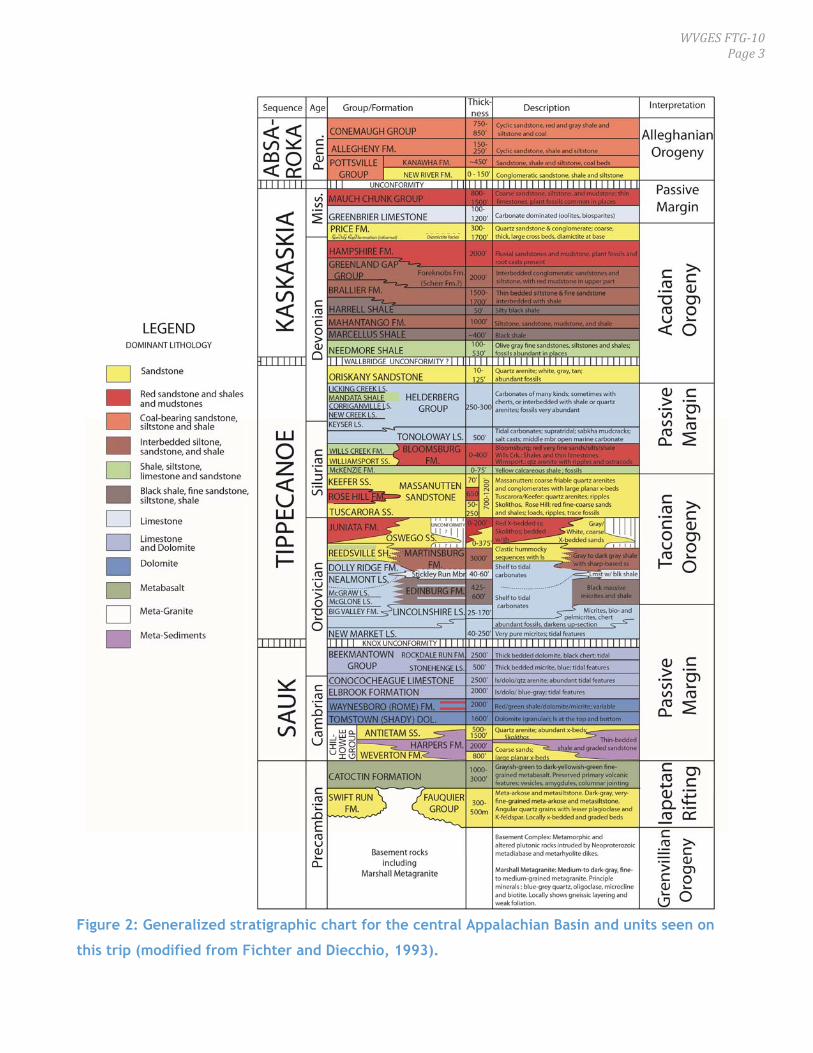


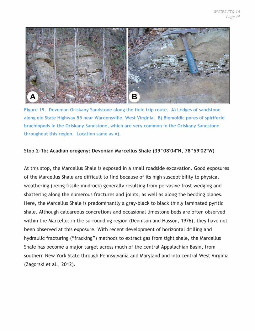


![[A J S ,V . 299, J , 1999, P. 502–515] DISTINGUISHING ...earth.geology.yale.edu/~ajs/1999/06.1999.03Karabinos.pdf · DISTINGUISHING GRENVILLIAN BASEMENT FROM PRE-TACONIAN COVER](https://static.documents.pub/doc/80x56/5afd5aa47f8b9a944d8d5ae2/a-j-s-v-299-j-1999-p-502515-distinguishing-earth-ajs199906199903karabinospdfdistinguishing.jpg)


