109
Appendices: Appraisal of Sustainability Site Report for Wylfa EN-6: Draft National Policy Statement for Nuclear Power Generation Planning for new energy infrastructure November 2009

Appendices: Appraisal of Sustainability Site Report for Wylfa EN-6: Draft National Policy Statement for Nuclear Power Generation
Planning for new energy infrastructure November 2009

Appendices to the Appraisal of Sustainability Site Report For Wylfa
2
Appraisal of Sustainability of the draft Nuclear National Policy Statement The Appraisal of Sustainability (AoS), incorporating Strategic Environmental Assessment, of the draft Nuclear National Policy Statement (Nuclear NPS) has been undertaken at a strategic level. It considers the effects of the proposed policy at a national level and the sites to be assessed for their suitability for the deployment of new nuclear power stations by 2025. These strategic appraisals are part of an ongoing assessment process that started in March 2008 and, following completion of this AoS, will continue with project level assessments when developers make applications for development consent in relation to specific projects. Applications for development consents to the Infrastructure Planning Commission will need to be accompanied by an Environmental Statement having been the subject of a detailed Environmental Impact Assessment. The AoS/SEA Reports are presented in the following documents: AoS Non-Technical Summary Main AoS Report of draft Nuclear NPS Introduction Approach and Methods Alternatives Radioactive Waste Findings Summary of Sites Technical Appendices Annexes to Main AoS Report: Reports on Sites Site AoS Reports Technical Appendices All documents are available on the website of the Department of Energy and Climate Change at http://www.energynpsconsultation.decc.gov.uk This document is the Appendices to the Appraisal of Sustainability Site Report for Wylfa. These appendices have been prepared by the Department of Energy and Climate Change with expert input from a team of specialist planning and environmental consultancies led by MWH UK Ltd with Enfusion Ltd, Nicholas Pearsons Associates Ltd, Studsvik UK Ltd and Metoc plc.
Appendices to the Appraisal of Sustainability Site Report For Wylfa
3
Contents
Appendix 1: Sustainable Development Themes and AoS Objectives ............................. 4 Appendix 2: Appraisal Matrices .......................................................................................... 8 Appendix 3: Plans and Programmes Review (Regional) ................................................. 52 Appendix 4: Baseline Information ..................................................................................... 60
Appendices to the Appraisal of Sustainability Site Report For Wylfa
4
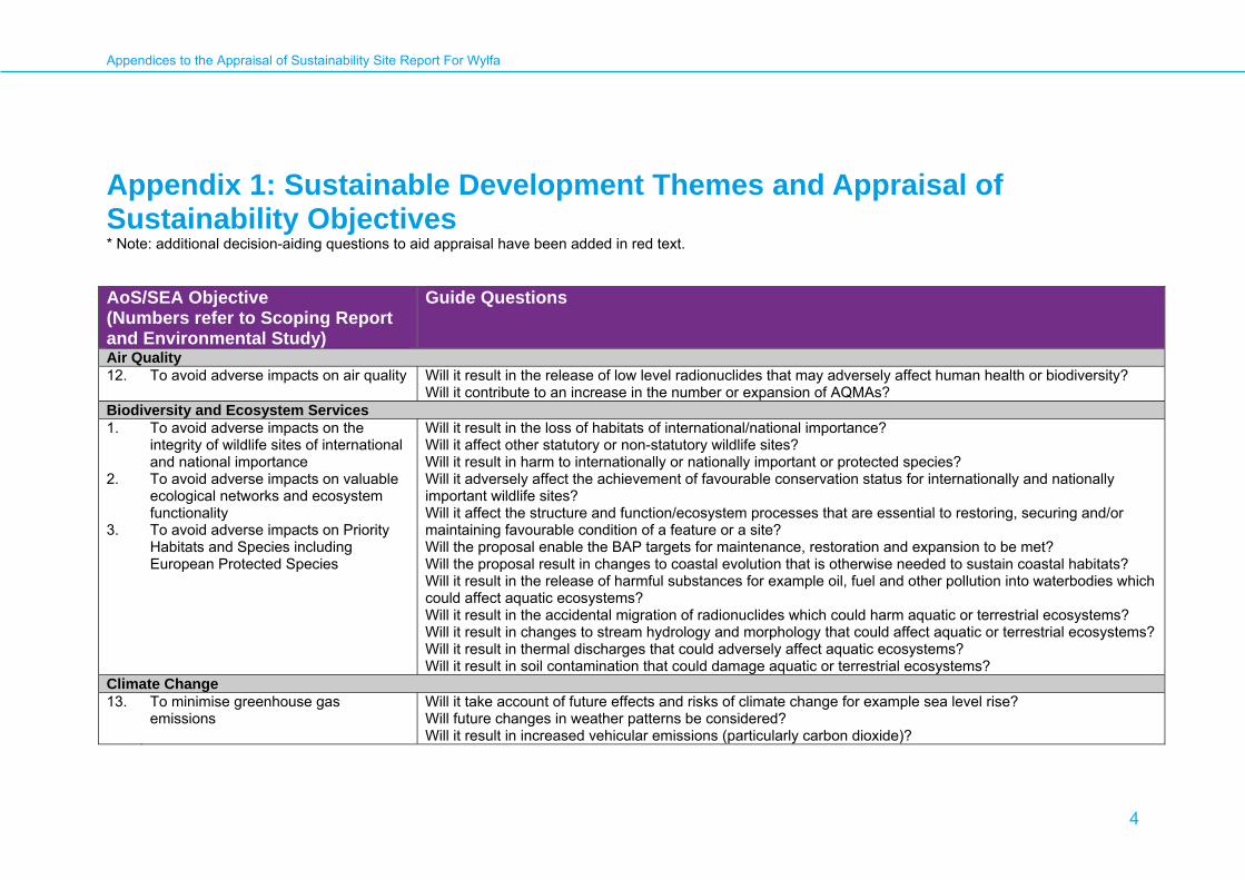
Appendix 1: Sustainable Development Themes and Appraisal of Sustainability Objectives * Note: additional decision-aiding questions to aid appraisal have been added in red text.
AoS/SEA Objective (Numbers refer to Scoping Report and Environmental Study)
Guide Questions
Air Quality 12. To avoid adverse impacts on air quality Will it result in the release of low level radionuclides that may adversely affect human health or biodiversity?
Will it contribute to an increase in the number or expansion of AQMAs? Biodiversity and Ecosystem Services 1. 2. 3.
To avoid adverse impacts on the integrity of wildlife sites of international and national importance To avoid adverse impacts on valuable ecological networks and ecosystem functionality To avoid adverse impacts on Priority Habitats and Species including European Protected Species
Will it result in the loss of habitats of international/national importance? Will it affect other statutory or non-statutory wildlife sites? Will it result in harm to internationally or nationally important or protected species? Will it adversely affect the achievement of favourable conservation status for internationally and nationally important wildlife sites? Will it affect the structure and function/ecosystem processes that are essential to restoring, securing and/or maintaining favourable condition of a feature or a site? Will the proposal enable the BAP targets for maintenance, restoration and expansion to be met? Will the proposal result in changes to coastal evolution that is otherwise needed to sustain coastal habitats? Will it result in the release of harmful substances for example oil, fuel and other pollution into waterbodies which could affect aquatic ecosystems? Will it result in the accidental migration of radionuclides which could harm aquatic or terrestrial ecosystems? Will it result in changes to stream hydrology and morphology that could affect aquatic or terrestrial ecosystems? Will it result in thermal discharges that could adversely affect aquatic ecosystems? Will it result in soil contamination that could damage aquatic or terrestrial ecosystems?
Climate Change 13. To minimise greenhouse gas
emissions Will it take account of future effects and risks of climate change for example sea level rise? Will future changes in weather patterns be considered? Will it result in increased vehicular emissions (particularly carbon dioxide)?
Appendices to the Appraisal of Sustainability Site Report For Wylfa
5
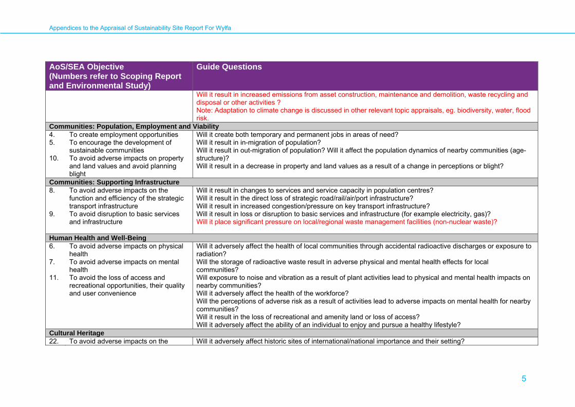
AoS/SEA Objective (Numbers refer to Scoping Report and Environmental Study)
Guide Questions
Will it result in increased emissions from asset construction, maintenance and demolition, waste recycling and disposal or other activities ? Note: Adaptation to climate change is discussed in other relevant topic appraisals, eg. biodiversity, water, flood risk.
Communities: Population, Employment and Viability 4. 5. 10.
To create employment opportunities To encourage the development of sustainable communities To avoid adverse impacts on property and land values and avoid planning blight
Will it create both temporary and permanent jobs in areas of need? Will it result in in-migration of population? Will it result in out-migration of population? Will it affect the population dynamics of nearby communities (age-structure)? Will it result in a decrease in property and land values as a result of a change in perceptions or blight?
Communities: Supporting Infrastructure 8. 9.
To avoid adverse impacts on the function and efficiency of the strategic transport infrastructure To avoid disruption to basic services and infrastructure
Will it result in changes to services and service capacity in population centres? Will it result in the direct loss of strategic road/rail/air/port infrastructure? Will it result in increased congestion/pressure on key transport infrastructure? Will it result in loss or disruption to basic services and infrastructure (for example electricity, gas)? Will it place significant pressure on local/regional waste management facilities (non-nuclear waste)?
Human Health and Well-Being 6. 7. 11.
To avoid adverse impacts on physical health To avoid adverse impacts on mental health To avoid the loss of access and recreational opportunities, their quality and user convenience
Will it adversely affect the health of local communities through accidental radioactive discharges or exposure to radiation? Will the storage of radioactive waste result in adverse physical and mental health effects for local communities? Will exposure to noise and vibration as a result of plant activities lead to physical and mental health impacts on nearby communities? Will it adversely affect the health of the workforce? Will the perceptions of adverse risk as a result of activities lead to adverse impacts on mental health for nearby communities? Will it result in the loss of recreational and amenity land or loss of access? Will it adversely affect the ability of an individual to enjoy and pursue a healthy lifestyle?
Cultural Heritage 22. To avoid adverse impacts on the Will it adversely affect historic sites of international/national importance and their setting?
Appendices to the Appraisal of Sustainability Site Report For Wylfa
6
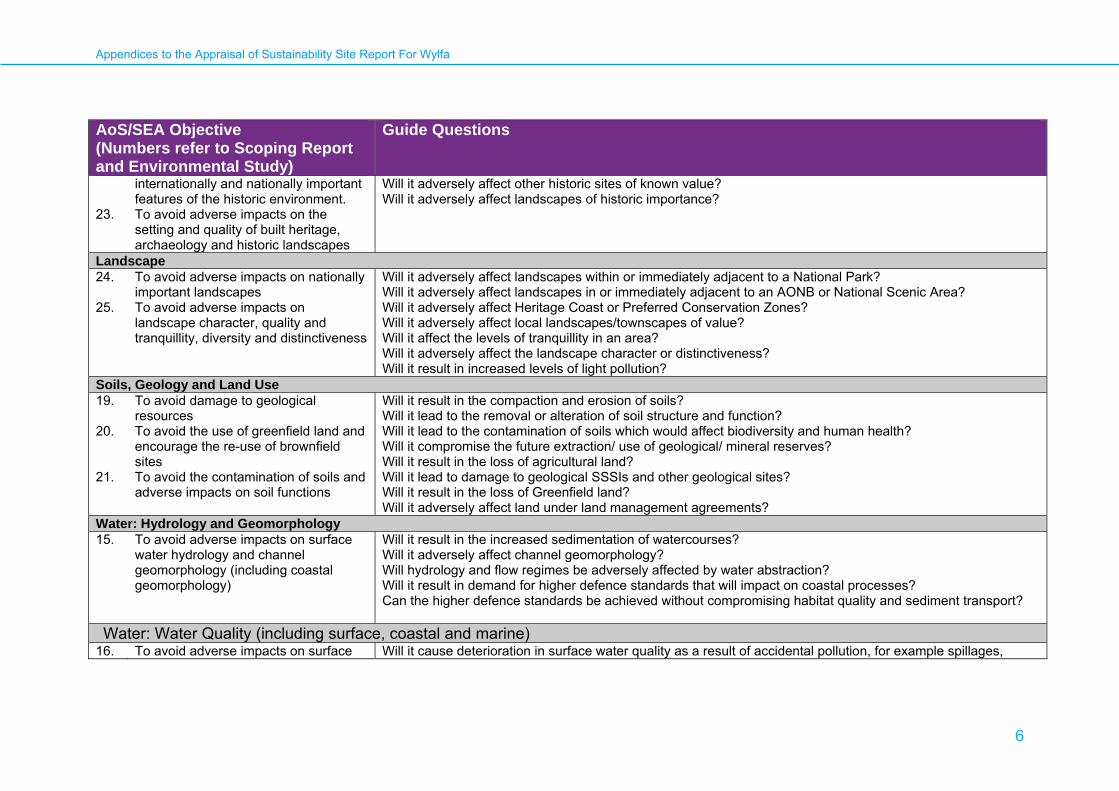
AoS/SEA Objective (Numbers refer to Scoping Report and Environmental Study)
Guide Questions
23.
internationally and nationally important features of the historic environment. To avoid adverse impacts on the setting and quality of built heritage, archaeology and historic landscapes
Will it adversely affect other historic sites of known value? Will it adversely affect landscapes of historic importance?
Landscape 24. 25.
To avoid adverse impacts on nationally important landscapes To avoid adverse impacts on landscape character, quality and tranquillity, diversity and distinctiveness
Will it adversely affect landscapes within or immediately adjacent to a National Park? Will it adversely affect landscapes in or immediately adjacent to an AONB or National Scenic Area? Will it adversely affect Heritage Coast or Preferred Conservation Zones? Will it adversely affect local landscapes/townscapes of value? Will it affect the levels of tranquillity in an area? Will it adversely affect the landscape character or distinctiveness? Will it result in increased levels of light pollution?
Soils, Geology and Land Use 19. 20. 21.
To avoid damage to geological resources To avoid the use of greenfield land and encourage the re-use of brownfield sites To avoid the contamination of soils and adverse impacts on soil functions
Will it result in the compaction and erosion of soils? Will it lead to the removal or alteration of soil structure and function? Will it lead to the contamination of soils which would affect biodiversity and human health? Will it compromise the future extraction/ use of geological/ mineral reserves? Will it result in the loss of agricultural land? Will it lead to damage to geological SSSIs and other geological sites? Will it result in the loss of Greenfield land? Will it adversely affect land under land management agreements?
Water: Hydrology and Geomorphology 15.
To avoid adverse impacts on surface water hydrology and channel geomorphology (including coastal geomorphology)
Will it result in the increased sedimentation of watercourses? Will it adversely affect channel geomorphology? Will hydrology and flow regimes be adversely affected by water abstraction? Will it result in demand for higher defence standards that will impact on coastal processes? Can the higher defence standards be achieved without compromising habitat quality and sediment transport?
Water: Water Quality (including surface, coastal and marine) 16. To avoid adverse impacts on surface Will it cause deterioration in surface water quality as a result of accidental pollution, for example spillages,
Appendices to the Appraisal of Sustainability Site Report For Wylfa
7
AoS/SEA Objective (Numbers refer to Scoping Report and Environmental Study)
Guide Questions
water quality (including coastal and marine water quality) and assist achievement of Water Framework Directive objectives
leaks? Will it cause deterioration in coastal and / or marine water quality as a result of accidental pollution, for example spillages, leaks? Will it cause deterioration in surface water quality as a result of the disturbance of contaminated soil? Will it cause deterioration in coastal and / or marine water as a result of the disturbance of contaminated soil? Will it affect designated Shellfish Waters? Will it affect Freshwater Fish Directive sites? Will it increase turbidity in water bodies? Will it increase the temperature of the water in water bodies?
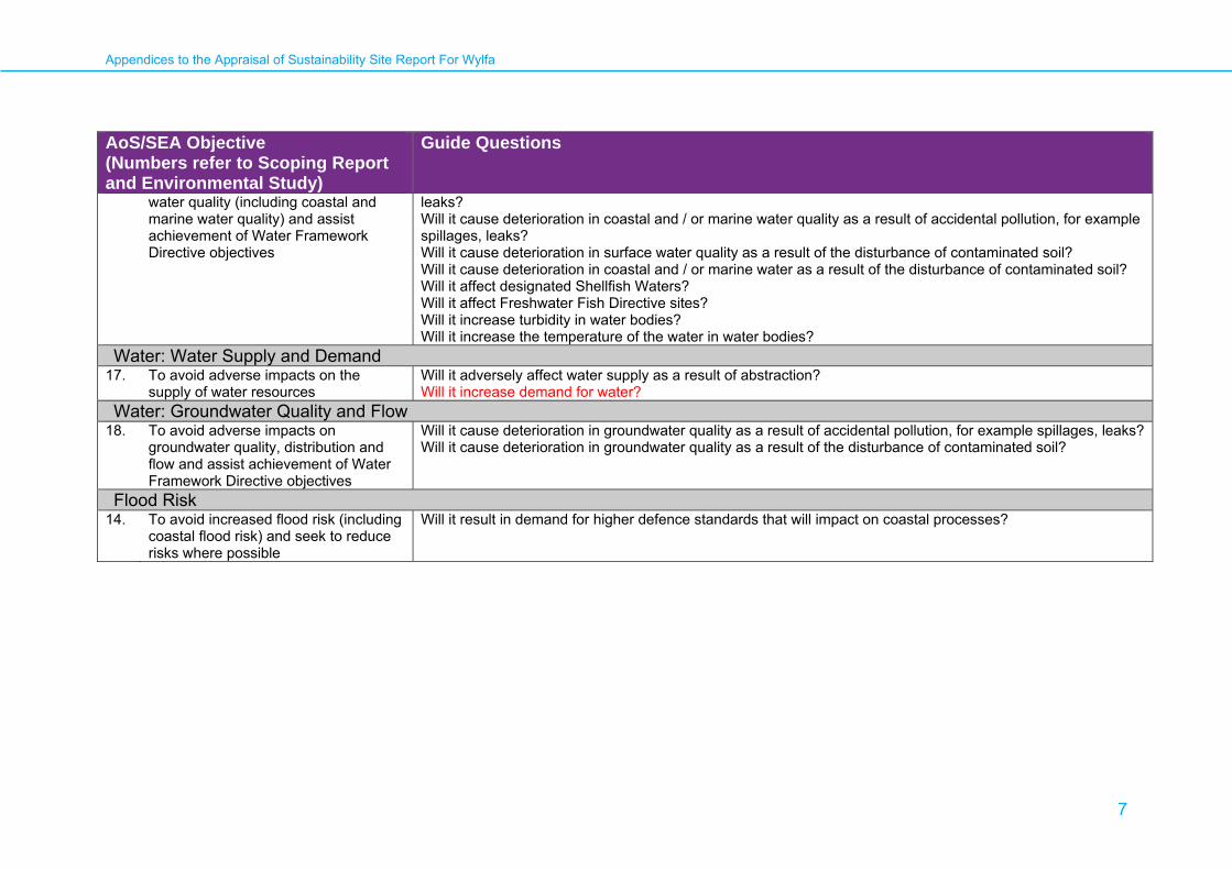
Water: Water Supply and Demand 17. To avoid adverse impacts on the
supply of water resources Will it adversely affect water supply as a result of abstraction? Will it increase demand for water?
Water: Groundwater Quality and Flow 18. To avoid adverse impacts on
groundwater quality, distribution and flow and assist achievement of Water Framework Directive objectives
Will it cause deterioration in groundwater quality as a result of accidental pollution, for example spillages, leaks? Will it cause deterioration in groundwater quality as a result of the disturbance of contaminated soil?
Flood Risk 14. To avoid increased flood risk (including
coastal flood risk) and seek to reduce risks where possible
Will it result in demand for higher defence standards that will impact on coastal processes?
Appendices to the Appraisal of Sustainability Site Report For Wylfa
8
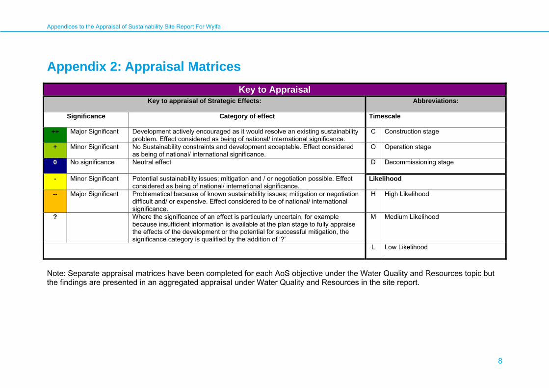
Appendix 2: Appraisal Matrices
Key to Appraisal Key to appraisal of Strategic Effects:
Abbreviations:
Significance Category of effect Timescale
++ Major Significant
Development actively encouraged as it would resolve an existing sustainability problem. Effect considered as being of national/ international significance.
C Construction stage
+
Minor Significant No Sustainability constraints and development acceptable. Effect considered as being of national/ international significance.
O Operation stage
0 No significance
Neutral effect D Decommissioning stage
-
Minor Significant Potential sustainability issues; mitigation and / or negotiation possible. Effect considered as being of national/ international significance.
Likelihood
-- Major Significant Problematical because of known sustainability issues; mitigation or negotiation difficult and/ or expensive. Effect considered to be of national/ international significance.
H High Likelihood
? Where the significance of an effect is particularly uncertain, for example because insufficient information is available at the plan stage to fully appraise the effects of the development or the potential for successful mitigation, the significance category is qualified by the addition of ‘?’
M Medium Likelihood
L Low Likelihood
Note: Separate appraisal matrices have been completed for each AoS objective under the Water Quality and Resources topic but the findings are presented in an aggregated appraisal under Water Quality and Resources in the site report.

Appendices to the Appraisal of Sustainability Site Report For Wylfa
9
Air Quality AoS Objective:
12. To avoid adverse impacts on air quality Guide questions:
Will it result in the release of low level radionuclides that may adversely affect human health or biodiversity? Will it contribute to the degradation of air quality – both local and transboundary?
Potential Receptors:
• Local populations and wider regional population (human health) • Sensitive habitats, including Cemlyn Bay SSSI, SAC and Cemlyn Bay and The Skerries SPA; Cae Gwyn SSSI and Tre’r GofSSSI.
Potential Significant Effects and Mitigation Possibilities:
International/ National/ Transboundary
1. The release of non-radioactive gaseous emissions during construction and operation is not likely to have a strategically significant effect, as effects from construction and operation will be localised (see regional/local appraisal below) and controlled through appropriate regulatory regimes and consents/permits (possibly similar in nature to those the existing Wylfa nuclear facility operates under) and management techniques during construction, operation and decommissioning stages.
2. However there is potential for release of radioactive emissions, planned and accidental, during the operation and decommissioning of a nuclear power station and waste storage on the site. The prevailing wind direction is south-westerly through the year, however there is a high frequency of north to north-east winds in spring. This has potentially negative significant consequences for a wide demographic area across the Isle of Anglesey, including the Holyhead conurbation. In extreme circumstances (both in terms of releases and meteorological conditions) there is a potential for transboundary effects, in particular the south eastern coastline of Ireland and north-western coastline of England. The potential effects of release of radiation are discussed in the main AoS report, however detailed modelling will be required and considered as part of the HSE and Environmental Regulators risk assessment as carried out for the consenting process. There is however an opportunity to employ any lessons learned from the decommissioning of the existing Wylfa nuclear facility when it occurs (decommissioning currently expected to commence in 2010).
3. There is a small risk that increased concentrations of airborne pollutants or nutrients could have an adverse effect on adjacent sites of nature
conservation interest. Any accidental or planned release of radioactive emissions may also affect sensitive ecosystems. This is discussed further in the Biodiversity and Ecosystem Sections.
Regional/ Local

Appendices to the Appraisal of Sustainability Site Report For Wylfa
10
Air Quality 1. Air quality in Wales is generally good, and has been steadily improving since the 1990s. However, pockets of moderately poor air quality exists in the
region, concentrated around major industrial installations and heavily urbanised areas. The main causes of moderate or higher pollution at urban sites are fine particles (PM10) and ozone. No Air Quality Management Areas (AQMAs) have been declared in the Isle of Anglesey County Council region. The effect on air quality from the development is not likely to be significant, provided construction and operation is in accordance with regulatory/consenting regimes.
2. It is unlikely that the development project will lead to the designation of any new AQMAs in the region due to the duration of construction activities.
3. As with any major infrastructure project, the emission of pollutants to the atmosphere associated with transport and the generation of fine particulates and dust during construction have the potential for local nuisance and impacts on health within a zone of influence from the construction site. Air pollution can be minimised and controlled through working in accordance with good site environmental practices and managed through the use of Construction Environmental Management Plans. This is discussed in further detail in Section 9 of the AoS report.
4. The release of radioactive emissions from the site will be governed by HSE and the environmental regulator through the development of appropriate
discharge limits, as part of the authorisation under the Radioactive Substances Act 1993. This will be specific to the reactor type being used, alongside the siting and sensitivity of the receiving environment.
5. There is a small risk that increased concentrations of airborne pollutants or nutrients could have an adverse effect on adjacent sites of nature conservation interest. Any accidental or planned release of radioactive emissions may also affect sensitive ecosystems. This is discussed further in the Biodiversity and Ecosystem Sections.
Summary of Significant Strategic Effects:
Timescale C O D Significance - - ? - ? Likelihood M L L
Significant Effects
Mitigation and Monitoring Possibilities
• Release of non-radioactive emissions is unlikely to have a strategically significant effect on air quality
• There is a small risk that increased concentrations of airborne pollutants or nutrients could have an adverse effect on adjacent sites of nature conservation interest.
• Release of radioactive emissions (planned and accidental) can have a significant strategic
• Please refer to mitigation measures contained in the Biodiversity and Ecosystems Sections.
• Release of radioactive emissions controlled through regulatory process and risk assessment undertaken for consenting process.
Appendices to the Appraisal of Sustainability Site Report For Wylfa
11
Air Quality effect on air quality, including transboundary effects. The HSE and Environmental Regulator will consider this as part of the HSE and Environmental Regulators risk assessment carried out as part of the consenting process and must be satisfied risk to public health and safety is within acceptable limits.
Appendices to the Appraisal of Sustainability Site Report For Wylfa
12
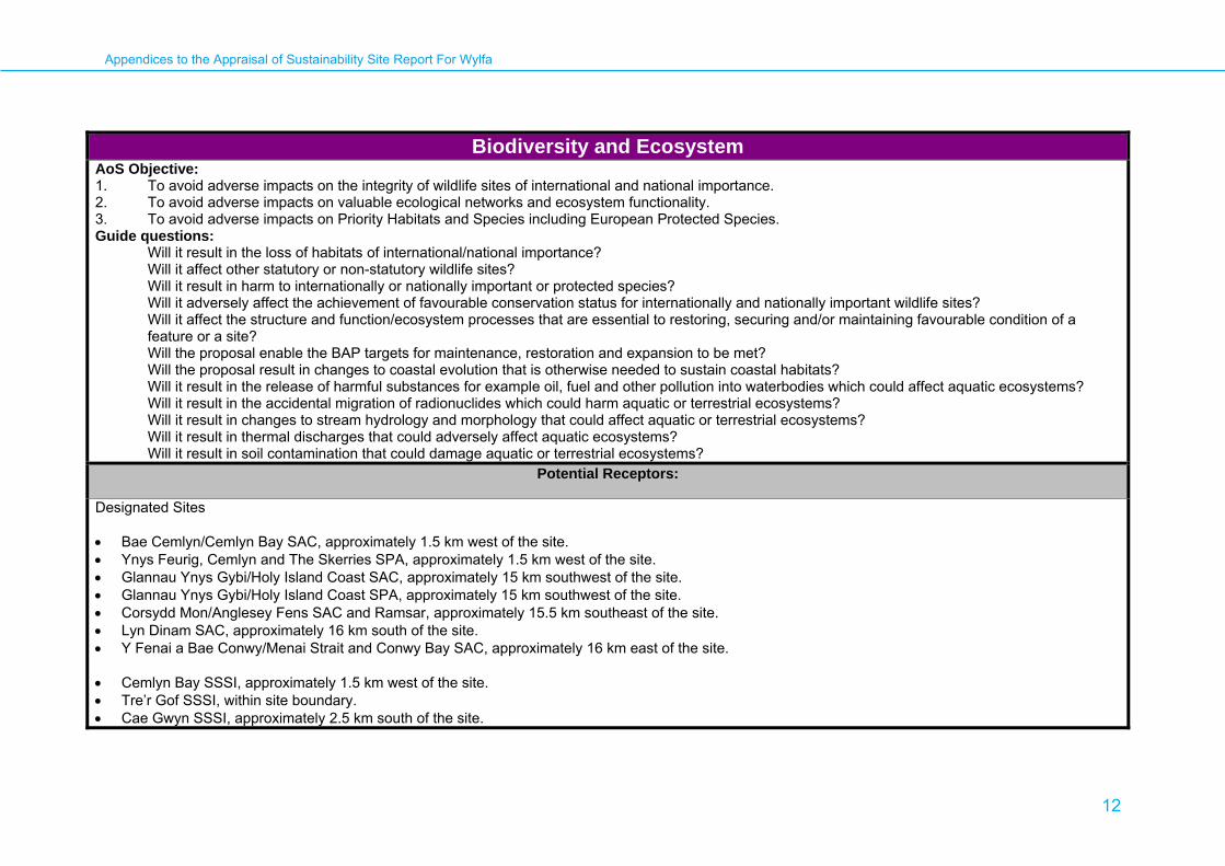
Biodiversity and Ecosystem AoS Objective: 1. To avoid adverse impacts on the integrity of wildlife sites of international and national importance. 2. To avoid adverse impacts on valuable ecological networks and ecosystem functionality. 3. To avoid adverse impacts on Priority Habitats and Species including European Protected Species. Guide questions:
Will it result in the loss of habitats of international/national importance? Will it affect other statutory or non-statutory wildlife sites? Will it result in harm to internationally or nationally important or protected species? Will it adversely affect the achievement of favourable conservation status for internationally and nationally important wildlife sites? Will it affect the structure and function/ecosystem processes that are essential to restoring, securing and/or maintaining favourable condition of a feature or a site? Will the proposal enable the BAP targets for maintenance, restoration and expansion to be met? Will the proposal result in changes to coastal evolution that is otherwise needed to sustain coastal habitats? Will it result in the release of harmful substances for example oil, fuel and other pollution into waterbodies which could affect aquatic ecosystems? Will it result in the accidental migration of radionuclides which could harm aquatic or terrestrial ecosystems? Will it result in changes to stream hydrology and morphology that could affect aquatic or terrestrial ecosystems? Will it result in thermal discharges that could adversely affect aquatic ecosystems? Will it result in soil contamination that could damage aquatic or terrestrial ecosystems?
Potential Receptors: Designated Sites • Bae Cemlyn/Cemlyn Bay SAC, approximately 1.5 km west of the site. • Ynys Feurig, Cemlyn and The Skerries SPA, approximately 1.5 km west of the site. • Glannau Ynys Gybi/Holy Island Coast SAC, approximately 15 km southwest of the site. • Glannau Ynys Gybi/Holy Island Coast SPA, approximately 15 km southwest of the site. • Corsydd Mon/Anglesey Fens SAC and Ramsar, approximately 15.5 km southeast of the site. • Lyn Dinam SAC, approximately 16 km south of the site. • Y Fenai a Bae Conwy/Menai Strait and Conwy Bay SAC, approximately 16 km east of the site. • Cemlyn Bay SSSI, approximately 1.5 km west of the site. • Tre’r Gof SSSI, within site boundary. • Cae Gwyn SSSI, approximately 2.5 km south of the site.
Appendices to the Appraisal of Sustainability Site Report For Wylfa
13
Biodiversity and Ecosystem Habitats considered potential receptors are: • Lowland bog • Lowland fen • Lowland heathland • Mudflats and sandbanks • Saline lagoons Species considered potential receptors: • Breeding terns (including common, artic, sandwich and roseate species), primary reason for designation of the Cemlyn and The Skerries SPA • Other breeding and over-wintering birds could be affected locally • Rare and uncommon plants • Invertebrate species • Common species of reptile • Bats
Potential Significant Effects and Mitigation Possibilities:
International/ National/ Transboundary Disturbance (noise, light and visual)
1. Potential significant effects may arise due to disturbance from construction activities (duration 5-6 years), increased vehiclular movements, machinery,
earthworks and excavations, an increase in lighting and increased personnel presence on the site. Similar impacts could also occur during operation (c.60 years) and de-comissioning (c.20 years). This could have an adverse impact on fauna within the immediate locality of the site. The nominator will need to assess the potential for disturbance effects on fauna, especially in relation to the near by breeding tern colonies (Common, Arctic, Sandwich and Roseate Tern species) of Cemlyn Bay and The Skerries SPA and Cemlyn Bay SSSI. Impacts of disturbance on biodiversity will be investigated thoroughly during the EIA process for the site. Mitigation measures should seek to avoid and
Appendices to the Appraisal of Sustainability Site Report For Wylfa
14
Biodiversity and Ecosystem minimise impacts on important bird assemblages through careful design and site layout. Possible mitigation could incorporate shielding to reduce light pollution, locating particularly noisy activities away from sensitive zones, acoustic screening and timing activities to avoid sensitive periods for key bird species of the SPA.
Loss, damage and fragmentation of important habitats and species
2. Construction activities, earthworks and excavations and provision of new buildings and infrastructure could all result in the direct loss, damage,
reduction, alteration or fragmentation of important priority habitats as listed in the UK Biodiversity Action Plan and Anglesey Biodiversity Action Plan. Potential impacts on important habitats/species will need to be investigated further (both the site level and within the wider area). Mitigation will need to avoid or minimise any loss with appropriate measures defined in the nominator’s proposals and Environmental Impact Assessment (EIA). Further studies1 would be required to determine a baseline for the prediction of the effects of developing the site on any habitats/species so that suitable mitigation measures can be implemented. Protected species likely to occur in the area include common reptile species, breeding and over-wintering birds, bats and invertebrate species. The site is considered close enough to cause fragmentation and disturbance to the Cemlyn Bay and The Skerries SPA and Cemlyn Bay SAC/ SSSI.
Mitigation should seek to avoid and minimise impacts where possible through careful site design and layout; buffer zones could be created around sensitive areas and in the event any habitats of importance being lost these should be re-created elsewhere. Opportunities should also be sought for positive improvements for biodiversity within and around the development for example through habitat creation and enhancement.
Coastal Squeeze
3. Construction of infrasturcture and facilities relating to the operation of the nuclear power station may result in an encroachment upon land at the coastal fringes. This may impact upon sedimentation regimes and coastal processes resulting in changes in erosion and deposition cycles along the coast, which may in turn effect the habitats and associated species of Cemlyn Bay and The Skerries SAC/SPA and the Menai Strait and Conwy Bay SAC. Until further details of the development footprint and extent (if any) of encroachment onto the coastal fringe is known, a precautionary appoach asssumes likley impact on the above sites.
Water Resources and Quality
4. Discharge of heated water into waterbodies can impact upon aquatic ecosystems due to the temperature of the water being up to 10°C warmer. Cemlyn Bay and The Skerries SPA, Cemlyn Bay SAC and SSSI is in close proximity to the site and therefore any discharge of heated water into could have an adverse impact on the habitats and species for which these sites are designated for example oxygen is less soluble in water at higher
1 Where it is stated further studies are required this is in reference to further studies to be carried out by the nominator at the EIA stage.

Appendices to the Appraisal of Sustainability Site Report For Wylfa
15
Biodiversity and Ecosystem temperatures and a reduction in dissolved oxygen can put aquatic life under stress. Any loss of habitats/plants or invertebrates could in turn have an impact on other species which rely on such sources for feeding. Further studies will be required by the nominator to assess the effects of discharged heated water on aquatic ecology especially any effects which could impact on the Cemlyn Bay and The Skerries SPA and Cemlyn Bay SAC and SSSI and their interest features.
The Environment Agency has a statutory duty to ensure the integrity of internationally designated sites are maintained or restored through sustainable water resources management. As part of this duty, they have to ensure that permissions (abstractions licenses, discharge consents, radioactive substance authorizations, waste management licenses and integrated pollution control (IPC) authorizations) do not have an adverse effect on the integrity of the designated sites.
5. Water intake from surface water bodies can lead to the incidental mortality of fish and other aquatic species. Fish, larvae and eggs can be sucked into
condenser circuits and be subjected to heat before being returned to the sea. Any loss of fish food sources for birds at Holy Island SPA could have an adverse impact on important seabirds associated with the nominated site. The design and siting of any intake system should be carefully considered so as to minimize any impacts on habitats and species.
6. Groundwater abstractions may affect groundwater supply to other areas hydrologically linked to the site, this could result in habitat degradation further
afield. Tre’r Gof SSSI falls within the site boundary and Cae Gwyn SSSI lies approximately 2.5 km to the south. These areas contains habitats such as wet heath, fen, and swamp which could be vulnerable to groundwater extraction. Further hydrological studies will be required by the nominator to assess the effects of any proposed water abstraction on ecology, particularly wetland habitats (such as the SSSI’s mentioned above) and also to the Anglesey Fens SAC/Ramsar and Lyn Dinam SAC which may or may not be vulnerable to groundwater abstraction depending on water basin areas. Further detailed hydrological studies should be undertaken by the nominator as part of the EIA process for the site.
7. During construction, operation and decomissioning there is a risk of adverse impacts to flora and fauna through accidental pollution (for example
spillages of oil, fuel or other contaminants) and increase sediment loads which could affect terrestrial or aquatic habitats on or near to the site from changes in organic and nutrient loading. Further studies should be undertaken by the nominator to assess the effects of any pollution on local biodiversity, a number of sensitive site including Cemlyn Bay and The Skerries SPA, Cemlyn Bay SAC and SSSI, Tre’r Gof SSSI (within site boundary) and Cae Gwyn SSSI are within close proximty. Good site environmental management practices should be put in place to minimise the above risks.
8. New drainage systems on or within the site could result in adverse impacts on both terrestrial and aquatic habitats during both construction and
operation. Installing new drainage systems could result in physical loss of habitats and new operating drainage systems may result in increased sediment loading of watercourses and altered run off rates. This could affect the hydrology and morphology of watercourses/habitats and could impact on aquatic flora and fauna. In addition nutrient enrichment could alter the composition of habitats within aquatic ecosystems. Further hydrological studies will be required by the nominator to assess the effects of any drainage infrastructure on local ecology, particularly aquatic habitats and/or areas of valuable habitat such as those associated with Tre’r Gof SSSI, Cae Gwyn SSSI and Cemlyn Bay and The Skerries SAC/SPA.

Appendices to the Appraisal of Sustainability Site Report For Wylfa
16
Biodiversity and Ecosystem
9. Routine radioactive discharges to the aquatic environment may have a negative impact on both terrestrial and aquatic ecology. Depending on dosage lethal, genetic or reproductive effects may result. Radionuclides may also accumulate in organisms such as invertebrates and plants which could have both direct and indirect effects, in particular on the Cemlyn Bay and the Skerries SPA, Cemlyn Bay SAC and SSSI and their interest features such as the important breeding tern assemblages. There is also potential that radionuclides will be transported over considerable distances along the coast with the prevailing south-westerly winds to accumulate in the mudflats and sandbanks of the Menai Strait and Conwy Bay SAC. Further studies will be required to understand fully the extent and likely significance of effects on ecology of any proposals for radioactive discharges from the site. Any new nuclear power stations would require authorisation from the relevant environment agency under the Radioactive Substances Act 1993 before making any discharges of radioactivity and regular water quality monitoring will be required.
10. There is a very small risk of accidental release of radiation (either through the air, water or soil) into the environment which could affect aquatic or
terrestrial fauna or flora associated with the Cemlyn Bay and The Skerries SPA, Cemlyn Bay SAC and SSSI as well as biodiversity in the area as a whole. Such an event could occur during operation, interim radioactive waste storage, during decommissioning or during final transport of waste for disposal. There is also the potential for accidental pollution of watercourses due to leaks or spillages from water treatment plants. This could cause toxic contamination of aquatic or terrestrial ecology. Given the proximity of the Cemlyn Bay and The Skerries SPA, Cemlyn Bay SAC and SSSI and the Menai Strait and Conwy Bay SAC, key interest features of these designated sites could be impacted, for example contaminants could have lethal effects or sub-lethal effects on aquatic organisms impairing reproduction, physiology, genetics and health, or compounds could be bioaccumulated within tissues and could subsequently enter the food chain. The operation of the site including waste storage, and decommissioning activities and the transport of radioactive waste, will be subject to strict regulatory controls which aim to minimise such risks, and the likelihood of any effect is considered low. Further studies are likely to be required to assess the risks and potential effects of the occurrence of such events on the designated sites and on biodiversity in the wider area as a whole and regular monitoring of water quality will be required.
Cumulative effects
11. There are potential cumulative impacts associated with developing the site, whilst operation (up to 2012) and subsequent de-commissioning takes place of the existing Wylfa A power station.
Regional/ Local Air quality
12. The development of the site may affect air quality. In particular through construction activities (duration 5-6 years) and as a result of increased
vehicular movements (both within the site itself and via increased traffic on access roads to and from the development). Increased vehicular emissions and mobilisation of dust could both impact on the sensitive habitats of the Cemlyn Bay SAC as well as biodiversity in the general locality, particularly if the dust is of a different acidity to the surrounding habitats, which can cause alterations to underlying soil chemistry and changes to the structure of
Appendices to the Appraisal of Sustainability Site Report For Wylfa
17
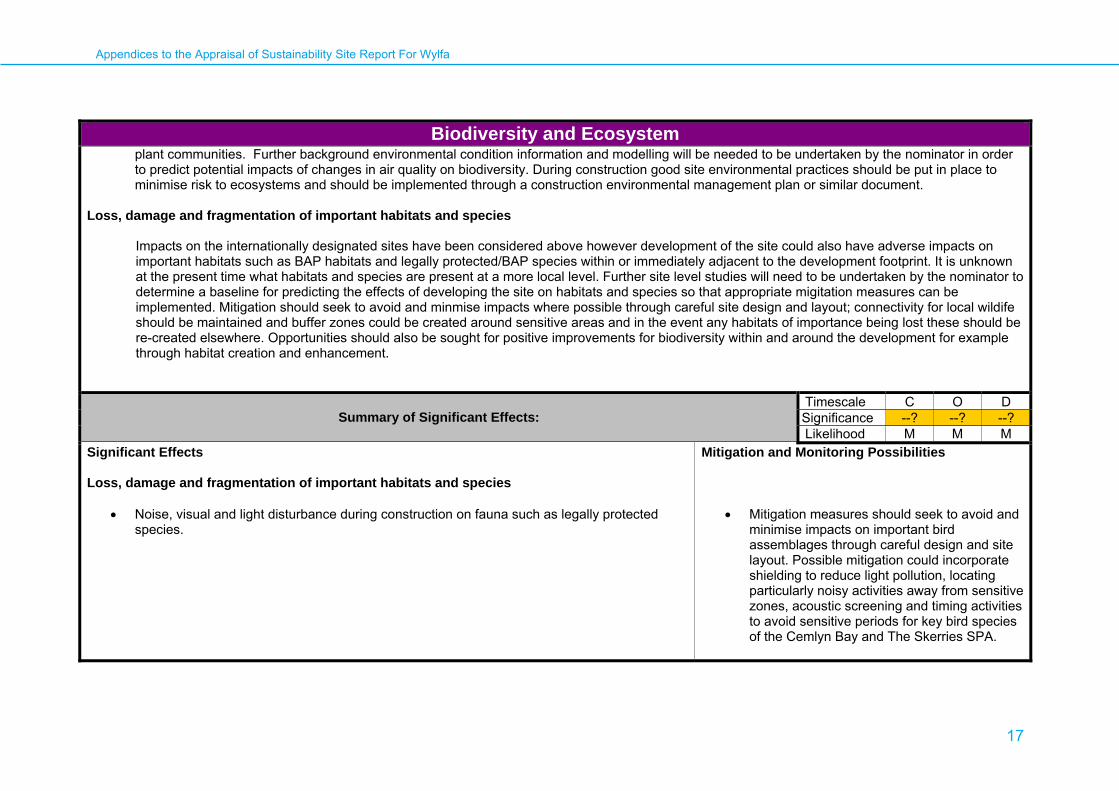
Biodiversity and Ecosystem plant communities. Further background environmental condition information and modelling will be needed to be undertaken by the nominator in order to predict potential impacts of changes in air quality on biodiversity. During construction good site environmental practices should be put in place to minimise risk to ecosystems and should be implemented through a construction environmental management plan or similar document.
Loss, damage and fragmentation of important habitats and species
Impacts on the internationally designated sites have been considered above however development of the site could also have adverse impacts on important habitats such as BAP habitats and legally protected/BAP species within or immediately adjacent to the development footprint. It is unknown at the present time what habitats and species are present at a more local level. Further site level studies will need to be undertaken by the nominator to determine a baseline for predicting the effects of developing the site on habitats and species so that appropriate migitation measures can be implemented. Mitigation should seek to avoid and minmise impacts where possible through careful site design and layout; connectivity for local wildife should be maintained and buffer zones could be created around sensitive areas and in the event any habitats of importance being lost these should be re-created elsewhere. Opportunities should also be sought for positive improvements for biodiversity within and around the development for example through habitat creation and enhancement.
Summary of Significant Effects: Timescale C O D Significance --? --? --? Likelihood M M M
Significant Effects Loss, damage and fragmentation of important habitats and species
• Noise, visual and light disturbance during construction on fauna such as legally protected species.
Mitigation and Monitoring Possibilities
• Mitigation measures should seek to avoid and
minimise impacts on important bird assemblages through careful design and site layout. Possible mitigation could incorporate shielding to reduce light pollution, locating particularly noisy activities away from sensitive zones, acoustic screening and timing activities to avoid sensitive periods for key bird species of the Cemlyn Bay and The Skerries SPA.
Appendices to the Appraisal of Sustainability Site Report For Wylfa
18
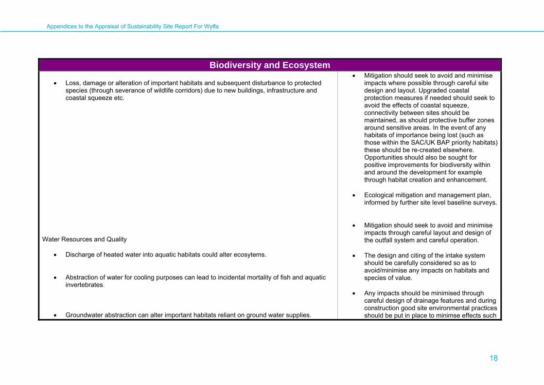
Biodiversity and Ecosystem • Loss, damage or alteration of important habitats and subsequent disturbance to protected
species (through severance of wildlife corridors) due to new buildings, infrastructure and coastal squeeze etc.
Water Resources and Quality
• Discharge of heated water into aquatic habitats could alter ecosytems. • Abstraction of water for cooling purposes can lead to incidental mortality of fish and aquatic
invertebrates. • Groundwater abstraction can alter important habitats reliant on ground water supplies.
• Mitigation should seek to avoid and minimise impacts where possible through careful site design and layout. Upgraded coastal protection measures if needed should seek to avoid the effects of coastal squeeze, connectivity between sites should be maintained, as should protective buffer zones around sensitive areas. In the event of any habitats of importance being lost (such as those within the SAC/UK BAP priority habitats) these should be re-created elsewhere. Opportunities should also be sought for positive improvements for biodiversity within and around the development for example through habitat creation and enhancement.
• Ecological mitigation and management plan,
informed by further site level baseline surveys.
• Mitigation should seek to avoid and minimise impacts through careful layout and design of the outfall system and careful operation.
• The design and citing of the intake system
should be carefully considered so as to avoid/minimise any impacts on habitats and species of value.
• Any impacts should be minimised through
careful design of drainage features and during construction good site environmental practices should be put in place to minimse effects such

Appendices to the Appraisal of Sustainability Site Report For Wylfa
19
Biodiversity and Ecosystem
• Routine releases of radioactive discharges into water could impact aquatic ecosystems either directly or indirectly, for example through bioaccumulation of toxins within food chains.
• Accidental pollution from for example, leakage of radioactive waste or other chemical compounds. Such risks are present throughout construction, operation and decomissioning.
• Construction and operation of new drainage infrastructure could impact on both terrestrial and aquatic ecosystems.
as increased sediment run off into watercourses/systems. During construction good site environmental management practices should be put in place to minimise risks to ecological receptors and should be implemented through a construction environmental management plan or similar document.
• Modern techniques to minimise radioactive
discharges should be incorporated into the design of the site. Regular monitoring of water quality and the surrounding environment should also be undertaken.
• During design, the layout and siting of
potential sources of pollution should be carefully considered so as to avoid and minimise potential impacts on sensitive areas. During construction good site environmental management practices should be put in place to minimise risks to ecological receptors and should be implemented through a construction environmental management plan or similar document.
• Any impacts should be minimised through
careful design of drainage features and during construction good site environmental practices should be put in place to minimse effects such as increased sediment run off into watercourses/systems. During construction good site environmental management practices should be put in place to minimise

Appendices to the Appraisal of Sustainability Site Report For Wylfa
20
Biodiversity and Ecosystem
• Improper management of materials during construction, operation and decomissioning could lead to contanmination of soil, water and air through leakages and spills. This in turn could have adverse impacts on local biodiversity.
Air Quality
• Reduction in air quality, particularly due to increased dust and vehicle emissions, could have potential impacts on local biodiversity.
risks to ecological receptors and should be implemented through a construction environmental management plan or similar document.
• Further studies required to determine impact.
Avoid impacts through safe site operation, decomissioning and waste transfer.
• Regular monitoring of water quality. • Avoid through safe materials mangement
practices guided by an Environmental Management Plan.
• Dust impacts should be minimised through
careful site design. During construction good site environmental management practices should be put in place to minimise risk to ecosystems and should be implemented through a construction environmental management plan or similar document. Possible mitigation measures could include phasing operations to avoid sensitive periods (for example for birds) and avoiding weather conditions which could encourage dust dispersal. Dust generating activities should be placed away from sensitive locations and in zones which give maximum protection from wind.
• Construction Environmetal Management Plan to minimise impacts.

Appendices to the Appraisal of Sustainability Site Report For Wylfa
21
Climate Change AoS Objective:
13. To minimise greenhouse gas emissions Guide questions:
Will it result in increased vehicular emissions (particularly carbon dioxide)? Will the development result in an overall reduction in greenhouse gas emissions over its life time resulting from changes in: Transport of people and goods Scope, form and methods of asset construction, maintenance and demolition Waste recycling and disposal Land management practices Other secondary activities in the wider local and national economy Note: Adaptation to climate change is discussed in other relevant topic appriasals, eg. biodiversity, water, flood risk.
Potential Receptors:
Human population and environment at all geographical scales.
Potential Significant Effects and Mitigation Possibilities:
International/ National/ Transboundary
1. The effects of changes in greenhouse gas emissions as a result of the proposed development have national and international effects, particularly when combined with a wider nuclear programme. The benefits of the low carbon emissions from the operation of nuclear power stations due to this technology and that are independent of the site chosen are considered in the overarching AoS report. Emissions during the operational phase of the power station are significantly lower than that of any non-nuclear (conventional fossil fuel-powered) facility delivering equivalent power output.
2. During the operational phase, the carbon footprint is similar to that of wind power with equivalent output but with significantly less land or area coverage.
3. This consideration is independent of any life-cycle (embodied) carbon emission analysis, which is currently outside the scope of this study.
4. Although the effects of any emissions will be felt globally, the emissions during construction and decommissioning will largely be determined by regional and local factors, (for example local transport infrastructure and how the location of the site will affect transport emissions) .
Appendices to the Appraisal of Sustainability Site Report For Wylfa
22
Climate Change 5. Construction and decommissioning activities will have both direct and indirect greenhouse gas emissions associated with them regardless of the
location of such plants. A comparison of these construction and decommissioning related emissions to those of fossil-fuelled power plants will largely depend upon the design parameters of such plants with the exception of specific sub-activities associated with nuclear fuel and nuclear wastes.
Regional/Local
6. The provision of a nuclear power station for energy generation at the site will make a positive contribution to the objective of the Anglesey County Council (ACC) to incorporate carbon reduction as a requirement of public sector investment decisions and procurement, when compared to some other sources of energy. In 2006 the ACC signed the Welsh Assembly’s ‘Welsh Commitment to Address Climate Change’ that are aligned to those of the central government targets. The combination of nuclear power generation with increased investment in renewable energy sources will assist in reducing greenhouse gas emissions compared to a non nuclear power facility option in the region.
7. The activities involved in the construction of the plant are likely to have a negative impact on targets for reductions in carbon from transport and construction plant. The materials incorporated in the plant will also contribute to levels of embodied carbon in the region. The extent will depend upon the methods of transport and construction adopted and on the types and quantities of materials incorporated in the plant. Another option for transportation to consider will be the use of the nearest railway connection at Amlwch or its potential extension . The indirect impacts associated with the construction phase could be higher in totality than the emissions of the construction activity itself. These include the influx of labour population, increased population vehicular usage, transport of materials, higher demand on utilities. This will fit well with the Wales Region Strategy.
8. Other considerations include the possibility of expanding road or rail transport in order to accommodate the construction upgrade demands in a rural
setting. The net cross-cutting impacts of emissions on biodiversity, land, water, population and health are taken into account within the AoS report- Opportunities of applying better transport, material and application design aspects that could minimise emission impacts should be explored.
9. Energy and climate change impacts from decommissioning the plant at the end of its life are not sensitive to the site location other than the distance that will be required to transport nuclear waste to any long-term waste Geological Depository Facility. The means of disposing of nuclear waste, including spent fuel, from new nuclear power stations is being considered as part of the Government’s programme for Managing Radioactive Waste Safely.
10. The Welsh Local Government Association (WLGA) and could make the site more susceptable to the following climate chage impacts: • A longer growing season • Milder wetter winters • Drier hotter summers • Increase in extremes of heat and decrease in extremes of cold
Appendices to the Appraisal of Sustainability Site Report For Wylfa
23
Climate Change • Warmer seas and sea level rise of up to 100cm • More extreme events (droughts, heat waves, flooding and etc) • More frequent and more violent storms/gales
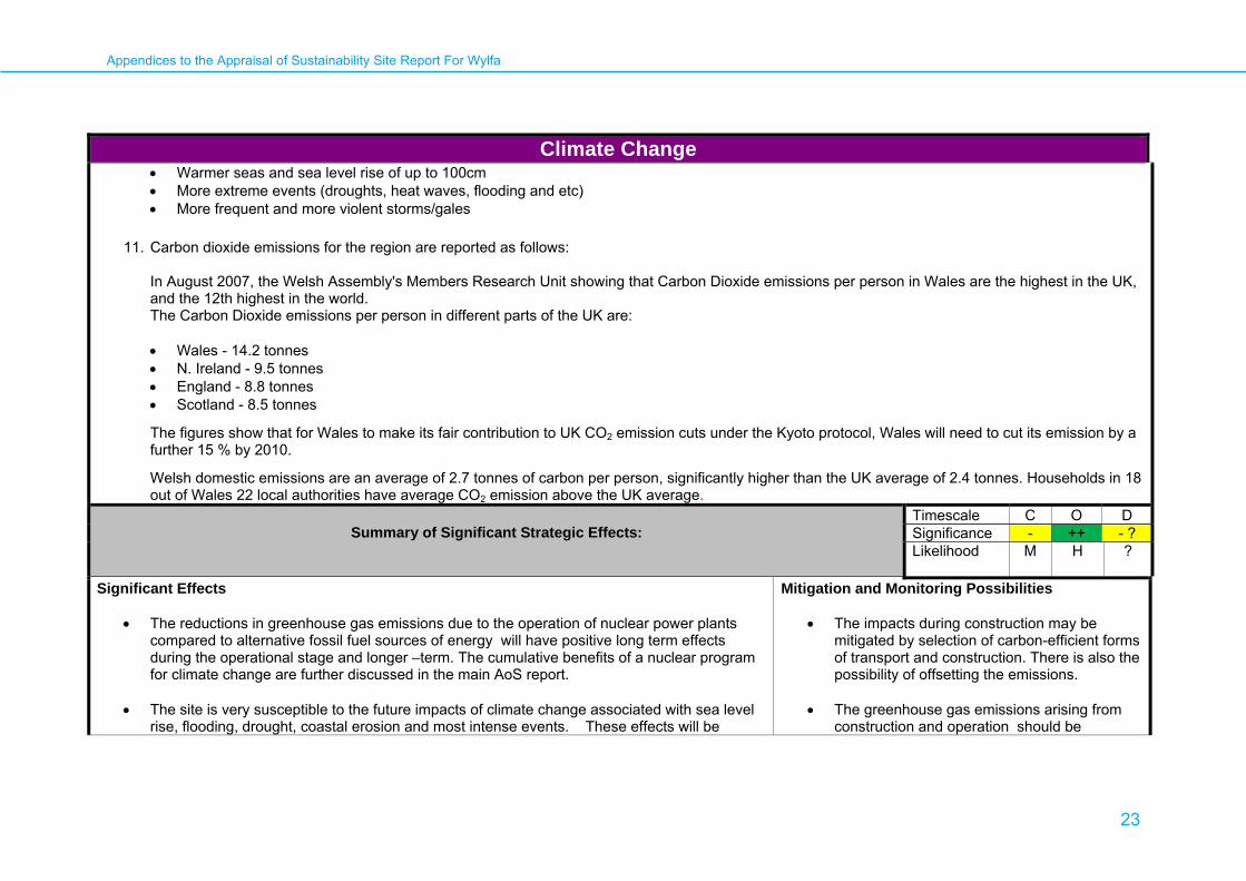
11. Carbon dioxide emissions for the region are reported as follows:
In August 2007, the Welsh Assembly's Members Research Unit showing that Carbon Dioxide emissions per person in Wales are the highest in the UK, and the 12th highest in the world. The Carbon Dioxide emissions per person in different parts of the UK are: • Wales - 14.2 tonnes • N. Ireland - 9.5 tonnes • England - 8.8 tonnes • Scotland - 8.5 tonnes
The figures show that for Wales to make its fair contribution to UK CO2 emission cuts under the Kyoto protocol, Wales will need to cut its emission by a further 15 % by 2010.
Welsh domestic emissions are an average of 2.7 tonnes of carbon per person, significantly higher than the UK average of 2.4 tonnes. Households in 18 out of Wales 22 local authorities have average CO2 emission above the UK average.
Summary of Significant Strategic Effects:
Timescale C O D Significance - ++ - ? Likelihood M H ?
Significant Effects
• The reductions in greenhouse gas emissions due to the operation of nuclear power plants compared to alternative fossil fuel sources of energy will have positive long term effects during the operational stage and longer –term. The cumulative benefits of a nuclear program for climate change are further discussed in the main AoS report.
• The site is very susceptible to the future impacts of climate change associated with sea level rise, flooding, drought, coastal erosion and most intense events. These effects will be
Mitigation and Monitoring Possibilities
• The impacts during construction may be mitigated by selection of carbon-efficient forms of transport and construction. There is also the possibility of offsetting the emissions.
• The greenhouse gas emissions arising from
construction and operation should be
Appendices to the Appraisal of Sustainability Site Report For Wylfa
24
Climate Change further discussed in the Flood Risk Section.
• Locating a nuclear power station on the site could have a positive multiplier effect on the
further investment and implementation of other renewable (low carbon) energy sources in the region.
• Construction activity will produce an increase in greenhouse gas emissions, but will make only a relatively small addition to the regional inventory of emissions in comparison to the low carbon energy output of the station. This is discusssed in the main AoS Report.
• The operational phase of the power station is likely to have a far lower carbon footprint
compared to those of fossil-fuel powered stations providing similar power output.
monitored to inform carbon reduction through the lifetime of the project.
• Appropriate construction design features and sea defence could help mitigate and adapt the site to the potential risk and subsequent damage caused by coastal erosion and flooding.

Appendices to the Appraisal of Sustainability Site Report For Wylfa
25
Communities: Population, Employment and Viability AoS Objective:
4. To create employment opportunities. 5. to encourage the development of sustainable communities 10. To avoid adverse impacts on property and land values and avoid planning blight
Guide questions: Will it create both temporary and permanent jobs in areas of need? Will it result in in-migration of population? Will it result in out-migration of population? Will it affect the population dynamics of nearby communities (age-structure)? Will it result in a decrease in property and land values as a result of a change in perceptions or blight?
Potential Receptors:
• Local and regional resident workforce • Local and regional population
Potential Significant Effects and Mitigation Possibilities:
International/ National/ Transboundary No significant effects identified at this scale. Regional/ Local 1. Short-medium term positive effects through creating new jobs for local and regional population. The quality and quantity of employment during the construction stages (approx 5-6 years) of the reactor will differ to the operational stage (approx 30 years), where longer-term employment will lead to quality of life benefits. Labour requirements will tail-off towards the end of the operational stage, however decommissioning will still require significant levels of labour for a minimum of 30 years. The significance of the effect is greater at the local level, whereas at the regional level this is of minor significance, as jobs are absorbed into regional employment figures. 2. The existing reactor at the site is a significant local employer, employing over 650 staff2. A new power station may assist in offsetting job-losses from the decommissioning of the existing power station at the site -however it is noted the time difference between decommissioning (estimated to be 2025 end of care and maintanace period) and construction of any new reactor will likely require employees to seek employment elsewhere.
2 http://www.magnoxnorthsites.com/about-us/our-sites/wylfa/facts-and-figures

Appendices to the Appraisal of Sustainability Site Report For Wylfa
26
Communities: Population, Employment and Viability 3. Positive effects through the provision of training, education and upskilling for employees and contractors in the region. 4. Positive multiplier effects (for both nuclear-related industry and wider industry as a result of increased demand from an incoming population). Of greater significance at the local level. 5. Some uncertainty is identified as the construction may affect the ability of other industries/projects to source labour, for example for house-building in region and other major infrastructure projects. 6. Likely changes to the population dynamics of local communities - with potential positive and negative effects. Effects dependent on source of labour, for example from local community or outside. Possible negative effects during construction stage as a temporary new community (construction labour) may not integrate with existing community. Longer term, new employees likely to be drawn from a wide area, including local communities and the wider area generally up to 25 mile radius, with less pressure on local services. Positive economic and social benefits likely as new population will require new services and facilities and will help to support existing services. 7. Potential for adverse effects on property values within close proximity to site. Mitigation possible. No evidence to suggest significant effects beyond immediate site surrounds.
Summary of Significant Strategic Effects: Timescale C O D Significance +? +? 0 Likelihood H H M
Significant Effects
Mitigation and Monitoring Possibilities
• Strategic effects are considered minor positive with regard to the creation of temporary jobs during construction and permanent full-time employment during operation, although some uncertainty identified as the project may lead to a shortage of local construction workers to meet the needs of other industries and major projects.
• Consideration may need to be given to potential negative effects/difficulties in sourcing labour and the effects of this on the local/regional construction industry.

Appendices to the Appraisal of Sustainability Site Report For Wylfa
27
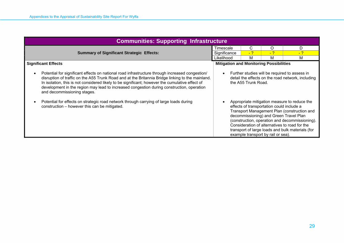
Communities: Supporting Infrastructure
AoS Objective: 8. to avoid adverse impacts on the function and efficiency of the strategic transport infrastructure 9. to avoid disruption to basic services and infrastructure
Guide questions:
Will it result in changes to services and service capacity in population centres? Will it result in the direct loss of strategic road/rail/air/port infrastructure? Will it result in increased congestion/pressure on key transport infrastructure? Will it result in loss or disruption to basic services and infrastructure (for example electricity, gas)? Will it place significant pressure on local/regional waste management facilities (non-nuclear waste)?
Potential Receptors:
• Local and regional population • Existing transportation and service infrastructure • Existing waste management infrastructure
Potential Significant Effects and Mitigation Possibilities:
International/ National/ Transboundary
1. Potential for negative effects on national transport network through congestion to A55 Trunk Road during construction, operation and decommissioning
stages. The carriageway restriction at the Britannia Bridge is a significant factor for road transport. Currently, the A55 across Anglesey has a volume to capacity ratio between 25 and 50 %, rising to between 50 and 85 % at the Britannia Bridge. These levels are anticipated to rise by 2011 such that greater lengths will fall into the 50-85 % band. By 2021, forecast volume to capacity ratio on the A55 across Anglesey will be between 50 an 85 % over most of its length with the same scenario affecting the remaining length of the road all the way to Chester.
2. Further information is required to determine the effect on the A55, including details on construction workforce, timeframes and volume of materials to be transported. However, it is clear that the capacity of the A55, particularly at the Britannia Bridge, is likely to be under significant strain during the lifetime of this project, mainly due to future planned development in and around the area.
3. Mitigation measures can be implemented to minimise effects on the A55 trunk Road through appropriate planning. This may include physical improvements, carrying of large loads outside of peak period, construction transport management plans, and green travel plans for the construction and
Appendices to the Appraisal of Sustainability Site Report For Wylfa
28
Communities: Supporting Infrastructure operational workforces to encourage sustainable travel.
4. Rail should also be considered as an alternative option, particularly for the transport of construction materials, using the existing line to Holyhead. Enhanced freight handling facilities would probably be required for this option. This may have impacts on existing passenger and freight movements on this line, although such effects can be mitigated through appropriate planning and management plans.
5. Use of sea-borne transportation for bulk materials should also be considered, possibly building upon those currently used by Anglesey Aluminium. 6. Impacts of the transportation of Nuclear Waste are unknown until the location of a long-term waste geological depository facility is known. This is being
considered as part of the Government’s programme for Managing Radioactive Waste Safely. 7. Impacts of the storage and disposal of nuclear waste are dealt with separately in the main AoS Report
Regional/ Local
8. Negative effects identified for transportation network. Nature and significance of effects depend on mode of transport, and further details on construction workforce, timeframes and volume of materials to be transported.
9. Access by road is limited to the A5025 but it is of reasonable standard, having possibly been upgraded when the existing power station was built. The strategic road providing current access to the site (the A55) already suffers some peak period and seasonal (summer) congestion, particularly at the Britannia Bridge.
10. Some negative local transportation effects likely for the villages along the A5025, however further transportation studies are required to determine appropriate mitigation measures, including any physical improvements to the road network.
11. Rail network may provide an alternative for bulk material transport, but will require enhanced facilities. However, further transport to the nomiated site would still require transport on local roads, in this case through Holyhead itself. The use of shuttle buses operating possibly between Holyhead station and the site may alleviate some pressure on the local road network brought about by the workforce.
12. Use of port facilities at Holyhead (currently used by Anglesey Aluminium) may also reduce problems of long-distance haulage by road but will still affect local communities.
13. Non-nuclear construction waste will need to be further considered once details are available, including the volume and type of waste likely to be produced and transportation routes- however effects are unlikely to be significant. The preparation of a Construction waste management plan will assist in minimising impacts on existing waste facilities.
14. Operational waste (non-nuclear) will have impacts upon the capacity of existing waste management services, however it may be possible to extend arrangements for the existing nuclear facility and the implementation of an operational waste management plan would help to minimise any impacts.
15. Any influx of a new temporary workforce will place pressure on existing infrastructure, social and community services, as will increased population in local towns and villages in the longer term. This may require augmentation of existing services (including electricity and wastewater infrastructure) to cope with demand, however is not considered to have a significant effect. Further details regarding the sourcing of the workforce will be required to consider this at the detailed planning stage.
16. The development of a nuclear power station at Wylfa may require new power lines to be built, or existing lines to be upgraded, to connect the facility with the National Grid. The potential impact of new or upgraded power lines will be considered in a separate Networks National Policy Statement (NPS).
Appendices to the Appraisal of Sustainability Site Report For Wylfa
29
Communities: Supporting Infrastructure
Summary of Significant Strategic Effects: Timescale C O D Significance - ? - ? - ? Likelihood M M M
Significant Effects
• Potential for significant effects on national road infrastructure through increased congestion/ disruption of traffic on the A55 Trunk Road and at the Britannia Bridge linking to the mainland. In isolation, this is not considered likely to be significant; however the cumulative effect of development in the region may lead to increased congestion during construction, operation and decommissioning stages.
• Potential for effects on strategic road network through carrying of large loads during
construction – however this can be mitigated.
Mitigation and Monitoring Possibilities
• Further studies will be required to assess in detail the effects on the road network, including the A55 Trunk Road.
• Appropriate mitigation measure to reduce the effects of transportation could include a Transport Management Plan (construction and decommissioning) and Green Travel Plan (construction, operation and decommissioning). Consideration of alternatives to road for the transport of large loads and bulk materials (for example transport by rail or sea).

Appendices to the Appraisal of Sustainability Site Report For Wylfa
30
Human Health and Well-being AoS Objective:
6. To avoid adverse impacts on physical health. 7. To avoid adverse impacts on mental health. 11. to avoid the loss of access and recreational opportunities, their quality and user convenience.
Guide questions: Will it adversely affect the health of its workforce or local communities through accidental radioactive discharges or exposure to radiation during construction, operation, decommissioning and interim storage of radioactive waste on the site. Will it lead to unacceptable community disturbance during construction, operation or decommissioning? Are there any particularly vulnerable local communities that could be affected? Will it help to reduce any health inequalities? Will local perceptions of risk associated with the proposed power station lead to adverse impacts on mental health for nearby communities? Will it adversely affect the ability of an individual to enjoy and pursue a healthy lifestyle?
Potential Receptors: • Temporary local and regional resident workforce during construction and decommissioning phases. • Permanent and temporary workforce during site operational phase. • Local and regional resident population, visiting tourists and recreational users. • National and international resident population.
Potential Significant Effects and Mitigation Possibilities: International/ National/ Transboundary
1. National and transboundary health risks: There is a potential for any radioactive material discharged from the proposed site to travel both nationally and internationally (eg, to the Republic of Ireland). However, current radiological monitoring of the nuclear power stations that have been on the site since 1971 (see Appendix 4), suggests that the risk to the public is extremely low with total dosage from all sources (including direct radiation) estimated as being less than 2 % of the limit specified in the Ionising Radiations Regulations 1999. With regard to transboundary effects, there is a requirement under Article 37 of the Euratom Treaty for the United Kingdom, before plant authorisation can be granted, to submit its assessment of the likely effects to a panel of European experts who decide whether contamination of the water, soil or airspace of another Member State is likely to take place.
2. Exposure Limits: The radiation to which members of the public are exposed by the operations of a nuclear power station is limited to 1mSv per year.3
This limit applies to all members of the public, including those who receive the highest doses as a result of the location of their homes and their habits
3 This is through the Ionising Radiations Regulations 1999 http://www.statutelaw.gov.uk (which includes all activities carried out under a nuclear site licence granted by the Nuclear Installations Inspectorate under the Nuclear Installations Act 1965) http://www.opsi.gov.uk/RevisedStatutes/Acts/ukpga/1965/cukpga_19650057_en_1, the
Appendices to the Appraisal of Sustainability Site Report For Wylfa
31
Human Health and Well-being of life. It also applies to the cumulative effects of planned exposures from all sources of radiation, excluding medical exposures of patients and natural background radiation. This will need to be taken into account when planning all future power plants in terms of their size, design, position and allowed emissions and discharges. Therefore, the exposures of people living near to a new nuclear power stations have to be less than the dose limit taking into account exposures from any other nearby sites and any past controlled releases. This statutory dose limit is reinforced by the concept of ALARP (As Low As Reasonably Practicable), which is used by the nuclear regulators to reduce doses to as low as is reasonably practicable.
Regional/ Local
3. Health impacts from routine discharges: The strict regulatory framework, to restrict both routine discharges from nuclear power stations and direct radiation exposures to workers and the general public, should reduce potential health impacts to acceptable levels and ensure that radiation doses are well within internationally agreed limits. The relevant regulators, by means of a statutory authorisation procedure, will require the operators of nuclear plants to ensure that the exposure of workers and the public to radioactivity from nuclear sites is kept below stringent legal limits which are as low as is reasonable achievable. This system of regulation should ensure that the permitted discharges from the proposed nuclear power station at Wylfa do not cause unacceptable risk to health.
4. Transmission Lines: It is possible that the proposed power station will require additional electricity transmission lines to link its output to the national grid system. Given the current uncertainty regarding the health effects of prolonged low level exposure to electromagnetic fields (EMFs) it is recommended that, in keeping with Health Protection Agency advice4, a precautionary approach be adopted to the routing of any required power lines.
5. Risk of accident – unplanned release of radiation: During the operation of the nuclear power station, there is a risk of unplanned release of radiation into the environment leading to adverse health impacts. However, the risk of such an accident is very small because of the strict regulatory regime in the UK (referred to above) and the generic design assessment being carried out by the Health and Safety Executive (HSE) . This assessment, and the Executive’s input into the nuclear site licensing regime, is designed to ensure that several levels of protection and defence are provided against significant faults or failures, accident management and emergency preparedness strategies are prepared and that all reasonably practicable steps have been taken to minimise the radiological consequences of an accident.
6. Risk of accident – transport of nuclear material: The transportation of nuclear materials to and from the site increases the possibility of an accident with radiological consequences. However, the safety record for the transport of nuclear material suggests that the risks are very low. Data from the Radioactive Materials Transport Event Database (RAMTED) for the period 1958 to 2006 showed that of the recorded 850 events associated with the transport of radioactive materials no ‘significant dose events’ were associated with the nuclear power industry. Rather all nineteen recorded significant
Radioactive Substances Direction 2000 http://www.defra.gov.uk/ENVIRONMENT/radioactivity/government/legislation/pdf/rsd2000.pdf and the Radioactive Substances (Basic Safety Standards) (Scotland) Regulations 2000 http://www.opsi.gov.uk/legislation/scotland/ssi2000/20000100.htm 4 http://www.hpa.org.uk/web/HPAweb&HPAwebStandard/HPAweb_C/1195733817602
Appendices to the Appraisal of Sustainability Site Report For Wylfa
32
Human Health and Well-being dose events involved the transport of industrial radiography sources that were moved without the source being properly returned to the container.
7. Health services: There is a possibility that the influx of workers required for the construction and operational phases of the proposed new power station may put a strain on local health and other services and lead to community integration and conflict issues. In order to realistically gauge whether or not this will be a problem, a review should be carried out during the planning process to determine the need for additional health service capacity and community assistance in the area.
8. Health and safety issues: The work associated with the construction and operation of a nuclear power plant at Wylfa brings with it the possibility of health and safety incidents. However, nuclear power stations are highly regulated in this regard and must not only comply with the requirements of the Health and Safety at Work Act 1974 but also with the requirements of the Nuclear Installations Act 1965 and the Ionising Radiations Regulations 1999. This means that the potential operator must have a licence from the Nuclear Installations Inspectorate (NII) before construction can begin. Such a licence will only be granted if the NII is satisfied that the power station can be built, operated and decommissioned safely with risks being kept to ‘as low as reasonably practicable’ (ALARP) at all times. The licence will, therefore, have conditions attached to it which will allow NII to control safety risks throughout the lifetime of the project.
9. Perception of risk: It is possible that the perception of risk associated with living or working near to a nuclear power plant could adversely affect the health and well-being of relevant individuals. However, there is little literature available on this potential impact which suggests that it has not been a significant problem in the past. In any event, in the case of the site, people living and working nearby have had a long time to get used to there being an adjacent nuclear plant so this is unlikely to be a problem at this location.
10. Community well-being: The LLanbadrig Lower Super Output Area on the Isle of Anglesey area is a reasonably deprived area with income, employment, health and living environment deprivation and barriers to housing and services being greater than the average for Wales as a whole. The siting of a new nuclear power station at Wylfa should help to alleviate these deprivations somewhat as more jobs will be created in the area leading to an increase in community wealth, additional housing and other associated neighbourhood infrastructure.
11. Community disturbance: The presence of, and more particularly the construction of, a nuclear power station at the nominated site is certain to increase community disturbance to some degree when compared to the current situation. Potential disturbances in the construction phase include noise and vibration, dust and increased traffic although these effects would be temporary. Construction noise will be variable and transient in nature and will need to be mitigated by the use of good construction practice, regulation and timing of construction operations, the use of noise controlled plant and equipment and noise and vibration monitoring. There is also likely to be some disturbance associated with increased traffic during the operational and decommissioning phases of the power station. These effects should be considered, and mitigated if necessary, during the planning stage of the power station project by considering the adoption of an environmental management plan for the construction phase and an appropriate transport plan for all project phases. In particular, significant benefits would result if potential sources of noise emissions could be reduced through a combination of engineering design solutions.

Appendices to the Appraisal of Sustainability Site Report For Wylfa
33
Human Health and Well-being
12. Employment: Employment levels in the Isle of Anglesey County Council area are low compared to the Welsh average and lower still when compared to the average for Great Britain. As has been demonstrated, being in work can contribute to individual healthiness and, more particularly, being unemployed can be harmful to health in both a mental and physical sense. The development of a new nuclear power station at Wylfa can thus be expected to improve the general mental and physical health and well-being of the area’s population by providing more short term (construction and decommissioning phases) and long term (operational phase) work opportunities.
13. Recreation: There is a potential impact associated with the Anglesey Coastal Footpath, which passes through the Wylfa site. It is likely that this path may need to be closed during some phases of power station construction, but this effect will be temporary and can readily be mitigated by providing a bypass path around the Wylfa site.
Summary of Significant Strategic Effects: Timescale C O D Significance + + + Likelihood M M M
Significant Effects
Mitigation and Monitoring Possibilities
• The potential for electromagnetic fields generated by any required additional power lines to cause adverse health effects in the local and regional population
• The potential requirement for appropriate additional health service capacity for the influx of both construction and operational workers
• The construction and operation of the proposed nuclear power station may lead to unacceptable community disturbance
• It is likely that the presence of a new nuclear power station at Wylfa will lead to an increase in employment, community wealth, additional housing and other associated neighbourhood infrastructure – these positive effects are likely to be much more significant than any potential negative consequences assuming any effects on population health are not realised
• Ensure potential cumulative effects are calculated and assessed when planning and consenting all future nuclear power plants
• Carry out a review of local health provision to ensure it is adequate for the expected influx of power station workers
• Ensure an environmental construction management plan and an all-phase travel plan are produced, observed and monitored
• Ensure sufficient monitoring of power station discharges and effects on local health is undertaken throughout the operational and decommissioning phases of the project

Appendices to the Appraisal of Sustainability Site Report For Wylfa
34
Cultural Heritage AoS Objective:
22. To avoid adverse impacts on the internationally and nationally important features of the historic environment. 23. To avoid adverse impacts on the setting and quality of built heritage, archaeology and historic landscapes
Guide questions: Will it adversely affect historic sites of international/national importance and their setting? Will it adversely affect other historic sites of known value? Will it adversely affect landscapes of historic importance?
Potential Receptors: Scheduled Monuments Listed Buildings Conservation Areas Historic Landscape Archaeology
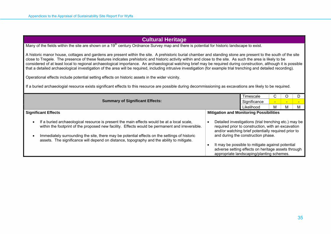
Potential Significant Effects and Mitigation Possibilities:
International/ National/ Transboundary There are 11 listed buildings within a 3km of the site and are all Grade II or II* listed. There are three which are within the site. These are as follows: Corn Mill at Gafnan (LB No. 24416) Grade II* Corn drying house at Felin Gafnan (LB No. 24417) Grade II Mill house at Felin Gafnan (LB No. 24418) GradeII
Regional/ Local Data from Cadw shows that there are two scheduled monuments within 3km within the site. Both are Standing Stones ( AN030, AN080). Cestyll Garden (GD45), Grade II in the Cadw/ICOMOS register of Parks and Gardens of Special Historic Interest in Wales, lies immediately to the west of the site boundary. Cestyll House (within the site boundary) was demolished in 1991.
Appendices to the Appraisal of Sustainability Site Report For Wylfa
35
Cultural Heritage Many of the fields within the site are shown on a 19th century Ordnance Survey map and there is potential for historic landscape to exist. A historic manor house, cottages and gardens are present within the site. A prehistoric burial chamber and standing stone are present to the south of the site close to Tregele. The presence of these features indicates prehistoric and historic activity within and close to the site. As such the area is likely to be considered of at least local to regional archaeological importance. An archaeological watching brief may be required during construction, although it is possible that a detailed archaeological investigation of the area will be required, including intrusive investigation (for example trial trenching and detailed recording). Operational effects include potential setting effects on historic assets in the wider vicinity. If a buried archaeologial resource exists significant effects to this resource are possible during decommissioning as excavations are likely to be required.
Summary of Significant Effects: Timescale C O D Significance - - - Likelihood M M M
Significant Effects
Mitigation and Monitoring Possibilities
• If a buried archaeological resource is present the main effects would be at a local scale, within the footprint of the proposed new facility. Effects would be permanent and irreversible.
• Immediately surrounding the site, there may be potential effects on the settings of historic
assets. The significance will depend on distance, topography and the ability to mitigate.
• Detailed investigations (trial trenching etc.) may be required prior to construction, with an excavation and/or watching brief potentially required prior to and during the construction phase.
• It may be possible to mitigate against potential
adverse setting effects on heritage assets through appropriate landscaping/planting schemes.
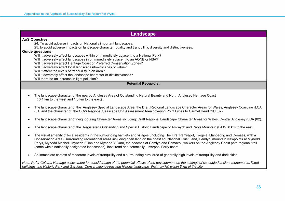
Appendices to the Appraisal of Sustainability Site Report For Wylfa
36
Landscape AoS Objective:
24. To avoid adverse impacts on Nationally important landscapes. 25. to avoid adverse impacts on landscape character, quality and tranquillity, diversity and distinctiveness.
Guide questions: Will it adversely affect landscapes within or immediately adjacent to a National Park? Will it adversely affect landscapes in or immediately adjacent to an AONB or NSA? Will it adversely affect Heritage Coast or Preferred Conservation Zones? Will it adversely affect local landscapes/townscapes of value? Will it affect the levels of tranquillity in an area? Will it adversely affect the landscape character or distinctiveness? Will there be an increase in light pollution?
Potential Receptors:
• The landscape character of the nearby Anglesey Area of Outstanding Natural Beauty and North Anglesey Heritage Coast ( 0.4 km to the west and 1.8 km to the east) . • The landscape character of the Anglesey Special Landscape Area, the Draft Regional Landscape Character Areas for Wales, Anglesey Coastline rLCA
(01) and the character of the CCW Regional Seascape Unit Assessment Area covering Point Lynas to Carmel Head rSU (07). • The landscape character of neighbouring Character Areas including: Draft Regional Landscape Character Areas for Wales, Central Anglesey rLCA (02).
• The landscape character of the Registered Outstanding and Special Historic Landscape of Amlwych and Parys Mountain (LA19) 8 km to the east.
• The visual amenity of local residents in the surrounding hamlets and villages (including The Firs, Pentregof, Tregele, Llanbadrig and Cemaes, with a
Conservation Area), surrounding recreational areas including open land on the coast eg. National Trust Land, Cemlyn, mountain viewpoints at Mynedd Parys, Mynedd Mechell, Mynedd Eilian and Mynedd Y Garn, the beaches at Cemlyn and Cemaes , walkers on the Anglesey Coast path regional trail (some within nationally designated landscapes), local road and potentially, Liverpool Ferry users.
• An immediate context of moderate levels of tranquillity and a surrounding rural area of generally high levels of tranquillity and dark skies.
Note: Refer Cultural Heritage assessment for consideration of the potentilal effects of the development on the settings of scheduled ancient monuments, listed buildings, the Historic Park and Gardens, Conservation Areas and historic landscape that may fall within 5 km of the site.
Appendices to the Appraisal of Sustainability Site Report For Wylfa
37
Landscape Potential Significant Effects and Mitigation Possibilities:
International/ National/ Transboundary
1. There are no anticipated international indirect effects likely to arise from the site, given distances to the Irish Coast, the Isle of Man and English mainland. 2. There are unlikely to be any significant indirect landscape or visual effects on the Snowdonia National Park on the Welsh mainland given distances of
36 km.
3. There are likely to be indirect effects on the landscape character and the visual amenity people within of of the Anglesey Area of Outstanding Natural Beauty and Anglesey Heritage Coast, which are as close as 0.4 km from the site to the west, 1.8 km to the east. The indirect landscape character effects and visual effects are anticipated to be experienced intermittently along the northern coastine of Anglesey, from the AONB and Heritage Coast, in the localty of the site. Other potential intervisibility is likely to be limited to mountain areas within the AONB to the west including Mynedd Y Garn. Construction impacts arising from laydown areas, construction operations and increase traffic are highly likely to have a temporary adverse indirect effect on the character of these areas. The indirect effects of construction traffic inland potentially can be reduced through the use of a marine landing platform for deliveries by sea. The operation of a new nuclear power station on the site is likely to result in the addition of new buildings that significantly add to the existing building visual mass. This will potentially give rise to significant adverse effects beyond those that are already recognised as arising from the existing power stations. However, the new power station is likely to be seen in the context of the existing power station from all nationally designated areas. Adverse visual impacts will not be able to be fully mitigated until after decommissioning. Over such time periods, it is difficult to have certainty over the future land use of the decommissioned areas.
Regional/ Local
4. The Anglesey Coastline Regional Landscape Character Area rLCA (o1) covers the coastal strip of the island of Anglesey and the site. The character of
this area is protected at a local level by the Anglesey Special Landscape Area Designation. Within this area there are likely to be direct and indirect adverse effects arising from the construction and operation of a new power station on the site, on both local character and views. Impacts are likely to include distant effects upon elevated mountain areas to the west and east including the Registered Outstanding and Special Historic Landscape of Amlwych and Parys Mountain (LA19) and more localised effects on the settlement areas clustered around the existing Wylfa power station, on adjoining rural countryside and seascape and on the users of sections of the North Anglesey Coast path. Due to the scale and mass of the new power station buildings, in combination with the existing power station buildings, the indirect effects are anticipated to be adverse but predominantly localised with limited potential for mitigation of visual effects, until decommissioning. There is some potential though to cluster the new buildings in close proximity to the existing buildings in a manner that avoids broadening intervisibility. Direct effects on this regional landscape character area, the Special Landscape Area and the landscape of the site are considered in paragraphs 6-8.
Appendices to the Appraisal of Sustainability Site Report For Wylfa
38
Landscape
5. The anticipated Indirect effects of the new power station on the site at Wylfa , on the landscape character of the neighbouring Draft Regional Landscape Character Areas for Wales, specifically, Central Anglesey rLCA (02), are likely to be of lower significance as this interior part of Anglesey is generally gently undulating and more enclosed, which is likely to limit the potential for intervisibility. However, there is potential for direct adverse impacts arising in the construction and operation phases, some increase in road traffic and from in combination effects from associated new electricity pylons, if required, by the National Grid which would add to the effects of existing windfarms that occur in this area to the east of the Wylfa site .
6. The potential direct effects of the new nuclear power station on the site itself from construction to decommissioning cannot be assessed against
published local landscape type descriptions, in this instance, as this emerging Welsh Landmap information is yet to be published. However , the creation of a new power station on the site and associated construction lay down areas, are likely to give rise to impacts resulting from the following: the creation of temporary construction areas, new power station buildings, ancilliary buildings,new roads, new pylons, enhanced sea defences (if required), a further marine landing platform (if the existing platform cannot be utilised) and two new water cooling culverts. The construction activities for the permanent site and temporary lay down areas will potentially adversely effect local landscape features. There would be potential effects on open cliff top farmland and semi natural moorland which may need to be cleared and this may involve the associated removal of some existing walled field enclosures. The existing condition of these features appears variable. Dependent on the extent of contruction areas, there is some existing conifer woodland on banks which provides some local screening to Cemaes that may nee to be cleared. There potentially could also be some direct adverse effects on the landscape features on the foreshore, including low cliffs. The visual effects of construction and the operational of a new power station on neighbouring residents, walkers, holiday makers and local road users, including effects associated with lighting and traffic, may also be significantly adverse at local level but in localised area where tranquillity is lower than in most other parts of the coastline.
7. Mitigation potential includes: Protective fencing and buffer areas that could be incorporated during construction to protect some existing walled field
enclosures and woodland areas. Restricting construction working areas and new built structures to areas away from sensitive and intact areas of cliff or beach and to maintain some separation from neighbouring residential properties, could also mitigate potential adverse effects. The siting of the new power station building in close proximity to the existing power station buildings, to the south west and away from the more prominent headland to the north, could avoid a significant broadening of visual impact. During operation, there is a high potential for restoring temporary construction areas back to coastal farmland and moorland . Any new sea defences, if required, could be positioned to avoid direct impact on the low cliffs and the beaches and in a form that respects local distinctiveness and materials. Sensitive location and design of water cooling culverts (using tunnelling techqniques) and the continued use of the existing marine landing platform, may reduce adverse impacts on the foreshore and on areas that have visual prominence from adjoining recreational areas. Other measures might include: the delivery of construction materials by sea to reduce road use and the use of directional, cut off, low level lighting and restricted working hours ,to limit further potential light pollution. Key positive opportunities include landscape restoration and off set enhancement measures. These measures could include: coastal farmland and moorland restoration and the restoration and repair of field wall enclosures in the surrounding landscape of the British Energy Estate.
8. With this potential site design and mitigation in place and the potential for landscape restoration, local site landscape impacts could be reduced to a slight
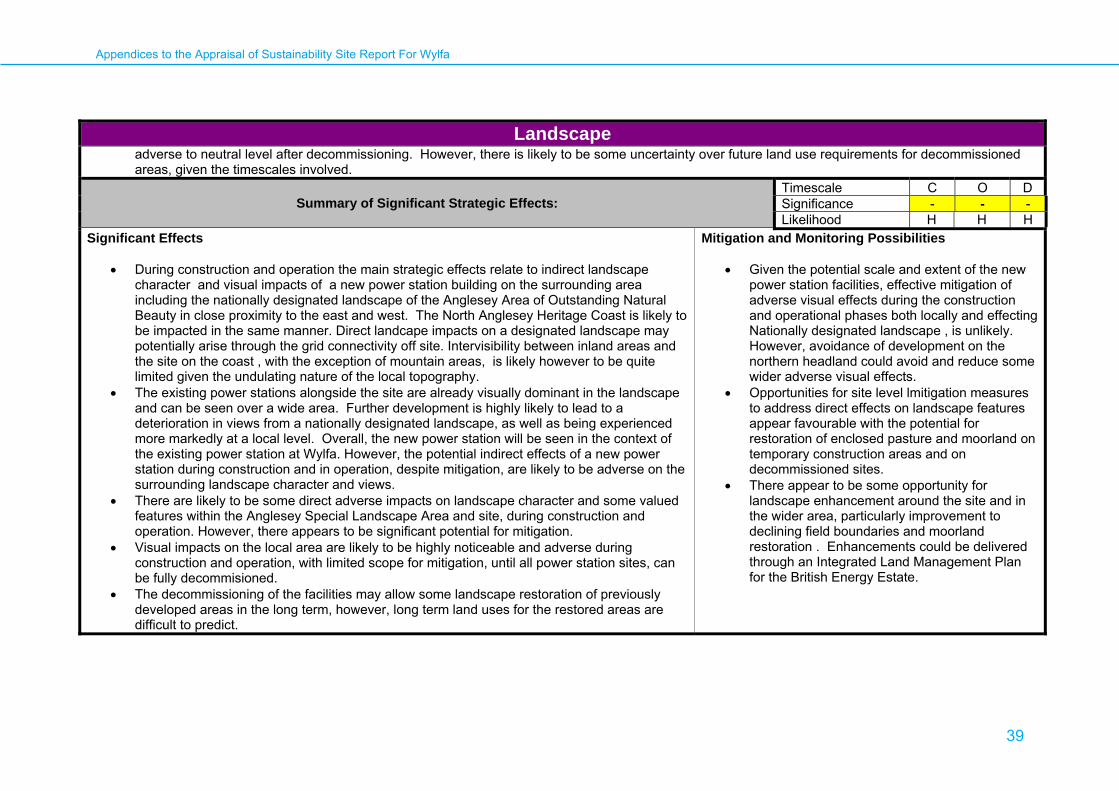
Appendices to the Appraisal of Sustainability Site Report For Wylfa
39
Landscape adverse to neutral level after decommissioning. However, there is likely to be some uncertainty over future land use requirements for decommissioned areas, given the timescales involved.
Summary of Significant Strategic Effects:
Timescale C O D Significance - - - Likelihood H H H
Significant Effects
• During construction and operation the main strategic effects relate to indirect landscape character and visual impacts of a new power station building on the surrounding area including the nationally designated landscape of the Anglesey Area of Outstanding Natural Beauty in close proximity to the east and west. The North Anglesey Heritage Coast is likely to be impacted in the same manner. Direct landcape impacts on a designated landscape may potentially arise through the grid connectivity off site. Intervisibility between inland areas and the site on the coast , with the exception of mountain areas, is likely however to be quite limited given the undulating nature of the local topography.
• The existing power stations alongside the site are already visually dominant in the landscape and can be seen over a wide area. Further development is highly likely to lead to a deterioration in views from a nationally designated landscape, as well as being experienced more markedly at a local level. Overall, the new power station will be seen in the context of the existing power station at Wylfa. However, the potential indirect effects of a new power station during construction and in operation, despite mitigation, are likely to be adverse on the surrounding landscape character and views.
• There are likely to be some direct adverse impacts on landscape character and some valued features within the Anglesey Special Landscape Area and site, during construction and operation. However, there appears to be significant potential for mitigation.
• Visual impacts on the local area are likely to be highly noticeable and adverse during construction and operation, with limited scope for mitigation, until all power station sites, can be fully decommisioned.
• The decommissioning of the facilities may allow some landscape restoration of previously developed areas in the long term, however, long term land uses for the restored areas are difficult to predict.
Mitigation and Monitoring Possibilities
• Given the potential scale and extent of the new power station facilities, effective mitigation of adverse visual effects during the construction and operational phases both locally and effecting Nationally designated landscape , is unlikely. However, avoidance of development on the northern headland could avoid and reduce some wider adverse visual effects.
• Opportunities for site level lmitigation measures to address direct effects on landscape features appear favourable with the potential for restoration of enclosed pasture and moorland on temporary construction areas and on decommissioned sites.
• There appear to be some opportunity for landscape enhancement around the site and in the wider area, particularly improvement to declining field boundaries and moorland restoration . Enhancements could be delivered through an Integrated Land Management Plan for the British Energy Estate.

Appendices to the Appraisal of Sustainability Site Report For Wylfa
40
Soils, Geology and Land use AoS Objective:
19. to avoid damage to geological resources 20. to avoid the use of greenfield land and encourage the re-use of brownfield sites 21. to avoid the contamination of soils and adverse impacts on soil functions
Guide questions: Will it result in the compaction and erosion of soils? Will it lead to the removal or alteration of soil structure and function? Will it lead to the contamination of soils which would affect biodiversity and human health? Will it compromise the future extraction/ use of geological/ mineral reserves? Will it result in the loss of agricultural land? Will it lead to damage to geological SSSIs and other geological sites? Will it result in the loss of Greenfield land? Will it adversely affect land under land management agreements?
Potential Receptors:
The site lies within an area of agricultural land use. No significant geological designated site lies within the local vicinity. TRE'R GOF SSSI – adjacent to and potentially (to be confirmed by nomination) within the site. CEMLYN BAY SSSI/SPA/SAC – adjacent to the site. Adjacent agricultural land/green field land Nys Môn /Anglesey AONB adjacent to the site.
Potential Significant Effects and Mitigation Possibilities:
International/ National/ Transboundary
1. The site potentially lies within the Tre'r Gof SSSI and also Cemlyn Bay SSSI/SPA/SAC. Construction activities and operational activities are likely to have a detrimental effect to the short/medium term soil quality within the area of the proposed development. Compaction/removal/alteration of soils is likely to affect the soil quality within these designated sites, which may also affect biodiversity; however this is addressed in the appraisal of Biodiversity.
2. There are no geological designations of note within the local vicinity.
3. The loss of greenfield land is not considered to be significant on a National level.

Appendices to the Appraisal of Sustainability Site Report For Wylfa
41
Soils, Geology and Land use
Regional/ Local
4. The soils in the local area adjacent to the site lies within a region classified to be of low fertility by the National Soils Resources Institute. Any development is likely to have a local effect on agricultural land use and agriculture in prevalent in the local area.. The soils could potentially be returned to an equivalent agricultural grade but reinstating the original soils matrix is unlikely. The extent of the loss of agricultural land is unlikely to be significant in a national context. Soils could be returned to a similar agricultural importance once the site has been decommissioned however the original soils matrix is unlikely to be restored.
5. Construction of new plant upon greenfield sites. The loss of greenfield land is likely to be of local significance.
6. Radioactive contamination of soils is not covered as part of this assessment but is covered by the additional research being undertaken as part of the wider radioactive waste issue. The site would fall within National Permitting requirements and therefore management of the site in order to prevent the contamination of soils would be covered by these legislative requirements. Contamination and effects to Human Health would also be covered by this investigation.
Summary of Significant Strategic Effects:
Timescale C O D Significance -? -? -? Likelihood M M M
Significant Effects
Mitigation and Monitoring Possibilities
• The construction of the power station and associated infrastructure (including transmission lines/towers) will lead to the direct loss of soil structure. This may include impacts on soils that maintain terrestrial habitats, including designated nature conservation sites; the Tre'r Gof SSSI and also Cemlyn Bay SSSI/SPA/SAC. This is considered further in the biodiversity appraisal.
• Limitation of the footprint of the development reducing the area of soils affected. Avoidance of any soils within designated sites of ecological importance.
Appendices to the Appraisal of Sustainability Site Report For Wylfa
42
Water - Hydrology and Geomorphology AoS Objective:
15. To avoid adverse impacts on surface water hydrology and channel geomorphology (including coastal geomorphology). Guide questions:
Will it result in the increased sedimentation of watercourses? Will it adversely affect channel geomorphology? Will hydrology and flow regimes be adversely affected by water abstraction? Will it result in demand for higher defence standards that will impact on coastal processes? Can the higher defence standards be achieved without compromising habitat quality and sediment transport?
Potential Receptors: Local and district resident population and tourists, local and district ecosystems in coastal waters, nearby watercourses and on land.
Potential Significant Effects and Mitigation Possibilities:
International/National/Transboundary
1. The potential effects on surface water hydrology and fluvial and coastal geomorphology are likely to be limited to the northern coastline of Anglesey and adjoining coastline within approximately 10-20 km of the site. It would be necessary for the nominator to undertake a data collection and modelling exercise to confirm the spatial extent of this impact at the EIA stage.
Regional/Local
2. The site of the existing Wylfa power station is not within the area at risk from the 1/100 year flood event. However, climate change driven rises in sea-
level rise may increase flood risk over the coming decades and any further development would require encroachment into the area at risk of flooding. Further details are provided in the appraisal of flood risk issues.
3. The provision of cooling water for a new power station at the site may require excavation/dredging in adjacent coastal waters to enable the construction of a channel and/or pipeline for the abstraction and return of the cooling water. Construction disturbance associated with these works may have the short-term effect of accelerated delivery of sediment to water bodies during construction. Over the longer-term, during operation, there is the possibility that the discharge of cooling water may affect local coastal hydrodynamics and sedimentation processes. The effects of construction and operation of the cooling water system on coastal processes and sediment transport could be reduced or potentially eliminated by suitable design and construction methods.
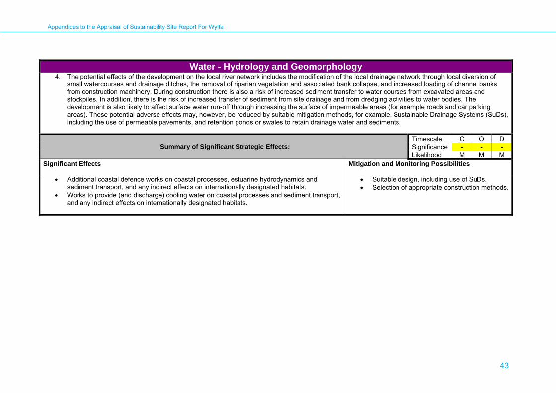
Appendices to the Appraisal of Sustainability Site Report For Wylfa
43
Water - Hydrology and Geomorphology 4. The potential effects of the development on the local river network includes the modification of the local drainage network through local diversion of
small watercourses and drainage ditches, the removal of riparian vegetation and associated bank collapse, and increased loading of channel banks from construction machinery. During construction there is also a risk of increased sediment transfer to water courses from excavated areas and stockpiles. In addition, there is the risk of increased transfer of sediment from site drainage and from dredging activities to water bodies. The development is also likely to affect surface water run-off through increasing the surface of impermeable areas (for example roads and car parking areas). These potential adverse effects may, however, be reduced by suitable mitigation methods, for example, Sustainable Drainage Systems (SuDs), including the use of permeable pavements, and retention ponds or swales to retain drainage water and sediments.
Summary of Significant Strategic Effects: Timescale C O D Significance - - - Likelihood M M M
Significant Effects
Mitigation and Monitoring Possibilities
• Additional coastal defence works on coastal processes, estuarine hydrodynamics and sediment transport, and any indirect effects on internationally designated habitats.
• Works to provide (and discharge) cooling water on coastal processes and sediment transport, and any indirect effects on internationally designated habitats.
• Suitable design, including use of SuDs. • Selection of appropriate construction methods.

Appendices to the Appraisal of Sustainability Site Report For Wylfa
44
Water - Water Quality (including surface, coastal and marine) AoS objective:
16. To avoid adverse impacts on water quality (including surface, coastal and marine water quality) and to help meet the objectives of the Water Framework Directive.
Guide questions: Will it cause deterioration in surface water quality as a result of accidental pollution, for example spillages, leaks? Will it cause deterioration in coastal and / or marine water quality as a result of accidental pollution, for example spillages, leaks? Will it cause deterioration in surface water quality as a result of the disturbance of contaminated soil? Will it cause deterioration in coastal and / or marine water as a result of the disturbance of contaminated soil? Will it affect designated Shellfish Waters? Will it affect Freshwater Fish Directive sites? Will it increase turbidity in water bodies? Will it increase the temperature of the water in water bodies?
Potential Receptors: Local and district resident population and tourists, local and district ecosystems in watercourses and coastal waters. Regional and international receptors could potentially be affected by releases of persistent contaminants.
Potential Significant Effects and Mitigation Possibilities:
International/National/Transboundary Not significant. Regional/Local
1. The main liquid discharges from the a power station at the site during routine operation will be treated effluent from the wastewater treatment plant and
the return of cooling water to the estuary at elevated temperatures (if this mode of cooling were to be selected). The EA will be responsible for consenting the discharges and it is anticipated that they will seek to apply standards that ensure that the discharges lead to no deterioration in water quality or meet the statutory water quality standards (whichever is the most stringent).

Appendices to the Appraisal of Sustainability Site Report For Wylfa
45
Water - Water Quality (including surface, coastal and marine) 2. In the case of the discharge of cooling water it is unlikely to be feasible to eliminate some changes in thermal conditions locally, particularly at times of
low tide when the volume of water in the coastal water bodies is at a minimum. Detailed appraisal of the proposals for disposal of cooling water will be required to assess the acceptability of this effect. An existing power station with cooling water discharges is already operating at the site.
3. Liquid waste streams are separated from the radioactive materials; accordingly radioactive materials are not expected to be present in any of the
routine discharges of liquid waste. It is expected that liquid discharges will be treated to standards set by the EA to ensure compliance with all relevant legislation.
Summary of Significant Effects: Timescale C O D Significance - - - Likelihood M M M
Significant Effects
Mitigation and Monitoring Possibilities
• Thermal impact of cooling water discharges (if this mode of cooling were to be adopted). However, this effect may be of local and regional significance depending on regional currents within this area of the Irish Sea.
• Thermal discharges will need to be consented by the EA. The discharge quality will need to comply with existing standards or meet the no deterioration standard.

Appendices to the Appraisal of Sustainability Site Report For Wylfa
46
Water – Water Supply and Demand AoS objective:
17. To avoid adverse impacts on the supply of water resources. Guide questions:
Will it adversely affect water supply as a result of abstraction? Will it increase demand for water?
Potential Receptors: Local and district resident population and tourists. District ecosystems dependent on surface water features.
Potential Significant Effects and Mitigation Possibilities:
International/National/Transboundary. Not significant. Regional/Local
1. The site lies within the Ynys Môn Abstraction Management Strategy (CAMS) area. Surface and groundwater in the vicinity of the site is not currently
used for water supply. A power station development at the site is not expected to have any significant impact on water resources in the area.
2. Construction and operation may, however, increase demand for potable supplies both at the site and in local communities where the workforce will live. Depending on the nature of the demand and the potential efficiency savings, there may be implications for meeting this demand. However, this is unlikely to be significant in the operational phase where the numbers of additional workers is small; it may be more significant during the construction period when a substantial increase in the local population is likely. Nevertheless, an assessment of the likely change in water demands associated with development at the site should be undertaken to quantify the magnitude of any change. The North Eryri / Ynys Môn Water Resource Zone (WRZ) in which the site is located is predicted to move into deficit after 2014/2015. Measures are proposed to address this, and it is important to ensure that these are sufficient to address any changes in demand.
3. Increased water supply would probably be derived from multiple sources within the neighbouring WRZs, hence additional water supply could impact District aquatic ecosystems within and downstream of catchments used to provide additional water.
Appendices to the Appraisal of Sustainability Site Report For Wylfa
47
Water – Water Supply and Demand
Summary of Significant Effects: Timescale C O D Significance - 0 0 Likelihood M H H
Significant Effects
• Increased demand during the construction phase. The potential magnitude and duration of increased water demand will depend on the timing of the site development in relation to the activities (operation or decommissioning) of the existing site. Similar Significant effects are likely to apply to wastewater production from the site.
Mitigation and Monitoring Possibilities
• Studies to ensure that capacity of water and wastewater infrastructure in this area is sufficient.

Appendices to the Appraisal of Sustainability Site Report For Wylfa
48
Water - Groundwater Quality and Flow AoS Objective:
18. To avoid adverse impacts on groundwater quality, distribution and flow and to help meet the objectives of the Water Framework Directive Guide questions:
Will it cause deterioration in groundwater quality as a result of accidental pollution, for example spillages, leaks? Will it cause deterioration in groundwater quality as a result of the disturbance of contaminated soil?
Potential Receptors: Local and district resident population and tourists, local and district ecosystems with connections to groundwater.
Potential Significant Effects and Mitigation Possibilities:
International/National/Transboundary. Not significant. Regional/ Local
1. The site is located on the Ynys Môn Minor aquifer; there are no Groundwater Protection Zones in close vicinity of the site. It appears that this aquifer is not used for major water supply. The aquifer may be used for small private abstractions. However, localised groundwater pathways may exist between the site and other larger aquifers on Anglesey, hence accidental discharges or construction disturbance at the site could cause deterioration in groundwater quality and flow quantity.
2. Increased water supply would probably be derived from multiple sources within the North Eryri / Ynys Môn WRZ. Additional water supply could impact groundwater bodies used to provide additional water. Increased groundwater abstraction could lead to impacts on groundwater dependent surface water features and aquatic ecosystems.

Appendices to the Appraisal of Sustainability Site Report For Wylfa
49
Summary of Significant Effects:
Timescale C O D Significance - - 0 Likelihood M M M
Significant Effects Mitigation and Monitoring Possibilities
• Potential impacts on local groundwater bodies.
• Studies to ensure that local groundwater bodies are investigated and suitable design is adopted to mitigate potential impacts.
Appendices to the Appraisal of Sustainability Site Report For Wylfa
50
Flood Risk AoS Objective:
14. To avoid increased flood risk (including coastal flood risk) and seek to reduce risks where possible Guide questions:
Will it result in demand for higher defence standards?
Potential Receptors: Site workers. Local, District ecosystems in estuarine waters.
Potential Significant Effects and Mitigation Possibilities:
International/ National/ Transboundary Not significant Regional/ Local
1. The site is located mostly in Flood Zone 1, but is bounded along the coastline by Flood Zone 3.
2. It is likely through the impacts of climate change on sea level rise that flood risk to the site will increase.
3. The site is shown to be defended, but at this time no information was available regarding the composition, condition grade and standard of protection afforded by these defences.
4. To mitigate against flood risk for the lifetime of the development ongoing maintenance and improvement of these defences may be required, which
may effect coastal processes,
5. To mitigate against these effects any improvement in existing or construction of new defences will require appropriate design, construction and management.
6. Local land raising of the site could aso mitigate against increased flood risk.
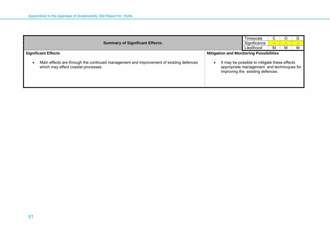
Appendices to the Appraisal of Sustainability Site Report for Wylfa
51
Summary of Significant Effects:
Timescale C O D Significance - - - Likelihood M M M
Significant Effects
• Main effects are through the continued management and improvement of existing defences which may effect coastal processes.
Mitigation and Monitoring Possibilities
• It may be possible to mitigate these effects appropriate management and technicques for improving the existing defences.

Appendices to the Appraisal of Sustainability Site Report for Wylfa
52
Appendix 3: Plans and Programmes Review (Regional) Planning Policy Wales (March 2002) (The Welsh Assembly) The purpose of Planning Policy Wales (PPW) is to set the context for sustainable land use planning and examines how planning policy can achieve the Welsh Assembly Government goals:
• Sustainable Development • Building a dynamic and advanced economy • Tackling social disadvantage • Equal Opportunities
PPW sets out the Government’s objectives on a number of key sustainable development issues: Natural Heritage
• Promote the conservation of landscape and biodiversity, in particular the conservation of native wildlife and habitats • Ensure that action in Wales contributes to meeting international responsibilities and obligations for the natural environment • Ensure that statutory designated sites are properly protected and enhanced • Safeguard protected species
Conserving the Historic Environment
• Preserve and enhance the historic environment, recognising its contribution to economic vitality and culture, civic pride and the quality of life, and its importance as a resource for future generations
• Protect archaeological remains, which are a finite and non-renewable resource, part of the historical and cultural identity of Wales, and valuable both for their own sake and for their role in education, leisure and the economy
Economic Development
• Enhance the economic success of both urban areas and the countryside, helping businesses to maximise their competitiveness • Promote the exploitation of new technologies which can provide new opportunities • Ensure that development for enterprise and employment uses is in line with sustainability principles, respecting the environment in its
location, scale and design

Appendices to the Appraisal of Sustainability Site Report for Wylfa
53
Transport
• Reduce the need to travel, especially by private car, by locating development where there is good access by public transport, walking and cycling
• Locating development near other related uses to encourage multi-purpose trips and reduce the length of journeys • Promoting sustainable transport options for freight and commerce • Ensuring that as far as possible, transport infrastructure does not contribute to land take, urban sprawl or neighbourhood severance
Housing
• Homes that are in good condition, in safe neighbourhoods and sustainable communities • New housing and residential environments are well designed, environmentally sound and make a significant contribution to promoting
community regeneration and improving the quality of life • Previously developed land is used instead of greenfield sites
Infrastructure and Services
• To protect and improve water resources through increased efficiency and demand management of water, particularly in those areas where additional water resources may not be available
• To promote the generation and use of energy from renewable sources and energy efficiency, especially as a means of reducing the effects of climate change.
Minimising and Managing Environmental Risks and Pollution • Maximise environmental protection for people, natural and cultural resources • Prevent or manage pollution and promote good environmental practice
LINK: http://wales.gov.uk/topics/planning/policy/ppw2002/?lang=en
Appendices to the Appraisal of Sustainability Site Report for Wylfa
54
One Wales: A Progressive Agenda for the Government of Wales 2007 (Welsh Assembly Government) The One Wales document sets out an agenda to make Wales a strong nation with a sustainable environment and shows the Government programme for their four year term. The programme discusses the Government plan to create a sustainable environment in Wales, with ideas including:
• Aim to achieve annual carbon reduction-equivalent emissions reductions of 3% per year by 2011 • Promotion of energy efficiency, renewable technologies and renewable energy production • Better and more co-ordinated waste management
One Wales also goes on to address other broad areas such as housing, communities, culture and education. LINK: http://wales.gov.uk/about/strategy/publications/onewales/?lang=en Wales: A Vibrant Economy – Strategic Framework for Economic Development 2005 (Welsh Assembly Government) The Strategic Framework for Economic Development sets out the vision for a vibrant Welsh economy delivering strong and sustainable economic growth by providing opportunities for all. The key actions to achieve this vision are:
• Supporting job creation and helping individuals to tackle barriers to participation in the world of work • Investing to regenerate communities and stimulate economic growth across Wales • Helping businesses to grow and increasing value-added per job and earnings • Ensuring that all economic policies and programmes support sustainable development, in particular by encouraging clean energy
generation and resource efficiency LINK:http://cymru.gov.uk/about/strategy/publications/business/935778/;jsessionid=hkwfKtVGsfKGHzJnFpvLR8H3LMLbkL2cHvZLdZQwGXQB97xj5dLH!-1895006922?cr=2&lang=en&ts=1
Appendices to the Appraisal of Sustainability Site Report for Wylfa
55
Powys Unitary Development Plan (Awaiting Adoption) (Powys County Council) The Powys UDP is currently awaiting adoption and is set to replace the Powys County Structure Plan Replacement 1996 document. The UDP will guide development up until 2016 and covers a multitude of topics including housing, conservation of the natural environment, economy, land use and renewable energy. At the draft stage the UDP sets out some specific policies and objectives: Environment and Conservation
• Conserving and enhancing the environment , historical and archaeological assets and the countryside as a whole • Safeguarding biodiversity and nature conservation sites • Protecting trees • Built and archaeological heritage is protected by policies on conservation areas, listed buildings and ancient monuments
Housing
• Housing allocations for 6750 dwellings Employment
• Strategic employment land allocations of 54.9 Ha Transport
• Highway improvement schemes and traffic management Energy
• Power station proposals • Renewable energy developments
LINK: http://www.powys.gov.uk/index.php?id=564
Appendices to the Appraisal of Sustainability Site Report for Wylfa
56
Minerals Planning Policy Wales 2001 (National Assembly for Wales) This documents sets out the land use planning policy guidance in relation to mineral extraction and related development in Wales. The key principles contained within the document include:
• Provide mineral resources to meet society’s needs and to safeguard resources from sterilisation • Protect areas of importance to natural or built heritage • Limit the environmental impact of mineral extraction
LINK: http://wales.gov.uk/topics/planning/policy/minerals/mineralsplanning?lang=en Environment Strategy for Wales (Welsh Assembly Government) The Environment Strategy for Wales sets out the long term strategy for the environment of Wales up to 2026 and aims to provide a framework within which to achieve an environment which is clean, healthy, biologically diverse and valued by the people of Wales. The priorities for the Welsh environment identified in the strategy are:
• Minimise our greenhouse gas emissions and adapt to the impacts of climate change • Conserve and enhance our biodiversity, while respecting the dynamics of nature • Monitor and regulate known and emerging environmental hazards • Tackle unsustainable practices, like waste production and disposal • Conserve and enhance our land and sea, our built environment, our natural resources and heritage, developing and using them in a
sustainable and equitable way and for the long term benefit of the people of Wales LINK: http://wales.gov.uk/topics/environmentcountryside/epq/envstratforwales/?lang=en

Appendices to the Appraisal of Sustainability Site Report for Wylfa
57
Wales Biodiversity Framework: Making the connections for biodiversity action in Wales (Wales Biodiversity Partnership) The purpose of the Wales Biodiversity Framework is to:
• Identify the key practical, policy and legislative drivers for protecting, restoring and enhancing biodiversity in Wales • Explain the roles and remit of those responsible for undertaking biodiversity action • Provide links to the tools and information to help maintain and improve biodiversity in Wales • For UK Biodiversity Action Plan (UKBAP) species within Wales, only 22% are considered to be stable or increasing • There are 24 Local Biodiversity Action Plans in Wales – one for every county and two for National Parks
The Wales Biodiversity Framework runs alongside the Wales Environmental Strategy, whereby the key challenges to achieving the targets set for improving biodiversity include:
• Safeguarding and ensuring favourable condition of priority habitats and species as defined in UKBAP • Making new and existing development and other activities more biodiversity-friendly • Taking biodiversity into account at the early stages of developing plans and projects • Influence private/business sectors to contribute more towards biodiversity enhancement/protection
LINK: www.biodiversitywales.org.uk/.../WBP%20Framework%20version%2013-06-07%20English.doc Sustainable Homes: A National Housing Strategy for Wales (Consultation Draft, January 2009) (Welsh Assembly Government) The National Housing Strategy will be implemented through an action plan, to be developed in 2009/10. It aims to provide a coherent direction for housing policy in Wales and the strategy is based around six key principles:
• Providing the right mix of housing • Using housing as a catalyst to improve lives • Strengthening communities • Radically reducing the ecological footprint • Ensuring better services • Delivering together
LINK:

Appendices to the Appraisal of Sustainability Site Report for Wylfa
58
Wise About Waste: The National Waste Strategy for Wales 2002 (Welsh Assembly Government) This strategic document sets out targets for recycling and composting of municipal waste and plans to move Wales away from an over reliance on landfill and towards more sustainable waste management. It delivers the following objectives:
• By 2010 and beyond to achieve at least 40% recycling and composting • The development of sustainable management of municipal wastes predicated on the conservation of material resources through re-
use, recycling and composting • Promotion of training and employment opportunities through re-use, recycling and composting • Assisting authorities with compliance under the Landfill Allowances Scheme in Wales and so avoiding potential fines from non
compliance with the requirements of the Landfill Directive • Reducing expenditure on waste disposal and increasing income from the sale of materials for recycling and composting • Provision of clean recyclate and compost for Welsh industry, including horticulture and agriculture • Contributing towards the management of wastes and material resources in ways that contribute to environmental protection, including
the reduction of greenhouse gas emissions as a contribution to addressing the challenges of global warming LINK: http://wales.gov.uk/docs/desh/consultation/090128housingstrategyen.pdf
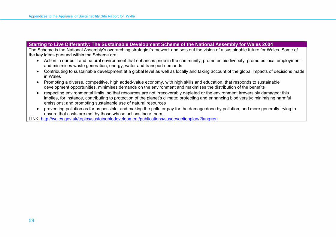
Appendices to the Appraisal of Sustainability Site Report for Wylfa
59
Starting to Live Differently: The Sustainable Development Scheme of the National Assembly for Wales 2004 The Scheme is the National Assembly’s overarching strategic framework and sets out the vision of a sustainable future for Wales. Some of the key ideas pursued within the Scheme are:
• Action in our built and natural environment that enhances pride in the community, promotes biodiversity, promotes local employment and minimises waste generation, energy, water and transport demands
• Contributing to sustainable development at a global level as well as locally and taking account of the global impacts of decisions made in Wales
• Promoting a diverse, competitive, high added-value economy, with high skills and education, that responds to sustainable development opportunities, minimises demands on the environment and maximises the distribution of the benefits
• respecting environmental limits, so that resources are not irrecoverably depleted or the environment irreversibly damaged: this implies, for instance, contributing to protection of the planet’s climate; protecting and enhancing biodiversity; minimising harmful emissions; and promoting sustainable use of natural resources
• preventing pollution as far as possible, and making the polluter pay for the damage done by pollution, and more generally trying to ensure that costs are met by those whose actions incur them
LINK: http://wales.gov.uk/topics/sustainabledevelopment/publications/susdevactionplan/?lang=en
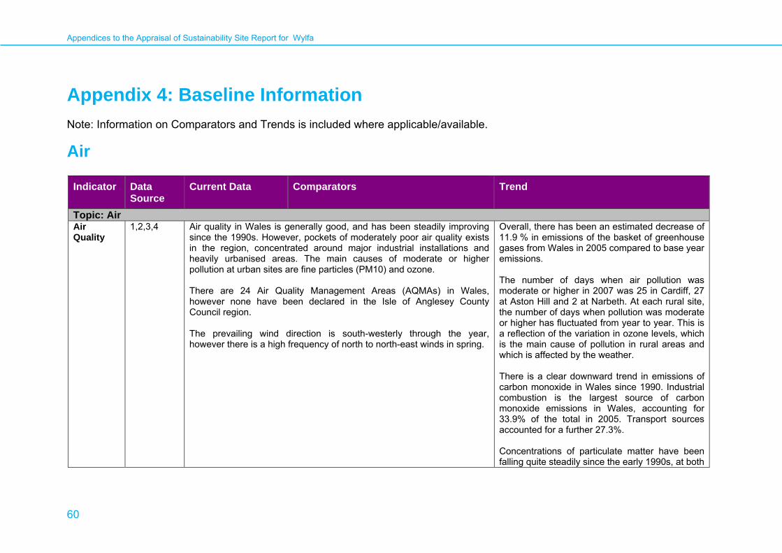
Appendices to the Appraisal of Sustainability Site Report for Wylfa
60
Appendix 4: Baseline Information Note: Information on Comparators and Trends is included where applicable/available.
Air
Indicator Data Source
Current Data Comparators Trend
Topic: AirAir Quality
1,2,3,4 Air quality in Wales is generally good, and has been steadily improving since the 1990s. However, pockets of moderately poor air quality exists in the region, concentrated around major industrial installations and heavily urbanised areas. The main causes of moderate or higher pollution at urban sites are fine particles (PM10) and ozone. There are 24 Air Quality Management Areas (AQMAs) in Wales, however none have been declared in the Isle of Anglesey County Council region. The prevailing wind direction is south-westerly through the year, however there is a high frequency of north to north-east winds in spring.
Overall, there has been an estimated decrease of 11.9 % in emissions of the basket of greenhouse gases from Wales in 2005 compared to base year emissions. The number of days when air pollution was moderate or higher in 2007 was 25 in Cardiff, 27 at Aston Hill and 2 at Narbeth. At each rural site, the number of days when pollution was moderate or higher has fluctuated from year to year. This is a reflection of the variation in ozone levels, which is the main cause of pollution in rural areas and which is affected by the weather. There is a clear downward trend in emissions of carbon monoxide in Wales since 1990. Industrial combustion is the largest source of carbon monoxide emissions in Wales, accounting for 33.9% of the total in 2005. Transport sources accounted for a further 27.3%. Concentrations of particulate matter have been falling quite steadily since the early 1990s, at both

Appendices to the Appraisal of Sustainability Site Report for Wylfa
61
Indicator Data Source
Current Data Comparators Trend
roadside and urban locations. Rural ozone concentrations have been relatively stable over the last 20 years, although average urban ozone levels appear to be rising. This may be, in part, due to the reduction in vehicle emissions during the same time period, as NOx emissions inhibit the formation of ozone at roadside and urban locations.
Key to Data Sources
1 Statistics for Wales (July 2008). Statistical Bulletin. http://www.statswales.wales.gov.uk/tableviewer/document.aspx?FileId=1822
2 DEFRA. UK Air Quality Archive. http://www.airquality.co.uk/archive/laqm/laqm.php [accessed 12 March 2009]
3 Met Office. Regional Climate – Wales. http://www.metoffice.gov.uk/climate/uk/wl/ [accessed 12 March 2009]
4 National Assembly for Wales and the Welsh Air Quality Forum. Air Pollution in Wales 2007: A report of the Welsh Air Quality Forum. http://www.welshairquality.co.uk/

Appendices to the Appraisal of Sustainability Site Report for Wylfa
62
Biodiversity and Ecosystems
Indicator Data Source
Current Data Comparators Trend
Topic: Biodiversity and EcosystemsAnglesey’s Biodiversity Action Plan
Habitats
1 A total of 21 habitat types and plans are recognised within the Anglesey Biodiversity Action Plan. These are split into different groups of ‘Broad Habitats’ of which there is 1 plan, ‘Local Habitat’ of which there are 11 plans and 9 ‘Priority Habitat’ plans. The habitats considered to be most relevant to the site include fens, lowland heathland and saline lagoons.
Anglesey’s Biodiversity Action Plan Species
1 A total of 21 species action plans are recognised within the Anglesey Biodiversity Action Plan. Of these 18 are UK BAP priority species with the remaining, action plans for species which are of local importance within Anglesey for example Chough Pyrrhocorax pyrrhocorax.
Natura 2000 sites (N2K)
2 There are 7 N2K sites within 20 km of the site, all of which are considered potential receptors: • Bae Cemlyn/Cemlyn Bay SAC, approximately 1.5 km west of the site. • Corsydd Mon/Anglesey Fens SAC, approximately 15.5 km southeast of
the site. • Glannau Ynys Gybi/Holy Island Coast SAC, approximately 15 km
southwest of the site. • Lyn Dinam SAC, approximately 16 km south of the site. • Y Fenai a Bae Conwy/Menai Strait and Conwy Bay SAC, approximately
16 km east of the site. • Glannau Ynys Gybi/Holy Island Coast SPA, approximately 15 km
southwest of the site. • Ynys Feurig, Cemlyn and The Skerries SPA, approximately 1.5 km west
of the site. Further details of N2K sites are given below.
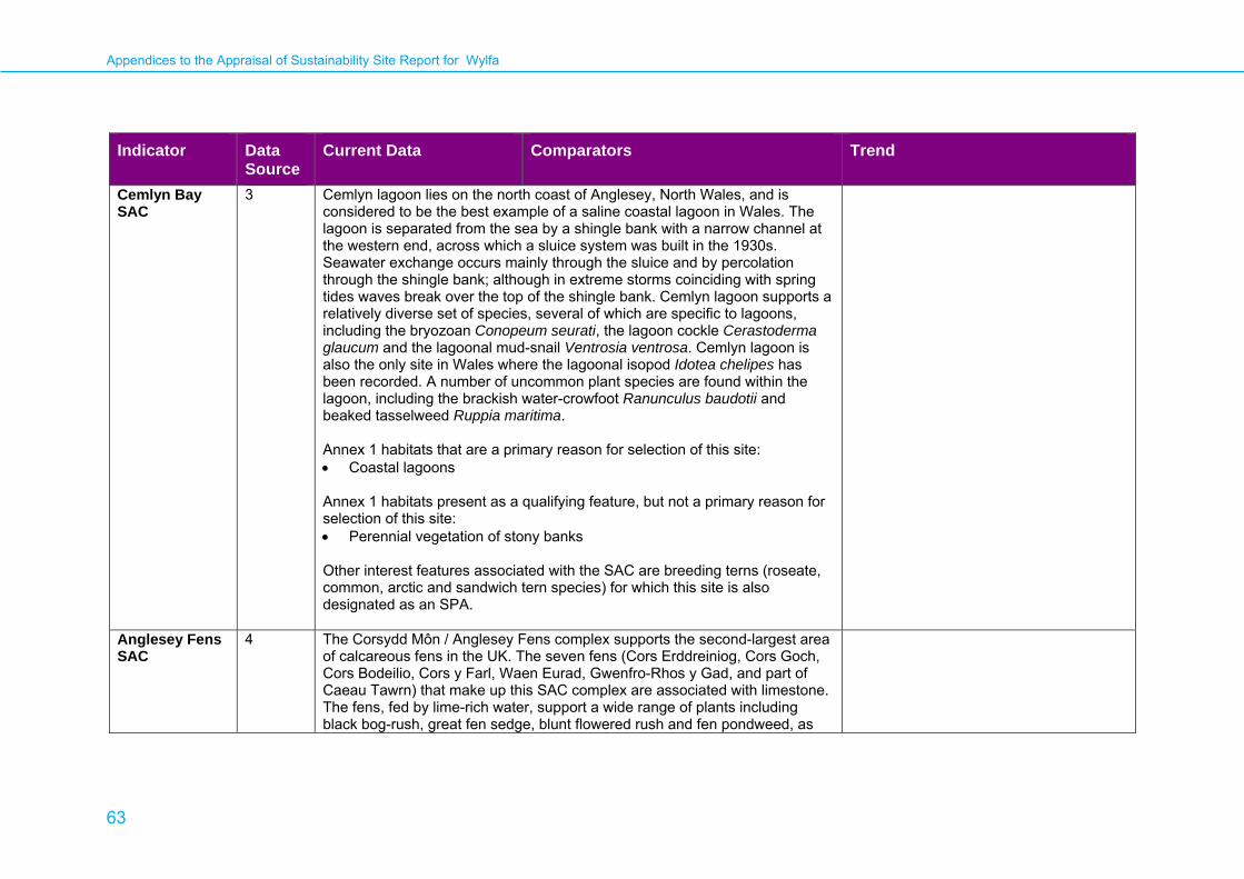
Appendices to the Appraisal of Sustainability Site Report for Wylfa
63
Indicator Data Source
Current Data Comparators Trend
Cemlyn Bay SAC
3 Cemlyn lagoon lies on the north coast of Anglesey, North Wales, and is considered to be the best example of a saline coastal lagoon in Wales. The lagoon is separated from the sea by a shingle bank with a narrow channel at the western end, across which a sluice system was built in the 1930s. Seawater exchange occurs mainly through the sluice and by percolation through the shingle bank; although in extreme storms coinciding with spring tides waves break over the top of the shingle bank. Cemlyn lagoon supports a relatively diverse set of species, several of which are specific to lagoons, including the bryozoan Conopeum seurati, the lagoon cockle Cerastoderma glaucum and the lagoonal mud-snail Ventrosia ventrosa. Cemlyn lagoon is also the only site in Wales where the lagoonal isopod Idotea chelipes has been recorded. A number of uncommon plant species are found within the lagoon, including the brackish water-crowfoot Ranunculus baudotii and beaked tasselweed Ruppia maritima. Annex 1 habitats that are a primary reason for selection of this site: • Coastal lagoons Annex 1 habitats present as a qualifying feature, but not a primary reason for selection of this site: • Perennial vegetation of stony banks Other interest features associated with the SAC are breeding terns (roseate, common, arctic and sandwich tern species) for which this site is also designated as an SPA.
Anglesey Fens SAC
4 The Corsydd Môn / Anglesey Fens complex supports the second-largest area of calcareous fens in the UK. The seven fens (Cors Erddreiniog, Cors Goch, Cors Bodeilio, Cors y Farl, Waen Eurad, Gwenfro-Rhos y Gad, and part of Caeau Tawrn) that make up this SAC complex are associated with limestone. The fens, fed by lime-rich water, support a wide range of plants including black bog-rush, great fen sedge, blunt flowered rush and fen pondweed, as

Appendices to the Appraisal of Sustainability Site Report for Wylfa
64
Indicator Data Source
Current Data Comparators Trend
well as more colourful flowers such as the water lily, fly orchid and narrow leaved orchid. Anthropogenic disturbance is believed to have been instrumental in the development of Cladium – Molinia communities, a particular feature of the rich fens of north-west Wales. This composite site includes four component fen systems supporting a diverse range of short-sedge mires, including the best and most extensive Welsh examples of NVC type M13 Schoenus nigricans – Juncus subnodulosus mire and a range of communities referable to M9a Carex rostrata – Calliergon cuspidatum/ giganteum mire. These are considered to be of pre-eminent importance in the UK, owing to their extent, biogeographical significance and exceptionally rich assemblage of rich-fen species. The fens are strongly influenced by the underlying Carboniferous limestone and are fed by calcareous groundwater arising from discrete springs and more diffuse zones of seepage. The alkaline fen communities often occur within complex vegetation zonations, with gradations to unimproved calcicolous and neutral grasslands also present. The characteristic mixture of southern and northern floristic elements includes a wide range of nationally or locally scarce species, including fly orchid Ophrys insectifera, narrow-leaved marsh orchid Dactylorhiza traunsteineri, marsh helleborine Epipactis palustris, lesser clubmoss, Selaginella selaginoides and slender sedge Carex lasiocarpa. Examples of M13 mire within Anglesey Fens which are strongly influenced by the discharge of calcareous groundwater provide the sole north Wales locus for the Annex II species Southern damselfly Coenagrion mercuriale. Within Cors Erddreiniog lies Llyn yr Wyth Eidion, a small marl (lime deposit) producing lake, an example of a lake on limestone. It is surrounded by the extensive calcareous valley mire of Cors Erddreiniog, which overlies limestone and protects the lake against nutrient enrichment, resulting in water of high quality. Hedgehog stonewort Chara pedunculata and the rare rugged stonewort C. rudis have been recorded at this site.
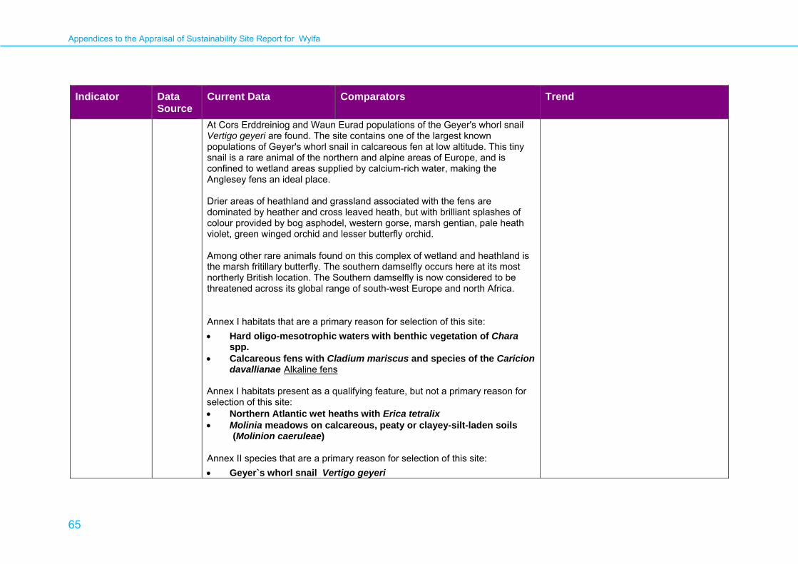
Appendices to the Appraisal of Sustainability Site Report for Wylfa
65
Indicator Data Source
Current Data Comparators Trend
At Cors Erddreiniog and Waun Eurad populations of the Geyer's whorl snail Vertigo geyeri are found. The site contains one of the largest known populations of Geyer's whorl snail in calcareous fen at low altitude. This tiny snail is a rare animal of the northern and alpine areas of Europe, and is confined to wetland areas supplied by calcium-rich water, making the Anglesey fens an ideal place. Drier areas of heathland and grassland associated with the fens are dominated by heather and cross leaved heath, but with brilliant splashes of colour provided by bog asphodel, western gorse, marsh gentian, pale heath violet, green winged orchid and lesser butterfly orchid. Among other rare animals found on this complex of wetland and heathland is the marsh fritillary butterfly. The southern damselfly occurs here at its most northerly British location. The Southern damselfly is now considered to be threatened across its global range of south-west Europe and north Africa.
Annex I habitats that are a primary reason for selection of this site: • Hard oligo-mesotrophic waters with benthic vegetation of Chara
spp. • Calcareous fens with Cladium mariscus and species of the Caricion
davallianae Alkaline fens Annex I habitats present as a qualifying feature, but not a primary reason for selection of this site: • Northern Atlantic wet heaths with Erica tetralix • Molinia meadows on calcareous, peaty or clayey-silt-laden soils
(Molinion caeruleae)
Annex II species that are a primary reason for selection of this site: • Geyer`s whorl snail Vertigo geyeri

Appendices to the Appraisal of Sustainability Site Report for Wylfa
66
Indicator Data Source
Current Data Comparators Trend
Annex II species present as a qualifying feature, but not a primary reason for site selection: • Southern damselfly Coenagrion mercuriale • Marsh fritillary butterfly Euphydryas (Eurodryas, Hypodryas)
aurinia Other European Protected Species known to occur at the site include Great Crested Newt Tristurus cristatus and Otter Lutra lutra.
Holy Island SAC
5 Holy Island Coast, off the north-west coast of Anglesey, Wales, has hard rock acidic cliffs and supports important examples of coastal cliff heathland vegetation. In addition to maritime heath including western gorse and heather, other grassland communities and several rare species such as spotted rock-rose Tuberaria guttata and the endemic South Stack fleawort Tephroseris integrifolia ssp maritima have colonised extensive maritime cliff-crevices within the folded rocks and are able to withstand harsh conditions. The maritime influence is not as extreme as in north Scotland, and this site represents an important part of the range of variation on the mid-west coast of the UK. Holy Island Coast is also the most important site in north Wales for maritime forms of European dry heaths. The main NVC types are H7 Calluna vulgaris – Scilla verna heath and H8 Calluna vulgaris – Ulex gallii heath. The dry heathland is associated with small areas of wet heath and forms part of a complete zonation from maritime grassland through maritime heath to inland heath with bracken Pteridium aquilinum to bramble Rubus fruticosus scrub. This mosaic of habitats provides conditions suitable for the chough and silver studded blue butterfly that can be seen on or around these expanses of heathland.
The cliffs also support important seabird colonies; guillemots, razorbills and puffins combine to create one of the largest colonies of breeding auks in North

Appendices to the Appraisal of Sustainability Site Report for Wylfa
67
Indicator Data Source
Current Data Comparators Trend
Wales. Fulmar and kittiwake also nest on these cliffs together with peregrine and chough, the latter using the heathland and adjacent areas extensively for feeding. Within the heathland stonechat, skylark, linnet and whitethroat all breed regularly.
Annex I habitats that are a primary reason for selection of this site: • Vegetated sea cliffs of the Atlantic and Baltic coasts • European dry heaths
Annex I habitats present as a qualifying feature, but not a primary reason for selection of this site: • Northern Atlantic wet heaths with Erica tetralix
Other European Protected species associated with this site include grey seal Halichoerus grypus.
Lyn Dinam SAC
6 Llyn Dinam is a coastal eutrophic lake in north Wales. Important features of this site include standing water habitat and aquatic plants found therein, reedswamp, marsh fern and breeding and overwintering wetland birds and waterfowl. Common reed Phragmites australis, and to a lesser extent common club-rush Scirpus lacustris ssp. lacustris, dominate the shoreline. Rigid hornwort Ceratophyllum demersum is abundant in shallow open water, often in association with autumnal starwort Callitriche hermaphroditica and ivy-leaved duckweed Lemna trisulca. The white and yellow water-lilies Nymphaea alba and Nuphar lutea dominate in a sheltered arm on the west side. Fennel-leaved pondweed Potamogeton pectinatus, perfoliate pondweed P. perfoliatus and lesser pondweed P. pusillus have been recorded. Stoneworts Chara spp. are present. Water chemistry characteristics are consistent with those expected in eutrophic lakes, including relatively high pH, alkalinity and phosphorus levels. Llyn Dinam is the least-enriched of a series of Anglesey Lakes which have been subjected to sediment diatom analysis.

Appendices to the Appraisal of Sustainability Site Report for Wylfa
68
Indicator Data Source
Current Data Comparators Trend
Annex I habitats that are a primary reason for selection of this site: • Natural eutrophic lakes with Magnopotamion or Hydrocharition-
type vegetation Other European Protected Species associated with this site include Otter.
Menai Strait and Conwy Bay SAC
7 The Menai Strait and Conwy Bay SAC is a multiple interest site that has been selected as a SAC for 5 different types of marine habitat and associated wildlife that it supports (habitats listed in Annex I of the Habitats Directive). The Menai Strait and Conwy Bay SAC is considered to be one of the best areas in the UK for:
• Mudflats and sandflats not covered by seawater at low tide • Reefs • Sandbanks which are slightly covered by sea water all the time and to
support a significant presence of: o Large shallow inlets and bays o Submerged or partially submerged sea caves
The unique physiographic conditions of the Menai Strait and Conwy Bay make it an important site. The wide variation in environmental conditions, such as tide, shelter from wave exposure and turbidity results in a diverse mixture of habitats and their associated plant and animal communities. The fact that five Annex I habitats have qualified for inclusion in this one SAC makes it of especially high importance in relation to the main aim of the Directive in conserving biodiversity. The unusual physiographic conditions of the Menai Strait and Conwy Bay make it an important site, not only nationally but also in a European context. The variation in environmental conditions, such as tide, shelter from wave exposure and turbidity results in the presence of a diverse mixture of habitats and their associated plant and animal communities. A major feature of the Menai Strait and Conwy Bay SAC is the continuum of ecological variation from within the most tide-swept, wave-sheltered narrows in the ‘Swellies’ section of the Menai Strait out into the
Appendices to the Appraisal of Sustainability Site Report for Wylfa
69
Indicator Data Source
Current Data Comparators Trend
more open, less tide-swept waters of
Conwy Bay and the moderately wave-exposed Great and Little Ormes. The wide variety of physiographic conditions experienced within the site, including exposure to tidal currents and examples of differing wave action, turbidity (water clarity), rock / sediment type and aspect throughout the site, are reflected in the diverse mixture of marine habitats and their associated plant and animal assemblages. Annex I habitats that are a primary reason for selection of this site: • Sandbanks which are slightly covered by sea water all the time • Mudflats and sandflats not covered by seawater at low tide • Reefs
Annex I habitats present as a qualifying feature, but not a primary reason for selection of this site: • Large shallow inlets and bays • Submerged or partially submerged sea caves
Holy Island Coast SPA
8 This site is important for its breeding and over-wintering Chough Pyrrhocorax pyrrhocorax
The cliffs also support important seabird colonies; guillemots, razorbills and puffins combine to create one of the largest colonies of breeding auks in North Wales. Fulmar and kittiwake also nest on these cliffs together with peregrine and chough, the latter using the heathland and adjacent areas extensively for feeding. Within the heathland stonechat, skylark, linnet and whitethroat all breed regularly.
Cemlyn and The Skerries SPA
9 This site is important for its breeding tern populations, which include the following species: • Roseate tern • Common tern
Appendices to the Appraisal of Sustainability Site Report for Wylfa
70
Indicator Data Source
Current Data Comparators Trend
• Artic tern • Sandwich tern
Ramsar sites
10 There is 1 Ramsar sites within 20 km of Site: • Corsydd Mon a Lyn/Anglesey and Lyn Fens
Anglesey and Lyn Fens Ramsar
11 Corsydd Mon comprises a series of fen basins located on the limestone of eastern Anglesey. Several of the sites (Cors Goch, Cors y Farl, Cors Erddreiniog, Cors Bodeilio) occupy former lake basins which have gradually infilled with clay, marl and peat sediments. These sites and others (Waun Eurad, Caeau Talwrn, Gwenfro - Rhos y Gad) also contain areas of flush mire where calcareous springs irrigate the surface. The site includes some of the best examples of base-rich fen (Alkaline fen and Calcareous fen) in Wales along with oligotrophic (nutrient poor) lakes, areas of purple moor grass (Molinia caerulea) meadow, wet and dry heath and associated areas of neutral and calcareous grassland. The sites support many species including Geyer's whorl snail, southern damselfly, marsh fritillary, great crested newt and otter. The component sites are set within a mainly agricultural landscape of livestock farms and small settlements. Refer to Corsydd Môn a Llyn / Anglesey SAC for further details.
Sites of Special Scientific Interest (SSSI)
12 There are 34 SSSI’s within 20 km of the site, 6 of these are within 5 km of the site these are: • Tre’r Gof • Cae Gwyn • Cemlyn Bay, forms part of the Cemlyn Bay SAC and Cemlyn Bay and the
Skerries SPA • Henborth • Llanbadrig-Dinas Gynfor • Llyn Llygeirian Of these 3 are considered potential receptor from the development of the site: • Cemlyn Bay, approximately 1.5 km west of the site. • Tre’r Gof, within site boundary.
Appendices to the Appraisal of Sustainability Site Report for Wylfa
71
Indicator Data Source
Current Data Comparators Trend
• Cae Gwyn, approximately 2.5 km south of the site. Further details of these SSSI’s if given below.
Cemlyn Bay SSSI (forms a component part of The Cemlyn Bay and The Skerries SAC/SPA)
12 The inner part of the bay is a tidal lagoon enclosed by a shingle ridge forming a "bay head barrier" of storm beach shingle. Saltmarsh communities occur around the lagoon. The shingle ridge, lagoon and brackish pools further inland support a number of uncommon plant species including sea kale Crambe maritima, sea radish Rapohanus maritimus, brackish water-crowfoot Ranunculus baudotii and Ruppia maritima. There are colonies of common, ‘arctic’ and sandwich terns which breed on low islands in the main lagoon. The number of breeding pairs of each species fluctuates from year to year but the site is particularly important for sandwich tern and often holds over 1% of the British breeding population. The water level in the lagoon is maintained by a weir which is controlled to prevent the ternery from flooding at high spring tides. Wintering wildfowl, notably wigeon, shoveler, goldeneye, teal, mallard and tufted duck use the area.
Tre’r Gof SSSI
12 This site has been selected for its biological interest, in particular as a representative example of rich-fen habitat in north-west Wales. The fen has developed in a basin above Cemaes Bay on the north Anglesey coast, and the vegetation present consists of a mosaic of rich-fen and associated communities. There are stands of fen meadow in which blunt-flowered rush Juncus subnodulosus and other jointed rushes are abundant; these grade into a variety of other communities in which fen species such as fen sedge Cladium mariscus, black bog rush Schoenus nigricans and common reed Phragmites communis are locally dominant. Swamp vegetation, with stands of greater reedmace Typha latifolia, and fen scrub occur in places. The variable structure of the vegetation at this site probably reflects a
Appendices to the Appraisal of Sustainability Site Report for Wylfa
72
Indicator Data Source
Current Data Comparators Trend
chequered management history as well as other environmental gradients. A wide range of wetland plant species occur in the various communities and of particular interest is the presence of a population of the marsh fern Thelypteris thelypteroides which is a scarce fen plant in Britain where it appears to be declining over much of its range.
Cae Gwyn SSSI
12 The main features of interest at Cae Gwyn are two wetland areas, separated by an area of heathland with outcropping rock. The southern wetland is confined by a rock basin; it has a 'lawn' of bogmoss Sphagnum spp. and a profusion of common wetland herbs such as bogbean Menyanthes trifoliata and marsh cinquefoil Potentilla palustris. The flora is distinguished by an abundance of royal fern Osmunda regalis which varies from very large old plants to young plants; other notable species are bog sedge Carex limosa and cranberry Vaccinium oxycoccus. The northern wetland differs in having denser areas of willow and common reed Phragmites communis, but is similar in having numerous plants of Osmunda.
National Nature Reserves (NNR)
13 There are 28 NNR’s within the North Region of Wales, the following NNR’s are within 20 km of the site: • Cors Erddreiniog, approximately 16 km south east of the site. • Cors Goch, approximately 19 km south east of the site.
Local Nature Reserves (LNR)
14 The following LNR is within 20 km of the site: • Trwyn Yr Wylfa/Wlyfa Head This LNR lies adjacent to the site and was gifted to the local community from the power station operator.
Local Wildlife Sites
NA Information to be obtained from a Local Records Centre at the appropriate time.
Legally Protected Species
15 The following legally protected species have been recorded within the 10 km square of the site: • Common reptiles species, adder and common Lizard • Bat species including Pipistrelle species, brown long-eared and whiskered
bat.
Appendices to the Appraisal of Sustainability Site Report for Wylfa
73
Indicator Data Source
Current Data Comparators Trend
Please note that further information on species records within the area is to be obtained from a Local Records Centre at the appropriate time. The above list gives an early indication only of what may occur in the area. It is likely that additional species will need to be considered once further information has been obtained.
Key to Data Sources
1 Joint Nature Conservative Committee. The Anglesey Local Biodiversity Action Plan. http://www.ukbap.org.uk/lbap.aspx?ID=357
2 Joint Nature Conservation Committee (JNCC) [online] available: http://www.jncc.gov.uk/
3 JNCC. Cemlyn Bay SAC Information. http://www.jncc.gov.uk/ProtectedSites/SACselection/sac.asp?EUCode=UK0030114
4 JNCC. Anglesey Fens SAC Information. http://www.jncc.gov.uk/ProtectedSites/SACselection/sac.asp?EUCode=UK0012884
5 JNCC. Holy Island SAC Information. http://www.jncc.gov.uk/ProtectedSites/SACselection/sac.asp?EUCode=UK0013046
6 JNCC. Llnyn Dinam SAC Information. http://www.jncc.gov.uk/ProtectedSites/SACselection/sac.asp?EUCode=UK0030186
7 JNCC. Menai Strait and Conwy Bay SAC Information. http://www.jncc.gov.uk/ProtectedSites/SACselection/sac.asp?EUCode=UK0030202
8 JNCC. Cemlyn Bay and the Skerries SPA Information. http://www.jncc.gov.uk/pdf/SPA/UK9013061.pdf
9 JNCC. Holy Island Coast SPA Information. http://www.jncc.gov.uk/pdf/SPA/UK9013101.pdf
10 JNCC. Designated and Proposed Ramsar sites within Wales. http://www.jncc.gov.uk/page-1392
11 JNCC. Anglesey and Lyn Fens Ramsar Information. http://www.jncc.gov.uk/pdf/RIS/UK14005.pdf

Appendices to the Appraisal of Sustainability Site Report for Wylfa
74
12 Countryside Council for Wales (CCW). http://www.ccw.gov.uk/
13 CCW. NNR’s within the North Region of Wales. http://www.ccw.gov.uk/landscape--wildlife/protecting-our-landscape/special-landscapes--sites/protected-landscapes/national-nature-reserves/nnr-north.aspx
14 Anglesey Nature. Wylfa Local Nature Reserve. http://angleseynature.co.uk/wylfalnr.html
15 National Biodiversity Network Gateway. http://data.nbn.org.uk/

Appendices to the Appraisal of Sustainability Site Report for Wylfa
75
Climate Change Indicator Data
Source Current Data Comparators Trend
Topic: Climate Change Wales (Precipitation and Temperatures)
3,4,7 The Welsh Assembly is bound to the UK’s target to cut emissions to 12 % below 1990 levels, but the Government and the Assembly aim to cut carbon dioxide emissions to 20 % below 1990 levels by 2020. The Welsh Local Government Association (WLGA) published a document entitled ‘Changing Climate: Changing Places’ in 2008 that outlines the main impacts of climate change in Wales by 2080. They are as follow: • A longer growing season • Milder ,wetter winters • Drier, hotter summers • Increases in extremes of heat
and decrease in extremes of cold
• Warmer seas and sea level rise of up to 100cm
• More extreme events (droughts, heat waves, flooding etc.)
• More frequent and more

Appendices to the Appraisal of Sustainability Site Report for Wylfa
76
Indicator Data Source
Current Data Comparators Trend
violent storms/gales The predicted trend in decreasing average summer rainfall in the region is consistent with the data gathered from 1961-to 2000 as illustrated in Figure 12.
Greenhouse Gas Emissions
5 In August 2007, the Welsh Liberal Democrats released figures calculated by the Welsh Assembly's Members Research Unit showing that carbon dioxide emissions per person in Wales are the highest in the UK, and the 12th highest in the world. The carbon dioxide emissions per person in different parts of the UK are:
• Wales - 14.2 tonnes • N. Ireland - 9.5 tonnes • England - 8.8 tonnes • Scotland - 8.5 tonnes
Welsh domestic emissions are approximately 2.7 tonnes of carbon per person, higher than the UK average of 2.4 tonnes. Households in 18 out of the 22 local authorities in Wales have average CO2 emission above the UK average.
The figures show that for Wales to contribute to UK CO2 emission cuts under the Kyoto protocol, it will need to cut its emissions by a further 15 % by 2010.
Isle of Anglesey County Council Authorities Greenhouse Gas Emissions
1,2 In 2006 the Isle of Anglesey council signed the Welsh Assembly's 'Welsh Commitment to Address Climate Change', which follows emissions targets and programmes for delivering change, which are agreed by Central Government and the National Assembly, as set out in the UK Climate Change programme.
Wales Region Strategy
6 The Welsh Assembly states that they will aim to achieve annual carbon emission reductions of 3 % per year by 2011 in areas of devolved competence. The target will include all ‘direct’ greenhouse gas emissions in Wales except those from heavy industry and power generation, which are being broadly
Appendices to the Appraisal of Sustainability Site Report for Wylfa
77
Indicator Data Source
Current Data Comparators Trend
defined as those installations covered by the EU Emissions Trading Scheme (EU ETS). Emissions from most large power plants are covered by the EU ETS. However, because the importance of reducing electricity consumption in order to reduce emissions is recognised, these emissions will be included in the 3 % target by assigning them to the end-user of the electricity. To measure the target, the Welsh Assembly will compare the relevant emissions to a baseline in each year from 2011 onwards. This baseline will be an average of the relevant emissions between 2006 and 2010. These sectoral targets provide an indication of the relative expected contribution of each sector to the 3 % target. • Transport – emissions to stabilise and then start to decline over ten years • Residential – buildings on the existing downward trajectory continuing
year on year reductions over the next ten years • Public sector – every part of the public sector in Wales expected to be
working towards 3 % annual reductions in the greenhouse gas emissions they are responsible for
• Energy efficiency improvements in buildings and industry – measures such as loft and cavity wall insulation, turning appliances off and using less air conditioning, will be particularly important for reducing emissions in the period to 2020
• Decarbonisation of the power sector – starting now and continuing through the 2020s, based on replacing existing conventional fossil fuel fired plants with renewable, nuclear and carbon capture and storage (CCS) technologies
• Transport sector decarbonisation – first through improving fuel efficiency of conventional engines and increased use of sustainable first generation biofuels, with progressive introduction of new technologies such as

Appendices to the Appraisal of Sustainability Site Report for Wylfa
78
Indicator Data Source
Current Data Comparators Trend
electric cars, plug-in hybrids and hydrogen vehicles, and second generation biofuels
• Heat sector decarbonisation – through increased use of biomass in boilers and CHP, air exchange and ground source heat pumps, and modern electric storage heating
• Decarbonisation of industry – through the introduction of new technologies such as CCS in cement, iron and steel
Topic: Energy
Energy 8,9,13 Electricity Consumption 2007 (Isle of Anglesey) Overall: 340.2 GWh (0.1 % of UK) Average Domestic Consumption: 5,251 kWh Average Industrial Consumption: 41,183 kWh Total Energy Consumption 2006 (Isle of Anglesey) 1,857.2 GWh
Electricity Consumption 2007 (Wales) Overall: 16,632.6 GWh Average Domestic Consumption: 4,143 kWh Average Industrial Consumption: 90,462 kWh Electricity Consumption 2007 (Great Britain) Overall: 309,669.5 GWh Average Domestic Consumption: 4,392 kWh Average Industrial Consumption: 79,077 kWh Total Energy Consumption 2006 Wales: 97,377.2 GWhUK: 2,120,261.5 GWh
Anglesey’s electricity consumption accounts for 0.1 % of Britain’s electricity consumption. 18 % of Anglesey’s energy consumption comes from electricity. The Welsh Climate Change Strategy sets out the following ways to reduce emissions within Wales:
• Energy efficiency in the domestic, public, business and industrial sectors, to reduce demand and increase efficiency
• Encouraging smaller scale low carbon energy generation
Renewable Energy
9,12 Energy Consumption from Renewable Sources 2006 (Isle of Anglesey) 16.2 GWh (0.8 %)
Total Energy Consumption from Renewable Sources 2006 Wales: 609.1 GWh (0.6 %) UK: 6,939.5 GWh (0.3 %)
The Welsh Government is reviewing its renewable targets to revise them upwards. The current renewable electricity targets are: • 4TWhr by 2010 • 7TWhr by 2020

Appendices to the Appraisal of Sustainability Site Report for Wylfa
79
Indicator Data Source
Current Data Comparators Trend
Furthermore, the Welsh Government plans to: • draw up an energy strategy - which will
include actions on diversified renewable energy generation and biomass
• promote research and development into renewable technologies including their application on-shore and off-shore
• develop a support programme to promote energy efficiency and renewable energy production on-farm
Current Capacity
10,11 The existing nuclear power station at Wylfa has a capacity of 980 MW. It is expected to operate until 2010. Power stations in the vicinity of the site include: • Dinorwig power station: hydro, 1,728 MW, 40 km • Rhyd-y-Groes power station: wind, 7 MW, 40 km • Dolgarrog High-Head Power Station: hydro, 30 MW, 48 km • Ffestiniog power station: hydro, 360 MW, 72 km • Deeside power station: gas, 500 MW, 112 km • Shotton CHP station: gas, 210 MW, 112 km
Key to Data Sources
1 Isle of Anglesey County Coucil (October 2007). Bright idea to help tackle climate change. http://www.anglesey.gov.uk/doc.asp?cat=3335&doc=6657
2 Welsh Local Government Association. Climate Change. http://www.wlga.gov.uk/english/climate-change/
3 Welsh Local Government Association. Changing Climate/ Changing Places. http://www.wlga.gov.uk/english/environment-regeneration/changing-climate-changing-places/

Appendices to the Appraisal of Sustainability Site Report for Wylfa
80
4 Forestry Commission. Wales Climate Change Policy. http://www.forestry.gov.uk/forestry/INFD-6VLK5H
5 Welsh Liberal Democrats. Wales has the highest CO2 emissions per person in the UK. http://www.jennywillott.co.uk/news/000127/wales_has_highest_co2_emissions_per_person_in_the_uk.html
6 Welsh Assembly Government (January 2009). Climate Change Strategy:High Level Policy Statement Consultation. http://wales.gov.uk/docs/desh/consultation/090116climateconsultationen.pdf
7 United Kingdom Climate Impact Programme (April 2002). Climate Change Scenarios for the United Kingdom. The UKCIP02 Scientific Report. available http://www.ukcip.org.uk/images/stories/Pub_pdfs/UKCIP02_tech.pdf [accessed 26 february 2009]
8 Department of Business Enterprise and Regulatory Reform (BERR). Electricity Consumption Data at Regional and Local Authority Level. http://www.berr.gov.uk/energy/statistics/regional/regional-local-electricity/page36213.html
9 Department of Business Enterprise and Regulatory Reform, Total Final Energy Consumption at Regional and Local Authority Level. http://www.berr.gov.uk/energy/statistics/regional/total-final/page36187.html
10 Department of Business Enterprise and Regulatory Reform. Nuclear Power Stations http://www.berr.gov.uk/energy/sources/nuclear/key-issues/power-stations/page47765.html/sources/nuclear/key-issues/power-stations/page47765.html
11 Wikipedia (April 2009). Power Stations in Wales. http://en.wikipedia.org/wiki/List_of_power_stations_in_Wales
12 Welsh Assembly Government (2008). Renewable Energy Route Map for Wales. http://wales.gov.uk/consultation/desh/2008/renewable/routemape.pdf?lang=en
13 Welsh Assembly Government (January 2009). Climate Change Strategy:High Level Policy Statement Consultation. http://wales.gov.uk/docs/desh/consultation/090116climateconsultationen.pdf

Appendices to the Appraisal of Sustainability Site Report for Wylfa
81
Communities: Population and Economy Indicator Data
Source Current Data Comparators Trend
Topic: PopulationAge of population
1, 2 Lanbadrig Isle of Anglesey (Unitary Authority)
Wales Wales had a population of 3 million in 2006. This was 56,000 more compared with mid-2001 and an increase of 5.4 % since 1981. The largest percentage change was a 26 % increase in Ceredigion.
All People (Count)
1,392 66,992 2,903,085
People aged 0-4 (%)
4.38 5.40 5.78
People aged 5-7 (%)
3.52 3.66 3.73
People aged 8-9 (%)
2.95 2.61 2.66
People aged 10-14 (%)
6.25 6.60 6.75
People aged 15 (%)
0.79 1.21 1.31
People aged 16-17 (%)
1.87 2.56 2.59
People aged 18-19 (%)
1.58 2.06 2.46
People aged 20-24 (%)
4.45 4.95 5.84
People aged 25-29 (%)
4.17 5.30 5.73
People aged 30-44 (%)
16.16 19.29 20.87
People aged 45-59 (%)
24.50 21.43 19.62
People aged 60-64 (%)
6.61 6.07 5.27
People aged 65-74 (%)
11.64 10.12 9.10
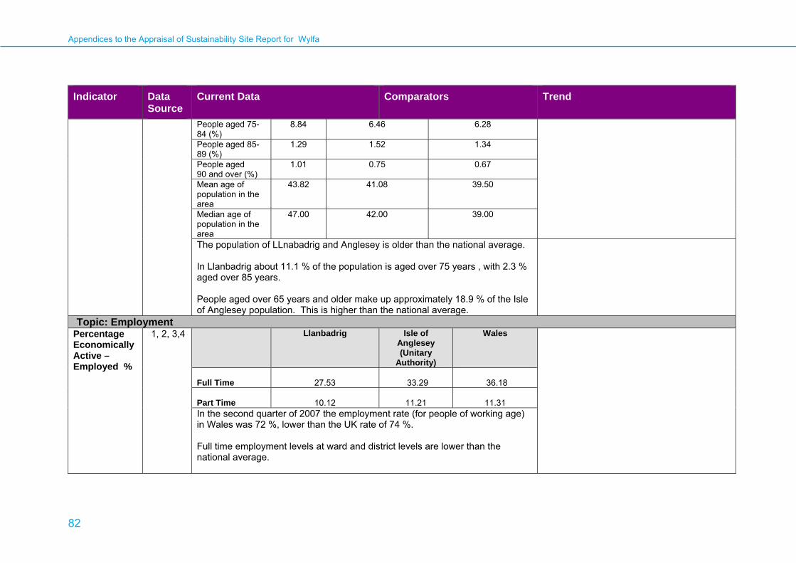
Appendices to the Appraisal of Sustainability Site Report for Wylfa
82
Indicator Data Source
Current Data Comparators Trend
People aged 75-84 (%)
8.84 6.46 6.28
People aged 85-89 (%)
1.29 1.52 1.34
People aged 90 and over (%)
1.01 0.75 0.67
Mean age of population in the area
43.82 41.08 39.50
Median age of population in the area
47.00 42.00 39.00
The population of LLnabadrig and Anglesey is older than the national average. In Llanbadrig about 11.1 % of the population is aged over 75 years , with 2.3 % aged over 85 years. People aged over 65 years and older make up approximately 18.9 % of the Isle of Anglesey population. This is higher than the national average.
Topic: Employment Percentage Economically Active –Employed %
1, 2, 3,4 Llanbadrig Isle of Anglesey (Unitary
Authority)
Wales
Full Time
27.53
33.29
36.18
Part Time
10.12
11.21
11.31 In the second quarter of 2007 the employment rate (for people of working age) in Wales was 72 %, lower than the UK rate of 74 %. Full time employment levels at ward and district levels are lower than the national average.
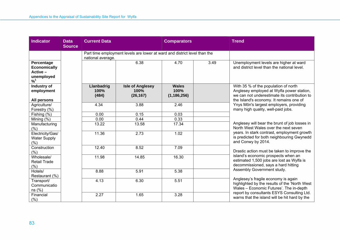
Appendices to the Appraisal of Sustainability Site Report for Wylfa
83
Indicator Data Source
Current Data Comparators Trend
Part time employment levels are lower at ward and district level than the national average.
Percentage Economically Active –unemployed %1
6.38 4.70 3.49 Unemployment levels are higher at ward and district level than the national level.
Industry of employment All persons
Llanbadrig 100% (484)
Isle of Anglesey 100%
(26,167)
Wales 100%
(1,186,256)
With 35 % of the population of north Anglesey employed at Wylfa power station, we can not underestimate its contribution to the Island's economy. It remains one of Ynys Môn's largest employers, providing many high quality, well-paid jobs. Anglesey will bear the brunt of job losses in North West Wales over the next seven years. In stark contrast, employment growth is predicted for both neighbouring Gwynedd and Conwy by 2014.
Drastic action must be taken to improve the island’s economic prospects when an estimated 1,500 jobs are lost as Wylfa is decommissioned, says a hard hitting Assembly Government study. Anglesey’s fragile economy is again highlighted by the results of the ‘North West Wales – Economic Futures’. The in-depth report by consultants ESYS Consulting Ltd. warns that the island will be hit hard by the
Agriculture/ Forestry (%)
4.34 3.88 2.46
Fishing (%) 0.00 0.15 0.03 Mining (%) 0.00 0.44 0.33 Manufacturing (%)
13.22 13.58 17.34
Electricity/Gas/Water Supply (%)
11.36 2.73 1.02
Construction (%)
12.40 8.52 7.09
Wholesale/ Retail Trade (%)
11.98 14.85 16.30
Hotels/ Restaurant (%)
8.88 5.91 5.38
Transport/ Communications (%)
4.13 6.30 5.51
Financial (%)
2.27 1.65 3.28

Appendices to the Appraisal of Sustainability Site Report for Wylfa
84
Indicator Data Source
Current Data Comparators Trend
Real Estate (%)
4.96 7.07 8.50 power station’s closure and faces serious economic and social challenges as too many of its jobs are dependent on ‘vulnerable’ industries. With the decommissioning of Wylfa looming in 2010 and other main industries, including metal production and manufacturing, facing uncertain futures, the findings reinforce the need to deliver new key employment opportunities on the island.
Anglesey is already one of the most economically disadvantaged areas of Wales, with low levels of economic activity and gross added value (GVA) per head barely half the UK average at 53 %.
Public Admin (%)
3.51 7.52 6.80
Education (%) 7.02 9.59 8.13 Health and Social Work (%)
11.98 13.18 13.00
Other (%) 3.93 4.62 4.84 Self Employed (%)
10.83 8.82 7.69
Socio-Economic Classifications 2001 (% Persons aged 16-74)
Llanbadrig Isle of Anglesey (Unitary Authority)
Wales
Large employers and higher managerial occupations
1.21 1.93 2.18
Higher professional occupations
3.34 3.62 3.72

Appendices to the Appraisal of Sustainability Site Report for Wylfa
85
Indicator Data Source
Current Data Comparators Trend
Lower managerial and professional occupations
11.94 14.86 16.05
Semi-routine occupations
12.15 12.64 12.25
Routine occupations
8.50 9.69 9.94
Never Worked 2.73 2.52 2.74 Full-time students
3.95 5.48 7.24
Key to Data Sources
1 Office for National Statistics (2001), Neighbourhood Statistics: Llanbadrig. http://neighbourhood.statistics.gov.uk/dissemination/LeadAreaSearch.do?a=7&r=1&i=1001&m=0&s=1236613640337&enc=1&areaSearchText=Llanbadrig&areaSearchType=14&extendedList=false&searchAreas=Search
2 National Statistics (May 2008). Regional profile – Wales. http://www.statistics.gov.uk/cci/nugget.asp?id=1135
3 Isle of Anglesey County Council. http://www.anglesey.gov.uk/doc.asp?cat=644&doc=9701
4 Isle of Anglesey County Council. http://www.anglesey.gov.uk/doc.asp?cat=2090&doc=4278

Appendices to the Appraisal of Sustainability Site Report for Wylfa
86
Communities: Supporting Infrastructure Indicator Data
Source Current Data Comparators Trend
Topic: TransportRegional Freight Routes
1
North Wales Strategic Routes
Network Stress - 2001
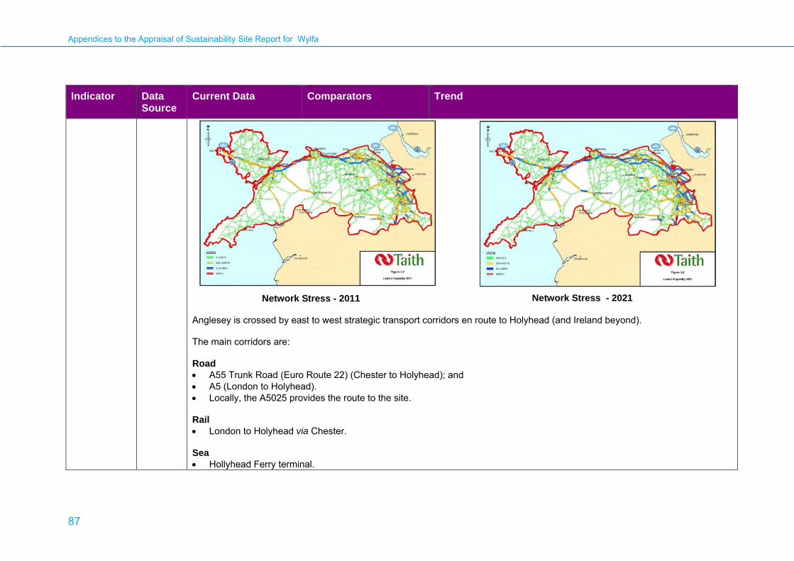
Appendices to the Appraisal of Sustainability Site Report for Wylfa
87
Indicator Data Source
Current Data Comparators Trend
Network Stress - 2011
Network Stress - 2021
Anglesey is crossed by east to west strategic transport corridors en route to Holyhead (and Ireland beyond). The main corridors are: Road • A55 Trunk Road (Euro Route 22) (Chester to Holyhead); and • A5 (London to Holyhead). • Locally, the A5025 provides the route to the site.
Rail • London to Holyhead via Chester.
Sea • Hollyhead Ferry terminal.
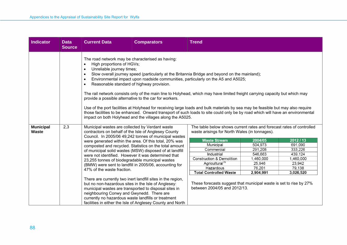
Appendices to the Appraisal of Sustainability Site Report for Wylfa
88
Indicator Data Source
Current Data Comparators Trend
The road network may be characterised as having: • High proportions of HGVs; • Unreliable journey times; • Slow overall journey speed (particularly at the Britannia Bridge and beyond on the mainland); • Environmental impact upon roadside communities, particularly on the A5 and A5025; • Reasonable standard of highway provision. The rail network consists only of the main line to Holyhead, which may have limited freight carrying capacity but which may provide a possible alternative to the car for workers. Use of the port facilities at Holyhead for receiving large loads and bulk materials by sea may be feasible but may also require those facilities to be enhanced. Onward transport of such loads to site could only be by road which will have an environmental impact on both Holyhead and the villages along the A5025.
Municipal Waste
2,3 Municipal wastes are collected by Verdant waste contractors on behalf of the Isle of Anglesey County Council. In 2005/06 49,242 tonnes of municipal wastes were generated within the area. Of this total, 20% was composted and recycled. Statistics on the total amount of municipal solid wastes (MSW) disposed of at landfill were not identified. However it was determined that 23,255 tonnes of biodegradable municipal wastes (BMW) were sent to landfill in 2005/06, accounting for 47% of the waste fraction. There are currently two inert landfill sites in the region, but no non-hazardous sites in the Isle of Anglesey: municipal wastes are transported to disposal sites in neighbouring Conwy and Gwynedd. There are currently no hazardous waste landfills or treatment facilities in either the Isle of Anglesey County and North
The table below shows current rates and forecast rates of controlled waste arisings for North Wales (in tonnages).
These forecasts suggest that municipal waste is set to rise by 27% between 2004/05 and 2012/13.

Appendices to the Appraisal of Sustainability Site Report for Wylfa
89
Indicator Data Source
Current Data Comparators Trend
of Wales region, although established waste management contractors are known to operate and provide services within the region. Anglesey is the host authority for a sub-regional In-Vessel Composting unit (IVC) at Penhesgyn, a collaborative project with adjoining Gwynedd County Council and Conwy County Borough Council.
Radioactive and Hazardous Waste
The operation of a new nuclear power station at the site will require the interim storage of spent fuel and intermediate level waste on site for a period of approximately 100 years after operation has ceased. The arrangements for dealing with all types of radioactive and hazardous waste arising from the operation and decommissioning of new power stations, (including gaseous and liquid radioactive discharges), are appraised in Chapter 6 of the Main AoS Report.
Key to Data Sources
1 Provisional North Wales Regional Transport Plan (February 2009) http://www.taith.gov.uk/webcont/taith.nsf/0/29b2ac1e7eb3ec918025747800359b25/$FILE/RTP_2009-03-18.pdf
2 Municipal Waste Management Strategy (March 2004) http://www.anglesey.gov.uk/upload/public/attachments/43/Waste_Management_Strategy.pdf
3 North Wales Regional Waste Plan 1st Review Core Document (March 2008) http://www.walesregionalwasteplans.gov.uk/pdfs/Recommended_North_Wales_Regional_Waste_Plan_1st_Review_May_post_distribution_modifications.pdf
Appendices to the Appraisal of Sustainability Site Report for Wylfa
90
Human Health and Well-Being Indicator Data
Source Current Data Comparators Trend
Topic: Human Health and Well-beingCommunity well-being
1 A useful gauge of the overall well-being of the area can be obtained from the various deprivation indices on the StatsWales web page. This data compares the Lower Super Output Area, LLanbadrig to Wales as a whole as follows:
• Income deprivation slightly more than average
• Employment deprivation more than average
• Health deprivation slightly more than average
• Education deprivation approximately average
• Barriers to housing and services are more than average
• Crime is approximately average • Living environment deprivation is
more than average
Index of multiple deprivation (2007)
1 The Department of Communities and Local The StatsWales website provides an index of deprivation (an index combining a range of economic, social and housing issues into a single deprivation score) for Wales. This shows the Lower Super Output Area, Llanbadrig area ranked as 701 out of 1896 (where 1 is most deprived). This ranking
Other deprivation information on the StatsWales website shows that:
• 5 % of the Lower Super Output Areas in Anglesey fall within the top 10 % of the most deprived areas in Wales
• 55 % of Anglesey’s Lower Super Output Areas fall within the top 50 %

Appendices to the Appraisal of Sustainability Site Report for Wylfa
91
Indicator Data Source
Current Data Comparators Trend
shows that Llanbadrig is a reasonably deprived area.
of the most deprived areas in Wales • the three most deprived areas in the
Isle of Anglesey were Morawelon with a rank 0f 119, Tudur with a rank of 187 and Porthyfelin with a rank of 204
The above shows that there are several deprived areas reasonably close to the proposed Wylfa site.
Age profile (mid 2006)
2 On the Isle of Anglesey ,the age profile of the population is as follows:
Age Band (years) Percentage 0 – 14 18.3 15 – 64 62.9 64+ 18.8
These figures compare to Wales in 2007 as follows:
Age Band (years) Percentage 0 – 14 17.0 15 – 64 64.0 64+ 18.0
As can be seen from the tables, there is a much higher proportion of people in the upper age bracket (retired or approaching retirement) in Anglesey than in Wales as a whole. There are also slightly less people of working age in the area, therefore.
Appendices to the Appraisal of Sustainability Site Report for Wylfa
92
Indicator Data Source
Current Data Comparators Trend
General health (2001)
1 For the census in 2001, people were asked whether their health over the preceding twelve months was 'good', 'fairly good' or 'not good'. The results for the Isle of Anglesey were as follows:
• Good – 67.4 % • Fairly good – 22.1 % • Not good – 10.5 %
For comparison purposes, the same data for Wales and England are as below:
Wales England Good 65.1 68.8 Fairly good 22.5 22.2 Not good 12.5 9.0
Overall there are more people reporting good health and less people reporting poor health in Anglesey than in Wales as a whole.
Life expectancy at birth (Jan 04 – Dec 06)
1 Anglesey Males 77.20 Females 82.10
Wales England 76.64 77.32 80.98 81.55
As can be seen from above, the life expectancy in the Isle of Anglesey is slightly above that for Wales and similar to the national average for England.
Data from the same source for previous years show that these figures for life expectancy at birth in the Isle of Anglesey County Council area have risen slightly for both males and females since 2001.
Infant mortality (Jan 03 – Dec 05)
1 Infant mortality in the Isle of Anglesey County Council area for the years in question was 2.4 persons in every 1000.
This compares to the figure of 4.5 persons for Wales and 5.1 persons per thousand in England.
Data from the same source for previous years show that figures for infant mortality in the Isle of Anglesey County Council area have reduced since 1998-2000.
Proximity to medical services
3 Medical services in the area of the Wylfa site are as follows:
• One General Practitioner (GP) practice (Cemaes Surgery) within 5 km of the site. One other GP

Appendices to the Appraisal of Sustainability Site Report for Wylfa
93
Indicator Data Source
Current Data Comparators Trend
practice is within 10 km of the site. • Closest hospital is the Cefni
Hospital (21.3 km) but this has no Accident and Emergency department
• Nearest hospital with an Accident and Emergency department is Ysbyty Gwynedd in Bangor which is 31.5 km away
• The nearest hospital providing mental health services is the Hergest Unit at Ysbyty Gwynedd in Bangor which is 31.5 km away
Education - examination results for young people (2006 – 07)
1 In the Isle of Anglesey County Council area, 53.4 % of pupils achieved 5 or more A*- C grade passes including English and Mathematics at GCSE or equivalent.
This compares to the figure of 54.2 % of students for Wales and 46 % of students for England.
Housing – total unfit dwellings (1998)
1 The total percentage of unfit dwellings in the Isle of Anglesey County Council area for the year in question was 4.4 %.
This compares to a percentage of 8.5 % for Wales as a whole.
Radioactivity monitoring
4 The Food Standards Agency’s annual RIFE (Radioactivity In Food and the Environment) report details the results of regular radiological monitoring carried out to ensure that discharges of radioactivity do not result in unacceptable doses to the public. RIFE 13 relates to monitoring carried out in 2007. From this report it is possible to extract the following conclusions:
The dose limit for members of the public specified in The Ionising Radiation Regulations 1999 is 1 millisievert (mSv) per year for all artificial sources of radiation. Estimations of dosage levels to the public from the Wylfa sampling were as follows:
• estimated dose from locally grown
Trends in the data noted from sampling in previous years are as follows:
• locally grown foodstuffs has reduced slightly since 2006 when it was 0.006 mSv
• the estimated dose to

Appendices to the Appraisal of Sustainability Site Report for Wylfa
94
Indicator Data Source
Current Data Comparators Trend
• water, sediment, beach and
terrestrial and marine food and animal samples were collected from around the Wylfa site in 2007
• assessment of tritium, carbon-14 and sulphur-35 in milk, crops and fruit indicated that the effects of gaseous discharges from the site were very low
• concentrations of radioactivity in freshwater were less than the World Health Organisation’s screening level for drinking water
• concentrations of artificial radionuclides in seafood, sediment, sand and seawater were generally low but where raised were assessed as being from other sources of nuclear contamination
foodstuffs was less than 0.005 mSv • estimated dose to local fish and
shellfish consumers was 0.007 mSv • the total dose from all sources,
including direct radiation, was assessed as being 0.011 mSv
seafood consumers has risen slightly since 2006 (when it was 0.006 mSv)
• the total assessed dose from all sources has also increased slightly from 0.009 mSv in 2006
Health related to nuclear installations
5 There has been, since 1971, a nuclear power station operating on the Wylfa site. There are, therefore, historical data which can be analysed to correlate the incidence of disease reported around this site so that it can be compared to the average prevalence of the same disease in the British population as a whole. Such a comparison for childhood leukaemia, non-Hodgkin lymphoma and other malignant tumours was undertaken by the Committee on Medical Aspects of Radiation in the Environment
For comparison purposes, the figures derived using statistics for Britain as a whole are as follows:
• the expected number of cases of childhood leukaemia and non-Hodgkin lymphoma between 1969 and 1993 in a 25 km area around the plant should have been 11.12
• the expected number of cases of childhood tumours between 1969 and 1993 in a 25 km area around the plant

Appendices to the Appraisal of Sustainability Site Report for Wylfa
95
Indicator Data Source
Current Data Comparators Trend
(COMARE) in 2005. The results of this study for Wylfa are as below:
• actual cases of childhood leukaemia and non-Hodgkin lymphoma between 1969 and 1993 in a 25 km area around the plant were 7
• actual cases of childhood solid tumours between 1969 and 1993 in a 25 km area around the plant were 22.
should have been 19.01 It was concluded, from the above statistics, that there was no evidence of excess numbers of these cases in the 25 km area which would include either primary exposure to radioactive discharges or secondary exposure from re-suspended material.
Key to Data Sources
1 Welsh Assembly Government (2008). Welsh Index of Multiple Deprivation. http://www.statswales.wales.gov.uk/TableViewer/tableView.aspx?ReportId=6028
2 Office of National Statistics. Neighbourhood Statistics. http://neighbourhood.statistics.gov.uk/dissemination/home.do;jessionid=ac1f930c30d607c6170cbe3146ada704c9cac1978fc7?m=0&s=1236174480737&enc=1&bhcp=1&nsjs=true&nsck=true&nssvg=false&nswid=996
3 NHS Wales. http://www.wales.nhs.uk/directory.cfm
4 Food Standards Agency (December 2008). Radioactivity In Food and the Environment (RIFE) report (2007). http://www.food.gov.uk/science/surveillance/radiosurv/rife13
5 Committee on Medical Aspects of Radiation in the Environment (COMARE) (2005). Tenth Report. The incidence of childhood cancer around nuclear installations in Great Britain. Health Protection Agency, June 2005. http://www.comare.org.uk/comare_docs.htm
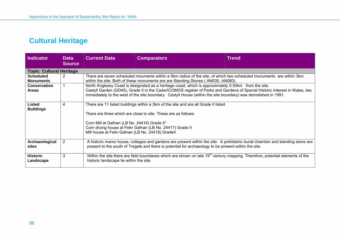
Appendices to the Appraisal of Sustainability Site Report for Wylfa
96
Cultural Heritage
Indicator Data Source
Current Data Comparators Trend
Topic: Cultural Heritage Scheduled Monuments
2 There are seven scheduled mouments within a 5km radius of the site, of which two scheduled monuments are within 3km within the site. Both of these monuments are are Standing Stones ( AN030, AN080).
Conservation Areas
1 North Anglesey Coast is designated as a heritage coast, which is approximately 0.50km from the site. Cestyll Garden (GD45), Grade II in the Cadw/ICOMOS register of Parks and Gardens of Special Historic Interest in Wales, lies immediately to the west of the site boundary. Cestyll House (within the site boundary) was demolished in 1991.
Listed Buildings
4 There are 11 listed buildings within a 3km of the site and are all Grade II listed. There are three which are close to site. These are as follows: Corn Mill at Gafnan (LB No. 24416) Grade II* Corn drying house at Felin Gafnan (LB No. 24417) Grade II Mill house at Felin Gafnan (LB No. 24418) GradeII
Archaeological sites
2 A historic manor house, cottages and gardens are present within the site. A prehistoric burial chamber and standing stone are present to the south of Tregele and there is potential for archaeology to be present within the site.
Historic Landscape
3 Within the site there are field boundaries which are shown on late 19th century mapping. Therefore, potential elements of the historic landscape lie within the site.

Appendices to the Appraisal of Sustainability Site Report for Wylfa
97
Key to Data Sources
1 Countryside Council for Wales Interactive maps http://www.ccw.gov.uk/interactive-maps/protected-sites-map.aspx
2 The Royal Commission on the Ancient and Historical Monuments of Wales http://www.rcahmw.org.uk/data/carn.shtml Accessed 12.3.2009
3 First Edition Ordnance Survey
4 Data from Cadw

Appendices to the Appraisal of Sustainability Site Report for Wylfa
98
Landscape Indicator Data
Source Current Data Comparators Trend
Topic: LandscapeCCW (Draft Regional Landscape Character Areas for Wales) CCW Seascapes Unit Regional Landscape Character Assessment 2009
1 The site at Wylfa is situated within the Anglesey Coastline rLCA (01). Key Characteristics are likely to include :
• Dry stone wall enclosed farmland with pockets of heath and moor in association with coastal landforms ; • A rugged rural convex coastline with rocky exposed low cliffs, coves, pebble beaches and a general lack of trees; • Pockets of modern and historical industry, some forming landmarks in an otherwise remote, wilderness landscape
setting; • Scattered small hamlets and occasional sheltered coastal fishing harbour villages , some with caravan parks that
detract; • Notable hills/mountains form landmarks and offer panoramic viewpoints, on the northern part of the island, including
Mynydd Y Garn and the Amlwych and Parys Mountains; • The Anglesey coastal path that runs along the coastline is a focal point for visitors to the area.
Surrounding rLCA’s within the local area include: 02- Central Anglesey Note : There are no current published landscape character descriptions for the Regional Landscape Character Areas for Wales Other relevant Landscape Character Assessment Reports and Considerations CCW Seascape (Regional Seascapes Unit landscape character assessment 2009) rSU07 Point Lynas to Carmel Head Key Characteristics include:
• ‘Fine grain, rocky, north facing convex coast of many small bays and headlands with low • cliffs and only one small sandy beach.
Appendices to the Appraisal of Sustainability Site Report for Wylfa
99
Indicator Data Source
Current Data Comparators Trend
• Undulating, glaciated, old rock coastal plateau supporting pastoral farming with areas of semi-natural vegetation. • Few settlements, but the area contains a number of wind farms inland and Wylfa Nuclear Power Station on the coast. • Exposed northern aspect with open sea and long views. • Key cultural associations: the history of trade and shipping over many centuries and Wylfa Nuclear Power Station.’
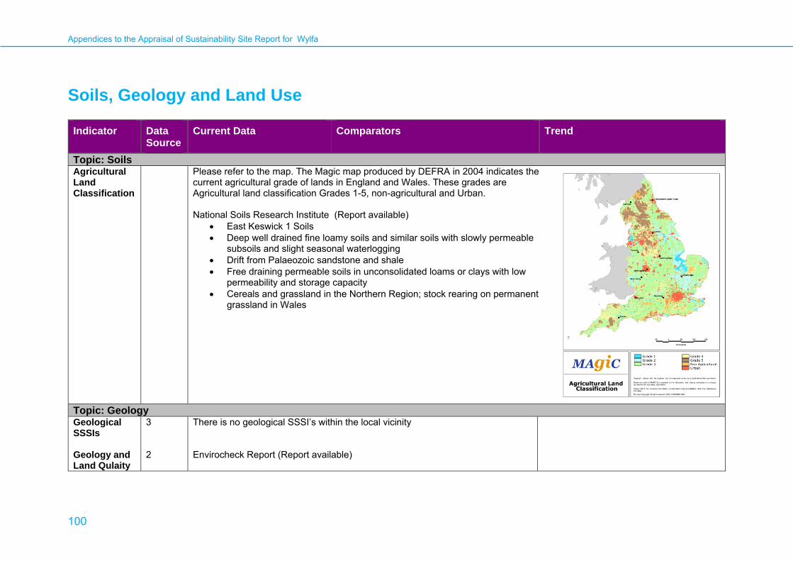
Appendices to the Appraisal of Sustainability Site Report for Wylfa
100
Soils, Geology and Land Use Indicator Data
Source Current Data Comparators Trend
Topic: SoilsAgricultural Land Classification
Please refer to the map. The Magic map produced by DEFRA in 2004 indicates the current agricultural grade of lands in England and Wales. These grades are Agricultural land classification Grades 1-5, non-agricultural and Urban. National Soils Research Institute (Report available)
• East Keswick 1 Soils • Deep well drained fine loamy soils and similar soils with slowly permeable
subsoils and slight seasonal waterlogging • Drift from Palaeozoic sandstone and shale • Free draining permeable soils in unconsolidated loams or clays with low
permeability and storage capacity • Cereals and grassland in the Northern Region; stock rearing on permanent
grassland in Wales
Topic: Geology Geological SSSIs Geology and Land Qulaity
3 2
There is no geological SSSI’s within the local vicinity Envirocheck Report (Report available)
Appendices to the Appraisal of Sustainability Site Report for Wylfa
101
Indicator Data Source
Current Data Comparators Trend
• Geological Risks The local Geology is Coastal Zone Deposits (Undifferentiated) and Till, Devensian There are three BGS recorded mineral sites recorded locally.
Based on the information within the Envirocheck report the geological risks are;
• Very low risk for the Potential for Landslide Ground Stability Hazards
• Very low risk for the Potential for Running Sand Ground Stability Hazards
• Very low risk for the Potential for Shrinking or Swelling Clay Ground Stability Hazards
• Environmental Hazards
Based on the Envirocheck report the main environmental Hazards are;
• No landfills or waste management facilities within 1 km of the site. • One Integrated Pollution Control Registered Waste Site associated
with the existing power station. • One Registered Waste Treatment or Disposal Site related to the
existing power station.
• Historic Land Use
• Historic maps ranging from the 1880’s to current were studied. No significant risks were identified, other than the existing power station.

Appendices to the Appraisal of Sustainability Site Report for Wylfa
102
Water Quality and Resources Indicator Data
Source Current Data Comparators Trend
Topic: WaterCurrent State of the Waters in the Western Wales River Basin District
1, 2, 3 The site at Wylfa is located within the Western Wales River Basin District (RBD). The draft Western Wales River Basin Management Plan (dRBMP) states that currently 28 % of rivers (by length of assessed river) are at good ecological status or potential, with 64 % of groundwater bodies (by number) at good chemical status, and 96 % of these same bodies at good quantitative status. Currently 45 % of the assessed water bodies at less than good ecological status are at moderate status mainly due to a single element. Most commonly this is fish and phosphorus, but sometimes this can be due to many different factors. In the case of groundwater bodies, the main pressures are poor water quality related to historic mining activity. There are over 700 km of coastline with 79 designated bathing waters and 25 designated shellfish waters within the Western Wales RBD. Of the 11 estuaries assessed, 8 do not meet good ecological status or potential, while of the 19 coastal waters assessed within the Western Wales RBD, 15 are at good ecological status or potential. The main pressures on these estuaries and coastal waters include morphological alterations, nutrient and microbiological contamination from runoff and sewage, chemical contamination and potential over-exploitation of fisheries. Under current proposals The proposals outlined in the dRBMP aim to achieve 30 % of rivers meeting the requirements for good ecological status by 2015. For estuarine and coastal waters, no changes are planned against the current assessments in terms of waters meeting good ecological status or potential. For groundwater bodies, the number achieving quantitative and chemical status is not expected to change from current assessments. The Western Wales RBD is split into 5 separate River Basin District catchments. The site at Wylfa is within the North West Wales catchment. This is not a single catchment, but many separate river systems which flow directly into the sea. Many have their own salmon and sea trout fisheries. There are a large number of lakes, many modified for water supply. Land-use is dominated by agriculture. Tourism of huge economic importance. Pressures in this area include acidification in lakes and upland rivers, elevated metals from abandoned mines, barriers to fish migration and ecological impacts from pesticides. Proposals are in place to deal with these issues. In the North West Wales catchment area, 40 % of surface water bodies currently achieve good ecological status. This is predicted to increase to 43 % by 2015. 95 % of groundwater bodies are currently achieving good quantitative quality, with this

Appendices to the Appraisal of Sustainability Site Report for Wylfa
103
Indicator Data Source
Current Data Comparators Trend
value to be maintained to 2015. 65 % of groundwater bodies are currently achieving good chemical quality, with this value to be maintained to 2015. Local information for the area around Wylfa from the Environment Agency (EA) web site relevant to Water Framework Directive (WFD) is summarised below:
Sector Ecological quality Chemical quality Current Predicted
2015 Current Predicted
2015 Rivers: Wygyr (Waterbody ID: 160)
Good Good Not Assessed
Not Assessed
Rivers: Afon Wygyr (Waterbody ID: 170)
Good Good Not Assessed
Not Assessed
Quantitative quality Chemical quality Current Predicted 2015 Current Predicted
2015 Groundwater: Ynys Môn Minor
Good Good Poor Poor
Ecological quality Chemical qualityLakes None present None present None present None present Estuarine None present None present None present None present Coastal: The Skerries
Good Good Not assessed Not assessed
Coastal: Anglesey North
Good Good High Good
There are five watercourses within close proximity of the site. All are labelled as being part of the Afon Wygyr catchment. Three are to the west of the site and two to the east. Ecological quality has only been assessed for the watercourses
Appendices to the Appraisal of Sustainability Site Report for Wylfa
104
Indicator Data Source
Current Data Comparators Trend
immediately to the east and west of the site. Both Watercourse ID 160 (to the west) and Watercourse ID 170 (main channel of the Afon Wygyr, to the east) have been assessed as having good ecological quality. The predicted ecological quality in 2015 is also good. Chemical quality has not yet been assessed for any of these watercourses. Coastal waters in the vicinity of the site have been assessed as having good ecological quality, with this status to be maintained to 2015. Chemical quality of coastal waters to the west of the site (The Skerries) has not been assessed. Chemical quality of coastal waters to the east of the site (Anglesey North) has been assessed as high, with the status predicted to decline to good by 2015. There are no estuarine waters or lakes within close proximity of the site. There are no groundwater source protection zones in the vicinity of the site. The site is located on the Ynys Môn Minor aquifer. The current quantitative quality of the groundwater is good and is predicted to maintain good status to 2015. The current chemical quality of the groundwater is poor and is predicted to maintain poor status to 2015. There are no Designated Shellfish Waters in the vicinity of the site. The closest Designated Shellfish Waters are on the Menai Strait (Foryd Bay, West and East) on the other side of the island of Anglesey, approximately 25 km away. Bathing waters in the surrounding area are of good quality. The nearest sampling point is in Cemaes Bay immediately to the east of the site.
Current State of the Waters in the Ynys Môn Catchment Abstraction Management area
4,5 The site at Wylfa is located within the Ynys Môn Catchment Abstraction Management Strategy area. The CAMS report for this catchment was prepared in October 2006. The site is not located in either of the 2 Water Resource Management Units (WRMUs) within the catchment. Water supply would have to come from one of the 2 Ynys Môn WRMUs (WRMU1: Braint, Crigyll, Tan-yr-allt and WRMU2: Cefni, Alaw). WRMU1 is currently designated as having “water available” status. This means that water is likely to be available at all flows including low flows. However, restrictions may apply. The target status for both 2013 and 2019 is to move to “no water available”. WRMU2 is currently designated as having “no water available” status. This means that there is no water available for further licensing at low flows. Water may be available at high flows with appropriate restrictions. The EA aim to maintain this area at “no water available” status through to 2019. There are 3 Sites of Special Scientific Interest (SSSIs) in WRMU1. In WRMU2 there are 4 SSSIs and one Special Area of
Appendices to the Appraisal of Sustainability Site Report for Wylfa
105
Indicator Data Source
Current Data Comparators Trend
Conservation (SAC) which is also designated as a RAMSAR site (the Anglesey Fens). Water Demand and Availability Projected to 2024
6
The assessment of demand and supply occurs at the level of a Water Resource Zone (WRZ). A WRZ is defined by the EA as ‘the largest possible zone in which all resources, including external transfers, can be shared and hence the zone in which all customers experience the same risk of supply failure from a resource shortfall’. The site at Wylfa is within the area served by Dŵr Cymru Welsh Water. Dŵr Cymru Welsh Water has 24 WRZs. Wylfa is located within the North Eryri / Ynys Môn (NEYM) WRZ (Zone Number 8001). At the last review (2004-2005), the NEYM WRZ was identified as being in deficit by 4.0 Ml/d. A £8Million engineering scheme was implemented to enable improved utilisation of resources on Anglesey and to retain resources on the mainland for increased use during a drought. The scheme will lead to 9.0 Ml/d increase in deployable output. The scheme is due for completion in 2009/2010. With these improvements, the NEYM WRZ under the critical period, will have a surplus of 7.07 Ml/d in 2009/2010 and 1.98 Ml/d by 2014/2015. By 2019/2020 the WRZ will be in deficit by 2.57 Ml/d, increasing to a deficit of 3.02 Ml/d by 2034/35. Dŵr Cymru Welsh Water intends to deal with this deficit through the allocation of £1.3Million for leak reduction and water efficiency schemes. These works will be in place by 2017/2018 and will save a maximum of 2.79Ml/d. By 2022/2023 further works carried out including the upgrade of Mynydd Llandegai Water Treatment Works and increased abstraction at Marchlyn Bach Reservoir. This will provide a maximum of 0.43Ml/d.
Coastal Processes and Sediments
The rocky coastline of Anglesey is very resistant to coastal erosion. The prevailing wave direction off the Anglesey coast is from the west, and south west. Shelf sea circulation off the coast of Anglesey is mainly driven by winds and tides, although narrow coastal currents and jets along the seasonal fronts can be driven by density gradients. The overall effect of the tides is quite small as tidal currents mainly move water back and forth. The overall pattern of circulation is mainly towards the north and wave induced sediment transport (suspended and bedload) generally follows the bathymetric contours and is towards the north and east around the Anglesey coastline. However, where the coastal alignment changes or shelter is provided by a major headland, the direction of transport may be reversed.

Appendices to the Appraisal of Sustainability Site Report for Wylfa
106
Key to Data Sources
1 Environment Agency (December 2008, corrected February 2009) Water for Life and Livelihoods: A consultation on the Draft River Basin Management Plan: Western Wales River Basin District [online] available: http://wfdconsultation.environment-agency.gov.uk/wfdcms/en/westernwales/Intro.aspx
2 Environment Agency. What’s in Your Backyard. http://maps.environment-agency.gov.uk/wiyby/wiybyController
3 Environment Agency Wales (2007). Urban Waste Water Treatment Directive Sensitive Areas. http://webarchive.nationalarchives.gov.uk/20080305115859/http://www.defra.gov.uk/environment/water/quality/uwwtd/sensarea/pdf/sensarea-wales.pdf
4 Environment Agency (October 2006). The Ynys Môn Catchment Abstraction Management Strategy Consultation Document. http://www.environment-agency.gov.uk/research/planning/33378.aspx
5 Environment Agency (June 2008). Managing Water Abstraction. http://publications.environment-agency.gov.uk/pdf/GEH00508BOAH-E-E.pdf
6 Dŵr Cymru Welsh Water (March 2008), Draft Water Resources Management Plan: Main Report. http://www.dwrcymru.co.uk/English/library/Reports/companyreports/businessoperations/wrmp/Final%20Draft%20WRP09.pdf
Appendices to the Appraisal of Sustainability Site Report for Wylfa
107
Flood Risk Indicator Data
Source Current Data Comparators Trend
Topic: Flood RiskFlood Risk 1 Map available separately.
The Environment Agency website shows the site to be outside the area at risk of flooding from rivers or the sea.
Flood risk is expected to increase in the UK due to the predicted changes in climate leading to more intense rainfall events, wetter winters, rising sea levels and coastal erosion. Scenarios of climate change for the UK were published by the United Kingdom Climate Impacts Programme (UKCIP) in 1998 and 2002. ‘The Climate of the UK and Recent Trends 2008’ by the Met Office, provided the following general comments in relation to trends in climate change and how this might affect flood risk: • Global sea level rise has accelerated between
mid 19th century and mid 20th century and is now about 3mm per year
• All regions in the UK have experienced an increase over the past 45 years in the contribution to winter rainfall from heavy precipitation events; in summer all regions except North East England and North Scotland show decreases
• Sea level rise around the UK rose by about 1mm/per year in the 20th century, corrected for land movement. The rate for the 1990s and 2000s has been higher than this
Most recently in June 2009, UKCIP launched the latest UK Climate Change Predictions 2009

Appendices to the Appraisal of Sustainability Site Report for Wylfa
108
Indicator Data Source
Current Data Comparators Trend
(UKCP09). These give information about climate change but not directly about flood risk. The key findings on climate change confirm the trends highlighted in the 2008 report and suggest: • All areas of the UK get warmer, and the warming
is greater in summer than in winter. • There is little change in the amount of
precipitation that falls annually, but it is likely that more of it will fall in the winter, with drier summers for much of the UK.
• Sea levels rise and the rise is greater in the south of the UK than in the north.
Key to Data Sources
1 Environment Agency. http://maps.environment-agency.gov.uk/wiyby/wiybyController

© Crown copyright 2009 Office for Nuclear Development Department of Energy & Climate Change Area 3D 3 Whitehall Place London SW1A 2HD www.decc.gov.uk URN: 09D/645


