22
APPENDICES APPENDICES

APPENDICES
APPENDICES

A P P EN D I X : M U N I C I PA L F O C U S A R E A
Vibrant. Green. Connected. Competitive.
183
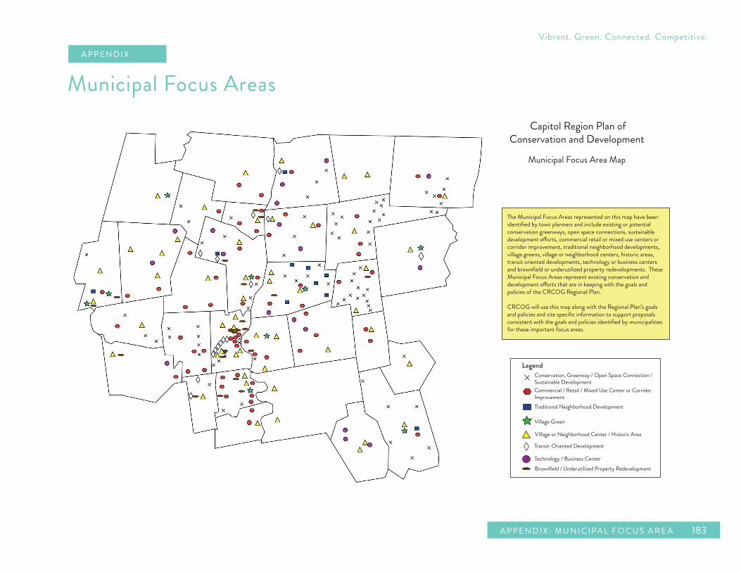
The Municipal Focus Areas represented on this map have been identified by town planners and include existing or potential conservation greenways, open space connections, sustainable development e�orts, commercial retail or mixed use centers or corridor improvement, traditional neighborhood developments, village greens, village or neighborhood centers, historic areas, transit oriented developments, technology or business centers and brownfield or underutilized property redevelopments. These Municipal Focus Areas represent existing conservation and development e�orts that are in keeping with the goals and policies of the CRCOG Regional Plan.
CRCOG will use this map along with the Regional Plan’s goals and policies and site specific information to support proposals consistent with the goals and policies identified by municipalities for these important focus areas.
Capitol Region Plan of Conservation and Development
Municipal Focus Area Map
LegendConservation, Greenway / Open Space Connection / Sustainable Development Commercial / Retail / Mixed Use Center or Corridor ImprovementTraditional Neighborhood Development
Village Green
Village or Neighborhood Center / Historic Area
Transit-Oriented Development
Technology / Business CenterBrownfield / Underutilized Property Redevelopment
Municipal Focus AreasA P P EN D I X

184
REG ION AL PL AN of CONSERVATION an d DE VELOPMENT
C ap ito l Re g io n Coun ci l of G ove r nm e nt s
This page intentionally left blank.
A P P EN D I X : M U N I C I PA L F O C U S A R E A
Vibrant. Green. Connected. Competitive.
185
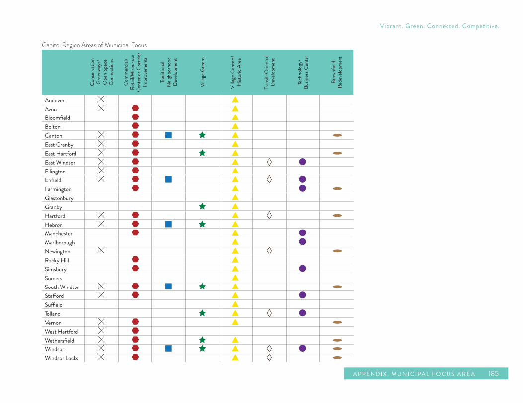
Capitol Region Areas of Municipal Focus
Con
serv
ation
G
reen
ways
/ O
pen
Spac
e C
onne
ction
s
Com
mer
cial/
Reta
il/M
ixed-
use
Cent
er o
r Cor
ridor
Im
prov
emen
ts
Tradit
ional
N
eighb
orho
od
Dev
elopm
ent
Villa
ge G
reen
s
Villa
ge C
ente
rs/
Hist
oric
Area
Trans
it-O
rient
edD
evelo
pmen
t
Tech
nolo
gy/
Busin
ess C
ente
r
Brow
nfield
Rede
velop
men
t
AndoverAvonBloomfieldBoltonCantonEast GranbyEast HartfordEast WindsorEllingtonEnfieldFarmingtonGlastonburyGranbyHartfordHebronManchesterMarlboroughNewingtonRocky HillSimsburySomersSouth WindsorStaffordSuffieldTollandVernonWest HartfordWethersfieldWindsorWindsor Locks

186
REG ION AL PL AN of CONSERVATION an d DE VELOPMENT
C ap ito l Re g io n Coun ci l of G ove r nm e nt s
Andover
Andover focuses on improvement of the Town Center by increasing its visibility along Route 6 and fostering a sense of place in this area. In the Town Center, the town aims at preserving historical heritage, encouraging economic development on key parcels, and ensuring appropriate residential development. According to the Andover Plan of Conservation and Development, a sense of place is crucial to future economic development efforts and helps to foster a sense of pride for the community and its residents.
A second focus area, complementary to the first, consists of the strategic preservation of Post Farm. The Plan of Conservation and Development states that the Post Farm is quintessential “Andover.” Its visibility along Route 6 defines Andover as an attractive rural community. Those areas of the farm currently zoned business are being rezoned to residential to help alleviate development pressure. The town promotes the purchase of development rights at the State and Federal level to preserve this important piece of farmland.
Avon
For the Town of Avon, Avon Center is a primary area of municipal focus, as well as West Avon Center,
Avon Old Farms and areas along the Metacomet Trail and the Farmington River. Recommendations from a 2005 Town Center Study aimed at enhancing the economic viability and historic significance of Avon Center cite the creation of an overlay zone and reuse of the Towpath School property as goals for this area. This study was incorporated into the 2006 Plan of Conservation and Development. It calls for construction of a “main street” with commercial shops and residential units, plus the construction of 300-500 additional residential units on approximately 80 acres of land located in Avon Park North.
Avon also has two areas of focus that are greenways. One proposes trail access and improvements and active recreation at or around Buckingham ball fields. The other is an open space corridor along the Farmington River, specifically a trail system near Fisher Meadows. The town is working to complete a trail connection between the 250-acre Huckleberry Hill open space tract and the 150-acre Found Land tract. This will provide access to more than 425 acres of open space with parking, plus a connection to the Buckingham ball fields and the Farmington River.
Another focus for Avon is the area of Avon Old Farms campus and its surrounding roadway infrastructure. A project to reconstruct portions of Old Farms, Thompson, and Scoville Roads has been a priority for the town for more than 20 years. Its purpose is to construct a new two lane roadway
system that will replace and relocate significant portions of the substandard and unsafe roadway system that citizens, students and faculty use both by car and on foot. This effort which has included a continued dialogue between the town, the school and state and federal agencies has evolved into an excellent example of long range planning for more sustainable development as it not only satisfies the town’s short and long-term transportation needs and the school’s future core-campus development plans, which have been endorsed by the town, but may also serve to preserve and enhance key open space. The roadway improvement project may involve the transfer of a significant piece of open space, currently owned by the school, to the town which will in turn help to complete a town greenway system that extends into other open space parcels to the north and south. It has recently come to the town’s attention that this roadway project is now seen favorably in the eyes of the Federal Highway Administration, largely due to the fact that it will not only improve traffic circulation and public safety, but it will also add to the town’s open space system in such a meaningful way.
The School owns more than 700 acres of undeveloped land. The Planning and Zoning Commission has identified this property as the highest priority for open space acquisition should the School wish to sell some or all of this acreage in the future.

A P P EN D I X : M U N I C I PA L F O C U S A R E A
Vibrant. Green. Connected. Competitive.
187
The Commission will be conducting a public hearing to amend the Avon 2006 Plan of Conservation and Development in the spring of 2014. In the event the property is sold for private development, residential development would be the most appropriate. The town would much prefer a form of cluster residential development, which will still result in the preservation of a significant amount of open space. The amendment to the 2006 Plan of Conservation and Development will recommend changes to the EL zoning regulations (property is currently zoned EL) to make a cluster development a possibility. The town hopes to achieve the preservation of 50% of this property as open space under this scenario. Public sewer would be extended to accomplish this compact form of development.
Bloomfield
Bloomfield Town Center has been the subject of recent planning studies that have shown a majority of town residents feel the need to improve the overall appearance of the district. The current Plan of Conservation and Development states the town’s desire to establish architectural design guidelines for the area, provide landscape treatment for selected roadway and parking areas, provide additional landscaping to plaza areas, encourage a higher standard for commercial signage and establish gateways to help identify entry into the Town
Center. Other initiatives for this area include making streetscape improvements, improving pedestrian access and identifying underutilized properties as redevelopment sites.
Bloomfield proposes four mixed-use areas in their 2000 Plan of Conservation and Development. These areas are North Bloomfield Mixed-Use Area, CIGNA Mixed-Use Area, Copaco Mixed-Use Area and the Neighborhood Center Mixed-Use Area. All of these four places continue to be areas of focus at this time. Many of these areas are gateways and existing commercial centers. Bloomfield’s plan calls for encouraging a greater mix of uses in these areas and for improving and enhancing pedestrian amenities in these places.
Bolton Bolton has placed an emphasis on developing a vision for the Route 44 Corridor which is one of its highlighted focus areas. The vision includes developing a unique character for this corridor defined by compact, pedestrian friendly, mixed residential and business districts that do not disrupt the scenic views of undeveloped open spaces, forests, parks, historic sites and working farms which are preserved as part of Bolton’s heritage. The corridor will also provide for safe car travel as well as other modes of transportation such as bikes and foot travel. The vision for developing this corridor also includes modifying
the I-384 interchange to encourage slower speeds and provide a gateway to town from this major route.
The Route 6 Corridor is also a focus for the Town of Bolton. The Bolton Plan of Conservation and Development states the need to reduce accidents and improve safety on this major roadway. Along with safety improvements, the town also wishes to encourage mixed-use development on this corridor.
The Bolton Board of Selectmen has adopted the “Bolton Center Study, Town of Bolton, Connecticut” which created a unified vision for Bolton Center focusing on its historic, municipal and recreational assets and potential linkages among key Town Center assets. Considerations included preservation of historic buildings such as the Stagecoach Tavern, conservation of open space and farmland, opening hilltop view sheds, and development of a unified signage program. The Study will be included in the town’s Plan of Conservation and Development.
Canton
Canton Center Historic District is a unique historic area in town that contains multiple historic buildings regulated by the Canton Center Historic District Commission. The most recent focus in this area has been on creating a Canton Center District to render many of the existing nonresidential properties conforming in an effort to preserve and continue their current use. The town has also

188
REG ION AL PL AN of CONSERVATION an d DE VELOPMENT
C ap ito l Re g io n Coun ci l of G ove r nm e nt s
focused on providing design standards and zoning standards that more closely match the existing pattern of development. The Plan of Conservation and Development states that a limited number of permitted, small-scale commercial uses would protect the area’s existing character and allow for future reinvestment to keep Canton Center vital.
Collinsville was a thriving mill village with a village green that grew for over one hundred years before Canton adopted planning and zoning regulations in 1957. As a result, the zoning used in Collinsville did not enhance the compact urban historic area, but currently this municipal focus area is undergoing improved design and zoning standards that more closely match the existing character and pattern of development. Existing properties may be made conforming, infill may mirror the existing character, adaptive reuse is promoted and apartments and offices over retail will be encouraged.
The Collinsville Axe Factory is an historic mill property that was built and run by the Collins Manufacturing Company from 1826 to 1966 and helped Collinsville maintain its vernacular as a mill village. Currently, the Town of Canton is looking toward redeveloping the Axe Factory buildings and property using new urbanist principles of pedestrian-friendly mixed-uses such as housing, restaurants, and retail in keeping with the character of the historic mill village.
Canton Village, an area known for historic Greek
Revival and Victorian structures, also houses Canton Green, another area of preservation focus for the Town of Canton. The Canton Village area, which encompasses the Canton Green, is an area where tighter design review for new development could be incorporated into a Center Business District.
Route 44 Corridor – Canton Commerce Center is an area that the town considers one of its main commercial areas where development is expected to expand. The current focus has been on proactively creating zoning to regulate future development in a way that benefits general public goals. An Albany Turnpike Overlay District has been adopted to give the Zoning Commission added control over the impacts of large-scale commercial development such as noise, traffic, lighting, and architectural compatibility.
Three other Canton areas of municipal focus are the Albany Avenue Superfund Site where clean-up and remediation would be beneficial, a significant section of open space in the northwest part of town, and the Dyer Avenue neighborhood which the town considers to be an example of traditional neighborhood development.
Preservation of core forest areas is also a focus for Canton. The town’s Plan of Conservation and Development recommends retaining a minimum forest area size of 500 acres for existing forested areas. Wherever possible this should be accomplished through conservation focused development patterns or
preservation through fair market acquisitions.
East Granby
East Granby’s Town Center is a primary focus area that underwent a major zoning change in 2007 to establish a Village Center Zone along School Street to emphasize a quintessential New England village center feel. In 2008 the town developed its first mixed-use project within the Center, School Street Square. Mixed-use development is the focus on the Route 20 Corridor in the commerce park zone to develop as an appropriate gateway to East Granby and Bradley Airport. East Granby also emphasizes key open space connections and developing walkways and bikeways along two conservation focus areas: The Metacomet Trail and the Farmington Valley Greenway.
East Hartford
Over the past few years, the Town of East Hartford has worked to redevelop and transform several brownfield sites to major investment areas. Goodwin College is an example. Goodwin College is an educational institution that provides new skills to a changing workforce, located adjacent to the Connecticut River. Redevelopment here will enhance the connections between educational opportunities and employment availability and includes increased opportunities for

A P P EN D I X : M U N I C I PA L F O C U S A R E A
Vibrant. Green. Connected. Competitive.
189
access to preserved open space along the riverfront.
East Hartford’s neighborhood development agenda concentrates on nine commercial nodes located along Main Street, Burnside Avenue, and Silver Lane with emphasis on infill projects and the redevelopment/reinvestment of existing properties. These commercial nodes highlight several key intersections and segments of commercial activity where use intensification, physical improvement and change is encouraged.
Rentschler Field is a focus area where the town hopes to grow a technology/retail and mixed-use/ transit-oriented development of a regional scale. This will complement the 40,000 capacity University of Connecticut football stadium and the existing Pratt & Whitney/United Technologies Research Center (UTRC) complex. In total, the development potential of Rentschler Field is approximately 3.75 million square feet. Improvements to its highway access and connections to the proposed Manchester East Busway and the East Coast Greenway support new investments here. Pratt & Whitney/UTRC is currently the town’s technology/business employment center and an area of regional economic development significance.
East Hartford’s Riverfront Corridor supports mixed-use areas located around the bridges (Founders Bridge, Bulkeley Bridge, Charter Oak Bridge and railroad bridge) between East Hartford and Hartford.
These nodes incorporate a variety of uses including residential, institutional, educational, office, and recreational/open space. The development nodes along the river could contain intensified development with the support and collaboration of the Army Corps of Engineers and Federal Emergency Management Agency.
East Hartford has a designated Local Historic District, the Naubuc District, the preservation of which involves a great deal of participation by the community. This local district, along with the National Historic Districts in town, is an area that East Hartford would like to preserve as a link to the town’s cultural heritage and character.
The town will also focus on maintaining and preserving the existing single family detached residential characteristics of the traditional neighborhood developments in the northeast and southeast areas of East Hartford.
East Windsor
Currently the Plan of Conservation and Development for East Windsor has a focus on preserving and enhancing village centers. The plan encourages adopting a village district designation or other zoning amendments to protect and enhance the historically mixed-use centers at Warehouse Point and Broad Brook.
Warehouse Point has the characteristics of a residential village with a mix of uses and cultural resources. Broad Brook features a mixed-use “Main Street” and is the center of town government. Village district regulations for both of these areas may address design and placement of buildings, maintenance of public views, paving materials and placement of roads along with other elements. Across the river from the Warehouse Point Area is a proposed transit-oriented development in Windsor Locks associated with the New Haven-Hartford-Springfield Commuter Rail Line. The Town of East Windsor sees the potential to provide uses near I-91 to service this type of development such as commuter parking.
Other focuses for East Windsor are existing businesses corridors and industrial areas. The western part of town is the location of the main business corridor along Route 5 and Route 140. The current town plan identifies distinct areas along the corridor and establishes a coordinated system of goals for the future zoning and design of these areas. These areas include a northern and central business corridor, each of which will have an emphasis on developing a mix of retail, office, hospitality and restaurants. Another of these areas is a large industrial section to the north where the plan encourages reclaiming land that may be unsuitable for industrial development and enhancing the potential of remaining developable land for future offices and research facilities. At the

190
REG ION AL PL AN of CONSERVATION an d DE VELOPMENT
C ap ito l Re g io n Coun ci l of G ove r nm e nt s
industrial area in the southern part of town, the focus is on encouraging rail line dependent businesses such as potential bio-diesel and green technologies businesses.
Finally East Windsor focuses on creating an interconnected system of open space corridors throughout town. Main spines would run along the Connecticut and Scantic Rivers with connections running through other open space areas and villages. East Windsor’s plan recognizes that there are already several regional greenway efforts underway to connect corridors along the rivers and that support for the American Heritage River Commission should be maintained.
Ellington
The Town of Ellington has identified several areas of municipal focus. To preserve the important role agricultural character plays in the town’s physical, economic, cultural and social identity, the town has developed a farmland preservation program and approved exclusive funding for the purchase of development rights. Use of these tools will be primarily targeted to the Western Farm Belt. The Village Center is a focus area where infill development, adaptive re-use and historic preservation are encouraged along with a high degree of architectural and site design control. In the Route
83 Corridor, the focus will be on developing the area as a “gateway corridor” through revitalization, mixed-use development of green field sites and circulation improvements. The town will also use a high degree of architectural standards and site design control here and hopes to secure STEAP grants to study the area. The Ellington Airport is currently undergoing a feasibility study to assess whether it should be purchased and operated by the town. Use of architectural standards, site design and potential mixed-use development are also being considered for the airport site.
The Shenipsit State Forest and Ridgeline is a municipal open space and conservation focus area. Signifying the first relatively significant elevation gain outside of the Connecticut River Valley, the forested ridgeline serves as an identifying feature as well as the approximate boundary of sensitive drinking water basins. Significant state holdings in the Shenipsit State Forest are located here and provide an open space linkage system for trails and wildlife movement. Protection of this ridgeline’s forest has been identified as a priority by the town. The Eastern Panhandle and Forest Highlands provide another open space linkage for trails and wildlife.
Enfield
Enfield’s areas of municipal focus include the Thompsonville Village area, particularly the riverfront and neighborhoods in the area around the potential multimodal transit center that is planned at a proposed stop of the New Haven-Hartford- Springfield Commuter Rail Line. This area is a prime candidate for traditional neighborhood design and mixed-use, transit-oriented development. The Thompsonville neighborhood is a prime candidate for redevelopment that focuses on building upon a solid historical foundation. Similarly the Hazardville Village Center has been the subject of design overlay zoning which helps protect the unique attributes of this village area.
Just outside the Thompsonville Village is a solid regional commercial core that has developed just east of the I-91 corridor. This area takes advantage of its location to provide a wide range of retail as well as service-oriented businesses.
Enfield is currently updating its Plan of Conservation and Development with a focus on growing its economy within the challenges posed by its natural resource areas. The Metro- North industrial area along the southernmost portion of Route 5 (King Street) is an area of focus that has the potential to be an example of development that respects these challenges by providing superior design and

A P P EN D I X : M U N I C I PA L F O C U S A R E A
Vibrant. Green. Connected. Competitive.
191
coordination among all necessary stakeholders.
Finally, the Town of Enfield has designated the area along and around the Scantic River in the southeastern portion of town as a conservation area with the potential for linked bikeways, walkways open space and recreational opportunities.
Farmington
The Town of Farmington has identified four areas of municipal focus. The Westfarms Mall Area will continue to function in the future as Farmington’s chief area of retail use. This area also serves the preeminent upscale shopping destination for residents of the Farmington Valley. The area surrounding the University of Connecticut Health Center has been identified in the Farmington Strategic Plan as one of two areas of major economic growth for the town. Development in this section of town will relate very closely to the Health Center and will include medical office space and space to accommodate biotechnology companies. The revitalization of Unionville Center has been cited by the Farmington Strategic Plan as an area of significant economic growth. The center has been redesigned to become a pedestrian friendly, compact, multi-use village and will function as the “downtown” for the Town of Farmington.
Finally, a brownfield redevelopment site in Unionville
Center is another focus area. This property is the former Charles House property which had a manufacturing facility that in the past produced high quality felt for the gaming industry. The property has been approved for 91 units of new urban-style housing, but the cleanup costs are currently presenting a substantial obstacle to the project’s moving forward.
Glastonbury
Glastonbury’s two focus areas are its Glastonbury Town Center and its South Glastonbury Village Center. Both areas incorporate at least one National Historic Register District.
The Glastonbury Town Center aims to promote compact residential design and increased residential opportunities, including mixed-use development, pedestrian circulation improvements, streetscape improvements, revised parking standards and adaptive reuse. The focus area in South Glastonbury Center maintains a working mix of land uses within a core retail area and a variety of housing types and styles. Glastonbury’s 2007 Plan of Conservation and Development calls for historic preservation and design guidelines, as well as pedestrian improvements to these areas.
Granby
Granby Town Center is the primary focus area for the Town of Granby. The Town Center contains the Town Green and serves as the primary gathering place for residents. It is a diverse area of commercial uses including office buildings, retail and restaurants; public service uses including the town hall complex, high and middle schools and the post office; and residential uses including condominium developments and senior housing. The Town Center also contains the Granby Historic District comprising over 85 acres and containing 35 properties that are listed on the National Register of Historic Places. One of the few places in town with public water and sewer service, the Granby Town Center is the highest density area for commercial and residential development. Goals for Granby Town Center include creating a comprehensive center zoning district that recognizes the similarities of the developments and links them together by vehicular and pedestrian access ways. The town also wants to preserve the historic areas of the center while creating opportunities for increased residential and commercial growth.
An exceptional combination of factors make the municipal focus area of Floydville Road a unique area planned for future growth within the Town of Granby. Floydville Road connects Route 10 in Granby with Route 189 in East Granby, and the area surrounding

192
REG ION AL PL AN of CONSERVATION an d DE VELOPMENT
C ap ito l Re g io n Coun ci l of G ove r nm e nt s
it touches the borders of Simsbury and East Granby. Abutting Floydville Road in Granby are properties with over 300 acres of undeveloped land, over 2,200 linear feet of frontage on Floydville Road and over 3,500 feet of frontage on Route 10 (Salmon Brook Street). A large part of the undeveloped portion of the focus area is currently used for the growing of container nursery stock. Top soil has been excavated and removed from much of the area. Overall, soils here are a mix of course and fine sand. This area is adjacent to an 80,000 square foot retail plaza, 50,000 square feet of commercial space, 20,000 square feet of office space and a 70 unit active adult development. The area is traversed by the Farmington Valley Greenway, served by public water, public sewer and available natural gas and zoned for economic development, making it ripe for creative development. Goals for the Floydville Road area include studying the feasibility of creating a mixed-use zone that provides for creative housing opportunities, commercial development and recreational use together with linkages to the Farmington Valley Greenway.
Hartford
For the City of Hartford’s Neighborhood Development Areas, the main focus is to increase homeownership, eliminate blight and improve quality of life through a strategic planning process.
Similarly, the city’s CDBG Neighborhood Revital- ization Strategy Areas are areas of focus where the city seeks to address systemic issues preventing investments.
The Downtown North Redevelopment Area is also an area of focus that encompasses a significant acreage in the northern part of Downtown Hartford. Here the city proposes to develop five distinct subareas all linked by pedestrian networks. The Downtown North area presents the city’s best opportunity for large-scale, mixed-use development that is expected to include office, retail and residential uses. The redevelopment plan also seeks to link these areas to the rest of downtown and two of the subareas, in particular to existing park space on the Connecticut River waterfront. This endeavor fulfills one policy recommendation in the Open Space and Farmland Preservation chapter of this Plan which is to support linkages from communities in Hartford to the Riverfront Recapture riverfront park system.
Similarly, in the Downtown West Redevelopment Area, the city is advocating higher density, transit-oriented development, and focusing regional efforts on assisting initiatives to expand Hartford’s housing and entertainment offerings, as well as its appeal for young professionals and empty nesters. The city also wishes to encourage improvements to the pedestrian environment including sidewalk improvements and other techniques, to make walking a more viable transportation option; to work with economic
development planners to match businesses to regional and local transit centers; and to encourage infill development in areas close to existing or proposed transit. As it stresses providing pedestrian linkages from new parking opportunities at the transit hub to a nearby corporate campus, this redevelopment plan seeks to enhance pedestrian options through this key area of the urban core and to bridge physical barriers that have typically isolated large corporate campuses west of Downtown. Through its recognition of Union Station as a center for future enhanced commuter rail and bus facilities, the redevelopement plan for this area strongly exemplifies transit-oriented development by seeking to provide additional, well designed parking opportunities, retail, residential and commercial spaces all combined to revitalize a vibrant mixed-use neighborhood within walking distance of the transit hub and entertainment district.
Also in a similar manner, the Constitution Plaza East Redevelopment Area is a focus of the city as it seeks to revitalize and redevelop key downtown parcels on the east side of the plaza bordered by Columbus Boulevard, State Street, and the vicinity of Kinsley Street to the north. The redevelopment plan area is recommended for a signature building or buildings with a mix of uses, including office space or residential units and ground floor retail. Given its gateway location, these uses are anticipated within a high-rise structure(s) as permitted in the B-1 downtown zoning district.

A P P EN D I X : M U N I C I PA L F O C U S A R E A
Vibrant. Green. Connected. Competitive.
193
Front Street, also a focus of the city, refers to the new pedestrian-oriented street that will provide an anchor to an entirely new development district, encompassing Arch Street and the Hartford Times Building, the historic portions of which are being preserved to showcase its grand balcony facing Prospect Street. The name Front Street was selected to tie the new development to the history of the original location where there was once a bustling riverfront thoroughfare and neighborhood from the late 1800s through the 1950s. The development has two phases: Phase I of Front Street will feature restaurant, entertainment venues and retail business, while Phase II will include the new housing units on the block anchored by the historic Hartford Times Building. This development will fill in the area across from the existing Connecticut Convention Center and Hartford Marriott and link Adriaen’s Landing to Main Street.
Hartford also focuses on transit-oriented development and sees the development of the New Britain-Hartford Busway as an opportunity to eliminate congestion, improve air quality by reducing volume of cars on road and provide journey to work alternatives for commuters. New Haven-Hartford- Springfield Commuter Rail Line will work to accomplish the same goals and in addition will provide connectivity between major urban areas.
Another focus for Hartford is on providing trails and
open space connections inland. The Park River Trail system is a major initiative that recently had a success with the ground breaking of its South Branch which begins on the east side of the river at Hamilton Street across from Pope Park, then runs southerly along Brookfield Street, across Flatbush Ave and continues southerly until its end at Newfield Avenue. Other segments being considered are: a meadow trail for walkers that would connect just south of the Flatbush Avenue trail head to the river; a westerly connection to the Trout Brook trail in West Hartford; and a southerly connection along the Piper Brook corridor, a state designated greenway in Newington.
The Connecticut Riverfront is another area of focus in the City of Hartford as the river is a key component of the downtown Hartford development strategy. In an effort to generate activity near the river, the Riverfront Recapture organization has implemented pedestrian links directly to this valuable natural resource. A pedestrian walkway connecting Constitution and Phoenix Plazas to Riverfront Plaza and Riverwalk Downtown provide stunning views and pedestrian passage to, along and across the river. Efforts are currently underway relative to the former Colt Firearms property and in the Sheldon/Charter Oak neighborhood. State funds also support the connection of Riverfront Plaza south to Charter Oak Landing and north to Riverside Park, as well as the Colt Gateway project, providing access to the river from Van Dyke Avenue.
Finally, the City of Hartford focuses on redeveloping its brownfields. There are hundreds of brownfields in Hartford, some more hazardous than others. The city is working to prioritize and address these areas. There are approximately thirty brownfield sites throughout city that are considered high priority. These sites are: 10 Love Lane, 10 Reserve Road, 101 Pope Park Highway, 111 Homestead Avenue, 135H Albany
Avenue, 1137 Albany Avenue, 12 Popieluszko Court, 141 Sheldon Street, 143 Hamilton Street, 147 Wawarme Avenue, 165 Liebert Road, 169 Bartholomew Avenue, 17 Bartholomew Avenue, 200 Newfield Avenue, 201 Bartholomew Avenue, 202 Albany Avenue, 2895 Main Street, 35 Van Dyke Avenue, 393 Homestead Avenue, 424 Homestead Avenue, 426 Woodland Street, 427 Albany Avenue, 45 Granby Street, 45 Olive Street, 500 Flatbush Avenue, 606 Wethersfield Avenue and 76 Pliny Street. (The sites listed in bold face type are those portrayed on the Municipal Focus Area Map.) The city has participated in the MetroHartford Brownfields Assessment Program to receive funding for the environmental assessment for several of these sites.
Hebron
Hebron’s Village Green District is composed of 140 acres of land located on the south side of Route 66

194
REG ION AL PL AN of CONSERVATION an d DE VELOPMENT
C ap ito l Re g io n Coun ci l of G ove r nm e nt s
and Route 85. This parcel is entirely within the town’s sewer service district and is served by public water. It was zoned as a mixed-use traditional neighborhood development zoning district and is the focus of Hebron’s downtown business development efforts.
The Hebron Green, located at the intersection of Routes 66 and 85, is a National Register Historic District. This is the historic center of the community where mixed-use has always been the norm and where the current Hebron Green Zoning District, and the Hebron Green Expansion Area, encourages more of this type of development. A new Main Street Overlay Zone is being developed for this area that can promote more Village-style development. Hebron’s adjacent Main Street (CT RT 66) has also been the focus of public improvement enhancements, façade improvements to existing businesses, and consideration of a mixed-use overlay district that will encourage mixed-use, infill development and a pedestrian-friendly downtown.
Hebron has an active Open Space and Land Acquisition Committee and process that promote Open Space Greenway connections to preserve prime farmland soils, river systems and wetland corridors. These planned Greenways build on an interconnected system of open space corridors along the Raymond Brook, Jeremy River, Hope Valley Brook, Fawn Brook, Blackledge River and Judd Brook corridors.
Manchester
Manchester has six areas that focus on the development and revitalization of commercial and industrial nodes. The major challenges for the Downtown focus area over the next planning period will need to be addressed through stakeholder partnerships to increase downtown activity by revitalizing vacant spaces, encouraging mixed-uses, increasing storefront business opportunity, and enhancing the perception and reality of Downtown as a safe place.
The Buckland Hills focus area is an important retail destination in the Hartford Region. Flexible mixed-use zoning, an ideal regional location, the opportunity to maximize underutilized space, and expanded transit connections will ensure the long-term viability of the district.
With visibility and access from major highways I-84 and I-291, the Buckland Industrial Park focus area has great economic development presence and potential. The park was developed under a set of special deed restrictions which provide a greater control over site and building design. The town looks to provide incentives to encourage development of vacant lots appropriately.
The Broad Street Corridor’s central location, walkability, transit and vehicular accessibility to
established residential neighborhoods make this focus area a key commercial location in Manchester. Streetscape improvements and reconstruction coupled with General Business zoning will allow the area to benefit from retail, service, and health care facilities development.
The Spencer Street focus area has significant opportunity to grow as a commercial corridor. With flexible General Business zoning, excellent highway access, proximity to Rentschler Field, and a connection to the proposed Manchester East Busway, this area should provide opportunity for adaptive reuse of current vacancies to commercial or mixed-use development.
Adams Street/New State Road is an area of focus because the need to protect the groundwater supply imposes significant land use constraints in this industrial district. The area will be part of an aquifer protection zone. Its locational advantages and mixed-use nature, in addition to the aquifer protection issues, will push the town to consider either a more limited industrial zoning district or allow commercial or residential zoning and land uses.
Marlborough
Marlborough is implementing recommendations from its Village Land Use and Economic Enhancement Plan to create a vital Village Center as an area

A P P EN D I X : M U N I C I PA L F O C U S A R E A
Vibrant. Green. Connected. Competitive.
195
of municipal focus. New zoning districts establish greater flexibility in design within a residential/commercial mixed-use setting and a pedestrian- friendly element.
A second focus area lies just north of the town center where Marlborough has purchased seventy-six acres of land off Route 66 for the purpose of the development of a Business Park. A consultant team developed a draft set of zoning regulations, market analysis, and a conceptual master development plan for the area which will promote the expansion of the nonresidential tax base in the town.
Also, Marlborough is focusing on the North Main Street Exit 12 Gateway area in the vicinity of Route 2’s Exit 12 for the expansion and retention of the existing commercial/industrial development and creation of new development non-residential opportunities. Newly established zoning districts allow for a greater flexibility in design and development within in this area of existing commercial/industrial development.
Newington
The Newington Town Center at the intersection of Main and Cedar Streets is a significant historic and community focus area for the town where new development should respect its heritage and current functionality.
Eddy Farm, a historical and agricultural resource is also a focus area where the town implements its Farmland Development Rights program.
Two other prime areas of focus are the two station areas on the New Britain-Hartford Busway, the Newington Junction Station, which is also an Amtrak transportation node, and the Cedar Street Station located on the Central Connecticut State University “East Campus.” The town has participated in station area planning studies for these locations along the busway and intends to foster the development of these areas as transit-oriented development centers. The Cedar Street Station area, known as the Cedar/Fenn TOD, is a brownfield redevelopment site, home to the National Welding property on which the town foreclosed. The town has used Environmental Protection Agency and MetroHartford brownfield grants to assess this property and wishes to redevelop it as a potential TOD.
Rocky Hill
In Rocky Hill, the Silas Deane Highway, Route 99, is the focus of a streetscape development project. The Rocky Hill Plan of Conservation and Development states that residents feel it is important to enhance community character. The Silas Deane Highway is an area where residents feel there is the least amount of character. The current streetscape development
project is part of an effort to encourage the development of a sense of character and place along a main corridor in town.
The former Ames Headquarters, at 2418 Main Street, is the focus of a Redevelopment Plan. In addition, the town sees the area just north of this site and east along Glastonbury Avenue to the Rocky Hill-Glastonbury Ferry as a special district with streetscape improvements, and possibly new regulations geared towards a town center. The town’s plan encourages more intensive mixed-use development of this area as well as encouraging more pedestrian-friendly development.
The town has been working in executive sessions towards the acquisition of the former Connecticut Foundry along the Connecticut River. The Foundry buildings still stands, in dilapidated condition, at the foot of Glastonbury Avenue in Rocky Hill. The Rocky Hill Plan states that this property provides an opportunity for river access, a site for a municipal facility, or for compatible commercial development. Most recently the town has been looking at the creation of a park on this site.
Simsbury
The Town of Simsbury has identified the special areas designated in its most recent Plan of Conservation and Development as municipal focus areas for

196
REG ION AL PL AN of CONSERVATION an d DE VELOPMENT
C ap ito l Re g io n Coun ci l of G ove r nm e nt s
the CRCOG Regional Plan. The first, Simsbury Center, is the historic, cultural, and economic hub of Simsbury. Encouraging village scale infill development between Hopmeadow Street and Iron Horse Boulevard is a priority for the community. The town considers West Street where it connects with Hopmeadow Street to be an important edge of Simsbury Center with considerable redevelopment and mixed-use potential. The town will also consider mixed-use zoning for this portion of West Street.
Weatogue Center is another focus area as it has the potential to grow and to become better defined. The town’s plan states that a charrette would be useful in this area. The edge between Weatogue and Simsbury Center is loosely defined so that over- development could threaten to turn Hopmeadow into a strip.
The town views West Simsbury as a small, well defined hamlet, in which growth is limited due to Simsbury Land Trust acquisitions. Infill here should be consistent with existing form.
Tariffville is Simsbury’s best-defined historic village center. The town recognizes that a comprehensive planning process in this portion of town will best guide and enable its future growth.
The Northern Gateway at Historic Hoskins Crossing is an area of focus with over 100 acres of existing industrial land. Here, the town envisions a potential new full-scale village center.
The northernmost area of focus for the Town of Simsbury it is the Tri-Town Airport property. The preservation of this airport is a top priority because its expansion could foster industrial development and become an even greater asset to the town.
In the industrially zoned Powder Forest area the town encourages industrial/office development consistent with its 1984 Plan of Conservation and Development.
The Southwest Corner of town is Simsbury’s sole existing major retail center. The town focuses on concentrating highest impact retail uses in this area.
Finally, the town’s Southern Gateway is a focus area where the plan is to expand and reinforce office uses consistent with both existing larger and smaller business.
Somers
Somers Center and Somersville are the two areas of municipal focus in the Town of Somers. They are being reinforced through encouraging housing in and near the villages, mixed-uses in business districts, providing multigenerational housing opportunities, and fostering walkability through sidewalk/ crosswalk improvements. Somers limits commercial sprawl throughout the town, so that commercial activity may be focused in the villages, adding to their vitality
and helping to restore their importance in daily life. The Somersville Manufacturing Mill complex, a valuable part of the historic village, was found to be suited for a number of adaptive reuse strategies including fostering the local tourism economy or as an incubator for small businesses.
South Windsor
South Windsor has identified several focus areas. The town is proud of is preservation efforts along its Historic Main Street and sees this area as an amenity and an area to focus more of its preservation efforts. The town’s only Historic District is found in the old Main Street area. Historic homes line the thoroughfare dating back to the mid-1700s. This portion of the town was the home/staging area of the Bissell Ferry, one of the few means to cross the Connecticut River which operated from the mid-1600s until 1917. Additionally, scattered throughout other areas of the town, are many other historic houses and structures. Recently, the town enacted a demolition delay ordinance to review proposed demolition of older structures, both inside and outside of the District prior to their removal.
The town has also adopted a vision plan within its current Plan of Conservation and Development for a traditional town center area in the southeastern part of town at the intersection of Buckland and Oakland Streets. The town is currently developing

A P P EN D I X : M U N I C I PA L F O C U S A R E A
Vibrant. Green. Connected. Competitive.
197
zoning regulations to encourage the growth of the “South Windsor Center” district, which will include mixed-use commercial/residential development with an emphasis on creating a more pedestrian friendly environment.
South Windsor has several corridor zones or overlay zones where performance standards require enhanced design standards for structures, and landscaping, as well as more stringent zoning requirements for setbacks, buffers, green space, and outdoor storage. Two specific areas identified include the Buckland Road Gateway as well as the I-291 Corridor in the vicinity of Ellington and Chapel Roads. South Windsor has acquired an economic development grant to provide infrastructure improvements to the I-291/RT 5 interchange. This makes the adjacent properties more attractive for development for a variety of uses including technological based businesses.
South Windsor experienced accelerated growth in the 1980s and 90s in the residential sector that expanded the traditional neighborhood developments that had been established through the 50s and 60s. Residential subdivisions replaced established farmland on a large scale in short period of time. Several residential zones were established that accommodated the markets at the time for both modest and upscale house construction.
In efforts to balance our growth with preservation,
South Windsor has made commitment to preserving open space through several methods. Through referendum, the town has passed several bonds dedicated to the purchase of open space. Open space requirements for subdivision applications are extensive. Acquisition of properties that provide linkages to current or potential greenways is a high priority. Currently three trail systems have been constructed along major riparian corridors totaling approximately six miles.
Lastly, South Windsor has been working with a developer on redeveloping a brownfield site that has been designated as contaminated by industrial pollution. Mitigation plans are being developed which would allow the facility to be rehabilitated and once again viable as a commercial property.
Stafford
From 1961 until the present, a number of attempts have been made to build an industrial park in the Monson Road (RT 32) area. Prior to 1960, the Stafford Industrial Foundation was formed to establish an industrial park. The Foundation purchased land on Monson Road, between West Stafford Road and Diamond Ledge Road and sold lots as industrial sites. This industrial park has been moderately successful, but has been hampered by a lack of public water and sewers. The corridor along the westerly
side of Monson Road between West Stafford Road and Diamond Ledge Road is a primary location for new industrial growth within the community. The town envisions extending its sewer system so that this section of town and all properties in this area have access to public sewer.
A prime priority for the town is developing the parcels between West Stafford Road and Orcuttville Road as a town owned industrial park with medium sized industrial facilities which could be marketed nationally. The vision is to attract modern industries that suit the skills of Stafford’s labor force and create new jobs to increase the town’s tax base. The town envisions working to purchase the land in this area and then pursue community development grant funding so that road, sewer lines and water lines can be constructed within this industrial park.
From 1977 to the present, there have been several attempts to rehabilitate the Main Street area by either taking down abandoned buildings or encouraging landlords to renovate. The net effect of this has been to reduce the number of buildings and improve the appearance of some properties. While the area is still struggling, some successful businesses have taken root. A major component of successful downtown revitalization program would be to leverage private investment for building and façade improvements that are consistent with the preservation or restoration of the historical integrity of the building and/or with overall design guidelines
198
REG ION AL PL AN of CONSERVATION an d DE VELOPMENT
C ap ito l Re g io n Coun ci l of G ove r nm e nt s
that have been formulated for the area. The town envisions establishing a special fund either through a grant or matching fund program for downtown property owners to upgrade the façades of their properties.
The town also envisions developing the Highway Business Zone as a sub-regional commercial area, hopefully attracting business from Stafford residents and from neighboring towns such as Somers, Tolland, Willington and Ashford that lack commercial outlets. Development in this area would include small shopping centers, retail stores, professional offices, restaurants and other uses that attract customers from both inside and outside Stafford. The vision is to consider this area as unified whole and not as individual parcels by proactively encouraging developing neighboring parcels in a conforming manner. The goal is creating a commercial area that is visually attractive and will allow medium-size retail stores and professional offices to succeed.
The town has a plan to expand domestic water and sanitary sewer services to existing businesses whose operations and growth have been restricted by the lack of access to these utilities. This is to be coupled with the installation of a natural gas pipeline in accordance with the Governor’s Comprehensive Energy Plan. By installing these lines together, the town sees the benefit of saving on installation costs. The biggest benefits of this expansion project are the
savings in energy costs to existing businesses such as 3M and TTM, the subsequent addition of new jobs and the addition of new affordable housing in town. These existing developments will see large energy cost savings and a far greener energy future. The expansion of the sanitary sewer and water system brings the great benefit of bolstering the future of Johnson Memorial Hospital which is a major asset to the town, not only because of the number of jobs at the institution, but also because of the access to health care the facility provides to the residents of Stafford and the region. These expansions will enhance the quality of life in the region and also allow for the revitalization of Stafford brought by future economic development and job creation.
The rivers flowing through Stafford Springs are an important amenity to the community, but are not being taken advantage of fully. In many areas, the rivers are to the rear of the buildings, hidden from view. The town envisions incorporating the rivers into a park/greenway system that weaves through the borough, providing additional focal areas. The town’s plans for downtown revitalization will include improving views and access to the rivers running through the downtown area. In particular, the concrete flood control area in the area of the town hall is both aesthetically unappealing and a threat to aquatic life because of the lack of habitat in the concrete area, and because concrete raises water temperatures downstream.
The town also envisions the borough’s waterways as part of a town-wide greenway system both for the well-being of wildlife and for recreational opportunities, in combination with hiking trails and bike/horse trails. Open space planning will address town acquisition of sensitive areas as part of greenways. The town understands that improving access to outdoor recreation improves quality of life, health, and our relationship with nature as well as property values. Open space access should include public access.
Suffield
The Town Center is an area of municipal focus in Suffield. The town has taken several steps since their 1999 Plan of Conservation and Development to establish a village district overlay and to protect the distinctive character through design, maintenance, and historic preservation while increasing the density of development in the focus area.
The Route 75 Corridor, home to Suffield’s light industrial zone, is a focus of the town’s economic development efforts with recent projects including the building of a new road to access vacant land as well planning for the extension of utilities to make the area more conducive to development. The area is in close proximity to Bradley International Airport.

A P P EN D I X : M U N I C I PA L F O C U S A R E A
Vibrant. Green. Connected. Competitive.
199
The Industrial Area in the town’s southeast is home to Suffield’s only industrial zone which allows uses typically considered heavy industry businesses. This area continues to be a focus of economic development in terms of upgrading roads, and marketing vacant land.
Tolland
Tolland Green is an important preservation focus area. Tolland Green is on the National Historic Register and to preserve the historic and architectural integrity of the Green, the town guides physical improvements and has developed historic district signage. A Route 195 corridor study plans aims at calming traffic on the Green while preserving the Green’s existing character into the future.
The Tolland Gateway/South Green municipal focus area aims to preserve the character near the historic district while planning for more intense development in the gateway area near I-84. A 2007 visioning study plans for transitional mixed-use and increased density between these areas while protecting the historic and natural resources. Additionally, the extension of transit service to exit 68 on I-84 would lend a transit- oriented development element into the future vision for this area. A fourth focus area south of Route 195 is a proposed Business Incubator Cluster planned in coordination with University of
Connecticut.
Vernon
The maturely developed residential neighborhood of Rockville in northern Vernon is an area of municipal focus. Rockville is the downtown area of Vernon that exemplified a mix of uses such as business, office, retail, institutional and residential. A focus for Rockville is housing preservation and the encouragement of increased homeownership. Vernon seeks to provide amenities, including a plaza that supports neighborhood revitalization as part of the Neighborhood Residential Zone.
Vernon is focused on two other areas for mixed-use economic development. The town has created planned development zones for the Gerber Farm area and the Exit 67 development area to encourage retail, office, hotel and multifamily residences.
Talcotville is another Vernon historic district that has received both town and national historic area designations. This area has been a focus recently as the Talcotville Mill which was built in 1802 undergoes redevelopment into commercial, warehouse and studio space.
Another Vernon focus is on maintaining key open space assets. One of these assets is the Belding Wildlife Refuge, owned by the Connecticut
Department of Environmental Protection. The Refuge, a 282-acre parcel of land donated by Maxwell Belding to the State of Connecticut, provides a variety of habitat types including fields, forest and wetlands. This land is bordered by Bolton Road, Bamforth Road and Riverside Road. Also important to the town are the two Rails-to-Trails pathways owned by the Connecticut Department of Transportation.
Finally, Hillside Industrial Site is the home of a Superfund site where the town and the owner are in the process of completing a remediation plan.
West Hartford
In the 2009-2019 Plan of Conservation and Development, the Town of West Hartford places an emphasis on several major commercial nodes most of which are the centers of distinct neighborhoods or sections of town. These areas include, but are not limited to, Bishops Corner, West Hartford Center, Park Road and Elmwood Center. The main goals for these areas are to strengthen and redevelop existing commercial districts while preserving and protecting the residential character of the surrounding neighborhoods including focusing on pedestrian amenities wherever feasible. In these areas, and throughout town, the plan also encourages applying the principles of sustainability, smart growth and New

200
REG ION AL PL AN of CONSERVATION an d DE VELOPMENT
C ap ito l Re g io n Coun ci l of G ove r nm e nt s
Urbanism including complete streets, mixed-use development and natural resource protection.
The West Hartford Plan also focuses on identifying and protecting ridgelines, wildlife corridors, wetland areas and significant geologic and natural features. West Hartford has one of the most significant and bucolic ridgelines in the region, part of the Talcott Mountain Range which is home to a portion of the Metacomet Trail. A key open space focus area in the Town of West Hartford is the Trout Brook multi-use trail system which runs from the southeast section of town to the University of Connecticut campus. This trail is an important step toward the town’s vision for sustainability as it provides for alternate modes of transportation through several West Hartford neighborhoods.
Wethersfield
Old Wethersfield is the historic center of town. The current Plan of Conservation and Development seeks to create a tourism plan and promote the historic village concept in Old Wethersfield which also includes maintenance and preservation of the historic Town Green and improvements to Main Street. In 2005, the town completed the Historic Wethersfield Master Plan.
The town views the 1860 Reservoir and surrounding open space in the southwest portion of town as an
important natural resource and states in its Plan of Conservation and Development that this area should be maintained in its natural state and for passive recreational use. Another area that represents an important natural resource is the Wethersfield Cove. The town wishes to work toward better pedestrian access between Cove Park and the Connecticut River and toward updating the 1970 Master Plan for the Cove, which is also an historic area in town.
Wethersfield has been involved in a lengthy process to study and create a plan for the Silas Deane Highway Corridor where the focus has been on amending zoning regulations to promote mixed-use development and implement roadway, streetscape, pedestrian, transit, signage and architectural improvements . The Silas Deane Corridor has also been an area where brownfield redevelopment has played a part in strategic economic development.
Another area of focus in Wethersfield is the Berlin Turnpike Corridor. This is an area where brownfield redevelopment will play a part in strategic economic development.
The town has recently formed a Redevelopment Agency for the purposes of facilitating the reuse of a number of underutilized properties through town. The former Northeast Utilities property on Cumberland Avenue is one of the areas of focus that has significant potential for redevelopment.
Another municipal focus area is the centrally located 100+ acres Millwoods Park. This park provides the town with both passive and organized recreation opportunities. The town has prepared a detailed Master Plan that they are intending to implement over the next few years to preserve and enhance this critical resource.
Windsor
Windsor Center, the commercial, cultural, and social center of Windsor, has seen many successful planning efforts to protect and enhance character. The next step for this area of focus is planning for transit-oriented development in conjunction with the proposed New Haven-Hartford-Springfield Commuter Rail Line, utilizing brownfield and other potential redevelopment sites.
The Windsor Town Green is the central focus of Windsor Center and the site of numerous cultural events throughout the year. Many of the structures surrounding the Green are historic and included in a National Register Historic District. The Green has been significantly enlarged and enhanced over the years to achieve its present size and is currently undergoing renovation of the physical improvements such as sidewalks and lighting.
The Windsor Historic District, located north of Windsor Center on CT Route 159, is the site of the
A P P EN D I X : M U N I C I PA L F O C U S A R E A
Vibrant. Green. Connected. Competitive.
201
first English Settlement in Connecticut. The Windsor Historic District contains a village green of its own, known as the Palisado Green, and is the main focus of historic preservation efforts here through various existing and proposed recognition, regulatory, and incentive programs.
Wilson is a distinct village in the southern end of Windsor and is a priority focus area for community/neighborhood development. Wilson requires the potential for future commercial and industrial activity to be scaled back in many areas in order to protect its primary function as a residential neighborhood. Also central to the stabilization and enhancement of Wilson is traffic calming, aesthetic improvements, redevelopment of key parcels, and housing rehabilitation. The neighborhood may host a potential commuter rail station as well.
Poquonock is not the village center that it once was due to the loss of historic mills and a devastating tornado in 1979, but it retains a strong sense of identity among its residents. The focus of activity in Poquonock is to provide neighborhood commercial uses; retain and enhance the village character through a possible village district as well as pedestrian and streetscape improvements; and discourage speeding through-traffic by reinforcing the gateways into the village.
The Day Hill Corporate Area is comprised of approximately 2,500 acres of industrial and
commercial zoned land stretching 3.5 miles from I-91 west to the Bloomfield town line and from Day Hill Road south to Bloomfield Avenue. To date, roughly 1,400 of these acres have been developed with over 7.4 million square feet of industrial and commercial floor area. Combined with additional commercial and industrial land in adjacent Bloomfield, Day Hill is a major economic engine for the region. With the potential for roughly four million additional square feet of corporate/industrial development, the Day Hill Corporate Area is the focus of numerous initiatives to reduce peak-hour traffic including: improved transit service tying back to the New Haven-Hartford-Springfield Commuter Rail Line proposal in Windsor Center; pedestrian enhancements; workforce housing located in mixed-use, transit-oriented and traditional neighborhood developments utilizing both green- and brownfield sites; and traffic demand management programs with area employers. As the main gateway into the corporate area, scheduled improvements to I-91’s Exit 38 are critical to the continued success of the area.
Located in both Windsor and East Granby, and taking advantage of proximity to both Bradley International Airport and CT Route 20, the New England Tradeport is a secondary, yet critical component of Windsor’s economic base. The Tradeport houses over 2.1 million square feet of office/flex, light manufacturing, and warehouse space designed to be compatible with the nearby airport. There is
the potential for an additional 2.2 million square feet of floor area, provided that its configuration and use is compatible with surrounding residential neighborhoods.
The Connecticut and Farmington Rivers are an integral part of Windsor’s heritage and continue to be significant natural and scenic assets to the community. As such, they are the focus of Windsor’s open space/greenway program, with identified greenways and trails planned or constructed along their banks, including the Connecticut River Trail in conjunction with Riverfront Recapture and the Windsor Center Trail on the Farmington River.
Windsor Locks
The Town of Windsor Locks envisions transit-oriented development along the Main Street Historic Downtown area including: 1) improvement or preservation of a historic rail station and other historic sites; 2) creating a vibrant walkable mixed-use community; and 3) fostering both resident and regional activity. This section of Main Street will be serviced by the proposed New Haven-Hartford-Springfield Commuter Rail Line.
A second municipal focus area is along the southern portion of Ella Grasso Turnpike, a major Windsor Locks thorough-fare. In this area, the town is encouraging improvements identified in the Bradley

202
REG ION AL PL AN of CONSERVATION an d DE VELOPMENT
C ap ito l Re g io n Coun ci l of G ove r nm e nt s
Area Transportation Study including better access, traffic calming, sidewalks, and aesthetics. In addition to working with the State of Connecticut, the town is working with applicants through the subdivision and site plan process to implement these goals. The town has been approached with a preliminary plan regarding an imaginative and promising mixed-use development on a parcel west of Route 75 and north of Route 20.
Another municipal focus area is over 200 acres of land on South Center Street which includes “Water Works Brook.” This is an incredible natural resource that the town has been working for over a year to purchase and permanently preserve through an agreement with the Trust for Public Land (TPL) and the Connecticut Water Company.
The Town of Windsor Locks also identifies two areas as brownfields in need of remediation and potential redevelopment. These areas, on Main Street and Suffield Street, are the Montgomery Mill and an old car service shop. There is a possibility that these sites have hazardous waste and other contaminants.


