Bantry Inner Harbour Phase 1 Waste Licence Appendices Document No. 16341/6029/Rev. A __________________________________________________________________________________ __________________________________________________________________________________ March, 2016 Appendix 1-Attachment B For inspection purposes only. Consent of copyright owner required for any other use. EPA Export 08-04-2016:01:00:24
ISSUE FORM Project number 16341 Document number 6028 Document revision B Document title Natura Impact StatementDocument status Final Document prepared by Caoimhin O’Neill – MWP – February, 2016Document checked by MKy – MWP – 22/02/16
2.6 Desk Study .......................................................................................................................... 4
2.7 Description of Plan/Project ................................................................................................. 5
2.7.1 Brief Project Description ....................................................................................................................... 5 2.7.2 Purpose of the Project .......................................................................................................................... 5 2.7.3 Phase 1 Works at Bantry Inner Harbour ............................................................................................... 5 2.7.4 Site Location .......................................................................................................................................... 7 2.7.5 Description of the Site ........................................................................................................................... 7
2.8 Field Surveys ...................................................................................................................... 8
2.10 Identification of Natura 2000 Sites ..................................................................................... 20
2.10.1 Characteristics of Natura 2000 Sites ............................................................................................... 20 2.10.2 Conservation Objectives ................................................................................................................. 20 2.10.3 Description of Natura 2000 Sites .................................................................................................... 21
2.11 Identification of Potential Impacts ..................................................................................... 24
2.12 IDENTIFICATION OF QUALIFYING FEATURES of NATURA 2000 SITES FOR IMPACT ASSESSMENT ................................................................................................................................ 24
2.13 Identification of Potentially Significant Impacts to Qualifying Features .............................. 25
For
insp
ectio
n pur
pose
s only
.
Conse
nt of
copy
right
owne
r req
uired
for a
ny ot
her u
se.
EPA Export 08-04-2016:01:00:24
16341‐6028‐B Natura Impact Statement Bantry Inner Harbour Phase 1 February 2016
ii
2.13.1 Glengarriff Harbour and Woodland SAC (000090) ......................................................................... 26 2.13.2 Roaringwater Bay and Islands SAC (000101) .................................................................................. 28
2.14 QUALIFYING FEATURES SELECTED FOR NATURA IMPACT STATEMENT ............................... 33
2.14.1 Evaluation of the Qualifying Features Selected for Natura Impact Statement .............................. 34
2.15 ASSESSMENT OF POTENTIALLY SIGNFICANT EFFECTS TO NATURA 2000 SITES .................... 39
2.15.1 Habitat loss/alteration .................................................................................................................... 40 2.15.2 Water quality .................................................................................................................................. 40 2.15.3 Disturbance and or displacement of species .................................................................................. 41 2.15.4 Habitat or Species Fragmentation .................................................................................................. 44 2.15.5 Cumulative/In‐combination Impacts .............................................................................................. 44
16341‐6028‐B Natura Impact Statement Bantry Inner Harbour Phase 1 February 2016
iii
TABLE OF TABLES Table 1: Tidal levels at Bantry Harbour ................................................................................................... 8 Table 2: Extreme Tidal water levels in Bantry Bay .................................................................................. 9 Table 3: Grain size distribution for released particles in dredging simulation ..................................... 11 Table 4: Natura 2000 sites with qualifying features of conservation interest ..................................... 20 Table 5: Qualifying features of the Glengarriff Harbour and Woodland SAC (00090) considered to be potentially within the zone of impact influence of the proposal, and whether they will be carried forward for further assessment ............................................................................................................ 26 Table 6: Qualifying Interests of Roaringwater Bay and Islands SAC (000101) considered to be potentially within the zone of impact influence of the proposal, and whether they will be carried forward for further assessment ............................................................................................................ 28 Table 7: Qualifying features of nearby designated sites selected for further assessmant ................... 33
TABLE OF FIGURES Figure 1: Phase 1 Inner Bantry Harbour Development Layout ............................................................... 6 Figure 2: Site location ............................................................................................................................. 7 Figure 3: Location of ICPSS Prediction Points – Bantry S_6 .................................................................... 9 Figure 4: typical month of tides generated by the tidal model ............................................................ 11 Figure 5: Maximum suspended sediment concentration in water column during the dredging operations ............................................................................................................................................. 12 Figure 6: Sediment deposition on the seabed at the end of dredging operations ............................... 12 Figure 7: Harbour haul out sites in Bantry Bay, source: Cronin, 2007) ................................................. 36 Figure 8: Common seal activity within the Glengarriff Harbour SAC .................................................... 37
LIST OF APPENDICES Appendix 1 Stages of Appropriate Assessment Appendix 2 Appropriate Assessment screening (16341‐6027‐A)
For
insp
ectio
n pur
pose
s only
.
Conse
nt of
copy
right
owne
r req
uired
for a
ny ot
her u
se.
EPA Export 08-04-2016:01:00:24
16341‐6028‐B Natura Impact Statement Bantry Inner Harbour Phase 1 February 2016
1
1 SUMMARY OF FINDINGS
1.1 SCREENING FOR APPROPRIATE ASSESSMENT Project Title Bantry Inner Harbour Proposed Development: Phase 1Project Proponent Port of Cork Project Location Bantry, Co. CorkConclusion It has been concluded that the proposed Phase 1 works at Bantry Inner Harbour,
may potentially have a significant effect, or significant effects cannot be ruled out at this stage, on the following Natura 2000 sites:
• Glengarriff Harbour and Woodland SAC (000090) • Roaringwater Bay and Islands SAC (000101)
1.2 NATURA IMPACT STATEMENT Project Title Bantry Inner Harbour Proposed Development: Phase 1Project Proponent Port of Cork Project Location Bantry, Co. CorkMitigation Mitigation measures include:
• Appointment of Marine Mammal Observer • Water Quality Management, including
o Fuel/oil management plan o Control of cementios/contaminated materials
Conclusion In conclusion, provided the recommended mitigation measures are implemented in full, it is not expected that the proposed Phase 1 works at Bantry Inner Harbour, will result in an adverse impact on the Natura 2000 sites considered in this NIS, namely:
• Glengarriff Harbour and Woodland SAC (000090) • Roaringwater Bay and Islands SAC (000101)
For
insp
ectio
n pur
pose
s only
.
Conse
nt of
copy
right
owne
r req
uired
for a
ny ot
her u
se.
EPA Export 08-04-2016:01:00:24
16341‐6028‐B Natura Impact Statement Bantry Inner Harbour Phase 1 February 2016
2
2 INTRODUCTION The Natura 2000 network, which stems from the Habitats Directive, comprises the collective of Special Areas of Conservation (SACs), designated under the EU Habitats Directive1, and Special Protection Areas (SPAs) designated under the EU Birds Directive2. The Natura 2000 sites are selected to ensure the long‐term survival of Europe's most valuable and threatened species and habitats.
2.1 APPROPRIATE ASSESSMENT Article 6(3) of Directive 92/43/EEC stipulates that certain projects and plans must be subjected to an “appropriate assessment” of their effects on the integrity of Natura 2000 site(s). Article 6(3) provides in full:
“Any plan or project not directly connected with or necessary to the management of the site but likely to have a significant effect thereon, either individually or in combination with other plans or projects, shall be subject to appropriate assessment of its implications for the site in view of the site’s conservation objectives. In the light of the conclusions of the assessment of the implications for the site and subject to the provisions of paragraph 4, the competent national authorities shall agree to the plan or project only after having ascertained that it will not adversely affect the integrity of the site concerned and, if appropriate, after having obtained the opinion of the general public.”
The assessment carried out under Article 6(3) must be completed before a decision is made; consent can only be given after the competent authority, either the relevant local authority or An Bord Pleanála, has determined that the proposal for which consent is sought would not adversely affect the integrity of a Natura 2000 site in view of its Conservation Objectives. Case law of the Court of Justice of the European Union has established that the assessment carried out under Article 6(3) cannot have lacunae and must contain complete, precise and definitive findings and conclusions capable of removing all reasonable scientific doubt as to the effects of a project on a European site3. The integrity of the site has been defined as “the coherence of the site’s ecological structure and function, across its whole area, or the habitats, complex of habitats and/or populations of species for which the site is or will be classified” (PPG 9, UK Department the Environment, 1994, cited in EC,2000). EC (2000) then further states as follows “[t]he integrity of the site involves its ecological functions. The decision as to whether it is adversely affected should focus and be limited to the site’s conservation objectives.”
Appropriate Assessment is the consideration of the potential impacts, on the integrity of Natura 2000 site(s), of proposed projects or plans, either alone or in combination with other plans or projects, with respect to the structure and function and the Conservation Objectives of Natura 2000 sites.
1 Council Directive 92/43/EEC 2 Council Directive 79/409/EEC 3 Sweetman v. An Bord Pleanála, Case C‐258/11, CJEU judgment 11 April 2013
For
insp
ectio
n pur
pose
s only
.
Conse
nt of
copy
right
owne
r req
uired
for a
ny ot
her u
se.
EPA Export 08-04-2016:01:00:24
16341‐6028‐B Natura Impact Statement Bantry Inner Harbour Phase 1 February 2016
3
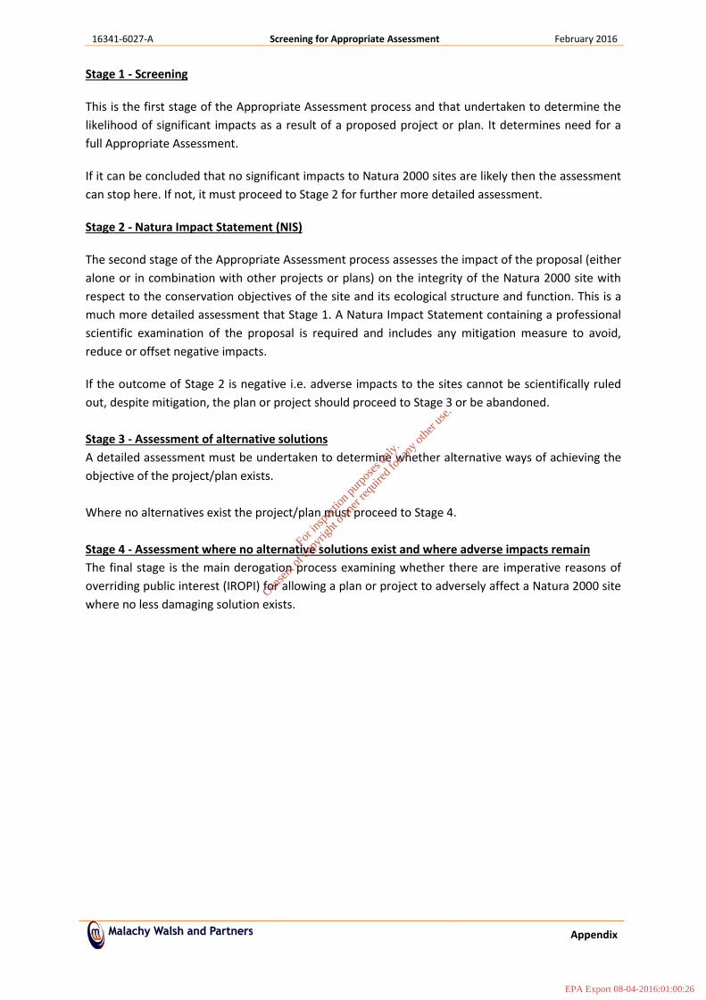
2.2 STAGES OF APPROPRIATE ASSESSMENT The Appropriate Assessment process is a four‐stage process with issues and tests at each stage. An important aspect of the process is that the outcome at each successive stage determines whether a further stage in the process is required. The stages are set out in Appendix 1.
A screening for AA determines whether a plan or project, either alone or in combination with other plans and projects, is likely to have significant effects on a Natura 2000 site in view of its conservation objectives. A Screening for AA is prepared by the developer to determine the requirement for NIS. In the event where NIS is required, this is prepared by competent person (s) using scientific examination and assessment of evidence and data. NIS facilitates the AA which is undertaken by the competent authority.
The screening for AA associated with this proposal (see Appendix 2) concluded that significant effects on the Conservation Objectives of certain Natura 2000 sites owing to the proposed Phase 1 works at Inner Bantry Harbour cannot be ruled out. These sites are:
• Glengarriff Harbour and Woodland SAC (000090) • Roaringwater Bay and Islands SAC (000101)
Therefore, further assessment is required to determine whether the proposed Phase 1 Inner Bantry Harbour works, are likely to adversely affect the integrity of those Natura 2000 sites. The qualifying features of Special Conservation Interest for these Natura 2000 sites are listed in Table 4 below. In light of potential impacts that could ensue from the proposed Phase 1 Inner Bantry Harbour works, mitigation measures are designed to prevent any identified impacts. These are described in detail in Section 2.16, below
2.3 PURPOSE OF ASSESSMENT This Natura Impact Statement (NIS) has been undertaken to determine the potential for adverse impacts of the proposed Phase 1 works at Inner Bantry Harbour, on sites the Natura 2000 sites identified during the screening for Appropriate Assessment associated with the proposal considered in this NIS (See Appendix 2).
This NIS has been undertaken by staff ecologists from Malachy Walsh and Partners, Engineering and Environmental Consultants.
2.4 ASSESSMENT METHODOLOGY
2.4.1 APPROPRIATE ASSESSMENT GUIDANCE This Natura Impact Statement has been undertaken in accordance with the European Commission Methodological Guidance on the provision of Article 6(3) and 6(4) of the ‘Habitats’ Directive 92/43/EEC (EC, 2001) and the European Commission Guidance ‘Managing Natura 2000 sites’ (EC, 2000) and guidance prepared by the NPWS (DoEHLG, 2009). Further information is available at: http://ec.europa.eu/environment/nature/legislation/habitatsdirective/ http://www.npws.ie/planning/appropriateassessment/
16341‐6028‐B Natura Impact Statement Bantry Inner Harbour Phase 1 February 2016
4
The current assessment was conducted within this legislative framework and also the Department of the Environment, Heritage and Local Government (DoEHLG, 2009) guidelines.
As described in these, it is the responsibility of the proponent of the project, in this case the Port of Cork, to provide a comprehensive and objective Natura Impact Statement, which can then be used by the competent authority, in this case, (Cork County Council), in order to conduct the Appropriate Assessment (DoEHLG, 2009).
The aim of the assessment is to provide a sufficient level of information to the competent authority, on which to base their appropriate assessment of the plan, or project.
Once the potential impacts that may arise from the proposal are identified the significance of these is assessed through the use of key indicators:
• Habitat loss • Habitat alteration • Habitat or species fragmentation • Disturbance and/or displacement of species • Water quality and resource
2.5 CONSULTATION In preparing the Environmental Impacts Statement, consultation was undertaken with;
• Department of Environment, Community and Local Government (Development Applications Unit) (NPWS)
• Environmental Protection Agency • Inland Fisheries Ireland • Department of Communications, • Marine and Natural Resources • Marine Institute • Birdwatch Ireland • Irish Wildlife Trust • Bord Iascaigh Mhara • IFA Aquaculture and Irish Shellfish Association • Sea Fisheries Protection Authority
The full list of consultations and a summary of the issues raised by the consultees is presented in the EIS for the overall Inner Bantry Harbour Development.
2.6 DESK STUDY In order to complete the Natura Impact Statement certain information on the existing environment is required. A desk study was carried out to collate available information on the site’s natural environment. This comprised a review of the following publications, data and datasets:
• OSI Aerial photography and 1:50000 mapping • National Parks and Wildlife Service (NPWS) • National Biodiversity Data Centre (NBDC) (on‐line map‐viewer)
For
insp
ectio
n pur
pose
s only
.
Conse
nt of
copy
right
owne
r req
uired
for a
ny ot
her u
se.
EPA Export 08-04-2016:01:00:24
16341‐6028‐B Natura Impact Statement Bantry Inner Harbour Phase 1 February 2016
5
• BirdWatch Ireland • Teagasc soil area maps (NBDC website) • Geological Survey Ireland (GSI) area maps • Environmental Protection Agency (EPA) water quality data • South Western River Basin District (SWRBD) datasets (Water Framework Directive) • Environmental Impact Statement prepared for the overall works at the Bantry Inner Harbour
Development • Other information sources and reports footnoted in the course of the report.
2.7 DESCRIPTION OF PLAN/PROJECT
2.7.1 Brief Project Description The overall proposal involves the development of Inner Bantry Harbour with additional plans to improve recreational and amenity facilities in the greater harbour area through land reclamation. The overall proposal involves several key work elements which will be dealt with on a phased basis.
2.7.2 Purpose of the Project The overall purpose of the development project is to enhance amenity and commercial facilities within Bantry Harbour. The purpose of the scheme is to provide a sheltered harbour environment and marina with increased water depth and improved pier facilities to promote fishing and tourism activities in the Bantry area. This will also provide additional and improved recreational and amenity areas at the inner harbour.
2.7.3 Phase 1 Works at Bantry Inner Harbour Phase 1, to which this screening for Appropriate Assessment pertains, involves a number of elements of work, all taking place within the inner section of the harbour. The main components of the proposed development at Bantry include the following;
• Dredging of the outer southern section of the Inner Harbour near the Town Pier. • Stabilisation of all fine grained sediments including some potentially contaminated dredge
material, prior to reuse as engineered backfill, within and behind proposed structures and reclaimed areas.
• Land Reclamation to an amenity area on the northen side of the within Inner Bantry Harbour around the Railway Pier.
• Extension/refurbishment of existing Town Pier and quayside adjacent to this pier. • Installation of a floating pontoon marina with berthing for 20+ vessels at the Town Pier. • Installation of a floating break water attached to the railway pier.
As a means of making use of the dredged sediments it is intended to make beneficial re‐use of clean dredged material for land reclamation, and the upgrade of the pier. The proposed Phase 1 Inner Bantry Harbour Development Layout can be viewed in Figure 1 below.
For
insp
ectio
n pur
pose
s only
.
Conse
nt of
copy
right
owne
r req
uired
for a
ny ot
her u
se.
EPA Export 08-04-2016:01:00:24
16341‐6028‐B Natura Impact Statement Bantry Inner Harbour Phase 1 February 2016
Figure 1: Phase 1 Inner Bantry Harbour Development Layout
6
For
insp
ectio
n pur
pose
s only
.
Conse
nt of
copy
right
owne
r req
uired
for a
ny ot
her u
se.
EPA Export 08-04-2016:01:00:24
16341‐6028‐B Natura Impact Statement Bantry Inner Harbour Phase 1 February 2016
7
2.7.4 Site Location Bantry Harbour sits adjacent to Bantry town, located on the south‐west coast of Ireland. Bantry lies approximately 90km west of Cork city, and 24km south‐east of the town of Kenmare. It is accessed via the N71 National Road.
Figure 2: Site location
2.7.5 Description of the Site Bantry is a thriving market town with a population of approximately 3,000 people, popular with both domestic and international visitors. The town lies in the far south‐eastern corner of Bantry Bay which stretches some 35km in a north‐east south‐west direction into the Atlantic Ocean. The town boasts a large harbour which is utilised by both commercial and amenity vessels. Although the bay is in the region of 10km wide at its head the harbour itself is narrow with an average width of 100m. While overall the bay is considered to be one of the deepest harbours in Europe usage of the inner harbour is restricted due to existing water depth. At low tide parts of the inner harbour drain completely and mudflats become exposed which limits access by commercial and amenity vessels to pier facilities. Existing facilities within Bantry Inner Harbour currently comprise two main piers, one of which extends along the southern side of the harbour, adjacent to the N71 National Road. A second pier extends out along the seaward side of the harbour, perpendicular to the roadway. The town surrounds the inner harbour on three sides with existing car‐parking facilities located on the eastern and northern edges of the harbour.
For
insp
ectio
n pur
pose
s only
.
Conse
nt of
copy
right
owne
r req
uired
for a
ny ot
her u
se.
EPA Export 08-04-2016:01:00:24
16341‐6028‐B Natura Impact Statement Bantry Inner Harbour Phase 1 February 2016
8
The Corine (2012) landcover category for the landscape immediately surrounding Bantry Harbour is classified as ‘Discontinuous urban fabric’ which in turn is surrounded predominantly by ‘Pastures’4. The underlying bedrock in the vicinity of the town is classified as ‘Dinantian Mudstones and Sandstones (Cork group)’5. The Bantry River, which passes through the town‐centre, empties into the harbour in its south‐eastern corner. This river is classified as having ‘Good’ ecological status6.
2.7.5.1 Overall water status A search of the EPA online mapping system of the Transitional and Coastal Water Quality of the Bantry is ‘High Status’ (Unpolluted). The inland area draining to Bantry Harbour forms part of the Water Framework Directive administrative area; the South Western River Basin District, and it is the sub catchment area of the Mealagh (EPA Code: IE_SW_21_6258). Report data based upon final WRBMP, 2009‐2015 (reported to Europe July 2010) indicates that the status of the Mealagh is ‘Good’ indicating ‘Unpolluted’ waters.
2.8 FIELD SURVEYS A number of marine surveys were completed as part of the Environmental Impact Statement carried out for the overall Inner Bantry Harbour Development (Planning No. 12/00735).
The following sections summarise the methodologies employed and the results for the same.
2.8.1 Existing Hydraulic Regime
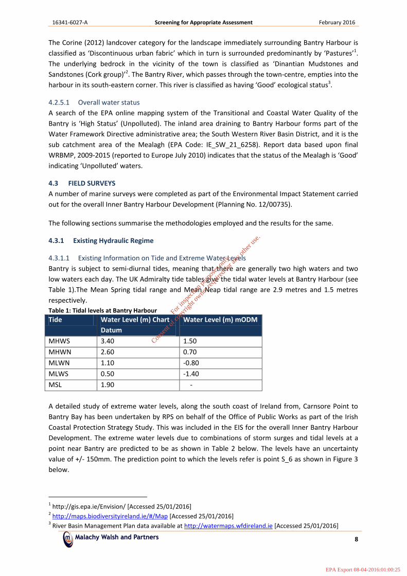
2.8.1.1 Existing Information on Tide and Extreme Water Levels Bantry is subject to semi‐diurnal tides, meaning that there are generally two high waters and two low waters each day. The UK Admiralty tide tables give the tidal water levels at Bantry Harbour (see Table 1).The Mean Spring tidal range and Mean Neap tidal range are 2.9 metres and 1.5 metres respectively. Table 1: Tidal levels at Bantry Harbour Tide Water Level (m) Chart
Datum Water Level (m) mODM
MHWS 3.40 1.50 MHWN 2.60 0.70 MLWN 1.10 ‐0.80 MLWS 0.50 ‐1.40 MSL 1.90 ‐ A detailed study of extreme water levels, along the south coast of Ireland from, Carnsore Point to Bantry Bay has been undertaken by RPS on behalf of the Office of Public Works as part of the Irish Coastal Protection Strategy Study. This was included in the EIS for the overall Inner Bantry Harbour Development. The extreme water levels due to combinations of storm surges and tidal levels at a point near Bantry are predicted to be as shown in Table 2 below. The levels have an uncertainty value of +/‐ 150mm. The prediction point to which the levels refer is point S_6 as shown in Figure 3 below.
4 http://gis.epa.ie/Envision/ [Accessed 25/01/2016] 5 Hhttp://maps.biodiversityireland.ie/#/MapH [Accessed 25/01/2016] 6 River Basin Management Plan data available at Hhttp://watermaps.wfdireland.ieH [Accessed 25/01/2016]
For
insp
ectio
n pur
pose
s only
.
Conse
nt of
copy
right
owne
r req
uired
for a
ny ot
her u
se.
EPA Export 08-04-2016:01:00:24
16341‐6028‐B Natura Impact Statement Bantry Inner Harbour Phase 1 February 2016
9
Table 2: Extreme Tidal water levels in Bantry Bay Annual Exceedence Probability (AEP)
Figure 3: Location of ICPSS Prediction Points – Bantry S_6
As outlined in the EIS for the Inner Banter Harbour Development, sea level rise due to global warming is currently expected to be 0.5m by 2100. Therefore at least 0.5m should be added to the extreme levels noted in Table 2 for the predicted water levels by 2100.
2.8.1.2 Tidal Flow Modelling In order to gain a full insight into the hydrodynamics of the site, tidal flow modelling was undertaken as part of the EIS for the overall Bantry Harbour Development. This was carried out using the nested Mike21 HD model, which is part of the Mike21 suite of coastal process software developed by the Danish Hydraulics Institute.
2.8.1.2.1 Tidal Model Simulations
Tidal currents in the area are very low and are in the region of 0.0 – 0.2 m/s, with very little difference between neap and spring conditions, thus flow patterns are typically dominated by meteorological and wave induced conditions, incurring significant eddying. The model was run for a
For
insp
ectio
n pur
pose
s only
.
Conse
nt of
copy
right
owne
r req
uired
for a
ny ot
her u
se.
EPA Export 08-04-2016:01:00:24
16341‐6028‐B Natura Impact Statement Bantry Inner Harbour Phase 1 February 2016
10
complete typical month of tides. Results indicated that the tidal flow velocities around the entrance area of Bantry Harbour are very low.
2.8.1.3 Benthos Survey As part of the EIS for the overall Inner Bantry Harbour Development, Aquatic Services Unit (ASU) undertook a survey of the benthos in the area. These included Intertidal Hard Benthos Survey, Intertidal Soft Benthos Survey, Intertidal Core Sampling, Sub‐tidal Soft Benthos Survey, and sub Tidal video survey.
2.8.1.4 Sediment Sampling Programme The seabed within the development area consists of a layer of fine grained material overlying a coarser grained material. From the analysis of the sediment, there are some areas with potentially elevated metal levels in the top 1m of material to be removed from the Inner Harbour. The fine sediments and courser grained sand and gravel material underlying the upper potentially contaminated dredged spoil is deemed free from contamination.
All fine sediments need to be solidified and stabilised (S/S) for engineering purposes and will be removed, treated, and used as fill for reclamation areas in the Inner Harbour pier and quayside expansion and for the development of the amenity area. The S/S treatment will also result in the retardation and encapsulation of any potentially polluting parameters in the dredge material. .
2.8.1.5 Dredging Plume Modelling As part of the overall Bantry Harbour Development dredging plume simulations were undertaken to investigate the fate of material mobilised into the water column during dredging operations. In these simulations it was assumed that the dredger would be working in the wet, with the tide going in and out of the harbour throughout the dredging operations. The following is summary of the dredge modelling carried out, and the results of the same. The full report can be viewed in the EIS carried out for the overall Inner Harbour Development.
2.8.1.5.1 Model Simulations
The model simulations were undertaken using the Mike21 npa particle tracking model which used a typical month of tides generated by the tidal model as shown in Figure 4. The model simulates the dispersion, settlement and the fate of the material lost to the water column during the dredging operations by releasing particles into the model flow regime and tracking them as they are carried by the currents and gradually settle out onto the sea bed. The source of the released particles follows the progress of the dredger as it gradually digs its way in from the entrance to the eastern end of the inner Harbour basin.
For
insp
ectio
n pur
pose
s only
.
Conse
nt of
copy
right
owne
r req
uired
for a
ny ot
her u
se.
EPA Export 08-04-2016:01:00:24
16341‐6028‐B Natura Impact Statement Bantry Inner Harbour Phase 1 February 2016
11
Figure 4: typical month of tides generated by the tidal model During dredging operations, losses to the water column are normally of the order of 2% of the quantity of material that is being dredged. The site investigation analysis has shown that the bed material at Bantry Harbour is composed of a mixture of gravel, sand and silt with a log linear grading from about 0.002mm to 20mm particle diameters. The coarsest one third of the material, i.e. the gravel and coarse sand, is so heavy that it will settle very quickly down to the bed thus the material which can potentially be carried away out of the harbour in the water column is approximately 2% of the finer fractions of the dredged material. In the simulation of the dredging at Bantry Harbour the losses were taken to be 2% of the rate of dredged material released at the surface with a grading as shown in Table 3. Some 2.5 million particles were released during the simulation with the distribution of the grain sizes of the released particles conforming to the grading shown in Table 3. The rate of dredging was assumed to be 1000 m3/day, although the dredging process is now likely to be much slower than this. Therefore the results of the dredging simulations may be treated as the worst case scenario.
Table 3: Grain size distribution for released particles in dredging simulation Grain diameter (mm) Percentage
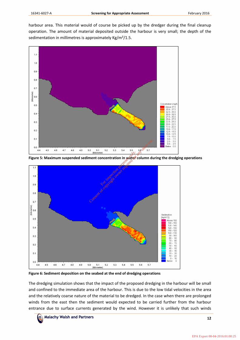
Figure 5 below shows the highest suspended concentration of sediment in the water column during the dredging operation. It will be seen that the values are very low outside the confines of the harbour. Figure 6 below shows the deposition of sediment lost to the water column during the
For
insp
ectio
n pur
pose
s only
.
Conse
nt of
copy
right
owne
r req
uired
for a
ny ot
her u
se.
EPA Export 08-04-2016:01:00:24
16341‐6028‐B Natura Impact Statement Bantry Inner Harbour Phase 1 February 2016
12
dredging operation. It will be noted that most of the material falls back onto the bed within the harbour area. This material would of course be picked up by the dredger during the final cleanup operation. The amount of material deposited outside the harbour is very small; the depth of the sedimentation in millimetres is approximately Kg/m²/1.5.
Figure 5: Maximum suspended sediment concentration in water column during the dredging operations
Figure 6: Sediment deposition on the seabed at the end of dredging operations
The dredging simulation shows that the impact of the proposed dredging in the harbour will be small and confined to the immediate area of the harbour. This is due to the low tidal velocities in the area and the relatively coarse nature of the material to be dredged. In the case when there are prolonged
For
insp
ectio
n pur
pose
s only
.
Conse
nt of
copy
right
owne
r req
uired
for a
ny ot
her u
se.
EPA Export 08-04-2016:01:00:24
16341‐6028‐B Natura Impact Statement Bantry Inner Harbour Phase 1 February 2016
13
winds from the east then the sediment would expected to be carried further from the harbour entrance due to surface currents generated by the wind. However it is unlikely that such winds would occur for a large part of the dredging period assumed in the simulations. Therefore it may be concluded that the dredging operations can be undertaken in the wet without a significant environmental impact away from the immediate area of the harbour and its entrance zone.
2.8.1.6 Dredging of Contaminated Material Due to the presence of mercury in the top 1m of the bed both inside and outside the harbour, specific dispersion modelling was carried out to determine the fate of the contaminant during and after dredging (available in EIS). Two dispersion scenarios were modelled, to ensure all possibilities were accounted for; one scenario assumed that the mercury was attached to the sediment and the other assumed the mercury dissolved in a solution. Both modelling scenarios were undertaken using a particle tracking model from the Mike Suite of software. Sediment dispersion modelling was carried out both inside and outside the harbour, assuming the mercury was attached to the sediment particles, and thus were not separate particles. On output, the relative concentration of mercury could be derived. A south easterly wind was applied to the model inside the harbour, as a worst case scenario, and likewise a southerly wind was applied to the outer harbour.
According to the Water Framework Directive Surface Water Regs (S.I. No. 272 of 2009), the Priority Substance, Mercury and its compounds, should have a MAC EQS of 0.07µg/l in Surface Waters (Other Waters), which excludes inland waters but includes coastal and transitional waters.
The model results showed that the maximum sediment concentrations in the inner harbour and outer harbour are generally less than 0.04kg/m3 and 0.025kg/m3 respectively. Assuming the concentration of mercury is 0.198mg/kg as derived, the more critical 0.04kg/m3 can be converted to an equivalent 0.0079µg/l, showing that concentrations for both the inner and outer harbour are well below the critical 0.07µg/l level.
2.8.2 Summary of Environmental Quantitative Risk Assessment (2015) Viridus Consulting Ltd., carried out a Quantitative Risk Assessment (QRA) on the quality of dredge material sampled from an area of Bantry Inner Harbour.
The following is a summary of the findings of this report; Some potential Heavy Metal, TBT and Hydrocarbon contaminates have been identified in the shallow sediments at some site investigation sample locations in the Phase 1 Development Area. Modelling of the potential mobilisation of these potential pollutants during the dredge phase indicate that while some slightly elevated concentrations may arise in the water column during dredging the source is not extensive, very elevated and is short lived so the dilution and dispersion of the contaminates will be relatively instantaneous, and no elevated concentrations are identified to be dispersed outside the dredge area to any of the ecological receptors located in Bantry Harbour.
The full QRA can be viewed in the waste licence application documents.
2.8.3 Summary The coastal processes in the Bantry area have been assessed and modelled, along with the impact of the proposed development on these processes. The construction of breakwaters, inner and outer harbour dredging, along with the various fates of both contaminated and uncontaminated material have been modelled and reviewed using various software programmes under the DHI Mike Suite of
For
insp
ectio
n pur
pose
s only
.
Conse
nt of
copy
right
owne
r req
uired
for a
ny ot
her u
se.
EPA Export 08-04-2016:01:00:24
16341‐6028‐B Natura Impact Statement Bantry Inner Harbour Phase 1 February 2016
14
software. Computational modelling has shown that the potential for the spread of contaminants if dredging in the wet is minimal.
Due to the presence of mercury in the top 1m of the bed both inside and outside the harbour, specific dispersion modelling was carried out to determine the fate of the contaminant during and after dredging. For all scenarios, suspended solids concentrations were well below the critical 0.07kg/m3 level.
2.8.4 Otter Survey A baseline otter survey was carried out to inform the EIS undertaken for the proposed works at the Inner Bantry Harbour Development.
2.8.4.1 Otter survey methodology and constraints A detailed search of c. 7km on either side of the bay was carried out on the 14th of February 2012. Weather conditions were good, with clear skies and good visibility. The searched area included the area from the west of the proposal site beside the air strip to Newtown in the east.
The survey for otters was carried out by means of a targeted search within the site and surrounding areas. Presence of otters is indicated principally by their signs, such as dwellings (Holts), feeding signs or spraints (otter faeces), which can be readily identified by their smell. GPS co‐ordinates were obtained for all of the sprainting sites using a Garmin GPS receiver. The north side of the bay was surveyed during low tide giving full access to the shore and its adjacent lands. Portions of the west side of the bay were surveyed during a rising tide, making it more difficult to search or gain access in places. Relatively short sections could not be accessed because of the presence of dense scrub due or due to access restrictions at private lands along the bay. However, these short sections occurred along stretches of shore well away from the proposed marina development.
2.8.4.2 Otter Survey Results In total, 7 sprainting sites were identified. These were located in the near vicinity of the site and in both directions away from the site, indicating that otters are active all along the bay, and beside the stream at Seafield (note that coastal otters require freshwater to wash their fur daily). Sprainting sites were found to be less frequent in the inner harbour area. No spraints were found at the site of the Harbour, i.e. along the existing quays. Human disturbance and the high quay walls do not provide good sprainting locations.
For
insp
ectio
n pur
pose
s only
.
Conse
nt of
copy
right
owne
r req
uired
for a
ny ot
her u
se.
EPA Export 08-04-2016:01:00:24
16341‐6028‐B Natura Impact Statement Bantry Inner Harbour Phase 1 February 2016
15
2.8.5 Characteristics of the Project The proposal is described below and has been confirmed with the project engineer.
Size, scale, area, land‐take
The proposed works consist of the following;− Reclamation of approximately 8,360m² quayside of Foreshore at the
amenity area, and − Reclamation of approximately 5,000m² of foreshore at the Pier‐side
extension, − Approximately 12,500m² of Dredging in the inner harbour.
Details of physical changes that will take place during the various stages of implementing the proposal
Dredging
− Dredging of the inner Bantry harbour will begin in November 2016 and will continue until end March 2017.
• The dredge spoil will be excavated from a floating barge and will be transported to the quayside or amenity area using dump barges.
• All fine grained Dredge Spoil (of which half is potentially contaminated dredge) will be stabilised and solidified (S/S) by adding between 8‐12 % cement.
• The addition of the cement will strengthen the spoil and also reduce the moisture content which will enable any contaminants present to be contained and will allow the material to be used as a construction backfill.
• Dredged spoil including the coarser uncontaminated sands and gravels, will be used as construction material behind proposed amenity, pier and quayside structures.
All fine grained material is to be treated. Not all of this material is contaminated. The treatment process allows this material to be re‐used as an engineered material, and also mitigates potential contamination.
Land reclamation (Amenity area)
− The proposed Amenity Area will be constructed using a combination of treated fine grained dredge spoil (potentially contaminated dredge spoil), and coarser uncontaminated dredge spoil. A rock revetment will be established around the amenity area prior to backfilling commencing.
• The dredged spoil to be stabilised with cement. It will be transferred into designated geotextile lined cells within the amenity area using a clamshell bucket on a long reach excavator. The cement (8‐12%) will be added to the contaminated dredged spoil in the cells using an Allu mixer and feeder.
• The uncontaminated dredge gravels will be placed within the amenity area first to raise the bed level in the amenity. The treated material will then be placed on top. This sequence will reduce potential for contact between the treated material and the tidal waters which will permeate through amenity area revetment.
• The top level of the amenity area is given in the planning documents as 5.75mCD. A permanent revetment will have a crest level of 5.75mCD
For
insp
ectio
n pur
pose
s only
.
Conse
nt of
copy
right
owne
r req
uired
for a
ny ot
her u
se.
EPA Export 08-04-2016:01:00:24
16341‐6028‐B Natura Impact Statement Bantry Inner Harbour Phase 1 February 2016
16
(3.57mODM) as per the planning documents.
− A floating break water attached to the railway pier will be installed during the construction of the amenity area revetment, this breakwater will provide 60m length of berthing.
Land reclamation (Quayside) and extension of existing pier
− The existing Town Pier, is to be extended by approximately 4m along the length of the inside Quay and the head of the pier.
• At the Quayside Stitch drilling will be undertaken to a depth of approximately 2m into the bedrock.
• Sheet piles will be driven into the pre drilled bedrock approximately 25‐30m from the existing quay wall for a length of 120m along the quayside. Treated Dredge material will be placed between the piles and the existing wall. Concrete will be applied on top in shuttering to prevent loss to the adjacent harbour waterbody.
Imported material will be used to build up a working area (causeway in quayside area). Once quayside is built this material will be dug up, and taken to amenity area to form part of permanent works in revetment core, or treatment cells foundation. There will be no tracking between reclamation areas. All dredge material is transported from dredge site to treatment areas by barge.
Installation of a floating pontoon marina with berthing for 20+ vessels
− A floating pontoon marina with berthing for 20+ vessels will be installed after the dredging of the inner harbour along the quayside. This area will be filled with treated dredge spoil, and also tar and chip pavement covering.
Description of resource requirements for the construction/operation and decommissioning of the proposal (water resources, construction material, human presence etc)
− General construction Equipment (and location within site) • 3* 20 tonne excavators (Site wide) • 2* 80 tonne crawler cranes (head of pier only) • 2* 6 tonne site dumpers (Site wide) • BSP Piling hammers (Quayside & Pierside finished in q4 2016) • 2* Dump barges (dredge area Nov to end March) • A25 dumper (Amenity Area) • Allu mixer, power feeder and 3* long reach excavators (Quay side &
Amenity area Nov 16 to March17) • Work Boat (present throughout works) • Safety Boat (present throughout works) • Barge (Dredge area) • Concrete skips (Site wide) • Tipper trucks and artics for deliveries (Site Wide) • Small tools (Site Wide)
− Construction Material
• Sheet piles (600 tonnes) • Precast concrete elements (100 units) • Rock armour (20,000m3) • General rock fill (20,000m3) • Cement (3000 tonnes) • Concrete (1000m3) • Steel reinforcement (250 tonnes)
For
insp
ectio
n pur
pose
s only
.
Conse
nt of
copy
right
owne
r req
uired
for a
ny ot
her u
se.
EPA Export 08-04-2016:01:00:24
16341‐6028‐B Natura Impact Statement Bantry Inner Harbour Phase 1 February 2016
17
• Pontoons, gangways and breakwaters (2 pontoon units, 3 20m breakwater units 2 gangways)
• Electrical appliances and cables • Block‐work and masonry stone • Timber formworks (400m2 of shuttering plywood) • Rock anchors (900m of double corrosion protection anchors)
− Concrete delivery trucks ( the concrete will be batched offsite and will be
delivered to site in bottlenose trucks, the wash out of the concrete trucks will take place off site back at the concrete batching plant)
− Personnel • 1* Contract Director • 1* Contracts Manager • 1* Project Manager • 2*Foremen • 1*Safety Officer • 2*Quantity Surveyors • 3*Site Engineers • 3*Design Engineers • Up to 20* General Operatives/Subcontractor operatives
Description of timescale for the various activities that will take place as a result of implementation (including likely start and finish date)
Temporary CausewayThe construction of a temporary causeway in the location of the new quayside along with the installation of the site offices and welfare facilities will commence in early March 2016. The construction of the temporary causeway will take approximately 4 weeks to complete. Dredging The dredging operations will commence on the 1st of November 2016 pending the successful receipt of a waste license from the EPA and will continue up to the end of March 2017. Reclamation Once the dredging commences the filling and construction of the rock revetment and the new amenity area will proceed in tandem. Filling behind the new reclaimed quayside will also be on‐going along with the dredging. The stabilisation of the dredged material will be carried out as and when it is needed during the dredging operation. Extension The sheet piling for the new quayside wall and along the head of the existing pier will follow on from the installation of the temporary causeway with pre drilling at the quayside expected to take place from April to July and subsequent pile driving at the quayside and pier to take place from July to September. The procurement of long lead in items such as the sheet piles and the pontoons will be on‐going. Once the sheet piles have been driven the anchors for the sheets piles will follow on. The concrete facing to the sheet piled walls and the construction of the new decks will all follow on in a linear fashion. Overall sequence of works The new Quayside works will run in tandem with the Pier extension. Once the sheet piling has been completed at the Quayside area the temporary causeway
For
insp
ectio
n pur
pose
s only
.
Conse
nt of
copy
right
owne
r req
uired
for a
ny ot
her u
se.
EPA Export 08-04-2016:01:00:24
16341‐6028‐B Natura Impact Statement Bantry Inner Harbour Phase 1 February 2016
18
will be removed and this material will be used to construct the new rock revetment around the Amenity area prior to any dredging taking place. The dredging, stabilisation and filling to the new amenity area and behind the sheet piled wall of the new Quayside will all take place in tandem. The final phase of the project will involve the installation of the new pontoons and marina along with all the various new services and pier furniture.
Description of wastes arising and other residues (including quantities) and their disposal
It is envisaged that any wastes generated will be minimal as materials will be sourced off –site/disposed of off –site or re‐used within the site.
− Approx. 45,000 m³ dredge spoil (approx 25,000m³ fine grained (half of which is potentially contaminated), 20,000m³ gravels and 20,000m³ silts)
• Fine grained dredge spoil (potentially contaminated dredge spoil) will be stabilised and re‐used as back fill.
• Uncontaminated Gravels and Sands to be used as additional construction fill.
− Construction wastes: (excess/residual materials/ packaged wastes) will be disposed of to a suitable licensed facility. KWD will provide 3 number skips which will be located at the site compound, the waste will be segregated so that it can be reused and recycled. One skip will be for timber, one for plastics and cardboard and one will be for general waste. KWD will also collect and steel waste for recycling on a regular basis. KWD are a fully licensed and certified waste collection and disposal company.
− Cementitious wastes: Cement used in the stabilisation process will be kept to a minimum due to the sealed nature of the mixing equipment being used. The cement will be delivered in sealed truck units which contain a donkey engine which will be used to blow the cement into the sealed Allu power feeder which will be used for the mixing and stabilisation of the dredged spoil. In the event of any cement waste arising it will be sucked up using an industrial vacuum and simply added to the dredged spoil for mixing.
− Causeway fill material: The fill for the temporary causeway will be reused in the construction of the rock revetment core of the Amenity Area. This will ensure that the material has a beneficial reuse within the project.
Identification of wastes arising and other residues (including quantities) that may be of particular concern in the context of the Natura 2000 network
− Approx. 45,000 fine grained dredge spoil (approx 25,000m³ fine grained 20,000m³ clean granular).
− Cementitious − General wastes − Packaging − Fuel/oils
Description of any additional services required to implement the project or plan, their location and means of construction
− Archaeological monitoring − MMO Paddy O’Dwyer will be on‐site for the duration of the proposal to
monitor marine mammal activity − Continuous Water Quality Monitoring and laboratory analysis of daily
samples of dredge material − Waste Licence to treat and place stabilised dredge material
For
insp
ectio
n pur
pose
s only
.
Conse
nt of
copy
right
owne
r req
uired
for a
ny ot
her u
se.
EPA Export 08-04-2016:01:00:24
16341‐6028‐B Natura Impact Statement Bantry Inner Harbour Phase 1 February 2016
19
2.9 IDENTIFICATION OF OTHER PROJECTS OR PLANS OR ACTIVITIES A search of Cork County Council’s on‐line planning enquiry system determined that there are many current and outstanding planning applications within the vicinity of Bantry Harbour. Many of these pertain to the development of the harbour/pier facilities, as well as commercial premises on the harbour‐front.
2.9.1 Harbour Operations Bantry harbour forms the main access point to the sea for various water based activities, including commercial shipping, fishing, sailing, casual boating and lifesaving. Activities within the existing harbour include commercial shipping, fishing, leisure and amenity.
2.9.2 Bantry Harbour overall Development The overall development will provide a sheltered harbour environment and marina with increased water depth and improved pier facilities to promote fishing and tourism activities in the Bantry area. The scheme will also provide additional and improved recreational and amenity areas. The scheme includes proposals for the beneficial re‐use of clean dredged material at adjacent, and connected, locations for beach re‐nourishment and land reclamation. The proposed/permitted development is described in detail in Chapter 4 of the EIS (Doc No. IBE0558). The following are the main components of the overall project:
o Dredging of the Inner Harbour to depths of up to ‐ 3m CD thereby providing a o harbour with water at all states of the tide; o Dredging of the Outer Harbour approaches to depths of up to – 6m CD; o Provision of pontoon berths for 200 vessels; o Provision of reclamation area to the north of the pier which can be used for amenity o purposes; o Use of clean dredged spoil for beach renourishment at Cove Beach to the north of o Bantry Harbour o Use of dredge spoil for land reclamation, to the South of Bantry Harbour.
2.9.3 Aquaculture
2.9.3.1 Mussel farming Mussel farming is an important aquaculture carried out at Bantry Bay. Mussel farms (rope grown blue mussels (Mytilus edulis)), in the inner bay are concentrated along the eastern shore of Whiddy Island with other farms situated just north west of Cove. There are 34 sites configured in several contiguous blocks licensed to 8 operators, while in Glengarriff Harbour there are a further 10 sites licenses to 2 operators. The nearest mussel farm license areas to the proposed Inner Harbour works are approximately 810m to the Abbey shore, approximately 940m to Bantry Harbour Pier, and approximately 340m to the Cove site respectively.
2.9.3.2 Commercial Fisheries There are about 5 in‐shore fishing boats operating in the area, mainly for shrimp and prawns.
For
insp
ectio
n pur
pose
s only
.
Conse
nt of
copy
right
owne
r req
uired
for a
ny ot
her u
se.
EPA Export 08-04-2016:01:00:24
16341‐6028‐B Natura Impact Statement Bantry Inner Harbour Phase 1 February 2016
20
2.10 IDENTIFICATION OF NATURA 2000 SITES
2.10.1 Characteristics of Natura 2000 Sites Table 4, below, lists the qualifying features of special conservation interest for the Natura 2000 sites selected for inclusion in the NIS. Information pertaining to the Natura 2000 sites is from site synopses, conservation objectives and other information available on www.npws.ie.
Table 4: Natura 2000 sites with qualifying features of conservation interest
Designated Site Qualifying features of conservation interest
Proximity of Phase 1 Inner Bantry Harbour site to nearest point of designated site
Glengarriff Harbour and Woodland SAC (000090)
• Old sessile oak woods with Ilex and Blechnum in the British Isles [91A0]
• Alluvial forests with Alnus glutinosa and Fraxinus excelsior (Alno‐Padion, Alnion incanae, Salicion albae) [91E0]
2.10.2 Conservation Objectives According to the Habitats Directive, the conservation status of a natural habitat will be taken as ‘favourable’ within its biogeographic range when:
• its natural range and areas it covers within that range are stable or increasing, and
• the specific structure and functions which are necessary for its long‐term maintenance exist and are likely to continue to exist for the foreseeable future, and
• the conservation status of its typical species is favourable as defined below.
According to the Habitats Directive, the conservation status of a species means the sum of the influences acting on the species concerned that may affect the long‐term distribution and abundance of its populations. The conservation status will be taken as ’favourable’ within its biogeographic range when:
16341‐6028‐B Natura Impact Statement Bantry Inner Harbour Phase 1 February 2016
21
• population dynamics data on the species concerned indicate that it is maintaining itself on a long‐term basis as a viable component of its natural habitats, and
• the natural range of the species is neither being reduced nor is likely to be reduced for the foreseeable future, and
• there is, and will probably continue to be, a sufficiently large habitat to maintain its populations on a long‐term basis.
The specific conservation objectives for each site are available on www.npws.ie. These have been accessed for the sites listed in the tables above on the 21/09/2015.
Site specific and more detailed conservation objectives were available for both the Natura 2000 sites, listed below:
• Glengarriff Harbour and Woodland SAC (000090) • Roaringwater Bay and Islands SAC (000101)
Management plans were not available for any sites.
All conservation objectives together with other designated site information are available on http://www.npws.ie/protectedsites/.
2.10.3 Description of Natura 2000 Sites
2.10.3.1 Glengarriff Harbour and Woodland SAC (000090) 7 This designated site is located to the south and north‐west of Glengarriff Village in west Cork. The site consists of a glacial valley opening out into a sheltered bay with rocky islets. The valley contains old oak woodland and alluvial forest. The underlying rock of the area is Old Red Sandstone, with the soil varying from acid brown earths to alluvial brown earths and peat.
Glengarriff woodland consists of a sizeable area of broadleaved semi‐natural woodland comprised of oak (Quercus sp.) and Holly (Ilex aquifolium), with much Downy Birch (Betula pubescens) and Rowan (Sorbus aucuparia). A little Yew (Taxus baccata) occurs and Strawberry Tree (Arbutus unedo) is scattered through the woods. The most frequent ground plants are Heather (Calluna vulgaris), Great Wood‐rush (Luzula sylvatica), Bilberry (Vaccinium myrtillus) and the ferns (Pteridium aquilinum, Blechnum spicant and Dryopteris aemula).
Wet woodland occurs along parts of the Canrooska and Glengarriff rivers. This is dominated by willows (mainly Salix cinerea subsp. oleifolia) and Downy Birch, with Alder (Alnus glutinosa) also frequent. A rich herb layer is found, characterised by such species as Bugle (Ajuga reptans), False Brome (Brachypodium sylvaticum), Meadowsweet (Filipendula ulmaria) and Wood Sanicle (Sanicula europaea). The rivers flood regularly, depositing silt within the woodlands.
Although this is the site of an ancient woodland, it was once part of an estate and much of the oak was planted around 1807‐1810. Some exotic species were also introduced, such as Beech (Fagus sylvatica), Sycamore (Acer pseudoplatanus) and Rhododendron (Rhododendron ponticum). The latter has invaded parts of the woodland, posing a serious problem. However, it is being systematically
16341‐6028‐B Natura Impact Statement Bantry Inner Harbour Phase 1 February 2016
22
removed. Other areas within the woodland have been planted with conifers including Sitka Spruce (Picea sitchensis), Scots Pine (Pinus sylvestris) and Western Hemlock (Tsuga heterophylla).
Overall, the site supports a diversity of fauna. The rocky islets in the harbour support the largest colony of common Seals in the south‐west of Ireland (maximum count of 151 in the all‐Ireland survey of 2003). This legally protected species is listed on Annex II of the E.U. Habitats Directive. Lesser Horseshoe Bat, also an Annex II species, were formerly recorded in high numbers in Glengarriff Castle (e.g. 300+ recorded during summer 1985, 268 in winter 1989). However numbers decreased at the Castle from the late 1990's onwards. Since then, summer roosts within the SAC boundary have been found in three buildings. The highest combined counts for the three summer sites were taken in July 2002 with a total of 228 bats. Bats have also been confirmed hibernating in one of the buildings and have used two purpose‐built hibernacula. A total of 114 hibernating bats were counted in winter 2002/2003. This site is of international importance for both summer roosting and hibernating Lesser Horseshoe Bats. Given the combination of winter, summer and foraging sites, the site is one of the most important for the species in the south‐west. An important roost of approximately 100 Long‐eared Bats (Plecotus auritus) is also present within the site. Both bat species are listed on Annex IV of the E.U. Habitats Directive. The woods, and the river flowing through it, are home to a range of other mammal species, including Otter (listed in Annex II of the E.U. Habitats Directive), Stoat, Red Squirrel, Badger and Sika Deer. Bird life is also diverse, with species such as Sparrowhawk, Peregrine, Long‐eared Owl, Woodcock, Heron, Jay, Dipper, Willow Warbler, Chiffchaff and Wood Pigeon.
2.10.3.2 Roaringwater Bay and Islands SAC (000101)8 Roaringwater Bay and Islands is a site of exceptional conservation importance, supporting diverse marine and terrestrial habitats, five of which are listed under the E.U. Habitats Directive. The site is also notable for the presence of Otter, Grey Seal and Harbour Porpoise
Roaringwater Bay, Co. Cork, is a wide, shallow bay located on the south‐west coast of Ireland. The SAC includes the immediate coastline on the mainland from Long Island to Baltimore, together with the whole bay and most of the islands. Some of the larger islands included are Sherkin Island, Cape Clear Island, Heir Island, Horse Island, Castle Island and Long Island. The bedrock in the area is composed of a series of Devonian Old Red Sandstone reefs that run parallel to troughs of Devonian Carboniferous marine clastics in a north‐east/south‐west direction. These reefs emerge to form the islands on the south side of the bay and within the bay. Generally the coast is low‐lying but the southern edge rises, in line with the hills behind Baltimore, to culminate in a summit of 160 m on Cape Clear.
The bay itself has a wide variety of reef and sediment habitats, subject to a range of wave exposures and tidal currents. Within the habitat ‘large shallow inlets and bays’ are found the following communities: muddy sand with bivalves and polychaetes complex, mixed sediment community complex, and shallow sand‐mud community complex. Also found are marine caves and reefs. The shores of the bay range from the exposed, rocky shores of South Sherkin Island, to the sheltered rock, sand and mud communities of the Inner Bay and estuarine communities where the rivers enter the bay. The shallow subtidal reefs have good examples of kelp forest community grazed by the sea
16341‐6028‐B Natura Impact Statement Bantry Inner Harbour Phase 1 February 2016
23
urchin (Echinus esculentus). The animal dominated reefs includes the feather star (Antedon bifida) community, the hydroid (Sertularia argentia) and (Hydralmania falcate) community, and sponge and ascidian communities. Some of these are species‐rich and at least two rare species occur; the sponge (Tethyspira spinosa) and the rare red alga (Phyllophora sicula). The scarce hydroid (Tamarisca tamarisca) occurs at a number of sites within the bay. These communities are typical of very sheltered areas with some current present. The cave community on Sherkin Island is home to the rare filamentous red alga (Pterosiphonia pennata). The sedimentary communities in Roaringwater Bay are exceptional. Of particular interest is the extensive bed of the calcareous free living red alga (Lithophyllum dentatum), (generally termed maerl, but may be locally known as ‘coral’), which is the largest in the country for this species. This bed typically contains specimens that are very large and uniquely flattened in form, with the rare filamentous red alga (Spyridia filimentosa). Lithophyllum dentatum is only known from two other sites. There are also other maerl communities and several Eelgrass (Zostera marina) beds which may co‐occur with a particularly good example in Horseshoe Bay, Sherkin Island.
The terrestrial habitats at this site are also of conservation interest and include good examples of two habitats listed under the E.U. Habitats Directive, i.e. dry heath and sea cliffs. The coastal heath vegetation is typified by an abundance of Western Gorse (Ulex gallii), Heather (Calluna vulgaris) and Bell Heather (Erica cinerea). This is regularly burnt in most places so that there are clearings where grasses and herbs such as Wood Sage (Teucrium scorodonia), Common Dog‐violet (Viola riviniana) and Tormentil (Potentilla erecta) have a temporary rise to prominence before the shrubs grow again. Outcrops of rock bring variety into the heath and these areas are sometimes host to interesting species. These include many plants of southern distribution, for example the rare Red Data Book species Bird’s‐foot (Ornithopus perpusillus), Spotted Rock‐rose (Tuberaria guttata), Hairy Bird’s‐foot‐trefoil (Lotus subbiflorus), Pale Dog‐violet (Viola lactea) and Lanceolate Spleenwort (Asplenium billotii). The latter three on this list are also protected under the Flora (Protection) Order, 1999. In addition there is a small amount of Deptford Pink (Dianthus armeria), one of only a very small number of places it grows in Ireland, though it may have been introduced here, as at other sites. Flushes and damp places through this vegetation support some interesting liverworts, as well as Bird’s‐foot Clover (Trifolium ornithopodioides) and the special annual plants of the south‐west, Chaffweed (Anagallis minima), Yellow Centaury (Cicendia filiformis) and Allseed (Radiola linoides). Chamomile (Chamaemelum nobile) is also common, with Yellow Bartsia (Parentucellia viscosa) somewhat less so. Most of the species mentioned above have restricted distributions in Ireland.
Otter, Grey Seal and Harbour Porpoise, all mammal species listed on Annex II of the E.U. Habitats Directive, occur within the site. Grey Seal is present at the site throughout the year during all aspects of its annual life cycle which includes breeding, moulting, non‐breeding, foraging and resting phases. A minimum population for all ages was estimated at 116‐149 in 2005. Roaringwater Bay may be one of the most important sites in Ireland for Harbour Porpoise. Harbour Porpoise in Irish waters are largely resident and observations have shown that they are regular in the waters of Roaringwater Bay. Most observations are in the autumn, when more than 100 individuals have been recorded in a day. The population has been estimated (in 2008) to be 117‐201 individuals. The main threat to Harbour Porpoise is incidental capture in fishery gear, especially set gillnets but also drift nets.
For
insp
ectio
n pur
pose
s only
.
Conse
nt of
copy
right
owne
r req
uired
for a
ny ot
her u
se.
EPA Export 08-04-2016:01:00:24
16341‐6028‐B Natura Impact Statement Bantry Inner Harbour Phase 1 February 2016
24
2.11 IDENTIFICATION OF POTENTIAL IMPACTS Potential ecological impacts arising from the project are identified in this section. Only those features of the development that have the potential to impact on qualifying features, conservation interests and conservation objectives of the identified Natura 2000 sites if implemented without mitigation measures, are identified in this section. Description of elements of the project likely to give rise to potential ecological impacts.
− Dredging − Pile driving − Use of concrete − Reclamation − Use of machinery − and increased human activity
Describe any likely direct, indirect or secondary ecological impacts of the project (either alone or in combination with other plans or projects) by virtue of: o Size and scale; o Land‐take; o Distance from Natura 2000 Site or
key features of the Site; o Resource requirements; o Emissions; o Excavation requirements; o Transportation requirements; o Duration of construction, operation
etc.; and o Other.
− Water quality impacts from increased suspended sediment and turbidity levels in the water column during dredging.
− Water quality impacts from accidental oil spill associated with fuelling activities.
− Water quality impacts as result of accidental spill of cementious materials/use of cementiuos materials during the construction phase.
− Loss and alteration of seabed habitat and associated species at the location of the dredge area/s.
− Potentially dredging could alter characteristics of benthic habitats, which may result in negative impacts on benthic flora and fauna.
− Increased noise levels as result of machinery/increased vessel activity.
− Disturbance /displacements impacts on marine mammals. − Increased sediment/turbidity levels could potentially result in
reduction of prey items for marine mammals.
The main potential impacts the works pose, are negative impacts to water quality at Bantry Bay, as a result of dredging works at the Inner Harbour, and the construction works associated with the proposal. There is also the potential for disturbance/displacement impacts to marine mammals/aquatic/semi aquatic species as a result of increased noise levels.
2.12 IDENTIFICATION OF QUALIFYING FEATURES OF NATURA 2000 SITES FOR IMPACT ASSESSMENT
When Natura 2000 sites are selected for stage 2 assessments, then all the qualifying features of conservation interest must be included in that stage of the assessment. However, when assessing impact, qualifying features are only considered relevant where a credible or tangible source‐pathway‐receptor link exists between the proposed development and a protected species or habitat. In order for an impact to occur there must be a risk initiated by having a 'source' (e.g. near stream construction works at a proposed development site), a 'receptor' (e.g. a protected species associated aquatic or riparian habitats), and an impact pathway between the source and the receptor (e.g. a watercourse which connects the proposed development site to the site designated for the protection of the aforementioned species). Identifying a risk that could, in theory, cause an impact does not automatically mean that the risk event will occur, or that it will cause or create an adverse impact. However, identification of the risk does mean that there is a latent possibility of ecological or environmental damage occurring, with the level and significance of the impact depending upon the nature of the risk, the extent of the exposure to the risk and the characteristics of the receptor.
For
insp
ectio
n pur
pose
s only
.
Conse
nt of
copy
right
owne
r req
uired
for a
ny ot
her u
se.
EPA Export 08-04-2016:01:00:24
16341‐6028‐B Natura Impact Statement Bantry Inner Harbour Phase 1 February 2016
25
Therefore, bearing in mind the scope, scale, and size of the project (described in section 2.7 above), its location relative to the distribution of the species and habitats listed, and the degree of connectedness that exists between the project and the potential receptors, it is considered that not all of the qualifying intersets are within the zone of potential impact influence of the proposal.
2.13 IDENTIFICATION OF POTENTIALLY SIGNIFICANT IMPACTS TO QUALIFYING FEATURES The following tables (Table 5 and Table 6) , list the qualifying features of the two Designated Sites carried forward for further assessment, and evaluates through a scientific examination of evidence, and data, whether or not these features should, or should not be selected for further assessment in the NIS. The qualifying features that are selected for further assessment are discussed further in the section followed by an assessment of potentially significant effects arising from the proposed Phase 1 Inner Bantry Harbour works. These qualifying features have been included / excluded according to guidance outlined by the NPWS.
For
insp
ectio
n pur
pose
s only
.
Conse
nt of
copy
right
owne
r req
uired
for a
ny ot
her u
se.
EPA Export 08-04-2016:01:00:24
16341‐6028‐B Natura Impact Statement Bantry Inner Harbour Phase 1 February 2016
26
2.13.1 Glengarriff Harbour and Woodland SAC (000090) Table 5: Qualifying features of the Glengarriff Harbour and Woodland SAC (00090) considered to be potentially within the zone of impact influence of the proposal, and whether they will be carried forward for further assessment Qualifying Feature Potential for
significant impact
Rationale
Old sessile oak woods with Ilex and Blechnum in the British Isles [91A0]
No
Old sessile oak woods are a terrestrial habitat, and would not be subjected to any impacts as a result of poor water quality during the construction phase of the proposed works. Additionally, the locations of both these habitat types, within this designated site, are located a considerable distance from the Inner Bantry site, situated up stream, and up‐gradient, of the open tidal water separating both sites. Furthermore, this designated site is situated approximately 7.20km to north‐west, of the proposed works at Inner Bantry Harbour, however the distribution mapping for this designated site9, shows this habitat type is situated an additional 2.55km further inland Therefore, this habitat type is not considered further in the NIS.
Alluvial forests with Alnus glutinosa and Fraxinus excelsior (Alno‐Padion, Alnion incanae, Salicion albae) [91E0]
No
Alluvial forests with Alnus glutinosa and Fraxinus excelsior are found on flood plains in a range of situations, from islands in river channels to low‐lying wetlands alongside the channels10. This habitat type is subjected to infrequent flooding, and therefore, are not likely be impacted by poor water quality, as a result of the proposed works at Inner Bantry Harbour. Furthermore, this designated site is situated approximately 7.20km to north‐west, of the proposed works at Inner Bantry Harbour, however the distribution mapping for this designated site11, shows this habitat type is situated an additional 3km further inland/upslope/upstream. Therefore, this habitat type is not considered to be within the significant impact influence of the proposed works, and is not considered further in the NIS.
Kerry slug (Geomalacus maculosus) [1024]
No
Kerry Slug is mainly associated with, broad‐leaved woodland, and blanket bog and wet heathland habitats. Within these habitats, it is only present if there are stone outcrops and boulders, largely bare of vegetation except
16341‐6028‐B Natura Impact Statement Bantry Inner Harbour Phase 1 February 2016
27
Qualifying Feature Potential for significant impact
Rationale
for lichens, mosses and liverworts, on which the species feeds12. Due to the fact that this species is terrestrial, with a considerable distance separating both sites, along with the fact that the land area of this designated site is situated up‐gradient of the proposed Phase 1 works at Inner Bantry Harbour, no significant impacts will ensue on this species as a result of the proposed works described in this proposal. Therefore, this species is not considered further in the NIS.
Lesser Horseshoe Bat (Rhinolophus hipposideros) [1303]
No
Optimal roosting sites for this species include old buildings and caves. Lesser horseshoe bats normally forage in woodlands/scrub within 2.5km of their roosts (Schofield, 2008). The preferred foraging habitat includes, sheltered valleys, with extensive deciduous woods or dense scrub, close to roost sites. The bats are vulnerable to the loss or disturbance of both summer, and winter roost sites, and the removal of linear habitat corridors. The Conservation Objectives for this designated site shows the potential foraging grounds for this species within this designated site, with a 2.5km buffer. The proposed works at Bantry Inner Harbour are situated approximately 5km to the southeast of this buffer zone. The proposed works will be carried out at the existing port, and the harbour area, and will not require optimal habitat loss for this species. Due to the aforementioned, it is considered that the proposed Bantry works will not significantly impact this species type, protected within the Glengarriff Harbour and Woodland SAC. Therefore, this species is not considered further in the NIS.
Otter (Lutra lutra) [1355]
Yes
Even though more suitable/optimal habitat is offered within the SAC, for otters using this designated site, it is likely that otters are using the coastal areas along Bantry Bay. During surveys at the site, there was evidence of this species. Therefore this species will be carried forward for further assessment.
Common seal (Phoca vitulina) [1365] Yes
The rocky islets in the Glengarriff Harbour support the largest colony of common seals in the south‐west of Ireland (maximum count of 151 in the all‐Ireland survey of 2003)13. This legally protected species is listed on Annex II of the E.U. Habitats Directive. Both sites connected by
16341‐6028‐B Natura Impact Statement Bantry Inner Harbour Phase 1 February 2016
28
Qualifying Feature Potential for significant impact
Rationale
open tidal water. Mobile marine species, potentially using Bantry Bay/Harbour.
2.13.2 Roaringwater Bay and Islands SAC (000101) Table 6: Qualifying Interests of Roaringwater Bay and Islands SAC (000101) considered to be potentially within the zone of impact influence of the proposal, and whether they will be carried forward for further assessment Qualifying Feature Potential for
significant impact
Rationale
• Large shallow inlets and bays [1160]
No
The entire tidal area within this designated site is mapped large shallow inlets and bays14.This designated site is situated approximately 13.20 linear km to south. However the connection distance between both sites is much larger, as Sheep’s head peninsula, and the Beara penninsula separate both sites. Conservatively, approximately 115km of coastline separates both sites. There is a separation buffer provided by the intervening Sheep’s head peninsula, and the Beara penninsula landmasses, along with the considerable separation distance of open water (dilution factor), between this protected habitat within this designated site, and the proposed works at Inner Bantry Harbour. Additionally, the results of the dredging simulations (which may be treated as the worst case scenario) showed that potential for the spread of contaminants during dredging is minimal, with the dredging simulation showing that the impact of the proposed dredging in the harbour will be small and confined to the immediate area of the harbour. Due to the aforementioned, there will be no significant impacts on Large shallow inlets and bays [1160] within this designated site as a result of the proposed works at Inner Bantry Harbour. Therefore, Large shallow inlets and bays [1160] are not considered further in the NIS.
• Reefs [1170]
No Reefs [1170] occur scattered throughout the tidal area
16341‐6028‐B Natura Impact Statement Bantry Inner Harbour Phase 1 February 2016
29
Qualifying Feature Potential for significant impact
Rationale
within this designated site. This designated site is situated approximately 13.20 linear km to south. However the connection distance between both sites is much larger, as Sheep’s head peninsula, and the Beara penninsula separates separate both sites. Conservatively, approximately 115km of coastline separates both sites. There is a separation buffer provided by the intervening Sheep’s head peninsula, and the Beara penninsula landmasses, along with the considerable separation distance of open water (dilution factor), between this protected within this designated site, and the proposed works at Inner Bantry Harbour. Additionally, the results of the dredging simulations (which may be treated as the worst case scenario) showed that potential for the spread of contaminants during dredging is minimal, with the dredging simulation showing that the impact of the proposed dredging in the harbour will be small and confined to the immediate area of the harbour. Due to the aforementioned, there will be no significant impacts on Reefs [1170] within this designated site as a result of the proposed works at Inner Bantry Harbour. Therefore, Reefs [1170] is not considered further in the NIS.
• Vegetated sea cliffs of the Atlantic and Baltic coasts [1230]
No
Vegetated sea cliffs are steep slopes fringing hard or soft coasts, created by past or present marine erosion, and supporting a wide diversity of vegetation types with variable maritime influence. The long fetch associated with these coasts generates high waves and swell, and the prevailing winds help deliver salt spray to the cliff face and cliff tops.15 This habitat is confined to the coastline towards the southern end of this designated site. This habitat type is protected within the Roaringwater Bay and Islands SAC (000101), which is situated approximately 13.20 linear km to south of the Bantry proposal. However the connection distance between
16341‐6028‐B Natura Impact Statement Bantry Inner Harbour Phase 1 February 2016
30
Qualifying Feature Potential for significant impact
Rationale
both sites is much larger, as Sheep’s head peninsula, and the Beara penninsula separates separate both sites. Conservatively, approximately 115km of coastline separates both sites. There is a separation buffer provided by the intervening Sheep’s head peninsula, and the Beara penninsula landmasses, along with the considerable separation distance of open water (dilution factor), between this protected within this designated site, and the proposed works at Inner Bantry Harbour. This habitat type is terrestrial, only subjected to high waves/sea spray. Additionally, the results of the dredging simulations (which may be treated as the worst case scenario) showed that potential for the spread of contaminants during dredging is minimal, with the dredging simulation showing that the impact of the proposed dredging in the harbour will be small and confined to the immediate area of the harbour. Due to the aforementioned, there will be no significant impacts on Vegetated sea cliffs of the Atlantic and Baltic coasts [1230] within this designated site as a result of the proposed works at Inner Bantry Harbour. Therefore, Vegetated sea cliffs of the Atlantic and Baltic coasts [1230] are not considered further in the NIS.
• European dry heaths [4030]
No European dry heaths typically occur on freely‐draining, acidic to circumneutral soils with generally low nutrient content16.
This habitat type is protected within the Roaringwater Bay and Islands SAC (000101), which is situated approximately 13.20 linear km to south of the Bantry proposal. However the connection distance between both sites is much larger, as Sheep’s head peninsula, and the Beara penninsula separates separate both sites. Conservatively, approximately 115km of coastline separates both sites. There is a separation buffer
16341‐6028‐B Natura Impact Statement Bantry Inner Harbour Phase 1 February 2016
31
Qualifying Feature Potential for significant impact
Rationale
provided by the intervening Sheep’s head peninsula, and the Beara penninsula landmasses. As this habitat type is confined to terrestrial locations above the high tide mark and outside of the zone of influence of any potential impact arising from the dredge works and activities associated with the proposed Inner Bantry Harbour works, there will not be a significant impact to European dry heaths. Therefore, European dry heaths [4030] are not considered further in the NIS.
• Submerged or partially submerged sea caves [8330]
No This Annex I type includes submerged sea caves and also partially submerged caves which are only exposed to the sea at high tide17. This habitat type occurs in the inner most Islands of this designated site. This habitat type is protected within the Roaringwater Bay and Islands SAC (000101), which is situated approximately 13.20 linear km to south of the Bantry proposal. However the connection distance between both sites is much larger, as Sheep’s head peninsula, and the Beara penninsula separates separate both sites. Conservatively, approximately 115km of coastline separates both sites. There is a separation buffer provided by the intervening Sheep’s head peninsula, and the Beara penninsula landmasses, along with the considerable separation distance of open water (dilution factor), between this protected habitat type, within this designated site, and the proposed works at Inner Bantry Harbour. Additionally, the results of the dredging simulations (which may be treated as the worst case scenario) showed that potential for the spread of contaminants during dredging is minimal, with the dredging simulation showing that the impact of the proposed dredging in the harbour will be small and confined to the immediate area of the harbour. Due to the aforementioned, there will be no significant impacts on Submerged or partially submerged sea caves
16341‐6028‐B Natura Impact Statement Bantry Inner Harbour Phase 1 February 2016
32
Qualifying Feature Potential for significant impact
Rationale
[8330] within this designated site as a result of the proposed works at Inner Bantry Harbour. Therefore, Submerged or partially submerged sea caves [8330] is not considered further in the NIS.
• Harbour porpoise (Phocoena phocoena) [1351]
Yes
Roaringwater Bay may be one of the most important sites in Ireland for Harbour Porpoise. Most observations are in the autumn, when more than 100 individuals have been recorded in a day. Observations of this species have been relatively common off southern coasts of Ireland and in the Irish Sea (O’ Cadhla et al., 2004). Both sites are connected by open tidal water. Harbour porpoise is a mobile marine species, potentially using Bantry Bay. Documented observations within 10km grid square V94, which includes the Inner Bantry Harbour site.18.
• Otter (Lutra lutra) [1355]
No
Otter, listed on Annex II of the E.U. Habitats Directive, occurs within the Roaringwater Bay and Islands SAC (000101). This designated site is situated approximately 13.20 linear km to south of the Bantry proposal. However the connection distance between both sites is much larger, as Sheep’s head peninsula, and the Beara penninsula separates separate both sites. Conservatively, approximately 115km of coastline separates both sites. There is a separation buffer provided by the intervening Sheep’s head peninsula, and the Beara penninsula landmasses, along with the considerable separation distance of open water (dilution factor), between this protected habitat type, within this designated site, and the proposed works at Inner Bantry Harbour. The considerable distance of open tidal water is the only connection between both sites, with no rivers/stream linking the sites. Additionally, the results of the dredging simulations
18 (NBDC online inquiry system
For
insp
ectio
n pur
pose
s only
.
Conse
nt of
copy
right
owne
r req
uired
for a
ny ot
her u
se.
EPA Export 08-04-2016:01:00:25
16341‐6028‐B Natura Impact Statement Bantry Inner Harbour Phase 1 February 2016
33
Qualifying Feature Potential for significant impact
Rationale
(which may be treated as the worst case scenario) showed that potential for the spread of contaminants during dredging is minimal, with the dredging simulation showing that the impact of the proposed dredging in the harbour will be small and confined to the immediate area of the harbour. Due to the aforementioned, there will be no significant impacts on Otter (Lutra lutra) [1355] within this designated site as a result of the proposed works at Inner Bantry Harbour.
• Grey seal (Halichoerus grypus) [1364]
Yes
Grey Seal is present at the Roaringwater Bay and Islands SAC (000101) site throughout the year during all aspects of its annual life cycle, which includes breeding, moulting, non‐breeding, foraging and resting phases. A minimum population for all ages was estimated at 116‐149 in 200519. This legally protected species is listed on Annex II of the E.U. Habitats Directive. Both sites are connected by open tidal water. Grey seal is a mobile marine species, potentially using Bantry Bay.
2.14 QUALIFYING FEATURES SELECTED FOR NATURA IMPACT STATEMENT The Qualifying features of the nearby designated sites that are considered within potential significant impact influence of the Phase 1 Inner Bantry Harbour are listed in the following table (Table7). The significance of the impacts affecting these will be assessed in the following sections. Table 7: Qualifying features of nearby designated sites selected for further assessmant Qualifying feature Natura 2000 Site Otter (Lutra lutra) [1355] Glengarriff Harbour and Woodland SAC (000090) Common seal (Phoca vitulina) [1365] Glengarriff Harbour and Woodland SAC (000090) Harbour porpoise (Phocoena phocoena) [1351] Roaringwater Bay and Islands SAC (000101) Grey seal (Halichoerus grypus) [1364] Roaringwater Bay and Islands SAC (000101)
16341‐6028‐B Natura Impact Statement Bantry Inner Harbour Phase 1 February 2016
34
2.14.1 Evaluation of the Qualifying Features Selected for Natura Impact Statement The species of conservation significance to the Natura 2000 Sites selected for Natura Impact Statement (listed in Table 7 above) are discussed further below. Any potential impacts on these species are also considered here.
2.14.1.1 Otter (L. lutra) Otter are a qualifying feature of the Glengarriff Harbour and Woodland SAC (000090) (approximately 7.25km to the northwest). In Ireland otters are protected by the Wildlife Act 1976 / 2000, the EU Habitats Directive (EC/92/43) and the Bern Convention. In broad terms, the diet of otter varies locally and seasonally, but is dominated by fish, in particular salmonids, eels, and sticklebacks in freshwater (Bailey and Rochford, 2006), and wrasse and rockling in coastal waters (COS 002165). Otters are found in a variety of aquatic habitats in Ireland such as lakes, rivers, streams, estuaries, marshland, canals and along the coast. Coastal dwelling otters require access to a freshwater source, as they must regularly cleanse their fur of salt, as this can affect its insulating properties. Any aquatic environment which has nearby vegetation or rock cover can be used by otters. As otter are very elusive, not much is known about population sizes, but best estimates put their numbers at 1 per km² along the coast. The ranges of otter also vary a great deal, depending on location, and resource distribution, and are generally larger for males, up to 10 or 20 km, but it can vary. Otter are considered to be of ‘Good’ conservation status (NPWS, 2013).
During baseline otter surveys, carried out at the site (see section 2.8.4 above), there was evidence that otter was using the Inner Bantry Harbour area. The study assessed otter activity within the Bantry harbour area of Bantry bay, by means of survey of otter signs, principally spraints. The results of the surveys indicated that otters range over most of the study area with concentrations to the east and west of the site, where cover and relative lack of disturbance are believed to contribute to this pattern of range use.
The Bantry harbour area includes elements of marine and freshwater habitats, it may be considered that the general area is used byseveral adult otters. Itwould be expected that breeding females are present in the area, however no holts were found during surveys.
The breeding season is variable, with a peak of births from May to August – though cubs may be born at any time of year. Young become active at 2 months and swim at 3 months.
Otters are a qualifying feature of the Glengarriff Harbour and Woodland SAC (000090), which is situated approximately 7.25km to the northwest of the proposal at Bantry. Both sites are connected by open tidal water and coastline. Potentially, otters protected within the Glengarriff Harbour and Woodland SAC may use the Bantry Harbour area as resting sites, foraging and commuting between sites.
Potential impacts include direct disturbance/displacement impacts during the construction phase as a result of increased activity/noise levels at the site (vessels/machinery/human activity). The project description describes that the proposed works will continue for approximately 16months, and will be restricted to daylight hours. It must be noted that a certain level of activity already exists at the site, and once the construction phase is complete noise levels will largely go back to those that are currently at the site. The operation phase of the proposal may result in an increase of vessels and river traffic in the estuary, which could be expected to affect otter activity also. However, there are
For
insp
ectio
n pur
pose
s only
.
Conse
nt of
copy
right
owne
r req
uired
for a
ny ot
her u
se.
EPA Export 08-04-2016:01:00:25
16341‐6028‐B Natura Impact Statement Bantry Inner Harbour Phase 1 February 2016
35
existing quays and harbourage for boats at the site and survey results show that otters appear to be reasonably tolerant of current human activity in the area. Therefore the proposed works are not likely to result in direct significant disturbance/displacement impacts on otter as a result of the proposed Phase 1 works at Bantry Inner Harbour.
As previously discussed, the coastline, and open water at the site, is likely used by otter. Without mitigation the proposed Phase 1 Bantry Harbour works could potentially pollute the tidal waters connecting both sites. The tidal waters and coastline could be potentially impaired during the construction phase, which could potentially result in a reduction in prey items for otter, and a reduction in the quality of foraging/commuting habitat. Section 2.16 below outlines a programme of mitigation measures, which are designed to eliminate potential significant water quality impacts, as a result of the proposed Phase works at Inner Banter Harbour. Residual impacts will be assessed in section 2.17 below.
2.14.1.2 Common seal (Phoca vitulina) Common seals (also known as “Harbour seals”) have established themselves at terrestrial colonies (or haul‐outs) along all coastlines of Ireland, which they leave when foraging or moving between sites. The common seal prefers sheltered coastal areas with a sandier coastline and calmer waters than the habitat of the grey seal. They will establish regularly visited resting sites on mudflats, and sandbanks in an area within their range. They will also enter harbours, bays and estuaries, if these areas provide an adequate source of fish. The common seal spends roughly half of it’s time on land at resting sites close to the water, and the remainder hunting in the sea. Common seals are carnivorous hunters, who are also opportunistic feeders with a large and varied diet. The preferred prey items of common seals in Irish waters are fish species including herring, hake, sole and sculpin. They will also hunt for shrimp, octopus, and squid in deeper waters, while they will catch molluscs and crustaceans when the opportunity arises20. This species return to shore to rest, rear young, and engage in social activity, etc. These haul‐out groups of common seals have tended historically to be found among inshore bays and islands, coves and estuaries (Bonner, 1990), particularly around the hours of lowest tide.
Over one third of the national minimum population estimate of harbour seals use terrestrial haul‐out sites in southwest Ireland (Cronin et al., 2007). Most of the common seal haul‐out sites in this region are located within Bantry Bay, and the Kenmare River. Glengarriff Harbour and Woodland SAC (000090) is designated as an SAC under the Habitats Directive, with the common seal, listed as one of the qualifying features for this site. The rocky islets in the harbour at this site support the largest colony of common seals in the south‐west of Ireland (maximum count of 151 in the all‐Ireland survey of 2003)21.In Ireland the conservation status for common seal is considered as "Favourable" (NPWS 2013).
Haul‐out sites within Glengarriff harbour, including the inner harbour, Garinish Island and the rocks at Big Point in the outer harbour (see Figure 8 and Figure 9 below), are significant haul‐out sites for the species within Bantry Bay. These sites are used as breeding sites (June through to August) and high numbers of pups have been observed at these sites during dedicated marine mammal studies in the area since 2003 (Cronin, 2007). The sites are also used for moulting during the months July
16341‐6028‐B Natura Impact Statement Bantry Inner Harbour Phase 1 February 2016
36
through to September. Compared to other haul‐out sites in Bantry Bay, haul‐out sites within Glengarriff harbour are used all year round by common seals, possibly because of the shelter they afford to seals during poor weather conditions. However seal abundances changes during the year.
Figure 7: Harbour haul out sites in Bantry Bay, source: Cronin, 2007)
For
insp
ectio
n pur
pose
s only
.
Conse
nt of
copy
right
owne
r req
uired
for a
ny ot
her u
se.
EPA Export 08-04-2016:01:00:25
16341‐6028‐B Natura Impact Statement Bantry Inner Harbour Phase 1 February 2016
37
Figure 8: Common seal activity within the Glengarriff Harbour SAC22
Due to the large population of common seals using the Bantry Harbour (terrestrial/aquatic habitat), and considering their local range, this species is considered potentially at risk from the proposed Phase 1 Inner Harbour works. Harbour seals are most vulnerable to disturbance at their terrestrial haul‐out sites during breeding and moulting periods. Mating includes males diving and calling at aquatic display sites (Hayes et al., 2004). These events occur between June and September in Ireland.
In addition to the identified terrestrial sites, and the surrounding waters are likely to be critical habitat for common seals, for feeding and/or for navigation to more offshore foraging areas.
Seals rely on sound to navigate, communicate and interpret sensory cues. Seals hearing ranges from 75Hz to 75KHz in water and 75Hz to 30KHz out of water (DAHG, 2014).
2.14.1.3 Harbour porpoise (Phocoena phocoena) The Harbour porpoise is a relatively small cetacean up to 2m in length and while they can be difficult to see, particularly off‐shore, they are still the most frequently recorded cetacean around Irish coasts (Berrow et al., 2010). The population size is estimated to be anywhere between 90,000 and 190,000 (NPWS, 2013). It is Ireland’s only porpoise species, and is widely distributed around the Irish coast throughout the year, with concentrations of live sightings in counties Dublin and Cork in particular. 22 http://www.npws.ie/sites/default/files/protected‐sites/conservation_objectives/CO000090.pdf
For
insp
ectio
n pur
pose
s only
.
Conse
nt of
copy
right
owne
r req
uired
for a
ny ot
her u
se.
EPA Export 08-04-2016:01:00:25
16341‐6028‐B Natura Impact Statement Bantry Inner Harbour Phase 1 February 2016
38
Harbour porpoises have a mixed diet of small fish including herring, mackerel, sprat, pollack, hake and sand eels. They also eat squid and octopus. While they can live for up to 24 years, their average life expectancy is around 14‐15 years. The overall status of Harbour Porpoise is considered favourable and there is little evidence of population growth or decline in this species (NPWS, 2013).
Harbour porpoise has a well defined breeding season but does not show any indication of possessing defined breeding areas, and calves may be born anywhere within its range (WWF, 2012). Most porpoises give birth between April and September with a distinct peak in mid‐summer.
Harbour porpoises are widely recorded in Irish waters as far out as the continental shelf waters and also occur in many enclosed bays and outer reaches of some estuaries. Given the mobility of the Harbour Porpoise and in particular the potential for seasonal movements in response to breeding requirements, prey distribution and abundance, and other natural processes, it is likely that individuals and/or groups of this species move between Irish waters and adjacent marine jurisdictions (NPWS, 2013).
Harbour porpoise is a qualifying feature of the Roaringwater Bay and Islands SAC (000101). Roaringwater Bay may be one of the most important sites in Ireland for Harbour Porpoise. Harbour Porpoise in Irish waters are largely resident and observations have shown that they are regular in the waters of Roaringwater Bay. Most observations are in the autumn, when more than 100 individuals have been recorded in a day. The population has been estimated (in 2008) to be 117‐201 individuals.23.
There are documented observations of harbour porpoise within 10km grid square V94, which incorporates the propose Phase 1 Inner Harbour works.
Marine mammals rely on sound to navigate, to communicate with one another, as well as to sense and interpret their environment. Hearing can be particularly sensitive at lower frequency ranges while newborn and young animals may have greater hearing sensitivity. Porpoises hearing ranges from between 200Hz and 180kHz (Lucke et al., 2007).
Potential impacts the proposed Phase 1 Inner Harbour works pose, are disturbance/displacement impacts during the construction and operational phases of the proposal. Impacts may also occur as result of impairment of water quality during the construction phase.
2.14.1.4 Grey seal (Halichoerus grypus) Grey seals are distributed throughout Irish coastal waters and commonly seen hauled out on more exposed shores than the harbour seal (Kiely, 1998). Haul out sites will be established in areas of rocky coasts or on steep sandbanks. Traditional breeding sites to which individuals will visit every year for the mating, and pupping seasons will be found on uninhabited islands, within sea caves or along remote beaches. In Ireland, the grey seal will be found along any coastline that will provide access to their traditional breeding sites known as rookeries but their preferred habitats are to be found along the southern and western seaboard. The grey seal species will gather in larger colonies than those of the common seals with bigger rookeries containing several hundred individuals. When
16341‐6028‐B Natura Impact Statement Bantry Inner Harbour Phase 1 February 2016
39
outside of the mating and pupping season grey seals will spend most of their time at sea in between periods spent hauled out at favoured resting sites24.
Grey seals are opportunistic carnivorous hunters, with a broad diet which will vary with the availability of prey both seasonally and locally. The grey seal usually rests by day at low tide, and at sunset at a haul out site while hunting at night and at high tide in the coastal zone up to 80 meters deep although they can dive deeper than 200 meters. Prey items include squid, crustaceans, flatfish and lobsters. Faster moving fish will be hunted if available including cod, herring, whiting, and sand eels. At or near the surface they will hunt mackerel and skate while they have also been known to snatch some resting seabirds. In areas of salmonid rivers grey seals may enter estuaries in search of spawning salmon. This seal species does not feed every day, and will fast for long periods on land during the breeding season. In areas of good visibility they will hunt by sight alone, but in deeper areas, where light levels are poor the seal depends on its underwater directional hearing, and sensitive whiskers which pick up movement vibrations. While hunting, the grey seal will emit a series of clicking sounds, which may have a function in the echolocation of prey similar to that used by dolphin species.
Grey seal is a qualifying feature of the Roaringwater Bay and Islands SAC (000101). Grey Seal is present at this designated site throughout the year during all aspects of its annual life cycle, which includes breeding, moulting, non‐breeding, foraging and resting phases. A minimum population for all ages was estimated at 116‐149 in 200525.
One or two grey seals occasionally haul out amongst groups of harbour seals near Garinish Island (Cronin, 2007), but mixed species haul‐out groups are unusual. Grey seals have a wide offshore foraging distribution, and as a result, seals from colonies on the west coast of Ireland, including the Roaringwater Bay colony, may potentially use the waters in Bantry Bay, for foraging and/or navigation. Therefore, potentially this species may be impacted as a result of disturbance displacement impacts during the construction/operational phases as a result of increased activity in the area. Poor water quality as a result of the proposed works may also impact this species.
2.15 ASSESSMENT OF POTENTIALLY SIGNFICANT EFFECTS TO NATURA 2000 SITES There follows an evaluation of the potential significance of impacts by the proposed project, on the selected qualifying interests and conservation objectives of the Natura 2000 Sites that have been selected for Natura Impact Statement.
When assessing impact, qualifying features are only considered relevant where a credible or tangible source‐pathway‐receptor link exists between the proposed development and a protected species or habitat type. In order for an impact to occur there must be a risk initiated by having a 'source' (e.g. intertidal harbour), a 'receptor' (e.g. a protected species associated aquatic or riparian habitats), and an impact pathway between the source and the receptor (e.g. a waterbody which connects the proposed development site to the site designated for the protection of the aforementioned species).
The section determines whether the potential impacts identified as a result of the proposed works will have adverse impacts on the Conservation Objectives of those sites selected for assessment in
16341‐6028‐B Natura Impact Statement Bantry Inner Harbour Phase 1 February 2016
40
the NIS. Where potentially significant adverse effects are identified proven mitigation measures will be recommended.
The likelihood of adverse effects to a Natura 2000 site from the project is determined based on the following;
• Habitat loss or alteration • Water quality and resource • Disturbance and or displacement of species • Habitat or species fragmentation
2.15.1 Habitat loss/alteration The proposed works do not overlap with a Natura 2000 site. There shall be no direct habitat loss within any Natura 2000 Sites as a result of the proposed phase 1 works at Inner Bantry Harbour.
Due to the location, size, scale and temporary nature of the proposed works, the habitats listed as qualifying interests of the Natura 2000 sites selected for NIS are considered outside the zone of significant impact influence. (Comprehensive assessment is available in Appendix 2 ‐Screening for AA)
2.15.2 Water quality During the dredging operations a percentage volume (3%) of sediment will be lost to the water column. Loss of this material will result in an increase in the volume of suspended sediments and an increase in turbidity levels locally in the water column. The dredging simulation carried out shows that the impact of the proposed dredging in the harbour will be small and confined to the immediate area of the harbour. However, there will be a temporary local increase in suspended solids in the vicinity of the dredging operation at Inner Bantry Bay/Harbour.
During the construction phase, there is the potential for pollution of Bantry Bay/Harbour as a result of accidental fuel/oil/concrete spills. There is potential for hydrocarbon, or other polluting substances generated during the construction phase to enter the water, and cause significant adverse impacts.
There is a possibility for point or diffuse sources of pollution to impact water quality during the construction phase of the proposal in the absence of appropriate mitigation.If polluting emissions to water occurit could result in negative impacts on the species listed on Table 7 above.
2.15.2.1 Glengarriff Harbour and Woodland SAC (000090) The Glengarriff Harbour and Woodland SAC is situated approximately 7.20km to north‐west. This designated site extends to Glengarriff Harbour. The proposed Phase 1 works at Inner Bantry Harbour are connected to this designated site, by open tidal water (Bantry Bay), and the associated coastline.
Oil/fuel/cementious materials entering Barnty Bay could have implications for the aquatic species using this designated site. Impairment of water quality of Bantry Bay could result in the reduction in the quality of foraging/commuting habitat for species aquatic/semi aquatic species listed in Table 1 above. The impairment of water quality as a result of the proposed works could reduce prey items for aquatic/semi aquatic species of this designated site.
For
insp
ectio
n pur
pose
s only
.
Conse
nt of
copy
right
owne
r req
uired
for a
ny ot
her u
se.
EPA Export 08-04-2016:01:00:25
16341‐6028‐B Natura Impact Statement Bantry Inner Harbour Phase 1 February 2016
41
In the absence of adequate mitigation measures, contamination of the tidal area at Bantry Bay water with suspended solids/hydrocarbons/cementious material may have the potential to impact on aquatic species. Pollution of the bay could result in direct/indirect impacts on otter, and common seal, which are qualifying features of this designated site.
2.15.2.2 Roaringwater Bay and Islands SAC (000101) Approximately 13.20 linear km separates this designated site, and the proposed works at Bantry Inner Harbour. However, the connection distance between both sites is much larger, as Sheep’s head peninsula, and the Beara peninsula separates both sites. Conservatively, approximately 115km of coastline separates both sites. Due to the separation buffer provided by the intervening Sheep’s head peninsula, and the Beara peninsula landmasses, along with the considerable distance of open water (dilution factor), between both sites, it is considered that there will be no significant water quality impacts within this designated site, as a result of the proposed Phase 1 works at Inner Bantry Harbour.
However, harbour porpoise, and grey seal, both included in the qualifying interest of this designated site, could potentially be using Bantry Bay for resting locations, foraging areas, and commuting between sites. Therefore, without mitigation, poor water quality as a result of the proposed works at Inner Bantry Harbour, potentially could significantly impact these species.
2.15.3 Disturbance and or displacement of species The following is a list of species selected for further impact assessment.
• Otter (Lutra lutra) [1355] • Common seal (Phoca vitulina) [1365] • Harbour porpoise (Phocoena phocoena) [1351] • Grey seal (Halichoerus grypus) [1364]
Dredging Dredging activity can sometimes result in alterations to the biological environment. Dredging will alter characteristics of benthic habitats with subsequent effects on prey distribution and abundance and impact on marine predators.
In addition dredging activities will result in potential disturbance to marine mammals through increased vessel activity in the area, and increases, in local ambient marine noise levels. Acoustic disturbance can be a threat to marine mammals causing hearing damage (Richardson et al., 1995).
Pile Driving Pile driving will be carried out during extension works at the pier. This activity could potentially impact on marine mammals, because it produces a very high source level and broad bandwidth sound. Sound produced during pile driving is carried through the air into water, through the water column and, to some extent, through the sediment, and back into the water column (Thompson et al., 2006). Sound pressure levels in impact pile driving are dependent on the length and the diameter of the pile and the impact energy (Nedwell et al., 2003). The response thresholds of cetaceans are usually the lowest for pulsed sounds, and pile driving is one of the loudest sources of this type of noise (Richardson and Wursig, 1996).
Drilling
For
insp
ectio
n pur
pose
s only
.
Conse
nt of
copy
right
owne
r req
uired
for a
ny ot
her u
se.
EPA Export 08-04-2016:01:00:25
16341‐6028‐B Natura Impact Statement Bantry Inner Harbour Phase 1 February 2016
42
Given the frequency characteristics of the noise from drilling, the broadband noise from drilling will be potentially audible to marine mammals. The OSPAR Convention report (2009) concluded that low source levels of injuries, from drilling operations are unlikely in marine mammals, except very close to the source. Drilling generally produces moderate levels of continuous omnidirectional sound at low frequency, several tens Hz up to c. 10kHz, and exposure from such operations are thought to be below that expected to cause injury, however they have the potential to cause lower level disturbance such as masking or perceptual impacts. Drilling has the potential to introduce continuous sound levels that may impact individuals and/or populations (NPWS, 2014). Stitch drilling will be required during the extension works at the pier. This will take place over a relatively short period of time (approx. 12 weeks) so any impact is considered temporary in nature.
2.15.3.1 Otter Results of the otter survey carried out at the site, suggest that they use the general area to forage, and commute between sites. There was no evidence of otter holts during the survey period. However a significant amount of time will have lapsed since these surveys were carried out and the commencement time of the proposed works. However, due to the fact that a certain amount of activity already exists at the location, and the ecology of otter, it is unlikely that circumstances would have changed significantly, with regarding no otter holts at the site.
Disturbance caused by elevated noise during the construction phase is considered not significant as the proposed works are will be temperature in nature, along with the fact that a certain amount of activity already exists at the site. During the operational phase of the proposed development, there is likely to be an increase in the level of boats/vessels using the site. However this disturbance is considered to be slight, as there is a certain amount of activity, currently at the site.
Potential disturbance/displacement impacts on otter include; • Displacement caused by potential impairment of water quality, as a result of reduction of
prey items, and quality of foraging/commuting habitat.
2.15.3.2 Common seal Common seal are included in the qualifying interests of the Glengarriff Harbour and Woodland SAC (000090), which is situated approximately 7.20km to the northwest. The rocky islets in the harbour support the largest colony of common seals in the south‐west of Ireland. Due to the relatively large population of harbour seals using haul out sites, and aquatic habitat in Bantry Bay, along with their localised foraging range, the proposed Phase 1 Inner Bantry Harbour works potentially could impact this species. The aquatic environment is used year round by seals, therefore there is no one period during the year that provides less risk to seals, from potential disturbance as a result of the proposed Phase 1 Inner Bantry Harbour works.
Potential disturbance/displacement impacts on common seal include; • Disturbance impacts caused by elevated noise during the construction phase. If works are
carried out during the breeding season, this could potentially result in negative impacts on mating success.
• Disturbance/displacement impacts as a result of chronic hearing impairment as a result of noise during construction activities.
• Displacement impacts as a result of reduction in prey items.
For
insp
ectio
n pur
pose
s only
.
Conse
nt of
copy
right
owne
r req
uired
for a
ny ot
her u
se.
EPA Export 08-04-2016:01:00:25
16341‐6028‐B Natura Impact Statement Bantry Inner Harbour Phase 1 February 2016
43
• Displacement impacts as a result of poor water quality. Poor water quality could result in contaminants entering the food chain.
• Disturbance/displacement impacts during the operation phase as result of increased boats/vessels in the harbour area. Increased levels of noise, and potential risk of collision.
2.15.3.3 Harbour porpoise Harbour porpoise are included in the qualifying interests of the Roaringwater Bay and Islands SAC (000101). As previously discussed, a considerable distance/tidal waters separate both sites. However due to the importance of this designated site for harbour porpoise, and the range of this species, along with the fact that there are documented observations of harbour porpoise within 10km grid square V94, which incorporates the propose Phase 1 Inner Harbour works, the proposed Phase 1 Inner Bantry Harbour works potentially could impact this species.
Potential disturbance/displacement impacts on harbour porpoise include; • Disturbance impacts caused by elevated noise during the construction phase. • Disturbance/displacement impacts as a result of chronic hearing damage, as a result of noise
during construction activities. • Displacement impacts as a result of reduction in prey items. • Displacement impacts as a result of poor water quality. Poor water quality could result in
contaminants entering the food chain. • Disturbance/displacement impacts during the operation phase as result of increased
boats/vessels in the harbour area. Increased levels of noise, and potential risk of collision.
2.15.3.4 Grey seal Grey seal are included in the qualifying interests of the Roaringwater Bay and Islands SAC (000101) and are present at this designated site throughout the year during all aspects of its annual life cycle As previously discussed, a considerable distance/tidal waters separates both sites. Given the distance separating both sites, and the lack of observations of this species within the Bantry Harbour area, significant impacts on this species are not likely. However, due to the precautionary principle, it is considered that this species is within the significant impact influence zone of the proposed works.
Potential disturbance/displacement impacts on grey seal include; • Disturbance impacts caused by elevated noise during the construction phase. • Disturbance/displacement impacts as a result of chronic hearing damage, as a result of noise
during construction activities. • Displacement impacts as a result of reduction in prey items. • Displacement impacts as a result of poor water quality. Poor water quality could result in
contaminants entering the food chain.
2.15.3.5 Summary of Disturbance/Displacement Impacts In summary the potential significant impacts the proposed Phase 1 Inner Bantry Harbour works pose are;
• Physical injury of marine mammals as a result of collision with vessels/pile driving activities. • Chronic hearing damage to marine mammals as a result of pile driving, and to a lesser extent
dredging/drilling activities. • Disturbance/displacement impacts on species as a result of elevated noise during
construction phase.
For
insp
ectio
n pur
pose
s only
.
Conse
nt of
copy
right
owne
r req
uired
for a
ny ot
her u
se.
EPA Export 08-04-2016:01:00:25
16341‐6028‐B Natura Impact Statement Bantry Inner Harbour Phase 1 February 2016
44
• Displacement impacts as a result of poor water quality (mainly species potentially impacted within the Glengarriff Harbour and Woodland SAC (000090)).
• Displacement impacts as a result of reduction of prey items. • Displacement impacts as a result of short term sedimentation disturbance.
There is a risk, without mitigation measures in place that the proposed Phase 1 Inner Bantry Harbour works will result in disturbance/displacement impacts to species within nearby designated sites. To control/prevent significant disturbance/displacement impacts, mitigation measures will be in place during the construction/operational phases. These are outlines in section 2.16 below.
2.15.4 Habitat or Species Fragmentation
2.15.4.1 Glengarriff Harbour and Woodland SAC (000090) The proposed works will not result in habitat loss within this designated site. However sections 2.15.2 and 2.15.3 above, describe that there is the potential for water quality and disturbance/displacement impacts to common seal, and to a lesser extent otter. Section 2.16 below describes mitigations that will be in place to prevent significant impacts to water quality and disturbance/displacement impacts to species of conservation concern. Therefore with mitigation measures in place, significant species fragmentation impacts are not expected to be occur within the Glengarriff Harbour and Woodland SAC (000090).
2.15.4.2 Roaringwater Bay and Islands SAC (000101) The proposed works will not result in habitat loss within this designated site. The proposed works will not result in water quality impacts within this designated site, due a separation buffer provided by the intervening Sheep’s head peninsula, and the Beara penninsula landmasses, along with the considerable separation distance of open water between both sites. However there is the potential that the proposed works may potentially have disturbance/displacement impacts to harbour porpoise and to some extent grey seal, that may potentially be using Bantry Bay. Therefore, without mitigation measures in place, the proposed works could potentially result in species fragmentation within this designated site. Mitigation measures that will be in place (see section 2.16 below) will prevent significant species fragmentation within this designated site.
2.15.5 Cumulative/In‐combination Impacts Existing activities in the area include regular harbour activities, such as commercial fishing, sailing, and casual boating. A search of Cork County Council’s on‐line planning enquiry system determined that there are many current and outstanding planning applications within the vicinity of Bantry Harbour. Many of these pertain to the development of the harbour/pier facilities, as well as commercial premises on the harbour‐front.
The main potential impacts the proposed Phase 1 Inner Harbour works pose, are impairment of water quality and disturbance/displacement impacts to species, as a result of elevated noise during the different activities during the construction phase. There is also the potential for some disturbance/displacement impacts during the operation phase of the proposal.
There is the potential, without mitigation that the proposed works could potentially impact nearby designated sites, namely the Glengarriff Harbour and Woodland SAC (000090) and the Roaringwater Bay and Islands SAC (000101). Mitigations will be put in place (outlined in section 2.16 below), during the construction and operational phases of the proposed works to prevent adverse cumulative
For
insp
ectio
n pur
pose
s only
.
Conse
nt of
copy
right
owne
r req
uired
for a
ny ot
her u
se.
EPA Export 08-04-2016:01:00:25
16341‐6028‐B Natura Impact Statement Bantry Inner Harbour Phase 1 February 2016
45
impacts on nearby designated sites as a result of the proposed works and other existing/proposed developments/projects that have been identified.
2.16 MITIGATIONS As with most maritime dredging/other large scale projects, environmental monitoring and mitigation will be required throughout the project. The following sections outline the mitigations that will be in place during the construction phase and operational phase of project.
2.16.1 Environmental Management Plan An Environmental Management Plan will be in place for the duration of the project. This can be viewed in the waste licence application documents. The following sections describe mitigations that will be in place to prevent significant impacts to nearby designated sites, and will be incorporated in the overall Environmental Management Plan
2.16.2 Marine Mammals Based on the NPWS risk assessment matrix, this work falls under the category A6.5, “A6. Risk minimisation measures” (NPWS, 2014). The mitigation measures outlined below are in line with “Guidance to Manage the Risk to Marine Mammals from Man‐made Sound Sources in Irish Waters” waters – January 2014’ (NPWS 2014). These will mitigate potential disturbance impacts to common seal, grey seal and harbour porpoise, as a result of the processes associated with dredging, drilling and pile driving activities.
2.16.2.1 Mitigations construction phase • A suitably qualified and experienced marine mammal observer (MMO) will be appointed to
monitor for marine mammals, for the duration of the project, and will log all relevant events using standardised data forms.
• The MMO will use site specific sound propagation and/or attenuation data to establish a zone within which activity by these species will be monitored) for the presence or absence of these marine mammals.
• If information specific to this project is not available (specific sound propagation data/attenuation data), and a distance modification has been agreed with the Site Engineer, dredging activity will not be carried out if marine mammals are detected within a 500m radial distance of the dredging sound source, within the monitored zone.
• With regard to this project, the distance from the proposed works, to the mouth of the harbour is approximately 200m, and given the enclosed nature of the harbour it will be possible for the MMO to position themselves in the vicinity of the Fisheries Centre, with a clear view, both toward the mouth of the harbour, and also toward the proposed works. As with any MMO operation viewing from a height is an advantage, and the MMO should follow any guidance provided by the Irish Whale and Dolphin Group (IWDG) in regard to appropriate positioning.
• The MMO will watch for marine mammals within the harbour prior to start up, and during the proposed works.
• Due to the significance of Inner Bantry Bay for common seal (harbour seal) at a national level, and the conservation status of this species, it is recommended that, every effort should be made to carry out the proposed works (dredging/pile driving/drilling) at low tide. This is when the highest numbers of seals are on dry land, and therefore at lower risk to acoustic disturbance underwater.
For
insp
ectio
n pur
pose
s only
.
Conse
nt of
copy
right
owne
r req
uired
for a
ny ot
her u
se.
EPA Export 08-04-2016:01:00:25
16341‐6028‐B Natura Impact Statement Bantry Inner Harbour Phase 1 February 2016
46
• The MMO will carry out constant survey effort for at least 30 minutes (pre‐start‐up monitoring), prior to the commencement of any sound producing activities. Sound producing activity will not commence until at least 30 minutes have elapsed, with no marine mammals observed within the monitored zone by the MMO.
• This pre‐start‐up monitoring will be followed immediately by normal dredging/drilling/pile driving activities. The delay between the end of pre‐start‐up monitoring, and the full dredging/drilling/pile driving must minimised.
• An agreed, and clear on site communication signal will be used between the MMO, and the Superintendent/Site Engineer, as to whether the relevant activity may proceed, or not, or resume following any break in activities.
• Dredging/drilling/pile driving activities will only be undertaken in day light hours, where effective visual monitoring has been carried out. Where effective monitoring (determined by the MMO), has not been achieved/was not possible for some reason, the sound producing activities will be postponed until effective monitoring is possible.
• Sound producing activities may only proceed on positive confirmation with the MMO. • Operations will cease temporarily if marine mammals are observed within the monitored
zone. • If there is a break in sound output for greater than 30 minutes (equipment failure/location
change/shutdown), then pre‐start monitoring will be carried out again, prior to recommencement of sound making activities.
• Any approach by marine mammals into the immediate works area should be reported to the National Parks and Wildlife Service.
• During movement of dredge spoil by barges caution should be exercised to minimize risks to marine mammals that may avoid detection by the MMO. A speed limit of 10 knots will be considered.
In addition, it is recommended that the following mitigation measures are implemented to reduce the magnitude of the impact of drilling and pile insertion activities associated with the works to marine mammals:
• Minimise the duration over which these activities are taking place, • Incorporate “ramp‐up” (i.e. “soft start”) procedures whereby sound is introduced in a
gradual manner to the marine environment
2.16.2.2 Mitigations operational phase During the operational phase there is the risk of disturbance/displacements impacts due to increased vessel activity in the area. Erratic movements at high speed by vessels/boats in shallow waters should be avoided (risk of collision with marine mammals). Consultation with the harbour authorities (Harbour Master) will be necessary for the effective implementation of speed limits/advising on speed limits.
2.16.3 Mitigations otter Otter surveys at the site indicated that a number of otters are likely to use the Bantry Harbour area. The bay provides habitat utilised by an important protected species of conservation interest – the otter. No otter holts were observed during surveys. It is noted that a considerable amount of time will have lapsed since these surveys were carried out, and the commencement of construction activities at the site. As previously discussed in section 2.15.3 above, it is not likely that the
For
insp
ectio
n pur
pose
s only
.
Conse
nt of
copy
right
owne
r req
uired
for a
ny ot
her u
se.
EPA Export 08-04-2016:01:00:25
16341‐6028‐B Natura Impact Statement Bantry Inner Harbour Phase 1 February 2016
47
circumstances regarding no otter holts at the site, would have changed significantly. Some slight disturbances are expected during the construction phase as a result of elevated human/machinery/equipment activities. The following mitigations will be carried out to prevent significant impacts on otter.
• Water quality control mitigations are included in the following sections to prevent significant displacement impacts on otter, as a result of the impairment of water quality.
2.16.4 Mitigations Birds The appropriate Assessment screening carried out for the proposal described in this report (see Appendix 2), concluded that the proposed Phase 1 Inner Bantry Harbour works will not result in significant impacts to any SPA sites. This is due to the considerable distances separating the relevant sites, and the ecology of the species that they protect. However, as this is a coastal project, and in line with common best practice with construction projects at coastal/marine sites, the proposed development will have mitigations in place, to prevent significant impacts to bird species locally.
The following mitigations will be in place to prevent significant impacts to birds using this site; • Habitats
o Habitat degradation for birds will be prevented, by controlling the movement of construction vehicles and machinery. Construction vehicles and machinery will not encroach onto habitats beyond the proposed development footprint.
o A Water Quality Management Plan will be in place (see following section (Section 2.16.5) during the construction phase, to protect the estuarine/marine habitats at the site.
2.16.5 Water Quality Management during Dredging Activities During the Phase 1 Bantry Inner Harbour dredging operations, a percentage volume of sediment will be lost to the water column. Loss of this material will result in a temporary increase in the volume of suspended sediments and turbidity levels, locally in the water column. The impact is considered to be much less outside the harbour. A Water Quality Management Programme (WQMP) will be prepared, and implemented, to incorporate the mitigation measures outlined in this section.
It is proposed to undertake a programme of water quality monitoring taken at various depths/locations in Bantry Harbour, including observations of states of the tide, and weather conditions, prior to the commencement of, and during dredging operations for the proposed works at Inner Bantry Harbour. Water quality monitoring prior to the dredging activities, will provide a baseline level at the site, for turbidity and suspended solids, and other parameters, including dissolved oxygen, pH., and temperature and will be incorporated in to the Water Quality Management Plan.
Daily analysis of heavy metal concentration will be undertaken by an accredited laboratory during proposed works. The programme, and specification of water quality monitoring is included in the planning report. Prior to construction activities commencing at the site, trigger levels for turbidity levels will be determined. Trigger levels will be established, to alarm if turbidity levels exceed the determined levels. In the event that turbidity levels exceed the permissible level, works will be suspended, pending the implementation of suitable water quality protection measures, to prevent further loss of material from the harbour. Contingency measures such as inserting silt curtains at the mouth of the inner harbour, or altering the dredging regime, so that dredging only occurs on ebbing
For
insp
ectio
n pur
pose
s only
.
Conse
nt of
copy
right
owne
r req
uired
for a
ny ot
her u
se.
EPA Export 08-04-2016:01:00:25
16341‐6028‐B Natura Impact Statement Bantry Inner Harbour Phase 1 February 2016
48
tide may be implemented, to prevent siltation impacts to the outer harbour or wider Bantry Bay area.
A WQMP is required to provide water quality measurements:
• Prior to commencement of dredging (baseline) • During dredging • Post dredging
The following parameters should form part of the programme:
• Turbidity • Dissolved oxygen • Total suspended solids • Heavy metals
Weather conditions and vessel traffic should also form part of the WQMP.
2.16.5.1 Turbidity Monitoring Plan The Turbidity Monitoring Plan will comprise:
• Fixed station in situ water quality monitoring • Boat‐based in situ water quality monitoring • Visual water quality monitoring • Laboratory water quality monitoring
A permissible level for turbidity and/or suspended solids will be agreed with the relevant authority, above which dredging must cease until levels drop below the permissible level. An alarm will be raised if turbidity levels drop below the permissible level and dredging activities will cease.
2.16.5.1.1 Fixed station in situ water quality monitoring
Turbidity sensors should be used to determine turbidity during the dredging operation using in‐situ readings. Continuous, real‐time, in situ water quality data should be collected through the use of sensors deployed on a buoy near the construction site. High‐frequency data is averaged at regular intervals and uploaded via telemetry to a website.
Fixed locations for turbidity sensors should be identified and agreed with the relevant authority.
2.16.5.1.2 Boat‐based in situ water quality monitoring
Daily mobile manual monitoring will also take place by boat‐based water quality monitoring, the frequency of which should be approved by the relevant authority.
2.16.5.1.3 Visual water quality monitoring
Visual monitoring should also be carried out from the shore and dredging vessel by the Contractor and Resident Engineer.
For
insp
ectio
n pur
pose
s only
.
Conse
nt of
copy
right
owne
r req
uired
for a
ny ot
her u
se.
EPA Export 08-04-2016:01:00:25
16341‐6028‐B Natura Impact Statement Bantry Inner Harbour Phase 1 February 2016
49
2.16.5.1.4 Laboratory water quality monitoring
Samples should be collected at agreed regular intervals to test for suspended solids. The Plan should be approved by the relevant authority.
2.16.5.2 Additional Water Quality Measures The following measures are also recommended:
• Consult with relevant stakeholders prior to dredging to inform them. • Prepare contracts which meet the requirements of all licenses, consents and agreements
applicable. • Fully brief the contractor beforehand on the sensitivities of the site, and any monitoring that
will be taking place. • Ensure dredging is undertaken in a manner that reduces the volumes of sediment that
escape into the water column and become suspended in the water column.
2.16.6 Dredging Activities • The dredger will transfer/transport the material in an appropriate safe manner, to pre
assigned location. • Dredging operations will be carried out as per CEMP, and the Dredging Method Statement
(see waste licence application documents).
2.16.7 Concrete/Cementitous materials It is important to prevent concrete from entering waterways. Among other things, concrete will be used for construction of the pier extension, and during the treatment of contaminated dredge.
The following measures will be implemented during the use of concrete:
2.16.7.1 Concrete pours/use of concrete (Pier) Concrete slabs for the extension pier works will be poured in situ.
• To reduce the potential for cementitious material entering watercourses/Bay/Harbour, concrete pours will be supervised by the Construction Manager/suitably qualified Engineer/Environmental Manager.
• The Construction Manger/Site Engineer will ensure that the formwork for the concrete slab/s, which will provide for the extension to the pier, are completely sealed prior to concrete pour, and there is no potential for concrete to enter watercourses.
• Weather conditions will be monitored, as to allow sufficient time for the concrete to cure, preventing runoff.
• In the event of a spillage on site, the Environmental Manager/Site Engineer will shut down the supply of concrete immediately, temporarily seal off the area. Any spillage will be collected immediately, before entering marine waters, and deposited in appropriate manner/area/removed off site to an appropriate licensed landfill.
• If dewatering is required, all contaminated water will be pumped to suitably sized settlement area/tank/bowser and treated, in order to prevent solids/contaminants escaping to the bay.
• pH will be monitored continuously in the Water Quality Management Plan.
For
insp
ectio
n pur
pose
s only
.
Conse
nt of
copy
right
owne
r req
uired
for a
ny ot
her u
se.
EPA Export 08-04-2016:01:00:25
16341‐6028‐B Natura Impact Statement Bantry Inner Harbour Phase 1 February 2016
50
2.16.7.2 Concrete Washout • To reduce the volume of cementitious water, washout of concrete trucks will not take place
on site. Concrete trucks will be washed out off site, at the batch area/source quarry.
2.16.7.3 Use of cementios material for treatment of contaminated dredge The EIS and the EQRA carried out for the proposed works, concluded that no elevated concentrations of contaminants were identified, that would be dispersed of outside the dredge area, to any of the ecological receptors located in Bantry Harbour. However, due to the precautionary principle, the following mitigations will be in place, to ensure no significant water quality impacts will ensue on nearby designated sites as a result of poor water quality during the treatment/handling of contaminated dredge.
• The holding/treatment cells/areas for the contaminated dredge will be lined with Geo textile‐low permeability membrane to prevent significant escapement of contaminants to the bay.
• Appropriate stabilisation of dredge spoil will be undertaken following best international practice.
• The treatment locations will be continuously monitored by Site Engineer/Site Ecologist. • As cement will be used in the treatment process, if there is a requirement, all high‐alkaline
water draining from the facilities must be neutralised in a settlement area (can dose with CO2), before being discharged, after settlement, back into Bantry Harbour, preferably toward the inner end of the harbour. This will prevent leaching of heavy metals, avoid the adverse impacts of highly alkaline discharges, and minimise of the discharge of suspends solids.
• Prior to dredging activities the contractor will complete further testing of the dredge sediments, to accurately quantify what percentage cement mix will be used in the treatment process, and leachability testing of the trial mixes will be carried out, so that the optimum treatment process for the required engineering/environmental objectives will be achieved.
• It is also proposed that samples, from beneath the treatment areas be chemically tested, before, and after construction, to verify that there will be/was no escape of leachate.
• The contaminated dredge will be allowed to dry out sufficiently, prior to treatment with 8‐12% cement (treated with appropriate percentage cement)
• The contaminated dredge will be stored at an area where there is no risk of significant runoff to the Bay/watercourses as a result of heavy rainfall/tidal influx.
• The treatment of the contaminated dredge material with cement will be carried out in contained cells, with no potential of significant runoff/tidal influx to Bantry Harbour.
• During the treatment of the contaminated dredge with cement, this mixing procedure will be monitored by Site Engineer/Site Ecologist. If there is any spillage/leakage this procedure will be stopped immediately and the leakage will be contained and immediately cleaned up and removed from area/reused.
2.16.8 Fuel and Oil (Construction Phase)
2.16.8.1 Vessels/barge/s It is recommended that appropriate fuel management measures are put in place, and agreed with the Harbour Master prior to the works commencing, to ensure that no significant negative impacts occur to water quality.
For
insp
ectio
n pur
pose
s only
.
Conse
nt of
copy
right
owne
r req
uired
for a
ny ot
her u
se.
EPA Export 08-04-2016:01:00:25
16341‐6028‐B Natura Impact Statement Bantry Inner Harbour Phase 1 February 2016
51
Potential leaks from vessels/boats will be mitigated by contractually requiring the contractors to only operate/supply vessels/boats that are in good working order, up to date in servicing etc., and free of leaks.
The fuel management plan will be implemented, which will incorporate the following elements:
2.16.8.2 Machinery/equipment • The potential for hydrocarbons getting into Bantry Bay and local watercourses will be
mitigated by only refuelling construction machinery/vehicles in designated refuelling areas, using a prescribed re‐fuelling procedure.
• Refuelling will be carried out using 110% capacity double bunded mobile bowsers. The refuelling bowser will be operated by trained personnel. The bowser will have spill containment equipment which the operators will be fully trained in using.
• To reduce the potential for oil leaks, only vehicles and machinery will be allowed onto the site that are mechanically sound. An up to date service record will be required from the main contractor.
• Potential leaks from delivery vehicles will be reduced by visually inspecting all delivery vehicles for major leaks. Contractors supplying concrete/crushed stone to the site will be contractually required to supply their products using roadworthy vehicles.
• Should there be an oil leak or spill, the leak or spill will be contained immediately using oil spill kits; any nearby drains/outfalls (if they occur), will be blocked with an oil absorbent boom until the fuel/oil spill has been cleaned up, and all oil and any contaminated material removed from the area. This contaminated material will be properly disposed of in an appropriate licensed facility.
• The Environmental Manager/Site Manager will be immediately informed of the oil leak/spill, and will assess the cause, and the management of the cleanup of the leak or spill. They will inspect nearby areas for the presence of oil, and initiate the clean‐up if necessary.
• Immediate action will be facilitated by easy access to oil spill kits. An oil spill kit that includes absorbing pads and socks will be kept at the site compound, and also in site vehicles and machinery.
• Correct action in the event of a leak or spill will be facilitated by training all vehicle/machinery operators in the use of the spill kits and clean up kits.
2.16.8.3 Oil storage during the construction phase • The scale of potential impacts on water quality will be reduced by only storing the required
volume of oils for the works taking place at the time. • Oil and fuel stored in bunded areas shall be stores an appropriate distance from any
watercourse/discharge point etc, as to prevent accidental spills entering the bay. • Access to oil stores will be controlled by the storage of oils/fuels within a locked steel
container/designated area, and cannot be accessed when there are no site personnel present.
• Collision with oil stores will be prevented by highly visible signs/posted. • Leakages of oil from oil stores will be prevented by storing these oils in bunded tanks which
have a capacity of 110% of the total volume of the stored oil. Ancillary equipment such as hoses and pipes will be contained within the bunded storage container. Taps, nozzles, or valves will be fitted with a lock system.
For
insp
ectio
n pur
pose
s only
.
Conse
nt of
copy
right
owne
r req
uired
for a
ny ot
her u
se.
EPA Export 08-04-2016:01:00:25
16341‐6028‐B Natura Impact Statement Bantry Inner Harbour Phase 1 February 2016
52
• The volume of leakages will be prevented through monitoring oil storage tanks/drums for leaks and signs of damage. This will be carried out daily/regularly by the Environmental Manager.
• Long term storage of waste oils will not be allowed on site. These waste oils will be collected in leak‐proof containers, and removed from the site for disposal, or re‐cycling by an approved service provider.
2.16.8.4 Fuel and oil operational phase Following completion of the remaining phases of the overall development, the new marina at Bantry Harbour should/will be operated following good management guidelines, in order to prevent pollution from fuel/oil spills and antifouling paints in particular.
2.16.9 Reclaimed areas
2.16.9.1 Construction phase The mitigations that may/will be required at these locations will prevent/reduce the suspended solids from entering the bay.
• Habitat degradation will be prevented, by controlling the movement of construction vehicles and machinery. Construction vehicles and machinery will not encroach onto habitats beyond the proposed development footprint.
• If there is the requirement, to reduce the potential for sediment runoff from these areas, runoff will be directed to the surface water drainage/other, for treatment, prior to entering the bay.
• The amenity area/reclaimed areas will be vegetated immediately as to prevent runoff to the Bay.
2.16.9.2 Operational phase Surface water run‐off from quayside will be controlled by Klargester petrol interceptor.
2.16.10 Waste control‐construction phase • The work areas will be kept neat and tidy. Access to materials will be controlled. A dedicated
storage area will be provided for, sheet piles, precast concrete elements, steel reinforcement, timber formworks, geotexile matting, rock anchors, tools, and equipment etc.
• Access to stored materials will be restricted • To contain and manage construction phase waste, multiple skips will be provided at the
storage compound/dedicated area; one for recyclable waste, and others for various construction wastes. These skips will be emptied when required, by a licensed waste management company. Waste oil, and waste oil drums will be collected, and stored in containers and on a bunded tray within the storage container.
• Excess materials, if they occur, such as excess back fill/gravels /etc, will be removed off site immediately, and disposed of at an appropriate licensed landfill.
• Following the removal of the temporary, causeway, the materials will be used as back fill, with excess (if occurring) removed to appropriate licensed landfill.
• Any other wastes, such as tyres, trolleys, traffic cones found in the dredge material will be collected, sorted into site skips, and removed to an appropriate licensed waste facility.
For
insp
ectio
n pur
pose
s only
.
Conse
nt of
copy
right
owne
r req
uired
for a
ny ot
her u
se.
EPA Export 08-04-2016:01:00:25
16341‐6028‐B Natura Impact Statement Bantry Inner Harbour Phase 1 February 2016
53
2.16.11 Waste water Construction phase During the construction phase, staff facilities will be provided at the site compound/designated area. The waste water tank, and sewage tank will be emptied as required by a vacuum tanker, and removed from site to a licensed facility. These staff facilities will be removed at the end of the construction phase.
2.16.12 Risk Management The best way to manage pollution incidents is to prevent them. The contractor will identify and quantify risks associated with each part of the proposed works.
A programme of regular checking of equipment, materials storage and transfer areas, work area, checking quality of work will be designed, and implemented during the construction phase of the project. The purpose of this management control is to ensure that the measures that are put in place continue to operate effectively, to prevent accidental leakages, and to identify potential breaches in the protective retentions etc, during the construction phase. The formulation and design of the programme of mitigation measures also incorporated the observations and recommendations made by NPWS in their correspondences. If it is required consultations shall also be carried out with NPWS/others, prior to commencement and during throughout the construction phase.
2.16.12.1 Emergency Plans and Procedures The contractor will prepare an emergency response plan and set of procedures for events likely to cause pollution including the pollution of watercourses with fuels/oils, silt/sediment, cement spillages, etc. There will be a contingency plan in place during construction and displayed at appropriate locations.
2.17 RESIDUAL IMPACTS Provided that the recommended mitigation measures in section 2.16 above are implemented in full, it is not expected that significant impacts will result to the qualifying features identified for appraisal in this NIS and thus it is not expected that the proposal will have an adverse impact on Natura 2000 sites.
2.18 CONCLUSION In conclusion, provided the recommended mitigation measures are implemented in full, it is not expected that the proposed Phase 1 Inner Bantry Harbour works will result in an adverse residual impact on the Natura 2000 sites considered in this NIS, namely:
• Glengarriff Harbour and Woodland SAC (000090) • Roaringwater Bay and Islands SAC (000101)
For
insp
ectio
n pur
pose
s only
.
Conse
nt of
copy
right
owne
r req
uired
for a
ny ot
her u
se.
EPA Export 08-04-2016:01:00:25
16341‐6028‐B Natura Impact Statement Bantry Inner Harbour Phase 1 February 2016
54
3 REFERENCES Bailey, M. and J. Rochford (2006). Otter Survey of Ireland 2004/2005. Irish Wildlife Manuals no. 23.
Berrow, S. D., Whooley, P. & Ferriss, S. (2001). Irish whale and dolphin group cetacean sighting schemes. Development of a system to record sightings of cetaceans in Irish waters. Final report to the Heritage Council (Ireland). Irish Whale and Dolphin Group. 29pp.
Bonner, W.N. (1990). The natural history of seals. Facts on File Inc. New York. 196pp
Cronin, M. (2007). The abundance, habitat use and haul‐out behaviour of harbour seals (Phoca vitulina vitulina) in southwest Ireland. Unpublished Phd thesis, University College Cork. 262 pp.
Department of Arts, Heritage and the Gaeltacht (DAHG), 2014. Guidance to Manage the Risk to Marine Mammals from Man‐made Sound Sources in Irish Waters.
Department of the Environment, Heritage and Local Government (DoEHLG) (2009). Appropriate Assessment of Plans and Projects in Ireland: Guidance for Planning Authorities. Department of Environment, Heritage and Local Government.
Directorate General Environment (DGE), (2013), Interpretation Manual of European Union Habitats‐ EUR 28. The European Commission. EC (2000). Managing Natura 2000 Sites: The provisions of Article 6 of the ‘Habitats’ Directive 92/43/EEC. Luxembourg: Office for Official Publications of the European Communities. EC (2001). Assessment of Plans and Projects Significantly Affecting Natura 2000 Sites: Methodological guidance on the provisions of Article 6(3) and (4) of the Habitats Directive 92/43/EEC. Luxembourg: Office for Official Publications of the European Communities. Fossitt, J. A. (2000). A Guide to Habitats in Ireland. Kilkenny, The Heritage Council.
Goold, J. C. (1996). Broadband characteristics and propagation of air gun acoustic emissions in the southern Irish Sea. Report to Chevron UK, Aran Energy and Repsol.
Hayes, S, Costa, D. Harvey, J. & Le Boeuf, J. (2004). Aquatic mating systems of the pacific harbour seal:are males defending the hotspot? Marine Mammal Science 20, 3, 639‐656.
Kiely, O.R.M. (1998). Population biology of grey seals (Halichoerus grypus Fabricius 1791) in western Ireland. Unpublished PhD. thesis, University College Cork. Ireland.
Lucke, K., Siebert, U., Lepper, P.A. and Blanchet, M‐A. (2009) Temporary shift in masked hearing thresholds in a harbor porpoise (Phocoena phocoena) after exposure to seismic airgun stimuli. J Journal of the Acoustical Society of America 125(6) 4060‐4070.
For
insp
ectio
n pur
pose
s only
.
Conse
nt of
copy
right
owne
r req
uired
for a
ny ot
her u
se.
EPA Export 08-04-2016:01:00:25
16341‐6028‐B Natura Impact Statement Bantry Inner Harbour Phase 1 February 2016
55
Nedwell J. R., Langworthy, J. & Howell, D. (2003). Assessment of sub‐sea acoustic noise and vibration from offshore wind turbines and its impact on marine wildlife; initial measurements of underwater noise during construction of offshore windfarms and comparison with background noise. COWRIE report No. 544 R 0424, 68pp.
(NPWS 2014). ‘Guidance to Manage the Risk to Marine Mammals from Man‐made Sound Sources in Irish Waters” waters – January 2014’.
NPWS (2013) The Status of EU Protected Habitats and Species in Ireland. Habitat Assessments Volume 2. Version 1.0. Unpublished Report, National Parks & Wildlife Services. Department of Arts, Heritage and the Gaeltacht, Dublin, Ireland.
OSPAR (2009) – Overview of the impacts of anthropogenic underwater sound in the marine environment, Vol. OSPAR Convention for the Protection of the Marine Environment of the North‐East Atlantic (www.ospar.org).
Richardson, W. J. & Wursig, B. (1996). Influences of man‐made noise and other human actions on cetacean behaviour. Marine and Freshwater Behaviour and Physiology, 29, 183‐209.
Thompsen, F., Ludemann, K., Kafemann, R. & Piper, W. (2006). Effects of offshore windfarm noise on marine mammals and fish. Hamburg, Germany on behalf of COWRIE Ltd. 66pp.
WWF, 2012. Protecting the Harbour Porpoise in UK Seas: Identifying a network of draft SACs for the Harbour Porpoise in the UK. A report to WWF by PGH Evans and JS Prior.
For
insp
ectio
n pur
pose
s only
.
Conse
nt of
copy
right
owne
r req
uired
for a
ny ot
her u
se.
EPA Export 08-04-2016:01:00:25
16341‐6028‐B Natura Impact Statement Bantry Inner Harbour Phase 1 February 2016
Appendix
Appendix 1 Stages of Appropriate Assessment
For
insp
ectio
n pur
pose
s only
.
Conse
nt of
copy
right
owne
r req
uired
for a
ny ot
her u
se.
EPA Export 08-04-2016:01:00:25
16341‐6028‐B Natura Impact Statement Bantry Inner Harbour Phase 1 February 2016
Appendix
Stage 1 ‐ Screening
This is the first stage of the Appropriate Assessment process and that undertaken to determine the likelihood of significant impacts as a result of a proposed project or plan. It determines need for a full Appropriate Assessment.
If it can be concluded that no significant impacts to Natura 2000 sites are likely then the assessment can stop here. If not, it must proceed to Stage 2 for further more detailed assessment.
Stage 2 ‐ Natura Impact Statement (NIS)
The second stage of the Appropriate Assessment process assesses the impact of the proposal (either alone or in combination with other projects or plans) on the integrity of the Natura 2000 site with respect to the conservation objectives of the site and its ecological structure and function. This is a much more detailed assessment that Stage 1. A Natura Impact Statement containing a professional scientific examination of the proposal is required and includes any mitigation measure to avoid, reduce or offset negative impacts.
If the outcome of Stage 2 is negative i.e. adverse impacts to the sites cannot be scientifically ruled out, despite mitigation, the plan or project should proceed to Stage 3 or be abandoned. Stage 3 ‐ Assessment of alternative solutions A detailed assessment must be undertaken to determine whether alternative ways of achieving the objective of the project/plan exists. Where no alternatives exist the project/plan must proceed to Stage 4. Stage 4 ‐ Assessment where no alternative solutions exist and where adverse impacts remain The final stage is the main derogation process examining whether there are imperative reasons of overriding public interest (IROPI) for allowing a plan or project to adversely affect a Natura 2000 site where no less damaging solution exists.
For
insp
ectio
n pur
pose
s only
.
Conse
nt of
copy
right
owne
r req
uired
for a
ny ot
her u
se.
EPA Export 08-04-2016:01:00:25
16341‐6028‐B Natura Impact Statement Bantry Inner Harbour Phase 1 February 2016
Appendix
Appendix 2
Appropriate Assessment screening
For
insp
ectio
n pur
pose
s only
.
Conse
nt of
copy
right
owne
r req
uired
for a
ny ot
her u
se.
EPA Export 08-04-2016:01:00:25
16341‐6028‐B Natura Impact Statement Bantry Inner Harbour Phase 1 February 2016
Appendix
For
insp
ectio
n pur
pose
s only
.
Conse
nt of
copy
right
owne
r req
uired
for a
ny ot
her u
se.
EPA Export 08-04-2016:01:00:25
Screening for Appropriate Assessment
Bantry Inner Harbour Proposed Development:
Phase 1
For
insp
ectio
n pur
pose
s only
.
Conse
nt of
copy
right
owne
r req
uired
for a
ny ot
her u
se.
EPA Export 08-04-2016:01:00:25
For
insp
ectio
n pur
pose
s only
.
Conse
nt of
copy
right
owne
r req
uired
for a
ny ot
her u
se.
EPA Export 08-04-2016:01:00:25
16341-6027-A Screening for Appropriate Assessment February, 2016
ISSUE FORM
Project number 16341
Document number 6027
Document revision A
Document title Screening for Appropriate Assessment
Document status Draft
Document prepared by Caoimhin O’Neill-MWP-February-2016
Document checked by MK-MWP-17/02/16
For
insp
ectio
n pur
pose
s only
.
Conse
nt of
copy
right
owne
r req
uired
for a
ny ot
her u
se.
EPA Export 08-04-2016:01:00:25
For
insp
ectio
n pur
pose
s only
.
Conse
nt of
copy
right
owne
r req
uired
for a
ny ot
her u
se.
EPA Export 08-04-2016:01:00:25
16341-6027-A Screening for Appropriate Assessment February 2016
i
Table of contents
1 SUMMARY OF FINDINGS ............................................................................................ 1
1.1 Screening for Appropriate Assessment .............................................................................. 1
4.2.2 Purpose of the Project .......................................................................................................................... 4
4.2.3 Phase 1 Works at Bantry Inner Harbour ............................................................................................... 4
4.2.4 Site Location .......................................................................................................................................... 7
4.2.5 Description of the Site ........................................................................................................................... 7
4.3 Field Surveys ..................................................................................................................... 8
4.5 Identification of Potential Impacts ................................................................................... 21
4.6 Assessment of Significance of Potential Impacts .............................................................. 22
4.7 Designated Sites Outside the Zone of Potential Impact Influence ..................................... 22
For
insp
ectio
n pur
pose
s only
.
Conse
nt of
copy
right
owne
r req
uired
for a
ny ot
her u
se.
EPA Export 08-04-2016:01:00:25
16341-6027-A Screening for Appropriate Assessment February 2016
ii
4.8 Designated Sites Within the Zone of Potential Impact Influence ....................................... 30
4.8.1 Habitat Loss ......................................................................................................................................... 32
4.8.3 Water Quality ...................................................................................................................................... 33
4.8.4 Disturbance and/or Displacement of Species ..................................................................................... 33
4.8.5 Habitat or Species Fragmentation....................................................................................................... 35
16341-6027-A Screening for Appropriate Assessment February 2016
9
Table 2: Extreme Tidal water levels in Bantry Bay
Annual
Exceedence
Probability
(AEP)
Water Level (m) OD
Malin
Water Level (m)
MSL
50 2.14 2.34
20 2.25 2.46
10 2.33 2.54
5 2.42 2.62
2 2.52 2.73
1 2.6 2.8
0.50 2.68 2.88
0.10 2.86 3.07
Figure 3: Location of ICPSS Prediction Points – Bantry S_6
As outlined in the EIS for the Inner Banter Harbour Development, sea level rise due to global
warming is currently expected to be 0.5m by 2100. Therefore at least 0.5m should be added to the
extreme levels noted in Table 2 for the predicted water levels by 2100.
4.3.1.2 Tidal Flow Modelling
In order to gain a full insight into the hydrodynamics of the site, tidal flow modelling was undertaken
as part of the EIS for the overall Bantry Harbour Development. This was carried out using the nested
Mike21 HD model, which is part of the Mike21 suite of coastal process software developed by the
Danish Hydraulics Institute.
4.3.1.2.1 Tidal Model Simulations
Tidal currents in the area are very low and are in the region of 0.0 – 0.2 m/s, with very little
difference between neap and spring conditions, thus flow patterns are typically dominated by
meteorological and wave induced conditions, incurring significant eddying. The model was run for a
For
insp
ectio
n pur
pose
s only
.
Conse
nt of
copy
right
owne
r req
uired
for a
ny ot
her u
se.
EPA Export 08-04-2016:01:00:25
16341-6027-A Screening for Appropriate Assessment February 2016
10
complete typical month of tides. Results indicated that the tidal flow velocities around the entrance
area of Bantry Harbour are very low.
4.3.1.3 Benthos Survey
As part of the EIS for the overall Inner Bantry Harbour Development, Aquatic Services Unit (ASU)
undertook a survey of the benthos in the area. These included Intertidal Hard Benthos Survey,
Intertidal Soft Benthos Survey, Intertidal Core Sampling, Sub-tidal Soft Benthos Survey, and sub Tidal
video survey.
4.3.1.4 Sediment Sampling Programme
The seabed within the development area consists of a layer of fine grained material overlying a
coarser grained material. From the analysis of the sediment, there are some areas with potentially
elevated metal levels in the top 1m of material to be removed from the Inner Harbour. The fine
sediments and courser grained sand and gravel material underlying the upper potentially
contaminated dredged spoil is deemed free from contamination.
All fine sediments need to be solidified and stabilised (S/S) for engineering purposes and will be
removed, treated, and used as fill for reclamation areas in the Inner Harbour pier and quayside
expansion and for the development of the amenity area. The S/S treatment will also result in the
retardation and encapsulation of any potentially polluting parameters in the dredge material. .
4.3.1.5 Dredging Plume Modelling
As part of the overall Bantry Harbour Development dredging plume simulations were undertaken to
investigate the fate of material mobilised into the water column during dredging operations. In these
simulations it was assumed that the dredger would be working in the wet, with the tide going in and
out of the harbour throughout the dredging operations. The following is summary of the dredge
modelling carried out, and the results of the same. The full report can be viewed in the EIS carried
out for the overall Inner Harbour Development.
4.3.1.5.1 Model Simulations
The model simulations were undertaken using the Mike21 npa particle tracking model which used a
typical month of tides generated by the tidal model as shown in Figure 4. The model simulates the
dispersion, settlement and the fate of the material lost to the water column during the dredging
operations by releasing particles into the model flow regime and tracking them as they are carried by
the currents and gradually settle out onto the sea bed. The source of the released particles follows
the progress of the dredger as it gradually digs its way in from the entrance to the eastern end of the
inner Harbour basin.
For
insp
ectio
n pur
pose
s only
.
Conse
nt of
copy
right
owne
r req
uired
for a
ny ot
her u
se.
EPA Export 08-04-2016:01:00:25
16341-6027-A Screening for Appropriate Assessment February 2016
11
Figure 4: typical month of tides generated by the tidal model
During dredging operations, losses to the water column are normally of the order of 2% of the
quantity of material that is being dredged. The site investigation analysis has shown that the bed
material at Bantry Harbour is composed of a mixture of gravel, sand and silt with a log linear grading
from about 0.002mm to 20mm particle diameters. The coarsest one third of the material, i.e. the
gravel and coarse sand, is so heavy that it will settle very quickly down to the bed thus the material
which can potentially be carried away out of the harbour in the water column is approximately 2% of
the finer fractions of the dredged material. In the simulation of the dredging at Bantry Harbour the
losses were taken to be 2% of the rate of dredged material released at the surface with a grading as
shown in Table 3. Some 2.5 million particles were released during the simulation with the
distribution of the grain sizes of the released particles conforming to the grading shown in Table 3.
The rate of dredging was assumed to be 1000 m3/day, although the dredging process is now likely to
be much slower than this. Therefore the results of the dredging simulations may be treated as the
worst case scenario.
Table 3: Grain size distribution for released particles in dredging simulation
Grain diameter (mm) Percentage
1.00 10
0.600 10
0.300 10
0.150 15
0.045 13
0.023 11
0.009 11
0.005 10
0.002 10
4.3.1.5.2 Model Results
Figure 5 below shows the highest suspended concentration of sediment in the water column during
the dredging operation. It will be seen that the values are very low outside the confines of the
harbour. Figure 6 below shows the deposition of sediment lost to the water column during the
dredging operation. It will be noted that most of the material falls back onto the bed within the
For
insp
ectio
n pur
pose
s only
.
Conse
nt of
copy
right
owne
r req
uired
for a
ny ot
her u
se.
EPA Export 08-04-2016:01:00:25
16341-6027-A Screening for Appropriate Assessment February 2016
12
harbour area. This material would of course be picked up by the dredger during the final cleanup
operation. The amount of material deposited outside the harbour is very small; the depth of the
sedimentation in millimetres is approximately Kg/m²/1.5.
Figure 5: Maximum suspended sediment concentration in water column during the dredging operations
Figure 6: Sediment deposition on the seabed at the end of dredging operations
The dredging simulation shows that the impact of the proposed dredging in the harbour will be small
and confined to the immediate area of the harbour. This is due to the low tidal velocities in the area
and the relatively coarse nature of the material to be dredged. In the case when there are prolonged
winds from the east then the sediment would expected to be carried further from the harbour
entrance due to surface currents generated by the wind. However it is unlikely that such winds
For
insp
ectio
n pur
pose
s only
.
Conse
nt of
copy
right
owne
r req
uired
for a
ny ot
her u
se.
EPA Export 08-04-2016:01:00:25
16341-6027-A Screening for Appropriate Assessment February 2016
13
would occur for a large part of the dredging period assumed in the simulations. Therefore it may be
concluded that the dredging operations can be undertaken in the wet without a significant
environmental impact away from the immediate area of the harbour and its entrance zone.
4.3.1.6 Dredging of Contaminated Material
Due to the presence of mercury in the top 1m of the bed both inside and outside the harbour,
specific dispersion modelling was carried out to determine the fate of the contaminant during and
after dredging (available in EIS). Two dispersion scenarios were modelled, to ensure all possibilities
were accounted for; one scenario assumed that the mercury was attached to the sediment and the
other assumed the mercury dissolved in a solution. Both modelling scenarios were undertaken using
a particle tracking model from the Mike Suite of software. Sediment dispersion modelling was
carried out both inside and outside the harbour, assuming the mercury was attached to the
sediment particles, and thus were not separate particles. On output, the relative concentration of
mercury could be derived. A south easterly wind was applied to the model inside the harbour, as a
worst case scenario, and likewise a southerly wind was applied to the outer harbour.
According to the Water Framework Directive Surface Water Regs (S.I. No. 272 of 2009), the Priority
Substance, Mercury and its compounds, should have a MAC EQS of 0.07Kg/l in Surface Waters (Other
Waters), which excludes inland waters but includes coastal and transitional waters.
The model results showed that the maximum sediment concentrations in the inner harbour and
outer harbour are generally less than 0.04kg/m3 and 0.025kg/m3 respectively. Assuming the
concentration of mercury is 0.198mg/kg as derived, the more critical 0.04kg/m3 can be converted to
an equivalent 0.0079Kg/l, showing that concentrations for both the inner and outer harbour are well
below the critical 0.07Kg/l level.
4.3.2 Summary of Environmental Quantitative Risk Assessment (2015)
Viridus Consulting Ltd., carried out a Quantitative Risk Assessment (QRA) on the quality of dredge
material sampled from an area of Bantry Inner Harbour.
The following is a summary of the findings of this report;
Some potential Heavy Metal, TBT and Hydrocarbon contaminates have been identified in the shallow
sediments at some site investigation sample locations in the Phase 1 Development Area. Modelling
of the potential mobilisation of these potential pollutants during the dredge phase indicate that
while some slightly elevated concentrations may arise in the water column during dredging the
source is not extensive, very elevated and is short lived so the dilution and dispersion of the
contaminates will be relatively instantaneous, and no elevated concentrations are identified to be
dispersed outside the dredge area to any of the ecological receptors located in Bantry Harbour.
The full QRA can be viewed in the waste licence application documents.
4.3.3 Summary
The coastal processes in the Bantry area have been assessed and modelled, along with the impact of
the proposed development on these processes. The construction of breakwaters, inner and outer
harbour dredging, along with the various fates of both contaminated and uncontaminated material
have been modelled and reviewed using various software programmes under the DHI Mike Suite of
software. Computational modelling has shown that the potential for the spread of contaminants if
dredging in the wet is minimal.
For
insp
ectio
n pur
pose
s only
.
Conse
nt of
copy
right
owne
r req
uired
for a
ny ot
her u
se.
EPA Export 08-04-2016:01:00:25
16341-6027-A Screening for Appropriate Assessment February 2016
14
Due to the presence of mercury in the top 1m of the bed both inside and outside the harbour,
specific dispersion modelling was carried out to determine the fate of the contaminant during and
after dredging. For all scenarios, suspended solids concentrations were well below the critical
0.07kg/m3 level.
4.3.4 Otter Survey
A baseline otter survey was carried out to inform the EIS undertaken for the proposed works at the
Inner Bantry Harbour Development.
4.3.4.1 Otter survey methodology and constraints
A detailed search of c. 7km on either side of the bay was carried out on the 14th of February 2012.
Weather conditions were good, with clear skies and good visibility. The searched area included the
area from the west of the proposal site beside the air strip to Newtown in the east.
The survey for otters was carried out by means of a targeted search within the site and surrounding
areas. Presence of otters is indicated principally by their signs, such as dwellings (Holts), feeding signs
or spraints (otter faeces), which can be readily identified by their smell. GPS co-ordinates were
obtained for all of the sprainting sites using a Garmin GPS receiver. The north side of the bay was
surveyed during low tide giving full access to the shore and its adjacent lands. Portions of the west
side of the bay were surveyed during a rising tide, making it more difficult to search or gain access in
places. Relatively short sections could not be accessed because of the presence of dense scrub due
or due to access restrictions at private lands along the bay. However, these short sections occurred
along stretches of shore well away from the proposed marina development.
4.3.4.2 Otter Survey Results
In total, 7 sprainting sites were identified. These were located in the near vicinity of the site and in both directions away from the site, indicating that otters are active all along the bay, and beside the stream at Seafield (note that coastal otters require freshwater to wash their fur daily). Sprainting sites were found to be less frequent in the inner harbour area. No spraints were found at the site of the Harbour, i.e. along the existing quays. Human disturbance and the high quay walls do not provide good sprainting locations.
4.3.5 Characteristics of the Project
The proposal is described below and has been confirmed with the project engineer.
Size, scale, area, land-take
The proposed works consist of the following;
Reclamation of approximately 8,360m² quayside of Foreshore at the
amenity area, and
Reclamation of approximately 5,000m² of foreshore at the Pier-side
extension,
Approximately 12,500m² of Dredging in the inner harbour.
Details of physical changes that will take place during the various stages of implementing the proposal
Dredging
Dredging of the inner Bantry harbour will begin in November 2016 and will continue until end March 2017.
The dredge spoil will be excavated from a floating barge and will be transported to the quayside or amenity area using dump barges.
All fine grained Dredge Spoil (of which half is potentially contaminated
For
insp
ectio
n pur
pose
s only
.
Conse
nt of
copy
right
owne
r req
uired
for a
ny ot
her u
se.
EPA Export 08-04-2016:01:00:25
16341-6027-A Screening for Appropriate Assessment February 2016
15
dredge) will be stabilised and solidified (S/S) by adding between 8-12 % cement.
The addition of the cement will strengthen the spoil and also reduce the moisture content which will enable any contaminants present to be contained and will allow the material to be used as a construction backfill.
Dredged spoil including the coarser uncontaminated sands and gravels, will be used as construction material behind proposed amenity, pier and quayside structures.
All fine grained material is to be treated. Not all of this material is contaminated. The treatment process allows this material to be re-used as an engineered material, and also mitigates potential contamination.
Land reclamation (Amenity area)
The proposed Amenity Area will be constructed using a combination of treated fine grained dredge spoil (potentially contaminated dredge spoil), and coarser uncontaminated dredge spoil. A rock revetment will be established around the amenity area prior to backfilling commencing.
The dredged spoil to be stabilised with cement. It will be transferred into designated geotextile lined cells within the amenity area using a clamshell bucket on a long reach excavator. The cement (8-12%) will be added to the contaminated dredged spoil in the cells using an Allu mixer and feeder.
The uncontaminated dredge gravels will be placed within the amenity area first to raise the bed level in the amenity. The treated material will then be placed on top. This sequence will reduce potential for contact between the treated material and the tidal waters which will permeate through amenity area revetment.
The top level of the amenity area is given in the planning documents as 5.75mCD. A permanent revetment will have a crest level of 5.75mCD (3.57mODM) as per the planning documents.
A floating break water attached to the railway pier will be installed during the construction of the amenity area revetment, this breakwater will provide 60m length of berthing.
Land reclamation (Quayside) and extension of existing pier
The existing Town Pier, is to be extended by approximately 4m along the length of the inside Quay and the head of the pier.
At the Quayside Stitch drilling will be undertaken to a depth of approximately 2m into the bedrock.
Sheet piles will be driven into the pre drilled bedrock approximately 25-30m from the existing quay wall for a length of 120m along the quayside. Treated Dredge material will be placed between the piles and the existing wall. Concrete will be applied on top in shuttering to prevent loss to the adjacent harbour waterbody.
Imported material will be used to build up a working area (causeway in quayside area). Once quayside is built this material will be dug up, and taken to amenity area to form part of permanent works in revetment core, or treatment
For
insp
ectio
n pur
pose
s only
.
Conse
nt of
copy
right
owne
r req
uired
for a
ny ot
her u
se.
EPA Export 08-04-2016:01:00:25
16341-6027-A Screening for Appropriate Assessment February 2016
16
cells foundation. There will be no tracking between reclamation areas. All dredge material is transported from dredge site to treatment areas by barge.
Installation of a floating pontoon marina with berthing for 20+ vessels
A floating pontoon marina with berthing for 20+ vessels will be installed after the dredging of the inner harbour along the quayside. This area will be filled with treated dredge spoil, and also tar and chip pavement covering.
Description of resource requirements for the construction/operation and decommissioning of the proposal (water resources, construction material, human presence etc)
General construction Equipment (and location within site)
3* 20 tonne excavators (Site wide)
2* 80 tonne crawler cranes (head of pier only)
2* 6 tonne site dumpers (Site wide)
BSP Piling hammers (Quayside & Pierside finished in q4 2016)
2* Dump barges (dredge area Nov to end March)
A25 dumper (Amenity Area)
Allu mixer, power feeder and 3* long reach excavators (Quay side & Amenity area Nov 16 to March17)
Work Boat (present throughout works)
Safety Boat (present throughout works)
Barge (Dredge area)
Concrete skips (Site wide)
Tipper trucks and artics for deliveries (Site Wide)
Small tools (Site Wide)
Construction Material
Sheet piles (600 tonnes)
Precast concrete elements (100 units)
Rock armour (20,000m3)
General rock fill (20,000m3)
Cement (3000 tonnes)
Concrete (1000m3)
Steel reinforcement (250 tonnes)
Pontoons, gangways and breakwaters (2 pontoon units, 3 20m breakwater units 2 gangways)
Electrical appliances and cables
Block-work and masonry stone
Timber formworks (400m2 of shuttering plywood)
Rock anchors (900m of double corrosion protection anchors)
Concrete delivery trucks ( the concrete will be batched offsite and will be delivered to site in bottlenose trucks, the wash out of the concrete trucks will take place off site back at the concrete batching plant)
Personnel
1* Contract Director
1* Contracts Manager
1* Project Manager
2*Foremen
1*Safety Officer
2*Quantity Surveyors
3*Site Engineers
3*Design Engineers
Up to 20* General Operatives/Subcontractor operatives
For
insp
ectio
n pur
pose
s only
.
Conse
nt of
copy
right
owne
r req
uired
for a
ny ot
her u
se.
EPA Export 08-04-2016:01:00:25
16341-6027-A Screening for Appropriate Assessment February 2016
17
Description of timescale for the various activities that will take place as a result of implementation (including likely start and finish date)
Temporary Causeway The construction of a temporary causeway in the location of the new quayside along with the installation of the site offices and welfare facilities will commence in early March 2016. The construction of the temporary causeway will take approximately 4 weeks to complete. Dredging The dredging operations will commence on the 1st of November 2016 pending the successful receipt of a waste license from the EPA and will continue up to the end of March 2017. Reclamation Once the dredging commences the filling and construction of the rock revetment and the new amenity area will proceed in tandem. Filling behind the new reclaimed quayside will also be on-going along with the dredging. The stabilisation of the dredged material will be carried out as and when it is needed during the dredging operation. Extension The sheet piling for the new quayside wall and along the head of the existing pier will follow on from the installation of the temporary causeway with pre drilling at the quayside expected to take place from April to July and subsequent pile driving at the quayside and pier to take place from July to September. The procurement of long lead in items such as the sheet piles and the pontoons will be on-going. Once the sheet piles have been driven the anchors for the sheets piles will follow on. The concrete facing to the sheet piled walls and the construction of the new decks will all follow on in a linear fashion. Overall sequence of works The new Quayside works will run in tandem with the Pier extension. Once the sheet piling has been completed at the Quayside area the temporary causeway will be removed and this material will be used to construct the new rock revetment around the Amenity area prior to any dredging taking place. The dredging, stabilisation and filling to the new amenity area and behind the sheet piled wall of the new Quayside will all take place in tandem. The final phase of the project will involve the installation of the new pontoons and marina along with all the various new services and pier furniture.
Description of wastes arising and other residues (including quantities) and their disposal
It is envisaged that any wastes generated will be minimal as materials will be sourced off –site/disposed of off –site or re-used within the site.
Approx. 45,000 m³ dredge spoil (approx 25,000m³ fine grained (half of which is potentially contaminated), 20,000m³ gravels and 20,000m³ silts)
Fine grained dredge spoil (potentially contaminated dredge spoil) will be stabilised and re-used as back fill.
Uncontaminated Gravels and Sands to be used as additional construction fill.
Construction wastes: (excess/residual materials/ packaged wastes) will be disposed of to a suitable licensed facility. KWD will provide 3 number skips which will be located at the site compound, the waste will be segregated so that it can be reused and recycled. One skip will be for timber, one for plastics and cardboard and one will be for general waste. KWD will also
For
insp
ectio
n pur
pose
s only
.
Conse
nt of
copy
right
owne
r req
uired
for a
ny ot
her u
se.
EPA Export 08-04-2016:01:00:25
16341-6027-A Screening for Appropriate Assessment February 2016
18
collect and steel waste for recycling on a regular basis. KWD are a fully licensed and certified waste collection and disposal company.
Cementitious wastes: Cement used in the stabilisation process will be kept to a minimum due to the sealed nature of the mixing equipment being used. The cement will be delivered in sealed truck units which contain a donkey engine which will be used to blow the cement into the sealed Allu power feeder which will be used for the mixing and stabilisation of the dredged spoil. In the event of any cement waste arising it will be sucked up using an industrial vacuum and simply added to the dredged spoil for mixing.
Causeway fill material: The fill for the temporary causeway will be reused in the construction of the rock revetment core of the Amenity Area. This will ensure that the material has a beneficial reuse within the project.
Identification of wastes arising and other residues (including quantities) that may be of particular concern in the context of the Natura 2000 network
Approx. 45,000 fine grained dredge spoil (approx 25,000m³ fine grained 20,000m³ clean granular).
Cementitious
General wastes
Packaging
Fuel/oils
Description of any additional services required to implement the project or plan, their location and means of construction
Archaeological monitoring
MMO Paddy O’Dwyer will be on-site for the duration of the proposal to monitor marine mammal activity
Continuous Water Quality Monitoring and laboratory analysis of daily samples of dredge material
Waste Licence to treat and place stabilised dredge material
4.3.6 Identification of Other Projects or Plans or Activities
A search of Cork County Council’s on-line planning enquiry system determined that there are many
current and outstanding planning applications within the vicinity of Bantry Harbour. Many of these
pertain to the development of the harbour/pier facilities, as well as commercial premises on the
harbour-front.
4.4 IDENTIFICATION OF NATURA 2000 SITES
4.4.1 Likely Zone of Impact Influence
As described above, the test for the screening for Appropriate Assessment is to assess, in view of
best scientific knowledge, if the development, individually or in combination with other plans or
projects is likely to have a significant effect on a Nature 2000 site. If there are any significant,
potentially significant, or uncertain effects, it will be necessary to proceed to Appropriate
Assessment and submit an NIS. National guidance recommends that a list is compiled of all Natura
2000 sites within what is described as a ‘likely zone of impact of [a] plan or project’ (DoEHLG , 2009,
p.32) and which may, or ultimately may not , be impacted upon by the proposal. In the case of plans
it is recommended that this zone extends out for a distance of 15km (Scott Wilson et al., 2006, cited
in DoEHLG, 2009). With regard to projects such as the proposal considered in this report, the
guidance goes on to state, as follows:
For projects, the distance could be much less than 15km, and in some cases less than 100m,
but this must be evaluated on a case-by-case basis with reference to the nature, size and
location of the project, and the sensitivities of the ecological receptors, and the potential for
in combination effects. (DoEHLG, 2009)
For
insp
ectio
n pur
pose
s only
.
Conse
nt of
copy
right
owne
r req
uired
for a
ny ot
her u
se.
EPA Export 08-04-2016:01:00:25
16341-6027-A Screening for Appropriate Assessment February 2016
19
The Natura 2000 sites within this ‘likely zone of impact’ and their qualifying features of Special
Conservation Interest are identified in section 4.4.2, below, and the conservation objectives of the
sites are described in accordance with the guidance. Following this, the potential impacts associated
with the proposal will be identified before an assessment is made of the likely significance of these
impacts. If, at the end of the screening process, it cannot be objectively concluded that no significant
impacts are likely or, if screening concludes that there is uncertainty about the significance of the
impacts, it will be necessary to proceed to Stage 2, Appropriate Assessment, for a more detailed
assessment of the potentially significant effects on the Natura 2000 sites in view of their
conservation objectives.
4.4.2 Identification of Natura 2000 Sites
Adopting the precautionary principle in identifying potentially affected European sites, it has been
decided to include all SACs and SPAs within 15km of the proposal site. Due to the fact that the
proposed Phase 1 Inner Bantry Harbour works are coastal, the search radius for SPA sites was
increased to approximately 25 km.
Table 4 below lists designated SACs and SPAs within 15km/or potentially within the zone of influence
of the proposal site including their proximity.
Table 4: Natura 2000 sites within 15km radius of proposal site
No. Designated Site Site
Code
Proximity of site to nearest point of
designated site
1 Glengarriff Harbour and Woodland SAC 000090 Approx. 7.20km to north-west
2 Caha Mountains SAC 000093 Approx. 9.20km to north-west
3 Derryclogher (Knockboy) Bog SAC 001873 Approx. 9.70km to north
4 Dunbeacon Shingle SAC 002280 Approx. 10.60km to south-west
5 Sheep’s Head SAC 000102 Approx. 11.10km to south-west
6 Reen Point Shingle SAC 002281 Approx. 13.10km to south-west
7 Roaringwater Bay and Islands SAC 000101 Approx. 13.20km to south
8 Sheep's Head to Toe Head SPA 004156 Approx. 22.5km to south-west
9 Beara Peninsula SPA 004155 Approx. 25.4km to west/south-west
4.4.3 Characteristics of Natura 2000 Sites
The following table (Table 5) lists the qualifying features of conservation interest for the SACs and SPA sites that lie within 15km of the proposal site. Information pertaining to designated sites is from site synopses, conservation objectives and other information available on www.npws.ie4.
4 As of 17/7/2015
For
insp
ectio
n pur
pose
s only
.
Conse
nt of
copy
right
owne
r req
uired
for a
ny ot
her u
se.
EPA Export 08-04-2016:01:00:25
16341-6027-A Screening for Appropriate Assessment February 2016
20
Table 5: Natura 2000 sites with qualifying features of conservation interest
Designated Site Qualifying features of conservation interest
Glengarriff Harbour and
Woodland SAC (000090)
Old sessile oak woods with Ilex and Blechnum in the British Isles [91A0]
Alluvial forests with Alnus glutinosa and Fraxinus excelsior (Alno-Padion,
Alnion incanae, Salicion albae) [91E0]
Kerry slug (Geomalacus maculosus) [1024]
Lesser Horseshoe Bat (Rhinolophus hipposideros) [1303]
Otter (Lutra lutra) [1355]
Common seal (Phoca vitulina) [1365]
Caha Mountains SAC
(000093)
Oligotrophic to mesotrophic standing waters with vegetation of the
According to the Habitats Directive, the conservation status of a natural habitat will be taken as
‘favourable’ within its biogeographic range when:
its natural range and areas it covers within that range are stable or increasing, and
For
insp
ectio
n pur
pose
s only
.
Conse
nt of
copy
right
owne
r req
uired
for a
ny ot
her u
se.
EPA Export 08-04-2016:01:00:25
16341-6027-A Screening for Appropriate Assessment February 2016
21
the specific structure and functions which are necessary for its long-term maintenance exist
and are likely to continue to exist for the foreseeable future, and
the conservation status of its typical species is favourable as defined below.
According to the Habitats Directive, the conservation status of a species means the sum of the
influences acting on the species concerned that may affect the long-term distribution and abundance
of its populations. The conservation status will be taken as ’favourable’ within its biogeographic
range when:
population dynamics data on the species concerned indicate that it is maintaining itself on a
long-term basis as a viable component of its natural habitats, and
the natural range of the species is neither being reduced nor is likely to be reduced for the
foreseeable future, and
there is, and will probably continue to be, a sufficiently large habitat to maintain its
populations on a long-term basis.
The specific conservation objectives for each site are available on www.npws.ie. These have been
accessed for the sites listed in the tables above on the 16/02/2016. Generic conservation objectives
were available for the following sites:
Caha Mountains SAC (000093)
Derryclogher (Knockboy) Bog SAC (001873)
Dunbeacon Shingle SAC (002280)
Sheep’s Head SAC (000102)
Reen Point Shingle SAC (002281)
Site specific and more detailed conservation objectives were available for the following sites:
Glengarriff Harbour and Woodland SAC (000090)
Roaringwater Bay and Islands SAC (000101)
Management plans were not available for any sites.
All conservation objectives together with other designated site information are available on
http://www.npws.ie/protectedsites/.
4.5 IDENTIFICATION OF POTENTIAL IMPACTS
Potential likely ecological impacts arising from the project are identified in this section.
Description of elements of the project likely to give rise to potential ecological impacts.
Dredging
Drilling
Pile driving
Use of concrete
Reclamation
Use of machinery
and increased human activity
Describe any likely direct, indirect or secondary ecological impacts of the project (either alone or in combination with other plans or projects) by virtue of:
Water quality impacts from increased suspended sediment and turbidity levels in the water column during dredging.
Water quality impacts from accidental oil spill associated with fuelling activities.
Water quality impacts as result of accidental spill of
16341-6027-A Screening for Appropriate Assessment February 2016
22
o Size and scale; o Land-take; o Distance from Natura 2000 Site or
key features of the Site; o Resource requirements; o Emissions; o Excavation requirements; o Transportation requirements; o Duration of construction, operation
etc.; and o Other.
cementious materials/use of cementiuos materials during the construction phase.
Loss and alteration of inter-tidal seabed habitat and associated species at the location of the dredge area/s.
Potentially dredging could alter characteristics of benthic habitats, which may result in negative impacts on benthic flora and fauna.
Increased noise levels as result of machinery/increased vessel activity.
Disturbance /displacements impacts on marine mammals.
Increased sediment/turbidity levels could potentially result in reduction of prey items for marine mammals.
The main potential impacts the works pose, are negative impacts to water quality at Bantry Bay, as a
result of dredging works at the Inner Harbour, and the construction works associated with the
proposal. There is also the potential for disturbance/displacement impacts to marine
mammals/aquatic/semi aquatic species as a result of increased noise levels.
4.6 ASSESSMENT OF SIGNIFICANCE OF POTENTIAL IMPACTS
This section considers the list of sites identified in section 4.4.2, above, together with the potential
ecological impacts identified in the previous section and determines whether the project is likely to
have significant effects on a Natura 2000 site.
When assessing impact, Natura 2000 sites are only considered relevant where a credible or tangible
source-pathway-receptor link exists between the proposed development and a protected species or
habitat type. In order for an impact to occur there must be a risk initiated by having a 'source' (e.g.
excavation), a 'receptor' (e.g. a protected species or associated aquatic or riparian habitats), and an
impact pathway between the source and the receptor (e.g. a watercourse which connects the
proposed development site to the protected species or habitats). An evaluation based on these
factors to determine which species and habitats are the plausible ecological receptors for potential
impacts of the proposed programme works will be conducted in the following sections. The
evaluation takes cognisance of the scope, scale, nature and size of the project, its location relative to
the Natura 2000 sites listed in Table 4, above, and the degree of connectedness that exists between
the project and each Natura 2000 site’s potential ecological receptors. The likelihood of significant
cumulative/in-combination effects is assessed in Section 4.10.5 below.
4.7 DESIGNATED SITES OUTSIDE THE ZONE OF POTENTIAL IMPACT INFLUENCE
It is considered that the proposed phase 1 works at Bantry Inner Harbour does not include any
element that is likely to have a significant effect on the conservation objectives for certain Natura
2000 sites that are considered in this report.
It is considered that some sites are outside the zone of significant impact influence of the proposal,
because the ecology of the species and/or the habitats in question is neither structurally, nor
functionally linked to the proposal site. Therefore the conditions required to initiate a potential
‘source-pathway-target’ vector connecting the proposal site to these designated sites will not be
created. It is further considered that no potential impact pathway connects these designated sites to
the location of the proposed works and, therefore, it is objectively concluded that no significant
impact on these sites is reasonably foreseeable as a result of the Phase 1 works at Bantry Inner
Harbour. These sites are listed in Table 6 below, along with an outline rationale for their exclusion,
For
insp
ectio
n pur
pose
s only
.
Conse
nt of
copy
right
owne
r req
uired
for a
ny ot
her u
se.
EPA Export 08-04-2016:01:00:26
16341-6027-A Screening for Appropriate Assessment February 2016
23
and will not be considered further in this document. These sites have been screened out according
to guidance outlined by the NPWS.
For
insp
ectio
n pur
pose
s only
.
Conse
nt of
copy
right
owne
r req
uired
for a
ny ot
her u
se.
EPA Export 08-04-2016:01:00:26
16341-6027-A Screening for Appropriate Assessment February 2016
24
Table 6: Designated sites considered outside the zone of significant impact influence, with rationale
Natura 2000
site
Qualifying interests Distance Connection to the
site
Potential for
significant
impact
Rationale
Caha
Mountains
SAC (000093)
Oligotrophic to mesotrophic
standing waters with
vegetation of the
Littorelletea uniflorae and/or
Isoeto-Nanojuncetea [3130]
Natural dystrophic lakes and
ponds [3160]
Northern Atlantic wet heaths
with Erica tetralix [4010]
Alpine and Boreal heaths
[4060]
Blanket bogs (* if active bog)
[7130]
Siliceous rocky slopes with
chasmophytic vegetation
[8220]
Kerry slug (Geomalacus
maculosus) [1024]
Killarney fern (Trichomanes
speciosum) [1421]
Approx. 9.2km
to north-west.
The water courses
that drain this
designated site
include the
Glengarriff River
and its tributaries,
and the
Magannagan River.
These rivers enter
the Glengarriff
Harbor
approximately
8.9km to the
northwest of the
proposed works.
No
There shall be no habitat loss within this designated
site as a result of the proposed works at Bantry
Harbour.
This designated site is drained by watercourses up
slope and a considerable distance from the proposed
phase 1 works at Bantry Harbour.
Approximately 8.9km of open tidal water exists
between the Glengarriff harbour confluence of
watercourses draining this designated site, and the
proposal site.
An intervening distance of approximately 21.5km of
coastline separates the Glengarriff harbour
confluence of watercourses draining this designated
site and the proposal site.
Terrestrial habitats/species included in the
conservation objectives of this designated site are
situated up-gradient of the proposed works.
The aquatic-semi/aquatic habitats/species occur
upstream and a considerable distance separates
both sites.
For
insp
ectio
n pur
pose
s only
.
Conse
nt of
copy
right
owne
r req
uired
for a
ny ot
her u
se.
EPA Export 08-04-2016:01:00:26
16341-6027-A Screening for Appropriate Assessment February 2016
25
Natura 2000
site
Qualifying interests Distance Connection to the
site
Potential for
significant
impact
Rationale
Due to the fact that a considerable distance
separates both sites and this designated site is
situated up-gradient of the proposal described in this
report it is considered that qualifying interests
protected within this designated site will not be
significantly impacted by the proposed works at
Inner Bantry Harbour. Therefore it is considered that
the Phase 1 works at Inner Bantry Harbour will not
result in adverse impacts to this designated site.
Derryclogher
(Knockboy)
Bog SAC
(001873)
Blanket bogs (* if active bog)
[7130]
Approximately
9.70km to
north
The water courses
that drain this
designated site
(Coomhola River),
and its tributaries’
enter the Atlantic
at Dromkeal,
approximately
5.2km to the north
of the proposed
works at the Inner
Bantry Harbour.
No
There shall be no habitat loss within this designated
site as a result of the proposed works at Bantry
Harbour.
The qualifying interest for this designated site is a
terrestrial habitat, and situated a considerable
distance up-gradient of the proposed works at Inner
Bantry Harbour. Therefore it is considered that the
Phase 1 works at Inner Bantry Harbour will not result
in adverse impacts to this designated site.
Dunbeacon
Shingle SAC
(002280)
Perennial vegetation of
stony banks [1220]
10.61km to
south-west
This coastal site is
located on the
northern coastline
of the Beara
peninsula. Sheeps
No
There shall be no habitat loss within this designated
site as a result of the proposed works at Bantry
Harbour.
This designated site is separated from the proposal
For
insp
ectio
n pur
pose
s only
.
Conse
nt of
copy
right
owne
r req
uired
for a
ny ot
her u
se.
EPA Export 08-04-2016:01:00:26
16341-6027-A Screening for Appropriate Assessment February 2016
26
Natura 2000
site
Qualifying interests Distance Connection to the
site
Potential for
significant
impact
Rationale
head peninsula and
Dunmanus Bay
seperates both
sites.
site by the land masses of Sheeps head peninsula
and Dunmanus Bay.
Considerable distance and open water separates
both sites.
Therefore it is considered that the Phase 1 works at
Inner Bantry Harbour will not result in adverse
impacts to this designated site.
Sheep’s Head
SAC (000102)
Northern Atlantic wet heaths
with Erica tetralix [4010]
European dry heaths [4030]
Kerry slug (Geomalacus
maculosus) [1024]
11.06km to
south-west
Sections of this
designated site
occur on the
northern coastline
of Sheeps head
peninsula, and
Bantry Bay.
Water course that
drain this
designated site
drain to Bantry Bay.
No
There shall be no habitat loss within this designated
site as a result of the proposed works at Inner Bantry
Harbour.
This designated site is situated up-gradient of the
proposed works at Inner Bantry Harbour.
The qualifying interests of designated site are
terrestrial.
Therefore it is considered that the Phase 1 works at
Inner Bantry Harbour will not result in adverse
impacts to this designated site.
Reen Point
Shingle SAC
(002281)
Perennial vegetation of stony
banks [1220]
13.10km to
south-west
This coastal site
situated on the
northern coastline
No
There shall be no habitat loss within this designated
site as a result of the proposed works at Inner Bantry
For
insp
ectio
n pur
pose
s only
.
Conse
nt of
copy
right
owne
r req
uired
for a
ny ot
her u
se.
EPA Export 08-04-2016:01:00:26
16341-6027-A Screening for Appropriate Assessment February 2016
27
Natura 2000
site
Qualifying interests Distance Connection to the
site
Potential for
significant
impact
Rationale
of Dunmanus Bay.
Sheeps head
peninsula separates
both sites.
Harbour.
Considerable distance and open tidal water
separates both sites. Sheeps head peninsula land
mass separates both sites.
Sheep's Head
to Toe Head
SPA (004156)
Peregrine (Falco peregrinus)
[A103]
Chough (Pyrrhocorax
pyrrhocorax) [A346]
22.5km to
south-west
The Sheep’s Head
to Toe Head SPA is
a large site,
occurring in 3
sections, situated,
on the south-west
coast of Co. Cork.
Closest section
includes the high
coast and sea cliffs
encompassing
Sheeps head
peninsula.
No
Considerable distance and open tidal water
separates both sites.
No optimal habitat for chough at immediate location
of Inner Bantry Harbour site.
At Sheep’s head peninsula, Choughs are
concentrated at the tip of the peninsula and roosting
is confined to the southern side of the very extremity
of the peninsula.
Peregrine falcon breeds on coastal and inland cliffs.
No optimal breeding habitat at immediate location
of Inner Bantry Harbour site.
Can move to other coastal sites during winter, such
as estuaries, where they hunt on concentrations on
water birds. However it is considered that more
suitable/optimal habitat occurs within this protected
site. A considerable distance separates both sites:
For
insp
ectio
n pur
pose
s only
.
Conse
nt of
copy
right
owne
r req
uired
for a
ny ot
her u
se.
EPA Export 08-04-2016:01:00:26
16341-6027-A Screening for Appropriate Assessment February 2016
28
Natura 2000
site
Qualifying interests Distance Connection to the
site
Potential for
significant
impact
Rationale
22.5km of coastline.
Beara
Peninsula SPA
(004155)
Fulmar (Fulmarus glacialis)
[A009]
Chough (Pyrrhocorax
pyrrhocorax) [A346]
25.4km to
west/south-
west
The Beara
Peninsula SPA site
encompasses the
high coast and sea
cliff sections of the
western end of the
Peninsula.
Separated by
25.4km of open
tidal water
No
Considerable distance and open tidal water
separates both sites.
No optimal habitat for chough at immediate location
of Inner Bantry Harbour site. Habitats and
topography within this designated site are more
favourable for chough.
Within the SPA site, the birds are found along the
coast from Bear Island, in the south to Reenmore
Point/Cod’s Head in the north, including Dursey
Island. Studies have shown that Chough forage
mainly within 300m inland of the cliff tops used for
breeding and these areas have been included in the
site5.
No optimal breeding habitat for fulmar at the
general location of the Inner Bantry Harbour site.
Fulmars mainly breed on sea cliffs. Will use steep
rocky cliffs, grassy cliffs and steep slopes above cliffs.
Fulmars winter at sea, but can be seen in Irish waters
16341-6027-A Screening for Appropriate Assessment February 2016
29
Natura 2000
site
Qualifying interests Distance Connection to the
site
Potential for
significant
impact
Rationale
throughout the year.
Fulmar, attends colonies in the winter sporadically,
with breeding cliffs deserted one week, and full the
next. No important colonies observed during surveys
at Inner Bantry Harbour site. It is considered that the
habitats within this designated site more optimal for
fulmar.
For
insp
ectio
n pur
pose
s only
.
Conse
nt of
copy
right
owne
r req
uired
for a
ny ot
her u
se.
EPA Export 08-04-2016:01:00:26
16341-6027-A Screening for Appropriate Assessment February 2016
30
4.8 DESIGNATED SITES WITHIN THE ZONE OF POTENTIAL IMPACT INFLUENCE
The following table (Table 7) lists the Natura 2000 sites that are considered to be potentially within the impact influence (without mitigation) of the proposed
Phase 1 works at Inner Bantry Harbour.
Table 7: Designated sites considered potentially within the zone of impact influence, with rationale
Natura 2000
site
Qualifying interests Distance Connection to the
site
Potential for
significant
impact
Rationale
Glengarriff
Harbour and
Woodland
SAC (000090)
Old sessile oak woods with
Ilex and Blechnum in the
British Isles [91A0]
Alluvial forests with Alnus
glutinosa and Fraxinus
excelsior (Alno-Padion,
Alnion incanae, Salicion
albae) [91E0]
Kerry slug (Geomalacus
maculosus) [1024]
Lesser Horseshoe Bat
(Rhinolophus hipposideros)
[1303]
Otter (Lutra lutra) [1355]
Common seal (Phoca
vitulina) [1365]
7.20km to
north-west
Watercourses that
drain this
designated site
ultimately form
Bantry Bay.
Gelngarriff Harbour
overlaps with this
designated site.
Glengarriff Harbour
situated within
Bantry Bay.
Yes
Potential impacts to
marine/aquatic/semi aquatic
species as a result of poor water
quality.
Potential
disturbance/displacement
impacts as result of poor water
quality.
Potential
disturbance/displacement
impacts as result of elevated
noise levels during proposal
works.
Roaringwater
Bay and
Islands SAC
(000101)
Large shallow inlets and bays
[1160]
Reefs [1170]
Vegetated sea cliffs of the
Atlantic and Baltic coasts
13.19km to
south
Situated on the
southern side of
the Beara
Penninsula.
Yes
As previously discussed, the main
potential impacts are as a result
of poor water quality and
disturbance/displacements
impacts as a result of elevated
For
insp
ectio
n pur
pose
s only
.
Conse
nt of
copy
right
owne
r req
uired
for a
ny ot
her u
se.
EPA Export 08-04-2016:01:00:26
16341-6027-A Screening for Appropriate Assessment February 2016
31
Natura 2000
site
Qualifying interests Distance Connection to the
site
Potential for
significant
impact
Rationale
[1230]
European dry heaths [4030]
Submerged or partially
submerged sea caves [8330]
Harbour porpoise (Phocoena
phocoena) [1351]
Otter (Lutra lutra) [1355]
Grey seal (Halichoerus
grypus) [1364]
Connected tidal
waters.
noise during the construction
phase.
Approximately 13.20 linear km
separates both sites with the
connection distance for marine
mammals is much larger as
sheeps head peninsula, and the
Beara penninsula separates both
sites.
However, the marine mammals
protected within this designated
site, could potentially be using
Bantry Harbour.
Therefore potential impacts
cannot be ruled out at this stage.
For
insp
ectio
n pur
pose
s only
.
Conse
nt of
copy
right
owne
r req
uired
for a
ny ot
her u
se.
EPA Export 08-04-2016:01:00:26
16341-6027-A Screening for Appropriate Assessment February 2016
32
The likelihood of significant effects to a Natura 2000 site from the project was determined based on
a number of indicators including:
Habitat loss
Habitat alteration
Habitat or species fragmentation
Disturbance and/or displacement of species
Water quality and resource
The likelihood of significant cumulative/in-combination effects is assessed in Section 4.8.6.
4.8.1 Habitat Loss
The proposed works do not overlap with a Natura 2000 site. There shall be no direct habitat loss
within any Natura 2000 Sites as a result of the proposed phase 1 works at Inner Bantry Harbour.
4.8.2 Habitat alteration
4.8.2.1 The Glengarriff Harbour and Woodland SAC (000090)
The Glengarriff Harbour and Woodland SAC is situated approximately 7.20km to north-west. The
habitats included in the conservation objectives for this designated site include;
Old sessile oak woods with Ilex and Blechnum in the British Isles [91A0], and
Alluvial forests with Alnus glutinosa and Fraxinus excelsior (Alno-Padion, Alnion incanae,
Salicion albae) [91E0].
Old sessile oak woods are a terrestrial habitat, and would not be subjected to any impacts as a result
of poor water quality during the construction phase of the proposed works. Alluvial forests with
Alnus glutinosa and Fraxinus excelsior, are only subjected to infrequent flooding, and therefore, are
not likely be impacted by poor water quality, as a result of the proposed works at Inner Bantry
Harbour. Additionally, the locations of both these habitat types, within this designated site, are
situated up stream, and up-gradient of the open water separating both sites.
4.8.2.2 Roaringwater Bay and Islands SAC (000101)
The Roaringwater Bay and Islands SAC, is situated approximately 13.20km to south. The habitats
included in the conservation objectives for this designated site include;
Large shallow inlets and bays [1160]
Reefs [1170]
Vegetated sea cliffs of the Atlantic and Baltic coasts [1230]
European dry heaths [4030]
Submerged or partially submerged sea caves [8330]
As previously discussed approximately 13.20 linear km separates both sites. However the connection
distance between both sites is much larger, as Sheep’s head peninsula, and the Beara penninsula
separates both sites. Conservatively, approximately 115km of coastline separates both sites. Due to
the separation buffer provided by the intervening Sheep’s head peninsula, and the Beara penninsula
For
insp
ectio
n pur
pose
s only
.
Conse
nt of
copy
right
owne
r req
uired
for a
ny ot
her u
se.
EPA Export 08-04-2016:01:00:26
16341-6027-A Screening for Appropriate Assessment February 2016
33
landmasses, along with the considerable distance of open water (dilution factor), between the
habitats, protected within this designated site, and the proposed works at Inner Bantry Harbour,
therefore, there will be no significant loss or alteration of habitats protected within the Roaringwater
Bay and Islands SAC (000101).
4.8.3 Water Quality
There will be a temporary local increase in suspended solids in the vicinity of the dredging operation
at Inner Bantry Bay/Harbour. During the dredging operations a small percentage volume of sediment
will be lost to the water column. Loss of this material will result in an increase in the volume of
suspended sediments and an increase in turbidity levels in the water column. During the
construction phase, there is the potential of pollution of Bantry Bay/Harbour as a result of accidental
fuel/oil/concrete spills. There is potential for hydrocarbon, or other polluting substances generated
during the construction phase to enter the water, and cause significant adverse impacts.
4.8.3.1 The Glengarriff Harbour and Woodland SAC (000090)
The Glengarriff Harbour and Woodland SAC designated site is connected to the proposed works at
Inner Bantry harbour, by approximately 7.2km of open tidal water. Even though considerable
distance/open water separates both sites, pollution of the inner Bantry Harbour, as a result of the
proposed works, may potentially impact the water quality within this designated site. Otter (Lutra
lutra), and common seal (Phoca vitulina) are listed in the conservation objectives of this designated
site. Potentially, these species may use the Inner Bantry Harbour for resting locations, foraging, and
commuting between sites.
Without mitigation, poor water quality, as a result of the proposed works at Inner Bantry Harbour,
may have significant impacts on this designated site. Therefore it is necessary to proceed to Stage 2,
Natura Impact Statement, to assess the impact of the proposal (either alone or in combination with
other projects or plans) on the integrity of the Glengarriff Harbour and Woodland SAC (000090) site,
with respect to the conservation objectives of this site.
4.8.3.2 Roaringwater Bay and Islands SAC (000101)
As previously discussed approximately 13.20 linear km separates this designated site, and the
proposed works at Bantry Inner Harbour. However the connection distance between both sites is
much larger, as Sheep’s head peninsula, and the Beara penninsula separates both sites.
Conservatively, approximately 115km of coastline separates both sites. Due to the separation buffer
provided by the intervening sheeps head peninsula, and the Beara penninsula landmasses, along
with the considerable distance of open water (dilution factor), between both sites, it is considered
that there will be no significant water quality impacts within this designated site, as a result of the
proposed works at Inner Bantry Harbour.
However, the conservation objectives of this designated site, list harbour porpoise (Phocoena
phocoena), otter (Lutra lutra), and grey seal (Halichoerus grypus). Potentially, these species may use
the Inner Bantry Harbour for resting locations, foraging, and commuting between sites. Therefore,
without mitigation, poor water quality as a result of the proposed works at Inner Bantry, potentially
could impact the conservation objectives Roaringwater Bay and Islands SAC site (000101).
4.8.4 Disturbance and/or Displacement of Species
The noise associated with harbour and pier development represents a source of acoustic
degradation in the marine environment. The proposed works will involve dredging, drilling and
For
insp
ectio
n pur
pose
s only
.
Conse
nt of
copy
right
owne
r req
uired
for a
ny ot
her u
se.
EPA Export 08-04-2016:01:00:26
16341-6027-A Screening for Appropriate Assessment February 2016
34
piling. These will produce sounds with combined low and high frequency components (Goold, 1996).
Sounds can have a variety of effects on aquatic life, ranging from subtle to strong behavioural
reactions such as startle response or complete avoidance of an area (OSPAR, 2009).
4.8.4.1 Marine mammals
During the construction phase, there will be an increase in human activity at the area, along with the
use of heavy machinery and the use of vessels during dredging at the site. Pile driving and stitch
drilling will also be carried out during construction phase of the proposed works. Therefore the
marine mammals using nearby designated sites, namely the The Glengarriff Harbour and Woodland
SAC (000090), and the Roaringwater Bay and Islands SAC (000101), may potentially be subjected to
disturbance/displacement impacts during the construction phase.
There is potential for hydrocarbon or other polluting substances generated during the construction
phase to enter the water and cause significant adverse impacts. Consumption of contaminated prey
items by marine mammals, as a result from contaminants entering the food chain during the
construction phase (where contaminated substrates are disturbed), could result in displacement
impacts to marine mammals within nearby designated sites. Therefore, without mitigation,
significant adverse impacts to water quality, during the construction phase may lead
disturbance/and or displacement of species within nearby Natura 2000 sites.
During the operational phase of the overall project, there is likely to be an increase of pleasure craft
density and associated increased noise and therefore a risk of disturbance/displacement impacts
(collision).
4.8.4.2 Otter
Baseline otter surveys, carried out at the site (see section 4.5 above), indicated that otter was using
the Inner Bantry Harbour area. Otter, are included in the conservation objectives of the Glengarriff
Harbour and Woodland SAC (000090) (approximately 7.25km to the northwest), and the
Roaringwater Bay and Islands SAC (000101) (13.20km to south). Otters are found in a variety of
aquatic habitats in Ireland such as lakes, rivers, streams, estuaries, marshland, canals and along the
coast. Coastal dwelling otters require access to a freshwater source, as they must regularly cleanse
their fur of salt, as this can affect its insulating properties. Any aquatic environment which has
nearby vegetation or rock cover can be used by otters. As otter are very elusive, not much is known
about population sizes, but best estimates put their numbers at 1 per km² along the coast6. The
ranges of otter also vary a great deal, depending on, location, and resource distribution, and are
generally larger for males, usually 10 to 20km, but it can vary7. Potential impacts the proposed works
at Inner Bantry harbour pose to otter include, disturbance caused by noise and general activity
during construction phase. Pollution incidents, as a result of the proposed works, could result in loss
of prey items for otter, resulting in displacement impacts, to otter on the estuarine and downstream
habitats. This could result in potential impacts on otter use of the estuary.
During the operation phase, potential impacts on otter include disturbance/displacement impacts as