DRAFT INITIAL COMPREHENSIVE PLAN GULF COAST ECOSYSTEM RESTORATION COUNCIL APPENDIX A: BACKGROUND INFORMATION Preliminary list of authorized but not yet commenced projects and programs The RESTORE Act requires the Initial Comprehensive Plan (Plan) to include “a list of projects and programs authorized prior to the date of enactment of [the Act] but not yet commenced, the completion of which would further the purposes and goals of [the Act].” In accordance with the Act, Council Members have developed a preliminary list of these projects and programs. In general, Council Members put forward projects and programs that have either been federally authorized by Congress or approved under a State program, plan, or action. This information will enable the Council and the public to have better awareness of projects and programs that have already been authorized in the region. The Council wishes to stress several important points regarding this preliminary list: 1) This list does not represent a list of projects and programs that the Council will prioritize or necessarily fund. As outlined in Section IV of the Plan, the Council will use an open and transparent process to evaluate and select ecosystem restoration projects under the Council-selected Restoration Component. 2) The Council will further review the projects and programs on this list to determine whether each project or program meets all applicable requirements of the RESTORE Act. 3) In putting forward projects and programs for this preliminary list, Council Members considered “not yet commenced” for planning projects to mean that planning has not yet commenced and, for construction projects, that construction has not yet commenced. The Council welcomes public comment on this preliminary list of authorized, but not yet commenced projects and programs.
Transcript
DRAFT INITIAL COMPREHENSIVE PLAN
GULF COAST ECOSYSTEM RESTORATION COUNCIL
APPENDIX A: BACKGROUND INFORMATION Preliminary list of authorized but not yet commenced projects and programs
The RESTORE Act requires the Initial Comprehensive Plan (Plan) to include “a list of projects and programs authorized prior to the date of enactment of [the Act] but not yet commenced, the completion of which would further the purposes and goals of [the Act].” In accordance with the Act, Council Members have developed a preliminary list of these projects and programs. In general, Council Members put forward projects and programs that have either been federally authorized by Congress or approved under a State program, plan, or action. This information will enable the Council and the public to have better awareness of projects and programs that have already been authorized in the region. The Council wishes to stress several important points regarding this preliminary list:
1) This list does not represent a list of projects and programs that the Council will prioritize or necessarily fund. As outlined in Section IV of the Plan, the Council will use an open and transparent process to evaluate and select ecosystem restoration projects under the Council-selected Restoration Component.
2) The Council will further review the projects and programs on this list to determine whether each project or program meets all applicable requirements of the RESTORE Act.
3) In putting forward projects and programs for this preliminary list, Council Members
considered “not yet commenced” for planning projects to mean that planning has not yet commenced and, for construction projects, that construction has not yet commenced.
The Council welcomes public comment on this preliminary list of authorized, but not yet commenced projects and programs.
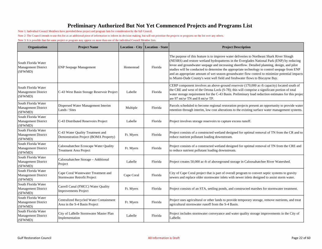
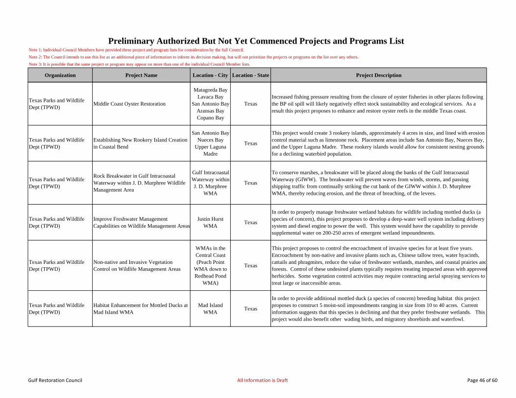
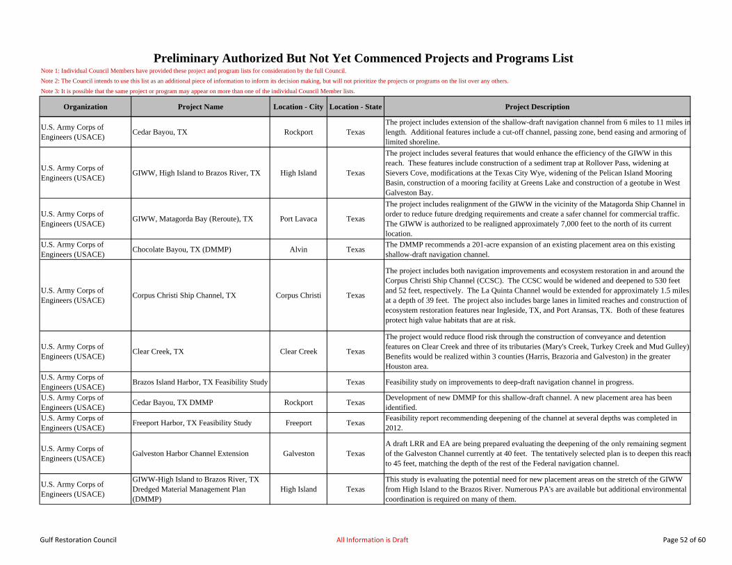
Note 1: Individual Council Members have provided these project and program lists for consideration by the full Council.
Note 2: The Council intends to use this list as an additional piece of information to inform its decision making, but will not prioritize the projects or programs on the list over any others.
Note 3: It is possible that the same project or program may appear on more than one of the individual Council Member lists.
Organization Project Name Location - City Location - State Project Description
Baldwin County Commission
Beach Renourishment and Restoration Trust Fund
Gulf Shores, Orange Beach, Unincorporated Baldwin County
AlabamaFund a Baldwin Beach Trust for long-term restoration solution to ongoing and tropical event beach erosion.
City of MobileEco-Restoration/Dredging of Dog River and Tributaries
Mobile AlabamaRestore lost wetland habitat due to sedimentation of Dog River and tributaries through dredging and restoration.
City of Mobile Map City of Mobile Drainage Systems Mobile Alabama Complete GIS Mapping of City of Mobile drainage systems.
City of MobileCarlisle Area Drainage Repair/Upgrade Additional Phases
Mobile AlabamaReduce sediment loading to Three Mile Creek by improving Carlisle area drainage through sediment stabilization and maintaining bank green space.
City of MobileRepair/Maintenance of Montlimar Creek, Bolton’s Branch, and Eslava Creek
Mobile AlabamaProject will address need for maintenance of existing major drainage way (Montlimar Creek) and two of its major tributaries.
City of Mobile Repair/Maintenance of Three Mile Creek Mobile Alabama Repair major earthen channel and drop structures to eliminate sedimentation and erosion.
City of MobileSpring Creek Drainage Repair/Upgrade Additional Phases
Mobile Alabama Reduce Dog River sediment load by improving Spring Creek Drainage.
Dog River Clearwater Revival
Clean, Healthy, Resilient Dog River: MooreCreek Bandalong Litter Trap and Eslava Creek Bandalong Litter Trap
Mobile Alabama Prevent litter from entering Dog River Creek with Bandalong Litter Trap.
Dog River Clearwater Revival
Dog River Scenic Blueway Mobile Alabama Promote habitat revitalization and nature-based tourism via a Dog River Scenic Blueway.
Alabama Perform hydrogeologic analysis and develop regional aquifer protection strategies.
Mobile Area Water & Sewer System (MAWSS)
MAWSS Wetland Construction for Removal of Pollutants in Watershed Tributaries
Mobile County Alabama Construct Big Creek wetlands for removal of sediment & pollutants in watershed tributaries.
Mobile County Public Works
Mobile County Parks and Recreational Facilities
Mobile County AlabamaAcquire additional park and recreational space including waterfront and ecologically sensitive areas.
Mobile County Soil and Water Conservation District
Dauphin Island Habitat Restoration Program Partnership with Mobile County Public Schools
Dauphin Island Alabama Increase funding for program for beach and marshland vegetation restoration by MCPSS students.
Town of LoxleyInterstate 10/Highway 59 Drainage Improvements
Loxley AlabamaConstruct major drainage improvements to eliminate storm water flooding of critical evacuation corridor at 1-10 and Hwy 59 interchange.
Preliminary Authorized But Not Yet Commenced Projects and Programs List
ALABAMA
Gulf Restoration Council All Information is Draft Page 1 of 60
Note 1: Individual Council Members have provided these project and program lists for consideration by the full Council.
Note 2: The Council intends to use this list as an additional piece of information to inform its decision making, but will not prioritize the projects or programs on the list over any others.
Note 3: It is possible that the same project or program may appear on more than one of the individual Council Member lists.
Organization Project Name Location - City Location - State Project Description
Preliminary Authorized But Not Yet Commenced Projects and Programs List
U.S. Geological Survey Alabama Hurricane Storm Surge NetworkMobile and
Baldwin Counties
Alabama Create a hurricane storm surge network to document characteristics of tropical storm events.
U.S. Geological SurveyAssessment of Groundwater Availability and Vulnerability in Coastal Areas of Mobile and Baldwin Counties, AL
Baldwin County Alabama Increase Baldwin electrical resiliency through multiple projects.
City of Mobile Mobile Regional Recycling Center Mobile Alabama Construct a Mobile Regional Recycling Center.
City of MobileEco Restoration/Dredging of Langan Park Lake (Municipal Lake)
Mobile Alabama Dredge lakes of Langan Park to restore recreational use and wildlife habitat.
City of MobileCity Wide Bridge/Culvert Maintenance Project
Mobile Alabama Repair City of Mobile bridges and culverts.
City of MobileFlorida St. Drainage Repair/Upgrade Additional Phases
Mobile Alabama Repair and upgrade Florida St drainage to reduce flooding.
City of MobileLittle Stickney Drainage Repair/Upgrade Additional Phases
Mobile Alabama Reduce rain event flooding by improving Little Stickney Drainage.
City of MobileDrainage Improvements in the Southern Drain Watershed
Mobile Alabama Southern watershed drainage improvements to address areas of high flooding frequency.
Daphne UtilitiesDaphne Utilities Wastewater Treatment and Collection System Improvements
Daphne Alabama Eliminate pollution sources & enhance Blakeley River, Mobile Bay, D'Olive Creek water quality.
City of Foley Utilities BoardFoley Wastewater Collection System Rehabilitation Project
Foley AlabamaProvide infrastructure upgrades to sewer system to minimize storm water run offs and sanitary sewer overflows.
Mobile Area Water & Sewer System (MAWSS)
MAWSS Low Pressure Sewer System to Replace On-Site Systems in Sensitive Riverine Areas
Mobile County Alabama Improve Dog River water quality by providing sewer service to residences now on septic tank.
Mobile Area Water & Sewer System (MAWSS)
MAWSS Big Creek Lake Reservoir Spill Containment Structure
Mobile County Alabama Protect Mobile’s water supply reservoir from acts of terrorism or transportation mishaps.
Gulf Restoration Council All Information is Draft Page 2 of 60
Note 1: Individual Council Members have provided these project and program lists for consideration by the full Council.
Note 2: The Council intends to use this list as an additional piece of information to inform its decision making, but will not prioritize the projects or programs on the list over any others.
Note 3: It is possible that the same project or program may appear on more than one of the individual Council Member lists.
Organization Project Name Location - City Location - State Project Description
Preliminary Authorized But Not Yet Commenced Projects and Programs List
Mobile Area Water & Sewer System (MAWSS)
MAWSS Pumps to Supply Emergency Back-Up Water Source
Mobile Alabama Provide alternate emergency water supply to single existing source of Big Creek Lake.
Mobile Area Water & Sewer System (MAWSS)
MAWSS Waterline Construction to Serve as Emergency Backup Line to Spanish Fort Area
Spanish Fort Alabama Construct emergency water backup supply to Spanish Fort.
Mobile County Emergency Management
New Emergency Operations Center for Mobile County
Mobile County AlabamaFacilitate disaster response through construction of facility adequate to co-locate multi-agency response teams.
Mobile County Emergency Management
Community Shelter Network for Mobile County
Mobile County Alabama Construct 9 public shelters rated Category 5 throughout Mobile County.
Mobile County Public Works
Mobile County Evacuation Route Improved Access to Mobile Regional Airport
Mobile County Alabama Improve south Mobile County Evacuation Route to Mobile Regional Airport.
Mobile County Public Works
Mobile County Evacuation Route Improved Capacity and Improved Access to Mobile County Public Schools
Mobile County Alabama Increase south Mobile county evacuation capacity with collateral improved Public School Access.
Mobile County Public Works
Mobile County Wastewater Treatment Facilities
Mobile County Alabama Provide wastewater treatment facilities for unincorporated Mobile County.
Mobile County Public Works
Mobile County Public Safety Radio Safety and Microwave Loop for 800 MHz System
Mobile County AlabamaAdd additional microwave communication towers to obtain complete coverage of Mobile County as well as uniform regional coverage.
Mobile County Public Works
Mobile County P-25 Compliant Communications System Upgrade
Mobile County AlabamaUpgrade Mobile County radio system to be P25 compliant as encouraged by Federal Communication Commission (FCC).
Mobile County Public Works
Mobile County Metro Jail Flood Protection System
Mobile County Alabama Construct retaining wall to protect Mobile Metro Jail from Category 3 storm surge.
Prodisee Pantry, Spanish Fort
Construct food storage & distribution facility for economic and disaster relief
Spanish Fort Alabama Construct food storage and distribution facility for economic and disaster relief.
South Alabama Regional PlanningCommission
Coastal AL Small Business Revolving LoanFund
Mobile and Baldwin Counties
AlabamaExpand existing small business revolving loan fund to provide emergency cash flow for disaster relief.
Town of Loxley Loxley Public Sewer Upgrade Loxley Alabama Increase sewer system capacity to eliminate storm water runoffs and sanitary sewer overflows.
Alabama Dept of Transportation
Mobile Bay Causeway/US HWY 98 Hydrological Restoration Project
Mobile/Spanish Fort
AlabamaImplementation of USACE’s Upper Mobile Bay Ecosystem Restoration Project Proposed Modification of US Highway 90 (Causeway), Planning Assistance to States Project (September 2001).
ADCNR/EPA-Gulf of Mexico Program
Alabama Gulf Ecological Management Site-Community-Based Restoration Program
Mobile and Baldwin Counties
AlabamaImplementation of the conservation, preservation and restoration objectives in the Alabama GEMS Sites.
Gulf Restoration Council All Information is Draft Page 3 of 60
Note 1: Individual Council Members have provided these project and program lists for consideration by the full Council.
Note 2: The Council intends to use this list as an additional piece of information to inform its decision making, but will not prioritize the projects or programs on the list over any others.
Note 3: It is possible that the same project or program may appear on more than one of the individual Council Member lists.
Organization Project Name Location - City Location - State Project Description
Preliminary Authorized But Not Yet Commenced Projects and Programs List
ADCNR/Mobile Bay NEPCoastal Alabama Submerged Aquatic Vegetation Monitoring Program
Mobile and Baldwin Counties
AlabamaImplementation of the Alabama Coastal Area Management Program/Mobile Bay NEP Submerged Aquatic Vegetation Monitoring Program.
Alabama Dept of Conservation and Natural Resources
AlabamaImplementation of the Alabama Coastal Area Management Program Section 309 Strategy Living Shorelines Initiative, including the planning, finding and construction of living shorelines-type projects in Mobile and Baldwin Counties.
Alabama Dept of Conservation and Natural Resources
Improved Access to Natural Resources and Habitat Restoration on State-owned Tracts along the US Hwy 98 Causeway Mobile and Baldwin Counties, Alabama
Mobile/Spanish Fort
Alabama
This project would improve, renovate and restore public access sites along the US Highway 98 Causeway. This would include improving existing boat ramps, improving sites used by subsistence and recreational fishermen, providing improved access to the natural resources of Upper Mobile Bay and the lower Mobile/Tensaw River Delta and associated Wildlife Management Areas, and conducting habitat restoration activities.
Alabama Dept of Conservation and Natural Resources
Habitat Restoration, Hydrological Restoration, Invasive Species Control and Reforestation on Forever Wild Land Trust Tracts in Coastal Alabama
Mobile and Baldwin Counties
Alabama
This project would included the repair of man-made hydrological impairments on State-owned lands, including drainage ditches, breaches in the natural flood levee and “pull ditches” remaining from historic logging operations. Additionally, the removal of invasive species, including Chinesetallow tree, cogon grass and similar species using selective application of herbicides, physical removal and prescribed fire would be conducted. Replanting of native vegetation would follow these activities. Other habitat restoration and protection activities may also take place. Project would take place on State-owned tracts in the Grand Bay Savannah, the Mobile-Tensaw River Delta (Delta), the Weeks Bay National Estuarine Research Reserve, Lillian Swamp, Mon Louis Island, the Perdido River Corridor and other tracts in Mobile and Baldwin Counties, AL.
Alabama Dept of Conservation and Natural Resources
Implement ADCNR Restoration Priorities including marsh restoration, oyster reef restoration, offshore reef restoration, submerged aquatic vegetation restoration and other estuarine and coastal resource restoration activities.
Mobile and Baldwin Counties
AlabamaImplement ADCNR Restoration Priorities including marsh restoration, oyster reef restoration, offshore reef restoration, submerged aquatic vegetation restoration and other estuarine and coastal resource restoration activities. Projects would span a wide range of habitats and locations.
ADCNR/Mobile Bay NEP
Implementation of MBNEP’s “Conserving Alabama’s Coastal Habitats: Acquisition and Restoration Priorities of Mobile and Baldwin Counties”
Mobile and Baldwin Counties
Alabama
Implementation of MBNEP’s “Conserving Alabama’s Coastal Habitats: Acquisition and Restoration Priorities of Mobile and Baldwin Counties”, a plan developed in cooperation with TNC, EPA-GMP and other state, local and federal partners. Projects would include acquisition, preservation and restoration of identified priority sites throughout Mobile and Baldwin Counties.
Alabama Dept of Conservation and Natural Resources
Implementation of Weeks Bay Reserve Master Plan
Fairhope Alabama
The Facility Master Plan (Master Plan) has been developed to assist future planning at Weeks Bay National Estuarine Research Reserve. It responds to program developments that are foreseen in the near to long term future. As programs grow and develop, this document will assist in providing guidance through implementation of various projects.
Gulf Restoration Council All Information is Draft Page 4 of 60
Note 1: Individual Council Members have provided these project and program lists for consideration by the full Council.
Note 2: The Council intends to use this list as an additional piece of information to inform its decision making, but will not prioritize the projects or programs on the list over any others.
Note 3: It is possible that the same project or program may appear on more than one of the individual Council Member lists.
Organization Project Name Location - City Location - State Project Description
Preliminary Authorized But Not Yet Commenced Projects and Programs List
Mobile Bay NEPSustaining Alabama's Working Waterfront through Oyster Aquaculture
Mobile and Baldwin Counties
AlabamaRestore priority intertidal marshes and flats with a combination of habitat for nursery sustainability, commercial fishing, recreational fishing, and oyster farming
Mobile Bay NEPSweetwater Branch/Chickasaw Creek Watershed Stream Restoration
Mobile AlabamaRestore streams (including system hydrology where feasible), riparian buffers and freshwater wetlands in priority watersheds to improve watershed discharges to fishery nursery areas and SAVbeds.
Mobile Bay NEPTiti Swamp Wetland Acquisition and Preserve
Mobile and Baldwin Counties
AlabamaProtect critical habitats that contribute to the health of fishery and water quality through acquisition, conservation easement, or other method.
Mobile Bay NEP Restore/Enhance Gulf Fronting Beaches Mobile Alabama Town of Dauphin Island Beach and Barrier Restoration Project.Mobile Bay NEP Restore/Enhance Estuarine Beaches Baldwin Alabama Town of Perdido Beach Shoreline Restoration Project.
Mobile Bay NEPWetland Breakwater Construction in Mobile Bay Using Dredged Material
Mobile and Baldwin Counties
AlabamaRestore salt marshes; encourage expanded use of dredge material for use in near shore and intertidal marshes and flats (net gain 100 acres).
Mobile Bay NEPWolf Bay Wetland Nature Preserve A Coastal Resource Recovery Land Acquisition Project
Baldwin Alabama Protect/conserve priority habitats for public benefit through land acquisition.
Mobile Bay NEP
Restore priority watersheds in urban areas through development and implementation of comprehensive watershed management plans that target reductions in non-point source pollutants
Baldwin AlabamaWolf Creek Restoration - streambed, wetlands and uplands through stormwater management improvements.
Alabama Dept of Conservation and Natural Resources
Monitoring and assessment of offshore fin-fish stocks
Mobile and Baldwin Counties
AlabamaMonitoring of recreationally and commercially important finfish species in state and federal waters of the Gulf of Mexico offshore of Alabama.
Alabama Dept of Conservation and Natural Resources
Maintenance and Improvement of State-owned Boating Access Sites
Mobile and Baldwin Counties
AlabamaMaintenance and Improvement of state-owned boating access sites in Mobile and Baldwin Counties, including repairing ramps, docks & piers, dredging of basins & access channels, improved lighting and other associated activities.
Alabama State Port Authority
Maintenance of Small Harbor Navigation Projects.
Mobile and Baldwin Counties
AlabamaMaintenance of small harbor navigation projects, such as Bayou La Batre, Bayou Coden, East Fowl River and Perdido Pass, to improve access to local waters.
Alabama Dept of Conservation and Natural Resources
Improvements and Support of Operations at the Claude-Peteet Mariculture Center
Baldwin County AlabamaLong-term maintenance and operations to support the production of important marine finfish species.
Alabama Dept of Conservation and Natural Resources
Biodiversity Inventories in Designated Protected Areas of Coastal Alabama
Mobile and Baldwin Counties
AlabamaThe objective of this project is to implement three biological surveys detailing plant and animal species composition and biodiversity. The surveys will result in a report and geographic database of species locations.
Gulf Restoration Council All Information is Draft Page 5 of 60
Note 1: Individual Council Members have provided these project and program lists for consideration by the full Council.
Note 2: The Council intends to use this list as an additional piece of information to inform its decision making, but will not prioritize the projects or programs on the list over any others.
Note 3: It is possible that the same project or program may appear on more than one of the individual Council Member lists.
Organization Project Name Location - City Location - State Project Description
Preliminary Authorized But Not Yet Commenced Projects and Programs List
Alabama Dept of Conservation and Natural Resources
Assessment of Coastal Alabama Salt Marsh Communities
Mobile and Baldwin Counties
AlabamaThe objective of this project is to implement three assessments of salt marsh indicators species. The assessment will result in a report and a geographic database.
Alabama Dept of Conservation and Natural Resources
Development of Natural Resource-based Public Education and Outreach Materials for Coastal Alabama
Mobile and Baldwin Counties
Alabama
This project will design and print five separate conservation education products such as books, maps, videos, posters, calendars, and/or brochures for distribution to schools to educate at least 70,000 students. In addition, this project will construct a water quality kiosk at Five Rivers Alabama’s Natural Resource Center to provide 75,000 people annually a hands-on interactive exhibit of water quality dynamics.
Alabama Dept of Conservation and Natural Resources
Implement and Expand Prescribed Burning Program
Mobile and Baldwin Counties
AlabamaThe objective of this project is to initiate fire on 1000 acres throughout designated protected areas in coastal Alabama.
Alabama Dept of Conservation and Natural Resources
Expansion of the Graduate Research Program at Weeks Bay National Estuarine Research Reserve
Fairhope AlabamaThis project will fund four (4) years of a graduate student stipend including tuition, research materials, and salaries to conduct research of harmful algal blooms in Weeks Bay, resulting in a final report.
Alabama Dept of Conservation and Natural Resources
Alabama Coastal Area Management Program Web Portal
NA AlabamaThis project will create and implement a multi-faceted educational website dedicated to supporting the mission of the Alabama Coastal Area Management Program (ACAMP).
Alabama Dept of Conservation and Natural Resources
Support of Natural Resource Damage Assessment Program (NRDA) in Coastal Alabama
NA Alabama
The objective of this project is to assist the DCNR State Lands Division in acquiring relevant data and research to support natural resource trustee injury assessment activities at Superfund sites in coastal Alabama. This project will result in collection and analysis of data sets, written reports, development of restoration plans and contracted professional services which support natural resource trustee injury restoration.
Alabama Dept of Conservation and Natural Resources
Land Acquisition in the Mobile-Tensaw Delta, Perdido River Corridor and/or LillianSwamp, Baldwin County
Mobile and Baldwin Counties
AlabamaThe objective of this project is to acquire approximately 5,000 acres of sensitive land for conservation in the Mobile-Tensaw Delta, Perdido River Corridor, and/or Lillian Swamp.
Alabama Dept of Conservation and Natural Resources
Land Acquisition in the Escatawpa River Corridor and/or Coastal Mobile County
Mobile County AlabamaThe objective of this project is to acquire approximately 5,000 acres of sensitive land for conservation in the Escatawpa River Corridor and/or other sensitive habitats within coastal MobileCounty.
Alabama Dept of Conservation and Natural Resources
Artificial Reef -- Construction, Research, and Development
Mobile and Baldwin Counties
AlabamaThe objective of this project is to construct, research and develop one-hundred (100) acres of offshore fishery enhancement reefs in coastal Alabama.
Alabama Dept of Conservation and Natural Resources
Outreach for Local Marine Conservation Awareness Public Service Announcement
NA Alabama
The objective of this project is to produce at least five (5) different forms of marine resource educational materials, including ten-thousand (10,000) brochures, two (2) television commercials, and one (1) informative website. Topics for outreach include invasive species, commercial harvests, recreational bag limits, bycatch, shoreline development, and habitat protection and enhancement.
Alabama Dept of Conservation and Natural Resources
Bathymetric, Seismic, and Vibracore Survey of Federal Waters
Mobile and Baldwin Counties
AlabamaThe objective of this project is to conduct a comprehensive bathymetric, seismic, and vibracore survey to perform sedimentological analysis offshore of Baldwin and Mobile Counties to identify sand for future beach renourishment projects.
Gulf Restoration Council All Information is Draft Page 6 of 60
Note 1: Individual Council Members have provided these project and program lists for consideration by the full Council.
Note 2: The Council intends to use this list as an additional piece of information to inform its decision making, but will not prioritize the projects or programs on the list over any others.
Note 3: It is possible that the same project or program may appear on more than one of the individual Council Member lists.
Organization Project Name Location - City Location - State Project Description
Preliminary Authorized But Not Yet Commenced Projects and Programs List
Alabama Dept of Conservation and Natural Resources
Development of GIS-based Applications and Digital Data to Assist in Management of Alabama's Coastal Resources
NA Alabama
The objective of this project is to develop four GIS-based applications and associated digital data to assist in the management of Alabama’s coastal resources including a GIS-based erosion model, shoreline classification model of Mobile Bay, Land Use/Land Cover analysis of both coastal counties from 1995 to 2005, and a turbidity study of Mobile Bay.
Baldwin County Commission
Erosion Control Materials for Highway Department
Silverhill AlabamaThe objective of this initiative is to purchase materials to be used by the County Highway Department and the County Parks Department to reduce the potential for erosion and sediment runoff.
Baldwin County Commission
Enhancement of Recycling Facility at Magnolia Landfill
Summerdale AlabamaThe objective is to increase the amount of recyclable material processed as well as eliminate recyclables from being disposed of in the Magnolia Landfill.
Baldwin County Commission
Household Hazardous Waste Amnesty Day Baldwin County AlabamaThe objective is to hold two (2) Household Hazardous Waste Amnesty Days (one per year for two years) to provide the opportunity for proper disposal of hazardous wastes.
Baldwin County Commission
Water & Wastewater Infrastructure Study Baldwin County AlabamaThe objective of this initiative is to hire a consultant to conduct an assessment on issues related to wastewater and groundwater in Baldwin County. The final product would be a written report submitted to the Baldwin County Commission.
Mobile County Commission Mobile County Conservation Acquisition Mobile County AlabamaThe objective of this project is to purchase approximately 800 acres of coastal areas and manage the tracts for conservation purposes. Elements of this project include appraising potential parcels for acquisition and developing and implementing conservation management plans.
Mobile County Commission South Mobile County Wastewater Facilities Mobile County AlabamaThe objective of the project is to construct a collection system to connect residential properties that currently use on-site sewage disposal systems, to a wastewater treatment plant. Approximately 200 homes will be served with a collection system.
Mobile County CommissionDauphin Island Causeway Restoration, Protection, and Public Access Project
Mobile County AlabamaThe objectives of the project are to expand the protective buffer along the right of way of the causeway, restore and enhance the causeway shoreline to promote wetland vegetation re-growth, improving the habitat for marine life, and to provide additional public access points.
Mobile County Commission West Mobile County Wastewater Facilities Mobile County AlabamaThe objective of the project is to construct a collection system to connect residential properties that currently use on-site sewage disposal systems to a wastewater treatment plant. Approximately 200 homes will be served with a collection system.
Mobile County Commission Theodore Ship Channel Boat Access Theodore Alabama
The objective of this project is to prevent and abate long-term damage to seagrasses, wetland areas, and the shoreline due to uncontrolled access to the sensitive habitats within the project site by providing public access infrastructure and stabilizing the shoreline to prevent future degradation of wetlands.
Mobile County Commission Erosion & Sediment Control Mobile County AlabamaThe objective is to protect 300 acres of environmentally sensitive areas by implementing erosion control measures to prevent sediment transport with a surface treatment and/or the stabilization of at least 6 miles of dirt roads.
Gulf Restoration Council All Information is Draft Page 7 of 60
Note 1: Individual Council Members have provided these project and program lists for consideration by the full Council.
Note 2: The Council intends to use this list as an additional piece of information to inform its decision making, but will not prioritize the projects or programs on the list over any others.
Note 3: It is possible that the same project or program may appear on more than one of the individual Council Member lists.
Organization Project Name Location - City Location - State Project Description
Preliminary Authorized But Not Yet Commenced Projects and Programs List
Mobile County Commission Bayfront Park Improvements Mobile County Alabama
The objective of this project is to restore 7 to 12 acres of native vegetation including wetlands, place eight (8) interpretive signs that vary in size (12 to 36 inches) to educate the public on seagrass habitats, protection of wetlands, wildlife, and environmentally-friendly low impact activities. The project will also construct and enhance public access infrastructure.
Mobile County CommissionErosion Control Equipment for Public Works Department
Mobile County AlabamaThe objective of this initiative is the purchase of equipment to be used by the County Public Works Department and the County Parks and Recreation Department to reduce the potential for stormwater induced erosion.
Mobile County CommissionEscatawpa Hollow River Park Acquisition and Education Center
Mobile County Alabama
The primary objective of the project is to use CIAP funding to acquire the privately owned, 50-acre, Escatawpa Hollow Campground and Canoe Rental property and renovate facilities and infrastructure to provide a range of education and public access options while protecting the area from development pressures. An education center will provide public information on black water ecosystems. Water quality monitoring will take place on site and the facility will serve as a launching site for additional monitoring projects.
Alabama Dept of Conservation and Natural Resources
Bon Secour Land Acquisition ProjectNear Gulf
Shores, ALAlabama
This objective of this project is to purchase approximately 11.82 acres of coastal wetlands and uplands on the Bon Secour River in southwestern Baldwin County.
Alabama Dept of Conservation and Natural Resources
Investigation and Research of the West Indian Manatee and Freshwater Turtle Populations in Coastal Alabama
Mobile and Baldwin Counties
Alabama
This project will conduct research projects related to the West Indian Manatee (Trichechus manatus) and freshwater turtle populations providing critical data for decision-making activities that support long-term conservation, management, and restoration efforts. Each project will result in detailed report summarizing the research and associated findings.
Alabama Dept of Conservation and Natural Resources
Beneficial Use of Dredged Material from the Mobile Ship Channel
Dauphin Island AlabamaThis project will pay for additional costs associated with locating 1,000,000 cubic yards of dredged materials from the Mobile Ship Channel to Dauphin Island’s nearshore area instead Sand Island Beneficial Use Area.
Alabama Dept of Conservation and Natural Resources
Restoration of Dauphin Island's West End Dunes
Dauphin Island AlabamaThe goal of this project is to construct 10 acres of dune habitats along the west end of Dauphin Island.
Alabama Dept of Conservation and Natural Resources
Stream Restoration of Tributary to Tiawasee and D'Olive Creek
Daphne AlabamaThe objective of this project is the restore 800 linear feet of D’Olive Creek and 1000 linear feet of Tiawasee Creek in the City of Daphne in Baldwin County.
Alabama Dept of Conservation and Natural Resources
Perdido Bay Coastal Islands Acquisition Orange Beach AlabamaThe objective of this project is to purchase 2 coastal islands (Gilchrist Island and Walker Island) in Orange Beach, Baldwin County, Alabama.
Alabama Dept of Conservation and Natural Resources
Oyster Reef Enhancement: Quantifying Benefits to the Fishery
Dauphin Island Alabama
The objective of this project is to establish approximately 16 acres of oyster reefs in several suitable locations within Alabama coastal waters for fisheries enhancement and improved ecological services. The oyster reefs will be owned by the State of Alabama and will not be leased to commercial oyster fisherman.
Gulf Restoration Council All Information is Draft Page 8 of 60
Note 1: Individual Council Members have provided these project and program lists for consideration by the full Council.
Note 2: The Council intends to use this list as an additional piece of information to inform its decision making, but will not prioritize the projects or programs on the list over any others.
Note 3: It is possible that the same project or program may appear on more than one of the individual Council Member lists.
Organization Project Name Location - City Location - State Project Description
Preliminary Authorized But Not Yet Commenced Projects and Programs List
Alabama Dept of Conservation and Natural Resources
Coastal Alabama Land AcquisitionMobile and
Baldwin Counties
Alabama This project will purchase land for conservation within the coastal area of Alabama.
Alabama Dept of Conservation and Natural Resources
Habitat Protection and Restoration along State-Owned Lands in South Mobile County
Mobile County AlabamaThe objective of this project is to protect and restore salt marsh habitat and other habitats along State-owned shorelines located along Grand Bay, Portersville Bay and Mississippi Sound.
Alabama Dept of Conservation and Natural Resources
Submerged Aquatic Vegetation Mapping in Coastal Alabama
Mobile and Baldwin Counties
AlabamaThe objective of this project is to produce a comprehensive map of the Submerged Aquatic Vegetation (SAVs) in the Alabama Coastal Area in order to establish a comprehensive data set of SAV coverage and species composition.
Alabama Dept of Conservation and Natural Resources
Construction of a 1500-foot Boardwalk at the Weeks Bay Reserve
Fairhope AlabamaThis project will construct a 1500 linear feet in length boardwalk at Weeks Bay Reserve to complement stewardship activities occurring in connection with the existing boardwalk receiving over 20,000 visitors annually.
Alabama Dept of Conservation and Natural Resources
Enhancement, Research, and Development of Alabama's Artificial Reef System
Gulf Shores Alabama
The objective of this project is to enhance habitat through development and/or rehabilitation of artificial reefs, conduct research pertaining to artificial reefs, and continue the development of the artificial inshore and offshore reef zones under the jurisdiction of the Alabama Marine Resources Division.
Alabama Dept of Conservation and Natural Resources
Water Quality Enhancement in Coastal Watersheds
Mobile and Baldwin Counties
AlabamaThe objective is to protect coastal wetlands and watersheds by implementing erosion control measures through stabilization of dirt roads.
Baldwin County Commission
Stream Restoration for Tributary to Tiawasee Creek
Daphne AlabamaThe objective of this project is the restoration of approximately one thousand (1,000) linear feet ofan unnamed tributary of Tiawasee Creek. The restoration will serve to stop severe erosion, establish grade controls and re-establish floodplain connectivity.
Baldwin County Commission
Nature Center at Bicentennial Park Stockton AlabamaThe objective of this project is to construct an approximately 4,000 square foot environmental educational facility as well as boardwalks and observation platforms within Bicentennial Park.
Baldwin County Commission
Acquisition of Property for Conservation & Public Access
Baldwin County AlabamaThe goal of this project is to acquire property that will provide conservation and protection for sensitive wetland areas and wildlife habitat while also providing citizens with public access.
Mobile County CommissionHousehold Hazardous Waste Collection Events
Mobile County AlabamaThe objective of the project is to provide citizens opportunities to properly dispose of household hazardous waste and other difficult waste streams.
Mobile County Commission Habitat Restoration on Public Lands Mobile County Alabama
Objectives of the program include developing the scientific understanding necessary to direct current and future projects for the benefit of economically and ecologically important habitat and threatened and endangered plants and animals as well as implementing habitat restoration projects that enhance the services and benefits provided by coastal ecosystems.
Alabama Dept of Conservation and Natural Resources
Implementation of Weeks Bay National Estuarine Research Reserve Management Plan
Fairhope AlabamaImplementation includes environmental education, research, habitat restoration and conservation through land acquisition, permanent conservation easements, and agreements with willing landowners.
Gulf Restoration Council All Information is Draft Page 9 of 60
Note 1: Individual Council Members have provided these project and program lists for consideration by the full Council.
Note 2: The Council intends to use this list as an additional piece of information to inform its decision making, but will not prioritize the projects or programs on the list over any others.
Note 3: It is possible that the same project or program may appear on more than one of the individual Council Member lists.
Organization Project Name Location - City Location - State Project Description
Preliminary Authorized But Not Yet Commenced Projects and Programs List
Alabama Dept of Conservation and Natural Resources
Gulf State ParkGulf Shores,
Orange BeachAlabama
Habitat restoration and conservation including land acquisition, permanent conservation easements, and agreements with willing landowners.
Alabama Dept of Conservation and Natural Resources
Meaher State Park Spanish Fort AlabamaHabitat restoration and conservation including land acquisition, permanent conservation easements, and agreements with willing landowners.
Alabama Dept of Conservation and Natural Resources
Historic Blakeley State Park Spanish Fort AlabamaHabitat restoration and conservation including land acquisition, permanent conservation easements, and agreements with willing landowners.
Alabama Dept of Conservation and Natural Resources
Alabama Coastal Area Management Program Public Access Management Program
Mobile and Baldwin Counties
AlabamaObjective is to support, enhance, or develop new sites for public access to public lands and waters in Coastal Alabama.
Alabama Dept of Environmental Management/ Alabama Dept of Public Health
Coastal Alabama Beach Monitoring Program
Mobile and Baldwin Counties
AlabamaMonitoring and assessment of coastal recreational waters at 25 high use areas from Perdido Bay toDauphin Island, and the prompt notification of the public when applicable water quality standards are not being met.
Alabama Dept of Conservation and Natural Resources
Implementation of Coastal and Marine Spatial Planning for Coastal Alabama
Mobile and Baldwin Counties
Alabama Development of a Coastal and Marine Spatial Plan for Coastal Alabama.
Mobile Bay NEPImplementation of MBNEP's Comprehensive Conservation and Management Plan (CCMP)
Mobile and Baldwin Counties
AlabamaImplementation of MBNEP's CCMP which efforts related to access, beaches and shorelines, fish, heritage and culture, resiliency, water quality, stormwater, and public indifference.
Alabama Dept of Environmental Management
Implementation of Total Maximum Daily Loads (TMDLs) or Watershed Protection Plans in coastal watersheds
Mobile and Baldwin Counties
Alabama
Implement components of restoration plans, TMDL plans, or watershed protection plans for impaired coastal waterbodies. Implementation may include the use of Best Management Practices(BMPs) and other efforts to reduce nonpoint source pollution; upgrading failing wastewater collection systems and other infrastructure; replacing failing on-site sewerage systems; monitoring the effectiveness of implementation activities, or constructing polishing wetlands.
Alabama Dept of Environmental Management/Alabama Dept of Conservation and Natural Resources
Implementation of Alabama's Coastal Nonpoint Source Pollution Control Program
Mobile and Baldwin Counties
Alabama Implement management measures to address nonpoint pollution problems in coastal waters.
Gulf Restoration Council All Information is Draft Page 10 of 60
Note 1: Individual Council Members have provided these project and program lists for consideration by the full Council.
Note 2: The Council intends to use this list as an additional piece of information to inform its decision making, but will not prioritize the projects or programs on the list over any others.
Note 3: It is possible that the same project or program may appear on more than one of the individual Council Member lists.
Organization Project Name Location - City Location - State Project Description
Preliminary Authorized But Not Yet Commenced Projects and Programs List
Alabama Dept of Environmental Management
Water Supply Management for Coastal Alabama
Mobile and Baldwin Counties
AlabamaStudy and address water resource issues including freshwater inflow, water shortages and water supply management for coastal Alabama.
Alabama Dept of Environmental Management
Post MC252 Beach Patrol; Tar Ball and Oiling Monitoring and Abatement
Gulf front beaches from
Perdido Key to Dauphin Island
Alabama
Conduct Daily Surveys of beach segments in Mobile and Baldwin Counties where oiling was more significant during the MC252 Incident Response. Report discovered oil (tar balls) to NRC, mitigate when possible, generate daily reports, and deliver mitigated tar balls to USCG for proper documentation and disposal.
Alabama Dept of Environmental Management
Coastal Water Quality Monitoring Program
Bays, estuaries, bayous, and near shore waters of
Mobile and Baldwin Counties
Alabama
The Coastal Alabama Water Quality Monitoring Program provides for expanded coverage with the addition of 20 water quality monitoring stations in the Coastal Waters of Alabama. This effort will locate monitoring stations in a different estuary each year implementing a five year rotation. Iwill provide data that will provide necessary information allowing for more precise assessment of water quality conditions for designated estuaries and coastal rivers and streams. Additionally, the project integrates monitoring of priority watersheds identified by ADEM’s Nonpoint Source Management Program (6217) to provide corroborating data concerning the effectiveness of BMP implementation and enables the leveraging of other funds.
NRCS/Dale County Soil and Water Conservation District and the Dale County Commission
Camp Branch Site 18 Gully RepairCamp Branch
Site 18Alabama
Gully is still active and adds between 150 to 200TN/Yr of sediment to the Little Choctawhatchee River which flows into the Choctawhatchee Bay. Gully is also threatening electrical infrastructureThe repair is needed to correct the environmental problem.
NRCS/Long Beach Drainage District
Long Beach Canal 1 Repair Long Beach Mississippi Long Beach Canal 1- Channel enlargement of Canal 1 in Long Beach MS.
NRCS/LA Coastal Protection and Restoration Authority
Alligator Bend Shoreline Protection Project (PL-646)
See description. Louisiana
The Alligator Bend Shoreline Protection Project is a fully designed project, which has not been funded for construction. The project will maintain the East Orleans Landbridge by stopping shoreline erosion and protecting the inland wetlands between Lake Borgne and Lake St. Catherine. The shoreline protection features will directly protect the shoreline integrity of Lake Borgne and prevent breaching of the lake shoreline into the marsh. The project is estimated to yield 192 net acres over the 20 year project life at a fully funded cost of $56,006,897. The project is federally sponsored by NRCS.
NRCS/LA Coastal Protection and Restoration Authority
South Grand Chenier Marsh Creation Project (PL-646)
See description. Louisiana
The South Grand Chenier Marsh Creation Project is a fully designed project, which has not been funded for construction. The project will restore the marsh through dedicated dredging from the Gulf of Mexico. The project features will result in 453 net acres benefitting both intermediate andbrackish marsh over the 20-year project life at a fully funded cost of $21,933,085. The project is federally sponsored by the US Fish and Wildlife Service and designed by NRCS.
DEPARTMENT OF AGRICULTURE
Gulf Restoration Council All Information is Draft Page 11 of 60
Note 1: Individual Council Members have provided these project and program lists for consideration by the full Council.
Note 2: The Council intends to use this list as an additional piece of information to inform its decision making, but will not prioritize the projects or programs on the list over any others.
Note 3: It is possible that the same project or program may appear on more than one of the individual Council Member lists.
Organization Project Name Location - City Location - State Project Description
Preliminary Authorized But Not Yet Commenced Projects and Programs List
NRCS/LA Coastal Protection and Restoration Authority
West Pointe a la Hache Siphon Improvement Project (PL-646)
See description. Louisiana
The West Pointe a la Hache Siphon Improvement Project is a project currently in the planning anddesign phase, which will provide improvements in equipment and operation of an existing siphon-operated fresh water diversion structure on the Mississippi River in Plaquemines Parish. Once constructed the project is estimated to benefit a project area, totaling nearly 16,300 acres, consisting of approximately 6,440 acres of emergent wetland and non-wetland habitat, 9,425 acresof open water, and 435 acres of fastlands at a fully funded cost of $5,370,526. The project is federally sponsored by NRCS and currently being designed by the local Sponsor, Coastal Protection Restoration Authority.
NRCS/Tangipahoa Soil & Water Conservation District
Middle Tangipahoa Watershed (PL-566) See description. Louisiana
The Middle Tangipahoa Watershed includes 174,600 acres located in the central part of the Tangipahoa River Basin which has a total area of 520,600 acres in Louisiana and Mississippi. The Tangipahoa River is designated as a scenic stream in Louisiana, and the middle portion of this river is an area used for contact recreation. Runoff from dairy farms carries animal waste intothe River resulting in high bacteria counts and low dissolved oxygen concentrations. The Louisiana Department of Environmental Quality (LDEQ) listed the upper and lower reaches of theTangipahoa River on the state’s 2000 Clean Water Act section 303(d) list of impaired waters for not meeting their designated uses of primary and secondary contact recreation. With public outreach, implementation of land treatment measures and strict enforcement the levels of fecal coliform counts were significantly reduced which allowed the river to be removed from Louisiana’s 2008 303(d) impaired waters list for fecal coliform. However there remain approximately 12 dairy operations in the watershed that would benefit from land treatment measures at a cost of $300,000.
Natural Resource Conservation Service
Florida - Restoration Projects - FL State Office
coastal zone FloridaEstimated 1,200 acres of restoration on already closed easements - estimated cost reflects additional funds needed for restoration work.
Natural Resource Conservation Service
Louisiana - Easement and Restoration - LA State Office
coastal zone LouisianaEstimated 3,600 acres of potential easements and restoration on unclosed sites estimated cost reflect additional funds needed (which may include costs associated with land procurement and/or restoration work).
Natural Resource Conservation Service
Louisiana - Restoration Projects - LA State Office
coastal zone LouisianaEstimated 6,700 acres of restoration on already closed easements - estimated cost reflects additional funds needed for restoration work.
Natural Resource Conservation Service
Louisiana - Easement and Restoration - LA State Office
w/in 25 miles of coastal zone
LouisianaEstimated 160 acres of potential easements and restoration on unclosed sites estimated cost reflect additional funds needed (which may include costs associated with land procurement and/or restoration work).
Natural Resource Conservation Service
Louisiana - Restoration Projects - LA State Office
w/in 25 miles of coastal zone
LouisianaEstimated 2,500 acres of restoration on already closed easements - estimated cost reflects additional funds needed for restoration work.
Natural Resource Conservation Service
Texas - Restoration Projects - TX State Office
coastal zone and w/in 25 miles of
coastal zoneTexas
Estimated 22,000 acres of restoration on already closed easements - estimated cost reflects additional funds needed for restoration work.
Gulf Restoration Council All Information is Draft Page 12 of 60
Note 1: Individual Council Members have provided these project and program lists for consideration by the full Council.
Note 2: The Council intends to use this list as an additional piece of information to inform its decision making, but will not prioritize the projects or programs on the list over any others.
Note 3: It is possible that the same project or program may appear on more than one of the individual Council Member lists.
Organization Project Name Location - City Location - State Project Description
Preliminary Authorized But Not Yet Commenced Projects and Programs List
Natural Resource Conservation Service
Texas - Easement and Restoration - TX State Office
coastal zone and w/in 25 miles of
coastal zoneTexas
Estimated 7,720 acres of potential easements and restoration on unclosed sites estimated cost reflect additional funds needed (which may include costs associated with land procurement and/or restoration work).
Natural Resource Conservation Service
Alabama - Restoration Projects - AL State Office
coastal zone AlabamaEstimated 400 acres of restoration on already closed easements - estimated cost reflects additional funds needed for restoration work.
Natural Resource Conservation Service
Alabama - Easement and Restoration Projects - AL State Office
w/in 25 miles of coastal zone
AlabamaEstimated 300 acres of potential easements and restoration on unclosed sites estimated cost reflect additional funds needed (which may include costs associated with land procurement and/or restoration work).
U.S. Forest Service - NFS Apalachicola NF Tallahassee Florida1472 acres, longleaf pine habitat: 320 acres Ft. Gadsden Creek, 1152 acres Rowletts Creek; both significant tributaries to Apalachicola River, which feeds the Gulf. Gulf sturgeon critical habitat.
U.S. Forest Service - NFS Apalachicola NF Tallahassee FloridaSuwannee Wildlife Corridor/Pinhook Swamp Purchase Unit: 36,700 acres, 4 ownerships, headwaters to Suwannee River and wetland ecosystem directly linked to Gulf of Mexico.
U.S. Forest Service - Forest Legacy
Palmetto Bay/Thompson Creek Jacksonville Florida932-acre working forest on tidal marshes of Thomas Creek. Significant heritage resources includeartifacts from revolutionary war. a missing link in the nearly complete 78-mile, conservation corridor.
U.S. Forest Service - NFS NFs in Florida Tallahassee FloridaLandscape & Watershed Restoration, headwaters & wetlands in Apalachicola & Suwannee River basins. Restores integrity of longleaf pine ecosystem, contributes to Gulf resilience.
U.S. Forest Service - NFS Conecuh NF Consolidation Andalusia Alabama4,000 acres of inholdings in 29 tracts, headwaters of Blackwater & Yellow Rivers, critical habitat for endangered Gulf Sturgeon and 8 federally-listed mussels, feeds Pensacola Bay estuaries.
U.S. Forest Service - NFS Conecuh NF Corridor Florala Alabama100,000 acres, large landownerships in longleaf pine landscape, headwaters of 6 rivers that feed the gulf. Connects existing state/federal public lands, located in key military flight corridors.
U.S. Forest Service - NFS Conecuh NF Inholdings Restoration Andalusia AlabamaRestoration of native longleaf pine, wetland, and riparian systems where degraded on 4000 acres of acquired inholdings (Conecuh NF Consolidation ).
U.S. Forest Service - NFS Conecuh NF Corridor Restoration Florala AlabamaRestoration of native longleaf pine, wetland, and riparian systems where degraded on corridor acquisitions (Conecuh NF Corridor ).
U.S. Forest Service - Forest Legacy
Wolf Bay Tract Orange Beach Alabama569-acre tract within Wolf Bay estuarine system. Fronts Wolf Bay, 2.54 miles on Hammock and Wolf Creeks. Contains Alabama imperiled Munson's Grape and White-topped pitcher plant.
U.S. Forest Service - Forest Legacy
Ft. Pierce Tract Bay Minette Alabama4,300 acres adjacent to ADCNR Upper Delta WMA. 8.5 miles of frontage on Alabama River, Boatyard Lake, Majors and Pine Log Creeks, which feed Mobile River and the Gulf.
U.S. Forest Service - Forest Legacy
Clarke County Tract Bay Minette Alabama8,200 acres, >13 miles on Tombigbee River and Alabama River Cutoff, north of ADCNR Upper Delta WMA. >16 small ponds and sloughs, with abundant waterfowl populations.
Gulf Restoration Council All Information is Draft Page 13 of 60
Note 1: Individual Council Members have provided these project and program lists for consideration by the full Council.
Note 2: The Council intends to use this list as an additional piece of information to inform its decision making, but will not prioritize the projects or programs on the list over any others.
Note 3: It is possible that the same project or program may appear on more than one of the individual Council Member lists.
Organization Project Name Location - City Location - State Project Description
Preliminary Authorized But Not Yet Commenced Projects and Programs List
U.S. Forest Service - NFS NFs in Alabama Montgomery AlabamaLandscape Restoration for watershed protection, includes headwater wetlands Pensacola Bay. Restores community integrity of longleaf pine ecosystem, contributes to Gulf resilience.
U.S. Forest Service - NFS DeSoto NF Wiggins Mississippi160 acres tract, pitcher plant bog restoration (critical groundwater storage, filtration, flood control), 21 miles N of Gulf, 2 tributaries of Little Red Creek.
U.S. Forest Service - NFS DeSoto NF Wiggins Mississippi324 acres, Pascagoula River Basin fronts Black Creek Nat'l Wild & Scenic River & Little Red Creek. 280 acres in Coastal Streams Basin, 7 miles N of Back Bay of Biloxi, 1.4 miles of Tuxachanie Creek.
U.S. Forest Service - Forest Legacy
Wolf River Coastal Preserves Biloxi Mississippi74 acres tidal freshwater swamp forest, pine flatwoods, longleaf pine. Expand frontage on Wolf River, connect MDMR's Coastal Preserves to private easements and TCF properties.
U.S. Forest Service - NFS Pascagoula River Conservation Lands Biloxi Mississippi3,338 acres, 3 tracts, bottomland hardwoods, riparian and upland forests in Pascagoula River Basin. Will connect/expand >70,000 acres of NF, TNC preserves, State WMAs, & coastal preserves.
U.S. Forest Service - NFS Homochitto River Restoration Meadville MississippiStudy, planning, implementation for watershed restoration of channelization of Homochitto River. Includes tributaries with rare ecosystems, reduces sediment loading, improves hydrology.
U.S. Forest Service - NFS NFs in Mississippi Wiggins MississippiLandscape Restoration for watershed protection, includes headwater wetlands in Pascagoula Riverbasin. Restores community integrity of longleaf pine ecosystem, contributes to Gulf resilience.
U.S. Forest Service - NFS DeSoto NF Wiggins MississippiMississippi Gulf Coastal Plain Bog Restoration Project: 600 acres includes restoration followed byprescribed burning to facilitate rehabilitation of the bogs, moving them toward better health.
U.S. Forest Service - NFS DeSoto NF Wiggins MississippiPascagoula River Basin Bottomland Hardwood & Mesic Slope Forest Restoration Project: 500 acres of bottomland hardwoods & hardwood-dominated mesic slope forests near Black Creek Wild & Scenic River & larger creek systems in Pascagoula basin.
U.S. Forest Service - NFS Kisatchie NF Pineville Louisiana5,009 acres, NF inholdings, Red River watershed, which feeds Mississippi River. 1,475-acres in the Calcasieu River watershed which feeds the Gulf. All contain significant longleaf pine habitat.
U.S. Forest Service - NFS Kisatchie NF Pineville LouisianaLandscape Restoration for watershed protection, headwater wetlands in Red River and Calcasieu River basins. Restores community integrity of longleaf pine ecosystem, contributes to Gulf resilience.
U.S. Forest Service - NFS Kisatchie NF Pineville Louisiana1475 acres Calcasieu River watershed, conversion of off-site slash & loblolly to longleaf pine, prescribed burning, surface/groundwater restoration.
U.S. Forest Service - NFS Sam Houston NF Houston Texas5,563 acres, headwaters of San Jacinto River and Lake Conroe (provides Houston's drinking water). Two complete inholdings, a 5442-acre tract connects large blocks of NF land, encircles Huntsville State Park.
Gulf Restoration Council All Information is Draft Page 14 of 60
Note 1: Individual Council Members have provided these project and program lists for consideration by the full Council.
Note 2: The Council intends to use this list as an additional piece of information to inform its decision making, but will not prioritize the projects or programs on the list over any others.
Note 3: It is possible that the same project or program may appear on more than one of the individual Council Member lists.
Organization Project Name Location - City Location - State Project Description
Preliminary Authorized But Not Yet Commenced Projects and Programs List
U.S. Forest Service - NFS Angelina NF Houston Texas4,192 acres, Angelina and Neches Rivers, which feed the Gulf. Blue Hole tract contains an historic lake, and premier longleaf habitat. Rocky Branch tract contains coastal plain glades, barrens, woodlands.
U.S. Forest Service - NFS NFs in Texas Nacodoches TexasLandscape Restoration for watershed protection, includes headwater wetlands in Angelina & Neches Rivers. Restores community integrity of longleaf pine ecosystem, contributes to Gulf resilience.
National Oceanic and Atmospheric Administration (NOAA)-NOS
Coastal and Estuarine Land Conservation Program - Gulf state plans
varies by state all five gulf states
CELCP (pronounced "kelp") provides support to state and local governments to purchase coastal and estuarine lands that are important for their ecological, conservation, recreational, historical or aesthetic values and are under threat of conversion. CELCP provides matching funds to purchase property or conservation easements on land from willing sellers. These lands are protected in perpetuity so that they may be enjoyed by future generations. Since 2002, CELCP has protected more than 90,000 acres of valuable coastal and estuarine lands. Each coastal state develops their own state plan to guide the identification and consideration of projects to submit to CELCP funding competitions run by NOAA. Individual state CELCP plans are available here: http://coastalmanagement.noaa.gov/land/celcp_inyourstate.html
National Oceanic and Atmospheric Administration (NOAA)-NOS
National Estuarine Research Reserves (5 sites Gulf-wide)
Mission-Aransas, TX; Great Bay,
MS; Weeks Bay, AL;
Apalachicola, FL; Rookery
Bay, FL
Texas, Mississippi,
Alabama, Florida
The National Estuarine Research Reserve System (NERRS) is a partnership program between NOAA and the coastal states. It encompasses 28 research reserves nationwide that have been established for long-term research, education, and coastal stewardship. NOAA provides funding, national guidance and technical assistance. Each reserve is managed on a day to day basis by a lead state agency or university, with input from local partners. Each site has their own management plan that includes future plans (including long-term boundary and land acquisition plans). Links to each site can be accessed through: http://nerrs.noaa.gov/Default.aspx
National Oceanic and Atmospheric Administration (NOAA) Restoration Center
The work proposed will benefit more than 1,500 acres of estuarine intertidal wetland habitat in Terrebonne Parish, LA. The objective of this project is to increase freshwater inflow and associated nutrients and sediments to help restore and/or enhance the functional role of the project area. The proposed work is expected to enhance the habitats in the area and reduce high salinity spikes that could have adverse impacts on local vegetation over time, while also improving access to vegetated wetlands by fish.
National Oceanic and Atmospheric Administration (NOAA) Restoration Center
Big Bend Oyster Restoration Levy County Florida
Since the 1980’s, oyster reef habitat has declined precipitously in Florida’s Big Bend region of the Gulf of Mexico. To mitigate these declines, this oyster restoration project incorporates two new techniques in oyster restoration: (1) use of bagged building blocks of living oysters transplanted to create instant living reefs that are resilient to wave action, and (2) designing reefs to capture and protect extant oyster spat and increase growth and survival by enhancing water flow around reef structure in a way that allows built reefs to naturally expand.
DEPARTMENT OF COMMERCE
Gulf Restoration Council All Information is Draft Page 15 of 60
Note 1: Individual Council Members have provided these project and program lists for consideration by the full Council.
Note 2: The Council intends to use this list as an additional piece of information to inform its decision making, but will not prioritize the projects or programs on the list over any others.
Note 3: It is possible that the same project or program may appear on more than one of the individual Council Member lists.
Organization Project Name Location - City Location - State Project Description
Preliminary Authorized But Not Yet Commenced Projects and Programs List
National Oceanic and Atmospheric Administration (NOAA)/CPRA
Cole's Bayou Marsh Restoration
east of Freshwater
Bayou, Vermilion Parish
LouisianaThe project would restore 420 acres of marsh and increase freshwater and sediment inflow into interior wetlands by improving hydrology.
National Oceanic and Atmospheric Administration (NOAA)/CPRA
Oyster Bayou Marsh Restorationwest of Calcasieu
Ship Channel, Cameron Parish
Louisiana The project would restore 600 acres of marsh and create over 14,000 linear feet of terraces.
National Oceanic and Atmospheric Administration (NOAA)/CPRA
Rockefeller Refuge Gulf Shoreline Stabilization
near Joseph's Harbor, Cameron
ParishLouisiana
The project would address Rockefeller Wildlife Refuge gulf shoreline retreat that averages approximately 39 feet/year with a substantial loss of emergent wetlands. The expected net benefitsafter 20 years are around 300 acres.
National Oceanic and Atmospheric Administration (NOAA)/CPRA
Madison Bay Marsh Creation and Terracing
near Montegut, Terrebonne
ParishLouisiana
The project would restore 470 acres of brackish marsh and construct about 24,600 linear feet of terraces.
National Oceanic and Atmospheric Administration (NOAA)/CPRA
Cameron Meadows Marsh Creation and Terracing
near Joseph's Harbor, Cameron
ParishLouisiana
The project would restore approximately 352 acresof coastal marsh habitat and reverse the conversion of wetlands to shallow open water in the project area through re-establishment of hydrologic connectivity.
Department of the Interior Tamiami Trail Next Steps ProjectEverglades
National ParkFlorida
Project restores fresh water flow to Everglades National Park and to Florida Bay/Gulf of Mexico providing improvements to wetlands and coastal fisheries.
Department of the Interior/NPS
Jean Lafitte National Historical Park and Preserve
In and around the City of New
Orleans; Jefferson, Lafayette, Lafourche, Orleans, St.
Bernard, and St. Landry Parishes
Louisiana
Jean Lafitte National Historical Park and Preserve was authorized to preserve and protect nationally significant examples of the rich natural and cultural resources of Louisiana's Mississippi Delta region. The park consists of six physically separate sites and a park headquarterslocated in southeastern Louisiana. One of these sites, the Barataria Preserve, interprets the natural and cultural history of the uplands, swamps, and marshlands of the region. Conservation of significant habitat in the swamps and marshes of the preserve is secured through the federal acquisition, from willing sellers, of lands and conservation easements. This project is consistent with the intent of the RESTORE Act and will benefit the environment and economy of the Gulf Coast region. Such land acquisition projects in the preserve will help meet the Council’s goals to Restore and Conserve Habitat, Restore Water Quality, and Replenish and Protect Living and Coastal and Marine Resources.
DEPARTMENT OF THE INTERIOR
Gulf Restoration Council All Information is Draft Page 16 of 60
Note 1: Individual Council Members have provided these project and program lists for consideration by the full Council.
Note 2: The Council intends to use this list as an additional piece of information to inform its decision making, but will not prioritize the projects or programs on the list over any others.
Note 3: It is possible that the same project or program may appear on more than one of the individual Council Member lists.
Organization Project Name Location - City Location - State Project Description
Preliminary Authorized But Not Yet Commenced Projects and Programs List
Department of the Interior/NPS
Gulf Islands National Seashore Harrison and
Jackson CountiesMississippi
Protection of these barrier islands through the acquisition, from willing sellers, of land and conservation easements serves to conserve significant habitat. Gulf Islands National Seashore stretches 160 miles from Cat Island in Mississippi to the eastern tip of Santa Rosa Island in Florida. There are snowy-white beaches, sparkling blue waters, fertile coastal marshes, and dense maritime forests. Visitors can hike on winding nature trails, and primitive camp on Perdido Key and all Mississippi barrier islands except Cat and West Ship Islands. In addition, Horn and Petit Bois Islands located in Mississippi are federally designated wilderness areas. This project is consistent with the intent of the RESTORE Act and will benefit the environment and economy of the Gulf Coast region. Such land acquisition projects at the national seashore will help meet the Council’s goals to Restore and Conserve Habitat and Replenish and Protect Living Coastal and Marine Resources.
Department of the Interior/NPS
Palo Alto Battlefield National Historical Park
City of Brownsville;
Cameron CountyTexas
The federal acquisition of lands and conservation easements at the national historic site will conserve natural habitat and rich biodiversity unique to the South Texas area, including broad expanses of native coastal grassland prairies and dense thickets of Tamualipan brush. Several confirmed sightings of the federally endangered Aplomado falcon have come from the open prairies and the dense brush has the potential to provide refuge for the region’s two federally endangered cats, the ocelot and jaguarundi. Additionally, these tracts provide habitat for a wealth of other important wildlife such as the South Texas tortoise and Texas horned lizard, coyote, bobcat, and numerous species of birds and butterflies unique to this region. This project is consistent with the intent of the RESTORE Act and will benefit the environment and economy of the Gulf Coast region. Such land acquisition projects at the national historic site will help meet the Council’s goals to Restore and Conserve Habitat.
Department of the Interior/USFWS
St. Marks National Wildlife Refuge
Wakulla, Jefferson, Taylor,
and Franklin Counties
Florida
Habitat conservation through land acquisition, permanent conservation easements, and agreementswith willing landowners. The refuge spans over 43 miles of coastline and supports 52 species of mammals such as the Florida black bear and bobcat; 40 species of amphibians such as the endangered flatwoods salamander, and 65 species of reptiles. Natural salt marshes, freshwater swamps, pine forests and lakes provide a haven for wildlife and people. This project is consistent with the intent of the RESTORE Act and will benefit the environment and economy of the Gulf Coast region by conserving ecologically significant lands and natural resources. It will help meet the Council's restoration goals of Restore and Conserve Habitat, Restore Water Quality, Enhance Community Resilience, and Replenish and Protect Living and Coastal and Marine Resources.
Gulf Restoration Council All Information is Draft Page 17 of 60
Note 1: Individual Council Members have provided these project and program lists for consideration by the full Council.
Note 2: The Council intends to use this list as an additional piece of information to inform its decision making, but will not prioritize the projects or programs on the list over any others.
Note 3: It is possible that the same project or program may appear on more than one of the individual Council Member lists.
Organization Project Name Location - City Location - State Project Description
Preliminary Authorized But Not Yet Commenced Projects and Programs List
Department of the Interior/USFWS
Everglades Headwaters National Wildlife Refuge and Conservation Area
Polk, Osceola, Okeechobee, and
Highlands Counties
Florida
Habitat conservation through land acquisition, permanent conservation easements, and agreementswith willing landowners. The refuge and conservation area was authorized to protect 150,000 acres in the threatened grassland and long-leaf pine savanna landscapes north of Lake Okeechobee, through fee title acquisition and permanent conservation easements on private lands allowing continued cattle and agricultural production while preventing future development. Conserving and restoring the headwaters region of the Everglades will complement the efforts undertaken in the Comprehensive Everglades Restoration Plan by enhancing water quality and quantity throughout the Everglades and protecting the water supply for millions of people. In addition, the region provides important habitat for 88 federal and state listed threatened or endangered species as well as state Species of Greatest Conservation Need. This project is consistent with the intent of the RESTORE Act and will benefit the environment and economy of the Gulf Coast region by conserving ecologically significant lands and natural resources. It will help meet the Council's restoration goals including Restore and Conserve Habitat and Restore Water Quality.
Department of the Interior/USFWS
Lower Suwannee National Wildlife RefugeDixie and Levy
CountiesFlorida
Habitat conservation through land acquisition, permanent conservation easements, and agreementswith willing landowners. This refuge is one of the largest undeveloped river delta - estuarine systems in the United States and was established to protect natural ecosystems of the Suwannee River's lower reaches and coastal marsh, as it empties into the Gulf of Mexico. The conservation community and USFWS are interested in acquiring permanent conservation easements allowing timber management and operations to continue while preventing future development of lands within the area. This project is consistent with the intent of the RESTORE Act and will benefit the environment and economy of the Gulf Coast region by conserving ecologically significant lands and natural resources. It will help meet the Council's restoration goals including Restore and Conserve Habitat, Restore Water Quality, Replenish and Protect Living Coastal and Marine Resources, Enhance Community Resilience, and Reform and Revitalize the Gulf Economy.
Gulf Restoration Council All Information is Draft Page 18 of 60
Note 1: Individual Council Members have provided these project and program lists for consideration by the full Council.
Note 2: The Council intends to use this list as an additional piece of information to inform its decision making, but will not prioritize the projects or programs on the list over any others.
Note 3: It is possible that the same project or program may appear on more than one of the individual Council Member lists.
Organization Project Name Location - City Location - State Project Description
Preliminary Authorized But Not Yet Commenced Projects and Programs List
Department of the Interior/USFWS
Bon Secour National Wildlife RefugeBaldwin and
Mobile CountiesAlabama
Habitat conservation through land acquisition, permanent conservation easements, and agreementswith willing landowners. The refuge was established by Congress in 1980 to provide habitat for non-game birds migrating south in the fall and north in the spring. The refuge is also home to the endangered Alabama beach mouse, which is associated with the sand dunes and sea oats. Refuge beaches serve as nesting sites for green, loggerhead, and Kemp's Ridley sea turtles. Habitats include beaches and sand dunes, scrub forest, fresh and saltwater marshes, fresh water swamps, and uplands. Goals of the refuge are to conserve fish, wildlife and plants, which are listed as endangered or threatened species, to conserve an undisturbed beach/dune ecosystem which includes a diversity of fish and wildlife, and for the development, advancement, management, conservation and protection of fish and wildlife resources. This project is consistent with the intent of the RESTORE Act and will benefit the environment and economy of the Gulf Coast region by conserving ecologically significant lands and natural resources. It will help meet the Council's restoration goals of Restore and Conserve Habitat and Replenish and Protect Living and Coastal and Marine Resources.
Department of the Interior/USFWS
Grand Bay National Wildlife RefugeJackson County, MS and Mobile
County, AL
Mississippi/ Alabama
Habitat conservation through land acquisition, permanent conservation easements, and agreementswith willing landowners. Grand Bay NWR was established to protect one of the largest expanses of undisturbed pine savanna habitats in the Gulf Coastal Plain region. Goals of the refuge include conserving valuable riverine habitat, protecting threatened and endangered species, restoring and protecting key coastal habitats, and managing populations of migratory birds and other interjurisdictional trust species. This project is consistent with the intent of the RESTORE Act and will benefit the environment and economy of the Gulf Coast region by conserving ecologicallysignificant lands and natural resources. It will help meet the Council's restoration goals of Restore and Conserve Habitat, Restore Water Quality, and Replenish and Protect Living and Coastal and Marine Resources.
Department of the Interior/USFWS
Bayou Teche National Wildlife RefugeFranklin, St. Mary Parish
Louisiana
Habitat conservation through land acquisition, permanent conservation easements, and agreementswith willing landowners. The refuge is composed of cypress-tupelo swamp and wet bottomland hardwoods laced with bayous and canals. The refuge provides important habitat for the Louisianablack bear, a federally threatened subspecies of the American black bear. It also provides excellenthabitat for wading birds, neotropical songbirds, waterfowl, and reptiles and amphibians. This project is consistent with the intent of the RESTORE Act and will benefit the environment and economy of the Gulf Coast region by conserving ecologically significant lands and natural resources. It will help meet the Council's restoration goals including Restore and Conserve Habitat and Restore Water Quality.
Gulf Restoration Council All Information is Draft Page 19 of 60
Note 1: Individual Council Members have provided these project and program lists for consideration by the full Council.
Note 2: The Council intends to use this list as an additional piece of information to inform its decision making, but will not prioritize the projects or programs on the list over any others.
Note 3: It is possible that the same project or program may appear on more than one of the individual Council Member lists.
Organization Project Name Location - City Location - State Project Description
Preliminary Authorized But Not Yet Commenced Projects and Programs List
Department of the Interior/USFWS
Big Branch Marsh National Wildlife Refuge
Lacombe, St. Tammany Parish
Louisiana
Habitat conservation through land acquisition, permanent conservation easements, and agreementswith willing landowners. Big Branch Marsh NWR is comprised of coastal marsh and pine forested wetlands. The purpose of the refuge is to protect some of the only Lake Pontchartrain shoreline that exists in its natural state and to provide habitat for a diversity of wildlife species, with special emphasis on migratory birds and endangered species. This project is consistent with the intent of the RESTORE Act and will benefit the environment and economy of the Gulf Coast region by conserving ecologically significant lands and natural resources. It will help meet the Council's restoration goals of Restore and Conserve Habitat, Restore Water Quality, and Replenish and Protect Living and Coastal and Marine Resources.
Department of the Interior/USFWS
Texas Chenier Plain Refuge Complex (Composed of: Texas Point NWR, McFaddin NWR, Anahuac NWR, and Moody NWR)
Jefferson, Chambers and
Galveston Counties
Texas
Habitat conservation through land acquisition, permanent conservation easements, and agreementswith willing landowners. These refuges were established to protect and manage the coastal marsh for migrating, wintering and breeding waterfowl, shorebirds and waterbirds, and provide strategic and crucial nesting areas for the neotropical migratory songbirds migrating across the Gulf of Mexico. These refuges contain the largest remaining freshwater marsh on the Texas Coast and is home to the largest concentration of American alligators in the State. While ensuring the long-term conservation of fish and wildlife resources, these refuges provide important wildlife related outdoor recreation opportunities that support local communities and economies. Emphases on migratory birds and endangered species. This project is consistent with the intent of the RESTORE Act and will benefit the environment and economy of the Gulf Coast region by conserving ecologically significant lands and natural resources. It will help meet the Council's restoration goals of Restore and Conserve Habitat, Restore Water Quality, Enhance Community Resilience, and Replenish and Protect Living and Coastal and Marine Resources.
Department of the Interior/USFWS
South Texas Refuge Complex (Composed of: Lower Rio Grande NWR, Santa Ana NWR, and Laguna Atascosa NWR)
Willacy, Cameron,
Hidalgo and Starr Counties
Texas
Habitat conservation through land acquisition, permanent conservation easements, and agreementswith willing landowners. These refuges were established to conserve and restore the diverse plant communities and the tremendous variety of wildlife associated with the South Texas riparian, brush, grassland, beach and estuarine habitats. Over 500 species of birds are found here and include restoration efforts for the endangered aplomado falcon. These refuges also provide a unique opportunity to link native habitats for wildlife movement and for maintaining genetic diversity. While ensuring the long-term conservation of fish and wildlife resources, these refuges provide important wildlife related outdoor recreation opportunities that support local communities and economies. This project is consistent with the intent of the RESTORE Act and will benefit the environment and economy of the Gulf Coast region by conserving ecologically significant lands and natural resources. It will help meet the Council's restoration goals of Restore and Conserve Habitat, Restore Water Quality, and Replenish and Protect Living and Coastal and Marine Resources.
Gulf Restoration Council All Information is Draft Page 20 of 60
Note 1: Individual Council Members have provided these project and program lists for consideration by the full Council.
Note 2: The Council intends to use this list as an additional piece of information to inform its decision making, but will not prioritize the projects or programs on the list over any others.
Note 3: It is possible that the same project or program may appear on more than one of the individual Council Member lists.
Organization Project Name Location - City Location - State Project Description
Preliminary Authorized But Not Yet Commenced Projects and Programs List
Department of the Interior/USFWS
Trinity River National Wildlife RefugeLiberty (Liberty and Chambers
Counties) Texas
Habitat conservation through land acquisition, permanent conservation easements, and agreementswith willing landowners. This refuge was established to protect a remnant of the bottomland hardwood forest ecosystem along the Trinity River in southeastern Texas. It is one of only 14 Priority One sites identified for protection in the Texas Bottomland Protection Plan. This type of habitat is used during migration or nesting by nearly 50 percent of the neotropical migratory bird species, and is highly valuable for a diversity of waterfowl species and other wildlife such as white-tailed deer, squirrels, freshwater turtles, alligators, river otters, and bald eagle. While ensuring the long-term conservation of fish and wildlife resources, this refuge provides important wildlife related outdoor recreation opportunities that support local communities and economies. This project is consistent with the intent of the RESTORE Act and will benefit the environment and economy of the Gulf Coast region by conserving ecologically significant lands and natural resources. It will help meet the Council's restoration goals including Restore and Conserve Habitat and Restore Water Quality.
South Florida Water Management District (SFWMD)
C-111 Spreader Canal - Eastern Project Homestead FloridaThe Eastern PIR project will replace existing portions of the lower C-111 canal with a spreader canal to enhance sheetflow to Florida Bay, and restoration efforts within the Southern Glades and Model Lands.
South Florida Water Management District (SFWMD)
Caloosahatchee Back-pumping with Stormwater Treatment
Labelle FloridaThe purpose of this project is to capture excess C-43 Basin runoff in Hendry and Glades counties, which will be used to augment regional system water supply.
South Florida Water Management District (SFWMD)
Central Everglades Planning Project Multiple FloridaThe Central Everglades Planning Project includes the implementation of several CERP features such as conveyance and improvements, decompartmentalization, seepage management and storage.
South Florida Water Management District (SFWMD)
Florida Keys Tidal Restoration Key Largo FloridaThis project will provide for the removal of approximately 0.6 miles of impediments and will restore an historic flow way between the Atlantic Ocean and the Gulf of Mexico which was blocked during the construction of US Highway 1.
The project includes multiple individual elements, that complement each other, forming a larger-scale combined effect: a 10-acre stormwater lake/marsh filtering system; four culverts under State Road 951; hydrologic restoration around Manatee Basin including culverts, ditching, removal of some roadbed; invasive, exotic plant removal; a public access point and interpretive boardwalk; construction of a swale and spreader system; and removal of the Road-to-Nowhere.
South Florida Water Management District (SFWMD)
Lake Okeechobee Watershed Multiple FloridaThe purpose is to increase aquatic and wildlife habitat, regulate extreme highs and lows in lake staging, reduce phosphorus loading and reduce damaging releases to the surrounding estuaries.
FLORIDA
Gulf Restoration Council All Information is Draft Page 21 of 60
Note 1: Individual Council Members have provided these project and program lists for consideration by the full Council.
Note 2: The Council intends to use this list as an additional piece of information to inform its decision making, but will not prioritize the projects or programs on the list over any others.
Note 3: It is possible that the same project or program may appear on more than one of the individual Council Member lists.
Organization Project Name Location - City Location - State Project Description
Preliminary Authorized But Not Yet Commenced Projects and Programs List
South Florida Water Management District (SFWMD)
ENP Seepage Management Homestead Florida
The purpose of this feature is to improve water deliveries to Northeast Shark River Slough (NESRS) and restore wetland hydropatterns in the Everglades National Park (ENP) by reducing levee and groundwater seepage and increasing sheetflow. Detailed planning, design, and pilot studies will be conducted to determine the appropriate technology to control seepage from ENP and an appropriate amount of wet season groundwater flow control to minimize potential impacts to Miami-Dade County's west well field and freshwater flows to Biscayne Bay.
South Florida Water Management District (SFWMD)
C-43 West Basin Storage Reservoir Project Labelle Florida
CERP component involves an above-ground reservoir (170,000 ac-ft capacity) located south of the CRE and west of the Ortona Lock (S-78); this will comprise a significant portion of total water storage requirement for the C-43 Basin. Preliminary load reduction estimates for this projectare 97 mt/yr TN and 8 mt/yr TP.
South Florida Water Management District (SFWMD)
Dispersed Water Management Interim Lands / Sites
Multiple FloridaParcels scheduled to become regional restoration projects present an opportunity to provide water retention through interim, low cost alterations to the existing surface water management systems.
C-43 Water Quality Treatment and Demonstration Project (BOMA Property)
Ft. Myers FloridaProject consists of a constructed wetland designed for optimal removal of TN from the CR and to reduce nutrient pollutant loading downstream.
South Florida Water Management District (SFWMD)
Caloosahatchee Ecoscape Water Quality Treatment Area Project
Ft. Myers FloridaProject consists of a constructed wetland designed for optimal removal of TN from the CRE and to reduce nutrient pollutant loading downstream.
South Florida Water Management District (SFWMD)
Caloosahatchee Storage – Additional Project
Labelle Florida Project creates 50,000 ac-ft of aboveground storage in Caloosahatchee River Watershed.
South Florida Water Management District (SFWMD)
Cape Coral Wastewater Treatment and Stormwater Retrofit Project
Cape Coral FloridaCity of Cape Coral project that is part of overall program to convert septic systems to gravity sewers and replace older stormwater inlets with newer inlets designed to assist storm water.
South Florida Water Management District (SFWMD)
Carrell Canal (FMCC) Water Quality Improvements Project
Ft. Myers Florida Project consists of an STA, settling ponds, and constructed marshes for stormwater treatment.
South Florida Water Management District (SFWMD)
Centralized Recycled Water Containment Area in the S-4 Basin Project
Ft. Myers FloridaProject uses agricultural or other lands to provide temporary storage, remove nutrients, and treat agricultural stormwater runoff from the S-4 Basin.
South Florida Water Management District (SFWMD)
City of LaBelle Stormwater Master Plan Implementation
Labelle FloridaProject includes stormwater conveyance and water quality storage improvements in the City of LaBelle.
Gulf Restoration Council All Information is Draft Page 22 of 60
Note 1: Individual Council Members have provided these project and program lists for consideration by the full Council.
Note 2: The Council intends to use this list as an additional piece of information to inform its decision making, but will not prioritize the projects or programs on the list over any others.
Note 3: It is possible that the same project or program may appear on more than one of the individual Council Member lists.
Organization Project Name Location - City Location - State Project Description
Preliminary Authorized But Not Yet Commenced Projects and Programs List
South Florida Water Management District (SFWMD)
Coastal & Estuarine Land Conservation Program (CELCP)
Multiple Florida
Established in 2002 by NOAA, CELCP protects important coastal and estuarine areas that have significant conservation, recreation, ecological, historical, or aesthetic values, or that may be converted from their natural or recreational state to other uses (CELCP Final Guidelines, 2003). InFlorida, CELCP is coordinated through FDEP's Coastal Management Program.
South Florida Water Management District (SFWMD)
East Caloosahatchee Storage Project Labelle FloridaProject includes constructing distributed reservoirs on 7,500 acres of private properties, with the potential to create 100,000 ac-ft of aboveground storage.
South Florida Water Management District (SFWMD)
Fichter’s Creek Restoration Project Ft. Myers Florida
Project provides ecosystem restoration through hydrologic and water quality improvements in Fichter’s Creek, and provides flood protection for neighboring areas; components include 3.2 acres of lakes, three dry detention areas (7.1 acres), culvert installation/ replacement, filter marsh creation, and berm work.
South Florida Water Management District (SFWMD)
Ford Canal Filter Marsh (Ford Street Preserve) Project
Ft. Myers FloridaCity of Fort Myers project creates a filter marsh to improve overall quality of storm water discharging into Billy Creek; marsh is intended to work collectively with other treatment areas along Billy Creek and its tributaries.
South Florida Water Management District (SFWMD)
Fort Myers-Cape Coral Reclaimed Water Interconnect Project
Ft. Myers FloridaProject includes installing a 20-inch diameter transmission line from Fort Myers Treatment Plant to Cape Coral Reclamation Treatment Plant; this is intended to help prevent discharging 9 mgd treated water into the CRE.
South Florida Water Management District (SFWMD)
Four Corners/Spanish Creek Initiative Ft. Myers FloridaWaterway improvements between the SFWMD and Lee and Hendry counties to develop regional approaches for improving water quality and water storage in the Caloosahatchee River Watershed
South Florida Water Management District (SFWMD)
Greenbriar Preserve Project Lehigh Acres FloridaProject involves modifications within Greenbriar Swamp and to the connecting canal/swale system to increase surface water connectivity and storage within the swamp, thereby reducing freshwater discharge to the CRE.
South Florida Water Management District (SFWMD)
Harns Marsh Improvements – Phase III ( West Marsh) Project – ECWCD
Lehigh Acres FloridaProject involves a 578-acre ECWCD preserve and stormwater retention facility. Phase III includesdesigning the West Marsh, 230 acres recently purchased, to expand the marsh treatment facility.
South Florida Water Management District (SFWMD)
Hendry County Storage Project – ECWCD Labelle Florida
Project includes land acquisition for additional stormwater storage and treatment in the wet seasonand to provide base flows for ECWCD’s outfalls along with additional groundwater recharge in the dry season. Preliminary load reduction estimates for this project are 2.72 mt/yr TN and 0.68 mt/yr TP.
Labelle FloridaProject provides additional water quantity storage within existing canal right-of-way to help provide more stormwater storage in the 5.5 mile section of Hendry Extension Canal. Estimated load reductions are 0.36 mt/yr TN and 0.1 mt/yr TP.
South Florida Water Management District (SFWMD)
Hickey Creek Canal Widening Project – ECWCD
Lehigh Acres FloridaProject includes canal widening and construction of littoral zones along three miles of Hickey Creek Canal to increase storage, provide water quality treatment, and enhance habitat. Preliminaryload reduction estimates for this project are 0.2 mt/yr TN and 0.05 mt/yr TP.
Gulf Restoration Council All Information is Draft Page 23 of 60
Note 1: Individual Council Members have provided these project and program lists for consideration by the full Council.
Note 2: The Council intends to use this list as an additional piece of information to inform its decision making, but will not prioritize the projects or programs on the list over any others.
Note 3: It is possible that the same project or program may appear on more than one of the individual Council Member lists.
Organization Project Name Location - City Location - State Project Description
Preliminary Authorized But Not Yet Commenced Projects and Programs List
South Florida Water Management District (SFWMD)
Nalle Grade Stormwater Park Project Ft. Myers Florida
Lee County project proposes to restore/modify an existing degraded marsh system and design a stormwater retention facility to minimize flooding in the Bayshore Creek Watershed; ancillary benefits include restoration of hydrology, enhanced water quality and wildlife habitat, flood relief, and water conservation. Preliminary load reduction estimates for this project are 0.54 mt/yr TN and 0.14 mt/yr TP.
South Florida Water Management District (SFWMD)
North Ten Mile Canal Stormwater Treatment System Project
Ft. Myers Florida Project provides stormwater storage/detention for an urban and commercial area.
South Florida Water Management District (SFWMD)
Recyclable Water Containment Areas (RWCA) Project
Ft. Myers Florida Project utilizes agricultural lands for reducing nutrient loads into the CRE.
South Florida Water Management District (SFWMD)
Section 10 Storage Project Lehigh Acres FloridaProject includes modifying an existing mine pit to allow for additional surface water storage in theECWCD Water Management System; also, includes improvements to the connecting canals, control structures, and a pump station.
Ft. Myers FloridaProject includes installing weir/control structures to increase channel storage and provide peak flow attenuation, and also to reduce erosion and siltation into Billy Creek.
South Florida Water Management District (SFWMD)
West Caloosahatchee Water Quality Treatment Area Project
Ft. Myers FloridaProject consists of a constructed wetland designed to treat reservoir water to reduce nutrient concentrations from the CRE and nutrient pollutant loading downstream.
South Florida Water Management District (SFWMD)
Winkler Canal Treatment Marsh Project Ft. Myers FloridaProject creates a treatment marsh designed to divert and treat low flows from low-level rain eventsusing a diversion weir.
South Florida Water Management District (SFWMD)
Yellow Fever Creek/Gator Slough Transfer Facility Project (#208509)
Cape Coral Florida
Project restores historical flows to Yellow Fever Creek, a CRE tributary; involves constructing an interconnection facility between Gator Slough Canal and Yellow Fever Creek to transfer surface waters during high flow. Flows are currently intercepted by Gator Slough Canal and redirected to Matlacha Pass.
South Florida Water Management District (SFWMD)
NE Chemical Treatment Parcel Level Multiple FloridaProvides TP load reduction by implementing chemical treatment at the parcel level across the Lake Okeechobee Watershed.
South Florida Water Management District (SFWMD)
Additional Reservoir Storage and Water Quality Treatment Areas
Multiple FloridaThese projects include additional reservoirs and STAs to capture and treat undesired releases from Lake Okeechobee or the local watershed to the St. Lucie River and Estuary that are not addressed by proposed improvements north of the lake.
South Florida Water Management District (SFWMD)
Small Acreage Manure Management Multiple Florida
This project will reduce the amount of nutrients released into the regional watershed from landowner storage of manure on the banks of creeks. A centrally located and properly managed facility for collecting or composting manure waste will be developed. Water quality benefits are anticipated as a result of this project; however, the magnitude of these benefits is undetermined.
Gulf Restoration Council All Information is Draft Page 24 of 60
Note 1: Individual Council Members have provided these project and program lists for consideration by the full Council.
Note 2: The Council intends to use this list as an additional piece of information to inform its decision making, but will not prioritize the projects or programs on the list over any others.
Note 3: It is possible that the same project or program may appear on more than one of the individual Council Member lists.
Organization Project Name Location - City Location - State Project Description
Preliminary Authorized But Not Yet Commenced Projects and Programs List
South Florida Water Management District (SFWMD)
Southern CREW Bonita Springs Florida
The restoration project will provide significant benefits to the ecosystem including: Restoring wetlands and the natural sheetflow of water, Improving regional flood protection and improving drainage, Increasing water storage and aquifer recharge capability, Reducing the flow of fertilizer, pesticide and septic pollution into the Imperial River, Restoring wetlands.
National Estuary ProgramSouthwest Florida Regional Land Acquisition Plan
Southwest FL Florida
The Southwest Florida Regional Land Acquisition Plan includes 9 restoration projects, 7 of which are priority projects (listed on page 14 of the Southwest Florida Regional Ecosystem Restoration Plan). The 9 projects are designed to "expand the network of state, federal and private conservation areas to ensure healthy landscapes that support the environment and culture of the region and the diverse services provided by the Gulf of Mexico ecosystem," as specified in the December 2011 Gulf of Mexico Regional Ecosystem Restoration Strategy and the January 2013 document, The Path Forward to Restoring the Gulf Coast. Combined these projects will result in more natural timing and distribution of freshwater flows into the Gulf of Mexico.
National Estuary ProgramSouthwest Florida Regional Freshwater Flow Restoration Plan
Southwest FL Florida
The Southwest Florida Regional Freshwater Flow Restoration Plan includes 26 restoration projects, 13 of which are priority projects (listed on page 20 of the Southwest Florida Regional Ecosystem Restoration Plan). The 26 projects are designed to "improve the quality and quantity of freshwater flow into priority estuaries to protect their health and resiliency," as specified in the December 2011 Gulf of Mexico Regional Ecosystem Restoration Strategy and the January 2013 document, The Path Forward to Restoring the Gulf Coast. Combined these projects will result in more natural timing and distribution of freshwater flows into the Gulf of Mexico.
National Estuary ProgramFlorida Gulf Coast Comprehensive Coastal Management Planning
Southwest FL Florida
A Florida Priority within the Gulf of Mexico Regional Ecosystem Restoration Strategy is to "Compile, review and summarize 'coastal elements' of Florida’s 23 Gulf Coast counties’ Comprehensive Growth Management Plans for continuity and consistency in natural resource and community infrastructure protection to aid in Gulf restoration and com-munity resiliency." The Southwest Florida Regional Planning Council, through its Memorandum of Understanding with Florida's other regional planning councils proposes to implement this state priority for community resiliency.
National Estuary ProgramSouthwest Florida Regional Coastal Habitat Restoration Plan
Southwest FL Florida
The Southwest Florida Regional Coastal Habitat Restoration Plan includes 30 3-Year priority projects and 25 10-year projects. Projects include: Freshwater wetland creation in coastal watersheds, Coastal upland restoration, including longleaf pine restoration, Marsh and mangrove restoration, Exotic plant removal and replanting with native vegetation, Large-scale restoration of a mosaic of habitat types, from tidal fresh oligohaline, marsh, mangrove and salt barrens (or salterns), and coastal shorelines, Barrier island habitat restoration (from the Gulf to the bay), and Springs and spring run restoration.
Gulf Restoration Council All Information is Draft Page 25 of 60
Note 1: Individual Council Members have provided these project and program lists for consideration by the full Council.
Note 2: The Council intends to use this list as an additional piece of information to inform its decision making, but will not prioritize the projects or programs on the list over any others.
Note 3: It is possible that the same project or program may appear on more than one of the individual Council Member lists.
Organization Project Name Location - City Location - State Project Description
Preliminary Authorized But Not Yet Commenced Projects and Programs List
National Estuary ProgramSouthwest Florida Regional Nutrient/Dissolved Oxygen Management Plan
Southwest FL Florida
The Southwest Florida Regional Nutrient/Dissolved Oxygen Management Plan includes 22 projects. Projects include: Conversion of septic systems to central sewer, Replacement of aging forcemain and wastewater collections systems, Removal of WWTP surface water discharge to deep well injection, and Enhanced and expanded reclaimed water systems, reducing WWTP directdischarge to surface waters.
National Estuary ProgramSouthwest Florida Regional Replenishment of Animal Populations Plan
Southwest FL Florida
The Southwest Florida Regional Replenishment of Animal Populations Plan includes two 3-Year and eight 10-year projects. Projects include: Restore depleted population of living coastal and marine resources, Conserve and protect offshore environments, Restore and protect coral reefs, and other coastal environments, Coordinate and expand existing Gulf monitoring efforts to track sentinel species and sites and Minimize, and eliminate where possible, invasive species that impact the Gulf of Mexico.
National Estuary ProgramSouthwest Florida Regional Restoration of Reefs and Other Coastal Environments Plan
Southwest FL Florida
The Southwest Florida Regional Restoration of Reefs and Other Coastal Environments Plan includes eight 3-Year and eleven 10-year projects. Projects include: Restore coastal bird sanctuaries, Conserve and protect offshore environments, Restore and protect coral reefs and othercoastal environments, Coordinate and expand existing Gulf monitoring efforts to track sentinel species and sites, and Minimize, and eliminate where possible, invasive species that impact the Gulf of Mexico.
National Estuary ProgramSouthwest Florida Regional Stormwater Plan
Southwest FL Florida
The Southwest Florida Regional Stormwater Improvement Plan includes 16 3-Year priority projects and 40 10-year projects. Projects include: Water quality improvements in tributaries, Reductions in nutrient delivery, Reduced sediment and contaminant loadings, Reduced flooding, Improvements in the quality and timing of freshwater flow, Improved efficiency and low impact design demonstrations.
Department of Defense, US Fish and Wildlife Service, and Northwest Florida Water Management District
Rattlesnake Bluff Road and Riverbank Restoration
Pensacola FloridaThis project will stabilize Rattlesnake Bluff Road and nearby eroded riverbank sites to reduce sediment pollution to the Yellow River and Pensacola Bay and provide a safe, reliable thoroughfare for the public.
US Fish and Wildlife Service and Northwest Florida Water Management District
Coastal Dune Lakes Hydrologic Restoration Walton County Florida
Restoration of culverts with bridges to reestablish natural hydrologic connectivity for four coastal lakes (Deer Lake, Big Redfish Lake, Little Redfish Lake, and Alligator Lake) where County Road 30A crosses the lakes. The coastal dune lakes are unique blackwater ecosystems that exchange water with the Gulf. They have been designated as globally rare and critically imperiled by the Florida Natural Areas Inventory. The undersized culverts, which are continuously dammed by beavers functions as barriers. As a result, the north side of the each lake has become a freshwater system while the south side remains brackish. The project will restore approximately 730 acres of brackish marsh, open water, and pine flatwoods ecosystems. It will improve water quality in the lakes and enhance fish and wildlife habitat. The project also decreases effects of stormwater runoff and will improve flood protection.
Gulf Restoration Council All Information is Draft Page 26 of 60
Note 1: Individual Council Members have provided these project and program lists for consideration by the full Council.
Note 2: The Council intends to use this list as an additional piece of information to inform its decision making, but will not prioritize the projects or programs on the list over any others.
Note 3: It is possible that the same project or program may appear on more than one of the individual Council Member lists.
Organization Project Name Location - City Location - State Project Description
Preliminary Authorized But Not Yet Commenced Projects and Programs List
US Fish and Wildlife Service and Northwest Florida Water Management District
Community Resilience Through Living Shorelines and Public Education
Walton County Florida
Multi-pronged approach to restoration and health assessments, to include oyster shell recycling programs, living shoreline initiatives, oyster reef construction, shoreline plantings, and associated K-12 salt marsh nursery projects. Includes comprehensive monitoring of water quality, seagrass and constructed oyster reefs. The long-term, permanent result of all of these projects will be a more balanced, connected, and sustainable coastal/estuarine ecosystem.
Eglin Air Force Base and Northwest Florida Water Management District
Living Shorelines Projects Protecting Eglin AFB Shorelines
Eglin AFB Florida
Shoreline restoration projects along the northern shore of Choctawhatchee Bay, including on and adjacent to Eglin AFB, with potential habitat restoration on private lands. A living shoreline concept will be used to establish oyster bar and salt marsh habitat to stabilize severely eroded shoreline resources affected by anthropogenic and storm-induced destruction.
Department of Defense, US Fish and Wildlife Service, and Northwest Florida Water Management District
Knight Family Trust Conservation Easement Acquisition
Okaloosa and Walton Counties
Florida
Landscape scale, perpetual protection of habitats and water quality. Sustains working forest. Encompasses 63 square miles, primarily within the Choctawhatchee River watershed. Includes Pine Log Creek, Choctawhatchee River and Holmes Creek corridors and floodplains, as well as three major springs. Affected coastal species include American eel, Gulf sturgeon, and freshwatermussels. Combines resource based and regional Department of Defense mission needs in large coastal landscape.
Natural Resource Conservation Service and Northwest Florida Water Management District
Agricultural Pivot Irrigation System Retrofits
Jackson County FloridaRetrofit approximately 240 center pivot irrigation systems, essentially all within Jackson County, Florida (primarily within the Apalachicola River and Bay watershed) to improve water use efficiency, reduce ground water withdrawals, and to reduce nutrient loading.
US Fish and Wildlife Service and Northwest Florida Water Management District
Tates Hell Swamp Hydrologic RestorationTates Hell State
ForestFlorida
Restoration of historic hydrology to over 88,000 acres of freshwater swamp and tidal marsh. Specific actions include strategic installation of bridges, culverts, low water crossings, and vegetation planting and enhancement.
Department of Defense, US Fish and Wildlife Service, and Northwest Florida Water Management District
St. Vincent Sound to Lake Wimico Acquisition
Apalachicola Florida
Acquisition of approximately 40,000 acres via conservation easement to buffer St. Vincent Sound, Apalachicola Bay, and Lake Wimico. Protects major estuarine waterfront and drainage area for the Apalachicola River and bay. Preserves working forest and Department of Defense flyway and state conservation corridor.
Department of Defense and Northwest Florida Water Management District
Bear Creek Forest, Bay, Calhoun, and Gulf Counties
NW FL FloridaPreserves approximately 30,000 acres of forested tributary stream basin connections, water qualityand quantity, imperiled species connections, and sports and commercial fisheries. Sustains working forest resources and regional Department of Defense landscape corridor needs.
Louisiana Mitigation for damages as a result of construction and operation of the MRGO.
LOUISIANA
Gulf Restoration Council All Information is Draft Page 27 of 60
Note 1: Individual Council Members have provided these project and program lists for consideration by the full Council.
Note 2: The Council intends to use this list as an additional piece of information to inform its decision making, but will not prioritize the projects or programs on the list over any others.
Note 3: It is possible that the same project or program may appear on more than one of the individual Council Member lists.
Organization Project Name Location - City Location - State Project Description
Preliminary Authorized But Not Yet Commenced Projects and Programs List
Coastal Protection & Restoration Authority (CPRA)
Multipurpose Operation of the Houma Navigation Lock
Terrebonne Parish
Louisiana Operation of the HNC Lock for restoration purposes.
Coastal Protection & Restoration Authority (CPRA)
Medium Diversion at White DitchPlaquemines
ParishLouisiana Mississippi River sediment diversion into Breton basin at White Ditch.
Coastal Protection & Restoration Authority (CPRA)
Violet Diversion Violet Louisiana Mississippi River Diversion into Lake Borgne marshes at Violet.
LouisianaImplement Ecosystem Restoration Plan developed to restore areas affected by the navigation channel, restore natural features of the ecosystem to reduce storm surge and to reduce saltwater intrusion into the waterway.
National Oceanic and Atmospheric Administration (NOAA)
Magnuson-Stevens Act, Sec. 213, Hurricane Effects on Commercial and Recreational Fishery Habitats, Subsection (c), Habitat Restoration
Coastal Louisiana
Louisiana Restore fishery habitats affected by hurricanes in Mississippi and Louisiana.
Mississippi Dept of Environmental Quality/MsCIP
Danzler Ecosystem Restoration and Coastal Preserve
Pascagoula MississippiRestoration of 900 acres of marsh and forest. Project components include control of the invasive Chinese tallow, prescribed burning, cleanup of debris, reforestation, and monitoring.
Mississippi Dept of Environmental Quality/MsCIP
Bayou Cumbest Ecosystem Restoration Grand Bay MississippiRestoration of tidal hydrology, marsh, and dunes; shoreline protection; invasive species removal; and canal filling at various locations.
Mississippi Dept of Environmental Quality/MsCIP
Coastwide Beach and Dune RestorationHancock-Harrison Counties
MississippiCreation of a dune field, planting of dune vegetation, and placement of sand fencing along 36 miles of coastline.
Mississippi Dept of Environmental Quality/MsCIP
Admiral Island RestorationBiloxi, Harrison
CountyMississippi
Restoration of tidal hydrology, marsh, and dunes; shoreline protection; invasive species removal; and canal filling at various locations.
Mississippi Dept of Environmental Quality/MsCIP
Submerged Aquatic Vegetation Pilot*Grand Bay
NERRMississippi
Measures designed to evaluate techniques for restoring submerged aquatic vegetation (SAV), an essential component of an estuarine system. Specifically, five acres of SAVs in the Grand Bay National Estuary Research Reserve area that were destroyed by Hurricane Katrina will be restored using different techniques. The results will be used to guide and develop other SAV restoration projects.
Mississippi Dept of Environmental Quality/MsCIP
Turkey Creek Ecosystem Restoration Gulfport MississippiRestoration of 698 acres of an undeveloped site of degraded wet pine savannah habitat. Measures required to restore hydrology and natural vegetation of the site include filling drainage ditches, road removal and controlled burn.
MISSISSIPPI
Gulf Restoration Council All Information is Draft Page 28 of 60
Note 1: Individual Council Members have provided these project and program lists for consideration by the full Council.
Note 2: The Council intends to use this list as an additional piece of information to inform its decision making, but will not prioritize the projects or programs on the list over any others.
Note 3: It is possible that the same project or program may appear on more than one of the individual Council Member lists.
Organization Project Name Location - City Location - State Project Description
Preliminary Authorized But Not Yet Commenced Projects and Programs List
Mississippi Dept of Environmental Quality/MsCIP
LaFrance Canal Trenaisse RestorationHancock County -
Near AnsleyMississippi
The goal of this project is to directly restore approximately up to 56 acres of estuarine tidal marsh, by fill and vegetation planting in 34.3 acres of open canal and removal of 21.7 acres of sidecast materials to historical grade and re-establishment of tidal marsh vegetation. The project will also indirectly restore the natural hydrology in areas of adjacent tidal marsh and channels. This restoration will occur through the filling of a large artificial canal that began as a floatation channel cut through tidal marshes to build the Tennessee Gas Pipeline in the early 1960’s. Decades of boat traffic and tides have steadily enlarged the canal which now measures up to 200 feet wide by 1.5 miles. In addition, this canal and the dredge material sidecast during its construction have disrupted the natural hydrology of the area by allowing a direct outflow of tidal waters into Heron Bay and by disrupting sheetflow across the marsh. This outflow bypasses the filtering function of the tidal marsh contributing to degraded water quality conditions in Heron Bay. The high berm created from the sidecast dredged material is currently covered in invasive cogongrass and Chinese tallow trees and functions as a barrier to tidal sheetflow across the marsh.
Mississippi Dept of Environmental Quality/MsCIP
Franklin Creek Restoration Jackson County MississippiRestoration of tidal hydrology, marsh, and dunes; shoreline protection; invasive species removal; and canal filling at various locations.
Mississippi Dept of Environmental Quality/MsCIP
Deer Island RestorationBiloxi, Harrison
CountyMississippi Largely Completed
Mississippi Dept of Environmental Quality/MsCIP
DuPont Point Restoration Pass Christian MississippiRestoration of 650 acres of marsh and forest. Project components include clearing of debris, prescribed fires, invasive species control via spraying and cutting, marsh restoration, reforestation,and monitoring.
Mississippi Dept of Environmental Quality/MsCIP
Beckendorf Tract Restoration MississippiRestoration of a total of 580 total acres of marsh and coastal shrub scrub. Project components include prescribed fire tasks; control of the invasive Chinese tallow, cogongrass, and torpedo grass; and continued monitoring for wild pig, nutria, phragmites, and tallow.
Mississippi Dept of Environmental Quality/MsCIP
Wachovia RestorationHancock County-
Near LogtownMississippi
Restoration of 800 acres of marsh, 200 acres of forest, and 200 acres of savanna. Project components include debris removal, prescribed burning, control of invasive species including Chinese tallow, hydrologic restoration, reforestation, and monitoring. 1,200 acres total – 800 marsh, 200 forested, 200 savannah.
Mississippi Dept of Environmental Quality/MsCIP
Ansley Coastal Reserve Hancock County MississippiRestoration of Emergent aquatic vegetation, Wet pine savannah ; 900 acres – 800 marsh, 100 forested.
Mississippi Dept of Environmental Quality/MsCIP
Pascagoula River Marsh Restoration Pascagoula MississippiThis preserve consists of 11,150 acres that includes essentially all marsh associated with the mouth of the Pascagoula River. This drainage consist primary of tidal oligohaline marshes which give way to tidal freshwater marshes and tidal Bald Cypress forests and woodlands.
Gulf Restoration Council All Information is Draft Page 29 of 60
Note 1: Individual Council Members have provided these project and program lists for consideration by the full Council.
Note 2: The Council intends to use this list as an additional piece of information to inform its decision making, but will not prioritize the projects or programs on the list over any others.
Note 3: It is possible that the same project or program may appear on more than one of the individual Council Member lists.
Organization Project Name Location - City Location - State Project Description
Preliminary Authorized But Not Yet Commenced Projects and Programs List
Mississippi Dept of Environmental Quality/MsCIP-Phase III
(1) Pearlington, Hancock Pearlington, MS MississippiRestore 76 acres (State owns 2,200 acres in the Pearlington area) ;Emergent aquatic vegetation Bayhead Swamps trees Bayhead Swamps shrubs Riverine/levee forests.
Mississippi Dept of Environmental Quality/MsCIP-Phase III
(2) Pearlington South, Hancock South
Pearlington, MSMississippi
Restore 11 acres of Emergent aquatic vegetation Bayhead Swamps trees Bayhead Swamps shrubsRiverine/levee forests.
Mississippi Dept of Environmental Quality/MsCIP-Phase III
(3) Port /West, Hancock Hancock County Mississippi Restore 49 acres of Emergent aquatic vegetation.
Mississippi Dept of Environmental Quality/MsCIP-Phase III
(4) Ansley, Hancock Ansley, MS MississippiRestore 2,023 acres (State owns 6,000 acres west of Lakeshore Road) Emergent aquatic vegetation Wet pine savannah.
Mississippi Dept of Environmental Quality/MsCIP-Phase III
(5) Heron Bay Ansley Mississippi Restore 594 acres of Emergent aquatic vegetation.
Mississippi Dept of Environmental Quality/MsCIP-Phase III
(6) Lower Bay Mississippi Restore 226 acres of Emergent aquatic vegetation.
Mississippi Dept of Environmental Quality/MsCIP-Phase III
(7) Lakeshore, Hancock Hancock County,
MSMississippi Restore 275 acres of Emergent aquatic vegetation.
Mississippi Dept of Environmental Quality/MsCIP-Phase III
(8) Bayou Caddy/Lakeshore, Hancock Hancock County Mississippi Restore 362 acres of Emergent aquatic vegetation.
Mississippi Dept of Environmental Quality/MsCIP-Phase III
Mississippi Dept of Environmental Quality/MsCIP-Phase III
(10) Bayou La Croix, Hancock Hancock County Mississippi Restore 259 acres of Emergent aquatic vegetation.
Mississippi Dept of Environmental Quality/MsCIP-Phase III
(11) Shoreline Park, Hancock Hancock County Mississippi Restore 889 acres of Emergent aquatic vegetation.
Mississippi Dept of Environmental Quality/MsCIP-Phase III
(12) Chapman Road, Hancock Hancock County Mississippi Restore 146 acres of Emergent aquatic vegetation.
Mississippi Dept of Environmental Quality/MsCIP-Phase III
(13) Jourdan River – Interstate 10 Development, Hancock
Hancock County Mississippi Restore 638 acres of Emergent aquatic vegetation.
Gulf Restoration Council All Information is Draft Page 30 of 60
Note 1: Individual Council Members have provided these project and program lists for consideration by the full Council.
Note 2: The Council intends to use this list as an additional piece of information to inform its decision making, but will not prioritize the projects or programs on the list over any others.
Note 3: It is possible that the same project or program may appear on more than one of the individual Council Member lists.
Organization Project Name Location - City Location - State Project Description
Preliminary Authorized But Not Yet Commenced Projects and Programs List
Mississippi Dept of Environmental Quality/MsCIP-Phase III
Mississippi Dept of Environmental Quality/MsCIP-Phase III
(15) Delisle, Harrison Delisle MississippiRestore 120 acres (State owns 1,000 acres) Emergent aquatic vegetation Bayhead swamps trees Bayhead Swamps shrubs.
Mississippi Dept of Environmental Quality/MsCIP-Phase III
(16) Ellis Property, Harrison Harrison County Mississippi Restore 443 acres of Emergent aquatic vegetation Pine savannah - wet pine flatwoods.
Mississippi Dept of Environmental Quality/MsCIP-Phase III
(17) Pine Point East, Harrison Harrison County MississippiRestore 103 acres of (State owns 40-50 tax forfeited lots) Emergent aquatic vegetation Wet pine savannah habitat.
Mississippi Dept of Environmental Quality/MsCIP-Phase III
(18) Pine Point West, Harrison Harrison County MississippiRestore 83 acres of (State owns 40-50 tax forfeited lots) Emergent aquatic vegetation Wet pine savannah habitat.
Mississippi Dept of Environmental Quality/MsCIP-Phase III
(19) Pass Christian Beach Front, Harrison Pass Christian Mississippi Restore 21 acres of Emergent aquatic vegetation Bayhead swamps trees Bayhead Swamps shrubs.
Mississippi Dept of Environmental Quality/MsCIP-Phase III
(20) Pass Christian Site – Bayou Portage, Harrison
Pass Christian Mississippi Restore 43 acres of Emergent aquatic vegetation Bayhead swamps trees Bayhead Swamps shrubs.
Mississippi Dept of Environmental Quality/MsCIP-Phase III
(21) Brickyard Bayou, Harrison Harrison County Mississippi Restore 14 acres of Emergent aquatic vegetation Bayhead swamps trees Bayhead swamps shrubs.
Mississippi Dept of Environmental Quality/MsCIP-Phase III
(22) Biloxi River – Shorecrest, Harrison Harrison County MississippiRestore 15 acres of Emergent aquatic vegetation Bayhead swamps trees Bayhead swamps shrubs Riverine/levee forests.
Mississippi Dept of Environmental Quality/MsCIP-Phase III
(23) Biloxi River – Eagle Point, Harrison Harrison County MississippiRestore 17 acres of Emergent aquatic vegetation Bayhead swamps trees Bayhead swamps shrubs Riverine/levee forests.
Mississippi Dept of Environmental Quality/MsCIP-Phase III
(24) Biloxi Front Beach - South of Highway 90, Harrison*
Harrison County Mississippi Restore 40 acres of Dune System.
Mississippi Dept of Environmental Quality/MsCIP-Phase III
(25) Keegan Bayou, Harrison Harrison County Mississippi Restore 54 acres of Emergent aquatic vegetation Wet Pine Savannah habitat.
Mississippi Dept of Environmental Quality/MsCIP-Phase III
(26) St. Martin, Jackson Jackson County Mississippi Restore 467 acres of Emergent aquatic vegetation.
Gulf Restoration Council All Information is Draft Page 31 of 60
Note 1: Individual Council Members have provided these project and program lists for consideration by the full Council.
Note 2: The Council intends to use this list as an additional piece of information to inform its decision making, but will not prioritize the projects or programs on the list over any others.
Note 3: It is possible that the same project or program may appear on more than one of the individual Council Member lists.
Organization Project Name Location - City Location - State Project Description
Preliminary Authorized But Not Yet Commenced Projects and Programs List
Mississippi Dept of Environmental Quality/MsCIP-Phase III
(27) Fort Point, Jackson Jackson County Mississippi Restore 83 acres of Emergent aquatic vegetation.
Mississippi Dept of Environmental Quality/MsCIP-Phase III
(28) Pine Island, Jackson Pine Island Mississippi Restore 237 acres of Emergent aquatic vegetation.
Mississippi Dept of Environmental Quality/MsCIP-Phase III
(29) Belle Fontaine, Jackson Belle Fontaine Mississippi Restore 1,516 acres of Dune System.
Mississippi Dept of Environmental Quality/MsCIP-Phase III
(30) Griffin Point, Jackson Griffin Point Mississippi Restore 182 acres of Emergent aquatic vegetation.
Mississippi Dept of Environmental Quality/MsCIP-Phase III
(31) Bayou Chico, Jackson Bayou Chico Mississippi Restore 258 acres of Emergent aquatic vegetation.
Mississippi Dept of Environmental Quality/MsCIP-Phase III
(32) Grand Bay/Bayou Cumbest, Jackson Grand Bay Mississippi Restore 2,666 acres of Emergent aquatic vegetation.
Mississippi Dept of Environmental Quality/MsCIP-Phase III
(33) Wachovia, Hancock Hancock County MississippiRestore 1,200 acres total – 800 marsh, 200 forested, 200 savannah, Emergent aquatic vegetation, Bayhead Swamps trees Bayhead Swamps shrubs Riverine/levee forests.
Mississippi Dept of Environmental Quality/MsCIP-Phase III
Mississippi Dept of Environmental Quality/MsCIP-Phase III
(35) LaFrancis Camp Trenaisse, Hancock Ansley Mississippi Restore 45 acres total – all Open Water.
Mississippi Dept of Environmental Quality/MsCIP-Phase III
(36) DuPont, Harrison Harrison County MississippiRestore 650 acres – 170 marsh, 480 forested Emergent aquatic vegetation, Bayhead Swamps trees Bayhead Swamps shrubs Riverine/levee forests.
Mississippi Dept of Environmental Quality/MsCIP-Phase III
(37) Dantzler, Jackson (Alternate) Jackson County MississippiRestore 900 acres – 500 marsh, 385 forested Emergent aquatic vegetation, Bayhead Swamps trees Bayhead Swamps shrubs Riverine/levee forests.
Mississippi Dept of Environmental Quality/MsCIP-Phase III
(38) Pascagoula River Marsh, Jackson Jackson County MississippiRestore 11,150 acres of Emergent aquatic vegetation, Bayhead Swamps trees Bayhead Swamps shrubs Riverine/levee forests.
Mississippi Dept of Environmental Quality/MsCIP-Phase III
(39) Turkey Creek, Harrison Harrison County Mississippi Restore 880 acres of Wet pine savannah.
Gulf Restoration Council All Information is Draft Page 32 of 60
Note 1: Individual Council Members have provided these project and program lists for consideration by the full Council.
Note 2: The Council intends to use this list as an additional piece of information to inform its decision making, but will not prioritize the projects or programs on the list over any others.
Note 3: It is possible that the same project or program may appear on more than one of the individual Council Member lists.
Organization Project Name Location - City Location - State Project Description
Preliminary Authorized But Not Yet Commenced Projects and Programs List
Mississippi Dept of Environmental Quality/MsCIP-Phase III
(40) Dantzler, Jackson Jackson County Mississippi Restore 385 acres of Wet pine savannah.
Mississippi Dept of Environmental Quality/MsCIP-Phase III
(41) Franklin Creek Floodway, Jackson Jackson County Mississippi Restore 149 acres of Wet pine savannah.
Mississippi Dept of Environmental Quality/MsCIP-Phase III
(42) Bayou Cumbest, Jackson Jackson County Mississippi Restore 148 acres of Emergent aquatic vegetation, scrub shrub wetland.
Mississippi Dept of Environmental Quality/MsCIP-Phase III
(43) Admiral Island, Hancock Admiral Island Mississippi Restore 123 acres of Emergent aquatic vegetation, scrub.
Texas Council on Environmental Quality (TCEQ)
Implementation of Total Maximum Daily Loads (TMDLs) or Watershed Protection Plans in coastal watersheds
Houston and other coastal
cities.Texas
Implement components of the restoration plans for impaired coastal waterbodies. The plans may be either TMDL Plans or Watershed Protection Plans (see Clean Water Act Sections 303(d) and 319). Examples of components to be implemented include: constructing Best Management Practices (BMPs) and other efforts to reduce nonpoint source pollution; upgrading failing wastewater collection systems and other infrastructure; replacing failing on-site sewerage systemsmonitoring the effectiveness of implementation activities, or constructing polishing wetlands.
Texas Council on Environmental Quality (TCEQ)
Water Quality, Stream Habitat, and Biological Data Collection in Coastal Streams
Texas coastal area
Texas
Collect water quality, stream-habitat, and biological data from coastal streams. Water quality data will include diel measurements of water temperature, pH, specific conductance, and dissolved oxygen. Biological data is critical to understanding and protecting the health and productivity of tidal streams. This information will be used to develop water quality standards, which are currently not well-developed for tidal waterbodies.
Texas Council on Environmental Quality (TCEQ)
Development of Total Maximum Daily Loads (TMDLs) in Coastal Watersheds
Texas coastal watersheds
TexasDevelop TMDLs as required under Section 303(d) of the Clean Water Act in impaired coastal water bodies.
TEXAS
Gulf Restoration Council All Information is Draft Page 33 of 60
Note 1: Individual Council Members have provided these project and program lists for consideration by the full Council.
Note 2: The Council intends to use this list as an additional piece of information to inform its decision making, but will not prioritize the projects or programs on the list over any others.
Note 3: It is possible that the same project or program may appear on more than one of the individual Council Member lists.
Organization Project Name Location - City Location - State Project Description
Preliminary Authorized But Not Yet Commenced Projects and Programs List
Texas Council on Environmental Quality (TCEQ)
Use of Fish Contaminate Levels to Prioritize Restoration Activities
Texas coast Texas
Information on the levels of contaminants in fish help the Texas Commission on Environmental Quality (TCEQ) to focus restoration efforts under Section 303d of the Clean Water Act, as well asinform the public about potential health effects of eating fish from particular water bodies. In some water bodies with existing fish consumption advisories, contaminant levels have likely declined and are no longer a significant health risk. In other water bodies, preliminary data suggests contamination at a level that is a concern. The most common contaminants are PCBs, pesticides, dioxin and mercury. Data will be collected and analyzed from tidal or near-tidal waterways and the intracoastal bays and estuaries and the Gulf of Mexico. The information will help the TCEQ to evaluate and prioritize restoration efforts (typically TMDLs) for impaired water bodies.
Texas Council on Environmental Quality (TCEQ)
Coastal Nutrient Load Modeling Texas Gulf Coast TexasEstimates of nutrient loadings to tidal streams, bays and estuaries are needed to develop numeric nutrient criteria. Of specific interest are watershed characteristics, nutrient fluxes (daily, weekly, seasonally, etc.), instream flows, and salinity gradients.
Texas Council on Environmental Quality (TCEQ)
Probabilistic Assessment of Seagrass along the Texas Coast
Texas Gulf Coast TexasEvaluate and identify metrics that could be used to summarize characteristics of seagrass communities throughout the Texas Coast. Develop a probabilistic monitoring framework that could be used to collect data and summary statistics for Texas seagrass.
Texas Council on Environmental Quality (TCEQ)
Implement Routine Monitoring Network Consistent with the Gulf of Mexico Alliance Monitoring Network Design
Texas Gulf Coast Texas Fund data collection in the Gulf of Mexico to determine Baseline conditions.
TCEQ's Galveston Bay Estuary Program (GBEP)
Conservation Assistance ProgramGalveston Bay
WatershedTexas
Place approximately 10,000 acres of near-shore coastal habitat in the Galveston Bay watershed into permanent conservation, via fee simple acquisition or through the purchase of development rights, and enhance habitat on these and other previously protected areas. Multiple property owners have expressed interest and some discussions have been initiated.
TCEQ's Galveston Bay Estuary Program (GBEP)
Targeted Watershed Improvement Project Galveston Bay
WatershedTexas
Target an impaired sub-watershed (within a watershed being studied through a Total Maximum Daily Load (TMDL) or Watershed Protection Plan) for concentrated efforts for improvement. The watershed will be small enough to characterize all loading sources, identify a finite set of best management practices (BMPs) to target water quality improvement in the water body, demonstrate effectiveness through monitoring of the BMPs, and determine a scalable "true" cost to improve water quality in the larger watershed and in the region. Would include incentives to local government and private entities for use of BMPs; encourage additional funding support; monitor improvement and provide regional dissemination and outreach of results.
TCEQ's Galveston Bay Estuary Program (GBEP)
Virginia Point Texas City TexasProtect 400 Acers of marsh and uplands on Virginia Point that are at risk due to high levels of erosion. Project would install 1,000 ft. of breakwater and living shoreline.
Galveston Bay Foundation Pelican Island Shoreline Erosion Control City of Galveston TexasProtect 50 Acers of marsh and uplands on Pelican Island that are at risk due to high levels of erosion. Project would install 4,000 ft. of breakwater and living shoreline.
TCEQ's Galveston Bay Estuary Program (GBEP)
McAllis Point Phase II acquisition Galveston Island Texas Project would acquire the remaining 83 acre parcel of McAllis Point.
Gulf Restoration Council All Information is Draft Page 34 of 60
Note 1: Individual Council Members have provided these project and program lists for consideration by the full Council.
Note 2: The Council intends to use this list as an additional piece of information to inform its decision making, but will not prioritize the projects or programs on the list over any others.
Note 3: It is possible that the same project or program may appear on more than one of the individual Council Member lists.
Organization Project Name Location - City Location - State Project Description
Preliminary Authorized But Not Yet Commenced Projects and Programs List
TCEQ's Galveston Bay Estuary Program (GBEP)
Marquette Acquisition Galveston Island Texas Project would acquire 339 acres of marsh and upland habitat on the island.
TCEQ's Galveston Bay Estuary Program (GBEP), TPWD
Clear Creek Riparian Habitat Acquisition
Riparian corridor of Clear Creek,
Harris and Galveston Counties
Texas
Conserve open space in the urbanizing Clear Creek watershed. Open space, particularly along the riparian corridor of Clear Creek would be conserved for open space, create habitat sanctuaries, serve as flood storage, preserve water quality and develop recreational and ecotourism opportunities. Property along Clear Creek between FM 528 and Interstate 45 in Harris County would be acquired through fee simple acquisition and conservation easements, properties Where possible, property will be linked to Harris County's Challenger Park. The eventual goal would be to develop a nature trail to connect Challenger Park to the Johnson Space Center.
TCEQ's Galveston Bay Estuary Program (GBEP)
Armand Bayou Watershed Water Quality and Habitat Protection
Harris County Texas
Project would implement the completed Armand Bayou Green Print and the Bacteria I-Plan that is being developed. The project would acquire remaining riparian and upland habitats that have been identified in the Green Print that supports water quality and habitat protection, has been identified to have nature tourism value and will prevent flooding.
TCEQ's Galveston Bay Estuary Program (GBEP)
Greenways Initiative Harris County Texas
As early as 1912, the bayou system running through Houston was envisioned as the backbone of an equitable, accessible system of parks and greenspace. Almost 100 years later, Bayou Greenways is a long-range multi-county project to achieve that vision. Acquiring and restoring land adjacent to ten major bayous in the greater Houston region, will establish an interconnected system of greenspace which will help reduce flooding, slow storm water flow, clean storm water on its way to the gulf and improve air quality, while providing continuous hike and bike trails for healthy recreation and alternative transportation and stimulating economic development.
TCEQ's Galveston Bay Estuary Program (GBEP)
West Bay Estuarine Habitat Restoration andProtection Project
Galveston Island Texas
Objective: Restore and protect estuarine marsh habitats including intertidal fringe marsh, salt flat marsh, sand flats, shallow water, and seagrass at 7 locations; Gang's Bayou, Starvation Cove, Dana/Carancahua Coves, Jumbile Cove, Bird Island Cove, and McAllis Point, in West Galveston Bay.
TCEQ's Galveston Bay Estuary Program (GBEP)
Deer Park Prairie Preserve Deer Park Texas
Project would protect 50 acres, the last signature coastal prairie remnant habitat in the City of Deer Park. Local biologist have surveyed the site and have identified rare prairie plant species. The City and San Jacinto College would use the future park to educate the public on the value of native prairie, conduct research, use as a seed bank for prairie restorations, be maintained as green space, and protect water quality.
TCEQ's Galveston Bay Estuary Program (GBEP)
Inter Coastal Water Way (ICWW) Shoreline Protection
Brazoria, Galveston, Chambers
Texas 34,700 linear ft. of rock break water along the ICWW to protect 8,000 acres of emergent marsh.
Coastal Bend Bays and Estuaries Program (CBBEP)
Colonial Waterbird Rookery Island Management
Coastal Bend area
TexasIn addition to restoring rookery islands, there is a need for active management of predators (fire ants, raccoons, coyotes, etc.) and human disturbance.
Gulf Restoration Council All Information is Draft Page 35 of 60
Note 1: Individual Council Members have provided these project and program lists for consideration by the full Council.
Note 2: The Council intends to use this list as an additional piece of information to inform its decision making, but will not prioritize the projects or programs on the list over any others.
Note 3: It is possible that the same project or program may appear on more than one of the individual Council Member lists.
Organization Project Name Location - City Location - State Project Description
Preliminary Authorized But Not Yet Commenced Projects and Programs List
Coastal Bend Bays and Estuaries Program (CBBEP)
Providing Environmental Education for our Community
Coastal Bend Area
Texas
Introducing school children (and their parents) to the wonders of our bays and the Gulf of Mexico not only makes them better students but also makes learning fun. A disappointing number of students have never experienced the bays or the Gulf of Mexico. Learning is so much easier whena connection can be made to their environment.
Coastal Bend Bays and Estuaries Program (CBBEP)
Implement the Coastal Bend Bays PlanCoastal Bend
AreaTexas
The Coastal Bend Bays Plan was created in 1998 and outlines targeted projects and programs withmeasurable goals to be implemented in the Coastal Bend area. Funding projects and programs in this community-based plan would provide the Coastal Bend an opportunity to restore and protect valuable habitat, nature tourism, water quality, and other important environmental endeavors.
Coastal Bend Bays and Estuaries Program (CBBEP)
Coastal Bend Seagrass MonitoringCoastal Bend
AreaTexas
The state initiated a Seagrass Monitoring Workgroup which established a Seagrass Monitoring Plan in 2011. Funding this long term monitoring program would allow for this important resource to be characterized over time so that management decisions can be made for its protection.
Coastal Bend Bays and Estuaries Program (CBBEP)
Providing Environmental Education for our Community
Coastal Bend Area
Texas
Introducing school children (and their parents) to the wonders of our bays and the Gulf of Mexico not only makes them better students but also makes learning fun. A disappointing number of students have never experienced the bays or the Gulf of Mexico. Learning is so much easier whena connection can be made to their environment.
Coastal Bend Bays and Estuaries Program (CBBEP)
Coastal Habitat Protection-Mustang Island Corpus Christi Texas
Bay shoreline area of Mustang Island on Corpus Christi Bay - Experience has taught us that it is less costly to protect existing habitat than to create or restore. Important coastal habitats should beprotected through various acquisition strategies (donation, fee simple, purchase of easements, etc.).
Coastal Bend Bays and Estuaries Program (CBBEP)
Coastal Habitat Protection-Nueces River Delta
Corpus Christi Texas
Nueces River delta and Nueces River riparian corridor - Experience has taught us that it is less costly to protect existing habitat than to create or restore. Important coastal habitats should be protected through various acquisition strategies (donation, fee simple, purchase of easements, etc.).
Coastal Bend Bays and Estuaries Program (CBBEP)
Coastal Habitat Protection-Port Bay/Copano Bay complex
Rockport Texas
Wetlands and associated uplands in the Port Bay/Copano Bay complex -Experience has taught us that it is less costly to protect existing habitat than to create or restore. Important coastal habitats should be protected through various acquisition strategies (donation, fee simple, purchase of easements, etc.).
Coastal Bend Bays and Estuaries Program (CBBEP)
Coastal Habitat Protection-Mission River delta and riparian corridor
Copano Bay area TexasMission River delta and riparian corridor - Experience has taught us that it is less costly to protect existing habitat than to create or restore. Important coastal habitats should be protected through various acquisition strategies (donation, fee simple, purchase of easements, etc.).
Coastal Bend Bays and Estuaries Program (CBBEP)
Coastal Habitat Protection-Aransas River delta and riparian corridor
Copano Bay area TexasAransas River delta and riparian corridor- Experience has taught us that it is less costly to protect existing habitat than to create or restore. Important coastal habitats should be protected through various acquisition strategies (donation, fee simple, purchase of easements, etc.).
Gulf Restoration Council All Information is Draft Page 36 of 60
Note 1: Individual Council Members have provided these project and program lists for consideration by the full Council.
Note 2: The Council intends to use this list as an additional piece of information to inform its decision making, but will not prioritize the projects or programs on the list over any others.
Note 3: It is possible that the same project or program may appear on more than one of the individual Council Member lists.
Organization Project Name Location - City Location - State Project Description
Preliminary Authorized But Not Yet Commenced Projects and Programs List
Coastal Bend Bays and Estuaries Program (CBBEP)
Coastal Habitat Protection-Oso Creek riparian corridor
Corpus Christi area
Texas
Oso Creek riparian corridor and freshwater wetland enhancement - Experience has taught us that it is less costly to protect existing habitat than to create or restore. Important coastal habitats should be protected through various acquisition strategies (donation, fee simple, purchase of easements, etc.).
Coastal Bend Bays and Estuaries Program (CBBEP)
Coastal Habitat Protection-St. Joseph IslandPort Aransas -
RockportTexas
Conservation efforts of St. Joseph Island coastal habitat complex - Experience has taught us that itis less costly to protect existing habitat than to create or restore. Important coastal habitats should be protected through various acquisition strategies (donation, fee simple, purchase of easements, etc.).
Coastal Bend Bays and Estuaries Program (CBBEP)
Coastal Habitat Protection-Freshwater wetland restoration and creation in coastal area
Coastal Bend Area
TexasTargeted freshwater wetlands in the coastal area - Experience has taught us that it is less costly to protect existing habitat than to create or restore. Important coastal habitats should be protected through various acquisition strategies (donation, fee simple, purchase of easements, etc.).
Coastal Bend Bays and Estuaries Program (CBBEP)
Colonial Waterbird Rookery Island Restoration
Coastal Bend Area
Texas
The number of some nesting waterbirds has greatly declined along the Texas coast. Some of this decline can be attributed to the loss of island habitat needed for these large colonies of nesting birds. There is a need to restore lost islands, due to erosion, or to build new islands to provide a place for these birds to nest. Construction of 2 or more rookery islands in Nueces Bay, Construction of 2 or more rookery islands in the Copano/Aransas Bay system, Construction of 2 or more rookery islands in San Antonio Bay, Enhancement and erosion protection of 2 or more rookery islands in Upper Laguna Madre.
Coastal Bend Bays and Estuaries Program (CBBEP)
Protecting Vulnerable Estuarine and MarineSpecies
Coastal Bend Area
Texas
Little is known about the local populations of dolphins, sea turtles and terrapins, and an assortment of bird species that live in our area bays. What threats do they face from pollution, development, encroachment and other activities occurring in our bays. Strategies to protect these most vulnerable species are needed.
Coastal Bend Bays and Estuaries Program (CBBEP)
Public Access and Nature TourismCoastal Bend
AreaTexas
Well planned parks, nature preserves and educational facilities play a critical role in minimizing human impacts on natural resources. People will protect what they know an cherish. Providing the public with appropriate access points to enjoy the natural environment is not only good for the environment but also good for the economy.
Coastal Bend Bays and Estuaries Program (CBBEP)
Restoration-Artificial Reef StructuresCoastal Bend
AreaTexas
To restore historic reefs that have been lost to development, shell harvesting, erosion. Project would reconstruct historic reefs throughout bay systems in the Coastal Bend. The use of rock or man made reef components will provide structure necessary to attract and hold recreational fish populations.
Coastal Bend Bays and Estuaries Program (CBBEP)
Coastal Habitat Protection- Baffin Bay Complex
Kleberg & Kenedy Counties
Texas
Baffin Bay Complex Coastal & Pothole wetlands - increased fragmentation in Kleberg & Kenedy Counties adjacent to Baffin Bay has decreased habitat values in the area. Experience has taught us that it is less costly to protect existing habitat that to create or restore. Important coastal habitats should be protected through various acquisition strategies (donation, fee simple, purchase of easements, etc.).
Coastal Bend Bays and Estuaries Program (CBBEP)
Oyster Reef Restoration in Copano Bay Rockport TexasOyster reefs have declined dramatically, restoring oyster reefs not only benefits commercial harvesters and the local economy but also provides important habitat for non-commercial species of fish and crabs.
Gulf Restoration Council All Information is Draft Page 37 of 60
Note 1: Individual Council Members have provided these project and program lists for consideration by the full Council.
Note 2: The Council intends to use this list as an additional piece of information to inform its decision making, but will not prioritize the projects or programs on the list over any others.
Note 3: It is possible that the same project or program may appear on more than one of the individual Council Member lists.
Organization Project Name Location - City Location - State Project Description
Preliminary Authorized But Not Yet Commenced Projects and Programs List
Cameron County Sea Ranch Marina dredgeSouth Padre
IslandTexas Maintenance dredge to the entrance of the Sea Ranch Marina.
Cameron CountyAdolphe Thomae Jr. County Park Shoreline Stabilization Project
Adolphe Thomae County Park
Texas Shoreline stabilization
Cameron County Restoration of Bahia Grandeinside ETJ of City of Port
IsabelTexas
Wetland restoration project, widen pilot channel to allow for better flow of water between Brownsville Ship Channel & Bahia Grande.
Cameron County Bahia Grande Pull-Off Project inside ETJ of City of Port
IsabelTexas
Shoreline stabilization & boardwalk ramp and viewing deck. Ramp used to launch kayaks and viewing deck would be used for bird watching. Salvage of little peninsula since it is starting to erode away.
City of Port IsabelPort Isabel Derry Waterfront Park, Living Shoreline Project
City of Port Isabel
Texas Stabilize shoreline with rock embankment and vegetation.
City of Los Fresnos Los Fresnos Nature ParkCity of Los
FresnosTexas Land acquisition and improvements to the land such as bird blinds, vegetation.
Brownsville Public Utilities Board (PUB)
Quality Assurance Project Plan (QAPP) Arroyo Colorado
WatershedTexas
Bacterial Source Tracking to Support Adaptive Management of the Arroyo Colorado Watershed Protection Plan; Clean Water Act §319(h) Nonpoint Source Grant Program
Gulf Coast Waste Disposal Authority
Rivers, Lakes Bays 'N Bayous Trash BashGalveston and
Harris CountiesTexas Clean up trash and pollutants from Galveston Bay and waterways in the San Jacinto watershed.
Armand Bayou Nature Center
Coastal Prairie, Tidal Marsh, and Forested Wetland Restoration Project
Armand Bayou TexasPropagation and installation of native plants to restore ecosystems, reduce erosion, and increase habitat for wildlife.
Bayou Land Conservancy Spring Creek Greenway Project
Spring Creek between Harris
and Montgomery Counties
TexasLand and water preservation of 12,000 acres of contiguous forested riparian corridor along Spring Creek between Harris and Montgomery Counties.
Big Thicket Association Wetland Species and Ecosystem AnalysisBig Thicket
National PreserveTexas
Inventory of a taxonomic group for the Big Thicket National Preserve, such as lichens, bryophytes, mussels, mollusks, amphibians, fish, or birds.
City of Corpus ChristiWetland Construction, Habitat Enhancements, and Land Acquisition at the Oso Conservation Interpretive Park
Corpus Christi TexasDevelopment of a 162-acre nature park on the shores of Oso Bay, including habitat enhancement (wetland construction and enhancement of native species control, property acquisition) for wildlife.
Friends of the River San Bernard
Natural Area Acquisition and Conservation Program
Fort Bend County
TexasPermanently preserve and protect wetland and upland habitat next to San Bernard River by acquisition of conservation easements in Fort Bend County.
Galveston Bay FoundationThe Galveston Bay Restoration "Marsh Mania"
Galveston Bay Texas Restore shoreline elevations, growing plants for shoreline restoration, and planting new habitat.
Houston Arboretum and Nature Center
Hurricane Ike Habitat Restoration and Removal of Invasive Species
Houston TexasRemoval of exotic vegetation and replanting trees on 10 acres of the Houston Arboretum's property.
Gulf Restoration Council All Information is Draft Page 38 of 60
Note 1: Individual Council Members have provided these project and program lists for consideration by the full Council.
Note 2: The Council intends to use this list as an additional piece of information to inform its decision making, but will not prioritize the projects or programs on the list over any others.
Note 3: It is possible that the same project or program may appear on more than one of the individual Council Member lists.
Organization Project Name Location - City Location - State Project Description
Preliminary Authorized But Not Yet Commenced Projects and Programs List
National Audubon SocietyRestoration and revegetation of Green Island and Three-Islands
Green Island and Three-Islands
TexasImprove nesting conditions for colonial waterbirds on these four islands by planting appropriate native plants, thus further reducing damage due to erosion
City of Portland Violet Andrews Park Erosion Control and Habitat Restoration
Portland Texas Habitat restoration and erosion control in Violet Andrews Park.
The Conservation FundCade Ranch Habitat Acquisition and Preservation Project
Galveston County
Texas
Acquiring 2,614 coastal acres known as the Cade Ranch to be permanently protected for water quality and wildlife habitat. Following its purchase, the property shall be conveyed by donation to the United State Fish & Wildlife Service to be permanently protected as part of the Anahuac National Wildlife Refuge.
Trust for Public LandGalveston Bay Natural Area Acquisition and Conservation Program
Galveston Bay TexasAcquisitions to preserve open space in the Galveston Bay watershed, improve water quality, conserve wetlands and other habitat, and increase access to bay and tributaries.
Brazoria County Wastewater Treatment Assistance Brazoria County TexasRepair or replace failing septic systems for low-income residents impacting the Brazos River Basin, Christmas Bay, Galveston Bay, Chocolate Bayou, and Bastrop Bayou.
Jefferson CountyCheek Community First Time Sewer Service for Low-Income Homeowners
Jefferson County TexasFirst-time sewer service for low-income residential customers in the Candlelight and Martel Subdivisions (Cheek Community) in Jefferson County.
City of Pasadena Capture Gate on Preston Pasadena TexasDesign and install a gate to trap floatable debris, trash, and oil that will be removed from the stormwater stream before flowing into Armand Bayou and Galveston Bay.
National Audubon SocietyAnti-erosion, Revegetation, and Pest Control, Sundown Sanctuary Island
Sundown Island TexasDredge spoil will be used to restore the size of the island, revegetation of native plants will be conducted, and plants will be treated to control pest populations to stabilize the island, reduce erosion, and restore and maintain waterbird nesting areas.
Texas Association of RC&D Areas
Tire Collection Events and Cleanup of Abandoned Tire Sites
Coastal (projects can be performed
statewide)Texas
Conduct tire collection events for residents to properly dispose of or recycle used tires or clean sites where tires have been disposed of illegally.
Texas Association of RC&D Areas
Cleanup of Unauthorized DumpsitesCoastal (projects can be performed
statewide)Texas Clean up sites where trash, tires, or other materials have been disposed of illegally.
Texas Association of RC&D Areas
Wastewater Treatment AssistanceCoastal (projects can be performed
statewide)Texas Repair or replace failing on-site wastewater treatment systems for low-income households.
Conrad Blucher InstituteCoastal Storm-Resistance Data Collection Stations
Freeport, Port O'Connor, South
Padre Island, Port Aransas
TexasConstruction of storm-resistance data collection station platforms, components, and initiate operation of system and data collection.
Galveston County East Bay Oyster RestorationGalveston
CountyTexas Oyster Reef restoration
Gulf Restoration Council All Information is Draft Page 39 of 60
Note 1: Individual Council Members have provided these project and program lists for consideration by the full Council.
Note 2: The Council intends to use this list as an additional piece of information to inform its decision making, but will not prioritize the projects or programs on the list over any others.
Note 3: It is possible that the same project or program may appear on more than one of the individual Council Member lists.
Organization Project Name Location - City Location - State Project Description
Preliminary Authorized But Not Yet Commenced Projects and Programs List
Nature ConservancyHalf Moon Reef Oyster Reef Restoration Phase II
Matagorda County
Texas Oyster reef restoration
Ducks Unlimited McFaddin Willow Lake Restoration Jefferson County Texas Habitat restoration on McFaddin Willow Lake
City of Corpus ChristiOso Bay Coastal Environmental Learning Center
Corpus Christi Texas Environmental Learning Center
Texas RICE, Texas Agricultural Land Trust, Galveston Bay Foundation
Texas Farm and Ranch Land Conservation Coastwide Texas Conservation Easements
Chambers-Liberty Counties Navigation District
Turtle Bayou ProtectionChambers
CountyTexas Conservations Easement
Texas General Land OfficeWest Galveston Island Bayside Marsh restoration
Galveston County
Texas Habitat restoration
Texas Council on Environmental Quality (TCEQ)
Continuous Water Quality Monitoring in Arroyo Colorado
Cameron County Texas Water quality monitoring
Texas General Land Office CR 257 Dune restoration Brazoria County Texas Dune Restoration Construction
Texas Council on Environmental Quality (TCEQ)
Galveston Bay Public Awareness & Education Campaign
Galveston, Harris, Liberty,
Brazoria, Chambers Counties
Texas Bay Education campaign
Calhoun County Green Lake Acquisition Calhoun County Texas Wetland and Marsh restoration and protectionTexas Council on Environmental Quality (TCEQ)
Lower Rio Grande and Rio Bravo Water Quality Initiative
Cameron County Texas Development of water quality plan
Texas General Land Office McFaddin NWR Beach Restoration Jefferson County Texas Shoreline Protection on NWR
Artist Boat Settegast Coastal Heritage PreserveGalveston
CountyTexas Acquisition of coastal barrier habitat, public education.
Texas General Land OfficeWest Galveston Island Bayside Marsh Restoration
Galveston Island Texas Wetland and Marsh restoration and protection.
Texas Water Development Board
Biological Study of San Antonio Bay Phase 2
Calhoun County Texas Data collection of salinity and turbidity.
Texas Council on Environmental Quality (TCEQ)
Coastal Storm Water Best management Practices
Coastwide Texas Development of coastal stormwater BMPs
Gulf Restoration Council All Information is Draft Page 40 of 60
Note 1: Individual Council Members have provided these project and program lists for consideration by the full Council.
Note 2: The Council intends to use this list as an additional piece of information to inform its decision making, but will not prioritize the projects or programs on the list over any others.
Note 3: It is possible that the same project or program may appear on more than one of the individual Council Member lists.
Organization Project Name Location - City Location - State Project Description
Preliminary Authorized But Not Yet Commenced Projects and Programs List
South Padre Island Birding and Nature Center
Construction of Freshwater Ponds and Brush Habitat
Cameron County Texas Construction of ponds and brush for habitat restoration.
Texas Parks and Wildlife Dept (TPWD)
Erosion Protection and Habitat Enhancement in Old River Cove
Orange County Texas Shoreline protection, erosion protection and habitat enhancement.
Texas Parks and Wildlife Dept (TPWD)
Follets Island Conservation Initiative
Follett's Island, west of San Luis
Pass, Brazoria County
TexasPreservation of coastal prairie, palustrine and estuarine wetlands, and beach and dune habitats on Follett's Island west of San Luis Pass. Transfer to TPWD for long-term stewardship of the property.
Nueces CountyHabitat Restoration and Conservation at Packery Channel
Nueces County Texas Habitat restoration
Ducks UnlimitedJD Murphee Shoreline and Ecosystem Protection
Jefferson County Texas Shoreline Protection
Nature Conservancy Land Protection for Whooping Cranes Aransas County Texas Habitat restoration and protectionLower Rio Grande Valley Development Council
Lower Laguna Madre Regional Treatment Wetland System, Phase 1
Cameron County Texas Development of water quality improvements.
Coastal Bend Bays and Estuaries Program (CBBEP)
Matagorda Island Marsh Restoration Calhoun County Texas Wetland and Marsh Protection and restoration.
University of TexasMeasurement and Characterization of Bay Shoreline Changes
Coastwide Texas LiDAR survey of bay systems for shoreline change analysis
Coastal Bend Bays and Estuaries Program (CBBEP)
Nueces Bay Portland Causeway Marsh Restoration
San Patricio Texas Wetland and Marsh Protection and restoration
Texas General Land OfficeSouth Padre Island Beach and Dune Restoration
Cameron County Texas Dune restoration
Texas Parks and Wildlife Dept (TPWD)
Swan Lake Marsh RestorationGalveston
CountyTexas Wetland and Marsh restoration and protection
Scenic GalvestonVirginia Point Wetland Protection and Restoration
Galveston County
Texas Shoreline protection
Brazoria County Bryan Mound Waterwater Brazoria County Texas Habitat restoration
Houston Advanced Research Center
Coastal Impacts Technology Program Coastwide TexasIdentify technologies that will reduced environmental impacts of oil and gas activities along the coast.
Galveston Bay Foundation Galveston Bay Debris RemovalGalveston
CountyTexas Debris removal
Nature Conservancy Protecting North Padre Island Kleberg County Texas Land Acquisition
Gulf Restoration Council All Information is Draft Page 41 of 60
Note 1: Individual Council Members have provided these project and program lists for consideration by the full Council.
Note 2: The Council intends to use this list as an additional piece of information to inform its decision making, but will not prioritize the projects or programs on the list over any others.
Note 3: It is possible that the same project or program may appear on more than one of the individual Council Member lists.
Organization Project Name Location - City Location - State Project Description
Preliminary Authorized But Not Yet Commenced Projects and Programs List
Texas Parks and Wildlife Dept (TPWD)
San Jacinto Battleground Seawall Replacement
Harris Texas Shoreline projection, bulkhead construction
Armand Bayou Nature Center
Armand Bayou Watershed Plan Phase IV Implementation
Harris TexasDetermine maximum inflow from bacteria sources hat still keeps bacteria levels in Armand Bayouto the acceptable human use contact levels.
University of TexasLower Rio Grande and Rio Bravo Water Quality Initiative
Cameron County Texas Water quality improvement, characterization of watershed.
Coastal Bend Bays and Estuaries Program (CBBEP)
San Antonio Bay Watershed Protection Plan
San Antonio Bay Texas Habitat restoration and enhancement.
Coastal Bend Bays and Estuaries Program (CBBEP)
Nueces Delta Freshwater Inflow Management
San Patricio County
Texas Water quality improvement of Nueces Delta freshwater inflows.
Aransas County Live Oak Nature and Education Trail Aransas County Texas Construction of Nature Center and living shoreline habitat demonstration.Marmillion and Company Coastal Marine Spatial Planning Coastwide Texas Data gathering of Marine spatial planning
Texas A&M Corpus ChristiAssessment of Mercury in Selected Game Fish Food Webs in the Texas Coastal Zone
Lower Texas Coast
Texas Gathering and sampling game fish, and analyzing for mercury.
Galveston Bay Foundation Bay DayGalveston
CountyTexas A day of education about Galveston Bay and Coastal Resources.
Galveston Bay Foundation Boater Waste Education CampaignGalveston
CountyTexas Educating boaters and the community about waste and water quality.
Texas A&M Corpus ChristiEvaluation of Factors Contributing t Water Quality Degradation in Oso Bay
Nueces County Texas Collecting and analysis of water samples
Galveston Bay FoundationGalveston Bay Oyster Shell Recycling Program
Galveston County
Texas Shell collection and recycling and education campaign
Rice UniversityResidential Storm Surge Damage Assessment for Galveston County
Galveston County
Texas Collection of GIS data and damage assessment equations
University of Houston, Clearlake
Science Based Monitoring of Created Wetlands and Restored Habitats
Galveston County
Texas Monitoring of created wetlands and habitats
Texas A&M Corpus ChristiSeagrass and Epiphyte Hyperspectral Imaging for Efficient Integrated Measurement of Water Quality
Nueces County Texas Water sediment quantity and quality improvements
Texas A&M Corpus Christi Shell Bank Nueces County Texas Oyster shell recycling habitat selection and outreach program.
University of TexasTexas High School Coastal Monitoring Program
Coastwide Texas School interactive and monitoring programs
Cameron County Drainage District #1
Casacade Park Coastal Wetlands Enhancement and Education
Cameron County Texas Wetlands construction and education program
Gulf Restoration Council All Information is Draft Page 42 of 60
Note 1: Individual Council Members have provided these project and program lists for consideration by the full Council.
Note 2: The Council intends to use this list as an additional piece of information to inform its decision making, but will not prioritize the projects or programs on the list over any others.
Note 3: It is possible that the same project or program may appear on more than one of the individual Council Member lists.
Organization Project Name Location - City Location - State Project Description
Preliminary Authorized But Not Yet Commenced Projects and Programs List
Port Isabel Derry Waterfront Park Living Shoreline Cameron County Texas Living shoreline construction
Cameron CountyJaime J. Zapata Memorial Boat Ramp Fishing Pier and Kayak Launching Area
Cameron County Texas Construction of public access ramp and pier
Cameron CountyPublic Access and Environmental Enhancements at the Hans and Pat Suter Wildlife Refuge
Corpus Christi Texas Public access construction project
Brazoria County San Luis Pass County Park Dune Walkover Brazoria County Texas Construction of boardwalk and dune walkover
South Padre IslandSouth Padre Island Beach and Dune Restoration Volunteer Program
Cameron County Texas Volunteer dune planting
Baytown Tabs Bay Harris Texas Derelict piling removal
Nueces CountyUpper Oso Watershed Water Quality Improvement and Habitat Education
Nueces County Texas Water quality improvement and education project
Houston Advanced Research Center
Galveston Bay Wetland Mitigation Assessment and Local Government Capacity Building
Galveston County
Texas Permit streamline and assistance for mitigation
Texas Parks and Wildlife Dept (TPWD)
Kemps Ridley Sea Turtle Restoration Texas Coast TexasNew turtle facilities, staffing, and protection in Padre Island National Seashore; fisheries bycatch monitoring and enforcement; and Gulf Islands National Seashore nest protection, Upper Texas Coast nest detection and egg transfer.
Texas Parks and Wildlife Dept (TPWD)
Upper Texas Coast Beach Ridge Restoration
McFaddin NWR Texas
This project proposes to restore the now eroded historic beach ridge. The scope of this project will include identification of appropriate sediment sources that can be used to hydraulically place material along the former beach ridge. Over 11 miles of dune and beach habitat have been reduced to the clay lens adjacent to the McFaddin NWR on the upper Texas Gulf Coast. This loss is attributed to subsidence, sea level rise, and several major storms/hurricanes that have eroded the beach ridge that buffers and protects coastal prairie and wetland habitat. This area is now vulnerable to high tides that push saltwater into the marshes destroying habitat that is critical for migrating waterfowl, waterbirds and estuarine fish.
Texas Parks and Wildlife Dept (TPWD)
Estuarine Wetlands Restoration and Protection in West Galveston Bay
West Galveston Bay
Texas
Restore and protect wetland shoreline of West Galveston Bay adjacent to Galveston Island. Restore 640 acres of wetlands and protect an additional 2,500 acres of wetlands from loss due to erosion at Gangs Bayou, Starvation Cove, Galveston Island State Park, Carancahua Cove, Jumbile Cove and Bird Island Cove.
Texas Parks and Wildlife Dept (TPWD)
Salt Bayou Siphons
J. D. Murphree WMA near the
Gulf Intracoastal Waterway
Texas
These siphons will restore a hydrologic connection between the freshwater marsh systems north ofthe Gulf Intracoastal Waterway (GIWW) and degraded marshes south of the GIWW. This freshwater diversion is part of an integrated restoration plan that has been vetted and developed through the multi agency Salt Bayou Working group.
Gulf Restoration Council All Information is Draft Page 43 of 60
Note 1: Individual Council Members have provided these project and program lists for consideration by the full Council.
Note 2: The Council intends to use this list as an additional piece of information to inform its decision making, but will not prioritize the projects or programs on the list over any others.
Note 3: It is possible that the same project or program may appear on more than one of the individual Council Member lists.
Organization Project Name Location - City Location - State Project Description
Preliminary Authorized But Not Yet Commenced Projects and Programs List
Texas Parks and Wildlife Dept (TPWD)
Creation of Nearshore Hard-Substrate Reef Habitats in Texas State Waters
Offshore of Freeport
Texas Construct artificial reef in permitted region near Freeport Texas.
Texas Parks and Wildlife Dept (TPWD)
Beneficial Use of Dredged Material: Marsh restoration in Nelda Stark Unit, Lower Neches Wildlife Management Area, Orange County (TX)
J. D. Murphree Wildlife
Management Area (WMA)
TexasPrepare 300 acres of land in Lower Neches WMA to accept dredged material to restore land for beneficial use of wildlife and fisheries.
Texas Parks and Wildlife Dept (TPWD)
West Bay Water Quality Protection ProjectWest Galveston
BayTexas
Protect water quality of West Galveston Bay through an initiative to conserve farm and ranchlandsas well as native coastal habitats in watersheds that drain into West Galveston Bay.
Texas Parks and Wildlife Dept (TPWD)
Galveston Bay Colonial Waterbird Rookery Rehabilitation
Jigsaw Islands, Vingt-une
Islands, Rollover Bay Islands and Chocolate Point
Island in Galveston Bay
TexasRestore elevation and provide shoreline protection for Jigsaw Islands, Vingt-une Islands, Rollover Bay Islands and Chocolate Point Island to facilitate nesting of numerous bird guilds.
Texas Parks and Wildlife Dept (TPWD)
Sea Rim State Park Wildlife Viewing Blind, Fish Cleaning Shelter and Vault Toilet
Sea Rim State Park
TexasConstruction of amenities to provide observation opportunities and to enhance the recreational experience.
Texas Parks and Wildlife Dept (TPWD)
Galveston Island State Park Beach Re-Development
Galveston Island State Park
TexasConstruction of multi-use campsites, tent campsites, day-use facilities, check-in station, and dune access walks on beach side of Galveston Island State Park.
Texas Parks and Wildlife Dept (TPWD)
Beneficial Use of Dredged Material to Restore Marshes in Salt Bayou
J. D. Murphree WMA
Texas Provide for planting and success monitoring of wetlands constructed using dredged materials.
Texas Parks and Wildlife Dept (TPWD)
East Matagorda Peninsula Conservation Easement
East Matagorda Peninsula
TexasPlace East Matagorda Peninsula, currently under GLO ownership, into conservation easement or similar.
Texas Parks and Wildlife Dept (TPWD)
Hydrologic Restoration of Salt Bayou Ecosystem
Keith Lake Fish Pass, Jefferson
CountyTexas
Reduce the cross section of the KLFP to its original design to reduce the impacts of salt water intrusion to coastal marsh, and slow or halt marsh loss related to salt water intrusion.
Texas Parks and Wildlife Dept (TPWD)
Upper Texas Coast Dune Restoration Project
Sea Rim State Park
TexasRestore up to 5 miles of dune habitat at Sea Rim State Park by installing fencing to help protect interior wetlands that have been affected by erosion.
Texas Parks and Wildlife Dept (TPWD)
Galveston Bay Oyster Reef Restoration and Enhancement
Galveston Bay TexasRestore and Enhance oyster reefs in Galveston Bay. Over 50% of the bay's reefs were destroyed in Hurricane Ike.
Texas Parks and Wildlife Dept (TPWD)
Oyster Restoration Projects in Galveston Bay
Galveston Bay Texas Expand the scope of current oyster restoration and enhancement projects.
Gulf Restoration Council All Information is Draft Page 44 of 60
Note 1: Individual Council Members have provided these project and program lists for consideration by the full Council.
Note 2: The Council intends to use this list as an additional piece of information to inform its decision making, but will not prioritize the projects or programs on the list over any others.
Note 3: It is possible that the same project or program may appear on more than one of the individual Council Member lists.
Organization Project Name Location - City Location - State Project Description
Preliminary Authorized But Not Yet Commenced Projects and Programs List
Texas Parks and Wildlife Dept (TPWD)
McAllis Point Phase 2 Land Acquisition Project
McAllis Point, Galveston
CountyTexas
Preservation of coastal prairie and palustrine and estuarine wetlands. The acquisition and public protection of the McAllis Point parcel will conserve 2.97 acres of estuarine emergent marsh, 4.17 acres of palustrine emergent marsh, and 59.84 acres of coastal prairie. Transfer to Galveston County for long-term stewardship of property.
Texas Parks and Wildlife Dept (TPWD)
Barrier Island Habitat Conservation - Coastal Bend
St Joseph, Mustang and/or
North Padre Island
TexasProtect essential habitat on barrier islands (St. Joseph, Mustang, or North Padre Island) by working with private landowners to purchase land, purchase development rights or to donate conservation easements.
Texas Parks and Wildlife Dept (TPWD)
Increased Habitat Conservation, Laguna Atascosa National Wildlife Refuge (LANWR)
Laguna Atascosa National Wildlife
Refuge (LANWR)
TexasAcquire additional land parcels adjacent to LANWR to protect vital coastal habitats along the Laguna Madre to protect the barrier island ecosystem from coastal development.
Texas Parks and Wildlife Dept (TPWD)
Sabine Lake Oyster Reef Restoration and Enhancement
Sabine Lake TexasExpand the Texas oyster reefs in Sabine Lake that are not open to fishing to mitigate for commercial losses that occur on the Louisiana portion of the Lake.
Texas Parks and Wildlife Dept (TPWD)
Enhance Intertidal Wetlands: Wetlands of Paso Corvinas at the Bahia Grande Unit of Laguna Atascosa National Wildlife Refuge in the Lower Laguna Madre Region of Texas
Bahia Grande Unit of Laguna
Atascosa National Wildlife
Refuge in the Lower Laguna
Madre Region of Texas
TexasRestore the historic tidal connection to improve productivity and to provide habitat for a variety of wildlife, particularly shorebirds, wading birds, and waterfowl.
Texas Parks and Wildlife Dept (TPWD)
Goose Island Shoreline Protection Goose Island
State ParkTexas
Shoreline revetment would be used to protect sensitive habitats (seagrasses, marshes, intertidal habitats, etc.) from the eroding substrate and it would also be used to protect existing infrastructure.
Texas Parks and Wildlife Dept (TPWD)
Mad Island WMA Shoreline Protection Mad Island
WMATexas
The objective of this project is to stop erosion and concomitant saltwater intrusion along the Gulf Intracoastal Waterway (GIWW) by constructing a rock breakwater structure along a 2 mile stretch of shoreline that boarders the GIWW.
Texas Parks and Wildlife Dept (TPWD)
Nueces River Delta Wetland ProtectionNueces River
DeltaTexas
Help maintain sensitive coastal habitats by providing breakwaters to decrease wave energy and erosion. Previous studies have indicated that the delta is eroding on average 8.2 feet per year. The erosion is causing the loss of emergent intertidal and subtidal marsh habitat.
Texas Parks and Wildlife Dept (TPWD)
Nueces Bay Marsh Restoration ProtectionNueces River
Delta Texas
Over 300 acres of marsh loss has resulted from development activities and subsequent erosion in the Nueces delta. This project proposes to protect a newly restored marsh by armoring the outer-most marsh berm with rock to protect it against future erosion.
Gulf Restoration Council All Information is Draft Page 45 of 60
Note 1: Individual Council Members have provided these project and program lists for consideration by the full Council.
Note 2: The Council intends to use this list as an additional piece of information to inform its decision making, but will not prioritize the projects or programs on the list over any others.
Note 3: It is possible that the same project or program may appear on more than one of the individual Council Member lists.
Organization Project Name Location - City Location - State Project Description
Preliminary Authorized But Not Yet Commenced Projects and Programs List
Texas Parks and Wildlife Dept (TPWD)
Middle Coast Oyster Restoration
Matagorda BayLavaca Bay
San Antonio BayAransas BayCopano Bay
TexasIncreased fishing pressure resulting from the closure of oyster fisheries in other places following the BP oil spill will likely negatively effect stock sustainability and ecological services. As a result this project proposes to enhance and restore oyster reefs in the middle Texas coast.
Texas Parks and Wildlife Dept (TPWD)
Establishing New Rookery Island Creation in Coastal Bend
San Antonio BayNueces Bay
Upper Laguna Madre
Texas
This project would create 3 rookery islands, approximately 4 acres in size, and lined with erosion control material such as limestone rock. Placement areas include San Antonio Bay, Nueces Bay, and the Upper Laguna Madre. These rookery islands would allow for consistent nesting grounds for a declining waterbird population.
Texas Parks and Wildlife Dept (TPWD)
Rock Breakwater in Gulf Intracoastal Waterway within J. D. Murphree Wildlife Management Area
Gulf Intracoastal Waterway within J. D. Murphree
WMA
Texas
To conserve marshes, a breakwater will be placed along the banks of the Gulf Intracoastal Waterway (GIWW). The breakwater will prevent waves from winds, storms, and passing shipping traffic from continually striking the cut bank of the GIWW within J. D. Murphree WMA, thereby reducing erosion, and the threat of breaching, of the levees.
Texas Parks and Wildlife Dept (TPWD)
Improve Freshwater Management Capabilities on Wildlife Management Areas
Justin Hurst WMA
Texas
In order to properly manage freshwater wetland habitats for wildlife including mottled ducks (a species of concern), this project proposes to develop a deep-water well system including delivery system and diesel engine to power the well. This system would have the capability to provide supplemental water on 200-250 acres of emergent wetland impoundments.
Texas Parks and Wildlife Dept (TPWD)
Non-native and Invasive Vegetation Control on Wildlife Management Areas
WMAs in the Central Coast (Peach Point
WMA down to Redhead Pond
WMA)
Texas
This project proposes to control the encroachment of invasive species for at least five years. Encroachment by non-native and invasive plants such as, Chinese tallow trees, water hyacinth, cattails and phragmites, reduce the value of freshwater wetlands, marshes, and coastal prairies andforests. Control of these undesired plants typically requires treating impacted areas with approved herbicides. Some vegetation control activities may require contracting aerial spraying services to treat large or inaccessible areas.
Texas Parks and Wildlife Dept (TPWD)
Habitat Enhancement for Mottled Ducks at Mad Island WMA
Mad Island WMA
Texas
In order to provide additional mottled duck (a species of concern) breeding habitat this project proposes to construct 5 moist-soil impoundments ranging in size from 10 to 40 acres. Current information suggests that this species is declining and that they prefer freshwater wetlands. This project would also benefit other wading birds, and migratory shorebirds and waterfowl.
Gulf Restoration Council All Information is Draft Page 46 of 60
Note 1: Individual Council Members have provided these project and program lists for consideration by the full Council.
Note 2: The Council intends to use this list as an additional piece of information to inform its decision making, but will not prioritize the projects or programs on the list over any others.
Note 3: It is possible that the same project or program may appear on more than one of the individual Council Member lists.
Organization Project Name Location - City Location - State Project Description
Preliminary Authorized But Not Yet Commenced Projects and Programs List
Texas Parks and Wildlife Dept (TPWD)
Goose Island State Park Habitat Conservation
Goose Island State Park
Texas
Create and implement a Master Plan for public recreational opportunities and natural resource conservation. The Master Plan would delineate a phased approach for sustainable development of the Park’s recreational opportunities and long-term conservation of the natural resources. Additionally, there would be other components that would be implemented including shoreline and marsh protection, creation of offshore oyster reef habitat, and other habitat protection, creation of a nature trail, whooping crane interpretive center, Big Tree Ranch Restoration, and a salt marsh overlook.
Texas Parks and Wildlife Dept (TPWD)
Dagger Island Restoration Project-Corpus Christi Bay
Corpus Christi Bay: Dagger Island and
Ransom Island
TexasThe objective of this project is to stabilize the shoreline of Dagger and Ransom Islands to protect and conserve critical habitat for fish and wildlife.
Texas Parks and Wildlife Dept (TPWD)
Upper Laguna Madre Rookery Island Erosion Protection
Upper Laguna Madre
Texas
The objective is to protect two rookery islands in the upper Laguna Madre from erosion by constructing 500 linear feet of breakwater at each island. Tern Island provides nesting habitat for herons, egrets, gulls, terns and skimmers. Triangle Tree Island has large pine trees and supports large numbers of herons and great egrets.
Texas Parks and Wildlife Dept (TPWD)
Coastal Bend Rookery Island Restoration – Site Selection and Feasibility Assessment
Texas Coast Texas
The objectives of this project will be to determine the appropriate size and location for the creation of a new rookery island and to obtain preliminary feasibility analysis, engineering and cost estimates. Constructing a rookery island for colonial nesting birds will help alleviate declines in waterbird populations.
Texas Parks and Wildlife Dept (TPWD)
Myrtle Foester Whitmire Unit Wetland Enhancement Project
Forester Whitmire Unit in
the Aransas National Wildlife
Refuge
Texas
This project will create managed moist soil units in abandoned rice files by rebuilding levees and installing water control structures. These improvements will enhance up to 400 acres of moist soilwetland for the benefit of shorebirds and waterfowl. This area is utilized by mottled ducks and northern pintails, two species in decline.
Texas Parks and Wildlife Dept (TPWD)
Living Shoreline, Habitat Protection in Nueces and Copano Bays
North shoreline of Nueces Bay
and the El Copano site
located on the western shore of
Copano Bay
TexasThis project will use a wave break to reduce wave energy along with vegetative plantings to establish a more stable shoreline habitat in areas that have a high rate of erosion (average rates between 3 and 5 feet/year).
Texas Parks and Wildlife Dept (TPWD)
Rookery Island Rehabilitation –Coastal Bend
Texas Coastal Bend
Texas
A recent oil spill resulted in an influx of colonial waterbirds increasing the pressure on breeding habitat. This project will enhance three to five existing islands in the Coastal Bend that have experienced severe erosion problems. Each island will add approximately 1 to 3 acres of new nesting area, by placing approximately 4,800 to 14,400 cubic yards of material around the island’scurrent shorelines.
Gulf Restoration Council All Information is Draft Page 47 of 60
Note 1: Individual Council Members have provided these project and program lists for consideration by the full Council.
Note 2: The Council intends to use this list as an additional piece of information to inform its decision making, but will not prioritize the projects or programs on the list over any others.
Note 3: It is possible that the same project or program may appear on more than one of the individual Council Member lists.
Organization Project Name Location - City Location - State Project Description
Preliminary Authorized But Not Yet Commenced Projects and Programs List
Texas Parks and Wildlife Dept (TPWD)
Habitat Restoration: Protection of Colonial Bird-Nesting Islands at the Bahia Grande Unit of Laguna Atascosa National Wildlife Refuge in the Lower Laguna Madre Region of Texas
Bahia Grande Units of Laguna
Atascosa National Wildlife
Refuge
Texas
Install erosion control structures to provide breakwater structures to reduce the wave energy thereby maintaining the bird-nesting islands and protecting approximately 56 acres of bird nesting habitat. It is thought that this is likely the largest Gull-billed Tern nesting colony in the U.S. A biologist has documented over 3,000 nests of Gull-billed Terns.
Texas Parks and Wildlife Dept (TPWD)
Habitat Restoration: Replacement of Crossing #2 Structure at Laguna Atascosa National Wildlife Refuge
Laguna Atascosa National Wildlife
Refuge Texas
A dilapidated water control structure will be replaced in order to provide suitable habitat for priority species including mottled ducks, snowy plovers, reddish egrets, Wilson's plover, Rio Grande lesser siren and black-spotted newts.
Texas Parks and Wildlife Dept (TPWD)
Additional Oyster Reef Restoration in Nueces and Corpus Christi Bay
Nueces BayCorpus Christi
BayTexas
This project will focus on locating and restoring approximately one acre of oyster reef at 5 different sites where there was evidence of existing reef in the past (hard bottom, calcified bottom or shell remnants). Because the effects of dredging and tonging in Texas Bays have eliminated much of the vertical structure of the oyster reefs, this project will build vertical structure into the restoration of oyster reefs.
Texas Parks and Wildlife Dept (TPWD)
Reducing Human Impacts to Colonial Nesting Waterbirds through Education and Outreach
Texas Texas
The objective of this project is to develop an education/outreach program in cooperation with the Service, States, and Audubon aimed at reducing human disturbance to coastal colonial nesting waterbirds. The program would develop signs, public service announcements, and other materials needed to educate bay user groups about the importance of waterbirds in the coastal environment and the need to avoid approaching colonies during the nesting season.
Texas Parks and Wildlife Dept (TPWD)
Species protection Research Project-Protecting Texas Shorebird Habitats: Using Piping Plover as an Indicator Species
Coastal Bend and around the
Galveston Bay system
Texas
The goal of this project is to protect Texas shorebird habitats by using Piping plover (Charadrius melodus) as an indicator species. The project will result in a map of all habitats used by plovers as determined by elementary results, band sightings, and survey counts. Other shorebird use will also be reported in numbers of individuals of each species found when plovers are located on a site. These will also be shown on the map. Both observed and projected threats to each site will be summarized and recommendations made to ameliorate those threats. In addition to the map, a report containing specific management information necessary for protecting piping plovers in these two bay systems, and at least one submitted scientific manuscript, will be produced.
Texas Parks and Wildlife Dept (TPWD)
Habitat Project/Study: Bathymetry and Currents Profiles of Lower Laguna Madre Near Brazos Santiago
Lower Laguna Madre Near
Brazos SantiagoTexas
This project functions to provide tools for reducing the risk of a repeat of the 15 September 2001 barge-causeway collision, planning for and response to oil spills and coastal flooding, and expanding the knowledge and understanding of water circulation and exchange patterns of the Lower Laguna Madre (LLM). This project proposes to establish a near real-time hydrological/meteorological monitoring network in coastal Cameron County. This network will monitor water currents at selected locations along with ancillary hydrological and meteorological parameters. Near real-time data in tabular and graphic format will be served on the Internet and data will be logged for computer modeling studies and archiving.
Gulf Restoration Council All Information is Draft Page 48 of 60
Note 1: Individual Council Members have provided these project and program lists for consideration by the full Council.
Note 2: The Council intends to use this list as an additional piece of information to inform its decision making, but will not prioritize the projects or programs on the list over any others.
Note 3: It is possible that the same project or program may appear on more than one of the individual Council Member lists.
Organization Project Name Location - City Location - State Project Description
Preliminary Authorized But Not Yet Commenced Projects and Programs List
Texas Parks and Wildlife Dept (TPWD)
Justin Hurst WMA Land Acquisitions Justin Hurst
WMATexas
Several tracts of land adjoining Justin Hurst WMA (JHWMA) have been identified for potential acquisition because of their high conservation value. The tracts of land total approximately 2,176 acres and contain significant habitats that include coastal hardwoods, coastal prairies, and wetlands. The acquisition of these tracts would protect important habitats for neo-tropical migratory birds, resident mottled ducks, white-tailed deer, and upland grassland birds. One particular tract is known to contain historic cultural resources.
Texas Parks and Wildlife Dept (TPWD)
Calhoun County Land Acquisition Calhoun County Texas
Acquire high quality habitat in Calhoun County (including several miles of waterfront frontage along Matagorda Bay) that is facing development pressure. The property has expansive coastal grasslands, mima mounds, live oak mottes, salt marsh, and inland bayous. Of particular note is thepresence of vast numbers of freshwater ponds, which cover over 40% of the acreage. These freshwater wetlands are unique in that unlike most all of the remaining freshwater wetland complexes along the Texas coast, these have not been subject to hydrological modification from draining, dredging, or diking.
Texas Parks and Wildlife Dept (TPWD)
Land Acquisition and Management for Shorebirds in South Texas
Cameron County adjacent to the Lower Laguna
Madre
Texas
The objective of this project is to acquire and manage former shrimp farms as impoundments for shorebirds in South Texas. There are 1730 acres that are appropriate for shorebird management. By providing managed habitats that are near bay waters but can be protected from oil, migrating individuals of these species will be better able to successfully overwinter and to complete their northern return migration and reproductive cycle successfully.
Texas Parks and Wildlife Dept (TPWD)
Habitat Conservation , Laguna Atascosa National Wildlife Refuge
Jenkins Tract, Laguna Atascosa National Wildlife
Refuge
Texas
The objective of the project are to acquire coastal sections of property to protect it from coastal development. The purpose of acquiring this land is to protect vital coastal habitats along the Laguna Madre to connect a coastal corridor between the main unit of Laguna Atascosa National Wildlife Refuge (LANWR), the Bahia Grande unit and ultimately to a sister refuge, the Lower Rio Grande Valley NWR, and protected lands in Mexico. Brush habitat provides critical fall-out and stopover habitat for neotropical birds migrating across or circum-navigating the Gulf of Mexico. The project will provide important wetland habitats for migrating birds and protect a coastline for wading birds and shorebirds such as Wilson’s, Snowy and Piping Plover, Long-billedCurlews as well as Redhead (duck). Protection of the coastal grasslands and savannah areas on this tract would bolster the existing Aplomado Falcon population by providing critical nesting and foraging habitat.
Texas Parks and Wildlife Dept (TPWD)
Habitat conservation , Laguna Atascosa National Wildlife Refuge
Laguna Atascosa National Wildlife
RefugeTexas
Acquire tracts to protect vital coastal habitats along the Laguna Madre to reestablish a corridor between two refuges. Acquiring this land will protect it from coastal development and conserve critical ocelot corridors. Tracts supports mature dense Tamaulipan brush on the uplands on the western edge of the property that would be highly beneficial for the movements of ocelots to and from this and other conservation properties nearby. The tracts are mostly comprised of coastal marshlands as well as tidal marsh and salt flats with black mangroves along the Laguna Madre shoreline.
Gulf Restoration Council All Information is Draft Page 49 of 60
Note 1: Individual Council Members have provided these project and program lists for consideration by the full Council.
Note 2: The Council intends to use this list as an additional piece of information to inform its decision making, but will not prioritize the projects or programs on the list over any others.
Note 3: It is possible that the same project or program may appear on more than one of the individual Council Member lists.
Organization Project Name Location - City Location - State Project Description
Preliminary Authorized But Not Yet Commenced Projects and Programs List
Texas Parks and Wildlife Dept (TPWD)
Habitat Conservation , Laguna Atascosa National Wildlife Refuge
Laguna Atascosa National Wildlife
RefugeTexas
Acquire habitat in order to improve the management of coastal wetlands and to improve wildlife access to existing and future/restored wildlife corridors.
Texas Parks and Wildlife Dept (TPWD)
Habitat Conservation, Laguna Atascosa National Wildlife Refuge
Adjacent to the Arroyo Colorado on the north side of Arroyo City
Texas
Acquire tracts to enhance population of endangered ocelot and Aplomado Falcons that are likely using the area. The goal of acquiring this land is to protect vital coastal habitats along the Arroyo Colorado in order to connect a corridor between the Laguna Atascosa National Wildlife Refuge and Willacy County ocelot populations and ultimately the historic range of the ocelot in Hidalgo County. Ocelots have used this tract before and have even denned nearby.
Texas Parks and Wildlife Dept (TPWD)
Land AcquisitionTexas Gulf coast
countiesTexas
Land containing important habitat would be protected through direct purchase of the land or purchase of conservation easements. Funds would be used for conservation easements, purchase of development rights and fee title purchases to conserve properties held by willing land owners.
Texas Parks and Wildlife Dept (TPWD)
Oyster Restoration Texas Gulf coast Texas
Oyster reefs have declined dramatically, restoring oyster reefs not only benefits commercial harvesters and the local economy but also provides important habitat for non-commercial species of fish and crabs. Projects would include restoration of damaged reefs or creation of new ones, relocation of oyster beds, culturing of oysters, and conservation of ecologically significant reefs.
Texas Parks and Wildlife Dept (TPWD)
Habitat EnhancementTexas Gulf coast
countiesTexas
Projects that provide restoration of coastal, riparian, and upland forests; and support of wildlife rehabilitation.
Texas Parks and Wildlife Dept (TPWD)
Artificial ReefTexas State waters in the
Gulf of MexicoTexas
Hard substrate reef habitat provides substrate for encrusting organisms which provide the foundation for an interactive food web that supports a host of reef fish species and will ultimately develop into a complex reef community. By providing food and shelter, artificial reefs can enhance overfished populations of resident reef fish like snapper and grouper. Hard substrate reef habitat will be constructed through the placement of specially designed concrete tetrahedrons combined with other structures such as clean concrete, rubble, limestone and shell and configured optimally to provide maximum ecological benefit for a broad range of fish and invertebrate species found offshore of Texas.
Texas Parks and Wildlife Dept (TPWD)
Wetland construction/ enhancement, including marshes and mangroves
Texas Gulf coast counties
Texas
Projects would include creation of new wetlands through placement of dredged material or conversion of agricultural land, and restoration of degraded wetlands through hydrologic modifications or revegetation. Additional projects may also include types of shoreline protections such as rock barriers, breakwaters or revetments.
Texas Parks and Wildlife Dept (TPWD)
Seagrass enhancement Texas Gulf coast Texas
Enhance and restore shallow water habitat for submerged aquatic vegetation through nutrient addition, physical repair or revegetation of damaged beds, and conservation of ecologically significant seagrass beds. The Projects could protect open water creating calm and clear water conditions suitable for seagrass reestablishment.
Gulf Restoration Council All Information is Draft Page 50 of 60
Note 1: Individual Council Members have provided these project and program lists for consideration by the full Council.
Note 2: The Council intends to use this list as an additional piece of information to inform its decision making, but will not prioritize the projects or programs on the list over any others.
Note 3: It is possible that the same project or program may appear on more than one of the individual Council Member lists.
Organization Project Name Location - City Location - State Project Description
Preliminary Authorized But Not Yet Commenced Projects and Programs List
Texas Parks and Wildlife Dept (TPWD)
Bird Island restoration and protection Texas Gulf coast Texas
Measurable increases in waterbird populations will require the creation of islands in the most appropriate location. For a number of reasons, a small island positioned in a bay which has intact foraging and roosting sites will be much more productive than a large island constructed near degraded or developed shorelines. Therefore, suitable sites within healthy bay systems need to be identified for future waterbird island creation projects. The goal of these projects is to construct, enhance, and protect rookery islands in Texas bays for colonial nesting waterbirds. Projects could include construction of protective breakwaters or revetments, renourishment or restoration throughsediment addition, revegetation, and protection from natural forces and human interference.
Texas Parks and Wildlife Dept (TPWD)
Water rights acquisition Texas watersheds Texas
Funding for the project would purchase water rights or pay for water use reductions in order to capture or retain excess water for environmental flows. It would also include just compensation to water rights holders who must forgo a business or income related venture as a result of the sale of a water right. Overall cost of water rights is not certain at this time, as this process would essentially create the market for water rights purchases for environmental flows. Other species would also see the benefits of this project since this ecosystem also supports nesting colonial waterbirds, migratory waterfowl, shorebirds, and important fisheries (oysters, shrimp).
Texas Parks and Wildlife Dept (TPWD)
Coastal Fisheries enhancementTexas Gulf coast
countiesTexas Marine aquaculture of key species to restore fisheries through restocking.
Texas Parks and Wildlife Dept (TPWD)
Coastal Fisheries monitoringTexas Gulf coast
countiesTexas
These science or monitoring projects would improve or expand existing programs or establish newprograms to collect data, evaluate those data, and support decision-making for ongoing resource management. Selected projects could build on and integrate existing monitoring and observation networks, invest in monitoring equipment, establish a remote monitoring system, and support new technologies to improve deep water monitoring. Additional projects could develop data-management, modeling, and decision-support tools; evaluate existing water quality, species, or habitat data sets and prepare needs assessments; and perform gap analyses to prioritize needs.
Texas Parks and Wildlife Dept (TPWD)
Enhance and increase fisheries population Texas Gulf coast TexasShoreline and salt marsh protection projects throughout coastal areas of the Gulf of Mexico protect salt marshes, which provide important nursery habitat for commercial and recreational fisheries.
Texas Parks and Wildlife Dept (TPWD)
Fisheries regulations Enforcement Texas Gulf coast TexasExpand and improve the enforcement of fisheries regulated by the Magnuson–Stevens Fishery Conservation and Management Act .
Texas Parks and Wildlife Dept (TPWD)
Restore Water Quality and Reduce Hypoxia Texas watersheds Texas
These projects would improve water quality in Gulf Coast watersheds through reduction in nutrient loads; restoration of natural hydrology; improvements in stormwater control and better management of municipal effluents in priority watersheds; and restoration of riparian vegetation that can reduce downstream sedimentation. Pilot project to reduce hypoxic zone in the Gulf of Mexico at the mouth of the Brazos River.
U.S. ARMY CORPS OF ENGINEERS
Gulf Restoration Council All Information is Draft Page 51 of 60
Note 1: Individual Council Members have provided these project and program lists for consideration by the full Council.
Note 2: The Council intends to use this list as an additional piece of information to inform its decision making, but will not prioritize the projects or programs on the list over any others.
Note 3: It is possible that the same project or program may appear on more than one of the individual Council Member lists.
Organization Project Name Location - City Location - State Project Description
Preliminary Authorized But Not Yet Commenced Projects and Programs List
U.S. Army Corps of Engineers (USACE)
Cedar Bayou, TX Rockport TexasThe project includes extension of the shallow-draft navigation channel from 6 miles to 11 miles in length. Additional features include a cut-off channel, passing zone, bend easing and armoring of limited shoreline.
U.S. Army Corps of Engineers (USACE)
GIWW, High Island to Brazos River, TX High Island Texas
The project includes several features that would enhance the efficiency of the GIWW in this reach. These features include construction of a sediment trap at Rollover Pass, widening at Sievers Cove, modifications at the Texas City Wye, widening of the Pelican Island Mooring Basin, construction of a mooring facility at Greens Lake and construction of a geotube in West Galveston Bay.
U.S. Army Corps of Engineers (USACE)
GIWW, Matagorda Bay (Reroute), TX Port Lavaca Texas
The project includes realignment of the GIWW in the vicinity of the Matagorda Ship Channel in order to reduce future dredging requirements and create a safer channel for commercial traffic. The GIWW is authorized to be realigned approximately 7,000 feet to the north of its current location.
U.S. Army Corps of Engineers (USACE)
Chocolate Bayou, TX (DMMP) Alvin TexasThe DMMP recommends a 201-acre expansion of an existing placement area on this existing shallow-draft navigation channel.
U.S. Army Corps of Engineers (USACE)
Corpus Christi Ship Channel, TX Corpus Christi Texas
The project includes both navigation improvements and ecosystem restoration in and around the Corpus Christi Ship Channel (CCSC). The CCSC would be widened and deepened to 530 feet and 52 feet, respectively. The La Quinta Channel would be extended for approximately 1.5 miles at a depth of 39 feet. The project also includes barge lanes in limited reaches and construction of ecosystem restoration features near Ingleside, TX, and Port Aransas, TX. Both of these features protect high value habitats that are at risk.
U.S. Army Corps of Engineers (USACE)
Clear Creek, TX Clear Creek Texas
The project would reduce flood risk through the construction of conveyance and detention features on Clear Creek and three of its tributaries (Mary's Creek, Turkey Creek and Mud Gulley).Benefits would be realized within 3 counties (Harris, Brazoria and Galveston) in the greater Houston area.
U.S. Army Corps of Engineers (USACE)
Brazos Island Harbor, TX Feasibility Study Texas Feasibility study on improvements to deep-draft navigation channel in progress.
U.S. Army Corps of Engineers (USACE)
Cedar Bayou, TX DMMP Rockport TexasDevelopment of new DMMP for this shallow-draft channel. A new placement area has been identified.
U.S. Army Corps of Engineers (USACE)
Freeport Harbor, TX Feasibility Study Freeport TexasFeasibility report recommending deepening of the channel at several depths was completed in 2012.
U.S. Army Corps of Engineers (USACE)
Galveston Harbor Channel Extension Galveston TexasA draft LRR and EA are being prepared evaluating the deepening of the only remaining segment of the Galveston Channel currently at 40 feet. The tentatively selected plan is to deepen this reach to 45 feet, matching the depth of the rest of the Federal navigation channel.
U.S. Army Corps of Engineers (USACE)
GIWW-High Island to Brazos River, TX Dredged Material Management Plan (DMMP)
High Island TexasThis study is evaluating the potential need for new placement areas on the stretch of the GIWW from High Island to the Brazos River. Numerous PA's are available but additional environmental coordination is required on many of them.
Gulf Restoration Council All Information is Draft Page 52 of 60
Note 1: Individual Council Members have provided these project and program lists for consideration by the full Council.
Note 2: The Council intends to use this list as an additional piece of information to inform its decision making, but will not prioritize the projects or programs on the list over any others.
Note 3: It is possible that the same project or program may appear on more than one of the individual Council Member lists.
Organization Project Name Location - City Location - State Project Description
Preliminary Authorized But Not Yet Commenced Projects and Programs List
U.S. Army Corps of Engineers (USACE)
Houston-Galveston Navigation Channels, TX - DMMP
Galveston TexasThis DMMP will evaluate potential new placement areas for the Houston Ship Channel project. Some areas are approaching capacity and new sites will be needed for future dredging operations.
U.S. Army Corps of Engineers (USACE)
Houston-Galveston Navigation Channels, TX - Expansion Feasibility Study
Galveston TexasA Initial Appraisal was completed in Sep 2011 evaluating the potential to deepen the upstream portion of the Houston Ship Channel to 45 feet to be consistent with the downstream portion of the channel.
U.S. Army Corps of Engineers (USACE)
Jacintoport Assumption of Maintenance Houston TexasUSACE was directed to evaluate Federal assumption of maintenance for the Jacintoport Channel, one of several non-Federal channels that branch off of the Houston Ship Channel.
U.S. Army Corps of Engineers (USACE)
Sabine Bay to Galveston Bay Rescoping TexasThis study team is evaluating measures that would reduce storm surge risk or perform ecosystem restoration in a six county area on the Upper Texas Coast.
U.S. Army Corps of Engineers (USACE)
East Baton Rouge ParishEast Baton
Rouge ParishLouisiana
The primary objective of the authorized project is to reduce flood damages from headwater flooding in this watershed. The authorized project calls for improving approximately 66 miles of channels in 5 sub-basins within East Baton Rouge Parish.
U.S. Army Corps of Engineers (USACE)
Calcasieu River and Pass Dredged Material Management Plan
Cameron and Calcasieu parishes
Louisiana Construction and Rehabilitation of New Disposal areas per the DMMP.
U.S. Army Corps of Engineers (USACE)
Ascension Parish Environmental Infrastructure
Ascension Parish Louisiana Assist in developing and protecting the Parish water and waste water infrastructure.
U.S. Army Corps of Engineers (USACE)
East Baton Rouge Environmental Infrastructure
East Baton Rouge Parish
LouisianaAssist the Parish in ongoing planning and rehabilitation efforts to design infrastructure improvements and to construct sewer system modifications.
U.S. Army Corps of Engineers (USACE)
Livingston Parish Environmental Infrastructure
Livingston Parish LouisianaAssist the Parish in the ongoing planning and rehabilitation efforts to design infrastructure improvements and to construct sewer system modifications.
U.S. Army Corps of Engineers (USACE)
Iberia Parish Environmental Infrastructure Iberia Parish LouisianaAssist the Parish in ongoing planning and rehabilitation efforts to design infrastructure improvements and to construct sewer system modifications.
U.S. Army Corps of Engineers (USACE)
Plaquemines Parish Environmental Infrastructure
Plaquemines Parish
LouisianaDesign infrastructure improvements identified in the Parish master plan and to construct sewer system modifications.
U.S. Army Corps of Engineers (USACE)
St. John Parish Environmental Infrastructure
St John the Baptist Parish,
LALouisiana
Assist the Parish in ongoing planning and rehabilitation efforts to design infrastructure improvements and to construct sewer system modifications.
U.S. Army Corps of Engineers (USACE)
St. Bernard Parish Environmental Infrastructure
St. Bernard Parish
LouisianaAssist the Parish in ongoing planning and rehabilitation efforts to design infrastructure improvements and to construct sewer system modifications.
U.S. Army Corps of Engineers (USACE)
St. Charles Parish Environmental Infrastructure
St. Charles Parish
LouisianaAssist the Parish in ongoing planning and rehabilitation efforts to design infrastructure improvements and to construct sewer system modifications.
U.S. Army Corps of Engineers (USACE)
Jefferson Parish Environmental Infrastructure
Jefferson Parish LouisianaAssist the Parish in ongoing planning and rehabilitation efforts to design infrastructure improvements and to construct sewer system modifications.
U.S. Army Corps of Engineers (USACE)
St. Tammany Parish Environmental Infrastructure
St. Tammany Parish
LouisianaAssist the Parish in ongoing planning and rehabilitation efforts to design infrastructure improvements and to construct sewer system modifications.
Gulf Restoration Council All Information is Draft Page 53 of 60
Note 1: Individual Council Members have provided these project and program lists for consideration by the full Council.
Note 2: The Council intends to use this list as an additional piece of information to inform its decision making, but will not prioritize the projects or programs on the list over any others.
Note 3: It is possible that the same project or program may appear on more than one of the individual Council Member lists.
Organization Project Name Location - City Location - State Project Description
Preliminary Authorized But Not Yet Commenced Projects and Programs List
U.S. Army Corps of Engineers (USACE)
Tangipahoa Parish Environmental Infrastructure
Tangipahoa Parish
LouisianaAssist the Parish in ongoing planning and rehabilitation efforts to design infrastructure improvements and to construct sewer system modifications.
U.S. Army Corps of Engineers (USACE)
Orleans Parish Environmental Infrastructure
Orleans Parish LouisianaAssist the Parish in ongoing planning and rehabilitation efforts to design infrastructure improvements and to construct sewer system modifications.
U.S. Army Corps of Engineers (USACE)
Mississippi River Deepening (to 50 ft)
Orleans, Jefferson, St. Bernard, and Plaquemines
Parishes
LouisianaMississippi River is authorized to 55 feet and currently maintained at 45 feet. Proposed project would deepen navigation channel to 50 feet.
U.S. Army Corps of Engineers (USACE)
Amite River and Tributaries Ecosystem Restoration
East Baton Rouge,
Livingston, Ascension, and
Iberville parishes
LouisianaFeasibility study of structural and non-structural means for reducing environmental impacts to the Amite River corridor.
U.S. Army Corps of Engineers (USACE)
Louisiana Coastal Authority - Small Diversion at Hope Canal
St. James Parish, LA
Louisiana5,000 cfs MS River diversion to provide freshwater, nutrients, and sediment into the Maurepas Swamp.
LouisianaProject to increase MS River flows into Bayou Lafourche on the west bank of the MS River in Donaldsonville, LA.
U.S. Army Corps of Engineers (USACE)
Louisiana Coastal Authority - Medium Diversion at Myrtle Grove
Plaquemines Parish, LA
LouisianaMedium MS River diversion into Barataria Basin, with dedicated dredging of 2 mcy of MS River sediment annually to create marsh wetlands.
U.S. Army Corps of Engineers (USACE)
Louisiana Coastal Authority - Mississippi River Hydrology
Lower Mississippi River from Old River
Control Structure to Gulf of Mexico
LouisianaA comprehensive hydrodynamic model of MS River from Old River Control Structure to Gulf of Mexico and the Mississippi River Delta Management Study. Model to be used to understand and assess impacts of MS River diversions on Navigation and MR&T flood risk management system.
U.S. Army Corps of Engineers (USACE)
Louisiana Coastal Authority - Inventory of Existing Structures
Coastal Louisiana
LouisianaInvestigate feasibility of modifying existing Federal authorized water resource projects in coastal Louisiana to contribute to ecosystem restoration.
U.S. Army Corps of Engineers (USACE)
Louisiana Coastal Authority - Atchafalaya River to Northern Terrebeonne Marsh
Terrebonne Parish
LouisianaConstruction/operation of 57-element outfall management plan to convey Atchafalaya River water into the marshes in northern Terrebonne Parish.
U.S. Army Corps of Engineers (USACE)
Louisiana Coastal Authority - Modification of Davis Pond
St. Charles Parish
LouisianaImprove wetland creation and ecosystem restoration in the Barataria Basin by modifying the operation of the existing Davis Pond Freshwater Diversion.
U.S. Army Corps of Engineers (USACE)
Louisiana Coastal Authority - Gulf Shoreline Restoration at Point au Fer
Terrebonne Parish
LouisianaShoreline restoration project to stabilize the Gulf shoreline of the island between the Gulf of Mexico and Four League Bay.
U.S. Army Corps of Engineers (USACE)
Louisiana Coastal Authority - Land Bridge Caillou Lake
Terrebonne Parish, LA
LouisianaShoreline restoration project to maintain the natural hydrologic barrier between the Gulf of Mexico and Caillou Lake and associated wetlands in lower Terrebonne Parish.
Gulf Restoration Council All Information is Draft Page 54 of 60
Note 1: Individual Council Members have provided these project and program lists for consideration by the full Council.
Note 2: The Council intends to use this list as an additional piece of information to inform its decision making, but will not prioritize the projects or programs on the list over any others.
Note 3: It is possible that the same project or program may appear on more than one of the individual Council Member lists.
Organization Project Name Location - City Location - State Project Description
Preliminary Authorized But Not Yet Commenced Projects and Programs List
U.S. Army Corps of Engineers (USACE)
Louisiana Coastal Authority - Modification at Caernarvon Division
St. Bernard and Plaquemines parishes, LA
LouisianaImprove wetland creation and ecosystem restoration in St. Bernard and Plaquemines parishes by modifying the operation of the existing Caernarvon Freshwater Diversion.
LouisianaRestoration of the Timbalier and Isle Derniers barrier island chains to preserve the southern boundary of the Terrebonne Basin.
U.S. Army Corps of Engineers (USACE)
Louisiana Coastal Authority - Comprehensive Plan
Coastal Louisiana
LouisianaDevelopment of a comprehensive plan for protecting, preserving, and restoring the coastal Louisiana ecosystem.
U.S. Army Corps of Engineers (USACE)
Louisiana Coastal Authority - Amite River Diversion Canal
Livingston Parish, LA
LouisianaConstruction of gaps in existing spoil banks of the Amite River Diversion Canal to allow water, nutrients and sediment into the western Maurepas Swamp.
U.S. Army Corps of Engineers (USACE)
Louisiana Coastal Authority - Beneficial Use
Coastal Louisiana
LouisianaProgram to beneficially use dredged material from Federally-maintained waterways in coastal Louisiana. Program costs to be above/beyond Federal standard.
LouisianaShoreline restoration project on Caminada Headland and Shell Island in south Plaquemines Parish, LA, in order to preserve the southern boundary of the Barataria Basin.
U.S. Army Corps of Engineers (USACE)
Louisiana Coastal Authority - Demo Projects
Coastal Louisiana
LouisianaProjects designed to resolve critical areas of scientific or technological uncertainty related to implementation of the coastal LA restoration plan.
U.S. Army Corps of Engineers (USACE)
Southwest Coastal Louisiana
Calcasieu, Cameron, and
Vermilion parishes
LouisianaCoastal protection and restoration measures for Southwest LA parishes of Calcasieu, Cameron, and Vermilion.
U.S. Army Corps of Engineers (USACE)
Southcentral Coastal LouisianaIberia, St.
Martin, and St. Mary parishes,
LouisianaSurveying coastal LA in Iberia, St. Martin, and St. Mary parishes to determine feasibility of providing hurricane protection and storm damage reduction.
U.S. Army Corps of Engineers (USACE)
St. Charles Parish Urban Flood ControlSt. Charles Parish (east
bank)Louisiana Flood risk management project for the east bank of St. Charles Parish, LA.
U.S. Army Corps of Engineers (USACE)
Calcasieu Lock, LouisianaCameron and
Calcasieu parishes
LouisianaCalcasieu Lock on Gulf Intracoastal Waterway in Calcasieu Parish, LA, prevents saltwater intrusion from Calcasieu River into the Mermentau River basin. Study determining the feasibility of reducing navigation delays caused by drainage events at the Calcasieu Lock.
U.S. Army Corps of Engineers (USACE)
Bayou Sorrel Lock Planning and Engineering Design
Iberville Parish LouisianaStudy determining the feasibility of reducing navigation delays at his multi-purpose (navigation and flood risk management) lock on the GIWW, Morgan City - Port Allen Route.
U.S. Army Corps of Engineers (USACE)
Barataria Landbridge Jefferson Parish LouisianaCreation and nourishment of approximately 223 acres on Barataria Land Bridge to help reduce therisk of storm surge and storm damage to communities in Jefferson Parish.
U.S. Army Corps of Engineers (USACE)
Mississippi Delta Region, Louisiana, Modification at Caernarvon
St. Bernard and Plaquemines
parishesLouisiana
Improve the hydraulic efficiency of existing Caernarvon Freshwater Diversion discharge system yielding greater flexibility in managing salinities in the Breton Basin to benefit the ecosystem and the Greater New Orleans storm damage reduction system.
U.S. Army Corps of Engineers (USACE)
Terrebonne Basin Barrier Shoreline Restoration
Terrebonne Parish
Louisiana Restoration of the Isle Denieres and Timbalier barrier island chains.
Gulf Restoration Council All Information is Draft Page 55 of 60
Note 1: Individual Council Members have provided these project and program lists for consideration by the full Council.
Note 2: The Council intends to use this list as an additional piece of information to inform its decision making, but will not prioritize the projects or programs on the list over any others.
Note 3: It is possible that the same project or program may appear on more than one of the individual Council Member lists.
Organization Project Name Location - City Location - State Project Description
Preliminary Authorized But Not Yet Commenced Projects and Programs List
U.S. Army Corps of Engineers (USACE)
Small Diversion at Convent/Blind River Convent Louisiana Mississippi River diversion into western Maurepas swamp via Blind River near Convent.
U.S. Army Corps of Engineers (USACE)
C-111 Spreader Canal - Eastern Project Homestead FloridaThe Eastern PIR project will replace existing portions of the lower C-111 canal with a spreader canal to enhance sheetflow to Florida Bay, and restoration efforts within the Southern Glades and Model Lands.
U.S. Army Corps of Engineers (USACE)
Caloosahatchee Back-pumping with Stormwater Treatment
Labelle FloridaThe purpose of this project is to capture excess C-43 Basin runoff in Hendry and Glades counties, which will be used to augment regional system water supply.
U.S. Army Corps of Engineers (USACE)
Central Everglades Planning Project Multiple FloridaThe Central Everglades Planning Project includes the implementation of several CERP features such as conveyance and improvements, decompartmentalization, seepage management and storage.
U.S. Army Corps of Engineers (USACE)
Florida Keys Tidal Restoration Key Largo FloridaThis project will provide for the removal of approximately 0.6 miles of impediments and will restore an historic flow way between the Atlantic Ocean and the Gulf of Mexico which was blocked during the construction of US Highway 1.
The project includes multiple individual elements, that complement each other, forming a larger-scale combined effect: a 10-acre stormwater lake/marsh filtering system; four culverts under State Road 951; hydrologic restoration around Manatee Basin including culverts, ditching, removal of some roadbed; invasive, exotic plant removal; a public access point and interpretive boardwalk; construction of a swale and spreader system; and removal of the Road-to-Nowhere.
U.S. Army Corps of Engineers (USACE)
Lake Okeechobee Watershed Multiple FloridaThe purpose is to increase aquatic and wildlife habitat, regulate extreme highs and lows in lake staging, reduce phosphorus loading and reduce damaging releases to the surrounding estuaries.
U.S. Army Corps of Engineers (USACE)
Pinellas County SPP-Treasure Island Treasure Island Florida Restoration of design beach template.
U.S. Army Corps of Engineers (USACE)
Lido Key SPP Sarasota Florida Restoration of design beach template.
U.S. Army Corps of Engineers (USACE)
Sarasota County SPP Sarasota County Florida Restoration of design beach template.
U.S. Army Corps of Engineers (USACE)
Manatee County SPP Manatee County Florida Restoration of design beach template.
U.S. Army Corps of Engineers (USACE)
Shallow Draft Harbors
Multiple Harbors from Clearwater
Pass south to Naples to Big Marco Pass
Florida Maintenance dredging for beneficial use of Dredged Material.
U.S. Army Corps of Engineers (USACE)
Suwannee River Dixie County FloridaA possible safe harbor in the Northwest Florida Gulf Coast, supports Gulf Sturgeon Critical Habitat Restoration, and an avenue for Gulf of Mexico economic development.
Gulf Restoration Council All Information is Draft Page 56 of 60
Note 1: Individual Council Members have provided these project and program lists for consideration by the full Council.
Note 2: The Council intends to use this list as an additional piece of information to inform its decision making, but will not prioritize the projects or programs on the list over any others.
Note 3: It is possible that the same project or program may appear on more than one of the individual Council Member lists.
Organization Project Name Location - City Location - State Project Description
Preliminary Authorized But Not Yet Commenced Projects and Programs List
U.S. Army Corps of Engineers (USACE)
Tampa Region RSM Planning Florida
U.S. Army Corps of Engineers (USACE)
Southwest Florida Comprehensive Watershed Plan
Florida
U.S. Army Corps of Engineers (USACE)
Southwest Fl RSM Planning Florida
U.S. Army Corps of Engineers (USACE)
Choctawhatchee River, FL Florida
U.S. Army Corps of Engineers (USACE)
FL Keys Water Quality Improvements Florida Keys FloridaAuthorized to provide technical and financial assistance to carryout projects for the planning, design and construction of treatment works to improve water quality in the Florida Keys National Marine Sanctuary.
U.S. Army Corps of Engineers (USACE)
Manatee Protection Feature Naples FloridaProvide refuge during cold winter months to manatees displaced by plugging of canals and restoration of natural sheet flow in the Picayune Strand Restoration Project.
U.S. Army Corps of Engineers (USACE)
Southwest Protection Feature Naples Florida7.5 mile levee to protect residential communities from increased water levels after restoring natural water flows in an adjacent area.
U.S. Army Corps of Engineers (USACE)
Lee County SPP-Captiva Captiva Florida Restoration of design beach template.
U.S. Army Corps of Engineers (USACE)
Lee County SPP-Gasparilla Gasparilla Florida Restoration of design beach template.
U.S. Army Corps of Engineers (USACE)
Pinellas County SPP-Sand Key Clearwater Florida Restoration of design beach template.
U.S. Army Corps of Engineers (USACE)
Pinellas County SPP-Long Key St. Pete Beach Florida Restoration of design beach template.
U.S. Army Corps of Engineers (USACE)
Tampa O&M Filling Dredge Holes and Bird Island Formation
Tampa FloridaMaintenance dredging of Florida's largest tonnage port with beneficial use disposal on Egmont Key.
U.S. Army Corps of Engineers (USACE)
Egmont Key Feasibility Egmont Key Florida Sheetpile wall construction to retain beneficially placed dredged material.
U.S. Army Corps of Engineers (USACE)
Destin-Noriega Point FL Destin Florida Identifying opportunities for beneficial use of dredged materials.
U.S. Army Corps of Engineers (USACE)
Escambia Bay and River, FL study of completed project
Pensacola Florida Identifying opportunities for beneficial use of dredged materials.
U.S. Army Corps of Engineers (USACE)
Panama City Harbor DMMP Panama City FloridaDevelop dredged material maintenance plan for the Panama City Harbor Federal Navigation Channel.
U.S. Army Corps of Engineers (USACE)
Grande Batture Island, MS Restoration Jackson County MississippiGrand Batture, located within Grand Bay NERR in the eastern most part of Jackson County, has eroded away within only remnants of a shoal remaining.
U.S. Army Corps of Engineers (USACE)
Hancock, Harrison, and Jackson Counties, MS, Aquatic Ecosystem and Reef Restoration
Statewide MississippiProject for aquatic ecosystem restoration and reef restoration along the Gulf Coast, Hancock, Harrison, and Jackson Counties, Mississippi.
Gulf Restoration Council All Information is Draft Page 57 of 60
Note 1: Individual Council Members have provided these project and program lists for consideration by the full Council.
Note 2: The Council intends to use this list as an additional piece of information to inform its decision making, but will not prioritize the projects or programs on the list over any others.
Note 3: It is possible that the same project or program may appear on more than one of the individual Council Member lists.
Organization Project Name Location - City Location - State Project Description
Preliminary Authorized But Not Yet Commenced Projects and Programs List
U.S. Army Corps of Engineers (USACE)
MS Comprehensive Barrier Island and Ecosystem Restoration
3 coastal counties Mississippi
Coastwide Comprehensive plan for hurricane and storm damage risk reduction, flood risk reduction, fish and wildlife preservation, saltwater intrusion, shoreline erosion and other water related projects aimed at making the coast of Mississippi more resilient to future events. Phase 1 includes construction of 12 projects: barrier island restoration, 8 ecosystem restoration projects, 2 structural risk reduction projects and 1 non structural risk reduction program involving the purchase from willing sellers of 2000 parcels in the 100-year floodplain. Also recommended are 53 feasibility studies.
U.S. Army Corps of Engineers (USACE)
Coastal Mississippi Wetlands Restoration Projects
3 coastal counties MississippiSec 528 of WRDA 2000 authorized restoration of critical coastal wetlands and barrier islands in the State of Mississippi.
U.S. Army Corps of Engineers (USACE)
Mobile Harbor Beneficial Use DMMP Mobile Alabama Develop beneficial use plan for Upper Mobile Bay
U.S. Army Corps of Engineers (USACE)
Arlington-Garrows Bend Channel, Mobile Harbor
Mobile Alabama
Create 45 acres of tidal wetland during the capping of open water contaminated site within Garrows Bend, Mobile, AL. Capping involves course sand containment dike using stockpiled sand from BWT system. Filled with adjacent channel sediment and covered with additional layer of BWT material. Indirect benefit to community resilience with return of USCG deep draft buoy tender which departed due to channel issues. House Resolution 2311 of 2001.
U.S. Army Corps of Engineers (USACE)
Three Mile Creek Watershed Mobile AlabamaOpportunities exist for aquatic ecosystem restoration throughout the Three Mile Creek watershed in the City of Mobile.
U.S. Army Corps of Engineers (USACE)
Accelerated Contributions to Conservation Buffer Partnerships in Support of the DoD Readiness and Environmental Protection Integration Program (REPI)
Coastwide Alabama To support conservation initiative of the REPI program in the Gulf Region.
U.S. Army Corps of Engineers (USACE)
Accelerated Contributions to Conservation Buffer Partnerships in Support of the DoD Readiness and Environmental Protection Integration Program (REPI)
Coastwide Florida To support conservation initiative of the REPI program in the Gulf Region.
U.S. Army Corps of Engineers (USACE)
Accelerated Contributions to Conservation Buffer Partnerships in Support of the DoD Readiness and Environmental Protection Integration Program (REPI)
Coastwide Louisiana To support conservation initiative of the REPI program in the Gulf Region.
U.S. Army Corps of Engineers (USACE)
Accelerated Contributions to Conservation Buffer Partnerships in Support of the DoD Readiness and Environmental Protection Integration Program (REPI)
Coastwide Mississippi To support conservation initiative of the REPI program in the Gulf Region.
Gulf Restoration Council All Information is Draft Page 58 of 60
Note 1: Individual Council Members have provided these project and program lists for consideration by the full Council.
Note 2: The Council intends to use this list as an additional piece of information to inform its decision making, but will not prioritize the projects or programs on the list over any others.
Note 3: It is possible that the same project or program may appear on more than one of the individual Council Member lists.
Organization Project Name Location - City Location - State Project Description
Preliminary Authorized But Not Yet Commenced Projects and Programs List
U.S. Army Corps of Engineers (USACE)
Accelerated Contributions to Conservation Buffer Partnerships in Support of the DoD Readiness and Environmental Protection Integration Program (REPI)
Coastwide Texas To support conservation initiative of the REPI program in the Gulf Region.
None
U.S. Environmental Protection Agency (USEPA)
CWPPRA -- River Reintroduction into Maurepas Swamp
Ascension, St. James, and St
John the Baptist Parishes
LouisianaRe-introduction of Mississippi River waters into degraded cypress swamp adjacent to Lake Maurepas, Louisiana. Fact sheet can be found here: http://lacoast.gov/reports/gpfs/PO-29.pdf
U.S. Environmental Protection Agency (USEPA)
CWPPRA -- Ship Shoal: Whiskey West Flank Restoration
Terrebonne Parish
LouisianaRestore approximately 387 acres of barrier island habitat on the western flank of Whiskey Island using sediments dredged from Ship Shoal. A fact sheet can be found here: http://lacoast.gov/reports/gpfs/TE-47.pdf
U.S. Environmental Protection Agency (USEPA)
CWPPRA -- Venice Ponds Marsh Creation and Crevasses
Plaquemines Parish
LouisianaThis project will benefit approximately 318 acres of wetlands by depositing sediments acquired through dedicated dredging and by construction of crevasses. A fact sheet can be found here: http://lacoast.gov/reports/gpfs/MR-15.pdf
This project will create and nourish 415 acres of marsh using sediment from the Mississippi River. A fact sheet can be found here: http://lacoast.gov/reports/gpfs/BA-164.pdf
U.S. Environmental Protection Agency (USEPA)
CWPPRA -- Bertrandville SiphonPlaquemines
ParishLouisiana
This project will benefit approximately 1,613 acres of wetlands by re-introducing Mississippi River water into shallow open water and intermediate marsh via a siphon. A fact sheet can be found here: http://lacoast.gov/reports/gpfs/BS-18.pdf
U.S. Environmental Protection Agency (USEPA)
CWPPRA -- Hydrologic Restoration and Vegetative Planting in the Lac des Allemands Swamp (previously "Mississippi River Reintroduction Into Northwestern Barataria Basin")
St. James Parish Louisiana
This project focuses on restoring hydrology within part of the Lac des Allemands Swamp (upper Barataria Basin), by gapping spoil banks and installing culverts at strategic locations. Vegetative plantings (cypress), nutria control, and control of invasive Chinese tallow also included as project components.
U.S. ENVIRONMENTAL PROTECTION AGENCY
U.S. COAST GUARD
Gulf Restoration Council All Information is Draft Page 59 of 60
Note 1: Individual Council Members have provided these project and program lists for consideration by the full Council.
Note 2: The Council intends to use this list as an additional piece of information to inform its decision making, but will not prioritize the projects or programs on the list over any others.
Note 3: It is possible that the same project or program may appear on more than one of the individual Council Member lists.
Organization Project Name Location - City Location - State Project Description
Preliminary Authorized But Not Yet Commenced Projects and Programs List
U.S. Environmental Protection Agency (USEPA)
Gulf of Mexico Water Quality Initiative Emission Control Area (ECA) Study
Gulf-wide
The Gulf of Mexico Water Quality Initiative ECA Study (ECA study) project is a modeling study that would analyze shipping emission impacts to U.S. and Mexican waters and coastal communities of the Gulf of Mexico, as well as the benefits of possible emissions reductions scenarios. The ECA Study would help provide Mexico with the modeling results to demonstrate the impacts of shipping emissions as required by international law to establish an ECA. Among other things, regulation of ship emissions under a Mexican ECA is anticipated to have significant beneficial effects on the water quality, air quality, and natural resources of the Gulf Coast region.
Gulf Restoration Council All Information is Draft Page 60 of 60