Appendix A: Complete Network Plan Description The following table presents Ohio’s 2017-2018 proposed Air Monitoring Network, as required under 40 CFR 58.10 (b). Each monitoring site within the Local Air Agencies and District Offices in Ohio are listed. For each site, the following information is presented: • Monitoring Agency, AQS Site ID • Site Address • Site coordinates, latitude and longitude in decimal degrees • Pollutants/parameters monitored and collocation indicated • Sampling method/analysis • Sampling schedule, i.e. how frequent data is monitored • Monitoring objective • Spatial measurement scale • The identification of any sites that are suitable or not suitable for comparison against the annual or short term average of the NAAQS as described in CFR 58.30 • The MSA, CBSA, CSA or other area represented by the monitor (see Appendix D) • Site/monitor comments include AQS method code, AQI (Air Quality Index) indicated, any proposed change to site or monitor(s) (proposed changes are in red). 8.1 Monitoring Objectives and Spatial Scale Federal regulations indicate that a minimum of five monitoring objectives should be met in establishing an ambient air monitoring network. The network is to have stations that monitor: (1) the highest pollutant concentrations; (2) the representative concentrations in areas of high population density; (3) assessing population exposure and risk from air toxics (4) the impact of major pollution emissions sources; and (5) the general background concentration levels. The physical siting of the air monitoring station must achieve a spatial scale of representativeness that is consistent with the monitoring objective. The spatial scale results from the physical location of the site with respect to the pollutant sources and categories. It estimates the size of the area surrounding the monitoring site that experiences uniform pollutant concentrations. The categories of spatial scale are: Micro Scale: An area of uniform pollutant concentrations ranging from several meters up to 100 m. Middle Scale: Uniform pollutant concentrations in an area of about 100 meters to 0.5 kilometer. Neighborhood Scale: An area with dimensions in the 0.5 to 4.0 kilometer range with relatively uniform land use. Urban Scale: Citywide pollutant conditions with dimensions ranging from 4 to 50 kilometers. Within a city, the geographic placement of sources may result in there being no single site that can be said to represent air quality on an urban scale. Regional Scale: An entire rural area of the same general geography without large pollution sources and extends from tens to hundreds of kilometers.
Transcript
Appendix A: Complete Network Plan Description
The following table presents Ohio’s 2017-2018 proposed Air Monitoring Network, as required under 40 CFR 58.10 (b). Each monitoring site within the Local Air Agencies and District Offices in Ohio are listed. For each site, the following information is presented: • Monitoring Agency, AQS Site ID • Site Address • Site coordinates, latitude and longitude in decimal degrees • Pollutants/parameters monitored and collocation indicated • Sampling method/analysis • Sampling schedule, i.e. how frequent data is monitored • Monitoring objective • Spatial measurement scale • The identification of any sites that are suitable or not suitable for comparison against the annual or short term average of the
NAAQS as described in CFR 58.30 • The MSA, CBSA, CSA or other area represented by the monitor (see Appendix D) • Site/monitor comments include AQS method code, AQI (Air Quality Index) indicated, any proposed change to site or monitor(s)
(proposed changes are in red). 8.1 Monitoring Objectives and Spatial Scale
Federal regulations indicate that a minimum of five monitoring objectives should be met in establishing an ambient air monitoring network. The network is to have stations that monitor: (1) the highest pollutant concentrations; (2) the representative concentrations in areas of high population density; (3) assessing population exposure and risk from air toxics (4) the impact of major pollution emissions sources; and (5) the general background concentration levels. The physical siting of the air monitoring station must achieve a spatial scale of representativeness that is consistent with the monitoring objective. The spatial scale results from the physical location of the site with respect to the pollutant sources and categories. It estimates the size of the area surrounding the monitoring site that experiences uniform pollutant concentrations. The categories of spatial scale are: Micro Scale: An area of uniform pollutant concentrations ranging from several meters up to 100 m. Middle Scale: Uniform pollutant concentrations in an area of about 100 meters to 0.5 kilometer. Neighborhood Scale: An area with dimensions in the 0.5 to 4.0 kilometer range with relatively uniform land use. Urban Scale: Citywide pollutant conditions with dimensions ranging from 4 to 50 kilometers. Within a city, the geographic placement of sources may result in there being no single site that can be said to represent air quality on an urban scale. Regional Scale: An entire rural area of the same general geography without large pollution sources and extends from tens to hundreds of kilometers.
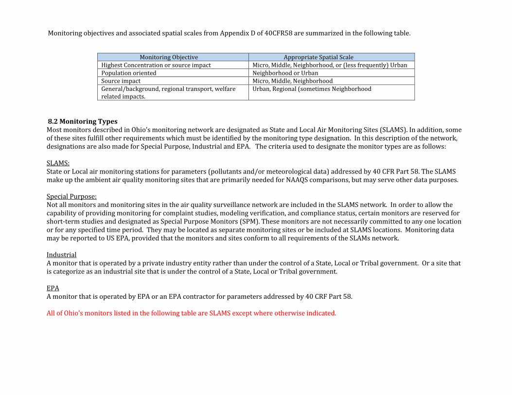
Monitoring objectives and associated spatial scales from Appendix D of 40CFR58 are summarized in the following table.
Monitoring Objective Appropriate Spatial Scale Highest Concentration or source impact Micro, Middle, Neighborhood, or (less frequently) Urban Population oriented Neighborhood or Urban Source impact Micro, Middle, Neighborhood General/background, regional transport, welfare related impacts.
Urban, Regional (sometimes Neighborhood
8.2 Monitoring Types Most monitors described in Ohio’s monitoring network are designated as State and Local Air Monitoring Sites (SLAMS). In addition, some of these sites fulfill other requirements which must be identified by the monitoring type designation. In this description of the network, designations are also made for Special Purpose, Industrial and EPA. The criteria used to designate the monitor types are as follows: SLAMS: State or Local air monitoring stations for parameters (pollutants and/or meteorological data) addressed by 40 CFR Part 58. The SLAMS make up the ambient air quality monitoring sites that are primarily needed for NAAQS comparisons, but may serve other data purposes. Special Purpose: Not all monitors and monitoring sites in the air quality surveillance network are included in the SLAMS network. In order to allow the capability of providing monitoring for complaint studies, modeling verification, and compliance status, certain monitors are reserved for short-term studies and designated as Special Purpose Monitors (SPM). These monitors are not necessarily committed to any one location or for any specified time period. They may be located as separate monitoring sites or be included at SLAMS locations. Monitoring data may be reported to US EPA, provided that the monitors and sites conform to all requirements of the SLAMs network. Industrial A monitor that is operated by a private industry entity rather than under the control of a State, Local or Tribal government. Or a site that is categorize as an industrial site that is under the control of a State, Local or Tribal government. EPA A monitor that is operated by EPA or an EPA contractor for parameters addressed by 40 CRF Part 58. All of Ohio’s monitors listed in the following table are SLAMS except where otherwise indicated.
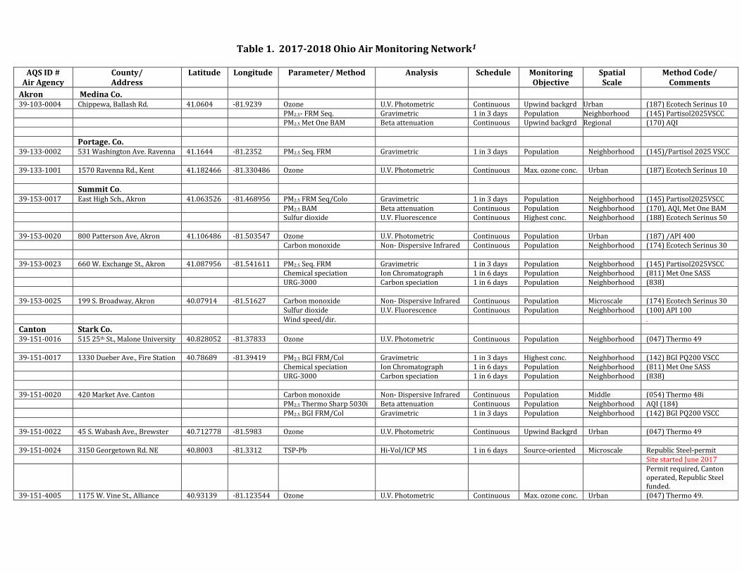
Table 1. 2017-2018 Ohio Air Monitoring Network1
AQS ID #
Air Agency County/ Address
Latitude Longitude Parameter/ Method Analysis Schedule Monitoring Objective
Spatial Scale
Method Code/ Comments
Akron Medina Co. 39-103-0004 Chippewa, Ballash Rd. 41.0604 -81.9239 Ozone U.V. Photometric Continuous Upwind backgrd Urban (187) Ecotech Serinus 10 PM2.5- FRM Seq. Gravimetric 1 in 3 days Population Neighborhood (145) Partisol2025VSCC PM2.5 Met One BAM Beta attenuation Continuous Upwind backgrd Regional (170) AQI
Portage. Co. 39-133-0002 531 Washington Ave. Ravenna 41.1644 -81.2352 PM2.5 Seq. FRM Gravimetric 1 in 3 days Population Neighborhood (145)/Partisol 2025 VSCC 39-133-1001 1570 Ravenna Rd., Kent 41.182466 -81.330486 Ozone U.V. Photometric Continuous Max. ozone conc. Urban (187) Ecotech Serinus 10
Summit Co. 39-153-0017 East High Sch., Akron 41.063526 -81.468956 PM2.5 FRM Seq/Colo Gravimetric 1 in 3 days Population Neighborhood (145) Partisol2025VSCC PM2.5 BAM Beta attenuation Continuous Population Neighborhood (170), AQI, Met One BAM Sulfur dioxide U.V. Fluorescence Continuous Highest conc. Neighborhood (188) Ecotech Serinus 50 39-153-0020 800 Patterson Ave, Akron 41.106486 -81.503547 Ozone U.V. Photometric Continuous Population Urban (187) /API 400 Carbon monoxide Non- Dispersive Infrared Continuous Population Neighborhood (174) Ecotech Serinus 30 39-153-0023 660 W. Exchange St., Akron 41.087956 -81.541611 PM2.5 Seq. FRM Gravimetric 1 in 3 days Population Neighborhood (145) Partisol2025VSCC Chemical speciation Ion Chromatograph 1 in 6 days Population Neighborhood (811) Met One SASS URG-3000 Carbon speciation 1 in 6 days Population Neighborhood (838) 39-153-0025 199 S. Broadway, Akron 40.07914 -81.51627 Carbon monoxide Non- Dispersive Infrared Continuous Population Microscale (174) Ecotech Serinus 30 Sulfur dioxide U.V. Fluorescence Continuous Population Neighborhood (100) API 100 Wind speed/dir. .
Canton Stark Co. 39-151-0016 515 25th St., Malone University 40.828052 -81.37833 Ozone U.V. Photometric Continuous Population Neighborhood (047) Thermo 49 39-151-0017 1330 Dueber Ave., Fire Station 40.78689 -81.39419 PM2.5 BGI FRM/Col Gravimetric 1 in 3 days Highest conc. Neighborhood (142) BGI PQ200 VSCC Chemical speciation Ion Chromatograph 1 in 6 days Population Neighborhood (811) Met One SASS URG-3000 Carbon speciation 1 in 6 days Population Neighborhood (838) 39-151-0020 420 Market Ave. Canton Carbon monoxide Non- Dispersive Infrared Continuous Population Middle (054) Thermo 48i PM2.5 Thermo Sharp 5030i Beta attenuation Continuous Population Neighborhood AQI (184) PM2.5 BGI FRM/Col Gravimetric 1 in 3 days Population Neighborhood (142) BGI PQ200 VSCC 39-151-0022 45 S. Wabash Ave., Brewster 40.712778 -81.5983 Ozone U.V. Photometric Continuous Upwind Backgrd Urban (047) Thermo 49 39-151-0024 3150 Georgetown Rd. NE 40.8003 -81.3312 TSP-Pb Hi-Vol/ICP MS 1 in 6 days Source-oriented Microscale Republic Steel-permit Site started June 2017
Permit required, Canton operated, Republic Steel funded.
Added a B sampler (POC 4) to increase SF from 1/6 to 1/3. Started 4/1/2017.
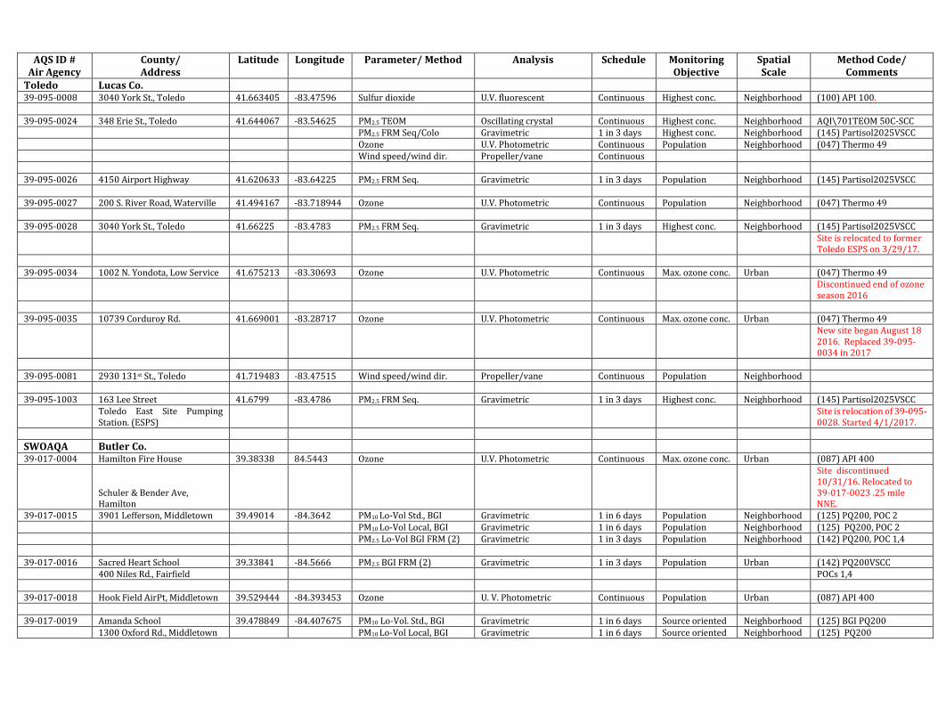
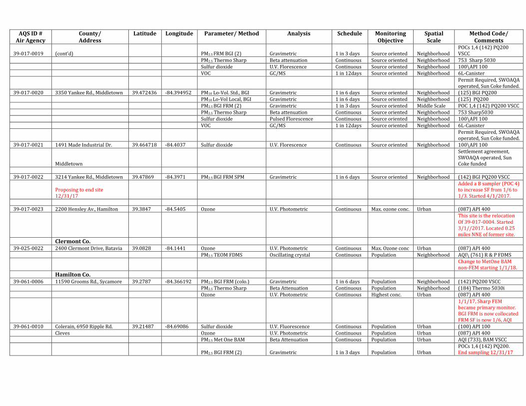
39-017-0023 2200 Hensley Av., Hamilton 39.3847 -84.5405 Ozone U.V. Photometric Continuous Max. ozone conc. Urban (087) API 400
This site is the relocation Of 39-017-0004. Started 3/1//2017. Located 0.25 miles NNE of former site.
Clermont Co. 39-025-0022 2400 Clermont Drive, Batavia 39.0828 -84.1441 Ozone U.V. Photometric Continuous Max. Ozone conc Urban (087) API 400 PM2.5 TEOM FDMS Oscillating crystal Continuous Population Neighborhood AQI\ (761) R & P FDMS
Change to MetOne BAM non-FEM starting 1/1/18.
Hamilton Co. 39-061-0006 11590 Grooms Rd., Sycamore 39.2787 -84.366192 PM2.5 BGI FRM (colo.) Gravimetric 1 in 6 days Population Neighborhood (142) PQ200 VSCC PM2.5 Thermo Sharp Beta Attenuation Continuous Population Neighborhood (184) Thermo 5030i Ozone U.V. Photometric Continuous Highest conc. Urban (087) API 400
1/1/17, Sharp FEM became primary monitor. BGI FRM is now collocated FRM SF is now 1/6, AQI
39-061-0010 Colerain, 6950 Ripple Rd. 39.21487 -84.69086 Sulfur dioxide U.V. Fluorescence Continuous Population Urban (100) API 100 Cleves Ozone U.V. Photometric Continuous Population Urban (087) API 400 PM2.5 Met One BAM Beta Attenuation Continuous Population Urban AQI (733), BAM VSCC
PM2.5 BGI FRM (2) Gravimetric 1 in 3 days Population Urban POCs 1,4 (142) PQ200. End sampling 12/31/17
AQS ID # Air Agency
County/ Address
Latitude Longitude Parameter/ Method Analysis Schedule Monitoring Objective
Spatial Scale
Method Code/ Comments
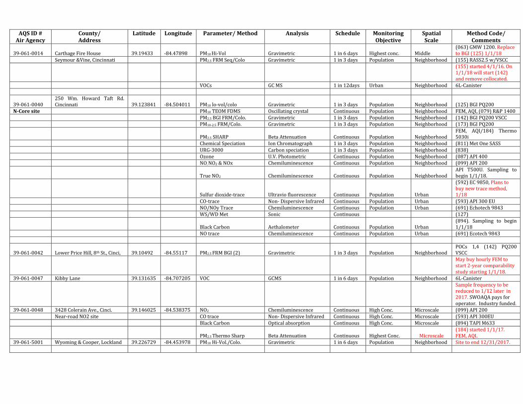
39-061-0014 Carthage Fire House 39.19433 -84.47898 PM10 Hi-Vol Gravimetric 1 in 6 days Highest conc. Middle (063) GMW 1200. Replace to BGI (125) 1/1/18
Seymour &Vine, Cincinnati PM2.5 FRM Seq/Colo Gravimetric 1 in 3 days Population Neighborhood (155) RASS2.5 w/VSCC
(155) started 4/1/16. On 1/1/18 will start (142) and remove collocated.
VOCs GC MS 1 in 12days Urban Neighborhood 6L-Canister
39-061-0040 250 Wm. Howard Taft Rd. Cincinnati 39.123841 -84.504011 PM10 lo-vol/colo Gravimetric 1 in 3 days Population Neighborhood (125) BGI PQ200
N-Core site PM10 TEOM FDMS Oscillating crystal Continuous Population Neighborhood FEM, AQI, (079) R&P 1400 PM2.5 BGI FRM/Colo. Gravimetric 1 in 3 days Population Neighborhood (142) BGI PQ200 VSCC PM10-2.5 FRM/Colo. Gravimetric 1 in 3 days Population Neighborhood (173) BGI PQ200
Chemical Speciation Ion Chromatograph 1 in 3 days Population Neighborhood (811) Met One SASS URG-3000 Carbon speciation 1 in 3 days Population Neighborhood (838) Ozone U.V. Photometric Continuous Population Neighborhood (087) API 400 NO, NO2 & NOx Chemiluminescence Continuous Population Neighborhood (099) API 200
True NO2 Chemiluminescence Continuous Population Neighborhood API T500U. Sampling to begin 1/1/18.
Sulfur dioxide-trace Ultravio fluorescence Continuous Population Urban
(592) EC 9850, Plans to buy new trace method, 1/18
CO-trace Non- Dispersive Infrared Continuous Population Urban (593) API 300 EU NO/NOy Trace Chemiluminescence Continuous Population Urban (691) Echotech 9843 WS/WD Met Sonic Continuous (127)
Black Carbon Aethalometer Continuous Population Urban (894). Sampling to begin 1/1/18
NO trace Chemiluminescence Continuous Population Urban (691) Ecotech 9843
39-061-0042 Lower Price Hill, 8th St., Cinci, 39.10492 -84.55117 PM2.5 FRM BGI (2) Gravimetric 1 in 3 days Population Neighborhood POCs 1,4 (142) PQ200 VSCC
May buy hourly FEM to start 2-year comparability study starting 1/1/18.
39-061-0047 Kibby Lane 39.131635 -84.707205 VOC GCMS 1 in 6 days Population Neighborhood 6L-Canister
Sample frequency to be reduced to 1/12 later in 2017. SWOAQA pays for operator. Industry funded.
39-061-0048 3428 Colerain Ave., Cinci. 39.146025 -84.538375 NO2 Chemiluminescence Continuous High Conc. Microscale (099) API 200 Near-road NO2 site CO trace Non- Dispersive Infrared Continuous High Conc. Microscale (593) API 300EU Black Carbon Optical absorption Continuous High Conc. Microscale (894) TAPI M633
Cleveland Cuyahoga Co. 39-035-0034 891 E. 152 St. 41.55523 -81.575256 PM2.5 FRM Seq. Gravimetric 1 in 3 days Population Urban (145) Partisol2025VSCC Cleveland Ozone U.V. Photometric Continuous Population Neighborhood (087) API400 39-035-0038 St. Theodosius, St. Tikon St. 41.477011 -81.682383 PM10 Hi-Vol. (5) unit Gravimetric 1 in 1 day Highest conc. Neighborhood (063) POCs 1,4,6,7,8 Cleveland PM2.5 FRM SeqColo Gravimetric 1 in 3 days Highest conc. Neighborhood (145) Partisol2025VSCC TSP lead-metals Hi-Vol/ICP MS 1 in 6 days Highest conc. Neighborhood (108) (192) Sulfur dioxide Pulsed Fluorescence Continuous Highest conc. Neighborhood (188) Ecotech Serinus 50. Chemical Speciation (colo) Ion Chromatograph 1 in 6 days Population Neighborhood (811) Met One SASS VOCs GC MS 1 in 12days Population Neighborhood 6L-canister URG-3000 Carbon speciation 1 in 6 days Population Neighborhood (838) 39-035-0042 Fire Station 4, 3136 Lorain 41.4823 -81.708906 TSP Pb\Metals Colo. Hi-Vol/ICP MS 1 in 6 days Population Middle (108) (192) 39-035-0045 FS 13, 4950 Broadway Ave. 41.471782 -81.656792 PM10 Hi-Vol./Colo. Gravimetric 1 in 6 days Population Neighborhood (063) GMW 1200 Cleveland PM2.5 FRM Seq. Gravimetric 1 in 3 days Population Neighborhood (145) Partisol2025VSCC Sulfur dioxide Pulsed Fluorescence Continuous Population Neighborhood (060) Thermo 43c 39-035-0049 Ferro Corp. E. 56th St. 41.446342 -81.6507 TSP-Pb/Metals Colo. Hi-Vol/ICP MS 1 in 6 days Source-oriented Neighborhood (108) (192) Cleveland 39-035-0051 Galleria, E. Ninth & St. Clair 41.504661 -81.690186 Carbon monoxide Non- Dispersive Infrared Continuous Highest conc. Microscale (054) Thermo 48c 39-035-0060 GT Craig, E. 14th & Orange 41.492117 -81.678449 PM10 Hi-Vol. Gravimetric 1 in 6 days Population Neighborhood (063) GMW 1200 N-Core site Cleveland PM10 TEOM Oscillating crystal Continuous Population Neighborhood (079) R&P 1400
PM2.5 FRM Seq. (colo) Gravimetric 1 in 3 days Population Neighborhood (179) Partisol Dicot2025i; colo Partisol started 4/17.
PM2.5 MetOne BAM Beta attenuation Continuous Population Neighborhood AQI (170) MetOne BAM PM2.5 Spec. Colo. Ion Chromatograph 1 in 3 days Population Neighborhood (811) Met One SASS URG-3000 Carbon speciation 1 in 6 days Population Neighborhood (838)
TSP lead-metals Hi-Vol/ICP MS 1 in 6 days Highest conc. Neighborhood (108)(192) Ended 8/26/16
Ozone U.V. Photometric Continuous Population Neighborhood (087) API400 NOx trace Chemiluminescence Continuous Population Neighborhood (690) POC 2 NO2 Chemiluminescence Continuous Population Neighborhood (074) Thermo 42i SO2 Pulsed Fluorescence Continuous Population Neighborhood (060) Thermo 43a SO2-trace POC 2 Pulsed Fluorescence Continuous Population Neighborhood (560) Thermo 43C-TLE NOy Chemiluminescence Continuous Population Neighborhood (674) CO-trace Non- Dispersive Infrared Infrared Population Neighborhood (554) Thermo 48i-TLE PM10 local Gravimetric 1 in 3 days Population Neighborhood (127) Partisol 2025i PM10-2.5 Seq. Gravimetric 1 in 3 days Population Neighborhood (176) Partisol Dicot2025i WS/WD Met 39-035-0061 South side W. 3rd St. Cleveland 41.473092 -81.676596 TSP-lead-metals Hi-Vol/ICP MS 1 in 6 days Highest conc. Middle (108) (192)
AQS ID # Air Agency
County/ Address
Latitude Longitude Parameter/ Method Analysis Schedule Monitoring Objective
Spatial Scale
Method Code/ Comments
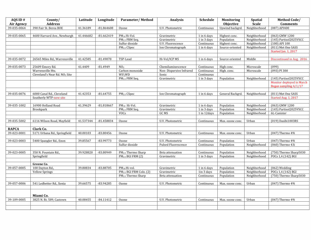
39-035-0064 390 Fair St. Berea BOE 41.36189 -81.864608 Ozone U.V. Photometric Continuous Upwind backgrd. Neighborhood (087) API400 39-035-0065 4600 Harvard Ave., Newburgh 41.446682 -81.662419 PM10 Hi-Vol. Gravimetric 1 in 6 days Highest conc. Neighborhood (063) GMW 1200 PM2.5 FRM Seq. Gravimetric 1 in 3 days Population Neighborhood (145) Partisol2025VSCC Sulfur dioxide U.V. Fluorescence Continuous Highest conc. Neighborhood (100) API 100 PM2.5 CSpec Ion Chromatograph 1 in 6 days Source-oriented Neighborhood (811) Met One SASS Started Jan. 1, 2017 39-035-0072 26565 Miles Rd., Warrensville 41.42585 -81.49078 TSP-Lead Hi-Vol/ICP MS 1 in 6 days Source oriented Middle Discontinued in Aug. 2016 39-035-0073 25609 Emory Rd. 41.4409 -81.4949 NO2 Chemiluminescence Continuous High conc. Microscale (099) Warrensville Hts. Carbon monoxide Non- Dispersive Infrared Continuous High. conc. Microscale (093) PI 300 Cleveland’s Near Rd. NO2 Site WS\WD Sonic Continuous PM2.5 FRM Seq. Gravimetric 1 in 3 days Population Neighborhood (145) Partisol2025VSCC
Monitor deployed in March Began sampling 4/1/17
39-035-0076 6000 Canal Rd., Cleveland 41.42353 -81.64755 PM2.5 CSpec Ion Chromatograph 1 in 6 days General Backgrd. Neighborhood (811) Met One SASS Southerly WTP-new site Started Aug. 1, 2017 39-035-1002 16900 Holland Road 41.39629 -81.818667 PM10 Hi-Vol. Gravimetric 1 in 6 days Population Neighborhood (063) GMW 1200 Brookpark PM2.5 FRM Seq. Gravimetric 1 in 3 days Population Neighborhood (145) Partisol2025VSCC VOCs GC MS 1 in 12days Population Neighborhood 6L-Canister 39-035-5002 6116 Wilson Road, Mayfield 41.537344 -81.458834 Ozone U.V. Photometric Continuous Max. ozone conc. Urban (019) Dasibi1003RS
RAPCA Clark Co. 39-023-0001 5171 Urbana Rd., Springfield 40.00103 -83.80456 Ozone U.V. Photometric Continuous Max. ozone conc. Urban (047) Thermo 49i 39-023-0003 5400 Spangler Rd., Enon 39.85567 -83.99773 Ozone U.V. Photometric Continuous Population Urban (047) Thermo 49i Sulfur dioxide Pulsed Fluorescence Continuous Population Neighborhood (060) Thermo 43i 39-023-0005 350 N. Fountain Rd., 39.928820 -83.80949 PM2.5 Thermo Sharp Beta attenuation Continuous Population Neighborhood (750) Thermo Sharp5030 Springfield PM2.5 BGI FRM (2) Gravimetric 1 in 3 days Population Neighborhood POCs 1,4 (142) BGI Greene Co. 39-057-0005 100 Dayton Rd., 39.80834 -83.88705 PM10 Hi-vol. Gravimetric 1 in 6 days Population Neighborhood (062) Wedding Yellow Springs PM2.5 BGI FRM Colo. (2) Gravimetric 1in 3 days Population Neighborhood POCs 1,4 (142) BGI PM2.5 Thermo Sharp Beta attenuation Continuous Population Neighborhood (750) Thermo Sharp5030 39-057-0006 541 Ledbetter Rd., Xenia 39.66575 -83.94285 Ozone U.V. Photometric Continuous Max. ozone conc. Urban (047) Thermo 49i
Latitude Longitude Parameter/ Method Analysis Schedule Monitoring Objective
Spatial Scale
Method Code/ Comments
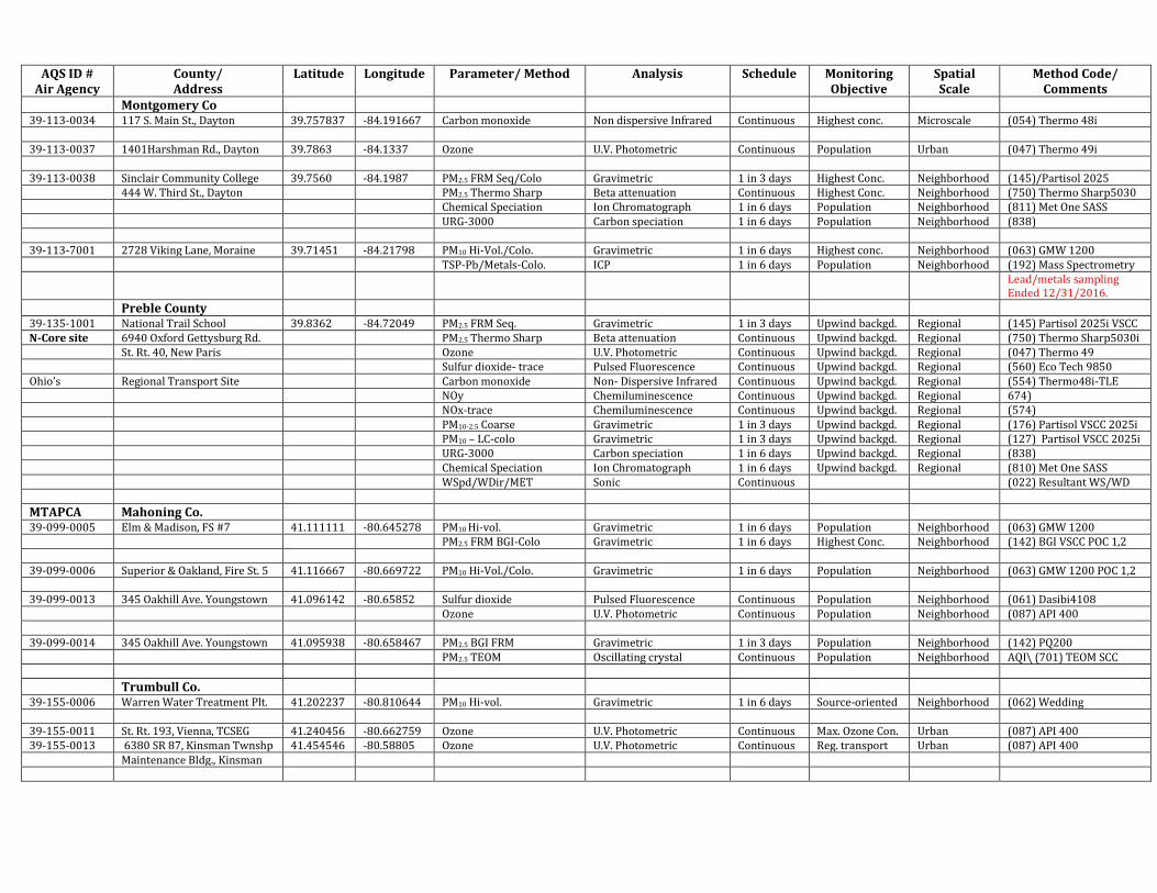
Montgomery Co 39-113-0034 117 S. Main St., Dayton 39.757837 -84.191667 Carbon monoxide Non dispersive Infrared Continuous Highest conc. Microscale (054) Thermo 48i 39-113-0037 1401Harshman Rd., Dayton 39.7863 -84.1337 Ozone U.V. Photometric Continuous Population Urban (047) Thermo 49i 39-113-0038 Sinclair Community College 39.7560 -84.1987 PM2.5 FRM Seq/Colo Gravimetric 1 in 3 days Highest Conc. Neighborhood (145)/Partisol 2025 444 W. Third St., Dayton PM2.5 Thermo Sharp Beta attenuation Continuous Highest Conc. Neighborhood (750) Thermo Sharp5030 Chemical Speciation Ion Chromatograph 1 in 6 days Population Neighborhood (811) Met One SASS URG-3000 Carbon speciation 1 in 6 days Population Neighborhood (838) 39-113-7001 2728 Viking Lane, Moraine 39.71451 -84.21798 PM10 Hi-Vol./Colo. Gravimetric 1 in 6 days Highest conc. Neighborhood (063) GMW 1200 TSP-Pb/Metals-Colo. ICP 1 in 6 days Population Neighborhood (192) Mass Spectrometry
Lead/metals sampling Ended 12/31/2016.
Preble County 39-135-1001 National Trail School 39.8362 -84.72049 PM2.5 FRM Seq. Gravimetric 1 in 3 days Upwind backgd. Regional (145) Partisol 2025i VSCC N-Core site 6940 Oxford Gettysburg Rd. PM2.5 Thermo Sharp Beta attenuation Continuous Upwind backgd. Regional (750) Thermo Sharp5030i St. Rt. 40, New Paris Ozone U.V. Photometric Continuous Upwind backgd. Regional (047) Thermo 49 Sulfur dioxide- trace Pulsed Fluorescence Continuous Upwind backgd. Regional (560) Eco Tech 9850 Ohio’s Regional Transport Site Carbon monoxide Non- Dispersive Infrared Continuous Upwind backgd. Regional (554) Thermo48i-TLE NOy Chemiluminescence Continuous Upwind backgd. Regional 674) NOx-trace Chemiluminescence Continuous Upwind backgd. Regional (574) PM10-2.5 Coarse Gravimetric 1 in 3 days Upwind backgd. Regional (176) Partisol VSCC 2025i PM10 – LC-colo Gravimetric 1 in 3 days Upwind backgd. Regional (127) Partisol VSCC 2025i URG-3000 Carbon speciation 1 in 6 days Upwind backgd. Regional (838) Chemical Speciation Ion Chromatograph 1 in 6 days Upwind backgd. Regional (810) Met One SASS WSpd/WDir/MET Sonic Continuous (022) Resultant WS/WD
MTAPCA Mahoning Co. 39-099-0005 Elm & Madison, FS #7 41.111111 -80.645278 PM10 Hi-vol. Gravimetric 1 in 6 days Population Neighborhood (063) GMW 1200 PM2.5 FRM BGI-Colo Gravimetric 1 in 6 days Highest Conc. Neighborhood (142) BGI VSCC POC 1,2 39-099-0006 Superior & Oakland, Fire St. 5 41.116667 -80.669722 PM10 Hi-Vol./Colo. Gravimetric 1 in 6 days Population Neighborhood (063) GMW 1200 POC 1,2 39-099-0013 345 Oakhill Ave. Youngstown 41.096142 -80.65852 Sulfur dioxide Pulsed Fluorescence Continuous Population Neighborhood (061) Dasibi4108 Ozone U.V. Photometric Continuous Population Neighborhood (087) API 400 39-099-0014 345 Oakhill Ave. Youngstown 41.095938 -80.658467 PM2.5 BGI FRM Gravimetric 1 in 3 days Population Neighborhood (142) PQ200 PM2.5 TEOM Oscillating crystal Continuous Population Neighborhood AQI\ (701) TEOM SCC
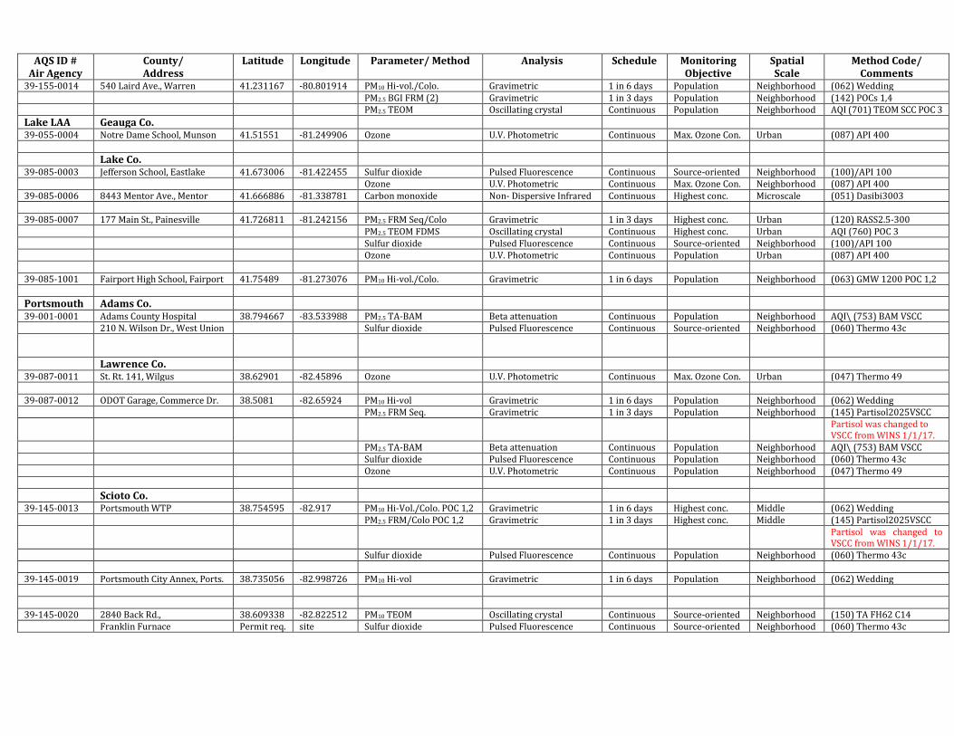
Trumbull Co. 39-155-0006 Warren Water Treatment Plt. 41.202237 -80.810644 PM10 Hi-vol. Gravimetric 1 in 6 days Source-oriented Neighborhood (062) Wedding 39-155-0011 St. Rt. 193, Vienna, TCSEG 41.240456 -80.662759 Ozone U.V. Photometric Continuous Max. Ozone Con. Urban (087) API 400 39-155-0013 6380 SR 87, Kinsman Twnshp 41.454546 -80.58805 Ozone U.V. Photometric Continuous Reg. transport Urban (087) API 400 Maintenance Bldg., Kinsman
AQS ID # Air Agency
County/ Address
Latitude Longitude Parameter/ Method Analysis Schedule Monitoring Objective
Spatial Scale
Method Code/ Comments
39-155-0014 540 Laird Ave., Warren 41.231167 -80.801914 PM10 Hi-vol./Colo. Gravimetric 1 in 6 days Population Neighborhood (062) Wedding PM2.5 BGI FRM (2) Gravimetric 1 in 3 days Population Neighborhood (142) POCs 1,4 PM2.5 TEOM Oscillating crystal Continuous Population Neighborhood AQI (701) TEOM SCC POC 3
Latitude Longitude Parameter/ Method Analysis Schedule Monitoring Objective
Spatial Scale
Method Code/ Comments
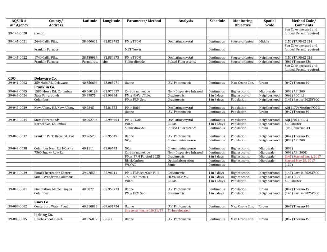
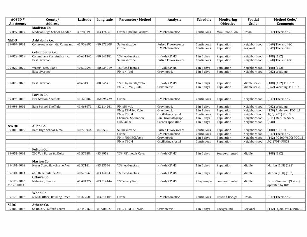
Madison Co. 39-097-0007 Madison High School, London 39.78819 -83.47606 Ozone Upwind Backgrd. U.V. Photometric Continuous Max. Ozone Con. Urban (047) Thermo 49
NEDO Ashtabula Co. 39-007-1001 Conneaut Water Plt., Conneaut 41.959695 -80.572808 Sulfur dioxide Pulsed Fluorescence Continuous Population Neighborhood (060) Thermo 43C Ozone U.V. Photometric Continuous Population Regional (047) Thermo 49
Columbiana Co. 39-029-0019 Columbiana Port Authority, 40.631545 -80.547181 TSP-lead-metals Hi-Vol/ICP MS 1 in 6 days Population Neighborhood (108) (192) East Liverpool Sulfur dioxide Pulsed Fluorescence Continuous Population Neighborhood (060) Thermo 43C 39-029-0020 Water Treat. Plant, 40.639595 -80.524019 TSP-lead-metals Hi-Vol/ICP MS 1 in 6 days Population Neighborhood (108) (192) East Liverpool PM10 Hi-Vol Gravimetric 1 in 6 days Population Neighborhood (062) Wedding 39-029-0023 East Liverpool 40.6349 -80.5457 TSP-Pb/metals/Colo. Hi-Vol/ICP MS 1 in 6 days Population Middle scale (108) (192) POC 1,2 PM10 Hi- Vol./Colo. Gravimetric 1 in 6 days Population Middle scale (062) Wedding, POC 1,2
Lorain Co. 39-093-0018 Fire Station, Sheffield 41.420882 -82.095729 Ozone U.V. Photometric Continuous Population Neighborhood (047) Thermo 49 39-093-3002 Barr School, Sheffield 41.463071 -82.114261 PM10 Hi-vol. Gravimetric 1 in 6 days Population Neighborhood (062) Wedding PM2.5 FRM Seq.Colo Gravimetric 1 in 3 days Population Neighborhood (120) Anderson; POC 1,2 PM2.5 TEOM Oscillating crystal Continuous Population Neighborhood AQI\ (701) POC 3 Chemical Speciation Ion Chromatograph 1 in 6 days Population Neighborhood (811) Met One SASS URG-3000 Carbon speciation 1 in 6 days Population Neighborhood (838)
NWDO Allen Co. 39-003-0009 Bath High School, Lima 40.770944 -84.0539 Sulfur dioxide Pulsed Fluorescence Continuous Population Neighborhood (100) API 100 Ozone U.V. Photometric Continuous Population Neighborhood (047) Thermo 49 PM2.5 FRM BGI/colo Gravimetric 1 in 6 days Population Neighborhood (142) PQ200 VSCC; POC1,2 PM2.5 TEOM Oscillating crystal Continuous Population Neighborhood AQI (701) POC 3
Fulton Co. 39-051-0001 200 Van Buren St., Delta 41.57588 -83.9959 TSP-PB\metals Colo. Hi-Vol/ICP MS 1 in 6 days Source-oriented Middle (108) (192)
Marion Co. 39-101-0003 Nucor Steel, Hawthorne Ave. 42.57141 -83.13556 TSP-lead-metals Hi-Vol/ICP MS 1 in 6 days Population Middle Marion (108) (192) 39-101-0004 640 Bellefontaine Ave. 40.57666 -83.14024 TSP-lead-metals Hi-Vol/ICP MS 1 in 6 days Population Middle Marion (108) (192)
Ottawa Co. 39-123-0006 Materion, Elmore 41.494722 -83.214444 TSP – beryllium Hi-Vol/ICP MS 7daysample Source-oriented Middle Brush-Wellman (9 sites) to 123-0014 operated by BW.
SEDO Athens Co. 39-009-0003 St. Rt. 377, Gifford Forest 39.442165 -81.908827 PM2.5 FRM BGI/colo Gravimetric 1 in 6 days Background Regional (142) PQ200 VSCC; POC 1,2
AQS ID # Air Agency
County/ Address
Latitude Longitude Parameter/ Method Analysis Schedule Monitoring Objective
Spatial Scale
Method Code/ Comments
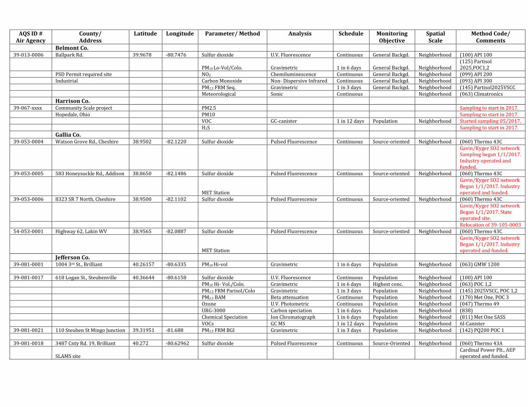
Belmont Co. 39-013-0006 Ballpark Rd. 39.9678 -80.7476 Sulfur dioxide U.V. Fluorescence Continuous General Backgd. Neighborhood (100) API 100
PM10 Lo-Vol/Colo. Gravimetric 1 in 6 days General Backgd. Neighborhood (125) Partisol 2025,POC1,2
PSD Permit required site NO2 Chemiluminescence Continuous General Backgd. Neighborhood (099) API 200 Industrial Carbon Monoxide Non- Dispersive Infrared Continuous General Backgd. Neighborhood (093) API 300 PM2.5 FRM Seq. Gravimetric 1 in 3 days General Backgd. Neighborhood (145) Partisol2025VSCC Meteorological Sonic Continuous Neighborhood (063) Climatronics
Harrison Co. 39-067-xxxx Community Scale project PM2.5 Sampling to start in 2017. Hopedale, Ohio PM10 Sampling to start in 2017. VOC GC-canister 1 in 12 days Population Neighborhood Started sampling 05/2017. H2S Sampling to start in 2017.
Gallia Co. 39-053-0004 Watson Grove Rd., Cheshire 38.9502 -82.1220 Sulfur dioxide Pulsed Fluorescence Continuous Source-oriented Neighborhood (060) Thermo 43C
Gavin/Kyger SO2 network Sampling began 1/1/2017. Industry operated and funded.
Gavin/Kyger SO2 network Began 1/1/2017. State operated site.
Relocation of 39-105-0003 54-053-0001 Highway 62, Lakin WV 38.9565 -82.0887 Sulfur dioxide Pulsed Fluorescence Continuous Source-oriented Neighborhood (060) Thermo 43C
MET Station
Gavin/Kyger SO2 network Began 1/1/2017. Industry operated and funded.
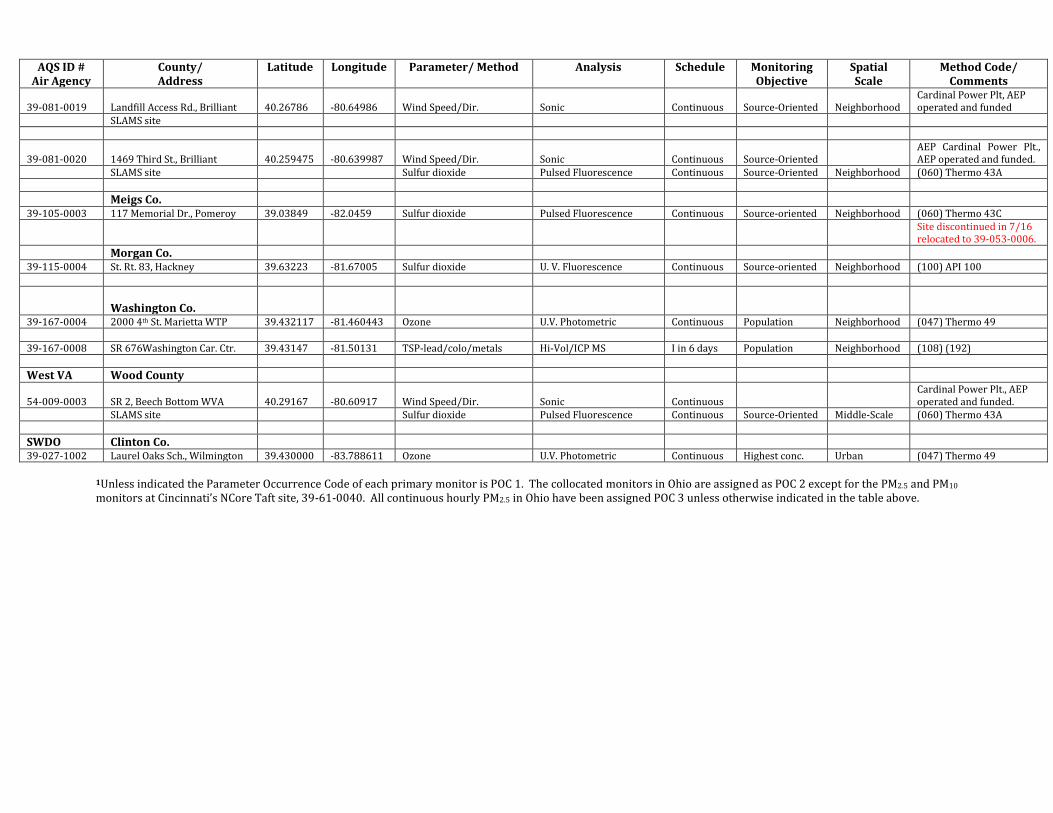
Jefferson Co. 39-081-0001 1004 3rd St., Brilliant 40.26157 -80.6335 PM10 Hi-vol Gravimetric 1 in 6 days Population Neighborhood (063) GMW 1200 39-081-0017 618 Logan St., Steubenville 40.36644 -80.6158 Sulfur dioxide U.V. Fluorescence Continuous Population Neighborhood (100) API 100 PM10 Hi- Vol./Colo. Gravimetric 1 in 6 days Highest conc. Neighborhood (063) POC 1,2 PM2.5 FRM Parisol/Colo Gravimetric 1 in 3 days Population Neighborhood (145) 2025VSCC, POC 1,2 PM2.5 BAM Beta attenuation Continuous Population Neighborhood (170) Met One, POC 3 Ozone U.V. Photometric Continuous Population Neighborhood (047) Thermo 49 URG-3000 Carbon speciation 1 in 6 days Population Neighborhood (838) Chemical Speciation Ion Chromatograph 1 in 6 days Population Neighborhood (811) Met One SASS VOCs GC MS 1 in 12 days Population Neighborhood 6l-Canister 39-081-0021 110 Steuben St Mingo Junction 39.31951 -81.688 PM2.5 FRM BGI Gravimetric 1 in 3 days Population Neighborhood (142) PQ200 POC 1 39-081-0018 3487 Cnty Rd. 19, Brilliant 40.272 -80.62962 Sulfur dioxide Pulsed Fluorescence Continuous Source-Oriented Neighborhood (060) Thermo 43A
SLAMS site Cardinal Power Plt., AEP operated and funded.
AQS ID # Air Agency
County/ Address
Latitude Longitude Parameter/ Method Analysis Schedule Monitoring Objective
Spatial Scale
Method Code/ Comments
39-081-0019 Landfill Access Rd., Brilliant 40.26786 -80.64986 Wind Speed/Dir. Sonic Continuous Source-Oriented Neighborhood Cardinal Power Plt, AEP operated and funded
SLAMS site
39-081-0020 1469 Third St., Brilliant 40.259475 -80.639987 Wind Speed/Dir. Sonic Continuous Source-Oriented AEP Cardinal Power Plt., AEP operated and funded.
Site discontinued in 7/16 relocated to 39-053-0006.
Morgan Co. 39-115-0004 St. Rt. 83, Hackney 39.63223 -81.67005 Sulfur dioxide U. V. Fluorescence Continuous Source-oriented Neighborhood (100) API 100
Washington Co.
39-167-0004 2000 4th St. Marietta WTP 39.432117 -81.460443 Ozone U.V. Photometric Continuous Population Neighborhood (047) Thermo 49 39-167-0008 SR 676Washington Car. Ctr. 39.43147 -81.50131 TSP-lead/colo/metals Hi-Vol/ICP MS I in 6 days Population Neighborhood (108) (192)
West VA Wood County
54-009-0003 SR 2, Beech Bottom WVA 40.29167 -80.60917 Wind Speed/Dir. Sonic Continuous Cardinal Power Plt., AEP operated and funded.
1Unless indicated the Parameter Occurrence Code of each primary monitor is POC 1. The collocated monitors in Ohio are assigned as POC 2 except for the PM2.5 and PM10 monitors at Cincinnati’s NCore Taft site, 39-61-0040. All continuous hourly PM2.5 in Ohio have been assigned POC 3 unless otherwise indicated in the table above.
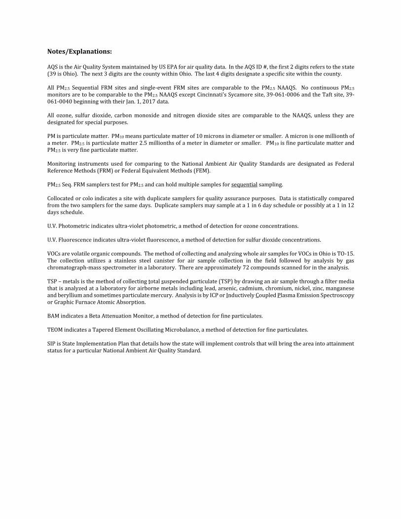
Notes/Explanations: AQS is the Air Quality System maintained by US EPA for air quality data. In the AQS ID #, the first 2 digits refers to the state (39 is Ohio). The next 3 digits are the county within Ohio. The last 4 digits designate a specific site within the county. All PM2.5 Sequential FRM sites and single-event FRM sites are comparable to the PM2.5 NAAQS. No continuous PM2.5 monitors are to be comparable to the PM2.5 NAAQS except Cincinnati’s Sycamore site, 39-061-0006 and the Taft site, 39-061-0040 beginning with their Jan. 1, 2017 data. All ozone, sulfur dioxide, carbon monoxide and nitrogen dioxide sites are comparable to the NAAQS, unless they are designated for special purposes. PM is particulate matter. PM10 means particulate matter of 10 microns in diameter or smaller. A micron is one millionth of a meter. PM2.5 is particulate matter 2.5 millionths of a meter in diameter or smaller. PM10 is fine particulate matter and PM2.5 is very fine particulate matter. Monitoring instruments used for comparing to the National Ambient Air Quality Standards are designated as Federal Reference Methods (FRM) or Federal Equivalent Methods (FEM). PM2.5 Seq. FRM samplers test for PM2.5 and can hold multiple samples for sequential sampling. Collocated or colo indicates a site with duplicate samplers for quality assurance purposes. Data is statistically compared from the two samplers for the same days. Duplicate samplers may sample at a 1 in 6 day schedule or possibly at a 1 in 12 days schedule. U.V. Photometric indicates ultra-violet photometric, a method of detection for ozone concentrations. U.V. Fluorescence indicates ultra-violet fluorescence, a method of detection for sulfur dioxide concentrations. VOCs are volatile organic compounds. The method of collecting and analyzing whole air samples for VOCs in Ohio is TO-15. The collection utilizes a stainless steel canister for air sample collection in the field followed by analysis by gas chromatograph-mass spectrometer in a laboratory. There are approximately 72 compounds scanned for in the analysis. TSP – metals is the method of collecting total suspended particulate (TSP) by drawing an air sample through a filter media that is analyzed at a laboratory for airborne metals including lead, arsenic, cadmium, chromium, nickel, zinc, manganese and beryllium and sometimes particulate mercury. Analysis is by ICP or Inductively Coupled Plasma Emission Spectroscopy or Graphic Furnace Atomic Absorption. BAM indicates a Beta Attenuation Monitor, a method of detection for fine particulates. TEOM indicates a Tapered Element Oscillating Microbalance, a method of detection for fine particulates. SIP is State Implementation Plan that details how the state will implement controls that will bring the area into attainment status for a particular National Ambient Air Quality Standard.
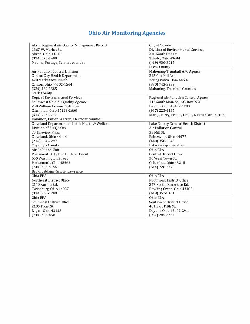
Ohio Air Monitoring Agencies
Akron Regional Air Quality Management District 1867 W. Market St. Akron, Ohio 44313 (330) 375-2480 Medina, Portage, Summit counties
City of Toledo Division of Environmental Services 348 South Erie St. Toledo, Ohio 43604 (419) 936-3015 Lucas County
Air Pollution Control Division Canton City Health Department 420 Market Ave. North Canton, Ohio 44702-1544 (330) 489-3385 Stark County
Mahoning-Trumbull APC Agency 345 Oak Hill Ave. Youngstown, Ohio 44502 (330) 743-3333 Mahoning, Trumbull Counties
Dept. of Environmental Services Southwest Ohio Air Quality Agency 250 William Howard Taft Road Cincinnati, Ohio 45219-2660 (513) 946-7777 Hamilton, Butler, Warren, Clermont counties
Regional Air Pollution Control Agency 117 South Main St., P.O. Box 972 Dayton, Ohio 45422-1280 (937) 225-4435 Montgomery, Preble, Drake, Miami, Clark, Greene
Cleveland Department of Public Health & Welfare Division of Air Quality 75 Erieview Plaza Cleveland, Ohio 44114 (216) 664-2297 Cuyahoga County
Lake County General Health District Air Pollution Control 33 Mill St. Painesville, Ohio 44077 (440) 350-2543 Lake, Geauga counties
Air Pollution Unit Portsmouth City Health Department 605 Washington Street Portsmouth, Ohio 45662 (740) 353-5156 Brown, Adams, Scioto, Lawrence
Ohio EPA Central District Office 50 West Town St. Columbus, Ohio 43215 (614) 728-3778