Appendix A: The Plate Tectonics Paradigm The first five chapters give us CSD theory, now let us have a little practice! Here we introduce the Plate Tectonics Paradigm. We will use it in for on-going Computational Scientific Discovery labs. Studying the Plate Tectonics paradigm has several advantages, including: 1. It was developed in the 1960s, around the same time as Kuhn's concept of paradigms. Giere and other philosophers of science who came after and were influenced by Kuhn intensively studied the development of the Plate Tectonics paradigm nearly in “real time”, or shortly after it happened. 2. Earthquakes (and geophysics more broadly) are technical without being too technical. There's math, but nothing as funky as quantum mechanics. 3. The United States Geological Survey keeps a free, Internet-accessible database of earthquakes. It is at http://neic.usgs.gov/neis/epic/. 4. The USGS site has the map-drawing ability. Beyond being just plain cool it also lets us see the data; it lets us really get a feel for it. A.1 The Importance of the Plate Tectonics Paradigm Plate tectonics is currently the dominant way to understand the Earth as a whole over much of its history. The wholestic time-and-space understanding unifies many previously separate terrestrial phenomena. Plate tectonics gives us an understanding of: 1. Most of the world's earthquakes, 2. Most of the world's volcanoes, 3. Most of the world's mountains, including an understanding of which are still growing and why, 4. The continents, and the Earth's crust more generally, 5. The abundance, location and age of fossils, 6. The abundance, location, age, magnetism, density and composition of rock. As successful as the Plate Tectonics paradigm is, it does not explain everything. As of 2008, when this paragraph was written, Plate Tectonics (as we understand it) has little to say about earthquakes that happen in the middle of continents, or about conditions on the early Earth, or about the natural history of Earth's sister planets: Mars and Venus. In what follows we will touch on some of the ideas among Western geologists prior to Plate Tectonics, then on Plate Tectonics and some of its issues, and finally on earthquakes and the USGS catalog of them. A.2 Pre-Plate Tectonics During the Medieval era in the Western world the Christian church played a large part in retaining knowledge and training scholars. Naturally early Western geologists schooled in this Copyright (c) 2008 Joseph Phillips All rights reserved.
Transcript
Appendix A: The Plate Tectonics Paradigm
The first five chapters give us CSD theory, now let us have a little practice! Here we introduce the Plate Tectonics Paradigm. We will use it in for ongoing Computational Scientific Discovery labs.
Studying the Plate Tectonics paradigm has several advantages, including:1. It was developed in the 1960s, around the same time as Kuhn's concept of paradigms.
Giere and other philosophers of science who came after and were influenced by Kuhn intensively studied the development of the Plate Tectonics paradigm nearly in “real time”, or shortly after it happened.
2. Earthquakes (and geophysics more broadly) are technical without being too technical. There's math, but nothing as funky as quantum mechanics.
3. The United States Geological Survey keeps a free, Internetaccessible database of earthquakes. It is at http://neic.usgs.gov/neis/epic/.
4. The USGS site has the mapdrawing ability. Beyond being just plain cool it also lets us see the data; it lets us really get a feel for it.
A.1 The Importance of the Plate Tectonics Paradigm
Plate tectonics is currently the dominant way to understand the Earth as a whole over much of its history. The wholestic timeandspace understanding unifies many previously separate terrestrial phenomena. Plate tectonics gives us an understanding of:
1. Most of the world's earthquakes,2. Most of the world's volcanoes,3. Most of the world's mountains, including an understanding of which are still growing
and why,4. The continents, and the Earth's crust more generally,5. The abundance, location and age of fossils,6. The abundance, location, age, magnetism, density and composition of rock.
As successful as the Plate Tectonics paradigm is, it does not explain everything. As of 2008, when this paragraph was written, Plate Tectonics (as we understand it) has little to say about earthquakes that happen in the middle of continents, or about conditions on the early Earth, or about the natural history of Earth's sister planets: Mars and Venus.
In what follows we will touch on some of the ideas among Western geologists prior to Plate Tectonics, then on Plate Tectonics and some of its issues, and finally on earthquakes and the USGS catalog of them.
A.2 PrePlate Tectonics
During the Medieval era in the Western world the Christian church played a large part in retaining knowledge and training scholars. Naturally early Western geologists schooled in this
Copyright (c) 2008 Joseph Phillips All rights reserved.
tradition used the Christian Bible as knowledge source. Therefore one of the first theories of the Earth in the West after the fall of Rome was that “The Earth was created by God”. The evidence for this was the Bible. Mountains, perhaps were indirectly created by God during the great flood.
During the European Enlightenment geologists were more inclined to look for mechanisms that did not call for continual deistic supervision. Scientists theorized that the Earth was very hot when it was created and that it has been cooling off ever since. As it cools it shrinks, and as it shrinks the excess surface crumples upward. Mountains are a result of this crumpling.
While details of both of these wholeEarth creation theories were sparse, details of phenomena more restricted in time and more restricted in space were understood in increasing specifics. For example, in the 1830s Swiss geologist Louis Agassiz looked at living glaciers in the Alps and saw Ushaped valleys and terminal moraines (deposits of gravel and dirt where glaciers stopped advancing and start retreating). He then saw looked around Europe and saw such things where there was no ice. He inferred that much of Europe, and much of the world, must have been covered with ice. This was not a story about the all of the Earth's history, but one that described a worldwide phenomenon at some particular time.
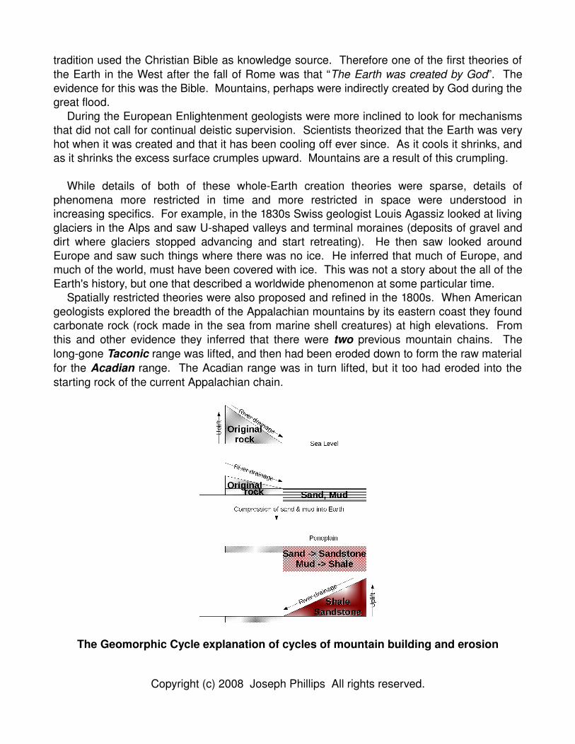
Spatially restricted theories were also proposed and refined in the 1800s. When American geologists explored the breadth of the Appalachian mountains by its eastern coast they found carbonate rock (rock made in the sea from marine shell creatures) at high elevations. From this and other evidence they inferred that there were two previous mountain chains. The longgone Taconic range was lifted, and then had been eroded down to form the raw material for the Acadian range. The Acadian range was in turn lifted, but it too had eroded into the starting rock of the current Appalachian chain.
The Geomorphic Cycle explanation of cycles of mountain building and erosion
Copyright (c) 2008 Joseph Phillips All rights reserved.
A theory was worked out to explain this, somewhat. A geomorphic cycle begins when somehow (they had no idea how), some rock was lifted to form the original mountain chain. Eventually this mountain chain would gradually erode to the sea, where it would become thick deposits of mud and sand. As time went on the mountains eroded down and the sand and mud deposits, still at sea level, would thicken as their lowest levels sank further down within the Earth.
Eventually the mountains would be practically gone. Overtime the Earth would heat and compact the sand into sandstone and the mud into shale. Somehow (perhaps by some sort of slow motion rebound) the Earth would raise the compacted rock to form a new mountain range. This range would itself erode to the sea to form new sedimentary rock and the cycle would begin anew. This cycle of erosion and deposition played itself out over geological time like some immense but slow moving seesaw.
This process, of course, was still going on. The Appalachians are a mature mountain range that are well eroded. The “piedmont” region east of the Appalachians that stretches from New Jersey to Alabama is such an erosioncreated landform.
Above all, geologists gradually appreciated that the Earth was much older than the approximately 6000 years old that can be inferred from the Bible. James Hutton developed and Charles Lyell popularized “uniformitarianism”, that changes happen gradually over time. A lot of time. Time enough for Agassiz's glaciers to come and go. Time enough even for the Appalachians parent and grandparent ranges to rise from childhood and sink to burial.
A.3 Continental Drift or “Hey! Africa matches South America!”
Many have noticed the western coast of Africa seems to match the eastern coast of South America, and many have asked if they were at one time joined. As far back as 1596 Dutch cartographer and geographer Abraham Ortelius examined some of the first coastal maps of both continents and was among to hypothesize it. He was followed by British philosopher and statesman Francis Bacon in 1620, British/American publisher, scientist and statesman Benjamin Franklin in the 1700s, and French geographer Antonio SniderPellegrini 1858.
By the early 1900s more geological evidence became available and “Continental Drift” as it became known was championed by a generation of scientists including Italian Geologist Roberto Mantovani between 1889 and 1909, American astronomer William Henry Pickering in 1907 and amateur American geologist Frank Bursley Taylor in 1908.
In the 1920s German meteorologist Alfred Wegener made the strongest case. He compared not just coastlines by rock types, fossil types, and evidence of prior climates.
Copyright (c) 2008 Joseph Phillips All rights reserved.
He went beyond linking South America and Africa to join all continents together into a “supercontinent” he called Pangaea or “entire Earth”. This continent split into a northern supercontinent Laurasia and a southern supercontinent Gondwanaland. Laurasia further split into North America and Eurasia. Some time later Gondwanaland split into South America, Africa, India, Antarctica and Australia.
With this idea he was able to explain why fossil beds throughout the southern hemisphere line up across seas, how coal fields in Europe matched up with North America, and why dinosaurs in the northern hemisphere were more diverse than those in the global south.
Alfred Wegener had a lot of evidence, but his weakness was the same as Copernicus' and Kepler's: the lack of a believable mechanism. “How” skeptical fuddyduddy AngloAmerican geologists asked “do continents plow through ocean rock?” Wegener's mechanism was centrifugal force: Pangaea broke up as the landmasses were forced towards the equator. The skeptics thought that this force was far to weak.
Wegener's ideas died when he did. He died in the 1930s in Greenland while doing experiments looking into the newly hypothesized jetstream with balloons.
A.4 Plate Tectonics
Plate tectonics vindicates Alfred Wegener by providing a plausible mechanism: in brief rock is created in some places, destroyed in others, and conveyorbelting continents move themselves and buffet others around. They explain most of earthquakes, volcanoes,
Copyright (c) 2008 Joseph Phillips All rights reserved.
magnetism, intercontinental fossil distribution and intercontinental rock ages. Further, this it does this for most of the Earth for much of its life.
Before discussing Plate Tectonics we need to reformat our minds into accepting two concepts that are unintuitive to most nongeologists: geological time and the flow of rock.
A.4.1 Geological Time
The concept of “Geological Time” is basic geology and predates Plate Tectonics. Indeed, Hutton, Lyell and others set the stage for Plate Tectonics by positing enough time for South America and Africa to separate themselves by thousands of kilometers at a speed of only couple centimeters per year.
Geological time is not like the time with which you are generally familiar. Perhaps you may live for 100 years. Perhaps, if you are Chinese, your civilization has lasted 2200 years. Perhaps if you can read ancient Sumerian cuneiform, the oldest thing you might read is about 5200 years old. Perhaps you accept the consensus among biologists, anthropologists and climatologists that humanity's development took off after the end of the last glaciation about 10,000 years ago when new ecological niches opened up. Perhaps you will be impressed that humanity was held back for so long. The last glaciation started over 70,000 years ago after perhaps being triggered by a supermassive volcanic eruption in northern Sumatra. This so called “Toba event” is believed to have come close to annihilating humanity.
Geological time is older than all of this. The unit of choice is “MYA” (or just “MY”) for “millions of years ago”. The Earth, it is believed, is about 4,500 MY, or in American numerological terms 4.5 billion years old.
It is hard enough to truly comprehend 100 years; comprehending 4500 MY requires that you develop another intuition for time.
Copyright (c) 2008 Joseph Phillips All rights reserved.
We believe the very early history of the Earth was quite violent. We believe that the Earth grew by the gravitational attraction of meteors and asteriods. When all of these collisions warmed the Earth up to the melting point of Iron (1535 degrees Celsius) all of the hither too randomly distributed Iron on the planet fell into the center. This released even more gravitational energy as heat. The Earth's finishing touch came when it was hit askance by a Marssized body. The collision was dramatic enough for the Iron cores of both bodies to mix. If there was an early atmosphere, or even an early sea, it was completely blown away. The askew nature of the collision gave the Earth its 22 degree tilt, and thus its seasons. It also gave us our satellite: the moon formed from remnants that gathered in Earth orbit.
Despite all of this trauma it is believed that life formed relatively early on Earth about 3800 MYA (about 16% into its current age). It was simple and prebacterial. Life remained simple for 1000 MYs. Eventually photosynthetic bacteria generated enough oxygen to oxygenate the atmosphere by about 2500 MYA (44% of its current age). This was a major turning point because all creatures were used to reducing environments, not oxidizing ones. Many creatures either retreated to a few remaining lowoxygen environments (where, like Clostridium botulinum1, they exist to this day) or went extinct. Life was also tested by wholeplanet Ice Ages that caused the formation of glaciers at the equator at sea level.
1 The bacteria that causes Botulism.
Copyright (c) 2008 Joseph Phillips All rights reserved.
Life generally remained simple until the Cambrian Explosion, about 700 MYA (84% of its current age). It is called an “explosion” because before this time there were no fossils of anything that could not be seen without a microscope. After it Boom! There were fossils of big creatures: trilobites, fishes, dinosaurs, and diversifying mammals.
The closer we get to the present the clearer the Earth's history seems. The formation of Wegener's Pangaea was, in the big scheme of things, both a late event and a transitory one. We believe Pangaea formed about 250 MYA (94.5% of its current age) and only lasted until about 180 MYA (96% of its current age for a total duration of only 1.5% of the Earth's history). During this time, dinosaurs first stalked the Earth and continued doing so while Pangaea broke up. Dinosaurs ruled until about 65 MYA (98.5% of its current age), when we suspect an asteroid, and perhaps other factors, killed all of them but the birds. With reduced competition the mammals diversified into niches previously dominated by dinosaurs. One type of mammal diversified into rodents, rabbits, and primates, and eventually into us.
A.4.2 Rocks flow?
The Earth can be thought of as a big machine whose job is to cool itself off. Volcanoes, earthquakes, the Earth's magnetic field, and plate motions are all manifestations of this. The continents move in various directions at a rate of a couple of centimeters a year.
Why should, how could, continents move? In everyday life rocks represent a “bedrock” of stability, hardness, and permanence. Over “geological time” though rocks flow like fluids. The continents lie on top of the Earth's mantle: hot slowly churning rock whose slow motion removes heat from the center. When the mantle moves close to the surface it drags the crust with it, moving it too. Convection makes the mantle churn in three dimensions. Relatively cold mantle rock plunges into the Earth, brushes against the also churning outer core, and arises (slowly) to release its heat by the crust.
The outer core is believed to be mostly Iron and Nickel. All of this hot, churning of conductive metal is thought to be responsible for the Earth's geodynamo and in turn the Earth's magnetic field. The outer core lies above the slowly growing inner core, a solid Iron and Nickel body at the center of the planet.
The Earth's Interior
Copyright (c) 2008 Joseph Phillips All rights reserved.
No one has ever been down to see the mantle, let alone the outer or inner core. Why do we think they exist? Early geologists and physicists compared the total mass of the Earth (obtainable from Newton's Laws and astronomic observations, e.g. the orbit of the moon) with the density of the rocks on the surface. They realized that the Earth as a whole must be more dense then its surface rocks.
When seismology developed, scientists found they had a tool for investigating the Earth's interior structure. Large earthquakes (and nuclear detonations) thump the planet hard enough to cause it to ring. Pressure waves travel through the mantle and some bounce off of the mantle/outer core boundary. Others cross the boundary, only to be reflected off of the outer core/inner core boundary. Most seismometers on Earth will be able to detect these events but not those on the opposite side of the Earth as the thumping event. The core casts a shadow that blocks the waves.
Where did all this convection heat come from? Like early geologists we believe that the some of the Earth's heat came from its beginning. More important than this obvious source is a more subtle one: radioactivity. When radionuclei decompose in the middle of the Earth they generate a lot of heat. If they are in the middle of the Earth then the heat has no where to go, so it heats up the rock where it is.
A.4.3 The Life and Death of Plates
The reason why the Plate Tectonics paradigm was not developed until it was in the 1960s is that most of the evidence of it is under the sea. The paradigm had to wait for interest in (and the technology to explore) the ocean floor due to Cold War submarine warfare concerns.
Geologists differentiate between two gross types of crustal rock: oceanic and continental. Oceanic crust is younger, denser, thinner, and is being born from and recycled into mantle right now. Continental crust is older, lighter, thicker and tends to last.
Oceanic plates like the large Pacific plate or the almostallgone Juan de Fuca plate (off the coast of Oregon, Washington state and British Columbia) are being lengthened along faults called spreading ridges, or spreading ocean ridges (with rare exceptions all of this spreading is occurring under the sea). Spreading ridges are small mountains in the sea at which mantle wells up and is symmetrically deposited along both sides of the ridge to add to both plates equally. There are spreading ridge spine at the bottom of the Atlantic Ocean about midway between the Old and New Worlds. There is seismicity at spreading ridges, but generally no huge quakes.
Because the ridges add to both plates equally both plates will have symmetric bands of rock of the same age parallel to the fault. Rock at the fault itself is “0 MY” old. Its age increases as one moves further away. This is dramatically seen when looking at the magnetic fields of rock on both sides. Every now and then the Earth's magnetic field flips: magnetic north becomes magnetic south and vice versa. When the quasiliquid mantle hardens into oceanic crust it is magnetized the direction of which ever way the Earth's field is at that time. Thus parallel and symmetric bands of magnetism are seen on opposite sides. This was one of the clues that helped convince geologists that they had the answer to “Continental Drift”
Copyright (c) 2008 Joseph Phillips All rights reserved.
If plates are being extended, and the Earth is not getting any bigger, then plates must be getting destroyed somewhere. This is occurring at places called subduction zones where two plates collide. Generally one of the plates is denser oceanic crust; it sinks to be remelted and returned into mantle material.
Subduction zones are interesting places. They make the largest earthquakes. When oceanic crust sinks beneath continental crust the volatile components in it bubble up through the continental crust they just sank beneath to erupt in volcanoes. The Cascade range in the American Northwest has several such volcanoes including Mount Rainer and Mount St. Helens. This is due to the subduction of the eastern edge of the Juan de Fuca plate underneath the North American plate.
When oceanic crusts sinks beneath other oceanic crust volcanoes popup in the overriding oceanic plate as an island arc. The Japanese islands mark where the Pacific and Philippine plates is being subducted under an oceanic edge of Eurasia. The Aleutians islands are where the Pacific is being subducted under an oceanic edge of the North American plate. In cases where oceanic crust is subducted beneath either ocean or continent one generally sees a deep trench just where the subducted ocean crust finally leaves the surface to rejoin the mantle. The Japanese trench just to the east of the islands is the deepest location on Earth.
On rare occasions when continental crust collides with continental crust one will subduce and the other will ride on top. There will be no (or perhaps fewer) trenches at the collision point or volcanoes just behind. It may not be volcanic but the the riding plate will have a mountain chain being pushed up by the collision, as the tallestandstillgrowing Himalayan mountains attest. The Himalayans result from the Indian plate's subduction beneath Eurasia.
Copyright (c) 2008 Joseph Phillips All rights reserved.
Last, besides plates pulling away from each other at spreading ridges and colliding at subduction zones, plates may also slide past each other at transform faults. Transform faults (also called strikeslip faults) are regions or intermediate seismicity between spreading ridges and subduction zones. They generally are under the sea where they link jumps in spreading ridges between two plates. A notable above sealevel exception is California's San Andreas fault, where (to the Pacific plate) the North American plate is sliding south and (to the North American plate) the Pacific plate is sliding north.
A.5 Complications of Plate Tectonics
Plate Tectonics tells a clean story about the action around plate boundaries, but not all of the Earth's actions happen around faults. Three problems that are explainable within the Plate Tectonics paradigm, with a little tweaking, are volcanoes not by subduction zones, unclear plate boundaries, and internal plate deformation.
Subduction zones tell an integrated story about volcanoes. We see them when oceanic crust subducts: the Pacific going under South America gives us the Andes, the Juan de Fuca going under North America gives us the Cascades, the Pacific going under the North America gives us the Aleutians, the Pacific going under Eurasia gives us northern Japan, the Philippine Plate going under Eurasia gives us southern Japan, Taiwan and the Philippines.
Sticking to Pacific, how do you explain the Hawaiian Islands and its volcanoes? Hawaii has a number of volcanoes including Mauna Loa, the world's largest. Hawaii, however, is pretty much at the center of the Pacific plate. Further, the Pacific is generally the subductor instead of the overrider, where we see the volcanoes.
Canadian geophysicist J. Tuzo Wilson answered the riddle by positing hot spots, regions where the mantle plumes up through the crust to make volcanoes. As the plate moves over the hot spot they form a continuous mountain chain that is highest where the hot spot is currently and that gradually descends by erosion as one moves to older peaks.
Drain the Pacific this is what you see in the Hawaiian Islands. Most of Hawaii's volcanoes are on the aptly named “Big Island”, the tallest and largest. Move away from the Big Island you will see a series of islands that generally decrease in size and average height.
Copyright (c) 2008 Joseph Phillips All rights reserved.
Eventually the Hawaiian islands disappear from the surface, but not completely. Under the ocean mountains rise above the ocean floor, but not high enough to reach the surface. If one follows them far enough one finds that they actual do rise above the surface again at the Midway Islands. They then submerge below the surface again, change angle, and eventually disappear as they get subducted around Kamchatka. The angle is an interesting twist. We believe that that is where the Pacific changed direction but kept moving.
Another issue with Plate Tectonics is that boundaries between plates are not always clear. For a long time it was thought that India shared a plate with Australia. India and Australia do not move in “lock step” but it was unclear what exactly was going on. More recently the “AustralianIndian” plate has been separated into three distinct plates: and Indian plate, and Australian plate, and a purely oceanic completely submerged Capricorn plate. This is how humans conceive of it, but the Earth is her own master.
A last issue is internal plate deformation. Plates are not purely rigid things that are only mangled by rising volcanic plumes and destroyed by subduction: they also get deformed by pulling and pushing. In some pulling cases they begin to tear. An example of this is Africa's Rift Valley: the newly forming Somalian plate is being ripped away from the mother African plate. In other pulling cases they thinout and form perpendicular mountain chains and valleys. The North American Basin and Range region exemplifies this. Neveda in particular is dominated by parallel northsouth running mountains and valleys resulting from its east to west stretching.
The Basin and Range region of the North American Plate and its expansion.
Copyright (c) 2008 Joseph Phillips All rights reserved.
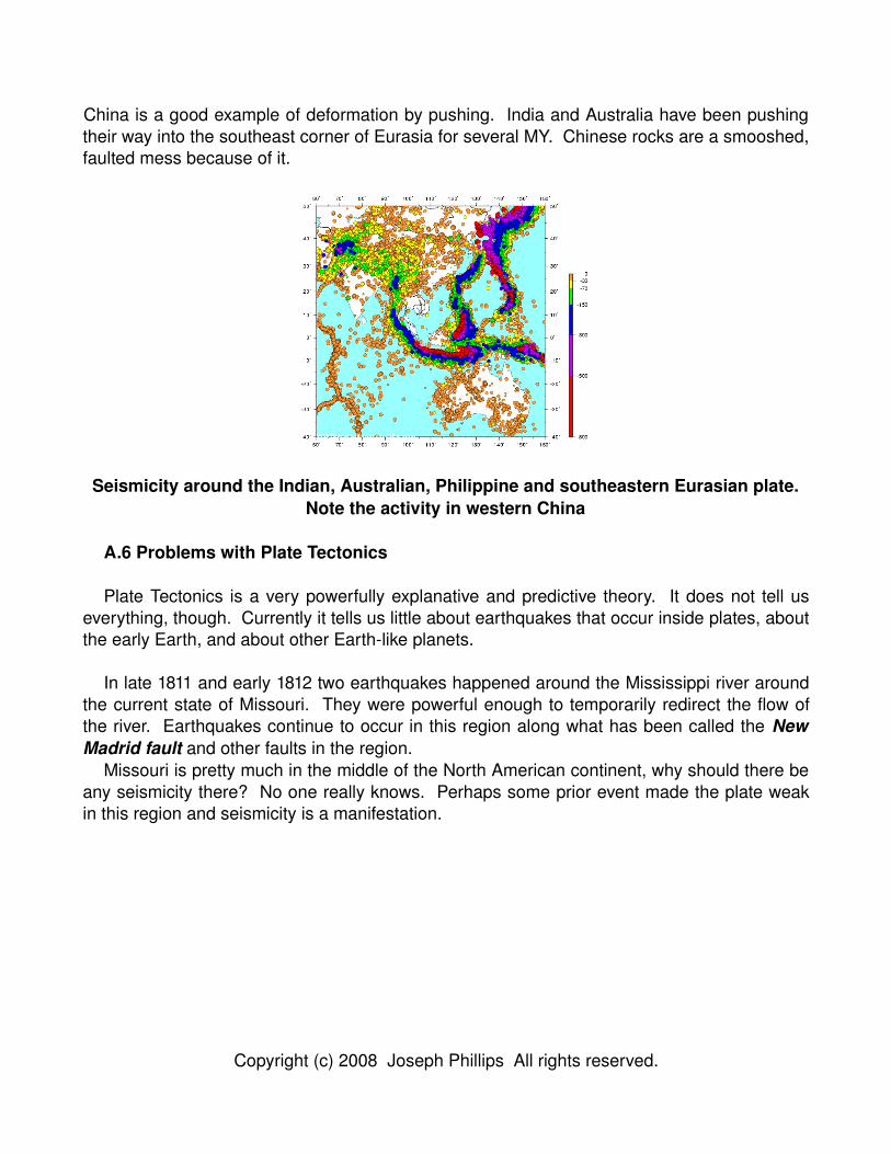
China is a good example of deformation by pushing. India and Australia have been pushing their way into the southeast corner of Eurasia for several MY. Chinese rocks are a smooshed, faulted mess because of it.
Seismicity around the Indian, Australian, Philippine and southeastern Eurasian plate.Note the activity in western China
A.6 Problems with Plate Tectonics
Plate Tectonics is a very powerfully explanative and predictive theory. It does not tell us everything, though. Currently it tells us little about earthquakes that occur inside plates, about the early Earth, and about other Earthlike planets.
In late 1811 and early 1812 two earthquakes happened around the Mississippi river around the current state of Missouri. They were powerful enough to temporarily redirect the flow of the river. Earthquakes continue to occur in this region along what has been called the New Madrid fault and other faults in the region.
Missouri is pretty much in the middle of the North American continent, why should there be any seismicity there? No one really knows. Perhaps some prior event made the plate weak in this region and seismicity is a manifestation.
Copyright (c) 2008 Joseph Phillips All rights reserved.
Seismicity in the western part of the east United States, and the eastern midWest. Note the seismicity around both the Mississippi Valley and the Appalachian Mtns
Another problem with Plate Tectonics is that is does not tell us much about the early Earth. The early Earth was a much hotter place. This is partially due to it having more of its initial heat. It is also due to being more radioactive. Uranium238, for example, has a halflife of about 4,000 MY. Therefore there was twice as much of the stuff 4,000 MYA generating twice as much heat. Uranium235, the stuff used in power plants and bombs, has a halflife of about 1,000 MY. Therefore there was sixteen times as much of the stuff 4,000 MYA, generating sixteen times the heat. Uranium is rare on Earth but Potassium is not; Potassium40 is probably the most important Earthheating radioisotope. Its half life is about 1,250 MY so there was about twelve times as much generating twelve times the heat.
With all that heat was there Plate Tectonics? If not, what was going on before and when did Plate Tectonics proper start? We do not know.
A third problem with Plate Tectonics is if it is such a good theory for Earth, what about Earth's sister planets, Mars and Venus?
Some say that they see evidence of former spreading ridges on Mars in satellite images. Mars has a weak magnetic field but nothing as strong as what an active Martian geodynamo would create. Mars is a smaller planet than the Earth: its greater surface area per unit volume would cool it faster and it would start with less radioisotopes to heat it. This suggests that perhaps Plate Tectonics was active on Mars, but that its mantle stopped flowing and the crust froze into place.
Venus has also been studied. The Soviet Union sent a probe to radarmap its surface, and then the United States sent the Magellan spacecraft to do the same thing in more resolution. For a while we knew more about the surface of Venus than we did about the underwater terrain of Earth.
We expected Venus to be tectonically active and dominated by “oceanic crust”: subduction zones and spreading ridges. We found “continental crust”: volcanoes and mountain ranges.
What is going on? Venus' thick atmosphere is traps the Sun's energy giving it an average temperature of 464 degrees Celsius. There may not be as big of an temperature difference
Copyright (c) 2008 Joseph Phillips All rights reserved.
between Venusian crust and its upper mantle.This might require Venus to shed its heat in another fashion. Venus has over 1,600 major
volcanoes or volcanic structures. It may have 100,000 smaller volcanoes, or even many more. The Earth, by contrast, has only about 1,500 active volcanoes, most of which are probably associated with subduction.
A.7 Earthquakes
Earthquakes are just one manifestation of Plate Tectonics. An advantages of studying them is that they happen often enough that databases of earthquakes has been built up. We will discuss one such database in the next section but now let us discuss quakes themselves.
An earthquake is obviously motion along some fault: part of the Earth moves one way, or part moves the other way (depending on your perspective).
How do we describe earthquakes? How do we know about them? Imagine an earthquake happening along a fault at position X. One can divide the Earth into four regions: two on either side of the fault. In the regions labeled “A” the first motion we sense is a motion away from us. This gives us a seismograph with a dip first. In the regions labeled “T” the first motion we sense is a motion towards us. This gives us a seismograph with a crest first. Comparing seismographs from different instruments all around the globe lets us deduce where, when, how big, and in which direction an earthquake occurred.
We lack the ability to predict earthquakes consistently2. There are, however, patterns in space, time and magnitude. In space the obvious pattern is that earthquakes tend to occur along faults. Spreading ridges are seismically simple and their quakes are neither deep nor large. Transform faults have a little more structure. Their quakes can be larger but all occur in the upper 30 or so kilometers. Below that plates easily slip past each other.
2 The Chinese have claimed they have predicted earthquakes by looking at the behavior of animals. They claimed they saved thousands of lives by doing this. Perhaps they have, but have also missed quakes which have taken thousands of lives. American geophysicists are of the opinion that earthquakes are inherently unpredictable, and the art of “earthquake prediction” has fallen in disrepute in that country. Besides animal behavior others have suggested looking at the level of water in wells, at changes in the local magnetic field, and rates of release of subterranean gases.
Copyright (c) 2008 Joseph Phillips All rights reserved.
Subduction zones are more interesting. Recall, subduction zones are where one plate (generally oceanic) gets pushed back into the mantle after colliding with another plate. As the subducting plate subducts it scrapes against the overriding plate. This results in the world's largest earthquakes: only subduction zones have been known to create magnitudes in the high 8s or 9s.
Eventually, however, the subducting plate heats up, flows more smoothly, and stops generating earthquakes. It still subducts but goes down willingly and quietly. The preceding unwilling, noisy and earthquakegenerating portion of a subduction zone is known as the WadatiBenioff zone.
Patterns in time can be classified by time scale. One the monthstoyears time scale is the main shock/aftershock sequence: a big earthquake is often followed by numerous smaller quakes. The main shock is sometimes preceded with a foreshock lower in magnitude.
If you feel a new earthquake, is it a main shock or just a foreshock for something larger? No one knows until the whole sequence plays out. If you feel a smaller earthquake after a main shock is it an aftershock or is it just “background seismicity” along the fault? We do not have a reliable way to label a given earthquake as an “aftershock” or not.
There may be a time pattern that plays out over centuries. Along many faults most of the energy is released by its biggest, whole fault rupturing earthquakes. (These are mercifully rare.) It seems reasonable to suggest that the fault builds up tension for a long period, all the while giving smaller quakes until the pressure is too much. It then ruptures violently along its entire length and generates its largest quake. Pressure relief allows the fault to lock in a new configuration, and for tension to build again. As fault geometry and plate motions are relatively constant on human time scales one could expect a rhythmic pattern to these large earthquakes. This is called the Elastic Rebound Hypothesis.
It is intuitive. It makes sense. Is it true? No one knows. The problem is that we do not have accurate enough records of large earthquakes to convincingly show this is statistically true3. If the USGS (or someone else) keeps measuring and recording earthquakes for the next 1000 years then we may be able to convince ourselves one way or another.
Lastly there are patterns in the magnitude of earthquakes. The main pattern is the GutenbergRichter relationship. Image a histogram of the number of quakes by magnitude. Now imagine a slightly different histogram where each bin not only included earthquakes within that magnitude range but also all quakes of higher magnitude. Now take the logarithmbase10 of this “cumulative” histogram, and fit it to a line as a function of magnitude. For high enough magnitude you will get a straight line. This relationship is given by the equation:
log(N(M)) = a - bM
where M is the magnitude of the histogram box, N(M) is the cumulative count for this box, and
3 If anyone can do it perhaps it is the Japanese. Being on a subduction zone they have kept records of major earthquakes that go back hundreds of years.
Copyright (c) 2008 Joseph Phillips All rights reserved.
a and b are two constants fit to the data.
For low enough magnitudes the line will falter. We believe that is due to us not recording all of the low magnitude earthquakes. For large enough magnitudes the curve sometimes flattens out: Singaporean geophysicist Nazli Nomanbhoy and American geophysicist Larry Ruff showed that along the Andes subduction zone doublets of large earthquakes occurred at a higher rate than would be expected than if the events were truly random. For large enough magnitudes the curve sometimes dips. That, however may also be incompleteness in the earthquake catalog: the biggest ones are also the rarest ones.
Faults have been studied statistically with a simple model. The springslider model models faults with a matrix of blocks dragged by one plate across another. The forces acting on each block are friction with the second plate, and springs allowing it to push, pull (and be pushed and pulled by) adjacent blocks.
With the springslider model physicists have replicated GutenbergRichter statistics, and have shown that earthquakes are inherently unpredictable. If one block moves it may or may not cause a cascade of other blocks sliding.
A.8 The USGS Earthquake Database
The United States Geological Survey keeps a calatog of seismicity worldwide that is
Copyright (c) 2008 Joseph Phillips All rights reserved.
accessible via web interface at http://neic.usgs.gov/neis/epic/. Their website allows one to get records of earthquakes in a circular area, rectangular area, or worldwide. Further, they let one lists out details on the quakes, or plot them against continental and some geopolitical structures to give you and intuition for where quakes have occurred. The catalog is not perfect though, and I discuss some of its limitations below.
Above all, the catalog is incomplete. This must be remembered for all analyses. Spatially we probably have a better record of terrestrial and nearshore quakes than ones in the middle of the ocean. Temporally the USGS site only starts at 1973 for its main catalog.
Earthquake magnitude provides the largest challenge. First of all there is more than one magnitude scale. The socalled Richter (or as some seismologists prefer, the RichterGutenberg) scale was among the first to be quantified in relation to seismograph measurements. It is more succinctly labeled “ML”. The problem with it is that it is too specific – it is defined to measure Californiaarea quakes with one particular type of seismometer.
Two other measurements measure two types of earthquake waves: “MB” measures deep traveling “body” waves while “MS” measures shallow traveling “surface” waves. They are defined more generally than just for the Californiaarea but they tend to saturate. If the quake is energetic enough then it might be forced to release energy by other means.
The metric “MW” alleviates this problem by truly being related to the energy of the quake. It was defined by Japanese geophysicist Kanamori using an earthquake's “seismic moment” such that its values would roughly equal those from previously defined scales:
Seismic moment = Mo = (rock rigidity)(fault area)(slip distance)Mw = 2/3 (log10Mo - 9.1)
Mw is the most “rational” metric and has the advantage that is does not saturate at large magnitudes. It is, however, the least listed magnitude in the USGS catalog. In my explorations the metric MB is the most prevalent.
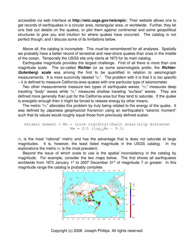
Beyond the issue of which scale to use is the spatial inconsistency in the catalog by magnitude. For example, consider the two maps below. The first shows all earthquakes worldwide from 1973 January 1st to 2007 December 31st of magnitude 7 or greater. In this magnitude range the catalog is probably complete.
Copyright (c) 2008 Joseph Phillips All rights reserved.
The second shows all quakes worldwide between magnitudes 1 and 2.
Do you really believe that most tiny quakes occur in western Europe? Obviously we have found where the world's most sensitive seismometers are rather than the location of all small quakes. Also, are there really this number of faults in Europe? These might be “quakes” associated with construction and mining detonations, war games, bad weather, etc.
A.9 Summary
In this chapter we have discussed the prehistory, main points, problems and some of the data associated with the Plate Tectonics paradigm. We will use it in computational scientific discovery labs.
(Please note: whatever you do Do NOT say you are doing earthquake prediction! This has been discredited, at least within the United States.)
References
Copyright (c) 2008 Joseph Phillips All rights reserved.