133
APPENDIX A UMAM DATA SHEETS

APPENDIX A
UMAM DATA SHEETS

Site/Project Name Application Number Assessment Area Name or Number
Impact or Mitigation Site? Assessment Area Size
Geographic relationship to and hydrologic connection with wetlands, other surface water, uplands
CommonWetland bordered on the east and south by recently cleared vacant land, on the west by commercial development and on the north by Ellis Road
Significant nearby features
UNIFORM WETLAND MITIGATION ASSESSMENT WORKSHEET - PART I - IMPACTForm 62-345.900(2), F.A.C. (See Sections 62-345.400 F.A.C.)
Disturbed shrub wetland dominated by willow but recently partially cleared and currently with open water with a duckweed cover. The wetland & adjacent uplands are contained within a chainlink fence.
Disturbed shrub-dominated wetland which disharges to a drainage ditch in the headwaters section of Crane Creek.
Assessment area description
Special Classification (i.e.OFW, AP, other local/state/federal designation of importance)
Basin 22, Central Indian River Lagoon
Impact
Basin/Watershed Name/Number Affected Waterbody (Class)
N/A
Acres
Crane Creek, Class III
Uniqueness (considering the relative rarity in relation to the regional landscape.)
Ellis Road W-20
FLUCCs code Further classification (optional)
618 PSS1C
Mitigation for previous permit/other historic use
Wildlife habitat, water quality enhancement, flood attenuation N/A
Anticipated Wildlife Utilization Based on Literature Review (List of species that are representative of the assessment area and reasonably expected to be found )
Anticipated Utilization by Listed Species (List species, their legal classification (E, T, SSC), type of use, and intensity of use of the assessment area)
Functions
Assessment conducted by: Assessment date(s):
Form 62-345.900(1), F.A.C. [ effective date ]
T. J. Deuerling 04/28/11
Additional relevant factors:
The wetland is a highly disturbed shrub-dominated system with the adjacent uplands as maintained grassland. It is located in an urban setting and the wetland & adjacent uplands are contained within a chainlink fence.
Wading birds, hawks, owls, songbirds, woodpeckers, raccoon, rabbit, opossum, gray squirrel, water snakes, frogs, water turtles, anoles
Limited foraging and nesting habitat for listed wading birds
Observed Evidence of Wildlife Utilization (List species directly observed, or other signs such as tracks, droppings, casings, nests, etc.):
None
X:\P\1071025000\emo\Env Reports\WER-Essential Fish-ESBA\Appendix A - UMAM\final 2011-04-28\w-20 2011-04-28a.xls

Impact or Mitigation:
Place an "X" in the box above next to
X
X
Place an "X" in the box above next to the two (2) most important criteria used
in scoring this section
X
X
a. Quality and quantity of habitat support outside of AA.
b. Invasive plant species.
Not Present (0)
Minimal level of support of wetland/surface water
functions
Condition is insufficient to provide wetland/surface water functions
With ImpactCurrent
Current With Impact
b. Reliability of water level indicators.
.500(6)(a) Location and Landscape Support
0
d. Downstream benefits provided to fish and wildlife.
e. Adverse impacts to wildlife in AA from land uses outside of AA.
d. Flow rates/points of discharge.
Condition is less than optimal, but sufficient to maintain most wetland/surface waterfunctions
h. Use by animals with hydrologic requirements.
a. Appropriateness of water levels and flows.
j. Water quality of standing water by observation (I.e., discoloration, turbidity).
Optimal (10)
k. Water quality data for the type of community.
l. Water depth, wave energy, and currents.
c. Wildlife access to and from AA (proximity and barriers).
UNIFORM WETLAND MITIGATION ASSESSMENT WORKSHEET - PART II - IMPACTForm 62-345.900(2), F.A.C. (See Sections 62-345.500 and .600, F.A.C.)
Site/Project Name: Application Number: Assessment Area Name or Number:
Moderate(7) Minimal (4)
Condition is optimal and fully supports wetland/surface water
functions
Ellis Road - W-19
Impact T. J. Deuerling 04/28/11
Assessment Date:Assessment Conducted by:
g. Dependency of downstream habitats on quantity or quality of discharges.
h. Protection of wetland functions provided by uplands (upland AAs only).
f. Hydrologic connectivity (impediments and flow restrictions).
f. Type of vegetation.
g. Hydrologic stress on vegetation.
c. Appropriateness of soil moisture.
i. Plant community composition associated with water quality (i.e., plants tolerant of poor WQ).
Historic hydrology has been impacted by past ditching and development.
Scoring Guidance
The scoring of each indicator is based on what would be suitable for the type of wetland or
surface water assessed
.500(6)(b) Water Environment (n/a for uplands)
4
e. Fire frequency/severity.
Current
Notes:
Notes:
With Impact
Wetland is located in urban setting. Poor wild;life corridor opportunity.
X Vegetation
Benthic
Both
8
X
X. Upland assessment area
Place an "X" in the box above next to the two (2) most important criteria used
in scoring this section8 0
II. Invasive/exotic plant species
I. Appropriate/desirable species
IX. Submerged vegetation (only score if present).
IV. Age, size distribution.
X
Current - w/Impact 0.67
0.00
NOTE: If impact is proposed to be mitigated at a mitigation bank thatwas assessed using UMAM, then the credits required for mitigation isequal to Functional Loss (FL). If impact mitigation is proposed at amitigation bank that was not assessed using UMAM, then UMAMcannot be used to assess impacts; use the assessment method ofthe mitigaiton bank.
FL = ID x Impact Acres = 0.00
Raw Score = Sum of above scores/30 (if uplands, divide by 20)
With ImpactCurrent
.500(6)(c) Community Structure
Impact Delta (ID)
0
Notes:
0.67
Current With Impact
VI. Plants' condition.
VII. Land management practices.
VIII. Topographic features (refugia, channels, hummocks).
III. Regeneration/recruitment
V. Snags, dens, cavity, etc.
Functional Loss (FL) [For Impact Assessment Areas]:
0Impact Acres =
Place an "X" in the box above next to the two (2) most important criteria used
in scoring this section
Native plant species dominant; however area highly disturbed.
X:\P\1071025000\emo\Env Reports\WER-Essential Fish-ESBA\Appendix A - UMAM\final 2011-04-28\w-19 2011-04-28a.xls

Site/Project Name Application Number Assessment Area Name or Number
Impact or Mitigation Site? Assessment Area Size
Geographic relationship to and hydrologic connection with wetlands, other surface water, uplands
CommonWetland is bordered on the south by residential development, on the east by commercial development, on the west by temperate hardwood hammock and commercial development and on the north by Ellis
Significant nearby features
UNIFORM WETLAND MITIGATION ASSESSMENT WORKSHEET - PART I - IMPACTForm 62-345.900(2), F.A.C. (See Sections 62-345.400 F.A.C.)
Red maple, laurel oak and Florida elm along with some cabbage palm form a closed canopy. Groundcover species include seedling and sapling canopy species, swamp fern, poison ivy and wild coffee.
W-19 is a seasonally inundated, forested wetland which extends off-site to the southwest. which discharges via sheet flow and a ditch to the L-15 Canal.
Assessment area description
Special Classification (i.e.OFW, AP, other local/state/federal designation of importance)
Basin 22, Central Indian River Lagoon
Impact
Basin/Watershed Name/Number Affected Waterbody (Class)
N/A
Acres
Crane Creek, Class III
Uniqueness (considering the relative rarity in relation to the regional landscape.)
Ellis Road W-19
FLUCCs code Further classification (optional)
617 PFO1C
Mitigation for previous permit/other historic use
Wildlife habitat, water quality enhancement, flood attenuation N/A
Anticipated Wildlife Utilization Based on Literature Review (List of species that are representative of the assessment area and reasonably expected to be found )
Anticipated Utilization by Listed Species (List species, their legal classification (E, T, SSC), type of use, and intensity of use of the assessment area)
Functions
Assessment conducted by: Assessment date(s):
Form 62-345.900(1), F.A.C. [ effective date ]
T. J. Deuerling 04/28/11
Additional relevant factors:
The wetland is a highly disturbed forested system. It is located in an urban setting.
Wading birds, hawks, owls, songbirds, woodpeckers, raccoon, rabbit, opossum, gray squirrel, water snakes, frogs, water turtles, anoles
Limited foraging and nesting habitat for listed wading birds
Observed Evidence of Wildlife Utilization (List species directly observed, or other signs such as tracks, droppings, casings, nests, etc.):
Northern Cardinal
X:\P\1071025000\emo\Env Reports\WER-Essential Fish-ESBA\Appendix A - UMAM\final 2011-04-28\w-19 2011-04-28a.xls

Impact or Mitigation:
With Impact
Wetland is located in urban setting. Poor wild;life corridor opportunity.
Current
Notes:
Notes:
Scoring Guidance
The scoring of each indicator is based on what would be suitable for the type of wetland or
surface water assessed
.500(6)(b) Water Environment (n/a for uplands)
4
e. Fire frequency/severity.
i. Plant community composition associated with water quality (i.e., plants tolerant of poor WQ).
Historic hydrology has been impacted by past ditching and development.
g. Dependency of downstream habitats on quantity or quality of discharges.
h. Protection of wetland functions provided by uplands (upland AAs only).
f. Hydrologic connectivity (impediments and flow restrictions).
f. Type of vegetation.
g. Hydrologic stress on vegetation.
c. Appropriateness of soil moisture.
Ellis Road - W-18
Impact T. J. Deuerling 04/28/11
Assessment Date:Assessment Conducted by:
UNIFORM WETLAND MITIGATION ASSESSMENT WORKSHEET - PART II - IMPACTForm 62-345.900(2), F.A.C. (See Sections 62-345.500 and .600, F.A.C.)
Site/Project Name: Application Number: Assessment Area Name or Number:
Moderate(7) Minimal (4)
Condition is optimal and fully supports wetland/surface water
functions
Condition is less than optimal, but sufficient to maintain most wetland/surface waterfunctions
h. Use by animals with hydrologic requirements.
a. Appropriateness of water levels and flows.
j. Water quality of standing water by observation (I.e., discoloration, turbidity).
Optimal (10)
k. Water quality data for the type of community.
l. Water depth, wave energy, and currents.
c. Wildlife access to and from AA (proximity and barriers).
Current With Impact
b. Reliability of water level indicators.
.500(6)(a) Location and Landscape Support
0
d. Downstream benefits provided to fish and wildlife.
e. Adverse impacts to wildlife in AA from land uses outside of AA.
d. Flow rates/points of discharge.
Not Present (0)
Minimal level of support of wetland/surface water
functions
Condition is insufficient to provide wetland/surface water functions
With ImpactCurrent
X
a. Quality and quantity of habitat support outside of AA.
b. Invasive plant species.
Place an "X" in the box above next to the two (2) most important criteria used
in scoring this section
X
X
X
Place an "X" in the box above next to
X Vegetation
Benthic
Both
7
Functional Loss (FL) [For Impact Assessment Areas]:
0Impact Acres =
Place an "X" in the box above next to the two (2) most important criteria used
in scoring this section
Native plant species dominant however groundcover maintained by mowing.
VI. Plants' condition.
VII. Land management practices.
VIII. Topographic features (refugia, channels, hummocks).
III. Regeneration/recruitment
V. Snags, dens, cavity, etc.
.500(6)(c) Community Structure
Impact Delta (ID)
0
Notes:
0.60
Current With Impact
FL = ID x Impact Acres = 0.00
Raw Score = Sum of above scores/30 (if uplands, divide by 20)
With ImpactCurrent
X
Current - w/Impact 0.60
0.00
NOTE: If impact is proposed to be mitigated at a mitigation bank thatwas assessed using UMAM, then the credits required for mitigation isequal to Functional Loss (FL). If impact mitigation is proposed at amitigation bank that was not assessed using UMAM, then UMAMcannot be used to assess impacts; use the assessment method ofthe mitigaiton bank.
IX. Submerged vegetation (only score if present).
IV. Age, size distribution.
II. Invasive/exotic plant species
I. Appropriate/desirable species
7 0Place an "X" in the box above next to
the two (2) most important criteria used in scoring this section
X
X. Upland assessment area
X:\P\1071025000\emo\Env Reports\WER-Essential Fish-ESBA\Appendix A - UMAM\final 2011-04-28\w-18 2011-04-28a.xls

Site/Project Name Application Number Assessment Area Name or Number
Impact or Mitigation Site? Assessment Area Size
Mitigation for previous permit/other historic use
Wildlife habitat, water quality enhancement, flood attenuation N/A
Anticipated Wildlife Utilization Based on Literature Review (List of species that are representative of the assessment area and reasonably expected to be found )
Anticipated Utilization by Listed Species (List species, their legal classification (E, T, SSC), type of use, and intensity of use of the assessment area)
Functions
Ellis Road W-18
FLUCCs code Further classification (optional)
617 PFO1C
Uniqueness (considering the relative rarity in relation to the regional landscape.)
Basin 22, Central Indian River Lagoon
Impact
Basin/Watershed Name/Number Affected Waterbody (Class)
N/A
Acres
Crane Creek, Class III
Geographic relationship to and hydrologic connection with wetlands, other surface water, uplands
CommonWetland bordered on the east and west by disturbed pine flatwoods or temperate hardwood hammock, on the south by residential development and on the north by Ellis Road.
Significant nearby features
UNIFORM WETLAND MITIGATION ASSESSMENT WORKSHEET - PART I - IMPACTForm 62-345.900(2), F.A.C. (See Sections 62-345.400 F.A.C.)
Disturbed forested wetland dominated by mesic oaks and red maple with a groundcover of seedling canopy species, swamp fern and Virginia chain fern. Groundcover is periodically mowed.
Disturbed forested wetland which disharges to a drainage ditch in the headwaters section of Crane Creek.
Assessment area description
Special Classification (i.e.OFW, AP, other local/state/federal designation of importance)
Assessment conducted by: Assessment date(s):
Form 62-345.900(1), F.A.C. [ effective date ]
T. J. Deuerling 04/28/11
Additional relevant factors:
The wetland is a disturbed forested system with the groundcover maintained by mowing. It is located in an urban setting
Wading birds, hawks, owls, songbirds, woodpeckers, raccoon, rabbit, opossum, gray squirrel, water snakes, frogs, water turtles, anoles
Limited foraging and nesting habitat for listed wading birds
Observed Evidence of Wildlife Utilization (List species directly observed, or other signs such as tracks, droppings, casings, nests, etc.):
None
X:\P\1071025000\emo\Env Reports\WER-Essential Fish-ESBA\Appendix A - UMAM\final 2011-04-28\w-18 2011-04-28a.xls

Impact or Mitigation:
With Impact
Wetland is located in urban setting. Poor wild;life corridor opportunity.
Current
Notes:
Notes:
Scoring Guidance
The scoring of each indicator is based on what would be suitable for the type of wetland or
surface water assessed
.500(6)(b) Water Environment (n/a for uplands)
4
e. Fire frequency/severity.
i. Plant community composition associated with water quality (i.e., plants tolerant of poor WQ).
Historic hydrology has been impacted by past ditching and development.
g. Dependency of downstream habitats on quantity or quality of discharges.
h. Protection of wetland functions provided by uplands (upland AAs only).
f. Hydrologic connectivity (impediments and flow restrictions).
f. Type of vegetation.
g. Hydrologic stress on vegetation.
c. Appropriateness of soil moisture.
Ellis Road - W-17
Impact T. J. Deuerling 04/28/11
Assessment Date:Assessment Conducted by:
UNIFORM WETLAND MITIGATION ASSESSMENT WORKSHEET - PART II - IMPACTForm 62-345.900(2), F.A.C. (See Sections 62-345.500 and .600, F.A.C.)
Site/Project Name: Application Number: Assessment Area Name or Number:
Moderate(7) Minimal (4)
Condition is optimal and fully supports wetland/surface water
functions
Condition is less than optimal, but sufficient to maintain most wetland/surface waterfunctions
h. Use by animals with hydrologic requirements.
a. Appropriateness of water levels and flows.
j. Water quality of standing water by observation (I.e., discoloration, turbidity).
Optimal (10)
k. Water quality data for the type of community.
l. Water depth, wave energy, and currents.
c. Wildlife access to and from AA (proximity and barriers).
Current With Impact
b. Reliability of water level indicators.
.500(6)(a) Location and Landscape Support
0
d. Downstream benefits provided to fish and wildlife.
e. Adverse impacts to wildlife in AA from land uses outside of AA.
d. Flow rates/points of discharge.
Not Present (0)
Minimal level of support of wetland/surface water
functions
Condition is insufficient to provide wetland/surface water functions
With ImpactCurrent
X
a. Quality and quantity of habitat support outside of AA.
b. Invasive plant species.
Place an "X" in the box above next to the two (2) most important criteria used
in scoring this section
X
X
X
Place an "X" in the box above next to
X Vegetation
Benthic
Both
8
Functional Loss (FL) [For Impact Assessment Areas]:
0Impact Acres =
Place an "X" in the box above next to the two (2) most important criteria used
in scoring this section
Native plant species dominant ;however Brazilian pepper invading the system.
VI. Plants' condition.
VII. Land management practices.
VIII. Topographic features (refugia, channels, hummocks).
III. Regeneration/recruitment
V. Snags, dens, cavity, etc.
.500(6)(c) Community Structure
Impact Delta (ID)
0
Notes:
0.63
Current With Impact
FL = ID x Impact Acres = 0.00
Raw Score = Sum of above scores/30 (if uplands, divide by 20)
With ImpactCurrent
X
Current - w/Impact 0.63
0.00
NOTE: If impact is proposed to be mitigated at a mitigation bank thatwas assessed using UMAM, then the credits required for mitigation isequal to Functional Loss (FL). If impact mitigation is proposed at amitigation bank that was not assessed using UMAM, then UMAMcannot be used to assess impacts; use the assessment method ofthe mitigaiton bank.
IX. Submerged vegetation (only score if present).
IV. Age, size distribution.
II. Invasive/exotic plant species
I. Appropriate/desirable species
7 0Place an "X" in the box above next to
the two (2) most important criteria used in scoring this section
X
X. Upland assessment area
X:\P\1071025000\emo\Env Reports\WER-Essential Fish-ESBA\Appendix A - UMAM\final 2011-04-28\w-17 2011-04-28a.xls

Site/Project Name Application Number Assessment Area Name or Number
Impact or Mitigation Site? Assessment Area Size
Mitigation for previous permit/other historic use
Wildlife habitat, water quality enhancement, flood attenuation N/A
Anticipated Wildlife Utilization Based on Literature Review (List of species that are representative of the assessment area and reasonably expected to be found )
Anticipated Utilization by Listed Species (List species, their legal classification (E, T, SSC), type of use, and intensity of use of the assessment area)
Functions
Ellis Road W-17
FLUCCs code Further classification (optional)
617 PFO1C
Uniqueness (considering the relative rarity in relation to the regional landscape.)
Basin 22, Central Indian River Lagoon
Impact
Basin/Watershed Name/Number Affected Waterbody (Class)
N/A
Acres
Crane Creek, Class III
Geographic relationship to and hydrologic connection with wetlands, other surface water, uplands
CommonWetland bordered on the east and west by commercial development, on the south by Ellis Road and on the east by temperate hardwood hammock.
Significant nearby features
UNIFORM WETLAND MITIGATION ASSESSMENT WORKSHEET - PART I - IMPACTForm 62-345.900(2), F.A.C. (See Sections 62-345.400 F.A.C.)
Disturbed forested wetland dominated by mesic oaks, red maple and elm with some cabbage palm and a groundcover seedling & sapling canopy species, swamp fern, poison ivy and wild coffee. Brazilian pepper invading the system.
Disturbed forested wetland which sheet flows to the L-15 Canal.
Assessment area description
Special Classification (i.e.OFW, AP, other local/state/federal designation of importance)
Assessment conducted by: Assessment date(s):
Form 62-345.900(1), F.A.C. [ effective date ]
T. J. Deuerling 04/28/11
Additional relevant factors:
The wetland is a highly disturbed forested system being invaded by Brazilian pepper. It is located in an urban setting.
Wading birds, hawks, owls, songbirds, woodpeckers, raccoon, rabbit, opossum, gray squirrel, water snakes, frogs, water turtles, anoles
Limited foraging and nesting habitat for listed wading birds
Observed Evidence of Wildlife Utilization (List species directly observed, or other signs such as tracks, droppings, casings, nests, etc.):
None
X:\P\1071025000\emo\Env Reports\WER-Essential Fish-ESBA\Appendix A - UMAM\final 2011-04-28\w-17 2011-04-28a.xls

Impact or Mitigation:
Place an "X" in the box above next to
X
X
Place an "X" in the box above next to the two (2) most important criteria used
in scoring this section
X
X
a. Quality and quantity of habitat support outside of AA.
b. Invasive plant species.
Not Present (0)
Minimal level of support of wetland/surface water
functions
Condition is insufficient to provide wetland/surface water functions
With ImpactCurrent
Current With Impact
b. Reliability of water level indicators.
.500(6)(a) Location and Landscape Support
0
d. Downstream benefits provided to fish and wildlife.
e. Adverse impacts to wildlife in AA from land uses outside of AA.
d. Flow rates/points of discharge.
Condition is less than optimal, but sufficient to maintain most wetland/surface waterfunctions
h. Use by animals with hydrologic requirements.
a. Appropriateness of water levels and flows.
j. Water quality of standing water by observation (I.e., discoloration, turbidity).
Optimal (10)
k. Water quality data for the type of community.
l. Water depth, wave energy, and currents.
c. Wildlife access to and from AA (proximity and barriers).
UNIFORM WETLAND MITIGATION ASSESSMENT WORKSHEET - PART II - IMPACTForm 62-345.900(2), F.A.C. (See Sections 62-345.500 and .600, F.A.C.)
Site/Project Name: Application Number: Assessment Area Name or Number:
Moderate(7) Minimal (4)
Condition is optimal and fully supports wetland/surface water
functions
Ellis Road - W-16
Impact T. J. Deuerling 04/28/11
Assessment Date:Assessment Conducted by:
g. Dependency of downstream habitats on quantity or quality of discharges.
h. Protection of wetland functions provided by uplands (upland AAs only).
f. Hydrologic connectivity (impediments and flow restrictions).
f. Type of vegetation.
g. Hydrologic stress on vegetation.
c. Appropriateness of soil moisture.
i. Plant community composition associated with water quality (i.e., plants tolerant of poor WQ).
Historic hydrology has been impacted by past ditch & borrow pit construction.
Scoring Guidance
The scoring of each indicator is based on what would be suitable for the type of wetland or
surface water assessed
.500(6)(b) Water Environment (n/a for uplands)
2
e. Fire frequency/severity.
Current
Notes:
Notes:
With Impact
Wetland is located in urban setting. Poor wild;life corridor opportunity.
X Vegetation
Benthic
Both
8
X
X. Upland assessment area
Place an "X" in the box above next to the two (2) most important criteria used
in scoring this section7 0
II. Invasive/exotic plant species
I. Appropriate/desirable species
IX. Submerged vegetation (only score if present).
IV. Age, size distribution.
X
Current - w/Impact 0.57
0.00
NOTE: If impact is proposed to be mitigated at a mitigation bank thatwas assessed using UMAM, then the credits required for mitigation isequal to Functional Loss (FL). If impact mitigation is proposed at amitigation bank that was not assessed using UMAM, then UMAMcannot be used to assess impacts; use the assessment method ofthe mitigaiton bank.
FL = ID x Impact Acres = 0.00
Raw Score = Sum of above scores/30 (if uplands, divide by 20)
With ImpactCurrent
.500(6)(c) Community Structure
Impact Delta (ID)
0
Notes:
0.57
Current With Impact
VI. Plants' condition.
VII. Land management practices.
VIII. Topographic features (refugia, channels, hummocks).
III. Regeneration/recruitment
V. Snags, dens, cavity, etc.
Functional Loss (FL) [For Impact Assessment Areas]:
0Impact Acres =
Place an "X" in the box above next to the two (2) most important criteria used
in scoring this section
Native plant species dominant ;however Brazilian pepper invading the system.
X:\P\1071025000\emo\Env Reports\WER-Essential Fish-ESBA\Appendix A - UMAM\final 2011-04-28\w-16 2011-04-28a.xls

Site/Project Name Application Number Assessment Area Name or Number
Impact or Mitigation Site? Assessment Area Size
Geographic relationship to and hydrologic connection with wetlands, other surface water, uplands
CommonWetland bordered on all sides by institutional develoment or Ellis Road.
Significant nearby features
UNIFORM WETLAND MITIGATION ASSESSMENT WORKSHEET - PART I - IMPACTForm 62-345.900(2), F.A.C. (See Sections 62-345.400 F.A.C.)
Disturbed forested wetland dominated by mesic oaks, red maple and elm with some cabbage palm and a groundcover seedling & sapling canopy species, swamp fern, poison ivy and wild coffee. Brazilian pepper invading the system.
Disturbed forested wetland which sheet flows to the L-15 Canal.
Assessment area description
Special Classification (i.e.OFW, AP, other local/state/federal designation of importance)
Basin 22, Central Indian River Lagoon
Impact
Basin/Watershed Name/Number Affected Waterbody (Class)
N/A
Acres
Crane Creek, Class III
Uniqueness (considering the relative rarity in relation to the regional landscape.)
Ellis Road W-16
FLUCCs code Further classification (optional)
617 PFO1C
Mitigation for previous permit/other historic use
Wildlife habitat, water quality enhancement, flood attenuation N/A
Anticipated Wildlife Utilization Based on Literature Review (List of species that are representative of the assessment area and reasonably expected to be found )
Anticipated Utilization by Listed Species (List species, their legal classification (E, T, SSC), type of use, and intensity of use of the assessment area)
Functions
Assessment conducted by: Assessment date(s):
Form 62-345.900(1), F.A.C. [ effective date ]
T. J. Deuerling 04/28/11
Additional relevant factors:
The wetland is a highly disturbed forested system being invaded by Brazilian pepper. It is located in an urban setting.
Wading birds, hawks, owls, songbirds, woodpeckers, raccoon, rabbit, opossum, gray squirrel, water snakes, frogs, water turtles, anoles
Limited foraging and nesting habitat for listed wading birds
Observed Evidence of Wildlife Utilization (List species directly observed, or other signs such as tracks, droppings, casings, nests, etc.):
Red-bellied Woodpecker
X:\P\1071025000\emo\Env Reports\WER-Essential Fish-ESBA\Appendix A - UMAM\final 2011-04-28\w-16 2011-04-28a.xls

Impact or Mitigation:
Place an "X" in the box above next to
X
X
Place an "X" in the box above next to the two (2) most important criteria used
in scoring this section
X
X
a. Quality and quantity of habitat support outside of AA.
b. Invasive plant species.
Not Present (0)
Minimal level of support of wetland/surface water
functions
Condition is insufficient to provide wetland/surface water functions
With ImpactCurrent
Current With Impact
b. Reliability of water level indicators.
.500(6)(a) Location and Landscape Support
0
d. Downstream benefits provided to fish and wildlife.
e. Adverse impacts to wildlife in AA from land uses outside of AA.
d. Flow rates/points of discharge.
Condition is less than optimal, but sufficient to maintain most wetland/surface waterfunctions
h. Use by animals with hydrologic requirements.
a. Appropriateness of water levels and flows.
j. Water quality of standing water by observation (I.e., discoloration, turbidity).
Optimal (10)
k. Water quality data for the type of community.
l. Water depth, wave energy, and currents.
c. Wildlife access to and from AA (proximity and barriers).
UNIFORM WETLAND MITIGATION ASSESSMENT WORKSHEET - PART II - IMPACTForm 62-345.900(2), F.A.C. (See Sections 62-345.500 and .600, F.A.C.)
Site/Project Name: Application Number: Assessment Area Name or Number:
Moderate(7) Minimal (4)
Condition is optimal and fully supports wetland/surface water
functions
Ellis Road - W-14
Impact T. J. Deuerling 04/28/11
Assessment Date:Assessment Conducted by:
g. Dependency of downstream habitats on quantity or quality of discharges.
h. Protection of wetland functions provided by uplands (upland AAs only).
f. Hydrologic connectivity (impediments and flow restrictions).
f. Type of vegetation.
g. Hydrologic stress on vegetation.
c. Appropriateness of soil moisture.
i. Plant community composition associated with water quality (i.e., plants tolerant of poor WQ).
Historic hydrology has been impacted by past ditch & borrow pit construction.
Scoring Guidance
The scoring of each indicator is based on what would be suitable for the type of wetland or
surface water assessed
.500(6)(b) Water Environment (n/a for uplands)
6
e. Fire frequency/severity.
Current
Notes:
Notes:
With Impact
Some undeveloped land adjacent to wetland, however poor wildlife corridor connection due urbanization of general area.
X Vegetation
Benthic
Both
8
X
X. Upland assessment area
Place an "X" in the box above next to the two (2) most important criteria used
in scoring this section7 0
II. Invasive/exotic plant species
I. Appropriate/desirable species
IX. Submerged vegetation (only score if present).
IV. Age, size distribution.
X
Current - w/Impact 0.70
0.00
NOTE: If impact is proposed to be mitigated at a mitigation bank thatwas assessed using UMAM, then the credits required for mitigation isequal to Functional Loss (FL). If impact mitigation is proposed at amitigation bank that was not assessed using UMAM, then UMAMcannot be used to assess impacts; use the assessment method ofthe mitigaiton bank.
FL = ID x Impact Acres = 0.00
Raw Score = Sum of above scores/30 (if uplands, divide by 20)
With ImpactCurrent
.500(6)(c) Community Structure
Impact Delta (ID)
0
Notes:
0.70
Current With Impact
VI. Plants' condition.
VII. Land management practices.
VIII. Topographic features (refugia, channels, hummocks).
III. Regeneration/recruitment
V. Snags, dens, cavity, etc.
Functional Loss (FL) [For Impact Assessment Areas]:
0Impact Acres =
Place an "X" in the box above next to the two (2) most important criteria used
in scoring this section
Native plant species dominant ;however Brazilian pepper invading the system.
X:\P\1071025000\emo\Env Reports\WER-Essential Fish-ESBA\Appendix A - UMAM\final 2011-04-28\w-15 2011-04-28a.xls

Site/Project Name Application Number Assessment Area Name or Number
Impact or Mitigation Site? Assessment Area Size
Geographic relationship to and hydrologic connection with wetlands, other surface water, uplands
CommonWetland bordered on west by John Rode Blvd. & drainage ditch, on north by residential development, on south by a school and on east by mesic hardwood hammock, borrow pit & disturbed land.
Significant nearby features
UNIFORM WETLAND MITIGATION ASSESSMENT WORKSHEET - PART I - IMPACTForm 62-345.900(2), F.A.C. (See Sections 62-345.400 F.A.C.)
Disturbed forested wetland dominated by mesic oaks, red maple and elm with some cabbage palm and a sparse groundcover seedling & sapling canopy species and swamp fern. Brazilian pepper invading the system.
Disturbed forested wetland which sheet flows to a ditch adjacent to John Rodes Boulevard and ultimately to the L-15 Canal.
Assessment area description
Special Classification (i.e.OFW, AP, other local/state/federal designation of importance)
Basin 22, Central Indian River Lagoon
Impact
Basin/Watershed Name/Number Affected Waterbody (Class)
N/A
Acres
Crane Creek, Class III
Uniqueness (considering the relative rarity in relation to the regional landscape.)
Ellis Road W-14
FLUCCs code Further classification (optional)
617 PFO1C
Mitigation for previous permit/other historic use
Wildlife habitat, water quality enhancement, flood attenuation N/A
Anticipated Wildlife Utilization Based on Literature Review (List of species that are representative of the assessment area and reasonably expected to be found )
Anticipated Utilization by Listed Species (List species, their legal classification (E, T, SSC), type of use, and intensity of use of the assessment area)
Functions
Assessment conducted by: Assessment date(s):
Form 62-345.900(1), F.A.C. [ effective date ]
T. J. Deuerling 04/28/11
Additional relevant factors:
The wetland is a highly disturbed forested system being invaded by Brazilian pepper. It is located in an urban setting.
Wading birds, hawks, owls, songbirds, woodpeckers, raccoon, rabbit, opossum, gray squirrel, water snakes, frogs, water turtles, anoles
Limited foraging and nesting habitat for listed wading birds
Observed Evidence of Wildlife Utilization (List species directly observed, or other signs such as tracks, droppings, casings, nests, etc.):
Raccoon Track, Boat-tailed Grackle
X:\P\1071025000\emo\Env Reports\WER-Essential Fish-ESBA\Appendix A - UMAM\final 2011-04-28\w-15 2011-04-28a.xls

Impact or Mitigation:
Place an "X" in the box above next to
X
X
Place an "X" in the box above next to the two (2) most important criteria used
in scoring this section
a. Quality and quantity of habitat support outside of AA.
b. Invasive plant species.
X
Not Present (0)
Minimal level of support of wetland/surface water
functions
Condition is insufficient to provide wetland/surface water functions
X
With ImpactCurrent
Current With Impact
b. Reliability of water level indicators.
.500(6)(a) Location and Landscape Support
0
d. Downstream benefits provided to fish and wildlife.
e. Adverse impacts to wildlife in AA from land uses outside of AA.
d. Flow rates/points of discharge.
Condition is less than optimal, but sufficient to maintain most wetland/surface waterfunctions
h. Use by animals with hydrologic requirements.
a. Appropriateness of water levels and flows.
j. Water quality of standing water by observation (I.e., discoloration, turbidity).
Optimal (10)
k. Water quality data for the type of community.
l. Water depth, wave energy, and currents.
c. Wildlife access to and from AA (proximity and barriers).
UNIFORM WETLAND MITIGATION ASSESSMENT WORKSHEET - PART II - IMPACTForm 62-345.900(2), F.A.C. (See Sections 62-345.500 and .600, F.A.C.)
Site/Project Name: Application Number: Assessment Area Name or Number:
Moderate(7) Minimal (4)
Condition is optimal and fully supports wetland/surface water
functions
Ellis Road - W-14
Impact T. J. Deuerling 04/28/11
Assessment Date:Assessment Conducted by:
g. Dependency of downstream habitats on quantity or quality of discharges.
h. Protection of wetland functions provided by uplands (upland AAs only).
f. Hydrologic connectivity (impediments and flow restrictions).
f. Type of vegetation.
g. Hydrologic stress on vegetation.
c. Appropriateness of soil moisture.
i. Plant community composition associated with water quality (i.e., plants tolerant of poor WQ).
Historic hydrology has been impacted by past development & canal construction.
Scoring Guidance
The scoring of each indicator is based on what would be suitable for the type of wetland or
surface water assessed
.500(6)(b) Water Environment (n/a for uplands)
6
e. Fire frequency/severity.
Current
Notes:
Notes:
With Impact
AA located in developed area and bordered by I-95 and a mobile home park. Vacant land on remaining sides but poor wildlife corridor connection to anywhere except developed properties.
X Vegetation
Benthic
Both
8
X
X. Upland assessment area
Place an "X" in the box above next to the two (2) most important criteria used
in scoring this section7 0
II. Invasive/exotic plant species
I. Appropriate/desirable species
IX. Submerged vegetation (only score if present).
IV. Age, size distribution.
X
Current - w/Impact 0.70
0.00
NOTE: If impact is proposed to be mitigated at a mitigation bank thatwas assessed using UMAM, then the credits required for mitigation isequal to Functional Loss (FL). If impact mitigation is proposed at amitigation bank that was not assessed using UMAM, then UMAMcannot be used to assess impacts; use the assessment method ofthe mitigaiton bank.
FL = ID x Impact Acres = 0.00
Raw Score = Sum of above scores/30 (if uplands, divide by 20)
With ImpactCurrent
.500(6)(c) Community Structure
Impact Delta (ID)
0
Notes:
0.70
Current With Impact
VI. Plants' condition.
VII. Land management practices.
VIII. Topographic features (refugia, channels, hummocks).
III. Regeneration/recruitment
V. Snags, dens, cavity, etc.
Functional Loss (FL) [For Impact Assessment Areas]:
0Impact Acres =
Place an "X" in the box above next to the two (2) most important criteria used
in scoring this section
Native plant species dominant, but Brazilian pepper invading the system.
X:\P\1071025000\emo\Env Reports\WER-Essential Fish-ESBA\Appendix A - UMAM\final 2011-04-28\w-14 2011-04-28a.xls

Site/Project Name Application Number Assessment Area Name or Number
Impact or Mitigation Site? Assessment Area Size
Geographic relationship to and hydrologic connection with wetlands, other surface water, uplands
CommonWetland bordered on west by a drainage canal and mobile home park, on the south by a drainage canal & associated maintenance road and on the remaining sides by disturbed mesic hammock.
Significant nearby features
UNIFORM WETLAND MITIGATION ASSESSMENT WORKSHEET - PART I - IMPACTForm 62-345.900(2), F.A.C. (See Sections 62-345.400 F.A.C.)
Disturbed forested wetland dominated by mesic oaks, red maple, cabbage palm and elm with sparse groundcover seedling & sapling canopy species and some swamp fern. Brazilian pepper invading the system adjacent to the ditch.
Disturbed forested wetland which discharges to a drainage ditch in the headwaters area of Crane Creek.
Assessment area description
Special Classification (i.e.OFW, AP, other local/state/federal designation of importance)
Basin 22, Central Indian River Lagoon
Impact
Basin/Watershed Name/Number Affected Waterbody (Class)
N/A
Acres
Crane Creek, Class III
Uniqueness (considering the relative rarity in relation to the regional landscape.)
Ellis Road W-14
FLUCCs code Further classification (optional)
617 PFO1C
Mitigation for previous permit/other historic use
Wildlife habitat, water quality enhancement, flood attenuation N/A
Anticipated Wildlife Utilization Based on Literature Review (List of species that are representative of the assessment area and reasonably expected to be found )
Anticipated Utilization by Listed Species (List species, their legal classification (E, T, SSC), type of use, and intensity of use of the assessment area)
Functions
Assessment conducted by: Assessment date(s):
Form 62-345.900(1), F.A.C. [ effective date ]
T. J. Deuerling 04/28/11
Additional relevant factors:
The wetland is a remnant of a much larger system that was filled for development and agricultural fields. The past land use practices have impacted the hydrology.
Wading birds, hawks, owls, songbirds, woodpeckers, raccoon, rabbit, opossum, gray squirrel, water snakes, frogs, water turtles, anoles
Limited foraging and nesting habitat for listed wading birds
Observed Evidence of Wildlife Utilization (List species directly observed, or other signs such as tracks, droppings, casings, nests, etc.):
Northern Cardinal, Northern Mockingbird
X:\P\1071025000\emo\Env Reports\WER-Essential Fish-ESBA\Appendix A - UMAM\final 2011-04-28\w-14 2011-04-28a.xls

Impact or Mitigation:
Place an "X" in the box above next to
X
X
Place an "X" in the box above next to the two (2) most important criteria used
in scoring this section
a. Quality and quantity of habitat support outside of AA.
b. Invasive plant species.
X
Not Present (0)
Minimal level of support of wetland/surface water
functions
Condition is insufficient to provide wetland/surface water functions
X
With ImpactCurrent
Current With Impact
b. Reliability of water level indicators.
.500(6)(a) Location and Landscape Support
0
d. Downstream benefits provided to fish and wildlife.
e. Adverse impacts to wildlife in AA from land uses outside of AA.
d. Flow rates/points of discharge.
Condition is less than optimal, but sufficient to maintain most wetland/surface waterfunctions
h. Use by animals with hydrologic requirements.
a. Appropriateness of water levels and flows.
j. Water quality of standing water by observation (I.e., discoloration, turbidity).
Optimal (10)
k. Water quality data for the type of community.
l. Water depth, wave energy, and currents.
c. Wildlife access to and from AA (proximity and barriers).
UNIFORM WETLAND MITIGATION ASSESSMENT WORKSHEET - PART II - IMPACTForm 62-345.900(2), F.A.C. (See Sections 62-345.500 and .600, F.A.C.)
Site/Project Name: Application Number: Assessment Area Name or Number:
Moderate(7) Minimal (4)
Condition is optimal and fully supports wetland/surface water
functions
Ellis Road - W-13
Impact T. J. Deuerling 04/28/11
Assessment Date:Assessment Conducted by:
g. Dependency of downstream habitats on quantity or quality of discharges.
h. Protection of wetland functions provided by uplands (upland AAs only).
f. Hydrologic connectivity (impediments and flow restrictions).
f. Type of vegetation.
g. Hydrologic stress on vegetation.
c. Appropriateness of soil moisture.
i. Plant community composition associated with water quality (i.e., plants tolerant of poor WQ).
Historic hydrology has been impacted by past development & canal construction.
Scoring Guidance
The scoring of each indicator is based on what would be suitable for the type of wetland or
surface water assessed
.500(6)(b) Water Environment (n/a for uplands)
6
e. Fire frequency/severity.
Current
Notes:
Notes:
With Impact
AA located in developed area and bordered by I-95 and a mobile home park. Vacant land on remaining sides but poor wildlife corridor connection to anywhere except developed properties.
X Vegetation
Benthic
Both
8
X
X. Upland assessment area
Place an "X" in the box above next to the two (2) most important criteria used
in scoring this section7 0
II. Invasive/exotic plant species
I. Appropriate/desirable species
IX. Submerged vegetation (only score if present).
IV. Age, size distribution.
X
Current - w/Impact 0.70
0.00
NOTE: If impact is proposed to be mitigated at a mitigation bank thatwas assessed using UMAM, then the credits required for mitigation isequal to Functional Loss (FL). If impact mitigation is proposed at amitigation bank that was not assessed using UMAM, then UMAMcannot be used to assess impacts; use the assessment method ofthe mitigaiton bank.
FL = ID x Impact Acres = 0.00
Raw Score = Sum of above scores/30 (if uplands, divide by 20)
With ImpactCurrent
.500(6)(c) Community Structure
Impact Delta (ID)
0
Notes:
0.70
Current With Impact
VI. Plants' condition.
VII. Land management practices.
VIII. Topographic features (refugia, channels, hummocks).
III. Regeneration/recruitment
V. Snags, dens, cavity, etc.
Functional Loss (FL) [For Impact Assessment Areas]:
0Impact Acres =
Place an "X" in the box above next to the two (2) most important criteria used
in scoring this section
Native plant species dominant, but Brazilian pepper invading the system.
X:\P\1071025000\emo\Env Reports\WER-Essential Fish-ESBA\Appendix A - UMAM\final 2011-04-28\w-13 2011-04-28a.xls

Site/Project Name Application Number Assessment Area Name or Number
Impact or Mitigation Site? Assessment Area Size
Geographic relationship to and hydrologic connection with wetlands, other surface water, uplands
CommonWetland bordered on the east by an unpaved trail road, on the west by I-95, on the north by a mobile home park and on the south by disturbed mesic hammock.
Significant nearby features
UNIFORM WETLAND MITIGATION ASSESSMENT WORKSHEET - PART I - IMPACTForm 62-345.900(2), F.A.C. (See Sections 62-345.400 F.A.C.)
Disturbed forested wetland dominated by mesic oaks, red maple and elm with sparse groundcover seedling & sapling canopy species and some swamp fern. Brazilian pepper invading the system adjacent to the ditch.
Disturbed forested wetland which sheet flows to a ditch that flows westward under I-95 to the St. Johns River. A shallow ditch bisects this wetland. A large canal is located near the eastern edge of this wetland, however no surface connection to this canal was evident.
Assessment area description
Special Classification (i.e.OFW, AP, other local/state/federal designation of importance)
Basin 22, Central Indian River Lagoon
Impact
Basin/Watershed Name/Number Affected Waterbody (Class)
N/A
Acres
St. Johns River, Class III
Uniqueness (considering the relative rarity in relation to the regional landscape.)
Ellis Road W-13
FLUCCs code Further classification (optional)
617 PFO1C
Mitigation for previous permit/other historic use
Wildlife habitat, water quality enhancement, flood attenuation N/A
Anticipated Wildlife Utilization Based on Literature Review (List of species that are representative of the assessment area and reasonably expected to be found )
Anticipated Utilization by Listed Species (List species, their legal classification (E, T, SSC), type of use, and intensity of use of the assessment area)
Functions
Assessment conducted by: Assessment date(s):
Form 62-345.900(1), F.A.C. [ effective date ]
T. J. Deuerling 04/28/11
Additional relevant factors:
The wetland is a remnant of a much larger system that was filled for development of I-95 and agricultural fields. The past land use practices have impacted the hydrology.
Wading birds, hawks, owls, songbirds, woodpeckers, raccoon, rabbit, opossum, gray squirrel, water snakes, frogs, water turtles, anoles
Limited foraging and nesting habitat for listed wading birds
Observed Evidence of Wildlife Utilization (List species directly observed, or other signs such as tracks, droppings, casings, nests, etc.):
Northern Cardinal, Blue Jay
X:\P\1071025000\emo\Env Reports\WER-Essential Fish-ESBA\Appendix A - UMAM\final 2011-04-28\w-13 2011-04-28a.xls
Impact or Mitigation:
With Impact
AA located in developed area and bordered by I-95. Vacant land on remaining sides but poor wildlife corridor connection to anywhere except developed properties.
Current
Notes:
Notes:
Scoring Guidance
The scoring of each indicator is based on what would be suitable for the type of wetland or
surface water assessed
.500(6)(b) Water Environment (n/a for uplands)
6
e. Fire frequency/severity.
i. Plant community composition associated with water quality (i.e., plants tolerant of poor WQ).
Historic hydrology has been impacted by past development & canal construction.
g. Dependency of downstream habitats on quantity or quality of discharges.
h. Protection of wetland functions provided by uplands (upland AAs only).
f. Hydrologic connectivity (impediments and flow restrictions).
f. Type of vegetation.
g. Hydrologic stress on vegetation.
c. Appropriateness of soil moisture.
Ellis Road - W-12
Impact T. J. Deuerling 04/28/11
Assessment Date:Assessment Conducted by:
UNIFORM WETLAND MITIGATION ASSESSMENT WORKSHEET - PART II - IMPACTForm 62-345.900(2), F.A.C. (See Sections 62-345.500 and .600, F.A.C.)
Site/Project Name: Application Number: Assessment Area Name or Number:
Moderate(7) Minimal (4)
Condition is optimal and fully supports wetland/surface water
functions
Condition is less than optimal, but sufficient to maintain most wetland/surface waterfunctions
h. Use by animals with hydrologic requirements.
a. Appropriateness of water levels and flows.
j. Water quality of standing water by observation (I.e., discoloration, turbidity).
Optimal (10)
k. Water quality data for the type of community.
l. Water depth, wave energy, and currents.
c. Wildlife access to and from AA (proximity and barriers).
Current With Impact
b. Reliability of water level indicators.
.500(6)(a) Location and Landscape Support
0
d. Downstream benefits provided to fish and wildlife.
e. Adverse impacts to wildlife in AA from land uses outside of AA.
d. Flow rates/points of discharge.
Not Present (0)
Minimal level of support of wetland/surface water
functions
Condition is insufficient to provide wetland/surface water functions
X
With ImpactCurrent
a. Quality and quantity of habitat support outside of AA.
b. Invasive plant species.
X
Place an "X" in the box above next to the two (2) most important criteria used
in scoring this section
X
X
Place an "X" in the box above next to
X Vegetation
Benthic
Both
8
Functional Loss (FL) [For Impact Assessment Areas]:
0Impact Acres =
Place an "X" in the box above next to the two (2) most important criteria used
in scoring this section
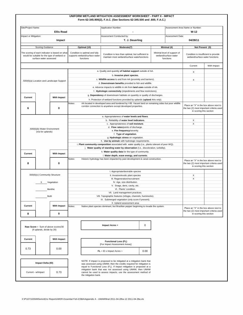
Native plant species dominant, but Brazilian pepper beginning to invade the system.
VI. Plants' condition.
VII. Land management practices.
VIII. Topographic features (refugia, channels, hummocks).
III. Regeneration/recruitment
V. Snags, dens, cavity, etc.
.500(6)(c) Community Structure
Impact Delta (ID)
0
Notes:
0.73
Current With Impact
FL = ID x Impact Acres = 0.00
Raw Score = Sum of above scores/30 (if uplands, divide by 20)
With ImpactCurrent
X
Current - w/Impact 0.73
0.00
NOTE: If impact is proposed to be mitigated at a mitigation bank thatwas assessed using UMAM, then the credits required for mitigation isequal to Functional Loss (FL). If impact mitigation is proposed at amitigation bank that was not assessed using UMAM, then UMAMcannot be used to assess impacts; use the assessment method ofthe mitigaiton bank.
IX. Submerged vegetation (only score if present).
IV. Age, size distribution.
II. Invasive/exotic plant species
I. Appropriate/desirable species
8 0Place an "X" in the box above next to
the two (2) most important criteria used in scoring this section
X
X. Upland assessment area
X:\P\1071025000\emo\Env Reports\WER-Essential Fish-ESBA\Appendix A - UMAM\final 2011-04-28\w-12 2011-04-28a.xls
Site/Project Name Application Number Assessment Area Name or Number
Impact or Mitigation Site? Assessment Area Size
Mitigation for previous permit/other historic use
Wildlife habitat, water quality enhancement, flood attenuation N/A
Anticipated Wildlife Utilization Based on Literature Review (List of species that are representative of the assessment area and reasonably expected to be found )
Anticipated Utilization by Listed Species (List species, their legal classification (E, T, SSC), type of use, and intensity of use of the assessment area)
Functions
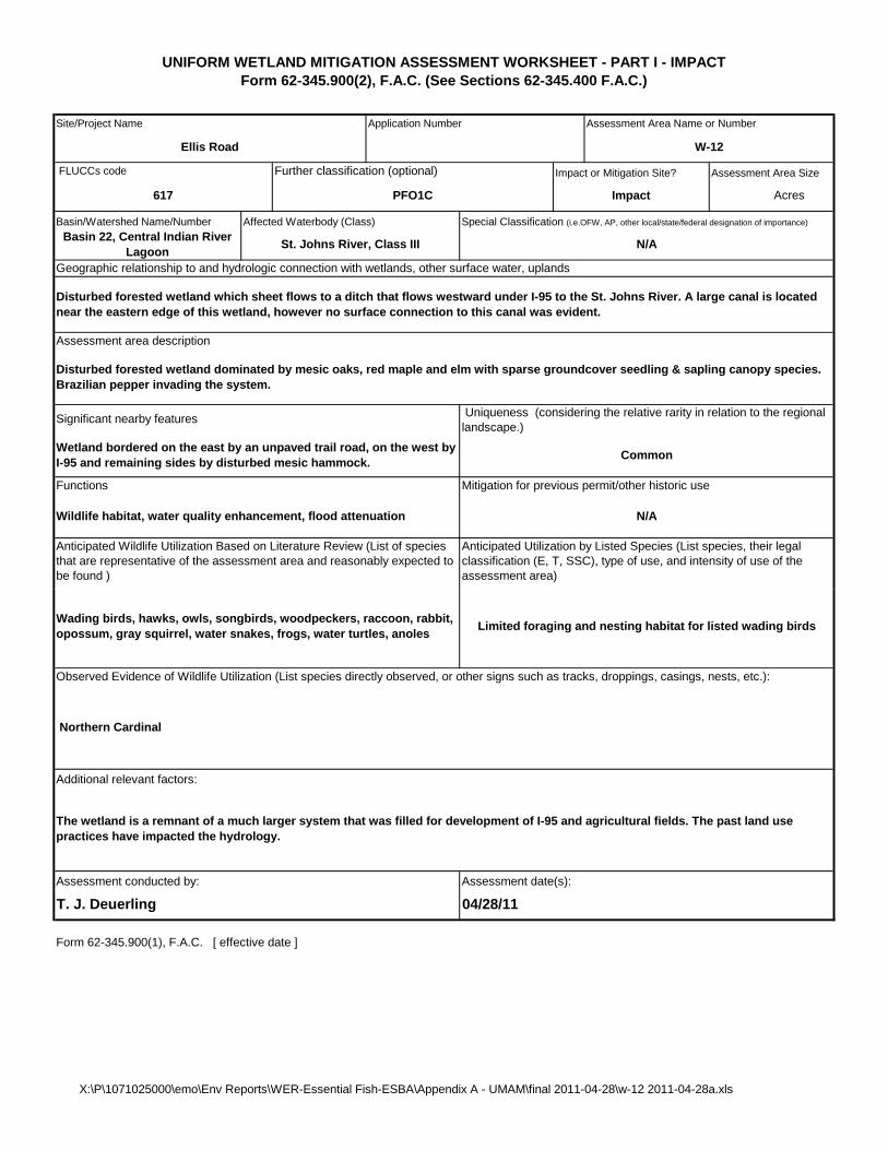
Ellis Road W-12
FLUCCs code Further classification (optional)
617 PFO1C
Uniqueness (considering the relative rarity in relation to the regional landscape.)
Basin 22, Central Indian River Lagoon
Impact
Basin/Watershed Name/Number Affected Waterbody (Class)
N/A
Acres
St. Johns River, Class III
Geographic relationship to and hydrologic connection with wetlands, other surface water, uplands
CommonWetland bordered on the east by an unpaved trail road, on the west by I-95 and remaining sides by disturbed mesic hammock.
Significant nearby features
UNIFORM WETLAND MITIGATION ASSESSMENT WORKSHEET - PART I - IMPACTForm 62-345.900(2), F.A.C. (See Sections 62-345.400 F.A.C.)
Disturbed forested wetland dominated by mesic oaks, red maple and elm with sparse groundcover seedling & sapling canopy species. Brazilian pepper invading the system.
Disturbed forested wetland which sheet flows to a ditch that flows westward under I-95 to the St. Johns River. A large canal is located near the eastern edge of this wetland, however no surface connection to this canal was evident.
Assessment area description
Special Classification (i.e.OFW, AP, other local/state/federal designation of importance)
Assessment conducted by: Assessment date(s):
Form 62-345.900(1), F.A.C. [ effective date ]
T. J. Deuerling 04/28/11
Additional relevant factors:
The wetland is a remnant of a much larger system that was filled for development of I-95 and agricultural fields. The past land use practices have impacted the hydrology.
Wading birds, hawks, owls, songbirds, woodpeckers, raccoon, rabbit, opossum, gray squirrel, water snakes, frogs, water turtles, anoles
Limited foraging and nesting habitat for listed wading birds
Observed Evidence of Wildlife Utilization (List species directly observed, or other signs such as tracks, droppings, casings, nests, etc.):
Northern Cardinal
X:\P\1071025000\emo\Env Reports\WER-Essential Fish-ESBA\Appendix A - UMAM\final 2011-04-28\w-12 2011-04-28a.xls

Impact or Mitigation:
With Impact
AA located in developed area and bordered by I-95. Vacant land on remaining sides but poor wildlife corridor connection to anywhere except developed properties.
Current
Notes:
Notes:
Scoring Guidance
The scoring of each indicator is based on what would be suitable for the type of wetland or
surface water assessed
.500(6)(b) Water Environment (n/a for uplands)
6
e. Fire frequency/severity.
i. Plant community composition associated with water quality (i.e., plants tolerant of poor WQ).
Historic hydrology has been impacted by past development & canal construction.
g. Dependency of downstream habitats on quantity or quality of discharges.
h. Protection of wetland functions provided by uplands (upland AAs only).
f. Hydrologic connectivity (impediments and flow restrictions).
f. Type of vegetation.
g. Hydrologic stress on vegetation.
c. Appropriateness of soil moisture.
Ellis Road - W-11
Impact T. J. Deuerling 04/28/11
Assessment Date:Assessment Conducted by:
UNIFORM WETLAND MITIGATION ASSESSMENT WORKSHEET - PART II - IMPACTForm 62-345.900(2), F.A.C. (See Sections 62-345.500 and .600, F.A.C.)
Site/Project Name: Application Number: Assessment Area Name or Number:
Moderate(7) Minimal (4)
Condition is optimal and fully supports wetland/surface water
functions
Condition is less than optimal, but sufficient to maintain most wetland/surface waterfunctions
h. Use by animals with hydrologic requirements.
a. Appropriateness of water levels and flows.
j. Water quality of standing water by observation (I.e., discoloration, turbidity).
Optimal (10)
k. Water quality data for the type of community.
l. Water depth, wave energy, and currents.
c. Wildlife access to and from AA (proximity and barriers).
Current With Impact
b. Reliability of water level indicators.
.500(6)(a) Location and Landscape Support
0
d. Downstream benefits provided to fish and wildlife.
e. Adverse impacts to wildlife in AA from land uses outside of AA.
d. Flow rates/points of discharge.
Not Present (0)
Minimal level of support of wetland/surface water
functions
Condition is insufficient to provide wetland/surface water functions
X
With ImpactCurrent
a. Quality and quantity of habitat support outside of AA.
b. Invasive plant species.
X
Place an "X" in the box above next to the two (2) most important criteria used
in scoring this section
X
X
Place an "X" in the box above next to
X Vegetation
Benthic
Both
8
Functional Loss (FL) [For Impact Assessment Areas]:
0Impact Acres =
Place an "X" in the box above next to the two (2) most important criteria used
in scoring this section
Native plant species dominant.
VI. Plants' condition.
VII. Land management practices.
VIII. Topographic features (refugia, channels, hummocks).
III. Regeneration/recruitment
V. Snags, dens, cavity, etc.
.500(6)(c) Community Structure
Impact Delta (ID)
0
Notes:
0.73
Current With Impact
FL = ID x Impact Acres = 0.00
Raw Score = Sum of above scores/30 (if uplands, divide by 20)
With ImpactCurrent
X
Current - w/Impact 0.73
0.00
NOTE: If impact is proposed to be mitigated at a mitigation bank thatwas assessed using UMAM, then the credits required for mitigation isequal to Functional Loss (FL). If impact mitigation is proposed at amitigation bank that was not assessed using UMAM, then UMAMcannot be used to assess impacts; use the assessment method ofthe mitigaiton bank.
IX. Submerged vegetation (only score if present).
IV. Age, size distribution.
II. Invasive/exotic plant species
I. Appropriate/desirable species
8 0Place an "X" in the box above next to
the two (2) most important criteria used in scoring this section
X
X. Upland assessment area
X:\P\1071025000\emo\Env Reports\WER-Essential Fish-ESBA\Appendix A - UMAM\final 2011-04-28\w-11 2011-04-28a.xls

Site/Project Name Application Number Assessment Area Name or Number
Impact or Mitigation Site? Assessment Area Size
Mitigation for previous permit/other historic use
Wildlife habitat, water quality enhancement, flood attenuation N/A
Anticipated Wildlife Utilization Based on Literature Review (List of species that are representative of the assessment area and reasonably expected to be found )
Anticipated Utilization by Listed Species (List species, their legal classification (E, T, SSC), type of use, and intensity of use of the assessment area)
Functions
Ellis Road W-11
FLUCCs code Further classification (optional)
617 PFO1C
Uniqueness (considering the relative rarity in relation to the regional landscape.)
Basin 22, Central Indian River Lagoon
Impact
Basin/Watershed Name/Number Affected Waterbody (Class)
N/A
Acres
St. Johns River, Class III
Geographic relationship to and hydrologic connection with wetlands, other surface water, uplands
CommonWetland bordered on the east by an unpaved trail road, on the west by I-95 and remaining sides by disturbed mesic hammock.
Significant nearby features
UNIFORM WETLAND MITIGATION ASSESSMENT WORKSHEET - PART I - IMPACTForm 62-345.900(2), F.A.C. (See Sections 62-345.400 F.A.C.)
Disturbed forested wetland dominated by mesic oaks, red maple and elm with sparse groundcover seedling & sapling canopy species.
Disturbed forested wetland which sheet flows to a ditch that flows westward under I-95 to the St. Johns River. A large canal is located near the eastern edge of this wetland, however no surface connection to this canal was evident.
Assessment area description
Special Classification (i.e.OFW, AP, other local/state/federal designation of importance)
Assessment conducted by: Assessment date(s):
Form 62-345.900(1), F.A.C. [ effective date ]
T. J. Deuerling 04/28/11
Additional relevant factors:
The wetland is a remnant of a much larger system that was filled for development of I-95 and agricultural fields. The past land use practices have impacted the hydrology.
Wading birds, hawks, owls, songbirds, woodpeckers, raccoon, rabbit, opossum, gray squirrel, water snakes, frogs, water turtles, anoles
Limited foraging and nesting habitat for listed wading birds
Observed Evidence of Wildlife Utilization (List species directly observed, or other signs such as tracks, droppings, casings, nests, etc.):
Gray Squirrel, Northern Cardinal
X:\P\1071025000\emo\Env Reports\WER-Essential Fish-ESBA\Appendix A - UMAM\final 2011-04-28\w-11 2011-04-28a.xls

Impact or Mitigation:
With Impact
AA located in developed area and bordered by I-95. Vacant land on remaining sides but poor wildlife corridor connection to anywhere except developed properties.
Current
Notes:
Notes:
Scoring Guidance
The scoring of each indicator is based on what would be suitable for the type of wetland or
surface water assessed
.500(6)(b) Water Environment (n/a for uplands)
6
e. Fire frequency/severity.
i. Plant community composition associated with water quality (i.e., plants tolerant of poor WQ).
Historic hydrology has been impacted by past development & canal construction.
g. Dependency of downstream habitats on quantity or quality of discharges.
h. Protection of wetland functions provided by uplands (upland AAs only).
f. Hydrologic connectivity (impediments and flow restrictions).
f. Type of vegetation.
g. Hydrologic stress on vegetation.
c. Appropriateness of soil moisture.
Ellis Road - W-10
Impact T. J. Deuerling 04/28/11
Assessment Date:Assessment Conducted by:
UNIFORM WETLAND MITIGATION ASSESSMENT WORKSHEET - PART II - IMPACTForm 62-345.900(2), F.A.C. (See Sections 62-345.500 and .600, F.A.C.)
Site/Project Name: Application Number: Assessment Area Name or Number:
Moderate(7) Minimal (4)
Condition is optimal and fully supports wetland/surface water
functions
Condition is less than optimal, but sufficient to maintain most wetland/surface waterfunctions
h. Use by animals with hydrologic requirements.
a. Appropriateness of water levels and flows.
j. Water quality of standing water by observation (I.e., discoloration, turbidity).
Optimal (10)
k. Water quality data for the type of community.
l. Water depth, wave energy, and currents.
c. Wildlife access to and from AA (proximity and barriers).
Current With Impact
b. Reliability of water level indicators.
.500(6)(a) Location and Landscape Support
0
d. Downstream benefits provided to fish and wildlife.
e. Adverse impacts to wildlife in AA from land uses outside of AA.
d. Flow rates/points of discharge.
Not Present (0)
Minimal level of support of wetland/surface water
functions
Condition is insufficient to provide wetland/surface water functions
X
With ImpactCurrent
a. Quality and quantity of habitat support outside of AA.
b. Invasive plant species.
X
Place an "X" in the box above next to the two (2) most important criteria used
in scoring this section
X
X
Place an "X" in the box above next to
X Vegetation
Benthic
Both
8
Functional Loss (FL) [For Impact Assessment Areas]:
0Impact Acres =
Place an "X" in the box above next to the two (2) most important criteria used
in scoring this section
Native plant species dominant.
VI. Plants' condition.
VII. Land management practices.
VIII. Topographic features (refugia, channels, hummocks).
III. Regeneration/recruitment
V. Snags, dens, cavity, etc.
.500(6)(c) Community Structure
Impact Delta (ID)
0
Notes:
0.73
Current With Impact
FL = ID x Impact Acres = 0.00
Raw Score = Sum of above scores/30 (if uplands, divide by 20)
With ImpactCurrent
X
Current - w/Impact 0.73
0.00
NOTE: If impact is proposed to be mitigated at a mitigation bank thatwas assessed using UMAM, then the credits required for mitigation isequal to Functional Loss (FL). If impact mitigation is proposed at amitigation bank that was not assessed using UMAM, then UMAMcannot be used to assess impacts; use the assessment method ofthe mitigaiton bank.
IX. Submerged vegetation (only score if present).
IV. Age, size distribution.
II. Invasive/exotic plant species
I. Appropriate/desirable species
8 0Place an "X" in the box above next to
the two (2) most important criteria used in scoring this section
X
X. Upland assessment area
X:\P\1071025000\emo\Env Reports\WER-Essential Fish-ESBA\Appendix A - UMAM\final 2011-04-28\w-10 2011-04-28a.xls

Site/Project Name Application Number Assessment Area Name or Number
Impact or Mitigation Site? Assessment Area Size
Mitigation for previous permit/other historic use
Wildlife habitat, water quality enhancement, flood attenuation N/A
Anticipated Wildlife Utilization Based on Literature Review (List of species that are representative of the assessment area and reasonably expected to be found )
Anticipated Utilization by Listed Species (List species, their legal classification (E, T, SSC), type of use, and intensity of use of the assessment area)
Functions
Ellis Road W-10
FLUCCs code Further classification (optional)
617 PFO1C
Uniqueness (considering the relative rarity in relation to the regional landscape.)
Basin 22, Central Indian River Lagoon
Impact
Basin/Watershed Name/Number Affected Waterbody (Class)
N/A
Acres
St. Johns River, Class III
Geographic relationship to and hydrologic connection with wetlands, other surface water, uplands
CommonWetland bordered on the east by an unpaved trail road and on the remaining sides by disturbed mesic hammock; however I-95 a short distance to the west.
Significant nearby features
UNIFORM WETLAND MITIGATION ASSESSMENT WORKSHEET - PART I - IMPACTForm 62-345.900(2), F.A.C. (See Sections 62-345.400 F.A.C.)
Disturbed forested wetland dominated by mesic oaks, red maple and elm with sparse groundcover seedling & sapling canopy species and swamp dogwood.
Disturbed forested wetland which sheet flows to a ditch that flows westward under I-95 to the St. Johns River. A large canal is located near the eastern edge of this wetland, however no surface connection to this canal was evident.
Assessment area description
Special Classification (i.e.OFW, AP, other local/state/federal designation of importance)
Assessment conducted by: Assessment date(s):
Form 62-345.900(1), F.A.C. [ effective date ]
T. J. Deuerling 04/28/11
Additional relevant factors:
The wetland is a remnant of a much larger system that was filled for development of I-95 and agricultural fields. The past land use practices have impacted the hydrology.
Wading birds, hawks, owls, songbirds, woodpeckers, raccoon, rabbit, opossum, gray squirrel, water snakes, frogs, water turtles, anoles
Limited foraging and nesting habitat for listed wading birds
Observed Evidence of Wildlife Utilization (List species directly observed, or other signs such as tracks, droppings, casings, nests, etc.):
X:\P\1071025000\emo\Env Reports\WER-Essential Fish-ESBA\Appendix A - UMAM\final 2011-04-28\w-10 2011-04-28a.xls

Impact or Mitigation:
Place an "X" in the box above next to
X
X
Place an "X" in the box above next to the two (2) most important criteria used
in scoring this section
a. Quality and quantity of habitat support outside of AA.
b. Invasive plant species.
X
Not Present (0)
Minimal level of support of wetland/surface water
functions
Condition is insufficient to provide wetland/surface water functions
X
With ImpactCurrent
Current With Impact
b. Reliability of water level indicators.
.500(6)(a) Location and Landscape Support
0
d. Downstream benefits provided to fish and wildlife.
e. Adverse impacts to wildlife in AA from land uses outside of AA.
d. Flow rates/points of discharge.
Condition is less than optimal, but sufficient to maintain most wetland/surface waterfunctions
h. Use by animals with hydrologic requirements.
a. Appropriateness of water levels and flows.
j. Water quality of standing water by observation (I.e., discoloration, turbidity).
Optimal (10)
k. Water quality data for the type of community.
l. Water depth, wave energy, and currents.
c. Wildlife access to and from AA (proximity and barriers).
UNIFORM WETLAND MITIGATION ASSESSMENT WORKSHEET - PART II - IMPACTForm 62-345.900(2), F.A.C. (See Sections 62-345.500 and .600, F.A.C.)
Site/Project Name: Application Number: Assessment Area Name or Number:
Moderate(7) Minimal (4)
Condition is optimal and fully supports wetland/surface water
functions
Ellis Road - W-9
Impact T. J. Deuerling 04/28/11
Assessment Date:Assessment Conducted by:
g. Dependency of downstream habitats on quantity or quality of discharges.
h. Protection of wetland functions provided by uplands (upland AAs only).
f. Hydrologic connectivity (impediments and flow restrictions).
f. Type of vegetation.
g. Hydrologic stress on vegetation.
c. Appropriateness of soil moisture.
i. Plant community composition associated with water quality (i.e., plants tolerant of poor WQ).
Historic hydrology has been impacted by past development & canal construction.
Scoring Guidance
The scoring of each indicator is based on what would be suitable for the type of wetland or
surface water assessed
.500(6)(b) Water Environment (n/a for uplands)
6
e. Fire frequency/severity.
Current
Notes:
Notes:
With Impact
AA located in developed area and bordered by I-95. Vacant land on remaining sides but poor wildlife corridor connection to anywhere except developed properties.
X Vegetation
Benthic
Both
8
X
X. Upland assessment area
Place an "X" in the box above next to the two (2) most important criteria used
in scoring this section8 0
II. Invasive/exotic plant species
I. Appropriate/desirable species
IX. Submerged vegetation (only score if present).
IV. Age, size distribution.
X
Current - w/Impact 0.73
0.00
NOTE: If impact is proposed to be mitigated at a mitigation bank thatwas assessed using UMAM, then the credits required for mitigation isequal to Functional Loss (FL). If impact mitigation is proposed at amitigation bank that was not assessed using UMAM, then UMAMcannot be used to assess impacts; use the assessment method ofthe mitigaiton bank.
FL = ID x Impact Acres = 0.00
Raw Score = Sum of above scores/30 (if uplands, divide by 20)
With ImpactCurrent
.500(6)(c) Community Structure
Impact Delta (ID)
0
Notes:
0.73
Current With Impact
VI. Plants' condition.
VII. Land management practices.
VIII. Topographic features (refugia, channels, hummocks).
III. Regeneration/recruitment
V. Snags, dens, cavity, etc.
Functional Loss (FL) [For Impact Assessment Areas]:
0Impact Acres =
Place an "X" in the box above next to the two (2) most important criteria used
in scoring this section
Native plant species dominant.
X:\P\1071025000\emo\Env Reports\WER-Essential Fish-ESBA\Appendix A - UMAM\final 2011-04-28\w-9 2011-04-28a.xls

Site/Project Name Application Number Assessment Area Name or Number
Impact or Mitigation Site? Assessment Area Size
Geographic relationship to and hydrologic connection with wetlands, other surface water, uplands
CommonWetland bordered on the east by an unpaved trail road and on the remaining sides by disturbed mesic hammock; however I-95 a short distance to the west.
Significant nearby features
UNIFORM WETLAND MITIGATION ASSESSMENT WORKSHEET - PART I - IMPACTForm 62-345.900(2), F.A.C. (See Sections 62-345.400 F.A.C.)
Disturbed forested wetland dominated by mesic oaks, red maple, elm and cabbage palm with sparse groundcover seedling & sapling canopy species and swamp dogwood.
Disturbed forested wetland which sheet flows to a ditch that flows westward under I-95 to the St. Johns River. A large canal is located near the eastern edge of this wetland, however no surface connection to this canal was evident.
Assessment area description
Special Classification (i.e.OFW, AP, other local/state/federal designation of importance)
Basin 22, Central Indian River Lagoon
Impact
Basin/Watershed Name/Number Affected Waterbody (Class)
N/A
Acres
St. Johns River, Class III
Uniqueness (considering the relative rarity in relation to the regional landscape.)
Ellis Road W-9
FLUCCs code Further classification (optional)
617 PFO1C
Mitigation for previous permit/other historic use
Wildlife habitat, water quality enhancement, flood attenuation N/A
Anticipated Wildlife Utilization Based on Literature Review (List of species that are representative of the assessment area and reasonably expected to be found )
Anticipated Utilization by Listed Species (List species, their legal classification (E, T, SSC), type of use, and intensity of use of the assessment area)
Functions
Assessment conducted by: Assessment date(s):
Form 62-345.900(1), F.A.C. [ effective date ]
T. J. Deuerling 04/28/11
Additional relevant factors:
The wetland is a remnant of a much larger system that was filled for development of I-95 and agricultural fields. The past land use practices have impacted the hydrology.
Wading birds, hawks, owls, songbirds, woodpeckers, raccoon, rabbit, opossum, gray squirrel, water snakes, frogs, water turtles, anoles
Limited foraging and nesting habitat for listed wading birds
Observed Evidence of Wildlife Utilization (List species directly observed, or other signs such as tracks, droppings, casings, nests, etc.):
Blue Jay, Northern Cardinal
X:\P\1071025000\emo\Env Reports\WER-Essential Fish-ESBA\Appendix A - UMAM\final 2011-04-28\w-9 2011-04-28a.xls

Impact or Mitigation:
Place an "X" in the box above next to
X
X
Place an "X" in the box above next to the two (2) most important criteria used
in scoring this section
a. Quality and quantity of habitat support outside of AA.
b. Invasive plant species.
X
Not Present (0)
Minimal level of support of wetland/surface water
functions
Condition is insufficient to provide wetland/surface water functions
X
With ImpactCurrent
Current With Impact
b. Reliability of water level indicators.
.500(6)(a) Location and Landscape Support
0
d. Downstream benefits provided to fish and wildlife.
e. Adverse impacts to wildlife in AA from land uses outside of AA.
d. Flow rates/points of discharge.
Condition is less than optimal, but sufficient to maintain most wetland/surface waterfunctions
h. Use by animals with hydrologic requirements.
a. Appropriateness of water levels and flows.
j. Water quality of standing water by observation (I.e., discoloration, turbidity).
Optimal (10)
k. Water quality data for the type of community.
l. Water depth, wave energy, and currents.
c. Wildlife access to and from AA (proximity and barriers).
UNIFORM WETLAND MITIGATION ASSESSMENT WORKSHEET - PART II - IMPACTForm 62-345.900(2), F.A.C. (See Sections 62-345.500 and .600, F.A.C.)
Site/Project Name: Application Number: Assessment Area Name or Number:
Moderate(7) Minimal (4)
Condition is optimal and fully supports wetland/surface water
functions
Ellis Road - W-8
Impact T. J. Deuerling 04/28/11
Assessment Date:Assessment Conducted by:
g. Dependency of downstream habitats on quantity or quality of discharges.
h. Protection of wetland functions provided by uplands (upland AAs only).
f. Hydrologic connectivity (impediments and flow restrictions).
f. Type of vegetation.
g. Hydrologic stress on vegetation.
c. Appropriateness of soil moisture.
i. Plant community composition associated with water quality (i.e., plants tolerant of poor WQ).
Historic hydrology has been impacted by past development & canal construction.
Scoring Guidance
The scoring of each indicator is based on what would be suitable for the type of wetland or
surface water assessed
.500(6)(b) Water Environment (n/a for uplands)
6
e. Fire frequency/severity.
Current
Notes:
Notes:
With Impact
AA located in developed area and bordered by I-95. Vacant land on remaining sides but poor wildlife corridor connection to anywhere except developed properties.
X Vegetation
Benthic
Both
8
X
X. Upland assessment area
Place an "X" in the box above next to the two (2) most important criteria used
in scoring this section8 0
II. Invasive/exotic plant species
I. Appropriate/desirable species
IX. Submerged vegetation (only score if present).
IV. Age, size distribution.
X
Current - w/Impact 0.73
0.00
NOTE: If impact is proposed to be mitigated at a mitigation bank thatwas assessed using UMAM, then the credits required for mitigation isequal to Functional Loss (FL). If impact mitigation is proposed at amitigation bank that was not assessed using UMAM, then UMAMcannot be used to assess impacts; use the assessment method ofthe mitigaiton bank.
FL = ID x Impact Acres = 0.00
Raw Score = Sum of above scores/30 (if uplands, divide by 20)
With ImpactCurrent
.500(6)(c) Community Structure
Impact Delta (ID)
0
Notes:
0.73
Current With Impact
VI. Plants' condition.
VII. Land management practices.
VIII. Topographic features (refugia, channels, hummocks).
III. Regeneration/recruitment
V. Snags, dens, cavity, etc.
Functional Loss (FL) [For Impact Assessment Areas]:
0Impact Acres =
Place an "X" in the box above next to the two (2) most important criteria used
in scoring this section
Native plant species dominant; however Brazilian pepper is invading the edge of the system.
X:\P\1071025000\emo\Env Reports\WER-Essential Fish-ESBA\Appendix A - UMAM\final 2011-04-28\w-8 2011-04-28a.xls

Site/Project Name Application Number Assessment Area Name or Number
Impact or Mitigation Site? Assessment Area Size
Geographic relationship to and hydrologic connection with wetlands, other surface water, uplands
CommonWetland bordered on the east by an unpaved trail road and on the remaining sides by disturbed mesic hammock; however I-95 a short distance to the west.
Significant nearby features
UNIFORM WETLAND MITIGATION ASSESSMENT WORKSHEET - PART I - IMPACTForm 62-345.900(2), F.A.C. (See Sections 62-345.400 F.A.C.)
Disturbed forested wetland dominated by mesic oaks and cabbage palm with sparse groundcover seedling & sapling canopy species. Brazilian pepper is invading the edge of the system.
Disturbed forested wetland which sheet flows to a ditch that flows westward under I-95 to the St. Johns River. A large canal is located near the eastern edge of this wetland, however no surface connection to this canal was evident.
Assessment area description
Special Classification (i.e.OFW, AP, other local/state/federal designation of importance)
Basin 22, Central Indian River Lagoon
Impact
Basin/Watershed Name/Number Affected Waterbody (Class)
N/A
Acres
St. Johns River, Class III
Uniqueness (considering the relative rarity in relation to the regional landscape.)
Ellis Road W-8
FLUCCs code Further classification (optional)
617 PFO1C
Mitigation for previous permit/other historic use
Wildlife habitat, water quality enhancement, flood attenuation N/A
Anticipated Wildlife Utilization Based on Literature Review (List of species that are representative of the assessment area and reasonably expected to be found )
Anticipated Utilization by Listed Species (List species, their legal classification (E, T, SSC), type of use, and intensity of use of the assessment area)
Functions
Assessment conducted by: Assessment date(s):
Form 62-345.900(1), F.A.C. [ effective date ]
T. J. Deuerling 04/28/11
Additional relevant factors:
The wetland is a remnant of a much larger system that was filled for development of I-95 and agricultural fields. The past land use practices have impacted the hydrology. Brazilian pepper is invading the edge of the system.
Wading birds, hawks, owls, songbirds, woodpeckers, raccoon, rabbit, opossum, gray squirrel, water snakes, frogs, water turtles, anoles
Limited foraging and nesting habitat for listed wading birds
Observed Evidence of Wildlife Utilization (List species directly observed, or other signs such as tracks, droppings, casings, nests, etc.):
Blue Jay, Tufted Titmouse
X:\P\1071025000\emo\Env Reports\WER-Essential Fish-ESBA\Appendix A - UMAM\final 2011-04-28\w-8 2011-04-28a.xls

Impact or Mitigation:
Place an "X" in the box above next to
X
X
Place an "X" in the box above next to the two (2) most important criteria used
in scoring this section
a. Quality and quantity of habitat support outside of AA.
b. Invasive plant species.
X
Not Present (0)
Minimal level of support of wetland/surface water
functions
Condition is insufficient to provide wetland/surface water functions
X
With ImpactCurrent
Current With Impact
b. Reliability of water level indicators.
.500(6)(a) Location and Landscape Support
0
d. Downstream benefits provided to fish and wildlife.
e. Adverse impacts to wildlife in AA from land uses outside of AA.
d. Flow rates/points of discharge.
Condition is less than optimal, but sufficient to maintain most wetland/surface waterfunctions
h. Use by animals with hydrologic requirements.
a. Appropriateness of water levels and flows.
j. Water quality of standing water by observation (I.e., discoloration, turbidity).
Optimal (10)
k. Water quality data for the type of community.
l. Water depth, wave energy, and currents.
c. Wildlife access to and from AA (proximity and barriers).
UNIFORM WETLAND MITIGATION ASSESSMENT WORKSHEET - PART II - IMPACTForm 62-345.900(2), F.A.C. (See Sections 62-345.500 and .600, F.A.C.)
Site/Project Name: Application Number: Assessment Area Name or Number:
Moderate(7) Minimal (4)
Condition is optimal and fully supports wetland/surface water
functions
Ellis Road - W-7
Impact T. J. Deuerling 04/28/11
Assessment Date:Assessment Conducted by:
g. Dependency of downstream habitats on quantity or quality of discharges.
h. Protection of wetland functions provided by uplands (upland AAs only).
f. Hydrologic connectivity (impediments and flow restrictions).
f. Type of vegetation.
g. Hydrologic stress on vegetation.
c. Appropriateness of soil moisture.
i. Plant community composition associated with water quality (i.e., plants tolerant of poor WQ).
Historic hydrology has been impacted by past development & canal construction.
Scoring Guidance
The scoring of each indicator is based on what would be suitable for the type of wetland or
surface water assessed
.500(6)(b) Water Environment (n/a for uplands)
6
e. Fire frequency/severity.
Current
Notes:
Notes:
With Impact
AA located in residential area and bordered on half of edge by paved roads. Poor wildlife corridor connection to anywhere except vacant land to south.
X Vegetation
Benthic
Both
8
X
X. Upland assessment area
Place an "X" in the box above next to the two (2) most important criteria used
in scoring this section8 0
II. Invasive/exotic plant species
I. Appropriate/desirable species
IX. Submerged vegetation (only score if present).
IV. Age, size distribution.
X
Current - w/Impact 0.73
0.00
NOTE: If impact is proposed to be mitigated at a mitigation bank thatwas assessed using UMAM, then the credits required for mitigation isequal to Functional Loss (FL). If impact mitigation is proposed at amitigation bank that was not assessed using UMAM, then UMAMcannot be used to assess impacts; use the assessment method ofthe mitigaiton bank.
FL = ID x Impact Acres = 0.00
Raw Score = Sum of above scores/30 (if uplands, divide by 20)
With ImpactCurrent
.500(6)(c) Community Structure
Impact Delta (ID)
0
Notes:
0.73
Current With Impact
VI. Plants' condition.
VII. Land management practices.
VIII. Topographic features (refugia, channels, hummocks).
III. Regeneration/recruitment
V. Snags, dens, cavity, etc.
Functional Loss (FL) [For Impact Assessment Areas]:
0Impact Acres =
Place an "X" in the box above next to the two (2) most important criteria used
in scoring this section
Native plant species dominant; however Brazilian pepper is invading the system.
X:\P\1071025000\emo\Env Reports\WER-Essential Fish-ESBA\Appendix A - UMAM\final 2011-04-28\w-7 2011-04-28a.xls

Site/Project Name Application Number Assessment Area Name or Number
Impact or Mitigation Site? Assessment Area Size
Geographic relationship to and hydrologic connection with wetlands, other surface water, uplands
CommonWetland bordered on the west by I-95, on the east by an unpaved trail road and on the remaining sides disturbed mesic hardwood hammock.
Significant nearby features
UNIFORM WETLAND MITIGATION ASSESSMENT WORKSHEET - PART I - IMPACTForm 62-345.900(2), F.A.C. (See Sections 62-345.400 F.A.C.)
Disturbed forested wetland dominated by mesic oaks, elm, cabbage palm and red maple with sparse groundcover seedling & sapling canopy species. Brazilian pepper is invading the system.
Disturbed forested wetland which sheet flows to a ditch that flows westward under I-95 to the St. Johns River. A large canal is located near the eastern edge of this wetland, however no surface connection to this canal was evident.
Assessment area description
Special Classification (i.e.OFW, AP, other local/state/federal designation of importance)
Basin 22, Central Indian River Lagoon
Impact
Basin/Watershed Name/Number Affected Waterbody (Class)
N/A
Acres
St. Johns River, Class III
Uniqueness (considering the relative rarity in relation to the regional landscape.)
Ellis Road W-7
FLUCCs code Further classification (optional)
617 PFO1C
Mitigation for previous permit/other historic use
Wildlife habitat, water quality enhancement, flood attenuation N/A
Anticipated Wildlife Utilization Based on Literature Review (List of species that are representative of the assessment area and reasonably expected to be found )
Anticipated Utilization by Listed Species (List species, their legal classification (E, T, SSC), type of use, and intensity of use of the assessment area)
Functions
Assessment conducted by: Assessment date(s):
Form 62-345.900(1), F.A.C. [ effective date ]
T. J. Deuerling 04/28/11
Additional relevant factors:
The wetland is a remnant of a much larger system that was filled for development of I-95 and agricultural fields. The past land use practices have impacted the hydrology. Brazilian pepper is invading the system.
Wading birds, hawks, owls, songbirds, woodpeckers, raccoon, rabbit, opossum, gray squirrel, water snakes, frogs, water turtles, anoles
Limited foraging and nesting habitat for listed wading birds
Observed Evidence of Wildlife Utilization (List species directly observed, or other signs such as tracks, droppings, casings, nests, etc.):
Blue Jay, Northern Cardinal
X:\P\1071025000\emo\Env Reports\WER-Essential Fish-ESBA\Appendix A - UMAM\final 2011-04-28\w-7 2011-04-28a.xls

Impact or Mitigation:
With Impact
Good wildlife corridor connection to the St. Johns River to the west. Wetland within a maintained powerline easement. I-95 a short distance to the east. Vehicular access roads on east border of wetland.
Current
Notes:
Notes:
Scoring Guidance
The scoring of each indicator is based on what would be suitable for the type of wetland or
surface water assessed
.500(6)(b) Water Environment (n/a for uplands)
9
e. Fire frequency/severity.
i. Plant community composition associated with water quality (i.e., plants tolerant of poor WQ).
Historic hydrology has been impacted by past ditch construction, agricutural development and powerline construction.
g. Dependency of downstream habitats on quantity or quality of discharges.
h. Protection of wetland functions provided by uplands (upland AAs only).
f. Hydrologic connectivity (impediments and flow restrictions).
f. Type of vegetation.
g. Hydrologic stress on vegetation.
c. Appropriateness of soil moisture.
Ellis Road - W-6
Impact T. J. Deuerling 04/28/11
Assessment Date:Assessment Conducted by:
UNIFORM WETLAND MITIGATION ASSESSMENT WORKSHEET - PART II - IMPACTForm 62-345.900(2), F.A.C. (See Sections 62-345.500 and .600, F.A.C.)
Site/Project Name: Application Number: Assessment Area Name or Number:
Moderate(7) Minimal (4)
Condition is optimal and fully supports wetland/surface water
functions
Condition is less than optimal, but sufficient to maintain most wetland/surface waterfunctions
h. Use by animals with hydrologic requirements.
a. Appropriateness of water levels and flows.
j. Water quality of standing water by observation (I.e., discoloration, turbidity).
Optimal (10)
k. Water quality data for the type of community.
l. Water depth, wave energy, and currents.
c. Wildlife access to and from AA (proximity and barriers).
Current With Impact
b. Reliability of water level indicators.
.500(6)(a) Location and Landscape Support
0
d. Downstream benefits provided to fish and wildlife.
e. Adverse impacts to wildlife in AA from land uses outside of AA.
d. Flow rates/points of discharge.
Not Present (0)
Minimal level of support of wetland/surface water
functions
Condition is insufficient to provide wetland/surface water functions
X
With ImpactCurrent
a. Quality and quantity of habitat support outside of AA.
b. Invasive plant species.
X
Place an "X" in the box above next to the two (2) most important criteria used
in scoring this section
X
X
Place an "X" in the box above next to
X Vegetation
Benthic
Both
8
Functional Loss (FL) [For Impact Assessment Areas]:
0Impact Acres =
Place an "X" in the box above next to the two (2) most important criteria used
in scoring this section
Native plant species dominant. Some torpedo grass invading the system. Maintained as powerline easement.
VI. Plants' condition.
VII. Land management practices.
VIII. Topographic features (refugia, channels, hummocks).
III. Regeneration/recruitment
V. Snags, dens, cavity, etc.
.500(6)(c) Community Structure
Impact Delta (ID)
0
Notes:
0.83
Current With Impact
FL = ID x Impact Acres = 0.00
Raw Score = Sum of above scores/30 (if uplands, divide by 20)
With ImpactCurrent
X
powerline construction.
Current - w/Impact 0.83
0.00
NOTE: If impact is proposed to be mitigated at a mitigation bank thatwas assessed using UMAM, then the credits required for mitigation isequal to Functional Loss (FL). If impact mitigation is proposed at amitigation bank that was not assessed using UMAM, then UMAMcannot be used to assess impacts; use the assessment method ofthe mitigaiton bank.
IX. Submerged vegetation (only score if present).
IV. Age, size distribution.
II. Invasive/exotic plant species
I. Appropriate/desirable species
8 0Place an "X" in the box above next to
the two (2) most important criteria used in scoring this section
X
X. Upland assessment area
X:\P\1071025000\emo\Env Reports\WER-Essential Fish-ESBA\Appendix A - UMAM\final 2011-04-28\w-6 2011-04-28a.xls

Site/Project Name Application Number Assessment Area Name or Number
Impact or Mitigation Site? Assessment Area Size
Mitigation for previous permit/other historic use
Wildlife habitat, water quality enhancement, flood attenuation N/A
Anticipated Wildlife Utilization Based on Literature Review (List of species that are representative of the assessment area and reasonably expected to be found )
Anticipated Utilization by Listed Species (List species, their legal classification (E, T, SSC), type of use, and intensity of use of the assessment area)
Functions
Ellis Road W-6
FLUCCs code Further classification (optional)
643 PEM1C
Uniqueness (considering the relative rarity in relation to the regional landscape.)
Basin 22, Central Indian River Lagoon
Impact
Basin/Watershed Name/Number Affected Waterbody (Class)
N/A
Acres
St. Johns River, Class III
Geographic relationship to and hydrologic connection with wetlands, other surface water, uplands
CommonW-6 is bordered on the east by I-95, on the north and south by the maintained powerline easement and on the west by vacant land.
Significant nearby features
UNIFORM WETLAND MITIGATION ASSESSMENT WORKSHEET - PART I - IMPACTForm 62-345.900(2), F.A.C. (See Sections 62-345.400 F.A.C.)
Wetland is a highly disturbed, seasonally inundated wet prairie located within an existing maintained powerline easement. It is currently colonized with a mix of maidencane, pickerelweed, blue maidencane, camphorweed and other wetland grasses and forbs.
This wetland sheets flows to ditches which ultimately drain westward to the St. Johns River.
Assessment area description
Special Classification (i.e.OFW, AP, other local/state/federal designation of importance)
Assessment conducted by: Assessment date(s):
Form 62-345.900(1), F.A.C. [ effective date ]
T. J. Deuerling 04/28/11
Additional relevant factors:
The wetland is part of the St. Johns River floodplain that was previously converted to agricultural fields. It is currently regenerating with a mixture of wetland species, but is withuin the maintained powerline easement. The adjacent land to the west is protected by a conservation easement.
Wading birds, hawks, owls, songbirds, raccoon, rabbit, opossum, water snakes, frogs, water turtles, anoles
Limited foraging and nesting habitat for listed wading birds
Observed Evidence of Wildlife Utilization (List species directly observed, or other signs such as tracks, droppings, casings, nests, etc.):
raccoon track, deer track
X:\P\1071025000\emo\Env Reports\WER-Essential Fish-ESBA\Appendix A - UMAM\final 2011-04-28\w-6 2011-04-28a.xls

Impact or Mitigation:
Place an "X" in the box above next to
X
X
Place an "X" in the box above next to the two (2) most important criteria used
in scoring this section
a. Quality and quantity of habitat support outside of AA.
b. Invasive plant species.
X
Not Present (0)
Minimal level of support of wetland/surface water
functions
Condition is insufficient to provide wetland/surface water functions
X
With ImpactCurrent
Current With Impact
b. Reliability of water level indicators.
.500(6)(a) Location and Landscape Support
0
d. Downstream benefits provided to fish and wildlife.
e. Adverse impacts to wildlife in AA from land uses outside of AA.
d. Flow rates/points of discharge.
Condition is less than optimal, but sufficient to maintain most wetland/surface waterfunctions
h. Use by animals with hydrologic requirements.
a. Appropriateness of water levels and flows.
j. Water quality of standing water by observation (I.e., discoloration, turbidity).
Optimal (10)
k. Water quality data for the type of community.
l. Water depth, wave energy, and currents.
c. Wildlife access to and from AA (proximity and barriers).
UNIFORM WETLAND MITIGATION ASSESSMENT WORKSHEET - PART II - IMPACTForm 62-345.900(2), F.A.C. (See Sections 62-345.500 and .600, F.A.C.)
Site/Project Name: Application Number: Assessment Area Name or Number:
Moderate(7) Minimal (4)
Condition is optimal and fully supports wetland/surface water
functions
Ellis Road - W-5
Impact T. J. Deuerling 04/28/11
Assessment Date:Assessment Conducted by:
g. Dependency of downstream habitats on quantity or quality of discharges.
h. Protection of wetland functions provided by uplands (upland AAs only).
f. Hydrologic connectivity (impediments and flow restrictions).
f. Type of vegetation.
g. Hydrologic stress on vegetation.
c. Appropriateness of soil moisture.
i. Plant community composition associated with water quality (i.e., plants tolerant of poor WQ).
Historic hydrology has been impacted by past ditch construction and agricutural development.
Scoring Guidance
The scoring of each indicator is based on what would be suitable for the type of wetland or
surface water assessed
.500(6)(b) Water Environment (n/a for uplands)
9
e. Fire frequency/severity.
Current
Notes:
Notes:
With Impact
Good wildlife corridor connection to the St. Johns River to the west. I-95 borders wetland on the east.The adjacent land to the north is protected by a conservation easement.
X Vegetation
Benthic
Both
9
X
X. Upland assessment area
Place an "X" in the box above next to the two (2) most important criteria used
in scoring this section8 0
II. Invasive/exotic plant species
I. Appropriate/desirable species
IX. Submerged vegetation (only score if present).
IV. Age, size distribution.
X
Current - w/Impact 0.87
0.00
NOTE: If impact is proposed to be mitigated at a mitigation bank thatwas assessed using UMAM, then the credits required for mitigation isequal to Functional Loss (FL). If impact mitigation is proposed at amitigation bank that was not assessed using UMAM, then UMAMcannot be used to assess impacts; use the assessment method ofthe mitigaiton bank.
FL = ID x Impact Acres = 0.00
Raw Score = Sum of above scores/30 (if uplands, divide by 20)
With ImpactCurrent
.500(6)(c) Community Structure
Impact Delta (ID)
0
Notes:
0.87
Current With Impact
VI. Plants' condition.
VII. Land management practices.
VIII. Topographic features (refugia, channels, hummocks).
III. Regeneration/recruitment
V. Snags, dens, cavity, etc.
Functional Loss (FL) [For Impact Assessment Areas]:
0Impact Acres =
Place an "X" in the box above next to the two (2) most important criteria used
in scoring this section
Native plant species dominant; however wax myrtle appears to be invading.
X:\P\1071025000\emo\Env Reports\WER-Essential Fish-ESBA\Appendix A - UMAM\final 2011-04-28\w-5 2011-04-28a.xls

Site/Project Name Application Number Assessment Area Name or Number
Impact or Mitigation Site? Assessment Area Size
Geographic relationship to and hydrologic connection with wetlands, other surface water, uplands
CommonWetland bordered on the east by powerline easement & I-95, on the north by a large drainage ditch, on the south by a stormwater treatment pond and on the west by undeveloped land.
Significant nearby features
UNIFORM WETLAND MITIGATION ASSESSMENT WORKSHEET - PART I - IMPACTForm 62-345.900(2), F.A.C. (See Sections 62-345.400 F.A.C.)
Historic agricultural fields currently dominated by wax myrtle, blue maidencane, sand cordgrass and camphorweed with scattered cabbage palm.
Historic agricultural fields currently revegetating with a mix of wetland shrubs and grasses which are located within the St. Johns River floodplain.
Assessment area description
Special Classification (i.e.OFW, AP, other local/state/federal designation of importance)
Basin 22, Central Indian River Lagoon
Impact
Basin/Watershed Name/Number Affected Waterbody (Class)
N/A
Acres
St. Johns River, Class III
Uniqueness (considering the relative rarity in relation to the regional landscape.)
Ellis Road W-5
FLUCCs code Further classification (optional)
643 PEM1C
Mitigation for previous permit/other historic use
Wildlife habitat, water quality enhancement, flood attenuation N/A
Anticipated Wildlife Utilization Based on Literature Review (List of species that are representative of the assessment area and reasonably expected to be found )
Anticipated Utilization by Listed Species (List species, their legal classification (E, T, SSC), type of use, and intensity of use of the assessment area)
Functions
Assessment conducted by: Assessment date(s):
Form 62-345.900(1), F.A.C. [ effective date ]
T. J. Deuerling 04/28/11
Additional relevant factors:
The wetland is part of the St. Johns River floodplain that was previously converted to agricultural fields. It is currently regenerating with wax myrtle and blue maindencane. The adjacent land to the north is protected by a conservation easement.
Wading birds, hawks, owls, songbirds, raccoon, rabbit, opossum, water snakes, frogs, water turtles, anoles
Limited foraging and nesting habitat for listed wading birds
Observed Evidence of Wildlife Utilization (List species directly observed, or other signs such as tracks, droppings, casings, nests, etc.):
Cardinal, raccoon track, deer track
X:\P\1071025000\emo\Env Reports\WER-Essential Fish-ESBA\Appendix A - UMAM\final 2011-04-28\w-5 2011-04-28a.xls

Impact or Mitigation:
Place an "X" in the box above next to
X
X
Place an "X" in the box above next to the two (2) most important criteria used
in scoring this section
a. Quality and quantity of habitat support outside of AA.
b. Invasive plant species.
X
Not Present (0)
Minimal level of support of wetland/surface water
functions
Condition is insufficient to provide wetland/surface water functions
X
With ImpactCurrent
Current With Impact
b. Reliability of water level indicators.
.500(6)(a) Location and Landscape Support
0
d. Downstream benefits provided to fish and wildlife.
e. Adverse impacts to wildlife in AA from land uses outside of AA.
d. Flow rates/points of discharge.
Condition is less than optimal, but sufficient to maintain most wetland/surface waterfunctions
h. Use by animals with hydrologic requirements.
a. Appropriateness of water levels and flows.
j. Water quality of standing water by observation (I.e., discoloration, turbidity).
Optimal (10)
k. Water quality data for the type of community.
l. Water depth, wave energy, and currents.
c. Wildlife access to and from AA (proximity and barriers).
UNIFORM WETLAND MITIGATION ASSESSMENT WORKSHEET - PART II - IMPACTForm 62-345.900(2), F.A.C. (See Sections 62-345.500 and .600, F.A.C.)
Site/Project Name: Application Number: Assessment Area Name or Number:
Moderate(7) Minimal (4)
Condition is optimal and fully supports wetland/surface water
functions
Ellis Road - W-4
Impact T. J. Deuerling 04/28/11
Assessment Date:Assessment Conducted by:
g. Dependency of downstream habitats on quantity or quality of discharges.
h. Protection of wetland functions provided by uplands (upland AAs only).
f. Hydrologic connectivity (impediments and flow restrictions).
f. Type of vegetation.
g. Hydrologic stress on vegetation.
c. Appropriateness of soil moisture.
i. Plant community composition associated with water quality (i.e., plants tolerant of poor WQ).
Historic hydrology has been impacted by past ditch construction, agricutural development and powerline construction.
Scoring Guidance
The scoring of each indicator is based on what would be suitable for the type of wetland or
surface water assessed
.500(6)(b) Water Environment (n/a for uplands)
9
e. Fire frequency/severity.
Current
Notes:
Notes:
With Impact
Good wildlife corridor connection to the St. Johns River to the west. I-95 and powerline easement borders wetland on the east. Vehicular access roads on three sides of wetland.
X Vegetation
Benthic
Both
8
X
X. Upland assessment area
Place an "X" in the box above next to the two (2) most important criteria used
in scoring this section8 0
II. Invasive/exotic plant species
I. Appropriate/desirable species
IX. Submerged vegetation (only score if present).
IV. Age, size distribution.
X
powerline construction.
Current - w/Impact 0.83
0.00
NOTE: If impact is proposed to be mitigated at a mitigation bank thatwas assessed using UMAM, then the credits required for mitigation isequal to Functional Loss (FL). If impact mitigation is proposed at amitigation bank that was not assessed using UMAM, then UMAMcannot be used to assess impacts; use the assessment method ofthe mitigaiton bank.
FL = ID x Impact Acres = 0.00
Raw Score = Sum of above scores/30 (if uplands, divide by 20)
With ImpactCurrent
.500(6)(c) Community Structure
Impact Delta (ID)
0
Notes:
0.83
Current With Impact
VI. Plants' condition.
VII. Land management practices.
VIII. Topographic features (refugia, channels, hummocks).
III. Regeneration/recruitment
V. Snags, dens, cavity, etc.
Functional Loss (FL) [For Impact Assessment Areas]:
0Impact Acres =
Place an "X" in the box above next to the two (2) most important criteria used
in scoring this section
Native plant species dominant. Some torpedo grass invading the system. Maintained as powerline easement.
X:\P\1071025000\emo\Env Reports\WER-Essential Fish-ESBA\Appendix A - UMAM\final 2011-04-28\w-4 2011-04-28a.xls

Site/Project Name Application Number Assessment Area Name or Number
Impact or Mitigation Site? Assessment Area Size
Geographic relationship to and hydrologic connection with wetlands, other surface water, uplands
CommonWetland bordered on the east by powerline easement & I-95, on the south by an elevated trail road, on the north by a drainage ditch and on the west by a stormwater treatment pond.
Significant nearby features
UNIFORM WETLAND MITIGATION ASSESSMENT WORKSHEET - PART I - IMPACTForm 62-345.900(2), F.A.C. (See Sections 62-345.400 F.A.C.)
Previously scaped area colonized by maidencane, pickerelweed, blue maidencane, willow and mallow.
Disturbed area between an existing stormwater pond and an elevated powerline easement trail road. It is currently revegetating with a mix of wetland species Located within the St. Johns River floodplain.
Assessment area description
Special Classification (i.e.OFW, AP, other local/state/federal designation of importance)
Basin 22, Central Indian River Lagoon
Impact
Basin/Watershed Name/Number Affected Waterbody (Class)
N/A
Acres
St. Johns River, Class III
Uniqueness (considering the relative rarity in relation to the regional landscape.)
Ellis Road W-4
FLUCCs code Further classification (optional)
643 PEM1C
Mitigation for previous permit/other historic use
Wildlife habitat, water quality enhancement, flood attenuation N/A
Anticipated Wildlife Utilization Based on Literature Review (List of species that are representative of the assessment area and reasonably expected to be found )
Anticipated Utilization by Listed Species (List species, their legal classification (E, T, SSC), type of use, and intensity of use of the assessment area)
Functions
Assessment conducted by: Assessment date(s):
Form 62-345.900(1), F.A.C. [ effective date ]
T. J. Deuerling 04/28/11
Additional relevant factors:
The wetland is part of the St. Johns River floodplain that was previously converted to agricultural fields. It is currently regenerating with a mixture of wetland species. The adjacent land to the north is protected by a conservation easement.
Wading birds, hawks, owls, songbirds, raccoon, rabbit, opossum, water snakes, frogs, water turtles, anoles
Limited foraging and nesting habitat for listed wading birds
Observed Evidence of Wildlife Utilization (List species directly observed, or other signs such as tracks, droppings, casings, nests, etc.):
raccoon track, deer track, Turkey
X:\P\1071025000\emo\Env Reports\WER-Essential Fish-ESBA\Appendix A - UMAM\final 2011-04-28\w-4 2011-04-28a.xls

Impact or Mitigation:
With Impact
Good wildlife corridor connection to the St. Johns River to the west. I-95 borders wetland on the east.
Current
Notes:
Notes:
Scoring Guidance
The scoring of each indicator is based on what would be suitable for the type of wetland or
surface water assessed
.500(6)(b) Water Environment (n/a for uplands)
9
e. Fire frequency/severity.
i. Plant community composition associated with water quality (i.e., plants tolerant of poor WQ).
Historic hydrology has been impacted by past ditch construction and agricutural development.
g. Dependency of downstream habitats on quantity or quality of discharges.
h. Protection of wetland functions provided by uplands (upland AAs only).
f. Hydrologic connectivity (impediments and flow restrictions).
f. Type of vegetation.
g. Hydrologic stress on vegetation.
c. Appropriateness of soil moisture.
Ellis Road - W-3
Impact T. J. Deuerling 04/28/11
Assessment Date:Assessment Conducted by:
UNIFORM WETLAND MITIGATION ASSESSMENT WORKSHEET - PART II - IMPACTForm 62-345.900(2), F.A.C. (See Sections 62-345.500 and .600, F.A.C.)
Site/Project Name: Application Number: Assessment Area Name or Number:
Moderate(7) Minimal (4)
Condition is optimal and fully supports wetland/surface water
functions
Condition is less than optimal, but sufficient to maintain most wetland/surface waterfunctions
h. Use by animals with hydrologic requirements.
a. Appropriateness of water levels and flows.
j. Water quality of standing water by observation (I.e., discoloration, turbidity).
Optimal (10)
k. Water quality data for the type of community.
l. Water depth, wave energy, and currents.
c. Wildlife access to and from AA (proximity and barriers).
Current With Impact
b. Reliability of water level indicators.
.500(6)(a) Location and Landscape Support
0
d. Downstream benefits provided to fish and wildlife.
e. Adverse impacts to wildlife in AA from land uses outside of AA.
d. Flow rates/points of discharge.
Not Present (0)
Minimal level of support of wetland/surface water
functions
Condition is insufficient to provide wetland/surface water functions
X
With ImpactCurrent
a. Quality and quantity of habitat support outside of AA.
b. Invasive plant species.
X
Place an "X" in the box above next to the two (2) most important criteria used
in scoring this section
X
X
Place an "X" in the box above next to
X Vegetation
Benthic
Both
9
Functional Loss (FL) [For Impact Assessment Areas]:
0Impact Acres =
Place an "X" in the box above next to the two (2) most important criteria used
in scoring this section
Native plant species dominant; however wax myrtle appears to be invading.
VI. Plants' condition.
VII. Land management practices.
VIII. Topographic features (refugia, channels, hummocks).
III. Regeneration/recruitment
V. Snags, dens, cavity, etc.
.500(6)(c) Community Structure
Impact Delta (ID)
0
Notes:
0.87
Current With Impact
FL = ID x Impact Acres = 0.00
Raw Score = Sum of above scores/30 (if uplands, divide by 20)
With ImpactCurrent
X
Current - w/Impact 0.87
0.00
NOTE: If impact is proposed to be mitigated at a mitigation bank thatwas assessed using UMAM, then the credits required for mitigation isequal to Functional Loss (FL). If impact mitigation is proposed at amitigation bank that was not assessed using UMAM, then UMAMcannot be used to assess impacts; use the assessment method ofthe mitigaiton bank.
IX. Submerged vegetation (only score if present).
IV. Age, size distribution.
II. Invasive/exotic plant species
I. Appropriate/desirable species
8 0Place an "X" in the box above next to
the two (2) most important criteria used in scoring this section
X
X. Upland assessment area
X:\P\1071025000\emo\Env Reports\WER-Essential Fish-ESBA\Appendix A - UMAM\final 2011-04-28\w-3 2011-04-28a.xls

Site/Project Name Application Number Assessment Area Name or Number
Impact or Mitigation Site? Assessment Area Size
Mitigation for previous permit/other historic use
Wildlife habitat, water quality enhancement, flood attenuation N/A
Anticipated Wildlife Utilization Based on Literature Review (List of species that are representative of the assessment area and reasonably expected to be found )
Anticipated Utilization by Listed Species (List species, their legal classification (E, T, SSC), type of use, and intensity of use of the assessment area)
Functions
Ellis Road W-3
FLUCCs code Further classification (optional)
643 PEM1C
Uniqueness (considering the relative rarity in relation to the regional landscape.)
Basin 22, Central Indian River Lagoon
Impact
Basin/Watershed Name/Number Affected Waterbody (Class)
N/A
Acres
St. Johns River, Class III
Geographic relationship to and hydrologic connection with wetlands, other surface water, uplands
CommonWetland bordered on the east and south by cabbage palm hammock, on the north by a stormwater pond and on the west by undeveloped land.
Significant nearby features
UNIFORM WETLAND MITIGATION ASSESSMENT WORKSHEET - PART I - IMPACTForm 62-345.900(2), F.A.C. (See Sections 62-345.400 F.A.C.)
Historic agricultural fields currently dominated by wax myrtle and blue maidencane with scattered cabbage palm.
Historic agricultural fields currently revegetating with a mix of wetland shrubs and grasses which are located within the St. Johns River floodplain.
Assessment area description
Special Classification (i.e.OFW, AP, other local/state/federal designation of importance)
Assessment conducted by: Assessment date(s):
Form 62-345.900(1), F.A.C. [ effective date ]
T. J. Deuerling 04/28/11
Additional relevant factors:
The wetland is part of the St. Johns River floodplain that was previously converted to agricultural fields. It is currently regenerating with wax myrtle and blue maindencane.
Wading birds, hawks, owls, songbirds, raccoon, rabbit, opossum, water snakes, frogs, water turtles, anoles
Limited foraging and nesting habitat for listed wading birds
Observed Evidence of Wildlife Utilization (List species directly observed, or other signs such as tracks, droppings, casings, nests, etc.):
Cardinal, raccoon track, vulture
X:\P\1071025000\emo\Env Reports\WER-Essential Fish-ESBA\Appendix A - UMAM\final 2011-04-28\w-3 2011-04-28a.xls

Impact or Mitigation:
With Impact
Good wildlife corridor connection to the St. Johns River to the west. I-95 and powerlines border wetland on the east.
Current
Notes:
Notes:
Scoring Guidance
The scoring of each indicator is based on what would be suitable for the type of wetland or
surface water assessed
.500(6)(b) Water Environment (n/a for uplands)
9
e. Fire frequency/severity.
i. Plant community composition associated with water quality (i.e., plants tolerant of poor WQ).
Historic hydrology has been impacted by past ditch and road construction as well as agricutural development.
g. Dependency of downstream habitats on quantity or quality of discharges.
h. Protection of wetland functions provided by uplands (upland AAs only).
f. Hydrologic connectivity (impediments and flow restrictions).
f. Type of vegetation.
g. Hydrologic stress on vegetation.
c. Appropriateness of soil moisture.
Ellis Road - W-2
Impact T. J. Deuerling 04/28/11
Assessment Date:Assessment Conducted by:
UNIFORM WETLAND MITIGATION ASSESSMENT WORKSHEET - PART II - IMPACTForm 62-345.900(2), F.A.C. (See Sections 62-345.500 and .600, F.A.C.)
Site/Project Name: Application Number: Assessment Area Name or Number:
Moderate(7) Minimal (4)
Condition is optimal and fully supports wetland/surface water
functions
Condition is less than optimal, but sufficient to maintain most wetland/surface waterfunctions
h. Use by animals with hydrologic requirements.
a. Appropriateness of water levels and flows.
j. Water quality of standing water by observation (I.e., discoloration, turbidity).
Optimal (10)
k. Water quality data for the type of community.
l. Water depth, wave energy, and currents.
c. Wildlife access to and from AA (proximity and barriers).
Current With Impact
b. Reliability of water level indicators.
.500(6)(a) Location and Landscape Support
0
d. Downstream benefits provided to fish and wildlife.
e. Adverse impacts to wildlife in AA from land uses outside of AA.
d. Flow rates/points of discharge.
Not Present (0)
Minimal level of support of wetland/surface water
functions
Condition is insufficient to provide wetland/surface water functions
X
With ImpactCurrent
a. Quality and quantity of habitat support outside of AA.
b. Invasive plant species.
X
Place an "X" in the box above next to the two (2) most important criteria used
in scoring this section
X
X
Place an "X" in the box above next to
X Vegetation
Benthic
Both
9
Functional Loss (FL) [For Impact Assessment Areas]:
0Impact Acres =
Place an "X" in the box above next to the two (2) most important criteria used
in scoring this section
Native plant species dominant.
VI. Plants' condition.
VII. Land management practices.
VIII. Topographic features (refugia, channels, hummocks).
III. Regeneration/recruitment
V. Snags, dens, cavity, etc.
.500(6)(c) Community Structure
Impact Delta (ID)
0
Notes:
0.87
Current With Impact
FL = ID x Impact Acres = 0.00
Raw Score = Sum of above scores/30 (if uplands, divide by 20)
With ImpactCurrent
X
development.
Current - w/Impact 0.87
0.00
NOTE: If impact is proposed to be mitigated at a mitigation bank thatwas assessed using UMAM, then the credits required for mitigation isequal to Functional Loss (FL). If impact mitigation is proposed at amitigation bank that was not assessed using UMAM, then UMAMcannot be used to assess impacts; use the assessment method ofthe mitigaiton bank.
IX. Submerged vegetation (only score if present).
IV. Age, size distribution.
II. Invasive/exotic plant species
I. Appropriate/desirable species
8 0Place an "X" in the box above next to
the two (2) most important criteria used in scoring this section
X
X. Upland assessment area
X:\P\1071025000\emo\Env Reports\WER-Essential Fish-ESBA\Appendix A - UMAM\final 2011-04-28\w-2 2011-04-28a.xls

Site/Project Name Application Number Assessment Area Name or Number
Impact or Mitigation Site? Assessment Area Size
Mitigation for previous permit/other historic use
Wildlife habitat, water quality enhancement, flood attenuation N/A
Anticipated Wildlife Utilization Based on Literature Review (List of species that are representative of the assessment area and reasonably expected to be found )
Anticipated Utilization by Listed Species (List species, their legal classification (E, T, SSC), type of use, and intensity of use of the assessment area)
Functions
Ellis Road W-2
FLUCCs code Further classification (optional)
643 PEM1C
Uniqueness (considering the relative rarity in relation to the regional landscape.)
Basin 22, Central Indian River Lagoon
Impact
Basin/Watershed Name/Number Affected Waterbody (Class)
N/A
Acres
St. Johns River, Class III
Geographic relationship to and hydrologic connection with wetlands, other surface water, uplands
CommonWetland bordered on the east by a trail road and on the remaining sides by cabbage palm hammock.
Significant nearby features
UNIFORM WETLAND MITIGATION ASSESSMENT WORKSHEET - PART I - IMPACTForm 62-345.900(2), F.A.C. (See Sections 62-345.400 F.A.C.)
Wetland-dominated depression within a cabbage palm hammock.
Historic agricultural fields currently revegetating with a mix of wetland shrubs and grasses which are located within the St. Johns River floodplain.
Assessment area description
Special Classification (i.e.OFW, AP, other local/state/federal designation of importance)
Assessment conducted by: Assessment date(s):
Form 62-345.900(1), F.A.C. [ effective date ]
T. J. Deuerling 04/28/11
Additional relevant factors:
The wetland is part of the St. Johns River floodplain that was previously converted to agricultural fields.
Wading birds, hawks, owls, songbirds, raccoon, rabbit, opossum, water snakes, frogs, water turtles, anoles
Limited foraging and nesting habitat for listed wading birds
Observed Evidence of Wildlife Utilization (List species directly observed, or other signs such as tracks, droppings, casings, nests, etc.):
X:\P\1071025000\emo\Env Reports\WER-Essential Fish-ESBA\Appendix A - UMAM\final 2011-04-28\w-2 2011-04-28a.xls

Impact or Mitigation:
Place an "X" in the box above next to
X
X
Place an "X" in the box above next to the two (2) most important criteria used
in scoring this section
a. Quality and quantity of habitat support outside of AA.
b. Invasive plant species.
X
Not Present (0)
Minimal level of support of wetland/surface water
functions
Condition is insufficient to provide wetland/surface water functions
X
With ImpactCurrent
Current With Impact
b. Reliability of water level indicators.
.500(6)(a) Location and Landscape Support
0
d. Downstream benefits provided to fish and wildlife.
e. Adverse impacts to wildlife in AA from land uses outside of AA.
d. Flow rates/points of discharge.
Condition is less than optimal, but sufficient to maintain most wetland/surface waterfunctions
h. Use by animals with hydrologic requirements.
a. Appropriateness of water levels and flows.
j. Water quality of standing water by observation (I.e., discoloration, turbidity).
Optimal (10)
k. Water quality data for the type of community.
l. Water depth, wave energy, and currents.
c. Wildlife access to and from AA (proximity and barriers).
UNIFORM WETLAND MITIGATION ASSESSMENT WORKSHEET - PART II - IMPACTForm 62-345.900(2), F.A.C. (See Sections 62-345.500 and .600, F.A.C.)
Site/Project Name: Application Number: Assessment Area Name or Number:
Moderate(7) Minimal (4)
Condition is optimal and fully supports wetland/surface water
functions
Ellis Road - W-1
Impact T. J. Deuerling 04/28/11
Assessment Date:Assessment Conducted by:
g. Dependency of downstream habitats on quantity or quality of discharges.
h. Protection of wetland functions provided by uplands (upland AAs only).
f. Hydrologic connectivity (impediments and flow restrictions).
f. Type of vegetation.
g. Hydrologic stress on vegetation.
c. Appropriateness of soil moisture.
i. Plant community composition associated with water quality (i.e., plants tolerant of poor WQ).
Historic hydrology has been impacted by past ditch construction and agricutural development.
Scoring Guidance
The scoring of each indicator is based on what would be suitable for the type of wetland or
surface water assessed
.500(6)(b) Water Environment (n/a for uplands)
9
e. Fire frequency/severity.
Current
Notes:
Notes:
With Impact
Good wildlife corridor connection to the St. Johns River to the west. I-95 and powerline easement border wetland on the east.
X Vegetation
Benthic
Both
9
X
X. Upland assessment area
Place an "X" in the box above next to the two (2) most important criteria used
in scoring this section8 0
II. Invasive/exotic plant species
I. Appropriate/desirable species
IX. Submerged vegetation (only score if present).
IV. Age, size distribution.
X
Current - w/Impact 0.87
0.00
NOTE: If impact is proposed to be mitigated at a mitigation bank thatwas assessed using UMAM, then the credits required for mitigation isequal to Functional Loss (FL). If impact mitigation is proposed at amitigation bank that was not assessed using UMAM, then UMAMcannot be used to assess impacts; use the assessment method ofthe mitigaiton bank.
FL = ID x Impact Acres = 0.00
Raw Score = Sum of above scores/30 (if uplands, divide by 20)
With ImpactCurrent
.500(6)(c) Community Structure
Impact Delta (ID)
0
Notes:
0.87
Current With Impact
VI. Plants' condition.
VII. Land management practices.
VIII. Topographic features (refugia, channels, hummocks).
III. Regeneration/recruitment
V. Snags, dens, cavity, etc.
Functional Loss (FL) [For Impact Assessment Areas]:
0Impact Acres =
Place an "X" in the box above next to the two (2) most important criteria used
in scoring this section
Native plant species dominant; however willow distribution out of proportion.
X:\P\1071025000\emo\Env Reports\WER-Essential Fish-ESBA\Appendix A - UMAM\final 2011-04-28\w-1 2011-04-28a.xls

Site/Project Name Application Number Assessment Area Name or Number
Impact or Mitigation Site? Assessment Area Size
Geographic relationship to and hydrologic connection with wetlands, other surface water, uplands
CommonWetland is bordered on the east by a powerline easement, on the north and west by cabbage palm hammock and on the south by a cleared and filled vacant land with several ponds.
Significant nearby features
UNIFORM WETLAND MITIGATION ASSESSMENT WORKSHEET - PART I - IMPACTForm 62-345.900(2), F.A.C. (See Sections 62-345.400 F.A.C.)
A seasonally inundated, coastalplain willow-dominated wetland that extends off-site to the west. Open water areas are present as well as sections dominated by spatterdock or pickerelweed .
Historic agricultural fields currently revegetating with a mix of wetland shrubs with open water areas and some emergent wetland species. W-1 is located within the St. Johns River floodplain. Sheet flow to the west to the St. Johns River.
Assessment area description
Special Classification (i.e.OFW, AP, other local/state/federal designation of importance)
Basin 22, Central Indian River Lagoon
Impact
Basin/Watershed Name/Number Affected Waterbody (Class)
N/A
Acres
St. Johns River, Class III
Uniqueness (considering the relative rarity in relation to the regional landscape.)
Ellis Road W-1
FLUCCs code Further classification (optional)
618 PSS1C
Mitigation for previous permit/other historic use
Wildlife habitat, water quality enhancement, flood attenuation N/A
Anticipated Wildlife Utilization Based on Literature Review (List of species that are representative of the assessment area and reasonably expected to be found )
Anticipated Utilization by Listed Species (List species, their legal classification (E, T, SSC), type of use, and intensity of use of the assessment area)
Functions
Assessment conducted by: Assessment date(s):
Form 62-345.900(1), F.A.C. [ effective date ]
T. J. Deuerling 04/28/11
Additional relevant factors:
The wetland is part of the St. Johns River floodplain that was previously converted to agricultural fields. It is currently regenerating with willow and wax myrtle.
Wading birds, hawks, owls, songbirds, raccoon, rabbit, opossum, water snakes, frogs, water turtles, anoles
Limited foraging and nesting habitat for listed wading birds
Observed Evidence of Wildlife Utilization (List species directly observed, or other signs such as tracks, droppings, casings, nests, etc.):
Cardinal, raccoon track
X:\P\1071025000\emo\Env Reports\WER-Essential Fish-ESBA\Appendix A - UMAM\final 2011-04-28\w-1 2011-04-28a.xls

Impact or Mitigation:
Place an "X" in the box above next to
X
X
Place an "X" in the box above next to the two (2) most important criteria used
in scoring this section
X
X
a. Quality and quantity of habitat support outside of AA.
b. Invasive plant species.
Not Present (0)
Minimal level of support of wetland/surface water
functions
Condition is insufficient to provide wetland/surface water functions
With ImpactCurrent
Current With Impact
b. Reliability of water level indicators.
.500(6)(a) Location and Landscape Support
0
d. Downstream benefits provided to fish and wildlife.
e. Adverse impacts to wildlife in AA from land uses outside of AA.
d. Flow rates/points of discharge.
Condition is less than optimal, but sufficient to maintain most wetland/surface waterfunctions
h. Use by animals with hydrologic requirements.
a. Appropriateness of water levels and flows.
j. Water quality of standing water by observation (I.e., discoloration, turbidity).
Optimal (10)
k. Water quality data for the type of community.
l. Water depth, wave energy, and currents.
c. Wildlife access to and from AA (proximity and barriers).
UNIFORM WETLAND MITIGATION ASSESSMENT WORKSHEET - PART II - IMPACTForm 62-345.900(2), F.A.C. (See Sections 62-345.500 and .600, F.A.C.)
Site/Project Name: Application Number: Assessment Area Name or Number:
Moderate(7) Minimal (4)
Condition is optimal and fully supports wetland/surface water
functions
Ellis Road - W-20
Impact T. J. Deuerling 04/28/11
Assessment Date:Assessment Conducted by:
g. Dependency of downstream habitats on quantity or quality of discharges.
h. Protection of wetland functions provided by uplands (upland AAs only).
f. Hydrologic connectivity (impediments and flow restrictions).
f. Type of vegetation.
g. Hydrologic stress on vegetation.
c. Appropriateness of soil moisture.
i. Plant community composition associated with water quality (i.e., plants tolerant of poor WQ).
Historic hydrology has been impacted by past ditching and development.
Scoring Guidance
The scoring of each indicator is based on what would be suitable for the type of wetland or
surface water assessed
.500(6)(b) Water Environment (n/a for uplands)
3
e. Fire frequency/severity.
Current
Notes:
Notes:
With Impact
Wetland is located in urban setting. Little cover on adjacent uplands. Poor wildlife corridor opportunity. The wetland & adjacent uplands are contained within a chainlink fence.
X Vegetation
Benthic
Both
7
X
X. Upland assessment area
Place an "X" in the box above next to the two (2) most important criteria used
in scoring this section7 0
II. Invasive/exotic plant species
I. Appropriate/desirable species
IX. Submerged vegetation (only score if present).
IV. Age, size distribution.
X
Current - w/Impact 0.57
0.00
NOTE: If impact is proposed to be mitigated at a mitigation bank thatwas assessed using UMAM, then the credits required for mitigation isequal to Functional Loss (FL). If impact mitigation is proposed at amitigation bank that was not assessed using UMAM, then UMAMcannot be used to assess impacts; use the assessment method ofthe mitigaiton bank.
FL = ID x Impact Acres = 0.00
Raw Score = Sum of above scores/30 (if uplands, divide by 20)
With ImpactCurrent
.500(6)(c) Community Structure
Impact Delta (ID)
0
Notes:
0.57
Current With Impact
VI. Plants' condition.
VII. Land management practices.
VIII. Topographic features (refugia, channels, hummocks).
III. Regeneration/recruitment
V. Snags, dens, cavity, etc.
Functional Loss (FL) [For Impact Assessment Areas]:
0Impact Acres =
Place an "X" in the box above next to the two (2) most important criteria used
in scoring this section
Native plant species dominant; however approaching nuisance propotions. Adjacent uplands maintained by mowing.
X:\P\1071025000\emo\Env Reports\WER-Essential Fish-ESBA\Appendix A - UMAM\final 2011-04-28\w-20 2011-04-28a.xls

APPENDIX B
ETDM SUMMARY REPORT

ETDM Summary Report
Project #11460 - I-95 and Ellis Road Interchange
Programming Screen - Published on 05/06/2010
Printed on: 6/01/2011

Screening Summary Reports
Introduction to Programming Screen Summary Report
The Programming Screen Summary Report shown below is a read-only version of information contained in the
Programming Screen Summary Report generated by the ETDM Coordinator for the selected project after
completion of the ETAT Programming Screen review. The purpose of the Programming Screen Summary
Report is to summarize the results of the ETAT Programming Screen review of the project; provide details
concerning agency comments about potential effects to natural, cultural, and community resources; and
provide additional documentation of activities related to the Programming Phase for the project. Available
information for a Programming Screen Summary Report includes:
Screening Summary Report chart
Project Description information (including a summary description of the project, a summary of public
comments on the project, and community-desired features identified during public involvement
activities)
Purpose and Need information (including the Purpose and Need Statement and the results of agency
reviews of the project Purpose and Need)
Alternative-specific information, consisting of descriptions of each alternative and associated road
segments; an overview of ETAT Programming Screen reviews for each alternative; and agency
comments concerning potential effects and degree of effect, by issue, to natural, cultural, and
community resources.
Project Scope information, consisting of general project commitments resulting from the ETAT
Programming Screen review, permits, and technical studies required (if any)
Class of Action determined for the project
Dispute Resolution Activity Log (if any)
The legend for the Degree of Effect chart is provided in an appendix to the report.
For complete documentation of the project record, also see the GIS Analysis Results Report published on the
same date as the Programming Screen Summary Report.

Table of ContentsProject Overview . . . . . . . . . . . . . . . . . . . . . . . . . . . . . . . . . . . . . . . . . 1
1 Project Details . . . . . . . . . . . . . . . . . . . . . . . . . . . . . . . . . . . . . . . . . . . 21.1. Project Description Data . . . . . . . . . . . . . . . . . . . . . . . . . . . . . . . . . . . . . . . . . . 2
1.1.1. Description Statement . . . . . . . . . . . . . . . . . . . . . . . . . . . . . . . . . . . . . . . . . . . . . . . . . . . . . . 2
1.1.2. Summary of Public Comments . . . . . . . . . . . . . . . . . . . . . . . . . . . . . . . . . . . . . . . . . . . . . . . 2
1.1.3. Community Desired Features . . . . . . . . . . . . . . . . . . . . . . . . . . . . . . . . . . . . . . . . . . . . . . . . 2
1.2. Purpose & Need Data . . . . . . . . . . . . . . . . . . . . . . . . . . . . . . . . . . . . . . . . . . . . 2
2 Alternative-Specific Data . . . . . . . . . . . . . . . . . . . . . . . . . . . . . . . . . . 62.1. Alternative #1 . . . . . . . . . . . . . . . . . . . . . . . . . . . . . . . . . . . . . . . . . . . . . . . . . . . 6
2.1.1. Alternative Description . . . . . . . . . . . . . . . . . . . . . . . . . . . . . . . . . . . . . . . . . . . . . . . . . . . . . 6
2.1.2. Segment(s) Description . . . . . . . . . . . . . . . . . . . . . . . . . . . . . . . . . . . . . . . . . . . . . . . . . . . . 6
2.1.3. Project Effects Overview . . . . . . . . . . . . . . . . . . . . . . . . . . . . . . . . . . . . . . . . . . . . . . . . . . . . 7
2.1.4. Agency Comments and Summary Degrees of Effect . . . . . . . . . . . . . . . . . . . . . . . . . . . . . 8
3 Project Scope . . . . . . . . . . . . . . . . . . . . . . . . . . . . . . . . . . . . . . . . . . . . 423.1. General Project Commitments . . . . . . . . . . . . . . . . . . . . . . . . . . . . . . . . . . . . . 42
3.2. Permits . . . . . . . . . . . . . . . . . . . . . . . . . . . . . . . . . . . . . . . . . . . . . . . . . . . . . . . . 42
3.3. Technical Studies . . . . . . . . . . . . . . . . . . . . . . . . . . . . . . . . . . . . . . . . . . . . . . . 42
3.4. Class of Action . . . . . . . . . . . . . . . . . . . . . . . . . . . . . . . . . . . . . . . . . . . . . . . . . . 42
3.5. Dispute Resolution Activity Logs . . . . . . . . . . . . . . . . . . . . . . . . . . . . . . . . . . 43
4 Hardcopy Maps: Alternative #1 . . . . . . . . . . . . . . . . . . . . . . . . . . . . . 445 Appendicies . . . . . . . . . . . . . . . . . . . . . . . . . . . . . . . . . . . . . . . . . . . . . 655.1. Degree of Effect Legend . . . . . . . . . . . . . . . . . . . . . . . . . . . . . . . . . . . . . . . . . . 65
5.2. Project Attachments . . . . . . . . . . . . . . . . . . . . . . . . . . . . . . . . . . . . . . . . . . . . . 65

11460 - I-95 and Ellis Road Interchange ** Most Recent Data
Review Start Date: 12/15/2009 Phase: Programming Screen
From: MP 22.16 To: ,"Location not available."
District: District 5 County: Brevard County
Contact Name / Phone:Mary McGehee(386) 943-5063 Contact Email:
Project Re-Published 5/06/2010
Project Overview: Summary Degree of Effect Chart
Evaluation of Direct EffectsNatural Cultural Community
LegendN/A N/A / No Involvement
1 Enhanced0 None2 Minimal (after 12/5/2005)3 Moderate4 Substantial5 Dispute Resolution (Programming)
Air
Qua
lity
Coa
stal
and
Mar
ine
Con
tam
inat
ed S
ites
Farm
land
s
Floo
dpla
ins
Infra
stru
ctur
e
Nav
igat
ion
Spe
cial
Des
igna
tions
Wat
er Q
ualit
y an
d Q
uant
ity
Wet
land
s
Wild
life
and
Hab
itat
His
toric
and
Arc
haeo
logi
cal S
ites
Rec
reat
ion
Are
as
Sec
tion
4(f)
Pot
entia
l
Aes
thet
ics
Eco
nom
ic
Land
Use
Mob
ility
Rel
ocat
ion
Soc
ial
Sec
onda
ry a
nd C
umul
ativ
e E
ffect
s
Alternative #1 From - To -- Reviewed from 12/15/2009 to 1/29/2010- Published on 5/6/2010
2 2 3 0 3 2 N/A 2 2 2 3 2 0 N/A 2 1 2 1 2 2 2
Page 1 of 65 Printed on: 6/01/2011

1. Project Details1.1. Project Description Data1.1.1. Description Statement
1.1.2. Summary of Public Comments
1.1.3. Community Desired Features
1.2. Purpose & Need Data
Project Description SummaryThe purpose of this project is to provide a more direct connection between Melbourne International Airport and I-95, andto address projected deficiencies at the existing I-95 interchanges with US 192 and Eau Gallie Boulevard. If thisconnection is made in the Ellis Road location, Ellis Road will require improvements to accommodate this newconnection.
Summary of Public Comments
Community Desired FeaturesNo desired features have been entered into the database. This does not necessarily imply that none have beenidentified.
Purpose and Need StatementFuture traffic growth related to Melbourne International Airport (MLB) activity and economic development surrounding theairport is forecast to push the exiting Interstate 95 (I-95) interchanges at US 192 and Eau Gallie Boulevard to failinglevels of service. An additional access from I-95 is needed to address this capacity deficiency and provide a more directconnection to the Melbourne International Airport. If this connection is made in the Ellis Road location, Ellis Road willrequire improvements to accommodate this new connection.
I-95 is not only a key national south-north connector but also a corner stone of the Florida Strategic Intermodal System(SIS). It links major activity centers with other modes of transportation like airports, bus hubs, seaports, spaceports, andtrain stations. While I-95 does not directly connect some of these hubs, access to the interstate is provided viainterchanges on SIS connectors. These facilities can be state or local roads. Currently, the emerging SIS hubs at MLBand Melbourne Greyhound Bus Terminal are being connected to the SIS network via the US 192 interchange, US 192 toAirport Boulevard to NASA Boulevard and the airport loop road. The general aviation service is connected via the EauGallie Boulevard interchange, Eau Gallie Boulevard to Sarno Road to Apollo Boulevard. Both US 192 and Eau GallieBoulevard are part of the Florida Hurricane Evacuation network and connect the eastern Florida shore to the mainland.US 192, also known as Space Coast Parkway is the most southern Brevard County causeway over the Indian River andthe last for over 25 miles. The closest causeway to the south is in Indian River County near Wabasso.
The dual function performed by US 192 signifies its importance in the local and regional travel patterns. Traffic studiesprepared by the FDOT and local authorities show that future traffic volumes on US 192 will exceed the standard level ofservice (LOS) volumes due to the local reliance on this facility for access to I-95. A new interchange connecting MLBdirectly to I-95 with associated improvements to Ellis Road would assume the SIS connector role from US 192 anddisperse the local access to I-95 between multiple facilities. MLB is an important transportation mode hub but also amajor employment area for Melbourne and Palm Bay.
City of Melbourne Comprehensive Plan shows that approximately 56-percent of the industrial designated future land useis vacant. MLB and its surroundings are the central piece of city's industrial area and covers in excess of 3,000 acresrepresenting the economic engine for the south Brevard communities. Currently, over 55,000 jobs are housed within 3miles of the airport based on a December 2008 Space Coast Economic Development Commission report. MLB is thesecond largest employment center in Brevard County lagging only behind Kennedy Space Center and is the hub of thelargest high tech high skilled industrialized area in east central Florida. MLB's industrial park has the potential to growover 300% in job attraction in the coming years and has had continuing growth despite the economic downturn in the USover the last two years. A Trip Generation Study conducted by the airport authority in March 2007 shows the potentialdevelopment of an additional 3,700,000 square feet of office, warehousing, and retail on airport grounds. The ultimatebuild up of the MLB surroundings would result in approximately 113,700 daily vehicle trips. The additional trips to theexisting roadway connectors to I-95 would overwhelm any planned improvements on US 192 or Eau Gallie Boulevardand result in traffic operations below the LOS standards.
Year 2034 annual average daily traffic (AADT) volumes from the FHWA approved Ellis Road Interchange JustificationReport (IJR) indicate that US 192 and Eau Gallie Boulevard would operate at LOS F if the additional I-95 interchange isnot built. The IJR approved a new interchange at Ellis Road, 1.37 miles north of US 192 and 1.5 miles south of EauGallie Boulevard, which requires an exception from the standard Interstate access spacing. Ellis Road needs to beimproved from its current local street cross section to a four-lane arterial typical section between I-95 and NASABoulevard. The improvement in conjunction with the new interchange would attract approximately 24,200 daily trips from
Page 2 of 65 Printed on: 6/01/2011

US 192 and Eau Gallie Boulevard. US 192 traffic operations would improve to LOS C. Eau Gallie Boulevard wouldexperience some traffic relief; however, operations would remain in the LOS F range. The IJR traffic operations analysisconfirms the February 2006 results of the I-95 System Operational Analysis Report (SOAR) conducted by FDOT for thePalm Bay Parkway/Ellis Road Interchange Feasibility Study. Both the Ellis Road improvements and the associated I-95interchange project have been included in the regional and local long range plans. Space Coast TPO and BrevardCounty consider both facilities a priority. Airport surrounding authorities, City of Melbourne, City of West Melbourne, andCity of Palm Bay support the addition of a more direct MLB access route and would positively benefit from increasedmobility between the residential areas they incorporate and the employment center at MLB.
The pending operational failure of the I-95 and US 192 interchange, the airport's SIS connector, will impede economicgrowth of the MLB and surrounding aerospace, defense and industrial business facilities. The proposed new interchangeat Ellis Road and the improved direct connection to the airport will provide relief to the existing adjacent interchanges byfocusing the airport traffic on the proposed new interchange.
Purpose and Need Reviews
Federal Highway Administration CommentsAgency Acknowledgment Review Date
Federal Highway Administration Accepted 1/27/2010Comments
FHWA accepts the need and purpose for this project. However, the Project Description and purpose and need includesthe following statement, "Both the Ellis Road improvements and the associated I-95 interchange project have beenincluded in the regional and local long range plans." Our FHWA planner for the District 5 area has reviewed the currentLong Range Transportation Plan and found that this project is not included in the Cost Feasible Plan. Their specificreview comment on this was as follows:
"The project information displayed in ETDM lists the current Long Range Plan as the 2020 Long Range Plan. This plan isexpired and the current plan is the 2025 Long Range Plan. Within the 2025 Long Range Plan this project is not part ofthe fiscally constrained plan. The Space Coast TPO is currently working on their 2035 Long Range Plan and the FloridaDOT should ensure the inclusion of this project in the fiscally constrained portion of the plan if it is the desire of the DOTto build this project."
If the project is not included in the November update to the LRTP, it is likely that proceeding into PD&E for this projectwould be an unnecessary expenditure at this time because FHWA would not be able to approve the document. Pleasecorrect the statements in the project description and purpose and need as part of the draft summary report to indicatethe correct status regarding consistency with the LRTP and to also note when/if it is expected that the LRTP would beamended to include this project as a cost feasible component.
US Coast Guard CommentsAgency Acknowledgment Review Date
US Coast Guard Understood 12/16/2009Comments
No Purpose and Need Comments Were Found.
US Environmental Protection Agency CommentsAgency Acknowledgment Review Date
US Environmental Protection Agency Understood 1/7/2010Comments
No Purpose and Need Comments Were Found.
FL Department of Community Affairs CommentsAgency Acknowledgment Review Date
Page 3 of 65 Printed on: 6/01/2011

FL Department of Community Affairs Understood 2/10/2010Comments
No Purpose and Need Comments Were Found.
FL Fish and Wildlife Conservation Commission CommentsAgency Acknowledgment Review Date
FL Fish and Wildlife Conservation Commission Understood 1/14/2010Comments
No Purpose and Need Comments Were Found.
FL Department of Environmental Protection CommentsAgency Acknowledgment Review Date
FL Department of Environmental Protection Understood 1/28/2010Comments
No Purpose and Need Comments Were Found.
Space Coast TPO CommentsAgency Acknowledgment Review Date
Space Coast TPO Understood 1/21/2010Comments
No Purpose and Need Comments Were Found.
US Fish and Wildlife Service CommentsAgency Acknowledgment Review Date
US Fish and Wildlife Service Understood 12/23/2009Comments
No Purpose and Need Comments Were Found.
National Marine Fisheries Service CommentsAgency Acknowledgment Review Date
National Marine Fisheries Service Understood 1/13/2010Comments
None.
Natural Resources Conservation Service CommentsAgency Acknowledgment Review Date
Natural Resources Conservation Service Understood 1/8/2010Comments
No Purpose and Need Comments Were Found.
FL Department of State CommentsAgency Acknowledgment Review Date
FL Department of State Understood 12/22/2009Comments
Please see detailed comments provided in "Describe Direct Effects" section.
Page 4 of 65 Printed on: 6/01/2011

US Army Corps of Engineers CommentsAgency Acknowledgment Review Date
US Army Corps of Engineers Understood 12/22/2009Comments
No Purpose and Need Comments Were Found.
Page 5 of 65 Printed on: 6/01/2011

2. Alternative-Specific Data2.1. Alternative #1
2.1.1. Alternative Description
2.1.2. Segment(s) Description
Alternative #1
Alternative DescriptionFrom ?To ?Type Traffic Operation EnhancementStatus Work ProgramTotal Length ? mi.CostModes Roadway
Location and LengthSegment #1 Segment #2
Name Ellis Road Improvements New InterchangeBeginning LocationEnding LocationLength (mi.) 2.168 0.914Roadway Id Digitized DigitizedBMP ?? ??EMP ?? ??
Jurisdiction and ClassSegment #1 Segment #2
Jurisdiction City FDOTUrban Service Area In/Out InFunctional Class
Current and Future ConditionsBase Conditions
Segment #1 Segment #2YearAADT unspecified unspecifiedLanesConfig
Interim PlanSegment #1 Segment #2
YearAADT unspecified unspecifiedLanesConfig
Needs PlanSegment #1 Segment #2
YearAADT unspecified unspecifiedLanesConfig
Cost Feasible PlanSegment #1 Segment #2
YearAADT unspecified unspecified
Page 6 of 65 Printed on: 6/01/2011

2.1.3. Project Effects Overview
LanesConfig
No funding sources found.
Project Effects Overview
Issue Degree of Effect Organization Date ReviewedNatural
Air Quality 2 Minimal US Environmental Protection Agency 1/11/2010
Coastal and Marine 2 Minimal National Marine Fisheries Service 1/13/2010
Contaminated Sites 3 Moderate FL Department of EnvironmentalProtection 1/28/2010
Contaminated Sites 2 Minimal US Environmental Protection Agency 1/28/2010
Farmlands 0 None Natural Resources ConservationService 1/08/2010
Floodplains 3 Moderate US Environmental Protection Agency 1/13/2010
Navigation 0 None US Army Corps of Engineers 12/22/2009
NavigationN/A
N/A / NoInvolvement US Coast Guard 12/16/2009
Special Designations 3 Moderate Federal Highway Administration 1/27/2010
Special Designations 0 None US Environmental Protection Agency 1/13/2010
Water Quality andQuantity
2 Minimal FL Department of EnvironmentalProtection 1/28/2010
Water Quality andQuantity
2 Minimal US Environmental Protection Agency 1/14/2010
Wetlands 3 Moderate National Marine Fisheries Service 1/13/2010
Wetlands 2 Minimal US Environmental Protection Agency 1/11/2010
Wetlands 2 Minimal US Army Corps of Engineers 12/22/2009
Wetlands 3 Moderate US Fish and Wildlife Service 1/19/2010
Wetlands 2 Minimal FL Department of EnvironmentalProtection 1/28/2010
Wildlife and Habitat 3 Moderate US Fish and Wildlife Service 1/19/2010
Wildlife and Habitat 3 Moderate FL Fish and Wildlife ConservationCommission 1/14/2010
CulturalHistoric andArchaeological Sites
3 Moderate FL Department of State 12/22/2009
Historic andArchaeological Sites
2 Minimal Miccosukee Tribe of Indians of Florida 1/19/2010
Recreation Areas 0 None FL Department of EnvironmentalProtection 1/28/2010
Recreation Areas 0 None US Environmental Protection Agency 1/07/2010
Page 7 of 65 Printed on: 6/01/2011

2.1.4. Agency Comments and Summary Degrees of Effect
Section 4(f) PotentialN/A
N/A / NoInvolvement National Park Service 1/15/2010
Community
Economic 1 Enhanced Space Coast TPO 1/21/2010
Land Use 2 Minimal FL Department of Community Affairs 2/10/2010
Land Use 2 Minimal Space Coast TPO 1/21/2010
Mobility 1 Enhanced Space Coast TPO 1/21/2010
Mobility 3 Moderate Federal Highway Administration 1/27/2010
Relocation 0 None Space Coast TPO 1/21/2010
Social 2 Minimal US Environmental Protection Agency 1/13/2010
Social 1 Enhanced Space Coast TPO 1/21/2010
Social 0 None FL Department of Community Affairs 2/10/2010
Secondary and Cumulative
ETAT Reviews: Natural
Air Quality
Coordinator Summary
2 Summary Degree of EffectAir Quality Summary Degree of Effect: MinimalReviewed By:FDOT District 5 (2/17/2010)Comments:One agency provided comments in regards to air quality issues and assigned a Minimal degree of effect.We concur with this assessment and are assigning a Minimal summary degree of effect for air quality.
ETAT Reviews for Air Quality
2 ETAT Review by Madolyn Dominy, US Environmental Protection Agency (01/11/2010)Air Quality Effect: Minimal
Coordination Document:No Selection
Dispute Information:N/A
Identified Resources and Level of Importance:Resources: Air Quality
Level of Importance: Low, due to minimal degree of effect. A minimal degree of effect is beingassigned to the air quality issue for the proposed interchange project (ETDM #11460, I-95 and EllisRoad Interchange).
Comments on Effects to Resources:Brevard County and the Melbourne area have not been designated non-attainment or maintenance
Page 8 of 65 Printed on: 6/01/2011

for ozone, carbon monoxide (CO) or particulate matter (PM) in accordance with the Clean Air Act.There are no violations of National Ambient Air Quality Standards (NAAQS). Nevertheless, it isrecommended that the environmental review phase of this project include air impact analyses whichdocuments the current pollutant concentrations recorded at the nearest air quality monitors, anevaluation of anticipated emissions, and air quality trend analyses. It is also recommended thatenvironmental reviews of the project include hot spot analyses at the points in time and placeswhere congestion are expected to be greatest or in areas of sensitive receptors. Air quality modelingusing an approved software program should be conducted to determine whether any conformityissues or violations of air quality standards are anticipated within the project area and/or counties.Current and proposed air quality requirements and standards should be used in modeling softwareprograms.
Also, air quality issues relating to the Melbourne International Airport, airport activity, and futuretraffic growth related to the airport and future economic development surrounding the airport shouldbe considered and evaluated.
Additional Comments (optional):As population growth and vehicle volumes increase, there is the potential to have air qualityconformity and non-attainment issues in the future. FDOT, MPOs, municipalities, and regionalplanning agencies should conduct air quality modeling as traffic forecasts increase.
FDOT District 5 Feedback to US Environmental Protection Agency's ReviewComments:Thank you for your review and comments. An air impact analysis will be conductedduring the PD&E phase for this project.Date Feedback Submitted:2/17/2010
No review submitted from the Federal Highway Administration-
Coastal and Marine
Coordinator Summary
2 Summary Degree of EffectCoastal and Marine Summary Degree of Effect: MinimalReviewed By:FDOT District 5 (2/17/2010)Comments:One agency provided comments on Coastal and Marine Issues and assigned a Minimal degree of effect.We are assigning a Minimal degree of effect for this issue.
ETAT Reviews for Coastal and Marine
2 ETAT Review by Brandon Howard, National Marine Fisheries Service (01/13/2010)Coastal and Marine Effect: Minimal
Coordination Document:No Involvement
Page 9 of 65 Printed on: 6/01/2011

Dispute Information:N/A
Identified Resources and Level of Importance:Based on our review of the information provided on the EST website, GIS-based effects analysis onwetlands, and interpretation of aerial photographs, NOAA's National Marine Fisheries Service(NMFS) determined that emergent wetlands, ponds, and canals are located within the projectcorridor. These wetlands range from low to moderate in quality.
Comments on Effects to Resources:The wetlands along the proposed interchange provide water quality functions, such as removal ofsediments, excess nutrients, and contaminants, which benefit and support these aquaticecosystems. Through hydrological connections, these wetlands also contribute plant material andother useable nutrients (both dissolved and particulate organic matter) into aquatic food webs thatinclude recreationally, commercially, or ecologically important species within downstream estuaries.If wetland impacts are unavoidable, sequential minimization and mitigation should take place.
With construction of the new interchange, secondary and indirect impacts should be explored. Itappears that no expansion is proposed to the west, but this project could lead to urban sprawl. Adiscussion addressing this issue should be included in the Wetlands Evaluation Report.
In addition to the direct impacts from filling wetlands, construction activities may impact adjacentwetlands through sedimentation and runoff.
Additional Comments (optional):Magnuson-Stevens Act: Based on the project location, information provided in the ETDM website,and GIS-based analysis of impacts, NOAA's National Marine Fisheries Service (NMFS) concludesthe proposed work would not directly impact areas that support essential fish habitat (EFH) or NOAAtrust fishery resources. NMFS has no comments or recommendations to provide pursuant to theEFH requirements of the Magnuson-Stevens Fishery Conservation and Management Act (P.L. 104-297); and this project will not require an EFH Assessment. Further consultation on this matter is notnecessary unless future modifications are proposed and you believe that the proposed action mayresult in adverse impacts to EFH.
Endangered Species Act: We are not aware of any threatened or endangered species or criticalhabitat under the purview of NMFS that occur within the project area. However, it should be notedthat a "no effect" determination must be made by the action agency and the reasoning underlyingthe determination should be documented in a project file. Please coordinate closely with the U.S.Fish and Wildlife Service for other species listed under the Endangered Species Act that mayrequire consultation.
Fish and Wildlife Coordination Act: The comments NMFS provided regarding sequential mitigationare in accordance with the Fish and Wildlife Coordination Act.
FDOT District 5 Feedback to National Marine Fisheries Service's ReviewComments:Thank you for your review and comments. Wetlands within the project area will beidentified and delineated during the PD&E phase. The Wetland Evaluation Report will address thefunctions and values of these wetland areas and potential impacts to these systems. Conceptdesigns developed during the PD&E study will attempt to avoid wetland areas and if not practical willaddress methods to minimize those impacts. Wetland impacts that are not avoidable will bemitigated in accordance with Section 373.4137 F.S. Thank you for the EFH determination under theMagnuson-Stevens Act. Further coordination with the U.S. Fish and Wildlife Service will take placeas the project progresses in order to determine potential effects to listed species.Date Feedback Submitted:2/17/2010
Page 10 of 65 Printed on: 6/01/2011

No review submitted from the Federal Highway Administration-
Contaminated Sites
Coordinator Summary
3 Summary Degree of EffectContaminated Sites Summary Degree of Effect: ModerateReviewed By:FDOT District 5 (2/17/2010)Comments:Two agencies provided comments on this issue with one assigning a Minimal degree of effect and the othera Moderate degree of effect. Due to the presence of sources with the potential to cause contamination weare assigning a Moderate summary degree of effect for this issue.
ETAT Reviews for Contaminated Sites
3 ETAT Review by Lauren P. Milligan, FL Department of Environmental Protection (01/28/2010)Contaminated Sites Effect: Moderate
Coordination Document:No Selection
Dispute Information:N/A
Identified Resources and Level of Importance:GIS data indicates that there is a brownfield area, two toxic release inventory sites, and 18 RCRAregulated facilities within the 500-ft. project buffer zone.
Comments on Effects to Resources:A Contamination Screening Evaluation (similar to Phase I and Phase II Audits) may need to beconducted along the project right-of-way in considering the proximity to potential hazardous wastecontamination sites. The Contamination Screening Evaluation should outline specific proceduresthat would be followed by the applicant in the event drums, wastes, tanks or potentiallycontaminated soils are encountered during construction. Special attention should be made in thescreening evaluation to historical land uses (such as solid waste disposal) that may have an affecton the proposed project, including storm water retention and treatment areas.
-- In the event contamination is detected during construction, DEP and the FDOT may need toaddress the problem through additional assessment and/or remediation activities. Please note thatrevisions to Chapters 62-770, 62-782, 62-785, 62-777, F.A.C., and a new rule, Chapter 62-780,F.A.C., all involving contamination assessment and cleanup along with other notificationrequirements, took effect on April 17, 2005.
-- Groundwater monitoring wells (and possibly water production wells) are likely present at/near theproject corridor. Arrangements need to be made to properly abandon (in accordance with Chapter62-532, F.A.C.) and or replace any wells that may be destroyed or damaged during construction.These wells may also be used to gather data for the Contamination Screening Evaluation report.
-- Depending on the findings of the Contamination Screening Evaluation and the proximity to knowncontaminated sites, projects involving "dewatering" should be discouraged, since there is a potential
Page 11 of 65 Printed on: 6/01/2011

to spread contamination to previously uncontaminated areas and affect contamination receptors,site workers and the public. Dewatering projects would require permits/approval from the St. JohnsRiver Water Management District, Water Use Section and coordination with the CountyEnvironmental Management Office.
-- Any land clearing or construction debris must be characterized for proper disposal. Potentiallyhazardous materials must be properly managed in accordance with Chapter 62-730, F.A.C. Inaddition, any solid wastes or other non-hazardous debris must be managed in accordance withChapter 62-701, F.A.C.
-- Staging areas, with controlled access, should be planned in order to safely store raw materialpaints, adhesives, fuels, solvents, lubricating oils, etc. that will be used during construction. Allcontainers need to be properly labeled. The project managers should consider developing writtenconstruction Contingency Plans in the event of a natural disaster, spill, fire or environmental releaseof hazardous materials stored / handled for the project construction.
FDOT District 5 Feedback to FL Department of Environmental Protection's ReviewComments:Thank you for your review and comments. A Contamination Screening Evaluation reportwill be produce during the study phase. This report will also investigate previous land uses inaddition to current uses with the potential to provide contamination. Further audits may be called fordepending on the results of the CSE report.Date Feedback Submitted:2/17/2010
2 ETAT Review by Madolyn Dominy, US Environmental Protection Agency (01/28/2010)Contaminated Sites Effect: Minimal
Coordination Document:No Selection
Dispute Information:N/A
Identified Resources and Level of Importance:Resources: Soils, groundwater, surface water which have the potential to be negatively affected bycontaminated site features such as underground petroleum storage tanks, industrial/commercialfacilities with onsite storage of hazardous materials, solid waste facilities, hazardous waste facilities,National Priority List (NPL) sites, etc.
Level of Importance: These resources are of a high level of importance in the State of Florida.However, a minimal degree of effect is being assigned for the proposed project (ETDM #11460, I-95and Ellis Road Interchange).
Comments on Effects to Resources:EPA reviewed the following contaminated sites GIS analysis data for buffer distances of 100, 200,and 500 feet: Brownfield Location Boundaries, Geocoded Dry Cleaners, Geocoded GasolineStations, Geocoded Petroleum Tanks, Hazardous Waste Sites, National Priority List Sites, NuclearSite Locations, Solid Waste Facilities, Superfund Hazardous Waste Sites, TANKS-NOV 2007, ToxicRelease Inventory Sites, and USEPA RCRA Facilities.
The Melbourne Economic Enhancement District Brownfield Site is listed as being within proximity ofthe proposed roadway project. Brownfield projects are defined as abandoned, idled or under-utilizedproperty where expansion or redevelopment is complicated by the presence or potential presence ofenvironmental contamination. Previous thriving areas of economic activity are listed as Brownfield if
Page 12 of 65 Printed on: 6/01/2011

the area is abandoned by contamination from past uses. Areas being unused or under-utilized areimpediments to economic development in rural and urban communities. Redeveloped, theseBrownfield areas can be catalysts for community revitalization. The Brownfield program bringstogether federal agencies to address cleanup and redevelopment in a more coordinated approach.Often times, federal grant programs and public/private organizations assist in the cleanup andredevelopment of Brownfield areas. The environmental review phase of the project should evaluatewhether the classification of this area as a Brownfield Site will impact the roadway project.
There are two (2) Toxic Release Inventory sites listed within the 500-foot buffer distance.(ANASTASIA FM, AND SHELLY SEDIMENTS OF PLIO-PLIESTOCENE).
There are fifteen (15) USEPA RCRA regulated facilities listed within the 500-foot buffer distance.
No other contaminated sites features were identified in the online EST GIS analysis data search.
Due to the fact that there are minimal to no contaminated sites features identified to be within thebuffer boundaries, impacts to and/or from contaminated site features are expected to be minimal.
The environmental review (PD&E) phase of the project should include a survey of the area toconfirm the location of current listed contaminated site features, along with other contaminated sitefeatures which may have been previously located in the area. If any contaminated sites features(e.g., petroleum storage tanks) are to be impacted or removed during the construction phase of theproject, sampling and analysis should be conducted to determine if pollutants are present aboveregulatory levels. If high levels of pollutants are identified, remediation may be required prior tocommencement of construction of the project.
FDOT District 5 Feedback to US Environmental Protection Agency's ReviewComments:Thank you for your review and comments. A Contamination Screening Evaluation reportwill be produce during the study phase. This report will also investigate previous land uses inaddition to current uses with the potential to provide contamination. Further audits may be called fordepending on the results of the CSE report.Date Feedback Submitted:2/17/2010
No review submitted from the Federal Highway Administration-
Farmlands
Coordinator Summary
0 Summary Degree of EffectFarmlands Summary Degree of Effect: NoneReviewed By:FDOT District 5 (2/17/2010)Comments:As the NRCS has determined that there are no Prime and Unique Farmland soils within any of the bufferareas, we are assigning a None degree of effect for this issue.
ETAT Reviews for Farmlands
Page 13 of 65 Printed on: 6/01/2011

0 ETAT Review by Rick Allen Robbins, Natural Resources Conservation Service (01/08/2010)Farmlands Effect: None
Coordination Document:No Selection
Dispute Information:N/A
Identified Resources and Level of Importance:The USDA-NRCS considers soil map units with important soil properties for agricultural uses to bePrime Farmland. In addition, the USDA-NRCS considers any soils used in the production ofcommodity crops (such as, cotton, citrus, row crops, specialty crops, nuts, etc.) to possibly beconsidered as Unique Farmlands. Nationally, there has been a reduction in the overall amount ofPrime and Unique Farmlands through conversion to non-farm uses. This trend has the possibility ofimpacting the nation's food supply and exporting capabilities.
Comments on Effects to Resources:Conducting GIS analysis of Prime Farmland (using USDA-NRCS data) and Important (Unique)Farmland Analysis (using 2006 SJRWMD data) has resulted in the determination that there are noPrime and Unique Farmland soils within any buffer width within the Project Area. Therefore, nodegree of effect to agricultural resources.
Additional Comments (optional):The Florida USDA-NRCS has evaluated soil map units statewide to determine there applicability toeither the Unique Farmland and/or Locally Important Farmland designations. It is possible that someof the map units in this County could be assigned one of these classifications in the future.
FDOT District 5 Feedback to Natural Resources Conservation Service's ReviewComments:Thank you for your review, comments and determination of no effect to agriculturalresources.Date Feedback Submitted:2/17/2010
No review submitted from the Federal Highway Administration-
Floodplains
Coordinator Summary
3 Summary Degree of EffectFloodplains Summary Degree of Effect: ModerateReviewed By:FDOT District 5 (2/17/2010)Comments:Given the acreage of 100-year floodplains within the project area we are assigning a Moderate degree ofeffect, as suggested by the U.S. E.P.A.
ETAT Reviews for Floodplains
Page 14 of 65 Printed on: 6/01/2011

3 ETAT Review by Madolyn Dominy, US Environmental Protection Agency (01/13/2010)Floodplains Effect: Moderate
Coordination Document:No Selection
Dispute Information:N/A
Identified Resources and Level of Importance:Resources: Floodplains
Level of Importance: Development within the 100-year floodplain is of a high level of importance.Construction of roadways within the floodplain should not impede, obstruct or divert the flow of wateror debris in the floodplain which would alter the roadway's discharge capacity or otherwise adverselyaffect public health, safety and welfare, or cause damage to public or private property in the event ofa flood. A moderate degree of effect is being assigned for the proposed project (ETDM #11460, I-95and Ellis Road Interchange).
Comments on Effects to Resources:A review of GIS analysis data (Special Flood Hazard Areas) in the EST at the programming screenphase of the project indicates the following approximate acreage within the 100-year floodplain, asdesignated by Zone AE of the flood hazard zone designation (FEMA Special Flood Hazard Areas):
100 foot buffer distance:Zone AE - 41.8 acres - 59.7% of total acres
200 foot buffer distance:Zone AE - 77.0 acres - 57.3% of total acres
500 foot buffer distance:Zone AE - 177.2 acres - 54.3% of total acres
Approximately 40 acres of 100-year floodplain are identified within the 100 foot buffer distance, 80acres of 100-year floodplain are identified within the 200 foot buffer distance, and 180 acres of 100-year floodplain are identified within the 500 foot buffer distance of the proposed bridge replacementproject. This project has the potential to impact floodplains and their functions in the area.
General comments relating to floodplains include the fact that any development within the 100-yearfloodplain has the potential for placing citizens and property at risk of flooding and producingchanges in floodplain elevations and plan view extent. Development (such as roadways, housingdevelopments, strip malls and other commercial facilities) within floodplains increases the potentialfor flooding by limiting flood storage capacity and exposing people and property to flood hazards.Development also reduces vegetated buffers that protect water quality and destroys importanthabitats for fish and wildlife. The area surrounding the proposed interchange project is expected toexperience significant growth.
The PD&E phase of the project should include an evaluation of floodplain impacts. FDOT shouldconsider alternatives to avoid adverse effects and incompatible development in the floodplains.Efforts should be made to avoid or minimize impacts to floodplain resources and functions.Engineering design features and hydrological drainage structures should be such that stormwatertransport, flow, and discharge meet or exceed flood control requirements. Consultation andcoordination with appropriate flood management agencies should occur relating to regulatoryrequirements, avoidance, minimization and/or mitigation strategies.
FDOT District 5 Feedback to US Environmental Protection Agency's Review
Page 15 of 65 Printed on: 6/01/2011

Comments:Thank you for your review and comments. During the PD&E study a Location HydraulicsReport will be generated which will further evaluate floodplains and floodways, if present. The LHRwill estimate impacts to these resources and recommend structure locations to provide and maintainconveyance and prevent increases in flood stages. Any measurable impacts to floodplains will bemitigated by providing additional floodplain storage capacity.Date Feedback Submitted:2/17/2010
No review submitted from the FL Department of Environmental Protection-No review submitted from the Federal Highway Administration-
Infrastructure
Coordinator Summary
2 Summary Degree of EffectInfrastructure Summary Degree of Effect: MinimalReviewed By:FDOT District 5 (2/24/2010)Comments:No agencies provided comments on this issue. Based on the GIS analysis, within the 1 mile buffer areathere are: two aviation transportation facilities, two airport runways, one hospital, four FAA obstructions, onelimited use drinking water well, one solid waste facility, one wastewater facility and six wireless antennastructures. Within the 500 foot buffer area the infrastructures drop to one aviation transportation facility andone FAA obstruction. Therefore, potential infrastructure impacts are minimal. We are assigning a Minimaldegree of effect for this issue.
ETAT Reviews for Infrastructure
No reviews found for the Infrastructure Issue.No review submitted from the Federal Highway Administration-
Navigation
Coordinator Summary
N/A Summary Degree of Effect
Navigation Summary Degree of Effect: N/A / No InvolvementReviewed By:FDOT District 5 (2/17/2010)Comments:Both the US Coast Guard and the US Army Corps of Engineers have determined that there are nonavigable waters within the project area. We are assigning a No Involvement summary degree of effect fornavigation issues.
Page 16 of 65 Printed on: 6/01/2011

ETAT Reviews for Navigation
0 ETAT Review by Randy Turner, US Army Corps of Engineers (12/22/2009)Navigation Effect: None
Coordination Document:No Selection
Dispute Information:N/A
Identified Resources and Level of Importance:No navigable waters were identified within the project area.
Comments on Effects to Resources:The project will have no impacts to navigation.
FDOT District 5 Feedback to US Army Corps of Engineers's ReviewComments:Thank you for your review.Date Feedback Submitted:2/17/2010
N/A ETAT Review by Evelyn Smart, US Coast Guard (12/16/2009)
Navigation Effect: N/A / No Involvement
Coordination Document:No Involvement
Dispute Information:N/A
Identified Resources and Level of Importance:None found.
Comments on Effects to Resources:No Coast Guard involvement.
FDOT District 5 Feedback to US Coast Guard's ReviewComments:Thank you for your review.Date Feedback Submitted:2/17/2010
No review submitted from the Federal Highway Administration-
Special Designations
Coordinator Summary
2 Summary Degree of Effect
Page 17 of 65 Printed on: 6/01/2011

Special Designations Summary Degree of Effect: MinimalReviewed By:FDOT District 5 (2/17/2010)Comments:Both EPA and FHWA provided comments on this issue and assigned None and Moderate degrees ofeffects due to the Melbourne Economic Enhancement District brownfield. We believe this project is notincompatible with this designation so we are assigning a Minimal summary degree of effect.
ETAT Reviews for Special Designations
3 ETAT Review by Cathy Kendall, Federal Highway Administration (01/27/2010)Special Designations Effect: Moderate
Coordination Document:PD&E Support Document As Per PD&E Manual
Dispute Information:N/A
Identified Resources and Level of Importance:The GIS analysis indicates the location of a brownfield called the "Melborne EconomicEnhancement District" within 200 feet of the project.
Comments on Effects to Resources:Coordination with DEP and the local government is needed to address brownfield issues as part ofthe PD&E process.
FDOT District 5 Feedback to Federal Highway Administration's ReviewComments:Thank you for your review. The brownfield issue will be coordinated with the MelbourneInternational Airport, the City of Melbourne, FDOT and FDEP during the upcoming study phase.Date Feedback Submitted:2/17/2010
0 ETAT Review by Madolyn Dominy, US Environmental Protection Agency (01/13/2010)Special Designations Effect: None
Coordination Document:No Selection
Dispute Information:N/A
Identified Resources and Level of Importance:None found.
Comments on Effects to Resources:There are no Special Designation features listed in the GIS analysis data at the programming screenphase of the project other than Special Flood Hazard Areas (See Floodplains issue for comments)and Brownfield Locations (See Contaminated Sites issue for comments).
FDOT District 5 Feedback to US Environmental Protection Agency's ReviewComments:Thank you for your review. Comments associated with Special Flood Hazard Areas andBrownfield location were addressed under floodplain and contamination issues, respectively.However, additional coordination on the Brownfield issue will take place between FDOT, FDEP, the
Page 18 of 65 Printed on: 6/01/2011

City of Melbourne and the Melbourne International Airport as the study progresses.Date Feedback Submitted:2/17/2010
No review submitted from the FL Department of Agriculture and Consumer Services-
Water Quality and Quantity
Coordinator Summary
2 Summary Degree of EffectWater Quality and Quantity Summary Degree of Effect: MinimalReviewed By:FDOT District 5 (2/23/2010)Comments:Two agencies provided comments on this issue and both assigned Minimal degrees of effect. As the projectwill provide stormwater attenuation and treatment facilities to the current standards, effects on receivingwaters should be minimal. We are assigning a Minimal degree of effect for this issue.
ETAT Reviews for Water Quality and Quantity
2 ETAT Review by Lauren P. Milligan, FL Department of Environmental Protection (01/28/2010)Water Quality and Quantity Effect: Minimal
Coordination Document:Permit Required
Dispute Information:N/A
Identified Resources and Level of Importance:Stormwater runoff from the road surface may alter adjacent wetlands and surface waters throughincreased pollutant loading. Increased runoff carrying oils, greases, metals, sediment, and otherpollutants from the increased impervious surface will be of concern. Natural resource impacts withinand adjacent to the proposed road right-of-way will likely include alteration of the existing surfacewater hydrology and natural drainage patterns, and reduction in flood attenuation capacity of areacreeks, ditches, and sloughs as a result of increased impervious surface within the watershed.
Comments on Effects to Resources:Every effort should be made to maximize the treatment of stormwater runoff from the proposed roadproject to prevent ground and surface water contamination. Stormwater treatment should bedesigned to maintain the natural predevelopment hydroperiod and water quality, as well as toprotect the natural functions of adjacent wetlands. We recommend that the PD&E study include anevaluation of existing stormwater treatment adequacy and details on the future stormwater treatmentfacilities. Retro-fitting of stormwater conveyance systems would help reduce impacts to waterquality.
FDOT District 5 Feedback to FL Department of Environmental Protection's ReviewComments:Thank you for your review and comments. The PD&E Study will evaluate any existingstormwater conveyance and treatment facilities and will also identify preliminary pond sites for
Page 19 of 65 Printed on: 6/01/2011

treatment and attenuation of stormwater runoff from areas draining to those ponds, including all newimpervious surfaces.Date Feedback Submitted:2/23/2010
2 ETAT Review by Madolyn Dominy, US Environmental Protection Agency (01/14/2010)Water Quality and Quantity Effect: Minimal
Coordination Document:No Selection
Dispute Information:N/A
Identified Resources and Level of Importance:Resources: Water quality, surface water, groundwater
Level of Importance: These resources are of a high level of importance in the State of Florida. Aminimal degree of effect is being assigned to this issue for the proposed project.
Comments on Effects to Resources:The project area encompasses the Crane Creek drainage basin within the Upper St. Johns Riverand Middle East Coast hydrologic watersheds. A minimal degree of effect is being assigned to theWater Quality issue since the proposed project is not expected to have a significant impact on waterquality in nearby waters. Potential impacts to surface water quality include stormwater runoff intonearby surface water bodies via drainage ditches or other conveyance systems. Stormwater runofffrom urban sources, including roadways, carry pollutants such as volatile organics, petroleumhydrocarbons, heavy metals, and pesticides/herbicides. Proper stormwater conveyance,containment, and treatment will be required in accordance with state and federal regulations andguidelines. Also, construction techniques and practices should also be designed and implemented toavoid or minimize impacts to surface water and groundwater.
Crane Creek (Water Body ID: FL-3085) is listed on the Clean Water Act 303(d) list of impairedwaters. Crane Creek is impaired for the following pollutants - coliforms, dissolved oxygen, andnutrients. Total Maximum Daily Loads (TMDLs) for this water body have been approved/establishedor are scheduled for development. A special TMDL development is noted as having been developedfor nutrients.
The PD&E study should include a review of water quality standards in Crane Creek, potentialsources of water quality impairment, and TMDL requirements and how these regulations and/orrequirements may affect the proposed project and environmental resource permits. It isrecommended that FDOT consult with the Florida Department of Environmental Protection (FDEP)water quality program on this issue, along with stormwater permitting issues and other water qualityissues relating to point and nonpoint source discharges into surface water bodies.
FDOT District 5 Feedback to US Environmental Protection Agency's ReviewComments:Thank you for your review and comments. Coordination with FDEP and St. Johns RiverWater Management District will take place during the PD&E Study in order to identify TMDL criteriafor discharges to Crane Creek impaired waters.Date Feedback Submitted:2/23/2010
No review submitted from the Federal Highway Administration-
Page 20 of 65 Printed on: 6/01/2011

Wetlands
Coordinator Summary
2 Summary Degree of EffectWetlands Summary Degree of Effect: MinimalReviewed By:FDOT District 5 (2/23/2010)Comments:Five agencies provided comments on this issue with three assigning Minimal degrees of effect and twoassigning Moderate degrees of effects. Due to the minimal acreage of low quality and fragmented wetlandswithin the project area, we are assigning a Minimal degree of effect for this issue.
ETAT Reviews for Wetlands
3 ETAT Review by Brandon Howard, National Marine Fisheries Service (01/13/2010)Wetlands Effect: Moderate
Coordination Document:No Involvement
Dispute Information:N/A
Identified Resources and Level of Importance:Based on our review of the information provided on the EST website, GIS-based effects analysis onwetlands, and interpretation of aerial photographs, NOAA's National Marine Fisheries Service(NMFS) determined that emergent wetlands, ponds, and canals are located within the projectcorridor. These wetlands range from low to moderate in quality.
Comments on Effects to Resources:The wetlands along the proposed interchange provide water quality functions, such as removal ofsediments, excess nutrients, and contaminants, which benefit and support these aquaticecosystems. Through hydrological connections, these wetlands also contribute plant material andother useable nutrients (both dissolved and particulate organic matter) into aquatic food webs thatinclude recreationally, commercially, or ecologically important species within downstream estuaries.If wetland impacts are unavoidable, sequential minimization and mitigation should take place.
With construction of the new interchange, secondary and indirect impacts should be explored. Itappears that no expansion is proposed to the west, but this project could lead to urban sprawl. Adiscussion addressing this issue should be included in the Wetlands Evaluation Report.
In addition to the direct impacts from filling wetlands, construction activities may impact adjacentwetlands through sedimentation and runoff.
Additional Comments (optional):Magnuson-Stevens Act: Based on the project location, information provided in the ETDM website,and GIS-based analysis of impacts, NOAA's National Marine Fisheries Service (NMFS) concludesthe proposed work would not directly impact areas that support essential fish habitat (EFH) or NOAAtrust fishery resources. NMFS has no comments or recommendations to provide pursuant to theEFH requirements of the Magnuson-Stevens Fishery Conservation and Management Act (P.L. 104-297); and this project will not require an EFH Assessment. Further consultation on this matter is notnecessary unless future modifications are proposed and you believe that the proposed action mayresult in adverse impacts to EFH.
Page 21 of 65 Printed on: 6/01/2011

Endangered Species Act: We are not aware of any threatened or endangered species or criticalhabitat under the purview of NMFS that occur within the project area. However, it should be notedthat a "no effect" determination must be made by the action agency and the reasoning underlyingthe determination should be documented in a project file. Please coordinate closely with the U.S.Fish and Wildlife Service for other species listed under the Endangered Species Act that mayrequire consultation.
Fish and Wildlife Coordination Act: The comments NMFS provided regarding sequential mitigationare in accordance with the Fish and Wildlife Coordination Act.
FDOT District 5 Feedback to National Marine Fisheries Service's ReviewComments:Thank you for your review and comments. We understand that an EFH Assessment willnot be required and that no further consultation on EFH issues will be required. We will coordinatewith the US Fish and Wildlife Service during the study phase for a determination of effects tothreatened and endangered species.Date Feedback Submitted:2/23/2010
2 ETAT Review by Madolyn Dominy, US Environmental Protection Agency (01/11/2010)Wetlands Effect: Minimal
Coordination Document:No Selection
Dispute Information:N/A
Identified Resources and Level of Importance:Resources: Wetlands, wetlands habitat, water quality
Level of Importance: These resources are of a high level of importance in the State of Florida. Aminimal degree of effect is being assigned to the wetlands issue for the proposed project.
Comments on Effects to Resources:There are a small amount of wetlands within the immediate project area (2.3 acres at 100 footbuffer, 4.6 acres at 200 foot buffer, and 24.4 acres at 500 foot buffer). These existing wetlands areon the east side of the project and have been impacted (fragmented) by previous development. Tothe west of the project is a large area of swamp/marsh land. EPA is assigning a minimal degree ofeffect to the wetlands issue due to the fact that there is not extensive acreage of wetlands within theimmediate buffer distances and the fact that the existing wetlands which may be directly impactedby the project are of low quality and fragmented.
EPA recommends that the PD&E study include an analysis of wetland areas to be potentiallyimpacted by the project, including the swamp area to the west of the project. The PD&E studyshould include a delineation of wetlands; functional analysis of wetlands to determine their value andfunction; an evaluation of stormwater pond sites to determine their impact on wetlands; avoidanceand minimization strategies for wetlands; and mitigation plans to compensate for adverse impacts.
One issue of concern includes increased stormwater runoff and the increase of pollutants intosurface waters and wetlands as a result of any roadway project and other point and nonpointsources. Every effort should be made to maximize the collection and treatment of stormwater.Stormwater collection and treatment mechanisms should be designed to protect the function ofsurrounding wetlands, floodplains, and surface water features. Engineering design features and
Page 22 of 65 Printed on: 6/01/2011

hydrological drainage structures should be such that stormwater transport, flow, and discharge meetor exceed requirements.
Additional Comments (optional):Indirect and cumulative effects on wetlands should be evaluated to identify and quantify incrementaland cumulative impacts on natural resources (wetlands) as a result of past, present, and reasonablyforeseeable actions, including the proposed project and other land use actions.
FDOT District 5 Feedback to US Environmental Protection Agency's ReviewComments:Thank you for your review and comments. The study phase will delineate wetlands andperform a functional analysis of the wetland systems. Preliminary pond sites will be selected to avoidwetland impacts. Avoidance and minimization strategies for wetlands will be documented in projectreports.Date Feedback Submitted:2/23/2010
2 ETAT Review by Randy Turner, US Army Corps of Engineers (12/22/2009)Wetlands Effect: Minimal
Coordination Document:No Selection
Dispute Information:N/A
Identified Resources and Level of Importance:A review of the EST revealed the presence of wetlands on the east side of I-95 that appear to be lowquality and fragmented by development. Using the GIS project overlay, it does not appear that thewetland system to the west of I-95 would be impacted; although, a jurisdictional determinationshould be completed to determine the extent of water of the United States on both the east and westside of I-95.
Comments on Effects to Resources:It appears impacts would be minimal; however, a functional assessment should be competed todetermine the functional value of the system(s).
FDOT District 5 Feedback to US Army Corps of Engineers's ReviewComments:Thank you for your review. A functional assessment of wetlands will be conducted duringthe study phase.Date Feedback Submitted:2/23/2010
3 ETAT Review by Todd Samuel Mecklenborg, US Fish and Wildlife Service (01/19/2010)Wetlands Effect: Moderate
Coordination Document:PD&E Support Document As Per PD&E Manual
Dispute Information:N/A
Identified Resources and Level of Importance:Federally listed plant and animal species, migratory birds, the habitats they occupy and are
Page 23 of 65 Printed on: 6/01/2011

supported by (breeding, feeding, and sheltering), and wetlands are trust resources that have a highlevel of importance to the mission of the U.S. Fish and Wildlife Service.
Our mission is working with others to conserve, protect and enhance fish, wildlife, plants and theirhabitats for the continuing benefit of the American people. We are both a leader and trusted partnerin fish and wildlife conservation, known for our scientific excellence, stewardship of lands andnatural resources, dedicated professionals and commitment to public service.
Comments on Effects to Resources:The Service has reviewed our Geographic Information Systems (GIS) database and the GISdatabase on the Environmental Screening Tool for recorded locations of federally listed threatenedand endangered species on or adjacent to the project study area. The Service's GIS database is acompilation of data received from several sources. After a literature review utilizing the 500 footbuffer and field reviews of the proposed alignments, the Service has the following comments andrecommendations:
The species of concern for the Ellis Roadway improvements and the new I-95 Interchange are theAudubon's crested caracara (Polyborus plancus audubonii), wood stork (Mycteria americana) and,Florida scrub-jay (Aphelocoma coeruluscens). The area immediately west of I-95 is part of the St.John's River floodplain. This large system has the potential to support nesting and foraging habitatfor the caracara as well as foraging opportunities for the wood stork. The project is within the coreforaging area of two wood stork colonies. Surveys will need to document usage of this area by thesespecies.
Any undeveloped xeric areas immediately east of the proposed new interchange will need to besurveyed for Florida scrub-jays. Scrub-jays occur near the project corridor and may still persistwithin the study corridor. This species has been reduced to small oak scrub patches withinresidential developments in many areas of Brevard County. If habitats utilized by this species areimpacted, surveys will need to be performed to document the presence or absence of the species.
The Service recommends the wetlands in the project area be delineated and evaluated using anevaluation technique such as the Wetland Rapid Assessment Procedure (WRAP) or the UniformMitigation Assessment Method (UMAM). If impacts to wetlands are unavoidable, the Service wouldrecommend minimizing the impacts to the greatest extent practicable and that all impacts towetlands are mitigated. Mitigation should be in-kind and within the same basin as the proposedimpacts. Suitable foraging habitat for the wood stork should be mitigated in-kind within the coreforaging area of the colonies.
Additional Comments (optional):Comments are provided in accordance with the Fish and Wildlife Coordination Act (48 Stat. 401, asamended; 16 U.S.C. 661 et seq.), section 7 of the Endangered Species Act of 1973, (87 Stat 884,as amended 16 U.S.C. 1531 et seq.), the Migratory Bird Treaty Act of 1918 (16 U.S.C. 703-712 etseq.), and the Marine Mammal Protection Act of 1972, as amended (16 U.S.C. 1361 et seq.).
FDOT District 5 Feedback to US Fish and Wildlife Service's ReviewComments:Thank you for your review and comments and for pointing out that the project is withinthe core foraging area of two wood stork colonies. Surveys will be conducted during the PD&EStudy to document the presence of listed species and their habitat. A functional analysis of thewetland systems will also be conducted during the study phase.Date Feedback Submitted:2/23/2010
2 ETAT Review by Lauren P. Milligan, FL Department of Environmental Protection (01/28/2010)
Page 24 of 65 Printed on: 6/01/2011

Wetlands Effect: Minimal
Coordination Document:Permit Required
Dispute Information:N/A
Identified Resources and Level of Importance:The EST reports approximately 24.4 acres of palustrine wetlands within the 500-ft. project buffer.
Comments on Effects to Resources:The project will require an environmental resource permit (ERP) from the St. Johns River WaterManagement District. The ERP applicant will be required to eliminate or reduce the proposedwetland resource impacts of roadway construction to the greatest extent practicable:
- Minimization should emphasize avoidance-oriented corridor alignments, wetland fill reductions viapile bridging and steep/vertically retained side slopes, and median width reductions within safetylimits.- Wetlands should not be displaced by the installation of stormwater conveyance and treatmentswales; compensatory treatment in adjacent uplands is the preferred alternative.- After avoidance and minimization have been exhausted, mitigation must be proposed to offset theadverse impacts of the project to existing wetland functions and values. Significant attention is givento forested wetland systems, which are difficult to mitigate.- The cumulative impacts of concurrent and future road improvement projects in the vicinity of thesubject project should also be addressed.
FDOT District 5 Feedback to FL Department of Environmental Protection's ReviewComments:Thank you for your review and comments. The PD&E Study will delineate all on sitewetlands and will conduct a functional analysis on these wetland systems. All efforts will be made toavoid wetland impacts to the extent feasible. If wetland impacts are unavoidable, design features tominimize these impacts will be explored.Date Feedback Submitted:2/23/2010
No review submitted from the Federal Highway Administration-
Wildlife and Habitat
Coordinator Summary
3 Summary Degree of EffectWildlife and Habitat Summary Degree of Effect: ModerateReviewed By:FDOT District 5 (2/24/2010)Comments:Two agencies provided comments on this issue and both assigned Moderate degrees of effect. Due to theproject being within several USF&WS Consultation Areas, biodiversity hot spots and having habitat typescapable of supporting numerous threatened, endangered or species of special concern, we are assigning aModerate degree of effect for this issue.
ETAT Reviews for Wildlife and Habitat
Page 25 of 65 Printed on: 6/01/2011

3 ETAT Review by Todd Samuel Mecklenborg, US Fish and Wildlife Service (01/19/2010)Wildlife and Habitat Effect: Moderate
Coordination Document:PD&E Support Document As Per PD&E Manual
Dispute Information:N/A
Identified Resources and Level of Importance:Federally listed plant and animal species, migratory birds, the habitats they occupy and aresupported by (breeding, feeding, and sheltering), and wetlands are trust resources that have a highlevel of importance to the mission of the U.S. Fish and Wildlife Service.
Our mission is working with others to conserve, protect and enhance fish, wildlife, plants and theirhabitats for the continuing benefit of the American people. We are both a leader and trusted partnerin fish and wildlife conservation, known for our scientific excellence, stewardship of lands andnatural resources, dedicated professionals and commitment to public service.
Comments on Effects to Resources:The Service has reviewed our Geographic Information Systems (GIS) database and the GISdatabase on the Environmental Screening Tool for recorded locations of federally listed threatenedand endangered species on or adjacent to the project study area. The Service's GIS database is acompilation of data received from several sources. After a literature review utilizing the 500 footbuffer and field reviews of the proposed alignments, the Service has the following comments andrecommendations:
The species of concern for the Ellis Roadway improvements and the new I-95 Interchange are theAudubon's crested caracara (Polyborus plancus audubonii), wood stork (Mycteria americana) and,Florida scrub-jay (Aphelocoma coeruluscens). The area immediately west of I-95 is part of the St.John's River floodplain. This large system has the potential to support nesting and foraging habitatfor the caracara as well as foraging opportunities for the wood stork. The project is within the coreforaging area of two wood stork colonies. Surveys will need to document usage of this area by thesespecies.
Any undeveloped xeric areas immediately east of the proposed new interchange will need to besurveyed for Florida scrub-jays. Scrub-jays occur near the project corridor and may still persistwithin the study corridor. This species has been reduced to small oak scrub patches withinresidential developments in many areas of Brevard County. If habitats utilized by this species areimpacted, surveys will need to be performed to document the presence or absence of the species.
The Service recommends the wetlands in the project area be delineated and evaluated using anevaluation technique such as the Wetland Rapid Assessment Procedure (WRAP) or the UniformMitigation Assessment Method (UMAM). If impacts to wetlands are unavoidable, the Service wouldrecommend minimizing the impacts to the greatest extent practicable and that all impacts towetlands are mitigated. Mitigation should be in-kind and within the same basin as the proposedimpacts. Suitable foraging habitat for the wood stork should be mitigated in-kind within the coreforaging area of the colonies.
Additional Comments (optional):Comments are provided in accordance with the Fish and Wildlife Coordination Act (48 Stat. 401, asamended; 16 U.S.C. 661 et seq.), section 7 of the Endangered Species Act of 1973, (87 Stat 884,as amended 16 U.S.C. 1531 et seq.), the Migratory Bird Treaty Act of 1918 (16 U.S.C. 703-712 etseq.), and the Marine Mammal Protection Act of 1972, as amended (16 U.S.C. 1361 et seq.).
FDOT District 5 Feedback to US Fish and Wildlife Service's ReviewComments:Thank you for your review and comments. Wildlife and Habitat surveys will be conducted
Page 26 of 65 Printed on: 6/01/2011
during the PD&E Study phase. Special attention will be paid towards the Audubon's crestedcaracara, wood stork and the Florida scrub-jay. A functional assessment of wetlands will also beconducted. Further coordination with the Service will take place as the study progresses.Date Feedback Submitted:2/23/2010
3 ETAT Review by Scott Sanders, FL Fish and Wildlife Conservation Commission (01/14/2010)Wildlife and Habitat Effect: Moderate
Coordination Document:To Be Determined: Further Coordination Required
Dispute Information:N/A
Identified Resources and Level of Importance:The Habitat Conservation Scientific Services Section of the Florida Fish and Wildlife ConservationCommission (FWC) has coordinated an agency review of ETDM #11460, Brevard County, andprovides the following comments related to potential effects to fish and wildlife resources on thisProgramming Phase project.
The Project Description Summary states that this project involves the construction of a newinterchange on I-95, connecting to Ellis Road in the Melbourne metropolitan area. Ellis Road wouldbe improved from a two-lane local street cross section to a four-lane arterial section from I-95 toNASA Boulevard, a distance of 2.1 miles, including approximately 0.3 miles of new Right-of-way(ROW) between I-95 and the current western terminus of Ellis Road. The purpose of thisinterchange project is to relieve traffic congestion at the US 192 and Eau Gallie Boulevardinterchanges, south and north, respectively, of the proposed Ellis Road interchange.
The project area was evaluated for potential fish, wildlife, and habitat resources within 500 feet ofthe proposed alignment. Our assessment reveals that the project area along Ellis Road is dominatedby commercial/industrial development, with some residential land use in the less developed areanear I-95. Man-altered land use types comprise 61.75% of the assessment area, including High andLow Impact Urban (185.6 acres, 56.84%), Open Water (borrow pits, 13.1 acres, 4.02%), OtherAgriculture (2.4 acres, 0.75%), and Bare Soil (0.4 acres, 0.14%). Native plant communities include:Hardwood Hammocks and Forests (28.4 acres, 8.71%), Dry Prairies (21.6 acres, 6.60%), Pinelands(19.6 acres, 5.99%), Freshwater Marsh and Wet Prairie (18.7 acres, 5.72%), Shrub Swamp (18.4acres, 5.65%), Mixed Hardwood-Pine Forest (8.7 acres, 2.65%), Hardwood Swamp (5.3 acres,1.63%), Shrub and Brushland (2.0 acres, 0.61%), Mixed Wetland Forest (1.3 acres, 0.41%), andCypress Swamp (0.9 acres, 0.27%).
Based on range and preferred habitat type, the following species listed by our agency asEndangered (E), Threatened (T), or Species of Special Concern (SSC) may occur along the projectarea: gopher frog (SSC), Eastern indigo snake (T), Florida pine snake (SSC), gopher tortoise (T),least tern (T), limpkin (SSC), snowy egret (SSC), little blue heron (SSC), tricolored heron (SSC),white ibis (SSC), Florida sandhill crane (T), wood stork (E), burrowing owl (SSC), crested caracara(T), Southeastern American kestrel (T), Florida scrub jay (T), Sherman's fox squirrel (SSC), andFlorida mouse (SSC).
The GIS analysis revealed several specific characteristics associated with lands along the projectalignment that provide an indication of potential habitat quality or sensitivity that will require fieldstudies to verify the presence or absence of listed wildlife species and the quality of wildlife habitatresources. Within the assessment area there are 14 FWC Biodiversity Hot Spots capable ofsupporting 3 to 4, 5 to 6, or 7 or more focal species, and two FWC Priority Wetlands capable of
Page 27 of 65 Printed on: 6/01/2011

supporting 4 to 6 focal species in wetlands and 1 to 3 focal species in uplands. The project is withinthe U.S. Fish and Wildlife Service Consultation Areas for crested caracara, scrub jay, red-cockadedwoodpecker, and snail kite. Nearly all lands west of the I-95 ROW at the project site are within thefloodplain of the St. Johns River, consisting of seasonally flooded marsh and shrub swamp utilizedby a wide variety of wildlife species.
Primary wildlife issues associated with this project include: potential adverse effects to a moderatenumber of species listed by our agency as Endangered, Threatened, or Species of Special Concern;direct loss of seasonal wetland habitats in the St. Johns River floodplain resulting from interchangeconstruction west of I-95; potential water quality degradation as a result of additional stormwaterrunoff from the expanded roadway surface draining into adjacent wetlands, and ultimately the St.Johns River; and increased roadkills of mammals, birds, reptiles, and amphibians due to theincrease in roadway surface and traffic.
Comments on Effects to Resources:Based on the project information provided, we believe that direct and indirect effects of this newinterchange could be moderate, primarily because of the potential for adverse effects on wildliferesources resulting from construction in wetlands west of I-95, and from direct and secondaryconstruction in undeveloped uplands just east of I-95.
Additional Comments (optional):We recommend that the Project Development and Environment (PD&E) Study address naturalresources by including the following measures for conserving fish and wildlife and habitat resourcesthat may occur within and adjacent to the project area. Plant community mapping and wildlifesurveys for the occurrence of wildlife species listed by the FWC as Endangered, Threatened, orSpecies of Special Concern should be performed, both along the Right-of-way and within sitesproposed for Drainage Retention Areas. A plan should also be implemented to avoid and minimizeproject effects to the extent practicable. Drainage Retention Areas and equipment staging areasshould be located in previously disturbed sites to avoid habitat destruction or degradation.Opportunities should also be investigated for providing structures to maintain habitat connectivity. Acompensatory mitigation plan should include the replacement of any wetland, upland, or aquatichabitat lost as a result of the project. This could be achieved by purchasing land, or securingconservation easements over lands adjacent to existing public lands, and by habitat restoration.Replacement habitat for mitigation should be type for type, as productive, and equal to or of higherfunctional value. Please notify us immediately if the design, extent, or footprint of the current projectis modified, as we may choose to provide additional comments and/or recommendations.
We appreciate the opportunity to provide input on highway design and the conservation of fish andwildlife resources. Please contact Brian Barnett at (850) 528-6316 or [email protected] to initiate the process for further overall coordination on this project.
FDOT District 5 Feedback to FL Fish and Wildlife Conservation Commission's ReviewComments:Thank you for your review and comments. Consultation with the US Fish and WildlifeService will occur during the PD&E Study for the following species: crested caracara, scrub jay, red-cockaded woodpecker and the snail kite. Surveys for other listed and species of special concern willalso be conducted during the study phase with an emphasis on those species listed as having aprobability of occurrence within the project area. Results of this survey will be contained within theWildlife and Habitat Evaluation Report.Date Feedback Submitted:2/24/2010
No review submitted from the Federal Highway Administration-No review submitted from the US Forest Service-
Page 28 of 65 Printed on: 6/01/2011

ETAT Reviews: Cultural
Historic and Archaeological Sites
Coordinator Summary
2 Summary Degree of EffectHistoric and Archaeological Sites Summary Degree of Effect: MinimalReviewed By:FDOT District 5 (2/24/2010)Comments:Two entities provided comments on this issue with one assigning a Minimal degree of effect and the other aModerate degree of effect. Surveys have been conducted along the I-95 corridor and for the realignment ofNasa Blvd. at the eastern terminus of this project. No significant resources were identified in either surveynor for a survey conducted immediately north of the project area. Based on the lack of any known resourceswithin the project area, we are assigning a Minimal degree of effect. Nonetheless, a Cultural ResourceAssessment Survey will still be conducted during the study phase.
ETAT Reviews for Historic and Archaeological Sites
3 ETAT Review by Jennifer R Ross, FL Department of State (12/22/2009)Historic and Archaeological Sites Effect: Moderate
Coordination Document:PD&E Support Document As Per PD&E Manual
Dispute Information:N/A
Identified Resources and Level of Importance:The GIS analysis revealed that there is only one previously-recorded cultural resource (Historic orArchaeological Site) within close vicinity (i.e. 500 feet or closer) of the project corridor. Thisresource, the MELBOURNE AIRPORT DRAINAGE CANAL (8BR01722), is a FLORIDA MASTERSITE FILE RESOURCE GROUP that is located within the project's 500 foot buffer. The SHPOdetermined that the canal was INELIGIBLE FOR NRHP in 2000. THIS CATEGORY'S LEVEL OFIMPORTANCE IS LOW.
Comments on Effects to Resources:The GIS analysis revealed that the MELBOURNE AIRPORT DRAINAGE CANAL (8BR01722) is theonly previously-recorded cultural resource within close vicinity (i.e. 500 feet or closer) of the projectcorridor. Due to the resource's location, it is likely to be directly affected by the project activities. Thisresource, however, has been determined to be INELIGIBLE FOR NRHP by the SHPO.
Additional Comments (optional):The GIS analysis revealed that only the eastern and western edges of the project corridor havebeen subject to study (Survey Nos. 8791 and 6415) and therefore the majority of the project areahas not yet been subject to a comprehensive effort to identify, document, and assess all significantcultural resources within its limits. Since unidentified potentially significant archaeological andhistoric sites may be present it is our recommendation that prior to initiating any project related landclearing or ground disturbing activities within the project area, that it should be subjected to asystematic professional archaeological and historical survey. The purpose of this survey will be tolocate and assess the significance of historic properties present and to address effects in regard toall identified historic properties within the project area. The resultant survey report shall conform tothe specifications set forth in Chapter 1A-46 Florida Administrative Code and will need to beforwarded to this agency for review.
Page 29 of 65 Printed on: 6/01/2011

FDOT District 5 Feedback to FL Department of State's ReviewComments:Thank you for your review and comments. A Cultural Resource Assessment Survey by aprofessional archaeological firm will be conducted during the PD&E phase. Results of this surveywill be provided to the SHPO for review and comments.Date Feedback Submitted:2/24/2010
2 ETAT Review by Steve Terry, Miccosukee Tribe of Indians of Florida (01/19/2010)Historic and Archaeological Sites Effect: Minimal
Coordination Document:No Selection
Dispute Information:N/A
Identified Resources and Level of Importance:There are no recorded archaeological sites reported near this project. However, a CulturalResources Survey will need to be done to ascertain if there are any archaeological sites within theproject boundaries.
Comments on Effects to Resources:Once a Cultural Resources Survey has been done, then effects, if any, to archaeological sites canbe ascertained.
Additional Comments (optional):If the Cultural Resources Survey shows there are no archaeological sites that will be impacted bythis project, then no further consultation is necessary. However, if the Cultural Resources Surveydoes show that archaeological sites will be impacted by this project, then further consultation withthe Miccosukee Tribe should be done.
FDOT District 5 Feedback to Miccosukee Tribe of Indians of Florida's ReviewComments:Thank you for your review and comments. A Cultural Resource Assessment Survey willbe conducted during the project development phase. Results of this survey will be shared with theMiccosukee Tribe and further consultation, if necessary, will be conducted.Date Feedback Submitted:2/24/2010
No review submitted from the Federal Highway Administration-No review submitted from the Seminole Tribe of Florida-
Recreation Areas
Coordinator Summary
0 Summary Degree of EffectRecreation Areas Summary Degree of Effect: NoneReviewed By:FDOT District 5 (3/10/2010)
Page 30 of 65 Printed on: 6/01/2011

Comments:Two agencies, FL Department of Environmental Protection and US Environmental Protection Agency,reviewed this issue and assigned a degree of effect of None, finding that no recreation areas should beimpacted by the project. FDOT concurs with this summary.
ETAT Reviews for Recreation Areas
0 ETAT Review by Lauren P. Milligan, FL Department of Environmental Protection (01/28/2010)Recreation Areas Effect: None
Coordination Document:No Selection
Dispute Information:N/A
Identified Resources and Level of Importance:None found.
Comments on Effects to Resources:None found.
FDOT District 5 Feedback to FL Department of Environmental Protection's ReviewComments:Thank you.Date Feedback Submitted:3/10/2010
0 ETAT Review by Madolyn Dominy, US Environmental Protection Agency (01/07/2010)Recreation Areas Effect: None
Coordination Document:No Selection
Dispute Information:N/A
Identified Resources and Level of Importance:None found.
Comments on Effects to Resources:None found.
FDOT District 5 Feedback to US Environmental Protection Agency's ReviewComments:Thank you.Date Feedback Submitted:3/10/2010
No review submitted from the Federal Highway Administration-No review submitted from the National Park Service-
Page 31 of 65 Printed on: 6/01/2011

Section 4(f) Potential
Coordinator Summary
N/A Summary Degree of Effect
Section 4(f) Potential Summary Degree of Effect: N/A / No InvolvementReviewed By:FDOT District 5 (4/13/2010)Comments:One agency, National Park Service, reviewed this issue and assigned a degree of effect of No Involvement.As the GIS data analysis shows no impact to parks or any other resources protected under Section 4(f) inthe immediate project area, FDOT is assigning a degree of effect of No Involvement to this issue.
ETAT Reviews for Section 4(f) Potential
N/A ETAT Review by Anita Barnett, National Park Service (01/15/2010)
Section 4(f) Potential Effect: N/A / No Involvement
Coordination Document:No Involvement
Dispute Information:N/A
Identified Resources and Level of Importance:None found.
Comments on Effects to Resources:None found.
FDOT District 5 Feedback to National Park Service's ReviewComments:Thank you.Date Feedback Submitted:3/10/2010
No review submitted from the Federal Highway Administration-
ETAT Reviews: Community
Aesthetics
Coordinator Summary
2 Summary Degree of EffectAesthetics Summary Degree of Effect: MinimalReviewed By:FDOT District 5 (2/18/2010)
Page 32 of 65 Printed on: 6/01/2011

Comments:No reviews or comments were received for this issue. According to the GIS analysis, the potential for noiseor vibration impacts is considered minimal. Accordingly, a Summary Degree of Effect Minimal is beingassigned for this issue.
ETAT Reviews for Aesthetics
No reviews found for the Aesthetics Issue.No review submitted from the Federal Highway Administration-No review submitted from the Space Coast TPO-
Economic
Coordinator Summary
1 Summary Degree of EffectEconomic Summary Degree of Effect: EnhancedReviewed By:FDOT District 5 (3/10/2010)Comments:FDOT agrees with Space Coast TPO's assessment that this project would likely enhance the economicdevelopment of the area, helping to support its future growth. We concur that the project could result inenhanced economic activity.
ETAT Reviews for Economic
1 ETAT Review by Susan Ditta, Space Coast TPO (01/21/2010)Economic Effect: Enhanced
Coordination Document:No Selection
Dispute Information:N/A
Identified Resources and Level of Importance:This Interchange will provide numerous economic development benefits for not only BrevardCounty, but Indian River County, as well. The existing I-95 Interchanges that one may take to get toMelbourne International Airport (MLB): US 192 to the south and Eau Gallie Blvd. to the north, holdprojected deficiencies. As noted in the IJR, the interchange at US 192/New Haven Avenue with I-95is operating at or below the minimum acceptable level of service standards established for this FIHSfacility. This operational failure of the interchange and the Airport's only SIS connector impedeseconomic growth for the Airport and for supporting businesses located near the Airport. A newinterchange and direct connection to the Airport will provide relief to the existing interchanges andbetter access to the Airport. The vacinity of MLB serves as the second largest employment area inBrevard County. MLB is a multimodal SIS hub which serves commercial and general aviation,interstate bus and is a potential future rail connection. MLB's total number of passengerenplanements increased by 6.0 percent in 2008 (statewide average declined by seven percent).MLB is also important to the cruise industry (Port Canaveral), as it is the closest commercial airport.The Space Coast TPO, Brevard County, the cities of Palm Bay, Melbourne and West Melbourne, aswell as the Melbourne Airport Authority and many other private concerns have been working on the
Page 33 of 65 Printed on: 6/01/2011

development of the St. Johns Heritage (also known as Palm Bay) Parkway for over a decade. Theproposed Parkway will provide numerous transportation benefits for the South Brevard County andNorth Indian River County areas. Item #11460, the Ellis Road Interchange @ I-95, is an integralcomponent of the Parkway projects.
Comments on Effects to Resources:The area around MLB is designated "industrial" on the City of Melbourne's Future Land Use Map. Byproviding a more direct connection between MLB and I-95, additional employment centers may berealized which would not only increase employment opportunities. MLB's industrial park holds afuture potential growth of over 300%.
Additional Comments (optional):The Federal Highway Administration has approved an Interchange Justification Report (04/09)which serves to approve the Interchange from an operational standpoint. Ellis Road will requireimprovements to accommodate this new interchange.
FDOT District 5 Feedback to Space Coast TPO's ReviewComments:Thank you for your review and comments.Date Feedback Submitted:3/10/2010
No review submitted from the Federal Highway Administration-
Land Use
Coordinator Summary
2 Summary Degree of EffectLand Use Summary Degree of Effect: MinimalReviewed By:FDOT District 5 (3/10/2010)Comments:Both reviewing agencies of this issue, FL Department of Community Affairs and the Space Coast TPO ,have assigned a degree of effect of Minimal, both citing that this project is included in the City'sComprehensive Plan and is consistent with the TPO's goals. FDOT is also assigning a Minimal Degree ofeffect.
ETAT Reviews for Land Use
2 ETAT Review by Gary Donaldson, FL Department of Community Affairs (02/10/2010)Land Use Effect: Minimal
Coordination Document:No Selection
Dispute Information:N/A
Identified Resources and Level of Importance:
Page 34 of 65 Printed on: 6/01/2011

The Department of Community Affairs has reviewed the referenced project and has determined thatit is identified on the Map T-9 of the City of Melbourne Future Roadway Transportation Map Seriesand is consistent with the City Comprehensive Plan.
Comments on Effects to Resources:see above
FDOT District 5 Feedback to FL Department of Community Affairs's ReviewComments:Thank you for your review and determination of consistency.Date Feedback Submitted:3/10/2010
2 ETAT Review by Susan Ditta, Space Coast TPO (01/21/2010)Land Use Effect: Minimal
Coordination Document:No Selection
Dispute Information:N/A
Identified Resources and Level of Importance:Land uses within the area are residential, commercial, office, agricultural and conservation. Thisproject is consistent with local government comprehensive plans, as well as the TPO Goals andObjectives.
Comments on Effects to Resources:Construction of this Interchange could encourage development that is compatible with existing landuse plans.
Additional Comments (optional):The Federal Highway Administration has approved an Interchange Justification Report (04/09)which serves to approve this Interchange from an operational standpoint. Ellis Road will requirementimprovements to accommodate this new interchange. There has been public involvementthroughout the St. Johns Heritage (Palm Bay) Parkway discussions, of which this Interchange hasbeen a part. As noted in the IJR, a public involvement plan will be developed during the PD&E studyfor this project. Public input will be obtained from interested groups including homeowners,businesses, agricultural interests, etc. Public meetings will be held to obtain official public commenton the project.
FDOT District 5 Feedback to Space Coast TPO's ReviewComments:Thank you for your review. The PD&E Study will have a public information plan whichmay consist of a project web site, newsletters, informational workshops and a formal Public Hearing.Date Feedback Submitted:3/10/2010
No review submitted from the Federal Highway Administration-
Mobility
Page 35 of 65 Printed on: 6/01/2011

Coordinator Summary
1 Summary Degree of EffectMobility Summary Degree of Effect: EnhancedReviewed By:FDOT District 5 (3/10/2010)Comments:Two agencies responded to this issue. The Space Coast TPO gave an enhanced degree of effect based onthe fact that this project would increase mobility for the residents and businesses within the area, providecongestion relief for US 192 and provide a direct connection between the interstate SIS facility and the multi-modal SIS hub at the Melbourne International Airport. The Federal Highway Administration gave amoderate degree of effect citing both a nearby high school and a high priority for greenway linkages in thisarea.We share FHWA's safety concerns for students arriving and departing from the school and the PD&E Studywill evaluate pedestrian and bicycle facilities, which currently do not exist. However, we believe that overallthis project will enhance mobility within the area. We are assigning an Enhanced degree of effect for thisissue.
ETAT Reviews for Mobility
1 ETAT Review by Susan Ditta, Space Coast TPO (01/21/2010)Mobility Effect: Enhanced
Coordination Document:No Selection
Dispute Information:N/A
Identified Resources and Level of Importance:This project is included in the Space Coast Transportation Planning Organization's Project Prioritiesand 2025 Cost Feasible Long Range Transportation Plan, as well as the Airport's Master Plan.Capacity improvements are consistent with regional transportation plans, including: FDOT Five-YearWork Program, FDOT FIHS plans, Brevard and Indian River County comprehensive Plans,Committed improvements for local and private sources,and the Brevard County accessmanagement plans. Airport surrounding authorities: Cities of Melbourne, West Melbourne and PalmBay support this more direct Melbourne International Airport (MLB)access route. According to theEconomic Development Commission of Florida's Space Coast (12/08), there are over 55,000 jobswithin a 3 mile radius of the Airport. This project could positively benefit surrounding communitiesthrough increased mobility between their residential areas and employment opportunities.
Comments on Effects to Resources:This Interchange holds many positive effects, including: increased mobility by providing more (henceeasier) on/off access to I-95 making it more readily accessible; improved emergency responserelated to incidents on the Interstate; relief of traffic congestion at adjacent Interchanges, particularlyduring commuter travel peak times; and, any necessary evacuations would be expedited.
Additional Comments (optional):MLB is a multimodal SIS hub which serves commercial and general aviation, interstate bus and is apotential future rail connection. There is currently no direct connection between MLB and I-95. TheFederal Highway Administration has approved an Interchange Justification Report(04/09)whichserves to approve the Interchange from an operational standpoint. Ellis Road will requireimprovements to accommodate this new interchange.
FDOT District 5 Feedback to Space Coast TPO's Review
Page 36 of 65 Printed on: 6/01/2011

Comments:Thank you for your review and comments.Date Feedback Submitted:3/10/2010
3 ETAT Review by Cathy Kendall, Federal Highway Administration (01/27/2010)Mobility Effect: Moderate
Coordination Document:PD&E Support Document As Per PD&E Manual
Dispute Information:N/A
Identified Resources and Level of Importance:The ETDM GIS analysis indicates the location of a senior high school within 200 feet of theproposed project. The analysis also notes that there is a high priority for greenway linkages in thisarea.
Comments on Effects to Resources:The mobility needs for students and faculty at the high school, as well as the need for greenwaylinkages, should be addressed in the PD&E. This analysis should address safety conisiderations forthe users of these existing and potential facilities that should be considered in the design of theproject.
FDOT District 5 Feedback to Federal Highway Administration's ReviewComments:Thank you for your review and comments. The PD&E study will evaluate pedestrian andbicycle facilities with a special emphasis on safety issues as it relates to the school. We believe thatthis project will provide for an enhancement of these facilities over existing conditions.Date Feedback Submitted:3/10/2010
No review submitted from the Federal Transit Administration-
Relocation
Coordinator Summary
2 Summary Degree of EffectRelocation Summary Degree of Effect: MinimalReviewed By:FDOT District 5 (3/10/2010)Comments:The Space Coast TPO provided comments on this issue and assigned a None degree of effect, citing apreliminary analysis conducted for the interchange IJR. However, we believe that improvements to EllisRoad will require acquisition of new right of way for the roadway and for stormwater facilities but it isunknown at this time if any of those acquisitions would require relocations under the Uniform Relocationand Assistance Act. Therefore, we are assigning a Minimal degree of effect for relocations.
Page 37 of 65 Printed on: 6/01/2011

ETAT Reviews for Relocation
0 ETAT Review by Susan Ditta, Space Coast TPO (01/21/2010)Relocation Effect: None
Coordination Document:No Selection
Dispute Information:N/A
Identified Resources and Level of Importance:The area around the proposed Interchange includes residential, commercial, office, agricultural andconservation. There is some land west of I-95 that is not fully developed and land use changeswithin this area may occur in the future.
Comments on Effects to Resources:Based on the Interchange Justification Report, there does not appear to be any relocation issues.There does not appear to be any residences/dwellings, businesses or public facilities that wouldneed to be relocated because of this proposed Interchange project.
Additional Comments (optional):The Federal Highway Administration approved an Interchange Justification Report (04/09) whichserves to approve the Interchange from an operational standpoint. Ellis Road will requireimprovements to accommodate this new connection. The public has had significant involvement inthis project's development process, as the Interchange is part of the long-discussed St. JohnsHeritage (Palm Bay) Parkway. As noted in the IJR, a public involvement plan will be developedduring the PD&E study for this project. Public input will be obtained from interested groups includinghomeowners, businesses, agricultural interests, etc.
FDOT District 5 Feedback to Space Coast TPO's ReviewComments:Thank you for your review and comments.Date Feedback Submitted:3/10/2010
No review submitted from the Federal Highway Administration-
Social
Coordinator Summary
2 Summary Degree of EffectSocial Summary Degree of Effect: MinimalReviewed By:FDOT District 5 (3/10/2010)Comments:Three agencies provided comments on this issue and assigned degrees of effect ranging from enhanced tominimal. We believe the social impacts of this project will be minimal, given the enhancement to mobility asdiscussed under that issue. We are assigning a Minimal degree of effect.
ETAT Reviews for Social
Page 38 of 65 Printed on: 6/01/2011

2 ETAT Review by Madolyn Dominy, US Environmental Protection Agency (01/13/2010)Social Effect: Minimal
Coordination Document:No Selection
Dispute Information:N/A
Identified Resources and Level of Importance:Resources: Social impacts such as residential populations, commuter populations, residentialcommunities, minority or low-income populations, disadvantaged populations, archeological andhistoric areas or structures, etc.
Level of Importance: These resources are of a high level of importance. Impacts to these types ofresources, both positive and negative, should be evaluated and documented in the PD&E phase ofthe project.
Comments on Effects to Resources:According to the project description, the purpose of this project is to provide a more directconnection between Melbourne International Airport and I-95, and to address projected deficienciesat the existing I-95 interchanges with US 192 and Eau Gallie Boulevard. If this connection is made inthe Ellis Road location, Ellis Road will require improvements to accommodate this new connection.
Future traffic growth related to Melbourne International Airport (MLB) activity and economicdevelopment surrounding the airport is forecast to push the exiting Interstate 95 (I-95) interchangesat US 192 and Eau Gallie Boulevard to failing levels of service. An additional access from I-95 isneeded to address this capacity deficiency and provide a more direct connection to the MelbourneInternational Airport. If this connection is made in the Ellis Road location, Ellis Road will requireimprovements to accommodate this new connection.
I-95 is not only a key national south-north connector but also a corner stone of the Florida StrategicIntermodal System (SIS). It links major activity centers with other modes of transportation likeairports, bus hubs, seaports, spaceports, and train stations. While I-95 does not directly connectsome of these hubs, access to the interstate is provided via interchanges on SIS connectors. Thesefacilities can be state or local roads. Currently, the emerging SIS hubs at MLB and MelbourneGreyhound Bus Terminal are being connected to the SIS network via the US 192 interchange, US192 to Airport Boulevard to NASA Boulevard and the airport loop road. The general aviation serviceis connected via the Eau Gallie Boulevard interchange, Eau Gallie Boulevard to Sarno Road toApollo Boulevard. Both US 192 and Eau Gallie Boulevard are part of the Florida HurricaneEvacuation network and connect the eastern Florida shore to the mainland. US 192, also known asSpace Coast Parkway is the most southern Brevard County causeway over the Indian River and thelast for over 25 miles. The closest causeway to the south is in Indian River County near Wabasso.
The dual function performed by US 192 signifies its importance in the local and regional travelpatterns. Traffic studies prepared by the FDOT and local authorities show that future traffic volumeson US 192 will exceed the standard level of service (LOS) volumes due to the local reliance on thisfacility for access to I-95. A new interchange connecting MLB directly to I-95 with associatedimprovements to Ellis Road would assume the SIS connector role from US 192 and disperse thelocal access to I-95 between multiple facilities. MLB is an important transportation mode hub butalso a major employment area for Melbourne and Palm Bay.
EPA is assigning a minimal degree of effect to this issue. There will be social benefits resulting fromthe project due to congestion relief and an improvement in mobility with the new interchange projectand resulting improvements to Ellis Road. There are social issues to be considered such as adisruption in traffic patterns (lane reductions, detours, etc) during the project construction, anincrease in noise to any surrounding businesses and residents, and increase in traffic volumes as a
Page 39 of 65 Printed on: 6/01/2011

result of the project. These issues should be evaluated and addressed during the PD&E phase ofthe project. Project impacts to sensitive populations such as minority, elderly, or disabledpopulations should be avoided or minimized to the best extent practicable. EPA recommends thatpublic involvement activities be conducted throughout the PD&E phase of the project.
FDOT District 5 Feedback to US Environmental Protection Agency's ReviewComments:Thank you for your review and comments. We agree that improvements to Ellis Road willcause disruptions you have mentioned during construction. These issues will be evaluated duringthe PD&E phase and subsequent design phase. The study phase will also evaluate noise impactsassociated with the proposed improvements and will determine if any receptor sites would qualify fornoise walls. Public involvement activities will be conducted during subsequent phases of this project.Date Feedback Submitted:3/10/2010
1 ETAT Review by Susan Ditta, Space Coast TPO (01/21/2010)Social Effect: Enhanced
Coordination Document:No Selection
Dispute Information:N/A
Identified Resources and Level of Importance:This project will increase ease of travel for varying purposes (i.e. work commute, shopping), as suchthe social impact (i.e. quality of life) is anticipated to be enhanced. The current land use is mixed:residential, commercial, office, agricultural and conservation. The Space Coast TPO, BrevardCounty, the cities of Palm Bay, Melbourne and West Melbourne, as well as the Melbourne AirportAuthority and many other private concerns have been working on the development of the St. JohnsHeritage (also known as the Palm Bay) Parkway for over a decade. The proposed Parkway willprovide numerous transportation benefits for the South Brevard County and North Indian RiverCounty areas. Item #11460, the Ellis Road Interchange, is an integral component of the Parkwayproject.
Comments on Effects to Resources:This proposed Interchange will provide direct access to the airport and improve traffic flow byrelieving traffic congestion at the adjacent existing interchanges (US 192 and Eau Gallie Boulevard).MLB's industrial park holds a potential growth of over 300%. This potential increased emplohymentcould increase population in neighboring communities.
Additional Comments (optional):The Federal Highway Administration has approved an Interchange Justification Report (04/09)whichserves to approve the Interchange from an operational standpoint. Ellis Road will requireimprovements to accommodate this new Interchange. As noted in the IJR, a public involvement planwill be developed during the PD&E study for this project. Public input will be obtained frominterested groups including homeowners, businesses, agricultural interests, etc.
FDOT District 5 Feedback to Space Coast TPO's ReviewComments:Thank you for your review and comments.Date Feedback Submitted:3/10/2010
Page 40 of 65 Printed on: 6/01/2011

0 ETAT Review by Gary Donaldson, FL Department of Community Affairs (02/10/2010)Social Effect: None
Coordination Document:No Selection
Dispute Information:N/A
Identified Resources and Level of Importance:Social impacts cannot currently be determined for this project.
Comments on Effects to Resources:see above
FDOT District 5 Feedback to FL Department of Community Affairs's ReviewComments:Thank you.Date Feedback Submitted:3/10/2010
No review submitted from the Federal Highway Administration-
ETAT Reviews: Secondary and Cumulative
Secondary and Cumulative Effects
Coordinator Summary
2 Summary Degree of EffectSecondary and Cumulative Effects Summary Degree of Effect: MinimalReviewed By:FDOT District 5 (3/10/2010)Comments:No reviews were received for this issue. Since this project is consistent with the Comprehensive Plan andFuture Land Use Plan we believe the secondary and cumulative effects to be minimal. We are assigning aMinimal degree of effect for this issue.
ETAT Reviews for Secondary and Cumulative Effects
No reviews found for the Secondary and Cumulative Effects Issue.
Page 41 of 65 Printed on: 6/01/2011

3. Project Scope3.1. General Project Commitments
3.2. Permits
3.3. Technical Studies
3.4. Class of Action
General Project CommitmentsDate Description4/13/2010 Coordination or consultation will be required during the PD&E or design phase with the following entities for
issues indicated: FDEP, City of Melbourne, Melbourne Internation Airport about Melbourne Brownfield.SJRWMD impaired waterbody criteria for discharges to Cranes Creek. State Historic Preservation Officer forCRAS. US Fish and Wildlife Service consultation for Audubon's crested caracara, wood stork core foragingarea, Florida scrub jay, red cockaded woodpecker and snail kite.
4/13/2010
PermitsPermit Name Type Review Org Review DateConstruction Generic Permit Stormwater FDOT District 5 03/10/10Department of the Army Corps of Engineers StateProgrammatic General Permit
USACE FDOT District 5 03/10/10
Section 404 Water Quality Certification USACE FDOT District 5 03/10/10Environmental Resource Permit State FDOT District 5 03/10/10
Technical StudiesTechnical Study Name Type Review Org Review DateLocation Hydraulics Report ENGINEERING FDOT District 5 03/10/10Drainage/Pond Siting Report ENGINEERING FDOT District 5 03/10/10Typical Section Package ENGINEERING FDOT District 5 03/10/10Public Involvement Plan ENVIRONMENTAL FDOT District 5 03/10/10Environmental Assessment ENVIRONMENTAL FDOT District 5 04/13/10Noise Study Report ENVIRONMENTAL FDOT District 5 03/10/10Air Quality Report ENVIRONMENTAL FDOT District 5 03/10/10Contamination Screening Evaluation Report ENVIRONMENTAL FDOT District 5 03/10/10Wetlands Evaluation Report ENVIRONMENTAL FDOT District 5 04/13/10Cultural Resource Assessment ENVIRONMENTAL FDOT District 5 03/10/10Access Management Report ENGINEERING FDOT District 5 03/10/10Stormwater Analysis ENGINEERING FDOT District 5 04/13/10Project Development Summary Report (PDSR) ENGINEERING FDOT District 5 03/10/10
Class of ActionClass of Action Other Actions
Categorical Exclusion NoneLead Agency Cooperating Agency/Agencies
Federal Highway Administration
SignaturesName Review Status Date
Lead Agency ETATMember
Cathy Kendall(Federal Highway
Administration) ACCEPTED 5/6/2010
CommentsPlease ensure that assumptions and traffic projections used in the PD&E are consistentwith those approved in the IJR.
Name Review Status DateFDOT ETDM Coordinator Richard Fowler ACCEPTED 4/13/2010
Page 42 of 65 Printed on: 6/01/2011

3.5. Dispute Resolution Activity Logs
(FDOT District 5)Comments Intend to conduct a Type II Categorical Exclusion.
Dispute Resolution Activity LogNo Dispute Actions Found.
Page 43 of 65 Printed on: 6/01/2011

4. Hardcopy Maps: Alternative #1
Hardcopy Maps: Alternative #1
Page 44 of 65 Printed on: 6/01/2011

Page 45 of 65 Printed on: 6/01/2011

Page 46 of 65 Printed on: 6/01/2011

Page 47 of 65 Printed on: 6/01/2011

Page 48 of 65 Printed on: 6/01/2011

Page 49 of 65 Printed on: 6/01/2011

Page 50 of 65 Printed on: 6/01/2011

Page 51 of 65 Printed on: 6/01/2011

Page 52 of 65 Printed on: 6/01/2011

Page 53 of 65 Printed on: 6/01/2011
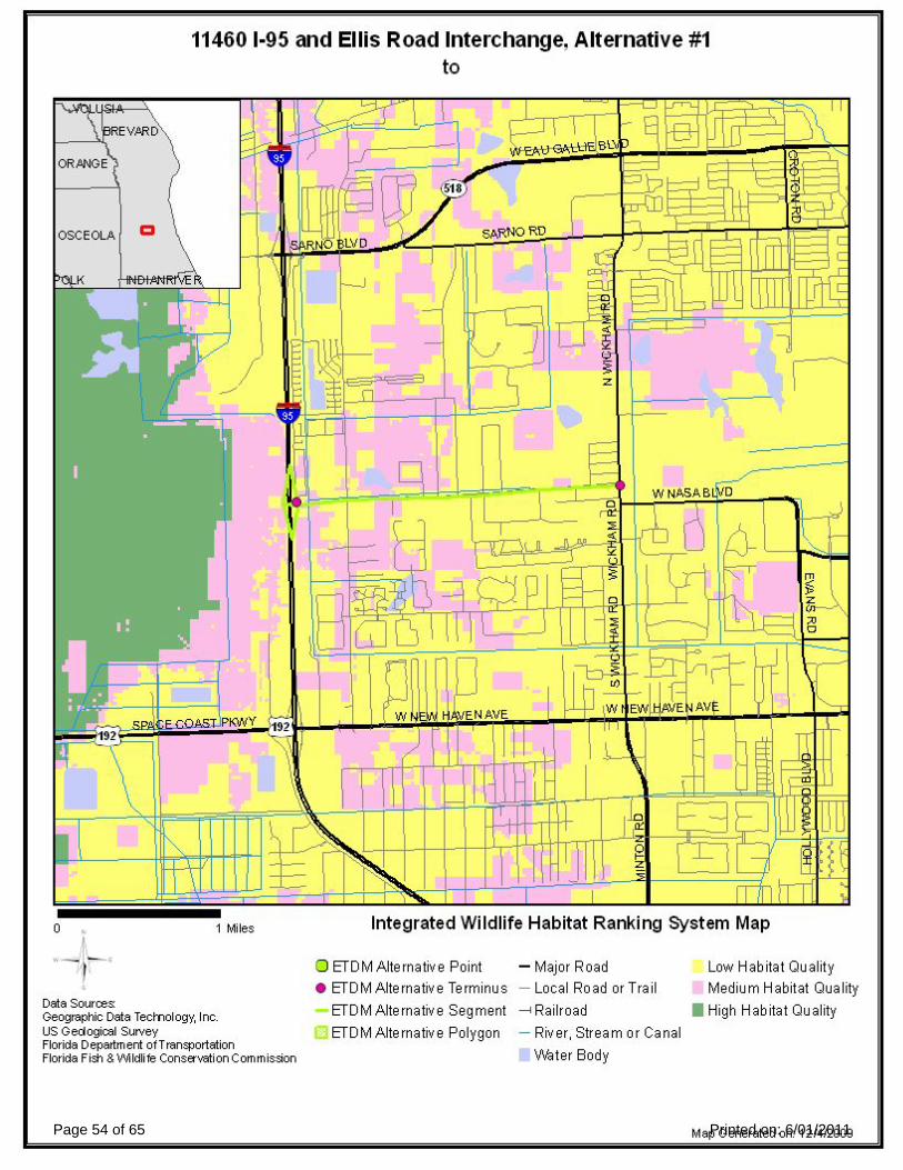
Page 54 of 65 Printed on: 6/01/2011

Page 55 of 65 Printed on: 6/01/2011

Page 56 of 65 Printed on: 6/01/2011

Page 57 of 65 Printed on: 6/01/2011

Page 58 of 65 Printed on: 6/01/2011

Page 59 of 65 Printed on: 6/01/2011

Page 60 of 65 Printed on: 6/01/2011

Page 61 of 65 Printed on: 6/01/2011

Page 62 of 65 Printed on: 6/01/2011

Page 63 of 65 Printed on: 6/01/2011

Page 64 of 65 Printed on: 6/01/2011

5. Appendicies
5.1. Degree of Effect Legend
5.2. Project Attachments
Appendicies
LegendColorCode Meaning ETAT Public Involvement
0 NoneThe issue is present, but the project will have noimpact on the issue; project has no adverse effect onETAT resources; permit issuance or consultationinvolves routine interaction with the agency.
No community opposition to the planned project.No adverse effect on the community.
1 EnhancedProject has positive effect on the ETAT resource orcan reverse a previous adverse effect leading toenvironmental improvement.
Affected community supports the proposedproject. Project has positive effect.
2 Minimal to NoneProject has little adverse effect on ETAT resources.Permit issuance or consultation involves routineinteraction with the agency. Low cost options areavailable to address concerns.
Minimum community opposition to the plannedproject. Minimum adverse effect on thecommunity.
3 Moderate
Agency resources are affected by the proposedproject, but avoidance and minimization options areavailable and can be addressed during developmentwith a moderated amount of agency involvement andmoderate cost impact.
Project has adverse effect on elements of theaffected community. Public Involvement isneeded to seek alternatives more acceptable tothe community. Moderate community interactionwill be required during project development.
4 Substantial
The project has substantial adverse effects but ETATunderstands the project need and will be able toseek avoidance and minimization or mitigationoptions during project development. Substantialinteraction will be required during projectdevelopment and permitting.
Project has substantial adverse effects on thecommunity and faces substantial communityopposition. Intensive community interaction withfocused Public Involvement will be requiredduring project development to addresscommunity concerns.
5 Dispute ResolutionProject does not conform to agency statutoryrequirements and will not be permitted. Disputeresolution is required before the project proceeds toprogramming
Community strongly opposes the project. Projectis not in conformity with local comprehensiveplan and has severe negative impact on theaffected community.
No ETAT Consensus ETAT members from different agencies assigned a different degree of effect to this project, and theETDM coordinator has not assigned a summary degree of effect.
No ETAT Reviews No ETAT members have reviewed the corresponding issue for this project, and the ETDM coordinatorhas not assigned a summary degree of effect.
Supporting DocumentsDate Type Size Link Name / Description
12/09/2009
Form SF-424:Application forFederalAssistance 113 KB http://etdmpub.fla-etat.org/est/servlet/blobViewer?blobID=9132
Final SF-424 formfor I-95 and Ellis RdInterchange:Application forFederal Assistance
12/04/2009 Feasibility Study 5.1 MB http://etdmpub.fla-etat.org/est/servlet/blobViewer?blobID=9074
I-95 @ Ellis Rd.Feasibility Study:SystemsOperationalAnalysis Report(SOAR)
12/03/2009
InterchangeModification/Justicfication Report
53.19MB http://etdmpub.fla-etat.org/est/servlet/blobViewer?blobID=9054
Final__MLB_IJR_Report_Revised_10-03-08: InterchangeJustification Reportfor I-95 at Ellis Road
Page 65 of 65 Printed on: 6/01/2011

APPENDIX C
AGENCY COORDINATION


APPENDIX D
STANDARD PROTECTION MEASURES FOR THE EASTERN INDIGO SNAKE

STANDARD PROTECTION MEASURES FOR THE EASTERN INDIGO SNAKE U.S. Fish and Wildlife Service
August 12, 2013
The eastern indigo snake protection/education plan (Plan) below has been developed by the U.S. Fish and Wildlife Service (USFWS) in Florida for use by applicants and their construction personnel. At least 30 days prior to any clearing/land alteration activities, the applicant shall notify the appropriate USFWS Field Office via e-mail that the Plan will be implemented as described below (North Florida Field Office: [email protected]; South Florida Field Office: [email protected]; Panama City Field Office: [email protected]). As long as the signatory of the e-mail certifies compliance with the below Plan (including use of the attached poster and brochure), no further written confirmation or “approval” from the USFWS is needed and the applicant may move forward with the project.
If the applicant decides to use an eastern indigo snake protection/education plan other than the approved Plan below, written confirmation or “approval” from the USFWS that the plan is adequate must be obtained. At least 30 days prior to any clearing/land alteration activities, the applicant shall submit their unique plan for review and approval. The USFWS will respond via e-mail, typically within 30 days of receiving the plan, either concurring that the plan is adequate or requesting additional information. A concurrence e-mail from the appropriate USFWS Field Office will fulfill approval requirements.
The Plan materials should consist of: 1) a combination of posters and pamphlets (see Poster Information section below); and 2) verbal educational instructions to construction personnel by supervisory or management personnel before any clearing/land alteration activities are initiated (see Pre-Construction Activities and During Construction Activities sections below).
POSTER INFORMATION
Posters with the following information shall be placed at strategic locations on the construction site and along any proposed access roads (a final poster for Plan compliance, to be printed on 11” x 17” or larger paper and laminated, is attached):
DESCRIPTION: The eastern indigo snake is one of the largest non-venomous snakes in North America, with individuals often reaching up to 8 feet in length. They derive their name from the glossy, blue-black color of their scales above and uniformly slate blue below. Frequently, they have orange to coral reddish coloration in the throat area, yet some specimens have been reported to only have cream coloration on the throat. These snakes are not typically aggressive and will attempt to crawl away when disturbed. Though indigo snakes rarely bite, they should NOT be handled.
SIMILAR SNAKES: The black racer is the only other solid black snake resembling the eastern indigo snake. However, black racers have a white or cream chin, thinner bodies, and WILL BITE if handled.
LIFE HISTORY: The eastern indigo snake occurs in a wide variety of terrestrial habitat types throughout Florida. Although they have a preference for uplands, they also utilize some wetlands
1

and agricultural areas. Eastern indigo snakes will often seek shelter inside gopher tortoise burrows and other below- and above-ground refugia, such as other animal burrows, stumps, roots, and debris piles. Females may lay from 4 - 12 white eggs as early as April through June, with young hatching in late July through October.
PROTECTION UNDER FEDERAL AND STATE LAW: The eastern indigo snake is classified as a Threatened species by both the USFWS and the Florida Fish and Wildlife Conservation Commission. “Taking” of eastern indigo snakes is prohibited by the Endangered Species Act without a permit. “Take” is defined by the USFWS as an attempt to kill, harm, harass, pursue, hunt, shoot, wound, trap, capture, collect, or engage in any such conduct. Penalties include a maximum fine of $25,000 for civil violations and up to $50,000 and/or imprisonment for criminal offenses, if convicted.
Only individuals currently authorized through an issued Incidental Take Statement in association with a USFWS Biological Opinion, or by a Section 10(a)(1)(A) permit issued by the USFWS, to handle an eastern indigo snake are allowed to do so.
IF YOU SEE A LIVE EASTERN INDIGO SNAKE ON THE SITE:
• Cease clearing activities and allow the live eastern indigo snake sufficient time to moveaway from the site without interference;
• Personnel must NOT attempt to touch or handle snake due to protected status.• Take photographs of the snake, if possible, for identification and documentation purposes.• Immediately notify supervisor or the applicant’s designated agent, and the appropriate
USFWS office, with the location information and condition of the snake.• If the snake is located in a vicinity where continuation of the clearing or construction
activities will cause harm to the snake, the activities must halt until such time that arepresentative of the USFWS returns the call (within one day) with further guidance as towhen activities may resume.
IF YOU SEE A DEAD EASTERN INDIGO SNAKE ON THE SITE:
• Cease clearing activities and immediately notify supervisor or the applicant’s designatedagent, and the appropriate USFWS office, with the location information and condition ofthe snake.
• Take photographs of the snake, if possible, for identification and documentation purposes.• Thoroughly soak the dead snake in water and then freeze the specimen. The appropriate
wildlife agency will retrieve the dead snake.
Telephone numbers of USFWS Florida Field Offices to be contacted if a live or dead eastern indigo snake is encountered:
North Florida Field Office – (904) 731-3336 Panama City Field Office – (850) 769-0552 South Florida Field Office – (772) 562-3909
2

PRE-CONSTRUCTION ACTIVITIES 1. The applicant or designated agent will post educational posters in the construction office and throughout the construction site, including any access roads. The posters must be clearly visible to all construction staff. A sample poster is attached. 2. Prior to the onset of construction activities, the applicant/designated agent will conduct a meeting with all construction staff (annually for multi-year projects) to discuss identification of the snake, its protected status, what to do if a snake is observed within the project area, and applicable penalties that may be imposed if state and/or federal regulations are violated. An educational brochure including color photographs of the snake will be given to each staff member in attendance and additional copies will be provided to the construction superintendent to make available in the onsite construction office (a final brochure for Plan compliance, to be printed double-sided on 8.5” x 11” paper and then properly folded, is attached). Photos of eastern indigo snakes may be accessed on USFWS and/or FWC websites. 3. Construction staff will be informed that in the event that an eastern indigo snake (live or dead) is observed on the project site during construction activities, all such activities are to cease until the established procedures are implemented according to the Plan, which includes notification of the appropriate USFWS Field Office. The contact information for the USFWS is provided on the referenced posters and brochures. DURING CONSTRUCTION ACTIVITIES 1. During initial site clearing activities, an onsite observer may be utilized to determine whether habitat conditions suggest a reasonable probability of an eastern indigo snake sighting (example: discovery of snake sheds, tracks, lots of refugia and cavities present in the area of clearing activities, and presence of gopher tortoises and burrows). 2. If an eastern indigo snake is discovered during gopher tortoise relocation activities (i.e. burrow excavation), the USFWS shall be contacted within one business day to obtain further guidance which may result in further project consultation. 3. Periodically during construction activities, the applicant’s designated agent should visit the project area to observe the condition of the posters and Plan materials, and replace them as needed. Construction personnel should be reminded of the instructions (above) as to what is expected if any eastern indigo snakes are seen. POST CONSTRUCTION ACTIVITIES Whether or not eastern indigo snakes are observed during construction activities, a monitoring report should be submitted to the appropriate USFWS Field Office within 60 days of project completion. The report can be sent electronically to the appropriate USFWS e-mail address listed on page one of this Plan.
3

ATTENTION: THREATENED EASTERN INDIGO SNAKES MAY BE PRESENT ON
THIS SITE!!! IF YOU SEE A LIVE EASTERN INDIGO SNAKE ON THE SITE: • Cease clearing activities and allow the eastern indigo snake sufficient time to move away from the site
without interference.• Personnel must NOT attempt to touch or handle snake due to protected status.• Take photographs of the snake, if possible, for identification and documentation purposes.• Immediately notify supervisor or the applicant’s designated agent, and the appropriate U.S. Fish and
Wildlife Service (USFWS) office, with the location information and condition of the snake.• If the snake is located in a vicinity where continuation of the clearing or construction activities will cause
harm to the snake, the activities must halt until such time that a representative of the USFWS returns thecall (within one day) with further guidance as to when activities may resume.
IF YOU SEE A DEAD EASTERN INDIGO SNAKE ON THE SITE:• Cease clearing activities and immediately notify supervisor or the applicant’s designated agent, and the
appropriate USFWS office, with the location information and condition of the snake.• Take photographs of the snake, if possible, for identification and documentation purposes.• Thoroughly soak the dead snake in water and then freeze the specimen. The appropriate wildlife agency will
retrieve the dead snake.
USFWS Florida Field Offices to be contacted if a live or dead eastern indigo snake is encountered: North Florida Field Office – (904) 731-3336 Panama City Field Office – (850) 769-0552 South Florida Field Office – (772) 562-3909
Killing, harming, or harassing indigo snakes is strictly prohibited and punishable under State and Federal Law.
DESCRIPTION: The eastern indigo snake is one of the largest non-venomous snakes in North America, with individuals often reaching up to 8 feet in length. They derive their name from the glossy, blue-black color of their scales above and uniformly slate blue below. Frequently, they have orange to coral reddish coloration in the throat area, yet some specimens have been reported to only have cream coloration on the throat. These snakes are not typically aggressive and will attempt to crawl away when disturbed. Though indigo snakes rarely bite, they should NOT be handled.
SIMILAR SNAKES: The black racer is the only other solid black snake resembling the eastern indigo snake. However, black racers have a white or cream chin, thinner bodies, and WILL BITE if handled.
LIFE HISTORY: The eastern indigo snake occurs in a wide variety of terrestrial habitat types throughout Florida. Although they have a preference for uplands, they also utilize some wetlands and agricultural areas. Eastern indigo snakes will often seek shelter inside gopher tortoise burrows and other below- and above-
ground refugia, such as other animal burrows, stumps, roots, and debris piles. Females may lay from 4 - 12 white eggs as early as April through June, with young hatching in late July through October.
PROTECTION: The eastern indigo snake is classified as a Threatened species by both the USFWS and the Florida Fish and Wildlife Conservation Commission. “Taking” of eastern indigo snakes is prohibited by the Endangered Species Act without a permit. “Take” is defined by the USFWS as an attempt to kill, harm, harass, pursue, hunt, shoot, wound, trap, capture, collect, or engage in any such conduct. Penalties include a maximum fine of $25,000 for civil violations and up to $50,000 and/or imprisonment for criminal offenses, if convicted.
Only individuals currently authorized through an issued Incidental Take Statement in association with a USFWS Biological Opinion, or by a Section 10(a)(1)(A) permit issued by the USFWS, to handle an
eastern indigo snake are allowed to do so.
Photo: Dirk Stevenson
August 12, 2013

IF YOU SEE A LIVE EASTERN INDIGO SNAKE ON THE SITE:
• Cease clearing activities and allowthe eastern indigo snake sufficienttime to move away from the sitewithout interference.
• Personnel must NOT attempt totouch or handle snake due toprotected status.
• Take photographs of the snake, ifpossible, for identification anddocumentation purposes.
• Immediately notify supervisor or theapplicant’s designated agent, and theappropriate U.S. Fish and WildlifeService (USFWS) office, with thelocation information and condition ofthe snake.
• If the snake is located in a vicinitywhere continuation of the clearing orconstruction activities will causeharm to the snake, the activities musthalt until such time that arepresentative of the USFWS returnsthe call (within one day) with furtherguidance as to when activities mayresume.
IF YOU SEE A DEAD EASTERN INDIGO SNAKE ON THE SITE:
• Cease clearing activities andimmediately notify supervisor or theapplicant’s designated agent, and theappropriate USFWS office, with thelocation information and condition ofthe snake.
• Take photographs of the snake, ifpossible, for identification anddocumentation purposes.
• Thoroughly soak the dead snake inwater and then freeze the specimen.The appropriate wildlife agency willretrieve the dead snake.
USFWS Florida Field Offices to be contacted if a live or dead eastern indigo snake is encountered:
North Florida ES Office – (904) 731-3336 Panama City ES Office – (850) 769-0552 South Florida ES Office – (772) 562-3909
DESCRIPTION: The eastern indigo snake is one of the largest non-venomous snakes in North America, with individuals often reaching up to 8 feet in length. They derive their name from the glossy, blue-black color of their scales above and uniformly slate blue below. Frequently, they have orange to coral reddish coloration in the throat area, yet some specimens have been reported to only have cream coloration on the throat. These snakes are not typically aggressive and will attempt to crawl away when disturbed. Though indigo snakes rarely bite, they should NOT be handled.
SIMILAR SNAKES: The black racer is the only other solid black snake resembling the eastern indigo snake. However, black racers have a white or cream chin, thinner bodies, and WILL BITE if handled.
LIFE HISTORY: The eastern indigo snake occurs in a wide variety of terrestrial habitat types throughout Florida. Although they have a preference for uplands, they also utilize some wetlands and agricultural areas. Eastern indigo snakes will often seek shelter inside gopher tortoise burrows and other below- and above-ground refugia, such as other animal burrows, stumps, roots, and debris piles. Females may lay from 4 - 12 white eggs as early as April through June, with young hatching in late July through October.

Killing, harming, or harassing indigo snakes is strictly prohibited and punishable under State and Federal Law.
Only individuals currently authorized through an issued Incidental Take Statement in association with a USFWS Biological Opinion, or by a Section 10(a)(1)(A) permit issued by the USFWS, to handle an eastern indigo snake are allowed to do so.
LEGAL STATUS: The eastern indigo snake is classified as a Threatened species by both the USFWS and the Florida Fish and Wildlife Conservation Commission. “Taking” of eastern indigo snakes is prohibited by the Endangered Species Act without a permit. “Take” is defined by the USFWS as an attempt to kill, harm, harass, pursue, hunt, shoot, wound, trap, capture, collect, or engage in any such conduct. Penalties include a maximum fine of $25,000 for civil violations and up to $50,000 and/or imprisonment for criminal offenses, if convicted.
ATTENTION: THREATENED EASTERN INDIGO SNAKES MAY BE PRESENT ON
THIS SITE!!!
Please read the following information provided by the U.S. Fish and Wildlife Service
to become familiar with standard protection measures for the eastern indigo snake.
Photo: Dirk Stevenson
August 12, 2013


