Page 1
i
Prepared by: GroundTruth
Prepared for: Tongaat Hulett Developments
Vegetation Report
Reference: GTB028-0414-01
Date: April 2014
Tongaat Hulett Developments: Assessment of Vegetation on Portion 2026 of
Cotton Lands No. 1575, Canelands
Page 2
Portion 2026 of Cotton Lands No. 1575
Vegetation Assessment Report 2014
© GroundTruth Water, Wetlands and Environmental Engineering Page i
Copyright
All intellectual property rights and copyright associated with GroundTruth’s services are
reserved and project deliverables1may not be modified or incorporated into subsequent
reports, in any form or by any means, without the written consent of the author/s. Similarly,
this report should be appropriately referenced if the results, recommendations or conclusions
stated in this report are used in subsequent documentation. Should this report form a
component of an overarching study, it is GroundTruth’s preference that this report be
included in its entirety as a separate section or annexure/appendix to the main report.
Indemnity
The project deliverables, including the reported results, comments, recommendations and
conclusions, are based on the authors’ professional knowledge as well as available
information. The study is based on assessment techniques and investigations that are
limited by time and budgetary constraints applicable to the type and level of survey
undertaken. GroundTruth therefore reserves the right to modify aspects of the project
deliverables if and when new/additional information may become available from research,
identifications or further work in the applicable field of practice, or pertaining to this study.
GroundTruth exercises all reasonable skill, care and diligence in the provision of services,
however, GroundTruth accepts no liability or consequential liability for the use of the supplied
project deliverables (in part or in whole) and any information or material contained therein.
The client, including their agents, by receiving these deliverables indemnifies GroundTruth
(including its members, employees and sub-consultants) against any actions, claims,
demands, losses, liabilities, costs, damages and expenses arising directly or indirectly from
or in connection with services rendered, directly or indirectly by GroundTruth.
1 Project deliverables (including electronic copies) comprise inter alia: reports, maps, assessment and monitoring data, ESRI ArcView shapefiles, and photographs.
Page 3
Portion 2026 of Cotton Lands No. 1575
Vegetation Assessment Report 2014
© GroundTruth Water, Wetlands and Environmental Engineering Page ii
Table of contents
Copyright ............................................................................................................................... i
Indemnity ............................................................................................................................... i
Table of contents .................................................................................................................. ii
List of figures ....................................................................................................................... ii
List of tables ......................................................................................................................... ii
1. INTRODUCTION ........................................................................................................... 1
1.1 Objectives ..................................................................................................................... 1
1.2 Methodology.................................................................................................................. 1
2. DESCRIPTION OF REFERENCE VEGETATION ......................................................... 4
3. DESCRIPTION OF THE SITE’S VEGETATION ............................................................ 6
3.1 Classification and mapping of vegetation/ecological units ............................................. 6
3.2 Present state of vegetation ............................................................................................ 8
3.3 Conservation important species .................................................................................... 9
3.4 Invasive/alien plant species ........................................................................................... 9
3.5 Important habitats and ecoystems ................................................................................. 9
4. DISCUSSION .............................................................................................................. 10
4.1 Assumptions and limitations ........................................................................................ 10
4.2 Impacts affecting the study area .................................................................................. 10
4.3 Recommendations ...................................................................................................... 10
4.4 Conclusion .................................................................................................................. 12
5. Acknowledgements ................................................................................................... 13
6. References ................................................................................................................. 13
7. Appendices ................................................................................................................ 14
List of figures
Figure 1-1 Study area and site map for the proposed development on portion 2026 of
Cotton Lands no. 1575, Canelands ......................................................................3
Figure 3-1 Mapped ecological units within portion 2026 of Cotton Lands no. 1575,
Canelands ............................................................................................................7
List of tables
Table 2-1 List of important, biogeographically important and endemic plant taxa defining
the KwaZulu-Natal Coastal Belt (Mucina et al., 2006) ...........................................4
Table 3-1 Ecological units and their respective areas within the study area as derived
from the available vegetation types ......................................................................8
Page 4
Portion 2026 of Cotton Lands No. 1575
Vegetation Assessment Report 2014
© GroundTruth Water, Wetlands and Environmental Engineering Page 1
1. INTRODUCTION
GroundTruth was appointed by Tongaat Hulett Developments (THD) to conduct a vegetation
assessment of Portion 2026 of Cotton Lands No 1575, hereafter referred to as the “site”
(Figure 1-1). This ecological report was produced in conjunction with the wetland
assessment and rehabilitation plan (Reference: GTW248-280214-01) and therefore makes
cross reference to the vegetation aspects of the wetland report.
The site, which is approximately 7.3 hectares, is adjacent to existing industrial developments
and located just north of Verulam in the eThekwini Municipality, KwaZulu-Natal (Figure 1-1).
A watercourse, flowing roughly in a north westerly direction, drains through the northern half
of the site. The proposed development footprint occurs in the southern portion of the site
and covers an area of 1.6 hectares.
1.1 Objectives
The primary aim of this study is to assess the ecological condition of the vegetation and
habitats associated with the site within the context of the proposed development. The
following objectives were therefore considered for the purpose achieving the overall aim:
Identify and map vegetation/ecological units that occur within the site using aerial
imagery and other available desktop information.
Conduct field surveys to verify and validate desktop information, to assess
ecological condition of the vegetation/habitats, identify species of conservation
concern, and highlight indicator species (including alien invasive plants).
Identify and map areas of importance from an ecological perspective.
Provide recommendations in terms of development constraints and opportunities
particularly in terms of achieving sustainable development and utilisation of the
present environment.
1.2 Methodology
The following desktop and field-based procedures were employed in this study:
Desktop assessment: Data and literature relating to the vegetation/habitats
occurring within the site was sourced and used to identify and define ecological
units. The potential vegetation reference state was established using the
vegetation types of South Africa classification system and map (Mucina and
Rutherford, 2006), which describes the spatial distribution of naturally occurring
vegetation within major habitat biomes. Aerial imagery was then used to verify
the occurrence of natural vegetation as well as to map the distribution and extent
of vegetation/habitats and land use that currently define the site. Mapping was
done using ArcMap 10 Geographical Information System (GIS).
Page 5
Portion 2026 of Cotton Lands No. 1575
Vegetation Assessment Report 2014
© GroundTruth Water, Wetlands and Environmental Engineering Page 2
Field-based assessment: A site visit was conducted on 21 September 2012 to
provide site-specific details in order to verify and validate the ecological units
identified during the desktop assessment process. Information obtained included
plant species diversity, presence and abundance of plant ecological indicators
(including alien invasive species), occurrences of species of conservation
concern, as well as any additional detail that may facilitate the overall study. The
purpose of the flora component of this study was primarily to provide a synthesis
of floristic biodiversity for the study area.
Page 6
Portion 2026 of Cotton Lands No. 1575
Vegetation Assessment Report 2014
© GroundTruth Water, Wetlands and Environmental Engineering Page 3
Figure 1-1 Study area and site map for the proposed development on portion 2026 of Cotton Lands no. 1575,
Canelands
Page 7
Portion 2026 of Cotton Lands No. 1575
Vegetation Assessment Report 2014
© GroundTruth Water, Wetlands and Environmental Engineering Page 4
2. DESCRIPTION OF REFERENCE VEGETATION
The site and broader study area occurs within the KwaZulu-Natal Coastal Belt (see
Appendix 5), an Endangered vegetation type (Mucina et al., 2006). The KwaZulu-Natal
Coastal Belt occupies a long, and in places broad, coastal strip along the KwaZulu-Natal
coast extending roughly from Mtunzini in the north to Port Edward in the south (Mucina et al.,
2006). In natural situations, this vegetation type is defined by various types of subtropical
coastal forest interspersed with Themeda triandra grassland. An extract of important,
biogeographically important and endemic plant taxa from Mucina et al. (2006) is provided in
Table 2-1.
Table 2-1 List of important, biogeographically important and endemic plant taxa defining the
KwaZulu-Natal Coastal Belt (Mucina et al., 2006)
Plant growth form Species
Important taxa2
Graminoids Aristida junciformis subsp. galpinii, Digitaria eriantha, Panicum maximum, Themeda triandra, Alloteropsis semialata subsp. eckloniana, Cymbopogon filipendula, Melinis repens.
Herbs Berkheya speciosa subsp. speciosa, Cyanotis speciosa, Senecio glaberrimus, Alepidea longifolia, Centella glabrata, Cephalaria oblongifolia, Chamaecrista mimosoides, Conostomium natalense, Crotalaria lanceolata, Dissotis canescens, Eriosema squarrosum, Gerbera ambigua, Hebenstretia comosa, Helichrysum cymosum subsp. cymosum, H. pallidum, Hibiscus pedunculatus, Hybanthus capensis, Indigofera hilaris, Pentansia prunelloides subsp. latifolia, Senecio albanesis, S. bupleuroides. S. coronatus, S. nigricans, Veronia galpinii, V. oliogocephala.
Geophytic herbs Bulbine asphodeloides, Disa polygonoides, Hypoxis filiformis, Ledebouria floribunda, Pachycarpus asperifolius, Schizocarphus nervosus, Tritonia disticha.
Low shrubs Clutia pulchella, Gnidia kraussiana, Phyllanthus glaucophyllus, Tephrosia polystachya.
Woody climbers Abrus laevigatus, Asparagus racemosus, Smilax anceps.
Small trees and tall shrubs
Bridelia micrantha, Phoenix reclinata, Syzigium cordatum, Acacia natalitia, Albizia adianthifolia, Antedesma venosum.
Biogeographically important taxa3
Graminoids Cyperus natalensis, Eragrostis lappula.
Herbs Helichrysum longifolium, Selago tarachodes, Senecio dregeanus, Sphenostylis angustifolia.
Geophytic herbs Knipofia gracilis, K. littoralis, K. rooperi, Pachystigma venosum, Zeuxine africana.
Low shrubs Helichrysum kraussii, Agathisanthemum bojeri, Desmodium dregeanum.
Megaherb Strelizia Nicolai.
2 Species (and lower taxa) that have a high abundance, a frequent occurrence or are prominent in the landscape.
3 Taxa that are not necessarily endemic, and are important, but carry additional importance being limited to a small group of vegetation units, they are listed a regionally endemic in an established Centre of Endemism, they occur at the limits of their distribution area and they show a very disjunct distribution pattern.
Page 8
Portion 2026 of Cotton Lands No. 1575
Vegetation Assessment Report 2014
© GroundTruth Water, Wetlands and Environmental Engineering Page 5
Plant growth form Species
Geoxylic suffritices Ancylobotrys petersiana, Eugenia albanensis, Salacia kraussii.
Small trees and tall shrubs
Anastrabe integerrima, Acacia nilotica subsp. kraussiana.
Endemic taxa4
Herb Veronia africana (extinct)
Geophytic herb Knipophia pauciflora
Low shrub Barleria natalensis (extinct)
Over the years, the natural vegetation of this unit has been highly transformed and
fragmented, primarily from extensive sugarcane cultivation, timber plantations and urban
sprawl. Due to the extensive transformation, the natural vegetation has been replaced by a
mosaic of secondary grasslands (dominated by Aristida sp.), seral thickets and bushveld
most of which is severely threatened by alien plant invasion. Currently only a very small
area (i.e. less than 1% of original area) is protected in Ngoye, Mbumbazi and Vernon
Crookes Nature Reserves.
Lower order vegetation units (e.g. grassland, forest, wetland, etc.) are also nested in the part
of the KwaZulu-Natal Coastal Belt. However, due to the degraded nature of the vegetation,
little can be referred back to these units in their original state.
4 Plant taxa that occur exlusively within the vegetation unit concerned (i.e. KwaZulu-Natal Coastal Belt).
Page 9
Portion 2026 of Cotton Lands No. 1575
Vegetation Assessment Report 2014
© GroundTruth Water, Wetlands and Environmental Engineering Page 6
3. DESCRIPTION OF THE SITE’S VEGETATION
3.1 Classification and mapping of vegetation/ecological units
The site contains several units as per the prevailing vegetation communities and land use.
Definitions and descriptions of each unit are as follows:
Thicket – Generally disturbed land comprising a high proportion of both woody
and herbaceous alien species, with a limited presence of pioneer, indigenous
woody species or more common indigenous herbaceous species. Thicket within
the site is generally confined to the southern boundary along the railway
servitude (Figure 3-1) and is identified by dense stands of trees or tall shrubs,
dominated by a few species.
Riparian habitat – Riparian habitat occur along watercourses draining valley
bottoms. In natural situations, the vegetation is mostly evergreen and
characterised by trees and other plant species that tolerate soils with high water
content or that are completely saturated. The National Water Act (Act 36 of
1998) defines riparian habitat as the “physical structure and associated
vegetation of the areas associated with a watercourse which are commonly
characterised by alluvial soils, and which are inundated or flooded to an extent
and with a frequency sufficient to support vegetation of species with a
composition and physical structure distinct from those of adjacent land areas”
(NWA, 1998). The vegetation associated with the riparian areas, extending
across the site to the northwestern corner (Figure 3-1), is defined as riverine
scrub.
Wetland habitat – The mapping and characterisation of wetland habitat is as
determined in the wetland report (Reference: GTW248-280214-01). This
includes the typha-dominated wetland and wetland habitat associated with the
watercourse and sugarcane (Figure 3-1).
Sugarcane – Land comprising cultivated sugarcane (Figure 3-1).
Roads/infrastructure – Areas that have been developed for roads and various
infrastructure (Figure 3-1).
Figure 3-1 shows the spatial extent and distribution of the aforementioned
vegetation/ecological units occurring within the site.
Page 10
Portion 2026 of Cotton Lands No. 1575
Vegetation Assessment Report 2014
© GroundTruth Water, Wetlands and Environmental Engineering Page 7
Figure 3-1 Mapped ecological units within portion 2026 of Cotton Lands no. 1575, Canelands
Page 11
Portion 2026 of Cotton Lands No. 1575
Vegetation Assessment Report 2014
© GroundTruth Water, Wetlands and Environmental Engineering Page 8
Table 3-1 summarises the areas of each vegetation/ecological unit as determined by the
desktop mapping and field-based verification procedures. The site is dominated by
sugarcane (67%). In terms of the remaining vegetation, riverine scrub is dominant (15%),
followed by typha wetland (8%) and thicket (5%) (Table 3-1). The wetland habitat as defined
in the wetland report (Reference: GTW248-280214-01) intercepts a significant portion
(~43%) of the vegetation units mapped for the site (Figure 3-1).
Table 3-1 Ecological units and their respective areas within the study area as derived from
the available vegetation types
Ecological Unit
Study area
Area (ha) Percent of total
area (%)
Thicket 1.1 5
Riverine scrub 0.4 15
Typha wetland 4.8 8
Sugarcane 0.3 67
Roads/infrastructure 0.6 6
Total 7.3 ha
3.2 Present state of vegetation
The vegetation cover of the site is dominated by cultivated sugarcane (Genus: Saccharum),
a tall perennial grass, introduced to South Africa for sugar production. The remaining open
spaces that are not developed or cultivated are disturbed and are largely dominated by
invasive alien plant species. The few indigenous plant species that remain form insignificant
and isolated components within the site. Furthermore, no elements resembling the natural
reference vegetation for the area, i.e. KwaZulu-Natal Coastal Belt (c.f. Section 2), are
associated with the site. As a result, the vegetation on the site is considered highly
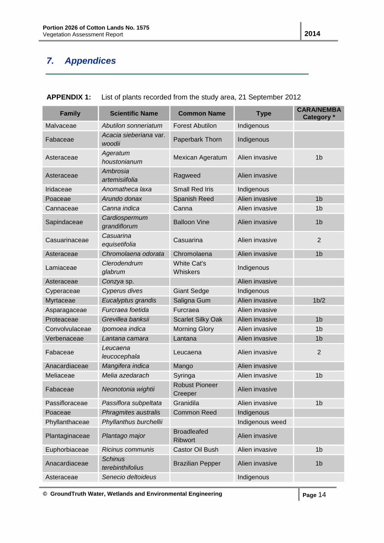
transformed. Appendix 1 provides a list of plant species identified within the site.
A general description of vegetation associated with the mapped ecological units (c.f. Section
3.1) is as follows:
Thicket – The thicket vegetation along the southern boundary is overwhelmingly
dominated by invasive alien trees, notably Melia azedarach (Syringa) and
Schinus terebinthifolius (Brazilian Pepper).
Riverine scrub – The riverine scrub contains a mosaic of different plant growth
forms (e.g. trees, shrubs, herbs and grasses) made up mostly of invasive alien
species. The few indigenous elements that remain include Anomatheca laxa
(Small Red Iris), Phragmites australis (Common Reed), Senecio
polyanthemoides, Trichilia emetica (Natal Mahogany) and Strelitzia nicolai (Wild
Banana).
Typha wetland – The wetland located near the southwestern corner of the site is
dominated by Typha capensis (Bulrush), but flanked by a variety of invasive alien
shrubs, herbs and climbers.
Page 12
Portion 2026 of Cotton Lands No. 1575
Vegetation Assessment Report 2014
© GroundTruth Water, Wetlands and Environmental Engineering Page 9
3.3 Conservation important species
No Red Listed or other conservation important plant species were observed within the site.
3.4 Invasive/alien plant species
Majority (~70%) of the plants identified during the site visit are invasive alien species which
supports the fact that the vegetation is generally highly disturbed (Appendix 1). Problematic
species include:
Trees: Casuarina equisetifolia (Casuarina), Eucalyptus grandis (Saligna Gum),
Grevillea banksii (Scarlet Silky Oak), Leucaena leucocephala (Leucaena), Melia
azedarach (Syringa), Schinus terebinthifolius (Brazilian Pepper Tree), Solanum
mauritianum (Bugweed) and Syzygium cuminii (Jambolan Plum);
Shrubs: Chromolaena odorata (Triffid Weed), Lantana camara (Lantana),
Ricinus communis (Castor-oil Plant), Senna didymobotrya (Peanut-butter
Cassia), Sesbania punicea (Brazilian Glory Pea) and Tithonia diversifolia
(Mexican Sunflower);
Herbs: Ageratum houstonianum (Blue Weed) and Canna indica (Canna);
Climbers: Cardiospermum grandiflorum (Balloon Vine), Ipomea purpurea
(Common Morning Glory) and Passiflora subpeltata (Wild Granidilla); and
Grass: Arundo donax (Giant Reed).
3.5 Important habitats and ecoystems
No vegetation that occurs within the site requires protection and/or specific management.
However, it is important that the aquatic ecosystems associated with the site (i.e. riparian
and wetland habitats) are protected under the auspices of the National Water Act (Act 36 of
1998). The functionality of these systems should be maintained, and where possible
improved, to ensure the continued supply of ecological and hydrological services in the
landscape (e.g. improving water quality, streamflow regulation, groundwater recharge,
erosion control, and maintenance of wetland-dependant biodiversity). The extent and
distribution of aquatic ecosystems is as mapped and described in the wetland report
(Reference: GTW248-280214-01).
Page 13
Portion 2026 of Cotton Lands No. 1575
Vegetation Assessment Report 2014
© GroundTruth Water, Wetlands and Environmental Engineering Page 10
4. DISCUSSION
4.1 Assumptions and limitations
This report was produced based on a single site visit conducted during September. It is
therefore possible that certain floral elements may have been undetected due to the timing
of the survey and the limited presence of flowering material. However, given the dominance
of alien/weedy plant species and high levels of disturbance observed, it is likely that this
study provides a reasonably accurate representation of the actual plant diversity expected
for the site. As a result, it was not necessary to comprehensively catalogue the diversity of
plants. Furthermore, the possibility of conservation important species (i.e. Red Listed, rare
and endemic species) occurring in the site, at most, very low.
4.2 Impacts affecting the study area
The site is currently affected by various impacts, these include:
Removal of vegetation – Majority (>70%) of the site’s vegetation has been
removed or is transformed, primarily through sugarcane agriculture and
construction of roads.
Alien invasive plants – The remaining areas with natural vegetation are heavily
infested with invasive alien plants (c.f. Section 3.2). As a result, the ecological
functionality and integrity of natural vegetation has been significantly affected.
Erosion – The riparian areas are impacted by bank collapse and incision of the
river channel, particularly just downstream of the Duiker road crossing.
Solid waste dumping – Localised sites of illegal solid waste dumping occur
throughout the site.
4.3 Recommendations
The following recommendations are provided to avoid and/or mitigate impacts that may arise
from construction and/or operations:
Ensure minimal or no disturbance outside of the development footprint area,
particularly during construction.
Ensure that the stormwater management plan for the development minimises
flow-related impacts to aquatic ecosystems located downstream. Interventions
that can be considered, in addition to the stormwater runoff recommendations of
the wetland report (Reference: GTW248-280214-01), include:
o On-site storage/attenuation structures incorporated into the overall design
layout.
Page 14
Portion 2026 of Cotton Lands No. 1575
Vegetation Assessment Report 2014
© GroundTruth Water, Wetlands and Environmental Engineering Page 11
o Open swales5, properly sized to accommodate excess stormwater,
particularly from roofs and paved areas.
o Permeable pavers incorporated, where practical, into the design and
construction of parking areas, walkways, etc.
Mature, indigenous trees occurring within the development footprint should be
incorporated, as far as possible, into the landscaping plan. Indigenous trees
should be clearly marked to avoid accidental removal/damage.
Topsoil from development area should be stockpiled in appropriately designated
areas for re-use during landscaping and revegetation/rehabilitation.
All construction materials and solid/liquid waste should be disposed in an
appropriate and sensible manner.
Develop and implement a comprehensive alien weed control programme to
remove problematic plant species and prevent further spread and establishment.
Invasive alien plants should be removed from the wetland/riparian areas and
planned open spaces prior to rehabilitation and revegetation taking place.
Allowance should be made for routine follow-ups until the time that there is either
no presence or a negligible presence of these plants. Alien plant control work
needs to be carried out by competent contractors.
As part of the rehabilitation process, erosion control measures (e.g. sediment
traps, geo-membranes, etc.) should be employed to reduce erosion, particularly
on steep slopes and banks within riparian areas.
Active planting of indigenous vegetation should consider the following:
o Revegetation should commence as soon as possible to create vegetative
cover on bare/exposed soils.
o Landscaping of the development area should include strategic planting of
indigenous plants that are representative of the area.
o Open spaces should be revegetated using an indigenous grass-seed mix,
with preference for important grasses of the KwaZulu-Natal Coastal Belt
(c.f. Table 2-1). Appropriate indigenous herbs may be inter-planted into
the grassland to speed up the process of natural recruitment and
succession.
o Suitable riparian trees and shrubs should be planted along the
watercourse draining through the site. Planting efforts should ensure that
a multi-layered, undisturbed vegetative community established within the
riparian areas over time. A detailed list of appropriate species is provided
in the rehabilitation plan (Reference: GTW248-280214-01).
The objective of the active planting and revegetation should be to improve
biodiversity and ecosystem service delivery, buffer the aquatic ecosystems from
5 Open swales are vegetated, shallow depressions that are often used along roadsides to capture surface runoff.
The increased surface roughness helps to reduce velocities of surface runoff thereby increasing infiltration of water into the soil layers.
Page 15
Portion 2026 of Cotton Lands No. 1575
Vegetation Assessment Report 2014
© GroundTruth Water, Wetlands and Environmental Engineering Page 12
impacts associated with the development and surrounding land use activities,
and to limit establishment of alien/ruderal vegetation. To achieve this, it will be
important that these areas are managed and maintained indefinitely, particularly
in terms of control of invasive alien plants.
It is important that the aforementioned recommendations are incorporated into the
development’s Environmental Management Programme (EMPr). The EMPr should also
include routine monitoring of the open spaces and riparian habitats with specifications for the
management and maintenance of these areas.
4.4 Conclusion
With exception to loss of wetland habitat, the proposed development will not have a
significant impact on the ecological state of the vegetation that is directly affected.
Furthermore, opportunities exist to rehabilitate non-developed areas of the site to allow
establishment of natural vegetation. Not only will this improve the integrity and functionality
of terrestrial and aquatic ecosystems on site, but will also enhance ecological connectivity
within the broader landscape setting.
Page 16
Portion 2026 of Cotton Lands No. 1575
Vegetation Assessment Report 2014
© GroundTruth Water, Wetlands and Environmental Engineering Page 13
5. Acknowledgements
GroundTruth would like to thank and acknowledge David Styles for his assistance and
botanical expertise with conducting this study.
6. References
Mucina L and Rutherford MC (eds). The Vegetation of South Africa, Lesotho and Swaziland.
Strelitzia 19: 578-579. South African National Biodiversity Institute, Pretoria.
Mucina L, Scott-Shaw R, Rutherford MC, Camp KGT, Matthews WS, Powrie LW and Hoare
DB. 2006. Indian Ocean Coastal Belt. In: Mucina L and Rutherford MC (eds). The Vegetation
of South Africa, Lesotho and Swaziland. Strelitzia 19: 578-579. South African National
Biodiversity Institute, Pretoria.
National Water Act. 1998. RSA Government Gazette No. 36 of 1998: 26 August 1998, No.
19182. Cape Town, RSA.
National Forests Act. 1998. RSA Government Gazette No. 30 of 1998: 30 October 1998, No.
19408. Cape Town, RSA.
Page 17
Portion 2026 of Cotton Lands No. 1575
Vegetation Assessment Report 2014
© GroundTruth Water, Wetlands and Environmental Engineering Page 14
7. Appendices
APPENDIX 1: List of plants recorded from the study area, 21 September 2012
Family Scientific Name Common Name Type CARA/NEMBA
Category *
Malvaceae Abutilon sonneriatum Forest Abutilon Indigenous
Fabaceae Acacia sieberiana var.
woodii Paperbark Thorn Indigenous
Asteraceae Ageratum
houstonianum Mexican Ageratum Alien invasive 1b
Asteraceae Ambrosia
artemisiifolia Ragweed Alien invasive
Iridaceae Anomatheca laxa Small Red Iris Indigenous
Poaceae Arundo donax Spanish Reed Alien invasive 1b
Cannaceae Canna indica Canna Alien invasive 1b
Sapindaceae Cardiospermum
grandiflorum Balloon Vine Alien invasive 1b
Casuarinaceae Casuarina
equisetifolia Casuarina Alien invasive 2
Asteraceae Chromolaena odorata Chromolaena Alien invasive 1b
Lamiaceae Clerodendrum
glabrum
White Cat's
Whiskers Indigenous
Asteraceae Conzya sp. Alien invasive
Cyperaceae Cyperus dives Giant Sedge Indigenous
Myrtaceae Eucalyptus grandis Saligna Gum Alien invasive 1b/2
Asparagaceae Furcraea foetida Furcraea Alien invasive
Proteaceae Grevillea banksii Scarlet Silky Oak Alien invasive 1b
Convolvulaceae Ipomoea indica Morning Glory Alien invasive 1b
Verbenaceae Lantana camara Lantana Alien invasive 1b
Fabaceae Leucaena
leucocephala Leucaena Alien invasive 2
Anacardiaceae Mangifera indica Mango Alien invasive
Meliaceae Melia azedarach Syringa Alien invasive 1b
Fabaceae Neonotonia wightii Robust Pioneer
Creeper Alien invasive
Passifloraceae Passiflora subpeltata Granidila Alien invasive 1b
Poaceae Phragmites australis Common Reed Indigenous
Phyllanthaceae Phyllanthus burchellii Indigenous weed
Plantaginaceae Plantago major Broadleafed
Ribwort Alien invasive
Euphorbiaceae Ricinus communis Castor Oil Bush Alien invasive 1b
Anacardiaceae Schinus
terebinthifolius Brazilian Pepper Alien invasive 1b
Asteraceae Senecio deltoideus Indigenous
Page 18
Portion 2026 of Cotton Lands No. 1575
Vegetation Assessment Report 2014
© GroundTruth Water, Wetlands and Environmental Engineering Page 15
Family Scientific Name Common Name Type CARA/NEMBA
Category *
Asteraceae Senecio
madagascariensis Alien invasive
Asteraceae Senecio
polyanthemoides Indigenous weed
Fabaceae Senna didymobotrya Peanut Cassia Alien invasive 1b
Fabaceae Sesbania punicea Brazilian Glory Pea Alien invasive 1b
Solanaceae Solanum mauritianum Bugweed Alien invasive 1b
Strelitziaceae Strelitzia nicolai Wild Banana Indigenous
Myrtaceae Syzygium cuminii Jambolan Plum Alien invasive 1b
Asteraceae Tithonia diversifolia Mexican Daisy Alien invasive 1b
Meliaceae Trichilia emetica Natal Mahogany Indigenous
Typhaceae Typha capensis Bulrush Indigenous
* Category 1a: High priority emerging plant species requiring compulsory control
Category 1b: Widespread invasive plant species controlled by a management programme Category 2: Invasive plant species controlled by area. Can be grown under permit conditions in a demarcated
area Category 3: Ornamental plants and other species that are permitted on a property but may no longer be
planted or sold