40
Appendix E Groundwater Level Data Since 2000

Appendix E
Groundwater Level Data Since 2000

This page intentionally left blank

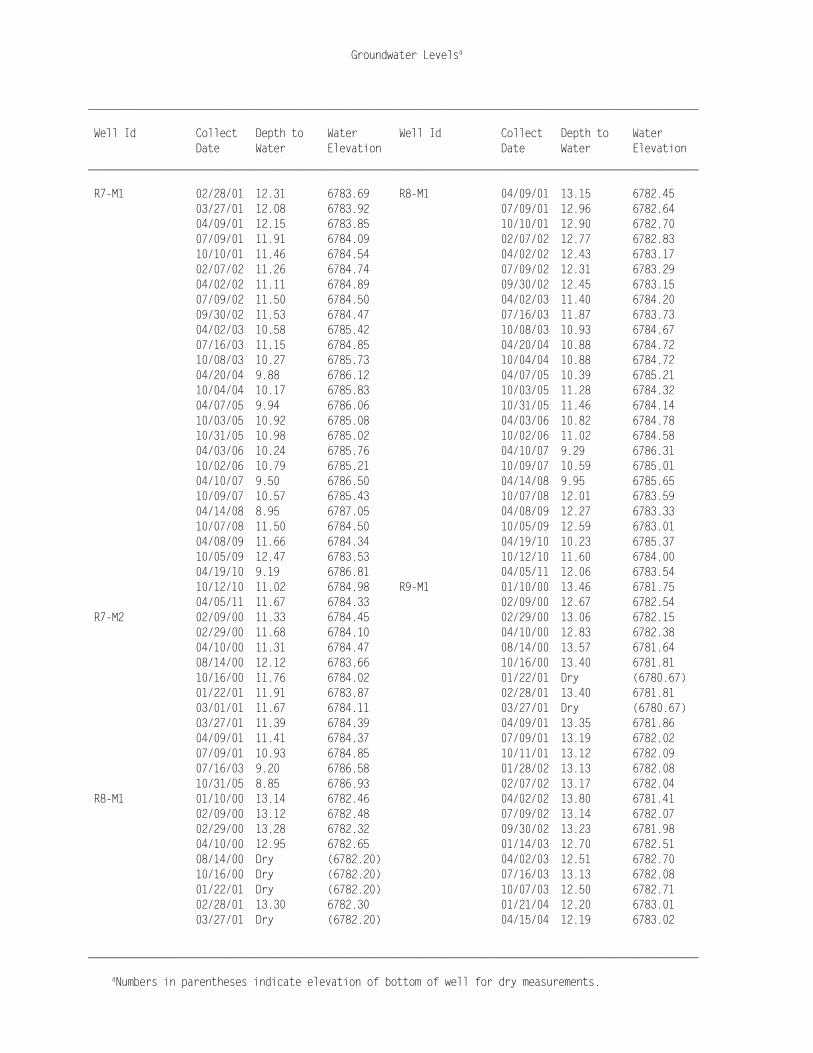
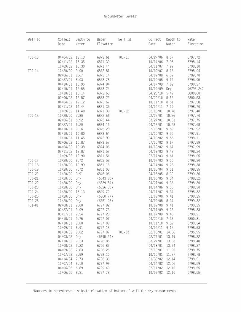
Groundwater Levelsa
______________________________________________________________________________________________________
aNumbers in parentheses indicate elevation of bottom of well for dry measurements.
______________________________________________________________________________________________________ Well Id Collect Depth to Water Well Id Collect Depth to Water Date Water Elevation Date Water Elevation ______________________________________________________________________________________________________ 0200 10/05/04 7.27 6755.42 31SW93-197-2 04/10/01 144.57 6767.47 04/07/05 5.22 6757.47 07/09/01 145.00 6767.04 10/04/05 5.26 6757.43 10/16/01 145.23 6766.81 04/05/06 6.90 6755.79 04/03/02 144.84 6767.20 10/04/06 5.88 6756.81 07/11/02 147.37 6764.67 04/12/07 6.78 6755.91 10/16/03 159.20 6752.84 10/10/07 6.44 6756.25 31SW93-197-3 04/24/00 144.60 6767.25 04/10/08 5.45 6757.24 07/26/00 144.81 6767.04 10/09/08 5.78 6756.91 04/10/01 144.57 6767.28 04/09/09 6.92 6755.77 07/09/01 144.76 6767.09 10/07/09 6.59 6756.10 10/16/01 144.86 6766.99 04/21/10 5.19 6757.50 04/03/02 144.65 6767.20 10/12/10 6.40 6756.29 07/11/02 145.65 6766.20 04/05/11 7.28 6755.41 10/16/03 157.90 6753.95 0202 10/04/04 14.71 6771.10 31SW93-197-4 04/24/00 67.46 6843.95 04/05/05 11.23 6774.58 07/27/00 67.42 6843.99 10/04/05 14.48 6771.33 04/10/01 71.09 6840.32 04/04/06 14.81 6771.00 07/09/01 71.04 6840.37 10/03/06 14.53 6771.28 10/10/01 71.05 6840.36 04/10/07 14.22 6771.59 04/03/02 70.95 6840.46 10/10/07 15.05 6770.76 07/11/02 Dry (6840.00) 04/08/08 10.25 6775.56 10/09/02 70.87 6840.54 10/08/08 14.00 6771.81 10/16/03 70.80 6840.61 04/08/09 15.61 6770.20 31SW93-197-5 04/24/00 43.16 6866.08 10/08/09 15.72 6770.09 07/26/00 43.59 6865.65 04/20/10 8.00 6777.81 04/10/01 43.39 6865.85 10/12/10 15.44 6770.37 07/09/01 43.53 6865.71 04/04/11 15.62 6770.19 10/10/01 43.82 6865.42 31NE93-205 01/13/00 177.88 6762.74 04/03/02 43.68 6865.56 04/14/00 177.10 6763.52 07/11/02 43.95 6865.29 08/02/00 77.47 6863.15 10/09/02 44.04 6865.20 04/10/01 176.88 6763.74 10/16/03 44.00 6865.24 07/09/01 177.41 6763.21 31SW93-200-1 01/13/00 116.98 6781.31 10/15/01 177.40 6763.22 04/14/00 116.42 6781.87 10/16/03 196.30 6744.32 08/02/00 116.81 6781.48 04/07/05 186.73 6753.89 04/10/01 102.20 6781.68 10/06/05 184.39 6756.23 07/10/01 102.41 6781.47 04/28/06 182.33 6758.29 10/10/01 102.52 6781.36 10/04/06 182.82 6757.80 02/06/02 102.43 6781.45 04/12/07 181.03 6759.59 04/04/02 102.38 6781.50 10/10/07 182.02 6758.60 07/11/02 106.03 6777.85 04/16/08 180.40 6760.22 10/09/02 113.25 6770.63 04/07/09 180.00 6760.62 10/15/03 119.10 6764.78 10/09/09 180.48 6760.14 31SW93-200-2 01/13/00 114.36 6783.00 04/21/10 179.20 6761.42 04/14/00 113.91 6783.45 10/12/10 179.84 6760.78 08/02/00 114.26 6783.10 04/05/11 179.00 6761.62 04/10/01 100.20 6783.18 31SW93-197-2 04/24/00 144.94 6767.10 07/10/01 100.72 6782.66 07/26/00 144.99 6767.05 10/10/01 100.73 6782.65

Groundwater Levelsa
______________________________________________________________________________________________________
aNumbers in parentheses indicate elevation of bottom of well for dry measurements.
______________________________________________________________________________________________________ Well Id Collect Depth to Water Well Id Collect Depth to Water Date Water Elevation Date Water Elevation ______________________________________________________________________________________________________ 31SW93-200-2 02/06/02 100.86 6782.52 82-08 03/27/01 13.00 6774.40 04/04/02 100.82 6782.56 04/10/01 12.99 6774.41 07/11/02 101.11 6782.27 07/19/01 13.02 6774.38 10/09/02 100.35 6783.03 10/10/01 12.99 6774.41 10/15/03 102.00 6781.38 10/17/01 13.02 6774.38 31SW93-200-3 01/13/00 20.61 6877.17 01/30/02 13.30 6774.10 04/14/00 21.74 6876.04 04/02/02 12.88 6774.52 08/02/00 20.63 6877.15 07/10/02 13.22 6774.18 04/10/01 5.17 6878.82 10/02/02 13.36 6774.04 07/10/01 5.37 6878.62 04/09/03 12.79 6774.61 10/10/01 4.88 6879.11 10/07/03 12.79 6774.61 02/06/02 6.28 6877.71 04/14/04 12.53 6774.87 04/04/02 6.71 6877.28 10/04/04 12.70 6774.70 07/11/02 6.19 6877.80 04/06/05 11.55 6775.85 10/09/02 6.24 6877.75 10/04/05 12.92 6774.48 10/15/03 6.30 6877.69 04/05/06 12.88 6774.52 31SW93-200-4 01/13/00 20.43 6877.28 10/03/06 12.93 6774.47 04/14/00 20.80 6876.91 04/10/07 12.87 6774.53 08/02/00 20.55 6877.16 10/10/07 13.00 6774.40 04/10/01 4.30 6878.89 04/08/08 10.69 6776.71 07/10/01 4.17 6879.02 10/08/08 13.01 6774.39 10/10/01 4.09 6879.10 04/08/09 13.00 6774.40 02/06/02 5.45 6877.74 10/07/09 Dry (6765.30) 04/04/02 5.87 6877.32 10/07/09 13.18 6774.22 07/11/02 5.53 6877.66 04/21/10 8.84 6778.56 10/09/02 5.46 6877.73 10/12/10 13.00 6774.40 04/01/03 6.00 6877.19 04/05/11 13.00 6774.40 10/06/03 5.42 6877.77 82-20 01/13/00 18.19 6871.51 10/16/03 70.80 6812.39 04/14/00 17.86 6871.84 04/20/04 5.72 6877.47 08/02/00 20.32 6869.38 82-07 01/12/00 Dry (6771.50) 04/10/01 15.81 6873.89 04/14/00 12.15 6773.55 07/10/01 15.91 6873.79 07/27/00 13.36 6772.34 10/11/01 16.85 6872.85 03/06/01 Dry (6771.50) 02/06/02 16.14 6873.56 03/27/01 Dry (6771.50) 04/04/02 15.61 6874.09 04/09/01 Dry (6771.50) 07/11/02 19.41 6870.29 07/18/01 Dry (6771.50) 10/09/02 20.74 6868.96 10/11/01 Dry (6771.50) 83-70 01/13/00 37.79 6763.12 01/30/02 Dry (6771.50) 04/18/00 37.36 6763.55 04/02/02 Dry (6771.50) 07/24/00 37.54 6763.37 07/10/02 Dry (6771.50) 04/09/01 37.27 6763.64 10/02/02 Dry (6771.50) 07/09/01 37.58 6763.33 04/07/03 12.44 6773.26 10/16/01 37.82 6763.09 10/06/03 13.72 6771.98 02/07/02 37.70 6763.21 04/20/04 11.28 6774.42 04/03/02 37.36 6763.55 82-08 01/12/00 13.14 6774.26 07/11/02 39.93 6760.98 04/14/00 12.37 6775.03 10/07/02 44.71 6756.20 07/28/00 12.85 6774.55 04/02/03 41.82 6759.09 03/06/01 13.00 6774.40 10/07/03 52.26 6748.65

Groundwater Levelsa
______________________________________________________________________________________________________
aNumbers in parentheses indicate elevation of bottom of well for dry measurements.
______________________________________________________________________________________________________ Well Id Collect Depth to Water Well Id Collect Depth to Water Date Water Elevation Date Water Elevation ______________________________________________________________________________________________________ 83-70 04/20/04 44.77 6756.14 88-85 04/19/10 2.63 6794.46 10/04/04 53.90 6747.01 10/12/10 3.50 6793.59 04/07/05 46.31 6754.60 04/04/11 3.81 6793.28 04/27/06 42.52 6758.39 92-01 10/15/03 19.80 6961.71 10/09/08 41.29 6759.62 92-02 10/15/03 187.50 6797.88 04/05/11 12.60 6788.31 92-03 10/15/03 10.69 6955.27 88-85 01/10/00 8.55 6789.28 92-04 10/15/03 184.40 6780.61 01/12/00 7.97 6789.86 92-05 04/14/00 16.57 6878.21 02/09/00 6.91 6790.92 07/25/00 17.56 6877.22 02/29/00 7.00 6790.83 04/11/01 14.84 6879.94 04/10/00 6.25 6791.58 07/20/01 17.45 6877.33 04/13/00 6.25 6791.58 10/10/01 17.65 6877.13 07/27/00 7.60 6790.23 10/15/03 17.85 6876.93 08/15/00 8.02 6789.81 92-06 01/13/00 109.37 6785.58 10/16/00 7.95 6789.62 04/14/00 108.75 6786.20 01/23/01 7.07 6790.02 07/25/00 109.25 6785.70 01/30/01 7.18 6789.91 04/10/01 108.62 6786.33 03/01/01 6.57 6790.52 07/09/01 109.06 6785.89 03/14/01 5.72 6791.37 10/10/01 109.20 6785.75 03/27/01 6.08 6791.01 10/15/03 125.25 6769.70 04/09/01 6.25 6790.84 92-07 04/10/00 18.71 6787.14 07/19/01 5.87 6791.22 04/18/00 18.65 6787.20 10/15/01 5.75 6791.34 07/27/00 20.00 6785.85 10/17/01 5.75 6791.34 10/16/00 18.74 6786.91 01/29/02 6.40 6790.69 01/23/01 17.40 6786.62 02/07/02 6.35 6790.74 01/30/01 17.40 6786.62 04/03/02 5.62 6791.47 03/06/01 17.23 6786.79 07/09/02 6.74 6790.35 03/27/01 17.18 6786.84 09/30/02 7.56 6789.53 04/09/01 17.18 6786.84 01/14/03 5.71 6791.38 07/19/01 16.81 6787.21 04/02/03 4.26 6792.83 10/16/01 16.82 6787.20 04/08/03 4.38 6792.71 01/29/02 16.92 6787.10 07/09/03 5.90 6791.19 04/02/02 16.79 6787.23 07/16/03 5.83 6791.26 07/09/02 16.88 6787.14 10/07/03 4.35 6792.74 09/30/02 17.05 6786.97 01/22/04 5.56 6791.53 01/14/03 16.79 6787.23 04/15/04 3.88 6793.21 04/08/03 16.49 6787.53 10/07/04 4.62 6792.47 07/09/03 16.74 6787.28 04/07/05 2.79 6794.30 10/07/03 16.52 6787.50 10/04/05 4.23 6792.86 01/22/04 16.84 6787.18 10/31/05 4.43 6792.66 04/15/04 16.35 6787.67 04/04/06 4.16 6792.93 10/04/04 16.70 6787.32 10/03/06 4.02 6793.07 04/05/05 16.43 6787.59 04/10/07 4.52 6792.57 10/04/05 16.70 6787.32 10/09/07 4.57 6792.52 04/04/06 16.61 6787.41 04/08/08 2.69 6794.40 10/03/06 16.65 6787.37 10/08/08 4.21 6792.88 04/10/07 16.79 6787.23 04/07/09 4.79 6792.30 10/09/07 16.75 6787.27 10/07/09 6.37 6790.72 04/08/08 16.52 6787.50

Groundwater Levelsa
______________________________________________________________________________________________________
aNumbers in parentheses indicate elevation of bottom of well for dry measurements.
______________________________________________________________________________________________________ Well Id Collect Depth to Water Well Id Collect Depth to Water Date Water Elevation Date Water Elevation ______________________________________________________________________________________________________ 92-07 10/08/08 16.74 6787.28 92-09 10/05/04 11.61 6721.68 04/08/09 16.85 6787.17 04/07/05 8.75 6724.54 04/08/09 16.83 6787.19 10/04/05 9.45 6723.84 10/08/09 17.03 6786.99 04/26/06 10.68 6722.61 04/20/10 16.42 6787.60 10/04/06 9.49 6723.80 10/12/10 16.70 6787.32 04/09/07 6.95 6726.34 04/04/11 16.63 6787.39 10/10/07 10.59 6722.70 92-08 01/10/00 16.12 6759.56 04/10/08 8.91 6724.38 04/13/00 10.15 6765.53 10/09/08 8.71 6724.58 07/26/00 10.47 6765.21 04/07/09 9.95 6723.34 01/29/01 15.80 6759.88 04/09/09 9.93 6723.36 04/10/01 13.51 6762.17 10/06/09 10.68 6722.61 07/19/01 12.35 6763.33 04/20/10 8.36 6724.93 10/16/01 13.55 6762.13 10/13/10 9.61 6723.68 02/06/02 13.89 6761.79 04/05/11 10.30 6722.99 04/02/02 12.50 6763.18 92-10 01/13/00 12.86 6720.94 07/11/02 13.71 6761.97 04/19/00 12.68 6721.12 10/07/02 15.64 6760.04 07/25/00 13.67 6720.13 04/09/03 10.24 6765.44 04/10/01 12.50 6721.30 10/06/03 12.10 6763.58 07/09/01 13.55 6720.25 04/14/04 9.24 6766.44 10/16/01 13.35 6720.45 10/07/04 11.35 6764.33 02/06/02 12.90 6720.90 04/06/05 8.24 6767.44 04/03/02 12.85 6720.95 10/04/05 9.95 6765.73 07/11/02 14.27 6719.53 04/04/06 11.40 6764.28 10/08/02 14.28 6719.52 10/04/06 9.90 6765.78 04/01/03 13.12 6720.68 04/10/07 10.86 6764.82 10/07/03 14.95 6718.85 10/10/07 11.31 6764.37 04/20/04 13.38 6720.42 04/08/08 8.33 6767.35 10/05/04 14.32 6719.48 10/08/08 10.06 6765.62 04/06/05 12.13 6721.67 04/08/09 12.49 6763.19 10/04/05 12.43 6721.37 10/07/09 11.83 6763.85 04/26/06 12.68 6721.12 04/20/10 7.45 6768.23 10/04/06 12.86 6720.94 10/12/10 11.25 6764.43 04/10/07 12.45 6721.35 04/04/11 12.77 6762.91 10/10/07 12.96 6720.84 92-09 01/13/00 10.48 6722.81 04/10/08 11.79 6722.01 04/12/00 10.21 6723.08 10/09/08 11.76 6722.04 07/25/00 11.84 6721.45 04/07/09 11.86 6721.94 04/10/01 10.39 6722.90 10/06/09 12.28 6721.52 07/09/01 12.11 6721.18 04/20/10 10.94 6722.86 10/16/01 11.53 6721.76 10/13/10 10.76 6723.04 02/06/02 10.86 6722.43 04/05/11 12.04 6721.76 04/03/02 10.90 6722.39 92-11 01/12/00 19.55 6794.18 04/03/02 10.81 6722.48 02/29/00 19.49 6794.24 07/11/02 12.70 6720.59 04/18/00 19.31 6794.42 10/08/02 12.41 6720.88 08/02/00 19.81 6793.92 04/07/03 10.45 6722.84 08/15/00 19.95 6793.78 10/07/03 12.41 6720.88 10/16/00 19.56 6794.17 04/16/04 9.74 6723.55 01/23/01 19.59 6794.14

Groundwater Levelsa
______________________________________________________________________________________________________
aNumbers in parentheses indicate elevation of bottom of well for dry measurements.
______________________________________________________________________________________________________ Well Id Collect Depth to Water Well Id Collect Depth to Water Date Water Elevation Date Water Elevation ______________________________________________________________________________________________________ 92-11 01/30/01 19.68 6794.05 92-12 10/10/07 55.05 6760.00 03/27/01 19.14 6794.59 04/14/08 54.00 6761.05 04/09/01 19.21 6794.52 10/07/08 54.24 6760.81 07/11/01 18.83 6794.90 04/08/09 53.33 6761.72 10/15/01 18.85 6794.88 10/08/09 53.55 6761.50 01/30/02 19.14 6794.59 04/21/10 52.71 6762.34 04/02/02 18.89 6794.84 10/12/10 52.72 6762.33 07/10/02 18.91 6794.82 04/05/11 52.28 6762.77 10/02/02 19.31 6794.42 92-13 01/13/00 106.48 6788.23 01/14/03 18.93 6794.80 04/14/00 106.35 6788.36 04/09/03 18.17 6795.56 07/25/00 106.57 6788.14 07/08/03 18.96 6794.77 04/10/01 106.10 6788.61 10/07/03 18.23 6795.50 07/09/01 106.51 6788.20 01/22/04 18.88 6794.85 10/10/01 106.46 6788.25 04/15/04 17.68 6796.05 10/15/03 107.60 6787.11 10/05/04 18.47 6795.26 93-01 01/13/00 106.92 6783.06 04/05/05 15.62 6798.11 04/14/00 106.38 6783.60 10/04/05 18.22 6795.51 08/02/00 106.80 6783.18 04/27/06 18.47 6795.26 04/10/01 106.22 6783.76 10/03/06 18.02 6795.71 07/10/01 106.70 6783.28 04/11/07 18.14 6795.59 10/09/01 106.65 6783.33 10/10/07 18.51 6795.22 02/06/02 106.80 6783.18 04/08/08 15.66 6798.07 04/04/02 106.70 6783.28 10/09/08 18.48 6795.25 07/11/02 110.51 6779.47 04/08/09 18.65 6795.08 10/09/02 117.55 6772.43 04/08/09 18.62 6795.11 04/01/03 111.85 6778.13 10/08/09 19.20 6794.53 10/06/03 122.65 6767.33 04/21/10 14.60 6799.13 10/15/03 122.90 6767.08 10/12/10 18.11 6795.62 04/20/04 114.63 6775.35 04/04/11 17.64 6796.09 10/08/04 123.76 6766.22 92-12 01/13/00 56.23 6758.82 04/07/05 122.90 6767.08 04/18/00 53.38 6761.67 10/05/05 113.70 6776.28 08/02/00 55.20 6759.85 10/02/06 111.78 6778.20 04/09/01 53.80 6761.25 04/10/07 110.74 6779.24 07/09/01 52.22 6762.83 10/09/07 112.45 6777.53 10/16/01 51.18 6763.87 04/10/08 109.99 6779.99 02/07/02 54.60 6760.45 10/08/08 110.22 6779.76 04/03/02 53.17 6761.88 04/07/09 109.63 6780.35 07/11/02 51.91 6763.14 10/07/09 109.42 6780.56 10/02/02 54.29 6760.76 04/20/10 108.98 6781.00 04/01/03 58.06 6756.99 10/13/10 109.23 6780.75 10/07/03 61.50 6753.55 04/05/11 108.62 6781.36 04/20/04 60.53 6754.52 95-01 01/13/00 5.27 6670.56 10/05/04 62.29 6752.76 04/10/00 5.17 6670.66 04/06/05 61.38 6753.67 07/25/00 5.62 6670.21 10/04/05 58.63 6756.42 04/10/01 5.00 6670.83 04/27/06 56.20 6758.85 07/09/01 5.46 6670.37 10/04/06 55.95 6759.10 10/17/01 5.47 6670.36 04/10/07 54.82 6760.23 02/06/02 5.05 6670.78

Groundwater Levelsa
______________________________________________________________________________________________________
aNumbers in parentheses indicate elevation of bottom of well for dry measurements.
______________________________________________________________________________________________________ Well Id Collect Depth to Water Well Id Collect Depth to Water Date Water Elevation Date Water Elevation ______________________________________________________________________________________________________ 95-01 04/03/02 5.09 6670.74 95-03 07/11/02 3.91 6700.87 07/11/02 5.72 6670.11 10/08/02 3.57 6701.21 10/08/02 5.51 6670.32 04/01/03 2.33 6702.45 10/05/04 5.04 6670.79 10/07/03 3.46 6701.32 04/06/05 4.05 6671.78 04/20/04 2.32 6702.46 10/04/05 4.64 6671.19 10/05/04 2.92 6701.86 04/26/06 4.42 6671.41 04/06/05 1.70 6703.08 10/04/06 4.70 6671.13 10/04/05 2.65 6702.13 04/10/07 4.55 6671.28 04/26/06 2.18 6702.60 10/10/07 5.02 6670.81 10/04/06 2.49 6702.29 04/10/08 3.87 6671.96 04/10/07 1.92 6702.86 10/09/08 5.28 6670.55 10/10/07 2.56 6702.22 04/07/09 4.65 6671.18 04/10/08 1.19 6703.59 10/06/09 5.23 6670.60 10/09/08 2.30 6702.48 10/06/09 5.17 6670.66 04/07/09 1.93 6702.85 04/20/10 4.01 6671.82 10/05/09 3.61 6701.17 10/13/10 4.95 6670.88 10/06/09 2.36 6702.42 04/05/11 4.60 6671.23 04/20/10 0.99 6703.79 95-02 01/13/00 3.59 6675.40 10/13/10 2.19 6702.59 04/12/00 3.45 6675.54 04/05/11 1.76 6703.02 07/25/00 4.14 6674.85 95-04 01/13/00 3.65 6702.59 04/10/01 3.30 6675.69 04/10/00 3.36 6702.88 07/09/01 3.97 6675.02 07/25/00 4.63 6701.61 10/17/01 3.94 6675.05 04/10/01 3.15 6703.09 02/06/02 3.40 6675.59 07/09/01 4.28 6701.96 04/03/02 3.33 6675.66 10/11/01 4.18 6702.06 07/11/02 4.15 6674.84 02/06/02 3.43 6702.81 10/08/02 4.00 6674.99 04/03/02 3.36 6702.88 10/05/04 3.62 6675.37 07/11/02 4.54 6701.70 04/06/05 2.25 6676.74 10/08/02 4.29 6701.95 10/04/05 3.27 6675.72 04/01/03 3.16 6703.08 04/26/06 2.61 6676.38 10/07/03 4.26 6701.98 10/04/06 3.00 6675.99 04/20/04 3.22 6703.02 04/10/07 2.67 6676.32 10/05/04 3.88 6702.36 10/10/07 3.25 6675.74 04/06/05 2.49 6703.75 04/10/08 2.08 6676.91 10/04/05 3.39 6702.85 10/07/08 3.41 6675.58 04/26/06 2.86 6703.38 04/07/09 2.68 6676.31 10/04/06 3.35 6702.89 10/06/09 3.35 6675.64 04/10/07 2.59 6703.65 04/21/10 1.91 6677.08 10/10/07 3.34 6702.90 10/13/10 3.12 6675.87 04/10/08 2.02 6704.22 04/05/11 2.88 6676.11 10/07/08 3.14 6703.10 95-03 01/13/00 2.71 6702.07 04/07/09 2.49 6703.75 04/10/00 2.38 6702.40 10/06/09 3.19 6703.05 07/25/00 3.94 6700.84 04/20/10 1.77 6704.47 04/10/01 2.18 6702.60 10/13/10 2.99 6703.25 07/09/01 3.57 6701.21 04/05/11 2.49 6703.75 10/11/01 3.25 6701.53 95-06 01/13/00 69.78 6755.13 04/03/02 2.59 6702.19 04/19/00 69.01 6755.90

Groundwater Levelsa
______________________________________________________________________________________________________
aNumbers in parentheses indicate elevation of bottom of well for dry measurements.
______________________________________________________________________________________________________ Well Id Collect Depth to Water Well Id Collect Depth to Water Date Water Elevation Date Water Elevation ______________________________________________________________________________________________________ 95-06 07/25/00 69.01 6755.90 95-08 10/08/02 129.31 6712.20 04/10/01 69.26 6755.65 10/15/03 130.20 6711.31 07/09/01 69.40 6755.51 10/05/04 129.98 6711.53 10/17/01 69.80 6755.11 04/07/05 128.51 6713.00 10/15/03 79.15 6745.76 10/04/05 128.44 6713.07 10/05/04 79.59 6745.32 04/26/06 128.19 6713.32 04/07/05 74.84 6750.07 10/05/06 128.60 6712.91 10/06/05 73.70 6751.21 04/11/07 128.10 6713.41 04/26/06 72.55 6752.36 10/10/07 128.63 6712.88 10/04/06 72.49 6752.42 04/09/08 127.57 6713.94 04/11/07 71.96 6752.95 10/07/08 127.97 6713.54 10/10/07 72.55 6752.36 10/06/09 127.86 6713.65 04/09/08 70.99 6753.92 04/20/10 127.05 6714.46 10/07/08 71.55 6753.36 10/13/10 127.72 6713.79 04/07/09 71.26 6753.65 04/05/11 127.54 6713.97 10/09/09 71.11 6753.80 AEC 6 07/27/00 159.68 04/21/10 69.79 6755.12 GB1126T 04/14/00 30.75 10/13/10 70.86 6754.05 08/01/00 33.40 04/05/11 70.67 6754.24 GB1227T 01/13/00 Dry 95-07 01/13/00 70.61 6812.73 04/14/00 Dry 04/14/00 70.49 6812.85 08/01/00 Dry 08/02/00 70.29 6813.05 GB1690T 01/13/00 Dry 04/10/01 70.27 6813.07 04/14/00 Dry 07/09/01 70.24 6813.10 08/01/00 Dry 10/16/01 70.32 6813.02 GB2820T 01/13/00 23.17 10/15/03 70.50 6812.84 04/14/00 24.10 10/05/04 70.61 6812.73 08/01/00 Dry 04/07/05 70.20 6813.14 GB3127T 01/13/00 Dry 10/06/05 70.39 6812.95 04/14/00 6.69 04/28/06 70.40 6812.94 08/01/00 Dry 10/04/06 69.82 6813.52 MW00-01 08/01/00 11.95 6870.82 04/11/07 70.25 6813.09 10/20/00 10.03 6872.74 10/10/07 70.45 6812.89 02/06/01 9.84 6872.93 04/09/08 69.81 6813.53 02/27/01 9.24 6873.53 10/07/08 70.50 6812.84 04/09/01 8.13 6874.64 04/07/09 70.39 6812.95 07/11/01 9.75 6873.02 10/09/09 70.20 6813.14 10/08/01 10.40 6872.37 04/19/10 70.00 6813.34 02/06/02 9.73 6873.04 10/12/10 70.40 6812.94 04/03/02 9.30 6873.47 04/05/11 70.54 6812.80 07/08/02 11.47 6871.30 95-08 01/13/00 128.17 6713.34 10/07/02 11.51 6871.26 04/12/00 128.00 6713.51 04/07/03 9.00 6873.77 08/02/00 128.50 6713.01 10/07/03 10.64 6872.13 04/10/01 127.65 6713.86 04/12/04 7.32 6875.45 07/09/01 128.30 6713.21 10/06/04 9.52 6873.25 10/16/01 128.47 6713.04 04/05/05 3.60 6879.17 02/06/02 128.11 6713.40 10/05/05 8.31 6874.46 04/03/02 128.03 6713.48 04/28/06 9.62 6873.15 07/11/02 129.27 6712.24 10/02/06 10.30 6872.47

Groundwater Levelsa
______________________________________________________________________________________________________
aNumbers in parentheses indicate elevation of bottom of well for dry measurements.
______________________________________________________________________________________________________ Well Id Collect Depth to Water Well Id Collect Depth to Water Date Water Elevation Date Water Elevation ______________________________________________________________________________________________________ MW00-01 04/11/07 9.41 6873.36 MW00-03 10/06/05 10.82 6842.33 10/08/07 10.99 6871.78 04/03/06 8.27 6844.88 04/10/08 6.29 6876.48 10/02/06 10.22 6842.93 10/08/08 11.46 6871.31 04/11/07 10.48 6842.67 04/06/09 10.30 6872.47 10/09/07 10.83 6842.32 10/06/09 12.81 6869.96 04/15/08 7.00 6846.15 04/20/10 5.56 6877.21 10/07/08 8.20 6844.95 10/11/10 11.21 6871.56 04/07/09 8.41 6844.74 04/05/11 9.50 6873.27 10/09/09 9.83 6843.32 MW00-02 08/02/00 13.15 6870.11 04/20/10 6.25 6846.90 02/06/01 9.77 6873.49 10/11/10 8.51 6844.64 02/27/01 9.43 6873.83 04/05/11 8.77 6844.38 04/09/01 8.71 6874.55 MW00-04 08/02/00 9.54 6797.61 07/12/01 9.30 6873.96 08/15/00 10.26 6796.89 10/11/01 10.11 6873.15 10/16/00 9.10 6798.05 02/06/02 9.37 6873.89 01/23/01 9.78 6797.37 04/03/02 8.80 6874.46 03/06/01 9.70 6797.45 07/09/02 12.55 6870.71 04/09/01 9.40 6797.75 10/09/02 13.92 6869.34 07/10/01 9.55 6797.60 04/07/03 8.97 6874.29 10/10/01 9.86 6797.29 10/08/03 11.31 6871.95 02/06/02 9.94 6797.21 04/20/04 7.55 6875.71 04/04/02 8.97 6798.18 10/06/04 9.82 6873.44 07/11/02 9.98 6797.17 04/07/05 3.76 6879.50 10/09/02 9.72 6797.43 10/05/05 7.53 6875.73 MW00-06 08/02/00 16.05 6777.09 04/03/06 6.00 6877.26 01/30/01 16.48 6776.66 10/02/06 7.52 6875.74 03/27/01 16.15 6776.99 04/11/07 6.38 6876.88 04/10/01 16.19 6776.95 10/08/07 8.43 6874.83 07/19/01 15.90 6777.24 04/10/08 4.19 6879.07 10/16/01 15.91 6777.23 10/07/08 8.96 6874.30 01/30/02 16.08 6777.06 04/07/09 7.41 6875.85 04/02/02 15.76 6777.38 10/09/09 11.04 6872.22 07/10/02 16.18 6776.96 10/11/10 8.52 6874.74 10/02/02 16.40 6776.74 04/05/11 6.64 6876.62 04/07/03 15.40 6777.74 MW00-03 08/02/00 10.65 6842.50 07/09/03 15.99 6777.15 10/20/00 11.02 6842.13 10/06/03 15.34 6777.80 04/09/01 10.42 6842.73 04/14/04 15.21 6777.93 07/10/01 10.45 6842.70 10/07/04 15.15 6777.99 10/15/01 11.02 6842.13 04/06/05 15.11 6778.03 02/06/02 12.27 6840.88 10/04/05 15.54 6777.60 04/03/02 12.65 6840.50 04/04/06 15.48 6777.66 07/11/02 13.32 6839.83 10/03/06 15.46 6777.68 10/09/02 13.49 6839.66 04/10/07 15.28 6777.86 04/09/03 12.16 6840.99 10/09/07 15.46 6777.68 10/08/03 13.58 6839.57 04/08/08 14.66 6778.48 04/20/04 12.37 6840.78 10/08/08 15.94 6777.20 10/07/04 13.63 6839.52 04/08/09 16.06 6777.08 04/07/05 8.41 6844.74 10/08/09 16.22 6776.92
Groundwater Levelsa
______________________________________________________________________________________________________
aNumbers in parentheses indicate elevation of bottom of well for dry measurements.
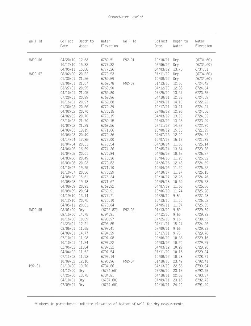
______________________________________________________________________________________________________ Well Id Collect Depth to Water Well Id Collect Depth to Water Date Water Elevation Date Water Elevation ______________________________________________________________________________________________________ MW00-06 04/20/10 12.63 6780.51 P92-01 10/10/01 Dry (6734.60) 10/12/10 15.82 6777.32 02/06/02 Dry (6734.60) 04/05/11 15.88 6777.26 04/03/02 13.75 6734.81 MW00-07 08/02/00 20.32 6770.53 07/11/02 Dry (6734.60) 01/30/01 21.26 6769.59 10/08/02 Dry (6734.60) 03/06/01 21.07 6769.78 P92-02 01/13/00 12.60 6724.42 03/27/01 20.95 6769.90 04/12/00 12.38 6724.64 04/10/01 21.05 6769.80 07/25/00 13.37 6723.65 07/20/01 20.89 6769.96 04/10/01 12.33 6724.69 10/16/01 20.97 6769.88 07/09/01 14.10 6722.92 01/30/02 20.56 6770.29 10/17/01 13.01 6724.01 04/02/02 20.70 6770.15 02/06/02 12.96 6724.06 04/02/02 20.70 6770.15 04/03/02 13.00 6724.02 07/10/02 21.70 6769.15 04/03/02 13.03 6723.99 10/02/02 21.29 6769.56 07/11/02 14.82 6722.20 04/09/03 19.19 6771.66 10/08/02 15.03 6721.99 10/06/03 20.49 6770.36 04/07/03 12.20 6724.82 04/14/04 17.85 6773.00 10/07/03 15.13 6721.89 10/04/04 20.31 6770.54 04/20/04 11.88 6725.14 04/06/05 16.59 6774.26 10/05/04 13.64 6723.38 10/04/05 20.01 6770.84 04/06/05 10.65 6726.37 04/03/06 20.49 6770.36 10/04/05 11.20 6725.82 10/03/06 20.03 6770.82 04/26/06 12.43 6724.59 04/10/07 19.75 6771.10 10/04/06 11.20 6725.82 10/10/07 20.56 6770.29 04/10/07 11.87 6725.15 04/08/08 15.61 6775.24 10/10/07 12.26 6724.76 10/08/08 19.18 6771.67 04/09/08 10.69 6726.33 04/08/09 20.93 6769.92 04/07/09 11.66 6725.36 10/08/09 20.94 6769.91 10/06/09 11.74 6725.28 04/19/10 13.14 6777.71 04/20/10 9.54 6727.48 10/12/10 20.75 6770.10 10/13/10 11.00 6726.02 04/05/11 20.81 6770.04 04/05/11 11.97 6725.05 MW00-08 08/01/00 Dry (6793.87) P92-03 01/13/00 9.89 6729.60 08/15/00 14.75 6794.31 04/12/00 9.66 6729.83 10/16/00 10.09 6798.97 07/25/00 9.16 6730.33 01/23/01 12.21 6796.85 04/11/01 15.24 6724.25 03/06/01 11.65 6797.41 07/09/01 9.56 6729.93 04/09/01 14.77 6794.29 10/17/01 9.73 6729.76 07/10/01 11.98 6797.08 02/06/02 10.33 6729.16 10/10/01 11.84 6797.22 04/03/02 10.20 6729.29 02/06/02 11.84 6797.22 04/03/02 10.29 6729.20 04/04/02 11.52 6797.54 07/11/02 10.15 6729.34 07/11/02 11.92 6797.14 10/08/02 10.78 6728.71 10/09/02 12.10 6796.96 P92-04 01/10/00 23.49 6792.41 P92-01 01/13/00 13.70 6734.86 04/13/00 22.56 6793.34 04/12/00 Dry (6734.60) 07/26/00 23.15 6792.75 07/25/00 13.75 6734.81 04/10/01 22.53 6793.37 04/10/01 Dry (6734.60) 07/09/01 23.18 6792.72 07/09/01 Dry (6734.60) 10/16/01 24.00 6791.90

Groundwater Levelsa
______________________________________________________________________________________________________
aNumbers in parentheses indicate elevation of bottom of well for dry measurements.
______________________________________________________________________________________________________ Well Id Collect Depth to Water Well Id Collect Depth to Water Date Water Elevation Date Water Elevation ______________________________________________________________________________________________________ P92-04 07/11/02 24.58 6791.32 P92-09 07/28/00 14.35 6821.86 P92-05 01/11/00 8.58 6780.80 03/05/01 13.21 6821.98 04/13/00 7.95 6781.43 03/27/01 12.98 6822.21 07/26/00 7.30 6782.08 04/10/01 13.10 6822.09 04/10/01 8.51 6780.87 07/09/01 13.73 6821.46 07/09/01 6.54 6782.84 10/17/01 15.17 6820.02 10/16/01 9.40 6779.98 04/03/02 15.98 6819.21 02/06/02 9.33 6780.05 07/11/02 Dry (6819.97) 04/03/02 9.55 6779.83 10/08/02 Dry (6819.97) 07/11/02 5.65 6783.73 PW-01 01/10/00 30.69 6784.60 10/07/02 9.47 6779.91 02/09/00 30.50 6784.79 P92-06 01/12/00 15.50 6759.23 02/29/00 30.53 6784.76 04/13/00 9.80 6764.93 04/10/00 30.47 6784.82 07/26/00 10.05 6764.68 08/15/00 28.51 6784.74 04/10/01 12.77 6761.96 10/16/00 28.36 6784.89 07/19/01 11.98 6762.75 01/22/01 28.55 6784.70 10/16/01 12.91 6761.82 03/06/01 28.37 6784.88 02/06/02 13.35 6761.38 03/27/01 20.34 6792.91 04/02/02 11.90 6762.83 04/09/01 28.37 6784.88 07/11/02 13.35 6761.38 PW-02 01/10/00 21.96 6786.12 10/07/02 15.03 6759.70 02/09/00 21.61 6786.47 04/09/03 9.94 6764.79 02/29/00 21.68 6786.40 07/09/03 12.30 6762.43 04/10/00 21.53 6786.55 10/06/03 11.67 6763.06 08/15/00 20.12 6786.33 04/14/04 9.01 6765.72 10/16/00 20.08 6786.37 10/04/04 11.16 6763.57 01/22/01 20.14 6786.31 04/06/05 8.01 6766.72 03/06/01 19.93 6786.52 10/04/05 9.55 6765.18 03/27/01 16.86 6789.59 04/04/06 10.90 6763.83 04/09/01 19.96 6786.49 10/03/06 9.76 6764.97 PW-03 01/10/00 15.71 6787.18 04/10/07 10.55 6764.18 02/09/00 15.49 6787.40 10/10/07 10.85 6763.88 02/29/00 15.45 6787.44 04/08/08 8.22 6766.51 04/10/00 15.30 6787.59 10/08/08 9.61 6765.12 08/15/00 14.22 6787.38 04/08/09 11.92 6762.81 10/16/00 14.07 6787.53 10/07/09 11.36 6763.37 01/22/01 14.16 6787.44 04/20/10 7.70 6767.03 03/06/01 14.00 6787.60 10/12/10 10.75 6763.98 03/27/01 13.86 6787.74 04/04/11 12.33 6762.40 04/09/01 13.95 6787.65 P92-07 01/12/00 12.21 6805.70 PW-04 01/10/00 34.53 6783.21 04/14/00 10.28 6807.63 02/09/00 34.45 6783.29 08/02/00 11.54 6806.37 02/29/00 34.46 6783.28 03/05/01 9.75 6807.33 04/10/00 34.38 6783.36 03/27/01 8.75 6808.33 08/15/00 32.02 6783.35 04/10/01 8.65 6808.43 10/16/00 Dry (6782.90) 07/09/01 9.61 6807.47 01/22/01 32.06 6783.31 10/16/01 12.50 6804.58 03/06/01 31.98 6783.39 P92-09 01/11/00 14.88 6821.33 03/27/01 31.94 6783.43 04/13/00 14.60 6821.61 04/09/01 31.95 6783.42

Groundwater Levelsa
______________________________________________________________________________________________________
aNumbers in parentheses indicate elevation of bottom of well for dry measurements.
______________________________________________________________________________________________________ Well Id Collect Depth to Water Well Id Collect Depth to Water Date Water Elevation Date Water Elevation ______________________________________________________________________________________________________ PW-05 01/10/00 29.90 6782.60 PW-09 04/09/01 16.81 6782.74 02/09/00 29.83 6782.67 PW-10 02/09/00 34.00 6782.03 02/29/00 29.86 6782.64 02/29/00 34.07 6781.96 04/10/00 29.91 6782.59 04/10/00 33.98 6782.05 08/15/00 28.77 6782.53 08/15/00 32.00 6782.04 10/16/00 28.85 6782.45 10/16/00 31.90 6782.14 01/22/01 Dry (6782.16) 01/22/01 32.05 6781.99 03/06/01 28.82 6782.48 01/29/01 32.02 6782.02 03/27/01 26.82 6784.48 03/06/01 31.90 6782.14 04/09/01 28.80 6782.50 03/27/01 31.87 6782.17 PW-06 01/10/00 26.72 6782.44 04/09/01 31.80 6782.14 02/09/00 26.71 6782.45 07/19/01 31.67 6782.27 02/29/00 26.66 6782.50 10/16/01 31.70 6782.24 04/10/00 26.77 6782.39 01/29/02 31.61 6782.33 08/15/00 24.77 6782.33 04/02/02 31.67 6782.27 10/16/00 24.68 6782.42 07/10/02 31.74 6782.20 01/22/01 Dry (6781.72) 09/30/02 31.77 6782.17 03/06/01 24.66 6782.44 10/06/03 31.38 6782.56 03/27/01 24.62 6782.48 04/14/04 31.41 6782.53 04/09/01 24.75 6782.35 10/04/04 31.50 6782.44 PW-07 01/10/00 Dry (6783.84) 04/07/05 31.28 6782.66 02/09/00 Dry (6783.84) 10/04/05 31.55 6782.39 02/29/00 Dry (6783.84) 04/03/06 31.40 6782.54 04/10/00 Dry (6783.84) 10/03/06 31.47 6782.47 08/15/00 Dry (6783.84) 04/11/07 31.55 6782.39 10/17/00 Dry (6783.84) 10/09/07 31.50 6782.44 01/22/01 Dry (6783.84) 10/07/08 31.44 6782.50 03/06/01 Dry (6783.84) 10/08/08 31.51 6782.43 03/27/01 Dry (6783.84) 04/08/09 31.63 6782.31 04/09/01 Dry (6783.84) 04/08/09 31.72 6782.22 PW-08 01/10/00 Dry (6783.29) 10/08/09 31.75 6782.19 02/09/00 Dry (6783.29) 04/19/10 30.81 6783.13 02/29/00 Dry (6783.29) 04/20/10 30.82 6783.12 04/10/00 Dry (6783.29) 10/12/10 31.51 6782.43 08/15/00 Dry (6783.29) 04/04/11 31.60 6782.34 10/16/00 Dry (6783.29) PW-11 02/09/00 29.40 6781.85 01/22/01 Dry (6783.29) 02/29/00 29.36 6781.89 03/06/01 Dry (6783.29) 04/10/00 29.39 6781.86 03/27/01 Dry (6783.29) 08/15/00 26.45 6781.90 04/09/01 Dry (6783.29) 10/16/00 26.43 6781.92 PW-09 01/10/00 19.47 6782.37 01/22/01 26.48 6781.87 02/09/00 19.12 6782.72 03/06/01 26.40 6781.95 02/29/00 19.35 6782.49 03/27/01 26.39 6781.96 04/10/00 19.16 6782.68 04/09/01 26.40 6781.95 08/15/00 17.15 6782.40 PW-12 01/10/00 Dry (6782.98) 10/16/00 17.25 6782.30 02/09/00 Dry (6782.98) 01/22/01 17.23 6782.32 02/29/00 Dry (6782.98) 03/06/01 16.76 6782.79 04/10/00 Dry (6782.98) 03/27/01 16.72 6782.83 08/15/00 Dry (6782.98)

Groundwater Levelsa
______________________________________________________________________________________________________
aNumbers in parentheses indicate elevation of bottom of well for dry measurements.
______________________________________________________________________________________________________ Well Id Collect Depth to Water Well Id Collect Depth to Water Date Water Elevation Date Water Elevation ______________________________________________________________________________________________________ PW-12 10/16/00 Dry (6782.98) PW-14A 08/15/00 17.36 6781.96 01/22/01 21.75 6783.01 10/16/00 17.40 6781.92 03/14/01 21.47 6783.29 01/22/01 17.47 6781.85 03/27/01 21.49 6783.27 03/06/01 17.38 6781.94 04/09/01 21.50 6783.26 03/27/01 17.03 6782.29 PW-13 01/10/00 Dry (6781.91) 04/09/01 17.19 6782.13 02/09/00 Dry (6781.91) PW-15 01/10/00 Dry (6783.03) 02/29/00 Dry (6781.91) 02/09/00 Dry (6783.03) 04/10/00 Dry (6781.91) 02/29/00 Dry (6783.03) 08/15/00 Dry (6781.91) 04/10/00 Dry (6783.03) 10/16/00 Dry (6781.91) 08/15/00 Dry (6783.03) 01/22/01 19.88 6782.85 10/16/00 Dry (6783.03) 03/06/01 Dry (6781.91) 01/22/01 Dry (6783.03) 03/27/01 Dry (6781.91) 03/06/01 Dry (6783.03) 04/09/01 Dry (6781.91) 03/27/01 Dry (6783.03) PW-14 01/10/00 19.70 6781.88 04/09/01 Dry (6783.03) 02/09/00 19.20 6782.38 PW-15A 04/10/00 15.95 6783.34 02/29/00 19.49 6782.09 08/15/00 14.90 6782.50 04/10/00 19.35 6782.23 10/16/00 14.40 6783.00 08/15/00 18.75 6781.90 01/22/01 14.45 6782.95 10/16/00 18.83 6781.82 03/06/01 14.14 6783.26 01/22/01 18.82 6781.83 03/27/01 13.98 6783.42 03/06/01 18.46 6782.19 04/09/01 14.10 6783.30 03/27/01 18.36 6782.29 PW-16 01/10/00 15.97 6782.93 04/09/01 18.30 6782.14 02/09/00 15.26 6783.64 07/19/01 18.37 6782.07 02/29/00 15.54 6783.36 10/16/01 18.21 6782.23 04/10/00 15.25 6783.65 01/29/02 18.27 6782.17 08/15/00 14.17 6782.73 04/02/02 18.25 6782.19 10/16/00 13.71 6783.19 04/02/02 18.25 6782.19 01/22/01 13.69 6783.21 07/10/02 18.25 6782.19 03/06/01 13.45 6783.45 09/30/02 18.27 6782.17 03/27/01 13.31 6783.59 10/08/03 17.88 6782.56 04/09/01 13.21 6783.51 04/20/04 17.65 6782.79 07/19/01 13.12 6783.60 10/04/04 17.75 6782.69 10/16/01 13.00 6783.72 04/07/05 17.69 6782.75 01/29/02 12.97 6783.75 10/04/05 17.93 6782.51 04/03/02 12.83 6783.89 04/03/06 17.53 6782.91 07/11/02 13.00 6783.72 10/03/06 17.80 6782.64 09/30/02 13.07 6783.65 04/10/07 17.31 6783.13 04/09/03 12.06 6784.66 10/09/07 17.71 6782.73 10/07/03 11.64 6785.08 04/08/08 17.34 6783.10 04/15/04 11.00 6785.72 10/07/08 18.00 6782.44 10/04/04 11.46 6785.26 04/08/09 18.09 6782.35 04/07/05 11.10 6785.62 10/05/09 18.55 6781.89 10/03/05 12.02 6784.70 04/19/10 16.96 6783.48 10/31/05 12.18 6784.54 10/12/10 17.84 6782.60 04/03/06 11.20 6785.52 04/05/11 18.06 6782.38 10/02/06 11.86 6784.86 PW-14A 04/10/00 18.86 6782.18 04/10/07 11.13 6785.59
Groundwater Levelsa
______________________________________________________________________________________________________
aNumbers in parentheses indicate elevation of bottom of well for dry measurements.
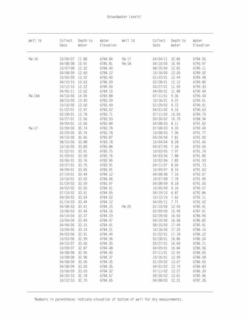
______________________________________________________________________________________________________ Well Id Collect Depth to Water Well Id Collect Depth to Water Date Water Elevation Date Water Elevation ______________________________________________________________________________________________________ PW-16 10/09/07 11.88 6784.84 PW-17 04/04/11 32.80 6784.55 04/08/08 10.91 6785.81 PW-18 04/10/00 10.95 6790.97 10/07/08 12.32 6784.40 08/15/00 12.81 6789.11 04/08/09 12.60 6784.12 10/16/00 12.00 6789.92 10/05/09 13.32 6783.40 01/22/01 12.44 6789.48 04/19/10 10.63 6786.09 02/28/01 12.12 6789.80 10/12/10 12.22 6784.50 03/27/01 11.59 6790.33 04/05/11 12.62 6784.10 04/09/01 11.88 6790.04 PW-16A 04/10/00 14.05 6783.88 07/11/01 9.30 6790.43 08/15/00 13.40 6783.09 10/16/01 9.22 6790.51 10/16/00 13.00 6783.49 01/29/02 9.72 6790.01 01/22/01 12.97 6783.52 04/01/02 9.10 6790.63 02/28/01 12.78 6783.71 07/11/02 10.03 6789.70 03/27/01 12.56 6783.93 09/30/02 10.79 6788.94 04/09/01 12.65 6783.84 04/08/03 8.11 6791.62 PW-17 02/09/00 35.74 6783.78 07/08/03 9.33 6790.40 02/29/00 35.74 6783.78 10/08/03 7.96 6791.77 04/10/00 35.65 6783.87 04/20/04 7.81 6791.92 08/15/00 33.88 6783.78 10/04/04 8.28 6791.45 10/16/00 33.80 6783.86 04/07/05 7.18 6792.55 01/22/01 33.91 6783.75 10/03/05 7.97 6791.76 01/29/01 33.90 6783.76 04/03/06 7.88 6791.85 03/06/01 33.76 6783.90 10/02/06 7.80 6791.93 03/27/01 33.75 6783.91 04/11/07 8.00 6791.73 04/09/01 33.65 6783.91 10/09/07 8.10 6791.63 07/19/01 33.44 6784.12 04/08/08 7.16 6792.57 10/16/01 33.50 6784.06 10/07/08 7.78 6791.95 01/29/02 33.59 6783.97 04/08/09 8.18 6791.55 04/02/02 33.55 6784.01 10/05/09 9.16 6790.57 07/10/02 33.51 6784.05 04/19/10 6.87 6792.86 09/30/02 33.54 6784.02 10/12/10 7.62 6792.11 01/14/03 33.44 6784.12 04/05/11 7.71 6792.02 04/08/03 33.41 6784.15 PW-20 01/10/00 12.50 6785.91 10/06/03 33.40 6784.16 02/09/00 15.99 6787.41 04/14/04 33.37 6784.19 02/29/00 16.50 6786.90 10/04/04 33.49 6784.07 04/10/00 16.58 6786.82 04/06/05 33.15 6784.41 08/15/00 17.49 6785.91 10/04/05 33.14 6784.21 10/16/00 17.25 6786.15 04/03/06 32.91 6784.44 01/22/01 17.18 6786.22 10/03/06 32.99 6784.36 02/28/01 16.86 6786.54 04/10/07 33.00 6784.35 03/27/01 16.69 6786.71 10/09/07 32.87 6784.48 04/09/01 16.84 6786.56 04/08/08 32.95 6784.40 07/11/01 12.92 6786.65 10/08/08 32.98 6784.37 10/16/01 12.99 6786.58 04/08/09 33.00 6784.35 01/29/02 13.07 6786.50 04/08/09 33.00 6784.35 04/01/02 12.74 6786.83 10/06/09 33.03 6784.32 07/11/02 13.27 6786.30 04/20/10 32.78 6784.57 09/30/02 13.61 6785.96 10/12/10 32.70 6784.65 04/08/03 12.31 6787.26

Groundwater Levelsa
______________________________________________________________________________________________________
aNumbers in parentheses indicate elevation of bottom of well for dry measurements.
______________________________________________________________________________________________________ Well Id Collect Depth to Water Well Id Collect Depth to Water Date Water Elevation Date Water Elevation ______________________________________________________________________________________________________ PW-20 10/08/03 12.17 6787.40 PW-23 04/10/00 24.26 6785.74 04/20/04 12.11 6787.46 08/15/00 23.55 6785.60 10/04/04 12.51 6787.06 10/16/00 23.53 6785.62 04/07/05 11.31 6788.26 03/14/01 23.39 6785.76 10/03/05 12.29 6787.28 03/27/01 23.41 6785.74 04/03/06 12.15 6787.42 04/09/01 23.46 6785.69 10/02/06 12.24 6787.33 07/19/01 23.23 6785.92 04/11/07 12.26 6787.31 10/16/01 23.46 6785.69 10/09/07 12.44 6787.13 01/29/02 23.60 6785.55 04/08/08 11.00 6788.57 04/02/02 23.47 6785.68 10/07/08 12.35 6787.22 07/10/02 23.50 6785.65 04/08/09 12.61 6786.96 09/30/02 23.60 6785.55 10/05/09 13.02 6786.55 04/08/03 23.24 6785.91 04/19/10 10.12 6789.45 10/06/03 23.38 6785.77 10/12/10 12.02 6787.55 04/14/04 23.21 6785.94 04/05/11 11.94 6787.63 10/04/04 23.58 6785.57 PW-22 01/10/00 12.75 6785.31 04/07/05 23.27 6785.88 02/09/00 13.33 6787.20 10/04/05 23.53 6785.62 02/29/00 13.96 6786.57 04/03/06 23.43 6785.72 04/10/00 14.27 6786.26 10/03/06 23.55 6785.60 08/15/00 15.15 6785.38 04/11/07 23.60 6785.55 10/16/00 14.07 6785.51 04/08/08 23.41 6785.74 01/22/01 14.08 6785.50 10/07/08 23.53 6785.62 02/28/01 13.84 6785.74 04/08/09 Dry (6784.71) 03/27/01 13.69 6785.89 10/05/09 23.78 6785.37 04/09/01 12.03 6785.75 04/19/10 23.26 6785.89 07/11/01 11.65 6785.80 10/12/10 23.59 6785.56 10/16/01 11.69 6785.76 04/05/11 23.59 6785.56 01/29/02 11.73 6785.72 PW-24 02/09/00 18.70 6786.24 04/03/02 11.26 6786.19 02/29/00 18.66 6786.28 07/11/02 11.90 6785.55 04/10/00 18.54 6786.40 09/30/02 12.19 6785.26 08/15/00 16.85 6786.10 04/08/03 11.02 6786.43 10/16/00 16.73 6786.22 10/07/03 10.97 6786.48 01/23/01 16.90 6786.05 04/15/04 10.80 6786.65 03/06/01 16.70 6786.25 10/04/04 11.21 6786.24 03/27/01 16.63 6786.32 04/07/05 10.03 6787.42 04/09/01 16.70 6786.25 10/03/05 10.90 6786.55 PW-25 02/09/00 11.55 6790.98 04/03/06 10.85 6786.60 02/29/00 11.71 6790.82 10/02/06 10.94 6786.51 04/10/00 10.86 6791.67 04/11/07 10.90 6786.55 08/15/00 10.62 6789.63 10/09/07 11.27 6786.18 10/16/00 9.67 6790.58 10/07/08 11.16 6786.29 01/23/01 10.12 6790.13 10/05/09 11.79 6785.66 03/06/01 9.45 6790.80 04/19/10 9.00 6788.45 03/27/01 9.03 6791.22 10/12/10 10.84 6786.61 04/09/01 9.31 6790.94 04/05/11 10.75 6786.70 PW-26 02/09/00 10.00 6791.18 PW-23 02/09/00 24.42 6785.58 02/29/00 10.18 6791.00 02/29/00 24.35 6785.65 04/10/00 9.29 6791.89

Groundwater Levelsa
______________________________________________________________________________________________________
aNumbers in parentheses indicate elevation of bottom of well for dry measurements.
______________________________________________________________________________________________________ Well Id Collect Depth to Water Well Id Collect Depth to Water Date Water Elevation Date Water Elevation ______________________________________________________________________________________________________ PW-26 08/15/00 9.44 6789.72 PW-28 10/13/10 8.54 6791.39 10/16/00 8.43 6790.73 04/05/11 8.00 6791.93 01/23/01 8.89 6790.27 PW-29 02/09/00 10.79 6792.18 03/06/01 8.19 6790.97 02/29/00 10.88 6792.09 03/27/01 7.79 6791.37 04/10/00 9.63 6793.34 04/09/01 8.04 6791.12 08/15/00 9.77 6791.17 PW-27 02/09/00 8.04 6791.25 10/16/00 8.59 6792.35 02/29/00 8.23 6791.06 01/23/01 9.34 6791.60 04/10/00 5.97 6791.99 03/06/01 8.64 6792.30 08/15/00 7.90 6789.76 03/27/01 8.18 6792.76 10/16/00 6.87 6790.79 04/09/01 8.37 6792.57 01/23/01 7.32 6790.34 PW-30 02/29/00 8.38 6793.98 03/06/01 6.57 6791.09 04/10/00 7.09 6795.27 03/27/01 6.14 6791.52 08/15/00 6.92 6793.59 04/09/01 6.42 6791.24 10/18/00 5.56 6794.89 PW-28 01/10/00 11.30 6789.32 01/23/01 6.40 6794.05 02/09/00 12.73 6790.17 03/06/01 6.01 6794.44 02/29/00 12.96 6789.94 03/27/01 5.73 6794.72 04/10/00 12.25 6790.65 04/09/01 5.65 6794.80 08/15/00 14.11 6788.79 PW99-16 01/10/00 17.29 6785.88 10/16/00 12.65 6789.57 02/09/00 15.91 6787.26 01/23/01 13.07 6789.15 02/29/00 16.52 6786.65 01/30/01 13.22 6789.00 04/10/00 16.54 6786.63 02/28/01 12.72 6789.50 08/15/00 17.38 6785.83 03/27/01 12.32 6789.90 10/16/00 17.14 6786.07 04/09/01 12.57 6789.65 01/22/01 17.06 6786.15 07/11/01 9.74 6790.19 01/31/01 17.06 6786.15 10/16/01 9.69 6790.24 02/28/01 16.75 6786.46 01/29/02 10.26 6789.67 03/27/01 16.59 6786.62 04/01/02 9.65 6790.28 04/09/01 16.73 6786.48 07/11/02 10.48 6789.45 07/11/01 13.27 6786.49 09/30/02 11.14 6788.79 10/16/01 13.27 6786.49 04/08/03 8.61 6791.32 01/29/02 13.45 6786.31 10/07/03 8.47 6791.46 04/01/02 13.10 6786.66 04/15/04 8.27 6791.66 07/11/02 13.60 6786.16 10/04/04 8.78 6791.15 09/30/02 13.86 6785.90 04/05/05 7.34 6792.59 01/14/03 12.91 6786.85 10/04/05 8.49 6791.44 04/08/03 12.60 6787.16 04/27/06 8.64 6791.29 10/07/03 12.55 6787.21 10/03/06 8.30 6791.63 01/22/04 13.19 6786.57 04/11/07 8.44 6791.49 04/15/04 12.43 6787.33 10/10/07 8.51 6791.42 10/04/04 12.70 6787.06 04/08/08 7.25 6792.68 04/07/05 11.87 6787.89 04/14/08 7.25 6792.68 10/03/05 12.68 6787.08 10/08/08 8.37 6791.56 04/03/06 12.71 6787.05 04/08/09 8.70 6791.23 10/02/06 12.64 6787.12 04/08/09 8.67 6791.26 04/11/07 12.67 6787.09 10/07/09 9.82 6790.11 10/09/07 12.83 6786.93 04/20/10 6.63 6793.30 04/08/08 11.49 6788.27
Groundwater Levelsa
______________________________________________________________________________________________________
aNumbers in parentheses indicate elevation of bottom of well for dry measurements.
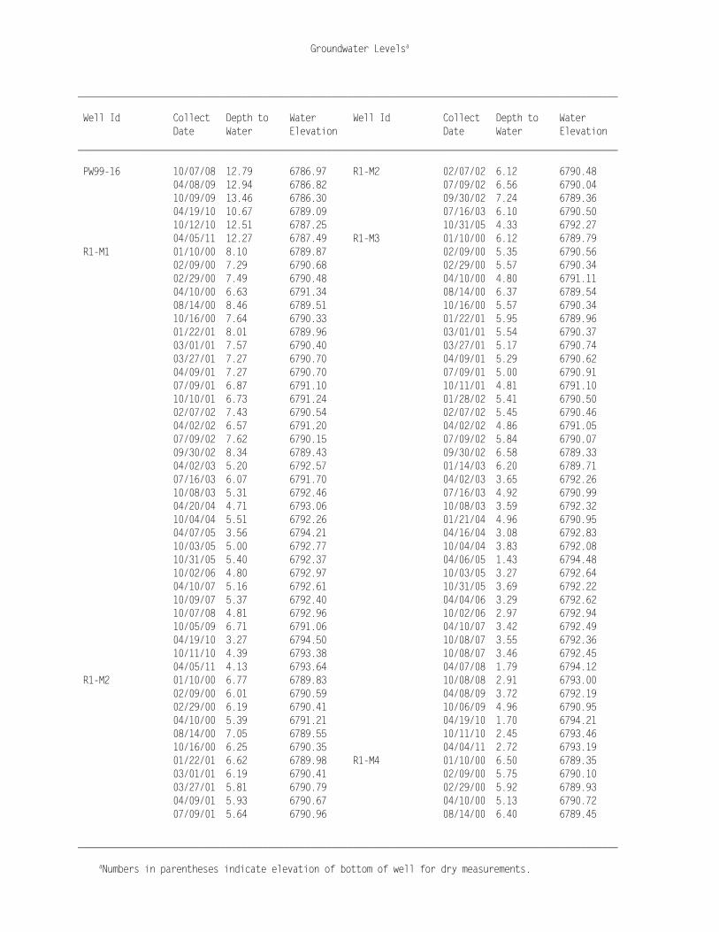
______________________________________________________________________________________________________ Well Id Collect Depth to Water Well Id Collect Depth to Water Date Water Elevation Date Water Elevation ______________________________________________________________________________________________________ PW99-16 10/07/08 12.79 6786.97 R1-M2 02/07/02 6.12 6790.48 04/08/09 12.94 6786.82 07/09/02 6.56 6790.04 10/09/09 13.46 6786.30 09/30/02 7.24 6789.36 04/19/10 10.67 6789.09 07/16/03 6.10 6790.50 10/12/10 12.51 6787.25 10/31/05 4.33 6792.27 04/05/11 12.27 6787.49 R1-M3 01/10/00 6.12 6789.79 R1-M1 01/10/00 8.10 6789.87 02/09/00 5.35 6790.56 02/09/00 7.29 6790.68 02/29/00 5.57 6790.34 02/29/00 7.49 6790.48 04/10/00 4.80 6791.11 04/10/00 6.63 6791.34 08/14/00 6.37 6789.54 08/14/00 8.46 6789.51 10/16/00 5.57 6790.34 10/16/00 7.64 6790.33 01/22/01 5.95 6789.96 01/22/01 8.01 6789.96 03/01/01 5.54 6790.37 03/01/01 7.57 6790.40 03/27/01 5.17 6790.74 03/27/01 7.27 6790.70 04/09/01 5.29 6790.62 04/09/01 7.27 6790.70 07/09/01 5.00 6790.91 07/09/01 6.87 6791.10 10/11/01 4.81 6791.10 10/10/01 6.73 6791.24 01/28/02 5.41 6790.50 02/07/02 7.43 6790.54 02/07/02 5.45 6790.46 04/02/02 6.57 6791.20 04/02/02 4.86 6791.05 07/09/02 7.62 6790.15 07/09/02 5.84 6790.07 09/30/02 8.34 6789.43 09/30/02 6.58 6789.33 04/02/03 5.20 6792.57 01/14/03 6.20 6789.71 07/16/03 6.07 6791.70 04/02/03 3.65 6792.26 10/08/03 5.31 6792.46 07/16/03 4.92 6790.99 04/20/04 4.71 6793.06 10/08/03 3.59 6792.32 10/04/04 5.51 6792.26 01/21/04 4.96 6790.95 04/07/05 3.56 6794.21 04/16/04 3.08 6792.83 10/03/05 5.00 6792.77 10/04/04 3.83 6792.08 10/31/05 5.40 6792.37 04/06/05 1.43 6794.48 10/02/06 4.80 6792.97 10/03/05 3.27 6792.64 04/10/07 5.16 6792.61 10/31/05 3.69 6792.22 10/09/07 5.37 6792.40 04/04/06 3.29 6792.62 10/07/08 4.81 6792.96 10/02/06 2.97 6792.94 10/05/09 6.71 6791.06 04/10/07 3.42 6792.49 04/19/10 3.27 6794.50 10/08/07 3.55 6792.36 10/11/10 4.39 6793.38 10/08/07 3.46 6792.45 04/05/11 4.13 6793.64 04/07/08 1.79 6794.12 R1-M2 01/10/00 6.77 6789.83 10/08/08 2.91 6793.00 02/09/00 6.01 6790.59 04/08/09 3.72 6792.19 02/29/00 6.19 6790.41 10/06/09 4.96 6790.95 04/10/00 5.39 6791.21 04/19/10 1.70 6794.21 08/14/00 7.05 6789.55 10/11/10 2.45 6793.46 10/16/00 6.25 6790.35 04/04/11 2.72 6793.19 01/22/01 6.62 6789.98 R1-M4 01/10/00 6.50 6789.35 03/01/01 6.19 6790.41 02/09/00 5.75 6790.10 03/27/01 5.81 6790.79 02/29/00 5.92 6789.93 04/09/01 5.93 6790.67 04/10/00 5.13 6790.72 07/09/01 5.64 6790.96 08/14/00 6.40 6789.45

Groundwater Levelsa
______________________________________________________________________________________________________
aNumbers in parentheses indicate elevation of bottom of well for dry measurements.
______________________________________________________________________________________________________ Well Id Collect Depth to Water Well Id Collect Depth to Water Date Water Elevation Date Water Elevation ______________________________________________________________________________________________________ R1-M4 10/16/00 5.71 6790.14 R1-M5 10/31/05 3.60 6792.01 01/22/01 6.03 6789.82 R1-M6 08/15/00 10.58 6789.42 02/28/01 5.68 6790.17 10/16/00 9.92 6790.08 03/27/01 5.33 6790.52 01/22/01 8.32 6789.84 04/09/01 5.43 6790.42 02/28/01 7.93 6790.23 07/09/01 5.18 6790.67 03/27/01 7.55 6790.61 10/11/01 4.96 6790.89 04/09/01 7.72 6790.44 01/28/02 5.53 6790.32 07/09/01 7.36 6790.80 02/07/02 5.57 6790.28 10/10/01 7.13 6791.03 04/02/02 4.97 6790.88 02/07/02 7.76 6790.40 07/09/02 5.95 6789.90 04/02/02 7.12 6791.04 09/30/02 6.69 6789.16 07/09/02 8.14 6790.02 01/14/03 5.14 6790.71 09/30/02 8.92 6789.24 04/02/03 3.87 6791.98 04/02/03 6.10 6792.06 07/16/03 5.02 6790.83 07/16/03 7.26 6790.90 10/08/03 3.78 6792.07 10/08/03 6.01 6792.15 01/21/04 5.11 6790.74 04/20/04 6.55 6791.61 04/16/04 3.34 6792.51 10/04/04 6.30 6791.86 10/04/04 4.11 6791.74 04/07/05 4.73 6793.43 04/06/05 2.26 6793.59 10/03/05 5.83 6792.33 10/03/05 3.53 6792.32 10/31/05 6.04 6792.12 10/31/05 3.76 6792.09 10/02/06 5.61 6792.55 04/04/06 3.57 6792.28 04/10/07 5.99 6792.17 10/02/06 3.18 6792.67 10/09/07 6.03 6792.13 04/10/07 3.66 6792.19 04/08/08 4.54 6793.62 10/08/07 3.66 6792.19 04/14/08 4.55 6793.61 04/07/08 1.99 6793.86 10/07/08 5.42 6792.74 10/07/08 3.08 6792.77 04/08/09 6.21 6791.95 10/07/08 3.02 6792.83 10/05/09 7.33 6790.83 04/07/09 3.88 6791.97 04/19/10 4.52 6793.64 10/05/09 5.10 6790.75 10/12/10 5.11 6793.05 04/19/10 2.08 6793.77 04/05/11 5.40 6792.76 10/11/10 2.58 6793.27 R10-M1 01/10/00 13.60 6781.51 04/04/11 3.06 6792.79 02/09/00 12.68 6782.43 R1-M5 01/10/00 6.14 6789.47 02/29/00 13.05 6782.06 02/09/00 5.40 6790.21 04/10/00 12.85 6782.26 02/29/00 5.61 6790.00 08/14/00 13.75 6781.36 04/10/00 4.80 6790.81 10/16/00 13.67 6781.44 08/14/00 6.21 6789.40 01/22/01 13.72 6781.39 10/16/00 5.52 6790.09 02/28/01 13.59 6781.52 01/22/01 5.84 6789.77 03/27/01 13.34 6781.77 02/28/01 5.51 6790.10 04/09/01 13.47 6781.64 03/27/01 5.09 6790.52 07/09/01 13.27 6781.84 04/09/01 5.24 6790.37 10/11/01 13.25 6781.86 07/09/01 4.92 6790.69 01/28/02 13.32 6781.79 02/07/02 5.32 6790.29 02/07/02 13.33 6781.78 07/09/02 5.71 6789.90 04/02/02 12.93 6782.18 09/30/02 6.45 6789.16 07/09/02 13.30 6781.81 07/16/03 4.82 6790.79 09/30/02 13.35 6781.76

Groundwater Levelsa
______________________________________________________________________________________________________
aNumbers in parentheses indicate elevation of bottom of well for dry measurements.
______________________________________________________________________________________________________ Well Id Collect Depth to Water Well Id Collect Depth to Water Date Water Elevation Date Water Elevation ______________________________________________________________________________________________________ R10-M1 01/14/03 12.82 6782.29 R11-M1 04/10/07 11.91 6782.88 04/02/03 12.70 6782.41 10/09/07 12.23 6782.56 07/16/03 13.33 6781.78 10/07/08 13.13 6781.66 10/07/03 12.79 6782.32 10/05/09 13.26 6781.53 01/21/04 12.83 6782.28 04/19/10 11.18 6783.61 04/15/04 12.84 6782.27 10/12/10 13.00 6781.79 10/04/04 12.72 6782.39 04/05/11 13.00 6781.79 04/06/05 12.60 6782.51 R2-M1 01/10/00 9.76 6787.18 10/03/05 12.79 6782.32 02/09/00 9.04 6787.90 10/31/05 12.86 6782.25 03/01/00 9.20 6787.74 04/04/06 12.48 6782.63 08/14/00 9.50 6787.44 10/02/06 12.23 6782.88 10/16/00 9.23 6787.71 04/10/07 11.76 6783.35 01/22/01 9.79 6787.15 10/08/07 12.12 6782.99 04/09/01 8.68 6788.26 04/08/08 12.11 6783.00 07/09/01 7.72 6789.22 10/07/08 13.20 6781.91 07/16/03 6.32 6790.62 10/08/08 13.24 6781.87 10/31/05 5.28 6791.66 04/08/09 13.31 6781.80 R2-M10 01/10/00 8.54 6787.17 10/06/09 13.45 6781.66 02/09/00 7.83 6787.88 04/19/10 11.51 6783.60 03/01/00 7.92 6787.79 10/11/10 13.19 6781.92 04/10/00 10.50 6785.21 04/04/11 13.36 6781.75 08/14/00 8.15 6787.41 R11-M1 01/10/00 13.30 6781.49 10/16/00 7.92 6787.64 02/09/00 11.82 6782.97 01/22/01 8.41 6787.15 02/29/00 12.33 6782.46 04/09/01 7.35 6788.21 04/10/00 12.28 6782.51 07/09/01 6.39 6789.17 08/14/00 13.24 6781.55 10/31/05 4.52 6791.04 10/16/00 13.27 6781.52 R2-M2 01/10/00 9.24 6787.19 01/22/01 13.29 6781.50 02/09/00 8.52 6787.91 02/28/01 13.18 6781.61 03/01/00 8.67 6787.76 03/27/01 12.94 6781.85 04/10/00 7.64 6788.79 04/09/01 13.06 6781.73 08/14/00 8.97 6787.46 07/09/01 12.89 6781.90 10/16/00 8.70 6787.73 10/11/01 12.89 6781.90 01/22/01 9.24 6787.19 01/28/02 13.00 6781.79 03/01/01 8.57 6787.86 02/07/02 12.99 6781.80 04/09/01 8.15 6788.28 04/02/02 12.51 6782.28 07/09/01 7.20 6789.23 07/09/02 13.00 6781.79 10/31/05 4.46 6791.97 09/30/02 13.11 6781.68 R2-M3 01/10/00 8.85 6787.18 04/02/03 12.13 6782.66 02/09/00 8.09 6787.94 07/16/03 12.95 6781.84 03/01/00 8.25 6787.78 10/07/03 12.52 6782.27 04/10/00 7.23 6788.80 04/20/04 12.42 6782.37 08/14/00 8.57 6787.46 10/04/04 12.58 6782.21 10/16/00 8.28 6787.75 04/07/05 12.35 6782.44 01/22/01 8.84 6787.19 10/03/05 12.73 6782.06 02/28/01 7.86 6788.17 10/31/05 12.87 6781.92 04/09/01 7.75 6788.28 04/03/06 12.60 6782.19 07/09/01 6.80 6789.23 10/02/06 12.38 6782.41 10/31/05 4.04 6791.99

Groundwater Levelsa
______________________________________________________________________________________________________
aNumbers in parentheses indicate elevation of bottom of well for dry measurements.
______________________________________________________________________________________________________ Well Id Collect Depth to Water Well Id Collect Depth to Water Date Water Elevation Date Water Elevation ______________________________________________________________________________________________________ R2-M4 01/10/00 8.62 6787.22 R2-M6 07/09/01 6.50 6789.21 02/09/00 7.92 6787.92 10/31/05 3.86 6791.85 03/01/00 8.08 6787.76 R2-M7 01/10/00 8.60 6787.20 04/10/00 7.05 6788.79 02/09/00 7.85 6787.95 08/14/00 8.39 6787.45 03/01/00 7.99 6787.81 10/16/00 8.10 6787.74 04/10/00 6.97 6788.83 01/22/01 8.65 6787.19 08/14/00 8.35 6787.45 03/01/01 7.97 6787.87 10/16/00 8.07 6787.73 04/09/01 7.55 6788.29 01/22/01 8.65 6787.15 07/09/01 6.59 6789.25 02/28/01 7.92 6787.88 10/11/01 6.21 6789.63 04/09/01 7.50 6788.30 01/28/02 6.01 6789.83 07/09/01 6.58 6789.22 04/02/02 5.38 6790.46 10/11/01 6.18 6789.62 07/09/02 6.12 6789.72 01/28/02 5.92 6789.88 09/30/02 7.25 6788.59 04/02/02 5.31 6790.49 04/02/03 4.24 6791.60 07/09/02 6.18 6789.62 07/16/03 5.23 6790.61 09/30/02 7.13 6788.67 10/08/03 4.07 6791.77 04/02/03 4.22 6791.58 04/16/04 3.43 6792.41 07/16/03 5.18 6790.62 10/04/04 4.45 6791.39 10/08/03 4.13 6791.67 04/07/05 2.18 6793.66 04/16/04 3.57 6792.23 10/03/05 2.36 6793.48 10/04/04 4.40 6791.40 10/31/05 3.85 6791.99 04/07/05 2.33 6793.47 10/02/06 3.11 6792.73 10/03/05 3.73 6792.07 04/10/07 3.47 6792.37 10/31/05 4.02 6791.78 10/09/07 3.70 6792.14 10/02/06 3.25 6792.55 04/14/08 2.00 6793.84 04/10/07 3.65 6792.15 10/07/08 2.81 6793.03 10/09/07 3.82 6791.98 10/05/09 4.69 6791.15 04/14/08 2.10 6793.70 04/19/10 2.00 6793.84 10/07/08 3.01 6792.79 10/11/10 2.64 6793.20 04/08/09 3.83 6791.97 04/05/11 2.66 6793.18 10/05/09 5.07 6790.73 R2-M5 01/10/00 8.51 6787.20 04/19/10 2.03 6793.77 02/09/00 7.76 6787.95 10/11/10 2.62 6793.18 03/01/00 7.94 6787.77 04/05/11 2.33 6793.47 08/14/00 8.24 6787.47 R2-M8 01/10/00 8.47 6787.29 10/16/00 7.97 6787.74 02/09/00 7.83 6787.93 01/22/01 8.51 6787.20 03/01/00 7.99 6787.77 04/09/01 7.35 6788.36 04/10/00 6.94 6788.82 07/09/01 6.46 6789.25 08/14/00 8.30 6787.46 10/31/05 3.86 6791.85 10/16/00 8.04 6787.72 R2-M6 01/10/00 8.51 6787.20 01/22/01 8.56 6787.20 02/09/00 7.78 6787.93 04/09/01 7.47 6788.29 03/01/00 7.95 6787.76 07/09/01 6.50 6789.26 04/10/00 6.91 6788.80 10/31/05 3.93 6791.83 08/14/00 8.26 6787.45 R2-M9 01/10/00 8.44 6787.14 10/16/00 7.98 6787.73 02/09/00 7.69 6787.89 01/22/01 8.55 6787.16 03/01/00 7.86 6787.72 04/09/01 7.42 6788.29 04/10/00 6.81 6788.77

Groundwater Levelsa
______________________________________________________________________________________________________
aNumbers in parentheses indicate elevation of bottom of well for dry measurements.
______________________________________________________________________________________________________ Well Id Collect Depth to Water Well Id Collect Depth to Water Date Water Elevation Date Water Elevation ______________________________________________________________________________________________________ R2-M9 08/14/00 8.16 6787.42 R3-M3 01/10/00 8.57 6787.19 10/16/00 7.89 6787.69 02/09/00 7.82 6787.94 01/22/01 8.46 6787.12 03/01/00 7.99 6787.77 02/28/01 7.77 6787.81 04/10/00 6.95 6788.81 04/09/01 7.36 6788.22 08/14/00 8.32 6787.44 07/09/01 6.39 6789.19 10/16/00 8.06 6787.70 10/31/05 3.81 6791.77 01/22/01 8.60 6787.16 R3-M1 01/10/00 9.25 6787.17 04/09/01 7.45 6788.31 02/09/00 8.50 6787.92 07/09/01 6.52 6789.24 03/01/00 8.67 6787.75 09/30/02 7.09 6788.67 04/10/00 7.64 6788.78 04/02/03 4.20 6791.56 08/14/00 8.97 6787.45 07/16/03 5.12 6790.64 10/16/00 8.69 6787.73 10/08/03 4.08 6791.68 01/22/01 9.25 6787.17 04/16/04 3.50 6792.26 03/01/01 8.55 6787.87 10/04/04 4.38 6791.38 04/09/01 8.15 6788.27 04/06/05 2.33 6793.43 07/09/01 7.21 6789.21 10/03/05 3.60 6792.16 10/31/05 4.45 6791.97 10/31/05 3.91 6791.85 R3-M2 01/10/00 8.61 6787.19 04/04/06 3.69 6792.07 02/09/00 7.88 6787.92 10/02/06 3.22 6792.54 03/01/00 8.07 6787.73 04/10/07 3.61 6792.15 04/10/00 7.02 6788.78 10/08/07 3.55 6792.21 08/14/00 8.35 6787.45 04/07/08 2.05 6793.71 10/16/00 8.09 6787.71 10/07/08 3.05 6792.71 01/22/01 8.62 6787.18 10/07/08 2.98 6792.78 03/01/01 7.95 6787.85 04/07/09 3.76 6792.00 04/09/01 7.51 6788.29 10/06/09 5.03 6790.73 07/09/01 6.53 6789.27 04/19/10 2.03 6793.73 09/30/02 7.14 6788.66 10/11/10 1.56 6794.20 04/02/03 4.15 6791.65 04/04/11 2.89 6792.87 07/16/03 5.07 6790.73 R3-M4 01/10/00 8.42 6787.13 10/08/03 4.21 6791.59 02/09/00 7.67 6787.88 04/16/04 3.43 6792.37 03/01/00 7.86 6787.69 10/04/04 4.30 6791.50 04/10/00 6.80 6788.75 04/06/05 2.20 6793.60 08/14/00 8.13 6787.42 10/03/05 3.48 6792.32 10/16/00 7.90 6787.65 10/31/05 3.88 6791.92 01/22/01 8.46 6787.09 04/04/06 3.51 6792.29 02/28/01 7.75 6787.80 10/02/06 3.11 6792.69 04/09/01 7.33 6788.22 04/10/07 3.36 6792.44 07/09/01 6.37 6789.18 10/08/07 3.45 6792.35 10/31/05 3.76 6791.79 04/07/08 2.02 6793.78 R4-M1 01/10/00 9.22 6787.19 10/08/08 2.91 6792.89 02/09/00 8.49 6787.92 04/08/09 3.64 6792.16 02/29/00 8.71 6787.70 04/08/09 3.71 6792.09 04/10/00 7.62 6788.79 10/06/09 4.95 6790.85 08/14/00 8.95 6787.46 04/19/10 1.99 6793.81 10/16/00 8.68 6787.73 10/11/10 2.54 6793.26 01/22/01 9.24 6787.17 04/04/11 7.71 6788.09 03/01/01 8.55 6787.86

Groundwater Levelsa
______________________________________________________________________________________________________
aNumbers in parentheses indicate elevation of bottom of well for dry measurements.
______________________________________________________________________________________________________ Well Id Collect Depth to Water Well Id Collect Depth to Water Date Water Elevation Date Water Elevation ______________________________________________________________________________________________________ R4-M1 03/27/01 8.05 6788.36 R4-M3 04/04/06 4.69 6791.07 04/09/01 8.14 6788.27 10/02/06 5.81 6789.95 07/09/01 7.18 6789.23 04/10/07 6.41 6789.35 02/07/02 6.52 6789.89 10/08/07 6.93 6788.83 07/09/02 6.81 6789.60 04/07/08 3.17 6792.59 09/30/02 7.75 6788.66 10/08/08 6.68 6789.08 07/16/03 5.84 6790.57 04/08/09 7.42 6788.34 10/31/05 6.25 6790.16 10/06/09 8.25 6787.51 R4-M2 01/10/00 8.08 6787.89 04/19/10 4.51 6791.25 02/09/00 8.05 6787.92 10/11/10 5.58 6790.18 02/29/00 8.27 6787.70 04/04/11 6.81 6788.95 04/10/00 7.18 6788.79 R4-M4 01/10/00 8.46 6787.20 08/14/00 8.52 6787.45 02/09/00 7.72 6787.94 10/16/00 8.26 6787.71 02/29/00 8.00 6787.66 01/22/01 8.30 6787.67 08/14/00 8.20 6787.46 03/27/01 7.59 6788.38 10/16/00 7.94 6787.72 04/09/01 7.70 6788.27 01/22/01 8.49 6787.17 07/09/01 6.75 6789.22 03/27/01 7.35 6788.31 02/07/02 6.06 6789.91 04/09/01 7.37 6788.29 07/09/02 6.36 6789.61 07/09/01 6.45 6789.21 09/30/02 7.32 6788.65 02/07/02 5.75 6789.91 07/16/03 5.37 6790.60 07/09/02 6.05 6789.61 10/31/05 5.62 6790.35 09/30/02 6.99 6788.67 R4-M3 01/10/00 8.56 6787.20 07/16/03 5.10 6790.56 02/09/00 7.84 6787.92 10/31/05 5.42 6790.24 02/29/00 8.05 6787.71 R4-M5 01/10/00 8.53 6787.19 04/10/00 6.95 6788.81 02/09/00 7.82 6787.90 08/14/00 8.30 6787.46 02/29/00 8.05 6787.67 10/16/00 8.05 6787.71 04/10/00 6.91 6788.81 01/22/01 8.60 6787.16 08/14/00 8.28 6787.44 03/01/01 7.88 6787.88 10/16/00 8.03 6787.69 03/27/01 7.38 6788.38 01/22/01 8.65 6787.07 04/09/01 7.47 6788.29 03/27/01 7.38 6788.34 07/09/01 6.53 6789.23 04/09/01 7.48 6788.24 10/11/01 6.16 6789.60 07/09/01 6.53 6789.19 02/07/02 5.80 6789.96 07/09/02 6.12 6789.60 02/07/02 5.84 6789.92 09/30/02 7.09 6788.63 04/02/02 5.27 6790.49 07/16/03 5.18 6790.54 07/09/02 6.13 6789.63 10/31/05 5.34 6790.38 09/30/02 7.00 6788.76 R4-M6 01/10/00 8.55 6787.16 04/02/03 4.18 6791.58 02/09/00 7.80 6787.91 07/16/03 5.23 6790.53 02/29/00 8.07 6787.64 10/08/03 4.53 6791.23 04/10/00 6.91 6788.80 01/21/04 6.17 6789.59 08/14/00 8.28 6787.43 04/16/04 3.55 6792.21 10/16/00 8.02 6787.69 10/04/04 5.09 6790.67 01/22/01 8.55 6787.16 04/06/05 2.30 6793.46 02/28/01 7.88 6787.83 10/03/05 4.93 6790.83 03/27/01 7.36 6788.35 10/31/05 5.44 6790.32 04/09/01 7.46 6788.25

Groundwater Levelsa
______________________________________________________________________________________________________
aNumbers in parentheses indicate elevation of bottom of well for dry measurements.
______________________________________________________________________________________________________ Well Id Collect Depth to Water Well Id Collect Depth to Water Date Water Elevation Date Water Elevation ______________________________________________________________________________________________________ R4-M6 07/09/01 6.51 6789.20 R4-M8 02/28/01 7.86 6787.81 10/11/01 6.13 6789.58 03/27/01 7.03 6788.64 01/28/02 5.83 6789.88 04/09/01 7.44 6788.23 02/07/02 5.80 6789.91 07/09/01 6.49 6789.18 04/02/02 5.21 6790.50 02/07/02 5.82 6789.85 07/09/02 6.10 6789.61 07/09/02 6.08 6789.59 09/30/02 7.05 6788.66 09/30/02 7.04 6788.63 04/02/03 4.16 6791.55 07/16/03 5.16 6790.51 07/16/03 5.16 6790.55 10/31/05 5.37 6790.30 10/08/03 4.19 6791.52 R5-M1 01/10/00 9.66 6787.18 01/21/04 5.63 6790.08 02/09/00 8.94 6787.90 04/16/04 3.53 6792.18 03/01/00 9.10 6787.74 10/04/04 5.20 6790.51 04/10/00 8.06 6788.78 04/06/05 2.31 6793.40 08/14/00 9.40 6787.44 10/03/05 4.90 6790.81 10/16/00 9.13 6787.71 10/31/05 5.42 6790.29 01/22/01 9.65 6787.19 04/04/06 4.61 6791.10 04/09/01 8.58 6788.26 10/02/06 5.28 6790.43 07/09/01 7.63 6789.21 04/10/07 6.28 6789.43 07/16/03 6.27 6790.57 10/08/07 6.78 6788.93 10/31/05 6.56 6790.28 04/07/08 2.89 6792.82 R5-M10 01/10/00 8.49 6787.14 10/07/08 6.01 6789.70 02/09/00 7.76 6787.87 04/07/09 7.34 6788.37 03/01/00 7.92 6787.71 10/06/09 7.69 6788.02 04/10/00 6.85 6788.78 04/19/10 4.50 6791.21 08/14/00 8.20 6787.43 10/11/10 4.88 6790.83 10/16/00 7.95 6787.68 04/04/11 6.70 6789.01 01/22/01 8.51 6787.12 R4-M7 01/10/00 8.41 6787.17 04/09/01 7.41 6788.22 02/09/00 7.68 6787.90 07/09/01 6.45 6789.18 02/29/00 7.91 6787.67 07/16/03 5.08 6790.55 04/10/00 6.80 6788.78 10/31/05 4.82 6790.81 08/14/00 8.15 6787.43 R5-M2 01/10/00 9.23 6787.16 10/16/00 7.90 6787.68 02/09/00 8.48 6787.91 01/22/01 8.45 6787.13 03/01/00 8.64 6787.75 03/27/01 7.29 6788.29 04/10/00 7.62 6788.77 04/09/01 7.36 6788.22 08/14/00 8.94 6787.45 07/09/01 6.38 6789.20 10/16/00 8.68 6787.71 02/07/02 5.71 6789.87 01/22/01 9.24 6787.15 07/09/02 5.99 6789.59 03/01/01 8.55 6787.84 09/30/02 6.95 6788.63 04/09/01 8.13 6788.26 07/16/03 5.03 6790.55 07/09/01 7.12 6789.27 10/31/05 5.28 6790.30 07/16/03 5.02 6791.37 R4-M8 01/10/00 8.51 6787.16 10/31/05 6.00 6790.39 02/09/00 7.78 6787.89 R5-M3 01/10/00 8.69 6787.29 02/29/00 8.04 6787.63 02/09/00 8.05 6787.93 04/10/00 6.91 6788.76 03/01/00 8.23 6787.75 08/14/00 8.25 6787.42 04/10/00 7.19 6788.79 10/16/00 8.00 6787.67 08/14/00 8.52 6787.46 01/22/01 8.56 6787.11 10/16/00 8.26 6787.72
Groundwater Levelsa
______________________________________________________________________________________________________
aNumbers in parentheses indicate elevation of bottom of well for dry measurements.
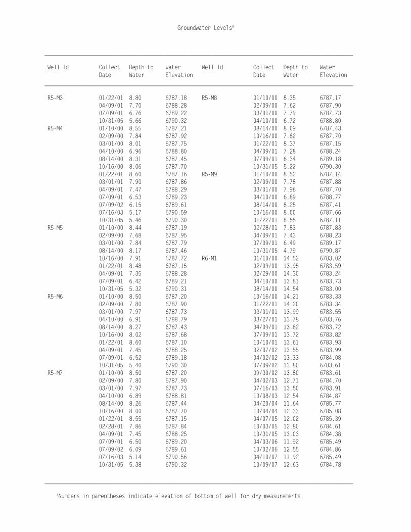
______________________________________________________________________________________________________ Well Id Collect Depth to Water Well Id Collect Depth to Water Date Water Elevation Date Water Elevation ______________________________________________________________________________________________________ R5-M3 01/22/01 8.80 6787.18 R5-M8 01/10/00 8.35 6787.17 04/09/01 7.70 6788.28 02/09/00 7.62 6787.90 07/09/01 6.76 6789.22 03/01/00 7.79 6787.73 10/31/05 5.66 6790.32 04/10/00 6.72 6788.80 R5-M4 01/10/00 8.55 6787.21 08/14/00 8.09 6787.43 02/09/00 7.84 6787.92 10/16/00 7.82 6787.70 03/01/00 8.01 6787.75 01/22/01 8.37 6787.15 04/10/00 6.96 6788.80 04/09/01 7.28 6788.24 08/14/00 8.31 6787.45 07/09/01 6.34 6789.18 10/16/00 8.06 6787.70 10/31/05 5.22 6790.30 01/22/01 8.60 6787.16 R5-M9 01/10/00 8.52 6787.14 03/01/01 7.90 6787.86 02/09/00 7.78 6787.88 04/09/01 7.47 6788.29 03/01/00 7.96 6787.70 07/09/01 6.53 6789.23 04/10/00 6.89 6788.77 07/09/02 6.15 6789.61 08/14/00 8.25 6787.41 07/16/03 5.17 6790.59 10/16/00 8.00 6787.66 10/31/05 5.46 6790.30 01/22/01 8.55 6787.11 R5-M5 01/10/00 8.44 6787.19 02/28/01 7.83 6787.83 02/09/00 7.68 6787.95 04/09/01 7.43 6788.23 03/01/00 7.84 6787.79 07/09/01 6.49 6789.17 08/14/00 8.17 6787.46 10/31/05 4.79 6790.87 10/16/00 7.91 6787.72 R6-M1 01/10/00 14.52 6783.02 01/22/01 8.48 6787.15 02/09/00 13.95 6783.59 04/09/01 7.35 6788.28 02/29/00 14.30 6783.24 07/09/01 6.42 6789.21 04/10/00 13.81 6783.73 10/31/05 5.32 6790.31 08/14/00 14.54 6783.00 R5-M6 01/10/00 8.50 6787.20 10/16/00 14.21 6783.33 02/09/00 7.80 6787.90 01/22/01 14.20 6783.34 03/01/00 7.97 6787.73 03/01/01 13.99 6783.55 04/10/00 6.91 6788.79 03/27/01 13.78 6783.76 08/14/00 8.27 6787.43 04/09/01 13.82 6783.72 10/16/00 8.02 6787.68 07/09/01 13.72 6783.82 01/22/01 8.60 6787.10 10/10/01 13.61 6783.93 04/09/01 7.45 6788.25 02/07/02 13.55 6783.99 07/09/01 6.52 6789.18 04/02/02 13.33 6784.08 10/31/05 5.40 6790.30 07/09/02 13.80 6783.61 R5-M7 01/10/00 8.50 6787.20 09/30/02 13.80 6783.61 02/09/00 7.80 6787.90 04/02/03 12.71 6784.70 03/01/00 7.97 6787.73 07/16/03 13.50 6783.91 04/10/00 6.89 6788.81 10/08/03 12.54 6784.87 08/14/00 8.26 6787.44 04/20/04 11.64 6785.77 10/16/00 8.00 6787.70 10/04/04 12.33 6785.08 01/22/01 8.55 6787.15 04/07/05 12.02 6785.39 02/28/01 7.86 6787.84 10/03/05 12.80 6784.61 04/09/01 7.45 6788.25 10/31/05 13.03 6784.38 07/09/01 6.50 6789.20 04/03/06 11.92 6785.49 07/09/02 6.09 6789.61 10/02/06 12.55 6784.86 07/16/03 5.14 6790.56 04/10/07 11.92 6785.49 10/31/05 5.38 6790.32 10/09/07 12.63 6784.78

Groundwater Levelsa
______________________________________________________________________________________________________
aNumbers in parentheses indicate elevation of bottom of well for dry measurements.
______________________________________________________________________________________________________ Well Id Collect Depth to Water Well Id Collect Depth to Water Date Water Elevation Date Water Elevation ______________________________________________________________________________________________________ R6-M1 04/14/08 11.60 6785.81 R6-M3 08/14/00 9.90 6785.81 10/07/08 13.01 6784.40 10/16/00 10.05 6785.66 04/08/09 13.25 6784.16 01/22/01 9.86 6785.85 10/05/09 14.07 6783.34 03/01/01 9.52 6786.19 04/19/10 11.40 6786.01 03/27/01 9.36 6786.35 10/11/10 12.85 6784.56 04/09/01 9.52 6786.19 04/05/11 13.19 6784.22 07/09/01 9.36 6786.35 R6-M2 01/10/00 8.95 6787.23 10/11/01 9.28 6786.43 02/09/00 8.30 6787.88 02/07/02 9.15 6786.56 02/29/00 8.50 6787.68 04/02/02 9.05 6786.66 04/10/00 7.43 6788.75 07/09/02 8.68 6787.03 08/14/00 8.74 6787.44 09/30/02 9.00 6786.71 10/16/00 8.45 6787.73 01/14/03 8.29 6787.42 01/22/01 9.04 6787.14 04/02/03 7.58 6788.13 03/01/01 8.35 6787.83 07/16/03 8.86 6786.85 03/27/01 7.88 6788.30 10/08/03 8.68 6787.03 04/09/01 7.95 6788.23 01/21/04 7.51 6788.20 07/09/01 7.09 6789.09 04/15/04 8.13 6787.58 10/11/01 6.83 6789.35 10/04/04 7.67 6788.04 01/28/02 6.91 6789.27 04/06/05 7.83 6787.88 02/07/02 7.00 6789.18 10/03/05 9.13 6786.58 04/02/02 6.97 6789.21 10/31/05 8.81 6786.90 07/09/02 7.34 6788.84 04/04/06 7.80 6787.91 09/30/02 8.08 6788.10 10/02/06 9.12 6786.59 01/14/03 6.58 6789.60 04/10/07 8.23 6787.48 04/02/03 6.07 6790.11 10/09/07 9.17 6786.54 07/16/03 6.76 6789.42 04/07/08 7.96 6787.75 10/08/03 5.61 6790.57 10/08/08 9.42 6786.29 01/21/04 7.48 6788.70 04/08/09 9.42 6786.29 04/16/04 10.05 6786.13 10/06/09 9.72 6785.99 10/04/04 7.62 6788.56 04/19/10 8.68 6787.03 04/07/05 5.12 6791.06 10/11/10 8.94 6786.77 10/03/05 7.53 6788.65 04/04/11 9.31 6786.40 10/31/05 8.00 6788.18 R6-M4 01/10/00 9.37 6786.16 04/03/06 7.35 6788.83 02/09/00 8.55 6786.98 10/02/06 7.34 6788.84 02/29/00 8.92 6786.61 04/10/07 7.22 6788.96 04/10/00 8.14 6787.39 10/09/07 7.53 6788.65 08/14/00 10.27 6785.26 04/14/08 4.87 6791.31 10/16/00 9.58 6785.95 10/07/08 7.59 6788.59 01/22/01 10.04 6785.49 04/08/09 8.17 6788.01 02/28/01 9.50 6786.03 10/05/09 8.53 6787.65 03/27/01 8.99 6786.54 04/19/10 7.43 6788.75 04/09/01 9.41 6786.12 10/11/10 6.01 6790.17 07/09/01 8.55 6786.98 04/05/11 7.61 6788.57 10/11/01 7.64 6787.89 R6-M3 01/10/00 10.11 6785.60 01/28/02 8.15 6787.38 02/09/00 9.53 6786.18 02/07/02 8.23 6787.30 02/29/00 9.70 6786.01 04/02/02 7.95 6787.58 04/10/00 9.34 6786.37 07/09/02 8.63 6786.90

Groundwater Levelsa
______________________________________________________________________________________________________
aNumbers in parentheses indicate elevation of bottom of well for dry measurements.
______________________________________________________________________________________________________ Well Id Collect Depth to Water Well Id Collect Depth to Water Date Water Elevation Date Water Elevation ______________________________________________________________________________________________________ R6-M4 09/30/02 8.58 6786.95 R6-M5 04/03/06 7.26 6788.28 01/14/03 6.65 6788.88 10/02/06 7.58 6787.96 04/02/03 6.21 6789.32 04/10/07 7.44 6788.10 07/16/03 7.58 6787.95 10/09/07 8.64 6786.90 10/08/03 6.09 6789.44 04/14/08 7.17 6788.37 01/21/04 7.19 6788.34 10/07/08 8.53 6787.01 04/15/04 6.86 6788.67 04/08/09 9.71 6785.83 10/04/04 7.42 6788.11 10/05/09 10.16 6785.38 04/06/05 5.48 6790.05 04/19/10 6.95 6788.59 10/03/05 7.80 6787.73 10/11/10 8.39 6787.15 10/31/05 8.07 6787.46 04/05/11 8.77 6786.77 04/04/06 7.21 6788.32 R6-M6 08/15/00 14.47 6785.13 10/02/06 7.40 6788.13 10/16/00 14.30 6785.30 04/10/07 7.17 6788.36 01/22/01 12.12 6785.10 10/08/07 8.20 6787.33 02/28/01 11.76 6785.46 04/07/08 6.39 6789.14 03/27/01 11.61 6785.61 10/07/08 8.46 6787.07 04/09/01 11.65 6785.57 04/07/09 8.54 6786.99 07/09/01 11.78 6785.44 10/06/09 9.46 6786.07 10/10/01 11.84 6785.38 04/19/10 7.10 6788.43 02/07/02 11.92 6785.30 10/11/10 8.08 6787.45 04/02/02 11.30 6785.92 04/04/11 8.53 6787.00 07/09/02 12.15 6785.07 R6-M5 01/10/00 9.14 6786.40 09/30/02 12.30 6784.92 02/09/00 8.20 6787.34 04/02/03 11.02 6786.20 02/29/00 8.57 6786.97 07/16/03 11.92 6785.30 04/10/00 7.91 6787.63 10/08/03 11.08 6786.14 08/14/00 9.21 6786.33 04/20/04 11.04 6786.18 10/16/00 9.02 6786.52 10/04/04 11.38 6785.84 01/22/01 9.39 6786.15 04/07/05 10.38 6786.84 02/28/01 8.60 6786.94 10/03/05 11.35 6785.87 03/27/01 8.14 6787.40 10/31/05 11.49 6785.73 04/09/01 8.23 6787.31 04/03/06 11.23 6785.99 07/09/01 7.54 6788.00 10/02/06 11.16 6786.06 10/11/01 7.36 6788.18 04/10/07 10.98 6786.24 02/07/02 7.30 6788.24 10/09/07 11.34 6785.88 04/02/02 6.64 6788.90 04/08/08 10.20 6787.02 07/09/02 7.30 6788.24 10/07/08 11.48 6785.74 09/30/02 8.20 6787.34 04/08/09 11.70 6785.52 01/14/03 6.47 6789.07 10/05/09 11.85 6785.37 04/02/03 6.03 6789.51 04/19/10 9.32 6787.90 07/16/03 7.30 6788.24 10/12/10 11.36 6785.86 10/08/03 6.18 6789.36 04/05/11 11.23 6785.99 01/21/04 7.57 6787.97 R7-M1 01/10/00 12.92 6783.08 04/16/04 6.32 6789.22 02/09/00 12.21 6783.79 10/04/04 7.65 6787.89 02/29/00 12.51 6783.49 04/06/05 6.06 6789.48 04/10/00 12.10 6783.90 04/07/05 6.05 6789.49 08/14/00 13.04 6782.96 10/03/05 7.82 6787.72 10/16/00 12.58 6783.42 10/31/05 7.59 6787.95 01/22/01 12.50 6783.50
Groundwater Levelsa
______________________________________________________________________________________________________
aNumbers in parentheses indicate elevation of bottom of well for dry measurements.
______________________________________________________________________________________________________ Well Id Collect Depth to Water Well Id Collect Depth to Water Date Water Elevation Date Water Elevation ______________________________________________________________________________________________________ R7-M1 02/28/01 12.31 6783.69 R8-M1 04/09/01 13.15 6782.45 03/27/01 12.08 6783.92 07/09/01 12.96 6782.64 04/09/01 12.15 6783.85 10/10/01 12.90 6782.70 07/09/01 11.91 6784.09 02/07/02 12.77 6782.83 10/10/01 11.46 6784.54 04/02/02 12.43 6783.17 02/07/02 11.26 6784.74 07/09/02 12.31 6783.29 04/02/02 11.11 6784.89 09/30/02 12.45 6783.15 07/09/02 11.50 6784.50 04/02/03 11.40 6784.20 09/30/02 11.53 6784.47 07/16/03 11.87 6783.73 04/02/03 10.58 6785.42 10/08/03 10.93 6784.67 07/16/03 11.15 6784.85 04/20/04 10.88 6784.72 10/08/03 10.27 6785.73 10/04/04 10.88 6784.72 04/20/04 9.88 6786.12 04/07/05 10.39 6785.21 10/04/04 10.17 6785.83 10/03/05 11.28 6784.32 04/07/05 9.94 6786.06 10/31/05 11.46 6784.14 10/03/05 10.92 6785.08 04/03/06 10.82 6784.78 10/31/05 10.98 6785.02 10/02/06 11.02 6784.58 04/03/06 10.24 6785.76 04/10/07 9.29 6786.31 10/02/06 10.79 6785.21 10/09/07 10.59 6785.01 04/10/07 9.50 6786.50 04/14/08 9.95 6785.65 10/09/07 10.57 6785.43 10/07/08 12.01 6783.59 04/14/08 8.95 6787.05 04/08/09 12.27 6783.33 10/07/08 11.50 6784.50 10/05/09 12.59 6783.01 04/08/09 11.66 6784.34 04/19/10 10.23 6785.37 10/05/09 12.47 6783.53 10/12/10 11.60 6784.00 04/19/10 9.19 6786.81 04/05/11 12.06 6783.54 10/12/10 11.02 6784.98 R9-M1 01/10/00 13.46 6781.75 04/05/11 11.67 6784.33 02/09/00 12.67 6782.54 R7-M2 02/09/00 11.33 6784.45 02/29/00 13.06 6782.15 02/29/00 11.68 6784.10 04/10/00 12.83 6782.38 04/10/00 11.31 6784.47 08/14/00 13.57 6781.64 08/14/00 12.12 6783.66 10/16/00 13.40 6781.81 10/16/00 11.76 6784.02 01/22/01 Dry (6780.67) 01/22/01 11.91 6783.87 02/28/01 13.40 6781.81 03/01/01 11.67 6784.11 03/27/01 Dry (6780.67) 03/27/01 11.39 6784.39 04/09/01 13.35 6781.86 04/09/01 11.41 6784.37 07/09/01 13.19 6782.02 07/09/01 10.93 6784.85 10/11/01 13.12 6782.09 07/16/03 9.20 6786.58 01/28/02 13.13 6782.08 10/31/05 8.85 6786.93 02/07/02 13.17 6782.04 R8-M1 01/10/00 13.14 6782.46 04/02/02 13.80 6781.41 02/09/00 13.12 6782.48 07/09/02 13.14 6782.07 02/29/00 13.28 6782.32 09/30/02 13.23 6781.98 04/10/00 12.95 6782.65 01/14/03 12.70 6782.51 08/14/00 Dry (6782.20) 04/02/03 12.51 6782.70 10/16/00 Dry (6782.20) 07/16/03 13.13 6782.08 01/22/01 Dry (6782.20) 10/07/03 12.50 6782.71 02/28/01 13.30 6782.30 01/21/04 12.20 6783.01 03/27/01 Dry (6782.20) 04/15/04 12.19 6783.02

Groundwater Levelsa
______________________________________________________________________________________________________
aNumbers in parentheses indicate elevation of bottom of well for dry measurements.
______________________________________________________________________________________________________ Well Id Collect Depth to Water Well Id Collect Depth to Water Date Water Elevation Date Water Elevation ______________________________________________________________________________________________________ R9-M1 10/04/04 11.85 6783.36 T00-02 10/16/00 9.30 6797.47 04/07/05 11.42 6783.79 01/23/01 9.50 6797.27 10/03/05 11.78 6783.43 02/27/01 8.60 6798.17 10/31/05 11.90 6783.31 03/27/01 9.23 6797.54 04/03/06 11.42 6783.79 04/09/01 9.28 6797.49 10/02/06 11.13 6784.08 07/10/01 9.79 6796.98 04/10/07 9.95 6785.26 10/10/01 9.44 6797.33 10/09/07 10.91 6784.30 02/06/02 9.97 6796.80 04/14/08 10.98 6784.23 04/04/02 9.54 6797.23 10/07/08 12.69 6782.52 07/11/02 Dry (6796.50) 04/08/09 12.92 6782.29 10/09/02 9.80 6796.97 10/05/09 13.04 6782.17 04/20/10 3.99 6802.78 04/19/10 11.01 6784.20 T00-03 08/15/00 7.94 6797.33 10/12/10 12.75 6782.46 10/16/00 6.85 6798.42 04/05/11 13.00 6782.21 01/23/01 7.57 6797.70 T00-01 08/01/00 11.95 6796.62 02/27/01 7.59 6797.68 08/15/00 12.02 6796.55 03/27/01 7.39 6797.88 10/16/00 11.25 6797.32 04/09/01 7.43 6797.84 01/23/01 11.48 6797.09 07/10/01 7.92 6797.35 02/27/01 10.74 6797.83 10/10/01 7.75 6797.52 03/27/01 11.22 6797.35 02/06/02 8.08 6797.19 04/09/01 11.06 6797.51 04/04/02 7.39 6797.88 07/18/01 9.52 6797.00 07/11/02 8.26 6797.01 10/09/01 9.44 6797.08 10/09/02 7.34 6797.93 01/31/02 9.55 6796.97 T00-04 08/15/00 9.18 6797.27 04/03/02 8.53 6797.99 10/16/00 8.40 6798.05 07/10/02 9.70 6796.82 01/23/01 8.88 6797.57 10/08/02 9.67 6796.85 02/27/01 8.84 6797.61 01/13/03 9.49 6797.03 03/27/01 8.63 6797.82 04/09/03 8.40 6798.12 04/09/01 8.67 6797.78 07/07/03 9.71 6796.81 07/11/01 7.18 6797.13 10/08/03 8.71 6797.81 10/15/01 7.00 6797.31 01/20/04 9.39 6797.13 01/31/02 7.30 6797.01 04/13/04 8.24 6798.28 04/03/02 6.73 6797.58 10/07/04 8.81 6797.71 07/09/02 7.41 6796.90 04/07/05 7.05 6799.47 10/08/02 6.69 6797.62 10/06/05 9.04 6797.48 01/13/03 6.60 6797.71 04/03/06 8.30 6798.22 04/09/03 6.62 6797.69 10/04/06 8.70 6797.82 07/09/03 7.85 6796.46 04/10/07 8.57 6797.95 10/06/03 6.62 6797.69 10/09/07 8.96 6797.56 01/20/04 6.96 6797.35 04/09/08 6.84 6799.68 04/13/04 6.61 6797.70 10/09/08 9.61 6796.91 10/07/04 6.71 6797.60 04/07/09 8.52 6798.00 04/07/05 4.98 6799.33 10/07/09 9.87 6796.65 10/06/05 7.03 6797.28 04/20/10 5.96 6800.56 04/03/06 6.65 6797.66 10/11/10 9.21 6797.31 10/04/06 7.02 6797.29 04/05/11 8.00 6798.52 04/10/07 6.91 6797.40 T00-02 08/15/00 10.03 6796.74 10/09/07 6.81 6797.50

Groundwater Levelsa
______________________________________________________________________________________________________
aNumbers in parentheses indicate elevation of bottom of well for dry measurements.
______________________________________________________________________________________________________ Well Id Collect Depth to Water Well Id Collect Depth to Water Date Water Elevation Date Water Elevation ______________________________________________________________________________________________________ T00-04 04/09/08 5.19 6799.12 T00-08 02/06/02 10.32 6903.64 10/09/08 7.06 6797.25 04/04/02 10.35 6903.61 04/07/09 6.94 6797.37 07/11/02 10.37 6903.59 10/09/09 Dry (6796.40) 10/09/02 9.70 6904.26 04/20/10 4.18 6800.13 T00-09 10/20/00 23.97 6879.98 10/11/10 6.78 6797.53 02/06/01 24.05 6879.90 04/05/11 6.78 6797.53 02/27/01 23.95 6880.00 T00-05 08/15/00 12.39 6797.06 04/10/01 25.14 6880.94 10/16/00 11.77 6797.68 07/10/01 25.38 6880.70 01/23/01 12.20 6797.25 10/10/01 26.19 6879.89 02/27/01 12.10 6797.35 02/06/02 26.66 6879.42 03/27/01 11.93 6797.52 04/04/02 26.56 6879.52 04/09/01 11.93 6797.52 07/11/02 26.65 6879.43 07/10/01 12.14 6797.31 10/09/02 Dry (6878.38) 10/10/01 12.24 6797.21 T00-10 10/20/00 21.85 6877.04 02/06/02 12.32 6797.13 02/06/01 21.93 6876.96 04/04/02 12.01 6797.44 02/27/01 21.84 6877.05 07/11/02 12.43 6797.02 04/10/01 23.81 6877.16 10/09/02 11.96 6797.49 07/10/01 23.93 6877.04 T00-06 08/15/00 Dry (6806.15) 10/10/01 23.99 6876.98 10/16/00 14.43 6806.34 02/06/02 23.96 6877.01 01/23/01 14.45 6806.32 04/04/02 23.95 6877.02 02/27/01 14.45 6806.32 07/11/02 24.00 6876.97 03/27/01 14.37 6806.40 10/09/02 24.08 6876.89 04/09/01 14.33 6806.44 T00-11 10/20/00 21.03 6871.05 07/10/01 14.51 6806.26 02/06/01 21.17 6870.91 10/10/01 14.63 6806.14 02/27/01 20.72 6871.36 02/06/02 14.52 6806.25 04/10/01 22.09 6872.12 04/04/02 14.52 6806.25 02/06/02 23.13 6871.08 07/11/02 14.49 6806.28 04/04/02 22.80 6871.41 10/09/02 14.54 6806.23 07/11/02 24.00 6870.21 T00-07 08/15/00 11.93 6811.16 10/09/02 Dry (6871.17) 10/16/00 11.83 6811.26 T00-12 10/20/00 17.42 6871.38 01/23/01 11.76 6811.33 02/06/01 17.55 6871.25 02/27/01 11.14 6811.95 02/27/01 17.15 6871.65 03/27/01 11.07 6812.02 04/10/01 18.65 6872.29 04/09/01 11.30 6811.79 07/10/01 19.45 6871.49 07/10/01 11.93 6811.16 10/10/01 19.88 6871.06 10/10/01 12.00 6811.09 02/06/02 19.48 6871.46 02/06/02 11.95 6811.14 04/04/02 19.20 6871.74 04/04/02 11.76 6811.33 07/11/02 20.85 6870.09 07/11/02 12.15 6810.94 10/09/02 20.80 6870.14 10/09/02 11.67 6811.42 T00-13 10/20/00 10.22 6873.07 T00-08 10/20/00 Dry (6903.49) 02/06/01 11.67 6873.10 02/06/01 7.77 6904.11 02/27/01 11.06 6873.71 02/27/01 6.98 6904.90 04/10/01 12.00 6874.74 04/10/01 9.91 6904.05 07/10/01 13.55 6873.19 07/10/01 9.71 6904.25 10/10/01 14.11 6872.63 10/10/01 9.39 6904.57 02/06/02 13.57 6873.17
Groundwater Levelsa
______________________________________________________________________________________________________
aNumbers in parentheses indicate elevation of bottom of well for dry measurements.
______________________________________________________________________________________________________ Well Id Collect Depth to Water Well Id Collect Depth to Water Date Water Elevation Date Water Elevation ______________________________________________________________________________________________________ T00-13 04/04/02 13.13 6873.61 T01-01 04/27/06 8.37 6797.72 07/11/02 15.35 6871.39 10/04/06 7.95 6798.14 10/09/02 15.30 6871.44 04/11/07 7.99 6798.10 T00-14 10/20/00 9.00 6872.81 10/09/07 8.05 6798.04 02/06/01 8.67 6873.14 04/09/08 6.39 6799.70 02/27/01 8.03 6873.78 10/09/08 9.14 6796.95 04/10/01 10.95 6874.84 04/07/09 7.82 6798.27 07/10/01 12.55 6873.24 10/09/09 Dry (6795.24) 10/10/01 13.14 6872.65 04/20/10 5.49 6800.60 02/06/02 12.57 6873.22 04/20/10 5.56 6800.53 04/04/02 12.12 6873.67 10/11/10 8.51 6797.58 07/11/02 14.44 6871.35 04/04/11 7.39 6798.70 10/09/02 14.40 6871.39 T01-02 02/08/01 10.78 6797.48 T00-15 10/20/00 7.80 6872.56 02/27/01 10.56 6797.70 02/06/01 6.92 6873.44 03/27/01 10.51 6797.75 02/27/01 6.20 6874.16 04/18/01 10.58 6797.68 04/10/01 9.16 6875.28 07/18/01 9.59 6797.92 07/10/01 10.80 6873.64 01/30/02 9.75 6797.91 10/10/01 11.45 6872.99 04/03/02 9.55 6798.11 02/06/02 10.87 6873.57 07/10/02 9.67 6797.99 04/04/02 10.38 6874.06 10/08/02 9.67 6797.99 07/11/02 12.87 6871.57 04/09/03 9.42 6798.24 10/09/02 12.90 6871.54 07/07/03 9.61 6798.05 T00-17 10/20/00 8.72 6852.58 10/07/03 9.36 6798.30 T00-18 10/20/00 10.99 6851.18 04/14/04 9.28 6798.38 T00-19 10/20/00 7.72 6851.03 10/05/04 9.31 6798.35 T00-20 10/20/00 9.91 6846.06 04/05/05 8.30 6799.36 T00-21 10/20/00 Dry (6843.80) 10/06/05 9.34 6798.32 T00-22 10/20/00 Dry (6839.84) 04/27/06 9.36 6798.30 T00-23 10/20/00 Dry (6826.30) 10/04/06 9.36 6798.30 T00-24 10/20/00 15.13 6849.72 04/11/07 9.34 6798.32 T00-25 10/20/00 Dry (6860.77) 01/09/08 9.41 6798.25 T00-26 10/20/00 Dry (6851.05) 04/09/08 8.34 6799.32 T01-01 02/08/01 9.00 6797.82 10/09/08 9.41 6798.25 02/27/01 9.09 6797.73 04/07/09 9.33 6798.33 03/27/01 9.54 6797.28 10/07/09 9.45 6798.21 04/18/01 9.75 6797.07 04/20/10 7.35 6800.31 07/18/01 9.00 6797.09 10/11/10 9.32 6798.34 10/09/01 8.91 6797.18 04/04/11 9.13 6798.53 01/30/02 9.02 6797.07 T01-03 02/08/01 14.56 6796.95 04/03/02 Dry (6795.24) 02/27/01 13.19 6798.32 07/10/02 9.23 6796.86 03/27/01 13.03 6798.48 10/08/02 9.22 6796.87 04/18/01 13.24 6798.27 04/09/03 7.83 6798.26 07/10/01 11.90 6798.75 10/07/03 7.99 6798.10 10/10/01 11.87 6798.78 04/14/04 7.73 6798.36 01/30/02 12.14 6798.51 10/07/04 8.10 6797.99 04/04/02 12.06 6798.59 04/06/05 6.69 6799.40 07/11/02 12.10 6798.55 10/06/05 8.31 6797.78 10/09/02 12.10 6798.55

Groundwater Levelsa
______________________________________________________________________________________________________
aNumbers in parentheses indicate elevation of bottom of well for dry measurements.
______________________________________________________________________________________________________ Well Id Collect Depth to Water Well Id Collect Depth to Water Date Water Elevation Date Water Elevation ______________________________________________________________________________________________________ T01-04 02/08/01 15.55 6798.99 T01-05 04/09/08 20.18 6802.03 02/27/01 15.44 6799.10 10/09/08 20.49 6801.72 03/27/01 15.31 6799.23 04/07/09 20.64 6801.57 04/18/01 15.45 6799.09 10/07/09 20.77 6801.44 07/18/01 14.60 6799.55 04/20/10 19.95 6802.26 10/10/01 14.60 6799.55 10/11/10 20.59 6801.62 01/30/02 14.80 6799.35 04/05/11 20.68 6801.53 04/03/02 14.65 6799.50 T01-06 02/14/01 Dry (6804.52) 07/10/02 14.70 6799.45 02/27/01 Dry (6804.52) 10/08/02 14.80 6799.35 03/27/01 24.06 6804.09 04/09/03 14.39 6799.76 04/18/01 24.30 6803.85 10/07/03 14.41 6799.74 07/18/01 24.71 6803.70 04/13/04 14.37 6799.78 10/09/01 24.97 6803.44 10/05/04 14.42 6799.73 01/30/02 25.15 6803.26 04/05/05 13.97 6800.18 04/03/02 25.10 6803.31 10/06/05 14.32 6799.83 07/09/02 Dry (6804.52) 04/27/06 14.36 6799.79 10/08/02 25.05 6803.36 10/03/06 14.24 6799.91 04/01/03 23.04 6805.37 04/11/07 14.30 6799.85 04/10/03 23.72 6804.69 10/09/07 14.35 6799.80 10/08/03 24.51 6803.90 04/09/08 13.94 6800.21 04/20/04 24.10 6804.31 10/09/08 14.42 6799.73 10/06/04 24.47 6803.94 04/07/09 14.40 6799.75 04/07/05 22.52 6805.89 10/07/09 14.54 6799.61 10/06/05 24.44 6803.97 04/20/10 13.61 6800.54 04/03/06 23.62 6804.79 10/11/10 14.36 6799.79 10/03/06 24.45 6803.96 04/04/11 14.31 6799.84 04/11/07 24.84 6803.57 T01-05 02/08/01 22.22 6800.64 10/09/07 29.23 6799.18 02/27/01 22.25 6800.61 04/09/08 22.51 6805.90 03/27/01 21.73 6801.13 10/07/08 24.96 6803.45 04/18/01 21.95 6800.91 04/07/09 24.66 6803.75 07/10/01 20.90 6801.31 10/09/09 25.02 6803.39 10/09/01 20.92 6801.29 04/20/10 22.23 6806.18 01/30/02 21.14 6801.07 10/12/10 24.89 6803.52 04/03/02 21.00 6801.21 04/05/11 24.86 6803.55 07/09/02 21.00 6801.21 T01-07 07/11/01 19.95 6803.34 10/08/02 21.22 6800.99 10/09/01 19.95 6803.34 04/01/03 20.72 6801.49 01/31/02 20.02 6803.27 04/09/03 20.74 6801.47 04/03/02 19.96 6803.33 07/08/03 21.92 6800.29 07/09/02 19.90 6803.39 10/07/03 20.62 6801.59 10/08/02 19.96 6803.33 04/13/04 20.70 6801.51 04/09/03 19.83 6803.46 10/05/04 20.75 6801.46 10/07/03 19.75 6803.54 04/05/05 20.38 6801.83 04/13/04 19.80 6803.49 10/06/05 20.64 6801.57 10/06/04 19.87 6803.42 04/27/06 20.66 6801.55 04/05/05 19.55 6803.74 10/03/06 20.51 6801.70 10/06/05 19.79 6803.50 04/11/07 20.50 6801.71 04/27/06 19.70 6803.59 10/09/07 20.68 6801.53 10/03/06 19.61 6803.68

Groundwater Levelsa
______________________________________________________________________________________________________
aNumbers in parentheses indicate elevation of bottom of well for dry measurements.
______________________________________________________________________________________________________ Well Id Collect Depth to Water Well Id Collect Depth to Water Date Water Elevation Date Water Elevation ______________________________________________________________________________________________________ T01-07 04/11/07 19.61 6803.68 T01-09 04/09/08 Dry (6813.38) 10/09/07 19.66 6803.63 04/07/09 Dry (6813.38) 04/09/08 19.44 6803.85 10/09/09 Dry (6813.38) 10/09/08 19.63 6803.66 04/20/10 Dry (6813.38) 04/07/09 19.71 6803.58 10/12/10 Dry (6813.38) 10/05/09 19.77 6803.52 04/05/11 Dry (6813.38) 04/20/10 19.20 6804.09 T01-10 07/10/01 7.03 6810.42 10/12/10 19.63 6803.66 10/10/01 8.07 6809.38 04/05/11 19.74 6803.55 01/31/02 8.87 6808.58 T01-08 07/11/01 4.26 6803.85 04/01/02 7.92 6809.53 10/11/01 4.46 6803.65 07/09/02 Dry (6808.10) 01/31/02 5.15 6802.96 10/08/02 8.56 6808.89 04/01/02 4.96 6803.15 04/01/03 7.30 6810.15 07/09/02 4.48 6803.63 10/08/03 8.63 6808.82 10/08/02 5.12 6802.99 04/20/04 8.21 6809.24 04/02/03 3.17 6804.94 10/06/04 8.74 6808.71 04/09/03 3.52 6804.59 04/07/05 6.75 6810.70 10/06/03 5.84 6802.27 10/06/05 7.87 6809.58 04/13/04 3.19 6804.92 04/03/06 6.39 6811.06 10/07/04 5.77 6802.34 10/02/06 8.23 6809.22 04/07/05 2.60 6805.51 04/11/07 8.21 6809.24 10/06/05 4.57 6803.54 10/09/07 6.96 6810.49 04/03/06 3.78 6804.33 04/09/08 4.02 6813.43 10/02/06 4.63 6803.48 10/07/08 8.09 6809.36 04/11/07 3.81 6804.30 04/07/09 7.58 6809.87 10/09/07 5.04 6803.07 10/09/09 8.88 6808.57 04/10/08 3.01 6805.10 04/20/10 4.86 6812.59 10/07/08 5.72 6802.39 10/11/10 7.83 6809.62 04/07/09 3.80 6804.31 04/05/11 8.48 6808.97 10/09/09 7.12 6800.99 T01-11 07/10/01 Dry (6831.48) 04/20/10 2.92 6805.19 10/10/01 Dry (6831.48) 10/11/10 5.70 6802.41 02/06/02 Dry (6831.48) 04/05/11 3.74 6804.37 04/04/02 Dry (6831.48) T01-09 07/10/01 Dry (6813.38) 07/11/02 Dry (6831.48) 10/09/01 Dry (6813.38) 10/09/02 Dry (6831.48) 01/31/02 Dry (6813.38) T01-12 07/11/01 20.19 6824.15 04/03/02 Dry (6813.38) 10/09/01 19.83 6824.51 07/09/02 Dry (6813.38) 01/30/02 20.76 6823.58 10/07/02 Dry (6813.38) 04/03/02 20.60 6823.74 04/01/03 Dry (6813.38) 07/09/02 20.59 6823.75 10/08/03 Dry (6813.38) 10/07/02 21.15 6823.19 04/20/04 Dry (6813.38) 04/08/03 20.12 6824.22 10/06/04 Dry (6813.38) 07/08/03 20.68 6823.66 04/07/05 Dry (6813.38) 10/07/03 19.62 6824.72 10/05/05 Dry (6813.38) 04/13/04 20.25 6824.09 04/03/06 Dry (6813.38) 10/07/04 20.25 6824.09 10/02/06 Dry (6813.38) 04/06/05 19.54 6824.80 04/11/07 Dry (6813.38) 10/05/05 20.50 6823.84 10/09/07 Dry (6813.38) 04/28/06 20.69 6823.65

Groundwater Levelsa
______________________________________________________________________________________________________
aNumbers in parentheses indicate elevation of bottom of well for dry measurements.
______________________________________________________________________________________________________ Well Id Collect Depth to Water Well Id Collect Depth to Water Date Water Elevation Date Water Elevation ______________________________________________________________________________________________________ T01-12 10/03/06 20.14 6824.20 T01-18 07/20/01 20.01 6840.48 04/11/07 20.08 6824.26 10/10/01 20.10 6840.39 10/09/07 20.84 6823.50 01/30/02 19.62 6840.87 04/10/08 20.39 6823.95 04/03/02 19.51 6840.98 10/08/08 20.63 6823.71 07/09/02 19.75 6840.74 04/07/09 20.99 6823.35 10/07/02 21.48 6839.01 10/08/09 21.23 6823.11 04/07/03 19.56 6840.93 10/12/10 20.86 6823.48 10/07/03 20.33 6840.16 04/05/11 21.00 6823.34 04/12/04 19.51 6840.98 T01-13 07/20/01 7.21 6822.46 10/06/04 19.85 6840.64 10/10/01 6.93 6822.74 04/07/05 18.08 6842.41 01/31/02 7.02 6822.65 10/05/05 18.91 6841.58 04/01/02 6.82 6822.85 04/03/06 18.95 6841.54 07/09/02 6.76 6822.91 10/03/06 19.41 6841.08 10/09/02 6.92 6822.75 04/10/07 19.14 6841.35 04/08/03 6.50 6823.17 10/08/07 19.12 6841.37 10/06/03 6.47 6823.20 04/09/08 18.14 6842.35 04/13/04 6.47 6823.20 10/08/08 18.89 6841.60 10/06/04 6.55 6823.12 04/07/09 18.94 6841.55 04/07/05 4.09 6825.58 10/06/09 18.80 6841.69 10/06/05 6.85 6822.82 04/20/10 18.16 6842.33 04/03/06 7.00 6822.67 10/12/10 18.24 6842.25 10/03/06 7.59 6822.08 04/05/11 18.40 6842.09 04/10/07 6.70 6822.97 T01-19 07/12/01 8.92 6839.72 10/09/07 7.05 6822.62 10/10/01 9.05 6839.59 04/10/08 4.22 6825.45 01/30/02 8.70 6839.94 10/09/08 7.80 6821.87 04/03/02 8.78 6839.86 04/07/09 7.69 6821.98 07/09/02 10.00 6838.64 04/20/10 4.22 6825.45 10/07/02 10.35 6838.29 10/11/10 7.67 6822.00 04/08/03 8.90 6839.74 04/05/11 7.53 6822.14 07/07/03 9.82 6838.82 T01-15 07/10/01 Dry (6857.30) 10/07/03 9.39 6839.25 10/10/01 Dry (6857.30) 04/12/04 8.87 6839.77 02/06/02 Dry (6857.30) 10/06/04 9.03 6839.61 04/04/02 Dry (6857.30) 04/05/05 7.60 6841.04 07/11/02 Dry (6857.30) 10/05/05 8.06 6840.58 10/09/02 Dry (6857.30) 04/28/06 8.52 6840.12 T01-16 07/10/01 Dry (6850.91) 10/03/06 8.78 6839.86 10/10/01 Dry (6850.91) 04/11/07 8.86 6839.78 02/06/02 Dry (6850.91) 10/08/07 8.26 6840.38 04/04/02 Dry (6850.91) 04/10/08 7.54 6841.10 07/11/02 Dry (6850.91) 10/08/08 8.08 6840.56 10/09/02 Dry (6850.91) 04/06/09 8.04 6840.60 T01-17 07/10/01 Dry (6843.76) 10/06/09 9.21 6839.43 10/10/01 5.07 6850.07 04/21/10 7.18 6841.46 02/06/02 5.77 6849.37 10/12/10 7.37 6841.27 04/04/02 8.35 6846.79 04/05/11 7.89 6840.75 07/11/02 9.06 6846.08 T01-20 07/19/01 11.60 6833.80 10/09/02 10.49 6844.65 10/11/01 11.79 6833.61

Groundwater Levelsa
______________________________________________________________________________________________________
aNumbers in parentheses indicate elevation of bottom of well for dry measurements.
______________________________________________________________________________________________________ Well Id Collect Depth to Water Well Id Collect Depth to Water Date Water Elevation Date Water Elevation ______________________________________________________________________________________________________ T01-20 01/31/02 12.07 6833.33 T01-23 10/12/10 6.69 6852.20 04/01/02 11.91 6833.49 04/05/11 6.58 6852.31 07/09/02 12.37 6833.03 T01-24 07/11/01 8.69 6850.14 10/09/02 12.49 6832.91 10/08/01 9.82 6849.01 04/08/03 11.90 6833.50 01/30/02 9.05 6849.78 10/06/03 11.39 6834.01 04/03/02 8.51 6850.32 04/13/04 11.39 6834.01 07/09/02 Dry (6849.12) 10/06/04 11.30 6834.10 10/07/02 Dry (6849.12) 04/07/05 10.63 6834.77 04/01/03 8.67 6850.16 10/05/05 10.60 6834.80 04/07/03 8.75 6850.08 04/03/06 10.86 6834.54 10/07/03 Dry (6849.12) 10/03/06 11.13 6834.27 04/12/04 7.88 6850.95 04/10/07 10.55 6834.85 10/06/04 8.67 6850.16 10/09/07 11.05 6834.35 04/07/05 7.20 6851.63 04/10/08 9.25 6836.15 10/05/05 7.32 6851.51 10/09/08 10.98 6834.42 04/03/06 6.83 6852.00 04/07/09 10.90 6834.50 10/03/06 6.32 6852.51 10/06/09 11.00 6834.40 04/11/07 6.00 6852.83 04/20/10 8.76 6836.64 10/08/07 5.72 6853.11 10/11/10 10.55 6834.85 04/09/08 5.62 6853.21 04/05/11 10.50 6834.90 10/07/08 5.75 6853.08 T01-22 07/10/01 Dry (6860.55) 04/07/09 5.51 6853.32 10/10/01 Dry (6860.55) 10/09/09 6.61 6852.22 02/06/02 Dry (6860.55) 04/20/10 5.29 6853.54 04/04/02 Dry (6860.55) 10/12/10 5.15 6853.68 07/11/02 Dry (6860.55) 04/05/11 5.05 6853.78 10/09/02 Dry (6860.55) T01-25 07/10/01 13.98 6842.35 T01-23 07/11/01 9.67 6849.22 10/11/01 12.42 6843.91 10/08/01 10.77 6848.12 01/31/02 11.60 6844.73 01/30/02 10.12 6848.77 04/01/02 10.89 6845.44 04/03/02 9.64 6849.25 07/09/02 10.84 6845.49 07/09/02 12.50 6846.39 10/09/02 10.49 6845.84 10/07/02 13.59 6845.30 04/08/03 9.95 6846.38 04/08/03 14.40 6844.49 10/06/03 9.03 6847.30 07/07/03 12.28 6846.61 04/13/04 8.58 6847.75 10/07/03 11.07 6847.82 10/06/04 7.53 6848.80 04/12/04 9.05 6849.84 04/07/05 6.65 6849.68 10/06/04 9.74 6849.15 10/05/05 6.23 6850.10 04/07/05 8.43 6850.46 04/03/06 6.59 6849.74 10/05/05 8.46 6850.43 10/03/06 7.50 6848.83 04/03/06 8.05 6850.84 04/11/07 6.16 6850.17 10/03/06 7.66 6851.23 10/09/07 9.84 6846.49 04/10/07 7.41 6851.48 04/10/08 4.39 6851.94 10/08/07 7.15 6851.74 10/09/08 7.90 6848.43 04/09/08 7.03 6851.86 04/07/09 7.01 6849.32 10/08/08 7.15 6851.74 10/06/09 7.39 6848.94 04/07/09 6.95 6851.94 04/20/10 4.13 6852.20 10/06/09 7.86 6851.03 10/11/10 7.27 6849.06 04/20/10 6.80 6852.09 04/05/11 6.32 6850.01

Groundwater Levelsa
______________________________________________________________________________________________________
aNumbers in parentheses indicate elevation of bottom of well for dry measurements.
______________________________________________________________________________________________________ Well Id Collect Depth to Water Well Id Collect Depth to Water Date Water Elevation Date Water Elevation ______________________________________________________________________________________________________ T01-26 07/11/01 17.08 6861.16 T01-28 04/01/03 4.35 6864.85 10/08/01 18.37 6859.87 04/08/03 4.50 6864.70 01/30/02 17.78 6860.46 10/08/03 Dry (6864.08) 04/03/02 17.21 6861.03 04/20/04 3.95 6865.25 07/09/02 19.35 6858.89 10/07/04 4.49 6864.71 10/07/02 19.75 6858.49 04/07/05 4.87 6864.33 04/07/03 16.66 6861.58 10/05/05 4.50 6864.70 10/07/03 18.80 6859.44 04/03/06 4.14 6865.06 04/12/04 15.65 6862.59 10/02/06 4.03 6865.17 10/06/04 17.75 6860.49 04/11/07 3.84 6865.36 04/07/05 14.58 6863.66 10/09/07 3.92 6865.28 10/05/05 15.83 6862.41 04/10/08 3.67 6865.53 04/03/06 15.50 6862.74 10/07/08 4.30 6864.90 10/03/06 15.67 6862.57 04/07/09 3.92 6865.28 04/11/07 14.96 6863.28 10/09/09 4.72 6864.48 10/08/07 15.52 6862.72 04/20/10 3.54 6865.66 04/10/08 3.67 6874.57 10/11/10 4.18 6865.02 10/07/08 16.06 6862.18 04/05/11 3.53 6865.67 04/07/09 15.16 6863.08 T01-35 10/23/01 12.25 6812.01 10/08/09 8.29 6869.95 01/31/02 12.42 6811.84 04/20/10 14.14 6864.10 04/01/02 12.35 6811.91 10/12/10 14.83 6863.41 07/09/02 12.30 6811.96 04/05/11 14.38 6863.86 10/07/02 12.33 6811.93 T01-27 07/12/01 0.05 6864.66 01/13/03 12.24 6812.02 10/10/01 0.13 6864.58 04/08/03 12.11 6812.15 04/01/02 1.05 6863.66 07/07/03 12.24 6812.02 07/09/02 2.25 6862.46 10/07/03 11.95 6812.31 10/09/02 2.33 6862.38 01/20/04 12.19 6812.07 04/08/03 1.17 6863.54 04/13/04 12.08 6812.18 10/08/03 1.60 6863.11 10/06/04 12.06 6812.20 10/07/04 0.45 6864.26 04/05/05 11.85 6812.41 04/07/05 0.00 6864.71 10/05/05 12.09 6812.17 04/03/06 0.59 6864.12 04/28/06 12.10 6812.16 10/02/06 2.26 6862.45 10/02/06 11.94 6812.32 04/11/07 0.56 6864.15 04/11/07 11.96 6812.30 10/09/07 0.91 6863.80 10/09/07 12.09 6812.17 04/10/08 0.62 6864.09 04/09/08 11.89 6812.37 10/07/08 2.06 6862.65 10/09/08 12.08 6812.18 04/07/09 1.50 6863.21 04/07/09 12.20 6812.06 10/09/09 2.28 6862.43 10/06/09 12.68 6811.58 04/20/10 0.71 6864.00 04/20/10 11.72 6812.54 10/13/10 2.21 6862.50 10/12/10 12.09 6812.17 04/05/11 1.02 6863.69 04/05/11 12.25 6812.01 T01-28 07/11/01 3.54 6865.66 T1-D 01/10/00 6.35 6789.47 10/10/01 4.06 6865.14 02/09/00 5.68 6790.14 01/31/02 3.98 6865.22 02/29/00 5.88 6789.94 04/01/02 4.03 6865.17 04/10/00 5.10 6790.72 07/09/02 Dry (6864.08) 08/14/00 6.39 6789.43 10/09/02 5.03 6864.17 10/16/00 5.70 6790.12

Groundwater Levelsa
______________________________________________________________________________________________________
aNumbers in parentheses indicate elevation of bottom of well for dry measurements.
______________________________________________________________________________________________________ Well Id Collect Depth to Water Well Id Collect Depth to Water Date Water Elevation Date Water Elevation ______________________________________________________________________________________________________ T1-D 01/22/01 6.00 6789.82 T3-D 04/10/00 6.93 6788.80 02/28/01 5.71 6790.11 08/14/00 8.28 6787.45 03/27/01 5.36 6790.46 10/16/00 8.02 6787.71 04/09/01 7.47 6788.35 01/22/01 8.59 6787.14 07/09/01 5.20 6790.62 02/28/01 7.86 6787.87 02/07/02 5.60 6790.22 04/09/01 7.43 6788.30 07/09/02 5.92 6789.90 07/09/01 6.52 6789.21 09/30/02 6.68 6789.14 10/31/05 3.87 6791.86 07/16/03 5.01 6790.81 T3-S 01/10/00 8.58 6787.19 10/31/05 3.79 6792.03 02/09/00 7.35 6788.42 T1-S 01/10/00 6.56 6789.28 03/01/00 8.00 6787.77 02/09/00 5.87 6789.97 04/10/00 6.97 6788.80 02/29/00 6.05 6789.79 08/14/00 8.35 6787.42 04/10/00 5.17 6790.67 10/16/00 8.05 6787.72 08/14/00 6.44 6789.40 01/22/01 8.60 6787.17 10/16/00 5.77 6790.07 04/09/01 7.47 6788.30 01/22/01 6.10 6789.74 07/09/01 6.57 6789.20 03/27/01 5.33 6790.51 10/31/05 3.89 6791.88 04/09/01 5.52 6790.32 T4-D 01/10/00 8.53 6787.20 07/09/01 5.26 6790.58 02/09/00 7.80 6787.93 02/07/02 5.64 6790.20 02/29/00 8.04 6787.69 07/09/02 5.97 6789.87 04/10/00 6.92 6788.81 09/30/02 6.72 6789.12 08/14/00 8.28 6787.45 07/16/03 5.04 6790.80 10/16/00 8.03 6787.70 10/31/05 4.80 6791.04 01/22/01 8.57 6787.16 T2-D 01/10/00 8.54 6787.21 02/28/01 7.88 6787.85 02/09/00 7.81 6787.94 03/27/01 7.38 6788.35 03/01/00 8.00 6787.75 04/09/01 7.45 6788.28 04/10/00 6.94 6788.81 07/09/01 6.52 6789.21 08/14/00 8.30 6787.45 02/07/02 5.84 6789.89 10/16/00 8.02 6787.73 07/09/02 6.12 6789.61 01/22/01 8.59 6787.16 09/30/02 7.08 6788.65 02/28/01 7.88 6787.87 07/16/03 5.15 6790.58 04/09/01 7.45 6788.30 10/31/05 5.42 6790.31 07/09/01 6.52 6789.23 T4-S 01/10/00 8.40 6787.17 10/31/05 3.91 6791.84 02/09/00 7.63 6787.94 T2-S 01/10/00 8.51 6787.20 02/29/00 7.94 6787.63 02/09/00 7.78 6787.93 04/10/00 6.77 6788.80 03/01/00 7.95 6787.76 08/14/00 8.16 6787.41 04/10/00 6.92 6788.79 10/16/00 7.76 6787.81 08/14/00 8.26 6787.45 01/22/01 8.47 6787.10 10/16/00 7.99 6787.72 03/27/01 7.14 6788.43 01/22/01 8.55 6787.16 04/09/01 7.27 6788.30 04/09/01 7.40 6788.31 07/09/01 6.38 6789.19 07/09/01 6.48 6789.23 02/07/02 5.68 6789.89 10/31/05 3.83 6791.88 07/09/02 5.93 6789.64 T3-D 01/10/00 8.55 6787.18 09/30/02 6.84 6788.73 02/09/00 7.80 6787.93 07/16/03 5.02 6790.55 03/01/00 7.95 6787.78 10/31/05 5.28 6790.29

Groundwater Levelsa
______________________________________________________________________________________________________
aNumbers in parentheses indicate elevation of bottom of well for dry measurements.
______________________________________________________________________________________________________ Well Id Collect Depth to Water Well Id Collect Depth to Water Date Water Elevation Date Water Elevation ______________________________________________________________________________________________________ T5-D 01/10/00 8.51 6787.20 T6-D 04/10/07 7.84 6787.82 02/09/00 7.88 6787.83 10/09/07 9.11 6786.55 03/01/00 7.94 6787.77 04/14/08 7.95 6787.71 04/10/00 6.91 6788.80 10/07/08 10.21 6785.45 08/14/00 8.26 6787.45 04/08/09 10.05 6785.61 10/16/00 8.00 6787.71 10/05/09 10.46 6785.20 01/22/01 8.55 6787.16 04/19/10 8.21 6787.45 02/28/01 7.85 6787.86 10/11/10 7.44 6788.22 04/09/01 7.43 6788.28 04/05/11 10.00 6785.66 07/09/01 6.50 6789.21 T6-S 01/10/00 10.12 6785.52 10/31/05 6.38 6789.33 02/09/00 9.40 6786.24 T5-S 01/10/00 8.50 6787.20 02/29/00 8.78 6786.86 02/09/00 7.78 6787.92 04/10/00 7.59 6788.05 03/01/00 7.93 6787.77 08/14/00 10.28 6785.36 04/10/00 6.90 6788.80 10/16/00 9.80 6785.84 08/14/00 8.25 6787.45 01/22/01 10.45 6785.19 10/16/00 8.01 6787.69 03/27/01 7.81 6787.83 01/22/01 8.60 6787.10 04/09/01 8.22 6787.42 04/09/01 7.43 6788.27 07/09/01 7.40 6788.24 07/09/01 6.50 6789.20 02/07/02 6.57 6789.07 10/31/05 5.40 6790.30 07/09/02 6.83 6788.81 T6-D 01/10/00 10.95 6784.71 09/30/02 7.40 6788.24 02/09/00 9.80 6785.86 07/16/03 6.47 6789.17 02/29/00 9.94 6785.72 10/31/05 6.55 6789.09 04/10/00 9.35 6786.31 T7-D 02/29/00 9.69 6786.04 08/14/00 10.33 6785.33 04/10/00 9.26 6786.47 10/16/00 10.04 6785.62 08/14/00 11.92 6783.81 01/22/01 11.50 6784.16 10/16/00 10.42 6785.31 02/28/01 10.17 6785.49 01/22/01 11.95 6783.78 03/27/01 9.99 6785.67 02/28/01 10.70 6785.03 04/09/01 10.27 6785.39 03/27/01 9.89 6785.84 07/09/01 9.20 6786.46 04/09/01 10.00 6785.73 10/11/01 8.55 6787.11 07/09/01 8.95 6786.78 01/28/02 8.40 6787.26 02/07/02 8.71 6787.02 04/02/02 8.67 6786.99 07/16/03 8.78 6786.95 07/09/02 8.36 6787.30 10/31/05 8.36 6787.37 09/30/02 8.41 6787.25 T99-01 01/13/00 27.82 6768.36 01/14/03 6.86 6788.80 04/18/00 24.27 6771.91 04/02/03 6.88 6788.78 07/27/00 26.91 6769.27 07/16/03 8.38 6787.28 T99-02 01/13/00 35.10 6775.75 10/08/03 7.19 6788.47 04/18/00 35.20 6775.65 01/21/04 7.48 6788.18 07/25/00 Dry (6775.76) 04/16/04 8.05 6787.61 T99-03 01/13/00 21.40 6799.12 10/04/04 7.52 6788.14 04/18/00 22.03 6798.49 04/07/05 7.22 6788.44 07/25/00 22.47 6798.05 10/04/05 8.16 6787.50 03/06/01 23.82 6796.70 10/31/05 8.35 6787.31 03/27/01 23.78 6796.74 04/03/06 7.45 6788.21 04/10/01 Dry (6795.18) 10/02/06 8.39 6787.27 07/09/01 22.35 6798.17
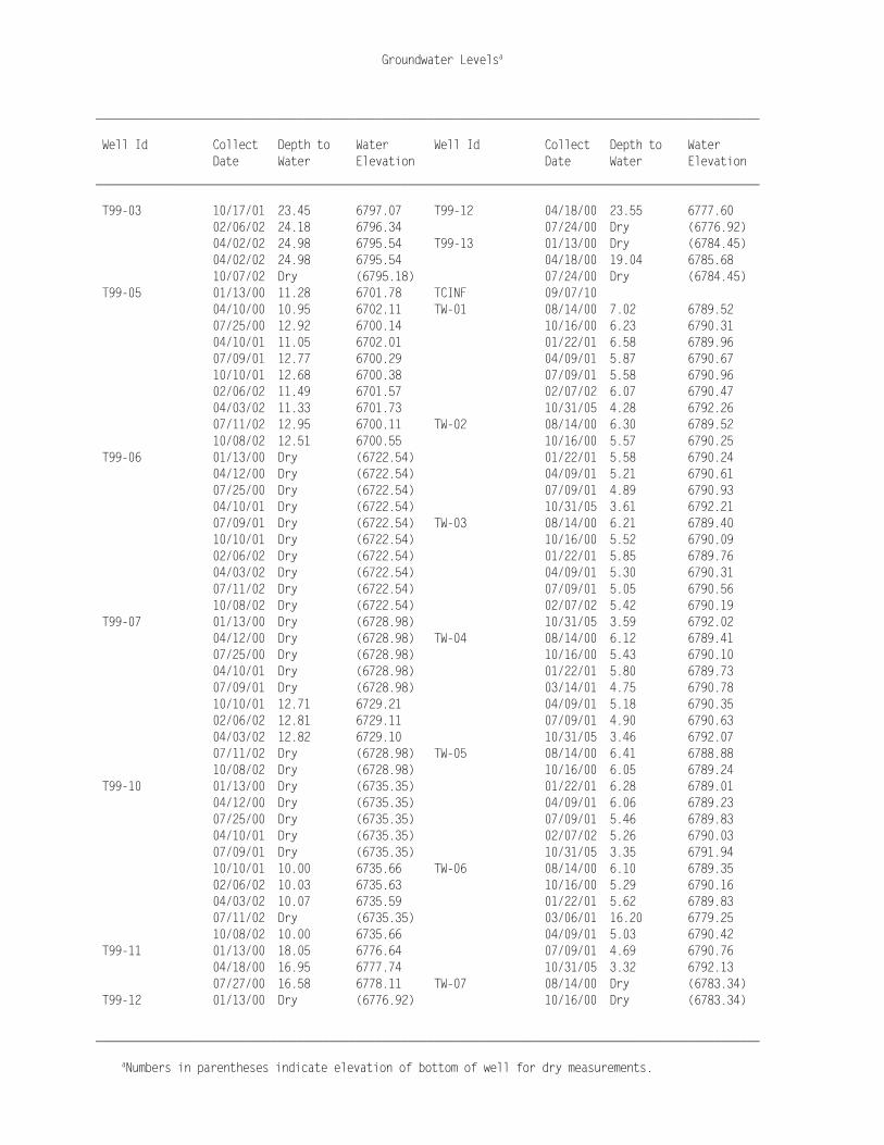
Groundwater Levelsa
______________________________________________________________________________________________________
aNumbers in parentheses indicate elevation of bottom of well for dry measurements.
______________________________________________________________________________________________________ Well Id Collect Depth to Water Well Id Collect Depth to Water Date Water Elevation Date Water Elevation ______________________________________________________________________________________________________ T99-03 10/17/01 23.45 6797.07 T99-12 04/18/00 23.55 6777.60 02/06/02 24.18 6796.34 07/24/00 Dry (6776.92) 04/02/02 24.98 6795.54 T99-13 01/13/00 Dry (6784.45) 04/02/02 24.98 6795.54 04/18/00 19.04 6785.68 10/07/02 Dry (6795.18) 07/24/00 Dry (6784.45) T99-05 01/13/00 11.28 6701.78 TCINF 09/07/10 04/10/00 10.95 6702.11 TW-01 08/14/00 7.02 6789.52 07/25/00 12.92 6700.14 10/16/00 6.23 6790.31 04/10/01 11.05 6702.01 01/22/01 6.58 6789.96 07/09/01 12.77 6700.29 04/09/01 5.87 6790.67 10/10/01 12.68 6700.38 07/09/01 5.58 6790.96 02/06/02 11.49 6701.57 02/07/02 6.07 6790.47 04/03/02 11.33 6701.73 10/31/05 4.28 6792.26 07/11/02 12.95 6700.11 TW-02 08/14/00 6.30 6789.52 10/08/02 12.51 6700.55 10/16/00 5.57 6790.25 T99-06 01/13/00 Dry (6722.54) 01/22/01 5.58 6790.24 04/12/00 Dry (6722.54) 04/09/01 5.21 6790.61 07/25/00 Dry (6722.54) 07/09/01 4.89 6790.93 04/10/01 Dry (6722.54) 10/31/05 3.61 6792.21 07/09/01 Dry (6722.54) TW-03 08/14/00 6.21 6789.40 10/10/01 Dry (6722.54) 10/16/00 5.52 6790.09 02/06/02 Dry (6722.54) 01/22/01 5.85 6789.76 04/03/02 Dry (6722.54) 04/09/01 5.30 6790.31 07/11/02 Dry (6722.54) 07/09/01 5.05 6790.56 10/08/02 Dry (6722.54) 02/07/02 5.42 6790.19 T99-07 01/13/00 Dry (6728.98) 10/31/05 3.59 6792.02 04/12/00 Dry (6728.98) TW-04 08/14/00 6.12 6789.41 07/25/00 Dry (6728.98) 10/16/00 5.43 6790.10 04/10/01 Dry (6728.98) 01/22/01 5.80 6789.73 07/09/01 Dry (6728.98) 03/14/01 4.75 6790.78 10/10/01 12.71 6729.21 04/09/01 5.18 6790.35 02/06/02 12.81 6729.11 07/09/01 4.90 6790.63 04/03/02 12.82 6729.10 10/31/05 3.46 6792.07 07/11/02 Dry (6728.98) TW-05 08/14/00 6.41 6788.88 10/08/02 Dry (6728.98) 10/16/00 6.05 6789.24 T99-10 01/13/00 Dry (6735.35) 01/22/01 6.28 6789.01 04/12/00 Dry (6735.35) 04/09/01 6.06 6789.23 07/25/00 Dry (6735.35) 07/09/01 5.46 6789.83 04/10/01 Dry (6735.35) 02/07/02 5.26 6790.03 07/09/01 Dry (6735.35) 10/31/05 3.35 6791.94 10/10/01 10.00 6735.66 TW-06 08/14/00 6.10 6789.35 02/06/02 10.03 6735.63 10/16/00 5.29 6790.16 04/03/02 10.07 6735.59 01/22/01 5.62 6789.83 07/11/02 Dry (6735.35) 03/06/01 16.20 6779.25 10/08/02 10.00 6735.66 04/09/01 5.03 6790.42 T99-11 01/13/00 18.05 6776.64 07/09/01 4.69 6790.76 04/18/00 16.95 6777.74 10/31/05 3.32 6792.13 07/27/00 16.58 6778.11 TW-07 08/14/00 Dry (6783.34) T99-12 01/13/00 Dry (6776.92) 10/16/00 Dry (6783.34)
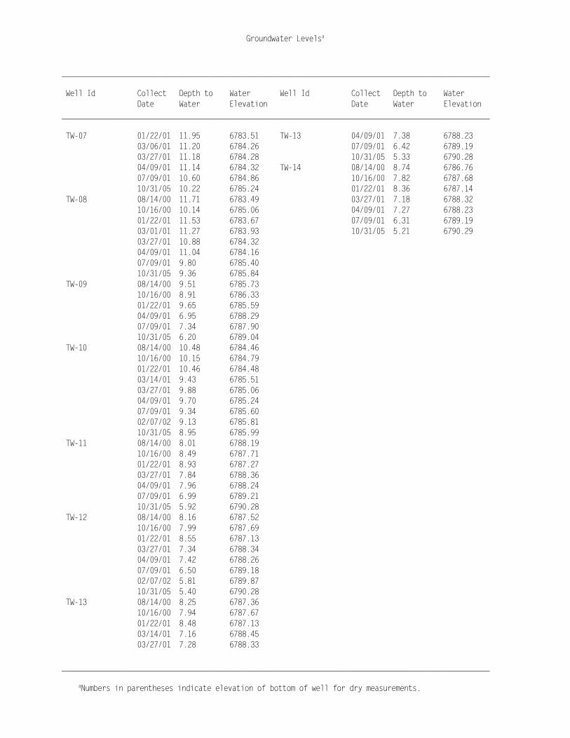
Groundwater Levelsa
______________________________________________________________________________________________________
aNumbers in parentheses indicate elevation of bottom of well for dry measurements.
______________________________________________________________________________________________________ Well Id Collect Depth to Water Well Id Collect Depth to Water Date Water Elevation Date Water Elevation ______________________________________________________________________________________________________ TW-07 01/22/01 11.95 6783.51 TW-13 04/09/01 7.38 6788.23 03/06/01 11.20 6784.26 07/09/01 6.42 6789.19 03/27/01 11.18 6784.28 10/31/05 5.33 6790.28 04/09/01 11.14 6784.32 TW-14 08/14/00 8.74 6786.76 07/09/01 10.60 6784.86 10/16/00 7.82 6787.68 10/31/05 10.22 6785.24 01/22/01 8.36 6787.14 TW-08 08/14/00 11.71 6783.49 03/27/01 7.18 6788.32 10/16/00 10.14 6785.06 04/09/01 7.27 6788.23 01/22/01 11.53 6783.67 07/09/01 6.31 6789.19 03/01/01 11.27 6783.93 10/31/05 5.21 6790.29 03/27/01 10.88 6784.32 04/09/01 11.04 6784.16 07/09/01 9.80 6785.40 10/31/05 9.36 6785.84 TW-09 08/14/00 9.51 6785.73 10/16/00 8.91 6786.33 01/22/01 9.65 6785.59 04/09/01 6.95 6788.29 07/09/01 7.34 6787.90 10/31/05 6.20 6789.04 TW-10 08/14/00 10.48 6784.46 10/16/00 10.15 6784.79 01/22/01 10.46 6784.48 03/14/01 9.43 6785.51 03/27/01 9.88 6785.06 04/09/01 9.70 6785.24 07/09/01 9.34 6785.60 02/07/02 9.13 6785.81 10/31/05 8.95 6785.99 TW-11 08/14/00 8.01 6788.19 10/16/00 8.49 6787.71 01/22/01 8.93 6787.27 03/27/01 7.84 6788.36 04/09/01 7.96 6788.24 07/09/01 6.99 6789.21 10/31/05 5.92 6790.28 TW-12 08/14/00 8.16 6787.52 10/16/00 7.99 6787.69 01/22/01 8.55 6787.13 03/27/01 7.34 6788.34 04/09/01 7.42 6788.26 07/09/01 6.50 6789.18 02/07/02 5.81 6789.87 10/31/05 5.40 6790.28 TW-13 08/14/00 8.25 6787.36 10/16/00 7.94 6787.67 01/22/01 8.48 6787.13 03/14/01 7.16 6788.45 03/27/01 7.28 6788.33


