15
Appendix E - Habitat Descriptions
Appendix E - Habitat Descriptions

Appendix E – Habitat Descriptions
1
RAAF Base Tindal PFAS ERA
Site (Tindal) Vegetation Habitat characteristicsKatherine River (Donkey Camp)
Katherine River at Donkey Camp weirpool (Power and Water intakestation).
Fish and vegetation: KR_Donkey_01,Dec 2017.
Melaleuca Open Forest: Melaleucaleucadendra, Melaleuca argentea, Melaleucacajuputi, Pandanus spiralis, Barringtoniaacutangula, Pandanus aquaticus, Germainiatruncatiglumis, Vetiveria spp., Pseudoraphisspinescens.
Dominant flora:
• Barringtonia acutangula (FreshwaterMangrove)
• Melaleuca argentea (Silver-leavedPaperbark)
• Pandanus aquaticus (River Pandanus)
This permanent freshwater pool was created by a concrete weir built for waterstorage. The pool was approximately 140 m wide near the weir and extends 10 kmupstream. The channel was typically 40-70 m wide. The pool depth during dryseason flows was probably less than 4 m. Aquatic habitat was abundant, withsnags, overhanging vegetation, deep water and shallow rock bars. However, fewerfish were observed during electrofishing of this pool when compared todownstream reaches, possibly due to operation constraints in low conductivity anddeep water. Although the weir is a low-flow barrier to fish movement, during thewet season the weir can be completely inundated, which allows fish andmacroinvertebrates (e.g. Cherabin) to freely migrate upstream. Fish samplingtargeted the shallow edges, plus the centre of channel and shallow rock bars. Thisextended from the weir to about 1.3 km upstream.
Riparian vegetation was comprised of a dense row of Paperbark, Pandanus andFreshwater Mangrove. The steep sandy bank supported a 50 m wide ripariancorridor on each bank, that is reasonably intact upstream to the Katherine Gorge.

Appendix E – Habitat Descriptions
2
RAAF Base Tindal PFAS ERA
Site (Tindal) Vegetation Habitat characteristicsKatherine River (Highway)
Pool upstream and downstream ofStuart Hwy crossing.
Fish: KR1 from near Second Street toold railway crossing, April 2017.
Fish: KR2 in line with Condon Ave,April 2017.
Fish: Stuart Hwy Ramp from boatramp to 800 m downstream,September 2017.
Melaleuca Open Forest: Melaleucaleucadendra, Melaleuca argentea, Melaleucacajuputi, Pandanus spiralis, Barringtoniaacutangula, Pandanus aquaticus, Germainiatruncatiglumis, Vetiveria spp., Pseudoraphisspinescens.
Dominant flora:
• Barringtonia acutangula (FreshwaterMangrove)
• Bauhinia cunninghamii (Bauhinia)• Corymbia bella (Ghost Gum)• Ficus racemosa (Cluster Fig)• Flagellaria indica (Flagellaria)• Livistona humilis (Sand Palm)• Lophostemon grandiforus subsp. riparius
(Swamp Box)• Melaleuca argentea (Silver-leaved
Paperbark)• Melaleuca leucadendra (Weeping Paperbark)• Melaleuca viridiflora (Broad-leaved
Paperbark)• Nauclea orientalis (Leichardt Pine)• Pandanus aquaticus (River Pandanus)
This permanent freshwater pool is created by a concrete weir at the Low LevelCrossing, about 3.5 km downstream of the Stuart Highway crossing. Aquatichabitat in this pool was abundant, with many large snags, overhanging vegetationand open water. The channel width and depth was approximately 40 m and 2-4 m,respectively.
Although the weir is a low-flow barrier to fish movement, during the wet season theweir can be completely inundated, which allows fish and macroinvertebrates (e.g.Cherabin) to freely migrate upstream. Three surveys were conducted from thebank and boat, with the boat targeting snags and overhanging vegetation from theboat ramp to about 800 m downstream.
Riparian vegetation was typical of the river, with Paperbarks, Figs, FreshwaterMangrove and Pandanus close to the water, and large Lophostemon, Leicharchtand Corymbia trees higher up the bank. The riparian corridor covered a two-tieredbank, about 120 m wide on the left and 40 m on the right (when facingdownstream). This green belt was relatively contiguous for the entire study areaand beyond, proving a good movement corridor for native fauna. It appeared inreasonable condition, with several age classes and only minor weed growth arounddisturbed areas.

Appendix E – Habitat Descriptions
3
RAAF Base Tindal PFAS ERA
Site (Tindal) Vegetation Habitat characteristics
Katherine River (Highway)

Appendix E – Habitat Descriptions
4
RAAF Base Tindal PFAS ERA
Site (Tindal) Vegetation Habitat characteristicsKatherine River (Low Level)
Both sides of Zimin Drive (Low LevelCrossing).Fish: KR3, April 2017.
Melaleuca Open Forest: Melaleucaleucadendra, Melaleuca argentea, Melaleucacajuputi, Pandanus spiralis, Barringtoniaacutangula, Pandanus aquaticus, Germainiatruncatiglumis, Vetiveria spp., Pseudoraphisspinescens.
Dominant flora:
• Acacia auriculiformis (Northern Black Wattle)• Barringtonia acutangula (Freshwater
Mangrove)• Ficus racemosa (Cluster Fig)• Flagellaria indica (Flagellaria)• Melaleuca leucadendra (Weeping
Paperbark)• Nauclea orientalis (Leichardt Pine)
• Pandanus aquaticus (River Pandanus)• Pandanus spiralis (Pandanus)
This permanent freshwater reach includes the transitions from a weir-pool tounregulated channel downstream. At the time of survey (wet season) the weir wasinundated and flooded into adjacent backwater pools. Aquatic habitat wasabundant, with many large snags, overhanging vegetation and open water. Thechannel width and depth was approximately 40 m and 2-4 m, respectively.
Although the weir is a low-flow barrier to fish movement, during the wet season theweir can be completely inundated, which allows fish and macroinvertebrates (e.g.Cherabin) to freely migrate upstream. One wet season survey was conducted fromthe bank, targeting backwater pools (stagnant), back-eddies around instream treesbelow the weir (slow flowing) and centre of channel downstream of the weir (fastflowing). Although fish are known to congregate at the base of instream barriers,the high wet season flow created deep water conditions and connectivity across theweir.
Dominant riparian vegetation varied from Pandanus upstream of the weir toPaperbark forest downstream. Other species are typical of the entire river, withFigs, Freshwater Mangrove, Leichardt and Black Wattle trees. The riparian zoneforms a relatively contiguous green belt along the river, generally 80-100 m wide oneach side. This width helps support movement of native fauna trough a rurallandscape.

Appendix E – Habitat Descriptions
5
RAAF Base Tindal PFAS ERA
Site (Tindal) Vegetation Habitat characteristicsKatherine River (Novus)
From Novus Quarry to 1 km upstreamof Tindal Creek.Fish and vegetation: KR_Novus_02,Dec 2017.
Melaleuca Open Forest: Melaleucaleucadendra, Melaleuca argentea, Melaleucacajuputi, Pandanus spiralis, Barringtoniaacutangula, Pandanus aquaticus, Germainiatruncatiglumis, Vetiveria spp., Pseudoraphisspinescens.Dominant flora:• Barringtonia acutangula (Freshwater
Mangrove)• Blyxa sp. (Blyxa)• Eleocharis sp. (Eleocharis)• Melaleuca leucadendra (Weeping
Paperbark)
• Pandanus aquaticus (River Pandanus)• Pandanus spiralis (Pandanus)
This permanent freshwater reach had a deep and wide channel with very slow-moving water. Fish surveys were conducted from the informal boat launch offNovus Quarry to approximately 1 km upstream near the sewerage treatmentponds.
Aquatic habitat was abundant, including undercut banks, overhanging riparianvegetation and open water and large woody debris. The channel was typically 50m wide and >3 m deep. Shallow sand bars occasionally occurred on inner bends.Fish were commonly found around snags and at the confluence with Tindal Creek.
The large sandy banks support a wide riparian zone (up to 120 m wide on eachside) leading to a staggered rural landscape on the upper flood terrace. Thispermanent water and dense riparian forest would support a variety of fauna eitherusing the area for foraging or navigation.

Appendix E – Habitat Descriptions
6
RAAF Base Tindal PFAS ERA
Site (Tindal) Vegetation Habitat characteristicsKatherine River (Galloping Jacks)
Near Cossack Rd, from GallopingJacks to 1.3 km downstream.Fish: d/s Galloping Jacks,September 2017.
Melaleuca Open Forest: Melaleucaleucadendra, Melaleuca argentea, Melaleucacajuputi, Pandanus spiralis, Barringtoniaacutangula, Pandanus aquaticus, Germainiatruncatiglumis, Vetiveria spp., Pseudoraphisspinescens.
Dominant flora:
• Barringtonia acutangula (FreshwaterMangrove)
• Eleocharis sp. (Eleocharis)• Melaleuca argentea (Silver-leaved
Paperbark)• Melaleuca leucadendra (Weeping
Paperbark)
• Pandanus aquaticus (River Pandanus)• Pandanus spiralis (Pandanus)• Syzygium forte (White Apple)
This permanent freshwater reach is a shallow bedrock channel with slow-to-fastflowing water most of the year. Fish surveys were conducted from the informalboat launch at Galloping Jacks to approximately 1.3 km downstream at a pointwhere a riffle restricted boat access.
Aquatic habitat was abundant and variable, including shallow rock bars,gravel/sand bars, undercut banks, overhanging riparian vegetation and open water.The channel was typically 25-40 m wide and 1-4 m deep. Rocky riffles and runsoccur upstream and downstream of the survey area, but the permanent flowsallowed adequate fish passage.
The large sandy banks support a wide riparian zone (50-100 m on each side)leading to a rural landscape on the right bank. Land adjacent to the left bank isuncleared. This permanent water and dense riparian forest would support a varietyof fauna either using the area for foraging or navigation.
Appendix E – Habitat Descriptions
7
RAAF Base Tindal PFAS ERA
Site (Tindal) Vegetation Habitat characteristicsTindal Creek (upper)
Tindal Creek from Tarakan Road to 1km upstream near dirt track.
Fish: TC2 either side of TarakanRoad, April 2017.
Fish: TC3 either side of dirt trackabout 1 km upstream of TarakanRoad, April 2017.
Terrestrial invertebrates: Tin_02_Tdownstream side of Tarakan Road,Nov 2018.
Terrestrial vertebrates: Tin_02_Tdownstream of dirt track, from nearchannel to 200 m away fromwaterway, May 2018..
Eucalyptus Woodland: Eucalyptus tectifica,Erythrophleum chlorostachys, Corymbia latifolia,Erythrophleum chlorostachys, Terminaliaferdinandiana, Petalostigma pubescens,Sorghum spp., Heteropogon triticeus,Chrysopogon fallax.
Dominant flora:
• Acacia holosericea (Silver Wattle)• Antidesma ghaesembilla (Antidesma)• Azadirachta indica (Neem)*• Bauhinia malabarica (Bauhinia)• Eucalyptus tetrodonta (Darwin Stringybark)• Heteropogon sp. (Black Speargrass)• Hyptis suaveolens (Hyptis)*• Lophostemon grandiforus subsp. riparius
(Swamp Box)• Terminalia platyphylla (Wild Plum)
This ephemeral creek originates within the base and exits beneath the main sealedroad to the airport (Tarakan Rd). The channel is typically 2-8 m wide and <1 mdeep and alternates between pool-riffle-run habitats, except at the road crossingwhere the channel broadens into shallow pools on each side. Fish surveys wereconducted at two locations, around the sealed road crossing and small dirt trackcrossing further upstream. Terrestrial invertebrates were sampled downstream ofthe sealed road, whilst terrestrial vertebrates were sampled around the dirt track (1km upstream).
Aquatic habitat is abundant with small refuge pools, sinuous channel, overhangingvegetation and large woody debris. Sediment varied from sand/gravel to boulders.Fish were observed across all habitat types, but were only comprised of a smallnumber of species (two fish and one crustacean).
Riparian vegetation was intact and varied in width from 5-30 m on each side.Regeneration appeared successful with various age classes and diverse tree andshrub species. Groundcover varied between dense leaf litter to dense savannagrasses, depending on canopy cover. The riparian vegetation would provide agood movement corridor through the woodland, and in denser portions provide acooler refuge and protection from grass fires.

Appendix E – Habitat Descriptions
8
RAAF Base Tindal PFAS ERA
Site (Tindal) Vegetation Habitat characteristicsTindalCreek(upper)

Appendix E – Habitat Descriptions
9
RAAF Base Tindal PFAS ERA
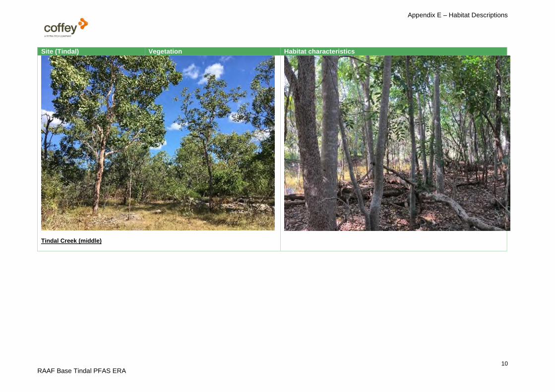
Site (Tindal) Vegetation Habitat characteristicsTindal Creek (middle)
Tindal Creek downstream of StuartHwy (between Burt Nixon Dr andBuyers Rd) and upstream of UrallaRd.
Fish: TC1, April 2017.
Terrestrial invertebrates: Tin-01-TUralla Road, north side of creek, Nov2017.
Terrestrial vertebrates: Tin-01-TUralla Road, south side of creek, May2018.
Eucalyptus Woodland: Eucalyptus tectifica,Erythrophleum chlorostachys, Corymbia latifolia,Erythrophleum chlorostachys, Terminaliaferdinandiana, Petalostigma pubescens,Sorghum spp., Heteropogon triticeus,Chrysopogon fallax.
Dominant flora:
• Azadirachta indica (Neem)*• Cupaniiopsis anacardioides (Tamarind)• Delonix regina (Poinciana)• Ficus racemosa (Cluster Fig)• Lophostemon grandiforus subsp. riparius
(Swamp Box)
This ephemeral reach travels from the Stuart Highway to Uralla Road. Fishsurveys were conducted from the Stuart Highway to an old rail crossing about 70 mdownstream. Surveys targeted deep pools, open channel and shallow edges nearoverhanging vegetation. Aquatic habitat was a long shallow pool, approximately 12m wide and 1 m deep. At the time of survey, the highway culvert was not creatinga barrier to fish passage, and it is expected fish could freely migrate 10 km in eitherdirection when flows are sufficient. Habitat was enhanced by a narrow band ofoverhanging riparian trees and scattered instream woody debris.
Terrestrial surveys were conducted upstream of Uralla Road, in a dense riparianforest between rural residential blocks. Here the creek had a broad floodplain witha single sand/gravel channel amongst bedrock.
The riparian zone was narrow and partially disturbed given the nearby roads,development and possible channel realignment in parts. The surrounding bushlandwas dense-to-moderate woodland with patches of cleared land for horticulture,residential and grazing. Although disturbed, the riparian zone and woodlandconnects other areas of better habitat, therefore proving an important movementcorridor alongside water.
Appendix E – Habitat Descriptions
10
RAAF Base Tindal PFAS ERA
Site (Tindal) Vegetation Habitat characteristics
Tindal Creek (middle)

Appendix E – Habitat Descriptions
11
RAAF Base Tindal PFAS ERA
Site (Tindal) Vegetation Habitat characteristicsTindal Creek (lower)
Fish: TC4 from Tindal Creek falls toKatherine River, April 2017.
Eucalyptus Woodland: Eucalyptus tectifica,Erythrophleum chlorostachys, Corymbia latifolia,Erythrophleum chlorostachys, Terminaliaferdinandiana, Petalostigma pubescens,Sorghum spp., Heteropogon triticeus,Chrysopogon fallax.
Dominant flora:
• Barringtonia acutangula (FreshwaterMangrove)
• Corymbia bella (Ghost Gum)• Flagellaria indica (Flagellaria)• Melaleuca leucadendra (Weeping
Paperbark)
This ephemeral creek transitions from a fast-moving bedrock channel (3 m wide by0.5 m deep), stepped water fall (>3 m in height) and backwater pool (5 m wide by<2 m deep) connected to the Katherine River. Fish surveys were conducted from abackwater pool immediately upstream of the falls to near the confluence of theKatherine River. Surveys targeted snags and overhanging vegetation plus openwater. Locals were observed fishing in the pool below the falls. Steep slipperybanks prevented foot access to most of the reach, so locals would focus on thepool.
Aquatic habitat was limited upstream due to the fast-moving shallow water abovethe falls. The pool at the base of the falls provided the best habitat as water wasdeep and aerated. Large overhanging trees and large woody debris werecommon. Fish species present are likely those that move in and out of theKatherine River when flows allow. The falls pose a barrier to fish migration, and itis likely most species are only able to travel upstream when backwater fromKatherine River pushes up the falls.
Riparian vegetation was mostly intact, besides some weeds and clearing around aninformal vehicle track. The area forms part of the general Katherine River ripariancorridor, which extends for the entire river length.

Appendix E – Habitat Descriptions
12
RAAF Base Tindal PFAS ERA
Site (Tindal) Vegetation Habitat characteristicsFire training area
Tindal Defence Base near fire trainingarea.
Terrestrial invertebrates: Tin-03-T,Nov 2017.
Terrestrial vertebrates: Tin-03-T, May2018.
Eucalyptus Woodland: Eucalyptus tectifica,Erythrophleum chlorostachys, Corymbia latifolia,Erythrophleum chlorostachys, Terminaliaferdinandiana, Petalostigma pubescens,Sorghum spp., Heteropogon triticeus,Chrysopogon fallax.
Dominant flora:
• Erythrophleum chlorostachys (Ironwood)• Eucalyptus tectifica (Grey Box)• Planchonia careya (Cocky Apple)• Sorghum spp.• Terminalia ferdinandianai (billy goat plum)
This woodland area surrounds the fire training area. Terrestrial fauna weresampled from a low-lying clay flat north of the bunded area, and a slightly elevatedsavanna forest to the south-east of the road. The first location had a sparsecanopy with a dominant grassy understorey, whilst the second location supported adenser Eucalypt woodland. Several depressions were observed that would collectdrainage from the road and cleared training ground. These depressions had smallscattered burrows inhabited by Austrothelphusa transversa (Inland FreshwaterCrab) (captured in a pitfall trap), even though the nearest waterway was over 700m away. This indicates this species is able to disperse across the woodland viawetted depressions and small drainage gullies.
The vegetation appeared to be in reasonable condition with minor weed invasionaround cleared areas. Tree recruitment was evident, but large trees and hollowswere sparse. Habitat is this area was mostly suited to small reptiles andamphibians that depend on leaf litter, bark fissures and logs. Where the canopywas thin, the grass cover and shrubs provide good shelter and foraging habitat forground mammals, such as Bandicoots and rodents.
The woodland was part of a much larger and contiguous community, with only thebase impacting natural habitat within a 5 km radius. Fauna are able to move freelythroughout the woodland and access alternative habitats, Tindal Creek (900 south)and water treatment ponds (200 m south).

Appendix E – Habitat Descriptions
13
RAAF Base Tindal PFAS ERA
Site (Tindal) Vegetation Habitat characteristicsBase (east)
Tindal Defence Base east near StuartHwy.
Terrestrial invertebrates: Tin-04-T,Nov 2017.
Terrestrial vertebrates: Tin-04-T, May2018.
Corymbia Woodland: Corymbiadichromophloia, Eucalyptus tetrodonta,Erythrophleum chlorostachys, Erythrophleumchlorostachys, Eucalyptus tetrodonta, Crotonarnhemicus, Sorghum intrans, Heteropogontriticeus, Themeda triandra.
Dominant flora:
• Acacia holosericea (Silver Wattle)• Bauhinia cunninghamii (Bauhinia)• Calotropis procera (Rubber Bush)*• Corymbia dichromophloia (Variable-barked
Bloodwood)• Erythrophleum chlorostachys (Ironwood)• Eucalyptus miniata (Darwin woollybutt)• Eucalyptus tetrodonta (Darwin Stringybark)• Terminalia ferdinandianai (billy goat plum)
This woodland area lies east of the base alongside the Stuart Highway. Thecommunity is characterised by scattered Corymbia and Eucalyptus trees with adominant grassy understorey. The red soils were shallow over rock flats, with theoccasional rocky outcrop. Small dense patches of Bauhmea occurred on black soilpatches within the woodland. This habitat diversity would benefit small reptiles andmammals, which otherwise rely on logs and bark fissures for shelter. Woodlandbirds are common throughout these habitat types.
The woodland appeared intact, with only minor disturbance from the track andoccasional groundcover weeds. The woodland was part of a much larger andcontiguous community, with the highway and cleared land 600 m to the east andthe base 2 km to the west. Fauna are able to move freely throughout the woodlandand access alternative habitats, such as extensive woodlands and small creeks 2km to the south.
* weed species

Appendix E – Habitat Descriptions
14
RAAF Base Tindal PFAS ERA
Vegetation community based on (NVIS 2005, Level 3: Wilson et al. 1990 and Brocklehurst & Lynch, 2009) and dominant flora (ELA observation)
References
Brock, J. (1995) Remnant vegetation survey: Darwin to Palmerston region. A Report to Greening Australia NT.
Brocklehurst, P. and Lynch, D. (2009) Melaleuca Survey of the Top End, Northern Territory. Technical Report No: 25/2009D. Department of Natural Resources,Environment, The Arts and Sport, Darwin, NT.
Eco Logical Australia (2012) Targeted Threatened Species Surveys and Vegetation Mapping: RAAF Darwin, Defence Establishment Berrimah and Shoal BayReceiving Station. Final Report for Department of Defence.
Wilson, B.A., Brocklehurst, P.S., Clark, M.J. & Dickinson, K.J.M. (1990) Vegetation Survey of the Northern Territory, Australia. Technical Report No. 49,Conservation Commission of the Northern Territory. Darwin, NT.


