24
FINAL DRAFT ETC Master Plan Appendix F Environmental Inventory and Evaluation

FINAL DRAFT ETC Master Plan
Appendix F Environmental Inventory and Evaluation
F‐1
FINAL DRAFT ETC Master Plan
Environmental Inventory and Evaluation
Introduction
A cursory‐level environmental inventory of existing conditions and a preliminary assessment of the project impacts was conducted for the for the Harmony Road ETC study area. The level of analysis performed for this project is commensurate with the requirements of the Federal Transit Administration (FTA) for Alternatives Analysis. The purpose of conducting the environmental inventory and evaluation was to develop an understanding of the existing physical opportunities and constraints of the corridor related to environmental resources. This information was used to inform the alternatives screening process and help determine which alternatives had physical limitations that could either eliminate an alternative from consideration or have an impact on an alternative’s cost and/or public acceptance due to resource conflicts. A summary of the environmental inventory and evaluation is provided below.
Methods
Environmental Inventory
The methods used to conduct the environmental inventory within the Harmony Road ETC study area included a desktop review of existing information, including existing geographic information system (GIS) data and available information from relevant agencies (e.g., City of Fort Collins, US Fish and Wildlife Service). A field visit was not performed as part of the preliminary environmental inventory. Mapping of the existing conditions within the study area is provided as an attachment to this appendix. The project team identified a list of resources potentially present within the study area to evaluate for the environmental inventory, including:
Noise Conditions
Air Quality
Historic Resources
Park and Recreation Resources
Hazardous Materials
Biological
Wetlands
Right‐of‐way
This list is not to be considered all‐inclusive and may be modified or adjusted as alternatives are developed during the implementation of any future projects. Environmental Evaluation
A preliminary environmental evaluation of the potential project impacts was performed using the widest potential alternative footprint for several “priority” resources that were identified in the study area. Environmental “priority” resources include the resources that could require avoidance or minimization of impacts during design and/or resources that can have lengthy environmental clearance processes. These resources were assessed to determine the potential impacts of the project.
F‐2
FINAL DRAFT ETC Master Plan
The following resources were identified as “priority” resources within the corridor:
Noise
Air Quality
Historic Resources
Park and Recreation Resources/Section 4(f) Resources
Hazardous Materials
Wetlands/Other Waters of the US
Priority Resources
The sections below describe the existing conditions for each of the “priority” resources, the results of a preliminary environmental evaluation of the potential project impacts (includes benefits) due to the project based on the widest potential alternative footprint, and the recommended next steps for any future NEPA process. Noise
Noise from transportation infrastructure can be a concern, primarily for sensitive receptors such as residences. Therefore, the overall purpose of this existing conditions analysis is to review sensitive receptors near the potential project improvements. Existing Conditions
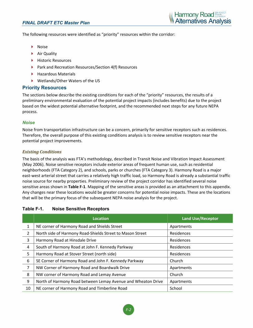
The basis of the analysis was FTA’s methodology, described in Transit Noise and Vibration Impact Assessment (May 2006). Noise sensitive receptors include exterior areas of frequent human use, such as residential neighborhoods (FTA Category 2), and schools, parks or churches (FTA Category 3). Harmony Road is a major east‐west arterial street that carries a relatively high traffic load, so Harmony Road is already a substantial traffic noise source for nearby properties. Preliminary review of the project corridor has identified several noise sensitive areas shown in Table F‐1. Mapping of the sensitive areas is provided as an attachment to this appendix. Any changes near these locations would be greater concerns for potential noise impacts. These are the locations that will be the primary focus of the subsequent NEPA noise analysis for the project. Table F-1. Noise Sensitive Receptors
Location Land Use/Receptor
1 NE corner of Harmony Road and Shields Street Apartments
2 North side of Harmony Road‐Shields Street to Mason Street Residences
3 Harmony Road at Hinsdale Drive Residences
4 South of Harmony Road at John F. Kennedy Parkway Residences
5 Harmony Road at Stover Street (north side) Residences
6 SE Corner of Harmony Road and John F. Kennedy Parkway Church
7 NW Corner of Harmony Road and Boardwalk Drive Apartments
8 NW corner of Harmony Road and Lemay Avenue Church
9 North of Harmony Road between Lemay Avenue and Wheaton Drive Apartments
10 NE corner of Harmony Road and Timberline Road School

F‐3
FINAL DRAFT ETC Master Plan
Noise Evaluation
The FTA methods do not include or recognize noise impacts under existing conditions, so no further noise analysis is needed now. The FTA methods look at the change in noise conditions that would be produced by the proposed action. For the purposes of alternative selection, the best alternatives in noise terms reduce or minimize transportation noise to the sensitive receptors along the corridor. Actions that could reduce noise to sensitive receptors include narrowing the roadway, removing vehicles, slower vehicle speeds, or fewer stopping and starting vehicles. Actions that increase noise levels, such as widening roads near houses, are more likely to cause noise impacts. Next Steps
A project noise analysis would typically be completed during the NEPA process and would be required to follow FTA methods (FTA, 2006). Federal Highway Administration methods may be added, if needed. The general process under FTA guidance is as follows. The various components of the Preferred Alternative will undergo noise screening to determine whether a General Assessment and/or Detailed Analysis is needed. If the alternative passes the noise screening, no noise impacts or abatement actions will be associated with the alternative and the analysis is done. If the alternative fails the noise screening, a noise evaluation will be performed to determine whether the Preferred Alternative will cause any noise impacts and, if so, whether noise abatement actions are needed. Air Quality
The Clean Air Act of 1970 and its amendments led to the establishment by the Environmental Protection Agency (EPA) of the National Ambient Air Quality Standards (NAAQS) for the six criteria air pollutants: carbon monoxide, sulfur dioxide, ozone, particulate matter, nitrogen dioxide and lead (Table F‐2). Motor vehicles are important contributors of carbon monoxide, ozone precursors, nitrogen dioxide and particulate matter. Table F-2. National Ambient Air Quality Standards (NAAQS)
Pollutant Averaging Time Primary Standard
Secondary Standard
Carbon Monoxide 8 hours 9 ppm Not applicable
1 hour 35 ppm Not applicable
Ozone 8 hours 0.075 ppm 0.075 ppm
Particulate Matter
<10 µm (PM10) 24 hours 150 µg/m3 150 µg/m3
<2.5 µm (PM2.5) Annual 12 µg/m3 15 µg/m3
24 hours 35 µg/m3 35 µg/m3
Nitrogen Dioxide Annual 53 ppb 53 ppb
1 hour 100 ppb Not applicable
Sulfur Dioxide 1 hour 75 ppb Not applicable
3 hours Not applicable 0.5 ppm
Lead 3 months 0.15 µg/m3 0.15 µg/m3 Note: ppb = parts per billion
ppm = parts per million
µg/m3 = micrograms per cubic meter
µm = micrometers

F‐4
FINAL DRAFT ETC Master Plan
Under the Clean Air Act, cities and regions were required to determine their compliance with the NAAQS. Areas that met the NAAQS were classified as attainment areas while areas that did not meet the NAAQS were classified as nonattainment. These classifications are long‐term and do not change often. Existing Conditions
The Fort Collins metropolitan area was classified as non‐attainment for carbon monoxide, but a number of successful air quality improvement actions led to reclassification by EPA as an attainment/maintenance area as of September 22, 2003, and a regional maintenance plan was developed. The corridor is entirely within the carbon monoxide maintenance area. Effective November 20, 2007, the entire Fort Collins metropolitan area is within the Denver regional non‐attainment area for the 8‐hour ozone NAAQS. The Fort Collins area is in attainment of the other NAAQS. Transportation has a direct impact on air quality and is an important contributor to carbon monoxide and ozone concentrations. Local air quality can be affected by a project that alters roadway lane configurations, traffic congestion, bus travel patterns or the movement of non‐transit motor vehicles by increasing the intersection delay times or by increasing the volume of vehicles at specific intersections. Sufficiently large projects can affect regional air quality, and regional air quality may be affected by changes in the transit system’s overall operations. Air Quality Evaluation
Increasing the volumes of vehicles or miles traveled can increase emissions of carbon monoxide and ozone precursors, but improved vehicular progression (reduced delay) through congested areas can reduce or offset those increases. Projects that reduce delays at intersections or improve vehicle speeds often have a side benefit of also reducing tailpipe emissions. The Preferred Alternative is expected to increase total miles of travel in the corridor by approximately 5 percent over No Action, but to the positive, corridor crossing time would decrease by approximately 13 percent and average corridor vehicle speeds would increase by approximately 17 percent. These improvements should reduce tailpipe emissions on the whole. Next steps
The typical next step would be to complete an air quality impact analysis for the Preferred Alternative. The regional analysis would be performed by the North Front Range Metropolitan Planning Organization through their conformity analysis for the Regional Transportation Plan (RTP). A regional conformity analysis must be completed through a future RTP amendment. A local analysis during future NEPA projects may consist of hot‐spot modeling for carbon monoxide concentrations at intersections or other locations where vehicle idling may result in higher concentrations. Through these analyses, it must be demonstrated that the air quality requirements can be achieved prior to implementation of the Preferred Alternative. Historic Resources
Section 106 of the National Historic Preservation Act (NHPA) requires federal agencies to consider the effects of their undertakings upon significant National Register of Historic Places listed or eligible historic properties. A historic resources review was conducted for this project that included a windshield survey by the City’s Historic Preservation staff. An overview of the designated historic resources and the resources potentially eligible for historic designation within the study area is provided below.

F‐5
FINAL DRAFT ETC Master Plan
Existing Conditions
The Harmony Corridor has been predominantly redeveloped over the last 20 years. However, the area was originally developed as an agricultural extension of Fort Collins during the late 19th century and also experienced various periods of development during the post‐World War II building boom. Some remaining buildings, dating to the late 19th and early 20th centuries, are representative of the area’s early agricultural heritage, and others relate to the postwar era in Fort Collins. Late 1800 and early 1900 sites
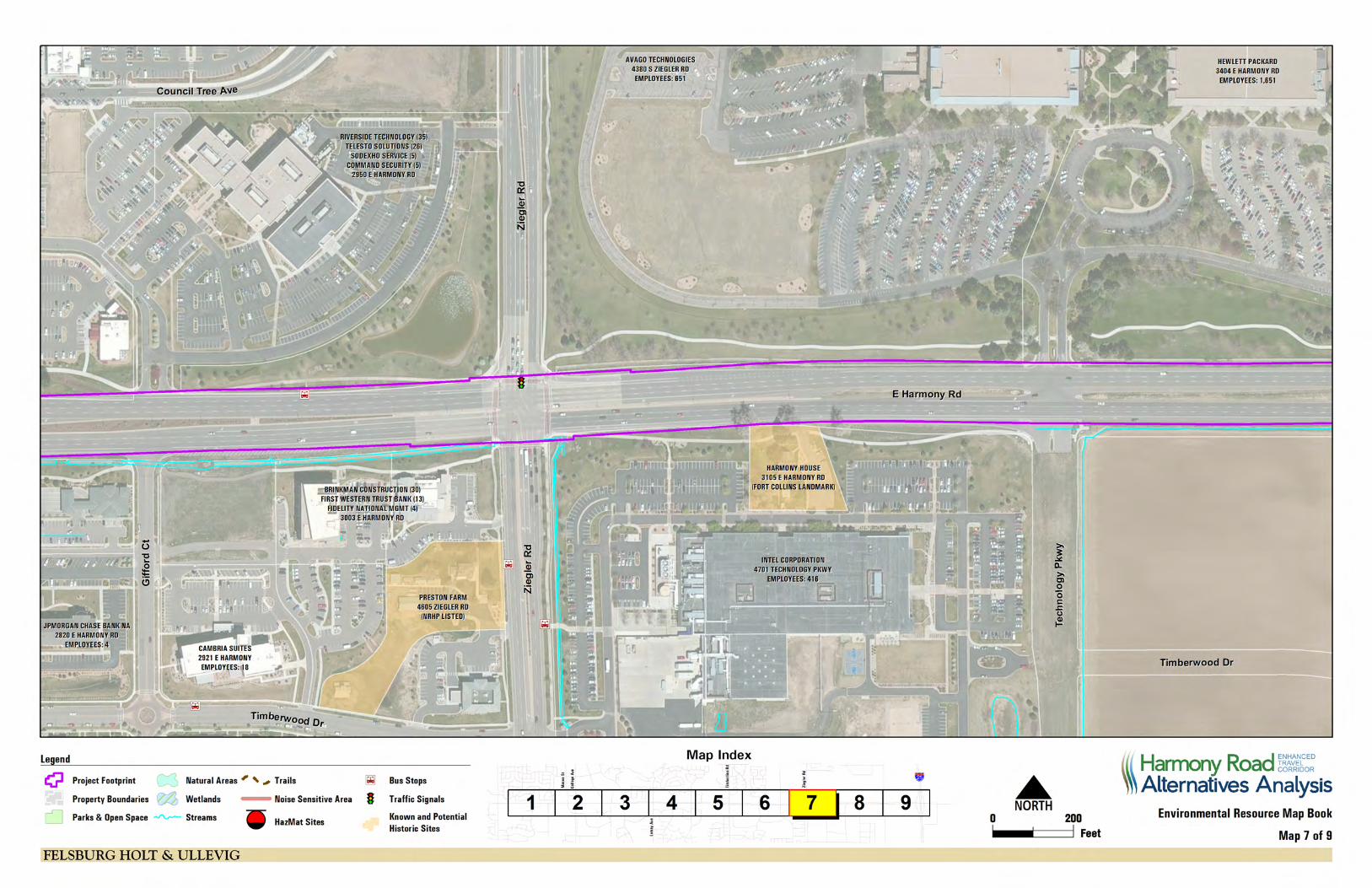
Three early agricultural complexes are still present along the corridor. The Harmony House and the Preston Farm have been integrated into new developments on the corridor, and the farmstead on the south side of Harmony, near Cinquefoil, is currently unused and vacant. The Preston Farm includes a primary residence and nine ancillary buildings, all of which have been designated as a Fort Collins Landmark district since 1998. All ancillary buildings have been relocated and are currently grouped at the corner of Harmony Road and Ziegler Road. The Harmony House, which remains in its original location, has not been formally designated but has been determined eligible for designation as a Fort Collins Landmark. Many of the outbuildings associated with the Harmony House have been removed or relocated. The third agricultural complex is located at the corner of Harmony Road and Cinquefoil Lane. From Harmony Road, it appears that five buildings remain on the site, the original home and four ancillary buildings, which have been vacant for many years and have never been reviewed for Landmark eligibility. In addition to the farmsteads, the Harmony School, remnants of the Harmony Store, and the Harmony Cemetery are also present on the corridor. These buildings also date to the area’s agricultural boom of the early 20th century. The Harmony School and its associated buildings, which sit at the corner of Harmony Road and Timberline Road, stand out as one of the most impressive historic resources along the corridor. They were designated as Fort Collins Landmarks in 1997. The original school house was built in 1878 and the larger
masonry school building was built in 1931 when the building was moved from its original location just west of the Harmony Cemetery. The larger building currently serves as a neighborhood pre‐school and day‐care facility and the original school house acts as a secondary building. The site of the original Harmony Store is across Timberline Road from the Harmony School. The original store building has been relocated from the site and at least two ancillary buildings remain. The remaining buildings are currently vacant and are located in a sensitive area in terms of any changes to the Harmony Road and Timberline Road intersection. All structures need current determinations of Landmark eligibility.
Farmstead south of Harmony Road near Cinquefoil
The Harmony School on the northeast corner of Harmony Road and Timberline Road.

F‐6
FINAL DRAFT ETC Master Plan
The Harmony Cemetery, located on the southeast quadrant of the intersection of Harmony Road and McMurry Avenue, is another site that dates to the area’s early agricultural heritage and is most likely eligible for either designation but needs a current determination of Landmark eligibility. Mid20th century sites
The Fairway Estates subdivision – located southeast of the intersection of Harmony Road and College Avenue – contains many buildings over 45 years old. None of the buildings within the subdivision have been evaluated for Landmark eligibility, nor has the subdivision been evaluated for eligibility as a Landmark District. Historic Resources Evaluation
The historic resources identified within the study area were further investigated through a review of aerial photography and overlay with the widest project footprint to determine potential impacts. A summary of the historic resources in the corridor and potential impacts is included in Table F‐3. Table F-3. Historic Resources within the Project Corridor
Resource Name Location Eligibility Status Potential Impact
Historic Cemetery Southeast corner of Harmony Rd. and McMurry Avenue
Needs a current determination of Landmark eligibility.
Although the project footprint is close to the property boundary, a direct impact appears to be avoided based on the conceptual design. Must be field verified.
Harmony Store – Ancillary Buildings
Northwest corner of Harmony Rd. and Timberline Rd.
Needs a current determination of Landmark eligibility.
Based on the conceptual design, the project footprint appears to encroach on this property. During later stages of design, it is recommended that options are considered to avoid this property.
Harmony School Northeast corner of Harmony Rd. and Timberline Rd.
Designated as Ft. Collins Landmarks in 1997.
In order to avoid impacting this Ft. Collins Landmark, the conceptual design was modified to avoid a direct impact to this property.
Preston Farm – Ancillary Buildings
Southwest corner of Harmony Rd. and Ziegler Rd.
Designated as Ft. Collins Landmarks in 1998.
Based on the conceptual design, the project footprint does not encroach on this property. No impact from conceptual design.
The Harmony Cemetery near Harmony Road and McMurry

F‐7
FINAL DRAFT ETC Master Plan
Resource Name Location Eligibility Status Potential Impact
Harmony House Southeast corner of Harmony Rd. and Ziegler Rd.
Not formally designated but determined eligible for designation as Ft. Collins Landmark.
Based on the conceptual design, the project footprint appears to encroach on the northwest corner of the property; however, this must be field confirmed. During later stages of design, it is recommended that options are considered to avoid this property.
Historic Farmstead Corner of Harmony Rd. and Cinquefoil Lane
Never reviewed for Ft. Collins Landmark eligibility.
Project footprint does not appear to encroach on property; however, this must be field confirmed. Based on conceptual design the future pedestrian underpass may impact this property; however, this must be field confirmed. During later stages of design, it is recommended that options are considered to avoid this property.
Fairway Estates Southeast corner or Harmony Rd. and College Ave.
Needs a current determination of Landmark eligibility.
Based on the conceptual design, the project footprint does not encroach on this property. No impact from conceptual design. Must be field verified.
Next steps
Based on the assumption that the funding source for any future corridor project would be federal‐based, any future NEPA process would require compliance with Section 106 of the NHPA, which requires federal agencies to consider the effects of their undertakings upon significant NRHP‐listed or eligible historic properties. It is recommended that avoidance and minimization of impacts to historic or potentially historic properties continue to be considered during preliminary and final design of the Preferred Alternative. Park and Recreation Resources
Parks and recreation resources are important community facilities that warrant consideration early in the planning process of projects that are potentially federally funded. These resources include parks, trails, and open space areas which offer opportunities for recreation, including both passive and active activities. For purposes of this preliminary analysis, park and recreational resources can be categorized as follows:
Regional Park and Recreational Facility – Regional parks typically involve jurisdiction partnerships that contribute to the development and maintenance of the regional park. These areas serve residents throughout the Front Range and are regionally recognized. Privately and publicly owned and managed golf courses in the corridor qualify as regional resources.
Community Park – These facilities are typically smaller in size than regional facilities and serve as an attraction for residents and communities within a closer area, about 3 miles, of the facility. Community parks are typically managed and maintained by one entity.

F‐8
FINAL DRAFT ETC Master Plan
Neighborhood Park – Neighborhood parks typically serve residents and community members within a 0.5 mile radius of the park. These parks are typically accessed by non‐motorized means and are managed by one jurisdiction.
Open Space – Open space areas include land and water parcels that remain in a predominantly natural or undeveloped state. The intention of open space acquisition varies from growth management to habitat protection and/or passive recreation. However, it must be noted that not all open space allows public access or use. Many areas defined as open space are used as conservation easements on agricultural lands. Smaller open space parcels are often coordinated with neighboring open space acquisitions to create buffers or corridors. Jurisdictional authority belongs to either the county open space department or municipal parks and recreation departments. In certain instances management and ownership may span multiple jurisdictions.
Trails – Municipalities typically manage numerous miles of trails, including paved and non‐paved trails. Trails often extend beyond one jurisdictional boundary into an adjacent boundary making them regional trails. It is typical for trails to follow existing linear features such as a ditch, river, or railroad.
Existing Conditions
Details and characteristics of existing parks and recreation resources in the corridor were identified through existing GIS information and are listed in Table F‐4. Additional inventory details about the resources, such as ownership, size and amenities were obtained from accessing individual property websites in February 2012. Research was centered on utilizing the most current version of information available online. Table F-4. Existing Park and Recreational Resources
Resource Name Size/Location Description of Property Resource
Type Managed by
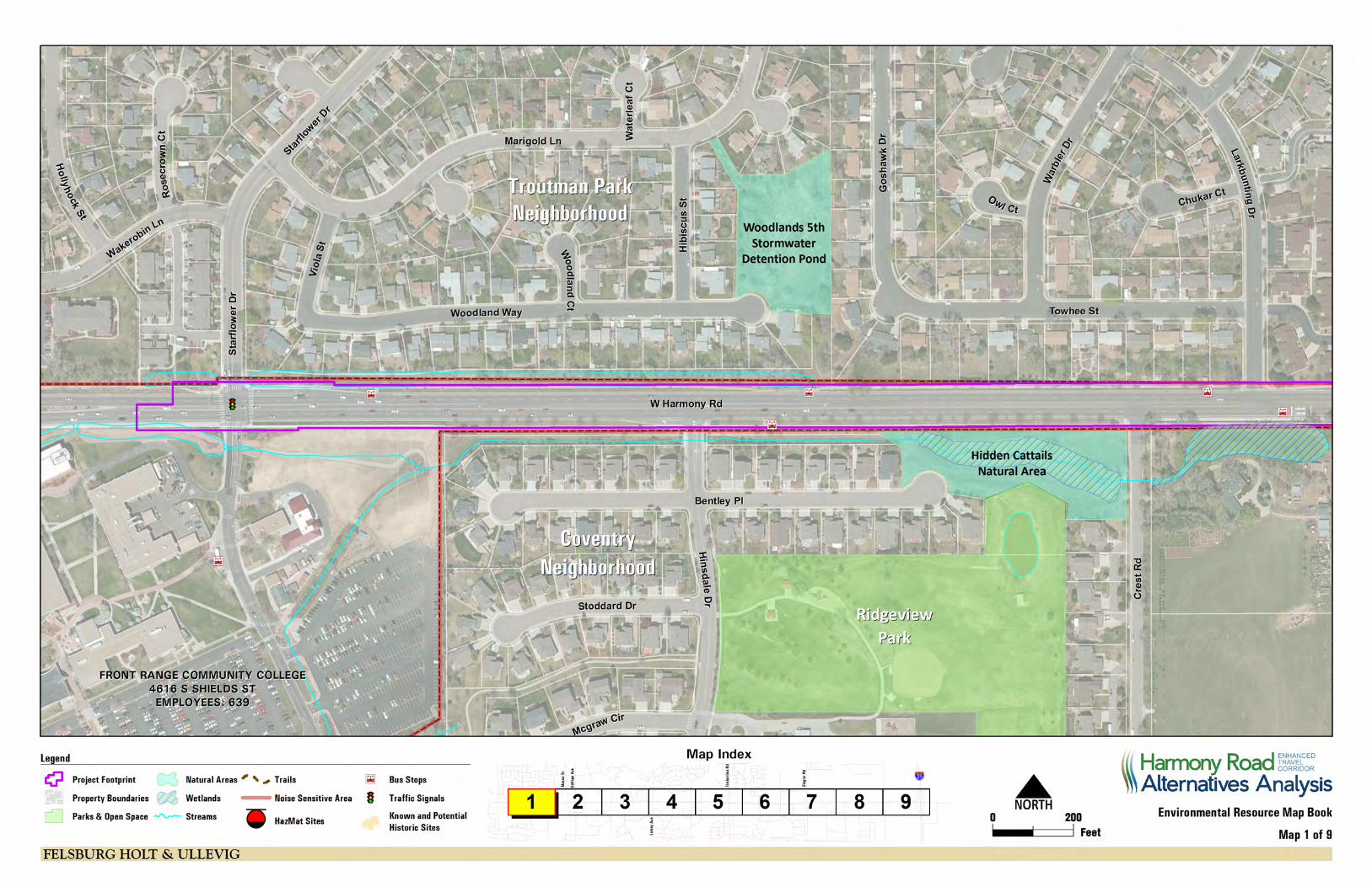
Hidden Cattails Natural Area
3 acres between College Avenue and Shields Street
Site has Mail Creek present and a small ponded area
Natural Area Homeowners
Association
Mason Trail Crosses Harmony Road west of Mason Street
3.5 mile trail connector adjacent to the BNSF Railway
Trail Fort Collins Streets Department
Power Trail Bike Trail
West side of UPRR to north of Harmony Road
3.9 mile paved trail. 10‐foot concrete trail and 5‐foot gravel path. Funding is Conservation Trust (Lottery) revenue
Trail Fort Collins
Arapaho Bend Natural Area
West of I‐25 at Strauss Cabin Road
Natural area with hiking, biking, equestrian, fishing, non‐motorized boating
Natural Area Fort Collins
Park and Recreational Resources Evaluation
Potential park and recreation resource impacts within the study area were investigated through a review of aerial photography and overlay with the widest potential project footprint. A summary of potential impacts to the park and recreational resources in the study area are included in Table F‐5.

F‐9
FINAL DRAFT ETC Master Plan
Table F-5. Potential Impacts to Park and Recreational Resources within the Project Corridor
Resource Name Size/Location Potential Impact
Hidden Cattails Natural Area
3 acres between College Avenue and Shields Street
Although the project footprint is close to the property boundary, a direct impact appears to be avoided based on the conceptual design. Must be field verified.
Mason Trail Crosses Harmony Road west of Mason Street
Project footprint appears to encroach on Mason Trail. Trail may require realignment in conjunction with roadway improvements. Depending on trail boundaries and located of future pedestrian underpass may be impacted based on conceptual design.
Power Trail Bike Trail
West side of UPRR to north of Harmony Road
Project footprint appears to encroach on Power Trail Bike Trail. Trail may require realignment in conjunction with roadway improvements.
Arapaho Bend Natural Area
West of I‐25 Strauss Cabin Road
Although the project footprint is close to the southern property boundary, a direct impact appears to be avoided based on the conceptual design. Must be field verified.
Next steps
The future NEPA process would require field verification of the park and recreational resource locations and boundaries. Section 4(f) and Section 6(f) Resources
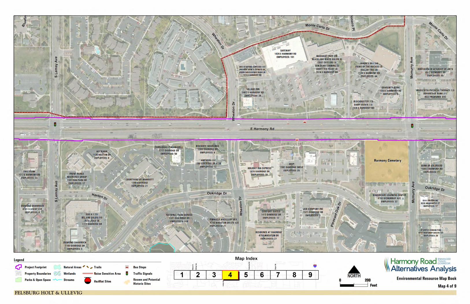
Some of the park and recreational properties present within the study area are publicly‐owned and are afforded protection under Section 4(f) as defined in 23 Code of Federal Regulations 774. A Section 4(f) resource is a property that functions or is designated as a significant publicly‐owned park, recreation area, wildlife or waterfowl refuge, or historic site. If one of these properties is impacted as part of any future project, then a Section 4(f) evaluation may be required for that particular resource. As identified above, 4(f) also applies to historic sites. In addition to Section 4(f), there are some properties within the study area that are afforded protection under Section 6(f) of the Land and Water Conservation Fund Act. Section 6(f) of the Act assures that once an area has been funded with Land and Water Conservation Fund assistance, it is continually maintained in public recreation use unless the National Park Service approves substitution property. Importantly, Section 6(f) applies to all transportation projects involving possible conversions of the property whether or not federal funding is being utilized for the project. Currently there are no properties in the project corridor that have been identified as being afforded Section 6(f) protection. Hazardous Materials
This section provides a preliminary review of properties with potential or known hazardous materials issues located adjacent to the Harmony Road corridor. The methodology used to identify sites with potential or known hazardous materials issues included a review of readily available local, state, tribal, and federal environmental agency databases obtained from Environmental Data Resources (EDR) and Satisfi, Inc. Existing Conditions
Seven leaking underground storage tank (LUST) sites and one leaking underground aboveground storage tank (LAST) site were identified within the study area (Table F‐6) as generally shown on the maps provided as an attachment to this appendix. All of the LUST sites are closed. However, closed LUST sites can still present a

F‐10
FINAL DRAFT ETC Master Plan
concern because the Colorado Department of Labor and Employment, Division of Oil and Public Safety (OPS) defines them as closed/clean‐up complete when “the owner and/or operator has not necessarily removed all contamination, but instead actions taken have met the criteria that the State uses for determining adequate clean up.” As a result, residual surface and subsurface soil contamination and/or groundwater contamination may be present at closed LUST sites and could be encountered in the vicinity of or downgrade from these sites during subsurface construction‐related activities. One site within the study area was listed as a Resource Conservation and Recovery Act (RCRA) Corrective Action (CORRACTS) site as generally shown on the maps provided as an attachment to this appendix. (Hewlett‐Packard 3404 E. Harmony Road). RCRA CORRACTS sites are hazardous waste handlers that have had corrective action activity due to a release of hazardous materials. This site was also listed as a Comprehensive Environmental Response, Compensation, and Liability System (CERCLIS) site. The site is defined as a No Further Remedial Action Planned (NFRAP) site, which indicated that an assessment of the site has been completed and the United States Environmental Protection Agency (USEPA) has determined that no further steps will be taken to list this site on the National Priorities List (NPL). Therefore, this is a site with a known past release of hazardous substances or petroleum products into the ground (soil), groundwater, or surface water and has the possibility for large‐scale migration from the contaminant source. Although this site is a NFRAP, residual contamination and/or groundwater contamination may be present and could be encountered in the vicinity of or downgrade from these sites during subsurface construction‐related activities. A more detailed hazardous materials assessment would typically be needed prior to construction of any alternative identified and evaluated during the future NEPA phase. The purpose of conducting a more detailed hazardous materials assessment is to provide the information needed to plan for known and potential hazardous materials and contaminated sites. During the planning and design process, this information can be used to identify avoidance options, when possible, and to assist with the development of specific contaminated soils/groundwater material management or mitigation measures. Hazardous Materials Evaluation
Hazardous materials concerns within the corridor were investigated to determine if any of the sites with potential or known hazardous materials issues would potentially be impacted by any of the alternatives under consideration. The assessment included a review of aerial photography and the City of Fort Collins current parcel data to verify the location of the sites that were identified. A summary of the sites with potential or known hazardous materials issues located adjacent to the project footprint is included in Table F‐6. Next Steps
All hazardous materials sites located within the study area have the potential to present a materials management and/or worker health and safety issue. Any future NEPA process would typically require a formal hazardous materials assessment, including a site verification, to identify any hazardous materials issues within the study area.

F‐11
FINAL DRAFT ETC Master Plan
Table F-6. Hazardous Materials Sites Adjacent to the Project Corridor
Site Address Location Type of Site
4524 S. College Ave. North of Harmony Rd./East of S. College Ave.
Closed leaking underground storage tank (LUST) site. Based on conceptual design, the project footprint appears to encroach on the property boundary. Needs to be field confirmed.
4619 S. Mason St. South of Harmony Rd./West of College Ave.
Drycleaner. Appears to be avoided based on conceptual design. Needs to be field confirmed.
4615 Hogan Dr. South of Harmony Rd./West of Hogan Dr./JFK Pkwy
Closed LUST site. Based on conceptual design, the project footprint appears to encroach on the property boundary. Needs to be field confirmed.
2032 E. Harmony Rd. North of Harmony Rd./West of S. Timberline Rd.
Closed LUST site. Appears to be avoided based on conceptual design. Needs to be field confirmed.
2824 E. Harmony Rd. North of Harmony Rd./East of Corbett Dr.
Closed LUST site. Appears to be avoided based on conceptual design. Needs to be field confirmed.
3404 E. Harmony Rd. North of Harmony Rd./East of Ziegler Rd.
Resource Conservation and Recovery Act (RCRA) Corrective Action (CORRACTS) site and Comprehensive Environmental Response, Compensation, and Liability System (CERCLIS) site. No Further Remedial Action Planned (NFRAP). Appears to be avoided based on conceptual design
4305 E. Harmony Rd. South of Harmony Rd./ West of I‐25 and Harmony Road Interchange
Closed LUST site. Appears to be avoided based on conceptual design.
4325 E. Harmony Rd. South of Harmony Rd./ West of I‐25 and Harmony Road Interchange
Closed LUST site. Appears to be avoided based on
conceptual design. Needs to be field confirmed.
4414 E. Harmony Rd. North of Harmony Rd./West of I‐25 and Harmony Road Interchange
Closed leaking aboveground storage tank (LAST) site appears to be avoided based on conceptual design. Needs to be field confirmed.
Wetlands/Other Waters of the US
The U.S. Army Corps of Engineers (USACE) defines wetland as “those areas inundated or saturated by surface or groundwater at a frequency and duration sufficient to support and under normal circumstances do support, a prevalence of vegetation typically adapted for life in saturated soil conditions.” Wetlands generally include swamps, marshes, bogs, and similar areas (33 CFR 328.3b). Wetland resources are protected under Section 404 of the Clean Water Act (CWA) and Executive Order 11990 Protection of Wetlands. The USACE Regulatory Program administers, and the USEPA enforces, Section 404 of the CWA. Under Section 404, a USACE permit is required for the discharge of dredged or fill material into waters of the U.S. The CWA defines waters of the U.S. as all navigable waters and their tributaries, all interstate waters and their tributaries, all wetlands adjacent to these waters, and all impoundments of these waters. The definition of waters of the U.S. under USACE jurisdiction does not include wetlands that do not have a surface connection to, and therefore are isolated from, regulated waters.
F‐12
FINAL DRAFT ETC Master Plan
Wetlands/Other Waters of the US Existing Conditions
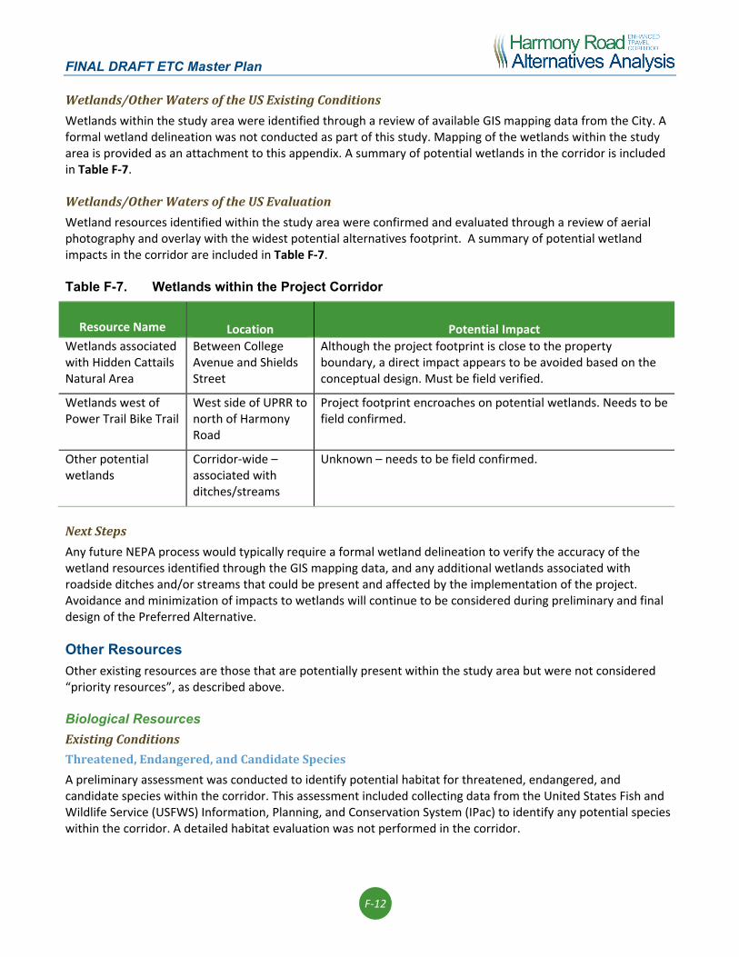
Wetlands within the study area were identified through a review of available GIS mapping data from the City. A formal wetland delineation was not conducted as part of this study. Mapping of the wetlands within the study area is provided as an attachment to this appendix. A summary of potential wetlands in the corridor is included in Table F‐7. Wetlands/Other Waters of the US Evaluation
Wetland resources identified within the study area were confirmed and evaluated through a review of aerial photography and overlay with the widest potential alternatives footprint. A summary of potential wetland impacts in the corridor are included in Table F‐7. Table F-7. Wetlands within the Project Corridor
Resource Name Location Potential Impact
Wetlands associated with Hidden Cattails Natural Area
Between College Avenue and Shields Street
Although the project footprint is close to the property boundary, a direct impact appears to be avoided based on the conceptual design. Must be field verified.
Wetlands west of Power Trail Bike Trail
West side of UPRR to north of Harmony Road
Project footprint encroaches on potential wetlands. Needs to be field confirmed.
Other potential wetlands
Corridor‐wide – associated with ditches/streams
Unknown – needs to be field confirmed.
Next Steps
Any future NEPA process would typically require a formal wetland delineation to verify the accuracy of the wetland resources identified through the GIS mapping data, and any additional wetlands associated with roadside ditches and/or streams that could be present and affected by the implementation of the project. Avoidance and minimization of impacts to wetlands will continue to be considered during preliminary and final design of the Preferred Alternative.
Other Resources
Other existing resources are those that are potentially present within the study area but were not considered “priority resources”, as described above. Biological Resources
Existing Conditions
Threatened, Endangered, and Candidate Species
A preliminary assessment was conducted to identify potential habitat for threatened, endangered, and candidate species within the corridor. This assessment included collecting data from the United States Fish and Wildlife Service (USFWS) Information, Planning, and Conservation System (IPac) to identify any potential species within the corridor. A detailed habitat evaluation was not performed in the corridor.

F‐13
FINAL DRAFT ETC Master Plan
Federally listed threatened and endangered species are protected under the Endangered Species Act (ESA) (16 U.S.C. 1531 et seq.). Under Section 7 of the ESA, a consultation and clearance process with the USFWS is required if a federally listed species or its habitat will be affected by project activities. A list of threatened and endangered species potentially located in Larimer County is included below (Table F‐8). Table F-8. Federally Threatened and Endangered (T&E) Species Potentially Found in Larimer
County
Common Name Scientific Name Status*
Greater sage‐grouse Centrocercus urophasianus C
Mexican Spotted Owl Strix occidentalis lucida T
Greenback Cutthroat trout Oncorhynchus clarki ssp. stomias T
Colorado Butterfly plant Gaura neomexicana var. coloradensis T
North Park phacelia Phacelia formosula E
Ute Ladies’‐tresses Spiranthes diluvialis T
Black‐footed Ferret Mustela nigripes Exp**
Canada Lynx Lynx canadensis T
North American wolverine Gulo gulo luscus C
Preble’s Meadow Jumping Mouse Zapus hudsonius preblei T
Species that may be affected, but only under certain conditions
Interior Least Tern*** Sternula antillarum E
Pallid Sturgeon*** Scaphirhynchus albus E
Piping Plover*** Charadrius melodus T
Whooping Crane*** Grus Americana E
Western Prairie Fringed Orchid*** Platanthera praeclara T
* T = Threatened Species, E = Endangered Species, C = Colorado State Listed Species ** Experimental Population, Non‐Essential ‐ Experimental, nonessential populations of endangered species are
treated as threatened species on public land, for consultation purposes, and as species proposed for listing on private land.
*** Water depletions in the South Platte River may affect the species and/or critical habitat in downstream reaches in other states.
Source: USFWS, 2012. Migratory Birds
Migratory birds, including raptors, are protected under the Migratory Bird Treaty Act (MBTA) (16USC §§ 703‐712). The eggs and active nests of migratory birds are also protected under the MBTA. Activities that may harm or harass migratory birds during the nesting and breeding season are prohibited by the MTBA. This includes the removal of active nests, which could result in the loss of eggs or young. A detailed habitat evaluation for migratory birds was not performed in the corridor. However, suitable migratory bird habitat may be present in the corridor. Field surveys would be required to identify locations of any nests prior to construction of any alternative identified and evaluated during future NEPA processes. Similarly, a survey of bridges and large culverts would be required to identify if swallows are currently nesting.

F‐14
FINAL DRAFT ETC Master Plan
Right-of-Way
Based on the parcel data included in the City’s GIS database, the existing right‐of‐way along Harmony Road varies from approximately 100 feet in some segments on the western end of the corridor to as wide as approximately 180 feet in the central sections of the corridor. The Harmony Corridor Plan developed setbacks and design guidelines to create an image of wide, bermed landscaped edges along Harmony Road. Portions of the 80‐foot setback area that are outside of the right‐of‐way are within a dedicated easement, which is also often used to carry major utility facilities, ditches, storm drainage facilities, etc. Water Resources
Most of Harmony Road was designed and built with a rural highway cross section. In the eastern portion of the corridor, the cross section is mostly inverse crowned with roadside swales or ditches. Some irrigation canals such as the one present in front of Hewlett‐Packard also run irrigation water to agricultural users to the south and east of the Harmony Road and Ziegler Road. In some areas where City development occurred adjacent to the highway, the drainage from the road was incorporated into the development drainage system and was routed away from the road through the development system itself, such as in the area of the Safeway shopping center at Wheaton Drive. Most of Harmony Road does not incorporate any stormwater quality treatment mitigation as currently required by the City's Municipal Separate Storm Sewer System (MS4) permit since it was mostly built up before these regulations went into effect. Current stormwater regulations and the City's State Stormwater permit require that any additional construction which exceeds one half an acre in impervious area, including capital construction projects such as highways, provide some form of water quality treatment prior to discharge into the City's Receiving Waters. Evaluation of Other Existing Resources
At this stage of the project, further assessment was deemed unnecessary for the following resources: threatened/endangered/candidate species, migratory birds, right‐of‐way, and water resources.