County of Yolo - Environmental Education and Sustainability Park Project Draft EIR Michael Brandman Associates H:\Client (PN-JN)\1759\17590007\EIR\3 - Draft EIR\17590007 Sec 99-00 Appendix Dividers.doc Appendix G: Phase I Environmental Site Assessment
Transcript
County of Yolo - Environmental Education and Sustainability Park Project Draft EIR
Yolo County - Solar Ground Tracker Project Phase I Environmental Site Assessment Table of Contents
Michael Brandman Associates iii H:\Client (PN-JN)\1759\17590008\Phase I ESA\17590008 Solar Ground Tracker Project 05-6-2012.doc
List of Tables
Table 1: Adjacent Property Usage .......................................................................................... 7 Table 2: State and Tribal – Equivalent NPL.......................................................................... 14 Table 3: State and Tribal – Equivalent CERCLIS ................................................................. 14 Table 4: FUDS ...................................................................................................................... 14 Table 5: Historic Aerial Photograph Summary ...................................................................... 15 Table 6: Historic Topographic Map Summary....................................................................... 16 Table 7: Summary of Site Reconnaissance.......................................................................... 19
List of Exhibits
Exhibit 1: Regional Location Map............................................................................................ 8 Exhibit 2: Local Vicinity Map - Aerial Base.............................................................................. 9 Exhibit 3: Local Vicinity Map - Topographic Base ................................................................. 10
Yolo County - Solar Ground Tracker Project Phase I Environmental Site Assessment Acronyms and Abbreviations
Michael Brandman Associates iv H:\Client (PN-JN)\1759\17590008\Phase I ESA\17590008 Solar Ground Tracker Project 05-6-2012.doc
ACRONYMS AND ABBREVIATIONS
AAI All Appropriate Inquiry
ACBM asbestos-containing building material
APN Assessor’s Parcel Numbers
AST Registered Aboveground Storage Tank
ASTM American Society for Testing and Materials
AWP Annual Work Plan
Cal EPA California Environmental Protection Agency
CEQA California Environmental Quality Act
CERCLA Comprehensive Environmental Response, Compensation, and Liability Act
CORRACTS Corrective Action Report
CS CalSites Properties
CUPA Certified Unified Program Agency
DTSC Department of Toxic Substances Control
EPA United States Environmental Protection Agency
ERNS Emergency Response Notification System
ESA Environmental Site Assessment
FIDS Cal EPA’s Facility Index System database
HVAC Heating/ventilation/air conditioning kg kilogram
HW Hazardous Waste
LBP lead-based paint
LGN Large Quantity Generators
LTANK Leaking Underground Storage Tank
LUST Leaking Underground Storage Tank
MBA Michael Brandman Associates
Yolo County - Solar Ground Tracker Project Phase I Environmental Site Assessment Acronyms and Abbreviations
Michael Brandman Associates v H:\Client (PN-JN)\1759\17590008\Phase I ESA\17590008 Solar Ground Tracker Project 05-6-2012.doc
NFA No Further Action Determination
NFRAP No Further Remedial Action Plan
NLR No Longer Registered
NPL National Priorities List
PCB Polychlorinated Biphenyls
PEA Preliminary Endangerment Assessment
RCRA Resource Conservation and Recovery Act
REA Registered Environmental Assessor
REF Referred to another Local or State Agency
RFE Unconfirmed Properties Needing Further Evaluation
RUST Registered Underground Storage Tank
RWQCB Regional Water Quality Control Board
SCH School Property Evaluation Program Properties
SGN Small Quantity Generators
SMBRPD Site Migration and Brownfields Re-use Program Database
SWF/LF Solid Waste Facilities or Landfills
TSD Treatment, Storage, and Disposal Facilities
UST underground storage tank
VCP Voluntary Cleanup Program
Yolo County - Solar Ground Tracker Project Phase I Environmental Site Assessment Introduction
Michael Brandman Associates 2 H:\Client (PN-JN)\1759\17590008\Phase I ESA\17590008 Solar Ground Tracker Project 05-6-2012.doc
SECTION 2: INTRODUCTION
2.1 - Purpose and Scope
The purpose of this Phase I ESA is to identify, to the extent feasible and pursuant to the processes prescribed herein, Recognized Environmental Conditions (RECs) in connection with the property, which are defined as follows:
ASTM E 1527 Section 1.1.1 Recognized Environmental Conditions - The term recognized environmental conditions means the presence or likely presence of any hazardous substances or petroleum products on a property under conditions that indicate an existing release, a past release, or a material threat of a release of any hazardous substances or petroleum products into structures on the property or into the ground, groundwater, or surface water on the property.
This report was prepared in accordance with the standards and procedures outlined in ASTM E 1527-05. The following principles are integral to the practice:
1) Performance of this ESA is intended to reduce, but not eliminate, uncertainty regarding the potential for recognized environmental conditions in connection with the property;
2) The level of inquiry into past ownership and use is not exhaustive, and is balanced between the competing goals of limiting costs and time, and the reduction of uncertainty about unknown conditions;
3) The appropriate level of inquiry is guided by the type of property, the expertise and risk tolerance of the user, and the information developed in the course of this inquiry.
This Phase I ESA has four components:
1) Records review
2) Site reconnaissance
3) Interviews with persons knowledgeable about the property or local environmental conditions, and local government officials
4) Preparation of a written report 2.1.1 - Special Terms and Conditions This report was prepared for the exclusive use of the Client and its employees or contractors under the terms and conditions specified in our agreement. The results of this study may be used at the discretion of the Client as necessary relative to this property, subject to the limitations identified
Yolo County - Solar Ground Tracker Project Phase I Environmental Site Assessment Introduction
Michael Brandman Associates 3 H:\Client (PN-JN)\1759\17590008\Phase I ESA\17590008 Solar Ground Tracker Project 05-6-2012.doc
herein. Any opinions or recommendations presented, apply to site conditions existing when services were performed. The author is unable to report on or accurately predict events that may change the site conditions after the described services have been performed. The author assumes no responsibility for conditions not authorized to investigate, or conditions not generally recognized as environmentally unacceptable when services were performed.
Environmental conditions may exist at the site that cannot be identified by visual observation or record searches. Where the scope of services was limited to observations made during site reconnaissance, interviews, and review of available reports and literature or any combination, any conclusions or recommendations are necessarily based in part on information supplied by others. The accuracy or sufficiency of reporting information may not have been independently reviewed.
The author believes as true the validity of several matters, including the legal capacity of all legal persons, the authenticity of all signatures, the authenticity of all documents submitted to the author as originals, that originals of all documents submitted to author are certified photocopies or facsimiles, and the authenticity of all originals. Upon examination of the documents, it was believed as true that all parties had the power, governmental or otherwise, to enter into and perform all obligations under such documents; in addition, it was believed as true that all parties have assumed the due authorization by all requisite action, governmental or otherwise, of the execution and delivery by all parties of such documents against all parties in accordance with the terms thereof. Unless otherwise stated, the author did not make independent investigation or inquiry into the accuracy or completeness of the comments and information supplied.
The author is not responsible for any potential impact of changes to applicable environmental standards, practices, or regulations following performance of services, on the conclusions or recommendations of the study.
Services hereunder were performed consistent with our agreement and understanding with, and solely for the use of the Client. Opinions and recommendations are intended for the Client, purpose, site, location, time span, and project parameters indicated. The author is not responsible for subsequent separation, detachment, or partial use of this document. Any reliance on this report by a third party shall be at such party’s sole risk.
2.1.2 - Limitations and Exceptions of Assessment A visual site reconnaissance was conducted on May 3, 2012 to check for visible indications of previously disposed hazardous waste, surface contamination, or underground storage tanks, as well as a visual survey of nearby properties. This Phase I ESA addresses only the observed visible surface features and information available through government databases. Boreholes were not drilled for the purpose of obtaining subsurface samples, nor were surface samples gathered for analysis in accordance with Section 6.4 of ASTM E 1527-00 and -05.
Yolo County - Solar Ground Tracker Project Phase I Environmental Site Assessment Introduction
Michael Brandman Associates 4 H:\Client (PN-JN)\1759\17590008\Phase I ESA\17590008 Solar Ground Tracker Project 05-6-2012.doc
2.1.3 - Limiting Scope and Methodology Records Review: The following standard databases and expanded records review search distances were used for this assessment, as measured from the boundary of the property (detailed descriptions of these databases are listed in Appendix A, EDR Radius Map Report):
• United States Environmental Protection Agency (EPA) and State Government Records, 1 mile search distance for National Priorities List (NPL)
• Proposed National Priorities List (Proposed NPL)
• Federal Superfund Liens (NPL LIENS)
• National Priority List Deletions (Delisted NPL)
• Comprehensive Environmental Response, Compensation, and Liability Information System (CERCLIS)
• Federal Facility Information Listing (FEDERAL FACILITY)
• CERCLIS No Further Remedial Action Planned (CERC-NFRAP)
• Corrective Action Report (CORRACTS)
• Resource Conservation and Recovery Act (RCRA) – Treatment, Storage, and Disposal (RCRA-TSDF)
• RCRA – Large Quantity Generators (RCRA-LQG)
• RCRA – Small Quantity Generators (RCRA-SQG)
• RCRA – Conditionally Exempt Small Quantity Generator (RCRA-CESQG)
• Engineering and Controls Sites List (US ENG CONTROLS)
• Sites with Institutional Controls (US INST CONTROL
• Emergency Response Notification System (ERNS)
• Solid Waste Information System (SWF/LF)
• Geotracker’s Leaking Underground Fuel Tank Report (LUST)
• Statewide SLIC Cases (SLIC)
• Leaking Underground Storage Tanks on Indian Land (INDIAN LUST)
• Active Underground Storage Tank Facilities (UST)
• Aboveground Petroleum Storage Tank Facilities (AST)
Yolo County - Solar Ground Tracker Project Phase I Environmental Site Assessment Introduction
Michael Brandman Associates 5 H:\Client (PN-JN)\1759\17590008\Phase I ESA\17590008 Solar Ground Tracker Project 05-6-2012.doc
• UST’s on Indian land (INDIAN UST)
• UST Listing (FEMA UST)
• Voluntary Cleanup Program Properties (VCP)
• Voluntary Cleanup Priority Listing (INDIAN VCP)
• Brownfields Sites (US BROWNFIELDS)
• Torres Martinez Reservation Illegal Dump Site Locations (DEBRIS REGION 9)
• Open Dump Inventory (ODI)
• Waste Management Unit Database (WMUDS/SWAT)
• Recycler Database (SWRCY)
• Registered Waste Tire Haulers Listing (HAULERS)
• Report on the Status of Open Dumps on Indian Lands (INDIAN ODI)
• Clandestine Drug Labs (US CDL)
• Historical Calsites Database (HIST Cal-Sites)
• School Property Evaluation Program (SCH)
• Toxic Pits Cleanup Act Sites (Toxic Pits)
• Clandestine Drug Labs (CDL)
• National Clandestine Laboratory Register (US HIST CDL)
• Hazardous Materials Information Reporting System (HMIRS)
• California Hazardous Material Incident Report System (CHMIRS)
• Land Disposal Sites Listing (LDS)
Yolo County - Solar Ground Tracker Project Phase I Environmental Site Assessment Introduction
Michael Brandman Associates 6 H:\Client (PN-JN)\1759\17590008\Phase I ESA\17590008 Solar Ground Tracker Project 05-6-2012.doc
• Military Cleanup Sites Listing (MCS)
• RCRA – Non Generators (RCRA-NonGen)
• Incident and Accident Data (DOT OPS). Review of available documents, including maps, aerial photographs, websites, applicable reference information, governmental lists of hazardous waste sites and underground tanks, and other records referenced in Appendix A were obtained and/or reviewed to assist in the identification of recognized environmental conditions in connection with the site.
2.2 - All Appropriate Inquiry
Congress enacted the Brownfield Amendments to the Comprehensive Environmental Response, Compensation, and Liability Act (CERCLA) in 2002 directing the EPA to establish federal regulations for conducting Phase I ESAs. Compliance with these guidelines enables property owners to assume the concept of “innocent landowner, contiguous property owner, or bona fide prospective purchaser” and avoid litigation in cases where hazardous material releases were discovered on property during their tenure of ownership, provided they could prove they did not cause the contamination. A function of this Phase I ESA is to gather sufficient information to develop an independent, professional opinion about the environmental condition of the subject property and any potential environmental contamination that may affect the purchaser’s claim to an “innocent land owner” defense following the acquisition of the property.
For a Phase I ESA to comply with the EPA’s All Appropriate Inquiry (AAI) Rule, a set of conditions must be satisfied during the course of the assessment and report generation; these conditions are mandatory for the document to be compliant and protect the landowner. This Phase I ESA has been performed to comply with 40 Code of Federal Regulations (CFR) 312 (AAI Rule). The signature at the end of this document verifies the investigation associated with the completion of this assessment is in accordance with the EPA’s AAI Rule, effective November, 2006.
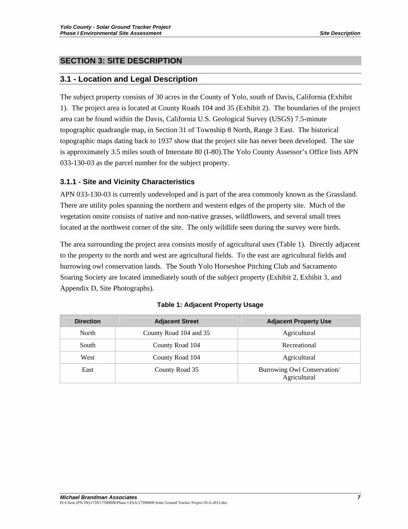
Yolo County - Solar Ground Tracker Project Phase I Environmental Site Assessment Site Description
Michael Brandman Associates 7 H:\Client (PN-JN)\1759\17590008\Phase I ESA\17590008 Solar Ground Tracker Project 05-6-2012.doc
SECTION 3: SITE DESCRIPTION
3.1 - Location and Legal Description
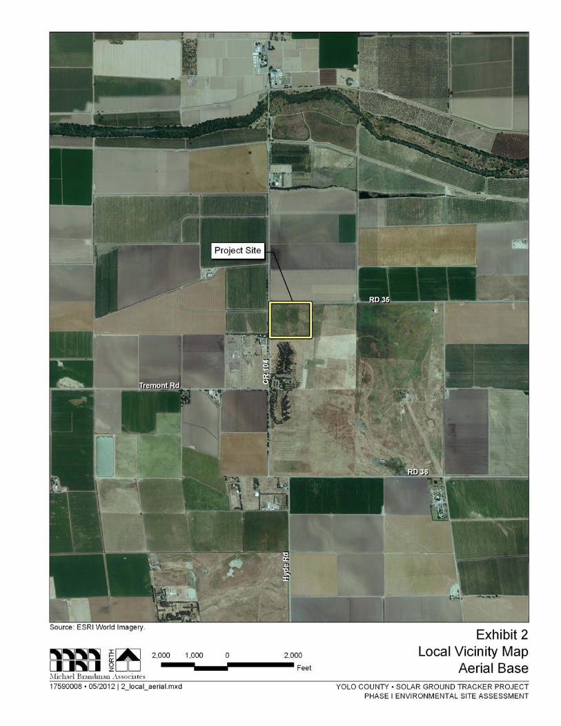
The subject property consists of 30 acres in the County of Yolo, south of Davis, California (Exhibit 1). The project area is located at County Roads 104 and 35 (Exhibit 2). The boundaries of the project area can be found within the Davis, California U.S. Geological Survey (USGS) 7.5-minute topographic quadrangle map, in Section 31 of Township 8 North, Range 3 East. The historical topographic maps dating back to 1937 show that the project site has never been developed. The site is approximately 3.5 miles south of Interstate 80 (I-80).The Yolo County Assessor’s Office lists APN 033-130-03 as the parcel number for the subject property.
3.1.1 - Site and Vicinity Characteristics APN 033-130-03 is currently undeveloped and is part of the area commonly known as the Grassland. There are utility poles spanning the northern and western edges of the property site. Much of the vegetation onsite consists of native and non-native grasses, wildflowers, and several small trees located at the northwest corner of the site. The only wildlife seen during the survey were birds.
The area surrounding the project area consists mostly of agricultural uses (Table 1). Directly adjacent to the property to the north and west are agricultural fields. To the east are agricultural fields and burrowing owl conservation lands. The South Yolo Horseshoe Pitching Club and Sacramento Soaring Society are located immediately south of the subject property (Exhibit 2, Exhibit 3, and Appendix D, Site Photographs).
Table 1: Adjacent Property Usage
Direction Adjacent Street Adjacent Property Use
North County Road 104 and 35 Agricultural
South County Road 104 Recreational
West County Road 104 Agricultural
East County Road 35 Burrowing Owl Conservation/ Agricultural
Yolo County - Solar Ground Tracker Project Phase I Environmental Site Assessment Site Description
Michael Brandman Associates 11 H:\Client (PN-JN)\1759\17590008\Phase I ESA\17590008 Solar Ground Tracker Project 05-6-2012.doc
3.2 - Physical Setting
3.2.1 - Topography and Soils The site is located within the Davis (2012) 7.5-minute United States Geological Survey (USGS) Quadrangle. The site’s approximate elevation is about 32 feet above sea level and contains relatively flat land within the property vicinity.
Soils in the area consist of Marvin silty clay loam (Mf), Pescadero silty clay, and Brentwood silty clay loam, 0 to 2 percent slopes (BrA) found on alluvial fans (USDA Natural Resources Conservation Service). Marvin is derived from a mixture of clayey and silty alluvium, and Pescadero consists of drained soils formed into an alluvium from sedimentary rocks, while the parent material of Brentwood consists of alluvium derived from sedimentary rock.
3.2.2 - Geology The project site is located just outside the Davis city limits in Yolo County, California, within the Sacramento Valley, a part of the Great Valley geomorphic province of California. The Great Valley geomorphic province of California consists of gently sloping to level alluvial plains. To the west is the Coast Range geomorphic province. Geologic units in the Great Valley area generally consist of Quaternary alluvium or basin deposits, and the Quaternary Modesto and Riverbank Formations, both of which consist of somewhat older alluvium.
Davis, California is surrounded by several faults in the San Andreas fault system to the west and the Eastern Sierra fault system to the east. A series of faults also run along the eastern base of the foothills west of the City. The Uniform Building Code identifies the planning area as being in Seismic Risk Zone III, which indicates that the maximum intensity of an earthquake that would be experienced in the planning area would be VII to VIII on the modified Mercalli intensity scale. An earthquake of such magnitude would result in “slight damage in specially designed structures; considerable in ordinary substantial buildings, with partial collapse; great in poorly built structures”
3.2.3 - Hydrology The City of Davis lies within the Sacramento Valley between the Coast Ranges and Sacramento River. Surface water in Yolo County generally drains from the west to east, eventually being received by the Yolo Bypass. Four major watersheds and associated drainages are located in Yolo County: the Sacramento River, Cache Creek, Putah Creek, and Willow Slough watersheds. Surface water supplies primarily originate from the Cache Creek and Putah Creek watersheds and the Sacramento River. In addition, many sloughs and drainage ditches cross the eastern half of the County. Yolo County is drained by the Sacramento River and by Yolo Bypass, which is part of the Sacramento River Flood Control Project. The major streams that drain the unincorporated County areas around Davis are Putah Creek to the south and Willow Slough Bypass to the North, both of which empty into the Yolo Bypass.
Yolo County - Solar Ground Tracker Project Phase I Environmental Site Assessment Site Description
Michael Brandman Associates 12 H:\Client (PN-JN)\1759\17590008\Phase I ESA\17590008 Solar Ground Tracker Project 05-6-2012.doc
The Yolo subbasin of the Sacramento Valley groundwater basin underlies the majority of Yolo County. Yolo County is underlain by a substantial amount of groundwater. It is estimated that groundwater storage for all of Yolo County between 20 and 420 feet below the surface is 14,038,000 acre-feet. The groundwater basin in Yolo County is divided into six subbasins: Capay Valley, Buckeye Creek, Dunnigan Hills, West Yolo, East Yolo, and Sacramento River. The groundwater quality is generally good for agricultural and municipal uses, though it is “hard” to “very hard” overall, due to elevated concentrations of selenium, nitrate, boron, and arsenic.
3.2.4 - Vegetation The project site contains various native and non-native grasses and wildflowers. In addition, there are several smaller trees located in the northwest corner of the project site. No plants appeared to be distressed.
3.3 - Ownership and Land Use
3.3.1 - Ownership The current owner of the property is the County of Yolo.
3.3.2 - Current Uses of the Property The Subject Property, APN 033-130-003, is currently undeveloped and is predominantly covered with native and non-native grasses.
3.3.3 - Current and Past Uses of Adjoining Properties Agency databases, an agency review report prepared by EDR, and personal correspondences were used to assess the project site’s history. Historic aerial photographs dating from 1937, 1957, 1965, 1970, 1987, 1993, 1998, 2005, and 2006; historical topographic maps dating from 1908, 1916, 1952, 1968, and 1993 were also reviewed and are included in the EDR report (Appendices B and C).
The area surrounding the project area consists mostly of agricultural uses. Directly adjacent to the property to the north and west are agricultural fields, to the east is burrowing owl conservation lands and agricultural lands, and to the south is the South Yolo Horseshoe Pitching Club and Sacramento Soaring Society.
Since 1937, most of the area around the subject property supported agricultural uses. The historical topographic maps show that the project site has never been developed.
Yolo County - Solar Ground Tracker Project Phase I Environmental Site Assessment Environmental Records Review
Michael Brandman Associates 13 H:\Client (PN-JN)\1759\17590008\Phase I ESA\17590008 Solar Ground Tracker Project 05-6-2012.doc
SECTION 4: ENVIRONMENTAL RECORDS REVIEW
A database search was conducted relative to the subject property and is provided in Environmental Data Resources™ Report available in Appendix A. The purpose of the records review is to obtain and evaluate records that will help identify recognized environmental conditions in connection with this property. ASTM E 1927-00 and -05 established Standard Environmental Record Sources and specified an approximate minimum search distance for each of the standard records. A detailed records search was conducted for this site using a maximum 1-mile search, as measured from the center of the property, for the record sources listed in Appendix A.
4.1 - Standard Environmental Record Sources
Searches of available environmental records were conducted by EDR and are included in Appendix A. A description of each database/list, together with a summary of search results and agency data is provided below. EDR’s research and reporting assist parties seeking to meet the search requirements of the USEPA’s Standards and Practices for All Appropriate Inquiries, pursuant to 40 CFR Part 312, the ASTM Standard Practice for ESAs (E-1527-05) or custom requirements developed for the evaluation of environmental risks associated with a parcel of real estate. EDR’s search of available “reasonably ascertainable” government records identified no mapped sites near the project site. Use of this information is subject to the limitation described in Section 2.1, Purpose and Scope. A copy of this records search is provided in Appendix A.
The lists consulted in the course of MBA’s assessment were compiled by EDR and MBA on May 2, 2012 and represent reasonably ascertainable, current listings. The EDR report summarizes the listed properties located within the ASTM search radii (EDR Report in Appendix A). No EDR unmapped, or orphaned, sites were determined to be located on or adjacent to the project site.
MBA has reviewed the EDR report, conducted a site reconnaissance, and researched regulatory agency databases for properties within the specified search radius of the project site appearing on local, state, or federally published lists of sites that use or have had releases of hazardous materials.
In general, only potentially hazardous materials released from facilities located approximately up-gradient and within a few hundred feet of the project site, or in a cross-gradient direction close to the project site, are judged to have a reasonable potential of migrating onsite. This opinion is based on the assumption that materials generally do not migrate large distances laterally within the soil; rather, they tend to migrate with groundwater in the general direction of groundwater flow. The EDR Radius Map Report is included in this report as Appendix A.
4.1.1 - Project Site The project site was not listed in any of the federal or state databases searched by EDR.
Yolo County - Solar Ground Tracker Project Phase I Environmental Site Assessment Environmental Records Review
Michael Brandman Associates 14 H:\Client (PN-JN)\1759\17590008\Phase I ESA\17590008 Solar Ground Tracker Project 05-6-2012.doc
4.1.2 - State- and Tribal-equivalent NPL RESPONSE: Identifies confirmed release sites where DTSC is involved in remediation, either in a lead or oversight capacity. These confirmed release sites are generally high-priority and high potential risk. A review of the RESPONSE list as provided by EDR and dated March 14, 2012 revealed that there is one RESPONSE site within approximately 1 mile of the target property (Table 2).
Table 2: State and Tribal – Equivalent NPL
Site Name Site Address Location from Project Site
Davis Transmitter Site Completed: Three diesel underground storage tanks removed, Operations and Maintenance Plan
Intersection of Mace Blvd. and Road 35
Adjacent to the site at the northwest corner
4.1.3 - State and Tribal ENVIROSTOR: The Department of Toxic Substances Control’s (DTSC’s) Site Mitigation and Brownfields Reuse Program’s (SMBRP’s) EnviroStor database identifies sites that have know contamination or sites for which there may be reasons to investigate further. A review of the ENVIROSTOR list indicated that there is one site within 1-mile of the subject property (Table 3).
Table 3: State and Tribal – Equivalent CERCLIS
Site Name Site Address Location from Project Site
Davis Transmitter Site Status: Refer: RWQCB
Intersection of Mace Blvd. and Road 35
Adjacent to the site at the northwest corner
4.1.4 - Other Ascertainable Records FUDS: The listing includes locations of Formerly Used Defense Sites Properties where the US Army Corps of Engineers is actively working or will take necessary cleanup actions. A review of the FUDS list indicated that there is one site within 1-mile of the subject property (Table 4).
Table 4: FUDS
Site Name Site Address Location from Project Site
Wilson Park Davis Communications Status: Refer: RWQCB
Intersection of Mace Blvd. and Road 35
0.172 mile SSE
4.1.5 - Orphan Sites Twenty-eight sites were listed on the databases searched within close proximity of the proposed project site, but because of poor or inadequate address information were not mapped; further
Yolo County - Solar Ground Tracker Project Phase I Environmental Site Assessment Environmental Records Review
Michael Brandman Associates 15 H:\Client (PN-JN)\1759\17590008\Phase I ESA\17590008 Solar Ground Tracker Project 05-6-2012.doc
information was not provided in the EDR report. It is assumed that no orphan sites contain conditions that pose as environmental hazards to the project site or adjacent properties.
4.2 - Local Regulatory Agency Review
Local regulatory agency interface included the following entity.
County of Yolo Health Department – Environmental Health: MBA personnel requested a files search of the County of Yolo Health Department – Environmental Health records to search for any major violations, spills, or other occurrences documented that could cause contamination of the site or nearby properties. Final comments have not been received from the Department. Once received, a supplemental letter will be provided to the Client.
4.3 - Aerial Photography
Historic aerial photos were received from EDR (Appendix C) and reviewed for land use changes and facilities. A summary of these aerials follows in Table 5.
Table 5: Historic Aerial Photograph Summary
Year Details
1937 The subject property is undeveloped and appears to support agricultural uses. The surrounding properties are undeveloped and also support agricultural uses. County Road 104 runs north-south along the western boundary of the subject property, and Road 35 runs east-west along the northern boundary of the subject property.
1957 The subject property has not significantly changes since 1937. A building is located approximately 0.5 mile southeast.
1965 The subject property and vicinity have not significantly changed since 1957.
1970 The subject property has remained unchanged since 1965. The Wilson Park Davis Communication Annex is developed southwest of the subject property.
1987 The subject property has remained unchanged since 1970. New buildings are located south of the subject property.
1993 The subject property has remained unchanged since 1987. Wilson Park is located south of the subject property.
1998 The subject property and vicinity has not significantly changed since 1993.
2005 The subject property remains the same. The Wilson Park Davis Communication Annex does not appear to be active.
2008 The subject property and vicinity have not significantly changed since 2005.
Yolo County - Solar Ground Tracker Project Phase I Environmental Site Assessment Environmental Records Review
Michael Brandman Associates 16 H:\Client (PN-JN)\1759\17590008\Phase I ESA\17590008 Solar Ground Tracker Project 05-6-2012.doc
4.4 - Historic Topography
Historic topographic maps were received from EDR (Appendix C) and reviewed for land use changes and facilities. A summary of these maps follows in Table 6.
Table 6: Historic Topographic Map Summary
Year Details
1908 The subject property consists of undeveloped land. County Road 104 runs north-south along the subject property’s western boundary. Road 35 runs east-west along the northern boundary of the subject property. Davisville and the Southern Pacific Railroad are located approximately 3.5 miles north of the subject property.
1916 The subject property consists of undeveloped land. A building is located south of the subject property. A cemetery is located approximately 0.5 mile west southwest of the subject property.
1952 The subject property appears to be the same as it was in 1916. It is labeled on the topographic map as a military reservation. There is a building located east of the subject property within the same section. There is a well located just north of the subject property’s northern boundary.
1968 The subject property appears to be the same as it was in 1952. The vicinity has not significantly changed since 1952.
1993 The subject property appears to be the same as it was in 1968. The parcel adjacent to the subject property is labeled as the Davis Communications Annex.
4.5 - Previous Environmental Information
MBA is not of aware of known previous environmental assessments performed on the subject property.
4.6 - Analysis of Impact on Recognized Environmental Conditions
Information obtained from standard environmental and additional record sources, historical information obtained from aerial photographs and topographic maps, analysis of physical setting sources, and site reconnaissance indicated that there is a low risk that RECs potentially exist at this site, due to environmental releases discovered in the local vicinity. Because of the distance and geographic location of these sites relative to the subject property, MBA concludes that there is a low risk of environmental conditions potentially existing at the site related to these facilities.
Yolo County - Solar Ground Tracker Project Phase I Environmental Site Assessment Site Reconnaissance
Michael Brandman Associates 17 H:\Client (PN-JN)\1759\17590008\Phase I ESA\17590008 Solar Ground Tracker Project 05-6-2012.doc
SECTION 5: SITE RECONNAISSANCE
The site reconnaissance was conducted on May 3, 2012; the methodology used during the visual reconnaissance consisted of a complete walkover of the property on foot. The subject property was also surveyed observing local land use and signs of potential contamination in the area. This was followed by a detailed inspection of the area within the property boundary.
Site photographs taken during the visual reconnaissance is found in Appendix D.
5.1 - Hazardous Substances In Connection With Identified Uses
The site, consisting of 033-130-03 is currently undeveloped. During the site reconnaissance, no hazardous substances were identified.
5.2 - Hazardous and Unidentified Substance Containers
During the site reconnaissance, no hazardous or unidentified substance containers were observed.
During the visual reconnaissance of the site, no aboveground storage tanks and no indication of underground storage tanks were observed on the subject property.
5.4 - Indications of Polychlorinated Biphenyls (PCBs)
Electrical transformers historically contained cooling lubricant containing PCB compounds. The federal Environmental Contaminants Act, 1976, prohibited the use of PCBs in heat transfer and electrical equipment installed after September 1, 1977, and in transformers and capacitors installed after July 1, 1980. In addition, storage and disposal of PCB waste materials is regulated. During the site reconnaissance, a pole-mounted transformer was observed on the northwest corner of the subject property near the intersection of County Road 104 and County Road 35.
5.5 - Radon
Radon is a natural occurring gas produced by the decay of naturally occurring uranium in soil and water. It is an odorless, tasteless, and invisible gas. Radon is a carcinogen and has negative effects to human health. Radon is found in outdoor air and in the indoor air of buildings of all kinds.
According to the EPA Map of Radon Zones, Yolo County is located in Zone 3 of the EPA Radon Zone Map. Zone 3 areas are designated as areas having predicted average indoor radon screening levels less than 2 picocuries per liter (pCi/L) of air, but it is not considered an REC relative to the subject property.
Yolo County - Solar Ground Tracker Project Phase I Environmental Site Assessment Site Reconnaissance
Michael Brandman Associates 18 H:\Client (PN-JN)\1759\17590008\Phase I ESA\17590008 Solar Ground Tracker Project 05-6-2012.doc
5.6 - Indications of Solid Waste Disposal
During the visual reconnaissance of the site, there was no indication of solid waste disposal.
5.7 - Physical Setting Analysis
APN 033-130-03 is undeveloped and unpaved; thus, there exists a potential for liquid percolation through the soil. It is not likely that surface water runoff or groundwater from surrounding properties has impacted the subject property. In addition, no hazardous liquids or stained soils were observed within the subject property.
5.8 - Agricultural Chemicals
According to the historical aerial photos and topographic maps (Appendix B, Historic Aerial Photographs and Appendix C, Historic Topographic Maps), the subject property is associated with agricultural uses. MBA believes there is a very low risk of agricultural chemicals percolating into the soil because of previous agricultural uses.
5.9 - Asbestos and Lead-Based Paint
Asbestos is the name given to a number of naturally occurring, fibrous silicate minerals mined for their useful properties such as thermal insulation, chemical and thermal stability, and high tensile strength. Asbestos is commonly used as an acoustic insulator, thermal insulation, fireproofing and in other building materials. Asbestos is made up of microscopic bundles of fibers that may become airborne when asbestos-containing materials are damaged or disturbed. When these fibers get into the air, they may be inhaled into the lungs where they can cause significant health problems. The California Occupational Health and Safety Administration (Cal/OSHA) defines asbestos-containing building materials (ACBM) as any material that contains 0.1 percent asbestos by weight.
Lead is a highly toxic metal that was used until the late 1970s in a number of products, most notably paint. Lead may cause a range of health effects, from behavioral problems and learning disabilities, to seizures and death. Primary sources of lead exposure are deteriorating lead-based paint (LBP), lead contaminated dust, and lead contaminated soil.
APN 033-130-03 contains no buildings constructed prior to 1976; therefore, it is unlikely that asbestos or lead base paint occur onsite.
5.10 - Other Conditions of Concern
APN 033-130-03 has utility poles with associated power-lines spanning the northern and western edges of the project site. As previously mentioned, a pole-mounted transformer was observed on the northwest corner of the subject property near the intersection of County Road 104 and County Road 35.
Yolo County - Solar Ground Tracker Project Phase I Environmental Site Assessment Site Reconnaissance
Michael Brandman Associates 19 H:\Client (PN-JN)\1759\17590008\Phase I ESA\17590008 Solar Ground Tracker Project 05-6-2012.doc
5.11 - Analysis of Impact on Recognized Environmental Conditions
The subject property has a low potential of containing RECs, as shown in Table 7.
Table 7: Summary of Site Reconnaissance
Feature Observed Not
Observed
Structures (existing) (were any power line towers on site) ● on APN 033-130-03
Evidence of past uses (foundations, debris, roads)* ●
Yolo County - Solar Ground Tracker Project Phase I Environmental Site Assessment Findings and Conclusions
Michael Brandman Associates 20 H:\Client (PN-JN)\1759\17590008\Phase I ESA\17590008 Solar Ground Tracker Project 05-6-2012.doc
SECTION 6: FINDINGS AND CONCLUSIONS
Trevor Macenski is a CA DTSC Registered Environmental Assessor who oversaw the completion of this Phase I ESA for the 30-acre property located on County Road 104 and 35 in the County of Yolo. MBA has endeavored to perform this Phase I ESA in substantial conformance with the scope and limitations of ASTM Practice E 1527-00 and -05 with exceptions to and deletions from the standards described above in Section 2.1.
A review of state and local registries did not reveal any hazardous conditions that were due to onsite conditions. Based on the records search of state and local registries, the potential exists for risk of RECs stemming from other properties in the area; however, it is MBA’s opinion that the potential of RECs onsite resulting from other properties is low, which is due to the distance and geographic location of these sites relative to the subject property.
A pole-mounted transformer found onsite may have the potential to contain PCB compounds if installed after 1980. However, based on available data, including onsite reconnaissance and agency database research, MBA concludes the subject property contains a minimal potential for Recognized Environmental Conditions (RECs).