44
Merced Wild and Scenic River Comprehensive Management Plan / DEIS APPENDIX H SCENIC VISTA MANAGEMENT IN THE MERCED RIVER CORRIDOR

Merced Wild and Scenic River Comprehensive Management Plan / DEIS
APPENDIX H
SCENIC VISTA MANAGEMENT IN THE MERCED RIVER CORRIDOR


Merced Wild and Scenic River Comprehensive Management Plan / DEIS H-1
APPENDIX H
SCENIC VISTA MANAGEMENT IN THE MERCED RIVER CORRIDOR
The Scenic Vista Management Plan for Yosemite National Park Environmental Assessment (SVMP), completed in 2010, inventoried 181 potential vista points throughout the park, outside of wilderness and chiefly along the major roads. The plan outlined a programmatic framework for prioritizing and prescribing the work to be completed at each of the viewpoints necessary to obtain a desirable vista. The 2010 Finding of No Significant Impact (FONSI) stipulates that the final determination of vista points for the Merced Wild and Scenic River corridor would be deferred to the comprehensive river management plan completion. Once an alternative has been selected in a Record of Decision, the management actions included in that selected alternative will be incorporated into the Merced River Plan to guide the future management of scenic values in the Merced River corridor.
This approach captures the programmatic direction, methods outlined in the SVMP, and analyzes the viewpoints from the perspective of the Wild and Scenic Rivers Act mandate to protect and enhance the values of the Merced Wild and Scenic River.
The scenery along the Merced River—considered an outstandingly remarkable value—offers outstanding views of the river valley, adjacent meadows, glaciated geology and hanging valleys. The locations where these tremendous views intersect with frequent visitation are often along roads and near historic buildings. As originally inventoried in the SVMP, eighty-three of these sites were located in, or adjacent to the Wild and Scenic River corridor of the Merced River. Upon analyzing these vista locations within the context of the Merced River Plan and considerations for river values (including free flow, water quality, and outstandingly remarkable values), thirty-two of these sites were removed from consideration. Reasons for removal range from sites encroaching on declared Wilderness areas, removal of the viewing area under proposed actions of the MRP, or sites being very similar to other nearby vistas. The inventory of sites includes analysis of each site with a Visual Resource Assessment (VRA) score that looks at a vista site with factors such as current infrastructure, numbers of scenic icons and quality of the view, and quantifies them for comparison. The sites are then prioritized by VRA score as high, medium or low based on their score up to eighteen. Low priority sites, scoring seven and below, are also be removed from consideration. The remaining sites are summarized and the proposed work actions analyzed regarding how the management of scenic vistas will take place as described under the Scenic Vista Management Plan, and comply with Merced River Plan to protect and enhance river values. As stated in the SVMP, the goal is not to remove all trees within a vista, but to remove a minimal number in order to allow a view, retain a natural appearance, and with the least invasive management practicable.
This appendix describes the impact over the projected life, typically twenty years for management plans, of the MRP. Some vistas are currently open, but will likely be encroached during this time frame, given past trends of conifer growth. The descriptions of estimated impact of trees removed during initial management for each vista point are by species and size as they are in 2012. Trees less than 6” diameter at breast height (dbh) can be removed in order to maintain a vista without additional
APPENDIX H
H-2 Merced Wild and Scenic River Comprehensive Management Plan / DEIS
compliance, and are not included in the estimates. If more trees than estimated over 6” dbh need to be removed, additional compliance will need to be completed.
Following tree removal, the work area will be revegetated with native vegetation, if necessary, the soil will be decompacted, and the area recontoured. Stumps must remain in place to provide soil stability. In order to preserve the natural aesthetic, stumps will be flush cut and buried. Seed collection and plant salvage will occur as necessary for revegetation after site work and tree removal are complete. An annual work plan will continue to be done that will describe the specific actions involved in initial management of removing larger trees, and maintenance involving revegetation or removing trees under 6” dbh. Approximately ten to twenty vista points will be done each year. This work plan will be posted on-line as described in the SVMP.
In the initial management of a vista, some downed trees may be left, but this will generally be no more than one tree in twenty. Trees which are removed will be used for traditional cultural purposes, chipped, left as woody debris in the river, or hauled away. If chipped, wood chips would remain on site (outside of meadows) as mulch (no more than 1 inch deep). The small diameter vegetation is to be lopped and scattered such that any saw marks are not visible from the vista point. Remaining woody debris which maybe left will depend on the conditions at the time. Woody debris left on site must adhere to the Fire Management Plan guidelines of tons per acre of downed fuel levels.
Maintaining these viewpoints will further enhance the visitor’s recreation enjoyment and enhance their connection to the natural world along the Merced River. At the same time, management of scenic vistas at these select locations must protect biological, cultural values (archeological sites and places of significance to American Indian tribes and groups), water quality, and the free-flowing condition of the river. Management will involve removal of trees, and when completed following careful review and attention to ORV protection will ensure that all other biological and cultural values are minimally affected. The outstandingly scenery will continue to evolve in response to natural ecological processes.
Providing and maintaining viewing areas at existing infrastructure (such as roadside turnouts) lessens the frequency of visitors creating or using social trails in order to see a view that is referred to in existing signs and publications. Many park visitors’ (87%) primary purpose when visiting the park is to take a scenic drive (Littlejohn et al 2006). Removing a limited number of trees in locations which support visitor use will give visitors an incentive to remain on durable surfaces and therefore not tread in more sensitive areas. Through visitors remaining on durable surfaces, the environment will be better protected and biological resources will be enhanced. Vista management in the Merced WSR corridor should reestablish vistas that once existed, without degrading other outstandingly remarkable values. What follows is a description of the work plan for each of the viewpoints established for the Merced River corridor. Each work plan provides
A description of the viewpoint and its specific location
Ecological considerations, particularly as they pertain to vegetation
A summary of the trees greater than 6” dbh that currently are, or potentially could, obscure the vista over the next twenty years. Trees are described by species and size dbh as of 2012.

Scenic Vista Management in the Merced River Corridor
Merced Wild and Scenic River Comprehensive Management Plan / DEIS H-3
Figure H-1: Cascade Falls. NPS 2009
RES-3-002 Cascade Falls Viewpoint (8-Medium) Location: El Portal Road View: Cascade Falls
Cascade Falls is located three miles east of the Arch Rock entrance station. The falls can be viewed from a formal viewing point located adjacent to the Cascade Falls parking area. The current view of the falls is narrow and should be opened to allow better visibility. Mature trees and shrubs in front of the viewing area and falls could obscure the view in the near future. This site contains mature California Black Oak, which is a species that will not be removed in a medium value vista. The oaks are growing between the viewing area and the waterfall, but they are unlikely to become much taller, and as a result will likely obscure only the bottom of the falls.
The El Portal Road was constructed in 1908, but turnouts were not added until 1932. Trees established before 1932 should not be removed.
The site was inventoried as part of the Scenic Vista Management Plan as site number 35. This site rated a medium priority with an average VRA score of 8 out of 18.
MAXIMUM NUMBER OF TREES OVER 6”DBH REMOVED AT THIS LOCATION
Tree Species <12” dbh <20” dbh <30” dbh <40” dbh TOTAL
Ponderosa 1 1 1 - 3
Cedar 6 - - 1 7
Live Oak - 1 1
Red Fir 3 - - - 3
Ceanothus (shrub) Trim 1
Total 14

APPENDIX H
H-4 Merced Wild and Scenic River Comprehensive Management Plan / DEIS
Figure H-2: Bridalveil Fall Approach. NPS 2009
RES-2-120 Bridalveil Fall Approach (10.25-High) Location: Southside Drive View: Bridalveil Falls
The Bridalveil Fall Approach is located on Southside Drive, 0.30 miles east of Pohono Bridge. Southside Drive heads directly to the falls before turning to the east at Bridalveil Meadow. This is one of the first waterfalls visitors see when entering the Yosemite Valley. The current view of the fall is very narrow and can only be seen along a brief segment of road. Further encroachment of mature trees from the sides of the road could block the view completely. This site contains a large number of cedar, fir and ponderosa saplings/seedlings that would need to be removed in the initial management of the site.
The road in its current configuration was completed in 1928. Trees established before 1928 should not be removed.
The site was inventoried as part of the Scenic Vista Management Plan as site number 152. This site rated a high priority with an average VRA score of 10.25 out of 18.
MAXIMUM NUMBER OF TREES OVER 6”DBH REMOVED AT THIS LOCATION
Tree Species <12” dbh <20” dbh <30” dbh <40” dbh TOTAL
Ponderosa 6 1 1 2 10
Cedar 27, Trim 3 - - - 27
Fir 10 1 - - 11
Live Oak 2 1 - - 3
Dogwood 1 - - - 1
Total 52

Scenic Vista Management in the Merced River Corridor
Merced Wild and Scenic River Comprehensive Management Plan / DEIS H-5
Figure H-3: Roosevelt Turnout. NPS 2009
RES-2-119 Roosevelt Turnout (10.5-High) Location: Southside Drive View: Bridalveil Falls
The Roosevelt Turnout is located 0.45 miles east Pohono Bridge. The focal point of the Roosevelt Turnout is Bridalveil Falls with a portion of Bridalveil meadow in the foreground. This sign commemorates the general location of where John Muir and Theodore Roosevelt camped in 1903. The current view is completely obscured by many conifers going back to the Wawona Road. A number of trees less than 6” dbh would also be removed during initial management of the site.
The road in its current configuration was completed in 1928. Trees established before 1928 should not be removed.
The site was inventoried as part of the Scenic Vista Management Plan as site number 156. This site rated a high priority with an average VRA score of 10.5 out of 18.
MAXIMUM NUMBER OF TREES OVER 6”DBH REMOVED AT THIS LOCATION
Tree Species <12” dbh <20” dbh <30” dbh <40” dbh <50” dbh TOTAL
Ponderosa - 11 14 4 1 30
Cedar 76 11 8 2 1 98
Fir 23 3 1 1 - 28
Total 156

APPENDIX H
H-6 Merced Wild and Scenic River Comprehensive Management Plan / DEIS
Figure H-4: Tunnel View. NPS 2009
RES-2-127 Tunnel View (15.2-High) Location: Wawona Road View: Yosemite Valley
Tunnel View is located east of the Wawona Tunnel, 1.5 miles southwest from the intersection of Southside Drive and Wawona Road. Tunnel View is one of the most popular vistas in the park with a magnificent panoramic view of the Yosemite Valley and iconic natural landmarks such as Bridalveil Fall, El Capitan, and Half Dome. It is part of the Yosemite Road Guide (W2). The area was rehabilitated and the vista opened in 2008. There are no trees currently obscuring the vista, although some trees could obscure the view in the future. This site should be monitored and the trees listed below could be removed if they further obscure the view in the future.
Wawona Tunnel was constructed in 1933. Trees established before 1933 should not be removed.
The site was inventoried as part of the Scenic Vista Management Plan as site number 49. This site rated a high priority with an average VRA score of 15.2 out of 18.
MAXIMUM NUMBER OF TREES OVER 6”DBH REMOVED AT THIS LOCATION
Tree Species <12” dbh <20” dbh TOTAL
Cedar 5 - 5
Ponderosa 2 1 3
Total 8
Scenic Vista Management in the Merced River Corridor
Merced Wild and Scenic River Comprehensive Management Plan / DEIS H-7
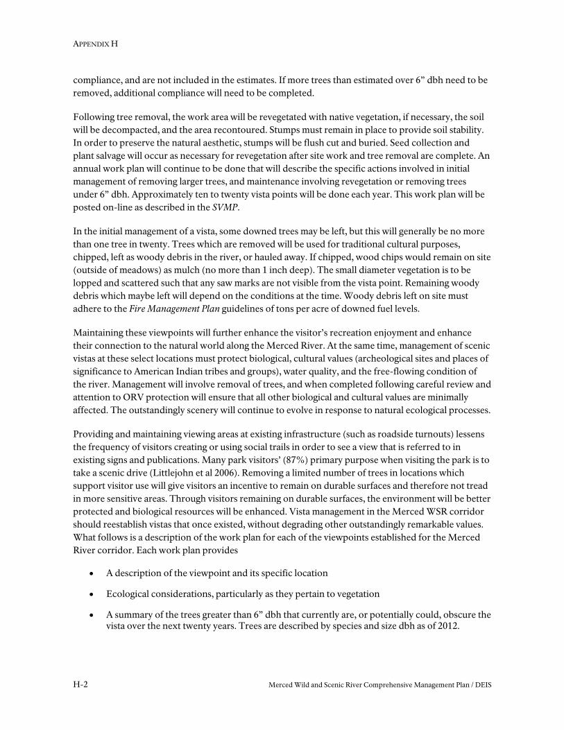
Figure H-5: Bridalveil Straight. NPS 2009
RES-2-078 Bridalveil Straight interpretive sign (13-High) Location: Southside Drive View: Bridalveil Falls
The Bridalveil Straight interpretive sign is located 0.25 miles east of the intersection of Southside Drive and Wawona Road. This vista is listed as a contributing feature to the Yosemite Valley Historic District. The focal point of the vista to be managed is Bridalveil Fall to the south. This location also has spectacular view of El Capitan to the east, over California Black Oaks. It is unlikely the oak trees will grow tall enough to obscure the view to El Capitan, but this area should also be monitored in the future for conifer encroachment.
The road in its current configuration was constructed in 1928. Trees established before 1928 should not be removed.
The site was inventoried as part of the Scenic Vista Management Plan as site number 38. This site rated a high priority with an average VRA score of 13 out of 18.
MAXIMUM NUMBER OF TREES OVER 6”DBH REMOVED AT THIS LOCATION
Tree Species <12” dbh <20” dbh <40” dbh <50” dbh TOTAL
Ponderosa - 3 1 - 4
Cedar 8 31 1 5 45
Fir - 3 - 3 6
Black Oak Trim
Total 55

APPENDIX H
H-8 Merced Wild and Scenic River Comprehensive Management Plan / DEIS
Figure H-6: Bridalveil Fall Foot Bridge. NPS 2009
RES-2-075 Bridalveil Fall Foot Bridge (7.25-Medium) Location: Bridalveil Trail View: Bridalveil Fall
The Bridalveil Fall Foot Bridge is located on the Bridalveil Fall trail at the base of the fall. This vista is from one of three bridges built in 1913 at the waterfall. These are the oldest remaining bridges in the valley. The intention in managing this vista is not to create a broad view, but a focused and intimate view of the fall.
Trees established before 1913 should not be removed.
The site was inventoried as part of the Scenic Vista Management Plan as site number 37. This site rated a medium priority with an average VRA score of 7.25 out of 18.
MAXIMUM NUMBER OF TREES OVER 6”DBH REMOVED AT THIS LOCATION
Tree Species <12” dbh <20” dbh <40” dbh <50” dbh TOTAL
Douglas fir 1 - - 2 3
Black Oak Trim
Live Oak - 2 - - 2
Cedar - - 1 - 1
Total 6
Scenic Vista Management in the Merced River Corridor
Merced Wild and Scenic River Comprehensive Management Plan / DEIS H-9
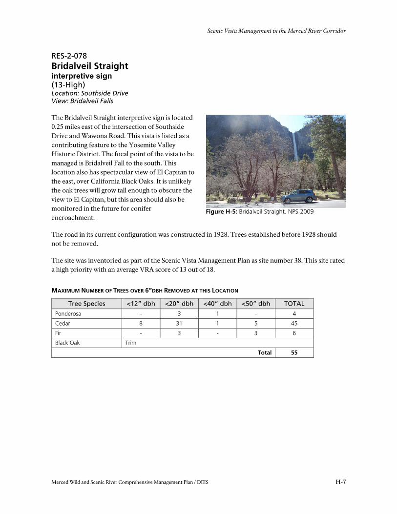
Figure H-7: Cathedral Spires. NPS 2012
RES-2-121 Cathedral Spires Turnout (7.5-Medium) Location: Southside Drive View: Cathedral Spires and Rock
The Cathedral Spires Turnout on Southside Drive is located 1.3 miles east of the Wawona Road and Southside Drive intersection. This vista is listed as a contributing feature of the Yosemite Valley Historic District.
The Valley Loop Road in its current configuration was constructed in 1928.
Trees established before 1928 should not be removed.
The site was inventoried as part of the Scenic Vista Management Plan as site number 225. This site rated a medium priority with an average VRA score of 7.5 out of 18.
MAXIMUM NUMBER OF TREES OVER 6”DBH REMOVED AT THIS LOCATION
Tree Species <12” dbh <20” dbh <30” dbh <40” dbh <50” dbh TOTAL
Cedar 5 - 6 1 - 12
Douglas Fir - 6 1 - 1 8
Ponderosa - 1 - - - 1
Total 21

APPENDIX H
H-10 Merced Wild and Scenic River Comprehensive Management Plan / DEIS
Figure H-8: Cathedral Beach Parking. NPS 2012
RES-2-158 Cathedral Beach Parking (9.75-Medium) View: Three Brothers
The Cathedral Beach Parking area is located on Southside Drive 0.25 miles east of the El Capitan Crossover.
This vista is located on the terrace above the restroom. There were two vistas inventoried from this area, this one, and another from the beach. The recommendation is to manage the vista from this location and not the vista from the beach. The view to Three Brothers is similar, and new parking could be built in this location to better accommodate visitors. Trees established before 1928 should not be removed when managing this vista.
The site was inventoried as part of the Scenic Vista Management Plan as site number 226. This site rated a medium priority with an average VRA score of 9.75 out of 18.
MAXIMUM NUMBER OF TREES OVER 6”DBH REMOVED AT THIS LOCATION
Tree Species <12” dbh <20” dbh <30” dbh <40” dbh <50” dbh TOTAL Ponderosa 6 2 5 9 2 24 Cedar 42 11 3 9 - 65 Fir 1 2 1 - - 4 Black Oak - 1 - - - 1
Total 94
Scenic Vista Management in the Merced River Corridor
Merced Wild and Scenic River Comprehensive Management Plan / DEIS H-11
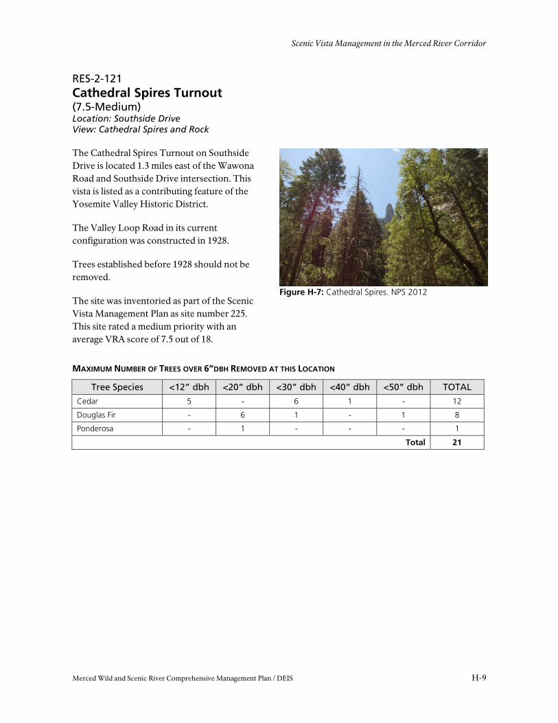
Figure H-10: El Capitan Postage Stamp. NPS 2009
RES-2-091 El Capitan Postage Stamp Turnout (9.5-Medium) Location: Northside Drive View: El Capitan, Merced River
The El Capitan Postage Stamp Turnout is located on Southside Drive 0.45 miles east of the El Capitan Drive intersection. The history of this vista began in 1868 when Carlton Watkins captured a photograph of El Capitan a few feet from the current turnout in 1868. This photograph was used in a postage stamp in 1934. It was a popular vista at one time, but is now almost completely obscured with conifers. There are a large number of dead trees in the area and the intention is to remove the smaller trees that have less habitat value and also reduce the fuel load. Several large deciduous riparian trees partially obscure the view, but will not be removed for vista management because of their high habitat potential.
The road was completed in 1928, so trees established before then should not be removed.
The site was inventoried as part of the Scenic Vista Management Plan as site number 3. This site rated a medium priority with an average VRA score of 9.5 out of 18.
MAXIMUM NUMBER OF TREES OVER 6”DBH REMOVED AT THIS LOCATION
Tree Species <12” dbh <20” dbh <30” dbh <40” dbh <50” dbh TOTAL Cedar 53 (28?) 4 4 9 3 73 Ponderosa 1 4 5 8 4 22 Live Oak 1 - - - - 1
Total 96
SNAGS TO REMAIN
Tree Species <12” dbh <20”dbh <40” dbh TOTAL Cedar 1 1 Oak 1 1 2 Willow 2 2
Total 5
SNAGS TO REMOVE
Tree Species <12” dbh TOTAL Cedar 15 15
Total 15

APPENDIX H
H-12 Merced Wild and Scenic River Comprehensive Management Plan / DEIS
Figure H-11: Ferry Bend. NPS 2009
RES-2-092 Ferry Bend Turnout (12-High) Location: Southside Drive View: El Capitan, Merced River
Ferry Bend Turnout is located on Southside Drive 1.17 miles east of the El Capitan Road intersection. The turnout is near where Ira Folsom began a ferry in 1871 to cross the Merced. The vista of the river and El Capitan is a contributing feature to the Yosemite Valley Historic District. The vista should be managed from the turnout to allow people to enjoy the view with minimal damage to the vegetation. Trees established before 1928 should not be removed from this location for vista management.
This site has a considerable number of snags from a managed burn in 2004. The area surveyed is approximately 4 acres. The intention is to remove snags less than 12” dbh, and retain any larger snags. This would retain 23 snags between 20” and 40” dbh, and remove 53 snags less than 12” dbh. There would also be a considerable number of cedar saplings and trees less than 6” dbh removed.
The site was inventoried as part of the Scenic Vista Management Plan as site number 44. This site rated a high priority with an average VRA score of 12 out of 18.
MAXIMUM NUMBER OF TREES OVER 6”DBH REMOVED AT THIS LOCATION
Tree Species
<12” dbh
<20” dbh
<30” dbh
<40” dbh
<50” dbh
<60” dbh
<70” dbh TOTAL
Ponderosa 6 23 59 62 14 3 3 170 Cedar 41 56 30 21 5 - 1 154 Fir - 1 6 2 2 1 - 12
Total 336
SNAGS TO REMOVE
Tree Species <12” dbh TOTAL Ponderosa Snag 4 4 Cedar Snag 48 48 Fir Snag 1 1
Total 53
SNAGS TO RETAIN
Tree Species <20” dbh <30” dbh TOTAL Ponderosa Snag 3 - 3 Cedar Snag 17 3 20
Total 23
Scenic Vista Management in the Merced River Corridor
Merced Wild and Scenic River Comprehensive Management Plan / DEIS H-13
Figure H-12: Sentinel Beach. NPS 2009
RES-2-115 Sentinel Beach Picnic Area (11.25-High) Location: Southside Drive View: Sentinel Rock
Sentinel Beach is adjacent to the Sentinel Beach picnic area located off of Southside Drive 1.7 miles east of the intersection of El Capitan Road. This is a popular destination for picnicking, and is also the pullout and shuttle stop for raft rentals. Trees established before 1928 should not be removed from this location.
An alternative picnic and parking area is considered under the MRP at the location initially surveyed. It is recommended that this site is managed within the new developed area because it would create a better, more durable platform for visitors’ to enjoy the vista.
The site was inventoried as part of the Scenic Vista Management Plan as site number 22. This site rated a high priority with an average VRA score of 11.25 out of 18.
MAXIMUM NUMBER OF TREES OVER 6”DBH REMOVED AT THIS LOCATION
Tree Species <12” dbh <30” dbh <40” dbh TOTAL
Ponderosa 1 3 7 11
Cedar - 5 5 10
Total 21
APPENDIX H
H-14 Merced Wild and Scenic River Comprehensive Management Plan / DEIS
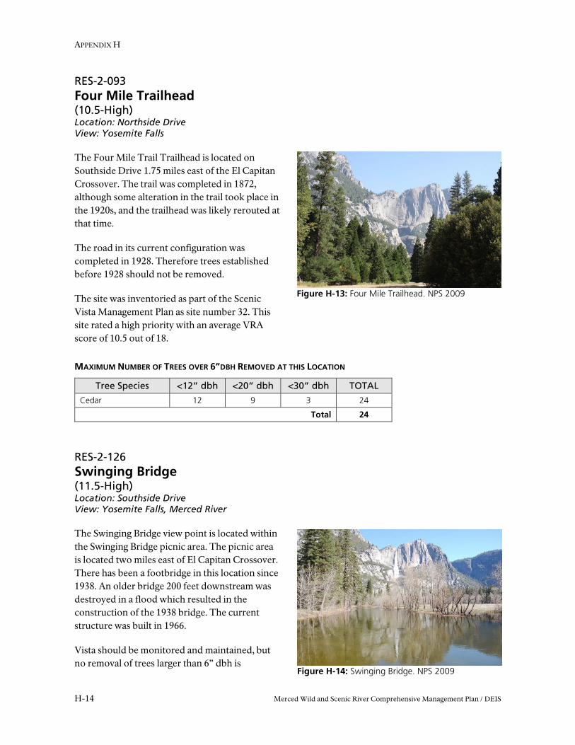
Figure H-13: Four Mile Trailhead. NPS 2009
Figure H-14: Swinging Bridge. NPS 2009
RES-2-093 Four Mile Trailhead (10.5-High) Location: Northside Drive View: Yosemite Falls
The Four Mile Trail Trailhead is located on Southside Drive 1.75 miles east of the El Capitan Crossover. The trail was completed in 1872, although some alteration in the trail took place in the 1920s, and the trailhead was likely rerouted at that time.
The road in its current configuration was completed in 1928. Therefore trees established before 1928 should not be removed.
The site was inventoried as part of the Scenic Vista Management Plan as site number 32. This site rated a high priority with an average VRA score of 10.5 out of 18.
MAXIMUM NUMBER OF TREES OVER 6”DBH REMOVED AT THIS LOCATION
Tree Species <12” dbh <20” dbh <30” dbh TOTAL
Cedar 12 9 3 24
Total 24
RES-2-126 Swinging Bridge (11.5-High) Location: Southside Drive View: Yosemite Falls, Merced River
The Swinging Bridge view point is located within the Swinging Bridge picnic area. The picnic area is located two miles east of El Capitan Crossover. There has been a footbridge in this location since 1938. An older bridge 200 feet downstream was destroyed in a flood which resulted in the construction of the 1938 bridge. The current structure was built in 1966.
Vista should be monitored and maintained, but no removal of trees larger than 6” dbh is
Scenic Vista Management in the Merced River Corridor
Merced Wild and Scenic River Comprehensive Management Plan / DEIS H-15
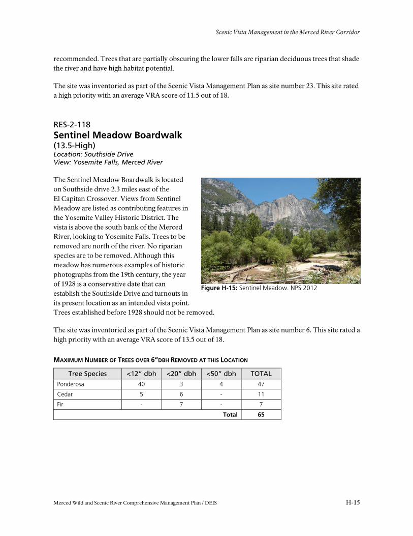
Figure H-15: Sentinel Meadow. NPS 2012
recommended. Trees that are partially obscuring the lower falls are riparian deciduous trees that shade the river and have high habitat potential.
The site was inventoried as part of the Scenic Vista Management Plan as site number 23. This site rated a high priority with an average VRA score of 11.5 out of 18.
RES-2-118 Sentinel Meadow Boardwalk (13.5-High) Location: Southside Drive View: Yosemite Falls, Merced River
The Sentinel Meadow Boardwalk is located on Southside drive 2.3 miles east of the El Capitan Crossover. Views from Sentinel Meadow are listed as contributing features in the Yosemite Valley Historic District. The vista is above the south bank of the Merced River, looking to Yosemite Falls. Trees to be removed are north of the river. No riparian species are to be removed. Although this meadow has numerous examples of historic photographs from the 19th century, the year of 1928 is a conservative date that can establish the Southside Drive and turnouts in its present location as an intended vista point. Trees established before 1928 should not be removed.
The site was inventoried as part of the Scenic Vista Management Plan as site number 6. This site rated a high priority with an average VRA score of 13.5 out of 18.
MAXIMUM NUMBER OF TREES OVER 6”DBH REMOVED AT THIS LOCATION
Tree Species <12” dbh <20” dbh <50” dbh TOTAL
Ponderosa 40 3 4 47
Cedar 5 6 - 11
Fir - 7 - 7
Total 65

APPENDIX H
H-16 Merced Wild and Scenic River Comprehensive Management Plan / DEIS
Figure H-16: Chapel. NPS 2009
RES-2-080 Yosemite Valley Chapel (10.5-High) Location: Southside Drive View: Yosemite Falls
The Yosemite Valley Chapel is located on Southside Drive 2.5 Miles east of the El Capitan Crossover. The Chapel is the oldest building in the Valley. It was moved to its present location in 1901, but was originally built in 1879. There are some trees to remove in the immediate foreground, but most of the trees are taller conifers about 300 m away, across the meadow, that obscure the lower fall. Trees established before 1901 should not be removed.
The site was inventoried as part of the Scenic Vista Management Plan as site number 20. This site rated a high priority with an average VRA score of 10.5 out of 18.
MAXIMUM NUMBER OF TREES OVER 6”DBH REMOVED AT THIS LOCATION
Tree Species <12” dbh <20” dbh <50” dbh TOTAL
Ponderosa 5 1 1 7
Cedar 2 5 1 8
Total 15
Scenic Vista Management in the Merced River Corridor
Merced Wild and Scenic River Comprehensive Management Plan / DEIS H-17
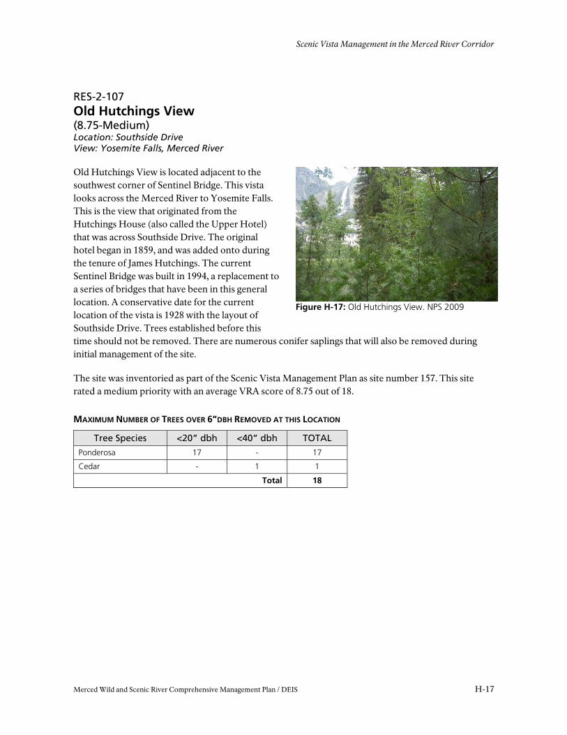
Figure H-17: Old Hutchings View. NPS 2009
RES-2-107 Old Hutchings View (8.75-Medium) Location: Southside Drive View: Yosemite Falls, Merced River
Old Hutchings View is located adjacent to the southwest corner of Sentinel Bridge. This vista looks across the Merced River to Yosemite Falls. This is the view that originated from the Hutchings House (also called the Upper Hotel) that was across Southside Drive. The original hotel began in 1859, and was added onto during the tenure of James Hutchings. The current Sentinel Bridge was built in 1994, a replacement to a series of bridges that have been in this general location. A conservative date for the current location of the vista is 1928 with the layout of Southside Drive. Trees established before this time should not be removed. There are numerous conifer saplings that will also be removed during initial management of the site.
The site was inventoried as part of the Scenic Vista Management Plan as site number 157. This site rated a medium priority with an average VRA score of 8.75 out of 18.
MAXIMUM NUMBER OF TREES OVER 6”DBH REMOVED AT THIS LOCATION
Tree Species <20” dbh <40” dbh TOTAL
Ponderosa 17 - 17
Cedar - 1 1
Total 18
APPENDIX H
H-18 Merced Wild and Scenic River Comprehensive Management Plan / DEIS
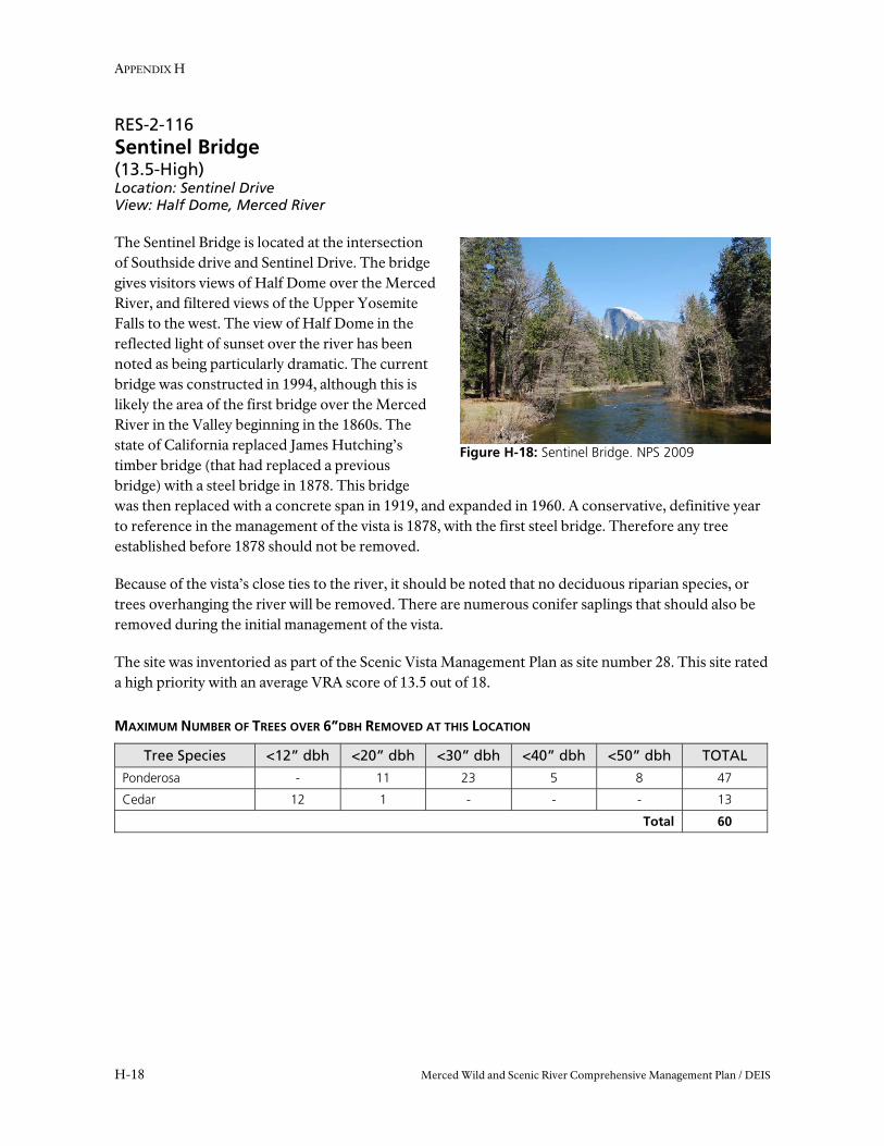
Figure H-18: Sentinel Bridge. NPS 2009
RES-2-116 Sentinel Bridge (13.5-High) Location: Sentinel Drive View: Half Dome, Merced River
The Sentinel Bridge is located at the intersection of Southside drive and Sentinel Drive. The bridge gives visitors views of Half Dome over the Merced River, and filtered views of the Upper Yosemite Falls to the west. The view of Half Dome in the reflected light of sunset over the river has been noted as being particularly dramatic. The current bridge was constructed in 1994, although this is likely the area of the first bridge over the Merced River in the Valley beginning in the 1860s. The state of California replaced James Hutching’s timber bridge (that had replaced a previous bridge) with a steel bridge in 1878. This bridge was then replaced with a concrete span in 1919, and expanded in 1960. A conservative, definitive year to reference in the management of the vista is 1878, with the first steel bridge. Therefore any tree established before 1878 should not be removed.
Because of the vista’s close ties to the river, it should be noted that no deciduous riparian species, or trees overhanging the river will be removed. There are numerous conifer saplings that should also be removed during the initial management of the vista.
The site was inventoried as part of the Scenic Vista Management Plan as site number 28. This site rated a high priority with an average VRA score of 13.5 out of 18.
MAXIMUM NUMBER OF TREES OVER 6”DBH REMOVED AT THIS LOCATION
Tree Species <12” dbh <20” dbh <30” dbh <40” dbh <50” dbh TOTAL
Ponderosa - 11 23 5 8 47
Cedar 12 1 - - - 13
Total 60
Scenic Vista Management in the Merced River Corridor
Merced Wild and Scenic River Comprehensive Management Plan / DEIS H-19
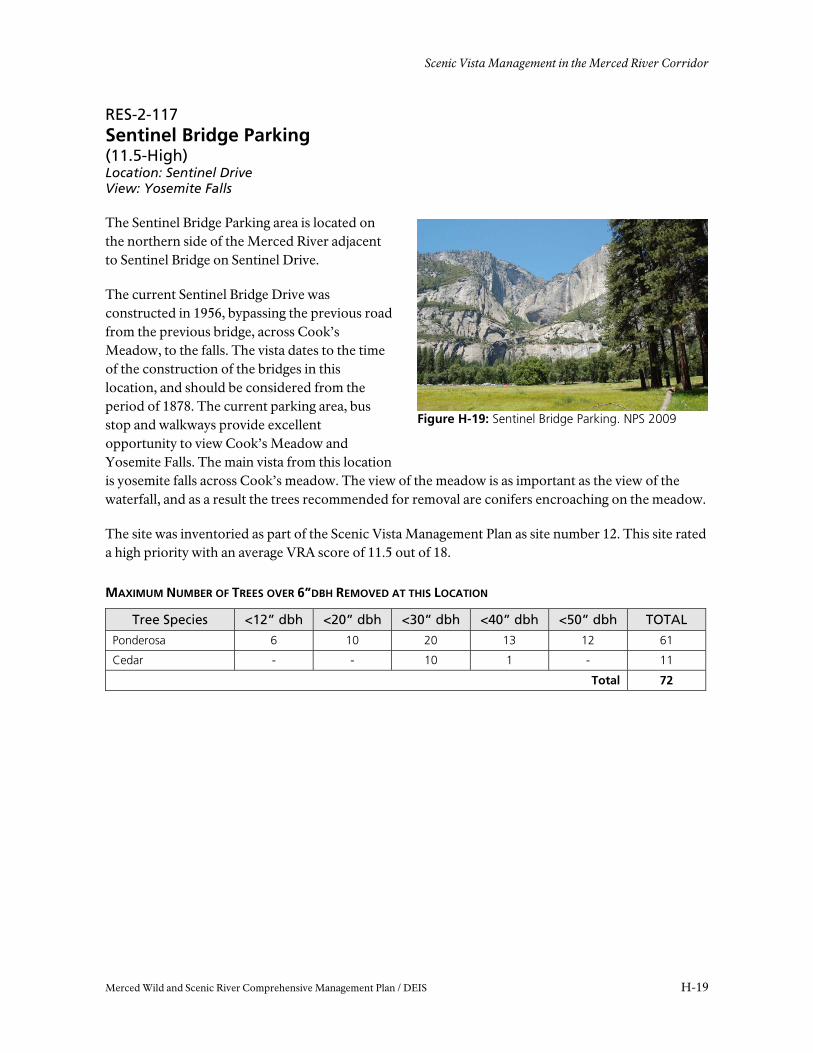
Figure H-19: Sentinel Bridge Parking. NPS 2009
RES-2-117 Sentinel Bridge Parking (11.5-High) Location: Sentinel Drive View: Yosemite Falls
The Sentinel Bridge Parking area is located on the northern side of the Merced River adjacent to Sentinel Bridge on Sentinel Drive.
The current Sentinel Bridge Drive was constructed in 1956, bypassing the previous road from the previous bridge, across Cook’s Meadow, to the falls. The vista dates to the time of the construction of the bridges in this location, and should be considered from the period of 1878. The current parking area, bus stop and walkways provide excellent opportunity to view Cook’s Meadow and Yosemite Falls. The main vista from this location is yosemite falls across Cook’s meadow. The view of the meadow is as important as the view of the waterfall, and as a result the trees recommended for removal are conifers encroaching on the meadow.
The site was inventoried as part of the Scenic Vista Management Plan as site number 12. This site rated a high priority with an average VRA score of 11.5 out of 18.
MAXIMUM NUMBER OF TREES OVER 6”DBH REMOVED AT THIS LOCATION
Tree Species <12” dbh <20” dbh <30” dbh <40” dbh <50” dbh TOTAL
Ponderosa 6 10 20 13 12 61
Cedar - - 10 1 - 11
Total 72
APPENDIX H
H-20 Merced Wild and Scenic River Comprehensive Management Plan / DEIS
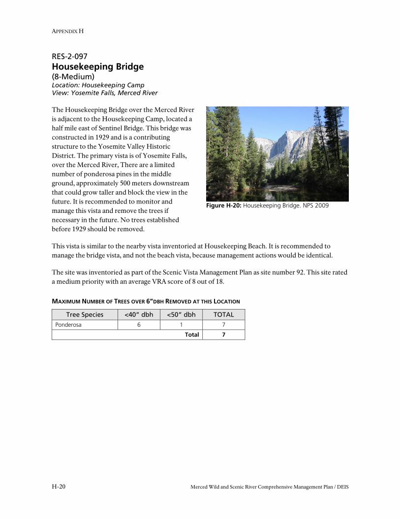
Figure H-20: Housekeeping Bridge. NPS 2009
RES-2-097 Housekeeping Bridge (8-Medium) Location: Housekeeping Camp View: Yosemite Falls, Merced River
The Housekeeping Bridge over the Merced River is adjacent to the Housekeeping Camp, located a half mile east of Sentinel Bridge. This bridge was constructed in 1929 and is a contributing structure to the Yosemite Valley Historic District. The primary vista is of Yosemite Falls, over the Merced River, There are a limited number of ponderosa pines in the middle ground, approximately 500 meters downstream that could grow taller and block the view in the future. It is recommended to monitor and manage this vista and remove the trees if necessary in the future. No trees established before 1929 should be removed.
This vista is similar to the nearby vista inventoried at Housekeeping Beach. It is recommended to manage the bridge vista, and not the beach vista, because management actions would be identical.
The site was inventoried as part of the Scenic Vista Management Plan as site number 92. This site rated a medium priority with an average VRA score of 8 out of 18.
MAXIMUM NUMBER OF TREES OVER 6”DBH REMOVED AT THIS LOCATION
Tree Species <40” dbh <50” dbh TOTAL
Ponderosa 6 1 7
Total 7
Scenic Vista Management in the Merced River Corridor
Merced Wild and Scenic River Comprehensive Management Plan / DEIS H-21
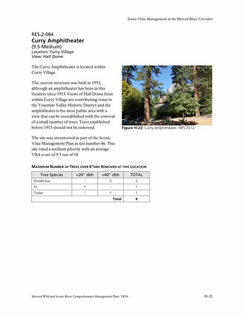
Figure H-23: Curry Amphitheater. NPS 2012
RES-2-084 Curry Amphitheater (9.5-Medium) Location: Curry Village View: Half Dome
The Curry Amphitheater is located within Curry Village.
The current structure was built in 1953, although an amphitheater has been in this location since 1915. Views of Half Dome from within Curry Village are contributing vistas in the Yosemite Valley Historic District and the amphitheater is the most public area with a view that can be reestablished with the removal of a small number of trees. Trees established before 1915 should not be removed.
The site was inventoried as part of the Scenic Vista Management Plan as site number 46. This site rated a medium priority with an average VRA score of 9.5 out of 18.
MAXIMUM NUMBER OF TREES OVER 6”DBH REMOVED AT THIS LOCATION
Tree Species <20” dbh <40” dbh TOTAL
Ponderosa - 2 2
Fir 1 - 1
Cedar - 1 1
Total 4
APPENDIX H
H-22 Merced Wild and Scenic River Comprehensive Management Plan / DEIS
Figure H-25: Stoneman Bridge. NPS 2012
Figure H-24: Curry Village Parking. NPS 2012
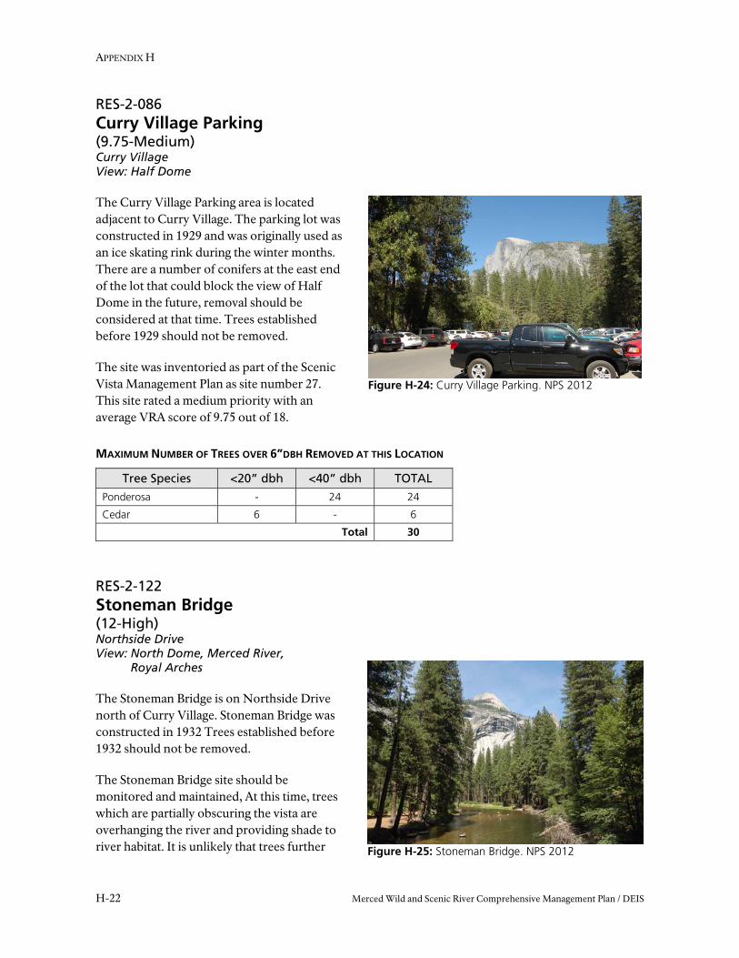
RES-2-086 Curry Village Parking (9.75-Medium) Curry Village View: Half Dome
The Curry Village Parking area is located adjacent to Curry Village. The parking lot was constructed in 1929 and was originally used as an ice skating rink during the winter months. There are a number of conifers at the east end of the lot that could block the view of Half Dome in the future, removal should be considered at that time. Trees established before 1929 should not be removed.
The site was inventoried as part of the Scenic Vista Management Plan as site number 27. This site rated a medium priority with an average VRA score of 9.75 out of 18.
MAXIMUM NUMBER OF TREES OVER 6”DBH REMOVED AT THIS LOCATION
Tree Species <20” dbh <40” dbh TOTAL
Ponderosa - 24 24
Cedar 6 - 6
Total 30
RES-2-122 Stoneman Bridge (12-High) Northside Drive View: North Dome, Merced River,
Royal Arches
The Stoneman Bridge is on Northside Drive north of Curry Village. Stoneman Bridge was constructed in 1932 Trees established before 1932 should not be removed.
The Stoneman Bridge site should be monitored and maintained, At this time, trees which are partially obscuring the vista are overhanging the river and providing shade to river habitat. It is unlikely that trees further

Scenic Vista Management in the Merced River Corridor
Merced Wild and Scenic River Comprehensive Management Plan / DEIS H-23
Figure H-26: Stoneman Meadow. NPS 2012
away would grow tall enough to cover the view of North Dome. The bridge is considered for removal. If the bridge is removed, the vista should not be maintained in the future.
The site was inventoried as part of the Scenic Vista Management Plan as site number 25. This site rated a high priority with an average VRA score of 12 out of 18.
RES-2-123 Stoneman Meadow Boardwalk (13.5-High) Location: Happy Isle Loop Road View: North Dome, Royal Arches, Washingtons Column, Stoneman Meadow
The Stoneman Meadow boardwalk is located at the intersection of Happy Isles Loop Road and Curry Village Road. The boardwalk gives visitors a panoramic view of the meadow and many other significant Yosemite landmarks such as Glacier Point, North Dome, Royal Arches, and Washington’s Column. Half Dome can be seen in the distance to the east and Yosemite Falls can be seen in the distance to the west. The primary vista to manage at this site is the view to North Dome, Royal Arches and Washington’s Column where conifers have encroached onto the edge of the meadow. The Happy Isles Loop was constructed in 1929 and trees established before 1929 should not be removed.
The site was inventoried as part of the Scenic Vista Management Plan as site number 6. This site rated a high priority with an average VRA score of 13.5 out of 18.
MAXIMUM NUMBER OF TREES OVER 6”DBH REMOVED AT THIS LOCATION
Tree Species <12” dbh <20” dbh <30” dbh <40” dbh TOTAL
Ponderosa 19 16 46 13 94
Cedar 36 12 15 3 66
Total 160

APPENDIX H
H-24 Merced Wild and Scenic River Comprehensive Management Plan / DEIS
Figure H-27: Clark’s Bridge. NPS 2012
Figure H-28: Happy Isles Bridge. NPS 2012
RES-2-082 Clarks Bridge (8-Medium) Location: Happy Isle Loop Road View: Yosemite Falls
Clarks Bridge is west of the Concessioner Stables on Happy Isles Loop Road. It is a distant vista of Yosemite Falls down the Merced River. Large trees in the middle ground up to 600 meters away are recommended for removal. Clarks Bridge was constructed in 1928, so trees established before 1928 should not be removed.
The site was inventoried as part of the Scenic Vista Management Plan as site number 7. This site rated a medium priority with an average VRA score of 8 out of 18.
MAXIMUM NUMBER OF TREES OVER 6”DBH REMOVED AT THIS LOCATION
Tree Species <12” dbh <20” dbh <30” dbh <40” dbh <50” dbh TOTAL
Ponderosa - 6 14 17 2 39
Cedar 11 5 1 4 - 21
Total 60
RES-2-094 Happy Isles Bridge (8.5-Medium) Location: Happy Isles Loop Road View: North Dome, Merced River
The Happy Isles Bridge is at the southeast point of Happy Isles Loop Road. Happy Isles Bridge was constructed in 1929, so trees established before 1929 should not be removed.
The site was inventoried as part of the Scenic Vista Management Plan as site number 14. This site rated a medium priority with an average VRA score of 8.5 out of 18.

Scenic Vista Management in the Merced River Corridor
Merced Wild and Scenic River Comprehensive Management Plan / DEIS H-25
Figure H-29: Illilouette View. NPS 2009
MAXIMUM NUMBER OF TREES OVER 6”DBH REMOVED AT THIS LOCATION
Tree Species <12” dbh <20” dbh <30” dbh <40” dbh TOTAL
Ponderosa - - - 1 1
Cedar 8 2 - - 10
Fir 11 2 1 3 17
Total 28
RES-2-100 Illilouette View (8.25-Medium) Location: Mist Trail View: Illilouette Falls
Illilouette View is located on the Mist Trail between the trailhead at Happy Isles and the Vernal Falls Bridge. The trail on the south side of the river was built in 1885 by George Anderson, and reworked by the Park Service in 1928.
The vista is from a viewing area to Illilouette Falls. The view is almost completely blocked. The trees recommended for removal are on the opposite bank of the river. No trees should be removed that overhang the river, or established before 1928. No actions in wilderness areas will occur.
The site was inventoried as part of the Scenic Vista Management Plan as site number 30. This site rated a medium priority with an average VRA score of 8.25 out of 18.
MAXIMUM NUMBER OF TREES OVER 6”DBH REMOVED AT THIS LOCATION
Tree Species <12” dbh <20” dbh <30” dbh <40” dbh <50” dbh TOTAL
Cedar - - 1 - 1 2
Fir 4 6 9 4 - 23
Total 25

APPENDIX H
H-26 Merced Wild and Scenic River Comprehensive Management Plan / DEIS
Figure H-30: Vernal Fall Foot Bridge. NPS 2009
Figure H-33: Ahwahnee Lounge. NPS 2012
RES-2-130 Vernal Fall Foot Bridge (7.25-Medium) Location: Mist Trail View: Vernal Falls
The Vernal Fall Foot Bridge is located on the mist trail approximately 0.75 miles from the Mist Trail trailhead. There has been a bridge near the base of the fall since one was constructed by the state of California in 1885. At present, there are conifers encroaching from the north, but these are within the Wilderness boundary, which is about 25 meters upstream from the bridge. No trees larger than 6” dbh are recommended for removal. This site should be monitored and maintained. There are small maple trees, outside of Wilderness, near the bridge that could be trimmed in the future to preserve a view to the fall.
The site was inventoried as part of the Scenic Vista Management Plan as site number 29. This site rated a medium priority with an average VRA score of 7.25 out of 18.
RES-2-069 Ahwahnee Lounge (11.25-High) Location: Ahwahnee Hotel, Royal Arches, North Dome, Washington’s Column View: Half Dome
The Ahwahnee Dining Lounge is located within the historic Ahwahnee Hotel, a National Historic Landmark. The Ahwahnee Hotel was constructed in 1927 and the Lounge was sited to be a viewing lounge to the scenic wonders of Yosemite. Many areas of the hotel were aligned to take full and dramatic effect of the scenery. One of the dramatic views that have been obscured by conifers is to Half Dome from the Lounge. Trees in the middle ground up to 250 meters from the building are recommended for removal. Trees established before 1927 should not be removed for vista management.
The site was inventoried as part of the Scenic Vista Management Plan as site number 159. This site rated a high priority with an average VRA score of 11.25 out of 18.

Scenic Vista Management in the Merced River Corridor
Merced Wild and Scenic River Comprehensive Management Plan / DEIS H-27
Figure H-31: Ahwahnee Winter Club Room. NPS 2012
Figure H-32: Ahwahnee Dining Room. NPS 2009
MAXIMUM NUMBER OF TREES OVER 6”DBH REMOVED AT THIS LOCATION
Tree Species <12” dbh <20” dbh <30” dbh <40” dbh <50” dbh <60” dbh TOTAL
Ponderosa 26 6 27 39 5 2 94
Cedar 45 66 10 - 1 - 122
Total 216
RES-2-073 Ahwahnee Winter Club Room (9.5-Medium) Location: Ahwahnee Hotel View: Royal Arches, North Dome, Washington’s Column, Half Dome
This vista is next to the Great Lounge, and falls within the same viewing corridor. This site should be monitored, and action should not be taken to block this view. No additional action should be taken at this location outside of managing the Ahwahnee Lounge vista.
The site was inventoried as part of the Scenic Vista Management Plan as site number 228. This site rated a medium priority with an average VRA score of 9.5 out of 18.
RES-2-068 Ahwahnee Dining Room (10.25-High) Location: Ahwahnee Hotel View: Yosemite Falls
The Ahwahnee Dining Room is within the historic Ahwahnee Hotel, a National Landmark. The large window at the end of the grand hall looks west to Yosemite Falls. It was intended to frame the dramatic view for the guests while dining.
The Ahwahnee Hotel was constructed in 1927, so trees established before this time should not be removed. This is the only vista which recommends removing California Black Oak. These trees are obscuring a view in which there is little opportunity for a viewer to move
APPENDIX H
H-28 Merced Wild and Scenic River Comprehensive Management Plan / DEIS
Figure H-34: Ahwahnee Solarium. NPS 2009
around. Trimming rather than removing would improve the current vista, but would likely need to be trimmed on an annual basis. Trees in the middle ground up to 500 meters from the window are recommended for removal.
The site was inventoried as part of the Scenic Vista Management Plan as site number 161. This site rated a high priority with an average VRA score of 10.25 out of 18.
MAXIMUM NUMBER OF TREES OVER 6”DBH REMOVED AT THIS LOCATION
Tree Species <12” dbh <20” dbh <30” dbh <40” dbh <50” dbh TOTAL
Ponderosa 56 26 48 23 3 156
Cedar 7 15 15 7 1 45
Black Oak 1 - 1 - - 2
Live Oak 4 - - - - 4
Total 207
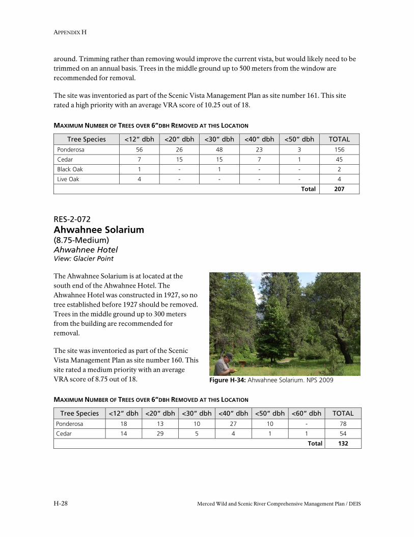
RES-2-072 Ahwahnee Solarium (8.75-Medium) Ahwahnee Hotel View: Glacier Point
The Ahwahnee Solarium is at located at the south end of the Ahwahnee Hotel. The Ahwahnee Hotel was constructed in 1927, so no tree established before 1927 should be removed. Trees in the middle ground up to 300 meters from the building are recommended for removal.
The site was inventoried as part of the Scenic Vista Management Plan as site number 160. This site rated a medium priority with an average VRA score of 8.75 out of 18.
MAXIMUM NUMBER OF TREES OVER 6”DBH REMOVED AT THIS LOCATION
Tree Species <12” dbh <20” dbh <30” dbh <40” dbh <50” dbh <60” dbh TOTAL
Ponderosa 18 13 10 27 10 - 78
Cedar 14 29 5 4 1 1 54
Total 132

Scenic Vista Management in the Merced River Corridor
Merced Wild and Scenic River Comprehensive Management Plan / DEIS H-29
Figure H-35: Ahwahnee Hotel Front Lawn. NPS 2009
Figure H-37: Ahwahnee Meadow. NPS 2012
RES-2-157 Ahwahnee Hotel, front lawn (10.25-High) Location: Ahwahnee Hotel View: Yosemite Falls, Glacier Point
The Ahwahnee Hotel Front Lawn is located at the southern end of the hotel. The vista is from the interpretive sign, looking toward Yosemite Falls.
The Ahwahnee Hotel was constructed in 1927, so no tree established before this time should be removed.
The site was inventoried as part of the Scenic Vista Management Plan as site number 16. This site rated a high priority with an average VRA score of 10.25 out of 18.
MAXIMUM NUMBER OF TREES OVER 6”DBH REMOVED AT THIS LOCATION
Tree Species <12” dbh <20” dbh <30” dbh <40” dbh <50” dbh TOTAL Ponderosa 8 1 1 3 1 14 Cedar - 1 - 1 - 2 Alder - trim - 1 - 1
Total 17
RES-2-071 Ahwahnee Meadow Peeling Domes Sign (11.5-High) Location: Northside Drive View: North Dome, Royal Arches, Washington’s
Column, Half Dome
The Ahwahnee Meadow is located on Northside Drive 0.5 miles from the intersection of Southside Drive. Northside Drive in its current configuration was constructed in 1928, so no trees established before this time should be removed. Removing this segment of Northside Drive is considered under the Merced River Plan. If the segment is removed, and no planned walkway replaces it in this area, the vista should not be monitored or maintained.

APPENDIX H
H-30 Merced Wild and Scenic River Comprehensive Management Plan / DEIS
Figure H-38: Church Bowl Picnic Area. NPS 2012
The site was inventoried as part of the Scenic Vista Management Plan as site number 227 This site rated a high priority with an average VRA score of 11.5 out of 18.
MAXIMUM NUMBER OF TREES OVER 6”DBH REMOVED AT THIS LOCATION
Tree Species <50” dbh TOTAL
Ponderosa 4 4
Total 4
RES-2-081 Church Bowl Picnic Area (12-High) Location: Ahwahnee Drive View: Half Dome
The Church Bowl Picnic Area is located on Ahwahnee Drive 0.37 miles west of the Ahwahnee Hotel. A coach road along the north side of the valley was constructed in 1872, although the alignment of the current road is known with certainty to date from 1927. Trees established before this time should not be removed.
The rockfall hazard zone has recently been updated to include an area further away from the cliff face. As stated in the SVMP, large trees help buffer the impact, and potential damage, of rockfall by absorbing some of the force and rock debris. Most of the trees currently obscuring the view are outside of the rock fall zone, on the south side of the road and not effective in protecting any structure. No trees on the north side of the road within the rockfall hazard zone will be removed.
The site was inventoried as part of the Scenic Vista Management Plan as site number 11. This site rated a high priority with an average VRA score of 12 out of 18.
MAXIMUM NUMBER OF TREES OVER 6”DBH REMOVED AT THIS LOCATION
Tree Species <12” dbh <20” dbh <30” dbh <40” dbh <50” dbh <60” dbh TOTAL
Ponderosa 80 6 12 6 6 4 114
Cedar 95 35 13 17 10 1 171
Total 285
Scenic Vista Management in the Merced River Corridor
Merced Wild and Scenic River Comprehensive Management Plan / DEIS H-31
Figure H-39: Visitor Center Benches. NPS 2012
Figure H-40: Hutchings View B. NPS 2012
RES-2-131 Visitor Center Benches (9.75-Medium) Location: Ahwahnee Drive View: Yosemite Falls
The Visitor Center Benches are in the plaza near the front entrance of the Yosemite Valley Visitors Center. The village was established with the construction of the Administration Building and the Museum, completed in 1926. Trees established before this time will not be removed.
The site was inventoried as part of the Scenic Vista Management Plan as site number 39. This site rated a medium priority with an average VRA score of 9.75 out of 18.
MAXIMUM NUMBER OF TREES OVER 6”DBH REMOVED AT THIS LOCATION
Tree Species <30” dbh TOTAL
Fir 3 3
Total 3
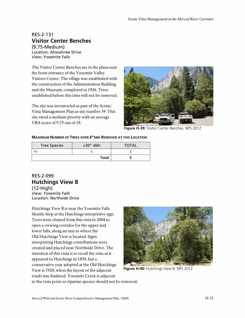
RES-2-099 Hutchings View B (12-High) View: Yosemite Falls Location: Northside Drive
Hutchings View B is near the Yosemite Falls Shuttle Stop at the Hutchings interpretive sign. Trees were cleared from this vista in 2004 to open a viewing corridor for the upper and lower falls, along an axis to where the Old Hutchings View is located. Signs interpreting Hutchings contributions were created and placed near Northside Drive. The intention of this vista is to recall the vista as it appeared to Hutchings in 1859, but a conservative year adopted at the Old Hutchings View is 1928, when the layout of the adjacent roads was finalized. Yosemite Creek is adjacent to the vista point so riparian species should not be removed.

APPENDIX H
H-32 Merced Wild and Scenic River Comprehensive Management Plan / DEIS
Figure H-41: Yosemite Falls View. NPS 2009
The site was inventoried as part of the Scenic Vista Management Plan as site number 158. This site rated a high priority with an average VRA score of 12 out of 18.
MAXIMUM NUMBER OF TREES OVER 6”DBH REMOVED AT THIS LOCATION
Tree Species <12” dbh <20” dbh <30” dbh <40” dbh <50” dbh TOTAL
Ponderosa - 6 11 1 1 19
Cedar 30 5 6 2 1 44
Black Oak Trim 4
Total 63
RES-2-141 Yosemite Falls View (8.75-Medium) Location: Northside Drive View: Yosemite Falls
Yosemite Falls View is northeast of The Yosemite Lodge. Trees were cleared as part of the Yosemite Falls approach project in 2005. The intention in managing this vista is to broaden the view to minimize future maintenance needs of trimming, and lessening the alley-like appearance of the trees on the approach to the falls. A conservative year to manage the vista from is 1928, when the circulation of the valley was generally set.
The site was inventoried as part of the Scenic Vista Management Plan as site number 18. This site rated a medium priority with an average VRA score of 8.75 out of 18.
MAXIMUM NUMBER OF TREES OVER 6”DBH REMOVED AT THIS LOCATION
Tree Species <12” dbh <20” dbh <30” dbh <40” dbh <50” dbh TOTAL
Ponderosa - 1 8 11 2 22
Cedar 55 4 1 4 - 64
Fir - 2 3 2 - 7
Total 93

Scenic Vista Management in the Merced River Corridor
Merced Wild and Scenic River Comprehensive Management Plan / DEIS H-33
Figure H-43: Cooks Meadow. NPS 2009
Figure H-42: Lower Falls Bridge. NPS 2009
RES-2-104 Lower Falls Bridge (10-High) Location: Lower Yosemite Falls Trail View: Yosemite Falls
The Lower Falls Bridge is near the base of the Yosemite Falls at the Lower Yosemite Falls Overlook. The vista is predominately open, but there are several cedars that could restrict the view in the future. These trees should be removed if they limit the view from the bridge. The bridge was built in 1920 and is a contributing structure to the Yosemite Valley Historic District. Trees established prior to 1920 should not be removed.
The site was inventoried as part of the Scenic Vista Management Plan as site number 48. This site rated a high priority with an average VRA score of 10 out of 18.
MAXIMUM NUMBER OF TREES OVER 6”DBH REMOVED AT THIS LOCATION
Tree Species <12” dbh <20” dbh TOTAL
Cedar 4 2 6
Total 6
RES-2-083 Cook’s Meadow, South Boardwalk (8-Medium) Location: Sentinel Drive View: Yosemite Falls
The Cook’s Meadow Boardwalk is located in the southwest corner of Cooks Meadow. This vista should be monitored and maintained, but no management actions removing trees larger than 6” dbh are recommended.
The site was inventoried as part of the Scenic Vista Management Plan as site number 2. This site rated a medium priority with an average VRA score of 8 out of 18.
APPENDIX H
H-34 Merced Wild and Scenic River Comprehensive Management Plan / DEIS
Figure H-45: Yosemite Lodge Portico. NPS 2009
Figure H-44: Superintendents Bridge. NPS 2009
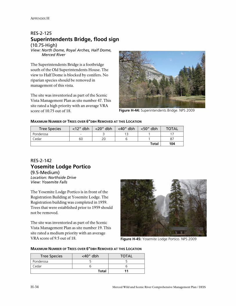
RES-2-125 Superintendents Bridge, flood sign (10.75-High) View: North Dome, Royal Arches, Half Dome,
Merced River
The Superintendents Bridge is a footbridge south of the Old Superintendents House. The view to Half Dome is blocked by conifers. No riparian species should be removed in management of this vista.
The site was inventoried as part of the Scenic Vista Management Plan as site number 47. This site rated a high priority with an average VRA score of 10.75 out of 18. MAXIMUM NUMBER OF TREES OVER 6”DBH REMOVED AT THIS LOCATION
Tree Species <12” dbh <20” dbh <40” dbh <50” dbh TOTAL Ponderosa - 3 13 1 17 Cedar 60 20 6 1 87
Total 104
RES-2-142 Yosemite Lodge Portico (9.5-Medium) Location: Northside Drive View: Yosemite Falls
The Yosemite Lodge Portico is in front of the Registration Building at Yosemite Lodge. The Registration building was completed in 1959. Trees that were established prior to 1959 should not be removed.
The site was inventoried as part of the Scenic Vista Management Plan as site number 19. This site rated a medium priority with an average VRA score of 9.5 out of 18. MAXIMUM NUMBER OF TREES OVER 6”DBH REMOVED AT THIS LOCATION
Tree Species <40” dbh TOTAL Ponderosa 5 5 Cedar 6 6
Total 11

Scenic Vista Management in the Merced River Corridor
Merced Wild and Scenic River Comprehensive Management Plan / DEIS H-35
Figure H-46: Leidig Meadow, west end. NPS 2009
RES-2-102 Leidig Meadow, west (11.75-High) Location: Valley Loop Trail View: North Dome, Washington’s Column, Cathedral Arches, Half Dome, Sentinel Rock
The vista is on a trail that about 50 meters south of the Valley Loop trail at the west end of Leidig Meadow, about 1 mile west of the Yosemite Lodge. It is a remarkable point in which a visitor can see many of the Yosemite Valley’s incredible geologic formations from one location, across a large meadow. The intention is to remove conifers encroaching in the meadow. It is difficult to assign a date to this location. Leidig Meadow has a long history of use including serving as the location for a US Army camp when the headquarters were moved to the Valley in 1906. The meadow was fenced for grazing shortly after, and at one point was the location of a horse race track. A conservative year from which the vista can be managed is 1928, when the circulation pattern in the valley was generally set.
The site was inventoried as part of the Scenic Vista Management Plan as site number 31. This site rated a high priority with an average VRA score of 11.75 out of 18.
MAXIMUM NUMBER OF TREES OVER 6”DBH REMOVED AT THIS LOCATION
Tree Species <12” dbh <20” dbh <30” dbh <40” dbh TOTAL
Ponderosa 4 5 4 6 19
Total 19
APPENDIX H
H-36 Merced Wild and Scenic River Comprehensive Management Plan / DEIS
Figure H-48: Devil’s Elbow. NPS 2009
Figure H-47: Wosky Pond. NPS 2009
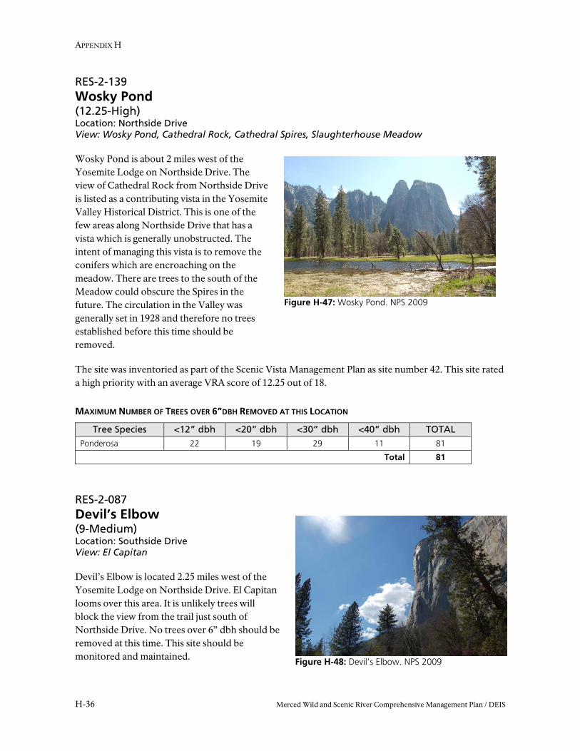
RES-2-139 Wosky Pond (12.25-High) Location: Northside Drive View: Wosky Pond, Cathedral Rock, Cathedral Spires, Slaughterhouse Meadow
Wosky Pond is about 2 miles west of the Yosemite Lodge on Northside Drive. The view of Cathedral Rock from Northside Drive is listed as a contributing vista in the Yosemite Valley Historical District. This is one of the few areas along Northside Drive that has a vista which is generally unobstructed. The intent of managing this vista is to remove the conifers which are encroaching on the meadow. There are trees to the south of the Meadow could obscure the Spires in the future. The circulation in the Valley was generally set in 1928 and therefore no trees established before this time should be removed.
The site was inventoried as part of the Scenic Vista Management Plan as site number 42. This site rated a high priority with an average VRA score of 12.25 out of 18.
MAXIMUM NUMBER OF TREES OVER 6”DBH REMOVED AT THIS LOCATION
Tree Species <12” dbh <20” dbh <30” dbh <40” dbh TOTAL Ponderosa 22 19 29 11 81
Total 81
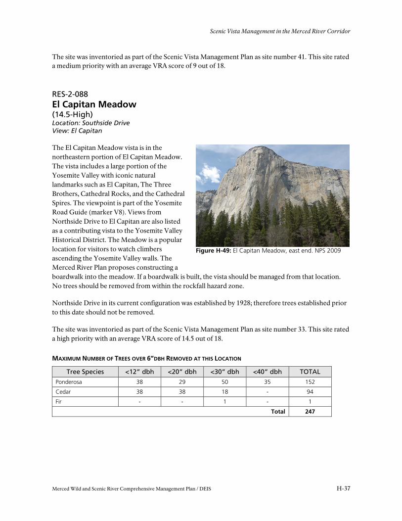
RES-2-087 Devil’s Elbow (9-Medium) Location: Southside Drive View: El Capitan
Devil’s Elbow is located 2.25 miles west of the Yosemite Lodge on Northside Drive. El Capitan looms over this area. It is unlikely trees will block the view from the trail just south of Northside Drive. No trees over 6” dbh should be removed at this time. This site should be monitored and maintained.
Scenic Vista Management in the Merced River Corridor
Merced Wild and Scenic River Comprehensive Management Plan / DEIS H-37
Figure H-49: El Capitan Meadow, east end. NPS 2009
The site was inventoried as part of the Scenic Vista Management Plan as site number 41. This site rated a medium priority with an average VRA score of 9 out of 18.
RES-2-088 El Capitan Meadow (14.5-High) Location: Southside Drive View: El Capitan
The El Capitan Meadow vista is in the northeastern portion of El Capitan Meadow. The vista includes a large portion of the Yosemite Valley with iconic natural landmarks such as El Capitan, The Three Brothers, Cathedral Rocks, and the Cathedral Spires. The viewpoint is part of the Yosemite Road Guide (marker V8). Views from Northside Drive to El Capitan are also listed as a contributing vista to the Yosemite Valley Historical District. The Meadow is a popular location for visitors to watch climbers ascending the Yosemite Valley walls. The Merced River Plan proposes constructing a boardwalk into the meadow. If a boardwalk is built, the vista should be managed from that location. No trees should be removed from within the rockfall hazard zone.
Northside Drive in its current configuration was established by 1928; therefore trees established prior to this date should not be removed.
The site was inventoried as part of the Scenic Vista Management Plan as site number 33. This site rated a high priority with an average VRA score of 14.5 out of 18.
MAXIMUM NUMBER OF TREES OVER 6”DBH REMOVED AT THIS LOCATION
Tree Species <12” dbh <20” dbh <30” dbh <40” dbh TOTAL
Ponderosa 38 29 50 35 152
Cedar 38 38 18 - 94
Fir - - 1 - 1
Total 247
APPENDIX H
H-38 Merced Wild and Scenic River Comprehensive Management Plan / DEIS
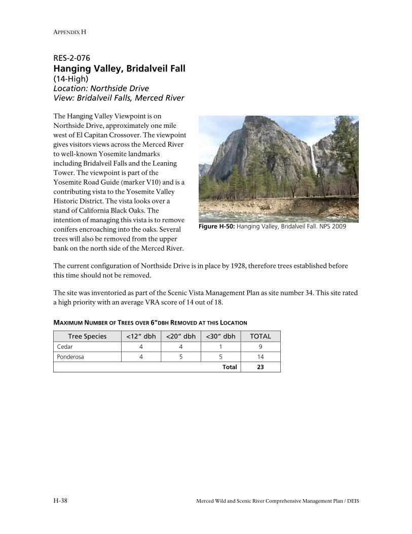
Figure H-50: Hanging Valley, Bridalveil Fall. NPS 2009
RES-2-076 Hanging Valley, Bridalveil Fall (14-High) Location: Northside Drive View: Bridalveil Falls, Merced River
The Hanging Valley Viewpoint is on Northside Drive, approximately one mile west of El Capitan Crossover. The viewpoint gives visitors views across the Merced River to well-known Yosemite landmarks including Bridalveil Falls and the Leaning Tower. The viewpoint is part of the Yosemite Road Guide (marker V10) and is a contributing vista to the Yosemite Valley Historic District. The vista looks over a stand of California Black Oaks. The intention of managing this vista is to remove conifers encroaching into the oaks. Several trees will also be removed from the upper bank on the north side of the Merced River.
The current configuration of Northside Drive is in place by 1928, therefore trees established before this time should not be removed.
The site was inventoried as part of the Scenic Vista Management Plan as site number 34. This site rated a high priority with an average VRA score of 14 out of 18.
MAXIMUM NUMBER OF TREES OVER 6”DBH REMOVED AT THIS LOCATION
Tree Species <12” dbh <20” dbh <30” dbh TOTAL
Cedar 4 4 1 9
Ponderosa 4 5 5 14
Total 23
Scenic Vista Management in the Merced River Corridor
Merced Wild and Scenic River Comprehensive Management Plan / DEIS H-39
Figure H-51: Valley View. NPS 2009
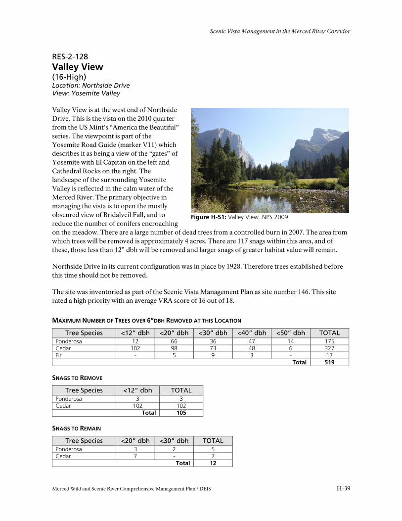
RES-2-128 Valley View (16-High) Location: Northside Drive View: Yosemite Valley
Valley View is at the west end of Northside Drive. This is the vista on the 2010 quarter from the US Mint’s “America the Beautiful” series. The viewpoint is part of the Yosemite Road Guide (marker V11) which describes it as being a view of the “gates” of Yosemite with El Capitan on the left and Cathedral Rocks on the right. The landscape of the surrounding Yosemite Valley is reflected in the calm water of the Merced River. The primary objective in managing the vista is to open the mostly obscured view of Bridalveil Fall, and to reduce the number of conifers encroaching on the meadow. There are a large number of dead trees from a controlled burn in 2007. The area from which trees will be removed is approximately 4 acres. There are 117 snags within this area, and of these, those less than 12” dbh will be removed and larger snags of greater habitat value will remain.
Northside Drive in its current configuration was in place by 1928. Therefore trees established before this time should not be removed.
The site was inventoried as part of the Scenic Vista Management Plan as site number 146. This site rated a high priority with an average VRA score of 16 out of 18.
MAXIMUM NUMBER OF TREES OVER 6”DBH REMOVED AT THIS LOCATION
Tree Species <12” dbh <20” dbh <30” dbh <40” dbh <50” dbh TOTAL Ponderosa 12 66 36 47 14 175Cedar 102 98 73 48 6 327Fir - 5 9 3 - 17
Total 519
SNAGS TO REMOVE
Tree Species <12” dbh TOTAL Ponderosa 3 3Cedar 102 102
Total 105
SNAGS TO REMAIN
Tree Species <20” dbh <30” dbh TOTAL Ponderosa 3 2 5Cedar 7 - 7
Total 12

APPENDIX H
H-40 Merced Wild and Scenic River Comprehensive Management Plan / DEIS
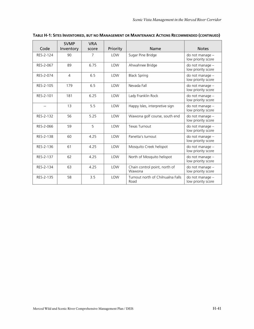
TABLE H-1: SITES INVENTORIED, BUT NO MANAGEMENT OR MAINTENANCE ACTIONS RECOMMENDED
Code SVMP
Inventory VRA score Priority Name Notes
-- 1 12.25 HIGH Residence One relocated - MRP common to all
RES-2-070 10 10.5 HIGH Ahwahnee Meadow, Northside Drive
do not manage - similar to 227
-- 17 12 HIGH Hutchings View A do not manage – similar to 158
-- 36 10.25 HIGH Valley View, old Big Oak Flat do not manage – near wilderness
RES-2-079 40 10.25 High Cathedral Beach do not manage – similar to 226
RES-2-085 224 9.75 MEDIUM Curry Village Ice Skating Rink do not manage – not in historic location, proposed removal in MRP
RES-2-096 26 9.75 MEDIUM Housekeeping Beach do not manage - similar to 92
RES-2-110 169 9.75 MEDIUM Old Wawona Road (point 3) do not manage - near wilderness
RES-2-112 164 9.75 MEDIUM Old Wawona Road (point 5) do not manage – near wilderness
RES-2-077 43 9.5 MEDIUM Bridalveil Meadow Do not manage – duplicate
RES-2-113 162 9.25 MEDIUM Old Wawona Road (point 6) do not manage – near wilderness
RES-2-111 165 9 MEDIUM Old Wawona Road (point 4) do not manage – near wilderness
-- 170 8.75 MEDIUM Old Wawona Road (point 2) do not manage – near wilderness
RES-2-108 171 8.75 MEDIUM Old Wawona Road (point 1) do not manage – near wilderness
RES-2-114 163 7.75 MEDIUM Old Wawona Road (point 7) do not manage – near wilderness
RES-2-090 21 8.5 MEDIUM El Capitan postage stamp beach do not manage - similar to 3
RES-2-140 230 0 LOW Yosemite Falls Trail do not manage - erroneous point
RES-2-089 91 0 LOW El Cap Meadow, east end do not manage - duplicate
RES-2-103 234 0 LOW Leidig Meadow, west end do not manage - duplicate
RES-2-133 57 7 LOW Wawona Hotel do not manage – low priority score
RES-2-105 178 7 LOW Nevada Fall Bridge do not manage – low priority score
RES-2-129 180 7 LOW Vernal Fall do not manage – low priority score
-- 8 7 LOW Lamon Orchard do not manage – low priority score
Scenic Vista Management in the Merced River Corridor
Merced Wild and Scenic River Comprehensive Management Plan / DEIS H-41
TABLE H-1: SITES INVENTORIED, BUT NO MANAGEMENT OR MAINTENANCE ACTIONS RECOMMENDED (CONTINUED)
Code SVMP
Inventory VRA score Priority Name Notes
RES-2-124 90 7 LOW Sugar Pine Bridge do not manage – low priority score
RES-2-067 89 6.75 LOW Ahwahnee Bridge do not manage – low priority score
RES-2-074 4 6.5 LOW Black Spring do not manage – low priority score
RES-2-105 179 6.5 LOW Nevada Fall do not manage – low priority score
RES-2-101 181 6.25 LOW Lady Franklin Rock do not manage – low priority score
-- 13 5.5 LOW Happy Isles, interpretive sign do not manage – low priority score
RES-2-132 56 5.25 LOW Wawona golf course, south end do not manage – low priority score
RES-2-066 59 5 LOW Texas Turnout do not manage – low priority score
RES-2-138 60 4.25 LOW Panetta's turnout do not manage – low priority score
RES-2-136 61 4.25 LOW Mosquito Creek helispot do not manage – low priority score
RES-2-137 62 4.25 LOW North of Mosquito helispot do not manage – low priority score
RES-2-134 63 4.25 LOW Chain control point, north of Wawona
do not manage – low priority score
RES-2-135 58 3.5 LOW Turnout north of Chilnualna Falls Road
do not manage – low priority score


