APPENDIX J COMMENTS AND RESPONSES The pulic comment period for the draft CMP/EIS ended on January 15, 2003. Comments were con- triuted y mail, y email through the wesite, www.elcaminoreal.org, and through a series of pulic meetings held etween Novemer 6, 2002, and January 6, 2003. During the comment period, 47 com- ments were received y letter or email; an additional four comments were received after January 15, 2003, ut were accepted as late comments. Pulic meetings, consisting of a two-to-three-hour infor- mational "open house," were held in seven communities in New Mexico and Texas, etween Novemer 6, 2002, and January 6, 2003. A total of 40 people attended these open house events. During the comment period, Camino Real Administration received 10 additional requests for informa- tion aout El Camino Real de Tierra Adentro National Historic Trail, including requests for informa- tion on the auto tour route and the availaility of classroom teaching resources. These requests are not included here as comments on the adequacy of the draft plan. All letters and emails sumitted through the mail or through the wesite, and all comments con- triuted during the open house events were reviewed and considered in preparation of the proposed Comprehensive Management Plan and Final Environmental Impact Statement (FEIS). Comments which addressed the adequacy of the draft CMP/EIS received a response. Comment contriutors are listed in Table 7. Each commentor contriuting a unique set of comments was assigned a unique comment numer. Each comment may contain a numer of salient points; these are identified through the assignment of suletter "a," "," and so on. Eighteen identical comments were sumitted y dif- ferent individuals and cominations of individuals representing a numer of small usinesses and pri- vate concerns. In Table 7, these comments are given a single comment numer, and each contriutor is noted in the tale. The comments received from the pulic during the comment period were summarized and astracted for presentation here. Each of the comments, summarized y salient point, are addressed in turn in our responses. Comment letters received from local, State, and other Federal agencies are printed in their entirety in Chapter 5, pages 128-155. Copies of all comment letters and emails are availale for viewing at the NPS Old Santa Fe Trail Building, Camino Real Administration Office, 1100 Old Santa Fe, Trail, Santa Fe, New Mexico. Commentors may track their comments y identifying their comment numers, including suletters, in Table 7, and finding the appropriate comment and response in the text section following Table 7. As noted previously, the Preferred Alternative presented in the draft has een rought forward, with minor modifications, as the Proposed Plan. We have continued to use the term "Preferred Alternative" in our responses here, as well as elsewhere in this document to stay as consistent with the language used in the draft as possile. Appendix J 275
Transcript
APPENDIX J COMMENTS AND RESPONSES
The pu lic comment period for the draft CMPEIS ended on January 15 2003 Comments were con-tri uted y mail y email through the we site wwwelcaminorealorg and through a series of pu lic meetings held etween Novem er 6 2002 and January 6 2003 During the comment period 47 com-ments were received y letter or email an additional four comments were received after January 15 2003 ut were accepted as late comments Pu lic meetings consisting of a two-to-three-hour infor-mational open house were held in seven communities in New Mexico and Texas etween Novem er 6 2002 and January 6 2003 A total of 40 people attended these open house events
During the comment period Camino Real Administration received 10 additional requests for informa-tion a out El Camino Real de Tierra Adentro National Historic Trail including requests for informa-tion on the auto tour route and the availa ility of classroom teaching resources These requests are not included here as comments on the adequacy of the draft plan
All letters and emails su mitted through the mail or through the we site and all comments con-tri uted during the open house events were reviewed and considered in preparation of the proposed Comprehensive Management Plan and Final Environmental Impact Statement (FEIS) Comments which addressed the adequacy of the draft CMPEIS received a response Comment contri utors are listed in Table 7 Each commentor contri uting a unique set of comments was assigned a unique comment num er Each comment may contain a num er of salient points these are identified through the assignment of su letter a and so on Eighteen identical comments were su mitted y dif-ferent individuals and com inations of individuals representing a num er of small usinesses and pri-vate concerns In Table 7 these comments are given a single comment num er and each contri utor is noted in the ta le
The comments received from the pu lic during the comment period were summarized and a stracted for presentation here Each of the comments summarized y salient point are addressed in turn in our responses Comment letters received from local State and other Federal agencies are printed in their entirety in Chapter 5 pages 128-155 Copies of all comment letters and emails are availa le for viewing at the NPS Old Santa Fe Trail Building Camino Real Administration Office 1100 Old Santa Fe Trail Santa Fe New Mexico
Commentors may track their comments y identifying their comment num ers including su letters in Table 7 and finding the appropriate comment and response in the text section following Table 7
As noted previously the Preferred Alternative presented in the draft has een rought forward with minor modifications as the Proposed Plan We have continued to use the term Preferred Alternative in our responses here as well as elsewhere in this document to stay as consistent with the language used in the draft as possi le
Appendix J 275
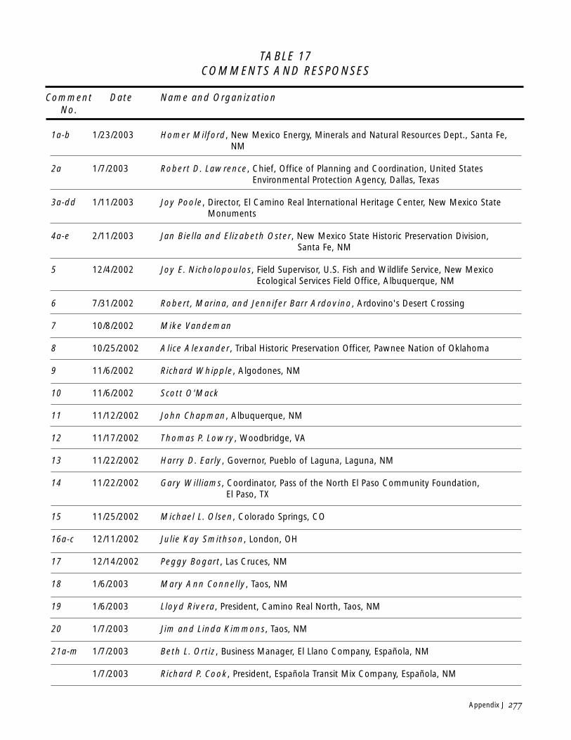
TABLE 17 COMMENTS AND RESPONSES
Comment Date Name and Organization No
1a-b 1232003 Homer Milford New Mexico Energy Minerals and Natural Resources Dept Santa Fe NM
2a 172003 Robert D Lawrence Chief Office of Planning and Coordination United States Environmental Protection Agency Dallas Texas
3a-dd 1112003 Joy Poole Director El Camino Real International Heritage Center New Mexico State Monuments
4a-e 2112003 Jan Biella and Elizabeth Oster New Mexico State Historic Preservation Division Santa Fe NM
5 1242002 Joy E Nicholopoulos Field Supervisor US Fish and Wildlife Service New Mexico Ecological Services Field Office Albuquerque NM
6 7312002 Robert Marina and Jennifer Barr Ardovino Ardovinos Desert Crossing
7 1082002 Mike Vandeman
8 10252002 Alice Alexander Tribal Historic Preservation Officer Pawnee Nation of Oklahoma
9 1162002 Richard Whipple Algodones NM
10 1162002 Scott OMack
11 11122002 John Chapman Albuquerque NM
12 11172002 Thomas P Lowry Woodbridge VA
13 11222002 Harry D Early Governor Pueblo of Laguna Laguna NM
14 11222002 Gary Williams Coordinator Pass of the North El Paso Community Foundation El Paso TX
15 11252002 Michael L Olsen Colorado Springs CO
16a-c 12112002 Julie Kay Smithson London OH
17 12142002 Peggy Bogart Las Cruces NM
18 162003 Mary Ann Connelly Taos NM
19 162003 Lloyd Rivera President Camino Real North Taos NM
20 172003 Jim and Linda Kimmons Taos NM
21a-m 172003 Beth L Ortiz Business Manager El Llano Company Espantildeola NM
172003 Richard P Cook President Espantildeola Transit Mix Company Espantildeola NM
Appendix J 277
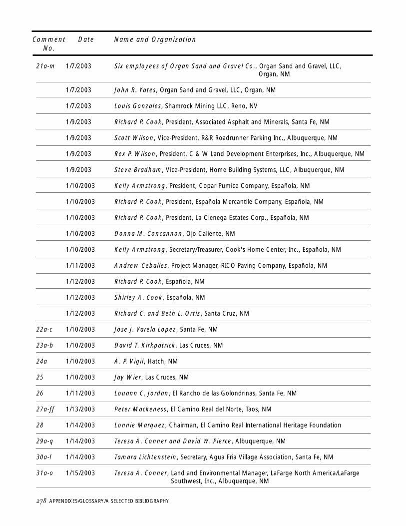
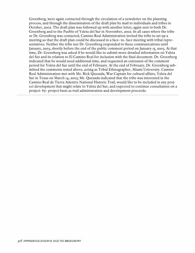
Comment Date Name and Organization No
21a-m 172003 Six employees of Organ Sand and Gravel Co Organ Sand and Gravel LLC Organ NM
172003 John R Yates Organ Sand and Gravel LLC Organ NM
172003 Louis Gonzales Shamrock Mining LLC Reno NV
192003 Richard P Cook President Associated Asphalt and Minerals Santa Fe NM
192003 Scott Wilson Vice-President RampR Roadrunner Parking Inc Albuquerque NM
192003 Rex P Wilson President C amp W Land Development Enterprises Inc Albuquerque NM
192003 Steve Bradham Vice-President Home Building Systems LLC Albuquerque NM
1102003 Kelly Armstrong President Copar Pumice Company Espantildeola NM
1102003 Richard P Cook President Espantildeola Mercantile Company Espantildeola NM
1102003 Richard P Cook President La Cienega Estates Corp Espantildeola NM
1102003 Donna M Concannon Ojo Caliente NM
1102003 Kelly Armstrong SecretaryTreasurer Cooks Home Center Inc Espantildeola NM
1112003 Andrew Ceballes Project Manager RICO Paving Company Espantildeola NM
1122003 Richard P Cook Espantildeola NM
1122003 Shirley A Cook Espantildeola NM
1122003 Richard C and Beth L Ortiz Santa Cruz NM
22a-c 1102003 Jose J Varela Lopez Santa Fe NM
23a-b 1102003 David T Kirkpatrick Las Cruces NM
24a 1102003 A P Vigil Hatch NM
25 1102003 Jay Wier Las Cruces NM
26 1112003 Louann C Jordan El Rancho de las Golondrinas Santa Fe NM
27a-ff 1132003 Peter Mackeness El Camino Real del Norte Taos NM
28 1142003 Lonnie Marquez Chairman El Camino Real International Heritage Foundation
29a-q 1142003 Teresa A Conner and David W Pierce Albuquerque NM
30a-l 1142003 Tamara Lichtenstein Secretary Agua Fria Village Association Santa Fe NM
31a-o 1152003 Teresa A Conner Land and Environmental Manager LaFarge North AmericaLaFarge Southwest Inc Albuquerque NM
278 APPENDIXESGLOSSARYA SELECTED BIBLIOGRAPHY
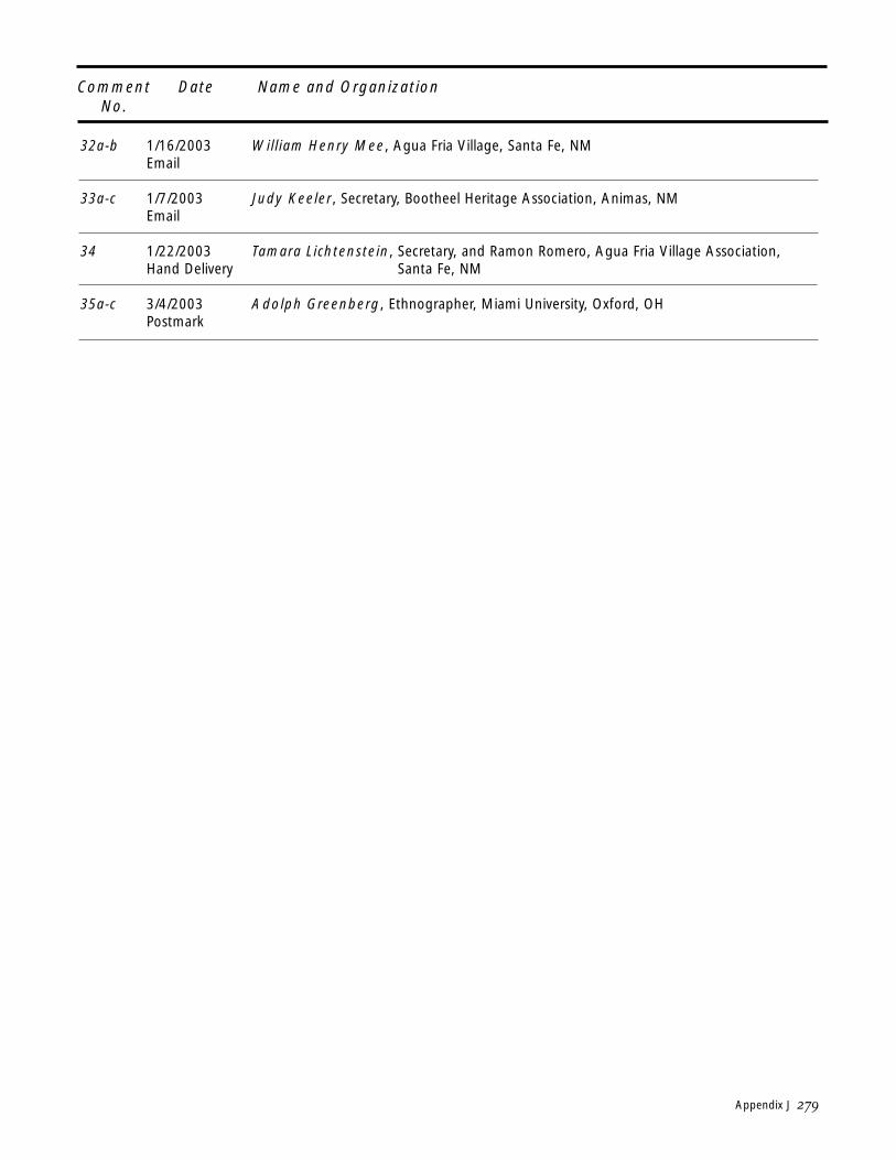
Comment No
Date Name and Organization
32a-b 1162003 Email
William Henry Mee Agua Fria Village Santa Fe NM
33a-c 172003 Email
Judy Keeler Secretary Bootheel Heritage Association Animas NM
34 1222003 Hand Delivery
Tamara Lichtenstein Secretary and Ramon Romero Agua Fria Village Association Santa Fe NM
35a-c 342003 Postmark
Adolph Greenberg Ethnographer Miami University Oxford OH
Appendix J 279
COMMENTS AND RESPONSES - STATE AND FEDERAL AGENCIES
COMMENT 1a Chapter 3 p 72 second paragraph - Fra Cristo al instead of Organ Mountains
RESPONSE We have changed the text to read Fra Cristo al Mountains here
COMMENT 1b Chapter 3 - Gives information on the Jornada to consider
RESPONSE Thank you for this information The history presented is an overview and not exhaustive We will keep your comments on file for future reference
COMMENT 1c Chapter 3 - Include founding of El Paso in historical narrative
RESPONSE The historical information is an overview of the regions history only We will keep your com-ment on file to use as we implement the plan and as further research takes place The city and county of El Paso Texas are very interested in participating in the trail plan and they have also noted strong interest in the Camino Real on the part of Juarez Mexico which is the historic settlement of El Paso referred to in the comment
COMMENT 1d Chapter 3 page 78 The railroad follows the Camino Real from La Bajada to El Paso
RESPONSE The text has een changed to reflect this
COMMENT 2 The Environmental Protection Agency (EPA) classifies your Draft Environmental Impact Statement (EIS) and proposed action as LO ie EPA has Lack of O jections to the pre-ferred alternative
RESPONSE Noted
COMMENT 3a Planning document appears to e a oiler plate format which might e accepta le for a historic trail that is 1) located totally within the United States or 2) isnt a via le living or still traveled trail
28 APPENDIXESGLOSSARYA SELECTED BIBLIOGRAPHY
RESPONSE We have to follow various laws and regulations in the formulation of the Comprehensive man-agement PlanEnvironmental Impact Statement (CMPEIS) However we have re-written parts of it to make it easier to read It should e noted that we can only do a plan for the section of the trail designated as a national historic trail and that is the section of El Camino Real that is in the United States While we have consulted with the National Institute for Anthropology and History (INAH) in Mexico a out the plan we will not e doing a plan for the section of the trail that lies in Mexico That rightfully is for the Nation of Mexico And while we do recognize that the trail is still eing used today our mandate is the National Trails System Act legislation and the Camino Real de Tierra Adentro legislation (See Appendixes A and B) Many of our partners including the Camino Real International Heritage Center will e a le to address such topics as you raise as they develop their educational and interpretive programs
COMMENT 3b Urge consideration of technological potential for digital li raries for resource sharing and international research push the envelope in terms of pertinent and germane cultural issues and in terms of technology capa ilities
RESPONSE This is a thoughtful suggestion for the future Many items can e stored in a digital li rary for-mat however we will e mindful of copyright restrictions that will preclude more recent items
COMMENT 3c The document is difficult to fully decipher in places and follow from written executive summa-ry through the matrix One of the acronyms (RMP) was undefined and there were references to federal perspectives and procedures that an ordinary citizen cannot fully comprehend
RESPONSE Noted We have rearranged and rewritten parts of the document and have added terms to the Glossary The draft Glossary did include the acronym RMP (Resource Management Plan)
COMMENT 3d The New Mexico State Monuments position with regard to the relationship etween the International Heritage Center and the National Historic Trail is that the Center was created as New Mexicos newest state monument for the sole purpose of serving as the official interpre-tive center for the trail in New Mexico The State Monuments Division recommends that the draft management plan also acknowledge its (the Centers) role and function as the official interpretive center for the national historic trail through a cooperative agreement certification or amendment to the national trails act
RESPONSE Noted The plan names the Camino Real International Heritage Center as a focal point for the trail
Appendix J 281
COMMENT 3e Executive summary pg V tie five issues identified to the environmental ta le in comparisons of alternatives and impacts
RESPONSE The five issues are addressed throughout the ta le and the document
COMMENT 3f Address opportunities for visitor services under Issues on page 8 Also should have included historical issues such as migration and commerce--people from Mexico are still following the trail of their ancestors in search of opportunities and the commercial trade in existence today etween the two countries issues should also acknowledge the trail as a living trail today
RESPONSE The planning issues were identified during the initial scoping of the plan Visitor services education andor recreation is an issue under How will trail management e integrated with tri al and other government agency and community plans
COMMENT 3g What appears to e missing is a contemporary goal that addresses economic development international colla oration and migration Unlike all the other national historic trails El Camino Real is a living vi rant trail It is still a trail of commerce of migration and a trail of evangelism (or cultural exchange) Colla orations with Department of Commerce and Immigration and Naturalization Service (INS) might e advisa le Add internationally to the second goal and add a goal of supporting andor promoting economic development and com-mercial opportunities as related to El Camino Real Omissions of commerce and migration are trou lesome given the historical importance of trade and commerce and the continuance of international commerce and trade today via North American Free Trade Agreement (NAFTA) today and the fact that historically El Camino Real was a migration route and I-25 serves today as a route of immigration These are changing and evolving human issues ut are via le charac-teristics of the trail and qualify for government protection
RESPONSE While we recognize your suggestion as a worthy goal we are limited y the National Trails System Act and the Camino Real legislation neither of which identify economic development as a purpose of the legislation However we recognize that many of our partners will e a le to more effectively carry out the goals you outline a ove as an integral part of their already exist-ing mission
COMMENT 3h Page x revise last sentence regarding local history to incorporate local history into a national and international historical and contemporary context The last sentence could e expanded to include such things as car and computer games ilingual tv
RESPONSE We have changed wording to replace documents with a variety of media We do not see the existing wording as limiting ut as inclusive of local history and local history in a national and international historical context
282 APPENDIXESGLOSSARYA SELECTED BIBLIOGRAPHY
COMMENT 3i Pages 14-15 include digital li rary capa ilities or identify them as a mechanism for delivery in Alternative C [editors note Preferred Alternative]--Li rary of Congress New Mexico State Li rary and Archives INAH and Mexican archives can colla orate with NPSBLM
RESPONSE We will work with a num er of entities to achieve a digital li rary working within the con-straints of copyright law Many items can e stored in a digital li rary format However we will e mindful of copyright restrictions that may preclude more recent items
COMMENT 3j pages xiii-xiv Many of the cultural facilities of New Mexico may not meet certification stan-dards without financial assistance through the cost-share program El Camino Real International Heritage Center exhi its plans should e passed efore the Long Distance Trails office to identify potential shortcomings that may affect their certification potential especially regarding Americans with Disa ilities Act (ADA) compliance
RESPONSE We will work with entities that want to e certified so that we can achieve the goal together through a variety of means including ut not limited to the Challenge Cost-share program Camino Real Administration will work with El Camino Real International Heritage Center to insure that the Center meets certification requirements
COMMENT 3k The economic analysis identifies primarily low-paying service industry jo s under the impacts of the preferred alternative The Hispanic and North American Indian communities will want etter higher wage jo s for their children What a out socio-economics for middle income residents in the US and Mexico Cottage industries involving artisans and regional arts and crafts could also e identified and promoted in New Mexico Texas and Mexico Place the entry-level tourism jo s currently identified in the preferred alternative into Alternative B and outline higher paying administrative and managerial tourism jo s in the preferred alternative--tourism is the 2 industry in New Mexico Economic development NAFTA or El Camino Real Trade could provide moderate income producing jo s
RESPONSE The economic model used to estimate jo creation impacts does not calculate the num er of jo s created y type ut only as a total num er of new jo s ased on algorithms utilizing eco-nomic aseline data and assumed economic activity generation multipliers Because of this the plan cannot e adjusted to shift jo types among alternatives The net economic enefits which are the net new jo s created com ined new sales generated and total increased income and sales tax revenue generated y implementation of the preferred alternative were calculated using the National Park Service developed Money Generation Model which is availa le on the NPS we site The model is useful in that it can quickly estimate the economic conse-quences of planning alternatives using area-specific aseline data and tailored assumptions on the input parameters Baseline economic activity data were provided y the Sonoran Institute in association with the Bureau of Land Management in its 2002 pu lication Economic Profile System which provides a variety of latest availa le economic activity data for use in producing custom socioeconomic profiles for the United States in a consistent format for all geographic areas Other locally varia le input data such as average length of stay for tourists average daily
Appendix J 283
tourist expenditures state and local tax rates and percent of non-local use were developed from pu licly-availa le state and county economic and tourist data and interviews with recre-ation and tourism officials
The asic rationale for the economic model is that a certain input in terms of new money spent new num ers of tourists attending a park and other inputs have a multiplier effect on the local economy as those inputs directly and indirectly propagate through the local economy inducing su sequent economic activity to oth serve the visitors and to provide products and services to the local community supporting the increased park or recreation activity
COMMENT 3l Is the National Endowment for the Arts helping to define trails as indicated on page 5 fourth paragraph
RESPONSE The National Endowment for the Arts is a signatory to a Memorandum of Understanding (MOU) for the Administration and Management of National Historic and National Scenic Trails dated January 19 2001 The MOU encourages long-term interagency coordination and cooperation to further the spirit and intent of the National Trails System Act y preserving and strengthening the visitor satisfaction administration management protection cultural enhancement cooperation partnerships and funding of those lands and resources associated with the National Trails A copy of that MOU is on file in the Camino Real Administration Office
COMMENT 3m Is it possi le to sign MOUs with the Department of Commerce Economic Development extolling the merits of NAFTA and recognizing the historical commercial importance of El Camino Real and its potential for today
RESPONSE It would not e appropriate for the Camino Real Administration to sign such an MOU Many of our partners have existing missions which would allow them to enter into such MOUs however
COMMENT 3n Page 6 6th ullet insert in hard copy or digitally efore to learn more a out dont under-stand 11th ulleted point
RESPONSE We do not see the existing language as excluding any form of learning in any manner We rec-ognize there are many ways to learn and fear that y trying to list them all we would inadver-tently omit some This visitor experience goal means that trail visitors will have the opportunity to meet and interact with local people whose lives have een affected y the trail
284 APPENDIXESGLOSSARYA SELECTED BIBLIOGRAPHY
COMMENT 3o Page 7 add electronic access capa ilities to end of discussion of interpretation and education
RESPONSE We support this option ut see no wording that would limit or exclude this option
COMMENT 3p Page 8 Issues to e resolved Wording for first two paragraphs seems negative and pessimistic Instead of perceiving them as pro lems to e resolved consider them as issues for considera-tion and strive for a win-win situation within the limitations of the federal governmentNPSBLM
RESPONSE We agree with you a out the wording ut we are following definitions set y our agency guid-ance We agree with your interpretation and essentially have tried to provide that philosophy throughout the document
COMMENT 3q One of the planning issues should e What opportunities are availa le to provide visitor serv-ices education or recreation
RESPONSE The planning issues were identified during the initial scoping of the plan Visitor services education andor recreation is an issue under How will trail management e integrated with tri al and other government agency and community plans
COMMENT 3r These issues should e added to the discussion of this trail Borderland trail security economic development trade and NAFTA and immigration and migration
RESPONSE The issues identified are indeed important ut outside of the scope of the National Trails System Act and the Act esta lishing El Camino Real de Tierra Adentro National Historic Trail
COMMENT 3s Add From what historical perspective do Native American tri es (sovereign governments) view the trail to the two issues of How will trail management e integrated with tri al and other government agency and community plans and How do we incorporate international interest in the trail
RESPONSE The planning issues were identified during the scoping phase of the plan However we do elieve that the issues you propose are addressed explicitly in the plan in Chapter 2 Preferred Alternative Description and Preferred Alternative State-level and Tri al Partners and Local-level Partners and in Chapter 4 Environmental Consequences North American Indians
Appendix J 285
COMMENT 3t Discussion of state-level partners should identify state li raries state archives state monu-ments and state historian divisions as well as historic preservation division of state government
RESPONSE The wording in this paragraph has een changed to indicate that a num er of state agencies can participate in the plan
COMMENT 3u Tri al governments omitted from discussion of partners on page 15
RESPONSE The paragraph now reads State-level and Tri al Partners Tri al governments are now rec-ognized in the text
COMMENT 3v Consider creating a digital li rary on Camino Real as a partnered effort etween three coun-tries and numerous li raries and pertinent agencies
RESPONSE Noted This suggestion will e explored in the future through partnerships
COMMENT 3w Auto Tour route can follow Highway 1 from a out mile marker 90 northward towards Socorro
RESPONSE The auto tour route does follow State Highway No 1 from just north of Truth or Consequences to Socorro
COMMENT 3x What are the certification criteria Are the criteria for high potential sites listed or is each site situational and situational criteria have yet to e determined Will rectifying incomplete his-toric documentation require original and possi ly sponsored research
RESPONSE National historic trails identify high-potential historic sites and segments The general charac-teristics of high-potential sites and segments are set out in Chapter 2 Continuing Management Guidance In general these sites and segments provide an opportunity to interpret the historic significance of the trail and are characterized y the presence of visi le historic remnants sce-nic quality and relative freedom from intrusion Those portions of the trail that are under fed-eral ownership are recognized as official protection components of the NHT Privately-owned high-potential historic sites and segments can also e recognized through the site certification process In addition as indicated in Chapter 2 in the section on Site Certification interpretive facilities such as El Camino Real International Heritage Center can also e considered as can-didates for certification The certification program is one of the most important ways in which federal administering agencies can foster partnerships with non-federal landowners through-
286 APPENDIXESGLOSSARYA SELECTED BIBLIOGRAPHY
out the trail corridor Certification agreements are written and agreed upon y the private landowner and the Camino Real Administration Office to preserve interpret and provide for pu lic access to high-potential historic sites and segments The certification program is an entirely voluntary one although property owners can enefit from the availa ility of challenge cost-share funds agency expertise and the increased awareness of their resources y the pu -lic property owners are not o liged to enter into certification agreements A sample certifica-tion agreement is in Appendix I Text has een added to Chapter 2 Site Certification to clarify the certification program
COMMENT 3y Page 36 can the reference to the location in the Jornada e tied to one of the maps or the appropriate Field Office for BLM identified Is this the trail north of the Jornada etween the future El Camino Real International Heritage Center and Fort Craig or is it some other proper-ty in the Jornada
RESPONSE Because the proposed projects are still in the conceptual stage locations have not een fixed or identified on the maps We have identified which BLM Field Office area they are located in The trail referred to is along the historic Camino Real and not a trail etween El Camino Real International Heritage Center and Fort Craig
COMMENT 3z Page 39 Although the emphasis will e on the southern part of the trail the whole trail will e interpreted y the Center Suggest revising the last sentence of this section to read The her-itage Center is another example of a joint government project and is therefore a separate proj-ect from the NHT It would serve as an officially recognized or designated interpretive center (focal point for trail related interpretation and education) with emphasis on the southern por-tion of the trail
RESPONSE We have updated the language in this paragraph to indicate that the Heritage Center has een uilt and will e open to interpret the trail soon The language of the text has een altered to recognize that construction is nearly complete at the Camino Real International Heritage Center The text now reads Camino Real Administration would not construct or operate facilities The BLM and the Museum of New Mexico State Monuments Division are develop-ing a new interpretive facility south of Socorro New Mexico the Camino Real International Heritage Center that will offer interpretive media and educational programs a out the trail The Heritage Center is a separate project from the NHT ut will serve as a focal point for trail-related interpretation and education with emphasis on the southern portion of the trail
COMMENT 3aa Page 40 Insert section on Digital Li raries here or with resources or we sites
RESPONSE We see no language here that would limit the use of digital li raries or we sites Many items can e stored in a digital li rary format however we will e mindful of copyright restrictions that will preclude more recent items We will work with a num er of entities to achieve a digital li rary working within the constraints of copyright law
Appendix J 287
COMMENT 3bb Heritage Tourism Include National Heritage Area as another potential example after heritage tourism programs
RESPONSE Noted
COMMENT 3cc Page 43--Include Digital Li raries under Inventory and Research and again on Page 44 under Interpretive Media
RESPONSE We see no language here that would limit the use of digital li raries or we sites Many items can e stored in a digital li rary format however we will e mindful of copyright restrictions that will preclude more recent items We will work with a num er of entities to achieve a digital li rary working within the constraints of copyright law
COMMENT 3dd No mention of prehistoric trade especially the importance of salt and other trade goods as documented in pu lished archaeological literature also no mention of missionaries women and Indians who are affiliated with the trail
RESPONSE The discussion concerning Ethnographic Resources and Archeological and Historic Resources is an overview only and not a comprehensive review of the su ject headings For a more com-prehensive view see the sources in the selected i liography
COMMENT 4a Supports Preferred Alternative
RESPONSE Noted
COMMENT 4b We strongly recommend that you consider creating a plan andor programmatic document that will serve to coordinate all of the necessary procedures for cultural resources management planning including ( ut not limited to) compliance with Section 106 of the National Historic Preservation Act (NHPA) and where applica le Texas and New Mexico state laws
RESPONSE Both BLM and NPS now have programmatic agreements or their equivalent in place with the appropriate federal agencies charged with compliance with the National Historic Preservation Act (NHPA) that detail how these agencies will carry out their NHPA responsi ilities While we do not anticipate developing additional programmatic agreements we will work with Texas and New Mexico State Historic Preservation Officers to create a plan which may e in the form of a Memorandum of Understanding for accomplishing the coordination of all necessary procedures
288 APPENDIXESGLOSSARYA SELECTED BIBLIOGRAPHY
COMMENT 4c Add State Cultural Preservation Laws to text
RESPONSE Camino Real Administration will comply as appropriate with the state laws your list of State Cultural Preservation Laws has een added to our files
COMMENT 4d Change wording in Chapter 4 Environmental Consequences - to wording suggested in letter for North American Indians on pages 102 112 and under Comparison of Impacts
RESPONSE Wording in this section now includes the following Tri al consultation will e ongoing throughout the development and management of El Camino Real facilities and any concerns identified y tri es will e taken into consideration The goals of such consultation will e to avoid or mitigate any impacts or effects that may e identified
COMMENT 4e Change Wording on page 102 Preferred Alternative - Cultural Resources (ArcheologicalHistorical) to the wording suggested in letter
RESPONSE Text in this section now reads The impacts from oth Alternatives B and the Preferred Alternative may have a neutral or positive impact upon the North American Indian tri es asso-ciated with El Camino Real
During implementation of the Preferred Alternative additional consultation with affected tri es may lead to positive impacts y providing them with the opportunity to present their stories from the tri al point of view in exhi its and documents Tri es that participate in the voluntary certification of sites and segments would e eligi le for technical assistance and challenge cost-share monies for preservation interpretive exhi its and signage
Where developments take place (roadside pullouts and interpretive wayside exhi its as pro-posed in the Preferred Alternative) a site-specific analysis would take place to ensure that resources are not distur ed or if resources would e impacted proposed mitigation measures would take place in consultation with the tri es
COMMENT 5a US Fish and Wildlife Service Cons 2-22-03-I-050 We look forward to reviewing the pre-construction environmental assessments for projects resulting from the trail
RESPONSE Noted
Appendix J 289
COMMENT 5b We strongly encourage the possi le wildlife improvement projects in the Jornada del Muerto and Santa Fe River Canyon areas ecause improved natural ha itats would attract native wildlife species that originally occurred along the trail
RESPONSE Noted
COMMENTS AND RESPONSES - PUBLIC COMMENTS
COMMENT 6 Carlos Caraveo geologistarchaeologist Sunland Park informed our family of his theory that the original crossing of Don Juan de Ontildeate could not have een near the present-day Harts MillLa Hacienda Restaurant site ut must have een to the west of Mt Cristo Rey His docu-mentation consisted of historic maps recent satellite images early settlers recounts which suggested that the pre-Ca allo and Elephant Butte Dam Rio Grande would not have een tra-versa le in early Spring and therefore the most likely route would have taken Ontildeate and his party to the west of the Sierra de Los Muleros todays Mt Christo Rey His satellite images showed a trail visi le in the 1980s Documentation materials enclosed with this comment Also we would like to suggest some additional recognition opportunities a memorial plaque on the Sunset Patio at Ardovinos Desert Crossing and a miniature walka le map of Camino Real on an acre of land elow the Sunset Patio with landscape design and gardener assistance provid-ed
RESPONSE We would e glad to consider any documented research or pu lications detailing the theory of an alternate location of the crossing We will keep your implementation suggestions for the future on file
COMMENT 7 Protect wildlife and wildlife ha itat y restricting mountain ikes icycles in-line skates scooters and strollers to paved roads and designated paved ike paths do not allow ikes and other vehicles on non-paved trails including Camino Real
RESPONSE Camino Real Administration will work to protect wildlife and wildlife ha itat where such ha i-tat occurs in association with Camino Real National Historic Trail (NHT) resources (identified high-potential sites and route segments and associated viewsheds) Under Alternative A the no-action alternative the pu lic would have the same access to trail resources on federally-managed lands as they now enjoy under Alternative B and the Preferred Alternative trail resources will e managed to ensure adequate protection and to enhance interpretation and education opportunities Trail resources will e protected through identification and docu-mentation through a trail promotion effort to increase pu lic awareness through the efforts of the Trail Association through cooperative management agreements and the certification pro-gram for resources on non-federally-managed lands and potentially through the efforts of
29 APPENDIXESGLOSSARYA SELECTED BIBLIOGRAPHY
volunteers and site steward-type programs Projects that may impact trail resources will e reviewed on a case- y-case asis for potential adverse impacts and will e designed to avoid or mitigate these impacts
COMMENT 8 Very old Pawnee Nation oral history says we migrated from Mexico we have no idea where we actually traveled through We only know we come from the south and have some rather loose ties to the Aztec people we dont know when we came from the South nor do we know the areas we traveled The Pawnee Nation has no known urial sites ancient village sacred or religious sites in Texas or New Mexico
RESPONSE Thank you Noted
COMMENT 9 Will auto tour route follow original road or 4th St through Al uquerque Original Camino Real was on west side of river didnt cross to east until Angostura (the narrows) May want to mark stage coach stop on Las Colonias in Algodones and place original trail signage on Las Colonias Make sure signage is clear a out when following original route and when deviat-ing for auto tour
RESPONSE The auto tour route follows route 313 to Corrales Road to Rio Grande Blvd to Route 47 in Al uquerque
COMMENT 10 The description of Valverde in Appendix E cites many references that do not appear in the i liography
RESPONSE The i liography in the plan will e retitled A Selected Bi liography The full i liography of over 40 pages will e posted on the we site ltelcaminorealorggt
COMMENT 11 The route designation does not fit with my research
RESPONSE If you would care to share your research with us we will add it to our project files at the Camino Real Administration office National Park Service Long Distance Trails Group Santa Fe The definition and routing of El Camino Real de Tierra Adentro National Historic Trail were set in the National Historic Trail Feasi ility Study for El Camino Real de Tierra Adentro completed y a study team of the National Park Service in 1997 (National Park Service National Historic Trail Feasi ility StudyEnvironmental Assessment El Camino Real de Tierra Adentro US Department of the Interior National Park Service March 1997 On file at the National Trails System Office - Santa Fe) Legislation (Appendix A) esta lishing El Camino Real de Tierra Adentro as a National Historic Trail in Section 3 paragraph 2 (A) states the lim-
Appendix J 291
its of the trail as running from the Rio Grande near El Paso Texas to San Juan Pue lo New Mexico as generally depicted on the maps in the 1997 feasi ility study
While the period of significance as recognized y the legislation esta lishing El Camino Real NHT is 1598-1882 there is nothing to preclude interpretation of the Camino Real oth efore and after that period
COMMENT 12 The Comprehensive Management PlanEnvironmental Impact Statement (CMPEIS) draft is impressive it represents terrific amount of work and I would not know how to improve on what you have done Consider the 370 Civil War court-martials as a potential pu lication a out the trail
RESPONSE Thank you for your comment We will keep in mind your work on the court-martials and share this information with appropriate sites
COMMENT 13 Suggest that you meet with the Pue lo of Laguna NAGPRA Committee at your convenience
RESPONSE We met with the Pue lo of Laguna NAGPRA Committee on January 29 2003
COMMENT 14 Suggestions for future implementation
RESPONSE Noted will keep on file
COMMENT 15 Stress the role of the Rio Grande in interpretation and along the auto tour route Provide access to the river
RESPONSE Thank you This is an excellent suggestion that we will keep on file to implement as we move into the operational phase of the trail At some point in the future a long-range interpretive plan will e done that will identify su jects like this
COMMENT 16a There is no discussion of the relationship etween short-term uses of mans environment and the maintenance and enhancement of long-term productivity The document lacks sufficient discussion of impacts on physical iological social and economic aspects of the human envi-ronment
292 APPENDIXESGLOSSARYA SELECTED BIBLIOGRAPHY
RESPONSE The existing environmental conditions are descri ed in Chapter 3 Existing Environment which is ased on currently availa le information and which provides a asis from which to estimate impacts associated with continuing current management practices andor implement-ing the limited num er of projects on federally-managed lands descri ed in the Preferred Alternative Aspects of the environment including the human environment descri ed here include the following topics North American Indians Archeological Historical Resources Energy and Minerals Livestock-grazing Land and Realty Uses RecreationVisitor ExperienceInterpretation Scenery Socio-economicsSocial ValuesEnvironmental Justice VegetationSoilsNoxious WeedsWater and Wildlife The relationship etween short-term activities or short-term uses of mans environment and long-term productivity are exam-ined in Chapter 4 Environmental Consequences Several types of impacts are discussed including direct impacts indirect impacts cumulative impacts irreversi le and irretrieva le commitment of resources and unavoida le adverse impacts The impacts of continuing the current management practices as well as implementing a limited num er of projects on feder-ally-managed lands are summarized in the Executive Summary Comparison of Impacts and detailed in Chapter 4
COMMENT 16b The plan should include a thorough and complete economic impact analysis
RESPONSE The economic analysis included in the document is appropriate for the actions presented
COMMENT 16c I support Alternative A No Action Opening a trail along an international order rife with drug trafficking and other crime such as murder and ro ery is not in the est interest of the American people
RESPONSE Noted
COMMENT 17 The draft plan has no discussion of relationship etween short-term uses of mans environ-ment and the maintenance and enhancement of long-term productivity It lacks sufficient dis-cussion of impacts on physical iological social and economic aspects of the human environ-ment The plan should include a thorough and complete economic impact analysis No Off Highway Vehicle (OHV) roads or trails should e closed on any pu lic lands along Camino Real no need to close roads and trails to OHV travel to accommodate estimated 900-5500 trail visitors per year No private lands should e integrated into this trail
REPONSE The existing environmental conditions are descri ed in Chapter 3 Existing Environment which is ased on currently availa le information and which provides a asis from which to estimate impacts associated with continuing current management practices andor implement-ing the limited num er of projects on federally-managed lands descri ed in the Preferred Alternative Aspects of the environment including the human environment descri ed here include the following topics North American Indians ArcheologicalHistorical Resources
Appendix J 293
Energy and Minerals Livestock-grazing Land and Realty Uses RecreationVisitor ExperienceInterpretation Scenery Socio-economicsSocial ValuesEnvironmental Justice VegetationSoilsNoxious WeedsWater and Wildlife The relationship etween short-term activities or short-term uses of mans environment and long-term productivity are exam-ined in Chapter 4 Environmental Consequences Several types of impacts are discussed including direct impacts indirect impacts cumulative impacts irreversi le and irretrieva le commitment of resources and unavoida le adverse impacts The impacts of continuing the current management practices as well as implementing a limited num er of projects on feder-ally-managed lands are summarized in the Executive Summary Comparison of Impacts and detailed in Chapter 4
No OHV roads or trails are currently marked for closure however routes or areas on Bureau of Land Management (BLM) administered lands may e closed to unauthorized vehicles where protected archeological and historic sites and trail route segments would e negatively impact-ed y vehicular traffic
There will e little or nor federal acquisition of private lands under this plan Acquisition would e on a willing-seller asis Private land and resource owners may opt to take part in the high-potential site and route segment certification program if they wish ut this program is entirely voluntary for private property owners
COMMENT 18 The Camino Real extends eyond the limits of Ontildeates journey to Taos and eyond Extend the designated trail to Taos and extend interpretation for educational purposes to include heritage from ancient hunters and trappers through Indians Hispanic and Anglo
RESPONSE The definition and routing of El Camino Real de Tierra Adentro National Historic Trail were set in the National Historic Trail Feasi ility Study for El Camino Real de Tierra Adentro com-pleted y a study team of the National Park Service in 1997 (National Park Service National Historic Trail Feasi ility StudyEnvironmental Assessment El Camino Real de Tierra Adentro US Department of the Interior National Park Service March 1997 On-file at the National Trails System Office - Santa Fe) Legislation (Appendix A) esta lishing El Camino Real de Tierra Adentro as a National Historic Trail in Section 3 paragraph 2 (A) states the limits of the trail as running from the Rio Grande near El Paso Texas to San Juan Pue lo New Mexico as generally depicted on the maps in the 1997 feasi ility study
While the period of significance as recognized y the legislation esta lishing El Camino Real NHT is 1598-1882 there is nothing to preclude interpretation of the Camino Real oth efore and after that period
COMMENT 19 Taos hosted a 2-day reception for the with Camino Real Colloquium--does this indicate then that Taos is part of the federal designation--Mexico City to San Juan Pue lo to Taos If not it should e Also we were not informed a out the 2-day activities in Taos that included 8 key planners Why
294 APPENDIXESGLOSSARYA SELECTED BIBLIOGRAPHY
RESPONSE While related y su ject matter the colloquium and the National Historic Trail are two differ-ent projects We regret that you were not contacted for the events in Taos however the collo-quium is a separate project coordinated y the National Park Service (NPS) the Bureau of Land Management (BLM) the Mexican National Institute for Anthropology and History (INAH) and others including community mem ers from Taos and outreach for that on-going annual project is handled separately from that which we have een doing as part of the trail planning effort
The question of whether the trail continued to Taos or not was first raised during the feasi ility study 1995-1997 After pu lic input and consideration of those comments it was decided that the definition that a Camino Real went from Spanish Capital to Spanish Capital was the most correct for purposes of the National Historic Trail Research was conducted in numerous archives in New Mexico Mexico and Spain to come up with that definition There has een no first-hand or primary evidence that has surfaced to date to indicate differently
COMMENT 20 Would like to see more research conducted on issue of trail extension to Taos do not appear to have considered evidence for trail ending in Taos
RESPONSE The question of whether the trail continued to Taos or not was first raised during the feasi ility study 1995-1997 After pu lic input and consideration of those comments it was decided that the definition that a Camino Real went from Spanish Capital to Spanish Capital was the most correct for purposes of the National Historic Trail Research was conducted in numerous archives in New Mexico Mexico and Spain to come up with that definition There has een no first-hand or primary evidence that has surfaced to date to indicate differently
COMMENT 21a The scope of the Environmental Impact Statement (EIS) does not take into account existing rights such as mining oil and gas claims and how those rights would e affected y the desig-nation of this trail The goals of the EIS do not take into consideration active mining oil gas claims and grazing leases Are takings eing considered on private land and private interest holdings--will trails designation prohi it development of an interest in an area and if so will the owner of that interest e compensated for the loss Although the plan states that grand-fathered and existing rights will e recognized no discussion is made as to how those rights will e preserved The preferred alternative does not discuss how existing rights will e rec-ognized and preserved or what impact preferred alternative will have on existing rights How will existing rights e honored How will Alternative B affect existing rights There is no discussion of energy and mineral resources development and development rights under pur-poseneed for action or relationship to legislation BLMNPS policies plans and programs the potential for mineral development along the trail has not een equally considered or val-ued
RESPONSE Under all alternatives surface distur ing operations authorized under an existing Federal material sale contract mineral lease and the surface management regulations under the Mining Law would e allowed to continue under the terms and conditions of the authorizing instru-ment That is existing operations including mining and energy development will continue as
Appendix J 295
authorized efore designation of the trail (see Chapter 4 Environmental Consequences Preferred Alternative Energy and Minerals) Similarly existing livestock-grazing operations on pu lic lands will continue with no reductions and limited additional restrictions Operations on an existing contract lease or mining claim causing new surface distur ance within the pro-posed VRM Class II areas will e su ject to the VRM classification o jectives new range improvement andor construction projects in areas where the VRM classification has een changed will need to e mitigated to meet visual resource management guidelines (see Chapter 4 Environmental Consequences Preferred Alternative Energy and Minerals and Livestock-grazing) The impacts to mining energy development and grazing through implementation of Alternative B are summarized in the Executive Summary and detailed in Chapter 4 Environmental Consequences Alternative B Energy and Minerals and Livestock-grazing ) These impacts would e identical to those detailed for Alternative A the no-action alterna-tive that continues current management practices The proposed Comprehensive Management PlanEnvironmental Impact Statement has een developed to esta lish o jectives policies processes and management actions needed to fulfill the preservation and pu lic use goals for El Camino Real de Tierra Adentro NHT within the multi-use mission of the BLM The poten-tial for mineral development along the trail is descri ed in Chapters 3 Existing Environment and 4 Environmental Consequences
COMMENT 21b Initial scoping failed to identify how to treat existing rights such as mining oil and gas claims as an issue
RESPONSE This was not an issue raised during the scoping meetings Nonetheless the plan states that existing rights will e protected
Under all alternatives surface distur ing operations authorized under an existing Federal material sale contract mineral lease and the surface management regulations under the Mining Law would e allowed to continue under the terms and conditions of the authorizing instru-ment That is existing operations including mining and energy development will continue as authorized efore designation of the trail (see Chapter 4 Environmental Consequences Preferred Alternative Energy and Minerals) Similarly existing livestock-grazing operations on pu lic lands will continue with no reductions and limited additional restrictions Operations on an existing contract lease or mining claim causing new surface distur ance within the pro-posed VRM Class II areas will e su ject to the VRM classification o jectives new range improvement andor construction projects in areas where the VRM classification has een changed will need to e mitigated to meet visual resource management guidelines (see Chapter 4 Environmental Consequences Preferred Alternative Energy and Minerals and Livestock-grazing) The impacts to mining energy development and grazing through implementation of Alternative B are summarized in the Executive Summary and detailed in Chapter 4 Environmental Consequences Alternative B Energy and Minerals and Livestock-grazing These impacts would e identical to those detailed for Alternative A the no-action alterna-tive that continues current management practices The proposed Comprehensive Management PlanEnvironmental Impact Statement has een developed to esta lish o jectives policies processes and management actions needed to fulfill the preservation and pu lic use goals for El Camino Real de Tierra Adentro NHT within the multi-use mission of the BLM The poten-tial for mineral development along the trail is descri ed in Chapters 3 Existing Environment and 4 Environmental Consequences
296 APPENDIXESGLOSSARYA SELECTED BIBLIOGRAPHY
COMMENT 21c Support Alternative A or B Alternative A attempts to alance all interests associated with the El Camino Real Trail The preferred alternative considers only the interests of those who do not favor energy or mineral development in the area Alternative B alances all interests along Camino Real trail not just those of cultural resource specialists Under these Alternatives (A and B) the auto tour route will e accessi le to anyone in any type of vehicle unlike preferred alternative that develops Point of Rocks and other remote pull outs and visitor areas that would only e accessi le y those few who drove high clearance vehicles without trailer Preferred Alternative incurs significant administration costs and is designed to preclude mineral and oilgas development especially the sand and gravel operations that create good jo s and pro-vide materials that enefit all New Mexicans
RESPONSE Alternative A is the No Action alternative required to e considered in all environmental docu-mentation Alternative B proposes some resource protection actions that would limit or dis-courage pu lic visitation and impact on high potential historic sites and route segments Energy or mineral development would e affected along less than 25 of the length of the trail The auto tour route follows paved all-weather roads and does not go through the Upham - Point of Rocks area The proposed developments there would e accessi le via the gravel county road which normally a sedan pulling a trailer could negotiate The kiosks proposed at each end of the county road would descri e the road surface and indicate when road conditions may e unsuita le for some classes of vehicles
COMMENT 21d Because the majority of the trail passes through private lands it appears that the integrity of the trail as the El Camino Real trail could easily e compromised ecause the NPS and BLM have management control over less than a third of trail length The Resource Protection section refers to energy and mineral development as eing an incompati le use ut mineral develop-ment and the preservation of historic and cultural resources have een in alance in the devel-opment of other historic sites A very large portion of culturalhistoric research and data col-lection is funded y mineral developers in the state of Nevada and other development areas
RESPONSE Much cooperation will need to take place etween the pu lic and private sector to preserve and interpret the trail The plan does not call energy and mineral development incompati le ut does identify protection measures including changes to the Visual Resource Management (VRM) classifications applied to several sections of the trail under federal management These new classification assignments will require new surface-distur ing projects in these sections to meet the VRM guidelines These VRM classification changes are intended to protect the his-toric character of some landscapes crossed y the National Historic Trail
COMMENT 21e Future development of Interstate 25 and several state highways along the El Camino Trail will require material from gravel pits and there is no consideration in the EIS for highway develop-ment
RESPONSE The development of gravel pits is not precluded under any of the proposed alternatives pre-sented in the plan The single most a undant and valua le mineral resource along the trail cor-
Appendix J 297
ridor-aggregate-occurs along the entire length of the trail Each new proposed activity on fed-erally-managed land including sand and gravel operations will e reviewed on a case- y-case asis additional VRM Class II restrictions will affect less than 25 of the length of the trail in New Mexico and are not expected to have any apprecia le effect on access to sand and gravel resources for highway construction and development
COMMENT 21f Certification Protection of properties on private lands will e achieved through certification--what does this term mean and what restrictions will e placed on private lands y certification
RESPONSE National Historic Trails identify high-potential historic sites and segments Those portions of the trail that are under federal ownership are recognized as official protection components of the NHT Privately-owned high-potential historic sites and segments can also e recognized through the site certification process The certification program is one of the most important ways in which federal administering agencies can foster partnerships with non-federal landowners throughout the trail corridor Certification agreements are written and agreed upon y the private landowner and the Camino Real Administration Office to preserve inter-pret and provide for pu lic access to high-potential historic sites and segments The certifica-tion program is an entirely voluntary one although property owners can enefit from the availa ility of challenge cost-share funds agency expertise and the increased awareness of their resources y the pu lic property owners are not o liged to enter into certification agree-ments A sample certification agreement is in Appendix I Text in Chapter 2 under the heading of Site Certification has een amended to clarify the certification process and program
COMMENT 21g The EIS does not address impact on air quality from fugitive emissions from increased visitor travel on dirt roads along trail corridor The development of the preferred alternative will sig-nificantly increase fugitive emissions along the dirt road from the Upham exit to the proposed Point of Rocks Visitor Center and will increase the potential for soil erosion and sediment pro-duction contrary to the high-priority goals identified under Existing Environment WaterAir Quality Have impacts to the air quality along the auto tour route een considered What type of modeling has BLM used to examine these impacts If visitation increases from 900 to 5500 visits annually what will e the impact from traffic fugitive emissions from dirt roads along the trail route The document includes no consideration of erosion from trails and iking along the trail and no discussion a out the impact to ground water or surface water or noxious weed introduction due to increased use The EIS says more detailed environmental analysis for specific trail projects will follow in appropriate environmental documents--shouldnt that information e included here for each individual trail project proposed
RESPONSE Although the Camino Real trail corridor crosses nine counties in Texas and New Mexico trav-el along this corridor will occur primarily on existing paved all-weather roads including Interstate 25 and a variety of smaller highways and roadways in oth states Trail-related travel along unpaved roads that parallel the trail or that actually follow the trail itself will occur in Dona Ana and Sierra Counties as visitors follow the trail through the Jornada del Muerto on county-maintained roads While visitors will not e encouraged to take these roads which are not part of the proposed auto tour route vehicular travel along these unpaved roads may reach an estimated maximum of 5500 visits (some 2750 individual car trips) per year Dontildea Ana
298 APPENDIXESGLOSSARYA SELECTED BIBLIOGRAPHY
County which has fewer than 15 miles of unpaved road that provides good access to the his-toric trail has significant concerns a out particulate air pollution as seasonal dust storms often ring the air close to or within air quality violations Sierra County which has a out 40 miles of pu licly-accessi le county-maintained gravel road paralleling the historic trail does not have significant air quality concerns Water quality concerns would primarily relate to erosion and sedimentation Currently the only water quality impaired streams identified y the New Mexico Environment Department (NMED) in the area are Ca allo and Elephant Butte Reservoirs which have impaired warm water fishery uses Pro a le causes include grazing agriculture atmospheric deposition and recreation and tourism activities other than oating
Designation and development of the trail may result in increased vehicular traffic along unpaved county maintained roads which could result in increased air orne PM10 particulate matter (dust) especially during dry periods Dust a atement measures will e developed for the roads if PM10 particulate matter levels ecome pro lematic The construction of pullout parking areas and hiking trails would remove vegetation and expose soils for a rief period of time and so impact air and water quality for a rief time These areas will e covered with gravel at the completion of the construction and therefore will not contri ute to long-term air orne PM10 levels in the areas Water quality issues may e addressed with pavement drainage control practices timely revegetation of distur ed areas or other est management practices as appropriate Dust a atement measures will e developed for the unpaved county-maintained roads if PM10 particulate matter levels ecome pro lematic
The impacts of specific projects proposed for BLM pu licly administered lands will e evalu-ated and addressed through Environmental Assessments (EAs) and Best Management Practices (BMPs) at the eginning of implementation for these projects The project planning and EABMP development will consider and conform with existing agreements etween BLM and appropriate state and county agencies for addressing non-point source water pollution issues air quality weed control efforts and other natural resources historic and cultural resources This response has een incorporated into the planning document in Chapters 3 Existing Environment and 4 Environmental Consequences
COMMENT 21h Pu lic scoping for EIS egan with notice of availa ility in Federal Register on Octo er 18 2002 and comment period comments are not reflected in this document
RESPONSE Pu lic scoping egan with the Notice of Intent pu lished in the Federal Register May 18 2001 Vol 66 No 97 page 27682-27684 Pu lished therein was notice of the times and locations of pu lic meetings A press release detailing the pu lic meetings was also sent out to the news media in New Mexico and West Texas The location of those meetings and additional pu lic meetings are noted in Chapter 5 Ta le 13 Issues and concerns identified during the pu lic scoping period in 2001 are reflected in the draft document and this document in Chapter 1 PurposeProcessIssues Comments received after the release of the draft document on Octo er 18 2002 are reflected in the final document See especially Chapter 5 ConsultationCoordination which includes comments on the draft received during the pu lic comment period etween Octo er 18 2002 and January 15 2003 (as well as four comments received after January 15 2003) as well as our responses to those comments
Appendix J 299
COMMENT 21i No cost comparisons are given in comparison of alternatives--what is impact to the taxpay-er Acquisition or exchange y willing sellers where lands could e effectively managed lan-guage in Resource Protection section of Comparison of Alternatives suggests BLM intends to acquire lands through purchase--what would e the costs No costs are identified with administering the trail preferred alternative identifies a significant amount of administration--what are the costs
RESPONSE At present Federal funding requests associated with El Camino Real are focussed on preserva-tion protection interpretation and education efforts for federally-managed trail components and resources and the development of partnerships with non-federal resource owners and managers to effect preservation protection interpretation and education programs for non-federally-managed trail components No funding requests are anticipated for land acquisition or purchase at this time and no costs for land acquisition can e identified at present Administration costs for El Camino Real de Tierra Adentro are addressed in Chapter 2 Alternatives Preferred Alternative Description Preferred Alternative Administration Annual Operating Costs Based on 2002 dollars the estimated annual operating costs at fully opera-tional levels would e approximately $475000 These funds would provide for co-administra-tors from NPS and BLM as well as administrative support and interdisciplinary support including interpretation and resource management This udget would support the certifica-tion program cooperative agreements technical assistance partner support travel Challenge Cost-Share projects and special projects such as mapping and media production Trail mark-ing rochure development and printing newsletters and other pu lication materials would also e supported The Camino Real Administration is not expected to reach fully operational levels for a num er of years and Camino Real Administration udgets for any given year will e su ject to the same funding constraints that impact every Federal program
COMMENT 21j The plan has no discussion of resources values of the energy and minerals in the area Document states Restrictions on lease development could result in an operation not drilling at the most geologically desira le location or time period This statement suggests the planners do not understand the development of mineral resources there is no reason to drill in areas that are less than geologically favora le In addition this statement seems designed to preclude any geologic investigations Reductions in mineral material activity along Camino Real within the new VRM Class II designations does a disservice to the mining heritage of the area--the El Camino Real trail rought miners and prospectors to the area and that heritage will e mini-mized or eliminated from Camino Real under these management practices What type of min-eral resources will e unavaila le and what is their cost What is the economic impact of re-classifying 60000 acres to VRM Class II The document has no discussion of the loss of royal-ties to BLM from mineral resource management no discussion concerning loss of mineral tax ase--mineral resource extraction would produce etter paying jo s in the area than hospital-ity- ased
RESPONSE Existing mineral resources activities on federally-managed lands near the projects proposed in this document are detailed in Chapter 3 Ta le 11 As the ta le indicates only 4 mineral opera-tions 3 of which are aggregate operations are located near the proposed turnouts short inter-pretive trails and wayside exhi it features descri ed in Chapter 2 under Preferred Alternative Visitor Experience Recreation Most of the active operations which are primarily aggregate
3 APPENDIXESGLOSSARYA SELECTED BIBLIOGRAPHY
operations are concentrated in the ur an areas of El Paso Las Cruces Al uquerque and Santa Fe (see Ta le 10 for a complete listing of current Federal mineral resource activities in the counties through which El Camino NHT runs) Only 1 of 66 active mining claims (15) and only 3 of 15 active aggregate operations in Dontildea Ana and Sierra Counties fall within the pro-posed VRM II classification area Forty-eight deposits of sand gravel cinder scoria and stone are currently eing worked in the trail corridor (on federally-managed lands and on other lands) Most of these aggregate operations are much closer to ur an areas etween El Paso Texas and Las Cruces New Mexico and etween Belen New Mexico and Santa Fe New Mexico Surface distur ing operations authorized under an existing Federal material sale con-tract mineral lease and the surface management regulations under the Mining Law would e allowed to continue under the terms and conditions of the authorizing instrument Operations on an existing contract lease or mining claim causing new surface distur ance within the pro-posed VRM Class II area would e su ject to the VRM o jectives VRM Class II o jectives may require alternation of new Federal mineral development activities ut would not necessarily preclude such activities Changing a VRM classification is not a withdrawal of lands from min-eral development so such an action would not preclude geologic investigations
COMMENT 21k What is the impact of designation of VRM Class II on private lands or existing rights What is the economic impact of re-classifying 60000 acres to VRM Class II How will conversion of lands from VRM Class III and Class IV to Class II impact private land in-holdings and devel-opment on private lands in the area
RESPONSE Amending the White Sands Mim res and Taos Resource Management Plan (RMP) Visual Resource Management (VRM) classifications will result in an increase of 99774 federally-managed acres in VRM Class II The areas proposed for re-classification consist of approxi-mately 85 linear miles of trail corridor or slightly under 25 of the total length of the route of El Camino Real within New Mexico Because there is such a high level of uncertainty as to what economic effect if any adoption of the preferred alternative and consequent changes in VRM classification will have on mineral development or other economic activities on these federally-managed lands no meaningful economic analysis is possi le The VRM classes and their o jectives are descri ed in Appendix H Class II management o jectives are to retain the existing character of the landscape y keeping the level of change to the landscape low Management activities (including resource extraction or range improvements for example) may e seen ut should not attract the attention of the casual o server Any changes must repeat the asic elements of form line color and texture found in the predominant natural features of the characteristic landscape With regard to existing rights operations on an existing grazing allotment contract lease or mining claim causing new surface distur ance within the proposed Class II area would e su ject to the VRM o jectives Operations that do not cause new surface distur ance would continue as efore
Visual Resource Management classifications apply only to federally-managed lands None of the three alternatives would impose restrictions on private land development nor would pri-vate landowners e precluded from developing their land as authorized under local develop-ment codes
Appendix J 3 1
COMMENT 21l Auto tour route Visitors reading the travel condition advisory planned for the Upham exit pullout will e advised that travel on the county road is not recommended for trailers over 15 feet motor homes or low-clearance vehicles therefore visitors are limited to those who will e traveling in four-wheel drive pickup trucks It appears from this description that the trail is eing developed for special interests and not the general pu lic ecause the average visitor will e traveling y car (a low clearance vehicle) in a motor home or will e towing a travel trailer the development of the auto tour route descri ed in Alternative B would give most en-efit to the common visitor
RESPONSE The auto tour route follows paved all-weather roads In the Upham location it follows Interstate - 25 The kiosk and travel information at Upham would warn those venturing off the auto tour route of the conditions of the county gravel road Usually this road could e followed to the proposed interpretive sites in cars and low clearance vehicles The warnings would e appropriate for wet weather travel on the road
COMMENT 21m In Relationship to LegislationBLM and NPS Policieshellip need to add mineral resources to discussion of management plans for various resources and programs
RESPONSE The plan integrates continuing management guidance for the management of pu lic lands and resources as directed y federal laws regulations policy and guidelines Executive Orders and planning documents developed to focus on specific areas resources or uses including mineral resources
COMMENT 22a The Camino Real is important and NHT designation is appropriate
RESPONSE Noted
COMMENT 22b The proposed auto tour route in the La Cieneguilla and La Cienega areas is not advisa le due to narrow winding roads and ecause the current local traffic already exceeds the optimal level of service increased traffic would exacer ate the safety of all motorists in these traditional communities Signage and interpretive materials along I-25 and the frontage road in this area will provide more appropriate opportunities for explaining the history and significance of the traditional communities and how there were founded and evolved as a result of the Camino Real de Tierra Adentro Also increased visitation through promotion of the tour route and increased signage may lead to increased vandalism of rich archaeological sites in this area which contains a wealth of petroglyphs The presence of oth federal land and identified pet-roglyphs have raised pro lems with trespass and vandalism already
RESPONSE The auto tour route has een re-routed to the Interstate - 25 frontage road via NM 599 in the vicinity of La Cieneguilla and La Cienega to meet these concerns
3 2 APPENDIXESGLOSSARYA SELECTED BIBLIOGRAPHY
COMMENT 22c The Visual Resource Management (VRM) oundary in La Cieneguilla encloses private lands within the area of proposed restricted actions to preserve viewsheds Private lands should not e included within the oundaries the oundary as drawn suggests that private landowners will e precluded from developing their land as authorized under local development codes
RESPONSE Visual Resource Management classifications apply only to federally-managed lands None of the three alternatives would impose restrictions on private land development nor would pri-vate landowners e precluded from developing their land as authorized under local develop-ment codes Map 5 Pu lic Lands in the Santa Fe River Canyon Proposed for VRM Class II (Preferred Alternative) shows the proposed VRM Class II oundary as an irregular relatively narrow polygon confined within the Santa Fe River canyon from just east of the community of La Bajada to just west of Cieneguilla Private lands which fall within this polygon ut which are not affected y the VRM classifications applied to BLM-managed lands are shown in light shading and BLM-managed lands are shown with a darker shading (Section 30 for example is primarily private land Section 31 immediately to the south is primarily BLM-managed land)
COMMENT 23a Support the preferred alternative The document is well organized and provides the informa-tion needed to comment on the proposed plan and the alternatives The preferred alternative provides the educational opportunities to the pu lic to learn a out the El Camino Real Yet the plan still provides the necessary management to protect this valua le national resource
RESPONSE Noted
COMMENT 23b In the summer of 1996 I conducted a revisit survey of the El Camino etween Upham and Aleman as part of the environmental studies for the proposed Southwest Regional Spaceport The survey resulted in correcting the location of a crossing that was incorrectly plotted on the USGS map The presence of earthen ramps and cut anks confirmed the correct location We were a le to follow the trail since it was clearly marked except for where it crossed low grassy flat areas The report is titled Southwest Regional Spaceport Archaeological Survey of the Proposed Upham Area Site Human Systems Research Inc Staff 1997 Human Systems Research Report Nos 9510 and 9517 Maps and updated site forms are presented in the Appendix volumes
RESPONSE Thank you This is an excellent resource and will e added to our i liography We also note that Mike Marshall recorded the same feature in his 1991 survey
COMMENT 24 Supports Alternative B with option to re uild ATampSF RR station at Engle as a monument to Railroaders and ranches who later used the Camino Real
RESPONSE Noted your suggestion has een added to our file of future implementation plans
Appendix J 3 3
COMMENT 25 Supports Alternative B
RESPONSE Noted
COMMENT 26 El Alamo in wrong location on Map 3G also Santa Fe County Road 56 misla eled as 285 84
RESPONSE Corrections have een made to Map 3G
COMMENT 27a Trail route is from Vera Cruz Mexico to Taos NM ending in 3 places there
RESPONSE The question of whether the trail continued to Taos or not was first raised during the feasi ility study conducted in 1995-1997 After pu lic input and consideration of those comments it was decided that the definition that a Camino Real went from Spanish capital to Spanish capital was the most correct for purposes of the National Historic Trail This definition is supported y research conducted in numerous archives in New Mexico Mexico There has een no first-hand or primary evidence that has surfaced to date to indicate differently
The definition and routing of El Camino Real de Tierra Adentro National Historic Trail were set in the National Historic Trail Feasi ility Study for El Camino Real de Tierra Adentro com-pleted y a study team of the National Park Service in 1997 (National Park Service National Historic Trail Feasi ility StudyEnvironmental Assessment El Camino Real de Tierra Adentro US Department of the Interior National Park Service March 1997 On file at the National Trails System Office - Santa Fe) Legislation (Appendix A) esta lishing El Camino Real de Tierra Adentro as a National Historic Trail in Section 3 paragraph 2 (A) states the limits of the trail as running from the Rio Grande near El Paso Texas to San Juan Pue lo New Mexico as generally depicted on the maps in the 1997 feasi ility study
While the period of significance as recognized y the legislation esta lishing El Camino Real NHT is 1598-1882 there is nothing to preclude interpretation of the Camino Real oth efore and after that period
COMMENT 27b Definition of Camino Real as used in the document is incorrect Who determined definition
RESPONSE The definition and routing of El Camino Real de Tierra Adentro National Historic Trail were set in the National Historic Trail Feasi ility Study for El Camino Real de Tierra Adentro com-pleted y a study team of the National Park Service in 1997 (National Park Service National Historic Trail Feasi ility StudyEnvironmental Assessment El Camino Real de Tierra Adentro US Department of the Interior National Park Service March 1997 On file at the National Trails System Office - Santa Fe) Legislation (Appendix A) esta lishing El Camino Real de Tierra Adentro as a National Historic Trail in Section 3 paragraph 2 (A) states the limits of the
3 4 APPENDIXESGLOSSARYA SELECTED BIBLIOGRAPHY
trail as running from the Rio Grande near El Paso Texas to San Juan Pue lo New Mexico as generally depicted on the maps in the 1997 feasi ility study
While the period of significance as recognized y the legislation esta lishing El Camino Real NHT is 1598-1882 there is nothing to preclude interpretation of the Camino Real oth efore and after that period
COMMENT 27c Suggests locations for Interpretive centers in Mexico and the US
RESPONSE Noted
COMMENT 27d Install vandal-proof signs and markers
RESPONSE Noted this suggestion will e retained in our files for reference as interpretive plans and sign-ing plans are implemented
COMMENT 27e The definition of Trail Significance of 1598-1882 is ar itrary and should e expanded
RESPONSE The definition and routing of El Camino Real de Tierra Adentro National Historic Trail were set in the National Historic Trail Feasi ility Study for El Camino Real de Tierra Adentro com-pleted y a study team of the National Park Service in 1997 (National Park Service National Historic Trail Feasi ility StudyEnvironmental Assessment El Camino Real de Tierra Adentro US Department of the Interior National Park Service March 1997 On file at the National Trails System Office - Santa Fe) Legislation (Appendix A) esta lishing El Camino Real de Tierra Adentro as a National Historic Trail in Section 3 paragraph 2 (A) states the limits of the trail as running from the Rio Grande near El Paso Texas to San Juan Pue lo New Mexico as generally depicted on the maps in the 1997 feasi ility study
While the period of significance as recognized y the legislation esta lishing El Camino Real NHT is 1598-1882 there is nothing to preclude interpretation of the Camino Real oth efore and after that period
The historic research conducted y the Spanish Colonial Research Center and others points to the period of 1598-1882 as the most significant for the trail The date starts with Ontildeates lazing the Camino Real through El Paso del Norte into New Mexico and ends with the completion of the railroad along the trail corridor Earlier Indian trade routes did not follow exactly the Camino Real and the railroad changed the character of travel along the trail
Appendix J 3 5
COMMENT 27f Why does plan only include Chihuahua in Mexico
RESPONSE See Chapter 3 Existing Environment State of Chihuahua Mexico The National Historic Trail ends at the U S - Mexico order The discussion of Chihuahua was included ecause it is the closest Mexican state that may e impacted y trail actions in the U S
COMMENT 27g Why is the Ontildeate Center in Alcalde NM not included in the plan
RESPONSE The Ontildeate Center is mentioned on page 86 and has the potential for certification as an inter-pretive site if they wish to participate
COMMENT 27h Why has only one International Heritage Center een planned not more
RESPONSE The planning for the International Heritage Center predates the designation of the National Historic Trail It is a separate ut closely related project etween the Bureau of Land Management and New Mexico State Monuments The preferred alternative as discussed on page 37 under InterpretationEducation proposes support for development of new facilities such as visitor center or museums y the private sector This plan does not propose any new facilities Instead this plan calls for support and strengthening of existing programs
COMMENT 27i Hold monthly meetings within communities to inform all pu lics
RESPONSE Noted This suggestion has een added to our files for reference during the development of implementation plans
COMMENT 27j Can private for-profit organizations ecome involved
RESPONSE Yes for-profit organizations can ecome involved
COMMENT 27k Why are BLM amp NPS involved in time of down-sizing
RESPONSE Legislation (PL 106-307 Appendix A) esta lished El Camino Real de Tierra Adentro as a National Historic Trail The Secretary of Interior (See Appendix C) directed the Bureau of Land Management and the National Park Service to plan for and administer the trail
3 6 APPENDIXESGLOSSARYA SELECTED BIBLIOGRAPHY
COMMENT 27l Not enough emphasis is placed on the positive economic aspects of the historic trail corridor
RESPONSE Although National Historic Trail designation has raised visitation to particular trails the eco-nomic enefits of trail designation have yet to e quantified either in general or for individual trails As descri ed in Chapter 4 Environmental ConsequencesPreferred AlternativeSocio-economicsSocial ValuesEnvironmental Justice El Camino Real NHT can expect some increases in visitation as a result of the greater pu lic awareness of this trail following designa-tion Increases in visitation are closely tied to the quality of pu lic awareness and promotional programs special events are particularly effective in raising awareness and visitation Because these effects have not een quantified for other trails however and no good models exist for quantifying these effects for the Camino Real the economic enefits that may accompany adoption of the Preferred Alternative or Alternative B cannot e estimated with any exactitude at this time
COMMENT 27m Why is there emphasis on the BLM Taos Field Office if the trail (NHT) does not cross Taos County
RESPONSE The BLM Taos Field Office covers Santa Fe and Rio Arri a counties Each of these counties contain Trail resources
COMMENT 27n Why isnt there an emphasis placed on Camino Real northern arterials
RESPONSE The National Historic Trail as defined herein and designated in the ena ling legislation ends at San Juan Pue lo
COMMENT 27o Why isnt there greater participation y Pue lo peoples
RESPONSE A concerted effort has een made to meet with and involve tri al people in this planning process and the National Historic Trail Several tri es have met with us and expressed interest and we will work with them and others who wish to participate now or in the future
COMMENT 27p What is the anticipated timeframe for the management plan
RESPONSE Management plans typically guide management for 15 to 20 years
Appendix J 3 7
COMMENT 27q How many staff and how much money is udgeted to date
RESPONSE This is a difficult question ecause a num er of agencies offices and personnel have worked on the plan and various aspects of the Camino Real over a period exceeding ten years The preparation planproject agreement for this planning effort identified a total cost of $1014000 to complete the trail CMPEIS It is anticipated that the final cost will e elow this figure
COMMENT 27r Where in the management plan is there a priority schedule
RESPONSE Implementation schedules are typically identified in yearly work plans Priorities will also depend very much on partners as they wish to develop their trail resources
COMMENT 27s Give credit and source for photos and illustrations
RESPONSE Sources for photos and the historic illustrations are on file and availa le from the Camino Real Administration Office
COMMENT 27t Is there a detailed udget plan
RESPONSE Implementation schedules are typically identified in yearly work plans Priorities will also depend very much on partners as they wish to develop their trail resources
The udget estimate of $475000 noted in Chapter 2 Description Preferred Alternative sup-poses full funding at an optimal operation Once funded at a ase level udgets will e formu-lated each year in conjunction with the work plan
COMMENT 27u Include in the glossary Camino Camino Real pue lo swale trace alignment corridor Bosque carreta SHPO etc
RESPONSE These definitions have een added to the glossary
3 8 APPENDIXESGLOSSARYA SELECTED BIBLIOGRAPHY
COMMENT 27v The Bi liography is incomplete
RESPONSE The title of the Bi liography has een changed to Selected Bi liography to more accurately reflect its contents A forty-page i liography is on file in the Camino Real Administration office and will e added to the we site elcaminorealorg
COMMENT 27w Why were interested private groups left out of the planning process
RESPONSE No one was intentionally left out of the process A Notice of Intent advising the pu lic of the development of the draft management plan and environmental impact statement was pu lished in the Federal Register May 18 2001 Vol 66 No 97 page 27682-27684 Pu lished therein was notice of the times and locations of pu lic scoping meetings Press releases detailing the sched-ule for pu lic scoping meetings were also sent out to the news media in New Mexico and West Texas the news media was also notified of additional meetings (see Chapter 5 Ta le 13 for a complete list) In addition to the pu lic notification process the Camino Real planning team also developed a mailing list with over 1300 names which was used to invite pu lic participation and to distri ute a newsletter and other mailings regarding the planning process The pu lic meeting schedule was also posted on our we site elcaminorealorg We regret that you did not see any of the pu lic notices or news media pu licity on the pu lic meetings
COMMENT 27x What are the clearly defined roles of the NPS and BLM as separate entities
RESPONSE Since the BLM and the NPS are directed to jointly manage the trail there are no separate roles for each agency We are committed to joint administration of the trail
COMMENT 27y Can the management plan e modified and can there e changes in content and form
RESPONSE If the management plan were to e changed or modified in any significant way another round of pu lic involvement meetings and planning process would have to take place However the plan is general enough to accommodate minor changes
COMMENT 27z Because of the various jurisdictions isnt management of the trail rather complex and are over-lapping jurisdictions a pro lem
RESPONSE Trail sites segments and other trail lands and programs will continue to e managed y the present managers This plan proposes that the Camino Real Administration Office would administer the Trail Program not manage the trail per se
Appendix J 3 9
COMMENT 27aa Why isnt the Em udo La Raza Center Historian Estevan Arellano and the newspaper El Camiante not involved in the CMP
RESPONSE These entities can choose to participate in the plan at any time Mr Arellano hosted a session and tour in the Camino Real Colloquium in Octo er of 2002
COMMENT 27bb Why are there no references to the ook La Vereda or to the two ooks on the Old Spanish Trail y Ron Kessler
RESPONSE The title of the Bi liography has een changed to Selected Bi liography to more accurately reflect its contents A forty page i liography is on file in the Camino Real Administration office and will e added to the we site elcaminorealorg
The i liography is only a selected i liography and even the expanded i liography only contains material that is primarily concerned with El Camino Real de Tierra Adentro
COMMENT 27cc Why are the alternate ranches from Santa Fe to San Juan Pue lo not descri ed or shown on maps
RESPONSE Although there were later variations of routes from Santa Fe to San Juan Pue lo (location of San Ga riel the Spanish capital) the route that existed from 1598 to 1609 when the capital was moved to Santa Fe is the one shown on the maps Once the capital moved to Santa Fe the route to San Ga riel no longer a Spanish capital ceased to e a Camino Real
COMMENT 27dd Three different kinds of Auto Tour Routes needed (1) Modern federal and State highways that parallel the historic trail (2) State and local county roads that lie directly on top of or parallel the historic trail (3) Remote sections of road on federal state and private lands that lie atop the actual trail
RESPONSE See Chapter 2 Description Preferred Alternative Auto tour route The auto tour route will e developed to promote the trail and to provide a user-friendly avenue for visitors to find trail-related resources This activity will occur on all-weather roads for two-wheel drive use year-round The idea is to provide an introduction to trail resources not auto access to all trail resources
31 APPENDIXESGLOSSARYA SELECTED BIBLIOGRAPHY
COMMENT 27ee Why are the grid lines on the Route maps crooked
RESPONSE The grid lines on the route maps accurately reflect the surveyed section oundaries
COMMENT 27ff The Trail Logo is too small
RESPONSE Noted
COMMENT 28 A resolution passed y El Camino Real International Heritage Center Foundation Board requests that the National Park ServiceBureau of Land management (NPSBLM) draft man-agement plan for the trail designate the El Camino Real International Heritage Center as the Official Center for the interpretation and enhancement of El Camino Real National Historic Trail Full text of resolution on file National Park Service El Camino Real National Historic Trail files
RESPONSE El Camino Real International Heritage Center is eing developed through a partnership etween the New Mexico Bureau of Land Management and the New Mexico State Monuments Division of the Museum of New Mexico The Center is recognized in this docu-ment as a focal point for providing visitor services especially interpretation of trail-related themes and educational programs related to interpretive themes El Camino Real de Tierra Adentro was added to the National Trails System y PL 106-307 on Octo er 13 2000 The ena ling legislation directs the BLM and the NPS to administer the national historic trail (NHT) according to the intent of Congress as expressed in the esta lishing legislation The Center while a major project for the BLM in partnership with the state of New Mexico is not specifically mentioned in the legislation that added El Camino Real de Tierra Adentro to the National Trails System and it is eyond the scope of this document to name the Center an Official Center The complementary missions of the NHT and the Center will ensure that these two elements of the federal involvement in Camino Real will have a close working rela-tionship
COMMENT 29a Although the CMPEIS indicates pu lic meetings were held no one had seen notice of these meetings Please review notification process
RESPONSE A Notice of Intent advising the pu lic of the development of the draft management plan and environmental impact statement was pu lished in the Federal Register May 18 2001 Vol 66 No 97 page 27682-27684 Pu lished therein was notice of the times and locations of pu lic scoping meetings Press releases detailing the schedule for pu lic scoping meetings were also sent out to the news media in New Mexico and West Texas the news media was also notified of additional meetings (see Chapter 5 Ta le 13 for a complete list) In addition to the pu lic
Appendix J 311
notification process the Camino Real planning team also developed a mailing list with over 1300 names which was used to invite pu lic participation and to distri ute a newsletter and other mailings regarding the planning process The pu lic meeting schedule was also posted on our we site elcaminorealorg We regret that you did not see any of the pu lic notices or news media pu licity on the pu lic meetings
COMMENT 29b No enefit in preserving the entire length of trail to do so would lock up a significant amount of aggregate resources that are concentrated along the Rio Grande valley
RESPONSE While the goal of the National Historic trail is to preserve interpret and provide for pu lic access to the significant Camino Real resources in reality that will e accomplished y cooper-ation with the private sector and many landowners The trail proposal restricts no use on pri-vate lands and only affects extraction of aggregate resources on a small percentage of pu lic lands
Only a out 25 of the trail falls on lands managed y federal agencies including the BLM the US Fish and Wildlife Service the US Forest Service and the US Army Corps of Engineers and most of these lands are far from the ur an corridors etween El Paso and Las Cruces and Belen and Al uquerque where aggregate operations are currently concentrated The BLM management will e guided in part y visual resource management o jectives (VRM classifica-tions) and y other continuing management guidance as descri ed in this document other federal lands will e managed in accordance with the guidelines esta lished y the individual agencies Furthermore the proposed management plan affects potential aggregate resource operations adversely only on BLM-managed lands and only in those two areas where VRM classifications will change-some 8 miles along the trail in the Jornada del Muerto where aggregate operations are relatively rare and less than a mile along the Santa Fe River Canyon near the small community of La Cieneguilla where no aggregate operations are currently working The remaining three-quarters of the trail around 300 miles crosses private lands Indian lands or state lands no changes in aggregate operations will e effected on these lands as a result of this management plan Preserving and protecting trail resources along the majori-ty of the trail will e pursued through partnerships and cooperative agreements with non-fed-eral landowners and managers
COMMENT 29c This proposal would lock up and eliminate use of significant amount of natural resources used to uild the infrastructure of the state This is unjustified as proposed
RESPONSE None of the identified alternatives would eliminate the extraction or use of natural resources used to uild the infrastructure of the state The proposed changes in VRM classification do not constitute a withdrawal from mineral development activities so this would not lock up mineral resources VRM Class II o jectives may require alteration of new Federal mineral development activities ut would not necessarily preclude such activities This VRM classifica-tion is limited to fewer than 10 linear miles of the trail corridor or less than 25 of its length The classification should have little effect on the single most a undant and valua le mineral resource along the corridor-aggregate-that occurs along its entire length
312 APPENDIXESGLOSSARYA SELECTED BIBLIOGRAPHY
COMMENT 29d A large portion of the proposed trail is in private or Indian ownership It is unlikely a majority of landowners would want to give or sell portions of their land for this purpose
RESPONSE Private landowners and Indian tri es would have the opportunity to enter into certification agreements with the Camino Real Administration Office This voluntary program provides the opportunity to preserve and share important Camino Real historic resources while retaining full ownership
COMMENT 29e On page 4 trail mileages total 653 miles while on page 3 Camino Real length is given as 404 these differences not explained until ta le 1 pg 48
RESPONSE Text clarifying trail mileage has een added to the planning document It reads Trail mileage totals 6545 miles This includes the 404 mile length of the trail and variant or alternate routes that parallel other trail segments
COMMENT 29f Chapter 1 pg 10 Planning Criteria Include concerns of those involved in mining activities or potential mining activities in enumerating Planning Criteria
RESPONSE Concerns of those involved in mining activities or potential mining activities are addressed in the sixth planning criterion identified in Chapter 1 Development and management of each segment of the National Trails System shall e designed to harmonize with and complement any esta lished multiple-use plans for the specific area in order to ensure continued maximum enefits from the land (Section 7 (a) (2)) [National Trails System Act Appendix B]
COMMENT 29g Chapter 1 pg 10-11 With all other planning efforts underway related to Camino Real we o ject to another effort and duplicate efforts
RESPONSE The planning efforts descri ed are a variety of pu lic and private ventures showing the popu-larity of cele rating the Camino Real in one manner or another The National Historic Trail designation will assist in coordinating and providing information on ut not duplicating these various activities
COMMENT 29h Chapter 1 pg 17 Certification should e etter explained why would a landowner wish to do Who would pay for certification what rules or regulations are used and who does the certifica-tion
Appendix J 313
RESPONSE Many landowners are proud of and willing to preserve and share their qualifying Camino Real properties with the pu lic A certification agreement allows a wide variety of technical infor-mation to e shared with the certified property owner allows the eligi ility of challenge-cost share funding for projects on the certified property and provides for a strong dialog etween the landowner and the Camino Real Administration Responsi ility for costs associated with certification will e agreed upon during the certification process
COMMENT 29i Chapter 3 Existing Environment Geology page 78 The Rio Grande valley is normally referred to as a rift valley not a asin and range province
RESPONSE The first paragraph of the Geology section has een amended to read The entire length of El Camino Real in New Mexico lies within the Rio Grande Rift The Rio Grande Valley is the sur-face expression of the rift The Rio Grande Rift zone lies within the larger physiographic fea-ture known as the Basin and Range Province ounded on the west y the Colorado Plateau on the east y the Great Plains and on the north y the Southern Rocky Mountains The province occupies the southwestern and central parts of the state extending northward to Taos County The Province is over 200 miles wide in the south narrowing northward to several miles wide in Taos County It includes fault lock mountains and plateaus volcanoes and lava flows and road flat alluvial plains The Rio Grande Rift a series of north-south parallel faults occupies the western part of the province More specific information regarding energy and mineral resources is detailed in Chapter 3 Existing Environment Resource Uses EnergyMinerals
COMMENT 29j Discussion of potential economic deposits in Chapter 3 pg 89-90 (Existing Environment Resource Uses EnergyMinerals) indicates significant num er of miningmineral operations within project area These types of activities cannot e relocated
RESPONSE The discussion in Chapter 3 includes all known mineral operations along the entire 400-mile long 10-mile wide corridor considered in this analysis Some forty-eight (48) deposits of sand gravel cinder scoria or stone are currently eing worked along the corridor Considering the large area involved this level of activity pro a ly cannot e considered to e a large or signifi-cant num er of operations Most of the active operations (primarily aggregate operations) are concentrated in the vicinity of El Paso Las Cruces Al uquerque and Santa Fe Outside these ur an areas there are only a few active mineral operations in the trail corridor
COMMENT 29k The third paragraph Chapter 4 page 103-104 states Restrictions on lease development could result in an operator not drilling at the most geologically desira le locationhellip In the explo-ration for energy and mineral resources the point is to drill in the most geologically desira le location If you are not allowed to do that then there is no point in conducting the drilling One cannot pick and choose where energy and mineral resources are located They are where they are and they cannot e moved This implies that the intent is to preclude all drilling activ-ities within the VRM Class II areas
314 APPENDIXESGLOSSARYA SELECTED BIBLIOGRAPHY
RESPONSE Chapter 4 details the environmental consequences of adopting one of the proposed alterna-tives Under the Preferred Alternative some BLM-managed lands would e reclassified from VRM Class III or IV to VRM Class II VRM Class II o jectives may require alteration of new Federal mineral development activities ut would not necessarily preclude such activities In certain cases a drill rig may e positioned to minimize its impact on the viewshed instead of drilling directly down the drill may e angled to intersect the deposit of interest The goal of such a practice would e to hide the drill rig ehind some feature so it is not visi le from the trail While this may not e feasi le in all cases these are the kind of options that would e explored in sections of the trail with restrictive Visual Resource Management classifications
Amending the White Sands Mim res and Taos Resource Management Plan (RMP) Visual Resource Management (VRM) classifications will result in an increase of 99774 federally-managed acres in VRM Class II The areas proposed for re-classification consist of approxi-mately 85 linear miles of trail corridor or slightly under 25 of the total length of the route of El Camino Real within New Mexico The VRM classes and their o jectives are descri ed in Appendix H Class II management o jectives are to retain the existing character of the land-scape y keeping the level of change to the landscape low Management activities (including resource extraction or range improvements for example) may e seen ut should not attract the attention of the casual o server Any changes must repeat the asic elements of form line color and texture found in the predominant natural features of the characteristic landscape
COMMENT 29l Mineral materials qualities are specified y market expense is determined in part y hauling distance Increased costs through increased hauling expense will e passed along to the con-sumer
RESPONSE Comment is an information statement or opinion no response needed
COMMENT 29m Chapter 4 pg 107 Give justification for claim that expenditure of $535000 per year for admin-istration and implementation activities will generate a net enefit of $119 million dollars and 36 jo s per year There should e a discussion of what contri utes to net enefit
RESPONSE Net economic enefits which are the net new jo s created com ined new sales generated and total increased income and sales tax revenue generated y implementation of the Preferred Alternative were calculated using the NPS-developed Money Generation Model which is availa le on the NPS we site The model is useful in that it can quickly estimate the economic consequences of planning alternatives using area-specific aseline data and tailored assump-tions on the input parameters Baseline economic activity data were provided y the Sonoran Institute in association with the Bureau of Land Management in its 2002 pu lication Economic Profile System which provides a variety of latest availa le economic activity data for use in producing custom socioeconomic profiles for the United States in a consistent for-mat for all geographic areas Other locally varia le input data such as average length of stay for tourists average daily tourist expenditures state and local tax rates and percent of non-local use were developed from pu licly-availa le state and county economic and tourist data and interviews with recreation and tourism officials
Appendix J 315
The asic rationale for the economic model is that a certain input in terms of new money spent new num ers of tourists attending a park and other inputs have a multiplier effect on the local economy as those inputs directly and indirectly propagate through the local economy inducing su sequent economic activity to oth serve the visitors and to provide products and services to the local community supporting the increased park or recreation activity
COMMENT 29n Chapter 4 pg 107 4th paragraph Visitation question has not een fully analyzed and needs work to e of any value
RESPONSE The visitation discussion is ased on an estimate which is ased in turn on the general experi-ences other designated national historic trails Because there is no single way to quantify visita-tion which can include visiting any one of a trails certified sites or driving the auto tour route or some com ination of these visitation strategies visitation estimates are still not availa le for trails that have een in operation for over ten years
COMMENT 29o Chapter 4 pg 107 5th paragraph Types of jo s to e generated y this proposal are minimum wage at est and are a meager contri ution to the economic improvement of any area would not enhance the economic sta ility of communities in the ESA 36 jo s would e scattered among a num er of counties so any contri ution to a specific county would e unnoticea le We are only talking a out a few low-paying jo s here these will not help these areas avoid future social costs from continued economic pro lems
RESPONSE This comment cannot e definitively responded to since it states an opinion It is true that the total num er of jo s to e created in the overall la or market is relatively small and that most of them will pro a ly e lower paying service industry jo s However in discussions with local leaders during preparation of the analysis they stressed that such jo s were important in that they provide entry-level employment opportunities for persons particularly in rural areas with very limited jo markets that they would not otherwise have Thus the new jo s would in fact contri ute to a small ut measura le degree to economic sta ility of the communities (again this effect would e most pronounced in the smaller jo markets) and avoidance of future social costs y providing employment opportunities where they are adly needed The text in paragraph 5 is clear on that point
COMMENT 29p The discussion in Chapter 4 pg 116 Unavoida le Adverse Impacts fails to include loss of potential natural resources due to their removal from access on pu lic lands and the potential economic enefit derived therefrom
RESPONSE The impact of the Preferred Alternative on Energy and Minerals resources is discussed in Chapter 3 Existing Environment Resource Uses EnergyMinerals and Chapter 4 Environmental Consequences Preferred Alternative Energy and Minerals Potential economic deposits of sand and gravel cinder scoria and stone occur throughout the trail corridor Mining of a particular deposit depends upon its proximity to a via le market usually an ur an
316 APPENDIXESGLOSSARYA SELECTED BIBLIOGRAPHY
area or a highway construction project Forty-eight of these deposits are currently eing mined Other minerals currently eing extracted along the corridor include gypsum perlite and pumice There is no current active mining of hardrock and related minerals within the corridor This plan proposes no withdrawals and no mining operations are precluded
COMMENT 29q Prefer Alternative A
RESPONSE Noted
COMMENT 30a Agua Fria Village Association has een instrumental in protecting the Camino Real historic route as it passes through Agua Fria Village in a num er of ways including discouraging improvement projects y the New Mexico State Highway and Transportation Department in the early 1990s petitioning for transfer of jurisdiction of the length of the trail through the vil-lage and its outlying lands (approximately four miles along Agua Fria Road previously Highway 599 and now County Route 66) working with Santa Fe County to install safety devices (stop signs) and complete a drainage pavement and sewer project through the villages while preserving the traditional narrow width of the historic route and improving pedestrian facilities along the route The Agua Fria Village Association consider that preservation and improvement of adequate pedestrian access compliant with Americans with Disa ilities Act (ADA) requirements was crucial to maintaining the trails historic pre-com ustion-engine-era use and function for generations to come In addition the Association is working with other groups to protect and improve the environment of the Santa Fe River throughout the vil-lage and to esta lish walking trails along sections of the river including Santa Fe River Park at San Isidro Crossing where the original cold springs were located and where the community well exists today
RESPONSE The Agua Fria Village Association is to e commended for its efforts in protecting the historic Camino Real We look forward to working with you in the future
COMMENT 30b Several sites within the Village of Agua Fria are known to e of historic archaeological or tra-ditional cultural importance including the Wofford residence east of Agua Fria School and the Bruce Cooper House on the Camino del Alamo ranch of Camino Real approximately one lock from the Lopez LaneAgua Fria intersection This latter property is currently for sale and might well serve as an interpretive or study center See attached report y Jane Whitmore
RESPONSE The report y Jane Whitmore The Traditional Village of Agua Fria dated May 12 1983 is on file in the Camino Real Administration Office It descri es and documents a num er of structures in Agua Fria Should any of the owners of the structures wish to explore certification this doc-ument will provide excellent aseline information
Appendix J 317
COMMENT 30c The Bruce Cooper House on the Camino del Alamo ranch of Camino Real approximately one lock from the Lopez LaneAgua Fria intersection is currently for sale and might well serve as an interpretive or study center
RESPONSE Page 39 of the draft descri es how Interpretive Facilities will e dealt with We would e pleased to work with the community should they decide to develop a center here
COMMENT 30d The Camino del Alamo with the eastern section called La Junta del Alamo merits protection as it is the northernmost remaining section of this ranch of the trail and has not een excavated paved or studied for its archaeological resources This section of the trail merits further study Why did the trail ranch here Were oth ranches used simultaneously or at different times of the year or in different years altogether or did the choice of route depend on travellers plans to visit other sites along a given route What landmark might have existed here to mark the trails divide
RESPONSE We agree this section merits further study The questions you raise would e generally applica- le to other portions of the trail
COMMENT 30e At the juncture of Camino del Alamo with La Junta del Alamo is a small triangle of land approximately 15 acre claimed y a non-resident owner of adjacent undeveloped land I would like to see this piece protected and identified as the juncture of two ranches of the Camino Real trail network marked y an appropriate sign and perhaps y appropriate pu lic artwork
RESPONSE With study this could e a high-potential historic site and therefore eligi le for certification
COMMENT 30f The large mostly unexcavated LA11 archaeological site located mainly on land owned jointly y the Archdiocese of Santa Fe and San Isidro Parish is an extremely important local resource
RESPONSE This site could e a high-potential historic site and eligi le for certification
COMMENTg Additional archaeological resources have een identified in a preliminary study across the river from LA11 on the former Lamereaux family tree farm A state archaeologist has stated that sig-nificant archaeological resources are likely to e found on the farm site including human uri-als We are concerned that the resources on this site will not receive adequate protection or oversight should the property e purchased for intensive development The lower portion of the property may e considered of great importance to the story of local Pue lo ha itation
318 APPENDIXESGLOSSARYA SELECTED BIBLIOGRAPHY
along the river and the trail while the area of LA11 on the south side of the river contains resources pertaining to oth Pue lo and Spanish use and ha itation Existing structures on the farm while in need of repair have great potential for a variety of pu lic and private uses This property is on the market and a group of local residents is exploring the possi ility of purchase for preservation and appropriate types of continued use This property is adjacent to the County open space parcel purchased
RESPONSE There are a variety of protection strategies for properties and we will e glad to with you those we are aware of and place you in touch with preservation groups
COMMENT 30h The existing ado e church of San Isidro has een recognized and posted with one of the states Camino Real historic signs as has Agua Fria School which contains a WPA-era ado e uild-ing
RESPONSE Noted These are possi le high-potential historic sites
COMMENT 30i On the north side of the Santa Fe River overlooking Agua Fria Village are the village park cemetary fire station and a La Familia clinic State Senator Nancy Rodriguez has o tained funds to uild a community center in the same area This area is under threat of annexation y the city of Santa Fe and the local residents hope that the County will amend the oundaries of the Agua Fria Traditional Historic Village to re-incorporate these village assets into its existing zoning oundaries
RESPONSE Noted
COMMENT 30j The Acequia Madre which travels through the city of Santa Fe ends up in Agua Fria Village along the north oundary of a housing development that is eing constructed adjacent to the Agua Fria School The acequia is enclosed etween fences etween the private development and the school playground It is a cultural and historic resource crucial to the existence of the Spanish community of Agua Fria esta lished along the Camino Real trail centuries ago and as such it requires continued protection and maintenance It would e desira le to o tain funds to create a short pu licly accessi le path with appropriate information signage along the ace-quias north edge using land currently within the school playground This project should e carried out with the schools and private developments cooperation and participation and keep in mind these entities security needs to limit hours of access as appropriate perhaps y creating a small perpetually accessi le information center adjacent to the limited access trail The design and development of this project could e carried out with the participation of the schools student population with appropriate professional direction
RESPONSE We would e glad to work with the community and the school to preserve this piece of Acequia
Appendix J 319
COMMENT 30k Documents were supplied for Camino Real Administration Office files
RESPONSE These documents are on file in the Camino Real Administration Office
COMMENT 30l On page 186 the trail is descri ed as forking west of Agua Fria when in fact it forked west of the church and springs ut within the Agua Fria landholding and farming area
RESPONSE The narrative descri es the journey of Ze ulon Montgomery Pike on the road south of Santa Fe We appreciate your work in this area and realize that more research needs to e conducted on the various routes in this area
COMMENT 31a Although the CMPEIS indicates pu lic meetings were held for many in our industry (con-struction materials including sand and gravel) this plan came as a complete surprise No one had seen notice of these meetings and it was simply an accident that we found out the draft document had een issued Please review notification process
RESPONSE A Notice of Intent advising the pu lic of the development of the draft management plan and environmental impact statement was pu lished in the Federal Register May 18 2001 Vol 66 No 97 page 27682-27684 Pu lished therein was notice of the times and locations of pu lic scoping meetings Press releases detailing the schedule for pu lic scoping meetings were also sent out to the news media in New Mexico and West Texas the news media was also notified of additional meetings (see Chapter 5 Ta le 13 for a complete list) In addition to the pu lic notification process the Camino Real planning team also developed a mailing list with over 1300 names which was used to invite pu lic participation and to distri ute a newsletter and other mailings regarding the planning process The pu lic meeting schedule was also posted on our we site elcaminorealorg We regret that you did not see any of the pu lic notices or news media pu licity on the pu lic meetings
COMMENT 31b No enefit in preserving the entire length of trail to do so would lock up a significant amount of aggregate resources that are concentrated along the Rio Grande valley
RESPONSE Amending the White Sands Mim res and Taos Resource Management Plan (RMP) Visual Resource Management (VRM) classifications will result in an increase of 99774 federally-managed acres in VRM Class II The areas proposed for re-classification consist of approxi-mately 85 linear miles of trail corridor or slightly under 25 of the total length of the route of El Camino Real within New Mexico The VRM classes and their o jectives are descri ed in Appendix H The reclassifications should have little effect on aggregate the single most a un-dant and valua le mineral resource along the corridor Visual Resource Management classifi-cations apply only to federally-managed lands None of the three alternatives would impose
32 APPENDIXESGLOSSARYA SELECTED BIBLIOGRAPHY
restrictions on private land development nor would private landowners e precluded from developing their land as authorized under local development codes
COMMENT 31c On page 4 trail mileage totals 653 miles while on page 3 Camino Real length is given as 404 these differences not explained until ta le 1 pg 48
RESPONSE Text clarifying trail mileage has een added to the planning document It reads Trail mileage totals 6545 miles This includes the 404 mile length of the trail and variant or alternate routes that parallel other trail segments
COMMENT 31d Chapter 1 pg 10 Planning Criteria Include concerns of those involved in mining activities or potential mining activities in enumerating Planning Criteria Chapter 1 pg 10
RESPONSE Planning criteria were set during the scoping process mining activities were addressed and taken into account at that time and are also discussed in the plan
COMMENT 31e Chapter 1 pg 10-11 With all other planning efforts underway related to Camino Real why ini-tiate another effort and duplicate efforts
RESPONSE The planning efforts descri ed are a variety of pu lic and private ventures showing the popu-larity of cele rating the Camino Real in one manner or another The National Historic Trail designation will assist in coordinating and providing information on ut not duplicating these various activities
COMMENT 31f Chapter 1 pg 17 What does certification really do What criteria rules or regulations are uti-lized in the certification process Who does the certification
RESPONSE National Historic Trails identify high-potential historic sites and segments Those portions of the trail that are under federal ownership are recognized as official protection components of the NHT Privately-owned high-potential historic sites and segments can also e recognized through the site certification process The certification program is one of the most important ways in which federal administering agencies can foster partnerships with non-federal landowners throughout the trail corridor Certification agreements are written and agreed upon y the private landowner and the Camino Real Administration Office to preserve inter-pret and provide for pu lic access to high-potential historic sites and segments The certifica-tion program is an entirely voluntary one although property owners can enefit from the availa ility of challenge cost-share funds agency expertise and the increased awareness of their resources y the pu lic property owners are not o liged to enter into certification agree-
Appendix J 321
ments A sample certification agreement is in Appendix I The text under the Preferred Alternative Description - Site Certification has een expanded to clarify the certification process and program
COMMENT 31g Chapter 3 Existing Environment Geology page 78 The Rio Grande valley is normally referred to as a rift valley not a asin and range province expand this discussion and give more specific information regarding resources throughout valley
RESPONSE The first paragraph of the Geology section has een amended to read The entire length of El Camino Real in New Mexico lies within the Rio Grande Rift The Rio Grande Valley is the sur-face expression of the rift The Rio Grande Rift zone lies within the larger physiographic fea-ture known as the Basin and Range Province ounded on the west y the Colorado Plateau on the east y the Great Plains and on the north y the Southern Rocky Mountains The province occupies the southwestern and central parts of the state extending northward to Taos County The Province is over 200 miles wide in the south narrowing northward to several miles wide in Taos County It includes fault lock mountains and plateaus volcanoes and lava flows and road flat alluvial plains The Rio Grande Rift a series of north-south parallel faults occupies the western part of the province More specific information regarding energy and mineral resources is detailed in Chapter 3 Existing Environment Resource Uses EnergyMinerals
COMMENT 31h Chapter 3 pg 89-90 discussion indicates significant num er of miningmineral operations within project area With so much activity is project via le
RESPONSE Yes development of miningmineral activities can e compati le with the National Historic Trail
COMMENT 31i Chapter 4 page 103-104 Third paragraph states Restrictions on lease development could result in an operator not drilling at the most geologically desira le locationhellip In the explo-ration for energy and mineral resources the point is to drill in the most geologically desira le location If you are not allowed to do that then there is no point in conducting the drilling One cannot pick and choose where energy and mineral resources are located They are where they are and they cannot e moved
RESPONSE What is referred to here is the usage of techniques such as slant drilling or directional drilling In certain cases a drill rig may e positioned to minimize its impact on the viewshed instead of drilling directly down the drill may e angled to intersect the deposit of interest The goal of such a practice would e to hide the drill rig ehind some feature so it is not visi le from the trail and still e a le to drill While this may not e feasi le in all cases these are the kind of options that would e explored in sections of the trail with restrictive Visual Resource Management classifications
322 APPENDIXESGLOSSARYA SELECTED BIBLIOGRAPHY
COMMENT 31j Mineral materials qualities are specified y market expense is determined in part y hauling distance Increased costs through increased hauling expense will e passed along to the con-sumer through direct costs or increased taxes
RESPONSE Comment is an information statement or opinion no response needed
COMMENT 31k Chapter 4 pg 107 Give justification for claim that expenditure of $535000 per year for admin-istration and implementation activities will generate a net enefit of $119 million dollars and 36 jo s per year
RESPONSE Net economic enefits which are the net new jo s created com ined new sales generated and total increased income and sales tax revenue generated y implementation of the Preferred Alternative were calculated using the NPS-developed Money Generation Model which is availa le on the NPS we site The model is useful in that it can quickly estimate the economic consequences of planning alternatives using area-specific aseline data and tailored assump-tions on the input parameters Baseline economic activity data were provided y the Sonoran Institute in association with the Bureau of Land Management in its 2002 pu lication Economic Profile System which provides a variety of latest availa le economic activity data for use in producing custom socioeconomic profiles for the United States in a consistent for-mat for all geographic areas Other locally varia le input data such as average length of stay for tourists average daily tourist expenditures state and local tax rates and percent of non-local use were developed from pu licly-availa le state and county economic and tourist data and interviews with recreation and tourism officials
The asic rationale for the economic model is that a certain input in terms of new money spent new num ers of tourists attending a park and other inputs have a multiplier effect on the local economy as those inputs directly and indirectly propagate through the local economy inducing su sequent economic activity to oth serve the visitors and to provide products and services to the local community supporting the increased park or recreation activity
COMMENT 31l You are assuming that ecause other national historic trails experienced an increase in visita-tion the Camino Real will as well This analysis needs statistical ackup
RESPONSE In general the other trails that have een designated as National Historic Trails have experi-enced an increase in visitation further this increase in visitation has een correlated at least anecdotally with the quality of trail promotion programs instituted y the various trails These increases have not een quantified systematically however and no statistical models can e applied at this point to predict the magnitude of economic enefit that will result from the increased visitation expected for Camino Real NHT
Appendix J 323
COMMENT 31m Chapter 4 pg 107 5th paragraph Types of jo s to e generated y this proposal are minimum wage at est and are a meager contri ution to the economic improvement of any area would not enhance the economic sta ility of communities in the Economic Study Area (ESA) 36 jo s would e scattered among a num er of counties so any contri ution to a specific county would e unnoticea le We are only talking a out a few low-paying jo s here these will not help these areas avoid future social costs from continued economic pro lems
RESPONSE This comment cannot e definitively responded to since it states an opinion It is true that the total num er of jo s to e created in the overall la or market is relatively small and that most of them will pro a ly e lower paying service industry jo s However in discussions with local leaders during preparation of the analysis they stressed that such jo s were important in that they provide entry-level employment opportunities for persons particularly in rural areas with very limited jo markets that they would not otherwise have Thus the new jo s would in fact contri ute to a small ut measura le degree to economic sta ility of the communities (again this effect would e most pronounced in the smaller jo markets) and avoidance of future social costs y providing employment opportunities where they are adly needed The text in paragraph 5 is clear on that point
COMMENT 31n The discussion in Chapter 4 pg 116 Unavoida le Adverse Impacts fails to include loss of potential natural resources due to their removal from access on pu lic lands and the potential economic enefit derived therefrom
RESPONSE The impact of the Preferred Alternative on Energy and Minerals resources is discussed in Chapter 3 Existing Environment Resource Uses EnergyMinerals and Chapter 4 Environmental Consequences Preferred Alternative Energy and Minerals Potential economic deposits of sand and gravel cinder scoria and stone occur throughout the trail corridor Mining of a particular deposit depends upon its proximity to a via le market usually an ur an area or a highway construction project Forty-eight of these deposits are currently eing mined Other minerals currently eing extracted along the corridor include gypsum perlite and pumice There is no current active mining of hardrock and related minerals within the corridor This plan proposes no withdrawals and no mining operations are precluded
COMMENT 31o Prefer Alternative A
RESPONSE Noted
COMMENT 32a Provides history on Agua Fria Village
RESPONSE Thank you This information will e kept on file for reference at the Camino Real Administration Office
324 APPENDIXESGLOSSARYA SELECTED BIBLIOGRAPHY
COMMENT 32b Gives proposal for an Agua Fria Village Museum
RESPONSE We would e glad to work with the village of Agua Fria as they develop a museum Challenge Cost-Share funds may e availa le for this project or portions thereof
COMMENT 33a Recommend adoption of Alternative A
RESPONSE Noted
COMMENT 33b The Draft EIS does not comply with the National Environmental Policy Act It provides no information on the relationship etween local short-term uses of mans environment and the maintenance and enhancement of long-term productivity
RESPONSE The existing environmental conditions are descri ed in Chapter 3 Existing Environment which is ased on currently availa le information and which provides a asis from which to estimate impacts associated with continuing current management practices andor implement-ing the limited num er of projects on federally-managed lands descri ed in the Preferred Alternative Aspects of the environment including the human environment descri ed here include the following topics North American Indians ArcheologicalHistorical Resources Energy and Minerals Livestock-grazing Land and Realty Uses RecreationVisitor ExperienceInterpretation Scenery Socio-economicsSocial Values Environmental Justice VegetationSoilsNoxious WeedsWater and Wildlife The relationship etween short-term activities or short-term uses of mans environment and long-term productivity are exam-ined in Chapter 4 Environmental Consequences Several types of impacts are discussed including direct impacts indirect impacts cumulative impacts irreversi le and irretrieva le commitment of resources and unavoida le adverse impacts The impacts of continuing the current management practices as well as implementing a limited num er of projects on feder-ally-managed lands are summarized in the Executive Summary Comparison of Impacts and detailed in Chapter 4
COMMENT 33c The draft provides no information on the impacts of proposed actions on the physical iologi-cal social and economic aspects of the human environment This should include a thorough and complete economic analysis
RESPONSE The existing environmental conditions are descri ed in Chapter 3 Existing Environment which is ased on currently availa le information and which provides a asis from which to estimate impacts associated with continuing current management practices andor implement-ing the limited num er of projects on federally-managed lands descri ed in the Preferred Alternative Aspects of the environment including the human environment descri ed here
Appendix J 325
include the following topics North American Indians Archeological Historical Resources Energy and Minerals Livestock-grazing Land and Realty Uses RecreationVisitor ExperienceInterpretation Scenery Socio-economicsSocial ValuesEnvironmental Justice VegetationSoilsNoxious WeedsWater and Wildlife The relationship etween short-term activities or short-term uses of mans environment and long-term productivity are exam-ined in Chapter 4 Environmental Consequences Several types of impacts are discussed including direct impacts indirect impacts cumulative impacts irreversi le and irretrieva le commitment of resources and unavoida le adverse impacts The impacts of continuing the current management practices as well as implementing a limited num er of projects on feder-ally-managed lands are summarized in the Executive Summary Comparison of Impacts and detailed in Chapter 4
The economic analysis included in the document is appropriate for the actions presented Economic impacts of the current management practices and the limited projects proposed for federally-managed lands are summarized in the Executive Summary and detailed in Chapter 4
COMMENT 34 Additional clarifications to letter from Lichtenstein of 1142003 The list of documents supplied with the earlier letter were compiled y Hazel Romero wife of Agua Fria Village Association President Ramon Romero Mrs Romero works at the Fray Angelico Chavez History Li rary and her research resulted in the documentation attached to the previous letter In addition she created a slide show a out Agua Fria which was shown at the History Li rary in the late 1990s Mr and Mrs Romero have een instrumental in keeping a core of committed local volunteers active on ehalf of Agua Fria as a neigh orhood a community and a living historical entity Mr Romero is including additional documentation with this letter a copy of Preserving the Community of Agua Fria y Hazel Romero La Herencia Vol XXXIV summer 2000 pp 36-37 and a copy of an aerial map of the central part of Agua Fria Village Mr Romero would like to credit the El Camino Real Committee of the Agua Fria Village Association (Hazel Romero William Mee and Tamara Lichtenstein) with gathering the documentation su mitted from the Associations files
RESPONSE Noted The documents (except the aerial photo retained y Mr Romero) are on file in the Camino Real Administration Office
COMMENT 35a Ysleta de Sur Pue los su stantial ethnographic resources and presence in the area are not mentioned except for perfunctory statements on pages 84 and 98
RESPONSE Four sites connected with Ysleta del Sur are descri ed in Chapter 3 Existing Environment Historic SitesParksCultural Facilities The El Paso Missions and Mission Trail are descri ed in general and the sites of San Elizario esta lished in 1789 to protect settlements in the lower Rio Grande valley the Socorro Mission and the Ysleta del Sur Mission are descri ed in rela-tion to the esta lishment of communities including oth Native Americans and Spanish colonists south of El Paso Texas following the Pue lo Revolt of 1680 Ysleta del Sur Pue lo is recognized again under the heading of North American Indian Pue los in Chapter 3 as well The Pue loan cultures of the United States are descri ed and their history outlined in rief as a group in Chapter 3 under the heading Pue loan Cultures We have added text to the list of
326 APPENDIXESGLOSSARYA SELECTED BIBLIOGRAPHY
Pue loan communities now found in the region descri ed in the draft on page 67 and includ-ed as the last paragraph of the section on Pue loan Cultures Chapter 3 in the final document to indicate that the Pue lo of Ysleta del Sur Texas is one of the Pue loan communities in the region today None of the other Pue lo communities are descri ed in any additional detail in the document Chapter 3 is intended to serve as an overview of the existing environment and is in no way a definitive history or description of any particular community
COMMENT 35b No representatives who were responsi le for developing the Resource Values section of the report contacted the Pue lo In order to identify ethnographic resources (defined in the draft plan as any cultural or natural resource ascri ed value y an existing community) in a given area such as the paseo del norte an ethnographer would have to contact a living human com-munity That this was not done is a violation of the spirit and intent of government-to-gov-ernment consultations On page 57 the goal of the draft report is stated as aid in consultation with existing tri es to determine their views regarding the affects El Camino Real has had on their history and what impacts if any the present plans proposal may have on existing ethno-graphic resources on or off of federal lands Developing this report in the a sence of su -stantive consultation with the Tigua community has led to the presentation of pages of unfo-cused secondary sources providing narrative on the Apaches a tri e whose occupancy or claim to the area has not een su stantiated Moreover the Indian Claims Commission (Docket 22-C) disallowed the Mescalero Apache claims in much of west Texas
RESPONSE The Ethnographic Resources section of the document presented in Chapter 3 is an overview of the Native American presence along the Camino Real spanning pre-Spanish contact through the present day This section of the document was developed through the use of existing pu -lished sources no ethnographic fieldwork was carried out to develop new information through interview archival research reviews of unpu lished materials or other efforts The material presented here is intended to serve as ackground information it does not represent the result of ethnographic fieldwork conducted for the purpose of generating new information on the Native American communities of the area Any construction or interpretation projects that may e developed y or in partnership with El Camino Real Administration will e su ject to all applica le environmental and cultural preservation legislation and regulation and consultation with tri es will e carried out as appropriate at that time
COMMENT 35c Further consultation with the Tri al Council will e necessary in order to identify what alter-natives in the plan the Tri e would support Until the report acknowledges the Tri es histori-cal occupancy of the west Texas area support for the plan will e difficult I have directed the tri al attorneys to provide your office with copies of the Tri al Archives which contain ample documentation of Ysleta del Surs occupancy use and ancestral possession of the west Texas section of the El Camino Real Please contact us for further commentary and to set up consul-tation meetings
RESPONSE A total of 31 tri es and tri al organizations including Ysleta del Sur were contacted concerning this planning process Contacts egan with letters soliciting participation in community meet-ings and scoping meetings Ysleta del Sur was represented y Rick Quezada at the meeting Ysleta del Sur Texas in July 24 2001 Tri es and interested parties including Dr Adolph
Appendix J 327
Green erg were again contacted through the circulation of a newsletter on the planning process and through the dissemination of the draft plan y mail to individuals and tri es in Octo er 2002 The draft plan was followed up with another letter again sent to oth Dr Green erg and to the Pue lo of Ysleta del Sur in Novem er 2002 In all cases where the tri e or Dr Green erg was contacted Camino Real Administration invited the tri e to set up a meeting so that the draft plan could e discussed in a face-to-face meeting with tri al repre-sentatives Neither the tri e nor Dr Green erg responded to these communications until January 2003 shortly efore the end of the pu lic comment period on January 15 2003 At that time Dr Green erg was asked if he would like to su mit more detailed information on Ysleta del Sur and its relation to El Camino Real for inclusion with the final document Dr Green erg indicated that he would need additional time and requested an extension of the comment period for Ysleta del Sur until the end of Fe ruary At the end of Fe ruary Dr Green erg su -mitted the comments noted a ove acting as Tri al Ethnographer Miami University Camino Real Administration met with Mr Rick Quezada War Captain for cultural affairs Ysleta del Sur in Texas on March 14 2003 Mr Quezada indicated that the tri e was interested in the Camino Real de Tierra Adentro National Historic Trail would like to e included in any proj-ect development that might relate to Ysleta del Sur and expected to continue consultation on a project- y-project asis as trail administration and development proceeds
328 APPENDIXESGLOSSARYA SELECTED BIBLIOGRAPHY
APPENDIX J COMMENTS AND RESPONSES
TABLE 17 COMMENTS AND RESPONSES
COMMENTS AND RESPONSES - STATE AND FEDERAL AGENCIES
COMMENT 1a
COMMENT 1b
COMMENT 1c
COMMENT 1d
COMMENT 2
COMMENT 3a
COMMENT 3b
COMMENT 3c
COMMENT 3d
COMMENT 3e
COMMENT 3f
COMMENT 3g
COMMENT 3h
COMMENT 3i
COMMENT 3j
COMMENT 3k
COMMENT 3l
COMMENT 3m
COMMENT 3n
COMMENT 3o
COMMENT 3p
COMMENT 3q
COMMENT 3r
COMMENT 3s
COMMENT 3t
COMMENT 3u
COMMENT 3v
COMMENT 3w
COMMENT 3x
COMMENT 3y
COMMENT 3z
COMMENT 3aa
COMMENT 3bb
COMMENT 3cc
COMMENT 3dd
COMMENT 4a
COMMENT 4b
COMMENT 4c
COMMENT 4d
COMMENT 4e
COMMENT 5a
COMMENT 5b
COMMENTS AND RESPONSES - PUBLIC COMMENTS
COMMENT 6
COMMENT 7
COMMENT 8
COMMENT 9
COMMENT 10
COMMENT 11
COMMENT 12
COMMENT 13
COMMENT 14
COMMENT 15
COMMENT 16a
COMMENT 16b
COMMENT 16c
COMMENT 17
COMMENT 18
COMMENT 19
COMMENT 20
COMMENT 21a
COMMENT 21b
COMMENT 21c
COMMENT 21d
COMMENT 21e
COMMENT 21f
COMMENT 21g
COMMENT 21h
COMMENT 21i
COMMENT 21j
COMMENT 21k
COMMENT 21l
COMMENT 21m
COMMENT 22a
COMMENT 22b
COMMENT 23a
COMMENT 23b
COMMENT 24
COMMENT 25
COMMENT 26
COMMENT 27a
COMMENT 27b
COMMENT 27c
COMMENT 27d
COMMENT 27e
COMMENT 27f
COMMENT 27g
COMMENT 27h
COMMENT 27i
COMMENT 27j
COMMENT 27k
COMMENT 27l
COMMENT 27m
COMMENT 27n
COMMENT 27o
COMMENT 27p
COMMENT 27q
COMMENT 27r
COMMENT 27s
COMMENT 27t
COMMENT 27u
COMMENT 27v
COMMENT 27w
COMMENT 27x
COMMENT 27y
COMMENT 27z
COMMENT 27aa
COMMENT 27bb
COMMENT 27cc
COMMENT 27dd
COMMENT 27ee
COMMENT 27ff
COMMENT 28
COMMENT 29a
COMMENT 29b
COMMENT 29c
COMMENT 29d
COMMENT 29e
COMMENT 29f
COMMENT 29g
COMMENT 29h
COMMENT 29i
COMMENT 29j
COMMENT 29k
COMMENT 29l
COMMENT 29m
COMMENT 29n
COMMENT 29o
COMMENT 29p
COMMENT 29q
COMMENT 30a
COMMENT 30b
COMMENT 30c
COMMENT 30d
COMMENT 30e
COMMENT 30f
COMMENTg
COMMENT 30h
COMMENT 30i
COMMENT 30j
COMMENT 30k
COMMENT 30l
COMMENT 31a
COMMENT 31b
COMMENT 31c
COMMENT 31d
COMMENT 31e
COMMENT 31f
COMMENT 31g
COMMENT 31h
COMMENT 31i
COMMENT 31j
COMMENT 31k
COMMENT 31l
COMMENT 31m
COMMENT 31n
COMMENT 31o
COMMENT 32a
COMMENT 32b
COMMENT 33a
COMMENT 33b
COMMENT 33c
COMMENT 35a
COMMENT 35b
COMMENT 35c
TABLE 17 COMMENTS AND RESPONSES
Comment Date Name and Organization No
1a-b 1232003 Homer Milford New Mexico Energy Minerals and Natural Resources Dept Santa Fe NM
2a 172003 Robert D Lawrence Chief Office of Planning and Coordination United States Environmental Protection Agency Dallas Texas
3a-dd 1112003 Joy Poole Director El Camino Real International Heritage Center New Mexico State Monuments
4a-e 2112003 Jan Biella and Elizabeth Oster New Mexico State Historic Preservation Division Santa Fe NM
5 1242002 Joy E Nicholopoulos Field Supervisor US Fish and Wildlife Service New Mexico Ecological Services Field Office Albuquerque NM
6 7312002 Robert Marina and Jennifer Barr Ardovino Ardovinos Desert Crossing
7 1082002 Mike Vandeman
8 10252002 Alice Alexander Tribal Historic Preservation Officer Pawnee Nation of Oklahoma
9 1162002 Richard Whipple Algodones NM
10 1162002 Scott OMack
11 11122002 John Chapman Albuquerque NM
12 11172002 Thomas P Lowry Woodbridge VA
13 11222002 Harry D Early Governor Pueblo of Laguna Laguna NM
14 11222002 Gary Williams Coordinator Pass of the North El Paso Community Foundation El Paso TX
15 11252002 Michael L Olsen Colorado Springs CO
16a-c 12112002 Julie Kay Smithson London OH
17 12142002 Peggy Bogart Las Cruces NM
18 162003 Mary Ann Connelly Taos NM
19 162003 Lloyd Rivera President Camino Real North Taos NM
20 172003 Jim and Linda Kimmons Taos NM
21a-m 172003 Beth L Ortiz Business Manager El Llano Company Espantildeola NM
172003 Richard P Cook President Espantildeola Transit Mix Company Espantildeola NM
Appendix J 277
Comment Date Name and Organization No
21a-m 172003 Six employees of Organ Sand and Gravel Co Organ Sand and Gravel LLC Organ NM
172003 John R Yates Organ Sand and Gravel LLC Organ NM
172003 Louis Gonzales Shamrock Mining LLC Reno NV
192003 Richard P Cook President Associated Asphalt and Minerals Santa Fe NM
192003 Scott Wilson Vice-President RampR Roadrunner Parking Inc Albuquerque NM
192003 Rex P Wilson President C amp W Land Development Enterprises Inc Albuquerque NM
192003 Steve Bradham Vice-President Home Building Systems LLC Albuquerque NM
1102003 Kelly Armstrong President Copar Pumice Company Espantildeola NM
1102003 Richard P Cook President Espantildeola Mercantile Company Espantildeola NM
1102003 Richard P Cook President La Cienega Estates Corp Espantildeola NM
1102003 Donna M Concannon Ojo Caliente NM
1102003 Kelly Armstrong SecretaryTreasurer Cooks Home Center Inc Espantildeola NM
1112003 Andrew Ceballes Project Manager RICO Paving Company Espantildeola NM
1122003 Richard P Cook Espantildeola NM
1122003 Shirley A Cook Espantildeola NM
1122003 Richard C and Beth L Ortiz Santa Cruz NM
22a-c 1102003 Jose J Varela Lopez Santa Fe NM
23a-b 1102003 David T Kirkpatrick Las Cruces NM
24a 1102003 A P Vigil Hatch NM
25 1102003 Jay Wier Las Cruces NM
26 1112003 Louann C Jordan El Rancho de las Golondrinas Santa Fe NM
27a-ff 1132003 Peter Mackeness El Camino Real del Norte Taos NM
28 1142003 Lonnie Marquez Chairman El Camino Real International Heritage Foundation
29a-q 1142003 Teresa A Conner and David W Pierce Albuquerque NM
30a-l 1142003 Tamara Lichtenstein Secretary Agua Fria Village Association Santa Fe NM
31a-o 1152003 Teresa A Conner Land and Environmental Manager LaFarge North AmericaLaFarge Southwest Inc Albuquerque NM
278 APPENDIXESGLOSSARYA SELECTED BIBLIOGRAPHY
Comment No
Date Name and Organization
32a-b 1162003 Email
William Henry Mee Agua Fria Village Santa Fe NM
33a-c 172003 Email
Judy Keeler Secretary Bootheel Heritage Association Animas NM
34 1222003 Hand Delivery
Tamara Lichtenstein Secretary and Ramon Romero Agua Fria Village Association Santa Fe NM
35a-c 342003 Postmark
Adolph Greenberg Ethnographer Miami University Oxford OH
Appendix J 279
COMMENTS AND RESPONSES - STATE AND FEDERAL AGENCIES
COMMENT 1a Chapter 3 p 72 second paragraph - Fra Cristo al instead of Organ Mountains
RESPONSE We have changed the text to read Fra Cristo al Mountains here
COMMENT 1b Chapter 3 - Gives information on the Jornada to consider
RESPONSE Thank you for this information The history presented is an overview and not exhaustive We will keep your comments on file for future reference
COMMENT 1c Chapter 3 - Include founding of El Paso in historical narrative
RESPONSE The historical information is an overview of the regions history only We will keep your com-ment on file to use as we implement the plan and as further research takes place The city and county of El Paso Texas are very interested in participating in the trail plan and they have also noted strong interest in the Camino Real on the part of Juarez Mexico which is the historic settlement of El Paso referred to in the comment
COMMENT 1d Chapter 3 page 78 The railroad follows the Camino Real from La Bajada to El Paso
RESPONSE The text has een changed to reflect this
COMMENT 2 The Environmental Protection Agency (EPA) classifies your Draft Environmental Impact Statement (EIS) and proposed action as LO ie EPA has Lack of O jections to the pre-ferred alternative
RESPONSE Noted
COMMENT 3a Planning document appears to e a oiler plate format which might e accepta le for a historic trail that is 1) located totally within the United States or 2) isnt a via le living or still traveled trail
28 APPENDIXESGLOSSARYA SELECTED BIBLIOGRAPHY
RESPONSE We have to follow various laws and regulations in the formulation of the Comprehensive man-agement PlanEnvironmental Impact Statement (CMPEIS) However we have re-written parts of it to make it easier to read It should e noted that we can only do a plan for the section of the trail designated as a national historic trail and that is the section of El Camino Real that is in the United States While we have consulted with the National Institute for Anthropology and History (INAH) in Mexico a out the plan we will not e doing a plan for the section of the trail that lies in Mexico That rightfully is for the Nation of Mexico And while we do recognize that the trail is still eing used today our mandate is the National Trails System Act legislation and the Camino Real de Tierra Adentro legislation (See Appendixes A and B) Many of our partners including the Camino Real International Heritage Center will e a le to address such topics as you raise as they develop their educational and interpretive programs
COMMENT 3b Urge consideration of technological potential for digital li raries for resource sharing and international research push the envelope in terms of pertinent and germane cultural issues and in terms of technology capa ilities
RESPONSE This is a thoughtful suggestion for the future Many items can e stored in a digital li rary for-mat however we will e mindful of copyright restrictions that will preclude more recent items
COMMENT 3c The document is difficult to fully decipher in places and follow from written executive summa-ry through the matrix One of the acronyms (RMP) was undefined and there were references to federal perspectives and procedures that an ordinary citizen cannot fully comprehend
RESPONSE Noted We have rearranged and rewritten parts of the document and have added terms to the Glossary The draft Glossary did include the acronym RMP (Resource Management Plan)
COMMENT 3d The New Mexico State Monuments position with regard to the relationship etween the International Heritage Center and the National Historic Trail is that the Center was created as New Mexicos newest state monument for the sole purpose of serving as the official interpre-tive center for the trail in New Mexico The State Monuments Division recommends that the draft management plan also acknowledge its (the Centers) role and function as the official interpretive center for the national historic trail through a cooperative agreement certification or amendment to the national trails act
RESPONSE Noted The plan names the Camino Real International Heritage Center as a focal point for the trail
Appendix J 281
COMMENT 3e Executive summary pg V tie five issues identified to the environmental ta le in comparisons of alternatives and impacts
RESPONSE The five issues are addressed throughout the ta le and the document
COMMENT 3f Address opportunities for visitor services under Issues on page 8 Also should have included historical issues such as migration and commerce--people from Mexico are still following the trail of their ancestors in search of opportunities and the commercial trade in existence today etween the two countries issues should also acknowledge the trail as a living trail today
RESPONSE The planning issues were identified during the initial scoping of the plan Visitor services education andor recreation is an issue under How will trail management e integrated with tri al and other government agency and community plans
COMMENT 3g What appears to e missing is a contemporary goal that addresses economic development international colla oration and migration Unlike all the other national historic trails El Camino Real is a living vi rant trail It is still a trail of commerce of migration and a trail of evangelism (or cultural exchange) Colla orations with Department of Commerce and Immigration and Naturalization Service (INS) might e advisa le Add internationally to the second goal and add a goal of supporting andor promoting economic development and com-mercial opportunities as related to El Camino Real Omissions of commerce and migration are trou lesome given the historical importance of trade and commerce and the continuance of international commerce and trade today via North American Free Trade Agreement (NAFTA) today and the fact that historically El Camino Real was a migration route and I-25 serves today as a route of immigration These are changing and evolving human issues ut are via le charac-teristics of the trail and qualify for government protection
RESPONSE While we recognize your suggestion as a worthy goal we are limited y the National Trails System Act and the Camino Real legislation neither of which identify economic development as a purpose of the legislation However we recognize that many of our partners will e a le to more effectively carry out the goals you outline a ove as an integral part of their already exist-ing mission
COMMENT 3h Page x revise last sentence regarding local history to incorporate local history into a national and international historical and contemporary context The last sentence could e expanded to include such things as car and computer games ilingual tv
RESPONSE We have changed wording to replace documents with a variety of media We do not see the existing wording as limiting ut as inclusive of local history and local history in a national and international historical context
282 APPENDIXESGLOSSARYA SELECTED BIBLIOGRAPHY
COMMENT 3i Pages 14-15 include digital li rary capa ilities or identify them as a mechanism for delivery in Alternative C [editors note Preferred Alternative]--Li rary of Congress New Mexico State Li rary and Archives INAH and Mexican archives can colla orate with NPSBLM
RESPONSE We will work with a num er of entities to achieve a digital li rary working within the con-straints of copyright law Many items can e stored in a digital li rary format However we will e mindful of copyright restrictions that may preclude more recent items
COMMENT 3j pages xiii-xiv Many of the cultural facilities of New Mexico may not meet certification stan-dards without financial assistance through the cost-share program El Camino Real International Heritage Center exhi its plans should e passed efore the Long Distance Trails office to identify potential shortcomings that may affect their certification potential especially regarding Americans with Disa ilities Act (ADA) compliance
RESPONSE We will work with entities that want to e certified so that we can achieve the goal together through a variety of means including ut not limited to the Challenge Cost-share program Camino Real Administration will work with El Camino Real International Heritage Center to insure that the Center meets certification requirements
COMMENT 3k The economic analysis identifies primarily low-paying service industry jo s under the impacts of the preferred alternative The Hispanic and North American Indian communities will want etter higher wage jo s for their children What a out socio-economics for middle income residents in the US and Mexico Cottage industries involving artisans and regional arts and crafts could also e identified and promoted in New Mexico Texas and Mexico Place the entry-level tourism jo s currently identified in the preferred alternative into Alternative B and outline higher paying administrative and managerial tourism jo s in the preferred alternative--tourism is the 2 industry in New Mexico Economic development NAFTA or El Camino Real Trade could provide moderate income producing jo s
RESPONSE The economic model used to estimate jo creation impacts does not calculate the num er of jo s created y type ut only as a total num er of new jo s ased on algorithms utilizing eco-nomic aseline data and assumed economic activity generation multipliers Because of this the plan cannot e adjusted to shift jo types among alternatives The net economic enefits which are the net new jo s created com ined new sales generated and total increased income and sales tax revenue generated y implementation of the preferred alternative were calculated using the National Park Service developed Money Generation Model which is availa le on the NPS we site The model is useful in that it can quickly estimate the economic conse-quences of planning alternatives using area-specific aseline data and tailored assumptions on the input parameters Baseline economic activity data were provided y the Sonoran Institute in association with the Bureau of Land Management in its 2002 pu lication Economic Profile System which provides a variety of latest availa le economic activity data for use in producing custom socioeconomic profiles for the United States in a consistent format for all geographic areas Other locally varia le input data such as average length of stay for tourists average daily
Appendix J 283
tourist expenditures state and local tax rates and percent of non-local use were developed from pu licly-availa le state and county economic and tourist data and interviews with recre-ation and tourism officials
The asic rationale for the economic model is that a certain input in terms of new money spent new num ers of tourists attending a park and other inputs have a multiplier effect on the local economy as those inputs directly and indirectly propagate through the local economy inducing su sequent economic activity to oth serve the visitors and to provide products and services to the local community supporting the increased park or recreation activity
COMMENT 3l Is the National Endowment for the Arts helping to define trails as indicated on page 5 fourth paragraph
RESPONSE The National Endowment for the Arts is a signatory to a Memorandum of Understanding (MOU) for the Administration and Management of National Historic and National Scenic Trails dated January 19 2001 The MOU encourages long-term interagency coordination and cooperation to further the spirit and intent of the National Trails System Act y preserving and strengthening the visitor satisfaction administration management protection cultural enhancement cooperation partnerships and funding of those lands and resources associated with the National Trails A copy of that MOU is on file in the Camino Real Administration Office
COMMENT 3m Is it possi le to sign MOUs with the Department of Commerce Economic Development extolling the merits of NAFTA and recognizing the historical commercial importance of El Camino Real and its potential for today
RESPONSE It would not e appropriate for the Camino Real Administration to sign such an MOU Many of our partners have existing missions which would allow them to enter into such MOUs however
COMMENT 3n Page 6 6th ullet insert in hard copy or digitally efore to learn more a out dont under-stand 11th ulleted point
RESPONSE We do not see the existing language as excluding any form of learning in any manner We rec-ognize there are many ways to learn and fear that y trying to list them all we would inadver-tently omit some This visitor experience goal means that trail visitors will have the opportunity to meet and interact with local people whose lives have een affected y the trail
284 APPENDIXESGLOSSARYA SELECTED BIBLIOGRAPHY
COMMENT 3o Page 7 add electronic access capa ilities to end of discussion of interpretation and education
RESPONSE We support this option ut see no wording that would limit or exclude this option
COMMENT 3p Page 8 Issues to e resolved Wording for first two paragraphs seems negative and pessimistic Instead of perceiving them as pro lems to e resolved consider them as issues for considera-tion and strive for a win-win situation within the limitations of the federal governmentNPSBLM
RESPONSE We agree with you a out the wording ut we are following definitions set y our agency guid-ance We agree with your interpretation and essentially have tried to provide that philosophy throughout the document
COMMENT 3q One of the planning issues should e What opportunities are availa le to provide visitor serv-ices education or recreation
RESPONSE The planning issues were identified during the initial scoping of the plan Visitor services education andor recreation is an issue under How will trail management e integrated with tri al and other government agency and community plans
COMMENT 3r These issues should e added to the discussion of this trail Borderland trail security economic development trade and NAFTA and immigration and migration
RESPONSE The issues identified are indeed important ut outside of the scope of the National Trails System Act and the Act esta lishing El Camino Real de Tierra Adentro National Historic Trail
COMMENT 3s Add From what historical perspective do Native American tri es (sovereign governments) view the trail to the two issues of How will trail management e integrated with tri al and other government agency and community plans and How do we incorporate international interest in the trail
RESPONSE The planning issues were identified during the scoping phase of the plan However we do elieve that the issues you propose are addressed explicitly in the plan in Chapter 2 Preferred Alternative Description and Preferred Alternative State-level and Tri al Partners and Local-level Partners and in Chapter 4 Environmental Consequences North American Indians
Appendix J 285
COMMENT 3t Discussion of state-level partners should identify state li raries state archives state monu-ments and state historian divisions as well as historic preservation division of state government
RESPONSE The wording in this paragraph has een changed to indicate that a num er of state agencies can participate in the plan
COMMENT 3u Tri al governments omitted from discussion of partners on page 15
RESPONSE The paragraph now reads State-level and Tri al Partners Tri al governments are now rec-ognized in the text
COMMENT 3v Consider creating a digital li rary on Camino Real as a partnered effort etween three coun-tries and numerous li raries and pertinent agencies
RESPONSE Noted This suggestion will e explored in the future through partnerships
COMMENT 3w Auto Tour route can follow Highway 1 from a out mile marker 90 northward towards Socorro
RESPONSE The auto tour route does follow State Highway No 1 from just north of Truth or Consequences to Socorro
COMMENT 3x What are the certification criteria Are the criteria for high potential sites listed or is each site situational and situational criteria have yet to e determined Will rectifying incomplete his-toric documentation require original and possi ly sponsored research
RESPONSE National historic trails identify high-potential historic sites and segments The general charac-teristics of high-potential sites and segments are set out in Chapter 2 Continuing Management Guidance In general these sites and segments provide an opportunity to interpret the historic significance of the trail and are characterized y the presence of visi le historic remnants sce-nic quality and relative freedom from intrusion Those portions of the trail that are under fed-eral ownership are recognized as official protection components of the NHT Privately-owned high-potential historic sites and segments can also e recognized through the site certification process In addition as indicated in Chapter 2 in the section on Site Certification interpretive facilities such as El Camino Real International Heritage Center can also e considered as can-didates for certification The certification program is one of the most important ways in which federal administering agencies can foster partnerships with non-federal landowners through-
286 APPENDIXESGLOSSARYA SELECTED BIBLIOGRAPHY
out the trail corridor Certification agreements are written and agreed upon y the private landowner and the Camino Real Administration Office to preserve interpret and provide for pu lic access to high-potential historic sites and segments The certification program is an entirely voluntary one although property owners can enefit from the availa ility of challenge cost-share funds agency expertise and the increased awareness of their resources y the pu -lic property owners are not o liged to enter into certification agreements A sample certifica-tion agreement is in Appendix I Text has een added to Chapter 2 Site Certification to clarify the certification program
COMMENT 3y Page 36 can the reference to the location in the Jornada e tied to one of the maps or the appropriate Field Office for BLM identified Is this the trail north of the Jornada etween the future El Camino Real International Heritage Center and Fort Craig or is it some other proper-ty in the Jornada
RESPONSE Because the proposed projects are still in the conceptual stage locations have not een fixed or identified on the maps We have identified which BLM Field Office area they are located in The trail referred to is along the historic Camino Real and not a trail etween El Camino Real International Heritage Center and Fort Craig
COMMENT 3z Page 39 Although the emphasis will e on the southern part of the trail the whole trail will e interpreted y the Center Suggest revising the last sentence of this section to read The her-itage Center is another example of a joint government project and is therefore a separate proj-ect from the NHT It would serve as an officially recognized or designated interpretive center (focal point for trail related interpretation and education) with emphasis on the southern por-tion of the trail
RESPONSE We have updated the language in this paragraph to indicate that the Heritage Center has een uilt and will e open to interpret the trail soon The language of the text has een altered to recognize that construction is nearly complete at the Camino Real International Heritage Center The text now reads Camino Real Administration would not construct or operate facilities The BLM and the Museum of New Mexico State Monuments Division are develop-ing a new interpretive facility south of Socorro New Mexico the Camino Real International Heritage Center that will offer interpretive media and educational programs a out the trail The Heritage Center is a separate project from the NHT ut will serve as a focal point for trail-related interpretation and education with emphasis on the southern portion of the trail
COMMENT 3aa Page 40 Insert section on Digital Li raries here or with resources or we sites
RESPONSE We see no language here that would limit the use of digital li raries or we sites Many items can e stored in a digital li rary format however we will e mindful of copyright restrictions that will preclude more recent items We will work with a num er of entities to achieve a digital li rary working within the constraints of copyright law
Appendix J 287
COMMENT 3bb Heritage Tourism Include National Heritage Area as another potential example after heritage tourism programs
RESPONSE Noted
COMMENT 3cc Page 43--Include Digital Li raries under Inventory and Research and again on Page 44 under Interpretive Media
RESPONSE We see no language here that would limit the use of digital li raries or we sites Many items can e stored in a digital li rary format however we will e mindful of copyright restrictions that will preclude more recent items We will work with a num er of entities to achieve a digital li rary working within the constraints of copyright law
COMMENT 3dd No mention of prehistoric trade especially the importance of salt and other trade goods as documented in pu lished archaeological literature also no mention of missionaries women and Indians who are affiliated with the trail
RESPONSE The discussion concerning Ethnographic Resources and Archeological and Historic Resources is an overview only and not a comprehensive review of the su ject headings For a more com-prehensive view see the sources in the selected i liography
COMMENT 4a Supports Preferred Alternative
RESPONSE Noted
COMMENT 4b We strongly recommend that you consider creating a plan andor programmatic document that will serve to coordinate all of the necessary procedures for cultural resources management planning including ( ut not limited to) compliance with Section 106 of the National Historic Preservation Act (NHPA) and where applica le Texas and New Mexico state laws
RESPONSE Both BLM and NPS now have programmatic agreements or their equivalent in place with the appropriate federal agencies charged with compliance with the National Historic Preservation Act (NHPA) that detail how these agencies will carry out their NHPA responsi ilities While we do not anticipate developing additional programmatic agreements we will work with Texas and New Mexico State Historic Preservation Officers to create a plan which may e in the form of a Memorandum of Understanding for accomplishing the coordination of all necessary procedures
288 APPENDIXESGLOSSARYA SELECTED BIBLIOGRAPHY
COMMENT 4c Add State Cultural Preservation Laws to text
RESPONSE Camino Real Administration will comply as appropriate with the state laws your list of State Cultural Preservation Laws has een added to our files
COMMENT 4d Change wording in Chapter 4 Environmental Consequences - to wording suggested in letter for North American Indians on pages 102 112 and under Comparison of Impacts
RESPONSE Wording in this section now includes the following Tri al consultation will e ongoing throughout the development and management of El Camino Real facilities and any concerns identified y tri es will e taken into consideration The goals of such consultation will e to avoid or mitigate any impacts or effects that may e identified
COMMENT 4e Change Wording on page 102 Preferred Alternative - Cultural Resources (ArcheologicalHistorical) to the wording suggested in letter
RESPONSE Text in this section now reads The impacts from oth Alternatives B and the Preferred Alternative may have a neutral or positive impact upon the North American Indian tri es asso-ciated with El Camino Real
During implementation of the Preferred Alternative additional consultation with affected tri es may lead to positive impacts y providing them with the opportunity to present their stories from the tri al point of view in exhi its and documents Tri es that participate in the voluntary certification of sites and segments would e eligi le for technical assistance and challenge cost-share monies for preservation interpretive exhi its and signage
Where developments take place (roadside pullouts and interpretive wayside exhi its as pro-posed in the Preferred Alternative) a site-specific analysis would take place to ensure that resources are not distur ed or if resources would e impacted proposed mitigation measures would take place in consultation with the tri es
COMMENT 5a US Fish and Wildlife Service Cons 2-22-03-I-050 We look forward to reviewing the pre-construction environmental assessments for projects resulting from the trail
RESPONSE Noted
Appendix J 289
COMMENT 5b We strongly encourage the possi le wildlife improvement projects in the Jornada del Muerto and Santa Fe River Canyon areas ecause improved natural ha itats would attract native wildlife species that originally occurred along the trail
RESPONSE Noted
COMMENTS AND RESPONSES - PUBLIC COMMENTS
COMMENT 6 Carlos Caraveo geologistarchaeologist Sunland Park informed our family of his theory that the original crossing of Don Juan de Ontildeate could not have een near the present-day Harts MillLa Hacienda Restaurant site ut must have een to the west of Mt Cristo Rey His docu-mentation consisted of historic maps recent satellite images early settlers recounts which suggested that the pre-Ca allo and Elephant Butte Dam Rio Grande would not have een tra-versa le in early Spring and therefore the most likely route would have taken Ontildeate and his party to the west of the Sierra de Los Muleros todays Mt Christo Rey His satellite images showed a trail visi le in the 1980s Documentation materials enclosed with this comment Also we would like to suggest some additional recognition opportunities a memorial plaque on the Sunset Patio at Ardovinos Desert Crossing and a miniature walka le map of Camino Real on an acre of land elow the Sunset Patio with landscape design and gardener assistance provid-ed
RESPONSE We would e glad to consider any documented research or pu lications detailing the theory of an alternate location of the crossing We will keep your implementation suggestions for the future on file
COMMENT 7 Protect wildlife and wildlife ha itat y restricting mountain ikes icycles in-line skates scooters and strollers to paved roads and designated paved ike paths do not allow ikes and other vehicles on non-paved trails including Camino Real
RESPONSE Camino Real Administration will work to protect wildlife and wildlife ha itat where such ha i-tat occurs in association with Camino Real National Historic Trail (NHT) resources (identified high-potential sites and route segments and associated viewsheds) Under Alternative A the no-action alternative the pu lic would have the same access to trail resources on federally-managed lands as they now enjoy under Alternative B and the Preferred Alternative trail resources will e managed to ensure adequate protection and to enhance interpretation and education opportunities Trail resources will e protected through identification and docu-mentation through a trail promotion effort to increase pu lic awareness through the efforts of the Trail Association through cooperative management agreements and the certification pro-gram for resources on non-federally-managed lands and potentially through the efforts of
29 APPENDIXESGLOSSARYA SELECTED BIBLIOGRAPHY
volunteers and site steward-type programs Projects that may impact trail resources will e reviewed on a case- y-case asis for potential adverse impacts and will e designed to avoid or mitigate these impacts
COMMENT 8 Very old Pawnee Nation oral history says we migrated from Mexico we have no idea where we actually traveled through We only know we come from the south and have some rather loose ties to the Aztec people we dont know when we came from the South nor do we know the areas we traveled The Pawnee Nation has no known urial sites ancient village sacred or religious sites in Texas or New Mexico
RESPONSE Thank you Noted
COMMENT 9 Will auto tour route follow original road or 4th St through Al uquerque Original Camino Real was on west side of river didnt cross to east until Angostura (the narrows) May want to mark stage coach stop on Las Colonias in Algodones and place original trail signage on Las Colonias Make sure signage is clear a out when following original route and when deviat-ing for auto tour
RESPONSE The auto tour route follows route 313 to Corrales Road to Rio Grande Blvd to Route 47 in Al uquerque
COMMENT 10 The description of Valverde in Appendix E cites many references that do not appear in the i liography
RESPONSE The i liography in the plan will e retitled A Selected Bi liography The full i liography of over 40 pages will e posted on the we site ltelcaminorealorggt
COMMENT 11 The route designation does not fit with my research
RESPONSE If you would care to share your research with us we will add it to our project files at the Camino Real Administration office National Park Service Long Distance Trails Group Santa Fe The definition and routing of El Camino Real de Tierra Adentro National Historic Trail were set in the National Historic Trail Feasi ility Study for El Camino Real de Tierra Adentro completed y a study team of the National Park Service in 1997 (National Park Service National Historic Trail Feasi ility StudyEnvironmental Assessment El Camino Real de Tierra Adentro US Department of the Interior National Park Service March 1997 On file at the National Trails System Office - Santa Fe) Legislation (Appendix A) esta lishing El Camino Real de Tierra Adentro as a National Historic Trail in Section 3 paragraph 2 (A) states the lim-
Appendix J 291
its of the trail as running from the Rio Grande near El Paso Texas to San Juan Pue lo New Mexico as generally depicted on the maps in the 1997 feasi ility study
While the period of significance as recognized y the legislation esta lishing El Camino Real NHT is 1598-1882 there is nothing to preclude interpretation of the Camino Real oth efore and after that period
COMMENT 12 The Comprehensive Management PlanEnvironmental Impact Statement (CMPEIS) draft is impressive it represents terrific amount of work and I would not know how to improve on what you have done Consider the 370 Civil War court-martials as a potential pu lication a out the trail
RESPONSE Thank you for your comment We will keep in mind your work on the court-martials and share this information with appropriate sites
COMMENT 13 Suggest that you meet with the Pue lo of Laguna NAGPRA Committee at your convenience
RESPONSE We met with the Pue lo of Laguna NAGPRA Committee on January 29 2003
COMMENT 14 Suggestions for future implementation
RESPONSE Noted will keep on file
COMMENT 15 Stress the role of the Rio Grande in interpretation and along the auto tour route Provide access to the river
RESPONSE Thank you This is an excellent suggestion that we will keep on file to implement as we move into the operational phase of the trail At some point in the future a long-range interpretive plan will e done that will identify su jects like this
COMMENT 16a There is no discussion of the relationship etween short-term uses of mans environment and the maintenance and enhancement of long-term productivity The document lacks sufficient discussion of impacts on physical iological social and economic aspects of the human envi-ronment
292 APPENDIXESGLOSSARYA SELECTED BIBLIOGRAPHY
RESPONSE The existing environmental conditions are descri ed in Chapter 3 Existing Environment which is ased on currently availa le information and which provides a asis from which to estimate impacts associated with continuing current management practices andor implement-ing the limited num er of projects on federally-managed lands descri ed in the Preferred Alternative Aspects of the environment including the human environment descri ed here include the following topics North American Indians Archeological Historical Resources Energy and Minerals Livestock-grazing Land and Realty Uses RecreationVisitor ExperienceInterpretation Scenery Socio-economicsSocial ValuesEnvironmental Justice VegetationSoilsNoxious WeedsWater and Wildlife The relationship etween short-term activities or short-term uses of mans environment and long-term productivity are exam-ined in Chapter 4 Environmental Consequences Several types of impacts are discussed including direct impacts indirect impacts cumulative impacts irreversi le and irretrieva le commitment of resources and unavoida le adverse impacts The impacts of continuing the current management practices as well as implementing a limited num er of projects on feder-ally-managed lands are summarized in the Executive Summary Comparison of Impacts and detailed in Chapter 4
COMMENT 16b The plan should include a thorough and complete economic impact analysis
RESPONSE The economic analysis included in the document is appropriate for the actions presented
COMMENT 16c I support Alternative A No Action Opening a trail along an international order rife with drug trafficking and other crime such as murder and ro ery is not in the est interest of the American people
RESPONSE Noted
COMMENT 17 The draft plan has no discussion of relationship etween short-term uses of mans environ-ment and the maintenance and enhancement of long-term productivity It lacks sufficient dis-cussion of impacts on physical iological social and economic aspects of the human environ-ment The plan should include a thorough and complete economic impact analysis No Off Highway Vehicle (OHV) roads or trails should e closed on any pu lic lands along Camino Real no need to close roads and trails to OHV travel to accommodate estimated 900-5500 trail visitors per year No private lands should e integrated into this trail
REPONSE The existing environmental conditions are descri ed in Chapter 3 Existing Environment which is ased on currently availa le information and which provides a asis from which to estimate impacts associated with continuing current management practices andor implement-ing the limited num er of projects on federally-managed lands descri ed in the Preferred Alternative Aspects of the environment including the human environment descri ed here include the following topics North American Indians ArcheologicalHistorical Resources
Appendix J 293
Energy and Minerals Livestock-grazing Land and Realty Uses RecreationVisitor ExperienceInterpretation Scenery Socio-economicsSocial ValuesEnvironmental Justice VegetationSoilsNoxious WeedsWater and Wildlife The relationship etween short-term activities or short-term uses of mans environment and long-term productivity are exam-ined in Chapter 4 Environmental Consequences Several types of impacts are discussed including direct impacts indirect impacts cumulative impacts irreversi le and irretrieva le commitment of resources and unavoida le adverse impacts The impacts of continuing the current management practices as well as implementing a limited num er of projects on feder-ally-managed lands are summarized in the Executive Summary Comparison of Impacts and detailed in Chapter 4
No OHV roads or trails are currently marked for closure however routes or areas on Bureau of Land Management (BLM) administered lands may e closed to unauthorized vehicles where protected archeological and historic sites and trail route segments would e negatively impact-ed y vehicular traffic
There will e little or nor federal acquisition of private lands under this plan Acquisition would e on a willing-seller asis Private land and resource owners may opt to take part in the high-potential site and route segment certification program if they wish ut this program is entirely voluntary for private property owners
COMMENT 18 The Camino Real extends eyond the limits of Ontildeates journey to Taos and eyond Extend the designated trail to Taos and extend interpretation for educational purposes to include heritage from ancient hunters and trappers through Indians Hispanic and Anglo
RESPONSE The definition and routing of El Camino Real de Tierra Adentro National Historic Trail were set in the National Historic Trail Feasi ility Study for El Camino Real de Tierra Adentro com-pleted y a study team of the National Park Service in 1997 (National Park Service National Historic Trail Feasi ility StudyEnvironmental Assessment El Camino Real de Tierra Adentro US Department of the Interior National Park Service March 1997 On-file at the National Trails System Office - Santa Fe) Legislation (Appendix A) esta lishing El Camino Real de Tierra Adentro as a National Historic Trail in Section 3 paragraph 2 (A) states the limits of the trail as running from the Rio Grande near El Paso Texas to San Juan Pue lo New Mexico as generally depicted on the maps in the 1997 feasi ility study
While the period of significance as recognized y the legislation esta lishing El Camino Real NHT is 1598-1882 there is nothing to preclude interpretation of the Camino Real oth efore and after that period
COMMENT 19 Taos hosted a 2-day reception for the with Camino Real Colloquium--does this indicate then that Taos is part of the federal designation--Mexico City to San Juan Pue lo to Taos If not it should e Also we were not informed a out the 2-day activities in Taos that included 8 key planners Why
294 APPENDIXESGLOSSARYA SELECTED BIBLIOGRAPHY
RESPONSE While related y su ject matter the colloquium and the National Historic Trail are two differ-ent projects We regret that you were not contacted for the events in Taos however the collo-quium is a separate project coordinated y the National Park Service (NPS) the Bureau of Land Management (BLM) the Mexican National Institute for Anthropology and History (INAH) and others including community mem ers from Taos and outreach for that on-going annual project is handled separately from that which we have een doing as part of the trail planning effort
The question of whether the trail continued to Taos or not was first raised during the feasi ility study 1995-1997 After pu lic input and consideration of those comments it was decided that the definition that a Camino Real went from Spanish Capital to Spanish Capital was the most correct for purposes of the National Historic Trail Research was conducted in numerous archives in New Mexico Mexico and Spain to come up with that definition There has een no first-hand or primary evidence that has surfaced to date to indicate differently
COMMENT 20 Would like to see more research conducted on issue of trail extension to Taos do not appear to have considered evidence for trail ending in Taos
RESPONSE The question of whether the trail continued to Taos or not was first raised during the feasi ility study 1995-1997 After pu lic input and consideration of those comments it was decided that the definition that a Camino Real went from Spanish Capital to Spanish Capital was the most correct for purposes of the National Historic Trail Research was conducted in numerous archives in New Mexico Mexico and Spain to come up with that definition There has een no first-hand or primary evidence that has surfaced to date to indicate differently
COMMENT 21a The scope of the Environmental Impact Statement (EIS) does not take into account existing rights such as mining oil and gas claims and how those rights would e affected y the desig-nation of this trail The goals of the EIS do not take into consideration active mining oil gas claims and grazing leases Are takings eing considered on private land and private interest holdings--will trails designation prohi it development of an interest in an area and if so will the owner of that interest e compensated for the loss Although the plan states that grand-fathered and existing rights will e recognized no discussion is made as to how those rights will e preserved The preferred alternative does not discuss how existing rights will e rec-ognized and preserved or what impact preferred alternative will have on existing rights How will existing rights e honored How will Alternative B affect existing rights There is no discussion of energy and mineral resources development and development rights under pur-poseneed for action or relationship to legislation BLMNPS policies plans and programs the potential for mineral development along the trail has not een equally considered or val-ued
RESPONSE Under all alternatives surface distur ing operations authorized under an existing Federal material sale contract mineral lease and the surface management regulations under the Mining Law would e allowed to continue under the terms and conditions of the authorizing instru-ment That is existing operations including mining and energy development will continue as
Appendix J 295
authorized efore designation of the trail (see Chapter 4 Environmental Consequences Preferred Alternative Energy and Minerals) Similarly existing livestock-grazing operations on pu lic lands will continue with no reductions and limited additional restrictions Operations on an existing contract lease or mining claim causing new surface distur ance within the pro-posed VRM Class II areas will e su ject to the VRM classification o jectives new range improvement andor construction projects in areas where the VRM classification has een changed will need to e mitigated to meet visual resource management guidelines (see Chapter 4 Environmental Consequences Preferred Alternative Energy and Minerals and Livestock-grazing) The impacts to mining energy development and grazing through implementation of Alternative B are summarized in the Executive Summary and detailed in Chapter 4 Environmental Consequences Alternative B Energy and Minerals and Livestock-grazing ) These impacts would e identical to those detailed for Alternative A the no-action alterna-tive that continues current management practices The proposed Comprehensive Management PlanEnvironmental Impact Statement has een developed to esta lish o jectives policies processes and management actions needed to fulfill the preservation and pu lic use goals for El Camino Real de Tierra Adentro NHT within the multi-use mission of the BLM The poten-tial for mineral development along the trail is descri ed in Chapters 3 Existing Environment and 4 Environmental Consequences
COMMENT 21b Initial scoping failed to identify how to treat existing rights such as mining oil and gas claims as an issue
RESPONSE This was not an issue raised during the scoping meetings Nonetheless the plan states that existing rights will e protected
Under all alternatives surface distur ing operations authorized under an existing Federal material sale contract mineral lease and the surface management regulations under the Mining Law would e allowed to continue under the terms and conditions of the authorizing instru-ment That is existing operations including mining and energy development will continue as authorized efore designation of the trail (see Chapter 4 Environmental Consequences Preferred Alternative Energy and Minerals) Similarly existing livestock-grazing operations on pu lic lands will continue with no reductions and limited additional restrictions Operations on an existing contract lease or mining claim causing new surface distur ance within the pro-posed VRM Class II areas will e su ject to the VRM classification o jectives new range improvement andor construction projects in areas where the VRM classification has een changed will need to e mitigated to meet visual resource management guidelines (see Chapter 4 Environmental Consequences Preferred Alternative Energy and Minerals and Livestock-grazing) The impacts to mining energy development and grazing through implementation of Alternative B are summarized in the Executive Summary and detailed in Chapter 4 Environmental Consequences Alternative B Energy and Minerals and Livestock-grazing These impacts would e identical to those detailed for Alternative A the no-action alterna-tive that continues current management practices The proposed Comprehensive Management PlanEnvironmental Impact Statement has een developed to esta lish o jectives policies processes and management actions needed to fulfill the preservation and pu lic use goals for El Camino Real de Tierra Adentro NHT within the multi-use mission of the BLM The poten-tial for mineral development along the trail is descri ed in Chapters 3 Existing Environment and 4 Environmental Consequences
296 APPENDIXESGLOSSARYA SELECTED BIBLIOGRAPHY
COMMENT 21c Support Alternative A or B Alternative A attempts to alance all interests associated with the El Camino Real Trail The preferred alternative considers only the interests of those who do not favor energy or mineral development in the area Alternative B alances all interests along Camino Real trail not just those of cultural resource specialists Under these Alternatives (A and B) the auto tour route will e accessi le to anyone in any type of vehicle unlike preferred alternative that develops Point of Rocks and other remote pull outs and visitor areas that would only e accessi le y those few who drove high clearance vehicles without trailer Preferred Alternative incurs significant administration costs and is designed to preclude mineral and oilgas development especially the sand and gravel operations that create good jo s and pro-vide materials that enefit all New Mexicans
RESPONSE Alternative A is the No Action alternative required to e considered in all environmental docu-mentation Alternative B proposes some resource protection actions that would limit or dis-courage pu lic visitation and impact on high potential historic sites and route segments Energy or mineral development would e affected along less than 25 of the length of the trail The auto tour route follows paved all-weather roads and does not go through the Upham - Point of Rocks area The proposed developments there would e accessi le via the gravel county road which normally a sedan pulling a trailer could negotiate The kiosks proposed at each end of the county road would descri e the road surface and indicate when road conditions may e unsuita le for some classes of vehicles
COMMENT 21d Because the majority of the trail passes through private lands it appears that the integrity of the trail as the El Camino Real trail could easily e compromised ecause the NPS and BLM have management control over less than a third of trail length The Resource Protection section refers to energy and mineral development as eing an incompati le use ut mineral develop-ment and the preservation of historic and cultural resources have een in alance in the devel-opment of other historic sites A very large portion of culturalhistoric research and data col-lection is funded y mineral developers in the state of Nevada and other development areas
RESPONSE Much cooperation will need to take place etween the pu lic and private sector to preserve and interpret the trail The plan does not call energy and mineral development incompati le ut does identify protection measures including changes to the Visual Resource Management (VRM) classifications applied to several sections of the trail under federal management These new classification assignments will require new surface-distur ing projects in these sections to meet the VRM guidelines These VRM classification changes are intended to protect the his-toric character of some landscapes crossed y the National Historic Trail
COMMENT 21e Future development of Interstate 25 and several state highways along the El Camino Trail will require material from gravel pits and there is no consideration in the EIS for highway develop-ment
RESPONSE The development of gravel pits is not precluded under any of the proposed alternatives pre-sented in the plan The single most a undant and valua le mineral resource along the trail cor-
Appendix J 297
ridor-aggregate-occurs along the entire length of the trail Each new proposed activity on fed-erally-managed land including sand and gravel operations will e reviewed on a case- y-case asis additional VRM Class II restrictions will affect less than 25 of the length of the trail in New Mexico and are not expected to have any apprecia le effect on access to sand and gravel resources for highway construction and development
COMMENT 21f Certification Protection of properties on private lands will e achieved through certification--what does this term mean and what restrictions will e placed on private lands y certification
RESPONSE National Historic Trails identify high-potential historic sites and segments Those portions of the trail that are under federal ownership are recognized as official protection components of the NHT Privately-owned high-potential historic sites and segments can also e recognized through the site certification process The certification program is one of the most important ways in which federal administering agencies can foster partnerships with non-federal landowners throughout the trail corridor Certification agreements are written and agreed upon y the private landowner and the Camino Real Administration Office to preserve inter-pret and provide for pu lic access to high-potential historic sites and segments The certifica-tion program is an entirely voluntary one although property owners can enefit from the availa ility of challenge cost-share funds agency expertise and the increased awareness of their resources y the pu lic property owners are not o liged to enter into certification agree-ments A sample certification agreement is in Appendix I Text in Chapter 2 under the heading of Site Certification has een amended to clarify the certification process and program
COMMENT 21g The EIS does not address impact on air quality from fugitive emissions from increased visitor travel on dirt roads along trail corridor The development of the preferred alternative will sig-nificantly increase fugitive emissions along the dirt road from the Upham exit to the proposed Point of Rocks Visitor Center and will increase the potential for soil erosion and sediment pro-duction contrary to the high-priority goals identified under Existing Environment WaterAir Quality Have impacts to the air quality along the auto tour route een considered What type of modeling has BLM used to examine these impacts If visitation increases from 900 to 5500 visits annually what will e the impact from traffic fugitive emissions from dirt roads along the trail route The document includes no consideration of erosion from trails and iking along the trail and no discussion a out the impact to ground water or surface water or noxious weed introduction due to increased use The EIS says more detailed environmental analysis for specific trail projects will follow in appropriate environmental documents--shouldnt that information e included here for each individual trail project proposed
RESPONSE Although the Camino Real trail corridor crosses nine counties in Texas and New Mexico trav-el along this corridor will occur primarily on existing paved all-weather roads including Interstate 25 and a variety of smaller highways and roadways in oth states Trail-related travel along unpaved roads that parallel the trail or that actually follow the trail itself will occur in Dona Ana and Sierra Counties as visitors follow the trail through the Jornada del Muerto on county-maintained roads While visitors will not e encouraged to take these roads which are not part of the proposed auto tour route vehicular travel along these unpaved roads may reach an estimated maximum of 5500 visits (some 2750 individual car trips) per year Dontildea Ana
298 APPENDIXESGLOSSARYA SELECTED BIBLIOGRAPHY
County which has fewer than 15 miles of unpaved road that provides good access to the his-toric trail has significant concerns a out particulate air pollution as seasonal dust storms often ring the air close to or within air quality violations Sierra County which has a out 40 miles of pu licly-accessi le county-maintained gravel road paralleling the historic trail does not have significant air quality concerns Water quality concerns would primarily relate to erosion and sedimentation Currently the only water quality impaired streams identified y the New Mexico Environment Department (NMED) in the area are Ca allo and Elephant Butte Reservoirs which have impaired warm water fishery uses Pro a le causes include grazing agriculture atmospheric deposition and recreation and tourism activities other than oating
Designation and development of the trail may result in increased vehicular traffic along unpaved county maintained roads which could result in increased air orne PM10 particulate matter (dust) especially during dry periods Dust a atement measures will e developed for the roads if PM10 particulate matter levels ecome pro lematic The construction of pullout parking areas and hiking trails would remove vegetation and expose soils for a rief period of time and so impact air and water quality for a rief time These areas will e covered with gravel at the completion of the construction and therefore will not contri ute to long-term air orne PM10 levels in the areas Water quality issues may e addressed with pavement drainage control practices timely revegetation of distur ed areas or other est management practices as appropriate Dust a atement measures will e developed for the unpaved county-maintained roads if PM10 particulate matter levels ecome pro lematic
The impacts of specific projects proposed for BLM pu licly administered lands will e evalu-ated and addressed through Environmental Assessments (EAs) and Best Management Practices (BMPs) at the eginning of implementation for these projects The project planning and EABMP development will consider and conform with existing agreements etween BLM and appropriate state and county agencies for addressing non-point source water pollution issues air quality weed control efforts and other natural resources historic and cultural resources This response has een incorporated into the planning document in Chapters 3 Existing Environment and 4 Environmental Consequences
COMMENT 21h Pu lic scoping for EIS egan with notice of availa ility in Federal Register on Octo er 18 2002 and comment period comments are not reflected in this document
RESPONSE Pu lic scoping egan with the Notice of Intent pu lished in the Federal Register May 18 2001 Vol 66 No 97 page 27682-27684 Pu lished therein was notice of the times and locations of pu lic meetings A press release detailing the pu lic meetings was also sent out to the news media in New Mexico and West Texas The location of those meetings and additional pu lic meetings are noted in Chapter 5 Ta le 13 Issues and concerns identified during the pu lic scoping period in 2001 are reflected in the draft document and this document in Chapter 1 PurposeProcessIssues Comments received after the release of the draft document on Octo er 18 2002 are reflected in the final document See especially Chapter 5 ConsultationCoordination which includes comments on the draft received during the pu lic comment period etween Octo er 18 2002 and January 15 2003 (as well as four comments received after January 15 2003) as well as our responses to those comments
Appendix J 299
COMMENT 21i No cost comparisons are given in comparison of alternatives--what is impact to the taxpay-er Acquisition or exchange y willing sellers where lands could e effectively managed lan-guage in Resource Protection section of Comparison of Alternatives suggests BLM intends to acquire lands through purchase--what would e the costs No costs are identified with administering the trail preferred alternative identifies a significant amount of administration--what are the costs
RESPONSE At present Federal funding requests associated with El Camino Real are focussed on preserva-tion protection interpretation and education efforts for federally-managed trail components and resources and the development of partnerships with non-federal resource owners and managers to effect preservation protection interpretation and education programs for non-federally-managed trail components No funding requests are anticipated for land acquisition or purchase at this time and no costs for land acquisition can e identified at present Administration costs for El Camino Real de Tierra Adentro are addressed in Chapter 2 Alternatives Preferred Alternative Description Preferred Alternative Administration Annual Operating Costs Based on 2002 dollars the estimated annual operating costs at fully opera-tional levels would e approximately $475000 These funds would provide for co-administra-tors from NPS and BLM as well as administrative support and interdisciplinary support including interpretation and resource management This udget would support the certifica-tion program cooperative agreements technical assistance partner support travel Challenge Cost-Share projects and special projects such as mapping and media production Trail mark-ing rochure development and printing newsletters and other pu lication materials would also e supported The Camino Real Administration is not expected to reach fully operational levels for a num er of years and Camino Real Administration udgets for any given year will e su ject to the same funding constraints that impact every Federal program
COMMENT 21j The plan has no discussion of resources values of the energy and minerals in the area Document states Restrictions on lease development could result in an operation not drilling at the most geologically desira le location or time period This statement suggests the planners do not understand the development of mineral resources there is no reason to drill in areas that are less than geologically favora le In addition this statement seems designed to preclude any geologic investigations Reductions in mineral material activity along Camino Real within the new VRM Class II designations does a disservice to the mining heritage of the area--the El Camino Real trail rought miners and prospectors to the area and that heritage will e mini-mized or eliminated from Camino Real under these management practices What type of min-eral resources will e unavaila le and what is their cost What is the economic impact of re-classifying 60000 acres to VRM Class II The document has no discussion of the loss of royal-ties to BLM from mineral resource management no discussion concerning loss of mineral tax ase--mineral resource extraction would produce etter paying jo s in the area than hospital-ity- ased
RESPONSE Existing mineral resources activities on federally-managed lands near the projects proposed in this document are detailed in Chapter 3 Ta le 11 As the ta le indicates only 4 mineral opera-tions 3 of which are aggregate operations are located near the proposed turnouts short inter-pretive trails and wayside exhi it features descri ed in Chapter 2 under Preferred Alternative Visitor Experience Recreation Most of the active operations which are primarily aggregate
3 APPENDIXESGLOSSARYA SELECTED BIBLIOGRAPHY
operations are concentrated in the ur an areas of El Paso Las Cruces Al uquerque and Santa Fe (see Ta le 10 for a complete listing of current Federal mineral resource activities in the counties through which El Camino NHT runs) Only 1 of 66 active mining claims (15) and only 3 of 15 active aggregate operations in Dontildea Ana and Sierra Counties fall within the pro-posed VRM II classification area Forty-eight deposits of sand gravel cinder scoria and stone are currently eing worked in the trail corridor (on federally-managed lands and on other lands) Most of these aggregate operations are much closer to ur an areas etween El Paso Texas and Las Cruces New Mexico and etween Belen New Mexico and Santa Fe New Mexico Surface distur ing operations authorized under an existing Federal material sale con-tract mineral lease and the surface management regulations under the Mining Law would e allowed to continue under the terms and conditions of the authorizing instrument Operations on an existing contract lease or mining claim causing new surface distur ance within the pro-posed VRM Class II area would e su ject to the VRM o jectives VRM Class II o jectives may require alternation of new Federal mineral development activities ut would not necessarily preclude such activities Changing a VRM classification is not a withdrawal of lands from min-eral development so such an action would not preclude geologic investigations
COMMENT 21k What is the impact of designation of VRM Class II on private lands or existing rights What is the economic impact of re-classifying 60000 acres to VRM Class II How will conversion of lands from VRM Class III and Class IV to Class II impact private land in-holdings and devel-opment on private lands in the area
RESPONSE Amending the White Sands Mim res and Taos Resource Management Plan (RMP) Visual Resource Management (VRM) classifications will result in an increase of 99774 federally-managed acres in VRM Class II The areas proposed for re-classification consist of approxi-mately 85 linear miles of trail corridor or slightly under 25 of the total length of the route of El Camino Real within New Mexico Because there is such a high level of uncertainty as to what economic effect if any adoption of the preferred alternative and consequent changes in VRM classification will have on mineral development or other economic activities on these federally-managed lands no meaningful economic analysis is possi le The VRM classes and their o jectives are descri ed in Appendix H Class II management o jectives are to retain the existing character of the landscape y keeping the level of change to the landscape low Management activities (including resource extraction or range improvements for example) may e seen ut should not attract the attention of the casual o server Any changes must repeat the asic elements of form line color and texture found in the predominant natural features of the characteristic landscape With regard to existing rights operations on an existing grazing allotment contract lease or mining claim causing new surface distur ance within the proposed Class II area would e su ject to the VRM o jectives Operations that do not cause new surface distur ance would continue as efore
Visual Resource Management classifications apply only to federally-managed lands None of the three alternatives would impose restrictions on private land development nor would pri-vate landowners e precluded from developing their land as authorized under local develop-ment codes
Appendix J 3 1
COMMENT 21l Auto tour route Visitors reading the travel condition advisory planned for the Upham exit pullout will e advised that travel on the county road is not recommended for trailers over 15 feet motor homes or low-clearance vehicles therefore visitors are limited to those who will e traveling in four-wheel drive pickup trucks It appears from this description that the trail is eing developed for special interests and not the general pu lic ecause the average visitor will e traveling y car (a low clearance vehicle) in a motor home or will e towing a travel trailer the development of the auto tour route descri ed in Alternative B would give most en-efit to the common visitor
RESPONSE The auto tour route follows paved all-weather roads In the Upham location it follows Interstate - 25 The kiosk and travel information at Upham would warn those venturing off the auto tour route of the conditions of the county gravel road Usually this road could e followed to the proposed interpretive sites in cars and low clearance vehicles The warnings would e appropriate for wet weather travel on the road
COMMENT 21m In Relationship to LegislationBLM and NPS Policieshellip need to add mineral resources to discussion of management plans for various resources and programs
RESPONSE The plan integrates continuing management guidance for the management of pu lic lands and resources as directed y federal laws regulations policy and guidelines Executive Orders and planning documents developed to focus on specific areas resources or uses including mineral resources
COMMENT 22a The Camino Real is important and NHT designation is appropriate
RESPONSE Noted
COMMENT 22b The proposed auto tour route in the La Cieneguilla and La Cienega areas is not advisa le due to narrow winding roads and ecause the current local traffic already exceeds the optimal level of service increased traffic would exacer ate the safety of all motorists in these traditional communities Signage and interpretive materials along I-25 and the frontage road in this area will provide more appropriate opportunities for explaining the history and significance of the traditional communities and how there were founded and evolved as a result of the Camino Real de Tierra Adentro Also increased visitation through promotion of the tour route and increased signage may lead to increased vandalism of rich archaeological sites in this area which contains a wealth of petroglyphs The presence of oth federal land and identified pet-roglyphs have raised pro lems with trespass and vandalism already
RESPONSE The auto tour route has een re-routed to the Interstate - 25 frontage road via NM 599 in the vicinity of La Cieneguilla and La Cienega to meet these concerns
3 2 APPENDIXESGLOSSARYA SELECTED BIBLIOGRAPHY
COMMENT 22c The Visual Resource Management (VRM) oundary in La Cieneguilla encloses private lands within the area of proposed restricted actions to preserve viewsheds Private lands should not e included within the oundaries the oundary as drawn suggests that private landowners will e precluded from developing their land as authorized under local development codes
RESPONSE Visual Resource Management classifications apply only to federally-managed lands None of the three alternatives would impose restrictions on private land development nor would pri-vate landowners e precluded from developing their land as authorized under local develop-ment codes Map 5 Pu lic Lands in the Santa Fe River Canyon Proposed for VRM Class II (Preferred Alternative) shows the proposed VRM Class II oundary as an irregular relatively narrow polygon confined within the Santa Fe River canyon from just east of the community of La Bajada to just west of Cieneguilla Private lands which fall within this polygon ut which are not affected y the VRM classifications applied to BLM-managed lands are shown in light shading and BLM-managed lands are shown with a darker shading (Section 30 for example is primarily private land Section 31 immediately to the south is primarily BLM-managed land)
COMMENT 23a Support the preferred alternative The document is well organized and provides the informa-tion needed to comment on the proposed plan and the alternatives The preferred alternative provides the educational opportunities to the pu lic to learn a out the El Camino Real Yet the plan still provides the necessary management to protect this valua le national resource
RESPONSE Noted
COMMENT 23b In the summer of 1996 I conducted a revisit survey of the El Camino etween Upham and Aleman as part of the environmental studies for the proposed Southwest Regional Spaceport The survey resulted in correcting the location of a crossing that was incorrectly plotted on the USGS map The presence of earthen ramps and cut anks confirmed the correct location We were a le to follow the trail since it was clearly marked except for where it crossed low grassy flat areas The report is titled Southwest Regional Spaceport Archaeological Survey of the Proposed Upham Area Site Human Systems Research Inc Staff 1997 Human Systems Research Report Nos 9510 and 9517 Maps and updated site forms are presented in the Appendix volumes
RESPONSE Thank you This is an excellent resource and will e added to our i liography We also note that Mike Marshall recorded the same feature in his 1991 survey
COMMENT 24 Supports Alternative B with option to re uild ATampSF RR station at Engle as a monument to Railroaders and ranches who later used the Camino Real
RESPONSE Noted your suggestion has een added to our file of future implementation plans
Appendix J 3 3
COMMENT 25 Supports Alternative B
RESPONSE Noted
COMMENT 26 El Alamo in wrong location on Map 3G also Santa Fe County Road 56 misla eled as 285 84
RESPONSE Corrections have een made to Map 3G
COMMENT 27a Trail route is from Vera Cruz Mexico to Taos NM ending in 3 places there
RESPONSE The question of whether the trail continued to Taos or not was first raised during the feasi ility study conducted in 1995-1997 After pu lic input and consideration of those comments it was decided that the definition that a Camino Real went from Spanish capital to Spanish capital was the most correct for purposes of the National Historic Trail This definition is supported y research conducted in numerous archives in New Mexico Mexico There has een no first-hand or primary evidence that has surfaced to date to indicate differently
The definition and routing of El Camino Real de Tierra Adentro National Historic Trail were set in the National Historic Trail Feasi ility Study for El Camino Real de Tierra Adentro com-pleted y a study team of the National Park Service in 1997 (National Park Service National Historic Trail Feasi ility StudyEnvironmental Assessment El Camino Real de Tierra Adentro US Department of the Interior National Park Service March 1997 On file at the National Trails System Office - Santa Fe) Legislation (Appendix A) esta lishing El Camino Real de Tierra Adentro as a National Historic Trail in Section 3 paragraph 2 (A) states the limits of the trail as running from the Rio Grande near El Paso Texas to San Juan Pue lo New Mexico as generally depicted on the maps in the 1997 feasi ility study
While the period of significance as recognized y the legislation esta lishing El Camino Real NHT is 1598-1882 there is nothing to preclude interpretation of the Camino Real oth efore and after that period
COMMENT 27b Definition of Camino Real as used in the document is incorrect Who determined definition
RESPONSE The definition and routing of El Camino Real de Tierra Adentro National Historic Trail were set in the National Historic Trail Feasi ility Study for El Camino Real de Tierra Adentro com-pleted y a study team of the National Park Service in 1997 (National Park Service National Historic Trail Feasi ility StudyEnvironmental Assessment El Camino Real de Tierra Adentro US Department of the Interior National Park Service March 1997 On file at the National Trails System Office - Santa Fe) Legislation (Appendix A) esta lishing El Camino Real de Tierra Adentro as a National Historic Trail in Section 3 paragraph 2 (A) states the limits of the
3 4 APPENDIXESGLOSSARYA SELECTED BIBLIOGRAPHY
trail as running from the Rio Grande near El Paso Texas to San Juan Pue lo New Mexico as generally depicted on the maps in the 1997 feasi ility study
While the period of significance as recognized y the legislation esta lishing El Camino Real NHT is 1598-1882 there is nothing to preclude interpretation of the Camino Real oth efore and after that period
COMMENT 27c Suggests locations for Interpretive centers in Mexico and the US
RESPONSE Noted
COMMENT 27d Install vandal-proof signs and markers
RESPONSE Noted this suggestion will e retained in our files for reference as interpretive plans and sign-ing plans are implemented
COMMENT 27e The definition of Trail Significance of 1598-1882 is ar itrary and should e expanded
RESPONSE The definition and routing of El Camino Real de Tierra Adentro National Historic Trail were set in the National Historic Trail Feasi ility Study for El Camino Real de Tierra Adentro com-pleted y a study team of the National Park Service in 1997 (National Park Service National Historic Trail Feasi ility StudyEnvironmental Assessment El Camino Real de Tierra Adentro US Department of the Interior National Park Service March 1997 On file at the National Trails System Office - Santa Fe) Legislation (Appendix A) esta lishing El Camino Real de Tierra Adentro as a National Historic Trail in Section 3 paragraph 2 (A) states the limits of the trail as running from the Rio Grande near El Paso Texas to San Juan Pue lo New Mexico as generally depicted on the maps in the 1997 feasi ility study
While the period of significance as recognized y the legislation esta lishing El Camino Real NHT is 1598-1882 there is nothing to preclude interpretation of the Camino Real oth efore and after that period
The historic research conducted y the Spanish Colonial Research Center and others points to the period of 1598-1882 as the most significant for the trail The date starts with Ontildeates lazing the Camino Real through El Paso del Norte into New Mexico and ends with the completion of the railroad along the trail corridor Earlier Indian trade routes did not follow exactly the Camino Real and the railroad changed the character of travel along the trail
Appendix J 3 5
COMMENT 27f Why does plan only include Chihuahua in Mexico
RESPONSE See Chapter 3 Existing Environment State of Chihuahua Mexico The National Historic Trail ends at the U S - Mexico order The discussion of Chihuahua was included ecause it is the closest Mexican state that may e impacted y trail actions in the U S
COMMENT 27g Why is the Ontildeate Center in Alcalde NM not included in the plan
RESPONSE The Ontildeate Center is mentioned on page 86 and has the potential for certification as an inter-pretive site if they wish to participate
COMMENT 27h Why has only one International Heritage Center een planned not more
RESPONSE The planning for the International Heritage Center predates the designation of the National Historic Trail It is a separate ut closely related project etween the Bureau of Land Management and New Mexico State Monuments The preferred alternative as discussed on page 37 under InterpretationEducation proposes support for development of new facilities such as visitor center or museums y the private sector This plan does not propose any new facilities Instead this plan calls for support and strengthening of existing programs
COMMENT 27i Hold monthly meetings within communities to inform all pu lics
RESPONSE Noted This suggestion has een added to our files for reference during the development of implementation plans
COMMENT 27j Can private for-profit organizations ecome involved
RESPONSE Yes for-profit organizations can ecome involved
COMMENT 27k Why are BLM amp NPS involved in time of down-sizing
RESPONSE Legislation (PL 106-307 Appendix A) esta lished El Camino Real de Tierra Adentro as a National Historic Trail The Secretary of Interior (See Appendix C) directed the Bureau of Land Management and the National Park Service to plan for and administer the trail
3 6 APPENDIXESGLOSSARYA SELECTED BIBLIOGRAPHY
COMMENT 27l Not enough emphasis is placed on the positive economic aspects of the historic trail corridor
RESPONSE Although National Historic Trail designation has raised visitation to particular trails the eco-nomic enefits of trail designation have yet to e quantified either in general or for individual trails As descri ed in Chapter 4 Environmental ConsequencesPreferred AlternativeSocio-economicsSocial ValuesEnvironmental Justice El Camino Real NHT can expect some increases in visitation as a result of the greater pu lic awareness of this trail following designa-tion Increases in visitation are closely tied to the quality of pu lic awareness and promotional programs special events are particularly effective in raising awareness and visitation Because these effects have not een quantified for other trails however and no good models exist for quantifying these effects for the Camino Real the economic enefits that may accompany adoption of the Preferred Alternative or Alternative B cannot e estimated with any exactitude at this time
COMMENT 27m Why is there emphasis on the BLM Taos Field Office if the trail (NHT) does not cross Taos County
RESPONSE The BLM Taos Field Office covers Santa Fe and Rio Arri a counties Each of these counties contain Trail resources
COMMENT 27n Why isnt there an emphasis placed on Camino Real northern arterials
RESPONSE The National Historic Trail as defined herein and designated in the ena ling legislation ends at San Juan Pue lo
COMMENT 27o Why isnt there greater participation y Pue lo peoples
RESPONSE A concerted effort has een made to meet with and involve tri al people in this planning process and the National Historic Trail Several tri es have met with us and expressed interest and we will work with them and others who wish to participate now or in the future
COMMENT 27p What is the anticipated timeframe for the management plan
RESPONSE Management plans typically guide management for 15 to 20 years
Appendix J 3 7
COMMENT 27q How many staff and how much money is udgeted to date
RESPONSE This is a difficult question ecause a num er of agencies offices and personnel have worked on the plan and various aspects of the Camino Real over a period exceeding ten years The preparation planproject agreement for this planning effort identified a total cost of $1014000 to complete the trail CMPEIS It is anticipated that the final cost will e elow this figure
COMMENT 27r Where in the management plan is there a priority schedule
RESPONSE Implementation schedules are typically identified in yearly work plans Priorities will also depend very much on partners as they wish to develop their trail resources
COMMENT 27s Give credit and source for photos and illustrations
RESPONSE Sources for photos and the historic illustrations are on file and availa le from the Camino Real Administration Office
COMMENT 27t Is there a detailed udget plan
RESPONSE Implementation schedules are typically identified in yearly work plans Priorities will also depend very much on partners as they wish to develop their trail resources
The udget estimate of $475000 noted in Chapter 2 Description Preferred Alternative sup-poses full funding at an optimal operation Once funded at a ase level udgets will e formu-lated each year in conjunction with the work plan
COMMENT 27u Include in the glossary Camino Camino Real pue lo swale trace alignment corridor Bosque carreta SHPO etc
RESPONSE These definitions have een added to the glossary
3 8 APPENDIXESGLOSSARYA SELECTED BIBLIOGRAPHY
COMMENT 27v The Bi liography is incomplete
RESPONSE The title of the Bi liography has een changed to Selected Bi liography to more accurately reflect its contents A forty-page i liography is on file in the Camino Real Administration office and will e added to the we site elcaminorealorg
COMMENT 27w Why were interested private groups left out of the planning process
RESPONSE No one was intentionally left out of the process A Notice of Intent advising the pu lic of the development of the draft management plan and environmental impact statement was pu lished in the Federal Register May 18 2001 Vol 66 No 97 page 27682-27684 Pu lished therein was notice of the times and locations of pu lic scoping meetings Press releases detailing the sched-ule for pu lic scoping meetings were also sent out to the news media in New Mexico and West Texas the news media was also notified of additional meetings (see Chapter 5 Ta le 13 for a complete list) In addition to the pu lic notification process the Camino Real planning team also developed a mailing list with over 1300 names which was used to invite pu lic participation and to distri ute a newsletter and other mailings regarding the planning process The pu lic meeting schedule was also posted on our we site elcaminorealorg We regret that you did not see any of the pu lic notices or news media pu licity on the pu lic meetings
COMMENT 27x What are the clearly defined roles of the NPS and BLM as separate entities
RESPONSE Since the BLM and the NPS are directed to jointly manage the trail there are no separate roles for each agency We are committed to joint administration of the trail
COMMENT 27y Can the management plan e modified and can there e changes in content and form
RESPONSE If the management plan were to e changed or modified in any significant way another round of pu lic involvement meetings and planning process would have to take place However the plan is general enough to accommodate minor changes
COMMENT 27z Because of the various jurisdictions isnt management of the trail rather complex and are over-lapping jurisdictions a pro lem
RESPONSE Trail sites segments and other trail lands and programs will continue to e managed y the present managers This plan proposes that the Camino Real Administration Office would administer the Trail Program not manage the trail per se
Appendix J 3 9
COMMENT 27aa Why isnt the Em udo La Raza Center Historian Estevan Arellano and the newspaper El Camiante not involved in the CMP
RESPONSE These entities can choose to participate in the plan at any time Mr Arellano hosted a session and tour in the Camino Real Colloquium in Octo er of 2002
COMMENT 27bb Why are there no references to the ook La Vereda or to the two ooks on the Old Spanish Trail y Ron Kessler
RESPONSE The title of the Bi liography has een changed to Selected Bi liography to more accurately reflect its contents A forty page i liography is on file in the Camino Real Administration office and will e added to the we site elcaminorealorg
The i liography is only a selected i liography and even the expanded i liography only contains material that is primarily concerned with El Camino Real de Tierra Adentro
COMMENT 27cc Why are the alternate ranches from Santa Fe to San Juan Pue lo not descri ed or shown on maps
RESPONSE Although there were later variations of routes from Santa Fe to San Juan Pue lo (location of San Ga riel the Spanish capital) the route that existed from 1598 to 1609 when the capital was moved to Santa Fe is the one shown on the maps Once the capital moved to Santa Fe the route to San Ga riel no longer a Spanish capital ceased to e a Camino Real
COMMENT 27dd Three different kinds of Auto Tour Routes needed (1) Modern federal and State highways that parallel the historic trail (2) State and local county roads that lie directly on top of or parallel the historic trail (3) Remote sections of road on federal state and private lands that lie atop the actual trail
RESPONSE See Chapter 2 Description Preferred Alternative Auto tour route The auto tour route will e developed to promote the trail and to provide a user-friendly avenue for visitors to find trail-related resources This activity will occur on all-weather roads for two-wheel drive use year-round The idea is to provide an introduction to trail resources not auto access to all trail resources
31 APPENDIXESGLOSSARYA SELECTED BIBLIOGRAPHY
COMMENT 27ee Why are the grid lines on the Route maps crooked
RESPONSE The grid lines on the route maps accurately reflect the surveyed section oundaries
COMMENT 27ff The Trail Logo is too small
RESPONSE Noted
COMMENT 28 A resolution passed y El Camino Real International Heritage Center Foundation Board requests that the National Park ServiceBureau of Land management (NPSBLM) draft man-agement plan for the trail designate the El Camino Real International Heritage Center as the Official Center for the interpretation and enhancement of El Camino Real National Historic Trail Full text of resolution on file National Park Service El Camino Real National Historic Trail files
RESPONSE El Camino Real International Heritage Center is eing developed through a partnership etween the New Mexico Bureau of Land Management and the New Mexico State Monuments Division of the Museum of New Mexico The Center is recognized in this docu-ment as a focal point for providing visitor services especially interpretation of trail-related themes and educational programs related to interpretive themes El Camino Real de Tierra Adentro was added to the National Trails System y PL 106-307 on Octo er 13 2000 The ena ling legislation directs the BLM and the NPS to administer the national historic trail (NHT) according to the intent of Congress as expressed in the esta lishing legislation The Center while a major project for the BLM in partnership with the state of New Mexico is not specifically mentioned in the legislation that added El Camino Real de Tierra Adentro to the National Trails System and it is eyond the scope of this document to name the Center an Official Center The complementary missions of the NHT and the Center will ensure that these two elements of the federal involvement in Camino Real will have a close working rela-tionship
COMMENT 29a Although the CMPEIS indicates pu lic meetings were held no one had seen notice of these meetings Please review notification process
RESPONSE A Notice of Intent advising the pu lic of the development of the draft management plan and environmental impact statement was pu lished in the Federal Register May 18 2001 Vol 66 No 97 page 27682-27684 Pu lished therein was notice of the times and locations of pu lic scoping meetings Press releases detailing the schedule for pu lic scoping meetings were also sent out to the news media in New Mexico and West Texas the news media was also notified of additional meetings (see Chapter 5 Ta le 13 for a complete list) In addition to the pu lic
Appendix J 311
notification process the Camino Real planning team also developed a mailing list with over 1300 names which was used to invite pu lic participation and to distri ute a newsletter and other mailings regarding the planning process The pu lic meeting schedule was also posted on our we site elcaminorealorg We regret that you did not see any of the pu lic notices or news media pu licity on the pu lic meetings
COMMENT 29b No enefit in preserving the entire length of trail to do so would lock up a significant amount of aggregate resources that are concentrated along the Rio Grande valley
RESPONSE While the goal of the National Historic trail is to preserve interpret and provide for pu lic access to the significant Camino Real resources in reality that will e accomplished y cooper-ation with the private sector and many landowners The trail proposal restricts no use on pri-vate lands and only affects extraction of aggregate resources on a small percentage of pu lic lands
Only a out 25 of the trail falls on lands managed y federal agencies including the BLM the US Fish and Wildlife Service the US Forest Service and the US Army Corps of Engineers and most of these lands are far from the ur an corridors etween El Paso and Las Cruces and Belen and Al uquerque where aggregate operations are currently concentrated The BLM management will e guided in part y visual resource management o jectives (VRM classifica-tions) and y other continuing management guidance as descri ed in this document other federal lands will e managed in accordance with the guidelines esta lished y the individual agencies Furthermore the proposed management plan affects potential aggregate resource operations adversely only on BLM-managed lands and only in those two areas where VRM classifications will change-some 8 miles along the trail in the Jornada del Muerto where aggregate operations are relatively rare and less than a mile along the Santa Fe River Canyon near the small community of La Cieneguilla where no aggregate operations are currently working The remaining three-quarters of the trail around 300 miles crosses private lands Indian lands or state lands no changes in aggregate operations will e effected on these lands as a result of this management plan Preserving and protecting trail resources along the majori-ty of the trail will e pursued through partnerships and cooperative agreements with non-fed-eral landowners and managers
COMMENT 29c This proposal would lock up and eliminate use of significant amount of natural resources used to uild the infrastructure of the state This is unjustified as proposed
RESPONSE None of the identified alternatives would eliminate the extraction or use of natural resources used to uild the infrastructure of the state The proposed changes in VRM classification do not constitute a withdrawal from mineral development activities so this would not lock up mineral resources VRM Class II o jectives may require alteration of new Federal mineral development activities ut would not necessarily preclude such activities This VRM classifica-tion is limited to fewer than 10 linear miles of the trail corridor or less than 25 of its length The classification should have little effect on the single most a undant and valua le mineral resource along the corridor-aggregate-that occurs along its entire length
312 APPENDIXESGLOSSARYA SELECTED BIBLIOGRAPHY
COMMENT 29d A large portion of the proposed trail is in private or Indian ownership It is unlikely a majority of landowners would want to give or sell portions of their land for this purpose
RESPONSE Private landowners and Indian tri es would have the opportunity to enter into certification agreements with the Camino Real Administration Office This voluntary program provides the opportunity to preserve and share important Camino Real historic resources while retaining full ownership
COMMENT 29e On page 4 trail mileages total 653 miles while on page 3 Camino Real length is given as 404 these differences not explained until ta le 1 pg 48
RESPONSE Text clarifying trail mileage has een added to the planning document It reads Trail mileage totals 6545 miles This includes the 404 mile length of the trail and variant or alternate routes that parallel other trail segments
COMMENT 29f Chapter 1 pg 10 Planning Criteria Include concerns of those involved in mining activities or potential mining activities in enumerating Planning Criteria
RESPONSE Concerns of those involved in mining activities or potential mining activities are addressed in the sixth planning criterion identified in Chapter 1 Development and management of each segment of the National Trails System shall e designed to harmonize with and complement any esta lished multiple-use plans for the specific area in order to ensure continued maximum enefits from the land (Section 7 (a) (2)) [National Trails System Act Appendix B]
COMMENT 29g Chapter 1 pg 10-11 With all other planning efforts underway related to Camino Real we o ject to another effort and duplicate efforts
RESPONSE The planning efforts descri ed are a variety of pu lic and private ventures showing the popu-larity of cele rating the Camino Real in one manner or another The National Historic Trail designation will assist in coordinating and providing information on ut not duplicating these various activities
COMMENT 29h Chapter 1 pg 17 Certification should e etter explained why would a landowner wish to do Who would pay for certification what rules or regulations are used and who does the certifica-tion
Appendix J 313
RESPONSE Many landowners are proud of and willing to preserve and share their qualifying Camino Real properties with the pu lic A certification agreement allows a wide variety of technical infor-mation to e shared with the certified property owner allows the eligi ility of challenge-cost share funding for projects on the certified property and provides for a strong dialog etween the landowner and the Camino Real Administration Responsi ility for costs associated with certification will e agreed upon during the certification process
COMMENT 29i Chapter 3 Existing Environment Geology page 78 The Rio Grande valley is normally referred to as a rift valley not a asin and range province
RESPONSE The first paragraph of the Geology section has een amended to read The entire length of El Camino Real in New Mexico lies within the Rio Grande Rift The Rio Grande Valley is the sur-face expression of the rift The Rio Grande Rift zone lies within the larger physiographic fea-ture known as the Basin and Range Province ounded on the west y the Colorado Plateau on the east y the Great Plains and on the north y the Southern Rocky Mountains The province occupies the southwestern and central parts of the state extending northward to Taos County The Province is over 200 miles wide in the south narrowing northward to several miles wide in Taos County It includes fault lock mountains and plateaus volcanoes and lava flows and road flat alluvial plains The Rio Grande Rift a series of north-south parallel faults occupies the western part of the province More specific information regarding energy and mineral resources is detailed in Chapter 3 Existing Environment Resource Uses EnergyMinerals
COMMENT 29j Discussion of potential economic deposits in Chapter 3 pg 89-90 (Existing Environment Resource Uses EnergyMinerals) indicates significant num er of miningmineral operations within project area These types of activities cannot e relocated
RESPONSE The discussion in Chapter 3 includes all known mineral operations along the entire 400-mile long 10-mile wide corridor considered in this analysis Some forty-eight (48) deposits of sand gravel cinder scoria or stone are currently eing worked along the corridor Considering the large area involved this level of activity pro a ly cannot e considered to e a large or signifi-cant num er of operations Most of the active operations (primarily aggregate operations) are concentrated in the vicinity of El Paso Las Cruces Al uquerque and Santa Fe Outside these ur an areas there are only a few active mineral operations in the trail corridor
COMMENT 29k The third paragraph Chapter 4 page 103-104 states Restrictions on lease development could result in an operator not drilling at the most geologically desira le locationhellip In the explo-ration for energy and mineral resources the point is to drill in the most geologically desira le location If you are not allowed to do that then there is no point in conducting the drilling One cannot pick and choose where energy and mineral resources are located They are where they are and they cannot e moved This implies that the intent is to preclude all drilling activ-ities within the VRM Class II areas
314 APPENDIXESGLOSSARYA SELECTED BIBLIOGRAPHY
RESPONSE Chapter 4 details the environmental consequences of adopting one of the proposed alterna-tives Under the Preferred Alternative some BLM-managed lands would e reclassified from VRM Class III or IV to VRM Class II VRM Class II o jectives may require alteration of new Federal mineral development activities ut would not necessarily preclude such activities In certain cases a drill rig may e positioned to minimize its impact on the viewshed instead of drilling directly down the drill may e angled to intersect the deposit of interest The goal of such a practice would e to hide the drill rig ehind some feature so it is not visi le from the trail While this may not e feasi le in all cases these are the kind of options that would e explored in sections of the trail with restrictive Visual Resource Management classifications
Amending the White Sands Mim res and Taos Resource Management Plan (RMP) Visual Resource Management (VRM) classifications will result in an increase of 99774 federally-managed acres in VRM Class II The areas proposed for re-classification consist of approxi-mately 85 linear miles of trail corridor or slightly under 25 of the total length of the route of El Camino Real within New Mexico The VRM classes and their o jectives are descri ed in Appendix H Class II management o jectives are to retain the existing character of the land-scape y keeping the level of change to the landscape low Management activities (including resource extraction or range improvements for example) may e seen ut should not attract the attention of the casual o server Any changes must repeat the asic elements of form line color and texture found in the predominant natural features of the characteristic landscape
COMMENT 29l Mineral materials qualities are specified y market expense is determined in part y hauling distance Increased costs through increased hauling expense will e passed along to the con-sumer
RESPONSE Comment is an information statement or opinion no response needed
COMMENT 29m Chapter 4 pg 107 Give justification for claim that expenditure of $535000 per year for admin-istration and implementation activities will generate a net enefit of $119 million dollars and 36 jo s per year There should e a discussion of what contri utes to net enefit
RESPONSE Net economic enefits which are the net new jo s created com ined new sales generated and total increased income and sales tax revenue generated y implementation of the Preferred Alternative were calculated using the NPS-developed Money Generation Model which is availa le on the NPS we site The model is useful in that it can quickly estimate the economic consequences of planning alternatives using area-specific aseline data and tailored assump-tions on the input parameters Baseline economic activity data were provided y the Sonoran Institute in association with the Bureau of Land Management in its 2002 pu lication Economic Profile System which provides a variety of latest availa le economic activity data for use in producing custom socioeconomic profiles for the United States in a consistent for-mat for all geographic areas Other locally varia le input data such as average length of stay for tourists average daily tourist expenditures state and local tax rates and percent of non-local use were developed from pu licly-availa le state and county economic and tourist data and interviews with recreation and tourism officials
Appendix J 315
The asic rationale for the economic model is that a certain input in terms of new money spent new num ers of tourists attending a park and other inputs have a multiplier effect on the local economy as those inputs directly and indirectly propagate through the local economy inducing su sequent economic activity to oth serve the visitors and to provide products and services to the local community supporting the increased park or recreation activity
COMMENT 29n Chapter 4 pg 107 4th paragraph Visitation question has not een fully analyzed and needs work to e of any value
RESPONSE The visitation discussion is ased on an estimate which is ased in turn on the general experi-ences other designated national historic trails Because there is no single way to quantify visita-tion which can include visiting any one of a trails certified sites or driving the auto tour route or some com ination of these visitation strategies visitation estimates are still not availa le for trails that have een in operation for over ten years
COMMENT 29o Chapter 4 pg 107 5th paragraph Types of jo s to e generated y this proposal are minimum wage at est and are a meager contri ution to the economic improvement of any area would not enhance the economic sta ility of communities in the ESA 36 jo s would e scattered among a num er of counties so any contri ution to a specific county would e unnoticea le We are only talking a out a few low-paying jo s here these will not help these areas avoid future social costs from continued economic pro lems
RESPONSE This comment cannot e definitively responded to since it states an opinion It is true that the total num er of jo s to e created in the overall la or market is relatively small and that most of them will pro a ly e lower paying service industry jo s However in discussions with local leaders during preparation of the analysis they stressed that such jo s were important in that they provide entry-level employment opportunities for persons particularly in rural areas with very limited jo markets that they would not otherwise have Thus the new jo s would in fact contri ute to a small ut measura le degree to economic sta ility of the communities (again this effect would e most pronounced in the smaller jo markets) and avoidance of future social costs y providing employment opportunities where they are adly needed The text in paragraph 5 is clear on that point
COMMENT 29p The discussion in Chapter 4 pg 116 Unavoida le Adverse Impacts fails to include loss of potential natural resources due to their removal from access on pu lic lands and the potential economic enefit derived therefrom
RESPONSE The impact of the Preferred Alternative on Energy and Minerals resources is discussed in Chapter 3 Existing Environment Resource Uses EnergyMinerals and Chapter 4 Environmental Consequences Preferred Alternative Energy and Minerals Potential economic deposits of sand and gravel cinder scoria and stone occur throughout the trail corridor Mining of a particular deposit depends upon its proximity to a via le market usually an ur an
316 APPENDIXESGLOSSARYA SELECTED BIBLIOGRAPHY
area or a highway construction project Forty-eight of these deposits are currently eing mined Other minerals currently eing extracted along the corridor include gypsum perlite and pumice There is no current active mining of hardrock and related minerals within the corridor This plan proposes no withdrawals and no mining operations are precluded
COMMENT 29q Prefer Alternative A
RESPONSE Noted
COMMENT 30a Agua Fria Village Association has een instrumental in protecting the Camino Real historic route as it passes through Agua Fria Village in a num er of ways including discouraging improvement projects y the New Mexico State Highway and Transportation Department in the early 1990s petitioning for transfer of jurisdiction of the length of the trail through the vil-lage and its outlying lands (approximately four miles along Agua Fria Road previously Highway 599 and now County Route 66) working with Santa Fe County to install safety devices (stop signs) and complete a drainage pavement and sewer project through the villages while preserving the traditional narrow width of the historic route and improving pedestrian facilities along the route The Agua Fria Village Association consider that preservation and improvement of adequate pedestrian access compliant with Americans with Disa ilities Act (ADA) requirements was crucial to maintaining the trails historic pre-com ustion-engine-era use and function for generations to come In addition the Association is working with other groups to protect and improve the environment of the Santa Fe River throughout the vil-lage and to esta lish walking trails along sections of the river including Santa Fe River Park at San Isidro Crossing where the original cold springs were located and where the community well exists today
RESPONSE The Agua Fria Village Association is to e commended for its efforts in protecting the historic Camino Real We look forward to working with you in the future
COMMENT 30b Several sites within the Village of Agua Fria are known to e of historic archaeological or tra-ditional cultural importance including the Wofford residence east of Agua Fria School and the Bruce Cooper House on the Camino del Alamo ranch of Camino Real approximately one lock from the Lopez LaneAgua Fria intersection This latter property is currently for sale and might well serve as an interpretive or study center See attached report y Jane Whitmore
RESPONSE The report y Jane Whitmore The Traditional Village of Agua Fria dated May 12 1983 is on file in the Camino Real Administration Office It descri es and documents a num er of structures in Agua Fria Should any of the owners of the structures wish to explore certification this doc-ument will provide excellent aseline information
Appendix J 317
COMMENT 30c The Bruce Cooper House on the Camino del Alamo ranch of Camino Real approximately one lock from the Lopez LaneAgua Fria intersection is currently for sale and might well serve as an interpretive or study center
RESPONSE Page 39 of the draft descri es how Interpretive Facilities will e dealt with We would e pleased to work with the community should they decide to develop a center here
COMMENT 30d The Camino del Alamo with the eastern section called La Junta del Alamo merits protection as it is the northernmost remaining section of this ranch of the trail and has not een excavated paved or studied for its archaeological resources This section of the trail merits further study Why did the trail ranch here Were oth ranches used simultaneously or at different times of the year or in different years altogether or did the choice of route depend on travellers plans to visit other sites along a given route What landmark might have existed here to mark the trails divide
RESPONSE We agree this section merits further study The questions you raise would e generally applica- le to other portions of the trail
COMMENT 30e At the juncture of Camino del Alamo with La Junta del Alamo is a small triangle of land approximately 15 acre claimed y a non-resident owner of adjacent undeveloped land I would like to see this piece protected and identified as the juncture of two ranches of the Camino Real trail network marked y an appropriate sign and perhaps y appropriate pu lic artwork
RESPONSE With study this could e a high-potential historic site and therefore eligi le for certification
COMMENT 30f The large mostly unexcavated LA11 archaeological site located mainly on land owned jointly y the Archdiocese of Santa Fe and San Isidro Parish is an extremely important local resource
RESPONSE This site could e a high-potential historic site and eligi le for certification
COMMENTg Additional archaeological resources have een identified in a preliminary study across the river from LA11 on the former Lamereaux family tree farm A state archaeologist has stated that sig-nificant archaeological resources are likely to e found on the farm site including human uri-als We are concerned that the resources on this site will not receive adequate protection or oversight should the property e purchased for intensive development The lower portion of the property may e considered of great importance to the story of local Pue lo ha itation
318 APPENDIXESGLOSSARYA SELECTED BIBLIOGRAPHY
along the river and the trail while the area of LA11 on the south side of the river contains resources pertaining to oth Pue lo and Spanish use and ha itation Existing structures on the farm while in need of repair have great potential for a variety of pu lic and private uses This property is on the market and a group of local residents is exploring the possi ility of purchase for preservation and appropriate types of continued use This property is adjacent to the County open space parcel purchased
RESPONSE There are a variety of protection strategies for properties and we will e glad to with you those we are aware of and place you in touch with preservation groups
COMMENT 30h The existing ado e church of San Isidro has een recognized and posted with one of the states Camino Real historic signs as has Agua Fria School which contains a WPA-era ado e uild-ing
RESPONSE Noted These are possi le high-potential historic sites
COMMENT 30i On the north side of the Santa Fe River overlooking Agua Fria Village are the village park cemetary fire station and a La Familia clinic State Senator Nancy Rodriguez has o tained funds to uild a community center in the same area This area is under threat of annexation y the city of Santa Fe and the local residents hope that the County will amend the oundaries of the Agua Fria Traditional Historic Village to re-incorporate these village assets into its existing zoning oundaries
RESPONSE Noted
COMMENT 30j The Acequia Madre which travels through the city of Santa Fe ends up in Agua Fria Village along the north oundary of a housing development that is eing constructed adjacent to the Agua Fria School The acequia is enclosed etween fences etween the private development and the school playground It is a cultural and historic resource crucial to the existence of the Spanish community of Agua Fria esta lished along the Camino Real trail centuries ago and as such it requires continued protection and maintenance It would e desira le to o tain funds to create a short pu licly accessi le path with appropriate information signage along the ace-quias north edge using land currently within the school playground This project should e carried out with the schools and private developments cooperation and participation and keep in mind these entities security needs to limit hours of access as appropriate perhaps y creating a small perpetually accessi le information center adjacent to the limited access trail The design and development of this project could e carried out with the participation of the schools student population with appropriate professional direction
RESPONSE We would e glad to work with the community and the school to preserve this piece of Acequia
Appendix J 319
COMMENT 30k Documents were supplied for Camino Real Administration Office files
RESPONSE These documents are on file in the Camino Real Administration Office
COMMENT 30l On page 186 the trail is descri ed as forking west of Agua Fria when in fact it forked west of the church and springs ut within the Agua Fria landholding and farming area
RESPONSE The narrative descri es the journey of Ze ulon Montgomery Pike on the road south of Santa Fe We appreciate your work in this area and realize that more research needs to e conducted on the various routes in this area
COMMENT 31a Although the CMPEIS indicates pu lic meetings were held for many in our industry (con-struction materials including sand and gravel) this plan came as a complete surprise No one had seen notice of these meetings and it was simply an accident that we found out the draft document had een issued Please review notification process
RESPONSE A Notice of Intent advising the pu lic of the development of the draft management plan and environmental impact statement was pu lished in the Federal Register May 18 2001 Vol 66 No 97 page 27682-27684 Pu lished therein was notice of the times and locations of pu lic scoping meetings Press releases detailing the schedule for pu lic scoping meetings were also sent out to the news media in New Mexico and West Texas the news media was also notified of additional meetings (see Chapter 5 Ta le 13 for a complete list) In addition to the pu lic notification process the Camino Real planning team also developed a mailing list with over 1300 names which was used to invite pu lic participation and to distri ute a newsletter and other mailings regarding the planning process The pu lic meeting schedule was also posted on our we site elcaminorealorg We regret that you did not see any of the pu lic notices or news media pu licity on the pu lic meetings
COMMENT 31b No enefit in preserving the entire length of trail to do so would lock up a significant amount of aggregate resources that are concentrated along the Rio Grande valley
RESPONSE Amending the White Sands Mim res and Taos Resource Management Plan (RMP) Visual Resource Management (VRM) classifications will result in an increase of 99774 federally-managed acres in VRM Class II The areas proposed for re-classification consist of approxi-mately 85 linear miles of trail corridor or slightly under 25 of the total length of the route of El Camino Real within New Mexico The VRM classes and their o jectives are descri ed in Appendix H The reclassifications should have little effect on aggregate the single most a un-dant and valua le mineral resource along the corridor Visual Resource Management classifi-cations apply only to federally-managed lands None of the three alternatives would impose
32 APPENDIXESGLOSSARYA SELECTED BIBLIOGRAPHY
restrictions on private land development nor would private landowners e precluded from developing their land as authorized under local development codes
COMMENT 31c On page 4 trail mileage totals 653 miles while on page 3 Camino Real length is given as 404 these differences not explained until ta le 1 pg 48
RESPONSE Text clarifying trail mileage has een added to the planning document It reads Trail mileage totals 6545 miles This includes the 404 mile length of the trail and variant or alternate routes that parallel other trail segments
COMMENT 31d Chapter 1 pg 10 Planning Criteria Include concerns of those involved in mining activities or potential mining activities in enumerating Planning Criteria Chapter 1 pg 10
RESPONSE Planning criteria were set during the scoping process mining activities were addressed and taken into account at that time and are also discussed in the plan
COMMENT 31e Chapter 1 pg 10-11 With all other planning efforts underway related to Camino Real why ini-tiate another effort and duplicate efforts
RESPONSE The planning efforts descri ed are a variety of pu lic and private ventures showing the popu-larity of cele rating the Camino Real in one manner or another The National Historic Trail designation will assist in coordinating and providing information on ut not duplicating these various activities
COMMENT 31f Chapter 1 pg 17 What does certification really do What criteria rules or regulations are uti-lized in the certification process Who does the certification
RESPONSE National Historic Trails identify high-potential historic sites and segments Those portions of the trail that are under federal ownership are recognized as official protection components of the NHT Privately-owned high-potential historic sites and segments can also e recognized through the site certification process The certification program is one of the most important ways in which federal administering agencies can foster partnerships with non-federal landowners throughout the trail corridor Certification agreements are written and agreed upon y the private landowner and the Camino Real Administration Office to preserve inter-pret and provide for pu lic access to high-potential historic sites and segments The certifica-tion program is an entirely voluntary one although property owners can enefit from the availa ility of challenge cost-share funds agency expertise and the increased awareness of their resources y the pu lic property owners are not o liged to enter into certification agree-
Appendix J 321
ments A sample certification agreement is in Appendix I The text under the Preferred Alternative Description - Site Certification has een expanded to clarify the certification process and program
COMMENT 31g Chapter 3 Existing Environment Geology page 78 The Rio Grande valley is normally referred to as a rift valley not a asin and range province expand this discussion and give more specific information regarding resources throughout valley
RESPONSE The first paragraph of the Geology section has een amended to read The entire length of El Camino Real in New Mexico lies within the Rio Grande Rift The Rio Grande Valley is the sur-face expression of the rift The Rio Grande Rift zone lies within the larger physiographic fea-ture known as the Basin and Range Province ounded on the west y the Colorado Plateau on the east y the Great Plains and on the north y the Southern Rocky Mountains The province occupies the southwestern and central parts of the state extending northward to Taos County The Province is over 200 miles wide in the south narrowing northward to several miles wide in Taos County It includes fault lock mountains and plateaus volcanoes and lava flows and road flat alluvial plains The Rio Grande Rift a series of north-south parallel faults occupies the western part of the province More specific information regarding energy and mineral resources is detailed in Chapter 3 Existing Environment Resource Uses EnergyMinerals
COMMENT 31h Chapter 3 pg 89-90 discussion indicates significant num er of miningmineral operations within project area With so much activity is project via le
RESPONSE Yes development of miningmineral activities can e compati le with the National Historic Trail
COMMENT 31i Chapter 4 page 103-104 Third paragraph states Restrictions on lease development could result in an operator not drilling at the most geologically desira le locationhellip In the explo-ration for energy and mineral resources the point is to drill in the most geologically desira le location If you are not allowed to do that then there is no point in conducting the drilling One cannot pick and choose where energy and mineral resources are located They are where they are and they cannot e moved
RESPONSE What is referred to here is the usage of techniques such as slant drilling or directional drilling In certain cases a drill rig may e positioned to minimize its impact on the viewshed instead of drilling directly down the drill may e angled to intersect the deposit of interest The goal of such a practice would e to hide the drill rig ehind some feature so it is not visi le from the trail and still e a le to drill While this may not e feasi le in all cases these are the kind of options that would e explored in sections of the trail with restrictive Visual Resource Management classifications
322 APPENDIXESGLOSSARYA SELECTED BIBLIOGRAPHY
COMMENT 31j Mineral materials qualities are specified y market expense is determined in part y hauling distance Increased costs through increased hauling expense will e passed along to the con-sumer through direct costs or increased taxes
RESPONSE Comment is an information statement or opinion no response needed
COMMENT 31k Chapter 4 pg 107 Give justification for claim that expenditure of $535000 per year for admin-istration and implementation activities will generate a net enefit of $119 million dollars and 36 jo s per year
RESPONSE Net economic enefits which are the net new jo s created com ined new sales generated and total increased income and sales tax revenue generated y implementation of the Preferred Alternative were calculated using the NPS-developed Money Generation Model which is availa le on the NPS we site The model is useful in that it can quickly estimate the economic consequences of planning alternatives using area-specific aseline data and tailored assump-tions on the input parameters Baseline economic activity data were provided y the Sonoran Institute in association with the Bureau of Land Management in its 2002 pu lication Economic Profile System which provides a variety of latest availa le economic activity data for use in producing custom socioeconomic profiles for the United States in a consistent for-mat for all geographic areas Other locally varia le input data such as average length of stay for tourists average daily tourist expenditures state and local tax rates and percent of non-local use were developed from pu licly-availa le state and county economic and tourist data and interviews with recreation and tourism officials
The asic rationale for the economic model is that a certain input in terms of new money spent new num ers of tourists attending a park and other inputs have a multiplier effect on the local economy as those inputs directly and indirectly propagate through the local economy inducing su sequent economic activity to oth serve the visitors and to provide products and services to the local community supporting the increased park or recreation activity
COMMENT 31l You are assuming that ecause other national historic trails experienced an increase in visita-tion the Camino Real will as well This analysis needs statistical ackup
RESPONSE In general the other trails that have een designated as National Historic Trails have experi-enced an increase in visitation further this increase in visitation has een correlated at least anecdotally with the quality of trail promotion programs instituted y the various trails These increases have not een quantified systematically however and no statistical models can e applied at this point to predict the magnitude of economic enefit that will result from the increased visitation expected for Camino Real NHT
Appendix J 323
COMMENT 31m Chapter 4 pg 107 5th paragraph Types of jo s to e generated y this proposal are minimum wage at est and are a meager contri ution to the economic improvement of any area would not enhance the economic sta ility of communities in the Economic Study Area (ESA) 36 jo s would e scattered among a num er of counties so any contri ution to a specific county would e unnoticea le We are only talking a out a few low-paying jo s here these will not help these areas avoid future social costs from continued economic pro lems
RESPONSE This comment cannot e definitively responded to since it states an opinion It is true that the total num er of jo s to e created in the overall la or market is relatively small and that most of them will pro a ly e lower paying service industry jo s However in discussions with local leaders during preparation of the analysis they stressed that such jo s were important in that they provide entry-level employment opportunities for persons particularly in rural areas with very limited jo markets that they would not otherwise have Thus the new jo s would in fact contri ute to a small ut measura le degree to economic sta ility of the communities (again this effect would e most pronounced in the smaller jo markets) and avoidance of future social costs y providing employment opportunities where they are adly needed The text in paragraph 5 is clear on that point
COMMENT 31n The discussion in Chapter 4 pg 116 Unavoida le Adverse Impacts fails to include loss of potential natural resources due to their removal from access on pu lic lands and the potential economic enefit derived therefrom
RESPONSE The impact of the Preferred Alternative on Energy and Minerals resources is discussed in Chapter 3 Existing Environment Resource Uses EnergyMinerals and Chapter 4 Environmental Consequences Preferred Alternative Energy and Minerals Potential economic deposits of sand and gravel cinder scoria and stone occur throughout the trail corridor Mining of a particular deposit depends upon its proximity to a via le market usually an ur an area or a highway construction project Forty-eight of these deposits are currently eing mined Other minerals currently eing extracted along the corridor include gypsum perlite and pumice There is no current active mining of hardrock and related minerals within the corridor This plan proposes no withdrawals and no mining operations are precluded
COMMENT 31o Prefer Alternative A
RESPONSE Noted
COMMENT 32a Provides history on Agua Fria Village
RESPONSE Thank you This information will e kept on file for reference at the Camino Real Administration Office
324 APPENDIXESGLOSSARYA SELECTED BIBLIOGRAPHY
COMMENT 32b Gives proposal for an Agua Fria Village Museum
RESPONSE We would e glad to work with the village of Agua Fria as they develop a museum Challenge Cost-Share funds may e availa le for this project or portions thereof
COMMENT 33a Recommend adoption of Alternative A
RESPONSE Noted
COMMENT 33b The Draft EIS does not comply with the National Environmental Policy Act It provides no information on the relationship etween local short-term uses of mans environment and the maintenance and enhancement of long-term productivity
RESPONSE The existing environmental conditions are descri ed in Chapter 3 Existing Environment which is ased on currently availa le information and which provides a asis from which to estimate impacts associated with continuing current management practices andor implement-ing the limited num er of projects on federally-managed lands descri ed in the Preferred Alternative Aspects of the environment including the human environment descri ed here include the following topics North American Indians ArcheologicalHistorical Resources Energy and Minerals Livestock-grazing Land and Realty Uses RecreationVisitor ExperienceInterpretation Scenery Socio-economicsSocial Values Environmental Justice VegetationSoilsNoxious WeedsWater and Wildlife The relationship etween short-term activities or short-term uses of mans environment and long-term productivity are exam-ined in Chapter 4 Environmental Consequences Several types of impacts are discussed including direct impacts indirect impacts cumulative impacts irreversi le and irretrieva le commitment of resources and unavoida le adverse impacts The impacts of continuing the current management practices as well as implementing a limited num er of projects on feder-ally-managed lands are summarized in the Executive Summary Comparison of Impacts and detailed in Chapter 4
COMMENT 33c The draft provides no information on the impacts of proposed actions on the physical iologi-cal social and economic aspects of the human environment This should include a thorough and complete economic analysis
RESPONSE The existing environmental conditions are descri ed in Chapter 3 Existing Environment which is ased on currently availa le information and which provides a asis from which to estimate impacts associated with continuing current management practices andor implement-ing the limited num er of projects on federally-managed lands descri ed in the Preferred Alternative Aspects of the environment including the human environment descri ed here
Appendix J 325
include the following topics North American Indians Archeological Historical Resources Energy and Minerals Livestock-grazing Land and Realty Uses RecreationVisitor ExperienceInterpretation Scenery Socio-economicsSocial ValuesEnvironmental Justice VegetationSoilsNoxious WeedsWater and Wildlife The relationship etween short-term activities or short-term uses of mans environment and long-term productivity are exam-ined in Chapter 4 Environmental Consequences Several types of impacts are discussed including direct impacts indirect impacts cumulative impacts irreversi le and irretrieva le commitment of resources and unavoida le adverse impacts The impacts of continuing the current management practices as well as implementing a limited num er of projects on feder-ally-managed lands are summarized in the Executive Summary Comparison of Impacts and detailed in Chapter 4
The economic analysis included in the document is appropriate for the actions presented Economic impacts of the current management practices and the limited projects proposed for federally-managed lands are summarized in the Executive Summary and detailed in Chapter 4
COMMENT 34 Additional clarifications to letter from Lichtenstein of 1142003 The list of documents supplied with the earlier letter were compiled y Hazel Romero wife of Agua Fria Village Association President Ramon Romero Mrs Romero works at the Fray Angelico Chavez History Li rary and her research resulted in the documentation attached to the previous letter In addition she created a slide show a out Agua Fria which was shown at the History Li rary in the late 1990s Mr and Mrs Romero have een instrumental in keeping a core of committed local volunteers active on ehalf of Agua Fria as a neigh orhood a community and a living historical entity Mr Romero is including additional documentation with this letter a copy of Preserving the Community of Agua Fria y Hazel Romero La Herencia Vol XXXIV summer 2000 pp 36-37 and a copy of an aerial map of the central part of Agua Fria Village Mr Romero would like to credit the El Camino Real Committee of the Agua Fria Village Association (Hazel Romero William Mee and Tamara Lichtenstein) with gathering the documentation su mitted from the Associations files
RESPONSE Noted The documents (except the aerial photo retained y Mr Romero) are on file in the Camino Real Administration Office
COMMENT 35a Ysleta de Sur Pue los su stantial ethnographic resources and presence in the area are not mentioned except for perfunctory statements on pages 84 and 98
RESPONSE Four sites connected with Ysleta del Sur are descri ed in Chapter 3 Existing Environment Historic SitesParksCultural Facilities The El Paso Missions and Mission Trail are descri ed in general and the sites of San Elizario esta lished in 1789 to protect settlements in the lower Rio Grande valley the Socorro Mission and the Ysleta del Sur Mission are descri ed in rela-tion to the esta lishment of communities including oth Native Americans and Spanish colonists south of El Paso Texas following the Pue lo Revolt of 1680 Ysleta del Sur Pue lo is recognized again under the heading of North American Indian Pue los in Chapter 3 as well The Pue loan cultures of the United States are descri ed and their history outlined in rief as a group in Chapter 3 under the heading Pue loan Cultures We have added text to the list of
326 APPENDIXESGLOSSARYA SELECTED BIBLIOGRAPHY
Pue loan communities now found in the region descri ed in the draft on page 67 and includ-ed as the last paragraph of the section on Pue loan Cultures Chapter 3 in the final document to indicate that the Pue lo of Ysleta del Sur Texas is one of the Pue loan communities in the region today None of the other Pue lo communities are descri ed in any additional detail in the document Chapter 3 is intended to serve as an overview of the existing environment and is in no way a definitive history or description of any particular community
COMMENT 35b No representatives who were responsi le for developing the Resource Values section of the report contacted the Pue lo In order to identify ethnographic resources (defined in the draft plan as any cultural or natural resource ascri ed value y an existing community) in a given area such as the paseo del norte an ethnographer would have to contact a living human com-munity That this was not done is a violation of the spirit and intent of government-to-gov-ernment consultations On page 57 the goal of the draft report is stated as aid in consultation with existing tri es to determine their views regarding the affects El Camino Real has had on their history and what impacts if any the present plans proposal may have on existing ethno-graphic resources on or off of federal lands Developing this report in the a sence of su -stantive consultation with the Tigua community has led to the presentation of pages of unfo-cused secondary sources providing narrative on the Apaches a tri e whose occupancy or claim to the area has not een su stantiated Moreover the Indian Claims Commission (Docket 22-C) disallowed the Mescalero Apache claims in much of west Texas
RESPONSE The Ethnographic Resources section of the document presented in Chapter 3 is an overview of the Native American presence along the Camino Real spanning pre-Spanish contact through the present day This section of the document was developed through the use of existing pu -lished sources no ethnographic fieldwork was carried out to develop new information through interview archival research reviews of unpu lished materials or other efforts The material presented here is intended to serve as ackground information it does not represent the result of ethnographic fieldwork conducted for the purpose of generating new information on the Native American communities of the area Any construction or interpretation projects that may e developed y or in partnership with El Camino Real Administration will e su ject to all applica le environmental and cultural preservation legislation and regulation and consultation with tri es will e carried out as appropriate at that time
COMMENT 35c Further consultation with the Tri al Council will e necessary in order to identify what alter-natives in the plan the Tri e would support Until the report acknowledges the Tri es histori-cal occupancy of the west Texas area support for the plan will e difficult I have directed the tri al attorneys to provide your office with copies of the Tri al Archives which contain ample documentation of Ysleta del Surs occupancy use and ancestral possession of the west Texas section of the El Camino Real Please contact us for further commentary and to set up consul-tation meetings
RESPONSE A total of 31 tri es and tri al organizations including Ysleta del Sur were contacted concerning this planning process Contacts egan with letters soliciting participation in community meet-ings and scoping meetings Ysleta del Sur was represented y Rick Quezada at the meeting Ysleta del Sur Texas in July 24 2001 Tri es and interested parties including Dr Adolph
Appendix J 327
Green erg were again contacted through the circulation of a newsletter on the planning process and through the dissemination of the draft plan y mail to individuals and tri es in Octo er 2002 The draft plan was followed up with another letter again sent to oth Dr Green erg and to the Pue lo of Ysleta del Sur in Novem er 2002 In all cases where the tri e or Dr Green erg was contacted Camino Real Administration invited the tri e to set up a meeting so that the draft plan could e discussed in a face-to-face meeting with tri al repre-sentatives Neither the tri e nor Dr Green erg responded to these communications until January 2003 shortly efore the end of the pu lic comment period on January 15 2003 At that time Dr Green erg was asked if he would like to su mit more detailed information on Ysleta del Sur and its relation to El Camino Real for inclusion with the final document Dr Green erg indicated that he would need additional time and requested an extension of the comment period for Ysleta del Sur until the end of Fe ruary At the end of Fe ruary Dr Green erg su -mitted the comments noted a ove acting as Tri al Ethnographer Miami University Camino Real Administration met with Mr Rick Quezada War Captain for cultural affairs Ysleta del Sur in Texas on March 14 2003 Mr Quezada indicated that the tri e was interested in the Camino Real de Tierra Adentro National Historic Trail would like to e included in any proj-ect development that might relate to Ysleta del Sur and expected to continue consultation on a project- y-project asis as trail administration and development proceeds
328 APPENDIXESGLOSSARYA SELECTED BIBLIOGRAPHY
APPENDIX J COMMENTS AND RESPONSES
TABLE 17 COMMENTS AND RESPONSES
COMMENTS AND RESPONSES - STATE AND FEDERAL AGENCIES
COMMENT 1a
COMMENT 1b
COMMENT 1c
COMMENT 1d
COMMENT 2
COMMENT 3a
COMMENT 3b
COMMENT 3c
COMMENT 3d
COMMENT 3e
COMMENT 3f
COMMENT 3g
COMMENT 3h
COMMENT 3i
COMMENT 3j
COMMENT 3k
COMMENT 3l
COMMENT 3m
COMMENT 3n
COMMENT 3o
COMMENT 3p
COMMENT 3q
COMMENT 3r
COMMENT 3s
COMMENT 3t
COMMENT 3u
COMMENT 3v
COMMENT 3w
COMMENT 3x
COMMENT 3y
COMMENT 3z
COMMENT 3aa
COMMENT 3bb
COMMENT 3cc
COMMENT 3dd
COMMENT 4a
COMMENT 4b
COMMENT 4c
COMMENT 4d
COMMENT 4e
COMMENT 5a
COMMENT 5b
COMMENTS AND RESPONSES - PUBLIC COMMENTS
COMMENT 6
COMMENT 7
COMMENT 8
COMMENT 9
COMMENT 10
COMMENT 11
COMMENT 12
COMMENT 13
COMMENT 14
COMMENT 15
COMMENT 16a
COMMENT 16b
COMMENT 16c
COMMENT 17
COMMENT 18
COMMENT 19
COMMENT 20
COMMENT 21a
COMMENT 21b
COMMENT 21c
COMMENT 21d
COMMENT 21e
COMMENT 21f
COMMENT 21g
COMMENT 21h
COMMENT 21i
COMMENT 21j
COMMENT 21k
COMMENT 21l
COMMENT 21m
COMMENT 22a
COMMENT 22b
COMMENT 23a
COMMENT 23b
COMMENT 24
COMMENT 25
COMMENT 26
COMMENT 27a
COMMENT 27b
COMMENT 27c
COMMENT 27d
COMMENT 27e
COMMENT 27f
COMMENT 27g
COMMENT 27h
COMMENT 27i
COMMENT 27j
COMMENT 27k
COMMENT 27l
COMMENT 27m
COMMENT 27n
COMMENT 27o
COMMENT 27p
COMMENT 27q
COMMENT 27r
COMMENT 27s
COMMENT 27t
COMMENT 27u
COMMENT 27v
COMMENT 27w
COMMENT 27x
COMMENT 27y
COMMENT 27z
COMMENT 27aa
COMMENT 27bb
COMMENT 27cc
COMMENT 27dd
COMMENT 27ee
COMMENT 27ff
COMMENT 28
COMMENT 29a
COMMENT 29b
COMMENT 29c
COMMENT 29d
COMMENT 29e
COMMENT 29f
COMMENT 29g
COMMENT 29h
COMMENT 29i
COMMENT 29j
COMMENT 29k
COMMENT 29l
COMMENT 29m
COMMENT 29n
COMMENT 29o
COMMENT 29p
COMMENT 29q
COMMENT 30a
COMMENT 30b
COMMENT 30c
COMMENT 30d
COMMENT 30e
COMMENT 30f
COMMENTg
COMMENT 30h
COMMENT 30i
COMMENT 30j
COMMENT 30k
COMMENT 30l
COMMENT 31a
COMMENT 31b
COMMENT 31c
COMMENT 31d
COMMENT 31e
COMMENT 31f
COMMENT 31g
COMMENT 31h
COMMENT 31i
COMMENT 31j
COMMENT 31k
COMMENT 31l
COMMENT 31m
COMMENT 31n
COMMENT 31o
COMMENT 32a
COMMENT 32b
COMMENT 33a
COMMENT 33b
COMMENT 33c
COMMENT 35a
COMMENT 35b
COMMENT 35c
COMMENTS AND RESPONSES - STATE AND FEDERAL AGENCIES
COMMENT 1a Chapter 3 p 72 second paragraph - Fra Cristo al instead of Organ Mountains
RESPONSE We have changed the text to read Fra Cristo al Mountains here
COMMENT 1b Chapter 3 - Gives information on the Jornada to consider
RESPONSE Thank you for this information The history presented is an overview and not exhaustive We will keep your comments on file for future reference
COMMENT 1c Chapter 3 - Include founding of El Paso in historical narrative
RESPONSE The historical information is an overview of the regions history only We will keep your com-ment on file to use as we implement the plan and as further research takes place The city and county of El Paso Texas are very interested in participating in the trail plan and they have also noted strong interest in the Camino Real on the part of Juarez Mexico which is the historic settlement of El Paso referred to in the comment
COMMENT 1d Chapter 3 page 78 The railroad follows the Camino Real from La Bajada to El Paso
RESPONSE The text has een changed to reflect this
COMMENT 2 The Environmental Protection Agency (EPA) classifies your Draft Environmental Impact Statement (EIS) and proposed action as LO ie EPA has Lack of O jections to the pre-ferred alternative
RESPONSE Noted
COMMENT 3a Planning document appears to e a oiler plate format which might e accepta le for a historic trail that is 1) located totally within the United States or 2) isnt a via le living or still traveled trail
28 APPENDIXESGLOSSARYA SELECTED BIBLIOGRAPHY
RESPONSE We have to follow various laws and regulations in the formulation of the Comprehensive man-agement PlanEnvironmental Impact Statement (CMPEIS) However we have re-written parts of it to make it easier to read It should e noted that we can only do a plan for the section of the trail designated as a national historic trail and that is the section of El Camino Real that is in the United States While we have consulted with the National Institute for Anthropology and History (INAH) in Mexico a out the plan we will not e doing a plan for the section of the trail that lies in Mexico That rightfully is for the Nation of Mexico And while we do recognize that the trail is still eing used today our mandate is the National Trails System Act legislation and the Camino Real de Tierra Adentro legislation (See Appendixes A and B) Many of our partners including the Camino Real International Heritage Center will e a le to address such topics as you raise as they develop their educational and interpretive programs
COMMENT 3b Urge consideration of technological potential for digital li raries for resource sharing and international research push the envelope in terms of pertinent and germane cultural issues and in terms of technology capa ilities
RESPONSE This is a thoughtful suggestion for the future Many items can e stored in a digital li rary for-mat however we will e mindful of copyright restrictions that will preclude more recent items
COMMENT 3c The document is difficult to fully decipher in places and follow from written executive summa-ry through the matrix One of the acronyms (RMP) was undefined and there were references to federal perspectives and procedures that an ordinary citizen cannot fully comprehend
RESPONSE Noted We have rearranged and rewritten parts of the document and have added terms to the Glossary The draft Glossary did include the acronym RMP (Resource Management Plan)
COMMENT 3d The New Mexico State Monuments position with regard to the relationship etween the International Heritage Center and the National Historic Trail is that the Center was created as New Mexicos newest state monument for the sole purpose of serving as the official interpre-tive center for the trail in New Mexico The State Monuments Division recommends that the draft management plan also acknowledge its (the Centers) role and function as the official interpretive center for the national historic trail through a cooperative agreement certification or amendment to the national trails act
RESPONSE Noted The plan names the Camino Real International Heritage Center as a focal point for the trail
Appendix J 281
COMMENT 3e Executive summary pg V tie five issues identified to the environmental ta le in comparisons of alternatives and impacts
RESPONSE The five issues are addressed throughout the ta le and the document
COMMENT 3f Address opportunities for visitor services under Issues on page 8 Also should have included historical issues such as migration and commerce--people from Mexico are still following the trail of their ancestors in search of opportunities and the commercial trade in existence today etween the two countries issues should also acknowledge the trail as a living trail today
RESPONSE The planning issues were identified during the initial scoping of the plan Visitor services education andor recreation is an issue under How will trail management e integrated with tri al and other government agency and community plans
COMMENT 3g What appears to e missing is a contemporary goal that addresses economic development international colla oration and migration Unlike all the other national historic trails El Camino Real is a living vi rant trail It is still a trail of commerce of migration and a trail of evangelism (or cultural exchange) Colla orations with Department of Commerce and Immigration and Naturalization Service (INS) might e advisa le Add internationally to the second goal and add a goal of supporting andor promoting economic development and com-mercial opportunities as related to El Camino Real Omissions of commerce and migration are trou lesome given the historical importance of trade and commerce and the continuance of international commerce and trade today via North American Free Trade Agreement (NAFTA) today and the fact that historically El Camino Real was a migration route and I-25 serves today as a route of immigration These are changing and evolving human issues ut are via le charac-teristics of the trail and qualify for government protection
RESPONSE While we recognize your suggestion as a worthy goal we are limited y the National Trails System Act and the Camino Real legislation neither of which identify economic development as a purpose of the legislation However we recognize that many of our partners will e a le to more effectively carry out the goals you outline a ove as an integral part of their already exist-ing mission
COMMENT 3h Page x revise last sentence regarding local history to incorporate local history into a national and international historical and contemporary context The last sentence could e expanded to include such things as car and computer games ilingual tv
RESPONSE We have changed wording to replace documents with a variety of media We do not see the existing wording as limiting ut as inclusive of local history and local history in a national and international historical context
282 APPENDIXESGLOSSARYA SELECTED BIBLIOGRAPHY
COMMENT 3i Pages 14-15 include digital li rary capa ilities or identify them as a mechanism for delivery in Alternative C [editors note Preferred Alternative]--Li rary of Congress New Mexico State Li rary and Archives INAH and Mexican archives can colla orate with NPSBLM
RESPONSE We will work with a num er of entities to achieve a digital li rary working within the con-straints of copyright law Many items can e stored in a digital li rary format However we will e mindful of copyright restrictions that may preclude more recent items
COMMENT 3j pages xiii-xiv Many of the cultural facilities of New Mexico may not meet certification stan-dards without financial assistance through the cost-share program El Camino Real International Heritage Center exhi its plans should e passed efore the Long Distance Trails office to identify potential shortcomings that may affect their certification potential especially regarding Americans with Disa ilities Act (ADA) compliance
RESPONSE We will work with entities that want to e certified so that we can achieve the goal together through a variety of means including ut not limited to the Challenge Cost-share program Camino Real Administration will work with El Camino Real International Heritage Center to insure that the Center meets certification requirements
COMMENT 3k The economic analysis identifies primarily low-paying service industry jo s under the impacts of the preferred alternative The Hispanic and North American Indian communities will want etter higher wage jo s for their children What a out socio-economics for middle income residents in the US and Mexico Cottage industries involving artisans and regional arts and crafts could also e identified and promoted in New Mexico Texas and Mexico Place the entry-level tourism jo s currently identified in the preferred alternative into Alternative B and outline higher paying administrative and managerial tourism jo s in the preferred alternative--tourism is the 2 industry in New Mexico Economic development NAFTA or El Camino Real Trade could provide moderate income producing jo s
RESPONSE The economic model used to estimate jo creation impacts does not calculate the num er of jo s created y type ut only as a total num er of new jo s ased on algorithms utilizing eco-nomic aseline data and assumed economic activity generation multipliers Because of this the plan cannot e adjusted to shift jo types among alternatives The net economic enefits which are the net new jo s created com ined new sales generated and total increased income and sales tax revenue generated y implementation of the preferred alternative were calculated using the National Park Service developed Money Generation Model which is availa le on the NPS we site The model is useful in that it can quickly estimate the economic conse-quences of planning alternatives using area-specific aseline data and tailored assumptions on the input parameters Baseline economic activity data were provided y the Sonoran Institute in association with the Bureau of Land Management in its 2002 pu lication Economic Profile System which provides a variety of latest availa le economic activity data for use in producing custom socioeconomic profiles for the United States in a consistent format for all geographic areas Other locally varia le input data such as average length of stay for tourists average daily
Appendix J 283
tourist expenditures state and local tax rates and percent of non-local use were developed from pu licly-availa le state and county economic and tourist data and interviews with recre-ation and tourism officials
The asic rationale for the economic model is that a certain input in terms of new money spent new num ers of tourists attending a park and other inputs have a multiplier effect on the local economy as those inputs directly and indirectly propagate through the local economy inducing su sequent economic activity to oth serve the visitors and to provide products and services to the local community supporting the increased park or recreation activity
COMMENT 3l Is the National Endowment for the Arts helping to define trails as indicated on page 5 fourth paragraph
RESPONSE The National Endowment for the Arts is a signatory to a Memorandum of Understanding (MOU) for the Administration and Management of National Historic and National Scenic Trails dated January 19 2001 The MOU encourages long-term interagency coordination and cooperation to further the spirit and intent of the National Trails System Act y preserving and strengthening the visitor satisfaction administration management protection cultural enhancement cooperation partnerships and funding of those lands and resources associated with the National Trails A copy of that MOU is on file in the Camino Real Administration Office
COMMENT 3m Is it possi le to sign MOUs with the Department of Commerce Economic Development extolling the merits of NAFTA and recognizing the historical commercial importance of El Camino Real and its potential for today
RESPONSE It would not e appropriate for the Camino Real Administration to sign such an MOU Many of our partners have existing missions which would allow them to enter into such MOUs however
COMMENT 3n Page 6 6th ullet insert in hard copy or digitally efore to learn more a out dont under-stand 11th ulleted point
RESPONSE We do not see the existing language as excluding any form of learning in any manner We rec-ognize there are many ways to learn and fear that y trying to list them all we would inadver-tently omit some This visitor experience goal means that trail visitors will have the opportunity to meet and interact with local people whose lives have een affected y the trail
284 APPENDIXESGLOSSARYA SELECTED BIBLIOGRAPHY
COMMENT 3o Page 7 add electronic access capa ilities to end of discussion of interpretation and education
RESPONSE We support this option ut see no wording that would limit or exclude this option
COMMENT 3p Page 8 Issues to e resolved Wording for first two paragraphs seems negative and pessimistic Instead of perceiving them as pro lems to e resolved consider them as issues for considera-tion and strive for a win-win situation within the limitations of the federal governmentNPSBLM
RESPONSE We agree with you a out the wording ut we are following definitions set y our agency guid-ance We agree with your interpretation and essentially have tried to provide that philosophy throughout the document
COMMENT 3q One of the planning issues should e What opportunities are availa le to provide visitor serv-ices education or recreation
RESPONSE The planning issues were identified during the initial scoping of the plan Visitor services education andor recreation is an issue under How will trail management e integrated with tri al and other government agency and community plans
COMMENT 3r These issues should e added to the discussion of this trail Borderland trail security economic development trade and NAFTA and immigration and migration
RESPONSE The issues identified are indeed important ut outside of the scope of the National Trails System Act and the Act esta lishing El Camino Real de Tierra Adentro National Historic Trail
COMMENT 3s Add From what historical perspective do Native American tri es (sovereign governments) view the trail to the two issues of How will trail management e integrated with tri al and other government agency and community plans and How do we incorporate international interest in the trail
RESPONSE The planning issues were identified during the scoping phase of the plan However we do elieve that the issues you propose are addressed explicitly in the plan in Chapter 2 Preferred Alternative Description and Preferred Alternative State-level and Tri al Partners and Local-level Partners and in Chapter 4 Environmental Consequences North American Indians
Appendix J 285
COMMENT 3t Discussion of state-level partners should identify state li raries state archives state monu-ments and state historian divisions as well as historic preservation division of state government
RESPONSE The wording in this paragraph has een changed to indicate that a num er of state agencies can participate in the plan
COMMENT 3u Tri al governments omitted from discussion of partners on page 15
RESPONSE The paragraph now reads State-level and Tri al Partners Tri al governments are now rec-ognized in the text
COMMENT 3v Consider creating a digital li rary on Camino Real as a partnered effort etween three coun-tries and numerous li raries and pertinent agencies
RESPONSE Noted This suggestion will e explored in the future through partnerships
COMMENT 3w Auto Tour route can follow Highway 1 from a out mile marker 90 northward towards Socorro
RESPONSE The auto tour route does follow State Highway No 1 from just north of Truth or Consequences to Socorro
COMMENT 3x What are the certification criteria Are the criteria for high potential sites listed or is each site situational and situational criteria have yet to e determined Will rectifying incomplete his-toric documentation require original and possi ly sponsored research
RESPONSE National historic trails identify high-potential historic sites and segments The general charac-teristics of high-potential sites and segments are set out in Chapter 2 Continuing Management Guidance In general these sites and segments provide an opportunity to interpret the historic significance of the trail and are characterized y the presence of visi le historic remnants sce-nic quality and relative freedom from intrusion Those portions of the trail that are under fed-eral ownership are recognized as official protection components of the NHT Privately-owned high-potential historic sites and segments can also e recognized through the site certification process In addition as indicated in Chapter 2 in the section on Site Certification interpretive facilities such as El Camino Real International Heritage Center can also e considered as can-didates for certification The certification program is one of the most important ways in which federal administering agencies can foster partnerships with non-federal landowners through-
286 APPENDIXESGLOSSARYA SELECTED BIBLIOGRAPHY
out the trail corridor Certification agreements are written and agreed upon y the private landowner and the Camino Real Administration Office to preserve interpret and provide for pu lic access to high-potential historic sites and segments The certification program is an entirely voluntary one although property owners can enefit from the availa ility of challenge cost-share funds agency expertise and the increased awareness of their resources y the pu -lic property owners are not o liged to enter into certification agreements A sample certifica-tion agreement is in Appendix I Text has een added to Chapter 2 Site Certification to clarify the certification program
COMMENT 3y Page 36 can the reference to the location in the Jornada e tied to one of the maps or the appropriate Field Office for BLM identified Is this the trail north of the Jornada etween the future El Camino Real International Heritage Center and Fort Craig or is it some other proper-ty in the Jornada
RESPONSE Because the proposed projects are still in the conceptual stage locations have not een fixed or identified on the maps We have identified which BLM Field Office area they are located in The trail referred to is along the historic Camino Real and not a trail etween El Camino Real International Heritage Center and Fort Craig
COMMENT 3z Page 39 Although the emphasis will e on the southern part of the trail the whole trail will e interpreted y the Center Suggest revising the last sentence of this section to read The her-itage Center is another example of a joint government project and is therefore a separate proj-ect from the NHT It would serve as an officially recognized or designated interpretive center (focal point for trail related interpretation and education) with emphasis on the southern por-tion of the trail
RESPONSE We have updated the language in this paragraph to indicate that the Heritage Center has een uilt and will e open to interpret the trail soon The language of the text has een altered to recognize that construction is nearly complete at the Camino Real International Heritage Center The text now reads Camino Real Administration would not construct or operate facilities The BLM and the Museum of New Mexico State Monuments Division are develop-ing a new interpretive facility south of Socorro New Mexico the Camino Real International Heritage Center that will offer interpretive media and educational programs a out the trail The Heritage Center is a separate project from the NHT ut will serve as a focal point for trail-related interpretation and education with emphasis on the southern portion of the trail
COMMENT 3aa Page 40 Insert section on Digital Li raries here or with resources or we sites
RESPONSE We see no language here that would limit the use of digital li raries or we sites Many items can e stored in a digital li rary format however we will e mindful of copyright restrictions that will preclude more recent items We will work with a num er of entities to achieve a digital li rary working within the constraints of copyright law
Appendix J 287
COMMENT 3bb Heritage Tourism Include National Heritage Area as another potential example after heritage tourism programs
RESPONSE Noted
COMMENT 3cc Page 43--Include Digital Li raries under Inventory and Research and again on Page 44 under Interpretive Media
RESPONSE We see no language here that would limit the use of digital li raries or we sites Many items can e stored in a digital li rary format however we will e mindful of copyright restrictions that will preclude more recent items We will work with a num er of entities to achieve a digital li rary working within the constraints of copyright law
COMMENT 3dd No mention of prehistoric trade especially the importance of salt and other trade goods as documented in pu lished archaeological literature also no mention of missionaries women and Indians who are affiliated with the trail
RESPONSE The discussion concerning Ethnographic Resources and Archeological and Historic Resources is an overview only and not a comprehensive review of the su ject headings For a more com-prehensive view see the sources in the selected i liography
COMMENT 4a Supports Preferred Alternative
RESPONSE Noted
COMMENT 4b We strongly recommend that you consider creating a plan andor programmatic document that will serve to coordinate all of the necessary procedures for cultural resources management planning including ( ut not limited to) compliance with Section 106 of the National Historic Preservation Act (NHPA) and where applica le Texas and New Mexico state laws
RESPONSE Both BLM and NPS now have programmatic agreements or their equivalent in place with the appropriate federal agencies charged with compliance with the National Historic Preservation Act (NHPA) that detail how these agencies will carry out their NHPA responsi ilities While we do not anticipate developing additional programmatic agreements we will work with Texas and New Mexico State Historic Preservation Officers to create a plan which may e in the form of a Memorandum of Understanding for accomplishing the coordination of all necessary procedures
288 APPENDIXESGLOSSARYA SELECTED BIBLIOGRAPHY
COMMENT 4c Add State Cultural Preservation Laws to text
RESPONSE Camino Real Administration will comply as appropriate with the state laws your list of State Cultural Preservation Laws has een added to our files
COMMENT 4d Change wording in Chapter 4 Environmental Consequences - to wording suggested in letter for North American Indians on pages 102 112 and under Comparison of Impacts
RESPONSE Wording in this section now includes the following Tri al consultation will e ongoing throughout the development and management of El Camino Real facilities and any concerns identified y tri es will e taken into consideration The goals of such consultation will e to avoid or mitigate any impacts or effects that may e identified
COMMENT 4e Change Wording on page 102 Preferred Alternative - Cultural Resources (ArcheologicalHistorical) to the wording suggested in letter
RESPONSE Text in this section now reads The impacts from oth Alternatives B and the Preferred Alternative may have a neutral or positive impact upon the North American Indian tri es asso-ciated with El Camino Real
During implementation of the Preferred Alternative additional consultation with affected tri es may lead to positive impacts y providing them with the opportunity to present their stories from the tri al point of view in exhi its and documents Tri es that participate in the voluntary certification of sites and segments would e eligi le for technical assistance and challenge cost-share monies for preservation interpretive exhi its and signage
Where developments take place (roadside pullouts and interpretive wayside exhi its as pro-posed in the Preferred Alternative) a site-specific analysis would take place to ensure that resources are not distur ed or if resources would e impacted proposed mitigation measures would take place in consultation with the tri es
COMMENT 5a US Fish and Wildlife Service Cons 2-22-03-I-050 We look forward to reviewing the pre-construction environmental assessments for projects resulting from the trail
RESPONSE Noted
Appendix J 289
COMMENT 5b We strongly encourage the possi le wildlife improvement projects in the Jornada del Muerto and Santa Fe River Canyon areas ecause improved natural ha itats would attract native wildlife species that originally occurred along the trail
RESPONSE Noted
COMMENTS AND RESPONSES - PUBLIC COMMENTS
COMMENT 6 Carlos Caraveo geologistarchaeologist Sunland Park informed our family of his theory that the original crossing of Don Juan de Ontildeate could not have een near the present-day Harts MillLa Hacienda Restaurant site ut must have een to the west of Mt Cristo Rey His docu-mentation consisted of historic maps recent satellite images early settlers recounts which suggested that the pre-Ca allo and Elephant Butte Dam Rio Grande would not have een tra-versa le in early Spring and therefore the most likely route would have taken Ontildeate and his party to the west of the Sierra de Los Muleros todays Mt Christo Rey His satellite images showed a trail visi le in the 1980s Documentation materials enclosed with this comment Also we would like to suggest some additional recognition opportunities a memorial plaque on the Sunset Patio at Ardovinos Desert Crossing and a miniature walka le map of Camino Real on an acre of land elow the Sunset Patio with landscape design and gardener assistance provid-ed
RESPONSE We would e glad to consider any documented research or pu lications detailing the theory of an alternate location of the crossing We will keep your implementation suggestions for the future on file
COMMENT 7 Protect wildlife and wildlife ha itat y restricting mountain ikes icycles in-line skates scooters and strollers to paved roads and designated paved ike paths do not allow ikes and other vehicles on non-paved trails including Camino Real
RESPONSE Camino Real Administration will work to protect wildlife and wildlife ha itat where such ha i-tat occurs in association with Camino Real National Historic Trail (NHT) resources (identified high-potential sites and route segments and associated viewsheds) Under Alternative A the no-action alternative the pu lic would have the same access to trail resources on federally-managed lands as they now enjoy under Alternative B and the Preferred Alternative trail resources will e managed to ensure adequate protection and to enhance interpretation and education opportunities Trail resources will e protected through identification and docu-mentation through a trail promotion effort to increase pu lic awareness through the efforts of the Trail Association through cooperative management agreements and the certification pro-gram for resources on non-federally-managed lands and potentially through the efforts of
29 APPENDIXESGLOSSARYA SELECTED BIBLIOGRAPHY
volunteers and site steward-type programs Projects that may impact trail resources will e reviewed on a case- y-case asis for potential adverse impacts and will e designed to avoid or mitigate these impacts
COMMENT 8 Very old Pawnee Nation oral history says we migrated from Mexico we have no idea where we actually traveled through We only know we come from the south and have some rather loose ties to the Aztec people we dont know when we came from the South nor do we know the areas we traveled The Pawnee Nation has no known urial sites ancient village sacred or religious sites in Texas or New Mexico
RESPONSE Thank you Noted
COMMENT 9 Will auto tour route follow original road or 4th St through Al uquerque Original Camino Real was on west side of river didnt cross to east until Angostura (the narrows) May want to mark stage coach stop on Las Colonias in Algodones and place original trail signage on Las Colonias Make sure signage is clear a out when following original route and when deviat-ing for auto tour
RESPONSE The auto tour route follows route 313 to Corrales Road to Rio Grande Blvd to Route 47 in Al uquerque
COMMENT 10 The description of Valverde in Appendix E cites many references that do not appear in the i liography
RESPONSE The i liography in the plan will e retitled A Selected Bi liography The full i liography of over 40 pages will e posted on the we site ltelcaminorealorggt
COMMENT 11 The route designation does not fit with my research
RESPONSE If you would care to share your research with us we will add it to our project files at the Camino Real Administration office National Park Service Long Distance Trails Group Santa Fe The definition and routing of El Camino Real de Tierra Adentro National Historic Trail were set in the National Historic Trail Feasi ility Study for El Camino Real de Tierra Adentro completed y a study team of the National Park Service in 1997 (National Park Service National Historic Trail Feasi ility StudyEnvironmental Assessment El Camino Real de Tierra Adentro US Department of the Interior National Park Service March 1997 On file at the National Trails System Office - Santa Fe) Legislation (Appendix A) esta lishing El Camino Real de Tierra Adentro as a National Historic Trail in Section 3 paragraph 2 (A) states the lim-
Appendix J 291
its of the trail as running from the Rio Grande near El Paso Texas to San Juan Pue lo New Mexico as generally depicted on the maps in the 1997 feasi ility study
While the period of significance as recognized y the legislation esta lishing El Camino Real NHT is 1598-1882 there is nothing to preclude interpretation of the Camino Real oth efore and after that period
COMMENT 12 The Comprehensive Management PlanEnvironmental Impact Statement (CMPEIS) draft is impressive it represents terrific amount of work and I would not know how to improve on what you have done Consider the 370 Civil War court-martials as a potential pu lication a out the trail
RESPONSE Thank you for your comment We will keep in mind your work on the court-martials and share this information with appropriate sites
COMMENT 13 Suggest that you meet with the Pue lo of Laguna NAGPRA Committee at your convenience
RESPONSE We met with the Pue lo of Laguna NAGPRA Committee on January 29 2003
COMMENT 14 Suggestions for future implementation
RESPONSE Noted will keep on file
COMMENT 15 Stress the role of the Rio Grande in interpretation and along the auto tour route Provide access to the river
RESPONSE Thank you This is an excellent suggestion that we will keep on file to implement as we move into the operational phase of the trail At some point in the future a long-range interpretive plan will e done that will identify su jects like this
COMMENT 16a There is no discussion of the relationship etween short-term uses of mans environment and the maintenance and enhancement of long-term productivity The document lacks sufficient discussion of impacts on physical iological social and economic aspects of the human envi-ronment
292 APPENDIXESGLOSSARYA SELECTED BIBLIOGRAPHY
RESPONSE The existing environmental conditions are descri ed in Chapter 3 Existing Environment which is ased on currently availa le information and which provides a asis from which to estimate impacts associated with continuing current management practices andor implement-ing the limited num er of projects on federally-managed lands descri ed in the Preferred Alternative Aspects of the environment including the human environment descri ed here include the following topics North American Indians Archeological Historical Resources Energy and Minerals Livestock-grazing Land and Realty Uses RecreationVisitor ExperienceInterpretation Scenery Socio-economicsSocial ValuesEnvironmental Justice VegetationSoilsNoxious WeedsWater and Wildlife The relationship etween short-term activities or short-term uses of mans environment and long-term productivity are exam-ined in Chapter 4 Environmental Consequences Several types of impacts are discussed including direct impacts indirect impacts cumulative impacts irreversi le and irretrieva le commitment of resources and unavoida le adverse impacts The impacts of continuing the current management practices as well as implementing a limited num er of projects on feder-ally-managed lands are summarized in the Executive Summary Comparison of Impacts and detailed in Chapter 4
COMMENT 16b The plan should include a thorough and complete economic impact analysis
RESPONSE The economic analysis included in the document is appropriate for the actions presented
COMMENT 16c I support Alternative A No Action Opening a trail along an international order rife with drug trafficking and other crime such as murder and ro ery is not in the est interest of the American people
RESPONSE Noted
COMMENT 17 The draft plan has no discussion of relationship etween short-term uses of mans environ-ment and the maintenance and enhancement of long-term productivity It lacks sufficient dis-cussion of impacts on physical iological social and economic aspects of the human environ-ment The plan should include a thorough and complete economic impact analysis No Off Highway Vehicle (OHV) roads or trails should e closed on any pu lic lands along Camino Real no need to close roads and trails to OHV travel to accommodate estimated 900-5500 trail visitors per year No private lands should e integrated into this trail
REPONSE The existing environmental conditions are descri ed in Chapter 3 Existing Environment which is ased on currently availa le information and which provides a asis from which to estimate impacts associated with continuing current management practices andor implement-ing the limited num er of projects on federally-managed lands descri ed in the Preferred Alternative Aspects of the environment including the human environment descri ed here include the following topics North American Indians ArcheologicalHistorical Resources
Appendix J 293
Energy and Minerals Livestock-grazing Land and Realty Uses RecreationVisitor ExperienceInterpretation Scenery Socio-economicsSocial ValuesEnvironmental Justice VegetationSoilsNoxious WeedsWater and Wildlife The relationship etween short-term activities or short-term uses of mans environment and long-term productivity are exam-ined in Chapter 4 Environmental Consequences Several types of impacts are discussed including direct impacts indirect impacts cumulative impacts irreversi le and irretrieva le commitment of resources and unavoida le adverse impacts The impacts of continuing the current management practices as well as implementing a limited num er of projects on feder-ally-managed lands are summarized in the Executive Summary Comparison of Impacts and detailed in Chapter 4
No OHV roads or trails are currently marked for closure however routes or areas on Bureau of Land Management (BLM) administered lands may e closed to unauthorized vehicles where protected archeological and historic sites and trail route segments would e negatively impact-ed y vehicular traffic
There will e little or nor federal acquisition of private lands under this plan Acquisition would e on a willing-seller asis Private land and resource owners may opt to take part in the high-potential site and route segment certification program if they wish ut this program is entirely voluntary for private property owners
COMMENT 18 The Camino Real extends eyond the limits of Ontildeates journey to Taos and eyond Extend the designated trail to Taos and extend interpretation for educational purposes to include heritage from ancient hunters and trappers through Indians Hispanic and Anglo
RESPONSE The definition and routing of El Camino Real de Tierra Adentro National Historic Trail were set in the National Historic Trail Feasi ility Study for El Camino Real de Tierra Adentro com-pleted y a study team of the National Park Service in 1997 (National Park Service National Historic Trail Feasi ility StudyEnvironmental Assessment El Camino Real de Tierra Adentro US Department of the Interior National Park Service March 1997 On-file at the National Trails System Office - Santa Fe) Legislation (Appendix A) esta lishing El Camino Real de Tierra Adentro as a National Historic Trail in Section 3 paragraph 2 (A) states the limits of the trail as running from the Rio Grande near El Paso Texas to San Juan Pue lo New Mexico as generally depicted on the maps in the 1997 feasi ility study
While the period of significance as recognized y the legislation esta lishing El Camino Real NHT is 1598-1882 there is nothing to preclude interpretation of the Camino Real oth efore and after that period
COMMENT 19 Taos hosted a 2-day reception for the with Camino Real Colloquium--does this indicate then that Taos is part of the federal designation--Mexico City to San Juan Pue lo to Taos If not it should e Also we were not informed a out the 2-day activities in Taos that included 8 key planners Why
294 APPENDIXESGLOSSARYA SELECTED BIBLIOGRAPHY
RESPONSE While related y su ject matter the colloquium and the National Historic Trail are two differ-ent projects We regret that you were not contacted for the events in Taos however the collo-quium is a separate project coordinated y the National Park Service (NPS) the Bureau of Land Management (BLM) the Mexican National Institute for Anthropology and History (INAH) and others including community mem ers from Taos and outreach for that on-going annual project is handled separately from that which we have een doing as part of the trail planning effort
The question of whether the trail continued to Taos or not was first raised during the feasi ility study 1995-1997 After pu lic input and consideration of those comments it was decided that the definition that a Camino Real went from Spanish Capital to Spanish Capital was the most correct for purposes of the National Historic Trail Research was conducted in numerous archives in New Mexico Mexico and Spain to come up with that definition There has een no first-hand or primary evidence that has surfaced to date to indicate differently
COMMENT 20 Would like to see more research conducted on issue of trail extension to Taos do not appear to have considered evidence for trail ending in Taos
RESPONSE The question of whether the trail continued to Taos or not was first raised during the feasi ility study 1995-1997 After pu lic input and consideration of those comments it was decided that the definition that a Camino Real went from Spanish Capital to Spanish Capital was the most correct for purposes of the National Historic Trail Research was conducted in numerous archives in New Mexico Mexico and Spain to come up with that definition There has een no first-hand or primary evidence that has surfaced to date to indicate differently
COMMENT 21a The scope of the Environmental Impact Statement (EIS) does not take into account existing rights such as mining oil and gas claims and how those rights would e affected y the desig-nation of this trail The goals of the EIS do not take into consideration active mining oil gas claims and grazing leases Are takings eing considered on private land and private interest holdings--will trails designation prohi it development of an interest in an area and if so will the owner of that interest e compensated for the loss Although the plan states that grand-fathered and existing rights will e recognized no discussion is made as to how those rights will e preserved The preferred alternative does not discuss how existing rights will e rec-ognized and preserved or what impact preferred alternative will have on existing rights How will existing rights e honored How will Alternative B affect existing rights There is no discussion of energy and mineral resources development and development rights under pur-poseneed for action or relationship to legislation BLMNPS policies plans and programs the potential for mineral development along the trail has not een equally considered or val-ued
RESPONSE Under all alternatives surface distur ing operations authorized under an existing Federal material sale contract mineral lease and the surface management regulations under the Mining Law would e allowed to continue under the terms and conditions of the authorizing instru-ment That is existing operations including mining and energy development will continue as
Appendix J 295
authorized efore designation of the trail (see Chapter 4 Environmental Consequences Preferred Alternative Energy and Minerals) Similarly existing livestock-grazing operations on pu lic lands will continue with no reductions and limited additional restrictions Operations on an existing contract lease or mining claim causing new surface distur ance within the pro-posed VRM Class II areas will e su ject to the VRM classification o jectives new range improvement andor construction projects in areas where the VRM classification has een changed will need to e mitigated to meet visual resource management guidelines (see Chapter 4 Environmental Consequences Preferred Alternative Energy and Minerals and Livestock-grazing) The impacts to mining energy development and grazing through implementation of Alternative B are summarized in the Executive Summary and detailed in Chapter 4 Environmental Consequences Alternative B Energy and Minerals and Livestock-grazing ) These impacts would e identical to those detailed for Alternative A the no-action alterna-tive that continues current management practices The proposed Comprehensive Management PlanEnvironmental Impact Statement has een developed to esta lish o jectives policies processes and management actions needed to fulfill the preservation and pu lic use goals for El Camino Real de Tierra Adentro NHT within the multi-use mission of the BLM The poten-tial for mineral development along the trail is descri ed in Chapters 3 Existing Environment and 4 Environmental Consequences
COMMENT 21b Initial scoping failed to identify how to treat existing rights such as mining oil and gas claims as an issue
RESPONSE This was not an issue raised during the scoping meetings Nonetheless the plan states that existing rights will e protected
Under all alternatives surface distur ing operations authorized under an existing Federal material sale contract mineral lease and the surface management regulations under the Mining Law would e allowed to continue under the terms and conditions of the authorizing instru-ment That is existing operations including mining and energy development will continue as authorized efore designation of the trail (see Chapter 4 Environmental Consequences Preferred Alternative Energy and Minerals) Similarly existing livestock-grazing operations on pu lic lands will continue with no reductions and limited additional restrictions Operations on an existing contract lease or mining claim causing new surface distur ance within the pro-posed VRM Class II areas will e su ject to the VRM classification o jectives new range improvement andor construction projects in areas where the VRM classification has een changed will need to e mitigated to meet visual resource management guidelines (see Chapter 4 Environmental Consequences Preferred Alternative Energy and Minerals and Livestock-grazing) The impacts to mining energy development and grazing through implementation of Alternative B are summarized in the Executive Summary and detailed in Chapter 4 Environmental Consequences Alternative B Energy and Minerals and Livestock-grazing These impacts would e identical to those detailed for Alternative A the no-action alterna-tive that continues current management practices The proposed Comprehensive Management PlanEnvironmental Impact Statement has een developed to esta lish o jectives policies processes and management actions needed to fulfill the preservation and pu lic use goals for El Camino Real de Tierra Adentro NHT within the multi-use mission of the BLM The poten-tial for mineral development along the trail is descri ed in Chapters 3 Existing Environment and 4 Environmental Consequences
296 APPENDIXESGLOSSARYA SELECTED BIBLIOGRAPHY
COMMENT 21c Support Alternative A or B Alternative A attempts to alance all interests associated with the El Camino Real Trail The preferred alternative considers only the interests of those who do not favor energy or mineral development in the area Alternative B alances all interests along Camino Real trail not just those of cultural resource specialists Under these Alternatives (A and B) the auto tour route will e accessi le to anyone in any type of vehicle unlike preferred alternative that develops Point of Rocks and other remote pull outs and visitor areas that would only e accessi le y those few who drove high clearance vehicles without trailer Preferred Alternative incurs significant administration costs and is designed to preclude mineral and oilgas development especially the sand and gravel operations that create good jo s and pro-vide materials that enefit all New Mexicans
RESPONSE Alternative A is the No Action alternative required to e considered in all environmental docu-mentation Alternative B proposes some resource protection actions that would limit or dis-courage pu lic visitation and impact on high potential historic sites and route segments Energy or mineral development would e affected along less than 25 of the length of the trail The auto tour route follows paved all-weather roads and does not go through the Upham - Point of Rocks area The proposed developments there would e accessi le via the gravel county road which normally a sedan pulling a trailer could negotiate The kiosks proposed at each end of the county road would descri e the road surface and indicate when road conditions may e unsuita le for some classes of vehicles
COMMENT 21d Because the majority of the trail passes through private lands it appears that the integrity of the trail as the El Camino Real trail could easily e compromised ecause the NPS and BLM have management control over less than a third of trail length The Resource Protection section refers to energy and mineral development as eing an incompati le use ut mineral develop-ment and the preservation of historic and cultural resources have een in alance in the devel-opment of other historic sites A very large portion of culturalhistoric research and data col-lection is funded y mineral developers in the state of Nevada and other development areas
RESPONSE Much cooperation will need to take place etween the pu lic and private sector to preserve and interpret the trail The plan does not call energy and mineral development incompati le ut does identify protection measures including changes to the Visual Resource Management (VRM) classifications applied to several sections of the trail under federal management These new classification assignments will require new surface-distur ing projects in these sections to meet the VRM guidelines These VRM classification changes are intended to protect the his-toric character of some landscapes crossed y the National Historic Trail
COMMENT 21e Future development of Interstate 25 and several state highways along the El Camino Trail will require material from gravel pits and there is no consideration in the EIS for highway develop-ment
RESPONSE The development of gravel pits is not precluded under any of the proposed alternatives pre-sented in the plan The single most a undant and valua le mineral resource along the trail cor-
Appendix J 297
ridor-aggregate-occurs along the entire length of the trail Each new proposed activity on fed-erally-managed land including sand and gravel operations will e reviewed on a case- y-case asis additional VRM Class II restrictions will affect less than 25 of the length of the trail in New Mexico and are not expected to have any apprecia le effect on access to sand and gravel resources for highway construction and development
COMMENT 21f Certification Protection of properties on private lands will e achieved through certification--what does this term mean and what restrictions will e placed on private lands y certification
RESPONSE National Historic Trails identify high-potential historic sites and segments Those portions of the trail that are under federal ownership are recognized as official protection components of the NHT Privately-owned high-potential historic sites and segments can also e recognized through the site certification process The certification program is one of the most important ways in which federal administering agencies can foster partnerships with non-federal landowners throughout the trail corridor Certification agreements are written and agreed upon y the private landowner and the Camino Real Administration Office to preserve inter-pret and provide for pu lic access to high-potential historic sites and segments The certifica-tion program is an entirely voluntary one although property owners can enefit from the availa ility of challenge cost-share funds agency expertise and the increased awareness of their resources y the pu lic property owners are not o liged to enter into certification agree-ments A sample certification agreement is in Appendix I Text in Chapter 2 under the heading of Site Certification has een amended to clarify the certification process and program
COMMENT 21g The EIS does not address impact on air quality from fugitive emissions from increased visitor travel on dirt roads along trail corridor The development of the preferred alternative will sig-nificantly increase fugitive emissions along the dirt road from the Upham exit to the proposed Point of Rocks Visitor Center and will increase the potential for soil erosion and sediment pro-duction contrary to the high-priority goals identified under Existing Environment WaterAir Quality Have impacts to the air quality along the auto tour route een considered What type of modeling has BLM used to examine these impacts If visitation increases from 900 to 5500 visits annually what will e the impact from traffic fugitive emissions from dirt roads along the trail route The document includes no consideration of erosion from trails and iking along the trail and no discussion a out the impact to ground water or surface water or noxious weed introduction due to increased use The EIS says more detailed environmental analysis for specific trail projects will follow in appropriate environmental documents--shouldnt that information e included here for each individual trail project proposed
RESPONSE Although the Camino Real trail corridor crosses nine counties in Texas and New Mexico trav-el along this corridor will occur primarily on existing paved all-weather roads including Interstate 25 and a variety of smaller highways and roadways in oth states Trail-related travel along unpaved roads that parallel the trail or that actually follow the trail itself will occur in Dona Ana and Sierra Counties as visitors follow the trail through the Jornada del Muerto on county-maintained roads While visitors will not e encouraged to take these roads which are not part of the proposed auto tour route vehicular travel along these unpaved roads may reach an estimated maximum of 5500 visits (some 2750 individual car trips) per year Dontildea Ana
298 APPENDIXESGLOSSARYA SELECTED BIBLIOGRAPHY
County which has fewer than 15 miles of unpaved road that provides good access to the his-toric trail has significant concerns a out particulate air pollution as seasonal dust storms often ring the air close to or within air quality violations Sierra County which has a out 40 miles of pu licly-accessi le county-maintained gravel road paralleling the historic trail does not have significant air quality concerns Water quality concerns would primarily relate to erosion and sedimentation Currently the only water quality impaired streams identified y the New Mexico Environment Department (NMED) in the area are Ca allo and Elephant Butte Reservoirs which have impaired warm water fishery uses Pro a le causes include grazing agriculture atmospheric deposition and recreation and tourism activities other than oating
Designation and development of the trail may result in increased vehicular traffic along unpaved county maintained roads which could result in increased air orne PM10 particulate matter (dust) especially during dry periods Dust a atement measures will e developed for the roads if PM10 particulate matter levels ecome pro lematic The construction of pullout parking areas and hiking trails would remove vegetation and expose soils for a rief period of time and so impact air and water quality for a rief time These areas will e covered with gravel at the completion of the construction and therefore will not contri ute to long-term air orne PM10 levels in the areas Water quality issues may e addressed with pavement drainage control practices timely revegetation of distur ed areas or other est management practices as appropriate Dust a atement measures will e developed for the unpaved county-maintained roads if PM10 particulate matter levels ecome pro lematic
The impacts of specific projects proposed for BLM pu licly administered lands will e evalu-ated and addressed through Environmental Assessments (EAs) and Best Management Practices (BMPs) at the eginning of implementation for these projects The project planning and EABMP development will consider and conform with existing agreements etween BLM and appropriate state and county agencies for addressing non-point source water pollution issues air quality weed control efforts and other natural resources historic and cultural resources This response has een incorporated into the planning document in Chapters 3 Existing Environment and 4 Environmental Consequences
COMMENT 21h Pu lic scoping for EIS egan with notice of availa ility in Federal Register on Octo er 18 2002 and comment period comments are not reflected in this document
RESPONSE Pu lic scoping egan with the Notice of Intent pu lished in the Federal Register May 18 2001 Vol 66 No 97 page 27682-27684 Pu lished therein was notice of the times and locations of pu lic meetings A press release detailing the pu lic meetings was also sent out to the news media in New Mexico and West Texas The location of those meetings and additional pu lic meetings are noted in Chapter 5 Ta le 13 Issues and concerns identified during the pu lic scoping period in 2001 are reflected in the draft document and this document in Chapter 1 PurposeProcessIssues Comments received after the release of the draft document on Octo er 18 2002 are reflected in the final document See especially Chapter 5 ConsultationCoordination which includes comments on the draft received during the pu lic comment period etween Octo er 18 2002 and January 15 2003 (as well as four comments received after January 15 2003) as well as our responses to those comments
Appendix J 299
COMMENT 21i No cost comparisons are given in comparison of alternatives--what is impact to the taxpay-er Acquisition or exchange y willing sellers where lands could e effectively managed lan-guage in Resource Protection section of Comparison of Alternatives suggests BLM intends to acquire lands through purchase--what would e the costs No costs are identified with administering the trail preferred alternative identifies a significant amount of administration--what are the costs
RESPONSE At present Federal funding requests associated with El Camino Real are focussed on preserva-tion protection interpretation and education efforts for federally-managed trail components and resources and the development of partnerships with non-federal resource owners and managers to effect preservation protection interpretation and education programs for non-federally-managed trail components No funding requests are anticipated for land acquisition or purchase at this time and no costs for land acquisition can e identified at present Administration costs for El Camino Real de Tierra Adentro are addressed in Chapter 2 Alternatives Preferred Alternative Description Preferred Alternative Administration Annual Operating Costs Based on 2002 dollars the estimated annual operating costs at fully opera-tional levels would e approximately $475000 These funds would provide for co-administra-tors from NPS and BLM as well as administrative support and interdisciplinary support including interpretation and resource management This udget would support the certifica-tion program cooperative agreements technical assistance partner support travel Challenge Cost-Share projects and special projects such as mapping and media production Trail mark-ing rochure development and printing newsletters and other pu lication materials would also e supported The Camino Real Administration is not expected to reach fully operational levels for a num er of years and Camino Real Administration udgets for any given year will e su ject to the same funding constraints that impact every Federal program
COMMENT 21j The plan has no discussion of resources values of the energy and minerals in the area Document states Restrictions on lease development could result in an operation not drilling at the most geologically desira le location or time period This statement suggests the planners do not understand the development of mineral resources there is no reason to drill in areas that are less than geologically favora le In addition this statement seems designed to preclude any geologic investigations Reductions in mineral material activity along Camino Real within the new VRM Class II designations does a disservice to the mining heritage of the area--the El Camino Real trail rought miners and prospectors to the area and that heritage will e mini-mized or eliminated from Camino Real under these management practices What type of min-eral resources will e unavaila le and what is their cost What is the economic impact of re-classifying 60000 acres to VRM Class II The document has no discussion of the loss of royal-ties to BLM from mineral resource management no discussion concerning loss of mineral tax ase--mineral resource extraction would produce etter paying jo s in the area than hospital-ity- ased
RESPONSE Existing mineral resources activities on federally-managed lands near the projects proposed in this document are detailed in Chapter 3 Ta le 11 As the ta le indicates only 4 mineral opera-tions 3 of which are aggregate operations are located near the proposed turnouts short inter-pretive trails and wayside exhi it features descri ed in Chapter 2 under Preferred Alternative Visitor Experience Recreation Most of the active operations which are primarily aggregate
3 APPENDIXESGLOSSARYA SELECTED BIBLIOGRAPHY
operations are concentrated in the ur an areas of El Paso Las Cruces Al uquerque and Santa Fe (see Ta le 10 for a complete listing of current Federal mineral resource activities in the counties through which El Camino NHT runs) Only 1 of 66 active mining claims (15) and only 3 of 15 active aggregate operations in Dontildea Ana and Sierra Counties fall within the pro-posed VRM II classification area Forty-eight deposits of sand gravel cinder scoria and stone are currently eing worked in the trail corridor (on federally-managed lands and on other lands) Most of these aggregate operations are much closer to ur an areas etween El Paso Texas and Las Cruces New Mexico and etween Belen New Mexico and Santa Fe New Mexico Surface distur ing operations authorized under an existing Federal material sale con-tract mineral lease and the surface management regulations under the Mining Law would e allowed to continue under the terms and conditions of the authorizing instrument Operations on an existing contract lease or mining claim causing new surface distur ance within the pro-posed VRM Class II area would e su ject to the VRM o jectives VRM Class II o jectives may require alternation of new Federal mineral development activities ut would not necessarily preclude such activities Changing a VRM classification is not a withdrawal of lands from min-eral development so such an action would not preclude geologic investigations
COMMENT 21k What is the impact of designation of VRM Class II on private lands or existing rights What is the economic impact of re-classifying 60000 acres to VRM Class II How will conversion of lands from VRM Class III and Class IV to Class II impact private land in-holdings and devel-opment on private lands in the area
RESPONSE Amending the White Sands Mim res and Taos Resource Management Plan (RMP) Visual Resource Management (VRM) classifications will result in an increase of 99774 federally-managed acres in VRM Class II The areas proposed for re-classification consist of approxi-mately 85 linear miles of trail corridor or slightly under 25 of the total length of the route of El Camino Real within New Mexico Because there is such a high level of uncertainty as to what economic effect if any adoption of the preferred alternative and consequent changes in VRM classification will have on mineral development or other economic activities on these federally-managed lands no meaningful economic analysis is possi le The VRM classes and their o jectives are descri ed in Appendix H Class II management o jectives are to retain the existing character of the landscape y keeping the level of change to the landscape low Management activities (including resource extraction or range improvements for example) may e seen ut should not attract the attention of the casual o server Any changes must repeat the asic elements of form line color and texture found in the predominant natural features of the characteristic landscape With regard to existing rights operations on an existing grazing allotment contract lease or mining claim causing new surface distur ance within the proposed Class II area would e su ject to the VRM o jectives Operations that do not cause new surface distur ance would continue as efore
Visual Resource Management classifications apply only to federally-managed lands None of the three alternatives would impose restrictions on private land development nor would pri-vate landowners e precluded from developing their land as authorized under local develop-ment codes
Appendix J 3 1
COMMENT 21l Auto tour route Visitors reading the travel condition advisory planned for the Upham exit pullout will e advised that travel on the county road is not recommended for trailers over 15 feet motor homes or low-clearance vehicles therefore visitors are limited to those who will e traveling in four-wheel drive pickup trucks It appears from this description that the trail is eing developed for special interests and not the general pu lic ecause the average visitor will e traveling y car (a low clearance vehicle) in a motor home or will e towing a travel trailer the development of the auto tour route descri ed in Alternative B would give most en-efit to the common visitor
RESPONSE The auto tour route follows paved all-weather roads In the Upham location it follows Interstate - 25 The kiosk and travel information at Upham would warn those venturing off the auto tour route of the conditions of the county gravel road Usually this road could e followed to the proposed interpretive sites in cars and low clearance vehicles The warnings would e appropriate for wet weather travel on the road
COMMENT 21m In Relationship to LegislationBLM and NPS Policieshellip need to add mineral resources to discussion of management plans for various resources and programs
RESPONSE The plan integrates continuing management guidance for the management of pu lic lands and resources as directed y federal laws regulations policy and guidelines Executive Orders and planning documents developed to focus on specific areas resources or uses including mineral resources
COMMENT 22a The Camino Real is important and NHT designation is appropriate
RESPONSE Noted
COMMENT 22b The proposed auto tour route in the La Cieneguilla and La Cienega areas is not advisa le due to narrow winding roads and ecause the current local traffic already exceeds the optimal level of service increased traffic would exacer ate the safety of all motorists in these traditional communities Signage and interpretive materials along I-25 and the frontage road in this area will provide more appropriate opportunities for explaining the history and significance of the traditional communities and how there were founded and evolved as a result of the Camino Real de Tierra Adentro Also increased visitation through promotion of the tour route and increased signage may lead to increased vandalism of rich archaeological sites in this area which contains a wealth of petroglyphs The presence of oth federal land and identified pet-roglyphs have raised pro lems with trespass and vandalism already
RESPONSE The auto tour route has een re-routed to the Interstate - 25 frontage road via NM 599 in the vicinity of La Cieneguilla and La Cienega to meet these concerns
3 2 APPENDIXESGLOSSARYA SELECTED BIBLIOGRAPHY
COMMENT 22c The Visual Resource Management (VRM) oundary in La Cieneguilla encloses private lands within the area of proposed restricted actions to preserve viewsheds Private lands should not e included within the oundaries the oundary as drawn suggests that private landowners will e precluded from developing their land as authorized under local development codes
RESPONSE Visual Resource Management classifications apply only to federally-managed lands None of the three alternatives would impose restrictions on private land development nor would pri-vate landowners e precluded from developing their land as authorized under local develop-ment codes Map 5 Pu lic Lands in the Santa Fe River Canyon Proposed for VRM Class II (Preferred Alternative) shows the proposed VRM Class II oundary as an irregular relatively narrow polygon confined within the Santa Fe River canyon from just east of the community of La Bajada to just west of Cieneguilla Private lands which fall within this polygon ut which are not affected y the VRM classifications applied to BLM-managed lands are shown in light shading and BLM-managed lands are shown with a darker shading (Section 30 for example is primarily private land Section 31 immediately to the south is primarily BLM-managed land)
COMMENT 23a Support the preferred alternative The document is well organized and provides the informa-tion needed to comment on the proposed plan and the alternatives The preferred alternative provides the educational opportunities to the pu lic to learn a out the El Camino Real Yet the plan still provides the necessary management to protect this valua le national resource
RESPONSE Noted
COMMENT 23b In the summer of 1996 I conducted a revisit survey of the El Camino etween Upham and Aleman as part of the environmental studies for the proposed Southwest Regional Spaceport The survey resulted in correcting the location of a crossing that was incorrectly plotted on the USGS map The presence of earthen ramps and cut anks confirmed the correct location We were a le to follow the trail since it was clearly marked except for where it crossed low grassy flat areas The report is titled Southwest Regional Spaceport Archaeological Survey of the Proposed Upham Area Site Human Systems Research Inc Staff 1997 Human Systems Research Report Nos 9510 and 9517 Maps and updated site forms are presented in the Appendix volumes
RESPONSE Thank you This is an excellent resource and will e added to our i liography We also note that Mike Marshall recorded the same feature in his 1991 survey
COMMENT 24 Supports Alternative B with option to re uild ATampSF RR station at Engle as a monument to Railroaders and ranches who later used the Camino Real
RESPONSE Noted your suggestion has een added to our file of future implementation plans
Appendix J 3 3
COMMENT 25 Supports Alternative B
RESPONSE Noted
COMMENT 26 El Alamo in wrong location on Map 3G also Santa Fe County Road 56 misla eled as 285 84
RESPONSE Corrections have een made to Map 3G
COMMENT 27a Trail route is from Vera Cruz Mexico to Taos NM ending in 3 places there
RESPONSE The question of whether the trail continued to Taos or not was first raised during the feasi ility study conducted in 1995-1997 After pu lic input and consideration of those comments it was decided that the definition that a Camino Real went from Spanish capital to Spanish capital was the most correct for purposes of the National Historic Trail This definition is supported y research conducted in numerous archives in New Mexico Mexico There has een no first-hand or primary evidence that has surfaced to date to indicate differently
The definition and routing of El Camino Real de Tierra Adentro National Historic Trail were set in the National Historic Trail Feasi ility Study for El Camino Real de Tierra Adentro com-pleted y a study team of the National Park Service in 1997 (National Park Service National Historic Trail Feasi ility StudyEnvironmental Assessment El Camino Real de Tierra Adentro US Department of the Interior National Park Service March 1997 On file at the National Trails System Office - Santa Fe) Legislation (Appendix A) esta lishing El Camino Real de Tierra Adentro as a National Historic Trail in Section 3 paragraph 2 (A) states the limits of the trail as running from the Rio Grande near El Paso Texas to San Juan Pue lo New Mexico as generally depicted on the maps in the 1997 feasi ility study
While the period of significance as recognized y the legislation esta lishing El Camino Real NHT is 1598-1882 there is nothing to preclude interpretation of the Camino Real oth efore and after that period
COMMENT 27b Definition of Camino Real as used in the document is incorrect Who determined definition
RESPONSE The definition and routing of El Camino Real de Tierra Adentro National Historic Trail were set in the National Historic Trail Feasi ility Study for El Camino Real de Tierra Adentro com-pleted y a study team of the National Park Service in 1997 (National Park Service National Historic Trail Feasi ility StudyEnvironmental Assessment El Camino Real de Tierra Adentro US Department of the Interior National Park Service March 1997 On file at the National Trails System Office - Santa Fe) Legislation (Appendix A) esta lishing El Camino Real de Tierra Adentro as a National Historic Trail in Section 3 paragraph 2 (A) states the limits of the
3 4 APPENDIXESGLOSSARYA SELECTED BIBLIOGRAPHY
trail as running from the Rio Grande near El Paso Texas to San Juan Pue lo New Mexico as generally depicted on the maps in the 1997 feasi ility study
While the period of significance as recognized y the legislation esta lishing El Camino Real NHT is 1598-1882 there is nothing to preclude interpretation of the Camino Real oth efore and after that period
COMMENT 27c Suggests locations for Interpretive centers in Mexico and the US
RESPONSE Noted
COMMENT 27d Install vandal-proof signs and markers
RESPONSE Noted this suggestion will e retained in our files for reference as interpretive plans and sign-ing plans are implemented
COMMENT 27e The definition of Trail Significance of 1598-1882 is ar itrary and should e expanded
RESPONSE The definition and routing of El Camino Real de Tierra Adentro National Historic Trail were set in the National Historic Trail Feasi ility Study for El Camino Real de Tierra Adentro com-pleted y a study team of the National Park Service in 1997 (National Park Service National Historic Trail Feasi ility StudyEnvironmental Assessment El Camino Real de Tierra Adentro US Department of the Interior National Park Service March 1997 On file at the National Trails System Office - Santa Fe) Legislation (Appendix A) esta lishing El Camino Real de Tierra Adentro as a National Historic Trail in Section 3 paragraph 2 (A) states the limits of the trail as running from the Rio Grande near El Paso Texas to San Juan Pue lo New Mexico as generally depicted on the maps in the 1997 feasi ility study
While the period of significance as recognized y the legislation esta lishing El Camino Real NHT is 1598-1882 there is nothing to preclude interpretation of the Camino Real oth efore and after that period
The historic research conducted y the Spanish Colonial Research Center and others points to the period of 1598-1882 as the most significant for the trail The date starts with Ontildeates lazing the Camino Real through El Paso del Norte into New Mexico and ends with the completion of the railroad along the trail corridor Earlier Indian trade routes did not follow exactly the Camino Real and the railroad changed the character of travel along the trail
Appendix J 3 5
COMMENT 27f Why does plan only include Chihuahua in Mexico
RESPONSE See Chapter 3 Existing Environment State of Chihuahua Mexico The National Historic Trail ends at the U S - Mexico order The discussion of Chihuahua was included ecause it is the closest Mexican state that may e impacted y trail actions in the U S
COMMENT 27g Why is the Ontildeate Center in Alcalde NM not included in the plan
RESPONSE The Ontildeate Center is mentioned on page 86 and has the potential for certification as an inter-pretive site if they wish to participate
COMMENT 27h Why has only one International Heritage Center een planned not more
RESPONSE The planning for the International Heritage Center predates the designation of the National Historic Trail It is a separate ut closely related project etween the Bureau of Land Management and New Mexico State Monuments The preferred alternative as discussed on page 37 under InterpretationEducation proposes support for development of new facilities such as visitor center or museums y the private sector This plan does not propose any new facilities Instead this plan calls for support and strengthening of existing programs
COMMENT 27i Hold monthly meetings within communities to inform all pu lics
RESPONSE Noted This suggestion has een added to our files for reference during the development of implementation plans
COMMENT 27j Can private for-profit organizations ecome involved
RESPONSE Yes for-profit organizations can ecome involved
COMMENT 27k Why are BLM amp NPS involved in time of down-sizing
RESPONSE Legislation (PL 106-307 Appendix A) esta lished El Camino Real de Tierra Adentro as a National Historic Trail The Secretary of Interior (See Appendix C) directed the Bureau of Land Management and the National Park Service to plan for and administer the trail
3 6 APPENDIXESGLOSSARYA SELECTED BIBLIOGRAPHY
COMMENT 27l Not enough emphasis is placed on the positive economic aspects of the historic trail corridor
RESPONSE Although National Historic Trail designation has raised visitation to particular trails the eco-nomic enefits of trail designation have yet to e quantified either in general or for individual trails As descri ed in Chapter 4 Environmental ConsequencesPreferred AlternativeSocio-economicsSocial ValuesEnvironmental Justice El Camino Real NHT can expect some increases in visitation as a result of the greater pu lic awareness of this trail following designa-tion Increases in visitation are closely tied to the quality of pu lic awareness and promotional programs special events are particularly effective in raising awareness and visitation Because these effects have not een quantified for other trails however and no good models exist for quantifying these effects for the Camino Real the economic enefits that may accompany adoption of the Preferred Alternative or Alternative B cannot e estimated with any exactitude at this time
COMMENT 27m Why is there emphasis on the BLM Taos Field Office if the trail (NHT) does not cross Taos County
RESPONSE The BLM Taos Field Office covers Santa Fe and Rio Arri a counties Each of these counties contain Trail resources
COMMENT 27n Why isnt there an emphasis placed on Camino Real northern arterials
RESPONSE The National Historic Trail as defined herein and designated in the ena ling legislation ends at San Juan Pue lo
COMMENT 27o Why isnt there greater participation y Pue lo peoples
RESPONSE A concerted effort has een made to meet with and involve tri al people in this planning process and the National Historic Trail Several tri es have met with us and expressed interest and we will work with them and others who wish to participate now or in the future
COMMENT 27p What is the anticipated timeframe for the management plan
RESPONSE Management plans typically guide management for 15 to 20 years
Appendix J 3 7
COMMENT 27q How many staff and how much money is udgeted to date
RESPONSE This is a difficult question ecause a num er of agencies offices and personnel have worked on the plan and various aspects of the Camino Real over a period exceeding ten years The preparation planproject agreement for this planning effort identified a total cost of $1014000 to complete the trail CMPEIS It is anticipated that the final cost will e elow this figure
COMMENT 27r Where in the management plan is there a priority schedule
RESPONSE Implementation schedules are typically identified in yearly work plans Priorities will also depend very much on partners as they wish to develop their trail resources
COMMENT 27s Give credit and source for photos and illustrations
RESPONSE Sources for photos and the historic illustrations are on file and availa le from the Camino Real Administration Office
COMMENT 27t Is there a detailed udget plan
RESPONSE Implementation schedules are typically identified in yearly work plans Priorities will also depend very much on partners as they wish to develop their trail resources
The udget estimate of $475000 noted in Chapter 2 Description Preferred Alternative sup-poses full funding at an optimal operation Once funded at a ase level udgets will e formu-lated each year in conjunction with the work plan
COMMENT 27u Include in the glossary Camino Camino Real pue lo swale trace alignment corridor Bosque carreta SHPO etc
RESPONSE These definitions have een added to the glossary
3 8 APPENDIXESGLOSSARYA SELECTED BIBLIOGRAPHY
COMMENT 27v The Bi liography is incomplete
RESPONSE The title of the Bi liography has een changed to Selected Bi liography to more accurately reflect its contents A forty-page i liography is on file in the Camino Real Administration office and will e added to the we site elcaminorealorg
COMMENT 27w Why were interested private groups left out of the planning process
RESPONSE No one was intentionally left out of the process A Notice of Intent advising the pu lic of the development of the draft management plan and environmental impact statement was pu lished in the Federal Register May 18 2001 Vol 66 No 97 page 27682-27684 Pu lished therein was notice of the times and locations of pu lic scoping meetings Press releases detailing the sched-ule for pu lic scoping meetings were also sent out to the news media in New Mexico and West Texas the news media was also notified of additional meetings (see Chapter 5 Ta le 13 for a complete list) In addition to the pu lic notification process the Camino Real planning team also developed a mailing list with over 1300 names which was used to invite pu lic participation and to distri ute a newsletter and other mailings regarding the planning process The pu lic meeting schedule was also posted on our we site elcaminorealorg We regret that you did not see any of the pu lic notices or news media pu licity on the pu lic meetings
COMMENT 27x What are the clearly defined roles of the NPS and BLM as separate entities
RESPONSE Since the BLM and the NPS are directed to jointly manage the trail there are no separate roles for each agency We are committed to joint administration of the trail
COMMENT 27y Can the management plan e modified and can there e changes in content and form
RESPONSE If the management plan were to e changed or modified in any significant way another round of pu lic involvement meetings and planning process would have to take place However the plan is general enough to accommodate minor changes
COMMENT 27z Because of the various jurisdictions isnt management of the trail rather complex and are over-lapping jurisdictions a pro lem
RESPONSE Trail sites segments and other trail lands and programs will continue to e managed y the present managers This plan proposes that the Camino Real Administration Office would administer the Trail Program not manage the trail per se
Appendix J 3 9
COMMENT 27aa Why isnt the Em udo La Raza Center Historian Estevan Arellano and the newspaper El Camiante not involved in the CMP
RESPONSE These entities can choose to participate in the plan at any time Mr Arellano hosted a session and tour in the Camino Real Colloquium in Octo er of 2002
COMMENT 27bb Why are there no references to the ook La Vereda or to the two ooks on the Old Spanish Trail y Ron Kessler
RESPONSE The title of the Bi liography has een changed to Selected Bi liography to more accurately reflect its contents A forty page i liography is on file in the Camino Real Administration office and will e added to the we site elcaminorealorg
The i liography is only a selected i liography and even the expanded i liography only contains material that is primarily concerned with El Camino Real de Tierra Adentro
COMMENT 27cc Why are the alternate ranches from Santa Fe to San Juan Pue lo not descri ed or shown on maps
RESPONSE Although there were later variations of routes from Santa Fe to San Juan Pue lo (location of San Ga riel the Spanish capital) the route that existed from 1598 to 1609 when the capital was moved to Santa Fe is the one shown on the maps Once the capital moved to Santa Fe the route to San Ga riel no longer a Spanish capital ceased to e a Camino Real
COMMENT 27dd Three different kinds of Auto Tour Routes needed (1) Modern federal and State highways that parallel the historic trail (2) State and local county roads that lie directly on top of or parallel the historic trail (3) Remote sections of road on federal state and private lands that lie atop the actual trail
RESPONSE See Chapter 2 Description Preferred Alternative Auto tour route The auto tour route will e developed to promote the trail and to provide a user-friendly avenue for visitors to find trail-related resources This activity will occur on all-weather roads for two-wheel drive use year-round The idea is to provide an introduction to trail resources not auto access to all trail resources
31 APPENDIXESGLOSSARYA SELECTED BIBLIOGRAPHY
COMMENT 27ee Why are the grid lines on the Route maps crooked
RESPONSE The grid lines on the route maps accurately reflect the surveyed section oundaries
COMMENT 27ff The Trail Logo is too small
RESPONSE Noted
COMMENT 28 A resolution passed y El Camino Real International Heritage Center Foundation Board requests that the National Park ServiceBureau of Land management (NPSBLM) draft man-agement plan for the trail designate the El Camino Real International Heritage Center as the Official Center for the interpretation and enhancement of El Camino Real National Historic Trail Full text of resolution on file National Park Service El Camino Real National Historic Trail files
RESPONSE El Camino Real International Heritage Center is eing developed through a partnership etween the New Mexico Bureau of Land Management and the New Mexico State Monuments Division of the Museum of New Mexico The Center is recognized in this docu-ment as a focal point for providing visitor services especially interpretation of trail-related themes and educational programs related to interpretive themes El Camino Real de Tierra Adentro was added to the National Trails System y PL 106-307 on Octo er 13 2000 The ena ling legislation directs the BLM and the NPS to administer the national historic trail (NHT) according to the intent of Congress as expressed in the esta lishing legislation The Center while a major project for the BLM in partnership with the state of New Mexico is not specifically mentioned in the legislation that added El Camino Real de Tierra Adentro to the National Trails System and it is eyond the scope of this document to name the Center an Official Center The complementary missions of the NHT and the Center will ensure that these two elements of the federal involvement in Camino Real will have a close working rela-tionship
COMMENT 29a Although the CMPEIS indicates pu lic meetings were held no one had seen notice of these meetings Please review notification process
RESPONSE A Notice of Intent advising the pu lic of the development of the draft management plan and environmental impact statement was pu lished in the Federal Register May 18 2001 Vol 66 No 97 page 27682-27684 Pu lished therein was notice of the times and locations of pu lic scoping meetings Press releases detailing the schedule for pu lic scoping meetings were also sent out to the news media in New Mexico and West Texas the news media was also notified of additional meetings (see Chapter 5 Ta le 13 for a complete list) In addition to the pu lic
Appendix J 311
notification process the Camino Real planning team also developed a mailing list with over 1300 names which was used to invite pu lic participation and to distri ute a newsletter and other mailings regarding the planning process The pu lic meeting schedule was also posted on our we site elcaminorealorg We regret that you did not see any of the pu lic notices or news media pu licity on the pu lic meetings
COMMENT 29b No enefit in preserving the entire length of trail to do so would lock up a significant amount of aggregate resources that are concentrated along the Rio Grande valley
RESPONSE While the goal of the National Historic trail is to preserve interpret and provide for pu lic access to the significant Camino Real resources in reality that will e accomplished y cooper-ation with the private sector and many landowners The trail proposal restricts no use on pri-vate lands and only affects extraction of aggregate resources on a small percentage of pu lic lands
Only a out 25 of the trail falls on lands managed y federal agencies including the BLM the US Fish and Wildlife Service the US Forest Service and the US Army Corps of Engineers and most of these lands are far from the ur an corridors etween El Paso and Las Cruces and Belen and Al uquerque where aggregate operations are currently concentrated The BLM management will e guided in part y visual resource management o jectives (VRM classifica-tions) and y other continuing management guidance as descri ed in this document other federal lands will e managed in accordance with the guidelines esta lished y the individual agencies Furthermore the proposed management plan affects potential aggregate resource operations adversely only on BLM-managed lands and only in those two areas where VRM classifications will change-some 8 miles along the trail in the Jornada del Muerto where aggregate operations are relatively rare and less than a mile along the Santa Fe River Canyon near the small community of La Cieneguilla where no aggregate operations are currently working The remaining three-quarters of the trail around 300 miles crosses private lands Indian lands or state lands no changes in aggregate operations will e effected on these lands as a result of this management plan Preserving and protecting trail resources along the majori-ty of the trail will e pursued through partnerships and cooperative agreements with non-fed-eral landowners and managers
COMMENT 29c This proposal would lock up and eliminate use of significant amount of natural resources used to uild the infrastructure of the state This is unjustified as proposed
RESPONSE None of the identified alternatives would eliminate the extraction or use of natural resources used to uild the infrastructure of the state The proposed changes in VRM classification do not constitute a withdrawal from mineral development activities so this would not lock up mineral resources VRM Class II o jectives may require alteration of new Federal mineral development activities ut would not necessarily preclude such activities This VRM classifica-tion is limited to fewer than 10 linear miles of the trail corridor or less than 25 of its length The classification should have little effect on the single most a undant and valua le mineral resource along the corridor-aggregate-that occurs along its entire length
312 APPENDIXESGLOSSARYA SELECTED BIBLIOGRAPHY
COMMENT 29d A large portion of the proposed trail is in private or Indian ownership It is unlikely a majority of landowners would want to give or sell portions of their land for this purpose
RESPONSE Private landowners and Indian tri es would have the opportunity to enter into certification agreements with the Camino Real Administration Office This voluntary program provides the opportunity to preserve and share important Camino Real historic resources while retaining full ownership
COMMENT 29e On page 4 trail mileages total 653 miles while on page 3 Camino Real length is given as 404 these differences not explained until ta le 1 pg 48
RESPONSE Text clarifying trail mileage has een added to the planning document It reads Trail mileage totals 6545 miles This includes the 404 mile length of the trail and variant or alternate routes that parallel other trail segments
COMMENT 29f Chapter 1 pg 10 Planning Criteria Include concerns of those involved in mining activities or potential mining activities in enumerating Planning Criteria
RESPONSE Concerns of those involved in mining activities or potential mining activities are addressed in the sixth planning criterion identified in Chapter 1 Development and management of each segment of the National Trails System shall e designed to harmonize with and complement any esta lished multiple-use plans for the specific area in order to ensure continued maximum enefits from the land (Section 7 (a) (2)) [National Trails System Act Appendix B]
COMMENT 29g Chapter 1 pg 10-11 With all other planning efforts underway related to Camino Real we o ject to another effort and duplicate efforts
RESPONSE The planning efforts descri ed are a variety of pu lic and private ventures showing the popu-larity of cele rating the Camino Real in one manner or another The National Historic Trail designation will assist in coordinating and providing information on ut not duplicating these various activities
COMMENT 29h Chapter 1 pg 17 Certification should e etter explained why would a landowner wish to do Who would pay for certification what rules or regulations are used and who does the certifica-tion
Appendix J 313
RESPONSE Many landowners are proud of and willing to preserve and share their qualifying Camino Real properties with the pu lic A certification agreement allows a wide variety of technical infor-mation to e shared with the certified property owner allows the eligi ility of challenge-cost share funding for projects on the certified property and provides for a strong dialog etween the landowner and the Camino Real Administration Responsi ility for costs associated with certification will e agreed upon during the certification process
COMMENT 29i Chapter 3 Existing Environment Geology page 78 The Rio Grande valley is normally referred to as a rift valley not a asin and range province
RESPONSE The first paragraph of the Geology section has een amended to read The entire length of El Camino Real in New Mexico lies within the Rio Grande Rift The Rio Grande Valley is the sur-face expression of the rift The Rio Grande Rift zone lies within the larger physiographic fea-ture known as the Basin and Range Province ounded on the west y the Colorado Plateau on the east y the Great Plains and on the north y the Southern Rocky Mountains The province occupies the southwestern and central parts of the state extending northward to Taos County The Province is over 200 miles wide in the south narrowing northward to several miles wide in Taos County It includes fault lock mountains and plateaus volcanoes and lava flows and road flat alluvial plains The Rio Grande Rift a series of north-south parallel faults occupies the western part of the province More specific information regarding energy and mineral resources is detailed in Chapter 3 Existing Environment Resource Uses EnergyMinerals
COMMENT 29j Discussion of potential economic deposits in Chapter 3 pg 89-90 (Existing Environment Resource Uses EnergyMinerals) indicates significant num er of miningmineral operations within project area These types of activities cannot e relocated
RESPONSE The discussion in Chapter 3 includes all known mineral operations along the entire 400-mile long 10-mile wide corridor considered in this analysis Some forty-eight (48) deposits of sand gravel cinder scoria or stone are currently eing worked along the corridor Considering the large area involved this level of activity pro a ly cannot e considered to e a large or signifi-cant num er of operations Most of the active operations (primarily aggregate operations) are concentrated in the vicinity of El Paso Las Cruces Al uquerque and Santa Fe Outside these ur an areas there are only a few active mineral operations in the trail corridor
COMMENT 29k The third paragraph Chapter 4 page 103-104 states Restrictions on lease development could result in an operator not drilling at the most geologically desira le locationhellip In the explo-ration for energy and mineral resources the point is to drill in the most geologically desira le location If you are not allowed to do that then there is no point in conducting the drilling One cannot pick and choose where energy and mineral resources are located They are where they are and they cannot e moved This implies that the intent is to preclude all drilling activ-ities within the VRM Class II areas
314 APPENDIXESGLOSSARYA SELECTED BIBLIOGRAPHY
RESPONSE Chapter 4 details the environmental consequences of adopting one of the proposed alterna-tives Under the Preferred Alternative some BLM-managed lands would e reclassified from VRM Class III or IV to VRM Class II VRM Class II o jectives may require alteration of new Federal mineral development activities ut would not necessarily preclude such activities In certain cases a drill rig may e positioned to minimize its impact on the viewshed instead of drilling directly down the drill may e angled to intersect the deposit of interest The goal of such a practice would e to hide the drill rig ehind some feature so it is not visi le from the trail While this may not e feasi le in all cases these are the kind of options that would e explored in sections of the trail with restrictive Visual Resource Management classifications
Amending the White Sands Mim res and Taos Resource Management Plan (RMP) Visual Resource Management (VRM) classifications will result in an increase of 99774 federally-managed acres in VRM Class II The areas proposed for re-classification consist of approxi-mately 85 linear miles of trail corridor or slightly under 25 of the total length of the route of El Camino Real within New Mexico The VRM classes and their o jectives are descri ed in Appendix H Class II management o jectives are to retain the existing character of the land-scape y keeping the level of change to the landscape low Management activities (including resource extraction or range improvements for example) may e seen ut should not attract the attention of the casual o server Any changes must repeat the asic elements of form line color and texture found in the predominant natural features of the characteristic landscape
COMMENT 29l Mineral materials qualities are specified y market expense is determined in part y hauling distance Increased costs through increased hauling expense will e passed along to the con-sumer
RESPONSE Comment is an information statement or opinion no response needed
COMMENT 29m Chapter 4 pg 107 Give justification for claim that expenditure of $535000 per year for admin-istration and implementation activities will generate a net enefit of $119 million dollars and 36 jo s per year There should e a discussion of what contri utes to net enefit
RESPONSE Net economic enefits which are the net new jo s created com ined new sales generated and total increased income and sales tax revenue generated y implementation of the Preferred Alternative were calculated using the NPS-developed Money Generation Model which is availa le on the NPS we site The model is useful in that it can quickly estimate the economic consequences of planning alternatives using area-specific aseline data and tailored assump-tions on the input parameters Baseline economic activity data were provided y the Sonoran Institute in association with the Bureau of Land Management in its 2002 pu lication Economic Profile System which provides a variety of latest availa le economic activity data for use in producing custom socioeconomic profiles for the United States in a consistent for-mat for all geographic areas Other locally varia le input data such as average length of stay for tourists average daily tourist expenditures state and local tax rates and percent of non-local use were developed from pu licly-availa le state and county economic and tourist data and interviews with recreation and tourism officials
Appendix J 315
The asic rationale for the economic model is that a certain input in terms of new money spent new num ers of tourists attending a park and other inputs have a multiplier effect on the local economy as those inputs directly and indirectly propagate through the local economy inducing su sequent economic activity to oth serve the visitors and to provide products and services to the local community supporting the increased park or recreation activity
COMMENT 29n Chapter 4 pg 107 4th paragraph Visitation question has not een fully analyzed and needs work to e of any value
RESPONSE The visitation discussion is ased on an estimate which is ased in turn on the general experi-ences other designated national historic trails Because there is no single way to quantify visita-tion which can include visiting any one of a trails certified sites or driving the auto tour route or some com ination of these visitation strategies visitation estimates are still not availa le for trails that have een in operation for over ten years
COMMENT 29o Chapter 4 pg 107 5th paragraph Types of jo s to e generated y this proposal are minimum wage at est and are a meager contri ution to the economic improvement of any area would not enhance the economic sta ility of communities in the ESA 36 jo s would e scattered among a num er of counties so any contri ution to a specific county would e unnoticea le We are only talking a out a few low-paying jo s here these will not help these areas avoid future social costs from continued economic pro lems
RESPONSE This comment cannot e definitively responded to since it states an opinion It is true that the total num er of jo s to e created in the overall la or market is relatively small and that most of them will pro a ly e lower paying service industry jo s However in discussions with local leaders during preparation of the analysis they stressed that such jo s were important in that they provide entry-level employment opportunities for persons particularly in rural areas with very limited jo markets that they would not otherwise have Thus the new jo s would in fact contri ute to a small ut measura le degree to economic sta ility of the communities (again this effect would e most pronounced in the smaller jo markets) and avoidance of future social costs y providing employment opportunities where they are adly needed The text in paragraph 5 is clear on that point
COMMENT 29p The discussion in Chapter 4 pg 116 Unavoida le Adverse Impacts fails to include loss of potential natural resources due to their removal from access on pu lic lands and the potential economic enefit derived therefrom
RESPONSE The impact of the Preferred Alternative on Energy and Minerals resources is discussed in Chapter 3 Existing Environment Resource Uses EnergyMinerals and Chapter 4 Environmental Consequences Preferred Alternative Energy and Minerals Potential economic deposits of sand and gravel cinder scoria and stone occur throughout the trail corridor Mining of a particular deposit depends upon its proximity to a via le market usually an ur an
316 APPENDIXESGLOSSARYA SELECTED BIBLIOGRAPHY
area or a highway construction project Forty-eight of these deposits are currently eing mined Other minerals currently eing extracted along the corridor include gypsum perlite and pumice There is no current active mining of hardrock and related minerals within the corridor This plan proposes no withdrawals and no mining operations are precluded
COMMENT 29q Prefer Alternative A
RESPONSE Noted
COMMENT 30a Agua Fria Village Association has een instrumental in protecting the Camino Real historic route as it passes through Agua Fria Village in a num er of ways including discouraging improvement projects y the New Mexico State Highway and Transportation Department in the early 1990s petitioning for transfer of jurisdiction of the length of the trail through the vil-lage and its outlying lands (approximately four miles along Agua Fria Road previously Highway 599 and now County Route 66) working with Santa Fe County to install safety devices (stop signs) and complete a drainage pavement and sewer project through the villages while preserving the traditional narrow width of the historic route and improving pedestrian facilities along the route The Agua Fria Village Association consider that preservation and improvement of adequate pedestrian access compliant with Americans with Disa ilities Act (ADA) requirements was crucial to maintaining the trails historic pre-com ustion-engine-era use and function for generations to come In addition the Association is working with other groups to protect and improve the environment of the Santa Fe River throughout the vil-lage and to esta lish walking trails along sections of the river including Santa Fe River Park at San Isidro Crossing where the original cold springs were located and where the community well exists today
RESPONSE The Agua Fria Village Association is to e commended for its efforts in protecting the historic Camino Real We look forward to working with you in the future
COMMENT 30b Several sites within the Village of Agua Fria are known to e of historic archaeological or tra-ditional cultural importance including the Wofford residence east of Agua Fria School and the Bruce Cooper House on the Camino del Alamo ranch of Camino Real approximately one lock from the Lopez LaneAgua Fria intersection This latter property is currently for sale and might well serve as an interpretive or study center See attached report y Jane Whitmore
RESPONSE The report y Jane Whitmore The Traditional Village of Agua Fria dated May 12 1983 is on file in the Camino Real Administration Office It descri es and documents a num er of structures in Agua Fria Should any of the owners of the structures wish to explore certification this doc-ument will provide excellent aseline information
Appendix J 317
COMMENT 30c The Bruce Cooper House on the Camino del Alamo ranch of Camino Real approximately one lock from the Lopez LaneAgua Fria intersection is currently for sale and might well serve as an interpretive or study center
RESPONSE Page 39 of the draft descri es how Interpretive Facilities will e dealt with We would e pleased to work with the community should they decide to develop a center here
COMMENT 30d The Camino del Alamo with the eastern section called La Junta del Alamo merits protection as it is the northernmost remaining section of this ranch of the trail and has not een excavated paved or studied for its archaeological resources This section of the trail merits further study Why did the trail ranch here Were oth ranches used simultaneously or at different times of the year or in different years altogether or did the choice of route depend on travellers plans to visit other sites along a given route What landmark might have existed here to mark the trails divide
RESPONSE We agree this section merits further study The questions you raise would e generally applica- le to other portions of the trail
COMMENT 30e At the juncture of Camino del Alamo with La Junta del Alamo is a small triangle of land approximately 15 acre claimed y a non-resident owner of adjacent undeveloped land I would like to see this piece protected and identified as the juncture of two ranches of the Camino Real trail network marked y an appropriate sign and perhaps y appropriate pu lic artwork
RESPONSE With study this could e a high-potential historic site and therefore eligi le for certification
COMMENT 30f The large mostly unexcavated LA11 archaeological site located mainly on land owned jointly y the Archdiocese of Santa Fe and San Isidro Parish is an extremely important local resource
RESPONSE This site could e a high-potential historic site and eligi le for certification
COMMENTg Additional archaeological resources have een identified in a preliminary study across the river from LA11 on the former Lamereaux family tree farm A state archaeologist has stated that sig-nificant archaeological resources are likely to e found on the farm site including human uri-als We are concerned that the resources on this site will not receive adequate protection or oversight should the property e purchased for intensive development The lower portion of the property may e considered of great importance to the story of local Pue lo ha itation
318 APPENDIXESGLOSSARYA SELECTED BIBLIOGRAPHY
along the river and the trail while the area of LA11 on the south side of the river contains resources pertaining to oth Pue lo and Spanish use and ha itation Existing structures on the farm while in need of repair have great potential for a variety of pu lic and private uses This property is on the market and a group of local residents is exploring the possi ility of purchase for preservation and appropriate types of continued use This property is adjacent to the County open space parcel purchased
RESPONSE There are a variety of protection strategies for properties and we will e glad to with you those we are aware of and place you in touch with preservation groups
COMMENT 30h The existing ado e church of San Isidro has een recognized and posted with one of the states Camino Real historic signs as has Agua Fria School which contains a WPA-era ado e uild-ing
RESPONSE Noted These are possi le high-potential historic sites
COMMENT 30i On the north side of the Santa Fe River overlooking Agua Fria Village are the village park cemetary fire station and a La Familia clinic State Senator Nancy Rodriguez has o tained funds to uild a community center in the same area This area is under threat of annexation y the city of Santa Fe and the local residents hope that the County will amend the oundaries of the Agua Fria Traditional Historic Village to re-incorporate these village assets into its existing zoning oundaries
RESPONSE Noted
COMMENT 30j The Acequia Madre which travels through the city of Santa Fe ends up in Agua Fria Village along the north oundary of a housing development that is eing constructed adjacent to the Agua Fria School The acequia is enclosed etween fences etween the private development and the school playground It is a cultural and historic resource crucial to the existence of the Spanish community of Agua Fria esta lished along the Camino Real trail centuries ago and as such it requires continued protection and maintenance It would e desira le to o tain funds to create a short pu licly accessi le path with appropriate information signage along the ace-quias north edge using land currently within the school playground This project should e carried out with the schools and private developments cooperation and participation and keep in mind these entities security needs to limit hours of access as appropriate perhaps y creating a small perpetually accessi le information center adjacent to the limited access trail The design and development of this project could e carried out with the participation of the schools student population with appropriate professional direction
RESPONSE We would e glad to work with the community and the school to preserve this piece of Acequia
Appendix J 319
COMMENT 30k Documents were supplied for Camino Real Administration Office files
RESPONSE These documents are on file in the Camino Real Administration Office
COMMENT 30l On page 186 the trail is descri ed as forking west of Agua Fria when in fact it forked west of the church and springs ut within the Agua Fria landholding and farming area
RESPONSE The narrative descri es the journey of Ze ulon Montgomery Pike on the road south of Santa Fe We appreciate your work in this area and realize that more research needs to e conducted on the various routes in this area
COMMENT 31a Although the CMPEIS indicates pu lic meetings were held for many in our industry (con-struction materials including sand and gravel) this plan came as a complete surprise No one had seen notice of these meetings and it was simply an accident that we found out the draft document had een issued Please review notification process
RESPONSE A Notice of Intent advising the pu lic of the development of the draft management plan and environmental impact statement was pu lished in the Federal Register May 18 2001 Vol 66 No 97 page 27682-27684 Pu lished therein was notice of the times and locations of pu lic scoping meetings Press releases detailing the schedule for pu lic scoping meetings were also sent out to the news media in New Mexico and West Texas the news media was also notified of additional meetings (see Chapter 5 Ta le 13 for a complete list) In addition to the pu lic notification process the Camino Real planning team also developed a mailing list with over 1300 names which was used to invite pu lic participation and to distri ute a newsletter and other mailings regarding the planning process The pu lic meeting schedule was also posted on our we site elcaminorealorg We regret that you did not see any of the pu lic notices or news media pu licity on the pu lic meetings
COMMENT 31b No enefit in preserving the entire length of trail to do so would lock up a significant amount of aggregate resources that are concentrated along the Rio Grande valley
RESPONSE Amending the White Sands Mim res and Taos Resource Management Plan (RMP) Visual Resource Management (VRM) classifications will result in an increase of 99774 federally-managed acres in VRM Class II The areas proposed for re-classification consist of approxi-mately 85 linear miles of trail corridor or slightly under 25 of the total length of the route of El Camino Real within New Mexico The VRM classes and their o jectives are descri ed in Appendix H The reclassifications should have little effect on aggregate the single most a un-dant and valua le mineral resource along the corridor Visual Resource Management classifi-cations apply only to federally-managed lands None of the three alternatives would impose
32 APPENDIXESGLOSSARYA SELECTED BIBLIOGRAPHY
restrictions on private land development nor would private landowners e precluded from developing their land as authorized under local development codes
COMMENT 31c On page 4 trail mileage totals 653 miles while on page 3 Camino Real length is given as 404 these differences not explained until ta le 1 pg 48
RESPONSE Text clarifying trail mileage has een added to the planning document It reads Trail mileage totals 6545 miles This includes the 404 mile length of the trail and variant or alternate routes that parallel other trail segments
COMMENT 31d Chapter 1 pg 10 Planning Criteria Include concerns of those involved in mining activities or potential mining activities in enumerating Planning Criteria Chapter 1 pg 10
RESPONSE Planning criteria were set during the scoping process mining activities were addressed and taken into account at that time and are also discussed in the plan
COMMENT 31e Chapter 1 pg 10-11 With all other planning efforts underway related to Camino Real why ini-tiate another effort and duplicate efforts
RESPONSE The planning efforts descri ed are a variety of pu lic and private ventures showing the popu-larity of cele rating the Camino Real in one manner or another The National Historic Trail designation will assist in coordinating and providing information on ut not duplicating these various activities
COMMENT 31f Chapter 1 pg 17 What does certification really do What criteria rules or regulations are uti-lized in the certification process Who does the certification
RESPONSE National Historic Trails identify high-potential historic sites and segments Those portions of the trail that are under federal ownership are recognized as official protection components of the NHT Privately-owned high-potential historic sites and segments can also e recognized through the site certification process The certification program is one of the most important ways in which federal administering agencies can foster partnerships with non-federal landowners throughout the trail corridor Certification agreements are written and agreed upon y the private landowner and the Camino Real Administration Office to preserve inter-pret and provide for pu lic access to high-potential historic sites and segments The certifica-tion program is an entirely voluntary one although property owners can enefit from the availa ility of challenge cost-share funds agency expertise and the increased awareness of their resources y the pu lic property owners are not o liged to enter into certification agree-
Appendix J 321
ments A sample certification agreement is in Appendix I The text under the Preferred Alternative Description - Site Certification has een expanded to clarify the certification process and program
COMMENT 31g Chapter 3 Existing Environment Geology page 78 The Rio Grande valley is normally referred to as a rift valley not a asin and range province expand this discussion and give more specific information regarding resources throughout valley
RESPONSE The first paragraph of the Geology section has een amended to read The entire length of El Camino Real in New Mexico lies within the Rio Grande Rift The Rio Grande Valley is the sur-face expression of the rift The Rio Grande Rift zone lies within the larger physiographic fea-ture known as the Basin and Range Province ounded on the west y the Colorado Plateau on the east y the Great Plains and on the north y the Southern Rocky Mountains The province occupies the southwestern and central parts of the state extending northward to Taos County The Province is over 200 miles wide in the south narrowing northward to several miles wide in Taos County It includes fault lock mountains and plateaus volcanoes and lava flows and road flat alluvial plains The Rio Grande Rift a series of north-south parallel faults occupies the western part of the province More specific information regarding energy and mineral resources is detailed in Chapter 3 Existing Environment Resource Uses EnergyMinerals
COMMENT 31h Chapter 3 pg 89-90 discussion indicates significant num er of miningmineral operations within project area With so much activity is project via le
RESPONSE Yes development of miningmineral activities can e compati le with the National Historic Trail
COMMENT 31i Chapter 4 page 103-104 Third paragraph states Restrictions on lease development could result in an operator not drilling at the most geologically desira le locationhellip In the explo-ration for energy and mineral resources the point is to drill in the most geologically desira le location If you are not allowed to do that then there is no point in conducting the drilling One cannot pick and choose where energy and mineral resources are located They are where they are and they cannot e moved
RESPONSE What is referred to here is the usage of techniques such as slant drilling or directional drilling In certain cases a drill rig may e positioned to minimize its impact on the viewshed instead of drilling directly down the drill may e angled to intersect the deposit of interest The goal of such a practice would e to hide the drill rig ehind some feature so it is not visi le from the trail and still e a le to drill While this may not e feasi le in all cases these are the kind of options that would e explored in sections of the trail with restrictive Visual Resource Management classifications
322 APPENDIXESGLOSSARYA SELECTED BIBLIOGRAPHY
COMMENT 31j Mineral materials qualities are specified y market expense is determined in part y hauling distance Increased costs through increased hauling expense will e passed along to the con-sumer through direct costs or increased taxes
RESPONSE Comment is an information statement or opinion no response needed
COMMENT 31k Chapter 4 pg 107 Give justification for claim that expenditure of $535000 per year for admin-istration and implementation activities will generate a net enefit of $119 million dollars and 36 jo s per year
RESPONSE Net economic enefits which are the net new jo s created com ined new sales generated and total increased income and sales tax revenue generated y implementation of the Preferred Alternative were calculated using the NPS-developed Money Generation Model which is availa le on the NPS we site The model is useful in that it can quickly estimate the economic consequences of planning alternatives using area-specific aseline data and tailored assump-tions on the input parameters Baseline economic activity data were provided y the Sonoran Institute in association with the Bureau of Land Management in its 2002 pu lication Economic Profile System which provides a variety of latest availa le economic activity data for use in producing custom socioeconomic profiles for the United States in a consistent for-mat for all geographic areas Other locally varia le input data such as average length of stay for tourists average daily tourist expenditures state and local tax rates and percent of non-local use were developed from pu licly-availa le state and county economic and tourist data and interviews with recreation and tourism officials
The asic rationale for the economic model is that a certain input in terms of new money spent new num ers of tourists attending a park and other inputs have a multiplier effect on the local economy as those inputs directly and indirectly propagate through the local economy inducing su sequent economic activity to oth serve the visitors and to provide products and services to the local community supporting the increased park or recreation activity
COMMENT 31l You are assuming that ecause other national historic trails experienced an increase in visita-tion the Camino Real will as well This analysis needs statistical ackup
RESPONSE In general the other trails that have een designated as National Historic Trails have experi-enced an increase in visitation further this increase in visitation has een correlated at least anecdotally with the quality of trail promotion programs instituted y the various trails These increases have not een quantified systematically however and no statistical models can e applied at this point to predict the magnitude of economic enefit that will result from the increased visitation expected for Camino Real NHT
Appendix J 323
COMMENT 31m Chapter 4 pg 107 5th paragraph Types of jo s to e generated y this proposal are minimum wage at est and are a meager contri ution to the economic improvement of any area would not enhance the economic sta ility of communities in the Economic Study Area (ESA) 36 jo s would e scattered among a num er of counties so any contri ution to a specific county would e unnoticea le We are only talking a out a few low-paying jo s here these will not help these areas avoid future social costs from continued economic pro lems
RESPONSE This comment cannot e definitively responded to since it states an opinion It is true that the total num er of jo s to e created in the overall la or market is relatively small and that most of them will pro a ly e lower paying service industry jo s However in discussions with local leaders during preparation of the analysis they stressed that such jo s were important in that they provide entry-level employment opportunities for persons particularly in rural areas with very limited jo markets that they would not otherwise have Thus the new jo s would in fact contri ute to a small ut measura le degree to economic sta ility of the communities (again this effect would e most pronounced in the smaller jo markets) and avoidance of future social costs y providing employment opportunities where they are adly needed The text in paragraph 5 is clear on that point
COMMENT 31n The discussion in Chapter 4 pg 116 Unavoida le Adverse Impacts fails to include loss of potential natural resources due to their removal from access on pu lic lands and the potential economic enefit derived therefrom
RESPONSE The impact of the Preferred Alternative on Energy and Minerals resources is discussed in Chapter 3 Existing Environment Resource Uses EnergyMinerals and Chapter 4 Environmental Consequences Preferred Alternative Energy and Minerals Potential economic deposits of sand and gravel cinder scoria and stone occur throughout the trail corridor Mining of a particular deposit depends upon its proximity to a via le market usually an ur an area or a highway construction project Forty-eight of these deposits are currently eing mined Other minerals currently eing extracted along the corridor include gypsum perlite and pumice There is no current active mining of hardrock and related minerals within the corridor This plan proposes no withdrawals and no mining operations are precluded
COMMENT 31o Prefer Alternative A
RESPONSE Noted
COMMENT 32a Provides history on Agua Fria Village
RESPONSE Thank you This information will e kept on file for reference at the Camino Real Administration Office
324 APPENDIXESGLOSSARYA SELECTED BIBLIOGRAPHY
COMMENT 32b Gives proposal for an Agua Fria Village Museum
RESPONSE We would e glad to work with the village of Agua Fria as they develop a museum Challenge Cost-Share funds may e availa le for this project or portions thereof
COMMENT 33a Recommend adoption of Alternative A
RESPONSE Noted
COMMENT 33b The Draft EIS does not comply with the National Environmental Policy Act It provides no information on the relationship etween local short-term uses of mans environment and the maintenance and enhancement of long-term productivity
RESPONSE The existing environmental conditions are descri ed in Chapter 3 Existing Environment which is ased on currently availa le information and which provides a asis from which to estimate impacts associated with continuing current management practices andor implement-ing the limited num er of projects on federally-managed lands descri ed in the Preferred Alternative Aspects of the environment including the human environment descri ed here include the following topics North American Indians ArcheologicalHistorical Resources Energy and Minerals Livestock-grazing Land and Realty Uses RecreationVisitor ExperienceInterpretation Scenery Socio-economicsSocial Values Environmental Justice VegetationSoilsNoxious WeedsWater and Wildlife The relationship etween short-term activities or short-term uses of mans environment and long-term productivity are exam-ined in Chapter 4 Environmental Consequences Several types of impacts are discussed including direct impacts indirect impacts cumulative impacts irreversi le and irretrieva le commitment of resources and unavoida le adverse impacts The impacts of continuing the current management practices as well as implementing a limited num er of projects on feder-ally-managed lands are summarized in the Executive Summary Comparison of Impacts and detailed in Chapter 4
COMMENT 33c The draft provides no information on the impacts of proposed actions on the physical iologi-cal social and economic aspects of the human environment This should include a thorough and complete economic analysis
RESPONSE The existing environmental conditions are descri ed in Chapter 3 Existing Environment which is ased on currently availa le information and which provides a asis from which to estimate impacts associated with continuing current management practices andor implement-ing the limited num er of projects on federally-managed lands descri ed in the Preferred Alternative Aspects of the environment including the human environment descri ed here
Appendix J 325
include the following topics North American Indians Archeological Historical Resources Energy and Minerals Livestock-grazing Land and Realty Uses RecreationVisitor ExperienceInterpretation Scenery Socio-economicsSocial ValuesEnvironmental Justice VegetationSoilsNoxious WeedsWater and Wildlife The relationship etween short-term activities or short-term uses of mans environment and long-term productivity are exam-ined in Chapter 4 Environmental Consequences Several types of impacts are discussed including direct impacts indirect impacts cumulative impacts irreversi le and irretrieva le commitment of resources and unavoida le adverse impacts The impacts of continuing the current management practices as well as implementing a limited num er of projects on feder-ally-managed lands are summarized in the Executive Summary Comparison of Impacts and detailed in Chapter 4
The economic analysis included in the document is appropriate for the actions presented Economic impacts of the current management practices and the limited projects proposed for federally-managed lands are summarized in the Executive Summary and detailed in Chapter 4
COMMENT 34 Additional clarifications to letter from Lichtenstein of 1142003 The list of documents supplied with the earlier letter were compiled y Hazel Romero wife of Agua Fria Village Association President Ramon Romero Mrs Romero works at the Fray Angelico Chavez History Li rary and her research resulted in the documentation attached to the previous letter In addition she created a slide show a out Agua Fria which was shown at the History Li rary in the late 1990s Mr and Mrs Romero have een instrumental in keeping a core of committed local volunteers active on ehalf of Agua Fria as a neigh orhood a community and a living historical entity Mr Romero is including additional documentation with this letter a copy of Preserving the Community of Agua Fria y Hazel Romero La Herencia Vol XXXIV summer 2000 pp 36-37 and a copy of an aerial map of the central part of Agua Fria Village Mr Romero would like to credit the El Camino Real Committee of the Agua Fria Village Association (Hazel Romero William Mee and Tamara Lichtenstein) with gathering the documentation su mitted from the Associations files
RESPONSE Noted The documents (except the aerial photo retained y Mr Romero) are on file in the Camino Real Administration Office
COMMENT 35a Ysleta de Sur Pue los su stantial ethnographic resources and presence in the area are not mentioned except for perfunctory statements on pages 84 and 98
RESPONSE Four sites connected with Ysleta del Sur are descri ed in Chapter 3 Existing Environment Historic SitesParksCultural Facilities The El Paso Missions and Mission Trail are descri ed in general and the sites of San Elizario esta lished in 1789 to protect settlements in the lower Rio Grande valley the Socorro Mission and the Ysleta del Sur Mission are descri ed in rela-tion to the esta lishment of communities including oth Native Americans and Spanish colonists south of El Paso Texas following the Pue lo Revolt of 1680 Ysleta del Sur Pue lo is recognized again under the heading of North American Indian Pue los in Chapter 3 as well The Pue loan cultures of the United States are descri ed and their history outlined in rief as a group in Chapter 3 under the heading Pue loan Cultures We have added text to the list of
326 APPENDIXESGLOSSARYA SELECTED BIBLIOGRAPHY
Pue loan communities now found in the region descri ed in the draft on page 67 and includ-ed as the last paragraph of the section on Pue loan Cultures Chapter 3 in the final document to indicate that the Pue lo of Ysleta del Sur Texas is one of the Pue loan communities in the region today None of the other Pue lo communities are descri ed in any additional detail in the document Chapter 3 is intended to serve as an overview of the existing environment and is in no way a definitive history or description of any particular community
COMMENT 35b No representatives who were responsi le for developing the Resource Values section of the report contacted the Pue lo In order to identify ethnographic resources (defined in the draft plan as any cultural or natural resource ascri ed value y an existing community) in a given area such as the paseo del norte an ethnographer would have to contact a living human com-munity That this was not done is a violation of the spirit and intent of government-to-gov-ernment consultations On page 57 the goal of the draft report is stated as aid in consultation with existing tri es to determine their views regarding the affects El Camino Real has had on their history and what impacts if any the present plans proposal may have on existing ethno-graphic resources on or off of federal lands Developing this report in the a sence of su -stantive consultation with the Tigua community has led to the presentation of pages of unfo-cused secondary sources providing narrative on the Apaches a tri e whose occupancy or claim to the area has not een su stantiated Moreover the Indian Claims Commission (Docket 22-C) disallowed the Mescalero Apache claims in much of west Texas
RESPONSE The Ethnographic Resources section of the document presented in Chapter 3 is an overview of the Native American presence along the Camino Real spanning pre-Spanish contact through the present day This section of the document was developed through the use of existing pu -lished sources no ethnographic fieldwork was carried out to develop new information through interview archival research reviews of unpu lished materials or other efforts The material presented here is intended to serve as ackground information it does not represent the result of ethnographic fieldwork conducted for the purpose of generating new information on the Native American communities of the area Any construction or interpretation projects that may e developed y or in partnership with El Camino Real Administration will e su ject to all applica le environmental and cultural preservation legislation and regulation and consultation with tri es will e carried out as appropriate at that time
COMMENT 35c Further consultation with the Tri al Council will e necessary in order to identify what alter-natives in the plan the Tri e would support Until the report acknowledges the Tri es histori-cal occupancy of the west Texas area support for the plan will e difficult I have directed the tri al attorneys to provide your office with copies of the Tri al Archives which contain ample documentation of Ysleta del Surs occupancy use and ancestral possession of the west Texas section of the El Camino Real Please contact us for further commentary and to set up consul-tation meetings
RESPONSE A total of 31 tri es and tri al organizations including Ysleta del Sur were contacted concerning this planning process Contacts egan with letters soliciting participation in community meet-ings and scoping meetings Ysleta del Sur was represented y Rick Quezada at the meeting Ysleta del Sur Texas in July 24 2001 Tri es and interested parties including Dr Adolph
Appendix J 327
Green erg were again contacted through the circulation of a newsletter on the planning process and through the dissemination of the draft plan y mail to individuals and tri es in Octo er 2002 The draft plan was followed up with another letter again sent to oth Dr Green erg and to the Pue lo of Ysleta del Sur in Novem er 2002 In all cases where the tri e or Dr Green erg was contacted Camino Real Administration invited the tri e to set up a meeting so that the draft plan could e discussed in a face-to-face meeting with tri al repre-sentatives Neither the tri e nor Dr Green erg responded to these communications until January 2003 shortly efore the end of the pu lic comment period on January 15 2003 At that time Dr Green erg was asked if he would like to su mit more detailed information on Ysleta del Sur and its relation to El Camino Real for inclusion with the final document Dr Green erg indicated that he would need additional time and requested an extension of the comment period for Ysleta del Sur until the end of Fe ruary At the end of Fe ruary Dr Green erg su -mitted the comments noted a ove acting as Tri al Ethnographer Miami University Camino Real Administration met with Mr Rick Quezada War Captain for cultural affairs Ysleta del Sur in Texas on March 14 2003 Mr Quezada indicated that the tri e was interested in the Camino Real de Tierra Adentro National Historic Trail would like to e included in any proj-ect development that might relate to Ysleta del Sur and expected to continue consultation on a project- y-project asis as trail administration and development proceeds
328 APPENDIXESGLOSSARYA SELECTED BIBLIOGRAPHY
APPENDIX J COMMENTS AND RESPONSES
TABLE 17 COMMENTS AND RESPONSES
COMMENTS AND RESPONSES - STATE AND FEDERAL AGENCIES
COMMENT 1a
COMMENT 1b
COMMENT 1c
COMMENT 1d
COMMENT 2
COMMENT 3a
COMMENT 3b
COMMENT 3c
COMMENT 3d
COMMENT 3e
COMMENT 3f
COMMENT 3g
COMMENT 3h
COMMENT 3i
COMMENT 3j
COMMENT 3k
COMMENT 3l
COMMENT 3m
COMMENT 3n
COMMENT 3o
COMMENT 3p
COMMENT 3q
COMMENT 3r
COMMENT 3s
COMMENT 3t
COMMENT 3u
COMMENT 3v
COMMENT 3w
COMMENT 3x
COMMENT 3y
COMMENT 3z
COMMENT 3aa
COMMENT 3bb
COMMENT 3cc
COMMENT 3dd
COMMENT 4a
COMMENT 4b
COMMENT 4c
COMMENT 4d
COMMENT 4e
COMMENT 5a
COMMENT 5b
COMMENTS AND RESPONSES - PUBLIC COMMENTS
COMMENT 6
COMMENT 7
COMMENT 8
COMMENT 9
COMMENT 10
COMMENT 11
COMMENT 12
COMMENT 13
COMMENT 14
COMMENT 15
COMMENT 16a
COMMENT 16b
COMMENT 16c
COMMENT 17
COMMENT 18
COMMENT 19
COMMENT 20
COMMENT 21a
COMMENT 21b
COMMENT 21c
COMMENT 21d
COMMENT 21e
COMMENT 21f
COMMENT 21g
COMMENT 21h
COMMENT 21i
COMMENT 21j
COMMENT 21k
COMMENT 21l
COMMENT 21m
COMMENT 22a
COMMENT 22b
COMMENT 23a
COMMENT 23b
COMMENT 24
COMMENT 25
COMMENT 26
COMMENT 27a
COMMENT 27b
COMMENT 27c
COMMENT 27d
COMMENT 27e
COMMENT 27f
COMMENT 27g
COMMENT 27h
COMMENT 27i
COMMENT 27j
COMMENT 27k
COMMENT 27l
COMMENT 27m
COMMENT 27n
COMMENT 27o
COMMENT 27p
COMMENT 27q
COMMENT 27r
COMMENT 27s
COMMENT 27t
COMMENT 27u
COMMENT 27v
COMMENT 27w
COMMENT 27x
COMMENT 27y
COMMENT 27z
COMMENT 27aa
COMMENT 27bb
COMMENT 27cc
COMMENT 27dd
COMMENT 27ee
COMMENT 27ff
COMMENT 28
COMMENT 29a
COMMENT 29b
COMMENT 29c
COMMENT 29d
COMMENT 29e
COMMENT 29f
COMMENT 29g
COMMENT 29h
COMMENT 29i
COMMENT 29j
COMMENT 29k
COMMENT 29l
COMMENT 29m
COMMENT 29n
COMMENT 29o
COMMENT 29p
COMMENT 29q
COMMENT 30a
COMMENT 30b
COMMENT 30c
COMMENT 30d
COMMENT 30e
COMMENT 30f
COMMENTg
COMMENT 30h
COMMENT 30i
COMMENT 30j
COMMENT 30k
COMMENT 30l
COMMENT 31a
COMMENT 31b
COMMENT 31c
COMMENT 31d
COMMENT 31e
COMMENT 31f
COMMENT 31g
COMMENT 31h
COMMENT 31i
COMMENT 31j
COMMENT 31k
COMMENT 31l
COMMENT 31m
COMMENT 31n
COMMENT 31o
COMMENT 32a
COMMENT 32b
COMMENT 33a
COMMENT 33b
COMMENT 33c
COMMENT 35a
COMMENT 35b
COMMENT 35c
volunteers and site steward-type programs Projects that may impact trail resources will e reviewed on a case- y-case asis for potential adverse impacts and will e designed to avoid or mitigate these impacts
COMMENT 8 Very old Pawnee Nation oral history says we migrated from Mexico we have no idea where we actually traveled through We only know we come from the south and have some rather loose ties to the Aztec people we dont know when we came from the South nor do we know the areas we traveled The Pawnee Nation has no known urial sites ancient village sacred or religious sites in Texas or New Mexico
RESPONSE Thank you Noted
COMMENT 9 Will auto tour route follow original road or 4th St through Al uquerque Original Camino Real was on west side of river didnt cross to east until Angostura (the narrows) May want to mark stage coach stop on Las Colonias in Algodones and place original trail signage on Las Colonias Make sure signage is clear a out when following original route and when deviat-ing for auto tour
RESPONSE The auto tour route follows route 313 to Corrales Road to Rio Grande Blvd to Route 47 in Al uquerque
COMMENT 10 The description of Valverde in Appendix E cites many references that do not appear in the i liography
RESPONSE The i liography in the plan will e retitled A Selected Bi liography The full i liography of over 40 pages will e posted on the we site ltelcaminorealorggt
COMMENT 11 The route designation does not fit with my research
RESPONSE If you would care to share your research with us we will add it to our project files at the Camino Real Administration office National Park Service Long Distance Trails Group Santa Fe The definition and routing of El Camino Real de Tierra Adentro National Historic Trail were set in the National Historic Trail Feasi ility Study for El Camino Real de Tierra Adentro completed y a study team of the National Park Service in 1997 (National Park Service National Historic Trail Feasi ility StudyEnvironmental Assessment El Camino Real de Tierra Adentro US Department of the Interior National Park Service March 1997 On file at the National Trails System Office - Santa Fe) Legislation (Appendix A) esta lishing El Camino Real de Tierra Adentro as a National Historic Trail in Section 3 paragraph 2 (A) states the lim-
Appendix J 291
its of the trail as running from the Rio Grande near El Paso Texas to San Juan Pue lo New Mexico as generally depicted on the maps in the 1997 feasi ility study
While the period of significance as recognized y the legislation esta lishing El Camino Real NHT is 1598-1882 there is nothing to preclude interpretation of the Camino Real oth efore and after that period
COMMENT 12 The Comprehensive Management PlanEnvironmental Impact Statement (CMPEIS) draft is impressive it represents terrific amount of work and I would not know how to improve on what you have done Consider the 370 Civil War court-martials as a potential pu lication a out the trail
RESPONSE Thank you for your comment We will keep in mind your work on the court-martials and share this information with appropriate sites
COMMENT 13 Suggest that you meet with the Pue lo of Laguna NAGPRA Committee at your convenience
RESPONSE We met with the Pue lo of Laguna NAGPRA Committee on January 29 2003
COMMENT 14 Suggestions for future implementation
RESPONSE Noted will keep on file
COMMENT 15 Stress the role of the Rio Grande in interpretation and along the auto tour route Provide access to the river
RESPONSE Thank you This is an excellent suggestion that we will keep on file to implement as we move into the operational phase of the trail At some point in the future a long-range interpretive plan will e done that will identify su jects like this
COMMENT 16a There is no discussion of the relationship etween short-term uses of mans environment and the maintenance and enhancement of long-term productivity The document lacks sufficient discussion of impacts on physical iological social and economic aspects of the human envi-ronment
292 APPENDIXESGLOSSARYA SELECTED BIBLIOGRAPHY
RESPONSE The existing environmental conditions are descri ed in Chapter 3 Existing Environment which is ased on currently availa le information and which provides a asis from which to estimate impacts associated with continuing current management practices andor implement-ing the limited num er of projects on federally-managed lands descri ed in the Preferred Alternative Aspects of the environment including the human environment descri ed here include the following topics North American Indians Archeological Historical Resources Energy and Minerals Livestock-grazing Land and Realty Uses RecreationVisitor ExperienceInterpretation Scenery Socio-economicsSocial ValuesEnvironmental Justice VegetationSoilsNoxious WeedsWater and Wildlife The relationship etween short-term activities or short-term uses of mans environment and long-term productivity are exam-ined in Chapter 4 Environmental Consequences Several types of impacts are discussed including direct impacts indirect impacts cumulative impacts irreversi le and irretrieva le commitment of resources and unavoida le adverse impacts The impacts of continuing the current management practices as well as implementing a limited num er of projects on feder-ally-managed lands are summarized in the Executive Summary Comparison of Impacts and detailed in Chapter 4
COMMENT 16b The plan should include a thorough and complete economic impact analysis
RESPONSE The economic analysis included in the document is appropriate for the actions presented
COMMENT 16c I support Alternative A No Action Opening a trail along an international order rife with drug trafficking and other crime such as murder and ro ery is not in the est interest of the American people
RESPONSE Noted
COMMENT 17 The draft plan has no discussion of relationship etween short-term uses of mans environ-ment and the maintenance and enhancement of long-term productivity It lacks sufficient dis-cussion of impacts on physical iological social and economic aspects of the human environ-ment The plan should include a thorough and complete economic impact analysis No Off Highway Vehicle (OHV) roads or trails should e closed on any pu lic lands along Camino Real no need to close roads and trails to OHV travel to accommodate estimated 900-5500 trail visitors per year No private lands should e integrated into this trail
REPONSE The existing environmental conditions are descri ed in Chapter 3 Existing Environment which is ased on currently availa le information and which provides a asis from which to estimate impacts associated with continuing current management practices andor implement-ing the limited num er of projects on federally-managed lands descri ed in the Preferred Alternative Aspects of the environment including the human environment descri ed here include the following topics North American Indians ArcheologicalHistorical Resources
Appendix J 293
Energy and Minerals Livestock-grazing Land and Realty Uses RecreationVisitor ExperienceInterpretation Scenery Socio-economicsSocial ValuesEnvironmental Justice VegetationSoilsNoxious WeedsWater and Wildlife The relationship etween short-term activities or short-term uses of mans environment and long-term productivity are exam-ined in Chapter 4 Environmental Consequences Several types of impacts are discussed including direct impacts indirect impacts cumulative impacts irreversi le and irretrieva le commitment of resources and unavoida le adverse impacts The impacts of continuing the current management practices as well as implementing a limited num er of projects on feder-ally-managed lands are summarized in the Executive Summary Comparison of Impacts and detailed in Chapter 4
No OHV roads or trails are currently marked for closure however routes or areas on Bureau of Land Management (BLM) administered lands may e closed to unauthorized vehicles where protected archeological and historic sites and trail route segments would e negatively impact-ed y vehicular traffic
There will e little or nor federal acquisition of private lands under this plan Acquisition would e on a willing-seller asis Private land and resource owners may opt to take part in the high-potential site and route segment certification program if they wish ut this program is entirely voluntary for private property owners
COMMENT 18 The Camino Real extends eyond the limits of Ontildeates journey to Taos and eyond Extend the designated trail to Taos and extend interpretation for educational purposes to include heritage from ancient hunters and trappers through Indians Hispanic and Anglo
RESPONSE The definition and routing of El Camino Real de Tierra Adentro National Historic Trail were set in the National Historic Trail Feasi ility Study for El Camino Real de Tierra Adentro com-pleted y a study team of the National Park Service in 1997 (National Park Service National Historic Trail Feasi ility StudyEnvironmental Assessment El Camino Real de Tierra Adentro US Department of the Interior National Park Service March 1997 On-file at the National Trails System Office - Santa Fe) Legislation (Appendix A) esta lishing El Camino Real de Tierra Adentro as a National Historic Trail in Section 3 paragraph 2 (A) states the limits of the trail as running from the Rio Grande near El Paso Texas to San Juan Pue lo New Mexico as generally depicted on the maps in the 1997 feasi ility study
While the period of significance as recognized y the legislation esta lishing El Camino Real NHT is 1598-1882 there is nothing to preclude interpretation of the Camino Real oth efore and after that period
COMMENT 19 Taos hosted a 2-day reception for the with Camino Real Colloquium--does this indicate then that Taos is part of the federal designation--Mexico City to San Juan Pue lo to Taos If not it should e Also we were not informed a out the 2-day activities in Taos that included 8 key planners Why
294 APPENDIXESGLOSSARYA SELECTED BIBLIOGRAPHY
RESPONSE While related y su ject matter the colloquium and the National Historic Trail are two differ-ent projects We regret that you were not contacted for the events in Taos however the collo-quium is a separate project coordinated y the National Park Service (NPS) the Bureau of Land Management (BLM) the Mexican National Institute for Anthropology and History (INAH) and others including community mem ers from Taos and outreach for that on-going annual project is handled separately from that which we have een doing as part of the trail planning effort
The question of whether the trail continued to Taos or not was first raised during the feasi ility study 1995-1997 After pu lic input and consideration of those comments it was decided that the definition that a Camino Real went from Spanish Capital to Spanish Capital was the most correct for purposes of the National Historic Trail Research was conducted in numerous archives in New Mexico Mexico and Spain to come up with that definition There has een no first-hand or primary evidence that has surfaced to date to indicate differently
COMMENT 20 Would like to see more research conducted on issue of trail extension to Taos do not appear to have considered evidence for trail ending in Taos
RESPONSE The question of whether the trail continued to Taos or not was first raised during the feasi ility study 1995-1997 After pu lic input and consideration of those comments it was decided that the definition that a Camino Real went from Spanish Capital to Spanish Capital was the most correct for purposes of the National Historic Trail Research was conducted in numerous archives in New Mexico Mexico and Spain to come up with that definition There has een no first-hand or primary evidence that has surfaced to date to indicate differently
COMMENT 21a The scope of the Environmental Impact Statement (EIS) does not take into account existing rights such as mining oil and gas claims and how those rights would e affected y the desig-nation of this trail The goals of the EIS do not take into consideration active mining oil gas claims and grazing leases Are takings eing considered on private land and private interest holdings--will trails designation prohi it development of an interest in an area and if so will the owner of that interest e compensated for the loss Although the plan states that grand-fathered and existing rights will e recognized no discussion is made as to how those rights will e preserved The preferred alternative does not discuss how existing rights will e rec-ognized and preserved or what impact preferred alternative will have on existing rights How will existing rights e honored How will Alternative B affect existing rights There is no discussion of energy and mineral resources development and development rights under pur-poseneed for action or relationship to legislation BLMNPS policies plans and programs the potential for mineral development along the trail has not een equally considered or val-ued
RESPONSE Under all alternatives surface distur ing operations authorized under an existing Federal material sale contract mineral lease and the surface management regulations under the Mining Law would e allowed to continue under the terms and conditions of the authorizing instru-ment That is existing operations including mining and energy development will continue as
Appendix J 295
authorized efore designation of the trail (see Chapter 4 Environmental Consequences Preferred Alternative Energy and Minerals) Similarly existing livestock-grazing operations on pu lic lands will continue with no reductions and limited additional restrictions Operations on an existing contract lease or mining claim causing new surface distur ance within the pro-posed VRM Class II areas will e su ject to the VRM classification o jectives new range improvement andor construction projects in areas where the VRM classification has een changed will need to e mitigated to meet visual resource management guidelines (see Chapter 4 Environmental Consequences Preferred Alternative Energy and Minerals and Livestock-grazing) The impacts to mining energy development and grazing through implementation of Alternative B are summarized in the Executive Summary and detailed in Chapter 4 Environmental Consequences Alternative B Energy and Minerals and Livestock-grazing ) These impacts would e identical to those detailed for Alternative A the no-action alterna-tive that continues current management practices The proposed Comprehensive Management PlanEnvironmental Impact Statement has een developed to esta lish o jectives policies processes and management actions needed to fulfill the preservation and pu lic use goals for El Camino Real de Tierra Adentro NHT within the multi-use mission of the BLM The poten-tial for mineral development along the trail is descri ed in Chapters 3 Existing Environment and 4 Environmental Consequences
COMMENT 21b Initial scoping failed to identify how to treat existing rights such as mining oil and gas claims as an issue
RESPONSE This was not an issue raised during the scoping meetings Nonetheless the plan states that existing rights will e protected
Under all alternatives surface distur ing operations authorized under an existing Federal material sale contract mineral lease and the surface management regulations under the Mining Law would e allowed to continue under the terms and conditions of the authorizing instru-ment That is existing operations including mining and energy development will continue as authorized efore designation of the trail (see Chapter 4 Environmental Consequences Preferred Alternative Energy and Minerals) Similarly existing livestock-grazing operations on pu lic lands will continue with no reductions and limited additional restrictions Operations on an existing contract lease or mining claim causing new surface distur ance within the pro-posed VRM Class II areas will e su ject to the VRM classification o jectives new range improvement andor construction projects in areas where the VRM classification has een changed will need to e mitigated to meet visual resource management guidelines (see Chapter 4 Environmental Consequences Preferred Alternative Energy and Minerals and Livestock-grazing) The impacts to mining energy development and grazing through implementation of Alternative B are summarized in the Executive Summary and detailed in Chapter 4 Environmental Consequences Alternative B Energy and Minerals and Livestock-grazing These impacts would e identical to those detailed for Alternative A the no-action alterna-tive that continues current management practices The proposed Comprehensive Management PlanEnvironmental Impact Statement has een developed to esta lish o jectives policies processes and management actions needed to fulfill the preservation and pu lic use goals for El Camino Real de Tierra Adentro NHT within the multi-use mission of the BLM The poten-tial for mineral development along the trail is descri ed in Chapters 3 Existing Environment and 4 Environmental Consequences
296 APPENDIXESGLOSSARYA SELECTED BIBLIOGRAPHY
COMMENT 21c Support Alternative A or B Alternative A attempts to alance all interests associated with the El Camino Real Trail The preferred alternative considers only the interests of those who do not favor energy or mineral development in the area Alternative B alances all interests along Camino Real trail not just those of cultural resource specialists Under these Alternatives (A and B) the auto tour route will e accessi le to anyone in any type of vehicle unlike preferred alternative that develops Point of Rocks and other remote pull outs and visitor areas that would only e accessi le y those few who drove high clearance vehicles without trailer Preferred Alternative incurs significant administration costs and is designed to preclude mineral and oilgas development especially the sand and gravel operations that create good jo s and pro-vide materials that enefit all New Mexicans
RESPONSE Alternative A is the No Action alternative required to e considered in all environmental docu-mentation Alternative B proposes some resource protection actions that would limit or dis-courage pu lic visitation and impact on high potential historic sites and route segments Energy or mineral development would e affected along less than 25 of the length of the trail The auto tour route follows paved all-weather roads and does not go through the Upham - Point of Rocks area The proposed developments there would e accessi le via the gravel county road which normally a sedan pulling a trailer could negotiate The kiosks proposed at each end of the county road would descri e the road surface and indicate when road conditions may e unsuita le for some classes of vehicles
COMMENT 21d Because the majority of the trail passes through private lands it appears that the integrity of the trail as the El Camino Real trail could easily e compromised ecause the NPS and BLM have management control over less than a third of trail length The Resource Protection section refers to energy and mineral development as eing an incompati le use ut mineral develop-ment and the preservation of historic and cultural resources have een in alance in the devel-opment of other historic sites A very large portion of culturalhistoric research and data col-lection is funded y mineral developers in the state of Nevada and other development areas
RESPONSE Much cooperation will need to take place etween the pu lic and private sector to preserve and interpret the trail The plan does not call energy and mineral development incompati le ut does identify protection measures including changes to the Visual Resource Management (VRM) classifications applied to several sections of the trail under federal management These new classification assignments will require new surface-distur ing projects in these sections to meet the VRM guidelines These VRM classification changes are intended to protect the his-toric character of some landscapes crossed y the National Historic Trail
COMMENT 21e Future development of Interstate 25 and several state highways along the El Camino Trail will require material from gravel pits and there is no consideration in the EIS for highway develop-ment
RESPONSE The development of gravel pits is not precluded under any of the proposed alternatives pre-sented in the plan The single most a undant and valua le mineral resource along the trail cor-
Appendix J 297
ridor-aggregate-occurs along the entire length of the trail Each new proposed activity on fed-erally-managed land including sand and gravel operations will e reviewed on a case- y-case asis additional VRM Class II restrictions will affect less than 25 of the length of the trail in New Mexico and are not expected to have any apprecia le effect on access to sand and gravel resources for highway construction and development
COMMENT 21f Certification Protection of properties on private lands will e achieved through certification--what does this term mean and what restrictions will e placed on private lands y certification
RESPONSE National Historic Trails identify high-potential historic sites and segments Those portions of the trail that are under federal ownership are recognized as official protection components of the NHT Privately-owned high-potential historic sites and segments can also e recognized through the site certification process The certification program is one of the most important ways in which federal administering agencies can foster partnerships with non-federal landowners throughout the trail corridor Certification agreements are written and agreed upon y the private landowner and the Camino Real Administration Office to preserve inter-pret and provide for pu lic access to high-potential historic sites and segments The certifica-tion program is an entirely voluntary one although property owners can enefit from the availa ility of challenge cost-share funds agency expertise and the increased awareness of their resources y the pu lic property owners are not o liged to enter into certification agree-ments A sample certification agreement is in Appendix I Text in Chapter 2 under the heading of Site Certification has een amended to clarify the certification process and program
COMMENT 21g The EIS does not address impact on air quality from fugitive emissions from increased visitor travel on dirt roads along trail corridor The development of the preferred alternative will sig-nificantly increase fugitive emissions along the dirt road from the Upham exit to the proposed Point of Rocks Visitor Center and will increase the potential for soil erosion and sediment pro-duction contrary to the high-priority goals identified under Existing Environment WaterAir Quality Have impacts to the air quality along the auto tour route een considered What type of modeling has BLM used to examine these impacts If visitation increases from 900 to 5500 visits annually what will e the impact from traffic fugitive emissions from dirt roads along the trail route The document includes no consideration of erosion from trails and iking along the trail and no discussion a out the impact to ground water or surface water or noxious weed introduction due to increased use The EIS says more detailed environmental analysis for specific trail projects will follow in appropriate environmental documents--shouldnt that information e included here for each individual trail project proposed
RESPONSE Although the Camino Real trail corridor crosses nine counties in Texas and New Mexico trav-el along this corridor will occur primarily on existing paved all-weather roads including Interstate 25 and a variety of smaller highways and roadways in oth states Trail-related travel along unpaved roads that parallel the trail or that actually follow the trail itself will occur in Dona Ana and Sierra Counties as visitors follow the trail through the Jornada del Muerto on county-maintained roads While visitors will not e encouraged to take these roads which are not part of the proposed auto tour route vehicular travel along these unpaved roads may reach an estimated maximum of 5500 visits (some 2750 individual car trips) per year Dontildea Ana
298 APPENDIXESGLOSSARYA SELECTED BIBLIOGRAPHY
County which has fewer than 15 miles of unpaved road that provides good access to the his-toric trail has significant concerns a out particulate air pollution as seasonal dust storms often ring the air close to or within air quality violations Sierra County which has a out 40 miles of pu licly-accessi le county-maintained gravel road paralleling the historic trail does not have significant air quality concerns Water quality concerns would primarily relate to erosion and sedimentation Currently the only water quality impaired streams identified y the New Mexico Environment Department (NMED) in the area are Ca allo and Elephant Butte Reservoirs which have impaired warm water fishery uses Pro a le causes include grazing agriculture atmospheric deposition and recreation and tourism activities other than oating
Designation and development of the trail may result in increased vehicular traffic along unpaved county maintained roads which could result in increased air orne PM10 particulate matter (dust) especially during dry periods Dust a atement measures will e developed for the roads if PM10 particulate matter levels ecome pro lematic The construction of pullout parking areas and hiking trails would remove vegetation and expose soils for a rief period of time and so impact air and water quality for a rief time These areas will e covered with gravel at the completion of the construction and therefore will not contri ute to long-term air orne PM10 levels in the areas Water quality issues may e addressed with pavement drainage control practices timely revegetation of distur ed areas or other est management practices as appropriate Dust a atement measures will e developed for the unpaved county-maintained roads if PM10 particulate matter levels ecome pro lematic
The impacts of specific projects proposed for BLM pu licly administered lands will e evalu-ated and addressed through Environmental Assessments (EAs) and Best Management Practices (BMPs) at the eginning of implementation for these projects The project planning and EABMP development will consider and conform with existing agreements etween BLM and appropriate state and county agencies for addressing non-point source water pollution issues air quality weed control efforts and other natural resources historic and cultural resources This response has een incorporated into the planning document in Chapters 3 Existing Environment and 4 Environmental Consequences
COMMENT 21h Pu lic scoping for EIS egan with notice of availa ility in Federal Register on Octo er 18 2002 and comment period comments are not reflected in this document
RESPONSE Pu lic scoping egan with the Notice of Intent pu lished in the Federal Register May 18 2001 Vol 66 No 97 page 27682-27684 Pu lished therein was notice of the times and locations of pu lic meetings A press release detailing the pu lic meetings was also sent out to the news media in New Mexico and West Texas The location of those meetings and additional pu lic meetings are noted in Chapter 5 Ta le 13 Issues and concerns identified during the pu lic scoping period in 2001 are reflected in the draft document and this document in Chapter 1 PurposeProcessIssues Comments received after the release of the draft document on Octo er 18 2002 are reflected in the final document See especially Chapter 5 ConsultationCoordination which includes comments on the draft received during the pu lic comment period etween Octo er 18 2002 and January 15 2003 (as well as four comments received after January 15 2003) as well as our responses to those comments
Appendix J 299
COMMENT 21i No cost comparisons are given in comparison of alternatives--what is impact to the taxpay-er Acquisition or exchange y willing sellers where lands could e effectively managed lan-guage in Resource Protection section of Comparison of Alternatives suggests BLM intends to acquire lands through purchase--what would e the costs No costs are identified with administering the trail preferred alternative identifies a significant amount of administration--what are the costs
RESPONSE At present Federal funding requests associated with El Camino Real are focussed on preserva-tion protection interpretation and education efforts for federally-managed trail components and resources and the development of partnerships with non-federal resource owners and managers to effect preservation protection interpretation and education programs for non-federally-managed trail components No funding requests are anticipated for land acquisition or purchase at this time and no costs for land acquisition can e identified at present Administration costs for El Camino Real de Tierra Adentro are addressed in Chapter 2 Alternatives Preferred Alternative Description Preferred Alternative Administration Annual Operating Costs Based on 2002 dollars the estimated annual operating costs at fully opera-tional levels would e approximately $475000 These funds would provide for co-administra-tors from NPS and BLM as well as administrative support and interdisciplinary support including interpretation and resource management This udget would support the certifica-tion program cooperative agreements technical assistance partner support travel Challenge Cost-Share projects and special projects such as mapping and media production Trail mark-ing rochure development and printing newsletters and other pu lication materials would also e supported The Camino Real Administration is not expected to reach fully operational levels for a num er of years and Camino Real Administration udgets for any given year will e su ject to the same funding constraints that impact every Federal program
COMMENT 21j The plan has no discussion of resources values of the energy and minerals in the area Document states Restrictions on lease development could result in an operation not drilling at the most geologically desira le location or time period This statement suggests the planners do not understand the development of mineral resources there is no reason to drill in areas that are less than geologically favora le In addition this statement seems designed to preclude any geologic investigations Reductions in mineral material activity along Camino Real within the new VRM Class II designations does a disservice to the mining heritage of the area--the El Camino Real trail rought miners and prospectors to the area and that heritage will e mini-mized or eliminated from Camino Real under these management practices What type of min-eral resources will e unavaila le and what is their cost What is the economic impact of re-classifying 60000 acres to VRM Class II The document has no discussion of the loss of royal-ties to BLM from mineral resource management no discussion concerning loss of mineral tax ase--mineral resource extraction would produce etter paying jo s in the area than hospital-ity- ased
RESPONSE Existing mineral resources activities on federally-managed lands near the projects proposed in this document are detailed in Chapter 3 Ta le 11 As the ta le indicates only 4 mineral opera-tions 3 of which are aggregate operations are located near the proposed turnouts short inter-pretive trails and wayside exhi it features descri ed in Chapter 2 under Preferred Alternative Visitor Experience Recreation Most of the active operations which are primarily aggregate
3 APPENDIXESGLOSSARYA SELECTED BIBLIOGRAPHY
operations are concentrated in the ur an areas of El Paso Las Cruces Al uquerque and Santa Fe (see Ta le 10 for a complete listing of current Federal mineral resource activities in the counties through which El Camino NHT runs) Only 1 of 66 active mining claims (15) and only 3 of 15 active aggregate operations in Dontildea Ana and Sierra Counties fall within the pro-posed VRM II classification area Forty-eight deposits of sand gravel cinder scoria and stone are currently eing worked in the trail corridor (on federally-managed lands and on other lands) Most of these aggregate operations are much closer to ur an areas etween El Paso Texas and Las Cruces New Mexico and etween Belen New Mexico and Santa Fe New Mexico Surface distur ing operations authorized under an existing Federal material sale con-tract mineral lease and the surface management regulations under the Mining Law would e allowed to continue under the terms and conditions of the authorizing instrument Operations on an existing contract lease or mining claim causing new surface distur ance within the pro-posed VRM Class II area would e su ject to the VRM o jectives VRM Class II o jectives may require alternation of new Federal mineral development activities ut would not necessarily preclude such activities Changing a VRM classification is not a withdrawal of lands from min-eral development so such an action would not preclude geologic investigations
COMMENT 21k What is the impact of designation of VRM Class II on private lands or existing rights What is the economic impact of re-classifying 60000 acres to VRM Class II How will conversion of lands from VRM Class III and Class IV to Class II impact private land in-holdings and devel-opment on private lands in the area
RESPONSE Amending the White Sands Mim res and Taos Resource Management Plan (RMP) Visual Resource Management (VRM) classifications will result in an increase of 99774 federally-managed acres in VRM Class II The areas proposed for re-classification consist of approxi-mately 85 linear miles of trail corridor or slightly under 25 of the total length of the route of El Camino Real within New Mexico Because there is such a high level of uncertainty as to what economic effect if any adoption of the preferred alternative and consequent changes in VRM classification will have on mineral development or other economic activities on these federally-managed lands no meaningful economic analysis is possi le The VRM classes and their o jectives are descri ed in Appendix H Class II management o jectives are to retain the existing character of the landscape y keeping the level of change to the landscape low Management activities (including resource extraction or range improvements for example) may e seen ut should not attract the attention of the casual o server Any changes must repeat the asic elements of form line color and texture found in the predominant natural features of the characteristic landscape With regard to existing rights operations on an existing grazing allotment contract lease or mining claim causing new surface distur ance within the proposed Class II area would e su ject to the VRM o jectives Operations that do not cause new surface distur ance would continue as efore
Visual Resource Management classifications apply only to federally-managed lands None of the three alternatives would impose restrictions on private land development nor would pri-vate landowners e precluded from developing their land as authorized under local develop-ment codes
Appendix J 3 1
COMMENT 21l Auto tour route Visitors reading the travel condition advisory planned for the Upham exit pullout will e advised that travel on the county road is not recommended for trailers over 15 feet motor homes or low-clearance vehicles therefore visitors are limited to those who will e traveling in four-wheel drive pickup trucks It appears from this description that the trail is eing developed for special interests and not the general pu lic ecause the average visitor will e traveling y car (a low clearance vehicle) in a motor home or will e towing a travel trailer the development of the auto tour route descri ed in Alternative B would give most en-efit to the common visitor
RESPONSE The auto tour route follows paved all-weather roads In the Upham location it follows Interstate - 25 The kiosk and travel information at Upham would warn those venturing off the auto tour route of the conditions of the county gravel road Usually this road could e followed to the proposed interpretive sites in cars and low clearance vehicles The warnings would e appropriate for wet weather travel on the road
COMMENT 21m In Relationship to LegislationBLM and NPS Policieshellip need to add mineral resources to discussion of management plans for various resources and programs
RESPONSE The plan integrates continuing management guidance for the management of pu lic lands and resources as directed y federal laws regulations policy and guidelines Executive Orders and planning documents developed to focus on specific areas resources or uses including mineral resources
COMMENT 22a The Camino Real is important and NHT designation is appropriate
RESPONSE Noted
COMMENT 22b The proposed auto tour route in the La Cieneguilla and La Cienega areas is not advisa le due to narrow winding roads and ecause the current local traffic already exceeds the optimal level of service increased traffic would exacer ate the safety of all motorists in these traditional communities Signage and interpretive materials along I-25 and the frontage road in this area will provide more appropriate opportunities for explaining the history and significance of the traditional communities and how there were founded and evolved as a result of the Camino Real de Tierra Adentro Also increased visitation through promotion of the tour route and increased signage may lead to increased vandalism of rich archaeological sites in this area which contains a wealth of petroglyphs The presence of oth federal land and identified pet-roglyphs have raised pro lems with trespass and vandalism already
RESPONSE The auto tour route has een re-routed to the Interstate - 25 frontage road via NM 599 in the vicinity of La Cieneguilla and La Cienega to meet these concerns
3 2 APPENDIXESGLOSSARYA SELECTED BIBLIOGRAPHY
COMMENT 22c The Visual Resource Management (VRM) oundary in La Cieneguilla encloses private lands within the area of proposed restricted actions to preserve viewsheds Private lands should not e included within the oundaries the oundary as drawn suggests that private landowners will e precluded from developing their land as authorized under local development codes
RESPONSE Visual Resource Management classifications apply only to federally-managed lands None of the three alternatives would impose restrictions on private land development nor would pri-vate landowners e precluded from developing their land as authorized under local develop-ment codes Map 5 Pu lic Lands in the Santa Fe River Canyon Proposed for VRM Class II (Preferred Alternative) shows the proposed VRM Class II oundary as an irregular relatively narrow polygon confined within the Santa Fe River canyon from just east of the community of La Bajada to just west of Cieneguilla Private lands which fall within this polygon ut which are not affected y the VRM classifications applied to BLM-managed lands are shown in light shading and BLM-managed lands are shown with a darker shading (Section 30 for example is primarily private land Section 31 immediately to the south is primarily BLM-managed land)
COMMENT 23a Support the preferred alternative The document is well organized and provides the informa-tion needed to comment on the proposed plan and the alternatives The preferred alternative provides the educational opportunities to the pu lic to learn a out the El Camino Real Yet the plan still provides the necessary management to protect this valua le national resource
RESPONSE Noted
COMMENT 23b In the summer of 1996 I conducted a revisit survey of the El Camino etween Upham and Aleman as part of the environmental studies for the proposed Southwest Regional Spaceport The survey resulted in correcting the location of a crossing that was incorrectly plotted on the USGS map The presence of earthen ramps and cut anks confirmed the correct location We were a le to follow the trail since it was clearly marked except for where it crossed low grassy flat areas The report is titled Southwest Regional Spaceport Archaeological Survey of the Proposed Upham Area Site Human Systems Research Inc Staff 1997 Human Systems Research Report Nos 9510 and 9517 Maps and updated site forms are presented in the Appendix volumes
RESPONSE Thank you This is an excellent resource and will e added to our i liography We also note that Mike Marshall recorded the same feature in his 1991 survey
COMMENT 24 Supports Alternative B with option to re uild ATampSF RR station at Engle as a monument to Railroaders and ranches who later used the Camino Real
RESPONSE Noted your suggestion has een added to our file of future implementation plans
Appendix J 3 3
COMMENT 25 Supports Alternative B
RESPONSE Noted
COMMENT 26 El Alamo in wrong location on Map 3G also Santa Fe County Road 56 misla eled as 285 84
RESPONSE Corrections have een made to Map 3G
COMMENT 27a Trail route is from Vera Cruz Mexico to Taos NM ending in 3 places there
RESPONSE The question of whether the trail continued to Taos or not was first raised during the feasi ility study conducted in 1995-1997 After pu lic input and consideration of those comments it was decided that the definition that a Camino Real went from Spanish capital to Spanish capital was the most correct for purposes of the National Historic Trail This definition is supported y research conducted in numerous archives in New Mexico Mexico There has een no first-hand or primary evidence that has surfaced to date to indicate differently
The definition and routing of El Camino Real de Tierra Adentro National Historic Trail were set in the National Historic Trail Feasi ility Study for El Camino Real de Tierra Adentro com-pleted y a study team of the National Park Service in 1997 (National Park Service National Historic Trail Feasi ility StudyEnvironmental Assessment El Camino Real de Tierra Adentro US Department of the Interior National Park Service March 1997 On file at the National Trails System Office - Santa Fe) Legislation (Appendix A) esta lishing El Camino Real de Tierra Adentro as a National Historic Trail in Section 3 paragraph 2 (A) states the limits of the trail as running from the Rio Grande near El Paso Texas to San Juan Pue lo New Mexico as generally depicted on the maps in the 1997 feasi ility study
While the period of significance as recognized y the legislation esta lishing El Camino Real NHT is 1598-1882 there is nothing to preclude interpretation of the Camino Real oth efore and after that period
COMMENT 27b Definition of Camino Real as used in the document is incorrect Who determined definition
RESPONSE The definition and routing of El Camino Real de Tierra Adentro National Historic Trail were set in the National Historic Trail Feasi ility Study for El Camino Real de Tierra Adentro com-pleted y a study team of the National Park Service in 1997 (National Park Service National Historic Trail Feasi ility StudyEnvironmental Assessment El Camino Real de Tierra Adentro US Department of the Interior National Park Service March 1997 On file at the National Trails System Office - Santa Fe) Legislation (Appendix A) esta lishing El Camino Real de Tierra Adentro as a National Historic Trail in Section 3 paragraph 2 (A) states the limits of the
3 4 APPENDIXESGLOSSARYA SELECTED BIBLIOGRAPHY
trail as running from the Rio Grande near El Paso Texas to San Juan Pue lo New Mexico as generally depicted on the maps in the 1997 feasi ility study
While the period of significance as recognized y the legislation esta lishing El Camino Real NHT is 1598-1882 there is nothing to preclude interpretation of the Camino Real oth efore and after that period
COMMENT 27c Suggests locations for Interpretive centers in Mexico and the US
RESPONSE Noted
COMMENT 27d Install vandal-proof signs and markers
RESPONSE Noted this suggestion will e retained in our files for reference as interpretive plans and sign-ing plans are implemented
COMMENT 27e The definition of Trail Significance of 1598-1882 is ar itrary and should e expanded
RESPONSE The definition and routing of El Camino Real de Tierra Adentro National Historic Trail were set in the National Historic Trail Feasi ility Study for El Camino Real de Tierra Adentro com-pleted y a study team of the National Park Service in 1997 (National Park Service National Historic Trail Feasi ility StudyEnvironmental Assessment El Camino Real de Tierra Adentro US Department of the Interior National Park Service March 1997 On file at the National Trails System Office - Santa Fe) Legislation (Appendix A) esta lishing El Camino Real de Tierra Adentro as a National Historic Trail in Section 3 paragraph 2 (A) states the limits of the trail as running from the Rio Grande near El Paso Texas to San Juan Pue lo New Mexico as generally depicted on the maps in the 1997 feasi ility study
While the period of significance as recognized y the legislation esta lishing El Camino Real NHT is 1598-1882 there is nothing to preclude interpretation of the Camino Real oth efore and after that period
The historic research conducted y the Spanish Colonial Research Center and others points to the period of 1598-1882 as the most significant for the trail The date starts with Ontildeates lazing the Camino Real through El Paso del Norte into New Mexico and ends with the completion of the railroad along the trail corridor Earlier Indian trade routes did not follow exactly the Camino Real and the railroad changed the character of travel along the trail
Appendix J 3 5
COMMENT 27f Why does plan only include Chihuahua in Mexico
RESPONSE See Chapter 3 Existing Environment State of Chihuahua Mexico The National Historic Trail ends at the U S - Mexico order The discussion of Chihuahua was included ecause it is the closest Mexican state that may e impacted y trail actions in the U S
COMMENT 27g Why is the Ontildeate Center in Alcalde NM not included in the plan
RESPONSE The Ontildeate Center is mentioned on page 86 and has the potential for certification as an inter-pretive site if they wish to participate
COMMENT 27h Why has only one International Heritage Center een planned not more
RESPONSE The planning for the International Heritage Center predates the designation of the National Historic Trail It is a separate ut closely related project etween the Bureau of Land Management and New Mexico State Monuments The preferred alternative as discussed on page 37 under InterpretationEducation proposes support for development of new facilities such as visitor center or museums y the private sector This plan does not propose any new facilities Instead this plan calls for support and strengthening of existing programs
COMMENT 27i Hold monthly meetings within communities to inform all pu lics
RESPONSE Noted This suggestion has een added to our files for reference during the development of implementation plans
COMMENT 27j Can private for-profit organizations ecome involved
RESPONSE Yes for-profit organizations can ecome involved
COMMENT 27k Why are BLM amp NPS involved in time of down-sizing
RESPONSE Legislation (PL 106-307 Appendix A) esta lished El Camino Real de Tierra Adentro as a National Historic Trail The Secretary of Interior (See Appendix C) directed the Bureau of Land Management and the National Park Service to plan for and administer the trail
3 6 APPENDIXESGLOSSARYA SELECTED BIBLIOGRAPHY
COMMENT 27l Not enough emphasis is placed on the positive economic aspects of the historic trail corridor
RESPONSE Although National Historic Trail designation has raised visitation to particular trails the eco-nomic enefits of trail designation have yet to e quantified either in general or for individual trails As descri ed in Chapter 4 Environmental ConsequencesPreferred AlternativeSocio-economicsSocial ValuesEnvironmental Justice El Camino Real NHT can expect some increases in visitation as a result of the greater pu lic awareness of this trail following designa-tion Increases in visitation are closely tied to the quality of pu lic awareness and promotional programs special events are particularly effective in raising awareness and visitation Because these effects have not een quantified for other trails however and no good models exist for quantifying these effects for the Camino Real the economic enefits that may accompany adoption of the Preferred Alternative or Alternative B cannot e estimated with any exactitude at this time
COMMENT 27m Why is there emphasis on the BLM Taos Field Office if the trail (NHT) does not cross Taos County
RESPONSE The BLM Taos Field Office covers Santa Fe and Rio Arri a counties Each of these counties contain Trail resources
COMMENT 27n Why isnt there an emphasis placed on Camino Real northern arterials
RESPONSE The National Historic Trail as defined herein and designated in the ena ling legislation ends at San Juan Pue lo
COMMENT 27o Why isnt there greater participation y Pue lo peoples
RESPONSE A concerted effort has een made to meet with and involve tri al people in this planning process and the National Historic Trail Several tri es have met with us and expressed interest and we will work with them and others who wish to participate now or in the future
COMMENT 27p What is the anticipated timeframe for the management plan
RESPONSE Management plans typically guide management for 15 to 20 years
Appendix J 3 7
COMMENT 27q How many staff and how much money is udgeted to date
RESPONSE This is a difficult question ecause a num er of agencies offices and personnel have worked on the plan and various aspects of the Camino Real over a period exceeding ten years The preparation planproject agreement for this planning effort identified a total cost of $1014000 to complete the trail CMPEIS It is anticipated that the final cost will e elow this figure
COMMENT 27r Where in the management plan is there a priority schedule
RESPONSE Implementation schedules are typically identified in yearly work plans Priorities will also depend very much on partners as they wish to develop their trail resources
COMMENT 27s Give credit and source for photos and illustrations
RESPONSE Sources for photos and the historic illustrations are on file and availa le from the Camino Real Administration Office
COMMENT 27t Is there a detailed udget plan
RESPONSE Implementation schedules are typically identified in yearly work plans Priorities will also depend very much on partners as they wish to develop their trail resources
The udget estimate of $475000 noted in Chapter 2 Description Preferred Alternative sup-poses full funding at an optimal operation Once funded at a ase level udgets will e formu-lated each year in conjunction with the work plan
COMMENT 27u Include in the glossary Camino Camino Real pue lo swale trace alignment corridor Bosque carreta SHPO etc
RESPONSE These definitions have een added to the glossary
3 8 APPENDIXESGLOSSARYA SELECTED BIBLIOGRAPHY
COMMENT 27v The Bi liography is incomplete
RESPONSE The title of the Bi liography has een changed to Selected Bi liography to more accurately reflect its contents A forty-page i liography is on file in the Camino Real Administration office and will e added to the we site elcaminorealorg
COMMENT 27w Why were interested private groups left out of the planning process
RESPONSE No one was intentionally left out of the process A Notice of Intent advising the pu lic of the development of the draft management plan and environmental impact statement was pu lished in the Federal Register May 18 2001 Vol 66 No 97 page 27682-27684 Pu lished therein was notice of the times and locations of pu lic scoping meetings Press releases detailing the sched-ule for pu lic scoping meetings were also sent out to the news media in New Mexico and West Texas the news media was also notified of additional meetings (see Chapter 5 Ta le 13 for a complete list) In addition to the pu lic notification process the Camino Real planning team also developed a mailing list with over 1300 names which was used to invite pu lic participation and to distri ute a newsletter and other mailings regarding the planning process The pu lic meeting schedule was also posted on our we site elcaminorealorg We regret that you did not see any of the pu lic notices or news media pu licity on the pu lic meetings
COMMENT 27x What are the clearly defined roles of the NPS and BLM as separate entities
RESPONSE Since the BLM and the NPS are directed to jointly manage the trail there are no separate roles for each agency We are committed to joint administration of the trail
COMMENT 27y Can the management plan e modified and can there e changes in content and form
RESPONSE If the management plan were to e changed or modified in any significant way another round of pu lic involvement meetings and planning process would have to take place However the plan is general enough to accommodate minor changes
COMMENT 27z Because of the various jurisdictions isnt management of the trail rather complex and are over-lapping jurisdictions a pro lem
RESPONSE Trail sites segments and other trail lands and programs will continue to e managed y the present managers This plan proposes that the Camino Real Administration Office would administer the Trail Program not manage the trail per se
Appendix J 3 9
COMMENT 27aa Why isnt the Em udo La Raza Center Historian Estevan Arellano and the newspaper El Camiante not involved in the CMP
RESPONSE These entities can choose to participate in the plan at any time Mr Arellano hosted a session and tour in the Camino Real Colloquium in Octo er of 2002
COMMENT 27bb Why are there no references to the ook La Vereda or to the two ooks on the Old Spanish Trail y Ron Kessler
RESPONSE The title of the Bi liography has een changed to Selected Bi liography to more accurately reflect its contents A forty page i liography is on file in the Camino Real Administration office and will e added to the we site elcaminorealorg
The i liography is only a selected i liography and even the expanded i liography only contains material that is primarily concerned with El Camino Real de Tierra Adentro
COMMENT 27cc Why are the alternate ranches from Santa Fe to San Juan Pue lo not descri ed or shown on maps
RESPONSE Although there were later variations of routes from Santa Fe to San Juan Pue lo (location of San Ga riel the Spanish capital) the route that existed from 1598 to 1609 when the capital was moved to Santa Fe is the one shown on the maps Once the capital moved to Santa Fe the route to San Ga riel no longer a Spanish capital ceased to e a Camino Real
COMMENT 27dd Three different kinds of Auto Tour Routes needed (1) Modern federal and State highways that parallel the historic trail (2) State and local county roads that lie directly on top of or parallel the historic trail (3) Remote sections of road on federal state and private lands that lie atop the actual trail
RESPONSE See Chapter 2 Description Preferred Alternative Auto tour route The auto tour route will e developed to promote the trail and to provide a user-friendly avenue for visitors to find trail-related resources This activity will occur on all-weather roads for two-wheel drive use year-round The idea is to provide an introduction to trail resources not auto access to all trail resources
31 APPENDIXESGLOSSARYA SELECTED BIBLIOGRAPHY
COMMENT 27ee Why are the grid lines on the Route maps crooked
RESPONSE The grid lines on the route maps accurately reflect the surveyed section oundaries
COMMENT 27ff The Trail Logo is too small
RESPONSE Noted
COMMENT 28 A resolution passed y El Camino Real International Heritage Center Foundation Board requests that the National Park ServiceBureau of Land management (NPSBLM) draft man-agement plan for the trail designate the El Camino Real International Heritage Center as the Official Center for the interpretation and enhancement of El Camino Real National Historic Trail Full text of resolution on file National Park Service El Camino Real National Historic Trail files
RESPONSE El Camino Real International Heritage Center is eing developed through a partnership etween the New Mexico Bureau of Land Management and the New Mexico State Monuments Division of the Museum of New Mexico The Center is recognized in this docu-ment as a focal point for providing visitor services especially interpretation of trail-related themes and educational programs related to interpretive themes El Camino Real de Tierra Adentro was added to the National Trails System y PL 106-307 on Octo er 13 2000 The ena ling legislation directs the BLM and the NPS to administer the national historic trail (NHT) according to the intent of Congress as expressed in the esta lishing legislation The Center while a major project for the BLM in partnership with the state of New Mexico is not specifically mentioned in the legislation that added El Camino Real de Tierra Adentro to the National Trails System and it is eyond the scope of this document to name the Center an Official Center The complementary missions of the NHT and the Center will ensure that these two elements of the federal involvement in Camino Real will have a close working rela-tionship
COMMENT 29a Although the CMPEIS indicates pu lic meetings were held no one had seen notice of these meetings Please review notification process
RESPONSE A Notice of Intent advising the pu lic of the development of the draft management plan and environmental impact statement was pu lished in the Federal Register May 18 2001 Vol 66 No 97 page 27682-27684 Pu lished therein was notice of the times and locations of pu lic scoping meetings Press releases detailing the schedule for pu lic scoping meetings were also sent out to the news media in New Mexico and West Texas the news media was also notified of additional meetings (see Chapter 5 Ta le 13 for a complete list) In addition to the pu lic
Appendix J 311
notification process the Camino Real planning team also developed a mailing list with over 1300 names which was used to invite pu lic participation and to distri ute a newsletter and other mailings regarding the planning process The pu lic meeting schedule was also posted on our we site elcaminorealorg We regret that you did not see any of the pu lic notices or news media pu licity on the pu lic meetings
COMMENT 29b No enefit in preserving the entire length of trail to do so would lock up a significant amount of aggregate resources that are concentrated along the Rio Grande valley
RESPONSE While the goal of the National Historic trail is to preserve interpret and provide for pu lic access to the significant Camino Real resources in reality that will e accomplished y cooper-ation with the private sector and many landowners The trail proposal restricts no use on pri-vate lands and only affects extraction of aggregate resources on a small percentage of pu lic lands
Only a out 25 of the trail falls on lands managed y federal agencies including the BLM the US Fish and Wildlife Service the US Forest Service and the US Army Corps of Engineers and most of these lands are far from the ur an corridors etween El Paso and Las Cruces and Belen and Al uquerque where aggregate operations are currently concentrated The BLM management will e guided in part y visual resource management o jectives (VRM classifica-tions) and y other continuing management guidance as descri ed in this document other federal lands will e managed in accordance with the guidelines esta lished y the individual agencies Furthermore the proposed management plan affects potential aggregate resource operations adversely only on BLM-managed lands and only in those two areas where VRM classifications will change-some 8 miles along the trail in the Jornada del Muerto where aggregate operations are relatively rare and less than a mile along the Santa Fe River Canyon near the small community of La Cieneguilla where no aggregate operations are currently working The remaining three-quarters of the trail around 300 miles crosses private lands Indian lands or state lands no changes in aggregate operations will e effected on these lands as a result of this management plan Preserving and protecting trail resources along the majori-ty of the trail will e pursued through partnerships and cooperative agreements with non-fed-eral landowners and managers
COMMENT 29c This proposal would lock up and eliminate use of significant amount of natural resources used to uild the infrastructure of the state This is unjustified as proposed
RESPONSE None of the identified alternatives would eliminate the extraction or use of natural resources used to uild the infrastructure of the state The proposed changes in VRM classification do not constitute a withdrawal from mineral development activities so this would not lock up mineral resources VRM Class II o jectives may require alteration of new Federal mineral development activities ut would not necessarily preclude such activities This VRM classifica-tion is limited to fewer than 10 linear miles of the trail corridor or less than 25 of its length The classification should have little effect on the single most a undant and valua le mineral resource along the corridor-aggregate-that occurs along its entire length
312 APPENDIXESGLOSSARYA SELECTED BIBLIOGRAPHY
COMMENT 29d A large portion of the proposed trail is in private or Indian ownership It is unlikely a majority of landowners would want to give or sell portions of their land for this purpose
RESPONSE Private landowners and Indian tri es would have the opportunity to enter into certification agreements with the Camino Real Administration Office This voluntary program provides the opportunity to preserve and share important Camino Real historic resources while retaining full ownership
COMMENT 29e On page 4 trail mileages total 653 miles while on page 3 Camino Real length is given as 404 these differences not explained until ta le 1 pg 48
RESPONSE Text clarifying trail mileage has een added to the planning document It reads Trail mileage totals 6545 miles This includes the 404 mile length of the trail and variant or alternate routes that parallel other trail segments
COMMENT 29f Chapter 1 pg 10 Planning Criteria Include concerns of those involved in mining activities or potential mining activities in enumerating Planning Criteria
RESPONSE Concerns of those involved in mining activities or potential mining activities are addressed in the sixth planning criterion identified in Chapter 1 Development and management of each segment of the National Trails System shall e designed to harmonize with and complement any esta lished multiple-use plans for the specific area in order to ensure continued maximum enefits from the land (Section 7 (a) (2)) [National Trails System Act Appendix B]
COMMENT 29g Chapter 1 pg 10-11 With all other planning efforts underway related to Camino Real we o ject to another effort and duplicate efforts
RESPONSE The planning efforts descri ed are a variety of pu lic and private ventures showing the popu-larity of cele rating the Camino Real in one manner or another The National Historic Trail designation will assist in coordinating and providing information on ut not duplicating these various activities
COMMENT 29h Chapter 1 pg 17 Certification should e etter explained why would a landowner wish to do Who would pay for certification what rules or regulations are used and who does the certifica-tion
Appendix J 313
RESPONSE Many landowners are proud of and willing to preserve and share their qualifying Camino Real properties with the pu lic A certification agreement allows a wide variety of technical infor-mation to e shared with the certified property owner allows the eligi ility of challenge-cost share funding for projects on the certified property and provides for a strong dialog etween the landowner and the Camino Real Administration Responsi ility for costs associated with certification will e agreed upon during the certification process
COMMENT 29i Chapter 3 Existing Environment Geology page 78 The Rio Grande valley is normally referred to as a rift valley not a asin and range province
RESPONSE The first paragraph of the Geology section has een amended to read The entire length of El Camino Real in New Mexico lies within the Rio Grande Rift The Rio Grande Valley is the sur-face expression of the rift The Rio Grande Rift zone lies within the larger physiographic fea-ture known as the Basin and Range Province ounded on the west y the Colorado Plateau on the east y the Great Plains and on the north y the Southern Rocky Mountains The province occupies the southwestern and central parts of the state extending northward to Taos County The Province is over 200 miles wide in the south narrowing northward to several miles wide in Taos County It includes fault lock mountains and plateaus volcanoes and lava flows and road flat alluvial plains The Rio Grande Rift a series of north-south parallel faults occupies the western part of the province More specific information regarding energy and mineral resources is detailed in Chapter 3 Existing Environment Resource Uses EnergyMinerals
COMMENT 29j Discussion of potential economic deposits in Chapter 3 pg 89-90 (Existing Environment Resource Uses EnergyMinerals) indicates significant num er of miningmineral operations within project area These types of activities cannot e relocated
RESPONSE The discussion in Chapter 3 includes all known mineral operations along the entire 400-mile long 10-mile wide corridor considered in this analysis Some forty-eight (48) deposits of sand gravel cinder scoria or stone are currently eing worked along the corridor Considering the large area involved this level of activity pro a ly cannot e considered to e a large or signifi-cant num er of operations Most of the active operations (primarily aggregate operations) are concentrated in the vicinity of El Paso Las Cruces Al uquerque and Santa Fe Outside these ur an areas there are only a few active mineral operations in the trail corridor
COMMENT 29k The third paragraph Chapter 4 page 103-104 states Restrictions on lease development could result in an operator not drilling at the most geologically desira le locationhellip In the explo-ration for energy and mineral resources the point is to drill in the most geologically desira le location If you are not allowed to do that then there is no point in conducting the drilling One cannot pick and choose where energy and mineral resources are located They are where they are and they cannot e moved This implies that the intent is to preclude all drilling activ-ities within the VRM Class II areas
314 APPENDIXESGLOSSARYA SELECTED BIBLIOGRAPHY
RESPONSE Chapter 4 details the environmental consequences of adopting one of the proposed alterna-tives Under the Preferred Alternative some BLM-managed lands would e reclassified from VRM Class III or IV to VRM Class II VRM Class II o jectives may require alteration of new Federal mineral development activities ut would not necessarily preclude such activities In certain cases a drill rig may e positioned to minimize its impact on the viewshed instead of drilling directly down the drill may e angled to intersect the deposit of interest The goal of such a practice would e to hide the drill rig ehind some feature so it is not visi le from the trail While this may not e feasi le in all cases these are the kind of options that would e explored in sections of the trail with restrictive Visual Resource Management classifications
Amending the White Sands Mim res and Taos Resource Management Plan (RMP) Visual Resource Management (VRM) classifications will result in an increase of 99774 federally-managed acres in VRM Class II The areas proposed for re-classification consist of approxi-mately 85 linear miles of trail corridor or slightly under 25 of the total length of the route of El Camino Real within New Mexico The VRM classes and their o jectives are descri ed in Appendix H Class II management o jectives are to retain the existing character of the land-scape y keeping the level of change to the landscape low Management activities (including resource extraction or range improvements for example) may e seen ut should not attract the attention of the casual o server Any changes must repeat the asic elements of form line color and texture found in the predominant natural features of the characteristic landscape
COMMENT 29l Mineral materials qualities are specified y market expense is determined in part y hauling distance Increased costs through increased hauling expense will e passed along to the con-sumer
RESPONSE Comment is an information statement or opinion no response needed
COMMENT 29m Chapter 4 pg 107 Give justification for claim that expenditure of $535000 per year for admin-istration and implementation activities will generate a net enefit of $119 million dollars and 36 jo s per year There should e a discussion of what contri utes to net enefit
RESPONSE Net economic enefits which are the net new jo s created com ined new sales generated and total increased income and sales tax revenue generated y implementation of the Preferred Alternative were calculated using the NPS-developed Money Generation Model which is availa le on the NPS we site The model is useful in that it can quickly estimate the economic consequences of planning alternatives using area-specific aseline data and tailored assump-tions on the input parameters Baseline economic activity data were provided y the Sonoran Institute in association with the Bureau of Land Management in its 2002 pu lication Economic Profile System which provides a variety of latest availa le economic activity data for use in producing custom socioeconomic profiles for the United States in a consistent for-mat for all geographic areas Other locally varia le input data such as average length of stay for tourists average daily tourist expenditures state and local tax rates and percent of non-local use were developed from pu licly-availa le state and county economic and tourist data and interviews with recreation and tourism officials
Appendix J 315
The asic rationale for the economic model is that a certain input in terms of new money spent new num ers of tourists attending a park and other inputs have a multiplier effect on the local economy as those inputs directly and indirectly propagate through the local economy inducing su sequent economic activity to oth serve the visitors and to provide products and services to the local community supporting the increased park or recreation activity
COMMENT 29n Chapter 4 pg 107 4th paragraph Visitation question has not een fully analyzed and needs work to e of any value
RESPONSE The visitation discussion is ased on an estimate which is ased in turn on the general experi-ences other designated national historic trails Because there is no single way to quantify visita-tion which can include visiting any one of a trails certified sites or driving the auto tour route or some com ination of these visitation strategies visitation estimates are still not availa le for trails that have een in operation for over ten years
COMMENT 29o Chapter 4 pg 107 5th paragraph Types of jo s to e generated y this proposal are minimum wage at est and are a meager contri ution to the economic improvement of any area would not enhance the economic sta ility of communities in the ESA 36 jo s would e scattered among a num er of counties so any contri ution to a specific county would e unnoticea le We are only talking a out a few low-paying jo s here these will not help these areas avoid future social costs from continued economic pro lems
RESPONSE This comment cannot e definitively responded to since it states an opinion It is true that the total num er of jo s to e created in the overall la or market is relatively small and that most of them will pro a ly e lower paying service industry jo s However in discussions with local leaders during preparation of the analysis they stressed that such jo s were important in that they provide entry-level employment opportunities for persons particularly in rural areas with very limited jo markets that they would not otherwise have Thus the new jo s would in fact contri ute to a small ut measura le degree to economic sta ility of the communities (again this effect would e most pronounced in the smaller jo markets) and avoidance of future social costs y providing employment opportunities where they are adly needed The text in paragraph 5 is clear on that point
COMMENT 29p The discussion in Chapter 4 pg 116 Unavoida le Adverse Impacts fails to include loss of potential natural resources due to their removal from access on pu lic lands and the potential economic enefit derived therefrom
RESPONSE The impact of the Preferred Alternative on Energy and Minerals resources is discussed in Chapter 3 Existing Environment Resource Uses EnergyMinerals and Chapter 4 Environmental Consequences Preferred Alternative Energy and Minerals Potential economic deposits of sand and gravel cinder scoria and stone occur throughout the trail corridor Mining of a particular deposit depends upon its proximity to a via le market usually an ur an
316 APPENDIXESGLOSSARYA SELECTED BIBLIOGRAPHY
area or a highway construction project Forty-eight of these deposits are currently eing mined Other minerals currently eing extracted along the corridor include gypsum perlite and pumice There is no current active mining of hardrock and related minerals within the corridor This plan proposes no withdrawals and no mining operations are precluded
COMMENT 29q Prefer Alternative A
RESPONSE Noted
COMMENT 30a Agua Fria Village Association has een instrumental in protecting the Camino Real historic route as it passes through Agua Fria Village in a num er of ways including discouraging improvement projects y the New Mexico State Highway and Transportation Department in the early 1990s petitioning for transfer of jurisdiction of the length of the trail through the vil-lage and its outlying lands (approximately four miles along Agua Fria Road previously Highway 599 and now County Route 66) working with Santa Fe County to install safety devices (stop signs) and complete a drainage pavement and sewer project through the villages while preserving the traditional narrow width of the historic route and improving pedestrian facilities along the route The Agua Fria Village Association consider that preservation and improvement of adequate pedestrian access compliant with Americans with Disa ilities Act (ADA) requirements was crucial to maintaining the trails historic pre-com ustion-engine-era use and function for generations to come In addition the Association is working with other groups to protect and improve the environment of the Santa Fe River throughout the vil-lage and to esta lish walking trails along sections of the river including Santa Fe River Park at San Isidro Crossing where the original cold springs were located and where the community well exists today
RESPONSE The Agua Fria Village Association is to e commended for its efforts in protecting the historic Camino Real We look forward to working with you in the future
COMMENT 30b Several sites within the Village of Agua Fria are known to e of historic archaeological or tra-ditional cultural importance including the Wofford residence east of Agua Fria School and the Bruce Cooper House on the Camino del Alamo ranch of Camino Real approximately one lock from the Lopez LaneAgua Fria intersection This latter property is currently for sale and might well serve as an interpretive or study center See attached report y Jane Whitmore
RESPONSE The report y Jane Whitmore The Traditional Village of Agua Fria dated May 12 1983 is on file in the Camino Real Administration Office It descri es and documents a num er of structures in Agua Fria Should any of the owners of the structures wish to explore certification this doc-ument will provide excellent aseline information
Appendix J 317
COMMENT 30c The Bruce Cooper House on the Camino del Alamo ranch of Camino Real approximately one lock from the Lopez LaneAgua Fria intersection is currently for sale and might well serve as an interpretive or study center
RESPONSE Page 39 of the draft descri es how Interpretive Facilities will e dealt with We would e pleased to work with the community should they decide to develop a center here
COMMENT 30d The Camino del Alamo with the eastern section called La Junta del Alamo merits protection as it is the northernmost remaining section of this ranch of the trail and has not een excavated paved or studied for its archaeological resources This section of the trail merits further study Why did the trail ranch here Were oth ranches used simultaneously or at different times of the year or in different years altogether or did the choice of route depend on travellers plans to visit other sites along a given route What landmark might have existed here to mark the trails divide
RESPONSE We agree this section merits further study The questions you raise would e generally applica- le to other portions of the trail
COMMENT 30e At the juncture of Camino del Alamo with La Junta del Alamo is a small triangle of land approximately 15 acre claimed y a non-resident owner of adjacent undeveloped land I would like to see this piece protected and identified as the juncture of two ranches of the Camino Real trail network marked y an appropriate sign and perhaps y appropriate pu lic artwork
RESPONSE With study this could e a high-potential historic site and therefore eligi le for certification
COMMENT 30f The large mostly unexcavated LA11 archaeological site located mainly on land owned jointly y the Archdiocese of Santa Fe and San Isidro Parish is an extremely important local resource
RESPONSE This site could e a high-potential historic site and eligi le for certification
COMMENTg Additional archaeological resources have een identified in a preliminary study across the river from LA11 on the former Lamereaux family tree farm A state archaeologist has stated that sig-nificant archaeological resources are likely to e found on the farm site including human uri-als We are concerned that the resources on this site will not receive adequate protection or oversight should the property e purchased for intensive development The lower portion of the property may e considered of great importance to the story of local Pue lo ha itation
318 APPENDIXESGLOSSARYA SELECTED BIBLIOGRAPHY
along the river and the trail while the area of LA11 on the south side of the river contains resources pertaining to oth Pue lo and Spanish use and ha itation Existing structures on the farm while in need of repair have great potential for a variety of pu lic and private uses This property is on the market and a group of local residents is exploring the possi ility of purchase for preservation and appropriate types of continued use This property is adjacent to the County open space parcel purchased
RESPONSE There are a variety of protection strategies for properties and we will e glad to with you those we are aware of and place you in touch with preservation groups
COMMENT 30h The existing ado e church of San Isidro has een recognized and posted with one of the states Camino Real historic signs as has Agua Fria School which contains a WPA-era ado e uild-ing
RESPONSE Noted These are possi le high-potential historic sites
COMMENT 30i On the north side of the Santa Fe River overlooking Agua Fria Village are the village park cemetary fire station and a La Familia clinic State Senator Nancy Rodriguez has o tained funds to uild a community center in the same area This area is under threat of annexation y the city of Santa Fe and the local residents hope that the County will amend the oundaries of the Agua Fria Traditional Historic Village to re-incorporate these village assets into its existing zoning oundaries
RESPONSE Noted
COMMENT 30j The Acequia Madre which travels through the city of Santa Fe ends up in Agua Fria Village along the north oundary of a housing development that is eing constructed adjacent to the Agua Fria School The acequia is enclosed etween fences etween the private development and the school playground It is a cultural and historic resource crucial to the existence of the Spanish community of Agua Fria esta lished along the Camino Real trail centuries ago and as such it requires continued protection and maintenance It would e desira le to o tain funds to create a short pu licly accessi le path with appropriate information signage along the ace-quias north edge using land currently within the school playground This project should e carried out with the schools and private developments cooperation and participation and keep in mind these entities security needs to limit hours of access as appropriate perhaps y creating a small perpetually accessi le information center adjacent to the limited access trail The design and development of this project could e carried out with the participation of the schools student population with appropriate professional direction
RESPONSE We would e glad to work with the community and the school to preserve this piece of Acequia
Appendix J 319
COMMENT 30k Documents were supplied for Camino Real Administration Office files
RESPONSE These documents are on file in the Camino Real Administration Office
COMMENT 30l On page 186 the trail is descri ed as forking west of Agua Fria when in fact it forked west of the church and springs ut within the Agua Fria landholding and farming area
RESPONSE The narrative descri es the journey of Ze ulon Montgomery Pike on the road south of Santa Fe We appreciate your work in this area and realize that more research needs to e conducted on the various routes in this area
COMMENT 31a Although the CMPEIS indicates pu lic meetings were held for many in our industry (con-struction materials including sand and gravel) this plan came as a complete surprise No one had seen notice of these meetings and it was simply an accident that we found out the draft document had een issued Please review notification process
RESPONSE A Notice of Intent advising the pu lic of the development of the draft management plan and environmental impact statement was pu lished in the Federal Register May 18 2001 Vol 66 No 97 page 27682-27684 Pu lished therein was notice of the times and locations of pu lic scoping meetings Press releases detailing the schedule for pu lic scoping meetings were also sent out to the news media in New Mexico and West Texas the news media was also notified of additional meetings (see Chapter 5 Ta le 13 for a complete list) In addition to the pu lic notification process the Camino Real planning team also developed a mailing list with over 1300 names which was used to invite pu lic participation and to distri ute a newsletter and other mailings regarding the planning process The pu lic meeting schedule was also posted on our we site elcaminorealorg We regret that you did not see any of the pu lic notices or news media pu licity on the pu lic meetings
COMMENT 31b No enefit in preserving the entire length of trail to do so would lock up a significant amount of aggregate resources that are concentrated along the Rio Grande valley
RESPONSE Amending the White Sands Mim res and Taos Resource Management Plan (RMP) Visual Resource Management (VRM) classifications will result in an increase of 99774 federally-managed acres in VRM Class II The areas proposed for re-classification consist of approxi-mately 85 linear miles of trail corridor or slightly under 25 of the total length of the route of El Camino Real within New Mexico The VRM classes and their o jectives are descri ed in Appendix H The reclassifications should have little effect on aggregate the single most a un-dant and valua le mineral resource along the corridor Visual Resource Management classifi-cations apply only to federally-managed lands None of the three alternatives would impose
32 APPENDIXESGLOSSARYA SELECTED BIBLIOGRAPHY
restrictions on private land development nor would private landowners e precluded from developing their land as authorized under local development codes
COMMENT 31c On page 4 trail mileage totals 653 miles while on page 3 Camino Real length is given as 404 these differences not explained until ta le 1 pg 48
RESPONSE Text clarifying trail mileage has een added to the planning document It reads Trail mileage totals 6545 miles This includes the 404 mile length of the trail and variant or alternate routes that parallel other trail segments
COMMENT 31d Chapter 1 pg 10 Planning Criteria Include concerns of those involved in mining activities or potential mining activities in enumerating Planning Criteria Chapter 1 pg 10
RESPONSE Planning criteria were set during the scoping process mining activities were addressed and taken into account at that time and are also discussed in the plan
COMMENT 31e Chapter 1 pg 10-11 With all other planning efforts underway related to Camino Real why ini-tiate another effort and duplicate efforts
RESPONSE The planning efforts descri ed are a variety of pu lic and private ventures showing the popu-larity of cele rating the Camino Real in one manner or another The National Historic Trail designation will assist in coordinating and providing information on ut not duplicating these various activities
COMMENT 31f Chapter 1 pg 17 What does certification really do What criteria rules or regulations are uti-lized in the certification process Who does the certification
RESPONSE National Historic Trails identify high-potential historic sites and segments Those portions of the trail that are under federal ownership are recognized as official protection components of the NHT Privately-owned high-potential historic sites and segments can also e recognized through the site certification process The certification program is one of the most important ways in which federal administering agencies can foster partnerships with non-federal landowners throughout the trail corridor Certification agreements are written and agreed upon y the private landowner and the Camino Real Administration Office to preserve inter-pret and provide for pu lic access to high-potential historic sites and segments The certifica-tion program is an entirely voluntary one although property owners can enefit from the availa ility of challenge cost-share funds agency expertise and the increased awareness of their resources y the pu lic property owners are not o liged to enter into certification agree-
Appendix J 321
ments A sample certification agreement is in Appendix I The text under the Preferred Alternative Description - Site Certification has een expanded to clarify the certification process and program
COMMENT 31g Chapter 3 Existing Environment Geology page 78 The Rio Grande valley is normally referred to as a rift valley not a asin and range province expand this discussion and give more specific information regarding resources throughout valley
RESPONSE The first paragraph of the Geology section has een amended to read The entire length of El Camino Real in New Mexico lies within the Rio Grande Rift The Rio Grande Valley is the sur-face expression of the rift The Rio Grande Rift zone lies within the larger physiographic fea-ture known as the Basin and Range Province ounded on the west y the Colorado Plateau on the east y the Great Plains and on the north y the Southern Rocky Mountains The province occupies the southwestern and central parts of the state extending northward to Taos County The Province is over 200 miles wide in the south narrowing northward to several miles wide in Taos County It includes fault lock mountains and plateaus volcanoes and lava flows and road flat alluvial plains The Rio Grande Rift a series of north-south parallel faults occupies the western part of the province More specific information regarding energy and mineral resources is detailed in Chapter 3 Existing Environment Resource Uses EnergyMinerals
COMMENT 31h Chapter 3 pg 89-90 discussion indicates significant num er of miningmineral operations within project area With so much activity is project via le
RESPONSE Yes development of miningmineral activities can e compati le with the National Historic Trail
COMMENT 31i Chapter 4 page 103-104 Third paragraph states Restrictions on lease development could result in an operator not drilling at the most geologically desira le locationhellip In the explo-ration for energy and mineral resources the point is to drill in the most geologically desira le location If you are not allowed to do that then there is no point in conducting the drilling One cannot pick and choose where energy and mineral resources are located They are where they are and they cannot e moved
RESPONSE What is referred to here is the usage of techniques such as slant drilling or directional drilling In certain cases a drill rig may e positioned to minimize its impact on the viewshed instead of drilling directly down the drill may e angled to intersect the deposit of interest The goal of such a practice would e to hide the drill rig ehind some feature so it is not visi le from the trail and still e a le to drill While this may not e feasi le in all cases these are the kind of options that would e explored in sections of the trail with restrictive Visual Resource Management classifications
322 APPENDIXESGLOSSARYA SELECTED BIBLIOGRAPHY
COMMENT 31j Mineral materials qualities are specified y market expense is determined in part y hauling distance Increased costs through increased hauling expense will e passed along to the con-sumer through direct costs or increased taxes
RESPONSE Comment is an information statement or opinion no response needed
COMMENT 31k Chapter 4 pg 107 Give justification for claim that expenditure of $535000 per year for admin-istration and implementation activities will generate a net enefit of $119 million dollars and 36 jo s per year
RESPONSE Net economic enefits which are the net new jo s created com ined new sales generated and total increased income and sales tax revenue generated y implementation of the Preferred Alternative were calculated using the NPS-developed Money Generation Model which is availa le on the NPS we site The model is useful in that it can quickly estimate the economic consequences of planning alternatives using area-specific aseline data and tailored assump-tions on the input parameters Baseline economic activity data were provided y the Sonoran Institute in association with the Bureau of Land Management in its 2002 pu lication Economic Profile System which provides a variety of latest availa le economic activity data for use in producing custom socioeconomic profiles for the United States in a consistent for-mat for all geographic areas Other locally varia le input data such as average length of stay for tourists average daily tourist expenditures state and local tax rates and percent of non-local use were developed from pu licly-availa le state and county economic and tourist data and interviews with recreation and tourism officials
The asic rationale for the economic model is that a certain input in terms of new money spent new num ers of tourists attending a park and other inputs have a multiplier effect on the local economy as those inputs directly and indirectly propagate through the local economy inducing su sequent economic activity to oth serve the visitors and to provide products and services to the local community supporting the increased park or recreation activity
COMMENT 31l You are assuming that ecause other national historic trails experienced an increase in visita-tion the Camino Real will as well This analysis needs statistical ackup
RESPONSE In general the other trails that have een designated as National Historic Trails have experi-enced an increase in visitation further this increase in visitation has een correlated at least anecdotally with the quality of trail promotion programs instituted y the various trails These increases have not een quantified systematically however and no statistical models can e applied at this point to predict the magnitude of economic enefit that will result from the increased visitation expected for Camino Real NHT
Appendix J 323
COMMENT 31m Chapter 4 pg 107 5th paragraph Types of jo s to e generated y this proposal are minimum wage at est and are a meager contri ution to the economic improvement of any area would not enhance the economic sta ility of communities in the Economic Study Area (ESA) 36 jo s would e scattered among a num er of counties so any contri ution to a specific county would e unnoticea le We are only talking a out a few low-paying jo s here these will not help these areas avoid future social costs from continued economic pro lems
RESPONSE This comment cannot e definitively responded to since it states an opinion It is true that the total num er of jo s to e created in the overall la or market is relatively small and that most of them will pro a ly e lower paying service industry jo s However in discussions with local leaders during preparation of the analysis they stressed that such jo s were important in that they provide entry-level employment opportunities for persons particularly in rural areas with very limited jo markets that they would not otherwise have Thus the new jo s would in fact contri ute to a small ut measura le degree to economic sta ility of the communities (again this effect would e most pronounced in the smaller jo markets) and avoidance of future social costs y providing employment opportunities where they are adly needed The text in paragraph 5 is clear on that point
COMMENT 31n The discussion in Chapter 4 pg 116 Unavoida le Adverse Impacts fails to include loss of potential natural resources due to their removal from access on pu lic lands and the potential economic enefit derived therefrom
RESPONSE The impact of the Preferred Alternative on Energy and Minerals resources is discussed in Chapter 3 Existing Environment Resource Uses EnergyMinerals and Chapter 4 Environmental Consequences Preferred Alternative Energy and Minerals Potential economic deposits of sand and gravel cinder scoria and stone occur throughout the trail corridor Mining of a particular deposit depends upon its proximity to a via le market usually an ur an area or a highway construction project Forty-eight of these deposits are currently eing mined Other minerals currently eing extracted along the corridor include gypsum perlite and pumice There is no current active mining of hardrock and related minerals within the corridor This plan proposes no withdrawals and no mining operations are precluded
COMMENT 31o Prefer Alternative A
RESPONSE Noted
COMMENT 32a Provides history on Agua Fria Village
RESPONSE Thank you This information will e kept on file for reference at the Camino Real Administration Office
324 APPENDIXESGLOSSARYA SELECTED BIBLIOGRAPHY
COMMENT 32b Gives proposal for an Agua Fria Village Museum
RESPONSE We would e glad to work with the village of Agua Fria as they develop a museum Challenge Cost-Share funds may e availa le for this project or portions thereof
COMMENT 33a Recommend adoption of Alternative A
RESPONSE Noted
COMMENT 33b The Draft EIS does not comply with the National Environmental Policy Act It provides no information on the relationship etween local short-term uses of mans environment and the maintenance and enhancement of long-term productivity
RESPONSE The existing environmental conditions are descri ed in Chapter 3 Existing Environment which is ased on currently availa le information and which provides a asis from which to estimate impacts associated with continuing current management practices andor implement-ing the limited num er of projects on federally-managed lands descri ed in the Preferred Alternative Aspects of the environment including the human environment descri ed here include the following topics North American Indians ArcheologicalHistorical Resources Energy and Minerals Livestock-grazing Land and Realty Uses RecreationVisitor ExperienceInterpretation Scenery Socio-economicsSocial Values Environmental Justice VegetationSoilsNoxious WeedsWater and Wildlife The relationship etween short-term activities or short-term uses of mans environment and long-term productivity are exam-ined in Chapter 4 Environmental Consequences Several types of impacts are discussed including direct impacts indirect impacts cumulative impacts irreversi le and irretrieva le commitment of resources and unavoida le adverse impacts The impacts of continuing the current management practices as well as implementing a limited num er of projects on feder-ally-managed lands are summarized in the Executive Summary Comparison of Impacts and detailed in Chapter 4
COMMENT 33c The draft provides no information on the impacts of proposed actions on the physical iologi-cal social and economic aspects of the human environment This should include a thorough and complete economic analysis
RESPONSE The existing environmental conditions are descri ed in Chapter 3 Existing Environment which is ased on currently availa le information and which provides a asis from which to estimate impacts associated with continuing current management practices andor implement-ing the limited num er of projects on federally-managed lands descri ed in the Preferred Alternative Aspects of the environment including the human environment descri ed here
Appendix J 325
include the following topics North American Indians Archeological Historical Resources Energy and Minerals Livestock-grazing Land and Realty Uses RecreationVisitor ExperienceInterpretation Scenery Socio-economicsSocial ValuesEnvironmental Justice VegetationSoilsNoxious WeedsWater and Wildlife The relationship etween short-term activities or short-term uses of mans environment and long-term productivity are exam-ined in Chapter 4 Environmental Consequences Several types of impacts are discussed including direct impacts indirect impacts cumulative impacts irreversi le and irretrieva le commitment of resources and unavoida le adverse impacts The impacts of continuing the current management practices as well as implementing a limited num er of projects on feder-ally-managed lands are summarized in the Executive Summary Comparison of Impacts and detailed in Chapter 4
The economic analysis included in the document is appropriate for the actions presented Economic impacts of the current management practices and the limited projects proposed for federally-managed lands are summarized in the Executive Summary and detailed in Chapter 4
COMMENT 34 Additional clarifications to letter from Lichtenstein of 1142003 The list of documents supplied with the earlier letter were compiled y Hazel Romero wife of Agua Fria Village Association President Ramon Romero Mrs Romero works at the Fray Angelico Chavez History Li rary and her research resulted in the documentation attached to the previous letter In addition she created a slide show a out Agua Fria which was shown at the History Li rary in the late 1990s Mr and Mrs Romero have een instrumental in keeping a core of committed local volunteers active on ehalf of Agua Fria as a neigh orhood a community and a living historical entity Mr Romero is including additional documentation with this letter a copy of Preserving the Community of Agua Fria y Hazel Romero La Herencia Vol XXXIV summer 2000 pp 36-37 and a copy of an aerial map of the central part of Agua Fria Village Mr Romero would like to credit the El Camino Real Committee of the Agua Fria Village Association (Hazel Romero William Mee and Tamara Lichtenstein) with gathering the documentation su mitted from the Associations files
RESPONSE Noted The documents (except the aerial photo retained y Mr Romero) are on file in the Camino Real Administration Office
COMMENT 35a Ysleta de Sur Pue los su stantial ethnographic resources and presence in the area are not mentioned except for perfunctory statements on pages 84 and 98
RESPONSE Four sites connected with Ysleta del Sur are descri ed in Chapter 3 Existing Environment Historic SitesParksCultural Facilities The El Paso Missions and Mission Trail are descri ed in general and the sites of San Elizario esta lished in 1789 to protect settlements in the lower Rio Grande valley the Socorro Mission and the Ysleta del Sur Mission are descri ed in rela-tion to the esta lishment of communities including oth Native Americans and Spanish colonists south of El Paso Texas following the Pue lo Revolt of 1680 Ysleta del Sur Pue lo is recognized again under the heading of North American Indian Pue los in Chapter 3 as well The Pue loan cultures of the United States are descri ed and their history outlined in rief as a group in Chapter 3 under the heading Pue loan Cultures We have added text to the list of
326 APPENDIXESGLOSSARYA SELECTED BIBLIOGRAPHY
Pue loan communities now found in the region descri ed in the draft on page 67 and includ-ed as the last paragraph of the section on Pue loan Cultures Chapter 3 in the final document to indicate that the Pue lo of Ysleta del Sur Texas is one of the Pue loan communities in the region today None of the other Pue lo communities are descri ed in any additional detail in the document Chapter 3 is intended to serve as an overview of the existing environment and is in no way a definitive history or description of any particular community
COMMENT 35b No representatives who were responsi le for developing the Resource Values section of the report contacted the Pue lo In order to identify ethnographic resources (defined in the draft plan as any cultural or natural resource ascri ed value y an existing community) in a given area such as the paseo del norte an ethnographer would have to contact a living human com-munity That this was not done is a violation of the spirit and intent of government-to-gov-ernment consultations On page 57 the goal of the draft report is stated as aid in consultation with existing tri es to determine their views regarding the affects El Camino Real has had on their history and what impacts if any the present plans proposal may have on existing ethno-graphic resources on or off of federal lands Developing this report in the a sence of su -stantive consultation with the Tigua community has led to the presentation of pages of unfo-cused secondary sources providing narrative on the Apaches a tri e whose occupancy or claim to the area has not een su stantiated Moreover the Indian Claims Commission (Docket 22-C) disallowed the Mescalero Apache claims in much of west Texas
RESPONSE The Ethnographic Resources section of the document presented in Chapter 3 is an overview of the Native American presence along the Camino Real spanning pre-Spanish contact through the present day This section of the document was developed through the use of existing pu -lished sources no ethnographic fieldwork was carried out to develop new information through interview archival research reviews of unpu lished materials or other efforts The material presented here is intended to serve as ackground information it does not represent the result of ethnographic fieldwork conducted for the purpose of generating new information on the Native American communities of the area Any construction or interpretation projects that may e developed y or in partnership with El Camino Real Administration will e su ject to all applica le environmental and cultural preservation legislation and regulation and consultation with tri es will e carried out as appropriate at that time
COMMENT 35c Further consultation with the Tri al Council will e necessary in order to identify what alter-natives in the plan the Tri e would support Until the report acknowledges the Tri es histori-cal occupancy of the west Texas area support for the plan will e difficult I have directed the tri al attorneys to provide your office with copies of the Tri al Archives which contain ample documentation of Ysleta del Surs occupancy use and ancestral possession of the west Texas section of the El Camino Real Please contact us for further commentary and to set up consul-tation meetings
RESPONSE A total of 31 tri es and tri al organizations including Ysleta del Sur were contacted concerning this planning process Contacts egan with letters soliciting participation in community meet-ings and scoping meetings Ysleta del Sur was represented y Rick Quezada at the meeting Ysleta del Sur Texas in July 24 2001 Tri es and interested parties including Dr Adolph
Appendix J 327
Green erg were again contacted through the circulation of a newsletter on the planning process and through the dissemination of the draft plan y mail to individuals and tri es in Octo er 2002 The draft plan was followed up with another letter again sent to oth Dr Green erg and to the Pue lo of Ysleta del Sur in Novem er 2002 In all cases where the tri e or Dr Green erg was contacted Camino Real Administration invited the tri e to set up a meeting so that the draft plan could e discussed in a face-to-face meeting with tri al repre-sentatives Neither the tri e nor Dr Green erg responded to these communications until January 2003 shortly efore the end of the pu lic comment period on January 15 2003 At that time Dr Green erg was asked if he would like to su mit more detailed information on Ysleta del Sur and its relation to El Camino Real for inclusion with the final document Dr Green erg indicated that he would need additional time and requested an extension of the comment period for Ysleta del Sur until the end of Fe ruary At the end of Fe ruary Dr Green erg su -mitted the comments noted a ove acting as Tri al Ethnographer Miami University Camino Real Administration met with Mr Rick Quezada War Captain for cultural affairs Ysleta del Sur in Texas on March 14 2003 Mr Quezada indicated that the tri e was interested in the Camino Real de Tierra Adentro National Historic Trail would like to e included in any proj-ect development that might relate to Ysleta del Sur and expected to continue consultation on a project- y-project asis as trail administration and development proceeds
328 APPENDIXESGLOSSARYA SELECTED BIBLIOGRAPHY
APPENDIX J COMMENTS AND RESPONSES
TABLE 17 COMMENTS AND RESPONSES
COMMENTS AND RESPONSES - STATE AND FEDERAL AGENCIES