31
J Appendix J

JAppendix J

(blank page)

WESTCONNEX M4 WIDENING PITT STREET, PARRAMATTA TO
HOMEBUSH BAY DRIVE, HOMEBUSH
Aboriginal Archaeological Survey Report Stage 2 PACHCI
Prepared for Sinclair Knight Merz Pty Ltd on behalf of WestConnex Delivery Authority
July 2014
Ref. 1223
KELLEHER NIGHTINGALE CONSULTING PTY LTD Archaeological and Heritage Management
ACN 120 187 671
Level 10 25 Bligh Street
SYDNEY NSW 2000 Phone 02 9232 5373

WestConnex M4 Widening: Aboriginal archaeological survey report July 2014
i
Document Information
Project Name WestConnex M4 Widening Pitt Street, Parramatta to Homebush Bay Drive, Homebush Aboriginal archaeological survey, Stage 2 PACHCI
Project Number 1223
Status Final
Revision 10
Client Name Sinclair Knight Merz Pty Ltd
Recipient Jonas Ball, Project Manager
Issue Date 7 July 2014
Prepared by Dr Matthew Kelleher; Ben Anderson
Approved by Dr Matthew Kelleher; Alison Nightingale

WestConnex M4 Widening: Aboriginal archaeological survey report July 2014
ii
Executive Summary
WestConnex Delivery Authority (WDA) is proposing to widen and upgrade the M4 Motorway generally between Pitt Street, Parramatta and Homebush Bay Drive, Homebush (the M4 Widening project). Kelleher Nightingale Consulting Pty Ltd was engaged by Sinclair Knight Merz Pty Ltd on behalf of WDA to undertake an Aboriginal heritage assessment as part of the Environmental Impact Statement (EIS) for the WestConnex scheme and M4 Widening project. The EIS has been prepared in accordance with the (NSW) Roads and Maritime Services Procedure for Aboriginal Cultural Heritage Consultation and Investigation 2011 and the EIS requirements of the Director-General of the (NSW) Planning and Environment (the Director General’s requirements) issued on 4 November 2013. No Aboriginal archaeological objects, sites or potential archaeological deposits were identified in the construction footprint or associated compound locations. No Aboriginal cultural features were identified within the M4 Widening project by the Metropolitan Local Aboriginal Land Council or Deerubbin Local Aboriginal Land Council. No impacts to Aboriginal objects, sites or potential archaeological deposits would occur from the project. There are no Aboriginal archaeological heritage constraints to the M4 Widening project.

WestConnex M4 Widening: Aboriginal archaeological survey report July 2014
iii
Contents
EXECUTIVE SUMMARY .............................................................................................................................. II
CONTENTS................................................................................................................................................ III
FIGURES ................................................................................................................................................... IV
TABLES ..................................................................................................................................................... IV
1 INTRODUCTION ................................................................................................................................ 1
1.1 DIRECTOR-GENERAL’S REQUIREMENTS ...........................................................................................................3 1.2 SUMMARY OF FINDINGS ............................................................................................................................3 1.3 INVESTIGATOR / CONTRIBUTORS ...................................................................................................................3
2 PROJECT DESCRIPTION ..................................................................................................................... 4
3 ABORIGINAL STAKEHOLDER CONSULTATION .................................................................................... 6
4 REVIEW OF PREVIOUS ARCHAEOLOGICAL INVESTIGATIONS ............................................................. 7
4.1 AHIMS WEB SERVICES .............................................................................................................................7 4.2 OTHER HERITAGE REGISTERS AND DATABASES ....................................................................................................7 4.3 DISCUSSION OF SEARCH RESULTS ..................................................................................................................9 4.4 PREVIOUS ARCHAEOLOGICAL INVESTIGATIONS ...................................................................................................9
5 LANDSCAPE CONTEXT ..................................................................................................................... 10
5.1 FLOOD MODELLING ................................................................................................................................10
6 REGIONAL CHARACTER AND SITE PREDICTIONS .............................................................................. 12
7 SAMPLING STRATEGY ..................................................................................................................... 12
8 FIELD METHODS .............................................................................................................................. 12
9 SURVEY RESULTS ............................................................................................................................ 12
10 SURVEY COVERAGE ANALYSIS ........................................................................................................ 14
11 DISCUSSION .................................................................................................................................... 15
12 SIGNIFICANCE ASSESSMENT ........................................................................................................... 15
13 IMPACT ASSESSMENT ..................................................................................................................... 15
14 MANAGEMENT AND RECOMMENDATIONS .................................................................................... 15
REFERENCES ............................................................................................................................................ 16
APPENDIX A ABORIGINAL STAKEHOLDER COMMENTS ...................................................................... 17
APPENDIX B AHIMS SEARCH.............................................................................................................. 19

WestConnex M4 Widening: Aboriginal archaeological survey report July 2014
iv
Figures
Figure 1. Project location ................................................................................................................................ 1 Figure 2. Study area extent ............................................................................................................................. 2 Figure 3. Location of project and key features ................................................................................................ 5 Figure 4. AHIMS site locations ........................................................................................................................ 8 Figure 5. Geology of study area .................................................................................................................... 10 Figure 6. Digital elevation model of study area ............................................................................................ 11 Figure 7. Digital elevation model of confluence of Duck River and Duck Creek showing flood probability,
with more darkly shaded areas exhibiting a higher probability of flooding (source KNC 2013) .......... 11 Figure 8. Survey units with the study area ................................................................................................... 13
Tables
Table 1. Director-General’s requirements – Aboriginal heritage ................................................................... 3 Table 2. Investigator / contributor .................................................................................................................. 3 Table 3. Aboriginal organisations .................................................................................................................... 6 Table 4. Frequency of site types from AHIMS database search ...................................................................... 7 Table 5. Survey coverage ............................................................................................................................... 14 Table 6. Landform coverage .......................................................................................................................... 14

WestConnex M4 Widening: Aboriginal archaeological survey report July 2014
1
1 Introduction
WestConnex Delivery Authority (WDA) is proposing to widen and upgrade the M4 Motorway generally between Pitt Street, Parramatta and Homebush Bay Drive, Homebush (the M4 Widening project) (Figure 1).
Figure 1. Project location The project boundary and study area for this assessment includes all existing on-ramps and off-ramps, arterial road approaches, intersections adjacent to the ramps and identified potential compound and ancillary sites locations (refer to Figure 2 for extent of study area). Kelleher Nightingale Consulting Pty Ltd (KNC) was engaged by Sinclair Knight Merz Pty Ltd (SKM) on behalf of WDA to undertake an Aboriginal heritage assessment as part of the Environmental Impact Statement (EIS) for the M4 Widening project. The EIS has been prepared in accordance with the (NSW) Roads and Maritime Services (Roads and Maritime) Procedure for Aboriginal Cultural Heritage Consultation and Investigation (PACHCI 2011) and the EIS requirements of the Director-General of the (NSW) Planning and Environment (the Director General’s requirements (DGRs)) issued on 4 November 2013.

WestConnex M4 Widening: Aboriginal archaeological survey report July 2014
2
Figure 2. Study area extent

WestConnex M4 Widening: Aboriginal archaeological survey report July 2014
3
1.1 Director-General’s Requirements
This assessment addresses the Aboriginal heritage issues identified in the DGRs, as detailed in Table 1. Table 1. Director-General’s requirements – Aboriginal heritage
Director-General’s requirements Where addressed
impacts to Aboriginal heritage (including cultural and archaeological significance), in particular impacts to Aboriginal objects and potential archaeological deposits (PAD), should be assessed. Where impacts are identified, the assessment shall:
o outline the proposed mitigation and management measures (including measures to avoid significant impacts and an evaluation of the effectiveness of the measures) generally consistent with the Draft Guidelines for Aboriginal Cultural Heritage Impact Assessment and Community Consultation (Department of Environment and Conservation 2005),
o be undertaken by a suitably qualified heritage consultant(s), o demonstrate effective consultation with Aboriginal communities in determining and
assessing impacts and developing and selecting options and mitigation measures (including the final proposed measures),
o assess and document the archaeological and cultural significance of cultural heritage values of affected sites, and
o develop an appropriate assessment methodology, including research design, in consultation with the Department and the Office of Environment and Heritage, to guide physical archaeological test excavations of the sites and areas of PAD identified in a manner that establishes the full spatial extent and significance of any archaeological evidence across each site/area of PAD, and include the results of these excavations.
Section 13 - Impact assessment
(no impact to Aboriginal heritage identified)
1.2 Summary of findings
No Aboriginal archaeological objects, sites or potential archaeological deposits were identified in the proposed construction footprint within the road corridor or associated compound locations. The study area was found to be highly disturbed and urbanised with minimal natural ground surfaces. No impacts to Aboriginal objects, sites or potential archaeological deposits would occur from the project. There are no Aboriginal archaeological heritage constraints to the M4 Widening project.
1.3 Investigator / contributors
A full list of investigator / contributors to the current study is included in Table 2 below. Table 2. Investigator / contributor
Investigator / Contributor Affiliation Role
Dr Matthew Kelleher Kelleher Nightingale Consulting Reporting, Advisor and Survey
Alison Nightingale Kelleher Nightingale Consulting Reporting, Advisor and Review
Ben Anderson Kelleher Nightingale Consulting Reporting, GIS
Stirling Smith Kelleher Nightingale Consulting Survey
Mark Rawson Kelleher Nightingale Consulting Survey
Steve Randall Deerubbin Local Aboriginal Land Council (DLALC) Survey
Kevin Telford Metropolitan Local Aboriginal Land Council (MLALC) Survey
Adam Madden Metropolitan Local Aboriginal Land Council (MLALC) Survey

WestConnex M4 Widening: Aboriginal archaeological survey report July 2014
4
2 Project description
The WestConnex Delivery Authority (WDA) is proposing to widen and upgrade the M4 Motorway generally
between Pitt Street, Parramatta and Homebush Bay Drive, Homebush (the M4 Widening project). The
location of the project area is provided in Figure 3.
The M4 Widening project would include the following key features:
Construction of a new two lane viaduct for westbound traffic, on the southern side of the existing
viaduct structure between Church Street, Parramatta and Wentworth Street, Granville.
Reconfiguration of the traffic lanes on the existing viaduct structure to four lanes eastbound and two
lanes westbound.
Construction of a new bridge/viaduct over Duck River at Auburn.
Widening of the existing motorway to the south of the westbound carriageway between Wentworth
Street, Granville and Duck River, Auburn.
Widening of the at-surface carriageway of the motorway predominantly within the existing motorway
corridor (utilising both the existing median and verge areas), between Junction Street, Auburn and
Homebush Bay Drive, Homebush to provide four traffic lanes westbound and four traffic lanes
eastbound.
Construction of a new westbound G-loop on-ramp to the M4 Motorway at Homebush Bay Drive,
Homebush.
Construction of a new eastbound on-ramp to the M4 Motorway from Hill Road at Lidcombe.
Provision of Intelligent Transport Systems (ITS) infrastructure for motorway operations.
Provision of road infrastructure and services to support the future implementation of Managed
Motorway operations.
Widening and/or lengthening of existing ramps at Church Street, James Ruse Drive, Silverwater Road,
Hill Road and Homebush Bay Drive.
Provision of tolling infrastructure such as gantries and control systems.
Provision of new and modified noise barriers.
Provision of new asphalt wearing surface to the existing M4 Motorway.
The project is located approximately 13 kilometres to the west of the Sydney central business district
(CBD) and generally follows the alignment of the existing M4 Motorway. Figure 3 shows the project
location and key features. The project extends from Pitt Street, Parramatta in the west to east of the
Homebush Bay Drive interchange at Homebush in the east.
The project traverses the suburbs of Merrylands, Parramatta, Holroyd, Granville, Silverwater, Auburn,
Lidcombe, Sydney Olympic Park, Homebush and Homebush West. The project spans four local
government areas (LGAs) being Holroyd, Parramatta, Auburn and Strathfield.

WestConnex M4 Widening: Aboriginal archaeological survey report July 2014
5
Figure 3. Location of project and key features
WestConnex M4 Widening: Aboriginal archaeological survey report July 2014
6
3 Aboriginal stakeholder consultation
Roads and Maritime has developed the PACHCI to provide a consistent means of effective consultation with Aboriginal communities regarding activities which may impact on Aboriginal cultural heritage and a consistent assessment process for Roads and Maritime activities across NSW. The Aboriginal archaeological survey of the study area was undertaken in two sessions totalling four days with representatives from both the Deerubbin Local Aboriginal Land Council and Metropolitan Local Aboriginal Land Council in accordance with the PACHCI. A list of participants from Aboriginal organisations and the dates they attended is provided in Table 3. Table 3. Aboriginal organisations
Name Affiliation Dates
Steve Randall Deerubbin Local Aboriginal Land Council 19/07/13 27/02/14
Kevin Telford Adam Madden
Metropolitan Local Aboriginal Land Council 22/07/13 25/02/14
It was noted during field surveys by both Metropolitan Local Aboriginal Land Council and Deerubbin Local Aboriginal Land Council that no Aboriginal objects would be impacted by M4 Widening project. No Aboriginal cultural features were identified within the study are during the survey. Subsequent to the field survey Deerubbin Local Aboriginal Land Council provided a survey and cultural assessment report for Roads and Maritime in accordance with the PACHCI. Aboriginal stakeholder comments have been incorporated into the assessment and included in the report (Appendix A).

WestConnex M4 Widening: Aboriginal archaeological survey report July 2014
7
4 Review of previous archaeological investigations
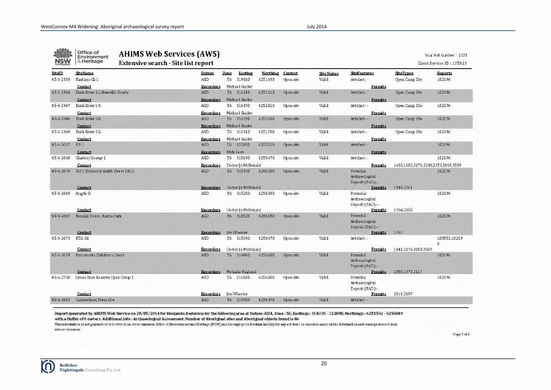
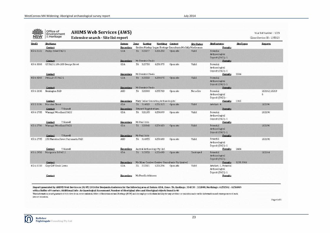
4.1 AHIMS web services
The Aboriginal Heritage Information Management System (AHIMS) is a database operated by the (NSW) Office of Environment and Heritage (OEH) and regulated under section 90(Q) of the (NSW) National Parks and Wildlife Act 1974 (NPW Act). AHIMS contains information and records related to registered Aboriginal archaeological sites (Aboriginal objects, as defined under the NPW Act) and declared Aboriginal places (as defined under the NPW Act) in NSW. A search of AHIMS was conducted on 18 March 2014 to identify registered (known) Aboriginal sites or declared Aboriginal places within or adjacent to the study area (Client service ID 128793). Search results are attached as Appendix B. The AHIMS Web Service database search was conducted within the following coordinates (GDA, Zone 56):
Eastings: 314338 - 322008 Northings: 6251562 - 6256849 Buffer: 0 metres (the search coordinates included a buffer around the study area).
The AHIMS search results showed:
46 Aboriginal sites are recorded in or near the above location
0 Aboriginal places have been declared in or near the above location
The type and distribution of recorded Aboriginal sites within these coordinates are shown in Figure 4. The frequencies of site types within the AHIMS database search area are shown in Table 4. Table 4. Frequency of site types from AHIMS database search
Site Type Total
Open artefact scatter 12
Midden 2
Isolated Artefact 3
Potential Archaeological Deposit 28
Modified Tree (Carved or Scarred Tree) 1
Total 46
4.2 Other heritage registers and databases
Other sources of information including heritage registers and lists were also searched for known Aboriginal heritage in the vicinity of the study area. These included:
Auburn Local Environment Plan 2010.
Holroyd Local Environment Plan 2013.
Parramatta Local Environment Plan 2011.
Strathfield Local Environment Plan 2012.
Roads and Maritime Heritage Register.
Railcorp Heritage Register.
Sydney Water Heritage Register.
State Heritage Register and State Heritage Inventory.
Commonwealth Heritage List.
National Heritage List.
Australian Heritage Places Inventory.
Historic Heritage Information Management System (HHIMS). No items of Aboriginal heritage were listed or registered on these databases within the study area.

WestConnex M4 Widening: Aboriginal archaeological survey report July 2014
8
Figure 4. AHIMS site locations

WestConnex M4 Widening: Aboriginal archaeological survey report July 2014
9
4.3 Discussion of search results
Results from the combined database searches show no items of Aboriginal heritage registered within the study area. A large number of potential archaeological deposits are concentrated on the sand sheet below the ground surface of the Parramatta CBD. Closer to the M4 Motorway corridor, two sites (AHIMS ID 45-6-2627 and AHIMS ID 45-6-2339) were located within one kilometre of the study area. Review of 45-6-2627 (HP-1) found this site/object was unlikely to be in context. Site 45-6-2339 located more than 500m south of the M4 Motorway was a small scatter of stone flakes and shell within built up grounds of a playing field. Review of the available information from heritage register searches showed that the most common site context within the vicinity of the project area was open artefact scatter. Potential archaeological deposit, isolated find and modified tree (carved or scarred tree) site contexts were also present. The absence of registered Aboriginal heritage items within the study area and the low number of items in the immediate surroundings is the result of the intensive modification of the landscape in the area. Registered Aboriginal heritage items therefore likely represent residual pockets where the landform has not been as extensively modified.
4.4 Previous archaeological investigations
An Aboriginal archaeological survey and assessment of the existing M4 Motorway corridor (this included a section within the current study area) was conducted by Kelleher Nightingale Consulting in 2013 as part of the Stage 2 PACHCI investigation for the M4 Managed Motorway project. No Aboriginal archaeological material or potential Aboriginal archaeological deposits were identified in the M4 Widening project study area. (The M4 Managed Motorway project archaeological survey and assessment included the existing M4 Motorway corridor - as per KNC 2013 - and portions of land outside of the corridor).

WestConnex M4 Widening: Aboriginal archaeological survey report July 2014
10
5 Landscape context
The study area traverses a series of simple slopes, flats and flood plains/channels. The study area is highly developed by urbanisation and much of the landscape has been significantly modified. Waterways include the Duck River System comprising Duck River, Duck Creek and Abecketts Creek and minor creeks of Haslams and Powells. The western portion of the study area skirts along fine sandstone and humic sands associated with flood deltas related to the Duck River/Creek system (Figure 5). These low lying lands have been largely filled, re-contoured and developed with virtually no natural land surfaces remaining. The eastern portion of the study area traverses shale and humic sands which also display high levels of urbanisation. Archaeologically the sands on the margins of waterway are good locations for archaeological material to survive, however the substantial modification to the landscape has virtually eliminated the heritage potential. The Duck River Duck Creek junction displayed some sensitivity, while the Haslams and Powells Creeks displayed no sensitivity due to impacts from infrastructure.
Figure 5. Geology of study area
5.1 Flood modelling
Flood modelling was undertaken by KNC to assess where archaeological deposit may exist intact within the study area. The modelling was used to identify the meeting point between past occupation and flood disturbance (ie the closest point to waterways that archaeology will statistically survive). Digital elevation models (Figure 6) utilising an estimated 1 per cent annual exceedance probability event (roughly four metres Australian Height Datum) indicated significant impact on soil stability within the primary deltas (humic sand areas). The confluence of Duck River and Duck Creek, which geographically would have been advantageous to past Aboriginal people, indicated high energy flood water moving through the system (Figure 7). The effect of this energy would be the total displacement of Aboriginal archaeological objects as energised water moves sediments down the system. Interestingly the abutments at the west end of Martha Street on the south side of the existing M4 Motorway above the cycle track on Duck River, appear above the hydraulic hazards of flood waters. This is likely an artificial result related to construction of the existing M4 Motorway abutment as no lithic geology appears to underlie the result, meaning that the location (the ground on which the current abutments rest) is unlikely to represent a natural raised feature. The existing ground surface was highly modified and assessment of geotechnical borehole logs showed

WestConnex M4 Widening: Aboriginal archaeological survey report July 2014
11
that a fill layer, generally to a depth of 70cm, covered homogenised clay alluvium (c.2-3 metres deep) indicating disturbance of the upper soil layers and an active soil matrix with low archaeological potential at the Duck River/Duck Creek/M4 Motorway junction.
Figure 6. Digital elevation model of study area
Figure 7. Digital elevation model of confluence of Duck River and Duck Creek showing flood probability, with more darkly shaded areas exhibiting a higher probability of flooding (source KNC 2013)

WestConnex M4 Widening: Aboriginal archaeological survey report July 2014
12
6 Regional character and site predictions
In highly urbanised landscapes, Aboriginal archaeological objects will only survive in situ where the natural surface of the ground remains undisturbed. Aboriginal occupation is statistically more likely to occur where quality raw materials are found in close proximity to major waterways on defined topography such as terraces or creek junctions. Significant archaeological sites will exist where such deposits are situated on elevated (above the 1:100 year flood level), low gradient landforms. The study area exhibited no undisturbed archaeologically significant landforms. The junction point between Duck River and Duck Creek had some sensitivity, however existing development and past flooding have lowered the archaeological potential.
7 Sampling strategy
The aim of the archaeological survey was to conduct a full coverage, pedestrian survey of the study area and identify/record any Aboriginal archaeological sites. Due to the relatively narrow and linear nature of the study area, it was possible for the survey team to conduct one transect on each side of the M4 corridor per survey unit (refer Figure 8). Based on the archaeological background and landform context of the study area, the survey team closely inspected any areas of surface exposure for artefacts, evidence of intact natural deposit and any mature trees for evidence of Aboriginal bark removal. Assessments of soil disturbance were also made during the survey.
8 Field methods
The route of the entire study area was inspected by pedestrian survey (19 and 22 July 2013). Additional survey was undertaken to assess design refinements and compound locations (25 and 27 February 2014). The study area covered a number of landforms but generally the landscape had been extensively modified and re-landscaped. The survey team was equipped with maps showing the boundaries of the study area and non-differential global positioning system (GPS). All GPS recordings were made using the Geocentric Datum of Australia (GDA) coordinate system. Two survey units were selected to reflect the two relevant Aboriginal land council boundaries.
9 Survey results
No Aboriginal archaeological objects, sites or potential archaeological deposits were identified within the study area. The study area exhibited substantial ground disturbance with only minimal potential for natural ground surface or intact buried surfaces.

WestConnex M4 Widening: Aboriginal archaeological survey report July 2014
13
Figure 8. Survey units with the study area

WestConnex M4 Widening: Aboriginal archaeological survey report July 2014
14
10 Survey coverage analysis
Overall surface visibility and exposure across the study area was low. Many areas were heavily impacted by existing infrastructure and development. Existing vegetated areas were landscaped with only remnant natural vegetation. Details of survey and landform coverage are outlined in the Tables 5 and 6. Table 5. Survey coverage
Survey Unit
Landform Survey
Unit Area (m2)
Visibility (%) Exposure (%) Effective
Coverage (m2) Effective
Coverage (%)
1 Slopes/Flats/Floodplain 400000 5 15 3000 0.75
2 Slopes/Floodplain 200000 5 10 1000 0.5
Table 6. Landform coverage
Landform Landform Area
(m2) Area Effectively Surveyed (m2)
% of Landform Effectively Surveyed
# of Sites # of Artefacts or Features
Floodplain/Flat 100000 750 0.75 0 0
Simple slope 500000 2500 0.5 0 0
Surface visibility across the floodplain/flat landform was low due to high levels of modification covering the ground surface: infrastructure, commercial and residential development, pavement, fill and landscaping. In many instances it was evident that ground surface was highly disturbed below the modification with levelling, cutting and filling visible in sample sections within the study area. Evidence of high energy flood activity in the past was also evident at the creek crossing where homogenised soils displayed no long term structural integrity indicating poor archaeological survivability for the flood channel and plain. Survey coverage across slopes also revealed similar levels of disturbance to the flats with landscaping and re-vegetation noticeable on the gradient shifts. In summary, the study area displayed low archaeological potential due to land modifications and high levels of ground disturbance.

WestConnex M4 Widening: Aboriginal archaeological survey report July 2014
15
11 Discussion
Background research, AHIMS records and field survey identified no Aboriginal archaeological sites within the study area. Archaeologically the study area is a highly disturbed and modified environment exhibiting little potential artefact survivability. The most sensitive locations near the waterways display disturbance from flooding within the channels effecting a hydraulic movement of soils (and any potentially associated archaeology). The margins along the waterways, generally the best location for artefact survivability, were heavily urbanised with substantial disturbance.
12 Significance assessment
No Aboriginal archaeological objects, sites or potential archaeological deposits have been identified within the study area. Much of the study area was disturbed and exhibits no archaeological potential.
13 Impact assessment
No impact would occur to any identified Aboriginal archaeological object, site or potential archaeological deposit within the study area.
14 Management and recommendations
Based on the assessment of the study area detailed within this archaeological survey report, no Aboriginal archaeological sites would be impacted by the proposed M4 Widening project. No further management of Aboriginal heritage is warranted for the proposed M4 Widening project.

WestConnex M4 Widening: Aboriginal archaeological survey report July 2014
16
References
Kelleher Nightingale Consulting Pty Ltd, 2013. M4 Managed Motorway from Lapstone (western end) to Strathfield (eastern end). Review of environmental factors. Aboriginal archaeological survey report Stage 2 PACHCI. Report prepared for SKM on behalf of Roads and Maritime Services. Roads and Maritime Services, Road Pavement and Geotechnical Engineering, Geotechnical Science Section. Geotechnical investigation report. WestConnex M4 Widening, Pitt Street Parramatta to Homebush Bay Drive Homebush.

WestConnex M4 Widening: Aboriginal archaeological survey report July 2014
17
Appendix A Aboriginal stakeholder comments

WestConnex M4 Widening: Aboriginal archaeological survey report July 2014
18

WestConnex M4 Widening: Aboriginal archaeological survey report July 2014
19
Appendix B AHIMS search
WestConnex M4 Widening: Aboriginal archaeological survey report July 2014
20

WestConnex M4 Widening: Aboriginal archaeological survey report July 2014
21

WestConnex M4 Widening: Aboriginal archaeological survey report July 2014
22
WestConnex M4 Widening: Aboriginal archaeological survey report July 2014
23

WestConnex M4 Widening: Aboriginal archaeological survey report July 2014
24


