66
J APPENDIX Archaeological Inventory Survey for Hawaiian Memorial Park, Kāne‘ohe Ahupua‘a, Ko‘olaupoko District, Island of O‘ahu – March 2019 Prepared by: Honua Consulting
JA P P END I X
Archaeological Inventory Survey for Hawaiian Memorial Park,
Kāne‘ohe Ahupua‘a, Ko‘olaupoko District, Island of O‘ahu – March 2019Prepared by: Honua Consulting
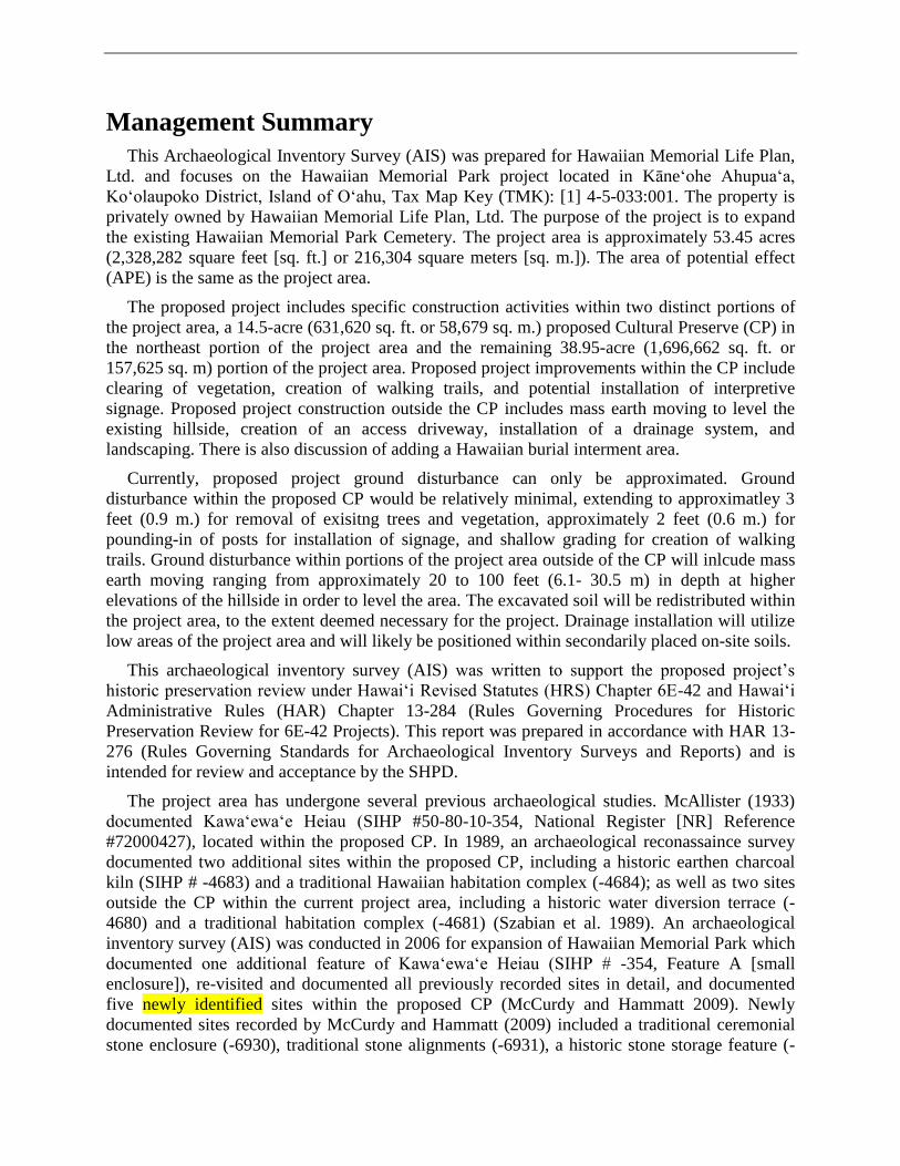
Draft
Archaeological Inventory Survey for
Hawaiian Memorial Park,
Kāne‘ohe Ahupua‘a, Ko‘olaupoko District,
Island of O‘ahu, TMK: [1] 4-5-033:001
Prepared for
Hawaiian Memorial Life Plan, Ltd.
Prepared by
Rosanna Thurman, M.A.,
Catharine Thetford, B.A.,
Arleen Garcia-Herbst, C. Phil, RPA,
Trisha Kehaulani Watson, J.D., Ph.D.
Honua Consulting
Honolulu, Hawai‘i
March 2019
Management Summary
This Archaeological Inventory Survey (AIS) was prepared for Hawaiian Memorial Life Plan,
Ltd. and focuses on the Hawaiian Memorial Park project located in Kāne‘ohe Ahupua‘a,
Ko‘olaupoko District, Island of O‘ahu, Tax Map Key (TMK): [1] 4-5-033:001. The property is
privately owned by Hawaiian Memorial Life Plan, Ltd. The purpose of the project is to expand
the existing Hawaiian Memorial Park Cemetery. The project area is approximately 53.45 acres
(2,328,282 square feet [sq. ft.] or 216,304 square meters [sq. m.]). The area of potential effect
(APE) is the same as the project area.
The proposed project includes specific construction activities within two distinct portions of
the project area, a 14.5-acre (631,620 sq. ft. or 58,679 sq. m.) proposed Cultural Preserve (CP) in
the northeast portion of the project area and the remaining 38.95-acre (1,696,662 sq. ft. or
157,625 sq. m) portion of the project area. Proposed project improvements within the CP include
clearing of vegetation, creation of walking trails, and potential installation of interpretive
signage. Proposed project construction outside the CP includes mass earth moving to level the
existing hillside, creation of an access driveway, installation of a drainage system, and
landscaping. There is also discussion of adding a Hawaiian burial interment area.
Currently, proposed project ground disturbance can only be approximated. Ground
disturbance within the proposed CP would be relatively minimal, extending to approximatley 3
feet (0.9 m.) for removal of exisitng trees and vegetation, approximately 2 feet (0.6 m.) for
pounding-in of posts for installation of signage, and shallow grading for creation of walking
trails. Ground disturbance within portions of the project area outside of the CP will inlcude mass
earth moving ranging from approximately 20 to 100 feet (6.1- 30.5 m) in depth at higher
elevations of the hillside in order to level the area. The excavated soil will be redistributed within
the project area, to the extent deemed necessary for the project. Drainage installation will utilize
low areas of the project area and will likely be positioned within secondarily placed on-site soils.
This archaeological inventory survey (AIS) was written to support the proposed project’s
historic preservation review under Hawai‘i Revised Statutes (HRS) Chapter 6E-42 and Hawai‘i
Administrative Rules (HAR) Chapter 13-284 (Rules Governing Procedures for Historic
Preservation Review for 6E-42 Projects). This report was prepared in accordance with HAR 13-
276 (Rules Governing Standards for Archaeological Inventory Surveys and Reports) and is
intended for review and acceptance by the SHPD.
The project area has undergone several previous archaeological studies. McAllister (1933)
documented Kawa‘ewa‘e Heiau (SIHP #50-80-10-354, National Register [NR] Reference
#72000427), located within the proposed CP. In 1989, an archaeological reconassaince survey
documented two additional sites within the proposed CP, including a historic earthen charcoal
kiln (SIHP # -4683) and a traditional Hawaiian habitation complex (-4684); as well as two sites
outside the CP within the current project area, including a historic water diversion terrace (-
4680) and a traditional habitation complex (-4681) (Szabian et al. 1989). An archaeological
inventory survey (AIS) was conducted in 2006 for expansion of Hawaiian Memorial Park which
documented one additional feature of Kawa‘ewa‘e Heiau (SIHP # -354, Feature A [small
enclosure]), re-visited and documented all previously recorded sites in detail, and documented
five newly identified sites within the proposed CP (McCurdy and Hammatt 2009). Newly
documented sites recorded by McCurdy and Hammatt (2009) included a traditional ceremonial
stone enclosure (-6930), traditional stone alignments (-6931), a historic stone storage feature (-
Honua Consulting Management Summary
ii
6932), a historic earthen charcoal kiln (-6933), and a traditional grinding stone (-7079)
(McCurdy and Hammatt 2009). The AIS recommended creation of the CP and archaeological
monitoring during project construction. Large communities of laua‘e or maile-scented fern
(Phymatosorus grossus) were also recommended for preservation.
During the current AIS investigation, all previously recorded sites within the project area
were re-visited, including eight (8) sites within the CP (SIHP #50-80-10-354, 50-80-10-4683,
50-80-10-4684, 50-80-10-6930, 50-80-10-6931, 50-80-10-6932, 50-80-10-6933 and 50-80-10-
7079) and two (2) sites outside the CP (SIHP #50-80-10-4680 and 50-80-10-4681), and an
additional 14 sites were newly documented (SIHP #50-80-10-8228 to -8241 [Honua 1-14]).
Within the CP, the current AIS recorded additional features of Kawa‘ewa‘e Heiau (SIHP # -354),
expanded SIHP # -7079 to include several terrace remnants and a stone mound; and recorded
SIHP # -8240, a terraced ‘auwai (drainage) where large ‘ekaha plants (Asplenium nidus) are
growing. Two newly documented sites were recored on the southern border of the proposed CP,
including a terraced ‘auwai (SIHP # -8231) and a historic charcoal kiln (SIHP # -8241). In
coordination with the landowner, SIHP # -8231 and -8241 will be incorporated within the
proposed CP. Newly recorded sites outside the CP include historic dairy roads (SIHP # -8228), a
historic road segment (SIHP # -8229), a historic ‘auwai (SIHP # -8230), an ‘auwai with
associated terraces (SIHP # -8232), agricultural terrace remnants (SIHP # -8233, -8234, and -
8237, a historic water retention terrace (SIHP # -8236), possible habitation sites (SIHP # -8235
and -8238), and an earthen pit (SIHP # -8239).
Excavation was conducted at one site during this AIS investigation, SIHP # -8241, historic
charcoal kiln). SIHP # -8241 was initially characterized as a walled pit feature (Features A-C),
constructed of earth and dry-stacked basalt stones. Two test units (TU 1 and 2) and an
exploratory excavation were dug to assess the type of feature, function, and associated time
period. Excavations revealed the interior stone wall (SIHP # -8241, Feature C) observable on the
ground surface, extended approximately 70 cm (2.3 ft.) deeper and was well-constructed of small
to large-sized basalt cobbles and boulders. Concentrations of dense soot on the lower portions of
the Feature C stone wall, the base of the site (Feature D), and adjacent to intentional voids or
openings within the stone wall construction (Features E and F) provided indicators of how the
site once functioned. SIHP # -8241 was identified as a historic guava (Psidium sp.) charcoal kiln
in good condition, with constructed air vents and a chimney or flue to release smoke. Production
of guava charcoal was a common activity in Windward O‘ahu in the latter half of the 19th
century and then again in the 20th century. The lack of mortar or a concrete dome suggests SIHP
# -8241 may have been built during the early period of guava charcoal production, 1825-1906.
Mitigation recommendations for this project are threefold, starting with a Data Recovery (DR)
program, followed by creation of a Preservation Plan (PP), and an archaeological monitoring
program. The DR program would focus on obtaining additional data at several documented sites
to aid in interpretatoin of site funtion, time period, and use activities and would focus on sites
which will be impacted by proposed project construction as well as sites which may not be
impacted. A PP will need to be completed to address short-term and long-term mitigation
measures for sites located within the proposed CP. Lastly, the proposed construction project
should proceed under an archaeological monitoring program.

Honua Consulting
i
Table of Contents
Section 1 Introduction ............................................................................................................. 1
1.1 Scope of Work ............................................................................................................................. 10 1.2 Environmental Setting ................................................................................................................. 12
1.2.1 Natural Environment............................................................................................................. 12 1.2.2 Built Environment................................................................................................................. 13
Section 2 Methods .................................................................................................................. 14
2.1 Pedestrian Survey ........................................................................................................................ 14 2.2 Excavation ................................................................................................................................... 15 2.3 Laboratory Analysis ..................................................................................................................... 15
2.3.1 Glass Bottles ......................................................................................................................... 15 2.3.2 Lithic Material ...................................................................................................................... 16 2.3.3 Faunal Bone .......................................................................................................................... 16 2.3.4 Charcoal Identification ......................................................................................................... 16
2.4 Background Research .................................................................................................................. 16
Section 3 Consultation ........................................................................................................... 17
Section 4 Background Research ........................................................................................... 20
4.1 Traditional and Mythological Background .................................................................................. 20 4.2 Early to Mid- 1800s ..................................................................................................................... 28
i. Māhele Documentation ........................................................................................................ 28 4.3 Mid 1800s to Present ................................................................................................................... 32
4.3.1 Sugar ..................................................................................................................................... 32 4.3.2 Rice ....................................................................................................................................... 33 4.3.3 Ranching ............................................................................................................................... 33 4.3.4 Guava Charcoal Production .................................................................................................. 34 4.3.5 Pineapple ............................................................................................................................... 35 4.3.6 Dairy ..................................................................................................................................... 36
Section 5 Previous Archaeological Research ....................................................................... 38
5.1 Previous Archaeological Studies in the Vicinity of the Project Area .......................................... 38 5.1.1 McAllister 1933 .................................................................................................................... 38 5.1.2 Hammatt and Shideler 1989 ................................................................................................. 39 5.1.3 McIntosh and Cleghorn 2013 ............................................................................................... 39 5.1.4 Medrano and Spear 2015 ...................................................................................................... 39
5.2 Previous Archaeological Studies Within the Current Project Area ............................................. 44 5.2.1 Szabian et al. 1989, Szabian 1989 ........................................................................................ 44 5.2.2 Hammatt 2008, McCurdy and Hammatt 2009 ...................................................................... 44
Section 6 Background Summary and Predictive Model ..................................................... 46
Section 7 AIS Results ............................................................................................................. 47
7.1 Pedestrian Survey ........................................................................................................................ 47 7.2 Survey Results ............................................................................................................................. 52

Honua Consulting
ii
7.3 Overview of Excavation .............................................................................................................. 53
Section 8 Historic Property Description .............................................................................. 62
8.1 Historic Properties Within the Cultural Preserve......................................................................... 62 8.1.1 SIHP #50-80-10-354 (NR #72000427), Kawa‘ewa‘e Heiau ................................................ 64 8.1.2 SIHP #50-80-10-4683, Historic Charcoal Kiln .................................................................... 86 8.1.3 SIHP #50-80-10-4684, Traditional Habitation Complex ...................................................... 89 8.1.4 SIHP #50-80-10-6930, Traditional Ceremonial Stone Enclosure ........................................ 99 8.1.5 SIHP #50-80-10-6931, Traditional Ceremonial Area ......................................................... 104 8.1.6 SIHP #50-80-10-6932, Historic Stone Storage Feature ...................................................... 109 8.1.7 SIHP #50-80-10-6933, Historic Charcoal Kiln .................................................................. 111 8.1.8 SIHP #50-80-10-7079, Traditional Agricultural Complex ................................................. 114 8.1.9 SIHP #50-80-10-8231 (Honua 4), Traditional Terraced ‘Auwai ........................................ 123 8.1.10 SIHP #50-80-10-8240 (Honua 13), Traditional Terraced ‘Auwai .................................... 129 8.1.11 SIHP #50-80-10-8241 (Honua 14), Historic Guava Charcoal Kiln .................................. 132
8.2 Historic Properties Not Within the Cultural Preserve................................................................ 150 8.2.1 SIHP #50-80-10-4680, Historic Water Retention Terrace.................................................. 151 8.2.2 SIHP #50-80-10-4681, Traditional Habitation Complex .................................................... 154 8.2.3 SIHP #50-80-10-8228 (Honua 1), Historic Dairy Roads .................................................... 165 8.2.4 SIHP #50-80-10-8229 (Honua 2), Historic Road ............................................................... 168 8.2.5 SIHP #50-80-10-8230 (Honua 3), Historic ‘Auwai ............................................................ 170 8.2.6 SIHP #50-80-10-8232 (Honua 5), Traditional Terrace Remnants ...................................... 178 8.2.7 SIHP #50-80-10-8233 (Honua 6), Traditional Terrace Remnants (6A) and Modified
Outcrop (6B) ...................................................................................................................... 183 8.2.8 SIHP #50-80-10-8234 (Honua 7), Traditional Terrace ....................................................... 190 8.2.9 SIHP #50-80-10-8235 (Honua 8), Habitation Site ............................................................. 193 8.2.10 SIHP #50-80-10-8236 (Honua 9), Historic Water Diversion ........................................... 195 8.2.11 SIHP #50-80-10-8237 (Honua 10), Traditional Terrace Remnants .................................. 197 8.2.12 SIHP #50-80-10-8238 (Honua 11), Agricultural Terraces and Possible Habitation ........ 200 8.2.13 SIHP #50-80-10-8239 (Honua 12), Earthen Pit ................................................................ 205
Section 9 Laboratory Analysis ............................................................................................ 208
9.1 Glass Bottles .............................................................................................................................. 208 9.2 Lithic Analysis ........................................................................................................................... 213 9.3 Faunal Analysis ......................................................................................................................... 214 9.4 Charcoal Identification .............................................................................................................. 215 9.5 Disposition of Materials ............................................................................................................ 215
Section 10 Summary and Interpretations .......................................................................... 216
Section 11 Significance Assessments and Recommendations ........................................... 218
11.1 Significance Assessment.......................................................................................................... 218 11.2 Project Effect Determination ................................................................................................... 218 11.3 Mitigation Recommendation ................................................................................................... 218
11.3.1 Data Recovery................................................................................................................... 224 11.3.2 Preservation ...................................................................................................................... 225 11.3.3 Archaeological Monitoring ............................................................................................... 225
Section 12 References Cited ................................................................................................ 226
Honua Consulting
iii
Appendix A National Register Nomination Form (Watts 1971) ...................................... A-1
Appendix B Hawai‘i Register .............................................................................................. B-1
Appendix C GPS Data ......................................................................................................... C-1
Appendix D EDXRF Analysis ............................................................................................. D-1
Appendix E Charcoal Identification Results ..................................................................... E-1
Appendix F Catalogue of Collected Material ..................................................................... F-1
Honua Consulting
iv
List of Figures
Figure 1. Portion of a 1998 Kāne‘ohe U.S. Geological Survey (USGS) topographic quadrangle
map showing the location of the project area (notice the Cultural Preserve [CP] in the
northern portion of the project area and Kawa‘ewa‘e Heiau) ..............................................2 Figure 2. 2011 aerial photograph showing the project area (outlined in red), the proposed CP
(shaded in pink), and the location of Kawa‘ewa‘e Heiau (shaded in pink with hatched
outline) (USGS Orthophoto 2011) .......................................................................................3 Figure 3. Tax Map Key (TMK): [1] 4-5-033 showing the project area (outlined in red), the
proposed CP (shaded in pink), and the location of Kawa‘ewa‘e Heiau (shaded in pink
with hatched outline) (Hawai‘i TMK Service) ...................................................................4 Figure 4. 2017 Conceptual Plan Showing the Project Area, proposed Cultural Preserve,
Previously Documented Historic Properties, and Proposed Project Infrastructure (Clark &
Green Associates, HHF Planners 2017)...............................................................................5 Figure 5. 2018 Conceptual Plan Showing the Project Area (Petition Area), proposed Cultural
Preserve, and Proposed Project Infrastructure (HHF Planners 2018)..................................6 Figure 6. 2018 Proposed Grading Plan with color-coded elevations of earthwork (HHF Planners
2018) ....................................................................................................................................7 Figure 7. 2018 Proposed Grading Plan (HHF Planners 2018).........................................................8
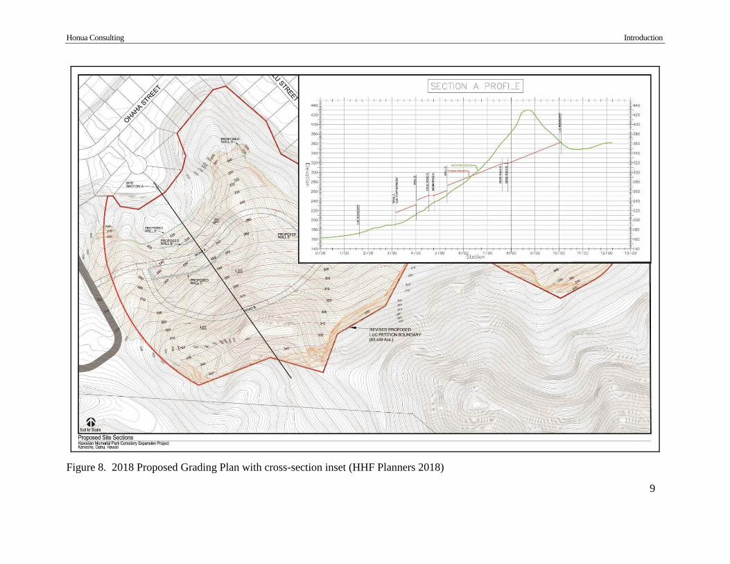
Figure 8. 2018 Proposed Grading Plan with cross-section inset (HHF Planners 2018) .................9
Figure 9. Portion of a 1998 Kāne‘ohe USGS with overlay of Soil Survey Data (Foote et al. 1972)13
Figure 10. Potential circular arrangement of boulders near the base of the hillside below
Kawa‘ewa‘e Heiau, view to north .....................................................................................18
Figure 11. Portion of a 1876 C. J. Lyons and W.D. Alexander map of “Kaneohe, Oahu with West
Kailua” showing the project area (Registered Map [RM] 585) .........................................21 Figure 12. Portion of an 1881 Hawaiian Government Survey Map showing the project area ......30
Figure 13. Portion of a 1902 W.E. Wall map showing the project area ........................................31 Figure 14. Portion of a 1954 Kāne‘ohe USGS topographic quadrangle map showing the project
area; notice a road and grouping of structures to the northwest of the project area, just
south of Castle High School, marking the Souza Brothers Dairy ......................................37 Figure 15. Portion of a 1998 Kāne‘ohe USGS topographic map showing the locations of
previous archaeological projects within and in the vicinity of the project area .................40
Figure 16. Portion of a 1998 Kāne‘ohe USGS topographic map showing the locations of
previously documented sites within and in the vicinity of the project area .......................41 Figure 17. Portion of a 1998 Kāne‘ohe USGS showing survey tracks and miscellaneous findings48 Figure 18. Photo showing representative vegetation in lower elevations with moderate ground
visibility, view to east ........................................................................................................49
Figure 19. Photo showing representative vegetation near streams, showing poor ground visibility,
view to northeast ................................................................................................................49 Figure 20. Photo showing representative vegetation in inland portions of the project area, with
moderate to poor ground visibility, view to east ................................................................49
Figure 21. Photo showing a possible ‘ili boundary stone located outside the project area (GPS:
PossIliBoundMrkr), view to southeast ...............................................................................50
Honua Consulting
v
Figure 22. Photo showing a view to Kāne‘ohe Bay from the possible ‘ili boundary stone, view to
east .....................................................................................................................................50
Figure 23. Photo showing a natural seeping spring located within the eastern end of the Cultural
Preserve (GPS: 12-28-SpringSeep), view to northeast ......................................................51 Figure 24. Portion of a 1998 Kaneohe USGS showing all documented sites within the project
area (in purple) ...................................................................................................................54 Figure 25. 2011 aerial photograph showing locations of all documented sites (in purple) ...........55
Figure 26. TMK: [1] 4-5-33 showing locations of all documented sites .......................................56 Figure 27. Portion of a 1998 USGS map showing locations of all documented sites and a 2018
Revised Cultural Preserve Boundary .................................................................................63
Figure 28. McAllister (1933) map of Kawa‘ewa‘e Heiau (SIHP # -354) (McAllister 1933:180) 67 Figure 29. Sketches of Kawa‘ewa‘e Heiau (SIHP # -354) drawn by Mr. Charlie Ogata (1992)
(Hammatt 2008:66) ............................................................................................................68 Figure 30. Model Replica of Kawa‘ewa‘e Heiau (SIHP # -354) created by Mr. Charlie Ogata;
view to east (Hammatt 2008:65) ........................................................................................69
Figure 31. Photo of Kawa‘ewa‘e Heiau, view to north (Jan Becket 1995, permission of author) 70
Figure 32. Photo of Kawa‘ewa‘e Heiau showing the interior surface of the heiau, view to east
(Jan Becket 1995, permission of author) ...........................................................................70 Figure 33. Photo within Kawa‘ewa‘e Heiau (SIHP # -354) showing the north interior wall
(Feature 7) of the heiau in good condition, view northeast ...............................................71 Figure 34. Revised Plan Map of Kawa‘ewa‘e Heiau (SIHP #50-80-10-354) showing main feature
locations (adapted from Ogata 1992) .................................................................................72 Figure 35. Detailed Plan Map of Kawa‘ewa‘e Heiau (SIHP # -354) showing all features and
elevations (adapted from Ogata 1992) ...............................................................................73 Figure 36. Photo of SIHP -354, Feature A (two-sectioned enclosure) (Section 1), view to west .74
Figure 37. Photo of SIHP -354, Feature A (two-sectioned enclosure) (Section 2) from inside the
feature, view to northwest ..................................................................................................74 Figure 38. Plan Map of Kawa‘ewa‘e Heiau (SIHP # -354), Feature A (McCurdy and Hammatt
2009:85) .............................................................................................................................75 Figure 39. Photo showing the exterior of Kawa‘ewa‘e Heiau, SIHP # -354, Feature 2 (heiau wall,
in background) and Feature 2A (ramped wall terrace, in foreground), view to northwest
(panorama) .........................................................................................................................78 Figure 40. Photo showing SIHP # -354, Feature 2 (exterior heiau wall, on left) and Feature 2A
(ramped terrace, in center), view to north ..........................................................................78 Figure 41. Photo showing Feature 2B (terrace), view to west .......................................................79 Figure 42. Photo from Hammatt (2008:69) showing Feature 2B (terrace), view to northeast ......79 Figure 43. Photo within SIHP # -354, showing Feature 4A (low stone terrace, in foreground) and
the east interior wall of the heiau (Feature 3) (in background), view to east ....................80
Figure 44. Photo within SIHP # -354, showing Feature 4A (low stone terrace) and a circular pit
constructed within the feature (at photo scale), view to southeast ....................................80 Figure 45. Photo showing SIHP # -354, Feature 6A1 (circular alignment), view to south ...........81
Figure 46. Photos showing SIHP -354, Feature 6A2-A4 (stone paving containing circular
alignments), view to northwest (left photo: notice two circular alignments, Features 6A2
[center of photo] and 6A3 [center left]; right photo: shows one large circular alignment,
Feature 6A4) ......................................................................................................................81
Honua Consulting
vi
Figure 47. Photo showing SIHP # -354, Feature 6B (terrace), view to northeast (notice the west
wall of Kawa‘ewa‘e Heiau in background) .......................................................................82
Figure 48. Photo showing SIHP # -354, Feature 6B (terrace), view to north ................................82 Figure 49. Photo showing SIHP # -354, Feature 7A (stepped heiau wall), view to south ............83 Figure 50. Photo showing SIHP # -354, Feature 7A (circular alignments [center and lower left
foreground), view to east ...................................................................................................83 Figure 51. Photo of SIHP # -354, Feature 8A (earthen pit), view to southwest ............................84
Figure 52. Photo showing SIHP # -354, Feature 8B (earthen pit), view to south .........................84 Figure 53. Photo showing SIHP # -354, Feature 8C (earthen pit), view to east ............................85 Figure 54. Photo showing SIHP # -354, Feature 8D (earthen pit), view to north .........................85
Figure 55. Photo of SIHP # -4683, Feature A (pit feature), view to northeast ..............................88 Figure 56. Revised Plan Map of SIHP # -4683 (historic charcoal kiln) (adapted from McCurdy
and Hammatt 2009:46) ......................................................................................................88 Figure 57. Photo of SIHP # -4684, Feature A, Test Unit 1 Northeast Profile Wall (McCurdy and
Hammatt 2009:58) .............................................................................................................92
Figure 58. Profile of SIHP # -4684, Feature A, Test Unit 1 Northeast Profile Wall (McCurdy and
Hammatt 2009:59) .............................................................................................................92 Figure 59. Photo of SIHP # -4684, Feature F, Test Unit 2 Southeast Profile Wall (McCurdy and
Hammatt 2009:61) .............................................................................................................93
Figure 60. Profile of SIHP # -4684, Feature F, Test Unit 2 Southeast Profile Wall (McCurdy and
Hammatt 2009:62) .............................................................................................................93
Figure 61. Revised Plan Map of SIHP -4684 (traditional habitation complex) (adapted from
McCurdy and Hammatt 2009:31) ......................................................................................94
Figure 62. Photo showing SIHP # -4684, Feature A (c-shape), view to east ................................95 Figure 63. Photo showing SIHP # -4684, Feature B (terrace), view to southeast .........................95
Figure 64. Photo showing SIHP # -4684, Feature C (terrace) (south portion), view to northeast .96 Figure 65. Photo showing SIHP # -4684, Feature D (c-shape), view to southeast ........................96 Figure 66. Photo showing SIHP # -4684, Feature E (circular stone feature), view to northeast ...97
Figure 67. Photo showing SIHP # -4684, Feature F (c-shape), view northeast .............................97 Figure 68. Photo showing SIHP # -4684, Feature G (c-shape), view to northwest .......................98
Figure 69. Photo showing SIHP # -4684, Feature H (stone alignment), view to east ...................98
Figure 70. Photo of SIHP # 6930 (enclosure), Test Unit 1, view south (McCurdy and Hammatt
2009:71) ...........................................................................................................................101
Figure 71. Profile of SIHP # 6930 (enclosure), Test Unit 1 (McCurdy and Hammatt 2009:72)101 Figure 72. Revised Plan View of SIHP # -6930 (adapted from McCurdy and Hammatt 2009:39)102 Figure 73. Photo of SIHP # -6930 (enclosure, north wall in foreground), view to south ............103 Figure 74. Photo of SIHP # -6930 (enclosure, west wall), view to southeast .............................103 Figure 75. Photo showing SIHP # -6931, Feature A (terrace, in foreground), Feature B (terrace,
center), and Feature C (terrace in background), view to northwest .................................105 Figure 76. Revised Plan Map of SIHP # -6931 (traditional ceremonial area) (adapted from
McCurdy and Hammatt 2009:97) ....................................................................................106
Figure 77. Photo showing SIHP # -6931, Feature D (ceremonial area, terrace), view to northeast107 Figure 78. Photo showing SIHP # -6931, Feature D (ceremonial area, top of hill), view to south107 Figure 79. Photo taken just south of SIHP # -6931, Feature D, showing a modern earthen pit
(west pit) and black plastic planting pot, view to west ....................................................108

Honua Consulting
vii
Figure 80. Photo taken just south of SIHP # -6931, Feature D, showing a modern earthen pit
(east pit) and black plastic planting pots, view to south ..................................................108
Figure 81. Revised Plan View of SIHP #50-80-10-6932 (Storage Feature) (adapted from
McCurdy and Hammatt 2009:74) ....................................................................................110 Figure 82. Photo of SIHP # -6932 (Storage Feature), view to north ...........................................110 Figure 83. Revised Plan View of SIHP # -6933 (Historic Kiln) (adapted from McCurdy and
Hammatt 2009:77) ...........................................................................................................112
Figure 84. Photo showing SIHP # -6933, Feature A (historic charcoal kiln), view to northeast 113 Figure 85. Photo showing SIHP # -6933, Feature B (terrace facing), view to east .....................113 Figure 86. Plan Map of SIHP # -7079 (agricultural complex) ....................................................116
Figure 87. Photo of SIHP # -7079, Feature A (grinding stone) ...................................................117 Figure 88. Photo of SIHP # -7079, Feature B (possible terrace remnant), view to northeast .....117 Figure 89. Photo showing SIHP #-7079, Feature C (terrace remnant), view to northeast ..........118 Figure 90. Photo showing SIHP # -7079, Feature D (mound), view to south .............................118 Figure 91. Photo showing SIHP # -7079, Feature E (terrace remnant), view to east ..................119
Figure 92. Photo showing SIHP # -7079, Feature F (possible terrace remnant), view to east ....119
Figure 93. Photo showing SIHP # -7079, Feature G (possible terrace remnant), view to east ...120 Figure 94. Photo showing SIHP # -7079, Feature H (stone alignment), view to east .................120 Figure 95. Photo showing SIHP # -7079, Feature I (stone alignment, north portion), view to east121
Figure 96. Photo showing SIHP # -7079, Feature I (stone alignment, south portion), view to
southeast ...........................................................................................................................121
Figure 97. Photo showing SIHP # -7079, Feature J (stone alignment), view to east ..................122 Figure 98. Photo showing SIHP # -7079, Feature K (stone alignment), view to southeast ........122
Figure 99. Photo showing SIHP # -8231, Feature A (c-shaped terrace), view to west ...............124 Figure 100. Plan Map of SIHP #50-80-10-8231 (traditional terraced ‘auwai) ............................125
Figure 101. Photo showing SIHP # -8231, Feature B (terrace), view to southwest ....................126 Figure 102. Photo showing SIHP # -8231, Feature C (mound, on right) and a section of the
‘auwai (on left), view to southwest ..................................................................................126
Figure 103. Photo showing SIHP # -8231, Feature D1 (mound, in foreground) and Feature D2
(mound, in background next to tree), view to south ........................................................127
Figure 104. Photo showing SIHP # -8231, Feature E (mound, under tree), view to south .........127
Figure 105. Photo showing SIHP # -8231, Feature F (mound, in right foreground), view to
northwest ..........................................................................................................................128
Figure 106. Photo showing SIHP # -8231, Feature G (terrace), view to northeast (notice the
terrace exists on both sides of the ‘auwai, lined by photo scales) ...................................128 Figure 107. Plan Map of SIHP #50-80-10-8240 (terraced ‘auwai) .............................................130 Figure 108. Photo showing SIHP # -8240, Feature A2 (terrace, in foreground), Feature A1
(terrace, center), and Feature B (terrace, in background), view to northeast ...................131
Figure 109. Photo showing SIHP # -8240, Feature C (terrace), view to north ............................131 Figure 110. Plan Map of SIHP #50-80-10-8241 (historic guava charcoal kiln) ..........................133 Figure 111. Photo of SIHP # -8241 (walled pit), showing Feature A (right foreground), Feature B
(left foreground), and Feature C (background), view to southeast; after clearing ...........134 Figure 112. Photo of SIHP # -8241, Feature C (stone wall), view to east ...................................134 Figure 113. Photo of SIHP # -8241 showing Test Unit 1 prior to excavation, view south .........136
Honua Consulting
viii
Figure 114. Photos and Plan Map of base of TU 1, Level V (50 cmbd, top and bottom left) and
Level VI (60 cmbd, top and bottom right) .......................................................................137
Figure 115. Photos showing cultural materials documented within TU 1, Stratum II
(concentration of cow bones, on top; isolated cow bones and charcoal deposit, on bottom)138 Figure 116. Photos showing Northeast (left) and Northwest (right) sidewalls of TU 1 at 70 cmbd
(Stratum III) .....................................................................................................................139 Figure 117. Photos showing Southwest (left) and Southeast (right) sidewalls of TU 1 at 70 cmbd
(Stratum III) .....................................................................................................................139 Figure 118. Photo of TU 1 at floor of charcoal kiln (Feature D, Stratum V) (left) and base of TU
1 excavation (right) ..........................................................................................................140
Figure 119. Photo and Profile of TU 1 Southwest Excavation Wall ...........................................141 Figure 120. Photo of SIHP # -8241 showing TU 2 prior to excavation, view to east .................143 Figure 121. Photo and Plan Maps of Level IV (top & bottom left), Level XI (top center & bottom
right), and Level XII (top right) .......................................................................................144 Figure 122. Photo of SIHP # -8241 TU 2, North Wall (left) and East Wall (right) ....................145
Figure 123. Photo of SIHP # -8241, TU 2 South Profile Wall (left) and close-up of Builders
Trench A and Feature C (right) ........................................................................................145 Figure 124. Profile of SIHP # -8241, TU 2 South Excavation Wall ...........................................146 Figure 125. Photo of Exploratory Excavation showing Feature F (poss. chimney), view southeast148
Figure 126. Photo showing final extent of excavations for SIHP # -8241, Feature C, view to east149 Figure 127. Profile of the north wall of SIHP # -8241, Feature C, showing TU 1, TU 2 &
Exploratory Excavation stratigraphy ...............................................................................149 Figure 128. Photo Showing -4680 Feature A1 in back right, Feature A2 in back left, and Feature
B in foreground; view to west ..........................................................................................152 Figure 129. Revised Plan Map of SIHP #50-80-10-4680 (historic water retention terrace)
(adapted from McCurdy and Hammatt 2009:43).............................................................153 Figure 130. Plan Map showing SIHP # -4681 (traditional habitation complex) .........................158 Figure 131. Photo showing SIHP # -4681, Feature A (c-shape), view to south ..........................159
Figure 132. Photo from above SIHP # -4681, Feature A (c-shape) showing the interior of Feature
A and looking towards Feature B (terraces), view to northeast .......................................159
Figure 133. Photo showing SIHP # -4681, Feature B1 (circular alignment), view to east..........160
Figure 134. Photo showing SIHP # -4681, Feature C1 (background), Feature C2 (left back), and
Feature D (foreground), view to south .............................................................................160
Figure 135. Photo showing SIHP # -4681, Feature E (c-shape), view to south ..........................161 Figure 136. Photo showing SIHP # -4681, Feature F1 (terrace of potential Hale o Papa) with
guardian stones on left, view to southwest ......................................................................161 Figure 137. Photo showing SIHP # -4681, Feature F2 (terrace of potential Hale o Papa), view to
south .................................................................................................................................162
Figure 138. Photo showing SIHP # -4681, Feature G1 (terrace face), view to south..................162 Figure 139. Photo showing SIHP # -4681, Feature G2 (L-shape terrace, west arm), view to south163 Figure 140. Photo showing SIHP # -4681, Feature G3 (terrace), view to southeast ...................163
Figure 141. Photo showing SIHP # -4681, Feature H1 (semi-circular terrace), view to south ...164 Figure 142. Photo showing SIHP # -4681, Feature H2 (terrace), view to southeast ...................164 Figure 143. Photo Showing SIHP # -8228, Historic Dairy Road 1, view to north ......................166 Figure 144. Photo showing SIHP # -8228, Historic Dairy Road 2A, view to north....................166

Honua Consulting
ix
Figure 145. Photo showing SIHP # -8228, Historic Dairy Road 2B, view to east ......................167 Figure 146. Photo showing SIHP # -8228, Historic Dairy Road 3 from near SIHP # -8230
(historic ‘auwai), view to northeast .................................................................................167 Figure 147. Photo showing SIHP # -8229 (historic road segment), view to southwest ..............169 Figure 148. Close-up of a 1902 W.E. Wall map with the SIHP # -8229 (historic road segment)
location overlain...............................................................................................................169 Figure 149. Photo showing dirt pathway leading from SIHP # -8228 (Honua 1), Road 2A to
SIHP # -8230 (Honua 3) (historic ‘auwai); notice the concrete cap (Feature A1) in
background; view northwest ............................................................................................171 Figure 150. Plan Map of SIHP #50-80-10-8230 (historic ‘auwai) ..............................................172
Figure 151. Photo showing SIHP # -8230, Feature A1 (concrete-capped spring), view northwest173 Figure 152. Photo showing SIHP # -8230, Feature A2 (small stone-lined terrace) in foreground
and Feature A3 (soil terrace) in background (left), view to north; and a close-up of a taro
plant growing between the features (right) ......................................................................173 Figure 153. Photo showing a representative portion of SIHP # -8230, Feature A (historic ‘auwai)
(left), view to southwest; and a photo of taro growing along the ‘auwai (right) .............174
Figure 154. Photo showing SIHP # -8230, Feature A4 (old corroded pipe), view to south ........174 Figure 155. Photo showing SIHP # -8230, Feature A5 (possible watering hole), view to south;
notice SIHP # -8230, Feature C (large stone terrace) in the background ........................175
Figure 156. Photo showing SIHP # -8230, Feature A6 (historic road crossing) where SIHP # -
8228, Road 3 crosses the ‘auwai, notice the shampoo ginger in background and
concentration of basalt stones in foreground, view to south ............................................175 Figure 157. Photo showing piles of wood and metal just west of SIHP # -8230, Feature A6
(historic road crossing), view to north .............................................................................176 Figure 158. Photo showing a concrete drainage at north end of SIHP # -8230, view to north ...176
Figure 159. Photo showing SIHP # -8230, Feature B (small terrace), view to west ...................177 Figure 160. Photo showing SIHP # -8230, Feature C (large historic terrace) in background, view
to south .............................................................................................................................177
Figure 161. Photo showing SIHP # -8232, Feature A1 (mound, left foreground), Feature A2
(mound, center background), Feature B1 (terrace, left background), Feature B2 (terrace,
background) and ‘auwai (center right), view to south .....................................................179
Figure 162. Plan Map of SIHP #50-80-10-8232 (traditional terrace remnants) ..........................180 Figure 163. Photo showing SIHP # -8232, Feature C1 (terrace, foreground) and Feature C2
(terrace, background), view to east ..................................................................................181 Figure 164. Photo showing SIHP # -8232, Feature D1 (terrace), view to south .........................181 Figure 165. Photo showing SIHP # -8232, Feature D2 (terrace remnant, foreground) and Feature
D3 (terrace remnant, background), view to southwest ....................................................182 Figure 166. Photo showing SIHP # -8232, Feature E1 (terrace remnant, left background), Feature
E2 (terrace, right background), and Feature E3 (natural terrace, foreground),view south182 Figure 167. Plan Map of SIHP #50-80-10-8233A (traditional terrace remnants) .......................185 Figure 168. Photo showing SIHP # -8233A, Feature A (terrace, foreground and background)
view to northeast ..............................................................................................................186 Figure 169. Photo showing SIHP # -8233A, Feature B (terrace, foreground) and Feature C1
(terrace, background), view to south ................................................................................186
Honua Consulting
x
Figure 170, Photo showing SIHP # -8233A, Feature C1 (terrace, right foreground), Feature C2
(terrace, right background), Feature C3 (mound, background [furthest photo scale]), and
Feature D (left), view to southwest ..................................................................................187 Figure 171. Photos of SIHP # -8233A, Feature E (on left) and Feature C3 (on right), view to
southeast and south respectively ......................................................................................187 Figure 172. Plan Map of SIHP #50-80-10-8233B (modified basalt outcrop) .............................188 Figure 173. Photo showing SIHP # -8233B (modified outcrop), view to east ............................189
Figure 174. Photo showing a large, flat boulder near SIHP # -8233B, view southeast ...............189 Figure 175. Photo showing SIHP # -8234, Feature A (terrace), view to southeast .....................190 Figure 176. Plan Map of SIHP #50-80-10-8234 (traditional terrace) ..........................................191
Figure 177. Photo showing SIHP # -8234, Feature B (natural terrace, in foreground) just
downslope from SIHP # -8234, Feature A (terrace, left background), view to south .....192 Figure 178. Photo showing SIHP # -8234, Feature C (natural terrace), view to south ...............192 Figure 179. Photo of SIHP # -8235 (habitation site), view to west .............................................193 Figure 180. Plan Map of SIHP #50-80-10-8235 (habitation site) ...............................................194
Figure 181. Photo of SIHP # -8236 (historic water retention feature), view to east ...................195
Figure 182. Plan Map of SIHP #50-80-10-823 (historic water retention terrace) .......................196 Figure 183. Plan Map of SIHP #50-80-10-8237 (traditional terrace remnants) ..........................198 Figure 184. Photo showing SIHP # -8237, Feature A area (very remnant terraces), view to
southeast ...........................................................................................................................199 Figure 185. Photo of SIHP # -8237, Feature B1 (terrace remnant, in foreground) and Feature B2
(terrace remnant, in background), view to south .............................................................199 Figure 186. Plan Map of SIHP #50-80-10-8238 (terraced hillside) ............................................201
Figure 187. Photo showing SIHP # -8238, west side of Feature A (terrace), view to west ........202 Figure 188. Photo showing SIHP # -8238, east side of Feature A (terrace), view to south ........202
Figure 189. Photo showing SIHP # -8238, Feature B (terrace, foreground) and Feature A
(terrace, background), view to south ................................................................................203 Figure 190. Photo showing SIHP # -8238, Feature C (terrace remnant), view to west ...............203
Figure 191. Photo showing SIHP # -8238, Feature D (terrace remnant, in foreground) and
Feature B (terrace, in background), view to southeast .....................................................204
Figure 192. Photo showing SIHP # -8238, Feature F (terrace remnant, in foreground) and Feature
E (terrace remnant, behind), view to south ......................................................................204 Figure 193. Photo of SIHP # -8239 (earthen pit) showing the entrance and interior, view to east206
Figure 194. Photo of SIHP # -8239 (earthen pit), view to west...................................................206 Figure 195. Plan Map of SIHP #50-80-10-8239 (earthen pit) .....................................................207 Figure 196. Photos of a collected milk bottle (Acc. #1) from SIHP # -8230 (historic ‘auwai) ...210 Figure 197. Photo showing an amber glass bottle observed near SIHP # -8230, Feature B .......210 Figure 198. Photo of GPS “Jug” found in the west portion of the project area ...........................211
Figure 199. Photo of GPS “1-3-bottle” found in the west portion of the project area.................211 Figure 200. Photo showing an isolated olive turn mold bottle found near the center of the project
area (GPS: HST BTL) ......................................................................................................212
Figure 201. Photo showing GPS “HIST BTL 2” from near -6933 (historic charcoal kiln) ........212 Figure 202. Photo of volcanic glass (Acc. #2) recovered from SIHP # -8241, Builders Trench A213 Figure 203. Photo of collected faunal bone from SIHP # -8241 TU 1, Stratum II ......................214
Honua Consulting
xi
Figure 204. 2018 Grading Plan showing locations of documented sites (amended from HHF
Planners 2018) .................................................................................................................223
Figure 205. Portion of a 1998 Kāne‘ohe USGS showing central GPS locations used for all
documented site locations ................................................................................................C-1
List of Tables
Table 1. Table Listing Consultation Efforts ..................................................................................19 Table 2. Table Listing Place Names in Kāne‘ohe in the Vicinity of the Project Area ..................22
Table 3. Table Listing Crown Lands of Kāne‘ohe Ahupua‘a (Van Dyke 2008) ...........................29 Table 4. Table Listing LCA in the Kalokoai and the Near Vicinity of the Project Area ..............32 Table 5. Table Listing Previous Archaeological Studies Within and in the Vicinity of the Current
Project Area .......................................................................................................................42
Table 6. Table Listing all Documented Sites .................................................................................57 Table 7. Table Listing Newly Documented Sites, SIHP #, and Temporary Site Numbers ...........61
Table 8. Table Listing Collected, Analyzed Artifacts .................................................................208 Table 9. Table Listing Bottles Observed and Documented in the Field ......................................209 Table 10. Table Listing Analyzed Lithic Artifacts ......................................................................213
Table 11. Table Listing Collected Faunal Material from SIHP # -8241 Excavations .................214
Table 12. Table Listing Identified Charcoal ................................................................................215 Table 13. Table Listing Documented Sites, Eligibility Recommendations, and Proposed
Mitigation Measures ........................................................................................................219
Table 14. Table Listing Sites Recommended for Data Recovery ................................................224 Table 15. Table Listing GPS Data Obtained During the Current Investigation ..........................C-1
Table 16. Table Listing EDXRF Results for Volcanic Glass (Acc. #2) found within SIHP # -
8241 (Honua 14), TU 1, Builders Trench A (sample results are highlighted in gray, the
control BHVO is below for comparison) ........................................................................ D-1

Introduction
1
Section 1 Introduction
This Archaeological Inventory Survey (AIS) was prepared for the Hawaiian Memorial Life
Plan, Ltd. and focuses on the Hawaiian Memorial Park project located in Kāne‘ohe Ahupua‘a,
Ko‘olaupoko District, Island of O‘ahu, Tax Map Key (TMK): [1] 4-5-033:001. The property is
privately owned by Hawaiian Memorial Life Plan, Ltd. The purpose of the project is to expand
the existing Hawaiian Memorial Park Cemetery. The project area is approximately 53.45 acres
(2,328,282 square feet [sq. ft.] or 216,304 square meters [sq. m.]). The area of potential effect
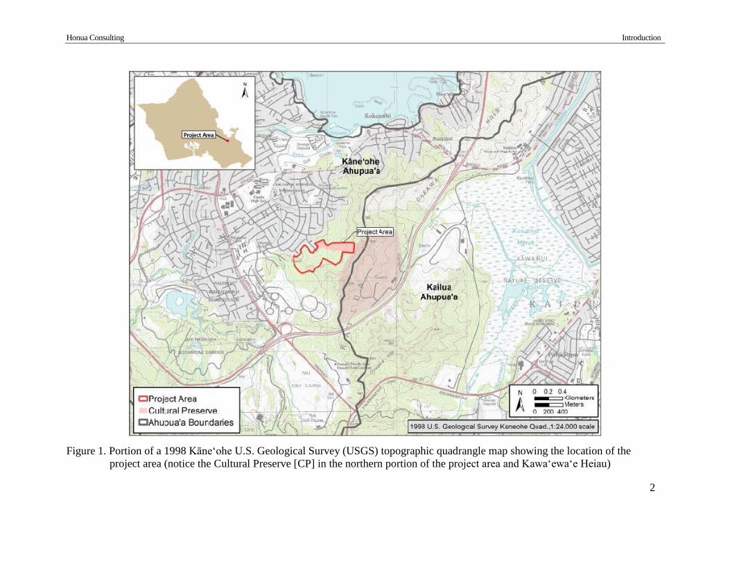
(APE) is the same as the project area. The project area is shown in a 1998 USGS (Figure 1),
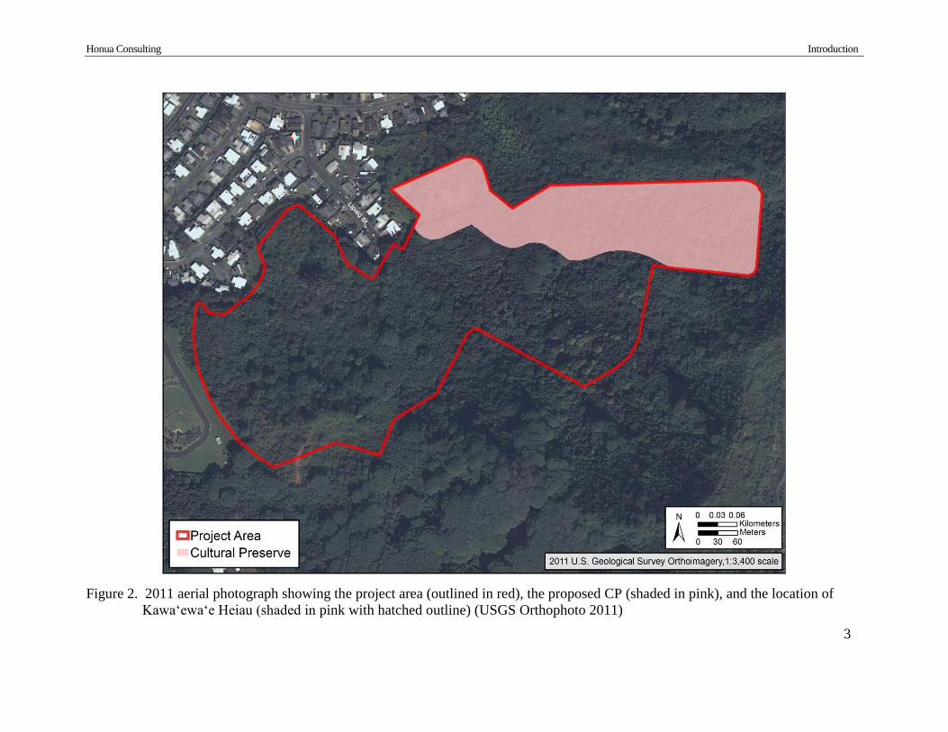
2011 aerial photograph (Figure 2), and Tax Map Key (TMK) (Figure 3).
The proposed project includes specific construction activities within two distinct portions of
the project area, a 14.5-acre (631,620 sq. ft. or 58,679 sq. m.) proposed Cultural Preserve (CP) in
the northeast portion of the project area and the remaining 38.95-acre (1,696,662 sq. ft. or
157,625 sq. m) portion of the project area. Proposed project improvements within the CP include
clearing of vegetation, creation of walking trails, and potential installation of interpretive
signage. Proposed project construction outside of the CP include mass earth moving to level the
existing hillside, creation of an access driveway, installation of a drainage system, and
landscaping. There is also discussion of adding a Hawaiian burial interment area. The conceptual
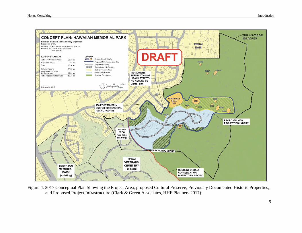
plan for the project has been revised based on this projects findings, conceptual plans for 2017
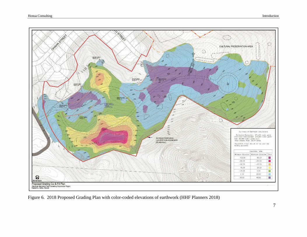
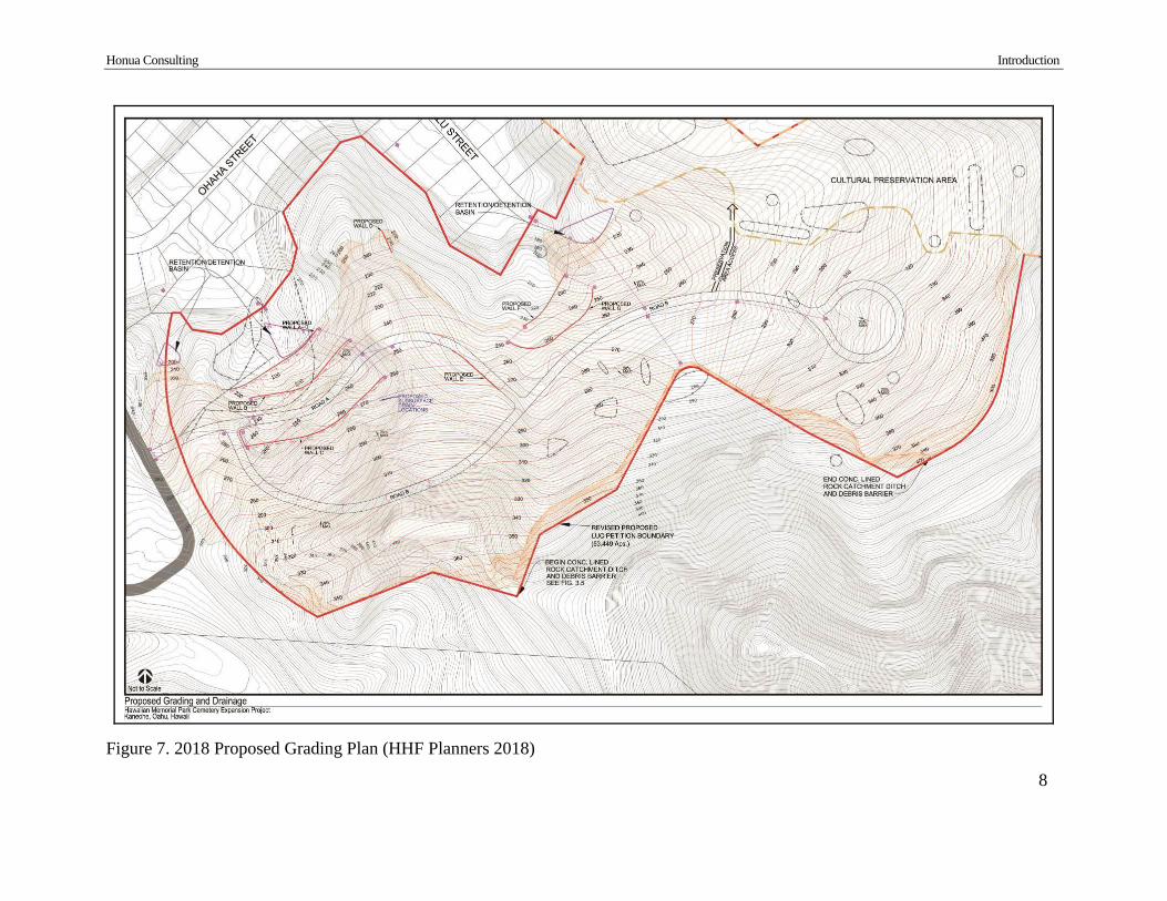
and 2018 are shown in Figure 4 and Figure 5. Grading plans are provided in Figure 6 to Figure 8.
Currently, proposed project ground disturbance can only be approximated. Ground
disturbance within the proposed CP would be relatively minimal, extending to approximatley 3
feet (0.9 m.) for removal of exisitng trees and vegetation, approximately 2 feet (0.6 m.) for
pounding-in of posts for installation of signage, and shallow grading for creation of walking
trails. Ground disturbance outside of the CP will inlcude mass earth moving ranging from
approximately 20 to 100 feet (6.1- 30.5 m) in depth at higher elevations of the hillside in order to
level the area. The excavated soil will be redistributed within the project area, to the extent
deemed necessary for the project. Drainage installation will utilize low areas of the project area
and will likely be positioned within secondarily placed on-site soils.
This archaeological inventory survey (AIS) was written to support the proposed project’s
historic preservation review under Hawai‘i Revised Statutes (HRS) Chapter 6E-42 and Hawai‘i
Administrative Rules (HAR) Chapter 13-284 (Rules Governing Procedures for Historic
Preservation Review for 6E-42 Projects). This report was prepared in accordance with HAR 13-
276 (Rules Governing Standards for Archaeological Inventory Surveys and Reports) and is
intended for review and acceptance by the SHPD.
The project area has undergone several previous archaeological studies (McAllister 1933,
Szabian et al. 1989, McCurdy and Hammatt 2009). All sites documented within the project area
are listed under State Inventory of Historic Places (SIHP) #50-80-10. Documented sites within
the CP include Kawa‘ewa‘e Heiau (SIHP #50-80-10-354, National Register [NR] Reference
#72000427), historic earthen charcoal kilns (-4683 and -6933), a traditional Hawaiian habitation
complex (-4684), a traditional ceremonial stone enclosure (-6930), traditional stone alignments (-
6931), a historic stone storage feature (-6932), and a traditional grinding stone (-7079). Large
communities of laua‘e or maile-scented fern (Phymatosorus grossus) were also recommended
Honua Consulting Introduction
2
Figure 1. Portion of a 1998 Kāne‘ohe U.S. Geological Survey (USGS) topographic quadrangle map showing the location of the
project area (notice the Cultural Preserve [CP] in the northern portion of the project area and Kawa‘ewa‘e Heiau)
Honua Consulting Introduction
3
Figure 2. 2011 aerial photograph showing the project area (outlined in red), the proposed CP (shaded in pink), and the location of
Kawa‘ewa‘e Heiau (shaded in pink with hatched outline) (USGS Orthophoto 2011)

Honua Consulting Introduction
4
Figure 3. Tax Map Key (TMK): [1] 4-5-033 showing the project area (outlined in red), the proposed CP (shaded in pink), and the
location of Kawa‘ewa‘e Heiau (shaded in pink with hatched outline) (Hawai‘i TMK Service)
Honua Consulting Introduction
5
Figure 4. 2017 Conceptual Plan Showing the Project Area, proposed Cultural Preserve, Previously Documented Historic Properties,
and Proposed Project Infrastructure (Clark & Green Associates, HHF Planners 2017)

Honua Consulting Introduction
6
Figure 5. 2018 Conceptual Plan Showing the Project Area (Petition Area), proposed Cultural Preserve, and Proposed Project
Infrastructure (HHF Planners 2018)
Honua Consulting Introduction
7
Figure 6. 2018 Proposed Grading Plan with color-coded elevations of earthwork (HHF Planners 2018)
Honua Consulting Introduction
8
Figure 7. 2018 Proposed Grading Plan (HHF Planners 2018)
Honua Consulting Introduction
9
Figure 8. 2018 Proposed Grading Plan with cross-section inset (HHF Planners 2018)

Honua Consulting Introduction Introduction
10
for preservation. Previously documented sites outside of the CP include a historic water
diversion terrace (-4680) and a traditional habitation complex (-4681).
Archaeological fieldwork for this project included a 100% surface pedestrian survey, GPS,
site documentation and photography of all encountered historic properties, and excavation at one
site (SIHP # -8241 [Honua 14]). Fieldwork was performed under the archaeological permit
numbers 17-16 (2017) and 18-33 (2018) issued to Honua Consulting by the State Historic
Preservation Division/Department of Land and Natural Resources (SHPD/DLNR) in accordance
with Hawai‘i Administrative Rules (HAR) Chapter 13-282. This report was written to fulfill
requirement of HAR 13-276 for Archaeological Inventory Surveys and is intended for review
and approval by the SHPD.
1.1 Scope of Work
The following archaeological inventory scope of work was designed to satisfy the Hawai’i
state requirements for archaeological inventory surveys (HAR chapter 13-276):
1.) Historic background information, including present findings on land use and
site patterns, prehistoric and early historic times found in literature, mid-
nineteenth century times as revealed by land commission awards, and post-
1850s times, as found in later literature or through oral history. Summarize
documents and materials reviewed during the research. Describe any land
commission awards granted within the project and depict them on a map when
possible.
2.) Archaeological background information shall include any relevant prior
archaeological studies in the project area or other appropriate area as
determined in consultation with SHPD. Previous archaeological summaries
shall include the extent of the prior survey coverage indicated on a map, a
synthesis and analysis of information on the project area and its related lands’
chronology, function and land use patterns, reconciling, as needed, the
historical and archaeological information, and predictions as to types of sites
expected to be encountered during field survey.
3.) The report shall contain a section on methods used in the archaeological field
survey to include the names and qualifications of the principal investigator,
the number of field personnel, dates when the survey was performed, and the
duration of time for the survey as well as the extent of survey coverage. If the
survey coverage was less than one hundred percent, the rationale for the
sample must be presented in a careful discussion. Sampling designs which
include analysis of possible subsurface sites under sand dunes, urban fill, and
other areas must also be presented and include discussion of any factors which
limited the survey effort, techniques used to identify archaeological properties

Honua Consulting Introduction Introduction
11
(transects, sweeps, test excavations, augering, etc.), the extent of historic
property recording (mapping, measuring, photographing, text excavations)
and the techniques used to plot site location and determine site boundaries.
4.) The report shall contain a section on its archaeological field survey and
laboratory findings. Each archaeological property found should be
individually described with a state inventory number, reference to previous
studies if previously recorded, the formal site type, size, horizontal extent,
shape, materials, methods of construction, area of the major feature or features
with representative architectural heights and widths, description of remains,
and description of subsurface deposits. Include stratigraphic information with
standard U.S.D.A. soil descriptions and Munsell colors, stratigraphic profile
drawings to scale, drafted plan maps to scale with north arrow and scale bar
(indicate mapping method), and representative photographs and illustrations.
Include a description of the site integrity, an assessment of site function or
functions with reasonable and adequate supportive arguments, an assessment
of site age with absolute dating results when available; and an evaluation of
site significance. The report should also discuss previous land disturbances
(e.g. bulldozing, sugarcane cultivation, etc.).
5.) The report shall include a summary of findings, to include, the total number
of archaeological sites found, a map or maps locating all the archaeological
properties found and boundaries when possible, with at least one site location
map being a portion of the relevant USGS standard 1:24,000 topographic
map. Include a table presenting the sites with their state number, formal type,
and possible function with each type of site summarized. Re-evaluate ideas on
the history of land use in the ahupua'a and the parcel.
6.) The report shall contain information on the consultation process with
individuals knowledgeable about the project area's history, if discussions with
the SHPD, background research or public input indicate a need to consult with
knowledgeable individuals. Information shall include: personnel conducting
the consultation process, with names and qualifications; methods of
identifying and contacting knowledgeable persons; names of knowledgeable
persons, consulted, or, if the person wishes to remain anonymous, a
characterization of the person; and a summary as to whether additional
archaeological historic properties were identified during the consultation
process, and whether additional information on archaeological site function

Honua Consulting Introduction Introduction
12
was obtained during the consultation process to be presented in the site
description portion of the report.
1.2 Environmental Setting
1.2.1 Natural Environment
The project area is located on the northeast (windward) side of O‘ahu, within the traditional
district (moku) of Ko‘olaupoko and the traditional land division (ahupua‘a) of Kāne‘ohe.
Kāne‘ohe Ahupua‘a is bordered by He‘eia Ahupua‘a to the north and Kailua Ahupua‘a to the
south. Kāne‘ohe Ahupua‘a extends from the crest of the Ko‘olau Mountain Range, over 2,600
feet (792 meters) in elevation, to the coast of Kāne‘ohe Bay.
The climate of Kāne‘ohe is moderate. Temperatures range from 69° Fahrenheit in January to
85° in September and rainfall averages 1,314 mm annually (U.S. Climate Data 2018,
Giambulluca et al. 2013). Kāne‘ohe is largely utilized for golf courses, urban land, commercial
business, and residential areas. Vegetation in the upper slopes and valleys of Kāne‘ohe includes
Molucca albizia (Paraserianthus falcataria), mango (Mangifera indica), silky oak (Grevillea
robusta), African tulip (Spathodea campanulata), octopus trees (Schefflera actinophylla), and
guava (Psidium guajava). Native and Polynesian-introduced species can also be found including
kukui (Aleurites moluccana), niu (coconut, Cocos nucifera), pandanus (Pandanus tectorius),
`ohi`a (Metrosideros polymorpha), koa (Acacia koa), uluhe fern (Dicranopteris linearis), laua‘e
or maile-scented fern (Phymatosorus grossus), ti (Cordyline fruticosa), noni (Morinda citrifolia),
and various other ferns, palms, and shrubs.
Geology of the area includes a large volcanic caldera that stretches for miles throughout the
lowlands of Kailua and Kāne‘ohe. The steep inland mountains are remnants of the Ko‘olau
Volcano that stood some 2.7 million years ago (Hazlett and Hyndman 1996). Mōkapu Peninsula,
at the northern edge of Ko‘olau caldera, is the result of eruptions produced approximately
850,000 years ago. Streams bring alluvium from higher elevations and deposit rich nutrients onto
the wide coastal lowland. Kāne‘ohe includes multiple perennial and intermittent streams. The
closest stream to the project area is Kawa Stream, approximately 400 m (1,312 ft.) to the west.
Traditionally, the streams fed extensive fields planted in taro, pandanus, wauke, bananas, and
sweet potatoes. Fishponds were built along the shore. Historically, the land was cultivated in
rice, pineapple, and sugarcane.
Soils within the project area include four typologies, consisting of Alaeloa Silty Clay and
Kaneohe Silty Clay (Foote et al. 1972) (Figure 9). The east half of the project area largely
contains Alaeloa Silty Clay with an 15-35% slope (AeE). Alaeloa Silty Clay with an 40-70%
slope (ALF) is found within the far east and southwest portions of the project area. Kaneohe
Silty Clay with an 8-15% slope (KgC) is found within the northern central tip and central portion
of project area and with a 30-65% slope (KHOF) in the west and central portions of the project
area.
The Alaeloa Series consists of well-drained soils that are developed from weathered igneous
rock and are found on gently sloping to very steep hillsides. Natural vegetation on these soils
include guava, Java plum (Syzygium cumini), Christmas berry (Schinus terebinthifolius),

Honua Consulting Introduction Introduction
13
Japanese tea (Chamaecrista nictitans), and hilo grass (Ischaemum byrone). Alaeloa Silty Clay
with an 15-35% slope (AeE) occurs on smooth slopes and toes of hillsides where permeability is
moderately rapid, runoff is medium, the erosion hazard is moderate, and the workability is
difficult due to the slope (Foote et al. 1972:26). This soil can be used for pineapple, pasture, and
homesites. Alaeloa Silty Clay with an 40-70% slope (ALF) has rapid to very rapid runoff, the
erosion hazard is severe, and the soil is best suited for pasture and wildlife habitat (Foote et al.
1972:26-27).
The Kaneohe Series consists of well-drained soils on terraces and alluvial fans of windward
O‘ahu. Natural vegetation on these soils include guava, Boston fern (Nephrolepis exaltata),
sensitive plant (Mimosa pudica), glenwood grass (Sacciolepis indica), and hilo grass (Foote et al.
1972:59). Kaneohe Silty Clay with an 8-15% slope (KgC) has medium runoff, moderate soil
erosion, and is used for pasture (Foote et al. 1972:60). Kaneohe Silty Clay with an 30-65% slope
(KHOF) typically includes volcanic ash and cinder 20 inches (51 cm) below the ground surface.
For this soil type runoff is medium to rapid, erosion hazard is moderate to severe, and it is most
usable for pasture (Foote et al. 1972:60).
1.2.2 Built Environment
The project area is completely undeveloped. It is situated mauka (inland) of a large
residential area and extends off the east side of Hawaiian Memorial Park Cemetery. Concrete
drainage basins border the downslope, northwest and north-central portions of the project area,
where several earthen drainage ditches from the property empty.
Figure 9. Portion of a 1998 Kāne‘ohe USGS with overlay of Soil Survey Data (Foote et al. 1972)
Honua Consulting Consultation Introduction
14
Section 2 Methods
Fieldwork for this project was conducted intermittently between September 21, 2017 and June
22, 2018. Fieldwork was completed by Arleen Garcia-Herbst, C. Phil, Catharine Thetford, B.A.,
Mark Paikuli-Stride, B.A., Matt Sproat, B.A., Kūpono Sproat, A.A., Deidra Moore, B.A., Kulani
Boyne, B.S., Fredrick LaChance, B.A., Christopher Monahan, Ph.D., Douglas W. Thurman,
B.A., and Rosanna Thurman, M.A. Fieldwork was carried out under permits 17-16 (2017) and
18-33 (2018) (in accordance with HRS 13-13-281).
There was no archaeological inventory survey plan for this project. In coordination with the
SHPD, the AIS investigation was designed to include 100% surface survey, documentation of
encountered historic properties, and excavation of select sites if deemed appropriate.
2.1 Pedestrian Survey
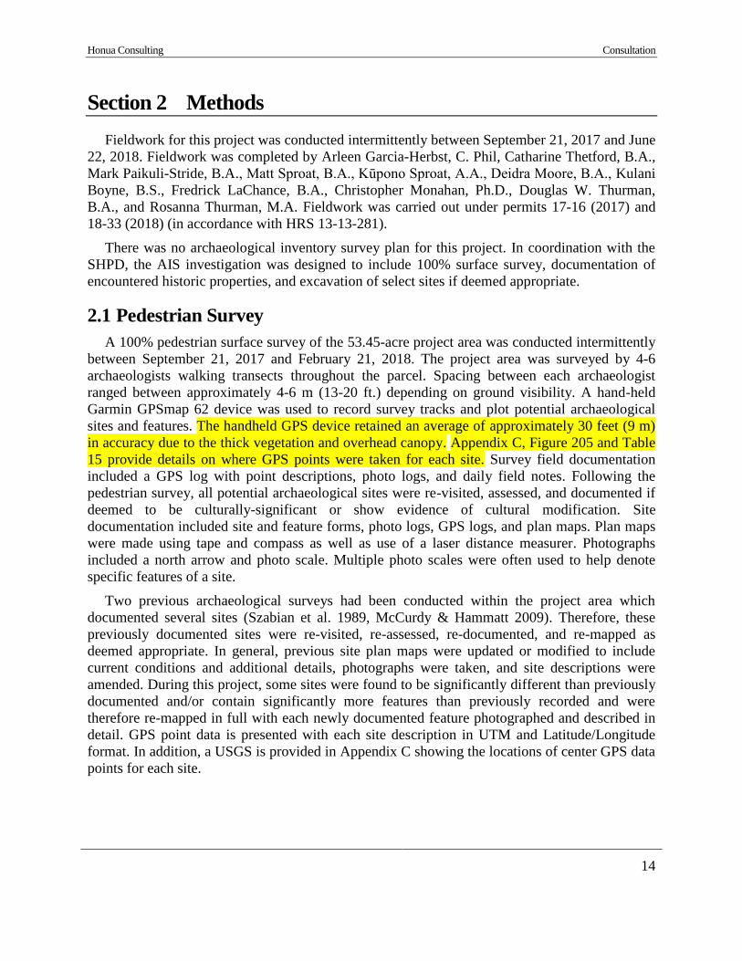
A 100% pedestrian surface survey of the 53.45-acre project area was conducted intermittently
between September 21, 2017 and February 21, 2018. The project area was surveyed by 4-6
archaeologists walking transects throughout the parcel. Spacing between each archaeologist
ranged between approximately 4-6 m (13-20 ft.) depending on ground visibility. A hand-held
Garmin GPSmap 62 device was used to record survey tracks and plot potential archaeological
sites and features. The handheld GPS device retained an average of approximately 30 feet (9 m)
in accuracy due to the thick vegetation and overhead canopy. Appendix C, Figure 205 and Table
15 provide details on where GPS points were taken for each site. Survey field documentation
included a GPS log with point descriptions, photo logs, and daily field notes. Following the
pedestrian survey, all potential archaeological sites were re-visited, assessed, and documented if
deemed to be culturally-significant or show evidence of cultural modification. Site
documentation included site and feature forms, photo logs, GPS logs, and plan maps. Plan maps
were made using tape and compass as well as use of a laser distance measurer. Photographs
included a north arrow and photo scale. Multiple photo scales were often used to help denote
specific features of a site.
Two previous archaeological surveys had been conducted within the project area which
documented several sites (Szabian et al. 1989, McCurdy & Hammatt 2009). Therefore, these
previously documented sites were re-visited, re-assessed, re-documented, and re-mapped as
deemed appropriate. In general, previous site plan maps were updated or modified to include
current conditions and additional details, photographs were taken, and site descriptions were
amended. During this project, some sites were found to be significantly different than previously
documented and/or contain significantly more features than previously recorded and were
therefore re-mapped in full with each newly documented feature photographed and described in
detail. GPS point data is presented with each site description in UTM and Latitude/Longitude
format. In addition, a USGS is provided in Appendix C showing the locations of center GPS data
points for each site.
Honua Consulting Consultation Introduction
15
2.2 Excavation
Excavation at one site, SIHP # -8241 (Honua 14, historic charcoal kiln) was conducted
between June 6 and June 22, 2018. Two test units (TU 1 and TU 2) and an exploratory
excavation were dug to assess the site type, function, and associated time period. Excavation of
TU 1 was supervised by Dr. Christopher Monahan and excavation of TU 2 and the exploratory
excavation was supervised by Rosanna Thurman, M.A.
Prior to excavation of SIHP # -8241, the site was cleared of vegetation, mapped in detail
using tape and compass, and photographed using a photo scale and north arrow. Test units were
situated to intentionally encounter artifactural materials within the site interior, to assess the
stone-stacked walls, and to gather stratigraphic data to indicate when and how the site was
created. Datums and level lines were established for TU 1 and TU2 for obtaining consistent
elevational data. To establish each datum, a nail was set at the highest surface point of each test
unit and a string with line level was tied around the nail at the ground surface (0 cm above
surface). The difference between the TU 1 and TU 2 datums was 80 cm in height.
Test unit excavations proceeded by removing arbitrary 10 cm levels by hand with trowels,
brushes, and shovels. Photographs and a hand-drawn plan maps were completed for each
arbitrary level. Plan maps documented locations and elevations of encountered in-situ artifactual
materials (faunal bone, kukui nut shells, charcoal, etc.), sub-surface deposits, and discrete
stratigraphic changes. Bulk sediment samples were collected from intact sub-surface deposits
when the sediment was thought to potentially contain more cultural material then could be easily
assessed in the field, such as charcoal flecking and/or charred soils. Bulk samples and artifactural
materials were collected in artifact bags which were labeled with all necessary provenience
information (project, site name and number, test unit, level, depth, feature (if applicable), date,
and fieldworkers initials). Photo logs and a bag list to keep track of all collected materials and
associated provenience information were kept current in the field.
The test units were excavated to depths in which necessary important stratigraphic data was
obtained and feature components could be easily assessed and documented. TU 1 was excavated
to natural, sterile soil. TU 2 and the exploratory excavation were excavated until feature
components and discrete deposits were clearly identified and understood. Profiles were drawn of
test unit sidewalls and sediments were described using Munsell color designations and standard
U.S. Department of Agriculture (USDA) soil descriptions.
2.3 Laboratory Analysis
2.3.1 Glass Bottles
Several historic (older than 50 years) and modern bottles were observed during project
fieldwork. Bottle characteristics were photographed and recorded in the field. Only one bottle, a
historic dairy milk bottle, was collected (Acc. #1). The bottle was cleaned, weighed, measured,
and catalogued by material type, form, function, design, and manufacturing characteristics. The
bottle was researched according to its manufacture mark and identified diagnostic characteristics
such as finish type, form, and color. Standard references were used to research date ranges and
place of manufacture (Toulouse 1971, Lindsey 2018, Lockhart and Hoenig 2015).

Honua Consulting Consultation Introduction
16
2.3.2 Lithic Material
Only one lithic artifact was recovered during this investigation. A small volcanic glass
fragment (Acc. #2) was recovered during excavation of SIHP # -8241, historic charcoal kiln [TU
2]). The volcanic glass fragment was sent to Dr. Steven Lundblad at the University of Hawai‘i-
Hilo Geo-Archaeology Lab for Energy Dispersive X-Ray Flourescence (ESXRF) analysis.
EDXRF is a non-destructive analysis which uses beams of infrared light rays to measure
concentrations of trace elements within any material. The chemical composition of lithic
materials can be compared with known source locations throughout the Hawaiian archipelago as
well as the wider Pacific region in order to identify where the material likely originated. EDXRF
analysis helps to develop data for interpreting Hawaiian lithic procurement, use, and exchange.
EDXRF analysis results are presented in Appendix D.
2.3.3 Faunal Bone
Faunal bone fragments were recovered during excavation of SIHP # -8241 (historic charcoal
kiln [TU 1]). Faunal bone was identified in the field by Dr. Christopher Monahan as cow bone. A
faunal reference book was consulted to confirm accurate and detailed identification of specific
skeletal elements (Schmid 1972). Faunal bone was collected in labeled brown paper bags.
2.3.4 Charcoal Identification
Several charcoal fragments were recovered during excavation of SIHP # -8241 (historic
charcoal kiln [TU 1 and TU 2]). Provenience information and detailed elevations were recorded
for collected charcoal. The charcoal was placed within labeled aluminum foil pouches and/or
within labeled plastic bags.
Several collected charcoal samples were delivered to the International Archaeological
Research Institute, Inc. (IARII) in Honolulu for plant species identification. Charcoal samples
used for charcoal identification were selected due to their context within a discrete deposit which
could answer questions on site use and date of construction. The analysis conducted by IARII
viewed the charcoal samples under magnification of an epi-illuminating microscope and
compared the samples with anatomical characteristics of known woods in the Pacific Islands
Wood Collection at the Department of Botany, University of Hawai‘i, and published
descriptions. The results of the charcoal analysis are presented in Appendix E.
2.4 Background Research
Research was conducted at the Hamilton Library at the University of Hawai‘i-Mānoa and the
State Historic Preservation Division (SHPD) library in Kapolei. On-line references were also
consulted including Ulukau Electronic Hawaiian Database (www.ulukau.com), Papakilo
Database (www.papakilodatabase.com), the State Library on-line (http://www.
librarieshawaii.org/Serials/databases.html), and Waihona ‘Aina Mahele database
(http://www.waihona.com). Hawaiian terms and place names were translated using the on-line
Hawaiian Dictionary (Nā Puke Wehewehe ‘Ōlelo Hawai‘i (www.wehewehe.com) and Place
Names of Hawaii (Pukui et al. 1974). Historic maps were obtained from the State of Hawai‘i
Land Survey Division website (http://ags.hawaii.gov/survey/map-search/). Maps were geo-
referenced using ArcGIS 10.3.
Honua Consulting Consultation Introduction
17
Section 3 Consultation
Consultation with project proponents and interested community members has been on-going
for this project since 2016 (Table 1). Multiple discussions, presentations, and meetings have been
held and attended in order to consult on proposed plans for the Cultural Preserve (CP) and the
overall project development. Consultation efforts have been conducted at the Ko‘olaupoko
Hawaiian Civic Club (KHCC), public meetings, and at Kāne‘ohe Neighborhood Board meetings
and a Cultural Advisory Group for the project has been formed. In addition, Honua Consulting is
in the process of completing a companion Cultural Impact Assessment (CIA) for the Hawaiian
Memorial Park project and has interviewed several lineal and cultural descendants, recognized
cultural experts, and other knowledgeable individuals (Watson et al. 2018- in progress).
During an April 4, 2017 meeting at the Ko‘olaupoko Hawaiian Civic Club, it was mentioned
by cultural descendants of the area that two cultural sites known to exist in the project area were
not documented during the previous AIS investigation (McCurdy and Hammatt 2009). The sites
included: 1.) a circular arrangement of basalt boulders at the southwest base of the hillside below
Kawa‘ewa‘e Heiau, near the end of Lipalu Street; and 2.) a grouping of large basalt boulders
thought to have been a Hale o Papa. The descendants request these cultural sites be preserved. It
was mentioned the circular arrangement of boulders (#1 above) may have been recently
disturbed and pushed around.
In response to discussions had at the April 4, 2017 meeting, on April 19, 2017 a site visit was
conducted by Honua Consulting archaeologists. A potential circular concentration of natural
boulders at the southwest base of the hillside below Kawa‘ewa‘e Heiau, near the end of Lipalu
Street, was located, photographed, and a GPS point was taken (Figure 10). No cultural
modifications were observed on or in the near vicinity of the boulders. The only site encountered
during the survey that is similar to that described as a Hale o Papa is SIHP # -4681 (traditional
habitation complex) which was described in the previous CIA for the project (Hammatt 2008:55-
57) as including a Hale o Papa with pōhaku kia‘i (stone guardians). This potential Hale o Papa
was mapped during the current study and designated as a feature of SIHP # -4681.
On September 27, 2017 an on-site meeting and tour was provided by a biologist, Maya
LaGrande of LaGrande Biological Surveys, Inc. It was discussed that a native damselfly was
present within a historic ‘auwai located in the northwest portion of the project area (SIHP # -
8230 [Honua 3]). It was discussed that changes to proposed project plans would be needed in
order to accommodate the native species habitat. The biologist showed the attending group
several existing dirt trails throughout the project area. Of additional note, the biologist took the
group to a potential archaeological site located in the southeast portion of the project area (SIHP
# -8235 [Honua 8]), which was situated within an area containing multiple large mango trees.
Consultation with the SHPD in relation to excavation of SIHP # -8241 (Honua 14, historic
charcoal kiln) was initiated in June of 2018. Proposed excavation plans were provided to the
SHPD for their review and comment on June 4, 2018. Following excavation of TU 1, a field
update was provided to SHPD. Following all excavations at SIHP # -8241, a site visit was
conducted by SHPD staff Dr. Susan Lebo and Stephanie Hacker. The site was discussed as likely
being an early to mid-19th century charcoal kiln in good condition, qualifying under Criterion c
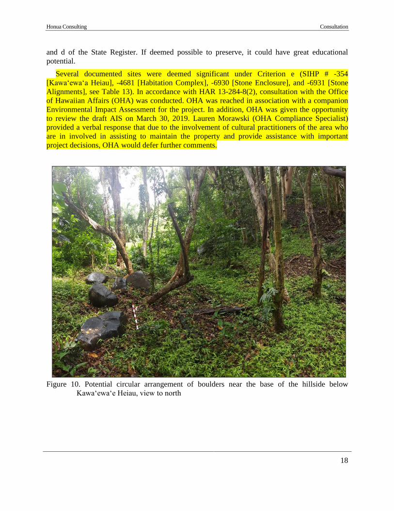
Honua Consulting Consultation Introduction
18
and d of the State Register. If deemed possible to preserve, it could have great educational
potential.
Several documented sites were deemed significant under Criterion e (SIHP # -354
[Kawaʻewaʻa Heiau], -4681 [Habitation Complex], -6930 [Stone Enclosure], and -6931 [Stone
Alignments], see Table 13). In accordance with HAR 13-284-8(2), consultation with the Office
of Hawaiian Affairs (OHA) was conducted. OHA was reached in association with a companion
Environmental Impact Assessment for the project. In addition, OHA was given the opportunity
to review the draft AIS on March 30, 2019. Lauren Morawski (OHA Compliance Specialist)
provided a verbal response that due to the involvement of cultural practitioners of the area who
are in involved in assisting to maintain the property and provide assistance with important
project decisions, OHA would defer further comments.
Figure 10. Potential circular arrangement of boulders near the base of the hillside below
Kawa‘ewa‘e Heiau, view to north
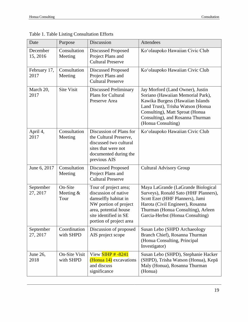
Honua Consulting Consultation Introduction
19
Table 1. Table Listing Consultation Efforts
Date Purpose Discussion Attendees
December
15, 2016
Consultation
Meeting
Discussed Proposed
Project Plans and
Cultural Preserve
Ko‘olaupoko Hawaiian Civic Club
February 17,
2017
Consultation
Meeting
Discussed Proposed
Project Plans and
Cultural Preserve
Ko‘olaupoko Hawaiian Civic Club
March 20,
2017
Site Visit Discussed Preliminary
Plans for Cultural
Preserve Area
Jay Morford (Land Owner), Justin
Soriano (Hawaiian Memorial Park),
Kawika Burgess (Hawaiian Islands
Land Trust), Trisha Watson (Honua
Consulting), Matt Sproat (Honua
Consulting), and Rosanna Thurman
(Honua Consulting)
April 4,
2017
Consultation
Meeting
Discussion of Plans for
the Cultural Preserve,
discussed two cultural
sites that were not
documented during the
previous AIS
Ko‘olaupoko Hawaiian Civic Club
June 6, 2017 Consultation
Meeting
Discussed Proposed
Project Plans and
Cultural Preserve
Cultural Advisory Group
September
27, 2017
On-Site
Meeting &
Tour
Tour of project area;
discussion of native
damselfly habitat in
NW portion of project
area, potential house
site identified in SE
portion of project area
Maya LaGrande (LaGrande Biological
Surveys), Ronald Sato (HHF Planners),
Scott Ezer (HHF Planners), Jami
Harota (Civil Engineer), Rosanna
Thurman (Honua Consulting), Arleen
Garcia-Herbst (Honua Consulting)
September
27, 2017
Coordination
with SHPD
Discussion of proposed
AIS project scope
Susan Lebo (SHPD Archaeology
Branch Chief), Rosanna Thurman
(Honua Consulting, Principal
Investigator)
June 26,
2018
On-Site Visit
with SHPD
View SIHP # -8241
(Honua 14) excavations
and discuss
significance
Susan Lebo (SHPD), Stephanie Hacker
(SHPD), Trisha Watson (Honua), Kepā
Maly (Honua), Rosanna Thurman
(Honua)

Honua Consulting Background Research
20
Section 4 Background Research
4.1 Traditional and Mythological Background
Kāneʻohe, the ahupua‘a (traditional land division) within which the project area is located, is
translated as "bamboo husband" or “bamboo man” and was named for a woman’s account of her
husband’s cruelty being comparable to the cutting edge of a bamboo knife (Pukui et al. 1974:
85). The word “Kāne” can mean “husband”, “man”, or serve as a reference to the god Kāne, the
god of creation (Pukui and Elbert 1986: 128), and "‘ohe" means “bamboo” (Pukui and Elbert:
276). The project area is located within two ʻili (small land division) boundaries, Kawaʻewaʻe
and Kalokoai. Kalokoai translates to “the food pond” (Pukui et al. 1974: 77-78). Kawa‘ewa‘e is a
heiau of great importance located within the current project area.
Kāneʻohe was a population center containing a fertile bay with a barrier reef, a multitude of
coastal fishponds, a natural harbor, inland agricultural fields, and multiple streams (Heʻeia,
Hooleinaiwa, Keaʻahala, Kamoʻoaliʻi, Kāneʻohe, Kāwā, Kuou, Luluku) flowing from the
Koʻolau Range. The streams and natural hillside runoff fed loʻi (irrigated taro fields) as well as
sweet potato, pandanus, wauke, and bananas. The coastal areas contained coconut groves and
coastal fishponds, including Hanalua, Kalokohanahou, Kaluoa, Kanohuluiwi, Keaalau, Keana,
Mahinui, Mikiola, Papaa (Panahaha 1 & 2), Punaluu, Waikalua Loko, and Waikaluawaho
(Waikalaa) (Pukui et al. 1974, AVA Konohiki 2018). Several fishponds were also constructed on the
shores of Mōkapu (Nu‘upia, Halekou, and Kaluapuhi). The inhabitants of Kāneʻohe lived near
the coast, on the fringes of lowland fields, and in the inland valleys. The upland reaches
consisting of inland forests (Wao akua or places of mystery) were thought to be sacred to the
Spirits or Akua of Nature (Paki 1972).
Several Hawaiian place names are known for features of the Kāne‘ohe landscape and
environment. An 1876 map of Kāne‘ohe shows many of the place names discussed in
mythological and historic-period accounts of the area (Figure 11). Table 2 lists place names, their
English translations, a description of the locations, and sources of information. Lanihuli is the
highest mountain peak of the Ko‘olau Range in Kāne‘ohe. Pakui is an ‘ili to the north of the
project area as well as the central peak of three peaks of Mount Olomana. Kumukumu is a
natural spring of Kāne‘ohe.
The legend of the half man, half pig demigod Kamapua‘a is a central mo‘olelo (story, myth,
or legend) of Kāne‘ohe and is pertinent to the current project area. Kamapua‘a was born to Hina
and ‘Olopana. According to Thrum (1906:48) ‘Olopana was responsible for the erection of
Kawa‘ewa‘e Heiau in the beginning of the 12th century. The heiau is said to have been
constructed by Menehune, a legendary race of people who worked at night (Fornander 1878).
Kalākaua (1990) states that Hina formed a relationship with ʻOlopana’s brother Kahikiula before
Kamapuaʻa’s birth, and ʻOlopana was convinced that Kahikiula was the true father of
Kamapuaʻa, shaping his resentment for the hog-child from birth. After ʻOlopana exiled
Kamapuaʻa from the district, Kamapuaʻa was joined by a large party of miscreants who aided
him in exacting revenge against ʻOlopana. Kamapuaʻa stole and vandalized ʻOlopana’s property,
and eventually cut down his coconut trees and destroyed his crops, which could be regarded as
“a declaration of war” (Kalākaua 1990:144). ʻOlopana repeatedly failed to dispose of Kamapuaʻa
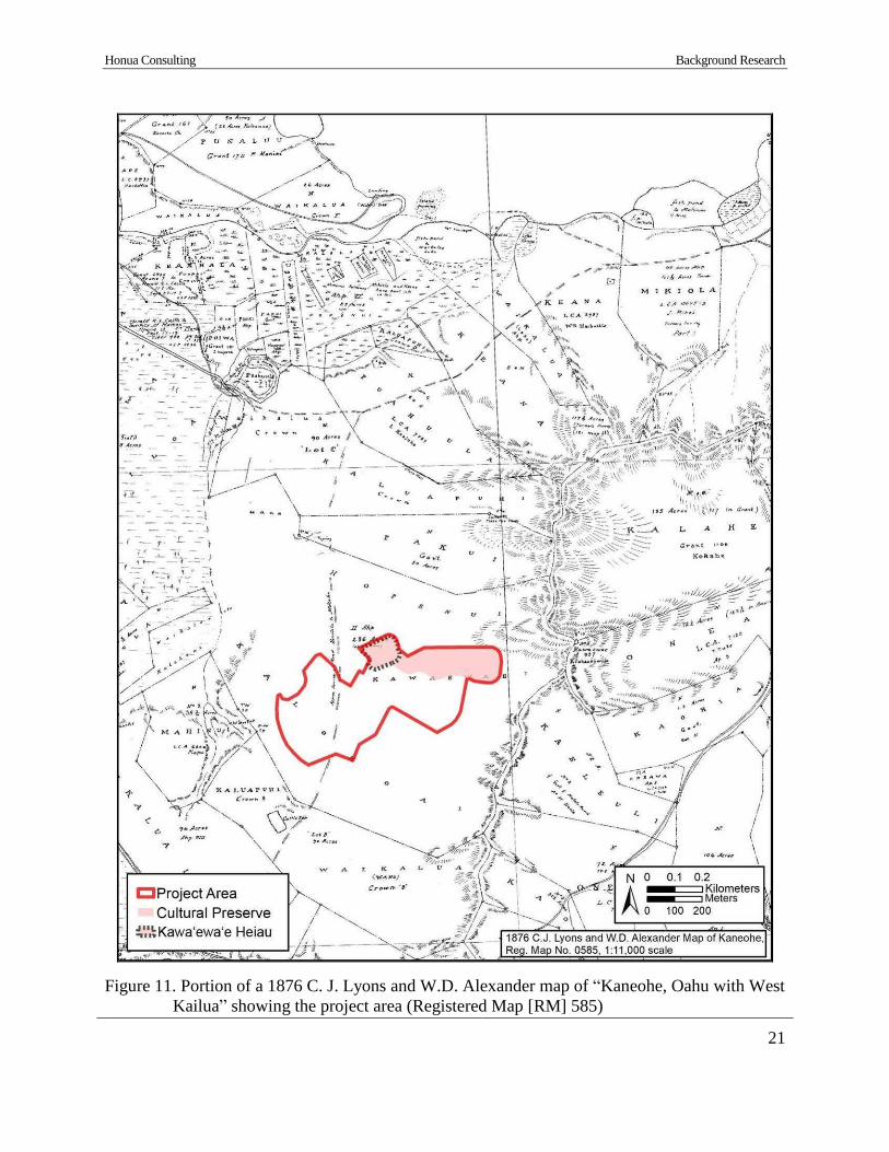
Honua Consulting Background Research
21
Figure 11. Portion of a 1876 C. J. Lyons and W.D. Alexander map of “Kaneohe, Oahu with West
Kailua” showing the project area (Registered Map [RM] 585)
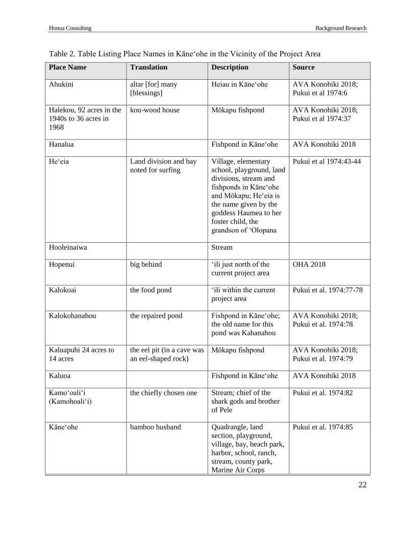
Honua Consulting Background Research
22
Table 2. Table Listing Place Names in Kāne‘ohe in the Vicinity of the Project Area
Place Name Translation Description Source
Ahukini altar [for] many
[blessings]
Heiau in Kāneʻohe AVA Konohiki 2018;
Pukui et al 1974:6
Halekou, 92 acres in the
1940s to 36 acres in
1968
kou-wood house Mōkapu fishpond AVA Konohiki 2018;
Pukui et al 1974:37
Hanalua Fishpond in Kāne‘ohe AVA Konohiki 2018
Heʻeia Land division and bay
noted for surfing
Village, elementary
school, playground, land
divisions, stream and
fishponds in Kāneʻohe
and Mōkapu; Heʻeia is
the name given by the
goddess Haumea to her
foster child, the
grandson of ʻOlopana
Pukui et al 1974:43-44
Hooleinaiwa Stream
Hopenui big behind ‘ili just north of the
current project area
OHA 2018
Kalokoai the food pond ‘ili within the current
project area
Pukui et al. 1974:77-78
Kalokohanahou the repaired pond Fishpond in Kāneʻohe;
the old name for this
pond was Kahanahou
AVA Konohiki 2018;
Pukui et al. 1974:78
Kaluapuhi 24 acres to
14 acres
the eel pit (in a cave was
an eel-shaped rock)
Mōkapu fishpond AVA Konohiki 2018;
Pukui et al. 1974:79
Kaluoa Fishpond in Kāne‘ohe AVA Konohiki 2018
Kamoʻoaliʻi
(Kamohoaliʻi)
the chiefly chosen one Stream; chief of the
shark gods and brother
of Pele
Pukui et al. 1974:82
Kāneʻohe bamboo husband Quadrangle, land
section, playground,
village, bay, beach park,
harbor, school, ranch,
stream, county park,
Marine Air Corps
Pukui et al. 1974:85

Honua Consulting Background Research
23
Place Name Translation Description Source
station, and golf course
Kanohuluiwi, 2.7 acres
in 1968
Fishpond AVA Konohiki 2018
Kawa distance Stream Pukui et al. 1974:96
Kawaʻewaʻe Heiau and ‘ili within the
current project area;
according to Thrum
(1906:48), it was built at
the beginning of the 12th
century (Sterling and
Summers 5:194);
ʻOlopana brought
Kamapuaʻa here to be
sacrificed, but he killed
‘Olopana instead
AVA Konohiki 2018;
Pukui et al. 1974:97.
Keaʻahala the pandanus root Stream, land sections,
and playground in
Kāneʻohe
Pukui et al 1974:100
Keaalau the many roots Land division and
fishpond in Kāneʻohe
AVA Konohiki 2018;
Pukui et al. 1974:100
Keana the cave Land division and
fishpond in Kāneʻohe;
the old name for Koko-
kahi
AVA Konohiki 2018;
Pukui et al. 1974:103
Kekele damp Heiau in Kāne‘ohe AVA Konohiki 2018;
Pukui et al. 1974:106
Kukuiokane (covered by
the H-3)
Heiau in Kāne‘ohe AVA Konohiki 2018
Kumukumu stubs Spring AVA Konohiki 2018;
Pukui et al. 1974:124
Kūʻou Stream; possible variant
of kūlou, to bow the
head, bend, to beckon
with the head; also
kūnou
Pukui and Elbert
1986:181,184
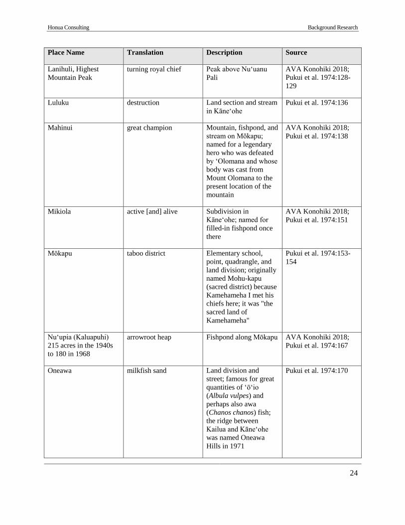
Honua Consulting Background Research
24
Place Name Translation Description Source
Lanihuli, Highest
Mountain Peak
turning royal chief Peak above Nuʻuanu
Pali
AVA Konohiki 2018;
Pukui et al. 1974:128-
129
Luluku destruction Land section and stream
in Kāneʻohe
Pukui et al. 1974:136
Mahinui great champion Mountain, fishpond, and
stream on Mōkapu;
named for a legendary
hero who was defeated
by ‘Olomana and whose
body was cast from
Mount Olomana to the
present location of the
mountain
AVA Konohiki 2018;
Pukui et al. 1974:138
Mikiola active [and] alive Subdivision in
Kāneʻohe; named for
filled-in fishpond once
there
AVA Konohiki 2018;
Pukui et al. 1974:151
Mōkapu taboo district Elementary school,
point, quadrangle, and
land division; originally
named Mohu-kapu
(sacred district) because
Kamehameha I met his
chiefs here; it was "the
sacred land of
Kamehameha"
Pukui et al. 1974:153-
154
Nuʻupia (Kaluapuhi)
215 acres in the 1940s
to 180 in 1968
arrowroot heap Fishpond along Mōkapu AVA Konohiki 2018;
Pukui et al. 1974:167
Oneawa milkfish sand Land division and
street; famous for great
quantities of ʻōʻio
(Albula vulpes) and
perhaps also awa
(Chanos chanos) fish;
the ridge between
Kailua and Kāneʻohe
was named Oneawa
Hills in 1971
Pukui et al. 1974:170

Honua Consulting Background Research
25
Place Name Translation Description Source
Pakui attached Central peak of three
peaks of Mount
Olomana; named for the
keeper of two Kailua
fishponds, a swift
runner
Pukui et al. 1974:176
Papaa (Panahaha 1 & 2) secure enclosure Fishpond in Kāneʻohe AVA Konohiki 2018;
Pukui et al. 1974:179
Punaluu spring dived for, coral
dived for
Fishpond in Kāneʻohe AVA Konohiki 2018;
Pukui et al. 1974:194
Puʻu Makani Heiau in Kāne‘ohe AVA Konohiki 2018
Pu'u Pahu, near
Kanohulu'iwi
Heiau in Kāne‘ohe AVA Konohiki 2018
Puʻu Waniania Heiau in Kāne‘ohe AVA Konohiki 2018
Waikalua Loko Fishpond in Kāne‘ohe AVA Konohiki 2018
Waikaluawaho
(Waikalaa)
Fishpond in Kāne‘ohe AVA Konohiki 2018
and his followers, but Kamapuaʻa was eventually captured and delivered to ʻOlopana. The
following passage by Kalākaua describes the events leading to and after Kamapuaʻa’s capture:
It is difficult to say just how long this desultory fighting
continued, but in the end the rebels were surrounded and nearly
destroyed, and Kamapuaa was captured unhurt and delivered over
to Olopana, to the great joy and relief of the people of Koolau.
Olopana had erected a heiau at Kaneohe, where Lonoaohi
officiated as high-priest, and thither he resolved to take his
rebellious son or nephew, and offer him as a sacrifice to the gods.
Hina pleaded for the life of Kamapuaa, but Olopana could not be
moved. Satisfied that he would listen to no appeals for mercy, she
determined to save her son, even at the sacrifice of her husband,
and to that end secured the assistance of the high-priest, through
whose treachery to Olopana the life of Kamapuaa was saved.
On the day fixed for the sacrifice Kamapuaa, carefully bound
and strongly guarded, was taken to the heiau, followed by
Olopana, who was anxious to witness the ghastly ceremonies, and
Honua Consulting Background Research
26
with his own eyes see that his troublesome enemy was duly slain
and his body laid upon the altar. In offering human sacrifices the
victim was taken without the walls of the heiau and slain with
clubs by the assistants of the high-priest. The body was then
brought in and placed upon the altar in front of the entrance to the
inner court, or sanctuary, when the left eye was removed by the
officiating priest, and handed, if he was present, to the chief who
had ordered the sacrifice. This being done, the offering was then
ceremoniously made, and the body was left upon the altar for the
elements to deal with.
Standing, with three or four attendants, at the door of his tabued
retreat, within forty or fifty paces of the altar, Olopana saw his
victim preliminarily led to the place of sacrifice, and a few minutes
after motioned for the ceremonies to begin. Kamapuaa was taken
without the walls of the temple to be slain. He was in charge of
three assistant priests, one of them leading him by a stout cord
around his neck, another keeping closely behind him, and the third
walking silently at his side with the club of execution in his hand.
Passing beyond the outer wall, the party entered a small walled
enclosure adjoining, and the executioner raised his club and
brought it down upon the head of his victim. Kamapuaa smiled,
but did not move. Twice, thrice with might sweep the club
descended upon the head of Kamapuaa, but scarcely bent the
bristly hairs upon his crown.
With a semblance of wonder the executioner, whose tender
blows would have scarcely maimed a mouse, dropped his club and
said:
“Three times have I tried and failed to slay him! The gods
refuse the sacrifice!”
“It is so, it is so, it is so!” chimed his companions. “The gods
indeed refuse the sacrifice! We have seen it!”
Therefore, instead of slaying Kampuaa, the assistants, as they
had been secretly instructed to do by the high-priest, removed the
cords from his limbs, smeared his hair, face and body with the
fresh blood of a fowl, and on their shoulders bore him back and
placed him upon the altar as if dead.
The high-priest approached the apparently lifeless body, and
bent for a moment over the face, as if to remove the left eye; then
placing on a wooden tray the eye of a large hog, which had been
procured for that purpose, he sent an assistant with it to Olopana, at
the same time retiring within the inner court, and leaving by the
side of Kamapuaa, and near his right hand, as if by accident, the
Honua Consulting Background Research
27
sharp ivory pahoa, or dagger, with which he had, to all appearance
been operating.
Giving but a single glance at the eye presented to him by the
assistant of the high-priest, Olopana passed it to an attendant
without the customary semblance of eating it, and approached the
altar alone. Kamapuaa did not breathe. His face was streaked with
blood, his eyelids closed, and not a single muscle moved to
indicate life.
Olopana looked at the hated face for a moment, and then turned
to leave the heiau, not caring to witness the ceremonies of formal
offering. As he did so Kamapuaa clutched the dagger beside his
hand, and, springing from the altar, drove the blade into the back
of Olopana. Again and again he applied the weapon until the chief,
with a groan of anguish, fell dead at the feet of his slayer.
Horrified at what they beheld, the attendants of Olopana sprang
toward their fallen chief. But their movement, whatever their
import, did not disturb Kamapuaa. He had been accustomed to
meeting and accepting odds in battle, and when he had secured
possession of the ihe and huge axe of stone conveniently placed for
his use behind the altar, he boldly approached and invited an
encounter.
But the challenge was not accepted. The attendants of the chief
did not ordinarily lack courage, but they were unnerved at the sight
of a victim, slain, mutilated and laid upon the altar by the priest,
coming to life and springing to his feet full-armed before his
enemies.
Appearing upon the scene, the high-priest expressed great
surprise and horror at what had occurred, and his assistant wildly
clamored at the sacrilege; but no hand was laid upon Kamapuaa,
and the friends of Olopana finally left the heiau, taking his body
with them.
This tragedy in the heiau of Kawaewae created a profound
excitement in the district. Had Kamapuaa been at all popular with
the masses the death of Olopana at his hands would have
occasioned but little indignation; but as many beside the dead chief
had suffered through his plundering visistations, and hundreds of
lives had been sacrificed in his pursuit and final capture, the people
rose almost in a body to hunt him down and destroy him (Kalākaua
1990: 145-147).
Honua Consulting Background Research
28
This legend of Kamapuaʻa continues with the conclusion that he was able to escape from the
outraged masses’ clutches and set sail with his small group to the windward islands in a fleet
obtained from the people of ‘Ewa District.
In addition to Kawaʻewaʻe Heiau, there is said to have been a hōlua slide adjacent to the
heiau. Unfortunately, this hōlua slide was destroyed by the pineapple industry during an attempt
to plant pineapples in this area (Devaney et al. 1982:62-63). Other heiau in Kāne‘ohe included
Ahukini, Kekele, Kukuiokane, Pu‘umakani, Pu‘u Pahu, and Pu‘u Waniania. The number of heiau
in Kāne‘ohe attest to its political importance and the abundance and value of its land.
4.2 Early to Mid- 1800s
Kāne‘ohe was a center of population in the 19th century. According to estimated population
data in the Kāne‘ohe area, over twice as many individuals resided in Kāneʻohe in 1779 compared
to the next most populated ahupuaʻa in the Kāneʻohe Bay region, Heʻeia. Estimates of roughly
15,000 to 17,000 people resided in the Bay region and Kāneʻohe and Heʻeia accounted for 55%
of the population at this time (Devaney et al. 1982). Subsequent data estimates of 1835-36 found
that the population of the nine ahupuaʻa from Kualoa to Kāneʻohe had dropped by approximately
48 people since 1831-32, while Kualoa and Kāneʻohe had increased their populations (Devaney
et al. 1982). An 1876 map of Kāne‘ohe (refer to Figure 11) shows the land covered in cane
fields, swamp lands, streams, coastal fishponds, and scattered cattle pens.
In 1795, Kamehameha I divided Oʻahu among allegiant warrior chiefs and counsellors.
Kamehameha retained the ahupuaʻa of Kāneʻohe as Crown Land, for his own personal property
(‘Ī‘ī 1959). Upon his death, much of Kāneʻohe continued to remain under Kamehameha I’s sons
Liholiho (Kamehameha II) and Kauikeaouli (Kamehameha III) (Hawaii Land Commission
1929).
i. Māhele Documentation
The Great Māhele, also known simply as the Māhele, was enacted under the reign of
Kamehameha III, and this event marked a dramatic shift in Hawaiʻi’s traditional system of land
use. Kamehameha III, through the guidance of foreign advisors, divided the lands that had been
held and administered by chiefs and their konohiki (advisors). The result of these divisions,
which became known as the Great Māhele, were approximately as follows: 23.8% (984,000
acres) of land in the islands were allocated to the king and were dubbed the Crown lands, 39.2%
(1,619,000 acres) were the konohiki lands to be divided among 245 chiefs, and 37% (1,523,000
acres) were declared as government lands, which were awarded to commoners who worked the
land as active tenants (Van Dyke 2008: 42). The land division was overseen by an appointed
Land Commission and Court of Claims.
The Māhele was followed by the Kuleana Act of 1850, which allowed commoners to petition
for the title to land on which they cultivated and lived and established a fee simple ownership of
land. The land tenants were required to document their claims in order to gain the permanent
title, and once granted, the kuleana land (as they would come to be known) was independent of
the ahupuaʻa in which it was situated and could be sold to parties with no ties to the area. Prior to
the Kuleana Act, few commoners were awarded the kuleana land by the Board of Land
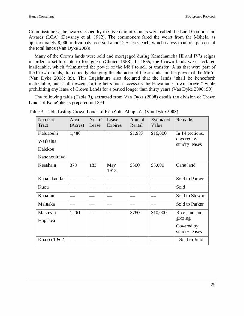
Honua Consulting Background Research
29
Commissioners; the awards issued by the five commissioners were called the Land Commission
Awards (LCA) (Devaney et al. 1982). The commoners fared the worst from the Māhele, as
approximately 8,000 individuals received about 2.5 acres each, which is less than one percent of
the total lands (Van Dyke 2008).
Many of the Crown lands were sold and mortgaged during Kamehameha III and IV’s reigns
in order to settle debts to foreigners (Chinen 1958). In 1865, the Crown lands were declared
inalienable, which “eliminated the power of the Mōʻī to sell or transfer ʻĀina that were part of
the Crown Lands, dramatically changing the character of these lands and the power of the Mōʻī”
(Van Dyke 2008: 89). This Legislature also declared that the lands “shall be henceforth
inalienable, and shall descend to the heirs and successors the Hawaiian Crown forever” while
prohibiting any lease of Crown Lands for a period longer than thirty years (Van Dyke 2008: 90).
The following table (Table 3), extracted from Van Dyke (2008) details the division of Crown
Lands of Kāneʻohe as prepared in 1894.
Table 3. Table Listing Crown Lands of Kāne‘ohe Ahupua‘a (Van Dyke 2008)
Name of
Tract
Area
(Acres)
No. of
Lease
Lease
Expires
Annual
Rental
Estimated
Value
Remarks
Kaluapuhi
Waikalua
Halekou
Kanohouluiwi
1,486 −− −− $1,987 $16,000 In 14 sections,
covered by
sundry leases
Keaahala 379 183 May
1913
$300 $5,000 Cane land
Kahalekauila −− −− −− −− −− Sold to Parker
Kuou −− −− −− −− −− Sold
Kahaluu −− −− −− −− −− Sold to Stewart
Maluaka −− −− −− −− −− Sold to Parker
Makawai
Hopekea
1,261 −− −− $780 $10,000 Rice land and
grazing
Covered by
sundry leases
Kualoa 1 & 2 −− −− −− −− −− Sold to Judd
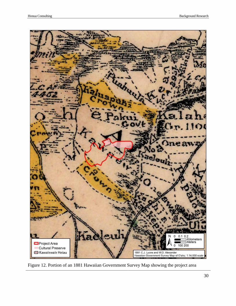
Honua Consulting Background Research
30
Figure 12. Portion of an 1881 Hawaiian Government Survey Map showing the project area
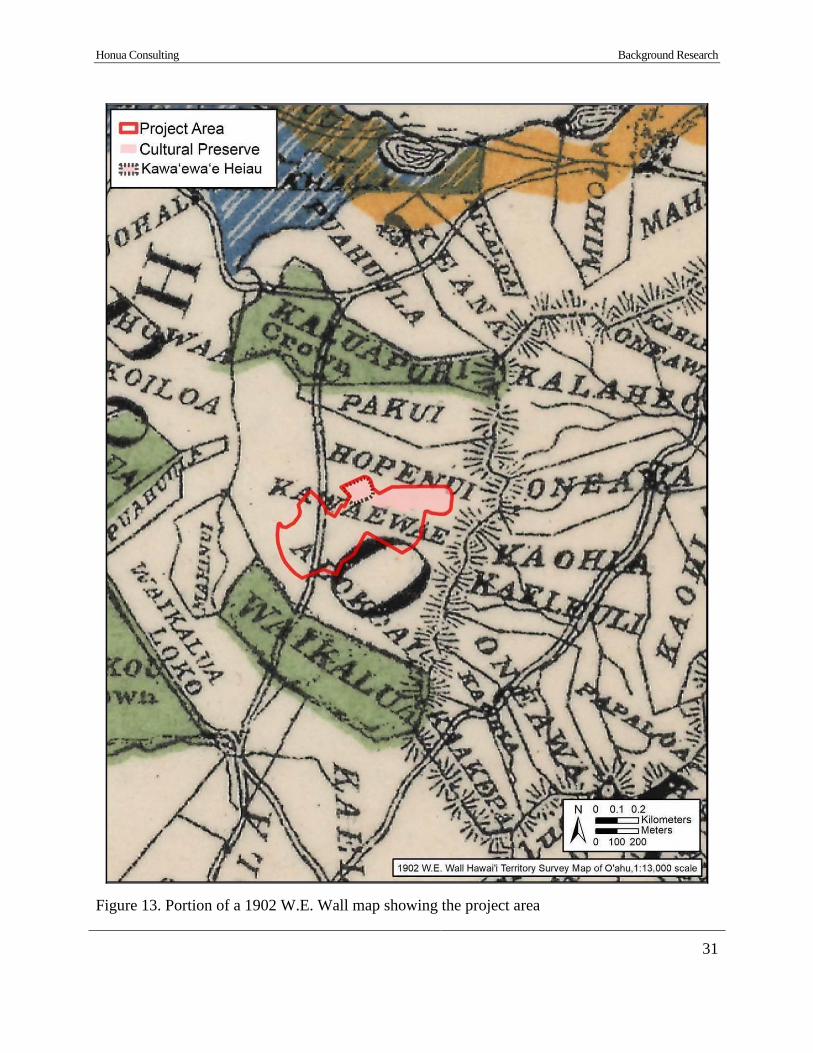
Honua Consulting Background Research
31
Figure 13. Portion of a 1902 W.E. Wall map showing the project area

Honua Consulting Background Research
32
Following the Kuleana Act, 242 land claims were made within Kāneʻohe ahupuaʻa, but only a
little more than half of these were awarded by the Land Commission. Queen Hakaleleponi
Kalama, 11 konohiki, and three (3) non-konohiki were eventually awarded the bulk of the
ahupuaʻa of Kāneʻohe (Kelly 1976). Taro land, fishponds, and dryland for crops were the types
of land claimed in Kāneʻohe, with taro land being the most predominant. The project area is
situated within the ʻili of Kalokoai and Kawa‘ewa‘e. No LCAs were issued within Kawa‘ewa‘e,
however, two were granted within Kalokoai (LCA 2444 and 2806) (Table 4).
Table 4. Table Listing LCA in the Kalokoai and the Near Vicinity of the Project Area
LCA # ʻIli Claimant Land Use Awarded
2444 Kalokoai Keawekukahi 2 loʻi; 1 house
lot; 3 fish ponds
3 ʻāpana; 1.808
acres
2806 Kalokoai Kahilikoolani 2 loʻi 1 ʻāpana; 0.839
acres
4.3 Mid 1800s to Present
This section discusses major cash crops of Kāne‘ohe that dominated the landscape throughout
the mid-19th through mid-twentieth centuries.
4.3.1 Sugar
Sugarcane was present in the Hawaiian Islands prior to European contact, but the height of its
cultivation did not begin until the 1860s. During this time period, Parker Sugar Co. and Kaneohe
Sugar Plantation were the two predominant sugar plantations in operation in Kāneʻohe. The
Parker Sugar Co. cultivated 75 acres of land in Kāneʻohe with an estimated yield of 120 tons, but
their lack of a mill and scarce employees made them less successful than the Kaneohe Sugar
Plantation (Devaney et al. 1982).
Kaneohe Sugar Plantation remained operational from 1865 to 1885. Unlike Parker Sugar Co.,
Kaneohe Sugar Plantation constructed a mill and brought equipment in from Liverpool to
maximize their yield. McAllister (1933: 178), notes that Kalaoa Heiau which once stood in
Waikalua, Kāneʻohe had its stones removed in the construction of the sugar mill. The plantation
cultivated 500 acres of its 7,000 acres in 1880 and had an estimated yield of 500 tons (Devaney
et al. 1982). Bowser states that approximately 100 men were employed and there were 70 yoke
of oxen, in addition to 50 mules and horses (1880: 407). In 1884, the plantation utilized 50 acres
of their 500 acres of land for planting, but were able to yield 572 tons (The Planters’ Monthly
1884). The Kaneohe Sugar Plantation remained operational until 1885.
Sugarcane cultivation was not as successful in Kāneʻohe as other parts of the island due to the
land being “too uneven in the irregular valleys for the problems of the systematic watering of the
cane as it is generally practiced in these Islands” (Pope 1911: 542). The peak of sugarcane

Honua Consulting Background Research
33
cultivation in Kāneʻohe was in 1880 and the years surrounding it, but the last plantation of the
Kāneʻohe Bay region in the ahupuaʻa of Heʻeia closed in 1902-03 due to the unprofitable nature
of the business (Devaney et al. 1982).
4.3.2 Rice
With the increase in agriculture on the Islands, there needed to also be an increase in workers
to cultivate the fields. Oriental workers, mostly Chinese, were brought to the Islands in the 1800s
for this purpose. The influx of Oriental immigrant workers brought about the need to increase
rice cultivation to the commercial crop status to satisfy demand. The rice industry in Hawaiʻi was
profitable from 1880 until its decline in the early 1920s, and its influence was felt in the
Kāneʻohe Bay region. The tracts of land once used in the cultivation of taro were modified and
increased to make way for rice cultivation in Kāneʻohe. According to Devaney et al. (1982: 49),
“vast networks of irrigation ditches were constructed, and the windward valleys of Oahu, near
the sea and extending into mauka regions along favorable waterways, were used for rice
growing”.
Rice acreage in 1892 for the Kāneʻohe Bay region was as follows: Waikane, 200 acres;
Kahaluʻu and Kaʻalaea, 300 acres; Heʻeia and Kāneʻohe, 200 acres (Devaney et al. 1982). The
shift to rice production in Kāneʻohe was not as successful as farmers and businesses hoped, as
the industry steadily declined over a ten-year period. Devaney et al. (1982) details the various
reasons behind the decline of the rice industry in Hawaiʻi:
The annexation of Hawaii by the United States in 1898 resulted in
restrictions on the number of Chinese laborers arriving from the
Far East. In addition, the increase of rice production in California
destroyed one of Hawaii’s major export markets. Rice birds were
also a major pest and, in the Kaneohe area, Pratt (1965: 71)
recalled the Chinese planters shooting them in the fields. The rice
borer insect, appearing around 1927, struck a final devastating
blow to the local rice industry. (Coulter and Chun 1937: 72,
Devaney et al. 1982: 52-53)
By 1963, the only remnant of the rice industry in Kāneʻohe were abandoned shacks in Waiahole
Valley and remaining pondfields and terraces (Miyagi 1963).
4.3.3 Ranching
The presence of livestock was a feature of the Kāneʻohe Bay region from the time of
settlement with the early Polynesians, and these animals included domesticated pigs, dogs and
jungle fowls. The number of introduced animal species increased after European contact, which
brought about more livestock, including cattle. Thrum (1905) notes that George W. Rowan
headed a cattle ranch in Heʻeia, while George J. Campbell owned a sheep and stock ranch in
Kāneʻohe. The livestock began to alter the landscape of Kāneʻohe as early as the mid-1860s,
where the plains at the foot of the Nuʻuanu Pali were described as “a rich land a while ago but
now there are not many plants there because animals are permitted there” (Sterling and Summers
1978: 207).
Honua Consulting Background Research
34
The Kaneohe Ranch lands were originally a part of the 20,000 acres belonging to Queen
Kalama, the Queen Consort of Kamehameha III and later Queen Dowager of the Kingdom of
Hawaiʻi. This land passed to Judge C. C. Harris upon her death, and his daughter, Nannie R.
Rice subsequently inherited the land from him (Devaney et al. 1982). J.P. Mendonca leased
15,000 acres from Mrs. Rice in 1894 for cattle raising, and the beginning of the ranch was
marked by the import of angus cattle by J. I. Dowsett. James B. Castle bought stock in the ranch
in 1907, and his son, Harold K. Castle, then purchased the property from Mrs. Rice in 1917. The
portion of the ranch in the Kāneʻohe Bay region was then confined to the southern section
(Devaney et al. 1982). At its peak, the Kaneohe Ranch included 2,000 head of cattle and 12,000
acres extending from the ocean in Kailua to the Pali (Henke 1929).
The construction of features for the Kaneohe Ranch Company were detrimental to important
religious sites for Native Hawaiians. Puʻumakani Heiau, once located on the ridge facing the
Nuʻuanu Pali, was dismantled and its stones were used in the construction of a cattle corral
(McAllister 1933: 181). In addition, Kawaʻewaʻe Heiau, located within the current project area,
was degraded by the cattle when “the structure was used as a cattle pen for many years [and] any
traces of heiau features [were] obliterated, and it is not known where the opening to the heiau
was situated” (McAllister 1933: 179).
4.3.4 Guava Charcoal Production
Prior to electricity many families heated their homes and cooked with homemade charcoal.
Guava (Psidium sp.) was introduced to Hawai‘i in 1825 and quickly spread, making way for the
cottage industry. Guava (Psidium sp.) charcoal kilns are recorded throughout the Kāne‘ohe-
Kailua uplands (Meeker and Murakami 1995, Allen et al. 2002, Dockall et al. 2003). In 1999, a
comprehensive study of 31 charcoal kilns within the region was completed (Meeker and
Murakami 1995). The kilns were found within the Minami Golf Course, Ho‘omaluhia Botanical
Gardens, Maunawili, Luluku, Punalu‘u Mauka, Pa‘u, and footprints of windward highways. The
Meeker and Murakami (1995) study divides charcoal kilns into two types, earth mounds and
covered pit kilns. Earth mounds include minimum surface modification and consist of a stack of
wood mounded with earth and fired. Covered pit kilns are typically “stone-lined circular pits dug
into the side of a moderately steep hillside and capped by a dome-shaped roof of baked clay or
concrete, in Hawai‘i, the concrete was often made with burnt coral lime called puna kameki
(Pukui and Elbert 1965:117,327); it was also used as a mortar or plaster” (Meeker and Murakami
1995:89). Covered pit kilns can use a simple earthen covering or a formal dome. Dome-covered
pits are attributed to early 1920s Japanese charcoal makers (Meeker and Murakami 1995:99).
Guava kilns have been found to be built for temporary or semi-permanent use. Once available
guava was cut from an area, the kiln was abandoned and a new kiln was constructed where guava
was more plentiful. The Meeker and Murakami (1995:94) study found kilns were distributed
within easy access of suitably sized guava patches and on slopes exposed to the prevailing trade
winds. Most all studied kilns were situated near unimproved roads built to serve the kilns. Kilns
were not found in areas that were first utilized by pineapple cultivation, ranching, or truck
farming, likely because those industries would have removed the guava forests.
An early twentieth-century report of the District Forester of Maunawili Ranch, Waimānalo,
notes:
Honua Consulting Background Research
35
It was formerly the custom in this section to lease out to Chinese
and others areas of land covered with Guava trees for the purpose
of making charcoal from the same. The result of this system was
temporarily of financial benefit to the owner of the land, but it
eventually resulting in causing the roots of the Guava trees so cut
to increase in enormous quantities through the suckers produced
from the roots, and thereby makes the land absolutely impossible
to the rancher in caring for the cattle roaming over the same. (Herd
1906:68, quoted in Meeker and Murakami 1995:96)
The common sprouting of the guava roots caused a ban on guava cutting in the late nineteenth
and early twentieth centuries (Herd 1906:69, quoted in Meeker and Murakami 1995:96).
However, the cessation of the guava charcoal industry did not last long. When the Homesteads
were opened in 1917 it became common for Japanese families to make guava charcoal,
particularly in the Luluku area (Kelly 1976 and Allen n.d., both quoted in Meeker and Murakami
1995:96).
4.3.5 Pineapple
The introduction of pineapple occurred in the early 1800s, but this crop did not begin
cultivation at commercial levels until the 1890s and early 1900s. Kāneʻohe, with its rich soils
and ideal climate, greatly contributed to the pineapple industry and this crop became the leading
agricultural industry in the area from approximately 1910 to 1925 (Harper 1972). Kaneohe
Ranch Company and Heʻeia Agriculture Co., Ltd. agreed to lease to Libby, McNeill & Libby
1,000 acres of land in Heʻeia, Kāneʻohe, and Kailua in 1912 for a term of 17 years (Devaney et
al. 1982). Pineapple cultivation on Windward Oʻahu reached 2,500 acres at its peak, stretching
from Kāneʻohe to Kahaluʻu; much of the acreage was contained within the Kāneʻohe Bay region
(Harper 1972).
According to Devaney et al (1982: 62-63) and other historians, the pineapple industry was
directly responsible for the degradation and destruction of many ancient Hawaiian sites:
At least five ancient Hawaiian sites were damaged or destroyed
during the pineapple era in the Kaneohe Bay area. In Kaneohe, the
Kukuiokane Heiau at Luluku, inland at the foot of a ride about the
banana fields, considered the largest and most important in the
region, was destroyed by Libby, McNeill & Libby operations.
According to the old Hawaiians of the district, the destruction of
this heiau caused a disease to attack their pineapples, with the
ultimate result that the undertaking was a failure (McAllister 1933:
177, site 340). John Bell reported that he saw the famous holua
slide in Kaneohe destroyed “when an attempt was made to plant
pineapples in this section” (ibid.: 181, site 355). In Heeia, the
Kaualauki Heiau was mostly destroyed by the pineapple growers
in their attempt to cultivate the region (ibid.: 173, site 328). Even
the site of the Libby, McNeill & Libby cannery was considered to
have been at the location of the Haluakaiamoana Heiau, and the
Honua Consulting Background Research
36
eventual failure of the cannery was credited to the destruction of
this temple (ibid.: 170, site 320). Finally, at Hakipuu, the lower
terrace of the Puakea Heiau was planted in pineapple (ibid.: 170,
site 315).
The pineapple industry of Kāneʻohe could not sustain cultivation as efficiently as other areas
around Oʻahu, such as Kalihi, as well as the other Hawaiian Islands. The cannery officially
closed in 1923, and the land dedicated to pineapple cultivation grew out, and some were used to
graze cattle while others returned to rice cultivation (Kelly 1976, Dorrance 1998).
4.3.6 Dairy
Following the conclusion of World War II, Kāneʻohe became a major residential center. The
construction of the Wilson Tunnel and expansion of the Pali Highway in the 1950s and 1960s
made Kāneʻohe easily accessible from Honolulu, which led to a developmental boom on the
windward side of Oʻahu. Farming and ranching became unprofitable, therefore, Kaneohe Ranch
converted operations to focusing on leasing land. The Kaneohe Ranch Company leased their vast
acreage to over 5,000 single family residential lots in Kailua and Kāneʻohe, and many of the
leaseholds were sold to the lessees (Hammatt 2008).
In the 1950s, the dairy district of Honolulu was forced to relocate so Kailua and Kāneʻohe
became an important dairy district of Oʻahu (Durand Jr. 1959). According to Durand Jr. (1959:
235), dairy farming had been a Caucasian dominated field, which soon changed, as he described
“among the names of island dairymen, illustrating the Portuguese-Spanish-Mainland
importance…are…Brazil, Carlos, Campos, Costa, Ferreria, Foster, Freitas, Knowles, Medeiros,
Moniz, Ornellas, Rapoza, Santos, Toledo, Vause and White”. Three dairies opened in the
Kāne‘ohe area, Texeira, Moniz, and the Souza Brothers Dairy. Nearest to the current project
area, the Souza Brothers Dairy opened in the 1950s and was short-lived. The dairy was operated
by two brothers, Alfred and Blase Souza, whose mother had come to O‘ahu from Peñuelas,
Puerto Rico in 1901 (Souza and Souza 1985). The dairy industry quickly declined due to high
prices of land in Honolulu, the urbanization of Kailua and Kāneʻohe, and the landowners
realization that developing land for housing was more profitable than farming (Durand Jr. 1959:
244-245). The current project area is thought to have been used as grazing land by the Souza
Brothers Dairy. The location of the dairy can be seen on a 1954 Kāne‘ohe USGS map, to the
northwest of the project area, just south of Castle High School (see Figure 14). The old diary is
now the Kaluapuhi Neighborhood Park, also referred to as Souza Dairy Park.
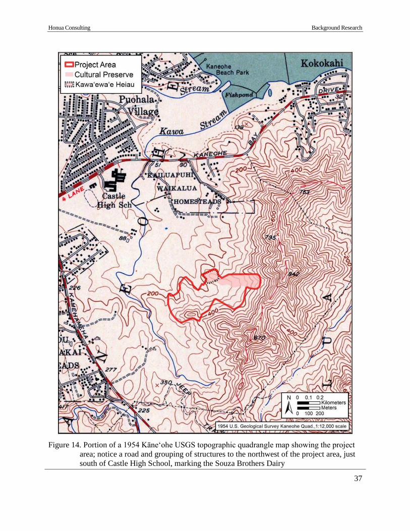
Honua Consulting Background Research
37
Figure 14. Portion of a 1954 Kāne‘ohe USGS topographic quadrangle map showing the project
area; notice a road and grouping of structures to the northwest of the project area, just
south of Castle High School, marking the Souza Brothers Dairy
Honua Consulting Previous Archaeology
38
Section 5 Previous Archaeological Research
Several previous archaeological studies have been conducted within and in the vicinity of the
current project area. Figure 15 and Figure 16 show the locations of previous archaeological
studies and documented sites in the area and Table 5 provides additional details on each study.
5.1 Previous Archaeological Studies in the Vicinity of the Project Area
5.1.1 McAllister 1933
The earliest archaeological survey of O‘ahu by J.G. McAllister (1933) recorded several sites
within and in the near vicinity of the project area. Sites in the vicinity include multiple fishponds
(Site 349-351), a spring (Site 353), heiau (Site 352, 354, 356), and a hōlua slide (Site 355).
McAllister’s (1933) map showing the locations of these sites indicates Kawa‘ewa‘e Heiau (Site
354), the hōlua slide (Site 355), and Pu‘umakani Heiau (Site 356) are close to or within the
current project area. Kawa‘ewa‘e Heiau (Site 354) has been documented within the current
project area and is discussed in detail within Section 8.1.1 of this report. Sites 355 and 356 were
recorded as follows:
Site 355. Small round hill, the name of which is not remembered,
near the mountain side of Kawa‘ewa‘e Heiau (Site 354). Said by
John Bell to have been the location of a holua slide. This he saw
destroyed when an attempt was made to plant pineapples in this
section. Without doubt this is the site of the slide described by
Bates in 1853 (pp. 106-107):
Before reaching the mission station at Kaneohe, the road leads
through a narrow but fertile ravine, tenanted by a few natives. In
leaving the ravine, a low round hill, to the right of the path, is
rather conspicuous from a long, narrow depression or channel on
its side. It was an indication that one of the favorite games of the
old Hawaiians had been played there. This game was called the
holua, and was one of their favorite games of chance. Both chiefs
and common people freely mingled in it. No particular spot
monopolized it…A trench was dug from the top of the hill to the
bottom, and carried out some distance over the adjoining plain.
This was made quite smooth, and spread over with grass to aid in
the velocity of the descending sled. It is said that the sliders would
frequently get carried nearly a mile along the trench. This
amusement was attended with great hazard of life, and great skill
and courage were required to properly to fit a man for such an
enterprise. Many of these sloped were on an angle of forty-five
degrees; and woe to the man who rolled from his sled, or whose
sled got out of the trench! Death was the penalty, or the unlucky
slider maimed for life. If the players escaped unhurt, many of them
lost their all in betting.
Honua Consulting Previous Archaeology
39
This same site was seen by Briggs (p. 38) in 1881: ‘Dewight
pointed out to me a long narrow depression on some of the hills to
be seen from our path, where old Hawaiians used to play one of
their favorite games of chance.’
Site 356. Puumakani Heiau, Kalapuhi, Waikalua, Kaneohe. This
heiau was on the ridge facing the Nuuanu Pali, but the stones were
removed and used for building a cattle corral farther down the
slope. The heiau is said to have been built by Olopana. (McAllister
1933: 181, also quoted in Sterling and Summers 1978: 219-220)
The locations of the hōlua slide (Site 355) and Pu‘umakani Heiau (Site 356) have not been
relocated.
5.1.2 Hammatt and Shideler 1989
In 1989, Cultural Surveys Hawaiʻi (CSH) conducted an archaeological survey of a 90-acre
parcel for the proposed Hawaiʻi State Veterans Cemetery, located approximately 0.8 km south of
current project area (Hammatt and Shideler 1989). The field survey did not encounter any
archaeological features. The report recommended that no archaeological monitoring would be
necessary for proposed construction of the veterans cemetery.
5.1.3 McIntosh and Cleghorn 2013
In 2013, Pacific Legacy, Inc. conducted an AIS of a 56-acre parcel, located approximately 0.7
km north of the current project area (McIntosh and Cleghorn 2013). One previously documented
site, Ahukini Heiau (SIHP # 50-80-10-352) was relocated. The heiau appeared to have been
impacted by previous construction activities. No additional sites were recorded.
5.1.4 Medrano and Spear 2015
In 2015, Scientific Consultant Services, Inc. conducted an AIS and Cultural Impact
Assessment (CIA) for the Kawa Stream and Ditch Improvements Project (Medrano and Spear
2015, Dagher and Spear 2015). The project was located along Kawa Stream, south of Kāneʻohe
Bay Drive and northwest of Kamehameha Highway; approximately 0.6 km northwest of the
current project area. The archaeological inventory survey documented one newly identified site,
Kawa Stream Bridge (SIHP #50-80-10-7766) (Medrano and Spear 2015). The cultural impact
assessment found that the Kawa Stream and Ditch Improvements Project would not hinder any
cultural practices or have an adverse effect on the cultural significance of the area (Dagher and
Spear 2015).
Honua Consulting Previous Archaeology
40
Figure 15. Portion of a 1998 Kāne‘ohe USGS topographic map showing the locations of previous archaeological projects within and
in the vicinity of the project area

Honua Consulting Previous Archaeology
41
Figure 16. Portion of a 1998 Kāne‘ohe USGS topographic map showing the locations of previously documented sites within and in the
vicinity of the project area

Honua Consulting Previous Archaeology
42
Table 5. Table Listing Previous Archaeological Studies Within and in the Vicinity of the Current
Project Area
Reference Type of Study Location &
Distance from PA
Documented Sites (SIHP #50-80-10)
McAllister
1933
Island-wide
Study
Oʻahu Three sites close to or within project
area, Kawa‘ewa‘e Heiau (Site 354,
SIHP # -354), a hōlua slide (Site
355, destroyed), and Pu‘umakani
Heiau (Site 356, not relocated,
possibly destroyed)
Hammatt and
Shideler 1989
Archaeological
Survey
Hawaiʻi State
Veterans Cemetery,
TMK [1] 4-5-023:
002 (approx. 0.8
km south of PA)
No sites recorded
Szabian et al.
1989, Szabian
1989
Archaeological
Reconnaissance
Survey and Post-
Field Summary
Report
Pikoiloa Cemetery
(current Hawaiian
Memorial Park
Cemetery), TMK
[1] 4-5-032:001-
002 (includes
current PA)
One previously recorded site,
Kawaʻewaʻe Heiau (SIHP # -354),
and 11 newly identified sites: SIHP
# -4676 (traditional habitation
complex), -4677 (historic wall
remnant, earthen mound), -4678
(historic wall remnant, earthen
mound), -4679 (historic wall
remnant), -4680 (historic terrace), -
4681 (traditional habitation
complex), -4682 (a platform and
series of terraces), -4683 (historic pit
feature), -4684 (traditional habitation
complex), -4685 (historic wall
remnants, terracing), and -4686
(historic stone alignments)
Hammatt 2008 Cultural Impact
Assessment
Hawaiian Memorial
Park, TMK [1] 4-5-
033:001 (includes
current PA)
Described concerns for preservation
of Kawaʻewaʻe Heiau (SIHP # -
354), understanding of surrounding
sites as a cultural complex associated
with Kawaʻewaʻe Heiau, and on-
going cultural practices associated
with gathering of plants for hula and
lei
Honua Consulting Previous Archaeology
43
Reference Type of Study Location &
Distance from PA
Documented Sites (SIHP #50-80-10)
McCurdy and
Hammatt 2009
Archaeological
Inventory Survey
Hawaiian Memorial
Park, TMK [1] 4-5-
033:001 (includes
current PA)
Seven previously recorded sites,
Kawaʻewaʻe Heiau (SIHP # -354), -
4680 (historic terrace), -4681
(traditional habitation complex), -
4682 (platform and terraces
determined to be natural, non-
cultural), -4683 (historic pit feature
[charcoal kiln]), -4684 (traditional
habitation complex) and -4686
(historic stone alignments); and 6
newly identified sites, SIHP # -6929
(2 concentrations of lithic debitage),
-6930 (traditional ceremonial stone
enclosure), -6931 (traditional
ceremonial stone alignments), -6932
(historic stone storage feature), -
6933 (historic pit feature [charcoal
kiln] with associated stone terrace),
and -7079 (traditional grinding
stone)
McIntosh and
Cleghorn 2013
Archaeological
Inventory Survey
Kāneʻohe
Ahupuaʻa, TMK [1]
4-5-032:001 (0.7
km north of PA)
One previously recorded site, SIHP
# 50-80-10-352 (Ahukini Heiau)
Medrano and
Spear 2015,
Dagher and
Spear 2015
Archaeological
Inventory
Survey, and
Cultural Impact
Assessment
Kawa Stream and
Ditch, TMK [1] 4-5
various (0.6 km
NW of PA)
One newly identified site, SIHP #50-
80-10-7766 (Kawa Stream Bridge)
Honua Consulting Previous Archaeology
44
5.2 Previous Archaeological Studies Within the Current Project Area
5.2.1 Szabian et al. 1989, Szabian 1989
In June of 1989, the applied research group of Bishop Museum conducted a 59.8-acre
reconnaissance survey of the proposed Pikoiloa Cemetery (Szabian et al. 1989). The project area
overlaps a portion of the current project area and extends approximately another 0.4 km north
and 0.7 km to the southwest. Originally their project area was 92-acres and extended all the way
to Kawa Stream. One previously recorded site, Kawaʻewaʻe Heiau (SIHP # 50-80-10-354), was
encountered as well as 11 newly identified sites, containing 25 associated features. The 11 newly
documented sites included: four sites adjacent to Kawa Stream south of the current project area,
SIHP # -4676 (traditional habitation complex), -4677 (historic wall remnant, earthen mound), -
4678 (historic wall remnant, earthen mound), and -4679 (possible historic wall remnant); two
sites to the north of the current project area, -4685 (historic wall remnants, terracing), and -4686
(historic stone alignments); and five sites within the current project area, -4680 (historic terrace),
-4681 (traditional habitation complex), -4682 (a platform and series of terraces), -4683 (historic
pit feature, natural terracing), -4684 (traditional habitation complex) (Szabian et al. 1989). A
post-field summary of the archaeological reconnaissance was composed with recommendations
for the newly recorded sites (Szabian 1989). The newly recorded sites were seen as being likely
associated with Kawaʻewaʻe Heiau and religious ritual, habitation and agricultural use of the
land. Szabian (1989) recommended future fieldwork within the project area which would include
intensive clearing and mapping with subsurface testing.
5.2.2 Hammatt 2008, McCurdy and Hammatt 2009
In 2008, a Cultural Impact Assessment (CIA) for the Hawaiian Memorial Park Expansion
project (formerly referred to as Pikoiloa Cemetery) was conducted by CSH (Hammatt 2008). The
CIA involved the examination of historical documents and maps, review of existing recorded
archaeological sites within the project area, and consultation with community members. The CIA
described two primary cultural concerns; the preservation of previously recorded Kawaʻewaʻe
Heiau (SIHP # 50-80-10-354) and on-going cultural practices associated with gathering of plants
for hula and lei (Hammatt 2008). It was noted that Kawaʻewaʻe Heiau (SIHP # -354) should be
recognized as not just one isolated site but a complex of associated sites throughout the
surrounding area. Consultation and site visits with community members suggested the potential
for burials in or around Kawaʻewaʻe Heiau, the potential of a Hale o Papa (women’s heiau) at
SIHP # -4681 (Hammatt 2008). CIA recommendations included the preservation and
maintenance of Kawaʻewaʻe Heiau in addition to awareness of cultural gathering practices
within the project area (Hammatt 2008).
In 2009, CSH conducted an AIS for the Hawaiian Memorial Park Expansion project
(McCurdy and Hammatt 2009). The AIS included a complete surface survey, documentation of
encountered archaeological sites, and subsurface testing of select features to determine if
subsurface deposits existed within the project area. During fieldwork a total of 12 sites were
identified, six were previously recorded by Szabian et al. (1989) and six were newly recorded. Of
the six previously recorded sites, five sites were relocated within the current project area
including SIHP # 50-80-10-354 (Kawaʻewaʻe Heiau), -4680 (historic terrace), -4681 (traditional
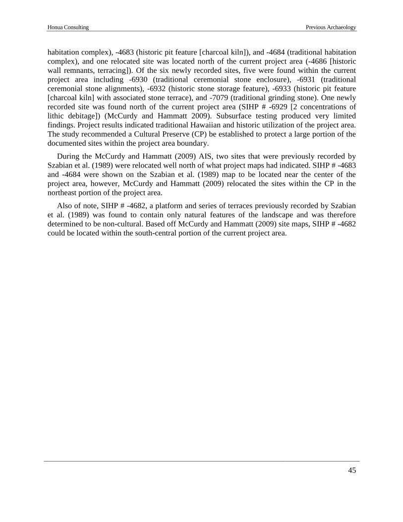
Honua Consulting Previous Archaeology
45
habitation complex), -4683 (historic pit feature [charcoal kiln]), and -4684 (traditional habitation
complex), and one relocated site was located north of the current project area (-4686 [historic
wall remnants, terracing]). Of the six newly recorded sites, five were found within the current
project area including -6930 (traditional ceremonial stone enclosure), -6931 (traditional
ceremonial stone alignments), -6932 (historic stone storage feature), -6933 (historic pit feature
[charcoal kiln] with associated stone terrace), and -7079 (traditional grinding stone). One newly
recorded site was found north of the current project area (SIHP # -6929 [2 concentrations of
lithic debitage]) (McCurdy and Hammatt 2009). Subsurface testing produced very limited
findings. Project results indicated traditional Hawaiian and historic utilization of the project area.
The study recommended a Cultural Preserve (CP) be established to protect a large portion of the
documented sites within the project area boundary.
During the McCurdy and Hammatt (2009) AIS, two sites that were previously recorded by
Szabian et al. (1989) were relocated well north of what project maps had indicated. SIHP # -4683
and -4684 were shown on the Szabian et al. (1989) map to be located near the center of the
project area, however, McCurdy and Hammatt (2009) relocated the sites within the CP in the
northeast portion of the project area.
Also of note, SIHP # -4682, a platform and series of terraces previously recorded by Szabian
et al. (1989) was found to contain only natural features of the landscape and was therefore
determined to be non-cultural. Based off McCurdy and Hammatt (2009) site maps, SIHP # -4682
could be located within the south-central portion of the current project area.
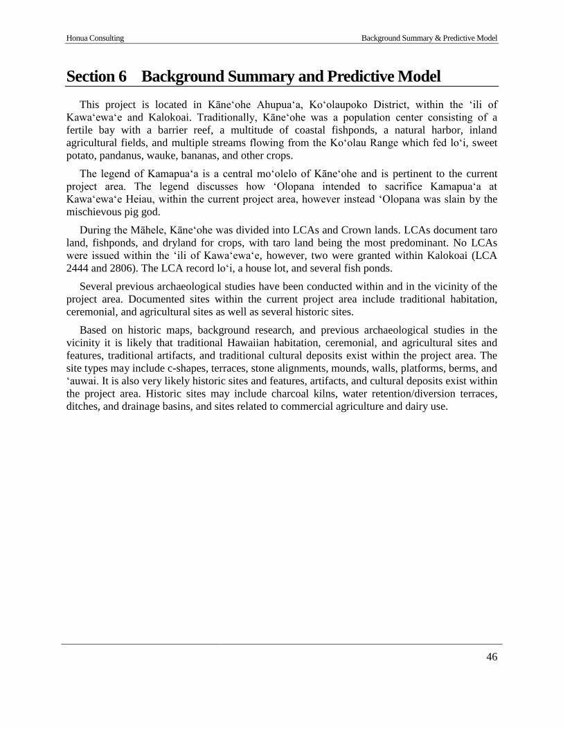
Honua Consulting Background Summary & Predictive Model
46
Section 6 Background Summary and Predictive Model
This project is located in Kāne‘ohe Ahupua‘a, Ko‘olaupoko District, within the ‘ili of
Kawa‘ewa‘e and Kalokoai. Traditionally, Kāneʻohe was a population center consisting of a
fertile bay with a barrier reef, a multitude of coastal fishponds, a natural harbor, inland
agricultural fields, and multiple streams flowing from the Koʻolau Range which fed loʻi, sweet
potato, pandanus, wauke, bananas, and other crops.
The legend of Kamapua‘a is a central mo‘olelo of Kāne‘ohe and is pertinent to the current
project area. The legend discusses how ‘Olopana intended to sacrifice Kamapua‘a at
Kawa‘ewa‘e Heiau, within the current project area, however instead ‘Olopana was slain by the
mischievous pig god.
During the Māhele, Kāne‘ohe was divided into LCAs and Crown lands. LCAs document taro
land, fishponds, and dryland for crops, with taro land being the most predominant. No LCAs
were issued within the ‘ili of Kawa‘ewa‘e, however, two were granted within Kalokoai (LCA
2444 and 2806). The LCA record loʻi, a house lot, and several fish ponds.
Several previous archaeological studies have been conducted within and in the vicinity of the
project area. Documented sites within the current project area include traditional habitation,
ceremonial, and agricultural sites as well as several historic sites.
Based on historic maps, background research, and previous archaeological studies in the
vicinity it is likely that traditional Hawaiian habitation, ceremonial, and agricultural sites and
features, traditional artifacts, and traditional cultural deposits exist within the project area. The
site types may include c-shapes, terraces, stone alignments, mounds, walls, platforms, berms, and
‘auwai. It is also very likely historic sites and features, artifacts, and cultural deposits exist within
the project area. Historic sites may include charcoal kilns, water retention/diversion terraces,
ditches, and drainage basins, and sites related to commercial agriculture and dairy use.

AIS Results
47
Section 7 AIS Results
Archaeological fieldwork for this project consisted of a 100% pedestrian archaeological
survey, documentation of encountered surface sites and features, and excavation at one site
location (SIHP # -8241 [Honua 14], walled pit).
7.1 Pedestrian Survey
A 100% pedestrian archaeological survey was conducted intermittently between September
21, 2017 to February 21, 2018 by between two and six archaeologists from Honua Consulting.
The 53.45-acre project area was surveyed by walking transects, oriented roughly N/S and E/W.
GPS tracks were recorded as the parcel was surveyed (Figure 17). Spacing between each
archaeologist ranged from between approximately 4-6 m (13-20 ft.) depending on ground
visibility. Vegetation ranged from extremely thick with 0% ground visibility to a moderately
open understory with approximately 90% ground visibility (Figure 18 through Figure 20).
A hand-held GPS was used to mark potential archaeological features and historic artifacts.
Ten (10) previously documented sites (SIHP # -354, -4680, -4681, -4683, -4684, -6930, -6931, -
6932, -6933 and -7079) and fourteen (14) newly identified sites (SIHP # -8228 to -8241 [Honua
1-14]) were recorded. In addition, one historic dairy bottle was collected (Acc. #1) and five
historic to modern glass bottles were recorded and plotted with GPS. Modern trash was observed
scattered within the southwest portion of the project area. No traditional Hawaiian artifacts were
encountered during the pedestrian survey.
During the current survey two natural features were observed and noted, including a possible
‘ili boundary stone and a natural spring (refer to Figure 17). A very large boulder was observed
approximately 40 meters south of the project area boundary and a GPS point was taken
(PossIliBoundMrkr). The boulder was approximately 3 meters in diameter and several additional
large boulders were nearby, all of which were within a circle of ti trees (Figure 21). It is
proposed that the large boulder may be an ‘ili boundary marker, separating the ili of Kawa'ewa'e
(to the north) and Kalokoai (to the south). A commanding view of Kāne‘ohe can be seen from
the boulder (Figure 22). In addition, during the current survey a natural spring seep was observed
within the eastern end of the Cultural Preserve (CP) and a GPS point was taken (12-28-
SpringSeep). Spring water was observed seeping from a large natural basalt outcrop (Figure 23).
The drainage area adjacent to the spring seep contained trickling water which appeared to be
flowing from a separate spring further upslope. This spring water helps supply the watershed
within the current project area, particularly within the CP, and likely feeds several of the ‘auwai
and terraces documented during this study.
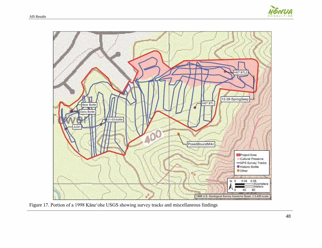
AIS Results
48
Figure 17. Portion of a 1998 Kāne‘ohe USGS showing survey tracks and miscellaneous findings
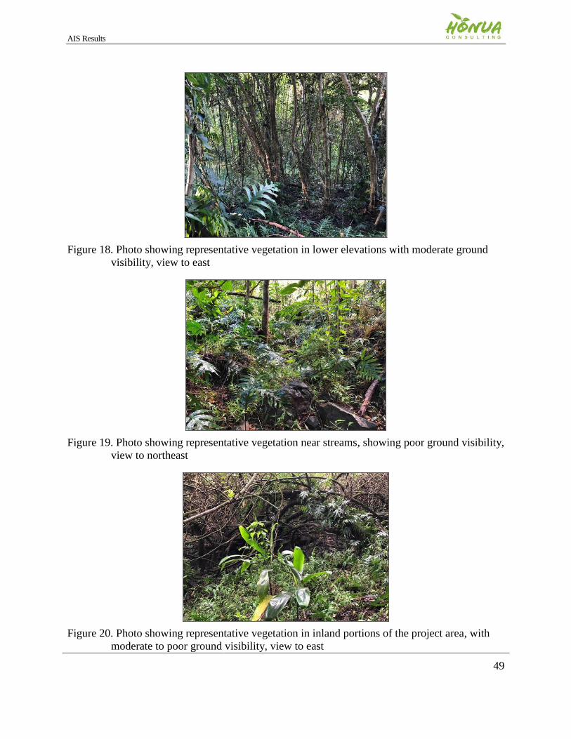
AIS Results
49
Figure 18. Photo showing representative vegetation in lower elevations with moderate ground
visibility, view to east
Figure 19. Photo showing representative vegetation near streams, showing poor ground visibility,
view to northeast
Figure 20. Photo showing representative vegetation in inland portions of the project area, with
moderate to poor ground visibility, view to east
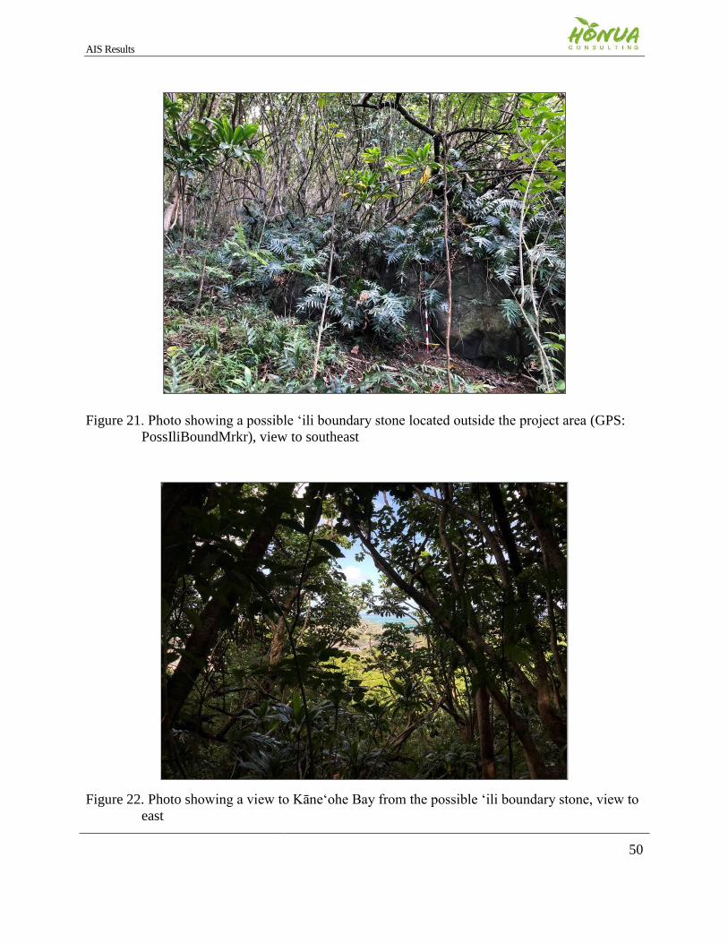
AIS Results
50
Figure 21. Photo showing a possible ‘ili boundary stone located outside the project area (GPS:
PossIliBoundMrkr), view to southeast
Figure 22. Photo showing a view to Kāne‘ohe Bay from the possible ‘ili boundary stone, view to
east
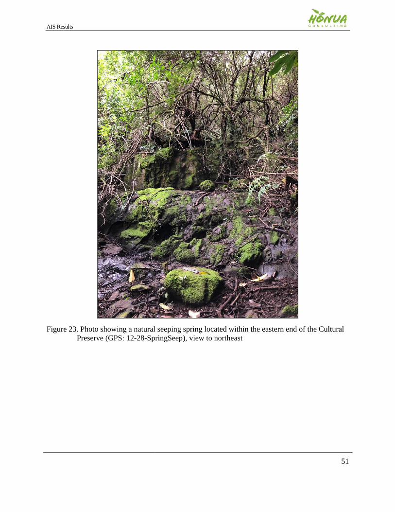
AIS Results
51
Figure 23. Photo showing a natural seeping spring located within the eastern end of the Cultural
Preserve (GPS: 12-28-SpringSeep), view to northeast


