114
Appendix 2 Mid Suffolk Assessment Sheets
Appendix 2 Mid Suffolk Assessment Sheets

Heritage and Settlement Sensitivity Assessment for Babergh and Mid Suffolk Districts
Appendix 2: Mid Suffolk Sensitivity Assessment Sheets
Settlement Name: Bacton District: Mid Suffolk
Settlement Description:
Bacton is a dual-focal village, located approximately five miles north of the town of Stowmarket. The historic core of the
village is centred around the church, and contains a cluster of houses around the road junction between Earls Green
Road, The Street and Wyverstone Road. There is a second settlement foci to the west of the historic core of the village,
which contains a group of listed buildings clustered around the road junction, all dating from the 16th and 17th centuries.
Summary History:
The name Bacton is written as ‘Bacan-tun’ in Old English, and translates as ‘Baca’s Farm’. The earliest evidence for the
settlement in the vicinity is Iron Age and Roman finds. The settlement is mentioned in the Domesday Book as a large
village of 62 households in the Hundred of Hartismere. At the time of the Conquest it was under the overlordship of the
Saxon noble Leofwine, who had lands in many parts of Suffolk and Essex.
From 1236 to 1536 Bacton was under the jurisdiction of the Bishops of Norwich. Richard Nykke, last Catholic bishop
before the English Reformation. He built a palace in Bacton which was eventually demolished and the bricks used to build
cottages. His coat of arms can be seen in the South aisle window of the Parish Church of St. Mary. The church dates from
the 1300's and stands in the middle of Bacton village.
Most of the archaeological finds from around this settlement date from the medieval and post medieval periods. The
medieval manor of Bacton was moated, and was sited between the settlement area to the west and the historic core
around the church. The current building on the site is an elegant large red brick house, constructed in the early eighteenth
century, which is listed grade II*. Another medieval moat lies to the south of the church, in open agricultural land originally
adjacent to Pulham’s Farm which is shown on the 1st edition OS map.
Around the church are several listed buildings. The earliest is Old Manor Cottage, which principally dates from the mid-
16th century, but has fragmentary remains of a 13th century core. The other listed buildings date to the 16th century.
The settlement group to the west of the main village comprises a core of 16th and 17th century buildings. On the late 19th
century OS map the settlement contains two malthouses and a brewery, as well as a Post Office.
There has been some later infilling between the listed buildings, as well as modern development to the east of the historic
core. There is also modern development situated to the north of the western settlement foci. The original gaps between
the settlements are largely preserved between the village, the manor house and the western settlement. There is a linear
connection of newer buildings along the road to the east between the church and the modern development.
Historic Environment Designations
Conservation Area:
None
Heritage and Settlement Sensitivity Assessment for Babergh and Mid Suffolk Districts
Listed Buildings: within the village
Grade I: Grade II*: Grade II:
Scheduled Monument:
None
Registered Park and Garden:
None
Landscape Designations
AONB:
None
SSSI:
None
SAC:
None
Ancient Woodland:
None
Key Characteristics
Settlement:
Note: The key positive features or qualities, which if lost or changed there would be a significant consequence for the
current character.
The settlement is characterised by its dual focal nature. The core of the settlement is centred on Tailors Green with the
church sitting at the heart of a range of listed buildings surrounding it. A second group of listed buildings is located to the
west centred on Wyverstone Green. Between the two is a large 18th century house sitting within a moated site, which was
the location of the medieval manor house. The boundary of the settlement has altered from its historic extent, and there
is a large modern development to the east of Tailors Green, as well other elements on both greens. This has partially
eroded this key characteristic.
Surrounding Landscape:
Note: The key positive features or qualities, which if lost or changed there would be a significant consequence for the
current character.
The surrounding landscape is largely agricultural in character with a dispersed series of farms and cottages spread to the
west along The Street and Rectory Road.
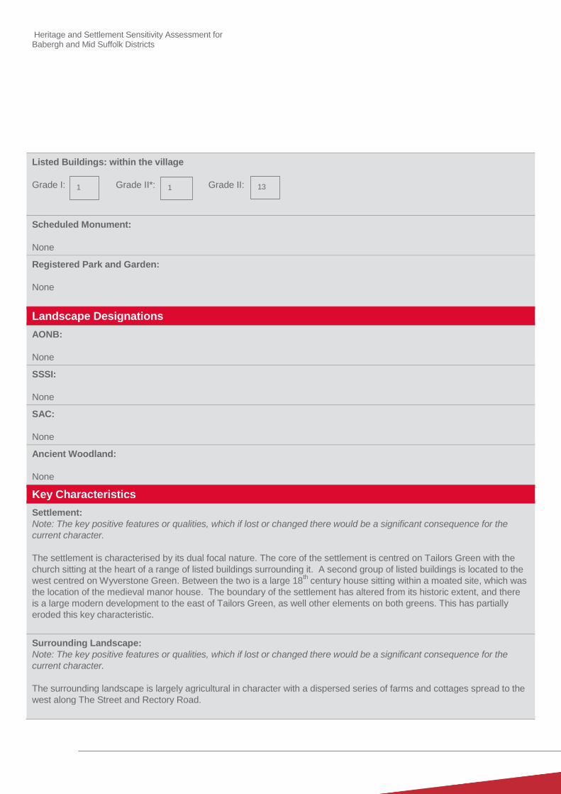
1 1 13

Heritage and Settlement Sensitivity Assessment for Babergh and Mid Suffolk Districts
Key Views
Note: The key views towards, through, across and away from the settlement
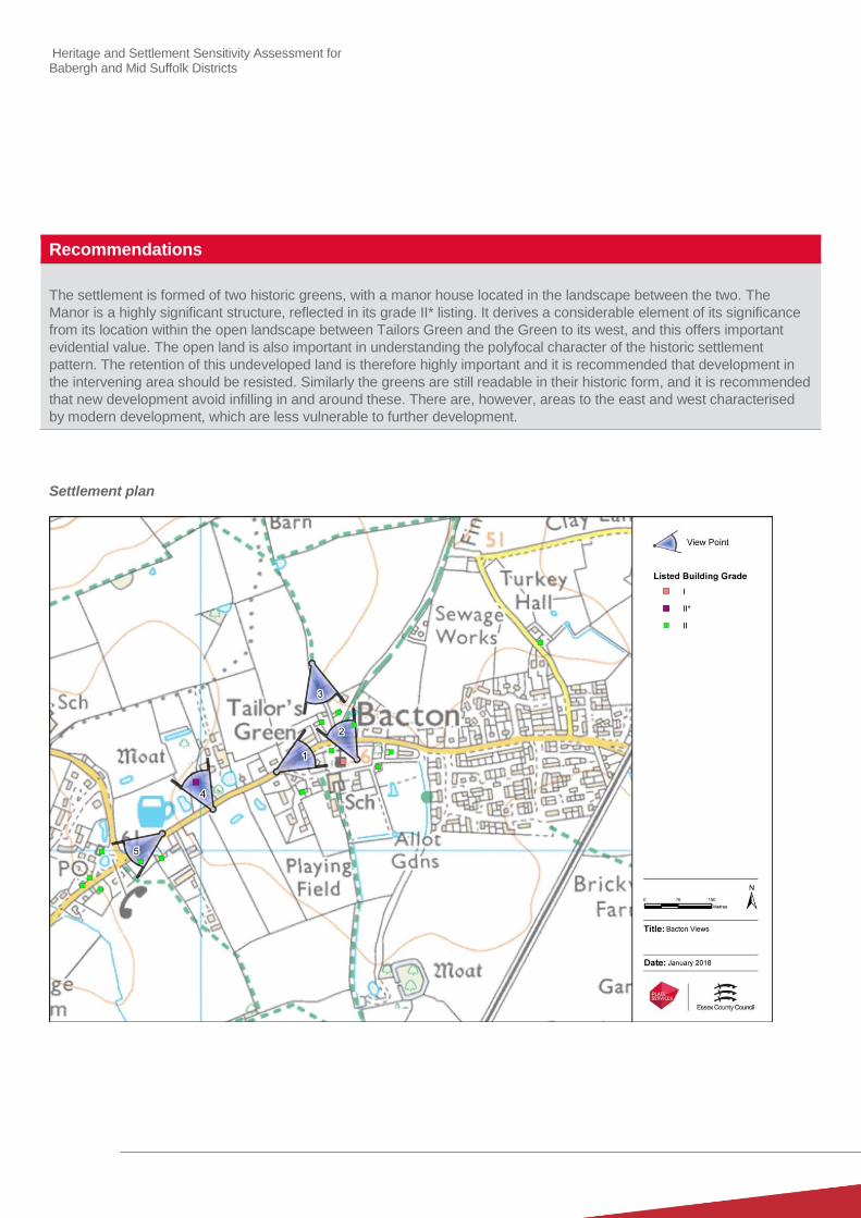
1. Looking east from The Street into Tailors Green:
2. Looking east and north across Tailors Green towards the Church and towards the cluster of listed buildings on
the north side of the green.
3. Looking south from footpath on northern side of Tailors Green looking towards the church over the listed
properties on the northern side of The Street
4. Views of the Manor in its semi isolated setting with its associated farm buildings.
5. Views looking west across Wyverstone Green: This allows an understanding of the contained nature of the
second Green to the west of the main core at Bacton.
Value
Note: Based on designation status (including setting of AONB/heritage assets, relationship of the settlement to the
heritage assets), local or community interest or use (access/enjoyment & amenity value), setting for the wider settlement.
Condition/rarity/quality.
The surviving core around the church is a good example of a surviving green with a nucleated settlement around the
church which would have been characteristic of the built landscape of Suffolk. It also includes several buildings of
considerable historic and architectural interest.
Similarly, but to a lesser extent, Wyverstone Green is a second example of a nucleated settlement around a Green.
The Manor is a building of exceptional architectural quality and is a significant example of earlier 18th century architecture.
Both the church and the Manor House are of exceptional architectural value, which is reflected in the fact that they are
listed grade I and grade II* respectively.
Susceptibility
Note: The ability of the receptors (features, qualities, characteristics, condition) to accommodate the changes without
undue consequences for the maintenance of the baseline.
Tailors Green is still readily readable as an historic green and is sensitive to development either within the green or which
would encircle and enclose it. In particular the area to the north has suffered minimal incursion and offers important
views of the historic settlement. Similarly Wyverstone Green is susceptible to change, although has already suffered more
intrusive infilling.
The Manor which is sited between the two greens on the northern side of The Street is deliberately positioned outside the
two greens, which is emblematic of its higher social status. It would therefore be particularly susceptible to infilling on
either side of the road which would impact on its isolated rural setting
Potential Enhancement
Note: Areas that could potentially be improved or enhanced.
Consideration of the Tailor Green area is to be submitted for consideration as a conservation area. The improvement of
the soft landscaping of both greens and their boundary demarcation would also better reveal their significance.
Heritage and Settlement Sensitivity Assessment for Babergh and Mid Suffolk Districts
Recommendations
The settlement is formed of two historic greens, with a manor house located in the landscape between the two. The
Manor is a highly significant structure, reflected in its grade II* listing. It derives a considerable element of its significance
from its location within the open landscape between Tailors Green and the Green to its west, and this offers important
evidential value. The open land is also important in understanding the polyfocal character of the historic settlement
pattern. The retention of this undeveloped land is therefore highly important and it is recommended that development in
the intervening area should be resisted. Similarly the greens are still readable in their historic form, and it is recommended
that new development avoid infilling in and around these. There are, however, areas to the east and west characterised
by modern development, which are less vulnerable to further development.
Settlement plan
Heritage and Settlement Sensitivity Assessment for Babergh and Mid Suffolk Districts
Settlement Name: Badwell Ash District: Mid Suffolk
Settlement Description:
The name Badwell Ash means ‘Bada’s stream near the field with ash trees’. Badwell Ash was originally called Parva Asshefelde, Little Ashfield, with the name being changed in the 14
th century. It is one of several villages and hamlets in
the area with an association with ash trees.
The settlement is shown on the first edition as a linear settlement and this is evident today, with the historic buildings located on the road frontage set against the edge of the pavement. The listed buildings are distributed along the main road, forming small separated clusters, interspersed amongst areas of 20
th century housing and a school.
In the mid to late 20th century modern housing developments were constructed on the west and to the south east of the
historic area of the settlement, greatly expanding the size of the settlement.
Summary History:
There is archaeological evidence which shows that there has been a long history of human habitation of the area, with quantities of Roman pottery and coins, and some Anglo- Saxon artefacts having been found. There is also a suggestion that a Saxon Church was located here, although no definitive proof has been found to corroborate this supposition.
The grade I listed Church of St Mary lies at the centre of the village, which was historically linear in character, and is sited close to the main road through the village. The oldest part of the church is the chancel which dates to the early/mid-14
th century, with a later 14th or early 15
th century nave, which still retains its original roof structure. The
church is suggested to contain some of the finest flushwork panels from any church in East Anglia. The main street through the settlement contains a range of listed buildings dating from the 16
th century with frontages directly onto the
street and later 20th century infill set back from the road frontage. Excavations in advance of development within the
northern area of the settlement have shown the presence of archaeological layers dating from the 16th century. This
reflects the fact that a large section of medieval was burnt to the ground as a result of a major fire which took place on 15th July 1723. The settlement has had large scale twentieth century alteration, with the erection of large areas of housing.
Historic Environment Designations
Conservation Area:
None
Listed Buildings: within the village
Grade I: Grade II*: Grade II:
1 1 7
Heritage and Settlement Sensitivity Assessment for Babergh and Mid Suffolk Districts
Scheduled Monument:
None
Registered Park and Garden:
None
Landscape Designations
AONB:
None
SSSI:
None
SAC:
None
Ancient Woodland:
None
Key Characteristics
Settlement:
Note: The key positive features or qualities, which if lost or changed there would be a significant consequence for the
current character.
The character of the settlement is dominated by the 20th century development, which comprises the great majority of the
built form. There is however a relatively short surviving linear core, albeit one that has been heavily infilled. The church is
a visually dominant feature particularly when approaching from the south, and there are four other grade II listed buildings
clustered around it.
Surrounding Landscape:
Note: The key positive features or qualities, which if lost or changed there would be a significant consequence for the
current character.
The landscape in which the settlement is situated has been extensively altered, particularly as a result of mineral
extraction. The quantity of modern development also means there is relatively little inter relationship between the historic
core and the surrounding landscape. The exception is to the west, where the intervening built form is more limited.
To the west of the settlement there is a church/hall complex centred around Langham Hall, where both the church and the
hall are listed grade II*.
Heritage and Settlement Sensitivity Assessment for Babergh and Mid Suffolk Districts
Key Views
Note: The key views towards, through, across and away from the settlement
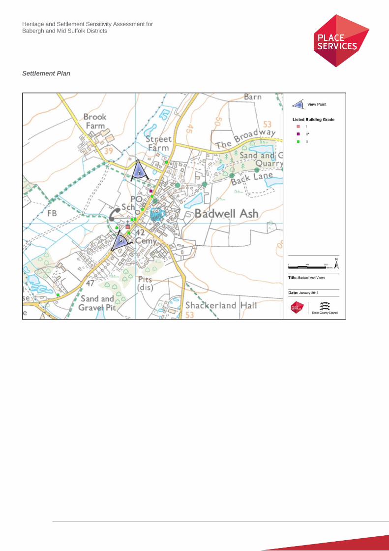
1. View looking south from the road to Brook Farm: This shows the prominence of the church as well as the
association between the open land and the grade II* listed medieval hall house.
2. Views of the Church looking north along the main road: This defines the entrance to the small historic element of
the settlement.
Value
Note: Based on designation status (including setting of AONB/heritage assets, relationship of the settlement to the
heritage assets), local or community interest or use (access/enjoyment & amenity value), setting for the wider settlement.
Condition/rarity/quality.
Cumulatively the settlement of Badwell Ash is of low value from a heritage perspective, although it does include several of
listed buildings, including one listed grade I and one listed grade II*, which are individually of higher value. However the
extent of the modern development has diminished the historic significance of the settlement, as well as the contribution
which their setting makes to the significance of these listed buildings.
Susceptibility
Note: The ability of the receptors (features, qualities, characteristics, condition) to accommodate the changes without
undue consequences for the maintenance of the baseline.
Given that the significance of the listed buildings mainly resides in their physical fabric and short views of the heritage
assets within the settlement as a whole has relatively low susceptibility to change.
Potential Enhancement
Note: Areas that could potentially be improved or enhanced.
None identified
Recommendations
The value of the settlement as a whole is low from a heritage perspective, and there are therefore limited
recommendations to make. However, it should be noted that the grade II* listed farmhouse at the northern end of the
settlement still retains some visual association with its surrounding agricultural landscape and that development which
would erode this association should be resisted.
Heritage and Settlement Sensitivity Assessment for Babergh and Mid Suffolk Districts
Settlement Plan
Heritage and Settlement Sensitivity Assessment for Babergh and Mid Suffolk Districts
Settlement Name: Barham District: Mid Suffolk
Settlement Description:
The settlement of Barham, as assessed, comprises a small area of residential properties located on Norwich Road
adjacent to parkland associated with a large historic house. The main settlement of Barham, which lies to the south, has
merged with the larger settlement of Claydon, and was therefore assessed as part of this settlement. Within this northern
section of Barham, to the immediate north of the residential area, lies the Grade I Registered Park and Garden centred on
Shrubland Hall, with an individually listed gate and lodge fronting onto Norwich Road. There are also a small number of
other historic buildings located on Norwich Road, including a coaching inn set back from the road
The land between this park and garden and the present urban edge of Claydon/Barham is agricultural in nature, on
ground which slopes down towards the River Gipping. The church of St Mary and St Peter at Barham is located on high
ground overlooking the slope leading to Shrubland Hall.
Summary History:
The land in which the settlement is located would have historically formed open countryside between the church/hall complex at Barham Hall to the south and the parkland associated with Shrubland to the north. The former contains the grade I listed church of St Mary, which has its origins in the 13th century, and which would have been associated with the moated site at Barham Hall. The latter is a country house, constructed in the later eighteenth century and surrounded by its associated parkland and ancillary buildings. This is thought to have been built on the site of an older sixteenth century house and forms part of a chain of hall complexes to the east of the main axial north-south road. The surviving built form would seem to also suggest that there were isolated buildings fronting onto Norwich Road located along its length. Historic mapping shows that the Barham Union Workhouse was located to the west of the road, but that the site now partially falls under the current route of the A14. This is recorded as having been a two and a half storey red brick building, which was built in 1766 by the Bosmere and Claydon Hundreds Incorporation. It was demolished in 1963, but is one of the many workhouses and institutions which purportedly inspired Charles Dickens to write Oliver Twist. The settlement is however now largely comprised of twentieth century development.
Historic Environment Designations
Conservation Area:
None
Listed Buildings: within the village
Grade I: Grade II*: Grade II:
Scheduled Monument:
None
Registered Park and Garden:
Grade I Registered park and garden to the north of the settlement (Shrubland Hall)
0 1

Heritage and Settlement Sensitivity Assessment for Babergh and Mid Suffolk Districts
Landscape Designations
AONB:
None
SSSI:
Located to the east of the settlement area
SAC:
None
Ancient Woodland:
The Ancient Woodland of Broomwalk Plantation is located to the east of the settlement
Key Characteristics
Settlement:
Note: The key positive features or qualities, which if lost or changed there would be a significant consequence for the
current character.
The settlement area assessed is modern in origin, located along Norwich Road. However, it abuts the Grade I registered
park and garden associated with Shrubland Hall which extends for a considerable distance to the north. This parkland
containing numerous listed buildings and has historic associations with prominent architects and landscape gardeners,
including Charles Barry and Humphrey Repton. This extensive parkland and associated house was designed for an
evidently wealthy land-owning family, and was deliberately sited separately from other settlements. The grandeur of this
estate is evident from Norwich Road in the scale and design of the lodge buildings. Within the settlement boundary is a
former coaching inn, formerly isolated in situation, but now surrounded by modern housing. There are several other older
buildings located to the north, and which are directly adjacent to Norwich Road, both of which are listed grade II in their
own right.
Surrounding Landscape:
Note: The key positive features or qualities, which if lost or changed there would be a significant consequence for the
current character.
The surrounding landscape is dominated to the north by the large registered Park and Garden associated with Shrubland
Hall. To the south there is a large area of Ancient Woodland and a SSSI. The park and garden has a relatively strong, if
piecemeal, boundary along Sandy Lane with only a small section of the main house visible from the surrounding
landscape. The rest of the surrounding landscape to the south has been assessed in conjunction with the settlement of
Claydon.
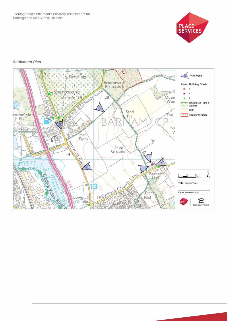
Key Views
Note: The key views towards, through, across and away from the settlement
1. Barham Church Lane: There are wide views from the church looking north, west and east with more limited
views to the south. Long views directly to the south are interrupted by the location of Barham Hall.
Heritage and Settlement Sensitivity Assessment for Babergh and Mid Suffolk Districts
2. Views along Norwich Road in which some of the lodge and gatehouses are visible.
3. Views into the park form the footpaths to the south in which the tower of the hall is visible allow an understanding
of both the extent of the associated parkland and the sale of the main residence.
4. View from the Norwich Road to Barham Church. This view is important for understanding the relationship with
Barham Church.
Value
Note: Based on designation status (including setting of AONB/heritage assets, relationship of the settlement to the
heritage assets), local or community interest or use (access/enjoyment & amenity value), setting for the wider settlement.
Condition/rarity/quality.
The Park and Garden associated with Shrubland Hall and the hall itself are both considered to be of exceptional
significance, particularly as a result of its historic association with prominent figures such as Humprey Repton and Charles
Barry, and this is reflected in the fact that they are listed Grade I and Grade II* respectively. There are other isolated
buildings of significance not associated with this estate, particularly the three listed buildings fronting onto Norwich Road.
The land to the south also has value in preserving the relatively isolated location of these heritage assets.
Susceptibility
Note: The ability of the receptors (features, qualities, characteristics, condition) to accommodate the changes without
undue consequences for the maintenance of the baseline.
The significance of the Park and Garden partially stems from its location outside the settlement boundaries, which
emphasises the social position and status of the hall and its owners, and is important to appreciating its significance. As
such it is susceptible to development which ran north from the current settlement boundary at Barham and infilled the
open countryside to the east of Norwich Road. It would be similarly vulnerable to the infilling of land between the A14 and
Norwich Road, which would create a sense of linear enclosure along its western boundary. The grade I listed church,
located in an isolated position overlooking the valley on the edge of Claydon, is highly susceptible to development on the
slopes leading towards Norwich Road.
Potential Enhancement
None identified.
Recommendations
The Church of St Mary sits on an elevated position on the ridge and is highly sensitive to development. It is
recommended that the setting of this building and the contribution this makes to its significance is given strong
consideration in any application sited to the east of Norwich Road. The historic routeway between Claydon Church,
Barham Church and Shrublands is of significance but currently lacks much interpretation or management. It is
recommended that consideration be given to improving this important historic route and protecting its rural character.
Consideration should also be given to the imposition of a section 106 agreement in relation to any development close to
or adjacent to Sandy Lane to ensure the creation of an improved landscape buffer along the southern boundary of land
associated with Shrublands.
Heritage and Settlement Sensitivity Assessment for Babergh and Mid Suffolk Districts
Settlement Plan

Heritage and Settlement Sensitivity Assessment for Babergh and Mid Suffolk Districts
Settlement Name: Bramford District: Mid Suffolk
Settlement Description:
Bramford is a medium-sized village, located three miles to the west of Ipswich in the Mid Suffolk administrative district.
The majority of the settlement lies to the west of the railway line and the River Gipping, but a section of built form, mainly
constructed in the second half of the 20th century, lies to the east of the railway line and the flood plain of the River
Gipping. The village has two churches; (one Anglican and one Methodist) the former located to the south-east of the
settlement, with the latter located in the north west of the village on the B1067 road. There are two distinct clusters of
historic buildings within the settlement, the first concentrated by the River Gipping at the southern end of the settlement
and the second located along the southern end of The Street. The former include the grade I listed Church of St. Mary
the Virgin, the grade II* listed Bramford House and a mill complex on the northern of along Mill lane. The other
concentration of historic buildings lie along The Street, and is comprised of a group of timber framed buildings opening
largely directly onto the pavement area.
Summary History:
Aerial photographic evidence indicates that it is likely that there is a Bronze Age cemetery located beneath the northern part of the present settlement area. Metal detector and chance finds of Saxon material to the south of the modern settlement would indicate the potential of Saxon occupation, possibly located in the vicinity of the church, and this is corroborated by the fact that the settlement is recorded in the Domesday Book (as "Brunfort" or "Branfort").
Within The Street there are a range of listed buildings dating from the 14th to 18th centuries all fronting onto the main
road. A second group of listed buildings is centred on the Church and mill area on the western side of the River Gipping. These include the Grade I listed church of St Mary and the Grade II* Bramford House, along with a range of grade II buildings associated with the mill and waterfront area
The economy of Bramford historically was largely agricultural, although remnants of its industrial past still exist along Paper Mill Lane. The old Fison's warehouses originally produced cloth before chemical fertiliser manufacturers took over in the 19th Century. The largest of the three semi-circular warehouses still standing on the site is listed as the only example of its kind left in the country. The River Gipping (the source of the River Orwell), runs to the east of the main village area and was a busy navigable waterway during the 19th century. The River Gipping passes through the village and was once a navigable waterway carrying goods from Ipswich to Stowmarket. The settlement was also originally on the Eastern Union railway line, but was closed in 1955.
Historic Environment Designations
Conservation Area:
None
Listed Buildings: within the village
Grade I: Grade II*: Grade II:
Scheduled Monument:
None
1 1 19
Heritage and Settlement Sensitivity Assessment for Babergh and Mid Suffolk Districts
Registered Park and Garden:
None
Landscape Designations
AONB:
None
SSSI:
None
SAC:
None
Ancient Woodland:
Hazel Wood is an Ancient Woodland located at the southern end of the village to the south of the church and on the
southern side of the River Gipping.
Key Characteristics
Settlement:
Note: The key positive features or qualities, which if lost or changed there would be a significant consequence for the
current character.
The historic settlement is dual focal, with a first cluster of listed buildings associated with the church and the river located
on the eastern edge of the settlement. Further to the west a second group of listed buildings are located on The Street, all
of which are located close to the edge of the pavement creating a tight linear character. However the majority of the
settlement is now predominantly characterised by large areas of 20th century development.
The settlement also contains several historic farmsteads including one at the southern end of the settlement, a second
one located across the railway to the east and a third to the north of the settlement. The second of these now falls within a
second modern settlement area to the east of the railway line.
Surrounding Landscape:
Note: The key positive features or qualities, which if lost or changed there would be a significant consequence for the
current character.
To the south and east of the main settlement the land is characterised by the flood plain of the river Gipping. On the
western side of the settlement the landscape includes several isolated farmsteads including Figeons Farmhouse and
Thornbush Hall.
Key Views
Note: The key views towards, through, across and away from the settlement
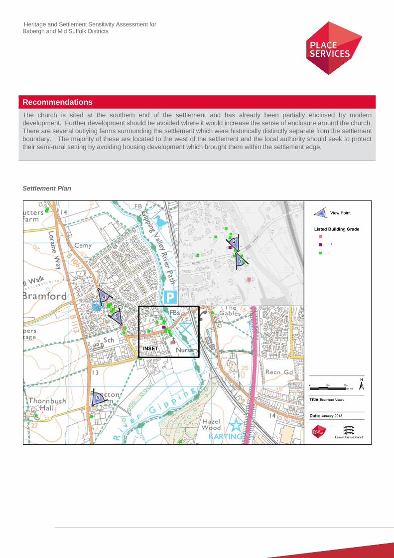
1. Looking south to the church from Ship Lane, allowing an appreciation of the church and its immediate
surroundings: This takes in the historic buildings around the church green.

Heritage and Settlement Sensitivity Assessment for Babergh and Mid Suffolk Districts
2. Looking North from Ship Lane towards Mill lane, which includes the listed buildings associated with the Mill as
well as Bramford House
3. The view looking North along The Street: This allows a view of the cluster of listed buildings fronting onto the
Street which form an important historic group
4. The view looking south along The Street: This also allows an appreciation of the cluster of listed buildings fronting
onto The Street.
5. Views from Runcton Farm looking north east to the Church on the edge of the River Gipping from the B1113.
Value
Note: Based on designation status (including setting of AONB/heritage assets, relationship of the settlement to the
heritage assets), local or community interest or use (access/enjoyment & amenity value), setting for the wider settlement.
Condition/rarity/quality.
The area around the church green and Mill Lane is one of the historic foci of the settlement which includes several
significant listed buildings including the Church of St. Mary the Virgin, Bramford House and the group of buildings
associated with the mill. This has been relatively unspoilt by modern development meaning that the group of buildings can
still be understood in their historic context. Several of these, including the church and Bramford House are of exceptionally
high architectural and historic value, reflected in their grade I and II* designations.
The listed buildings in the Street also form a distinct group which have a strong inter-relationship with each other.
However, whilst their context can still be interpreted it has been heavily curtailed by a large volume of modern
development in all directions.
The land to the west and south of the settlement is characterised by isolated farmsteads outside the body of the
settlement and these allow an understanding of the historic use and function of the land surrounding Bramford.
The majority of the rest of the settlement, which is characterised by modern housing developments, is of low value from a
heritage perspective.
Susceptibility
Note: The ability of the receptors (features, qualities, characteristics, condition) to accommodate the changes without
undue consequences for the maintenance of the baseline.
The historic core around the church and mill are highly susceptible to change particularly any which would sever links
between buildings or where development would create a sense of encirclement. There is, however, no such concern in
relation to the listed buildings along the Street, the setting of which has already been eroded by modern development.
The historic farmsteads which sit within the wider landscape and distinctly outside the settlement boundaries are also
susceptible to change if development was permitted which would bring them into or directly adjacent to the settlement
boundary.
Potential Enhancement
Note: Areas that could potentially be improved or enhanced.
None identified
Heritage and Settlement Sensitivity Assessment for Babergh and Mid Suffolk Districts
Recommendations
The church is sited at the southern end of the settlement and has already been partially enclosed by modern
development. Further development should be avoided where it would increase the sense of enclosure around the church.
There are several outlying farms surrounding the settlement which were historically distinctly separate from the settlement
boundary. The majority of these are located to the west of the settlement and the local authority should seek to protect
their semi-rural setting by avoiding housing development which brought them within the settlement edge.
Settlement Plan

Heritage and Settlement Sensitivity Assessment for Babergh and Mid Suffolk Districts
Settlement Name: Claydon District: Mid Suffolk
Settlement Description:
Claydon is a village located just to the north of Ipswich, the etymology of the name deriving from 'clay-on-the-hill'. The
settlement is located to the east of the River Gipping, although this historic relationship has been broken by the incursion
of the A14. The historic settlement was located along Norwich Road. On the eastern side of the settlement are two church
hall complexes, one located around Barnham Hall on Barnham Church Lane and the other around the Church of St Peter,
on Church Lane, which probably formerly associated with Claydon Hall. The villages of Claydon and Barham are
separate civil parishes but became a united benefice in 1974. St Peter's in Claydon was closed for regular public worship
in 1975 and St Mary's became the Parish Church of Claydon & Barham. In 1977 the Church in Claydon was declared
redundant and St Mary's became the Church of St Mary and St Peter.
There has been considerable development within Claydon in the second half of the 20th century, and this now determines
much of the current overall character and appearance of the core of the village.
Summary History:
Chance finds around the present settlement have given an indication that there was some prehistoric, Roman and Saxon occupation of the settlement. This is unsurprising as the location above the River Gipping would have made it a prime site for settlement.
Two church hall complexes are located on the edges of the present settlement. Originally both would have been some distance from the main settlement which developed on Norwich Road, with clear visual and physical separation. Claydon Hall lies to the north west of the Church of St Peter and is known to have originated as a medieval moated hall. The present building comprises a mid-14
th century core with major alterations in the 17
th century. St Peter (Grade
I) is one of the few surviving pre-Norman churches in Suffolk, which has been heavily restored and altered in the mid-nineteenth century, carried out under the direction of the then rector, Rev. George Drury, working with the architect Richard Phipson. The gardens associated with the Rectory are thought to date from the mid to late 19
th century
containing unusual garden walls and towers.
The second church hall complex at Barham Hall also contains a grade I listed church (the Church of St Mary), which has its origins in the 13th century, and would have been linked to the moated Hall at Barham Hall. These church/hall complexes would have been circled by their estates with other settlement located on Norwich Road.
To the north of the settlement there is postulated evidence for the site of a battle between the Saxons and the Danes, as excavations in an adjacent sand quarry found a number of human skeletons.
During the post medieval period a number of quarries developed at the southern end of the settlement and a number of limekilns were built, some of which survive and are listed. The first edition Ordnance Survey maps show a windmill within the settlement, now located beneath the residential development on York Crescent.
In the second half of the 20th century there was extensive residential development to the north and west of the Church
of St Mary. A large school was also created at this time between the main road and the church complex.
Historic Environment Designations
Conservation Area:
None
Heritage and Settlement Sensitivity Assessment for Babergh and Mid Suffolk Districts
Listed Buildings: within the village
Grade I: Grade II*: Grade II:
Scheduled Monument:
None
Registered Park and Garden:
None
Landscape Designations
AONB:
None
SSSI:
None
SAC:
None
Ancient Woodland:
None
Key Characteristics
Settlement:
Note: The key positive features or qualities, which if lost or changed there would be a significant consequence for the
current character.
The core of Claydon was historically a linear settlement with concentration of built form located at the junction between
Norwich Road and Station Road. There remains a surviving cluster of listed buildings within this area although the
prevailing character of Claydon is defined more by the considerable volume of modern housing of relatively curvilinear
plan form of the 20th century. There are surviving farm complexes to the north and south of the settlement but their setting
has been eroded.
The Church of St. Peter was historically located separate from the main settlement as part of a Church/Hall complex with
Claydon Hall to the south east. It currently still survives in a semi-rural context with associated vicarage and gardens.
This sense of isolation has been partially eroded by the construction of modern housing within one garden directly to the
west. However, the immediate open fields to the south and north still provide an open setting in which the grade I listed
building is experienced. The Church of St. Mary forms part of a second church/hall complex on the north-eastern corner of
the settlement. This grade listed I church is visible in longer views particularly from the road to the west and the east, and
survives in its historic rural setting set apart from the main body of the settlement. These two churches are still linked by
The Slade, an historic Lane shown on the first edition OS and preserved today as a footpath.
2 0 11
Heritage and Settlement Sensitivity Assessment for Babergh and Mid Suffolk Districts
Surrounding Landscape:
Note: The key positive features or qualities, which if lost or changed there would be a significant consequence for the
current character.
The surviving landscape is relatively undulating with the two church hall complexes sited on the higher ground and the
historic linear core located on the lower valley slopes above the River Gipping. The landscape to the south of the
settlement was historically quarried, with several surviving historic lime kilns still located in this area. However its value
has been diminished by the fact that it appears to have been recently re-landscaped. To the south of Barham Church
along The Slade there are areas of woodland which have developed within old gravel quarries.
Key Views
Note: The key views towards, through, across and away from the settlement
1. Wide views from the Church of St. Mary looking in all directions, which emphasises its prominent siting within the
surrounding landscape.
2. Views travelling along Barham Church Lane from the east, which highlight the prominent siting of the Church of St.
Mary.
3. Views looking east from the west of the Church of St. Mary, which also highlight the prominent siting of the church.
4. Views of Barham Church from Norwich Road: These views from the Norwich Road again emphasise its prominent
location within the landscape. These are a deliberate by-product of the building’s intentionally ostentatious siting.
5: Views from Claydon Church and Vicarage. These are less extensive, but important from this church complex,
particularly the views to the south, which emphasise the churches position on the higher slopes outside Claydon.
6: Views to the north towards Barham Church along The Slade, which allow an historic understanding of the relationship
between the two church/hall complexes.
7: Views looking along Ipswich Road into the historic core of listed buildings along this road, which allow an understanding
of the historic linear core of the village.
Value
Note: Based on designation status (including setting of AONB/heritage assets, relationship of the settlement to the
heritage assets), local or community interest or use (access/enjoyment & amenity value), setting for the wider settlement.
Condition/rarity/quality.
The historic core of Claydon has been heavily developed, and is of relatively low value- with the area of significance
located around the junction of Norwich Road and Station Road. However, to the east of the settlement are two surviving
church/hall complexes, set prominently within the landscape, with relatively well preserved settings and linked by The
Slade. Both of these complexes contain Grade I listed churches, and Claydon Hall to the south-east is also a surviving
moated site. These two complexes are therefore considered to be of high value.
Susceptibility
Note: The ability of the receptors (features, qualities, characteristics, condition) to accommodate the changes without
undue consequences for the maintenance of the baseline.
The core of the settlement has low to negligible susceptibility to change as the significance of these listed buildings
derives from their surviving fabric and their architectural and historic importance rather than from their surviving setting.
However, the two church/hall complexes which have purposely been sited both outside the settlement and on the higher
ground derive a considerable element of their significance from their surrounding landscape and their association with

Heritage and Settlement Sensitivity Assessment for Babergh and Mid Suffolk Districts
each other. This would make them both highly susceptible to development within close proximity and which severs or
impacts on key views.
Potential Enhancement
Note: Areas that could potentially be improved or enhanced.
The boundary treatment to the immediate west of Claydon Church could be improved and strengthened to provide a
greater physical and visual separation between the church and graveyard and the modern development to the west.
Recommendations
The historic routeway between Claydon Church, Barham Church and Shrublands is of significance but currently lacks
much interpretation or management. It is recommended that consideration be given to improving this important historic
route and protecting its rural character. The setting of the Claydon Church has already been partially denuded by the
incursion of modern development to the west but is still partially experience within an open landscape to the north and
south. This should be retained. The majority of the settlement is however relatively modern in character, and is thereby
less susceptible to further development.
Settlement Plan
Heritage and Settlement Sensitivity Assessment for Babergh and Mid Suffolk Districts
Settlement Name: Debenham District: Mid Suffolk
Settlement Description:
Debenham is a large linear village situated on the upper reaches of the River Deben. It is an historic market town, with the
historic built form located mainly along the High Street, a single north-south road which forms part of the route between
Woodbridge and Eye. This road rises from the south and north, with the church sited on the resulting area of higher
ground. The historic market place lies to the west of this road, at the junction between the High Street and Gracechurch
Street, and is surrounded by a group of highly significant listed buildings, several of which are listed grade II*. Two roads.
Little Back Lane and Greater Back Lane run north from Gracechurch Street, parallel to the High Street and are unusual
surviving remnants of a medieval street pattern which was centred on the market. The historic road to the east, Water
Lane, contains The Wash, an elongated ford where the riverbed forms part of the road.
The majority of the modern development is located on the higher ground to the south-west of the settlement, including a
large modern housing estate which has infilled open land between Low Road and Gracechurch Street and contains wide
winding roads with occasional green spaces within.
Summary History:
Prehistoric activity is evident on the edge of the modern settlement, on land between Low Road and Ipswich Road, where
excavation of two areas has revealed multi-period prehistoric activity from the early Neolithic through to the Iron Age.
There is also evidence of Roman settlement in the area around Low Road and Priory Lane with a range of ditches
indicative of agricultural use of the landscape. The current character of the settlement however has its origins in the
Saxon occupation, evidence for which is indicated by finds within the historic core of settlement. Evidence of settlement is
also recorded in the Domesday Book of 1086.
The medieval settlement extended along the High Street, Gracechurch Street and to the east along Water Street and
Priory Lane. The parish Church of St Mary Magdalene is located on slight summit, with the road dropping away to the
south and north. The core of the church dates to the 14th century, but incorporates substantial elements of a late eleventh
or early twelfth century building. The village was granted a market charter in 1221, with the historic marketplace being
located to the north of the junction between the High Street and Gracechurch Street. This is characterised by surviving
market buildings, the most significant of which is the former guild hall, a two storey market building, with an interesting
history of changing uses- including use as a school room and as a fire station. The Red Lion Public House, located at the
northern end of the market place, dates to 15th and 16
th century, and was originally a brewhouse associated with the
Guildhall of the Holy Trinity.
The settlement was an important trading centre, and the large proliferation of different trades is seen in late 17th Century
records, which record evidence of tailors, blacksmiths, butchers, wheelwrights, drapers, glovers, saddlers and
apothecaries. There are early records of hemp weaving, spinning and worsted production, an industry more associated
with the north-eastern part of Suffolk around the Waveney valley.
There is evidence for the existence of a range of post-medieval industries in the town, including two brickworks, several
maltings and three windmills in the immediate area close to the historic core. In 1890 a gas works was built within the
settlement and in 1904 the Mid Suffolk Light Railway was opened, a branch line of the Ipswich to Norwich line.
Heritage and Settlement Sensitivity Assessment for Babergh and Mid Suffolk Districts
Historic Environment Designations
Conservation Area:
Debenham Conservation Area
Listed Buildings: within the village
Grade I: Grade II*: Grade II:
Scheduled Monument:
None
Registered Park and Garden:
None
Landscape Designations
AONB:
None
SSSI:
None
SAC:
None
Ancient Woodland:
None
Key Characteristics
Settlement:
Note: The key positive features or qualities, which if lost or changed there would be a significant consequence for the
current character.
The historic settlement is linear in character, centred on a north-south axial road which is heavily populated with listed
buildings. This includes a cluster of highly designated buildings round the church and market green, which form the
historic heart of the settlement. Debenham has had considerable modern development to the west, but remains
comparatively unaltered to the east. There was an historic green at the southern end of the settlement which is still
partially discernible, and is located to the east of the High Street, in close proximity to the southern boundary of the land
associated with the church. The built form is largely set on the back of pavement line, but this set back increases as the
road travels north and south away from the church and market place.
1 6 69
Heritage and Settlement Sensitivity Assessment for Babergh and Mid Suffolk Districts
Surrounding Landscape:
Note: The key positive features or qualities, which if lost or changed there would be a significant consequence for the
current character.
The surrounding landscape is of an agricultural nature, characterised by dispersed farmsteads, some of which contain
listed buildings. The River Deben runs through the valley at the northern end of the settlement. The settlement sits within
the lower section of the valley with land rising in all directions.
Key Views
Note: The key views towards, through, across and away from the settlement
1. Views looking south through the historic settlement with glimpses of the church on high ground, which allow an
understanding of the historic linear character of the settlement and the prominent siting of the church within the
settlement.
2. View looking south from the northern edge of the market place, which is the most important open space within the
conservation area. This view also highlights the visual prominence of the guild hall.
3. View looking north from the southern edge of the market place, again highlighting the changing topography within
the conservation area, and the character of the group of significant buildings around the conservation area.
4. Views looking north through the settlement with the built form set on the top of the hill dominating containing the
church. This view also allows an understanding of the historic character of Debenham and again emphasises the
prominent siting of the church.
5. Views looking north-west to the church from the junction of Cross Green and Kenton Road, highlighting the
positon of the church within the wider landscape.
Value
Note: Based on designation status (including setting of AONB/heritage assets, relationship of the settlement to the
heritage assets), local or community interest or use (access/enjoyment & amenity value), setting for the wider settlement.
Condition/rarity/quality.
The core of the settlement contained within the conservation area is of high value, and is a well preserved medieval
market town, following a traditional linear plan form, with a church and market place in its centre. It contains several
buildings of exceptional significance, with the concentration of grade II* listed buildings around the market place being of
particular significance. There has been considerable modern development to the west, and this area is identified as being
of low value.
Susceptibility
Note: The ability of the receptors (features, qualities, characteristics, condition) to accommodate the changes without
undue consequences for the maintenance of the baseline.
Given the value which has been attributed to the core of the settlement, and the fact that this partially stems from the lack
of unsuitable intrusion, the core of the village is highly susceptible to unsuitable alterations, the remodelling of the public
realm and to modern infill. The church is highly prominent in views from the south and shorter views from the east and as
such is vulnerable inappropriately placed modern development both within and outside the settlement.
The extent of modern development to the west has eroded the value of the western boundary of the settlement, and is of
low value in its own right. This therefore makes the western edge of settlement less vulnerable to change.

Heritage and Settlement Sensitivity Assessment for Babergh and Mid Suffolk Districts
Potential Enhancement
Note: Areas that could potentially be improved or enhanced.
None identified.
Recommendations
The historic core is of very high value and is highly susceptible to the incursion of development both within the
conservation area and to its north, south and east. There is, however, an area of large modern development to the west
which separates the historic core from its landscape. Further housing development in this area is considered unlikely to
be harmful from a heritage perspective.
Settlement Plan
Heritage and Settlement Sensitivity Assessment for Babergh and Mid Suffolk Districts
Settlement Name: Elmswell District: Mid Suffolk
Settlement Description:
Elmswell is situated halfway between Bury St. Edmunds and Stowmarket and lies just to the north of the route of the A14.
Views into the settlement are dominated by the prominent Church of St John, which is located on a high point to the
south-west of the present settlement. There are a number of dispersed grade II listed buildings along School and Station
Roads and a series of four historic farmsteads, set in a line to west of the road running north out of the settlement.
There has been extensive modern development in the mid to late 20th century along with further development in the 21
st
century.
Summary History: According to the Oxford Dictionary of English Place-Names the origin of name Elmswell derives from the Old English
meaning 'Spring or Stream where elm-trees grow’. The Historic Environment Record shows that the early history of the
settlement can be traced back to the prehistoric and Roman period based on a number of sites in the south western area
of the settlement which has produced prehistoric metalwork and Roman pottery.
There was continued settlement in the area, and there is a settlement recorded in the area within the Domesday Book.
Occupation through the medieval period is attested to by the survival of the grade II* listed Church of St John, the earliest
section of which dates to the fourteenth century, and by the surviving medieval moated site at Elmswell Hall (the hall itself
dates to the second half of the sixteenth century).
By the later nineteenth century the built form in the village was on a staggered north-south road, with a further area of development to the west and around the station, constructed to serve the arrival of the railway in 1846. The development towards the north of the settlement also resulted in the loss of part of Button Haugh Green, although the historic configuration of the green is still readable in surviving field boundaries and the survival of four historic farmsteads set in north-south line to the west of Ashfield Road, and which would have historically been experienced as part of this green.
On the eastern side of the settlement, within the settlement boundary, lies The Grange, a large house set within its associated parkland. Elements of the parkland survive within areas of modern development, including the large tree belt around the school and adjacent properties.
Historic Environment Designations
Conservation Area:
None
Listed Buildings: within the village
Grade I: Grade II*: Grade II:
Scheduled Monument:
None
1 12
Heritage and Settlement Sensitivity Assessment for Babergh and Mid Suffolk Districts
Registered Park and Garden:
None
Landscape Designations
AONB:
None
SSSI:
None
SAC:
None
Ancient Woodland:
None
Key Characteristics
Settlement:
Note: The key positive features or qualities, which if lost or changed there would be a significant consequence for the
current character.
The most significant area of historic built form relates to the church and hall complex on the western edge of the
settlement, which includes the Church of St. John, its associated almshouses and Elmswell Hall. These occupy a highly
visible promontory of land, which drops away sharply to the northwest and south. There is strong intervisibilty between
the buildings in this group of assets.
On the historic mapping the main body of settlement is located along a north south road (Warren Lane, New Road,
Station Road and Ashfield Road) and includes a collection of historic farmsteads located outside the settlement boundary,
which provide the surviving evidence for the form and extent of Burton Hall Green. There are other buildings of historic
and architectural interest located throughout the settlement, but these are dispersed. The prevailing character of the rest
of the settlement is modern, with large areas of twentieth century development.
Surrounding Landscape:
Note: The key positive features or qualities, which if lost or changed there would be a significant consequence for the
current character.
The landscape to the south of the settlement is undulating in character, and climbs steeply from the west towards the
church, which occupies a plateau. To the north of the settlement there are a series of historic farmsteads all set back at
equal distance from the road and set equal distance from each other. As mentioned above, this relates to the historic
configuration of land form, which still partly characterises the landscape to the north the settlement. The survival of a
number of farmsteads throughout the surrounding landscape is indicative of the prevailing agricultural character of the
landscape.
Heritage and Settlement Sensitivity Assessment for Babergh and Mid Suffolk Districts
Key Views
Note: The key views towards, through, across and away from the settlement
1. View of the church from the bridge over the A14. This highlights the prominent positioning of the church, a
deliberate decision, which makes use of the natural topography. It is similarly prominent from all directions apart
from the east where modern development commences.
2. View from Parnell Lane looking south towards the church: This emphasises the intervisibility between Elmswell
Hall and the church, and allows an understanding of their historic association.
3. Extensive views from the church in all directions apart from the east. These again highlight the prominent position
of the church, and emphasise its isolated position within the landscape.
Value
Note: Based on designation status (including setting of AONB/heritage assets, relationship of the settlement to the
heritage assets), local or community interest or use (access/enjoyment & amenity value), setting for the wider settlement.
Condition/rarity/quality.
The settlement as a whole is considered to be of comparatively low value. However, Elmswell Hall and the Church of St.
John on the eastern edge of the settlement, including the surrounding complex of buildings associated with the church,
represent a prominent and cohesive group of historic buildings, which are considered to be of high value from both an
historic, architectural and aesthetic viewpoint.
The group of six historic farmsteads at the northern edge of the settlement, five of which still sit outside the settlement
boundary, are also of value. Not only do they represent an important collection of buildings of 15th to 17
th century origin
which together form a significant historic group, but they also allow an understanding of the historic character and form of
the historic built and natural landscape.
Susceptibility
Note: The ability of the receptors (features, qualities, characteristics, condition) to accommodate the changes without
undue consequences for the maintenance of the baseline.
The position of the church, its visibility in long views and its isolation mean that the setting of the church makes a
considerable contribution to its significance and therefore make it highly susceptible to the development of land in almost
a complete 360 degree radius around it.
Similarly, the group of historic farmsteads to the north of the settlement can still be read in their historic context and set
away from the main body of the settlement. They have a strong interrelationship with each other and with the surrounding
landscape, and their configuration and their separation from the main core of Elmswell is also important to their
significance. They are therefore susceptible to the development of the surrounding landscape, particularly any
development that incorporated them within the body of settlement.
Potential Enhancement
Note: Areas that could potentially be improved or enhanced.
None identified
Heritage and Settlement Sensitivity Assessment for Babergh and Mid Suffolk Districts
Recommendations
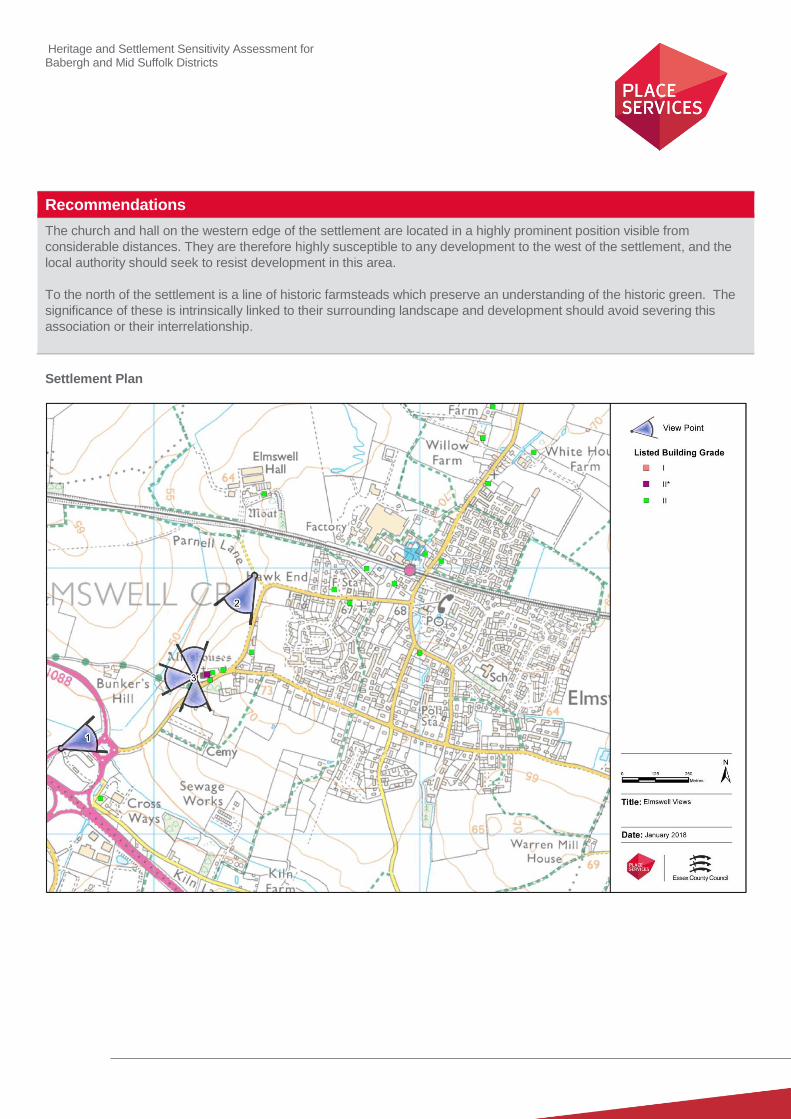
The church and hall on the western edge of the settlement are located in a highly prominent position visible from
considerable distances. They are therefore highly susceptible to any development to the west of the settlement, and the
local authority should seek to resist development in this area.
To the north of the settlement is a line of historic farmsteads which preserve an understanding of the historic green. The
significance of these is intrinsically linked to their surrounding landscape and development should avoid severing this
association or their interrelationship.
Settlement Plan
Heritage and Settlement Sensitivity Assessment for Babergh and Mid Suffolk Districts
Settlement Name: Eye District: Mid Suffolk
Settlement Description:
Eye is a small town sited on higher ground to the west of the River Dove. The historic core of the town is laid out in an
irregular oval shape, which follows the line of the original outer bailey around the castle, which is sited in the centre of the
settlement. The historic settlement contains a large number of listed buildings, including a number listed grade I or II*. To
the north of the settlement there is an outlying group of listed buildings located around Langton Green to the north. The
church is sited at the eastern edge of the settlement, close to the River Dove. Across the river, outside the town to the
east, are the remains of Eye Priory. There has been modern infill to the settlement, some to the west, but the majority to
the north, including development which subsumes the historic group of buildings at Langton Green.
Summary History:
The name ‘Eye’ is derived from the Old English word for ‘island’, reflecting the position of the original settlement on higher
land surrounded by the river and marshland. The earliest evidence of settlement in Eye dates from the Roman period¸ but
the evidence prior to the early medieval period is relatively scarce. Documentary evidence does however show that
immediately prior to the Norman conquest, Eye was one of the numerous holdings of Edric of Laxfield, a wealthy and
influential Saxon and the third largest land holder in Suffolk.
After the conquest, Eye was granted to William Malet, who by 1071 had constructed a castle, to establish his military and
administrative headquarters. He also initiated a market, which led to the establishment of the settlement. Later in 1086-7,
Robert Malet, William’s son, founded the Benedictine Priory of St Peter, a cell of the Abbey of Bernay in Normandy. The
Abbey (now a private house) occupies the site where this was situated, but there are very few remains of the priory still in
existence. In 1173 the castle was attacked by Hugh Bigod, Earl of Norfolk, during the rebellion against Henry II, It was
attacked again during the Barons’ War of 1265 after which it never regained its former status.
The castle was gradually demolished during the 14th century, though its prison continued in use until the early 17th
century. A windmill was built on the motte in 1561-2, which remained until it was demolished in 1844 to be replaced by a
stone dwelling, built by the then owner Sir Edward Kerrison for his batman. It was designed to resemble a shell keep and
was constructed in flint. This remains in situ today, albeit as a ruin. The extent of the associated land is still readable, as
Castle Street and Church Street trace the elliptical shape of the former outer bailey.
There is documentary evidence that there was a church in Eye as far back as 1066. The current Church of St Peter and
St Paul, dates from the 14th century, but retains a 13th century doorway from a previous church. It was restored in 1868,
and includes an exceptionable rood screen added in 1925 by Sir Ninian Comper. The Guildhall lies directly adjacent to the
church, the fabric of which dates to the fifteenth century, but which was rebuilt in 1875.
The settlement fell on a railway branch line, which spurred from the main line at Mellis and opened in 1866, and was the
shortest branch line in the Great Eastern Railway area. It closed in 1964.
Historic Environment Designations
Conservation Area:
Eye Conservation Area

Heritage and Settlement Sensitivity Assessment for Babergh and Mid Suffolk Districts
Listed Buildings: within the village
Grade I: Grade II*: Grade II:
Scheduled Monument:
SM 1019669 Remains of motte and bailey castle
Registered Park and Garden:
None
Landscape Designations
AONB:
None
SSSI:
None
SAC:
None
Ancient Woodland:
None
Key Characteristics
Settlement:
Note: The key positive features or qualities, which if lost or changed there would be a significant consequence for the
current character.
The appearance and character of the settlement is strongly defined by the fact that it is built around the castle and its
associated outer Bailey. This outer bailey defines the historic street pattern in the core of the settlement, and is still
readily identifiable when perambulating the streets. These streets have a heavy concentration of listed buildings, which
allow an understanding of the continuous built evolution of Eye through the centuries
The visual appearance of the street is defined by a relatively limited palate of materials, the majority being brick and
render. Flint is also used, but mainly on the more high status buildings, including the church, which forms part of an
important ecclesiastical complex of buildings at the eastern edge of the site.
The extent and survival of the historic built form has served to create relatively narrow roads and streets with built form
close to the edge of the pavements and few breaks within the building line.
3 4 130
Heritage and Settlement Sensitivity Assessment for Babergh and Mid Suffolk Districts
Surrounding Landscape:
Note: The key positive features or qualities, which if lost or changed there would be a significant consequence for the
current character.
The Benedictine Priory of St Peter is a high status complex, sited to the east of the settlement, of which some elements of
the built form survives. An association with this complex has defined the character of the landscape around it, and
cartographic evidence also suggests the associated fish ponds to the east of the complex are still discernible. The abbey
sits on the edge of the flood plain of the River Dove on relatively low lying land, which physically separated it from the
settlement. This important separation remains today.
The landscape to the south of the settlement is relatively low lying, and is defined by the course of the River Dove and by
a series of historic drainage ditches. Modern development to the north and south has divorced the settlement from its
wider landscape to the west and north.
Key Views
Note: The key views towards, through, across and away from the settlement
1. View along Hoxne Road (B1117) looking west from the Abbey, across the floodplain into the historic settlement.
This view not only highlights the important physical separation of the abbey from the settlement but also the
visual prominence of the church and the castle both of which were intentionally sited on higher ground.
2. View from the church looking East out of the settlement towards the Abbey. This allows an understanding of the
importance of the inter-relationship of the church and Priory, sited either side of the intervening water meadow.
3. View looking in a complete circular radius from the castle motte. These views not only allow an understanding of
the historically central position of the castle within the settlement, but allow important views of the interrelationship
of the historic built form within the core of the town.
4. Looking south into the historic settlement from Lambseth Street. This was the northern entrance to the town,
however, modern expansion to the north and north-west has eroded the significance of this view.
5. Views within the historic core along Castle Street, Broad Street and Church Street. These views allow a good
understanding of the historic street pattern which is defined by the outer Bailey containing an extensive range of
listed buildings, the church guild Hall and the Motte and Bailey Castle.
Value
Note: Based on designation status (including setting of AONB/heritage assets, relationship of the settlement to the
heritage assets), local or community interest or use (access/enjoyment & amenity value), setting for the wider settlement.
Condition/rarity/quality.
The compactness and completeness of the historic core means that the settlement is of very high value, particularly as it
has seen only minimal areas of modern infill. It is also noted that the historic core includes a high number of listed
buildings including several of exceptional significance including the church and the guild hall on the eastern edge of the
settlement. The street pattern is also of high value, as it not only preserves the medieval layout of the town, but it also
preserves an understanding of the layout of the castle and outer bailey. The latter is a rare survival of high significance.

Heritage and Settlement Sensitivity Assessment for Babergh and Mid Suffolk Districts
The Church of SS. Peter and Paul and the Priory of St. Peter are both assets of high value, and have an important
interrelationship. The open nature of the landscape to the east of the settlement which preserves the historic relationship
between the settlement and the Priory complex is therefore also highly significant.
Susceptibility
Note: The ability of the receptors (features, qualities, characteristics, condition) to accommodate the changes without
undue consequences for the maintenance of the baseline.
The settlement is of varying susceptibility which can be best defined on a geographical basis. The area to the east of the
settlement, particularly that between the Priory and the church is highly sensitive to change, as is the relatively
undeveloped southern edge of the settlement. To the north and north west there is a considerable amount of modern
development which has eroded the understanding of the historic settlement edge, in particular this modern development
has completely eroded the historic separation between Eye and the hamlet at Langton Green to the north. The
significance of the listed buildings around Langton Green has been further harmed by piecemeal modern development
which circles them. This northern edge of the settlement is therefore considered to be of lower susceptibility.
Potential Enhancement
Note: Areas that could potentially be improved or enhanced.
The Castle is an asset of high significance, the value of which could be enhanced, with a more proactive management
strategy and further interpretation.
Recommendations
The landscape to the east of the settlement preserves the important association between the church and Priory and is
therefore highly susceptible to modern development. The northern and western boundaries of the historic core have
already seen large areas of modern development and it is recommended that any further development is located adjacent
to these areas.

Heritage and Settlement Sensitivity Assessment for Babergh and Mid Suffolk Districts
Settlement Plan
Heritage and Settlement Sensitivity Assessment for Babergh and Mid Suffolk Districts
Settlement Name: Fressingfield District: Mid Suffolk
Settlement Description:
The core of the village was historically centred around the medieval church of St. Peter and St Paul, with a complex of
buildings associated with a mid-fourteenth century hall house situated to the north. There is an east-west road which runs
to the south of the settlement and a road which runs north-west to south-east at the northern end. The centre of the
settlement, which includes the church and a historic public house of early sixteenth century construction, is set between
two north-south roads, which give the impression of an historic marketplace to the south of the church. There are several
important houses of grander scale outside the settlement boundary, including a moated farm complex to the south-east,
and Fressingfield Hall, a manorial farmhouse of seventeenth century construction to the east. The settlement does not
contain a large number of listed buildings, but those which do survive are of high significance, given the high
concentration which are listed grade I and grade II* and the survival of such a high number of early manorial complexes.
The historic core has been partially subsumed by later modern development to the west, and to a lesser extent the south
and east.
Summary History:
The oldest section of the surviving historic core of the settlement would appear to date from the fourteenth century, with
manorial complexes located with the centre of the village and at Tithe Farm to the south-east. However, the village was
referred to as Fessefelda in the Domesday Book of 1086, which etymologically would suggest the settlement to be of
Saxon origin.
The Manor of Whittingham, located to the north-east of the settlement was granted the right to a market in 1267. This right
was transferred to the centre of the village by 1550, perhaps at a similar time to the construction of the Fox and Goose
public house, which documentary evidence places to 1509.
Pevsner suggests that this was a ‘church house’ associated with the adjacent medieval parish Church of St. Peter and St.
Paul and St. Paul. This forms part of a wider group of buildings within the core of the settlement associated with the
church, including Church Farm to the west of the church, and the Vicarage to the north-east.
Both Tithe Farm to the south-east and the hall house within the centre of the village exhibit a high quality of timber
framing, which would appear to be indicative that they were of high status, and that Fressingfield was relatively affluent as
a settlement. The insertion of a floor into this latter hall house in the sixteenth century would suggest it was still occupied
at this period, and the construction of what is now the Fox and Goose PH would suggest that the village remained affluent
into the early modern period. It is not clear whether the fact that this hall house became redundant for a residential use
was indicative of a wider downturn in the fortunes of the village or simply of an individual family.
Fressingfield Hall was constructed in the early seventeenth century, and survives as an impressive manorial farmhouse,
suggested in the list entry to be a particularly fine example of its type and date. The site is partly enclosed by a medieval
moat, suggesting it replaced an earlier building on the site.
The settlement shows evidence of expansion during the nineteenth century, as well as a relatively active dissenting community, both of which are evidenced by the construction of a Baptist chapel in 1835. However the majority of the more recent built form within Fressingfield dates to the twentieth and twenty-first centuries, which is particularly evident on the western approach into the village.

Heritage and Settlement Sensitivity Assessment for Babergh and Mid Suffolk Districts
Historic Environment Designations
Conservation Area:
Fressingfield Conservation Area
Listed Buildings: within the village
Grade I: Grade II*: Grade II:
Scheduled Monument:
None
Registered Park and Garden:
None
Landscape Designations
AONB:
None
SSSI:
Located to the east of the settlement area
SAC:
None
Ancient Woodland:
None
Key Characteristics
Settlement:
Note: The key positive features or qualities, which if lost or changed there would be a significant consequence for the
current character.
The central historic core is of unusual layout, and incorporates an important cluster of buildings associated with the
Church of St. Peter and St. Paul. These buildings are high significance and their interrelationship is still visually and
physically evident. However, the overall character of the settlement has suffered heavily from considerable amounts of
unsuitable modern development, particularly to the west and south of the settlement. There is also a considerable amount
of infill development, the most harmful being that around Church Farm Stable, the medieval hall house to the north-west
of the church.
The settlement is situated in a small valley, and is therefore relatively hidden in longer views. However, the church sits on
an isolated higher section making it prominent in the landscape, particularly in views from the north along Harleston Hill.
2 2 19

Heritage and Settlement Sensitivity Assessment for Babergh and Mid Suffolk Districts
Surrounding Landscape:
Note: The key positive features or qualities, which if lost or changed there would be a significant consequence for the
current character.
The settlement sits within a lower section of the surrounding landscape, which is fundamentally agricultural in character.
This character is evident in the fact that the settlement is surrounded by several historic farm complexes, as well as two
medieval moated sites (both of which contain grade II* buildings). These latter two retain their deliberate historic
separation from the settlement edge.
Key Views
Note: The key views towards, through, across and away from the settlement
1. Long view of the church looking north from Stradbroke Road. This view highlights not only the visual prominence
of the church in long views, but also the intrusion of modern development on the historic character of the
settlement.
2. Inter-related views between the church and Fox and Goose Public House, which was formerly the church house.
This view not only emphasises their historic association, but also makes a significant contribution to the historic
character of Fressingfield.
3. Long views from east from Laxfield Road. This is a second view which allows an understanding of the visual
prominence of the church in long views, and the visual incursion of the modern development.
4. View from the north from Harleston Hall. This emphasises both the location of the settlement within the lower
section of the valley and the prominent siting of the church. It is also the view into which modern development
intrudes the least. The church is particularly prominent in this shorter view, but it is also visible for more than half
a mile along this road.
Value
Note: Based on designation status (including setting of AONB/heritage assets, relationship of the settlement to the
heritage assets), local or community interest or use (access/enjoyment & amenity value), setting for the wider settlement.
Condition/rarity/quality.
The complex of buildings associated with the church within the centre of the settlement, including the grade I listed church
and grade II* listed church house, represents an important and significant survival, the value of which is very high. The
landscape to the east of the settlement also includes two surviving moated hall complexes, with a third more heavily
altered hall complex surviving within the western edge of the settlement. These are also of high value, and emphasise the
affluence of Fressingfield and its agricultural landscape.
However there has been a considerable degree of modern development within the settlement, particularly to the west and
south, which has altered its historic character, and the setting of several significant heritage assets. This has heavily
impacted on the overall value of the settlement, especially given its extent, location and visual prominence.
Susceptibility
Note: The ability of the receptors (features, qualities, characteristics, condition) to accommodate the changes without
undue consequences for the maintenance of the baseline.
The core of the settlement was highly susceptible to inappropriate modern development and inappropriate alterations to
key buildings within the conservation area. However in several areas this inappropriate development has already
Heritage and Settlement Sensitivity Assessment for Babergh and Mid Suffolk Districts
occurred, such as in the vicinity of the hall complex on the western side of the conservation area, which therefore
diminishes its susceptibility.
Nonetheless there are areas or assets which are still highly susceptible to change, most specifically the Church of St.
Peter and St. Paul. This was sited so as to be visually prominent in long views, and this is a characteristic which has been
retained, albeit with modern intrusion in views from the south and east. It is therefore susceptible to further modern infill
which would sever or further intrude on these longer views, especially to the north of the settlement, but also from the
south and east.
As noted above, a considerable amount of value is also attributed to the interrelationship between the Church and the Fox
and Goose PH, and any development which would intrude on this relationship would also be harmful to the significance of
both of these assets.
Finally there are two surviving hall complexes to the east of the settlement, both of which are of high status construction
and which have been deliberately sited outside the settlement within the wider associated landscape. This separation is
integral to understanding their historic significance, and these complexes are therefore susceptible to change which would
integrate them within, or conjoin them with, the boundary of the settlement.
Potential Enhancement
A potential enhancement to preserve the character and appearance of the conservation area would be to introduce an
Article 4 Direction to restrict permitted development rights in relation to windows, doors etc. This would help to address
the current spread of inappropriate detailing and materials within the conservation area.
Recommendations
The historic core has already seen several areas of inappropriate modern development and the Local Authority should
seek to avoid further exacerbating this harm. To the east of the development are two isolated moated sites the
significance of which is partially derived from their location outside the boundary of the settlement. Development between
the eastern boundary and these two sites and the settlement should be avoided. The land to the south and south east is
of lower susceptibility and any additional development should be placed here but should still consider the setting of
buildings such as Redhouse Farm. The church is particularly prominent in views from the north, due to its position within
the wider landscape. Long views of the church will need to be considered in relation to any proposed development or site
allocations to the north of the settlement.
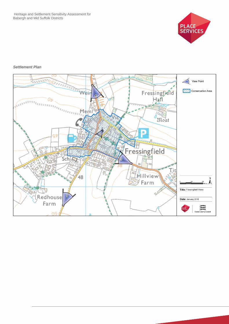
Heritage and Settlement Sensitivity Assessment for Babergh and Mid Suffolk Districts
Settlement Plan
Heritage and Settlement Sensitivity Assessment for Babergh and Mid Suffolk Districts
Settlement Name: Great Blakenham District: Mid Suffolk
Settlement Description:
Great Blakenham is a small village to the north-west of Ipswich, located on the west bank of the Gipping River and
separated from the neighbouring village of Claydon by the river and the A14. The historic core is small, comprising a
cluster of buildings at the northern end of the modern settlement, congregated around St Mary’s Church and The Rectory.
Great Blakenham Hall is sited on the outskirts of this group, close to the river. There are other listed buildings sited along
the main road, albeit interspersed amid modern development. Historically there was a second cluster of buildings at the
southern end of the modern village, which included Claydon Station, Blakenham Lodge and on Sandy Lane a Baptist
Chapel and a small number of cottages, but all have since been demolished.
The surrounding landscape is heavily dominated by the residue of mineral extraction, for which there is evidence as far
back as the 1st edition Ordnance Survey map, on which a number of gravel and chalk pits are depicted. One such quarry,
Column Field Quarry, now forms the western edge of the settlement. There has been extensive gravel extraction in the
Gipping valley, meaning that the north-eastern side of the village is now marked by flooded gravel-pits. To the north-west
of the settlement there is surviving ancient woodland.
There is a large area of modern housing, which is largely concentrated around the historic core in the northern half of the
village. The remainder of the settlement area, particularly on the southern and western sides of the settlement, is
characterised by a large number of large-scale industrial units, including the newly opened incinerator.
Summary History:
The earliest evidence for settlement in Great Blakenham dates to the prehistoric period, in the area of the modern Orion
Business park. There also appears to have been a focus of Roman and Saxon activity at the northern end of the modern
village, in the area around Tollgate Farm and to the immediate north of Great Wood.
The first documentary evidence relates to Saxon occupation, when the manor was held by Leofstan, commended to the
abbot of Ely, before the Conquest. By the compilation of the Domesday Book in 1086 it was held by Albert from Roger de
Poitou. A second, slightly smaller manor was held by thegn Aelfric before the Conquest and by William d’Ecouis in 1086,
and included a church with one acre.
Walter Gifford, Earl of Buckingham, gave the manor of Blakenham to the Benedictine abbey of Bec in the reign of William
II, these passed to Eton College when the priory was dissolved in the sixteenth century. The Parish Church of St Mary
(Grade I) is 12th century in origin, with 13
th century additions. It was restored in the 1870s. Evidence from excavation
suggests that this church formed the centre for one medieval foci, with Great Blakenham Hall sited between the church
and the River Gipping, A second medieval foci was located in the area now in use for the Great Blakenham Waste Site.
The nineteenth century saw the introduction of the railway and the building of Great Blakenham railway station. It also
saw the construction of a number of public buildings including the primary school and the Baptist Chapel, as well as few
small brick-built terraced cottages. Quarrying appears to have originated in the area in the Roman period and continued
on a larger intermittent piecemeal basis until the early 20th century, when it expanded greatly in scale. In 1912 Mason’s
Cement Works was founded, this was bombed during World War II and closed in 1999. The quarrying to the west and
north-east of the village largely dates to the post-war period.

Heritage and Settlement Sensitivity Assessment for Babergh and Mid Suffolk Districts
Historic Environment Designations
Conservation Area:
None
Listed Buildings: within the village
Grade I: Grade II*: Grade II:
Scheduled Monument:
None
Registered Park and Garden:
None
Landscape Designations
AONB:
None
SSSI:
None
SAC:
None
Ancient Woodland:
Great Wood (forms northern boundary of settlement area)
Key Characteristics
Settlement:
Note: The key positive features or qualities, which if lost or changed there would be a significant consequence for the
current character.
The vast majority of the settlement of Great Blakenham is characterised by modern housing and twentieth century
industrial and commercial development. The only concerted area of surviving historic built form relates to the historic
complex of buildings centred on the church at the northern end of settlement, which also include the vicarage and the
parish rooms, and Great Blakenham Hall located further to the east. There would also appear to be isolated areas of
nineteenth and early twentieth century houses along the main axial road, but these are predominantly subsumed within
the modern development.
1 0 3
Heritage and Settlement Sensitivity Assessment for Babergh and Mid Suffolk Districts
Surrounding Landscape:
Note: The key positive features or qualities, which if lost or changed there would be a significant consequence for the
current character.
The surrounding landscape is dominated by quarrying, the modern road network, the modern industrial estates and the
railway, and has therefore lost much of its historic character. However, there are still some areas of the historic landscape
still discernible, including the Ancient Woodland to the north west of the settlement, which has the potential to contain
historic earthworks. The River Gipping is a prominent feature to the east of the settlement, and is a significant feature in
the landscape, not least because it is likely to have been a determining factor in the siting of the church and hall.
Key Views
Note: The key views towards, through, across and away from the settlement
1) Views of the church and its associated vicarage in short views from directly to the west. This is the only view in
which the historic complex can be understood and experienced, as the extent and scale of the twentieth century
residential and industrial development has obscured virtually all other views of these heritage assets.
2) View looking west from Stowmarket Road towards Great Wood. This is the main surviving view in which the
woodland is appreciated, as there is a modern static caravan development to the east.
Value
Note: Based on designation status (including setting of AONB/heritage assets, relationship of the settlement to the
heritage assets), local or community interest or use (access/enjoyment & amenity value), setting for the wider settlement.
Condition/rarity/quality.
The value of the settlement of Great Blakenham is low, and has been significantly curtailed by modern development.
Whilst there are individual designated and undesignated assets which have value in their own right, this significance
derives from the architectural and historic significance of their fabric, and their immediate interrelationship, rather than
from their wider setting.
Susceptibility
Note: The ability of the receptors (features, qualities, characteristics, condition) to accommodate the changes without
undue consequences for the maintenance of the baseline.
As the value of the designated heritage assets is considered to reside mainly in the buildings and their immediate
surroundings, their susceptibility to further development is considered to be low. The woodland is an ancient feature,
susceptible to physical incursion. Any development would need to consider the likelihood of surviving boundary features,
and the surviving views of the woodland from the road, both of which have a minor susceptibility to change.
Potential Enhancement
Note: Areas that could potentially be improved or enhanced.
None identified.

Heritage and Settlement Sensitivity Assessment for Babergh and Mid Suffolk Districts
Recommendations
The settlement is of low susceptibilty from a heritage perspective, and there is a low potential for development to result in
harm to the identified heritage assets. The exception is the ancient woodland to the north of the settlement, and it is
recommended that the current surviving boundary of the historic woodland should be enhanced by an appropriate buffer if
development is proposed in this area.
Location Plan
Heritage and Settlement Sensitivity Assessment for Babergh and Mid Suffolk Districts
Settlement Name: Haughley District: Mid Suffolk
Settlement Description:
Haughley is located about 3 miles north-west of Stowmarket, just north of the A14. The settlement is situated on a slight
ridge overlooking the Gipping River to the south and a tributary to the east, with the land sloping from north to south. The
highest point falls at the north-western edge of the settlement, and this is occupied by a Norman motte and bailey castle,
which makes the most of the topography to fortify its military and administrative power.
The Church of St Mary the Virgin has its origins in the fourteenth century, and is situated within the outer bailey of the
castle to the south. The settlement extends down the slope to the south-east along Old Street, with the historic green at its
north-western end. There is considerable historic built form along Duke Street, which is likely to have historically fallen
inside the outer bailey, which may have followed the line of The Folly.
The settlement has extended considerablely in the past century, with large areas of twentieth century development to the
east and south-east.
Summary History:
The earliest archaeological evidence of inhabitation comes from prehistoric worked flints and Roman pottery. Late Saxon
pottery has been found, and this suggests that there was a settlement on the site by the Saxon period. The name of the
settlement derives from the Old English Hagula, meaning ‘a wood or clearing with a hedge or where haws grow’. It is
recorded as such in the Domesday Book, which also offers evidence that it was a significant manor, the overlord in 1066
being King Edward the Confessor, but by 1086 the principal tenant was Hugh de Montfort, who was Duke William’s
constable in Normandy, and took part in the Battle of Hastings. Amongst titles he was granted the Honour of Haughley,
suggesting that Haughley was a major administrative centre.
Hugh de Montfort built the substantial motte and bailey castle at the northern edge of the settlement, which is suggested
to have been constructed on the site of a Saxon Hall. Evidence suggests that the keep and palisade were originally
constructed in timber, but it is recorded as having been rebuilt in stone by Henry of Essex in the mid-twelfth century. The
castle is of considerable size and occupies a dominant location, which perhaps explains why the land and castle was
seized by Henry II in 1163. The castle itself was destroyed in 1173 by Robert de Beaumont, the Earl of Leicester during a
rebellion against Henry II by his son Henry the Young King. The rebellion ultimately ended in failure, but the castle was
never rebuilt. A farm complex was erected on the western edge of the site, in or by the seventeenth century.
The Church of St Mary the Virgin is located to the north-west of the settlement, within the former outer bailey of the castle.
The earliest surviving sections dating to the fourteenth century. It forms a series of listed buildings on Duke Street at the
north-western edge of the village green, the majority of which date from the sixteenth and seventeenth centuries. The
expansion of built form within the settlement around this period is corroborated by the similar dating of the built form along
Old Street and around The Green.
Historic Environment Designations
Conservation Area:
Haughley Conservation Area
Listed Buildings: within the village
Grade I: Grade II*: Grade II:
1 32

Heritage and Settlement Sensitivity Assessment for Babergh and Mid Suffolk Districts
Scheduled Monument:
Motte and Bailey no. 1006069
Registered Park and Garden:
None
Landscape Designations
AONB:
None
SSSI:
None
SAC:
None
Ancient Woodland:
None
Key Characteristics
Settlement:
The character of the historic core of the settlement is relatively intact, and is centred around two main foci, the church and
green, and the remains of the motte and bailey castle further to the north-west. The historic core of the settlement is linear
in character, with a main road running south east to north west which widens as it reaches the village green. There is a
further area of linear built form to the north-west, running east-west along Duke Street. The built form is set back from the
edge of the road and characterises an historic core which is relatively visually and physically unaltered, with only small
areas of modern infill intruding on its character.
The castle occupies a prominent location on higher ground, and its siting and form still informs the configuration of the
roads through the centre of the village. These roads give evidence for the historic boundary of the outer bailey of the
castle, as do the two main routes into the settlement from the south (The Folly and Fishponds Way), which would seem to
tie in with this historic configuration.
There has been a considerable swath of modern development on the eastern side of the settlement, which has
considerably increased the size of Haughley.
Surrounding Landscape:
The settlement is located on high ground on the northern slopes of the river valley, with the land dropping away from the
settlement into the flood plain to the south. The rest of the surrounding landscape is agricultural in nature, characterised
by dispersed farmsteads.
Heritage and Settlement Sensitivity Assessment for Babergh and Mid Suffolk Districts
Key Views
Note: The key views towards, through, across and away from the settlement
1. Long views looking north looking across the A14 towards the church, which highlight the prominent siting of the
church within the wider landscape. It also gives an indication as to how prominent the motte and bailey would
have been.
2. Views looking north-west up The Street through the village looking towards the green and church, which
highlights the architectural and historic character of the historic core of the settlement.
3. Shorter views looking across the Green to the Church, which allow an understanding of the interrelationship
between the important historic assets around a historically significant central open area.
4. View looking towards the Motte and Bailey and church from the north east and north-west. These more
immediate views allow the best understanding of the scale and presence of this asset, and therefore a better
understanding of its historic significance.
Value
Note: Based on designation status (including setting of AONB/heritage assets, relationship of the settlement to the
heritage assets), local or community interest or use (access/enjoyment & amenity value), setting for the wider settlement.
Condition/rarity/quality.
The completeness and quality of the surviving built form, and of the undeveloped survival of the central green, mean that
the settlement is of high value. The motte and bailey castle is a particularly important survival, forming part of a chain of
early medieval fortifications in East Anglia. It is also of particular value in relation to the ability to understand its historic
extent within the surviving settlement pattern, which is an important and rare survival. The centre of the settlement
therefore represents a well preserved historic core, which preserves an understanding of the Norman and early
Plantagenet plan form of the settlement, with a well preserved group of medieval and early modern built form.
The large area of modern development to the east however is not of historic significance and is therefore considered to be
of low value.
Susceptibility
Note: The ability of the receptors (features, qualities, characteristics, condition) to accommodate the changes without
undue consequences for the maintenance of the baseline.
The susceptibility of the historic core of the village (that which is contained within the conservation area) is high due to the
extent of surviving built form and the relative lack of modern incursion. Similarly, the survival of the motte and bailey at
the northern end of the settlement and the relative lack of modern incursion along both its northern and western edges
makes these boundaries highly susceptible to development. However, the large quantity of modern development which
encompasses much of the eastern edge of the conservation area makes the south eastern and eastern side of minimal
susceptibility.
Potential Enhancement
Note: Areas that could potentially be improved or enhanced.
The area of the motte and bailey castle excludes areas of its historic extent. It is suggested that the scheduling of the
castle complex should be recommended to be reviewed to ensure that the whole complex is protected, rather than at
present just the mound and associated ditch. The area of the associated moated site to the west should be considered to
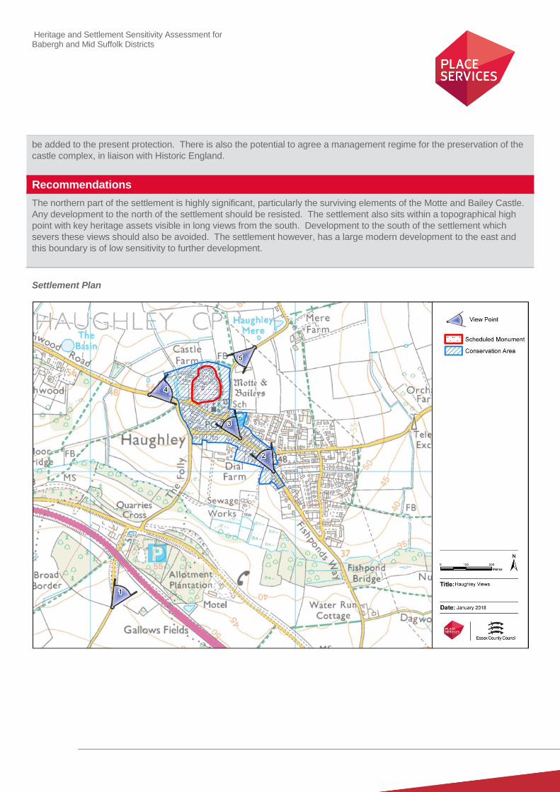
Heritage and Settlement Sensitivity Assessment for Babergh and Mid Suffolk Districts
be added to the present protection. There is also the potential to agree a management regime for the preservation of the
castle complex, in liaison with Historic England.
Recommendations
The northern part of the settlement is highly significant, particularly the surviving elements of the Motte and Bailey Castle.
Any development to the north of the settlement should be resisted. The settlement also sits within a topographical high
point with key heritage assets visible in long views from the south. Development to the south of the settlement which
severs these views should also be avoided. The settlement however, has a large modern development to the east and
this boundary is of low sensitivity to further development.
Settlement Plan
Heritage and Settlement Sensitivity Assessment for Babergh and Mid Suffolk Districts
Settlement Name: Hoxne District: Mid Suffolk
Settlement Description:
Hoxne is an irregularly shaped settlement with two primary foci, one at Hoxne Low Street and one around Cross Street
and Heckfield Green. The two settlement areas sit on two spurs of higher ground separated by the Goldbrook River and
its associated flood plain. The river and its tributary stream are crossed by two bridges (the Swan Bridge and Gold
Bridge).
Hoxne Low Street is the northernmost element of the settlement and includes the parish Church of St. Peter and St. Paul,
with its associated vicarage, set within a moated site. The church has a fine Perpendicular tower, as well as important 14th
century wall-paintings This group is located on the northern side of a probable former triangular green, which was largely
built up by the time of the 1st edition Ordnance Survey map. Hoxne Hall fell to the immediate west of the settlement, and
was replaced by a later house, Oakley Park, which was demolished in the twentieth century.
Cross Street is located to the south, and is a small linear settlement, set along the main road. The moated site of the
Hoxne Priory is located at the northern end of the settlement. Further to the south is Heckfield Green, historically a
separate small hamlet focused on a green at the road junction, but now joined to Cross Street by modern development.
Summary History:
The settlement of Hoxne is of considerable archaeological importance. It is the location of the type-site for the Hoxnian
interglacial period (c. 425,000-375,000 BC), the period which has the earliest evidence for early humans in Britain.
Hand-axes made by the ancestors of the Neanderthals have been recovered from Hoxne Brick Pit as well as important
environmental data relating to this earliest period of human occupation. The pit is a geological SSSI, but it has been
partially filled in and a house built on part of it.
It also has important evidential value for the Roman occupation of Britain. In 1992 a metal detectorist discovered a major
hoard comprising of 14,865 Roman coins and over 200 silver and gold artefacts. The Hoxne Hoard, which is now in the
British Museum, is the largest hoard of Roman silver and gold in Britain, and the largest discovery of silver and gold
coins from the entirety of the Roman Empire in the UK.
The settlement also has important Saxon connections. Most significantly Gold Bridge is suggested as the site where
Saint Edmund, the King of East Anglia was captured and executed by the Danes, although the death of St. Edmund is
so bound up with hagiography and early-Christian propaganda, that it is difficult to corroborate exact details. This has
had a significant impact on the later history of Hoxne, including being the reason for the construction of a bishop’s
palace and a priory in the settlement. This connection is still reinforced by the incorporation of a roundel and statue of
the saint into the Village Hall when it was constructed in 1879, and by the memorial on Abbey Hill, a stone cross erected
in 1907 supposedly on the site of the tree against which St Edmund was martyred.
There is documentary evidence from a will that an episcopal see was established in Hoxne by the middle of the 10th
century, which entrenched the settlement’s association with the Bishops of East Anglia, who had a residence in the
settlement as well as a chapel. The moated site at the northern end of Low Street is now occupied by a vicarage of
fifteenth and sixteenth century construction. However the size and extent of the moat, and the area contained within,
are indicative of a more substantial residence, and it is therefore likely to be the site of the bishop’s palace. The Swan
PH at the southern end of Low Street was formerly the Bishops Lodge, built in 1480 by the Bishops of Norwich, which
highlights not only the continued episcopal presence in the area, but also the extensive nature of their holdings.
The hall would appear to form part of an important church-hall complex with the Parish Church of St Peter and Paul
directly to the south. The current church predominately dates to the fifteenth century, which was restored and partly rebuilt
Heritage and Settlement Sensitivity Assessment for Babergh and Mid Suffolk Districts
in the nineteenth century. Given the evidence for the episcopal residence from the tenth century however, it is likely that
the current church is located on the site of an older church. This complex sits to the north of the historic triangular green
around which Low Street developed. This was historically larger, but was curtailed by development on its northern half,
which had taken place by the late 19th century.
Further to the south, in Cross Street, Hoxne Priory was established as a cell of the Benedictine priory at Norwich, and was
centred on a chapel to St. Edmund. There is documentary evidence for its existence in the eleventh century, and it is
suggested within the scheduling that it may pre-date the Norman Conquest in its establishment. It was demolished by the
mid-sixteenth century, and the current Abbey Farmhouse was constructed on the site of the principal buildings. The
earliest section of this building surviving is dated to 1540, and this ties into the dissolution and demolition of the priory in
the religious upheavals of the English Reformation. The surviving section of flint wall, and the extensive fishponds and
dovecotes within the surrounding landscape, would however suggest that the priory was relatively affluent. Most of the
Priory is Scheduled, whilst Abbey Farmhouse is listed grade II*. The historic core of the hamlet of Heckfield Green was
focused on a small irregular shaped green at the road junction, where there are a number of Listed buildings. Cross
Street and Heckfield Green are now linked by modern development.
To the west of the village is Oakley Park, the site of the medieval manor house in Hoxne. The manor historically
belonged to the Bishops of Norwich, and the parkland had its origins as a medieval deer park, which is evidenced as
being in existence by 1326/27. The manor passed to the crown in 1535. The site was then occupied by Hoxne Hall, the
seat of the Maynard family. A neoclassical house was erected on the site in c.1825, which itself was demolished in 1923-
24, although its quadrangular stables still survive and were converted into a house in 2003-5.
Historic Environment Designations
Conservation Area:
Low Street Conservation Area and Cross Street Conservation Area
Listed Buildings: (Low Street)
Grade I: Grade II*: Grade II:
Listed Buildings: (Cross Street and Heckfield Green)
Grade I: Grade II*: Grade II:
Scheduled Monument:
Moated site at the Vicarage of St Peter and St Paul
Remains of Hoxne Priory at Abbey Farm
Registered Park and Garden:
None
1 1 27
1 18
Heritage and Settlement Sensitivity Assessment for Babergh and Mid Suffolk Districts
Landscape Designations
AONB:
None
SSSI:
Hoxne Brick Pit
SAC:
None
Ancient Woodland:
None
Key Characteristics
Settlement:
Note: The key positive features or qualities, which if lost or changed there would be a significant consequence for the
current character.
The core of Hoxne Low Street is formed of a number of historic buildings located on and around a former green, a small
portion of which survives, the rest having later been built upon. A significant group of buildings survive at the northern end
of this green, probably historically a church and moated hall complex, with the hall being later replaced by a vicarage.
These historic buildings are a mix of timber framed and brick built structures with a mix of tile and thatch utilised for
roofing material. These are mainly set on the outer edge of the historic green, fronting onto it. The roads at the northern
end are relatively narrow, but the character of the conservation area opens as it reaches the flood plain of the Gold Brook.
Cross Street and Heckfield Green are formed of two concentrations of listed buildings, those within Cross Street forming
part of a conservation area. Hoxne Priory falls at the northern end of Cross Street with a small group of listed buildings
located to the south. Heckfield Green is formed of a cluster of listed buildings, conjoined to Cross Street by an area of
modern development.
Surrounding Landscape:
Note: The key positive features or qualities, which if lost or changed there would be a significant consequence for the
current character.
The surrounding landscape is agricultural in character, populated with dispersed historic farmsteads. It also includes the
remnants of the historic parkland associated Oakley Park, which would also appear to preserve elements of a historically
important deer park associated with Hoxne Hall and the Bishops of Norwich. It is also important to note that there survives
an area of open land between Hoxne Low Street and Cross Street, preserving their historic separation.
Key Views
Note: The key views towards, through, across and away from the settlement
1. View towards the church and moated complex: This shows the prominent location of the church and moated hall
complex, which is sited on the ridge, and which are visible from long distances.
2. View from the church and moated complex: This again highlights the dominate position of the church and hall
over the green and the rest of the settlement.

Heritage and Settlement Sensitivity Assessment for Babergh and Mid Suffolk Districts
3. Looking west from Green Street towards church adjacent to new bungalows: This again shows the dominant
position of the church and its relationship to the vicarage
4. View looking south from the road junction into the village. This view allows an understanding of the historic
character of the core of the village.
5. View from lane running down into the settlement on the east side of the former Green: This again shows the
historic core and character of the village situated on and round the original Green on the slope above the Gold
Brook.
6. Views from the Swan bridge north into the settlement and south across the flood plain towards Cross Street. This
shows the historic core and its position within the wider topography.
7. View of Oakley Park on western side of settlement: This shows the historic inter-relationship between Hoxne
Park and the village.
8. View looking towards Cross Street from Gold Brook Bridge: This shows the inter-relationship of the flood plain
and the position of both historic cores on higher ground.
9. View Looking to Low Street and to the memorial to St Edmund This shows the inter-relationship of the flood plain
and the development on higher ground to the two historic cores as well as the prominent location of the memorial.
10. View into Cross Street showing the wall of Hoxne Priory/Abbey Priory: This allows an understanding of Hoxne
Priory and its relationship to wider settlement in Cross Street
11. View from the northern edge of Heckfield Green looking towards Abbey Farm. This demonstrates the rural setting
of the settlement and its location on a local high point
12. Wide views to the south and east from White House Farm. This also highlights the rural setting of the settlement
and its location on a high point of the surrounding land.
Value
Note: Based on designation status (including setting of AONB/heritage assets, relationship of the settlement to the
heritage assets), local or community interest or use (access/enjoyment & amenity value), setting for the wider settlement.
Condition/rarity/quality.
Hoxne is a poly-focal settlement of high value, with the three settlement areas still relatively clearly defined. It has a large
number of surviving historic buildings, several of which are evidently of high status, including the remnants of a former
priory, and a moated site to the north. The survival of this built form, and the below ground archaeological finds in the area
means that the settlement is exceptional for its evidential and historic value. The settlement also has important historic
associations with St. Edmund, most obviously physically preserved in the monument to him on Abbey Hill. The settlement
is also still experienced within its wider landscape, with which it has a strong interrelationship, particularly in relation to the
former deer park to the west. This enhances the ability to interpret its character and contributes to its value.
Susceptibility
Note: The ability of the receptors (features, qualities, characteristics, condition) to accommodate the changes without
undue consequences for the maintenance of the baseline.
Hoxne is formed of three distinct settlement groups, which were never historically conjoined. It is therefore susceptible to
any development which would unite these three foci into a single linear settlement. There are also several high status
buildings and complexes on the edge of these foci, including the church and hall complex at Hoxne Low Street and the
remnants of the Priory at the northern edge of Cross Street. The edge of settlement location of these assets, which are
sited to be both visually prominent and to emphasise their status, are susceptible to development which would envelope
them. Finally there is an important interrelationship between the settlement and Oakley Park to the west, and this
parkland is susceptible to development within or surrounding it, particularly that which would sever its relationship with the
settlement.

Heritage and Settlement Sensitivity Assessment for Babergh and Mid Suffolk Districts
Potential Enhancement
Note: Areas that could potentially be improved or enhanced.
None identified
Recommendations
The polyfocal nature of the settlement is important to its significance and is relatively well preserved. Both Hoxne Low
Street and Cross Street include groups of highly significant heritage assets at their northern end both of which would be
highly vulnerable to development. Given the relatively unaltered nature of the settlement, infill development should also be
resisted. The landscape to the west includes the historic deer park, later Oakley Park, and this landscape has important
historical associations with the ecclesiastical significance of Hoxne and the local authority should seek to resist
development in this area.
Settlement plan
Heritage and Settlement Sensitivity Assessment for Babergh and Mid Suffolk Districts
Settlement Name: Laxfield District: Mid Suffolk
Settlement Description:
Laxfield is a village located about half-way between the Suffolk market towns of Halesworth and Framlingham. The
historic settlement is linear in nature, running along the High Street, an axial east-west road. The historic core lies within
the north-eastern section of the present settlement, and is designated as a conservation area. There have however been
areas of development in the mid to late twentieth century, which have occurred to the south and west of the historic core.
Summary History:
There is evidence of Roman occupation in the area to the south of the settlement with a number of Roman finds being made in the adjacent fields. However the present settlement of Laxfield is Saxon in origin, with an early church recorded in the settlement. The village itself appears in the Domesday Book of 1086. The settlement grew in importance in the medieval period, and was granted a charter to hold a market in 1226.
The Church of All Saints stands on the northern side of the High Street, and was originally constructed in the fourteenth century, with construction being complete by 1488. The church is visually and architecturally unusual for Suffolk, first because the tower is faced in dressed stone as opposed to the more commonly seen flint, and second because the chancel and east end of the nave were entirely rebuilt in brick in the 1820s.
The relative significance of the settlement is seen in the construction of a guildhall opposite the church, which suggests that the market had made the settlement at least relatively affluent. This was constructed in 1520, and was restored in the 1960s. The remainder of the historic settlement is of linear form along the High Street and Market Street, dating to between the sixteenth and eighteenth century. The village and the surrounding area had a strong history of Puritanism during much of the 17th century. Perhaps most significantly it was the birthplace of William Dowsing, an English iconoclast who operated at the time of the English Civil War. Dowsing was a puritan soldier who was born in Laxfield, Suffolk, and who was a prominent iconoclast, who was appointed “Commissioner for the Destruction of Monuments of Idolatry and Superstition" in 1643, and whose career is well recorded due to the fact that his journal, which documented his work, has been preserved.
A station opened in Laxfield in 1904, which was the final station on the Mid-Suffolk Light Railway. It closed in 1952. The
twentieth century also saw large areas of modern development to the south and west of the historic core, which
comprises a mix of bungalows and two-storey, semi-detached properties. It also saw areas of infill between some of the
listed buildings.
Historic Environment Designations
Conservation Area:
Laxfield Conservation Area
Listed Buildings: within the village
Grade I: Grade II*: Grade II:
Scheduled Monument:
None
1 2 24

Heritage and Settlement Sensitivity Assessment for Babergh and Mid Suffolk Districts
Registered Park and Garden:
None
Landscape Designations
AONB:
None
SSSI:
None
SAC:
None
Ancient Woodland:
None
Key Characteristics
Settlement:
Note: The key positive features or qualities, which if lost or changed there would be a significant consequence for the
current character.
The core of settlement is mostly characterised by its linear character with an important collection of higher status
buildings, including the church and guild hall, located around the market square at the eastern end. The built form
throughout the settlement is relatively large in scale, set back from the edge of road, and is predominantly timber framed.
The historic character of the settlement has however been altered by the extent of modern development to the south and
west, which has resulted in a considerable increase in its size and has altered the visual character of these entrances into
the settlement.
Surrounding Landscape:
Note: The key positive features or qualities, which if lost or changed there would be a significant consequence for the
current character.
Laxfield is set into the lower section of the surrounding landscape which rises to the east, west and north. The
surrounding area is predominantly agricultural and open in nature, with several isolated farmsteads set on higher points
within the landscape.
Key Views
Note: The key views towards, through, across and away from the settlement
1. View along High Street towards the church and market place: This shows the linear nature of the settlement and
the historic positioning of the built form within their plots.
2. View along Vicarage Road and Bickers Road towards the Church of All Saints: These highlights the church’s

Heritage and Settlement Sensitivity Assessment for Babergh and Mid Suffolk Districts
dominant position within the settlement
3. View from Gorams Mill Lane looking south to the church: This view in particular emphasises the immediate
interrelationship between the open landscape and the historic church.
Value
Note: Based on designation status (including setting of AONB/heritage assets, relationship of the settlement to the
heritage assets), local or community interest or use (access/enjoyment & amenity value), setting for the wider settlement.
Condition/rarity/quality.
The historic core of the settlement, especially the group of highly significant buildings situated around the Market Place, is
of high value. These exhibit a high level of craftsmanship and allow an understanding of the historic form of the
settlement, which in places is a good example of a linear medieval village. However, this has been eroded across the
settlement as a whole, which has harmed the value of the historic core, and means that there are large areas of the
settlement of low significance.
Susceptibility
Note: The ability of the receptors (features, qualities, characteristics, condition) to accommodate the changes without
undue consequences for the maintenance of the baseline.
The inter-relationship of the conservation area and the open agricultural land to the north-east of is particularly important
in establishing the historic context of the settlement as well as making an important contribution to the setting in which the
church is experienced. This is therefore an area which is susceptible to change. Similarly where modern development has
not intruded, the relationship of the buildings along the High Street is significant and is sensitive to modern infill
development.
The ability to appreciate the historic boundary of the settlement has been lost to the west and south, but is retained to the
north and east. The development of land in these two directions would lead the settlement susceptible to be enclosed by
modern development which would divorce it from its agricultural setting and lessen the current ability to understand the
historic settlement plan
However there are also large areas identified as being of low value from a heritage perspective which are divorced from
the historic core. These areas are of low susceptibility.
Potential Enhancement
Note: Areas that could potentially be improved or enhanced.
None identified
Recommendations
The historic core contains assets and groups of assets of high value, including an architectural unusual church for its
regional context. This church and its surrounding landscape are susceptible to development within their immediate
vicinity, particularly to the north. The settlement however, has already considerably extended to the south and west and
could accommodate development in these areas without harm to any known heritage assets.
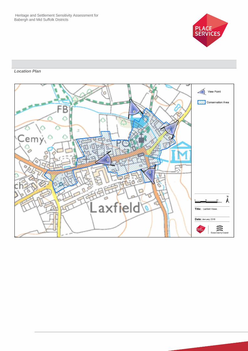
Heritage and Settlement Sensitivity Assessment for Babergh and Mid Suffolk Districts
Location Plan

Heritage and Settlement Sensitivity Assessment for Babergh and Mid Suffolk Districts
Settlement Name: Mendlesham District: Mid Suffolk
Settlement Description:
Mendlesham lies about 5 miles north-east of Stowmarket and to the west of the A140, a road which runs along the line of
the Roman Pye Road. The settlement is situated on the ‘High Suffolk’ claylands, on slightly higher ground between two
tributaries of the River Dove. There is a conservation area which encompasses the church and all but one of the listed
buildings within the settlement.
Summary History:
The earliest evidence within the settlement is a find of a Neolithic stone axe. A Roman quernstone was found near to the
church, and a number of Roman coins, metalwork and pottery sherds have come from outside the settlement area just to
the south-east. All of which suggests that the area was occupied during this period.
A Saxon bronze wrist clasp was found just to the east of Church Farm, suggesting later inhabitation, and the settlement
was definitely in existence by the late eleventh century, as it is recorded in Domesday Book as Mundlesham (meaning the
homestead or village of ‘Myndel’). This relates that the manor was held by Burghard in 1066, but that by 1086 it had
passed to King William. It is recorded in 1086 to have comprised of 45 households, and to have had a church.
The grade I Church of St Mary is located at the east end of the historic core and dates from the 13th century, with 14th
and 15th century additions. It was restored in the mid to late 19th century. There are a number of listed houses which date
from, or had their origins in, the 15th century, but other listed buildings in the historic core date mostly 16th or 17th
century, suggesting a rebuilding or expansion of the settlement in this period. The settlement is recorded as having a
market, the location of which has been suggested to be the area between Old Market Street and Front Street. This area
was certainly originally a market place or a green, but has been built up since at least the medieval period.
There are several farmhouses of varying dates located outside the settlement area, including Elms Farmhouse, which is
listed grade II*, and dates from the 15th century. To the east of the settlement is Mendlesham Manor a farmhouse of
sixteenth and seventeenth century construction, but which stands on the site of the historic manor house.
There was evidence of industry within the settlement, including a post-medieval mill located which is located just within
the settlement area on Mill Road, but has since been demolished.
The settlement expanded in the twentieth century, first in the 1950s to mid-1970s to the north of the historic core, but later
from the mid-1980s to 2000, housing was constructed to the south.
Historic Environment Designations
Conservation Area:
Mendlesham Conservation Area
Listed Buildings: within the village
Grade I: Grade II*: Grade II:
Scheduled Monument:
None
1 22

Heritage and Settlement Sensitivity Assessment for Babergh and Mid Suffolk Districts
Registered Park and Garden:
None
Landscape Designations
AONB:
None
SSSI:
None
SAC:
None
Ancient Woodland:
None
Key Characteristics
Settlement:
Note: The key positive features or qualities, which if lost or changed there would be a significant consequence for the
current character.
The historic core is located along two parallel east-west streets with a church at the eastern end and a moated manor
further to the east. To the south and west are several farm complexes with areas of modern development on the northern
and southern edges of the settlement. The parallel streets appear to enclose the location of the historic market place
near to the church.
This settlement plan is relatively well intact, as is the relationship between the church and the site of the manor hall. The
built form is linear in nature and set in close proximity to the road frontage. The dominant and relatively uninterrupted
nature of the historic built form, and the interrelationship between these assets, both within and outside the settlement, is
important to their historic character.
Surrounding Landscape:
Note: The key positive features or qualities, which if lost or changed there would be a significant consequence for the
current character.
The settlement is located within a rural agricultural landscape with dispersed farmsteads, a number of which contain listed
buildings. This includes the grade II* farmhouse at Elms Farm, which has been partially divorced from its historic setting
by its proximity to the immediately adjacent modern development. These surrounding farmsteads are all significant, but
of particular significance is the moated complex of Mendlesham Manor to the east of the main settlement
Key Views
Note: The key views towards, through, across and away from the settlement
1. View looking west from Mendlesham Manor towards the settlement. This not only emphasises the prominent
Heritage and Settlement Sensitivity Assessment for Babergh and Mid Suffolk Districts
position of the church and eastern edge of the settlement but also the highly significant relationship between
Church and Hall
2. View looking East from Hobbies Lane towards the settlement. The open fields between Hobbies Lane and the
edge of the settlement provide an important buffer between the farm complexes to the east and north east of
Mendlesham and the settlement. They also provide important views of the church.
3. Views along Front Street which emphasise the linear nature and character of the historic core
4. Views along Back Street, which also emphasise the linear character of the settlement.
Value
Note: Based on designation status (including setting of AONB/heritage assets, relationship of the settlement to the
heritage assets), local or community interest or use (access/enjoyment & amenity value), setting for the wider settlement.
Condition/rarity/quality.
The historic core, encapsulated mainly within the conservation area, is a relatively unaltered example of a medieval
settlement around a market. There is also an important surviving church and manor on the eastern side. The inter-
relationship between the settlement and the manor, and the settlement and the outlying farms is relatively well preserved
with only isolated areas of intrusion on the southern and northern edges. Due to this extent of survival, the settlement is
therefore of high value.
Susceptibility
Note: The ability of the receptors (features, qualities, characteristics, condition) to accommodate the changes without
undue consequences for the maintenance of the baseline.
The historic core is particularly susceptible to modern infill, as this would noticeably alter its character, as the settlement
has previously been relatively well protected from such incursion. Similarly the land between the church and manor is
highly sensitive due to the historic inter-relationship between these two assets, which is still readily readable.
The land to the west remains open and provides not only views of the church but is also important in preserving the
historic context of the settlement and its outlying farms. These were historically sited away from the settlement for
practical and functional reasons, and are therefore susceptible to development which would enclose them within the
settlement boundary.
Potential Enhancement
Note: Areas that could potentially be improved or enhanced.
The character of the settlement has been altered by the number of historic commercial buildings becoming redundant or
changing to more residential uses. A presumption in allowing sensitive commercial uses, most particularly in the form of
community assets such as public houses and cafes/restaurants, would be beneficial.
Recommendations
The open land between the church and Mendlesham Manor to the east of the settlement is highly significant and should
be preserved. The land to the west of the settlement forms the agricultural setting of several farmsteads and provides
long views of the church. Development within this area should seek to preserve both. There has already been large
areas of development to the south and north and these areas are less sensitive although any development should seek to
mitigate the impact on Elms Farm, a grade II* building to the south of the settlement.
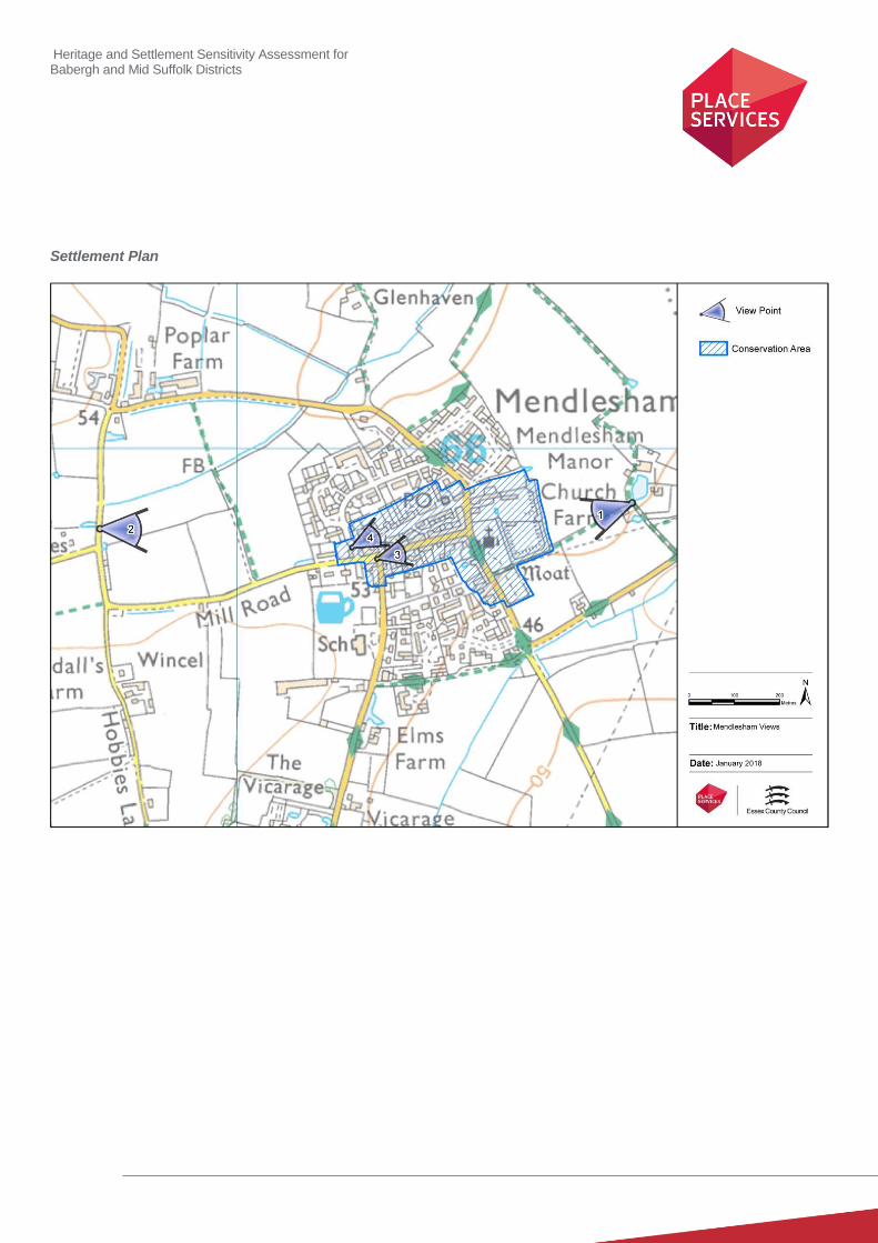
Heritage and Settlement Sensitivity Assessment for Babergh and Mid Suffolk Districts
Settlement Plan

Heritage and Settlement Sensitivity Assessment for Babergh and Mid Suffolk Districts
Settlement Name: Needham Market District: Mid-Suffolk
Settlement Description:
Needham Market is an historic market town, located to the south-east of Stowmarket. It falls on the B1113, which was
formerly the main road between Ipswich and Bury St. Edmunds. The historic built form is mainly located along this main
road, with isolated historic mill complexes located to the east close to the River Gipping. The town has its origins in the
13th century, and thrived until the mid-17
th century when it was devastated by plague, when its population dwindled
considerably. The settlement expanded to the west and south in the second half of the twentieth century. The
conservation area encompasses the historic core, as well as an area of water-meadow by the River Gipping.
Summary History:
The earliest evidence for occupation in the area relates to Roman activity, and was found in the vicinity of the primary
school. To the immediate north of the settlement boundary at Raven’s Farm there are cropmarks and metal-detecting
finds suggestive of a multi-period landscape incorporating ring-ditches, enclosures and Roman, Anglo-Saxon and
medieval activity.
Needham Market is not mentioned by name in the Domesday Book, and it appears to have been most probably a hamlet
within Barking parish. In 1245 a market charter was granted to the Bishop of Ely for Needham, and it is probable that the
development of the settlement dates to this period. The Church of St. John the Baptist was in existence by 1277,
although the present building dates to the second half of the sixteenth century and incorporates fabric from the older
building, including an exceptional hammer-beam roof. Until 1901 it was a Chapel of Ease for the church at Barking.
The principal medieval trade around which the market was formed was wool combing, but the ravages of the plague of
1663-65, in which the town was severely hit and was in effect quarantined, irrevocably damaged it as a centre of the wool
trade, as it lost its trade to Ipswich and Stowmarket.
In the post-medieval period the settlement was largely engaged in agriculture occupations, although industry included the
corn mill, brickworks and a mouse-trap factory. This period also saw the construction of several non-conformist chapels,
including the Unitarian Church, constructed in 1837. The nineteenth century also saw the arrival of the railway, which
linked the town to Ipswich and Bury.
The town was bombed in 1942, and the modern buildings on the High Street were largely built in response to the
consequent destruction. Further twentieth century development has been largely located to the west and south of the
historic town, partly because potential growth to the east is curtailed by the railway line and flood meadows.
Historic Environment Designations
Conservation Area:
Needham Market Conservation Area
Listed Buildings: within the village
Grade I: Grade II*: Grade II:
1 5 91

Heritage and Settlement Sensitivity Assessment for Babergh and Mid Suffolk Districts
Scheduled Monument:
None
Registered Park and Garden:
None
Landscape Designations
AONB:
None
SSSI:
None
SAC:
None
Ancient Woodland:
None
Key Characteristics
Settlement:
Note: The key positive features or qualities, which if lost or changed there would be a significant consequence for the
current character.
The historic core of the settlement is linear in nature and is located along a single main axial street running north-west to
south-east. This is the historic road between Bury St. Edmunds and Ipswich, and it is heavily populated with historic
buildings, albeit with areas of twentieth century infill. The majority of these earlier buildings are either timber framed and
plastered or constructed in brick, and are set close to the road edge creating a sense of enclosure and long narrow views.
The entrances into the settlement from the east are dominated by two considerable mill complexes, both set along the
River Gipping. However the historic character of the settlement has been altered considerably in other areas, and there is
considerable modern development to the west, south and north
Surrounding Landscape:
Note: The key positive features or qualities, which if lost or changed there would be a significant consequence for the
current character.
The surrounding landscape to the east is defined by the River Gipping and the river floodplain, and includes several high
quality mill complexes as well as several lake features to the east and west of the river. Beyond the new settlement
edges to the north, west and south, the landscape is agricultural in character, with several historic farmsteads set on rising
ground, some containing listed buildings. This landscape is however divorced from the historic settlement edge by large
areas of modern development.
Heritage and Settlement Sensitivity Assessment for Babergh and Mid Suffolk Districts
Key Views
Note: The key views towards, through, across and away from the settlement
1. View looking north-west up the High Street. This allows an appreciation of the character of the historic built form
within the historic built core, and of the historic form of the settlement.
2. View looking south-east up the High Street. This similarly allows an appreciation of the character of the historic
built form within the historic built core, and of the historic form of the settlement.
3. Shorter views along Hawkes Mill Street looking west towards the mill complex. This not only highlights the visual
prominence of the mill complex, but also the historic character and industry of the river valley.
4. Shorter view along Coddenham Road looking north-west towards the mill complex. This again highlights the
character of the river valley and therefore reinforces the character of the historic landscape surrounding Needham
Market.
Value
Note: Based on designation status (including setting of AONB/heritage assets, relationship of the settlement to the
heritage assets), local or community interest or use (access/enjoyment & amenity value), setting for the wider settlement.
Condition/rarity/quality.
The historic core contains a large concentration of buildings of national significance centred the historic road between
Ipswich and Bury St. Edmunds. Whilst there has been modern incursion along this road, this section of the settlement is
of high value. Similarly the mill complexes to the east of the settlement along the River Gipping are also considered to be
of high value. However, the majority of the periphery of Needham Market, which consists of multiple phases of modern
development, is of low value.
Susceptibility
Note: The ability of the receptors (features, qualities, characteristics, condition) to accommodate the changes without
undue consequences for the maintenance of the baseline.
The core is susceptible to development along the main road, particularly modern infill between or directly adjacent to the
historic built form. Similarly the mill complexes to the east of the settlement are susceptible to development which would
encircle or obscure. Both the historic core and these mill complexes are susceptible to development which would infill the
area between the two, and remove their historic separation.
The rest of the settlement, and particularly the southern, northern and western boundaries, are of lower value and are
considered to be less susceptible to change.
Potential Enhancement
Note: Areas that could potentially be improved or enhanced.
None identified
Recommendations
The landscape to the east of the settlement within the floodplain contains several important mill complexes and should be
preserved from development. The rest of the surrounding landscape is divorced from the historic core by large areas of
modern development and is therefore of lower sensitivity. The historic linear core is of high value and contains several
gap sites. Whilst there is not in principle objection to their development, a high standard of design should be required.

Heritage and Settlement Sensitivity Assessment for Babergh and Mid Suffolk Districts
Settlement Plan

Heritage and Settlement Sensitivity Assessment for Babergh and Mid Suffolk Districts
Settlement Name: Norton District: Mid Suffolk
Settlement Description:
Norton is a multi-focal village located approximately 3½ miles south of Ixworth. It was historically a series of separate
farms originally spread along Ixworth and Ashfield Roads, which have been conjoined by more recent linear development.
The historic church and hall lies to the north of the settlement, both still within open countryside. An 1870s Gazetteer of
Britain describes the parish as comprising 2,449 acres and having a population of 948. It also mentions it as a meet for
the Suffolk fox hounds.[
A separate small community has developed to the east of Norton, centred on a Manor complex at Norton Little Green.
This has a grade II* manor house listed barn, lodge and cart lodge clustered around Ashfield Road. (This was not
assessed as part of this project but does fit the pattern of dispersed agricultural properties developing into larger
communities).
Summary History:
The earliest evidence for settlement relates to extensive finds in the region of the church dating to the Roman period,
indicating the presence of a settlement in the immediate vicinity.
Norton (or Nortuna) is mentioned in the Domesday Book, as a large village of 64 households in the Hundred of
Blackbourn and under the control of the crown. It had previously fallen under the over-lordship of the Saxon noble
Burghard, who had lands in many parts of Suffolk. During the reign of Edward III the Pakenham family acquired the
lordship of Norton Hall from Agnes de Norton and this lordship has continued to be passed down through various families
to the present time when it is held by the Woodwards.
The Church of St Andrew is set away from the edge of the settlement, and was constructed in the fourteenth century on
the site of an older church, with its adjacent rectory built in the eighteenth century. The majority of the rest of the historic
built form forms part of historic farm complexes which have been subsumed into the settlement boundary, the majority of
which date from the sixteenth and seventeenth centuries. These historic farmsteads were joined together by development
in the mid to late 20th century development, creating a multi focal settlement.
Little Haugh Hall is located to the north-west of the settlement and was the former manor house of the settlement. It was
constructed in 1730 and much remodelled in 1830. The original manor house is likely to be located on the site of the
current Hall Farm.
The settlement is also famed for the fact that King Henry VIII was induced to search for gold in the parish in the early
sixteenth century. Earthworks spoils related to this were still visible in the landscape until recently.
Historic Environment Designations
Conservation Area:
None
Listed Buildings:
Grade I: Grade II*: Grade II:
1 12
Heritage and Settlement Sensitivity Assessment for Babergh and Mid Suffolk Districts
Scheduled Monument:
None
Registered Park and Garden:
None
Landscape Designations
AONB:
None
SSSI:
None
SAC:
None
Ancient Woodland:
None
Key Characteristics
Settlement:
Note: The key positive features or qualities, which if lost or changed there would be a significant consequence for the
current character.
The core of the current settlement is based around a cross roads with linear settlement concentrated on two intersecting
north-south and east-west roads. Historic mapping appears to show a possible market place on the northern side of the
crossroads. There is a church and associated rectory located to the north and east of the settlement located separately
on higher ground. To the north are two halls, one located to the east of the main road and one to the west positioned on a
similar contour to the church. A third hall (which is moated) is located to the south and east of the settlement and is
distinctly separate from the main body of settlement. There has been linear development in the second half of the 20th
century to the north of the historic core in filling the gap along Ickworth Road which previously separated the settlement
from the Halls.
Surrounding Landscape:
Note: The key positive features or qualities, which if lost or changed there would be a significant consequence for the
current character.
The settlement is set within a wider agricultural landscape with a historic hall complexes set within the settlement
boundary or in close proximity within the surrounding landscape. To the north-east of the settlement is a small area of
woodland, which encloses both the church and its associated rectory.
Key Views
Note: The key views towards, through, across and away from the settlement
1. View looking from the Church vicarage towards the settlement on the two road axis’s looking south and west,
Heritage and Settlement Sensitivity Assessment for Babergh and Mid Suffolk Districts
highlighting the isolated position of the church and rectory complex.
2. View from Halls Lane to Rectory and Church, which again shows the secluded location of the church complex,
and its relationship with the hall to the north
Value
Note: Based on designation status (including setting of AONB/heritage assets, relationship of the settlement to the
heritage assets), local or community interest or use (access/enjoyment & amenity value), setting for the wider settlement.
Condition/rarity/quality.
There are several buildings within the settlement which are of considerable architectural and historical significance,
including both the hall complexes to the north of the settlement and the church and rectory complex. These are
discernible within their contexts and both their fabric and their setting contribute to their significance. The surviving farm
complexes also have value in their own right, but the value of many of their settings has been eroded by modern
development. However these do not form an historic settlement in their own right and the settlement itself is of low value
from a heritage perspective.
Susceptibility
Note: The ability of the receptors (features, qualities, characteristics, condition) to accommodate the changes without
undue consequences for the maintenance of the baseline.
Both hall complexes, and the church and rectory, garner part of their value and significance from their position within open
landscape, which preserves their historic context. All would be susceptible to development which brought them into the
settlement boundary. However, the core of the settlement, which has considerably altered in character over the second
half of the twentieth century, has low susceptibility to further development.
Potential Enhancement
Note: Areas that could potentially be improved or enhanced.
None identified
Recommendations
The majority of Norton is comprised of modern linear development incorporating a previously dispersed cluster of
farmsteads. Development in depth should be resisted. To the north of the settlement are two hall complexes and a
complex centred on the church. These sit within an open agricultural landscape and development which encroaches
upon this should be avoided.
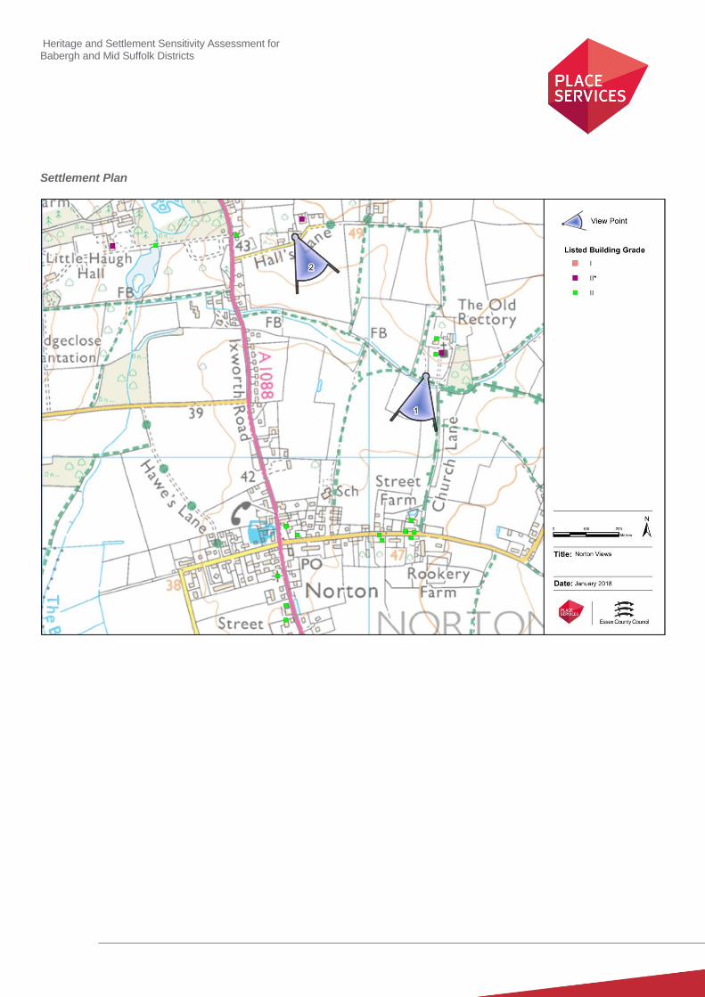
Heritage and Settlement Sensitivity Assessment for Babergh and Mid Suffolk Districts
Settlement Plan

Heritage and Settlement Sensitivity Assessment for Babergh and Mid Suffolk Districts
Settlement Name: Old Newton District: Mid Suffolk
Settlement Description:
Old Newton is situated about 2½ miles north of Stowmarket, sited on a small ridge with tributaries of the River Gipping to
east and west. The settlement is split between two groups of built form, a cluster of built form to the east, centred on the
church, and a predominantly modern settlement around the junction with the Stowmarket Road. The historical built form is
sited on the higher ground either side of the tributary of the River Gipping, with one collection to the east centred on the
church and one group on the high ground to the west sited on Church Road.
Summary History:
The earliest evidence of activity comprises the find of a Neolithic hand-axe, and an undated ring ditch which could be
Bronze Age, both just outside the settlement boundary. However the first documentary evidence dates from the
Domesday Book, where the settlement is referred to as Niwetuna or Neiuetuna, meaning new town or new farm.
The Grade I church of St Mary dates from the 14th century and is located in the eastern part of Old Newton. This may well
have replaced an earlier church, as a church in the settlement is mentioned in the Domesday Book. The former manor
house, Old Newton Hall, is situated some distance to the southeast of the church. The current building on the site dates to
the early seventeenth century, but replaced an earlier moated building on the site. There is evidence for several other
moated sites in the settlement, including one located to the north of Nether Hall, one close to Burnhams Cottage and one
to the north of Rookyard Farm. The majority of the built form, both around the church and to the west of the river tributary
dates from the sixteenth and seventeenth century, although as noted in relation to Old Newton Hall, several of these
appear to have replaced older buildings on the same site.
The settlement has considerably extended to the west in the twentieth century, in a curvilinear form either side of the
B1113. The settlement has also extended eastward from the church, but to a much lesser extent.
Historic Environment Designations
Conservation Area:
None
Listed Buildings: within the village
Grade I: Grade II*: Grade II:
Scheduled Monument:
None
Registered Park and Garden:
None
Landscape Designations
AONB:
None
1 1 5
Heritage and Settlement Sensitivity Assessment for Babergh and Mid Suffolk Districts
SSSI:
None
SAC:
None
Ancient Woodland:
None
Key Characteristics
Settlement:
Note: The key positive features or qualities, which if lost or changed there would be a significant consequence for the
current character.
The historic core of Old Newton is a polyfocal settlement with a group of buildings on the western side of the valley
overlooking the river tributary and a group of buildings on the eastern side of the valley centred on the church. There are
also several isolated farmsteads further to the west and south.
The first of these groups is located on the eastern edge of the settlement, and forms a distinct and attractive group set
away from the settlement, although there has been some inappropriate modern development on its eastern edge. This
group includes the church, a hall, now Church Farm, and a school.
The second group is located on the western edge of the valley, and includes historically significant listed and unlisted
buildings, including the non-designated vicarage, which is presumed to serve the Church of St Mary’s to the east. This
has an important interrelationship with group to the east and to the river tributary, but there has been considerable
development to the west which has subsumed it into a wider settlement.
The final group has been subsumed into modern development and is no longer easily readable. There are a number of
moated enclosures, many now associated with farm complexes located in the landscape around the settlement. The
most striking of these is the large moated site at Rookyard Farm to the north of the settlement.
Surrounding Landscape:
Note: The key positive features or qualities, which if lost or changed there would be a significant consequence for the
current character.
The settlement sits within an undulating landscape which to the south and east in particular is defined by its agricultural
character. This is evident in the number of surviving historic farmsteads, particularly to the south of the settlement. .
Key Views
Note: The key views towards, through, across and away from the settlement
1. View looking north along School Road. This view allows the entire church and hall complex to be appreciated as
a complete group.
2. View looking back from the eastern edge of Old Newton towards the church. This again emphasises the group
around the church as a whole. It also emphasises the relationship between the two historic groups of buildings on
either side of the valley, and the inter-relationship between the church and its vicarage.
3. View looking north from White Hall towards the historic group on the western side of the valley: This allows an

Heritage and Settlement Sensitivity Assessment for Babergh and Mid Suffolk Districts
understanding of the group as a whole, and reinforces their setting in the wider landscape.
4. View from White Hall lane across to the church and hall complex, which again highlights the prominence of this
complex within the wider landscape.
5. View looking north towards Rookhall Farm. This allows an understanding of the isolated position of this higher
status complex outside the main body of the settlement.
Value
Note: Based on designation status (including setting of AONB/heritage assets, relationship of the settlement to the
heritage assets), local or community interest or use (access/enjoyment & amenity value), setting for the wider settlement.
Condition/rarity/quality.
The Church and Hall complex to the east contains several buildings of high status. It is of high value and survives as an
intact and readable entity, despite the development to the east. Similarly the complex of buildings around Mill Hill at the
eastern edge of Old Newton forms an important group of historic value.
Three historic farmsteads are sited outside the present settlement boundary, including several set within moated sites.
These not only have intrinsic value, but their wider setting also allow an important understanding of the historic usage of
the agricultural landscape.
Susceptibility
Note: The ability of the receptors (features, qualities, characteristics, condition) to accommodate the changes without
undue consequences for the maintenance of the baseline.
There are several clusters of listed buildings and several individual farmsteads all of which are of significance and all of
which would be susceptible to development which encroached upon them and encircled them.
The open landscape to the north of the settlement which provides the setting of the moated enclosure within Rookyard
Farm is of particular susceptibility as there is only a relatively small area of intervening land between the settlement and
the moated complex.
The historic core of Old Newton has already been considerably altered by modern development, and is therefore of lower
susceptibility.
Potential Enhancement
Note: Areas that could potentially be improved or enhanced.
Consideration should be given for the nomination of the moated complex at Rookhall Yard for scheduling as it is a good
example of this type of historic complex. Similarly there are several unlisted buildings on the edge of Old Newton which
may merit consideration for statutory listing.
Recommendations
The cluster around the church to the east is of high value and further development in this area should be avoided. There
are also several farm complexes within the surrounding landscape, particularly to the north and south, the significance of
which is tied to their agricultural setting and development should not be supported where it would encompass these in the
settlement boundary. However, the core of the settlement particularly to the west has low susceptibility to development.
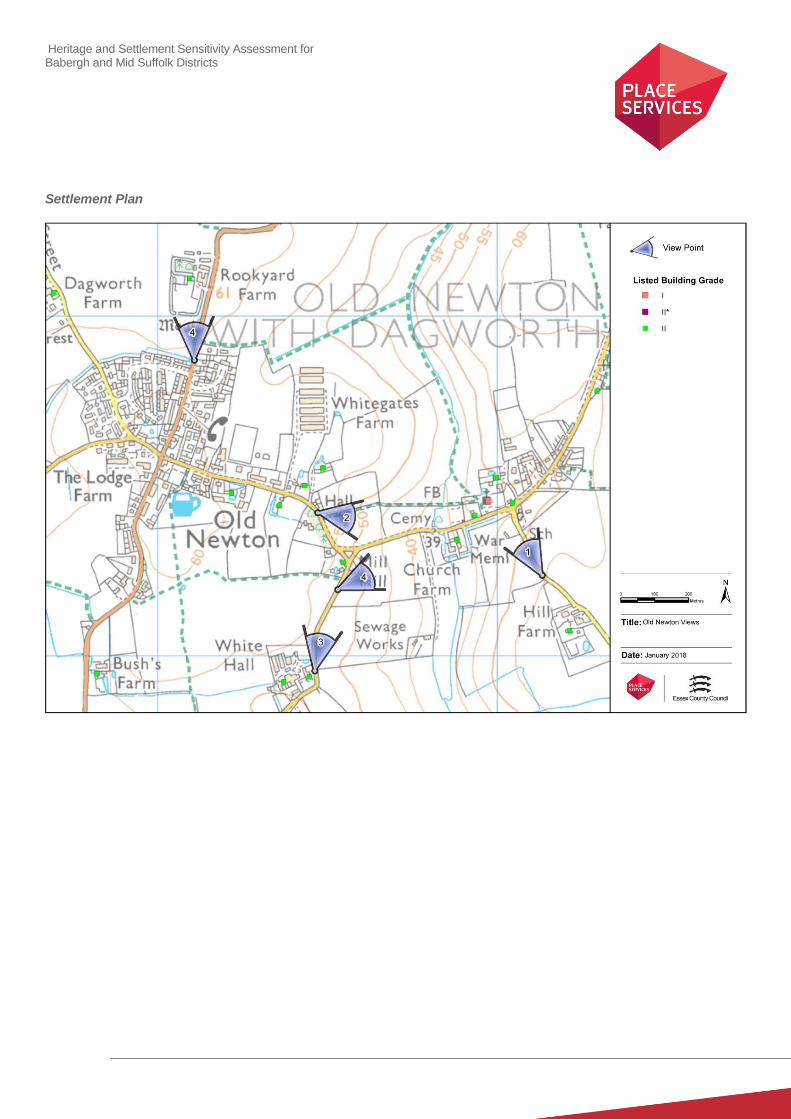
Heritage and Settlement Sensitivity Assessment for Babergh and Mid Suffolk Districts
Settlement Plan
Heritage and Settlement Sensitivity Assessment for Babergh and Mid Suffolk Districts
Settlement Name: Onehouse District: Mid Suffolk
Settlement Description:
Onehouse is a settlement situated about 2 miles to the west of Stowmarket, located on the road from Stowmarket to
Harleston. The settlement lies on a slight ridge above the Rattlesden River to the south, with the church and manor
situated separately to the south west. There is a group of listed buildings close to, and south of, the road.
Summary History:
The settlement is recorded in the Domesday Book under several names, ‘Anehus’, ‘Annhus’ and ‘Anhus’, all literally
meaning ‘one house’.
The Church of St. John the Baptist dates from the 12th century and is situated to the north of Onehouse Hall. This hall
was constructed in the sixteenth century, but sits within a medieval moated site suggesting that there was an older hall on
this, potentially contemporaneous with the church.
There is another possible medieval moat at Chilton Leys to the north-east of the settlement, and this, along with finds of
medieval coins to the south of the settlement, suggests that there was wider medieval inhabitation in the area. Northfield
Wood to the immediate north of the settlement is designated as ancient and semi-natural woodland, and is likely to have
been part of the woodland mentioned in the Domesday Book.
The majority of the settlement is of modern origin, and has developed around the older farms and houses along the road
and northwards up to the edge of Northfield Wood.
Historic Environment Designations
Conservation Area:
None
Listed Buildings: within the village
Grade I: Grade II*: Grade II:
Scheduled Monument:
None
Registered Park and Garden:
None
Landscape Designations
AONB:
None
SSSI:
6

Heritage and Settlement Sensitivity Assessment for Babergh and Mid Suffolk Districts
None
SAC:
None
Ancient Woodland:
Northfield Wood on the northern boundary of the settlement
Key Characteristics
Settlement:
Note: The key positive features or qualities, which if lost or changed there would be a significant consequence for the
current character.
The settlement is largely modern in origin with much of the historic built form subsumed within this area. The church and
hall complex to the south-west of the settlement is highly significant, and is still readable in its historic context set within
open landscape.
Surrounding Landscape:
Note: The key positive features or qualities, which if lost or changed there would be a significant consequence for the
current character.
The surrounding landscape is mainly agricultural in character with several disparate farmsteads. However, the area to the
north of the settlement is characterised by a large area of ancient woodland (Northfield Wood), directly abutting the
settlement. Onehouse Hall and the Church of St. John the Baptist are located to the south west of the settlement, and lie
within their historic open landscape.
Key Views
Note: The key views towards, through, across and away from the settlement
1. Views of the moated church and hall complex at Onehouse Hall from the west of the settlement. These highlight
the location of the complex within their wider landscape setting.
2. Views looking south east towards the associated lodge, highlighting its edge of settlement location and its
association with Onehouse Lodge.
Value
Note: Based on designation status (including setting of AONB/heritage assets, relationship of the settlement to the
heritage assets), local or community interest or use (access/enjoyment & amenity value), setting for the wider settlement.
Condition/rarity/quality.
The church and hall complex to the south of the settlement is of high value, and is still experienced within its historic
setting. However, while this area is of high value, the rest of the settlement is inherently modern in character, and is of low
historic value.
Susceptibility
Note: The ability of the receptors (features, qualities, characteristics, condition) to accommodate the changes without
undue consequences for the maintenance of the baseline.
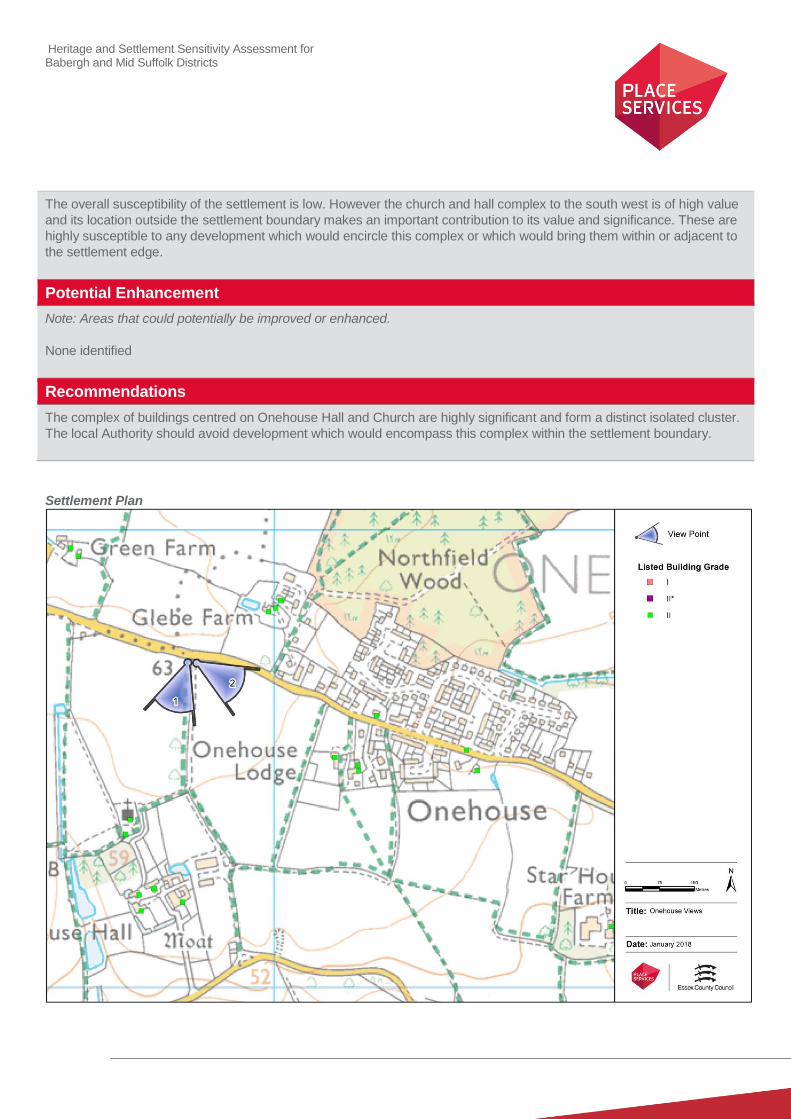
Heritage and Settlement Sensitivity Assessment for Babergh and Mid Suffolk Districts
The overall susceptibility of the settlement is low. However the church and hall complex to the south west is of high value
and its location outside the settlement boundary makes an important contribution to its value and significance. These are
highly susceptible to any development which would encircle this complex or which would bring them within or adjacent to
the settlement edge.
Potential Enhancement
Note: Areas that could potentially be improved or enhanced.
None identified
Recommendations
The complex of buildings centred on Onehouse Hall and Church are highly significant and form a distinct isolated cluster.
The local Authority should avoid development which would encompass this complex within the settlement boundary.
Settlement Plan
Heritage and Settlement Sensitivity Assessment for Babergh and Mid Suffolk Districts
Settlement Name: Rattlesden District: Mid Suffolk
Settlement Description:
The village of Rattlesden lies in a broad flat-bottomed valley between the market towns of Bury St Edmunds and
Stowmarket, on a branch of the River Gipping known as the Rattlesden River. To the south lie the hamlets of Poystreet
Green and Top Road which are included within the assessment. The large medieval Church of St Nicholas is sited in the
middle of the village and is surrounded by the historic core of the village. It is likely to have originated as a medieval
Church/Hall complex with the hall to the north. The Conservation Area includes the historic core and the more recent
development beyond, including some open areas outside of the village.
Summary History:
Rattlesden is thought to have been an important river crossing point during the Roman period, forming part of a road
known as the Peddar's Way, which continues across Suffolk and Norfolk to the Wash. Roman coin have been found at
Windy Ridge and at Poystreet Green, and pottery at Whalebone Cottage. The settlement at Rattlesden has its origins in
the Saxon period, and is referred to in the Domesday Book as Ratlesdena, Rachestdena and Rastedena. Hollingsworth in
his "History of Stowmarket" suggests that the village took its name from its having been an encampment of the Danes in
the 9th century (from Rates meaning boat and Doenas meaning Danes), who presumably sailed up the River Orwell and
River Gipping from the coast.
There are seven entries in the Domesday Book for Rattlesden. The largest holding including the church and church-land,
meadow and woodland, which was owned by the Abbey of Ely. The main manor is believed to have been sited near the
present Rattlesden Hall, which is a later farmhouse of seventeenth century construction. The Church of St Nicholas is
large compared to other local churches, and is sited in the middle of the settlement. It has its origins in the thirteenth
century, with later fourteenth and fifteenth century additions. The village may have developed around this Church/Hall
complex, which would partially explain the circular road pattern around the church. A fifteenth century hall house is
located to the south of the church, which would appear to have been historically associated with the church.
Rattlesden has a long industrial history, as is evidenced in the existence of a post mill and later a tower mill, both later demolished. A further tower mill to the south-west of the village, off the Brettenham Road, was recently converted to residential use and replaced an earlier smock mill to the north, the remains of which form the footings for the power mill that replaced them both.
Rattlesden has also been long connected with navigation. Until the coming of the Stowmarket Navigation in 1789, the
Rattlesden River was not a tributary, but rather a main watercourse. This is evident by records from the Middle Ages,
which record the unloading at Rattlesden of Caen stone, bound for the building of the Abbey at Bury St Edmunds. The village also once had a workhouse, which was located on the High Street near the church, in the house now known as Goldmartin. It is recorded in 1776 as having 26 inmates. The Primary School was built 1872.
Historic Environment Designations
Conservation Area:
Rattlesden Conservation Area
Listed Buildings: within the village
Grade I: Grade II*: Grade II:
1 1 24

Heritage and Settlement Sensitivity Assessment for Babergh and Mid Suffolk Districts
Scheduled Monument:
None
Registered Park and Garden:
None
Landscape Designations
AONB:
None
SSSI:
None
SAC:
None
Ancient Woodland:
None
Key Characteristics
Settlement:
Note: The key positive features or qualities, which if lost or changed there would be a significant consequence for the
current character.
Rattlesden is a polyfocal settlement set within the lower section of the valley, either side of the Rattlesden River. The
church sits at the centre of the settlement and forms part of an historic church-hall complex with Rattlesden Hall to the
north. This has several associated buildings including one which has historically been identified as a guildhall. To the
south there is Birds Green, a green formed of a row of thatched listed cottages alongside the river which was originally
distinct from the complex around the church.
The High Street runs to the north of the church, with the historic built form to the southwest of the church and modern
development to the north and north east. This later development is located on higher ground and this is characteristic
with much of the modern development within Rattlesden.
To the south of the settlement is an historic green called Poy Street Green, which is comprised of several historic
farmsteads. To the west of this there are further isolated farmsteads. There has been a considerable amount of modern
linear development which has not only subsumed this green and farmsteads but which is also close to creating
coalescence between the green, the farmsteads and the core of Rattlesden.
Surrounding Landscape:
Note: The key positive features or qualities, which if lost or changed there would be a significant consequence for the
current character
.
Rattlesden is sited within a low area of the steep valley either side of the Rattlesden River. The surrounding landscape is
open and agricultural, characterised by dispersed historic farmsteads to all sides.
Heritage and Settlement Sensitivity Assessment for Babergh and Mid Suffolk Districts
Key Views
Note: The key views towards, through, across and away from the settlement
1. View in from the north looking south west. This highlights the position of the settlement in the valley, and the
location of the church on higher ground within the core of the settlement.
2. Views from the south also highlight the position of the church within the settlement, although this view has been
more considerably intruded upon by modern development.
3. View along Bird Green which highlights the compact nature of the collection of properties on the river frontage.
This is the best surviving green which would have characterised the settlement of Rattlesden albeit with
inappropriate development on its southern side.
4. View looking directly north along Lower Road to the church. This again highlights the prominence of the church,
and gives the best understanding of its interrelationship with the historic built form on the High Street and Lower
Road.
Value
Note: Based on designation status (including setting of AONB/heritage assets, relationship of the settlement to the
heritage assets), local or community interest or use (access/enjoyment & amenity value), setting for the wider settlement.
Condition/rarity/quality.
The historic core of Rattlesden contains several buildings of high architectural value, particularly the groups around the
church, and that around Birds Green. The interesting historic settlement pattern is still also clearly visible, with two axial
roads passing to the north and south of the church, which coalesce at the river crossing to the south. However, the value
of the historic greens to the south and the dispersed farm complexes to the south east has been considerably reduced as
a result of the extent of inappropriate modern development, which has curtailed and altered their setting. Similarly the
modern development within the core of the development has begun to reduce its visual cohesion and the ability to
understand its historic form and significance.
Susceptibility
Note: The ability of the receptors (features, qualities, characteristics, condition) to accommodate the changes without
undue consequences for the maintenance of the baseline.
The siting of the settlement, set low within the river valley, makes its susceptible to modern development on the upper
slopes which will be inherently visually prominent, and will further intrude on long views of the settlement.
The settlement is also susceptible to further infill development. Within the conservation area further development would
distort the historic street pattern and lead to an increasingly cramped built form. This would also be harmful to the assets
significance. Outside the settlement the green at Poy Street Green has been considerably encircled by development, and
it is susceptible to further development which would not only exacerbate the existing harm, but also has the potential to
create a linear suburb of the settlement.
Potential Enhancement
Note: Areas that could potentially be improved or enhanced.
The conservation area boundary includes areas of open countryside and riverside scrub, and it is unclear what
contribution this makes to the character and appearance of the conservation area. Consideration should be given to
revising the Conservation Area boundaries in line with current Historic England guidance.
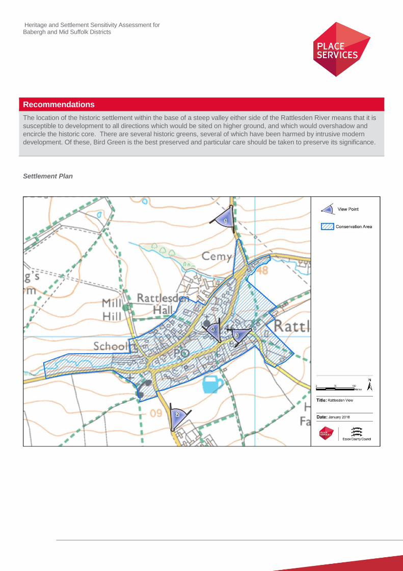
Heritage and Settlement Sensitivity Assessment for Babergh and Mid Suffolk Districts
Recommendations
The location of the historic settlement within the base of a steep valley either side of the Rattlesden River means that it is
susceptible to development to all directions which would be sited on higher ground, and which would overshadow and
encircle the historic core. There are several historic greens, several of which have been harmed by intrusive modern
development. Of these, Bird Green is the best preserved and particular care should be taken to preserve its significance.
Settlement Plan
Heritage and Settlement Sensitivity Assessment for Babergh and Mid Suffolk Districts
Settlement Name: Rickinghall and Botesdale District: Mid Suffolk
Settlement Description:
Rickinghall and Botesdale were historically two separate villages, but later development has meant that they have
coalesced to form one continuous linear settlement. The villages lie within a valley side in close proximity to a stream,
which flows into the lake at Redgrave Park to the north of Botesdale. Rickinghall to the south was historically subdivided
into Rickinghall Superior and Rickinghall Inferior, the latter to the north of The Street and the former on the southern side.
The villages of Botesdale and Rickinghall have a large number of listed buildings lining the main street, with a particular
cluster around Street Farm in Botesdale. This road undulates, rising to the north, where there is an important group of
buildings set around the junction between the High Street and Mill Road. Much of the original settlement pattern survives
and is protected within the Conservation Area.
Summary History:
There is evidence of early settlement in the landscape around the settlement, with finds of prehistoric pottery and flints
found to the north of the settlement (suggesting activity in the area since the Neolithic and Bronze Age periods), and
evidence of Roman activity found to the south of the settlement.
Rickinghall was recorded from the 10th century as Rikinghale and in the Domesday Book as Rikingahala. The etymology
of the name stems from the 'nook of the family or followers of a man called Rica' A church is recorded in Rickinghall
Inferior in the eleventh century, and fell within the land belonging to the Abbot of St Edmunds before 1066, land which
was not confiscated following the conquest as it was in ecclesiastical ownership.
Botesdale originated as a hamlet of the parish of Redgrave, the manor house for which fell to the north of the settlement.
Redgrave Park still survives, and is thought to have originated as a medieval deer park, and covered over 200 acres in
1575. The current form owes more to Capability Brown, who redesigned the landscape in 1763. The settlement expanded
when a medieval market, established in the 13th century by the Monks of Bury, was established to capitalise on the
increasing traffic on the road between Bury St Edmunds and the coast. The inhabitants of the new market town gained
permission to build a chapel of ease which was dedicated to St Botolph, and the new settlement became known as
Botesdale - literally, St Botolph's Dale. In 1289 there were more than 52 stalls and 14 shops. The Abbot of Bury St.
Edmunds, as Lord of the Manor, had a pillory, a ducking-stool and two windmills. The fair continued until the 18th century.
The settlement continued to expand, and the conjoined nature of Botesdale and Rickinghall is evident on the first edition
Ordnance Survey map.
Historic Environment Designations
Conservation Area:
Botesdale Conservation Area
Listed Buildings: within the village
Grade I: Grade II*: Grade II:
Scheduled Monument:
None
1 5 68
Heritage and Settlement Sensitivity Assessment for Babergh and Mid Suffolk Districts
Registered Park and Garden:
None
Landscape Designations
AONB:
None
SSSI:
None
SAC:
None
Ancient Woodland:
None
Key Characteristics
Settlement:
Note: The key positive features or qualities, which if lost or changed there would be a significant consequence for the
current character.
The core of the settlement is characterised by its linear nature, with the majority of the listed buildings fronting onto The
Street, with some larger buildings set further back in larger plots. The settlement exploits the prevailing topography of the
land, with the centre of Rickinghall set close to the flood plain and the core of Bottesdale sited on rising ground up to the
north.
The settlement is also characterised by the considerable number of historic buildings which survive in a relatively
concentrated manner along The Street, and include several complexes of particular significance, including that around the
chapel of ease.
Surrounding Landscape:
Note: The key positive features or qualities, which if lost or changed there would be a significant consequence for the
current character.
To the west of the settlement the land is relatively open due to the presence of the floodplain, which has not been intruded
on in any significant fashion. To the north east of the village lies the landscaped parkland associated with Redgrave Hall,
which although not registered is considered to be of historic interest and is a prominent and important feature in the
landscape.
To the south of the settlement the surrounding landscape has been partially infilled with a comparatively high volume of
modern housing which separates the historic core of the settlement from the surrounding landscape.
Heritage and Settlement Sensitivity Assessment for Babergh and Mid Suffolk Districts
Key Views
Note: The key views towards, through, across and away from the settlement
1. View looking north east from Bury Road: This is an important view for understanding the location of the church
within the settlement and for being the primary view in which ones initially experiences the settlement.
2. View looking north east along The Street: This emphasises the concentration of surviving listed buildings in
Botesdale and provides an understanding of the tight linear historic street form.
3. View looking south west along The Street, which emphasises the undulating nature of the topography in which
the settlement is placed.
4. Views from Mill Lane to the northern side of the settlement. These are the surviving views in which the
relationship between the settlement and its surrounding landscape can be best experienced and which highlight
the linear nature of the settlement.
5. View from footpath off Rectory Hill: This provides the only surviving connection between the southern edge of the
settlement and the open landscape. It is also the only part of the southern boundary of the conservation area
which has not been eroded by modern development.
Value
Note: Based on designation status (including setting of AONB/heritage assets, relationship of the settlement to the
heritage assets), local or community interest or use (access/enjoyment & amenity value), setting for the wider settlement.
Condition/rarity/quality.
The core of the settlement is of high value, and contains a high concentration of surviving listed buildings. In particular the
linear core of Botesdale contains areas of particularly high significance, such as the area around the Chapel of St.
Botolph.
The landscape to the northern side of the settlement has remains largely unaltered, preserving its relationship with its
agricultural hinterland within the river valley. This area of landscape also contains the historically important parkland at
Redgrave Park, which although non-designated is of value for its association with Capability Brown.
Susceptibility
Note: The ability of the receptors (features, qualities, characteristics, condition) to accommodate the changes without
undue consequences for the maintenance of the baseline.
To the south east of the settlement the surrounding landscape has been partially infilled with a comparatively high volume
of modern housing which separates the historic core of the settlement from the surrounding landscape. This means that
the southern boundary has a comparatively low sensitivity to change, the exception being the area at the south western
end where it still retains its relationship with its agricultural hinterland.
In comparison the northern and western edges of settlement have not been heavily developed and because the
settlement is sited on lower ground within the flood plain are therefore highly susceptible to change. In particular the
location of the historic parkland associated with Redgrave Park makes an important contribution to its significance, and it
is susceptible to development which does not preserve the sense of separation between the edge of the settlement and
the edge of the historic parkland.
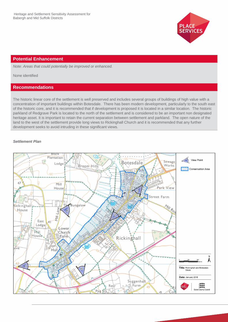
Heritage and Settlement Sensitivity Assessment for Babergh and Mid Suffolk Districts
Potential Enhancement
Note: Areas that could potentially be improved or enhanced.
None identified
Recommendations
The historic linear core of the settlement is well preserved and includes several groups of buildings of high value with a
concentration of important buildings within Botesdale. There has been modern development, particularly to the south east
of the historic core, and it is recommended that if development is proposed it is located in a similar location. The historic
parkland of Redgrave Park is located to the north of the settlement and is considered to be an important non designated
heritage asset. It is important to retain the current separation between settlement and parkland. The open nature of the
land to the west of the settlement provide long views to Rickinghall Church and it is recommended that any further
development seeks to avoid intruding in these significant views.
Settlement Plan
Heritage and Settlement Sensitivity Assessment for Babergh and Mid Suffolk Districts
Settlement Name: Stowmarket District: Mid Suffolk
Settlement Description:
Stowmarket is a large market town in the centre of Suffolk, 10 miles west of Ipswich. The settlement developed on the
western bank of the River Gipping close to the river crossing and centred on a crossroads and marketplace. The
settlement has substantially expanded beyond the River Gipping to the east and now encompasses several historic
outlying greens. Within the core of the town, the medieval church of St Peter and St Mary, listed grade I is a significant
landmark seen from long distances. Within the historic core a large wedge of green space remains containing Abbots
Hall and the Museum of East Anglian Life, and this extends down to the Rattlesden River which forms the southern
boundary of the settlement.
Summary History:
Stowmarket is listed in Domesday as ‘Tornai’ a royal manor later known as Thorney Hall, thought to be located in the area
of the railway station. At the time of Doomsday there are two churches recorded within the settlement, the Church of SS.
Peter and Paul, which stands at the centre of the settlement and is now the Church of SS. Peter and Mary, and the
Chapel of St. Mary, demolished in 1546.
Stowmarket probably developed as a seigneurial market town, which fell within the lands granted to the Abbot of St Osyth
(in Essex) by Henry II. The settlement had a longer association with the abbey, as the Church of SS. Peter and Paul had
been granted to the abbey by Henry I before 1135. The town was relatively affluent, in the medieval period, partly due to
the fact that Edward III granted the town a market charter in July 1347.
In 1793 the River Gipping leading from Stowmarket to Ipswich was canalised as the Ipswich and Stowmarket Navigation.
The arrival of the canal facilitated the significant expansion of the town, with the area of the river to the east of the town
centre becoming the industrial centre, later expanding further with the arrival of the railway. Brickworks are identified
within the town which would have provided the raw material for the expansion of the town.
In 1846 the Eastern Union Railway developed the railway linking Bury St Edmunds to Ipswich running along the Gipping
valley. A number of malthouses were established on the eastern side of the town in the vicinity of the railway station.
During the 1960’s large areas of Ipswich Street were cleared making way for the twentieth century development which is
prevalent today.
Historic Environment Designations
Conservation Area:
Stowmarket Conservation Area
Listed Buildings: within the village
Grade I: Grade II*: Grade II:
Scheduled Monument:
None
1 9 122

Heritage and Settlement Sensitivity Assessment for Babergh and Mid Suffolk Districts
Registered Park and Garden:
None
Landscape Designations
AONB:
None
SSSI:
None
SAC:
None
Ancient Woodland:
None.
Key Characteristics
Settlement:
Note: The key positive features or qualities, which if lost or changed there would be a significant consequence for the
current character.
The historic core of the settlement is characterised by a dense cluster of listed buildings set around a market place and
road junction. It is sited between two rivers with industrial development occurring in the eastern river valley. The current
boundary of settlement to the north and east is defined by the A14
However the majority of the built form of the settlement is of modern construction, which surrounds the historic core. This
has already integrated some historic farmsteads and greens which historically would have been in an open agricultural
landscape outside of the historic town; however other farm complexes still currently survive outside the settlement
boundary.
Surrounding Landscape:
Note: The key positive features or qualities, which if lost or changed there would be a significant consequence for the
current character.
The modern settlement is set within an agricultural landscape with dispersed farmsteads and a number of historic mills
exploiting the river valley to the south. The river floodplain forms the south western boundary of the settlement.To the east
the floodplain is now an extensive industrial estate.
Key Views
Note: The key views towards, through, across and away from the settlement
1. Views from the north looking towards the town. These highlight the dominance of the church spire in longer views
and give a sense of entry into Stowmarket from the north. These views have been more eroded from the east
and west.

Heritage and Settlement Sensitivity Assessment for Babergh and Mid Suffolk Districts
2. View looking east along Mill Lane, which emphasise the position of Clamps Farm on rising ground in an open
landscape.
3. Views of historic farm complexes are along Combs Lane. These allow an understanding of the historical
character and use of the surrounding landscape.
4. View from south of the settlement looking north from the Church of St. Mary. This highlights the sense of
separation between church and settlement.
5. Views looking into the core of the settlement from the east. This allows an understanding of the form and
character of the core of the settlement. This also highlights the changing topography within the settlement core
and the prominent position of the church.
6. Views looking into the core of the settlement from the west, which allows an understanding of the dense nature
form and tight linear character of the core of the settlement. This again also highlights the prominent position of
the church.
7. Views looking into the core of the settlement from the north. This allows an understanding of the dense nature
form and tight linear character of the core of the settlement.
8. Views looking into the core of the settlement from the south. These views allow an understanding of the centre of
the settlement, with views of the church across the market place.
Value
Note: Based on designation status (including setting of AONB/heritage assets, relationship of the settlement to the
heritage assets), local or community interest or use (access/enjoyment & amenity value), setting for the wider settlement.
Condition/rarity/quality.
The value of the historic core is high, as it contains a readable historic plan form, and a high number of listed buildings,
including several listed at grade I or II*. Similarly there are important farm complexes on the outskirts of the settlement
edge, sitting within their agricultural landscape.
The rest of the settlement is of varying quality with some higher quality 19th and 20
th century buildings but also large areas
of relatively indiscriminate modern development which are regarded to be of low value.
Susceptibility
Note: The ability of the receptors (features, qualities, characteristics, condition) to accommodate the changes without
undue consequences for the maintenance of the baseline.
The historic core has relatively low susceptibility, and is only really susceptible to infill development within the historic core
and in isolated areas on the peripheral of the settlement which preserve longer views of key buildings such as the church.
The significance of the outlying historic farm complexes is partly derived from their relationship with the landscape and
these are therefore susceptible to the encroachment of large scale development, which would divorce them from their
historic landscape setting.
There is a church hall complex to the south of the main settlement within an open valley with only limited intrusion from
modern development. The retention of this separation is important to retain the significance of the church.
Potential Enhancement
Note: Areas that could potentially be improved or enhanced.
There are potential opportunities to improve the market place, including the reconfiguration of the hard landscaping and
better control over elements such as a signage and shop fronts. The creation and adoption of a SPD covering this would
also be beneficial.
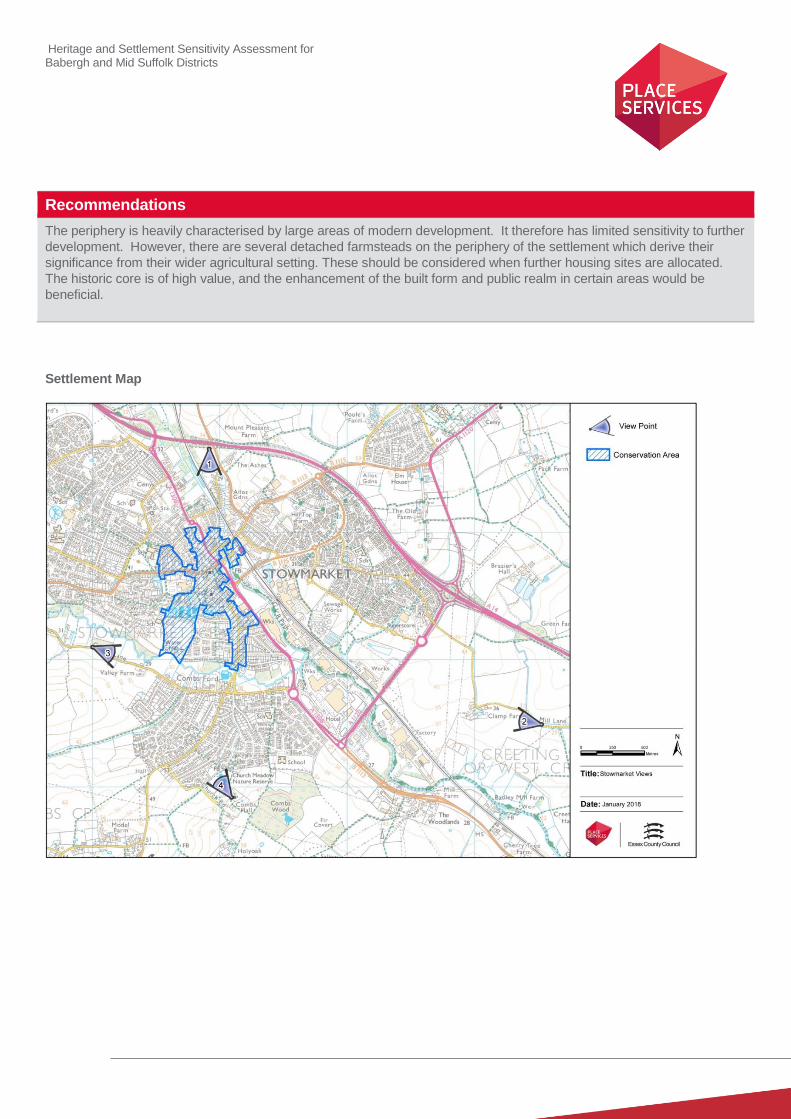
Heritage and Settlement Sensitivity Assessment for Babergh and Mid Suffolk Districts
Recommendations
The periphery is heavily characterised by large areas of modern development. It therefore has limited sensitivity to further
development. However, there are several detached farmsteads on the periphery of the settlement which derive their
significance from their wider agricultural setting. These should be considered when further housing sites are allocated.
The historic core is of high value, and the enhancement of the built form and public realm in certain areas would be
beneficial.
Settlement Map
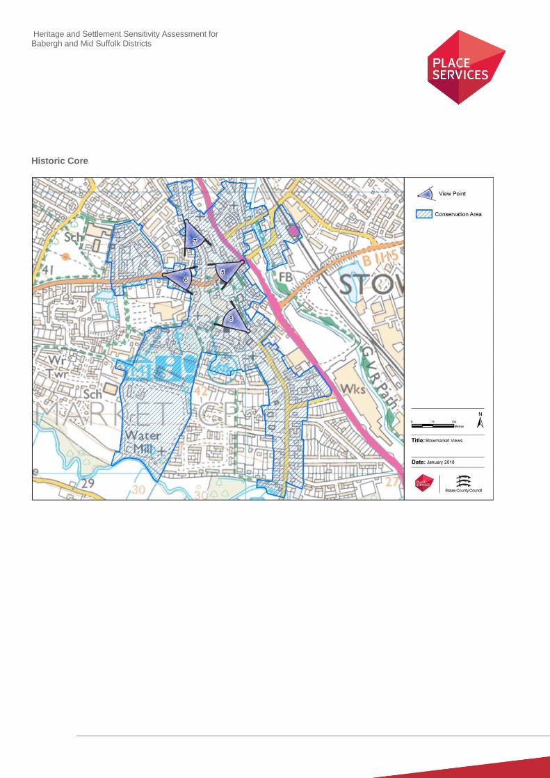
Heritage and Settlement Sensitivity Assessment for Babergh and Mid Suffolk Districts
Historic Core

Heritage and Settlement Sensitivity Assessment for Babergh and Mid Suffolk Districts
Settlement Name: Stowupland District: Mid-Suffolk
Settlement Description:
Stowupland is a village sited directly to the north of Stowmarket. Historically, it comprised of a small group of cottages
and farms around the edges of the T-shaped Thorney Green, along Church Road (A1120) and to the south of the modern
settlement, close to the outskirts of Stowmarket. The church was constructed in the middle of the 19th century at the north
eastern end of the village.
Summary History:
Stowupland is not recorded in the Domesday Book, and at that date it may have formed part of the wider Stowmarket
environs, and as late as 1844 it was described by White’s Directory as ‘a pleasant suburb to Stowmarket’. The large T-
shaped Thorney Green is probably medieval in origin, although cartographic evidence shows that there has been post-
medieval encroachment onto the Green, including a wind-mill. The 1st edition OS map shows two earthwork features
crossing the Green, both apparently marking the line of foot-paths or tracks.
The oldest historic complex in the settlement is the medieval moated site of Columbine Hall, with the manor-house dating
to c.1390. The rest of the surviving farm complexes within the settlement date to the fifteenth and sixteenth century, and
are sited around the edge of the historic green.
The Church of the Holy Trinity was built in 1843 and there is no cartographic or archaeological evidence for an earlier
medieval church on the site. Stowupland was a chapelry of Stowmarket. The Old Vicarage (1873-4) was sited roughly
opposite the Church, with the school sited next to the church. Stowupland Hall was constructed in the nineteenth century,
and was sited to the north-east of the settlement.
Modern development in Stowupland comprises two small housing-estates, located to the south-west and north-east of the
green, infilling along Church Road and Stowupland School which fronts on the green. There are playing-fields behind the
Church.
Historic Environment Designations
Conservation Area:
None
Listed Buildings:
Grade I: Grade II*: Grade II:
Scheduled Monument:
None
Registered Park and Garden:
13
Heritage and Settlement Sensitivity Assessment for Babergh and Mid Suffolk Districts
None
Landscape Designations
AONB:
None
SSSI:
None
SAC:
None
Ancient Woodland:
None
Key Characteristics
Settlement:
Note: The key positive features or qualities, which if lost or changed there would be a significant consequence for the
current character.
The settlement is built around Thorney Green, a large T-shaped area of open space evident on both the first edition OS
map and in the present day, and this is a defining characteristic of the settlement. There are several farm complexes
located around the Green and there is a linear sequence of farmsteads on Mill Street to the south of the settlement. Other
historic built form, including the church, survives either side of the modern day A1120. To the north of the settlement is
Columbine Hall, a grade II* building within a moated enclosure. The majority of the built form in the settlement is 20th and
21st century housing development, and this too makes a significant contribution to the character of the settlement.
Surrounding Landscape:
Note: The key positive features or qualities, which if lost or changed there would be a significant consequence for the
current character.
The surrounding landscape is largely agricultural in character, but has been considerably curtailed to the south west by
the A14 and expansion of Stowmarket, to the point where there is now very little physical separation between Stowmarket
and Stowupland. This interrelationship is however not wholly modern in origin, as evidenced in the fact that Stowupland is
referred to as a pleasant suburb as early as the mid-nineteenth century. This landscape does still however form the
surviving facet of several of the farm complexes agricultural setting.
Key Views
Note: The key views towards, through, across and away from the settlement
1. View looking east from The Green, which allows an understanding of the character of the southern section of the
green.
2. View looking north from The Green towards Thorney Green. This also allows an understanding of the character
of the character of the central green
3. View looking north east across Thorney Green from Thorney Green Road. This provides an understanding of the
historic character of the settlement, and the relationship between the historic farmsteads and central green.
Heritage and Settlement Sensitivity Assessment for Babergh and Mid Suffolk Districts
4. View looking north-west which defines the setting of the listed building complex at Thorney Green. This view also
provides an understanding of the historic character of the settlement, and the relationship between the historic
farmsteads and central green.
5. Views looking east along the A1120 towards the church, which is the only view in which the church can be
understood and appreciated.
Value
Note: Based on designation status (including setting of AONB/heritage assets, relationship of the settlement to the
heritage assets), local or community interest or use (access/enjoyment & amenity value), setting for the wider settlement.
Condition/rarity/quality.
The extent and expanse of the surviving green is an important characteristic of the settlement’s historic landscape value.
It is not only important in its own right but also for the contribution it makes to the significance of the listed buildings
around its perimeter. The medieval moated complex at Columbine Hall is of considerable age, and was evidently a high
status residence. It too is therefore of high value. The majority of the remainder of Stowupland is made up of modern
housing development and is of low value.
Susceptibility
Note: The ability of the receptors (features, qualities, characteristics, condition) to accommodate the changes without
undue consequences for the maintenance of the baseline.
The susceptibility of the settlement is limited; however, Thorney Green is of high significance and would be highly
susceptible to development which encroached upon it, or further surrounded it. Columbine Hall is an historic moated site
set within an open landscape. This is integral to its significance and it would be susceptible to development between it
and the northern boundary of Stowupland. The rest of Stowupland has lower susceptibility to development.
Potential Enhancement
Note: Areas that could potentially be improved or enhanced.
The verges around the green are currently ill defined and theoretically vulnerable to vehicular erosion. Whilst generic kerb
treatment would not be appropriate, a low level form of demarcation may be an enhancement, but would need to be
installed following considered consultation with relevant conservation professionals.
Recommendations
The character of Stowupland is dominated by the historic greens and the group of farm complexes along its north western
edge. The historic association between these farmsteads is still readable and understandable and it is recommended that
further development should seek to preserve their historic inter-relationship and their agricultural character. To the north of
the settlement is a moated hall complex at Columbine Hall which currently is located outside the settlement boundary.
This separation should be preserved.
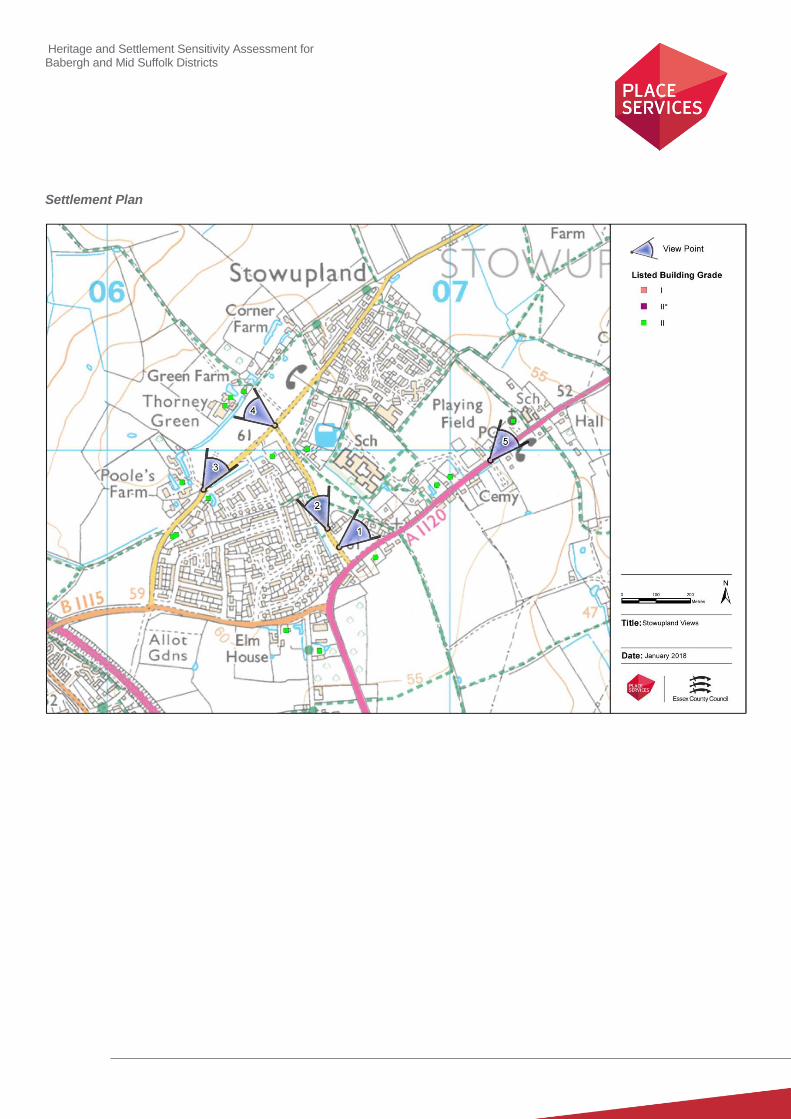
Heritage and Settlement Sensitivity Assessment for Babergh and Mid Suffolk Districts
Settlement Plan
Heritage and Settlement Sensitivity Assessment for Babergh and Mid Suffolk Districts
Settlement Name: Stradbroke District: Mid Suffolk
Settlement Description:
Stradbroke is a large village which has developed in a linear form around a staggered crossroads. The name is thought to
have etymologically derived from street (strad) over a brook (broke), and to relate to the tributary of the River Waveney
which forms the eastern boundary of the settlement.
At the centre of the village lies the medieval Church of All Saints, the prominent tower of which dominates the view from
all approaches. The centre of the village is notable due to the relatively large number of later 19th century commercial
properties which retain their traditional shopfronts, and in the widened street layout which extends along Queens Street.
Along Queen Street lies the moated site of Stadbroke Hall which is surrounded by trees and vegetation and fronted by a
long high hedge. Remains of a second moated site survive at The Priory, south of Church Street. A number of ponds
are located within the village and to the southeast, which could be the remains of a possible further moated site and/or
fish ponds.
Modern expansion of the village has taken place in linear form to the west and north along Queen Street with small
estates of semi-detached and bungalow housing at the northern extent of the settlement. Some recent backland
development has occurred beyond the conservation area boundary along Queen Street. The bulk of the modern
settlement occurs south of the historic core along Wilby Road made up of varying house forms, incorporating a school
site and community centre. To the west the modern development has extended to the brook made up of estates in a
mixture of single and two storey housing forms and garages.
Summary History:
The Domesday survey records two churches for the manor of Stradbroke. The current Church of All Saints is sited in the
centre of the village and dates to c.1430, and includes an exceptional flint porch, dating to the original phase of
construction. The village was granted a market charter in 1227, and this continued to the 17th century.
Two moated sites, at Stradbroke Hall and The Priory, are likely to be medieval in origin and are located north and south of
the medieval Church of All Saints. Stradbroke Hall dates to the 15th century and the Priory to the 16
th century and both are
likely to have replaced an earlier precursor. A guildhall was erected along Church Street in the early 16th century,
suggesting that the village was comparatively affluent.
The village expanded in the post-medieval period and contained a high number of commercial premises. This included
the erection of several ecclesiastical buildings in the nineteenth century, including the Baptist Church on Church Street
and the Public Library, which was erected in 1854 as a Corn Hall.
There is some activity of later industrial activity in the settlement, including a maltings located on Church Street and a
former mill to the west of Queens Street, set back from the road.
Historic Environment Designations
Conservation Area:
Stradbroke Conservation Area

Heritage and Settlement Sensitivity Assessment for Babergh and Mid Suffolk Districts
Listed Buildings:
Grade I: Grade II*: Grade II:
Scheduled Monument:
None
Registered Park and Garden:
None
Landscape Designations
AONB:
None
SSSI:
None
SAC:
None
Ancient Woodland:
None
Key Characteristics
Settlement:
Note: The key positive features or qualities, which if lost or changed there would be a significant consequence for the
current character.
Stradbroke is a linear settlement with the core of the historic town clustered around the church and guild hall. The
settlement was affluent in the medieval and early modern period, and this is reflected not only in the guildhall and the
quality of the flintwork in the church, but also in the survival of large moated sites to the north and south of the settlement.
There have been larger areas of modern developments to the north-east and south, as well as several insensitive
alterations to important listed buildings. This has harmed the historic character of the settlement, which is now more
piecemeal than other historic settlements.
Surrounding Landscape:
Note: The key positive features or qualities, which if lost or changed there would be a significant consequence for the
current character.
The surrounding landscape contains several further probable medieval moated sites, supporting the view of that this was
an affluent settlement, with rich agricultural hinterlands. Agriculture was, and still is, the prevailing land use. The influx of
large areas of modern development has partially divorced the historic core from its associated historic landscape.
However, this inter-relationship survives around both of the moated sites within the settlement, one to the south and one
1 45
Heritage and Settlement Sensitivity Assessment for Babergh and Mid Suffolk Districts
to the north. The open nature of the surrounding landscape also means that the church is particularly prominent in long
distance views in almost all directions.
Key Views
Note: The key views towards, through, across and away from the settlement
1. View from the south-west looking towards the settlement. This emphasises the visually prominent siting of the
church.
2. View from the north looking into the settlement, which allows an understanding of the historic entrance into the
settlement.
3. View looking west along Church Street, which highlights the historic plan form and linear character of the historic
core.
4. View looking south along Queen Street, which also elucidates an understanding of the historic character of the
settlement
5. View from Home Farm on Neaves Lane northwards into the settlement. This open view is one that is least
intruded on by modern development and allows the best understanding of the village within its landscape setting.
6. View from just outside the edge of the conservation area, showing the open block of land containing the northern
moated enclosure and forming edge of conservation area. This is one of the key links between the historic
settlement and its agricultural landscape.
7. Similar view from just inside the edge of the conservation area, showing the open block of land containing the
southern moated enclosure and forming edge of conservation area. This is one of the key links between the
historic settlement and its agricultural landscape.
Value
Note: Based on designation status (including setting of AONB/heritage assets, relationship of the settlement to the
heritage assets), local or community interest or use (access/enjoyment & amenity value), setting for the wider settlement.
Condition/rarity/quality.
The settlement contains a number of heritage assets of high value including two moated sites (probably medieval) and a
church which exhibits a high level of medieval craftsmanship. The remainder of the settlement is of medium value due to
the level of modern expansion, which has partially eroded its historic character and its association with its historic
landscape.
Susceptibility
Note: The ability of the receptors (features, qualities, characteristics, condition) to accommodate the changes without
undue consequences for the maintenance of the baseline.
The two moated sites within the conservation area both retain their link to the surrounding agricultural landscape, which
makes an important contribution to their significance, as does their edge of settlement location. They are both therefore
highly susceptible to change.
The church is visible in long distance views, highlighting its intentionally prominent and important location. These make an
important contribution to the significance of the heritage asset and the protection of these longer views needs to be given
consideration in relation to future development, particularly given the changing nature of the topography around the
settlement. The historic core comprises a number of listed buildings, and it is susceptible to further inappropriate
alterations and infill.
Heritage and Settlement Sensitivity Assessment for Babergh and Mid Suffolk Districts
Potential Enhancement
Note: Areas that could potentially be improved or enhanced.
The current condition of the moated site on Queen Street is poor, with insensitive fencing and a considerable degree of
vegetation growth. This could be improved, and it is suggested that the local planning authority should consider a section
215 notice. The listed buildings within the town centre have been adversely impacted upon by unsuitable alterations and
future applications should seek to minimise and reverse this trend.
Recommendations
The historic settlement edge has already been considerably expanded particularly to the north, east and south west. It is
therefore considered that development in these areas would be less harmful from a heritage perspective. However there
are several significant heritage assets with the core of the settlement, including two moated complexes and a church,
which still form the settlement boundary, and which are susceptible to development which would encircle them and
separate them from the wider agricultural landscape. There is also an important surviving farm complex to the south-east
of the settlement, the setting of which also makes an important contribution to its significance.
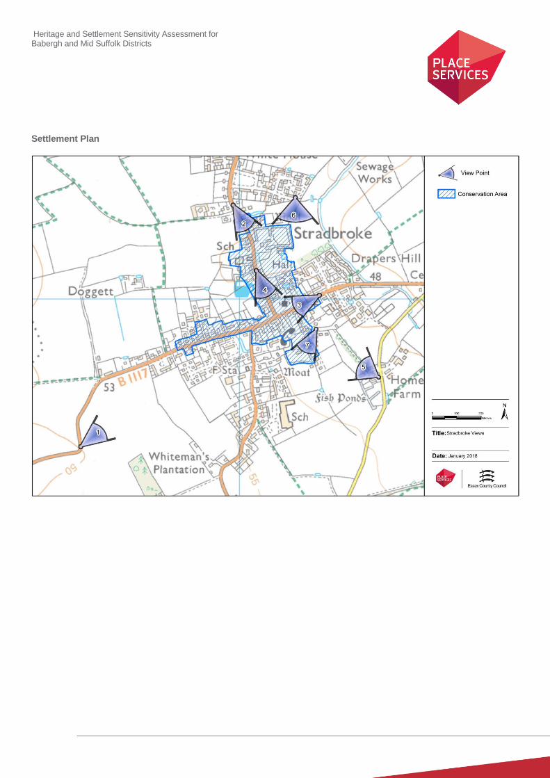
Heritage and Settlement Sensitivity Assessment for Babergh and Mid Suffolk Districts
Settlement Plan

Heritage and Settlement Sensitivity Assessment for Babergh and Mid Suffolk Districts
Settlement Name: Thurston District: Mid Suffolk
Settlement Description:
Thurston is situated about 4½ miles east of Bury St Edmunds, and lies on a ridge above a tributary of the Little Ouse
River. The settlement area was formed of a series of dispersed farmsteads, and a parish church and vicarage, but had no
distinct settlement core. The manor farm was situated to the north of the church separated by open fields and this
relationship was still maintained. A second group of historic buildings was centred on the train station. The majority of the
modern settlement is now defined by twentieth and twenty-first century development.
Summary History:
There is limited early evidence for habitation within the settlement of Thurston, consisting of a Palaeolithic elephant leg
bone and prehistoric worked flints. Some Iron Age and Roman pottery has also been found. The name of the settlement
derives from the Old English, meaning ‘Thor’s settlement’. It is mentioned in the Domesday Book as a large village of 66
households in the Hundred of Risbridge. At the time of the conquest it was under the overlordship of the Abbey of St.
Edmund in Bury St. Edmunds, and as an ecclesiastical overlord they were not dispossessed following the Norman
Conquest.
The settlement was characterised by dispersed farmsteads, and few buildings of medieval origin survive. The Church of
St. Peter is located on the eastern edge of the settlement. The current church was virtually entirely rebuilt in the
nineteenth century, but is sited on the same location as the medieval church. Manor Farm to the north was also
constructed in the nineteenth century, but is listed grade II* due to its association with a nationally significant architect,
Philip Webb. Thurston Hall is located to the south of the settlement set within its associated grounds. It dates to 1750, and
both the house and grounds are little changed from their depiction on the first edition OS map.
The railway came to Thurston in 1846, and the collection of associated buildings, including the railway station, associated
public house and the bridge across the railway line all date from this period. The settlement has considerably extended in
the twentieth and twenty-first centuries with the influx of several phases of housing development.
Historic Environment Designations
Conservation Area:
None
Listed Buildings: within the village
Grade I: Grade II*: Grade II:
Scheduled Monument:
None
Registered Park and Garden:
None
5
Heritage and Settlement Sensitivity Assessment for Babergh and Mid Suffolk Districts
Landscape Designations
AONB:
None
SSSI:
None
SAC:
None
Ancient Woodland:
None
Key Characteristics
Settlement:
Note: The key positive features or qualities, which if lost or changed there would be a significant consequence for the
current character.
Thurston is predominantly a modern settlement, and this is the characteristic which defines much of the settlement. There
are several important heritage assets on the outer edge of the settlement, including the church at eastern edge, a Manor
to the north east and several large houses to the south set within landscaped gardens. There is a cluster of buildings
within the centre located around the station of a contemporary age and an association with the railway. The church and
manor have an important interrelationship, as do the station, public house and bridge, but the majority of the assets are
dispersed and are read in isolation within their own immediate surroundings.
Surrounding Landscape:
Note: The key positive features or qualities, which if lost or changed there would be a significant consequence for the
current character.
The settlement as a whole is set within a wider agricultural landscape, which most obviously survives to the north-eastern
edge of the settlement. The larger houses to the south of the settlement are experienced within their own associated
landscapes. The greater majority of the settlement however is of modern construction and has little interrelationship with
its surrounding landscape.
Key Views
Note: The key views towards, through, across and away from the settlement
1. View from the church looking out over and across the open landscape to its north and east, which highlight its
settlement edge location and allow an understanding of its historic setting.
2. View from the Manor Farm to the Church, which shows the inter-visibility of the historic assets on the eastern side
of the settlement.

Heritage and Settlement Sensitivity Assessment for Babergh and Mid Suffolk Districts
Value
Note: Based on designation status (including setting of AONB/heritage assets, relationship of the settlement to the
heritage assets), local or community interest or use (access/enjoyment & amenity value), setting for the wider settlement.
Condition/rarity/quality.
The overall character of the settlement is modern, and therefore its value from a heritage perspective is low. However,
there are small groups of significant assets including the manor and church on the eastern side of the settlement, the
larger houses on the southern side of the settlement and the assets associated with the railway which includes the Fox
and Hound Pub. These have value in their own right, and have some historic interrelationship with each other, but do not
form a coherent historic settlement. The considerable amount of modern development between the station, bridge and
pub has however partially eroded the value of this group, and has been particularly harmful to the setting and viability of
the station
Susceptibility
Note: The ability of the receptors (features, qualities, characteristics, condition) to accommodate the changes without
undue consequences for the maintenance of the baseline.
Both the church and manor, and the pair of large houses on the southern side of the settlement, are set within wider
associated landscapes which contribute to their significance. Both would therefore be susceptible to development which
erodes or encroaches upon these landscapes and heritage assets. The rest of the settlement is fundamentally modern
and has very low susceptibility.
Potential Enhancement
Note: Areas that could potentially be improved or enhanced.
The station is a nationally designated heritage asset which is currently in a very poor condition and has been significantly
compromised by the loss of associated land to facilitate modern development. The LPA should actively consider working
with the owner to ensure a long term viable use for the building to prevent its further deterioration.
Recommendations
The church sits in a prominent location on the eastern edge of the settlement and is vulnerable to encircling development,
particularly within the landscape between the church and Manor Farm to the north. To the south east of the settlement
are several larger houses set within wider landscaped grounds. The separation between these and the settlement edge
makes an important contribution to their significance and it is recommended that development should not be placed in
areas which will bring these within the settlement edge. The rest of the settlement has a low susceptibility to further
development.

Heritage and Settlement Sensitivity Assessment for Babergh and Mid Suffolk Districts
Settlement Plan

Heritage and Settlement Sensitivity Assessment for Babergh and Mid Suffolk Districts
Settlement Name: Walsham le Willows District: Mid Suffolk
Settlement Description:
Walsham Le Willows is a large village located approximately 12 miles east of Bury St. Edmunds and 10 miles north of
Stowmarket. The main settlement is linear in character, with buildings largely located on the road frontage. The church
and vicarage complex are located at the south western end of the settlement, set to the south of the main road. Within the
settlement there is an abundance of flint used in not only the church but also in cottages and boundary walls. A large
open area of grassland with parkland trees is located on the southern side of the settlement forming the historic grounds
of The Grove.
The main settlement is connected to the hamlet of Four Ashes by The Causeway, and is one of four outlying hamlets (the
others being West Street, Crownland and Cranmer Green).
Summary History:
The earliest evidence of settlement comes from finds of Roman pottery in fields to northwest of Walsham Hall, but the
majority of the settlement appears to date to the Saxon period or later. The settlement is mentioned in the Domesday
Book, and identifies a church, probably on the present site of the Church of St Mary. This dates to the 14th and 15
th
century, and formed part of an already thriving medieval village, as evidenced by the surviving archaeological deposits
within the settlement which predate the present surviving built form and the fact that the village was recorded as having a
market by 1384.
The majority of the surviving built form comprises grade II buildings of timber framed and rendered houses with thatched
or tiled roofs dating from the 16th to 17
th centuries. The settlement would appear to be thriving in the medieval period with
the construction of a Guildhall in the 16th century within The Street. The building was located on the northern side of The
Street with the HER indicating that the site still survives as an earthwork in the adjacent meadow. The site of an
Elizabethan round theatre is recorded on the HER as being near to Walsham Hall in the north western corner of the
present settlement, with documentary evidence indicating it could hold up to 1000 people.
.
There was later industrial activity within the settlement, with the HER indicating the presence of a number of mills, two
windmills in and to the south of Four Ashes and a corn mill to the north at Crownland.
Historic Environment Designations
Conservation Area:
Walsham le Willows
Listed Buildings: within the village
Grade I: Grade II*: Grade II:
Scheduled Monument:
None
Registered Park and Garden:
None
1 44
Heritage and Settlement Sensitivity Assessment for Babergh and Mid Suffolk Districts
Landscape Designations
AONB:
None
SSSI:
None
SAC:
None
Ancient Woodland:
None
Key Characteristics
Settlement:
Note: The key positive features or qualities, which if lost or changed there would be a significant consequence for the
current character.
The settlement is linear in character, with church and hall complex located at its western end. This main axial street is
heavily populated by listed buildings with another distinct cluster to the south of the church. The historic built form has a
mix of properties fronting directly onto the pavement and those set back into the plots some behind varying boundary
treatments. The building line is not unbroken and this allows frequent glimpse views of the church. At the eastern end of
the street development is set back further with a stream running along the southern side of the road. There are areas of
modern development to the north-east, and east of the historic core, including a large industrial area to the south-east.
To the south of the main core is the hamlet of Four Ashes which contains a dispersed series of five listed buildings
interspersed amongst modern development. These are set back from the road, and most originated as farm houses. The
intervening land between the historic core and this hamlet is formed of the historic grounds of The Grove, a country house
of early nineteenth century construction, the boundary of which is still well defined and easily readable.
Surrounding Landscape:
Note: The key positive features or qualities, which if lost or changed there would be a significant consequence for the
current character.
The settlement lies within an agricultural landscape, and is characterised by dispersed farmsteads and open land. This
land drops from north to south creating long views of the church from the south west but obscuring views from the north
east. There are also important views from the north into the settlement when entering along Summer Road. The parkland
in which the Grove is situated is an important landscape feature, sited to the south of the centre of the settlement.
Key Views
Note: The key views towards, through, across and away from the settlement
1. View looking into settlement from the north along Summer Road. This view looks southwards down the slope
towards the core of the settlement around the church, and highlights its prominent siting.
2. View from the west looking east. This view looks eastwards slope towards the core of the settlement around the
church, and highlights the interrelationship of this important group.

Heritage and Settlement Sensitivity Assessment for Babergh and Mid Suffolk Districts
3. View from the west looking north east from the fields adjacent to Badwell Road. This view provides a clear view of
the prominence of the church from the surrounding landscape and the view from the hamlet of Four Ashes.
4. View looking west along The Street, which allows the best understanding of the historic linear core of the
settlement.
5. View looking south-east from crossroads, which shows the relationship between the church and the hall, and
allows the best short views of the church.
Value
Note: Based on designation status (including setting of AONB/heritage assets, relationship of the settlement to the
heritage assets), local or community interest or use (access/enjoyment & amenity value), setting for the wider settlement.
Condition/rarity/quality.
The core of the village contains an important church hall complex and a relatively intact historic aesthetically pleasing
linear core. Both the church hall complex and the linear core along The Street are considered to be of high value, albeit
the latter is partially compromised by the modern development and industrial area to the east.
To the south of the settlement core is The Grove, a house of early nineteenth century construction, set within its own
associated landscaped grounds. Both the grounds and the associated built heritage are of high value, not least because it
allows an understanding of the evolution of the settlement into the 19th century.
To the southern end Four Ashes is a linear hamlet, containing several important listed farm buildings. However, the value
of this hamlet has been partially diminished by the quantity of modern infill. .
Susceptibility
Note: The ability of the receptors (features, qualities, characteristics, condition) to accommodate the changes without
undue consequences for the maintenance of the baseline.
The historic core of the settlement, particularly at its western end is well preserved and is therefore susceptible to
inappropriate backland and infill development. The landscape to the west and the north provides important views into the
settlement, and in particular allows important long views of the church. These views make an important contribution to
the significance of the individual heritage assets, as well as the settlement as a whole, and both are therefore vulnerable
to inappropriate development.
A large area of the northern boundary of the conservation area borders directly onto the surrounding agricultural
landscape. This landscape provides the wider context for much of the settlement, as well as making a contribution to the
setting of several assets on its periphery. The settlement is therefore susceptible to development which severed the
settlement from its wider landscape in this area.
Elsewhere within the settlement particularly the eastern end has had considerable modern development which has
eroded the understanding of the historic boundary and appearance of the historic settlement.
Potential Enhancement
Note: Areas that could potentially be improved or enhanced.
The Six Bells is a prominent listed building on the junction with the church. Its continuation in its historic use makes an
important contribution to the Conservation Area. However its current external appearance does not preserve the
significance of the listed building and diminishes its beneficial contribution to the conservation area.
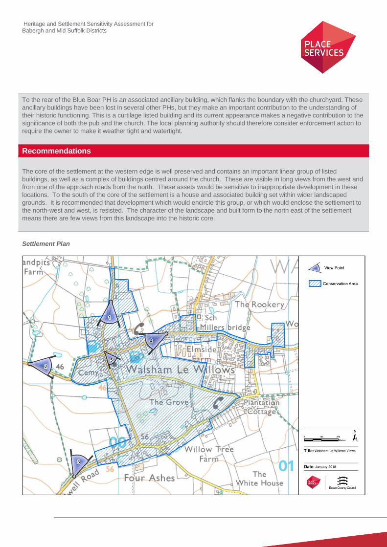
Heritage and Settlement Sensitivity Assessment for Babergh and Mid Suffolk Districts
To the rear of the Blue Boar PH is an associated ancillary building, which flanks the boundary with the churchyard. These
ancillary buildings have been lost in several other PHs, but they make an important contribution to the understanding of
their historic functioning. This is a curtilage listed building and its current appearance makes a negative contribution to the
significance of both the pub and the church. The local planning authority should therefore consider enforcement action to
require the owner to make it weather tight and watertight.
Recommendations
The core of the settlement at the western edge is well preserved and contains an important linear group of listed
buildings, as well as a complex of buildings centred around the church. These are visible in long views from the west and
from one of the approach roads from the north. These assets would be sensitive to inappropriate development in these
locations. To the south of the core of the settlement is a house and associated building set within wider landscaped
grounds. It is recommended that development which would encircle this group, or which would enclose the settlement to
the north-west and west, is resisted. The character of the landscape and built form to the north east of the settlement
means there are few views from this landscape into the historic core.
Settlement Plan

Heritage and Settlement Sensitivity Assessment for Babergh and Mid Suffolk Districts
Settlement Name: Woolpit District: Mid Suffolk
Settlement Description:
Woolpit is located in central Suffolk, situated on a gentle spur of land projecting between tributaries of the Black Bourn. The settlement is bypassed by the A14, which formerly passed through the centre of the village.
The church lies in the centre, designated grade I having its origins in the 13th century, located close to the old market
place which is surrounded by brick-faced timber-framed houses and shops dating back to the fourteenth and fifteenth century, the majority of which are grade II listed. Together with part of the street leading to Bury St. Edmunds, this formed the commercial centre of the village. The ancient market place is triangular in shape, and it was originally surrounded by a number of inns. The historic core of the settlement is well preserved, with areas of modern development on the periphery.
Summary History:
The etymology of Woolpit as a place name derives from ‘Wolf’s Pit’, meaning a place to trap wolves. The earliest
evidence of settlement in Woolpit was found in the surrounding fields, with finds of multi-period dates from the Palaeolithic
through to the Roman period. These comprised of flint, pottery, metalwork and coins, indicating settlement in the vicinity,
although no definite settlement sites have been identified.
The first documentary evidence of the existence of Woolpit as a settlement is in 1005, when Ulfketel gave Woolpit, along with five other manors, to the Shrine of St Edmund at Beodricsworth, modern day Bury St. Edmunds. The Abbot remained Lord of the manor of Woolpit until the Abbey was dissolved in 1538. The settlement is also referred to in the Little Domesday Book, which recorded that there were 17 villeins, 3 bordars and 40 freeman in Woolpit.
In the thirteenth century Woolpit was granted licences for a weekly market and two annual fairs, and this may have been the catalyst for the creation of the current street pattern and plan form of the settlement. The settlement was commercially affluent throughout the medieval period and also became a popular place of pilgrimage, with many people coming to pray at the Shrine of Our Lady of Woolpit. The pilgrim trade led to the church becoming sufficiently rich that in the twelfth century the King appropriated the Abbey’s proportion of Woolpit’s tithes for himself. The market itself was also clearly affluent, and the wealth of the local merchants is perhaps best seen in the fact that in medieval times there were two guilds in Woolpit: (the Guild of the Holy Trinity and the Guild of Our Blessed Lady).
A well called Our Lady’s Well is situated north east of the church in a field called Palgrave’s Meadow. The earliest reference to the well is in the Manorial Extent of 1574 which in turn refers to an earlier survey in which a piece of land is ‘lying alongside the way which led to the spring called Our Lady’s Well’.
The settlement also has a long history as a site for brickworks. The first record of a brick kiln appears in the Manorial Extent of 1574. By the 18th century the Brickworks were an important part of the settlement and three working pits continued to provide employment throughout the 19th century. In a modified form they continued to work until just before the Second World War. These brickworks were largely located on the eastern side of the settlement
A local 17th century legend tells of the ‘Green Children’ who appeared out the ‘wolf pits’ after which the village is allegedly
named, and spoke no known language. Eventually absorbed into the local community, they lost their colour. The boy
died and the girl married a man from Kings Lynn.
Heritage and Settlement Sensitivity Assessment for Babergh and Mid Suffolk Districts
Historic Environment Designations
Conservation Area:
Woolpit Conservation Area
Drinkstone Conservation Area
Listed Buildings: within the village
Grade I: Grade II*: Grade II:
Scheduled Monument:
Lady Well (Holy Well and moat) 1005992
Registered Park and Garden:
None
Landscape Designations
AONB:
None
SSSI:
None
SAC:
None
Ancient Woodland:
None
Key Characteristics
Settlement:
Note: The key positive features or qualities, which if lost or changed there would be a significant consequence for the
current character.
The core of the settlement is formed of linear development set around a central triangular green and is heavily populated
with listed buildings. This tight and unaltered street pattern is a dominant characteristic within the settlement core. The
church is set to the east of the historic core and is visible from long distances in all directions. To the south east and north
west there has been considerable areas of modern development
Outside the settlement boundary there are several important groups of listed buildings. To the west there is a group of
industrial buildings set on high ground comprising two mills and associated cottage which are within their own
conservation area. . On the higher ground to the south are four farm complexes containing listed buildings and set away
from the edge of the settlement.
1 43
Heritage and Settlement Sensitivity Assessment for Babergh and Mid Suffolk Districts
Surrounding Landscape:
Note: The key positive features or qualities, which if lost or changed there would be a significant consequence for the
current character.
The surrounding landscape is agricultural in character, although it has been severed in places by the construction of the
A14 and the creation of an industrial estate to the east. An historic well is also situated to the east of the settlement, as
well as a scheduled moated site. These are visible as an area of secondary scrubland which seems to be currently
unmaintained or managed.
The landscape to the west of the settlement undulates with the mill complex set on higher ground with views across to the
settlement. There are four complexes of farmhouses to the south of the settlement and these sit within a wider agricultural
landscape.
Key Views
Note: The key views towards, through, across and away from the settlement
1. Views into the settlement from the north across open fields to the church, highlighting the prominent position of
the church at the eastern edge of the settlement.
2. Views into the settlement from the east looking west of the church, which again highlight the prominent settlement
edge location of the church.
3. Views looking north from the farm complexes on the ridge to the south of the settlement, which show the
interrelationship and separation between the farm complexes and the settlement.
4. Views from the west looking towards the mill complex to the west, which emphasise the physical separation
between the industrial complex and the settlement, and which would best allow for an understanding of the group
as a whole.
5. View looking south through the settlement, which allow an understanding of the historic settlement pattern.
6. View looking north across the central triangular green, which best illustrate the historic core around which the
settlement was formed.
Value
Note: Based on designation status (including setting of AONB/heritage assets, relationship of the settlement to the
heritage assets), local or community interest or use (access/enjoyment & amenity value), setting for the wider settlement.
Condition/rarity/quality.
The historic core represents a well preserved historic settlement with a high concentration of listed buildings surrounding a
central triangular space. Given the quality of the building stock, and the extent of their survival, it is of high value. The
church is a dominant visual feature from the surrounding landscape and is of high architectural and historic value.
The historic core, comprised of a large number of listed buildings, has relatively few areas of infill development, and where
infill has occurred it has been set back from the pervading building line which minimises its intrusion into the historic street
scene. This means that it is still understandable and readable in its historic form being of high value. There has been
considerable modern expansion to the west and south east which has removed the historic cores relationship with its
surrounding agricultural landscape thus reducing the value of this interrelationship.
The complex of mills at Drinkstone Mill to the west of the settlement represents an important and comparably rare survival
and includes a grade I and a grade II* listed building. The complex as a whole is therefore considered to be of
exceptionally high significance.
Heritage and Settlement Sensitivity Assessment for Babergh and Mid Suffolk Districts
Susceptibility
Note: The ability of the receptors (features, qualities, characteristics, condition) to accommodate the changes without
undue consequences for the maintenance of the baseline.
The church is prominent in long views from a number of directions. This makes an important contribution to its
significance and whilst there is modern development within close proximity this has not severed these views. The church
would therefore be susceptible to further modern development if this served to curtail or block these longer views.
The mill complex is also prominent in long views and is set at a distance away from the settlement to the west. It is
susceptible therefore to any development which would enclose or encircle this group or which would bring it into the
settlement boundary. The same is true of the group of farm complexes located to the south of the settlement
The moated site and Lady’s Well does not appear to benefit from regular maintenance and industrial development has
encroached up to its boundary. Further development within this area would have a significant detrimental effect to both
assets.
Finally the historic core is well preserved and is of high value. It is therefore susceptible to modern infill or backland
development which would intrude upon its character. There are however areas to the north-west and south-east where
modern development has intruded, and these areas would be less susceptible to further development.
Potential Enhancement
Note: Areas that could potentially be improved or enhanced.
The moated site and Lady’s Well to the east of the settlement are assets of high significance, but are currently poorly
maintained. These would benefit from the production of a management plan to ensure their better maintenance, as well a
scheme of interpretation.
An assessment of the current condition of both mills to the south of the settlement would seem to show that they are both
in varying states of deterioration. Consideration should be given as to how the condition of these assets could be
improved, either through enforcement action or by encouraging the owner to undertake repairs.
Recommendations
The historic core of Woolpit is well preserved, with only comparatively isolated areas of modern incursion, to the south-
east and north-west of the settlement. These areas are less susceptible to further development. There is however a group
of farm buildings on higher ground to the south, and a group of listed mill buildings to the west. These form important
separate clusters, the latter of exceptional significance, and development should be avoided in areas which would encircle
these, or draw them within the settlement boundary. The eastern boundary, particularly that around the Lady’s Well, is
also vulnerable to development which would further erode the significance of this asset. Development to the north of the
settlement should also be sited in locations which avoid further eroding long views of the church from this direction.
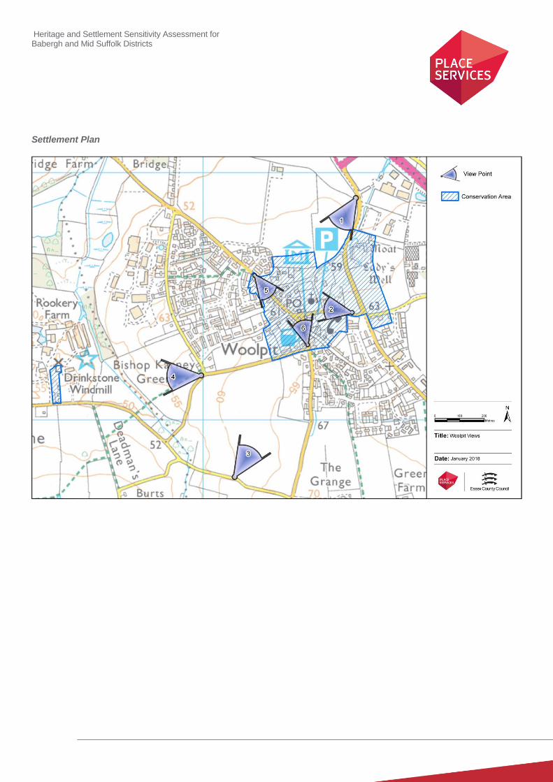
Heritage and Settlement Sensitivity Assessment for Babergh and Mid Suffolk Districts
Settlement Plan
Heritage and Settlement Sensitivity Assessment for Babergh and Mid Suffolk Districts
Settlement Name: Wyverstone District: Mid Suffolk
Settlement Description:
Wyverstone is split between several historic centres including Wyverstone, Wyverstone Green and Wyverstone Street, as
well as a complex of dispersed farmsteads. The village is located approximately five miles north of the town of
Stowmarket, sited on a ridge between the tributaries of the River Dove. The historic church and site of the original manor
are in Wyverstone. Wyverstone Street has a group of listed buildings dating from the late 15th century through to the 17th
century. Wyverstone Green has listed buildings associated with farming and date from the 17th and 19th centuries.
Summary History:
The etymology of the place name Wyverstone derives from the personal name Wigferp, and therefore means ‘Wigferp’s
homestead’. The earliest evidence for settlement in the vicinity is a find of Palaeolithic worked flint flake, and there is
evidence of later settlement seen in the unearthing of Roman pottery.
Wyverstone is mentioned in the Domesday Book as a village of 36 households in the Hundred of Hartismere. At the time
of the Conquest there were three separate manorial holdings, under the overlordships of the Saxon noble Leofwin the
Bald, Edric of Laxfield and the Abbey of Bury St. Edmunds. Twenty years later when the Domesday Book was compiled,
Richard, Hubert of Mont-Canisy and the Abbey of Bury St. Edmunds were the overlords, a common pattern of land
ownership in East Anglia post conquest, with many of the non- ecclesiastical landowners being dispossessed in favour of
Norman landholders. The manors became unified under one ownership soon after under the Hovel family, before passing
to William de Pole in c.1450.
The documentary evidence shows a relatively thriving village, with a weekly market and a yearly three-day fair, which was
recorded as being held from 1231. The surviving evidence for moated sites suggests that the settlement also contained
several higher status manors, including the medieval manor of Wyverstone, which was moated and was sited immediately
to the north of the church. The building has since been demolished, and the building now called the Manor between
Wyverstone and Wyverstone Street was originally the Rectory, and was built between1820-30 for the Rev W.C. Stegall.
Another medieval moat lies to the west of Wyverstone Green. Most of the archaeological finds from around this settlement
date from the medieval and post medieval periods, as do much of the older surviving built form. Similarly the 1st edition
OS map shows that the area between the separate settlements consists of small irregular fields, the form of which
suggests that they probably originated in the medieval period and have largely survived to the present day.
Some small scale development has occurred to the south of the church and at Wyverstone Street, but this is relatively
small scale, and has not intruded on the separation between distinct areas of the settlement.
Historic Environment Designations
Conservation Area:
None
Listed Buildings: within the village
Grade I: Grade II*: Grade II:
1 1 12
Heritage and Settlement Sensitivity Assessment for Babergh and Mid Suffolk Districts
Scheduled Monument:
None
Registered Park and Garden:
None
Landscape Designations
AONB:
None
SSSI:
None
SAC:
None
Ancient Woodland:
None
Key Characteristics
Settlement:
Note: The key positive features or qualities, which if lost or changed there would be a significant consequence for the
current character.
Wyverstone was originally a polyfocal settlement formed of four distinct areas. The first is the church and hall to the north
east at Wyverstone. The second is a group of buildings along Rectory Road, collectively forming Wyverstone Green. This
is a group to the north of Rectory Road with Grange Farm, The Manor and Park Farm, all of which contain designated
heritage assets. Finally there is a dispersed group of cottages farmsteads, and a moated site on Mill Road. Together the
heritage assets form one inter-related polyfocal settlement.
These were historically distinctly separate from each other and whilst modern development has considerably increased
the size of Wyvestone and Wyvestone Street there is still a distinct physical separation from each other. The dispersed
nature of the settlement, and the ability to read the assets and groups of assets independently, is integral to the character
of the settlement, as is the wider landscape in which they are sited.
Surrounding Landscape:
Note: The key positive features or qualities, which if lost or changed there would be a significant consequence for the
current character.
The surrounding landscape is fundamentally agricultural in character, and is defined by open fields and dispersed
farmsteads. There is very little change in topography across the settlement, with a gentle drop in land height from east to
west.

Heritage and Settlement Sensitivity Assessment for Babergh and Mid Suffolk Districts
Key Views
Note: The key views towards, through, across and away from the settlement
1. View of the Church looking East along Rectory Road, which highlights the separation of the church and hall
complex from the other settlement areas, and allows an understanding of the settlement’s polyfocal nature.
2. View of the Church looking west into the settlement. This highlights its position within the landscape and its
settlement edge location.
3. Views looking east from edge of Wyverstone Street which emphasises the polyfocal nature of the settlement.
Value
Note: Based on designation status (including setting of AONB/heritage assets, relationship of the settlement to the
heritage assets), local or community interest or use (access/enjoyment & amenity value), setting for the wider settlement.
Condition/rarity/quality.
The value of Wyverstone relates to the quality of its surviving built, and more significantly to its surviving polyfocal nature.
This would have been historically characteristic of the rural villages of Suffolk, but many have since loss this character due
to later infill development. It is therefore a good survival with limited modern expansion restricted to Wyverstone and
Wyverstone Street.
Susceptibility
Note: The ability of the receptors (features, qualities, characteristics, condition) to accommodate the changes without
undue consequences for the maintenance of the baseline.
The gap between Wyverstone and Wyverstone Street is important to the significance of the heritage assets within the two
groups. Similarly, the dispersed nature of the cottages and farm along Mill Road is important. In both instances this
sense of separation makes an important contribution to the significance of the heritage assets and all are susceptible to
the infilling of the spaces between.
Potential Enhancement
Note: Areas that could potentially be improved or enhanced.
None identified
Recommendations
The significance of the heritage assets derives considerably from their dispersed nature and it is recommended that
development which would create a linear settlement or which would infill the land on or between Rectory Road and Mill
Road.
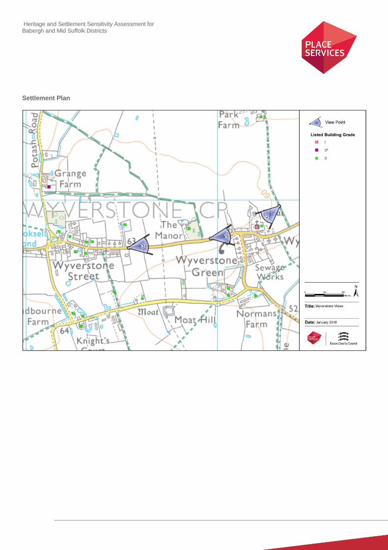
Heritage and Settlement Sensitivity Assessment for Babergh and Mid Suffolk Districts
Settlement Plan


