APPLICATION FOR A MINING PERMIT AND RELATED ENVIRONMENTAL APPROVALS FOR BORROW PIT 3 ADJACENT TO THE R61 SECTION 6 KM 52.6, EASTERN CAPE PROVINCE. DRAFT SCOPING REPORT DMR REFERENCE: Pending. Prepared for: On behalf of: South African National Roads Agency Ltd (SANRAL) Prepared by: EOH Coastal & Environmental Services EAST LONDON 25 Tecoma Street, Berea East London 5214 043 726 7809 Also in Grahamstown, Cape Town, Johannesburg, Port Elizabeth and Maputo (Mozambique) www.cesnet.co.za or www.eoh.co.za October 2017
Transcript
APPLICATION FOR A MINING PERMIT AND RELATED ENVIRONMENTAL APPROVALS FOR BORROW PIT 3 ADJACENT TO
THE R61 SECTION 6 KM 52.6, EASTERN CAPE PROVINCE.
DRAFT SCOPING REPORT
DMR REFERENCE: Pending.
Prepared for:
On behalf of:
South African National Roads Agency
Ltd (SANRAL)
Prepared by:
EOH Coastal & Environmental Services
EAST LONDON 25 Tecoma Street, Berea
East London 5214
043 726 7809 Also in Grahamstown, Cape Town, Johannesburg, Port Elizabeth and Maputo
This Report should be cited as follows: EOH Coastal & Environmental Services, October 2017: Rehabilitation of National Route R61 Section 6: Borrow Pit 3, Draft Scoping Report, EOH CES, East London.
REVISIONS TRACKING TABLE
EOH Coastal and Environmental Services
Report Title: Application for a mining permit and related environmental approvals for borrow pit 3 adjacent to the R61 section 6 km 52.6: Borrow Pit 3, Scoping Report
Report Version: Draft Project Number: 204
Name Responsibility Date
Thina Mgweba Report Writer
October 2017
Caitlin Smith
Project Manager/ Report Writer October 2017
Dr Alan Carter
Reviewer October 2017
Copyright This document contains intellectual property and propriety information that are protected by copyright in favour of EOH Coastal & Environmental Services (EOH CES) and the specialist
consultants. The document may therefore not be reproduced, used or distributed to any third party without the prior written consent of EOH CES. The document is prepared exclusively for
submission to SANRAL in the Republic of South Africa, and is subject to all confidentiality, copyright and trade secrets, rules intellectual property law and practices of South Africa.
INTRODUCTION ..................................................................................................................... 1 Background to the Study ................................................................................................. 1 Environmental Authorisation in South Africa .................................................................... 1 Scoping Phase ................................................................................................................ 1 Nature and Structure of this Scoping Report .................................................................... 1 Assumptions and Limitations ........................................................................................... 1 Mining Right Application .................................................................................................. 1 Details and Expertise of the Environmental Assessment Practitioner .............................. 2 1.7.1 Details of the EAP........................................................................................................ 2 1.7.2 Expertise of the study team ......................................................................................... 2
RELEVANT LEGISLATION .................................................................................................... 9 Relevant Legislation and Guidelines used in the Compilation of this Scoping Report ...... 9 Relevant policy .............................................................................................................. 10 4.2.1 National Policy ........................................................................................................... 10 4.2.2 Provincial Policy ........................................................................................................ 10 4.2.3 Municipal planning documents ................................................................................... 11 The Engcobo IDP (2014/2015) .............................................................................................. 11
PROJECT NEED & DESIRABILITY ..................................................................................... 12 PROJECT ALTERNATIVES ................................................................................................. 13
Reasonable and Feasible Alternatives ........................................................................... 13 Fundamental Alternatives .............................................................................................. 13 Incremental Alternatives ................................................................................................ 13 No-Go development ...................................................................................................... 13 Analysis of alternatives .................................................................................................. 14
PUBLIC PARTICIPATION .................................................................................................... 18 Notification of Interested and Affected Parties ............................................................... 18 7.1.1 Public Participation .................................................................................................... 18 7.1.2 Newspaper advertisement ......................................................................................... 18 7.1.3 On-site Notice ............................................................................................................ 18 7.1.4 Stakeholders and I&APs ............................................................................................ 18 7.1.5 Background information document ............................................................................ 19 7.1.6 Proof of notification .................................................................................................... 19 7.1.7 Issues raised by stakeholders/ I&APs ........................................................................ 19
DESCRIPTION OF THE ENVIRONMENT ............................................................................. 20 The Bio-Physical Environment ....................................................................................... 20 8.1.1 Current land use ........................................................................................................ 20 8.1.2 Climate ...................................................................................................................... 21 8.1.3 Topography ............................................................................................................... 21 8.1.4 Geology and soils ...................................................................................................... 22 Rivers and wetlands ...................................................................................................... 23 Vegetation ..................................................................................................................... 24 8.3.1 Mucina and Rutherford .............................................................................................. 24 Conservation and spatial planning tools ........................................................................ 25 8.4.1 Eastern Cape Biodiversity Conservation Plan ............................................................ 25 8.4.2 Protected Areas (NEMPAA & NPAES) ...................................................................... 26 8.4.3 Photographs of the borrow pit site: ............................................................................ 27 Socio-Economic Profile.................................................................................................. 28 8.5.1 Population ................................................................................................................. 28 8.5.2 Employment ............................................................................................................... 28
8.5.3 Education .................................................................................................................. 28 MANNER IN WHICH THE ENVIRONMENT MAY BE AFFECTED ....................................... 29
Possible Environmental Issues and Impacts .................................................................. 29 PLAN OF STUDY FOR EIA PHASE ..................................................................................... 32
Scope and Intent of the EIA Phase ................................................................................ 32 10.1.1 Specialist Studies .................................................................................................. 32 10.1.2 Environmental Impact Report. ................................................................................ 32 10.1.3 Issues and Response Trail..................................................................................... 32 10.1.4 Environmental Management Programme ............................................................... 33 10.1.5 Record of Decision of Environmental Authorisation and Appeals Process. ............ 33
The Public Participation Process ................................................................................... 33 10.2.1 Public Review Of The Draft Scoping Report .......................................................... 33 10.2.2 Public Review Of The Draft Environmental Impact Report ..................................... 33 10.2.3 Notification Of Environmental Authorisation ........................................................... 33
Environmental Impact Report ........................................................................................ 34 10.3.1 Structure of the EIA Report .................................................................................... 34
Methodology for assessing the significance of impacts .................................................. 35 CONCLUSIONS AND RECOMMENDATIONS ..................................................................... 39
Activity and Possible Impacts ........................................................................................ 39 Fatal Flaws .................................................................................................................... 39 The EIA Phase .............................................................................................................. 39
Appendix A: Public participation documents .................................................................. 41 13.1.1 Newspaper advert: ................................................................................................. 41 13.1.2 Background Information Document: ....................................................................... 43 13.1.3 Notice board .......................................................................................................... 50 13.1.4 Letter of notification................................................................................................ 52 13.1.5 Landowner permission from the Chief: ................................................................... 54 13.1.6 Public Meeting Minutes .......................................................................................... 58 13.1.7 Public Meeting Attendance Register ...................................................................... 61 13.1.8 Interested and affected parties database ............................................................... 65
LIST OF FIGURES
Figure 1.1 The EIA process. .................................................................................................................................... 3 Figure 2.1. Locality map of the proposed borrow pit site. ...................................................................................... 5 Figure 3.1 Proposed layout of the borrow pit. ........................................................................................................ 7 Figure 8.1. Land use map for the study area. ...................................................................................................... 20 Figure 8.2 Sheep grazing on the borrow pit site. ................................................................................................. 21 Figure 8.3: Engcobo average monthly temperatures (°C) and rainfall (mm) (Adapted from
http://www.saexplorer.co.za/south-africa/climate/engcobo_climate.asp) .................................................. 21 Figure 8.4 Topography of the study area. ............................................................................................................ 22 Figure 8.5. Geology of the study area. ................................................................................................................. 23 Figure 8.6 Rivers in the study area. ...................................................................................................................... 24 Figure 8.7 SANBI vegetation map of the study area. .......................................................................................... 25 Figure 8.8. ECBCP map of the study area. .......................................................................................................... 26 View looking east towards the borrow pit ............................................................................................................. 27 View looking west from the borrow pit site ........................................................................................................... 27 Graves near the borrow pit site ............................................................................................................................. 27 Sheep grazing on site ............................................................................................................................................ 27 Figure 8.9. Employment figures for the ELM (ELM IDP, 2014/2015). ................................................................ 28
LIST OF TABLES Table 1.1: Listed activities triggered by the proposed borrow pit.......................................................................... 1 Table 2.1: Property details ....................................................................................................................................... 4 Table 2.2: Coordinates of the corner points of the borrow pit site. ....................................................................... 4 Table 3.3: Listed activities triggered by the proposed borrow pit.......................................................................... 8 Table 4.1: Environmental legislation considered in the preparation this Scoping Report. .................................. 9 Table 6.1: The alternatives considered for the proposed mudstone borrow pit. ................................................ 15 Table 9.1: Issues and impacts identified in the planning and design phase of the proposed borrow pit. ........ 29 Table 9.2: Issues and impacts identified in the construction phase of the proposed borrow pit. ..................... 30 Table 9.3: Issues and impacts identified in the operation phase of the proposed borrow pit. .......................... 30 Table 9.4: Issues and impacts identified in the decommissioning phase of the proposed borrow pit. ............ 31 Table 10.1. Significance Rating Table .................................................................................................................. 36 Table 10.2. Impact Severity Rating ....................................................................................................................... 36 Table 10.3. Overall Significance Rating ................................................................................................................ 37
LIST OF ACRONYMS BAR Basic Assessment Report
BID: Background Information Document
CBA: Critical Biodiversity Areas
CITES: Committee for International Trade in Endangered Species
DEA: Department of Environmental Affairs
DWS: Department of Water and Sanitation
EAP: ECO
Environmental Assessment Practitioner Environmental Control Officer
EIA: Environmental Impact Assessment
EIR: Environmental Impact Report
EMPr: Environmental Management Programme
GNR: Government Notice Regulation
ha: Hectare
I&APs: Interested and Affected Parties
IDP: Integrated Development Plan
NEMA: National Environmental Management Act 107 of 1998 as amended
NFEPA National Freshwater Ecosystem Priority Area
PoS: Plan of Study
PAES Protected Areas Expansion Strategy
PPP: Public Participation Process
RDB: Red Data Book
SAHRA South African Heritage Resources Agency
SANBI South African National Biodiversity Institute
Background to the Study The South African National Roads Agency Ltd. (SANRAL) will be constructing various safety improvements on Section 6 of the R61 National Route from (KM 52.6) in the Engcobo Local Municipality in the Eastern Cape Province. A mudstone borrow pit is required to supply the necessary hard rock material for road construction. A suitable borrow pit has been identified approximately 750m off the R61 Section at Km 52.6 in the Beyele Administrative Area in the Engcobo Local Municipality, Eastern Cape. In terms of Section 106 of the Mineral and Petroleum Resources Development Act (Act No. 28 of 2002; MPRDA) SANRAL is exempted from the application for a Mining Right for the borrow pit but is not exempted from the application for environmental authorisation for the borrow pit. EOH Coastal and Environmental Services (EOH CES) has been appointed by Mott Macdonald (the project managers) as the EAP to undertake the Environmental Impact Assessment (EIA) for the proposed borrow pit.
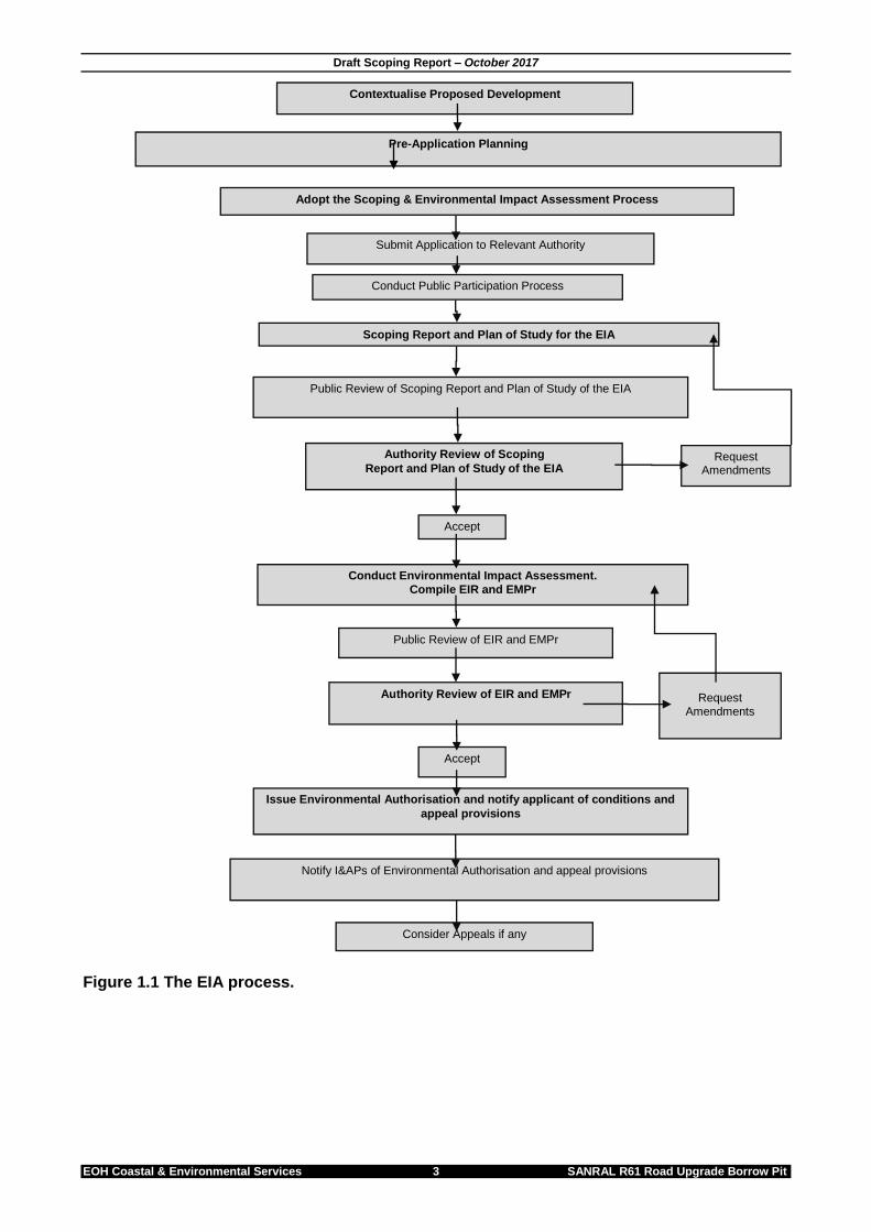
Environmental Authorisation in South Africa The regulation and protection of the environment within South Africa occurs mainly through the application of various items of legislation, within the regulatory framework of the Constitution (Act 108 of 1996). The primary legislation regulating Environmental Impact Assessments (EIA) within South Africa is the National Environmental Management Act (NEMA, Act 107 of 1998). NEMA makes provision for the Minister of Environmental Affairs to identify activities which may not commence prior to authorisation from either the Minister or the provincial Member of the Executive Council (MEC). In addition to this, NEMA also provided for the formulation of regulations in respect of such authorisations. The EIA regulations (2014) (amended 2017) allow for a Basic Assessment process for activities with limited environmental impact (listed in GNR. 327 and 324, 2017) and a more rigorous two-tiered approach for activities with potentially greater environmental impact (listed in GNR. 325, 2017). This two-tiered approach includes both a Scoping and EIA process (Figure 1.1). The listed activities that have been applied for are provided in Table 1.1 below. The proposed borrow pit triggers the need for a Full Scoping and EIA process under the NEMA Regulations (2014) (amended 2017) in terms of Listing Notices 1 and 2 published in Government Notices No. R. 327 and R. 324, respectively. The proposed borrow pit requires a Full Scoping and EIA due to the following triggers in terms of GNR 325: Table 1.1: Listed activities triggered by the proposed borrow pit.
Scoping Phase The Scoping Phase is designed to determine the “scope” of the subsequent Environmental Impact Assessment (EIA), conducted in fulfilment of the application for authorisation. The overall aim of the Scoping Phase is to determine those environmental issues and impacts associated with the proposed borrow pit that require further investigation in an EIA. The purpose of scoping is therefore to identify:
Environmental Issues
Impacts
Alternatives Also integral to the Scoping Phase is the initial public participation process (PPP). This process ensures that all possible interested and affected parties (I&APs) are informed of the proposed activity and are provided with an opportunity to comment and identify issues.
Nature and Structure of this Scoping Report This Scoping Report fulfils the requirement of the EIA Regulations (2014) (amended 2017) for the documentation of the Scoping Phase. The structure of this report is based on APPENDIX 2 of GNR No. 326, of the Environmental Impact Assessment Regulations (2014) (amended 2017), which clearly specifies the required content of a Scoping Report.
Assumptions and Limitations This Scoping Report is based on currently available information and, as a result, the following limitations and assumptions are implicit–
The report is based on project information provided by the client.
Descriptions of the natural and social environments are based on limited fieldwork and available literature. More information will be provided in the EIA phase.
Mining Right Application SANRAL is exempted from the application for a Mining Right for the borrow pit, but is not exempted from the application for Environmental Authorisation (EA). The borrow pit requires an application for EA in terms of NEMA (Act 107 of 1998) and a mining authorisation in terms of the MPRDA (No. 28 of 2002).
Details and Expertise of the Environmental Assessment Practitioner In fulfilment of the above-mentioned legislative requirement the details of the Environmental Assessment Practitioner (EAP) that prepared this draft scoping report as well as the expertise of the individual members of the study team are provided below. 1.7.1 Details of the EAP EOH was established in 1990 as a specialist environmental consulting company and has considerable experience in terrestrial, marine and freshwater ecology, the Social Impact Assessment (SIA) process, State of Environment Reporting (SOER), Integrated Waste Management Plans (IWMP), EMPs, Spatial Development Frameworks (SDF), public participation, as well as the management and co-ordination of all aspects of the EIA and Strategic Environmental Assessment (SEA) processes. 1.7.2 Expertise of the study team Dr Alan Carter (EAP) Alan is the executive of the CES East London Office. He holds a PhD in Marine Biology and is a certified Public Accountant, with extensive training and experience in both financial accounting and environmental science disciplines with international accounting firms in South Africa and the USA. He has 25 years’ experience in environmental management and has specialist skills in sanitation, coastal environments and industrial waste. Dr Carter is registered as a Professional Natural Scientist under the South African Council for Natural Scientific Professions (SACNASP). He is also registered as an EAP by the Environmental Assessment Practitioners of South Africa (EAPSA).
In terms of APPENDIX 2(2)(1) of the EIA Regulations (2014) (amended 2017), a Scoping Report must include – (a) Details of– (i) The EAP who prepared the report; and (ii) The expertise of the EAP, including a curriculum vitae.
Ms Caitlin Smith Senior Environmental Consultant. Caitlin holds a BSc degree with majors in Geology and Geography and a BSc Honours Degree (with distinction) in Geology both obtained from Nelson Mandela Metropolitan University. Caitlin is a qualified geologist and has managed and been involved in various Environmental Impact Assessments. Her interest lies in the water sector, specifically in wetland related studies. She has completed various Aquatic and Wetland assessments for road and infrastructure projects. She is currently studying her MSc degree in Hydrology at Rhodes University focusing on the groundwater and surface water interactions of the Kromme River wetlands. Ms Thina Mgweba Thina is an Environmental Consultant. She holds a BSc degree in Economics and Environmental Science as well as a BSc Honours degree in environmental science both from Rhodes University. Her honours dissertation investigated climate change resilience and adaptation in the coastal villages of Hamburg, Eastern Cape. Her professional interests include the development of climate change strategies, environmental economic analyses as well as social impact assessments.
Property Locality The proposed borrow pit is located approximately 750m off the R61 Section at Km 52.6 (from Qumanco River to Engcobo CBD) in the Beyele Administrative Area in Engcobo Local Municipality, Eastern Cape. Figure 2.1 illustrates the proposed borrow pit site. Property details are illustrated in Table 2.1 below. Coordinates of the proposed borrow pit site is illustrated in Table 2.2. Table 2.1: Property details
Province Eastern Cape
District Municipality Chris Hani District Municipality (CHDM)
Local Municipality Engcobo Local Municipality (ELM)
Erf details Beyele Administrative Area
Table 2.2: Coordinates of the corner points of the borrow pit site.
Latitude (S) (DDMMSS) Longitude (E) (DDMMSS)
31°45'4.15"S 27°57'11.68"E
31°44'56.88"S 27°57'17.60"E
31°44'55.41"S 27°57'21.33"E
31°44'56.52"S 27°57'23.12"E
31°44'57.10"S 27°57'28.18"E
31°44'59.12"S 27°57'28.39"E
31°45'6.16"S 27°57'18.47"E
31°45'8.09"S 27°57'11.68"E
In terms of APPENDIX 2(2)(1) of the EIA Regulations (2014) (amended 2017), a Scoping Report must include –
b) The location of the activity, including – (i) The 21 digit Surveyor General code of each cadastral land parcel; (ii) Where available, the physical address and farm name; (iii) Where the required information in terms of (i) and (ii) is not available, the
coordinates of the boundary of the property or properties; c) A plan which locates the proposed activity or activities applied for at an
Description of Proposed Activity SANRAL will be constructing various safety improvements on Section 6 of the R61 National Route from Qumanco River to Engcobo in the Eastern Cape Province. Mott MacDonald, the project managers, have appointed EOH CES as the EAP to undertake the Environmental Impact Assessment for this project. A mudstone borrow pit is required to supply the necessary rock material for road construction. A suitable borrow pit site has been identified approximately 750m off the R61 at Km 52.6 in the Beyele Administrative Area in the Engcobo Local Municipality, Eastern Cape. A perimeter fence will be constructed around the borrow pit site (Figure 3.1). The borrow pit area is approximately 8.8 hectares in size. The fence has a perimeter of approximately 1285 m. Approximately 45 129 m3 of topsoil will be taken off the borrow pit site and stockpiled. The topsoil stock pile area is 0.30 Ha in size. The borrow pit should yield approximately 405 394.16 m3 of mudstone rock for crushing. Rock will only be stored temporarily in stockpiles on site (taking up a total area of 0.54 Ha) before being crushed and taken off site.
In terms of Section APPENDIX 2(2)(1) of the EIA Regulations (2014) (amended 2017), a Scoping Report must include -
d) A description of the scope of the proposed activity, including – (i) All listed and specified activities triggered; (ii) A description of the activities to be undertaken, including associated
Listed activities triggered The proposed borrow pit triggers the need for a Full Scoping and EIA process under the NEMA Regulations (2014) (amended 2017) in terms of Listing Notices 1 and 2 published in Government Notices No. R. 327 and R. 325 respectively. The listed activities that have been applied for are provided in Table 3.3 below. Table 3.3: Listed activities triggered by the proposed borrow pit. Government Notice
Activity Number
Activity Description Relevance to this project
GNR 327 22
The decommissioning of any activity
requiring (i) a closure certificate in terms
of Section 43 of the MPRDA (2002).
Decommissioning of the
borrow pit once mining is
complete will require a closure
certificate.
GNR 327 27
The clearance of an area of 1 hectare or
more, but less than 20 hectares of
indigenous vegetation.
The borrow pit will require
clearance of more than 1
hectare of indigenous
vegetation.
GNR 325 17
Any activity including the operation of
that activity which requires a mining right
as contemplated in Section 22 of the
MPRDA (2002), including – (a)
associated infrastructure, structures and
earthworks, directly related to the
extraction of a mineral resource, or (b)
the primary processing of a mineral
resource including winning, extraction,
classifying, concentrating, crushing,
screening or washing.
The borrow pit will be used for
mining material to be used in
road construction
(approximately 8.8 ha in size).
Any activity which requires a mining right, including activities for which an exemption has been issued, require that an application for environmental authorisation be submitted to DMR.
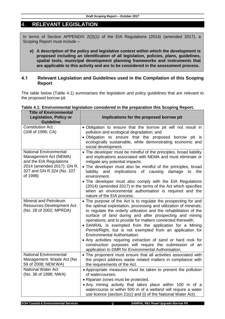
Relevant Legislation and Guidelines used in the Compilation of this Scoping Report
The table below (Table 4.1) summarises the legislation and policy guidelines that are relevant to the proposed borrow pit. Table 4.1: Environmental legislation considered in the preparation this Scoping Report.
Title of Environmental Legislation, Policy or
Guideline Implications for the proposed borrow pit
Constitution Act (108 of 1996; CA)
Obligation to ensure that the borrow pit will not result in pollution and ecological degradation; and
Obligation to ensure that the proposed borrow pit is ecologically sustainable, while demonstrating economic and social development.
National Environmental Management Act (NEMA) and the EIA Regulations 2014 (amended 2017): GN R. 327 and GN R.324 (No. 107 of 1998)
The developer must be mindful of the principles, broad liability and implications associated with NEMA and must eliminate or mitigate any potential impacts.
The developer must also be mindful of the principles, broad liability and implications of causing damage to the environment.
The developer must also comply with the EIA Regulations (2014) (amended 2017) in the terms of the Act which specifies when an environmental authorisation is required and the nature of the EIA process.
Mineral and Petroleum Resources Development Act (No. 28 of 2002; MPRDA)
The purpose of the Act is to regulate the prospecting for and the optimal exploitation, processing and utilization of minerals; to regulate the orderly utilization and the rehabilitation of the surface of land during and after prospecting and mining operations; and to provide for matters connected therewith.
SANRAL is exempted from the application for a Mining Permit/Right, but is not exempted from an application for Environmental Authorisation.
Any activities requiring extraction of sand or hard rock for construction purposes will require the submission of an application to DMR for Environmental Authorisation.
National Environmental Management: Waste Act (No 59 of 2008; NEM:WA)
The proponent must ensure that all activities associated with the project address waste related matters in compliance with the requirements of the Act.
National Water Act (No. 36 of 1998; NWA)
Appropriate measures must be taken to prevent the pollution of watercourses.
Riparian zones must be protected.
Any mining activity that takes place within 100 m of a watercourse or within 500 m of a wetland will require a water use licence (section 21(c) and (i) of the National Water Act).
In terms of Section APPENDIX 2(2)(1) of the EIA Regulations (2014) (amended 2017), a Scoping Report must include –
e) A description of the policy and legislative context within which the development is proposed including an identification of all legislation, policies, plans, guidelines, spatial tools, municipal development planning frameworks and instruments that
are applicable to this activity and are to be considered in the assessment process.
Guideline Implications for the proposed borrow pit
National Heritage Resources Act (No. 25 of 1999)
The Act requires all developers (including mines), to undertake cultural heritage studies for any development exceeding 5000 m2 in size. It also provides guidelines for impact assessment studies to be undertaken whenever cultural resources may be destroyed by development activities.
ECPHRA needs to be informed of the project.
Should heritage resources be identified during mining, appropriate measures must be undertaken to involve ECPHRA and to protect these resources.
Mine Health and Safety Act (No. 29 of 1996)
The key objectives of the Act are to provide for the health and safety of persons at work and in connection with the use of plants and machinery.
This Act will be applicable during all phases of the project and therefore necessary measures should be taken to ensure compliance.
National Environmental Management: Air Quality Act (No. 39 of 2004; NEM: AQA)
The purpose of this Act is to provide for national norms and standards regulating air quality monitoring, management and control.
This Act will be applicable during all phases of the project. The necessary measures must be taken to ensure compliance.
National Environmental Management: Biodiversity Act (No 10. of 2004), Alien and invasive species (2016)
If any declared weed and/or invader species listed in terms of this Act is present on site, it must be removed.
At this stage in the EIA process, the above list should not be regarded as complete or exhaustive, and it is probable that additional legislative requirements will be identified as the process progresses.
Relevant policy The proposed borrow pit is required to provide construction material for the upgrade of the National Route R61 Section 6. The policy listed below is thus relevant to the road upgrade. 4.2.1 National Policy
National Development Plan The National Development Plan (NDP) (also referred to as Vision 2030) is a detailed plan produced by the National Planning Commission in 2011 that is aimed at reducing and eliminating poverty in South Africa by 2030. The NDP represents a new approach by Government to promote sustainable and inclusive development in South Africa, promoting a decent standard of living for all, and includes key focus areas, such as improvement of roads and transport facilities. 4.2.2 Provincial Policy The Eastern Cape Vision 2030 Provincial Development Plan sets out nine key challenges that need to be addressed in the Eastern Cape. The challenge relevant to the proposed project has been extracted below:
(3) Infrastructure is poorly located, under-maintained and insufficient to foster higher growth and spatial transformation. • The road network is severely stressed and deteriorating. “…Because there are existing plans for the major arterial routes in the province, the programme will focus on building feeder and secondary roads, particularly rural and access roads, to ensure that no village is without a well-maintained connection to national roads and service centres by 2030.” 4.2.3 Municipal planning documents The Engcobo IDP (2014/2015) The Engcobo Local Municipality IDP (ELM IDP, 2014/2015) highlights the fact that there are serious road infrastructure challenges in the Municipality. The ELM IDP mentions the poor conditions of the roads and acknowledges that there are huge backlog challenges with regard to road maintenance.
PROJECT NEED & DESIRABILITY The proposed borrow pit will supply construction material for the upgrade of Section 6 of the R61 National Road. The need and desirability of this project is supported by National, Provincial and Municipal policy documents.
The road upgrade speaks directly to the National Development Plan for 2030. The vision statement of the NDP specifically mentions transport and improvement of roads.
The Eastern Cape Vision 2030 Provincial Development Plan (PDP) emphasises the challenge of road networks in the Eastern Cape and explains that roads are severely stressed and deteriorating. The PDP continues to explain that there are existing plans for the major arterial routes in the province and focus should be given to the construction of feeder and secondary roads. This is to ensure that no village is without a well-maintained connection to national roads.
The ELM IDP (2014/2015) highlights the provision and maintenance of road infrastructure in the strategic framework of the LM.
In terms of Section APPENDIX 2(2)(1) of the EIA Regulations (2014) (amended 2017), a Scoping Report must include –
f) A motivation for the need and desirability for the proposed development including the need and desirability of the activity in the context of the preferred location.
PROJECT ALTERNATIVES One of the objectives of an EIA is to investigate alternatives to the proposed project. There are two types of alternatives: Fundamental Alternatives and Incremental Alternatives.
Reasonable and Feasible Alternatives Alternatives should include consideration of all possible means by which the purpose and need of the proposed activity could be accomplished. The no-go alternative must also in all cases be included in the assessment phase as the baseline against which the impacts of the other alternatives are assessed. The determination of whether site or activity (including different processes etc.) or both is appropriate needs to be informed by the specific circumstances of the activity and its environment. “Alternatives”, in relation to a proposed activity, means different means of meeting the general purpose and requirements of the activity, which may include alternatives to; -
a) the property on which or location where it is proposed to undertake the activity. b) the type of activity to be undertaken. c) the design or layout of the activity. d) the option of not implementing the activity.
Fundamental Alternatives Fundamental alternatives are developments that are totally different from the proposed project description and usually include the following:
Alternative property or location where it is proposed to undertake the activity.
Alternative type of activity to be undertaken.
Alternative technology to be used in the activity.
Incremental Alternatives Incremental alternatives relate to modifications or variations to the design of a project that provide different options to reduce or minimise environmental impacts. There are several incremental alternatives that can be considered, including:
Alternative design or layout of the activity.
Alternative technology to be used in the activity.
Alternative operational aspects of the activity
No-Go development The EIA process is obligated to assess the status quo (i.e. the “No-Go” option). The No-Go alternative provides the assessment with a baseline against which predicted impacts resulting from the proposed development may be compared. A ‘’No-Go” alternative has been assessed for the proposed borrow pit.
In terms of Section APPENDIX 2(2)(1) of the EIA Regulations (2014) (amended 2017), a Scoping Report must include –
(g) A full description of the process followed to reach the proposed preferred activity, site and location of the development footprint within the site, including –
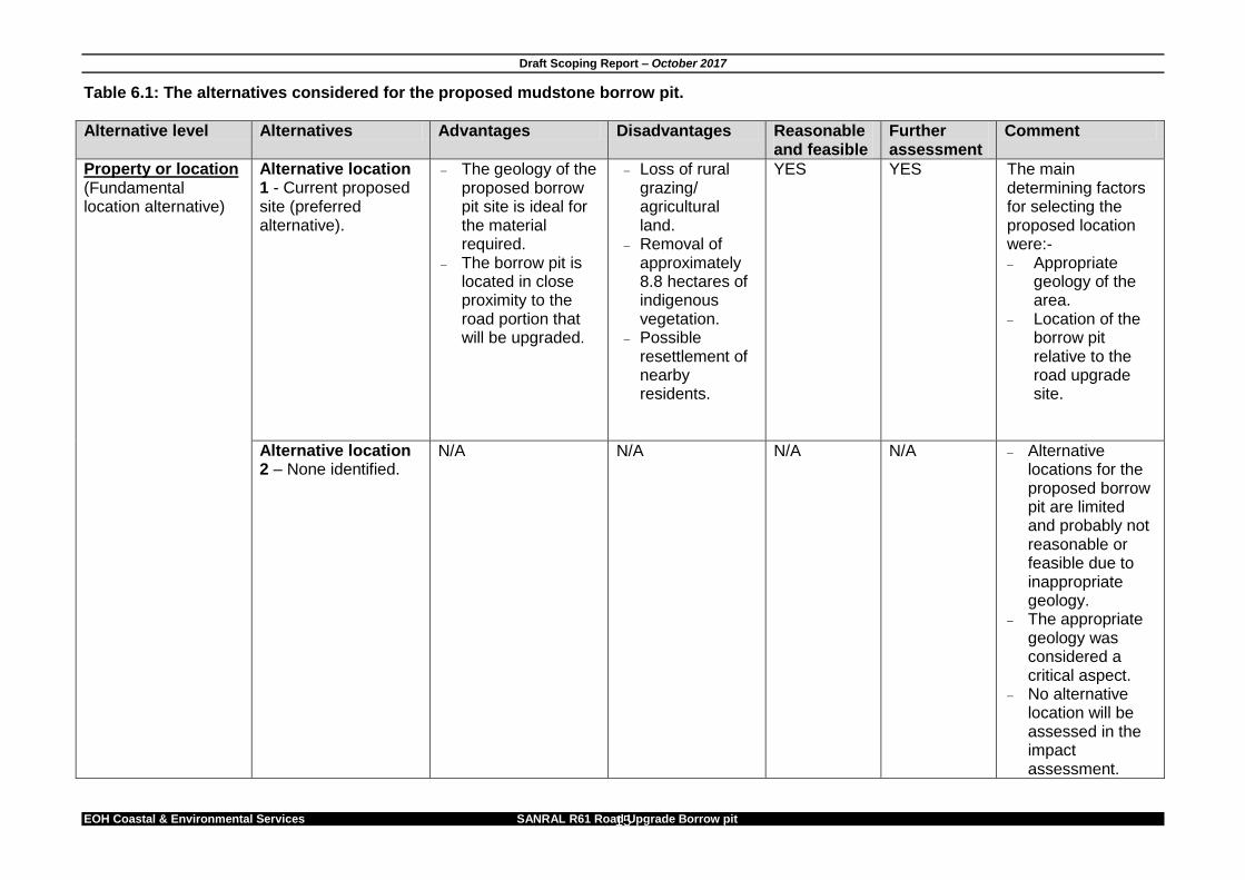
Analysis of alternatives Table 6.1 illustrates the methodology used to assess the identified alternatives. The table assesses the advantages and disadvantages, and provides further comments on the selected alternatives.
Alternative level Alternatives Advantages Disadvantages Reasonable and feasible
Further assessment
Comment
Type of technology This refers to the fundamental technology options required to operate the borrow pit.
Alternative technology 1 – Opencast mining using excavators and crushing and screening area on site (preferred alternative)
Time effective, i.e. shorter time required for processing material
Cost effective
Increase in noise levels on site and possible disturbance to surrounding areas.
Dust disturbance the surrounding areas especially during windy conditions.
YES YES This is the preferred and feasible mining method.
Alternative technology 2 – Opencast mining using excavators, transporting material for crushing and screening to an area offsite
Less noise and dust generated on site.
Higher cost to have a crushing and screening area offsite.
Materials will have to be transported from the borrow pit site to be processed.
YES NO This mining method will not be assessed further in the impact assessment process due to the high costs involved in transporting material to an offsite crusher.
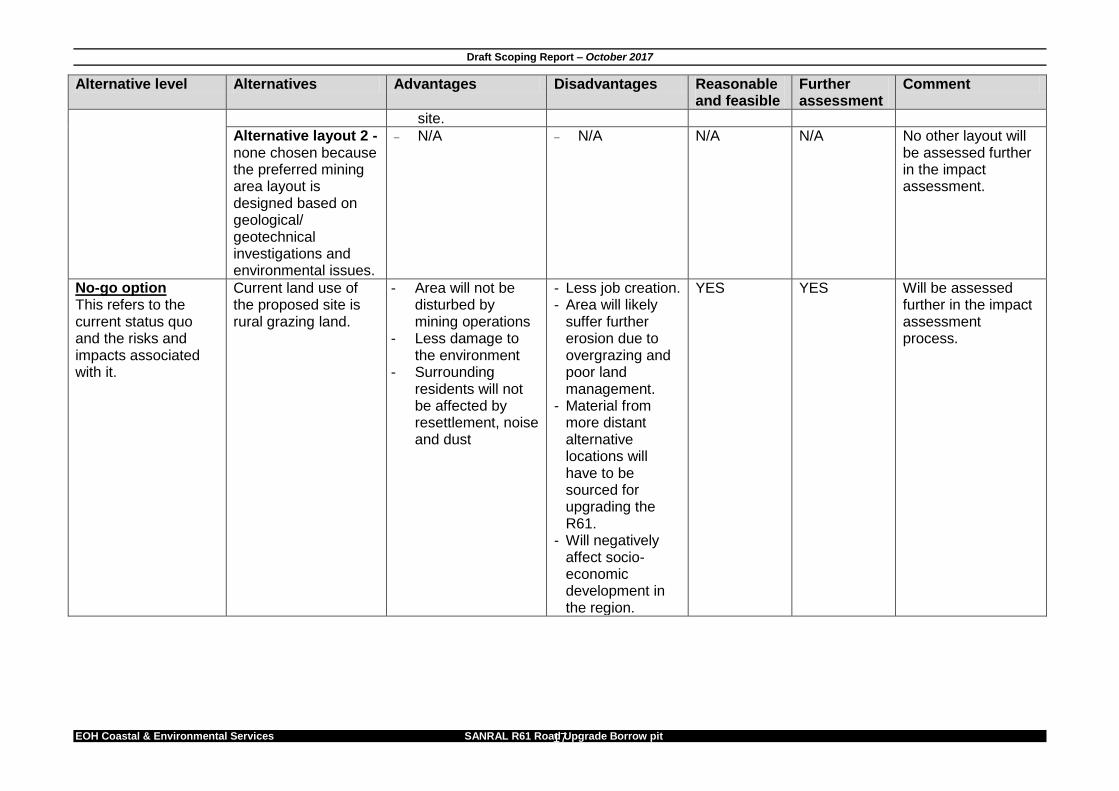
Layout alternative Incremental alternative.
Alternative layout 1 – Current proposed layout (preferred alternative).
The proposed borrow pit layout is ideal based on geological conditions.
This layout also takes into account environmental conditions of the
Possible resettlement of surrounding residents required.
YES YES This is the preferred layout and will be assessed further in the impact assessment. The proposed layout has been subjected to environmental screening.
Alternative level Alternatives Advantages Disadvantages Reasonable and feasible
Further assessment
Comment
site.
Alternative layout 2 - none chosen because the preferred mining area layout is designed based on geological/ geotechnical investigations and environmental issues.
N/A N/A N/A N/A No other layout will be assessed further in the impact assessment.
No-go option This refers to the current status quo and the risks and impacts associated with it.
Current land use of the proposed site is rural grazing land.
- Area will not be disturbed by mining operations
- Less damage to the environment
- Surrounding residents will not be affected by resettlement, noise and dust
- Less job creation. - Area will likely
suffer further erosion due to overgrazing and poor land management.
- Material from more distant alternative locations will have to be sourced for upgrading the R61.
- Will negatively affect socio-economic development in the region.
YES YES Will be assessed further in the impact assessment process.
Notification of Interested and Affected Parties 7.1.1 Public Participation Public consultation is a legal requirement throughout the EIA process. The proponent is required to conduct public consultation throughout the Scoping and EIR phase. Formal EIA documents are required to be made available for public review and comment by the proponent, these include the Project Brief, Scoping Report and Terms of Reference for the EIA, the draft and final EIA reports and the decision of the Competent Authority. The method of public consultation to be used depends largely on the location of the development and the level of education of those being impacted on by the project. Required means of public consultation include:
Site notice/s;
Newspaper advertisements;
Letter of Notification to affected landowner(s), stakeholders and registered I&APs;
Background Information Document (BID) distribution;
Focus group site meeting (Attendance register and meeting minutes);
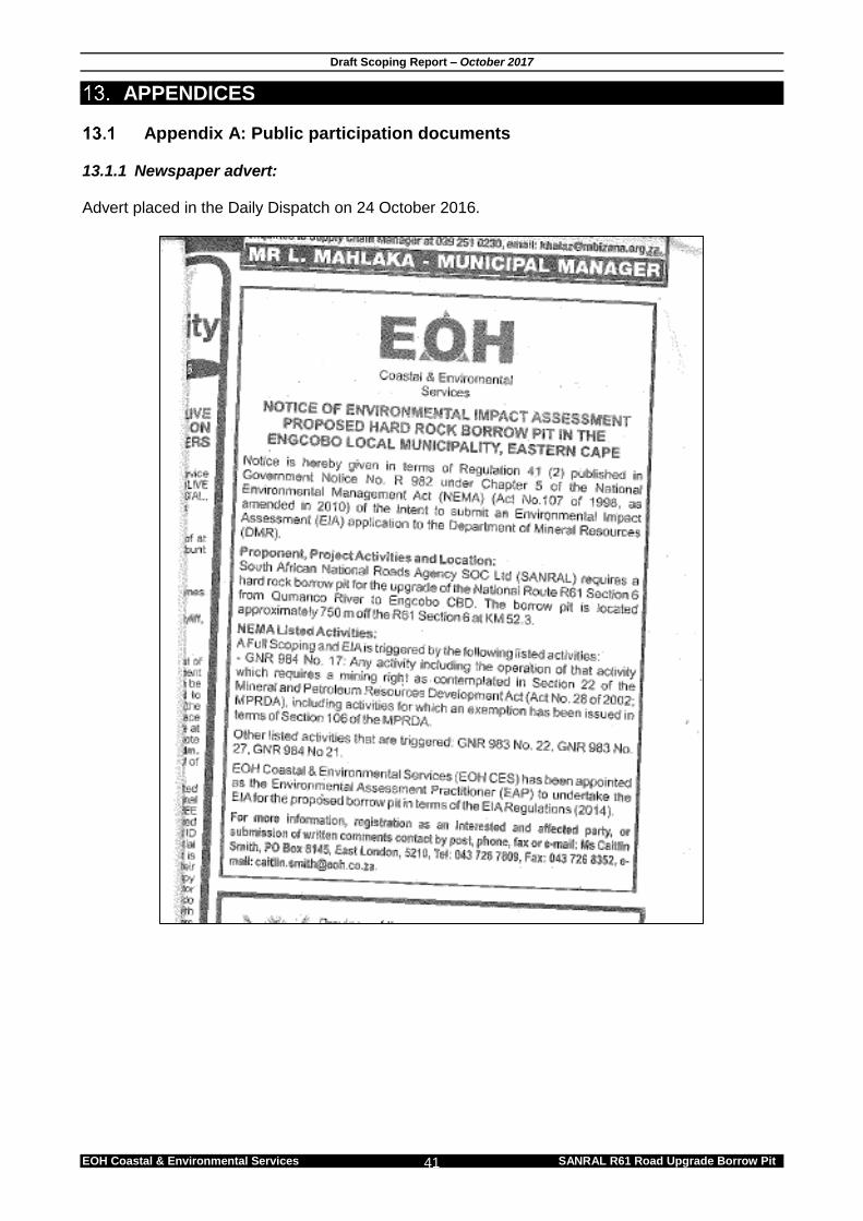
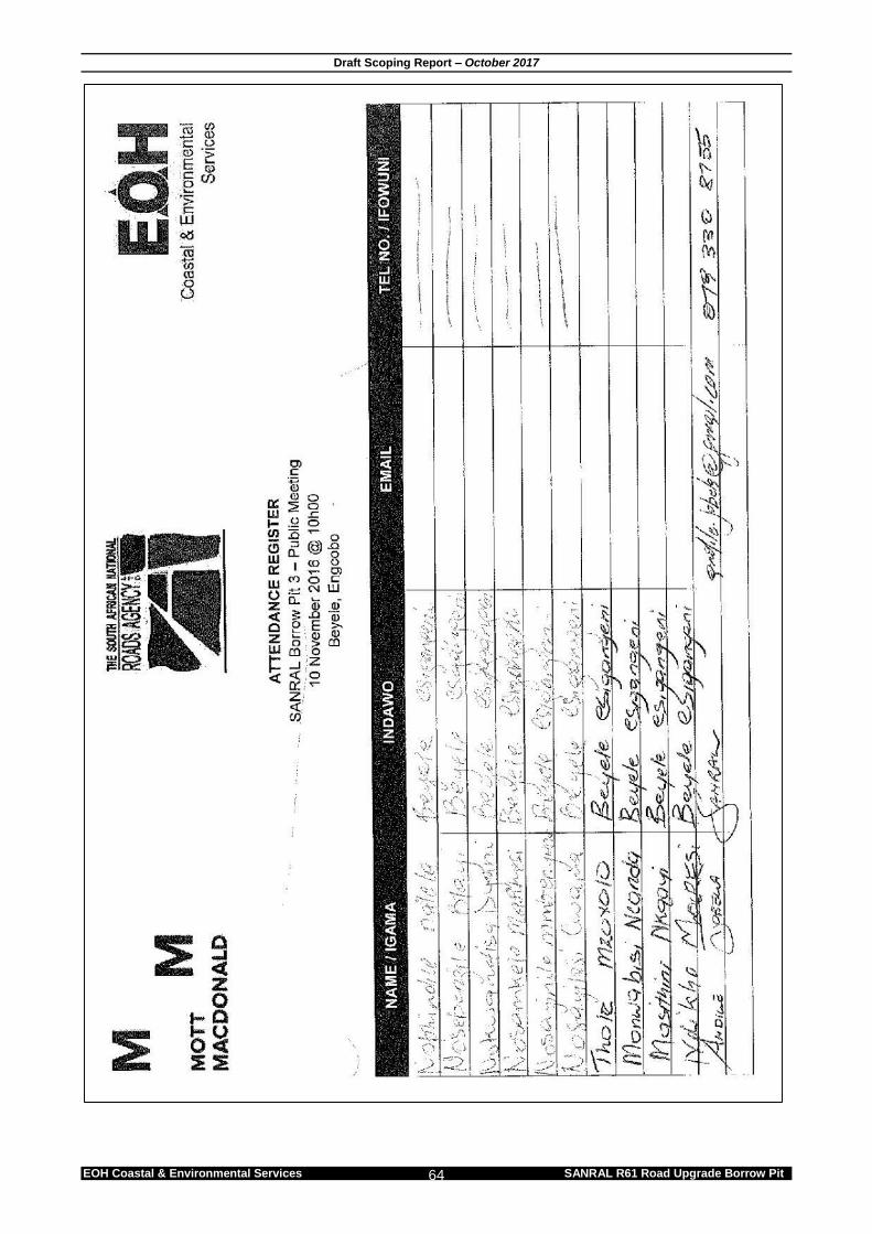
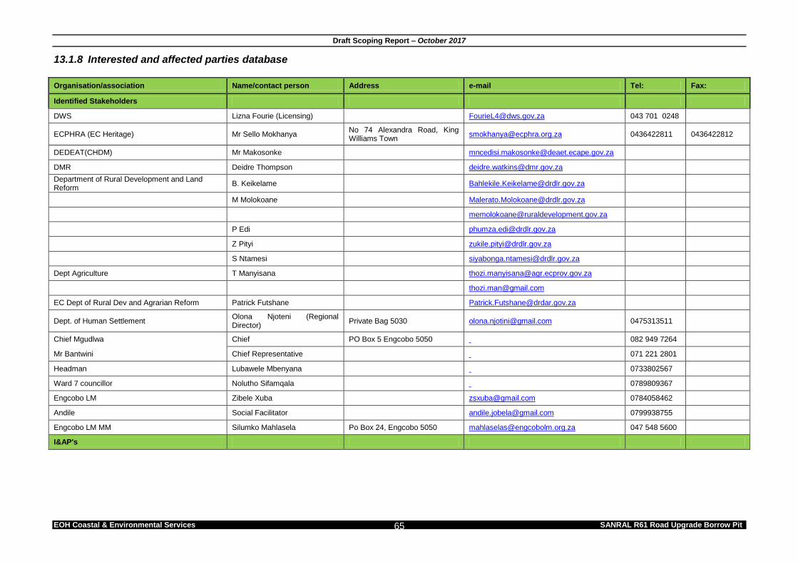
Authority and Stakeholder engagement (DMR, DEDEAT, DWS). 7.1.2 Newspaper advertisement The borrow pit was advertised in the Daily Dispatch on 24 October 2016. This advert included notification that a mining authorisation would be lodged with DMR for the proposed borrow pit. This advert provided detail about the proposed project and provided Interested and Affected Parties with an opportunity to register and comment on the project. 7.1.3 On-site Notice A notice board was placed at the entrance of the access road to the borrow pit in close proximity to the site (see Appendix A). 7.1.4 Stakeholders and I&APs Certain stakeholders were identified based on their potential interest in the project. These stakeholders were contacted either via e-mail or telephone for comment and were sent a Letter of Notification (LoN) and a Background Information Document (BID). A public meeting will be held about the proposed borrow pit on the 10 November 2016 where any issues raised by the community will be incorporated in the Scoping and EIA Reports. A list of stakeholders and I&APs is available in Appendix A. These stakeholders will notified of the EIA process for the borrow pit and will be notified of the availability of the draft Scoping Report for public review. Any new I&APs registered will be added to this list.
In terms of Section APPENDIX 2(2)(1) of the EIA Regulations (2014) (amended 2017), a Scoping Report and must include -
g) A full description of the process followed to reach the proposed preferred activity, site and location of the development footprint within the site, including – (ii) Details of the public participation process undertaken in terms of regulation 41
of the Regulations, including copies of the supporting documents and inputs; (iii) A summary of the issues raised by interested and affected parties, and an
indication of the manner in which the issues were incorporated, or the reasons for not including them.
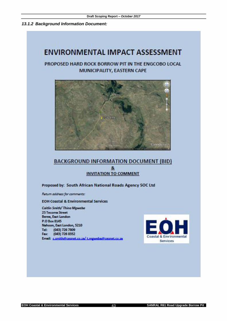
7.1.5 Background information document A Background Information Document (BID) for the proposed borrow pit was distributed to identified stakeholders and I&APs on 31 October 2016 (see Appendix A). 7.1.6 Proof of notification Stakeholders and I&APs were notified via email/registered mail/telephone about the proposed borrow pit (Appendix A). 7.1.7 Issues raised by stakeholders/ I&APs The Issues and Response Trail is updated throughout the EIA process and will include all comments received until submission of the final EIR to the competent authority. EOH CES will hold a public meeting during the Scoping phase where the proposed borrow pit will be discussed.
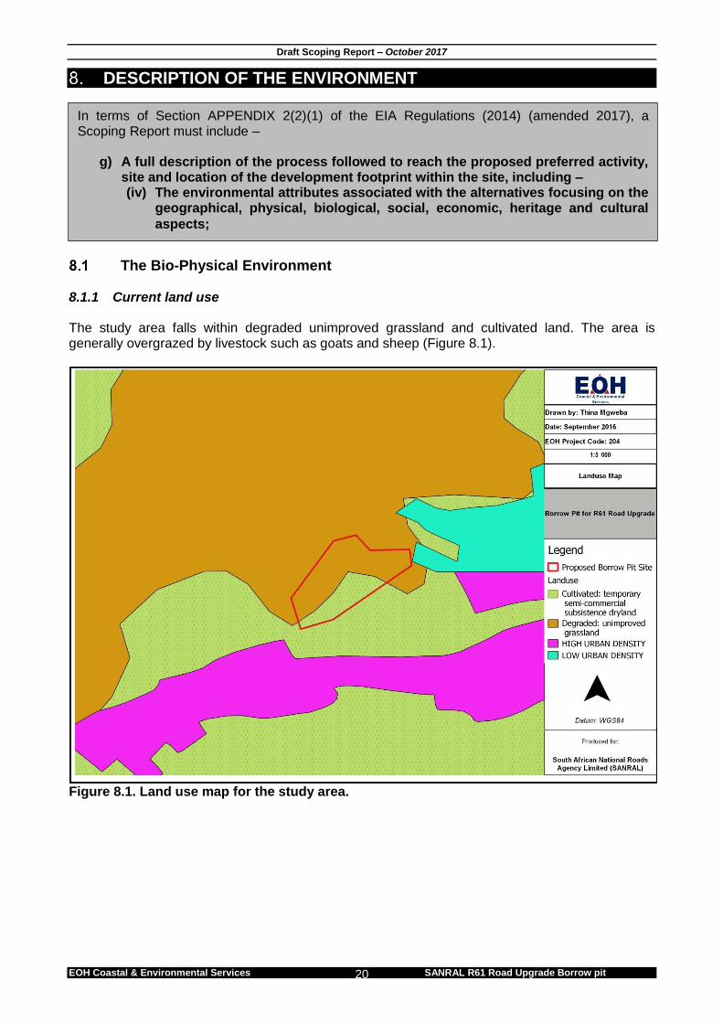
The Bio-Physical Environment 8.1.1 Current land use The study area falls within degraded unimproved grassland and cultivated land. The area is generally overgrazed by livestock such as goats and sheep (Figure 8.1).
Figure 8.1. Land use map for the study area.
In terms of Section APPENDIX 2(2)(1) of the EIA Regulations (2014) (amended 2017), a Scoping Report must include –
g) A full description of the process followed to reach the proposed preferred activity, site and location of the development footprint within the site, including – (iv) The environmental attributes associated with the alternatives focusing on the
geographical, physical, biological, social, economic, heritage and cultural
Figure 8.2 Sheep grazing on the borrow pit site. 8.1.2 Climate Engcobo receives about 700 mm of rain per year, with most rainfall occurring during summer. It receives the lowest rainfall (approximately 6 mm) in June and the highest (approximately 110 mm) in February (Figure 8.3). The average midday temperatures for Engcobo ranges from 18.6°C in June to 27°C in January. The region is the coldest during July when the temperature drops to 3.8°C on average during the night.
Figure 8.3: Engcobo average monthly temperatures (°C) and rainfall (mm) (Adapted from http://www.saexplorer.co.za/south-africa/climate/engcobo_climate.asp)
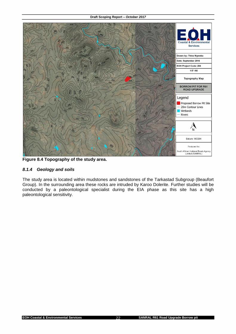
8.1.3 Topography Figure 8.4 indicates the topography of the study area. The local region is mainly flat or has undulating plains intersected by mountains. The site is located on the slopes of a small hill which peaks at approximately 860 m above sea level (Figure 8.4).
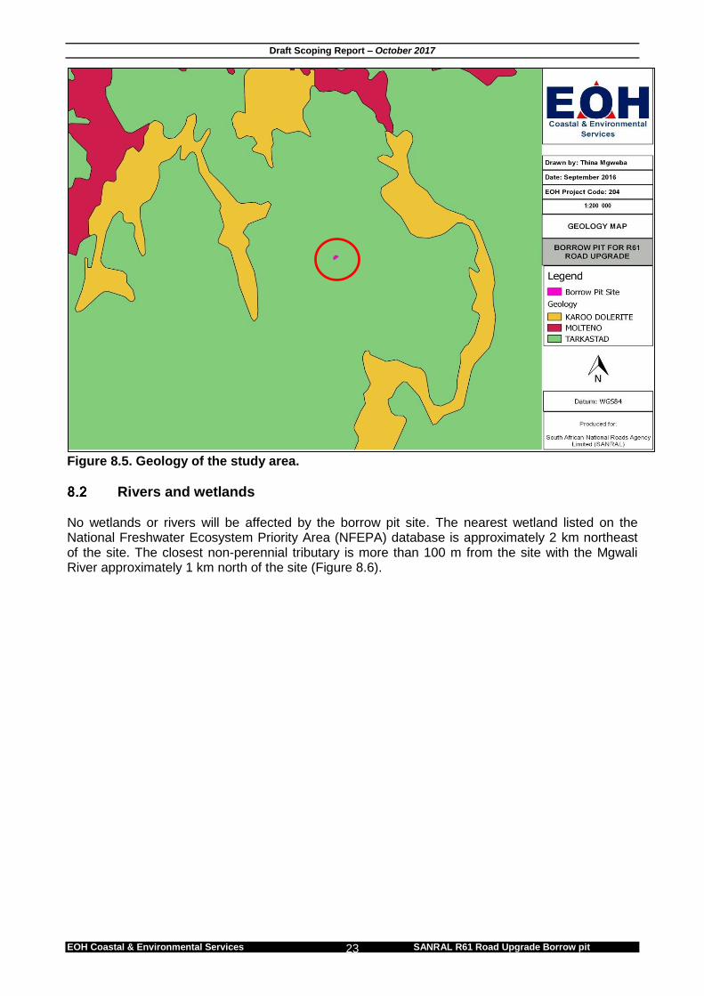
Figure 8.4 Topography of the study area. 8.1.4 Geology and soils The study area is located within mudstones and sandstones of the Tarkastad Subgroup (Beaufort Group). In the surrounding area these rocks are intruded by Karoo Dolerite. Further studies will be conducted by a paleontological specialist during the EIA phase as this site has a high paleontological sensitivity.
Rivers and wetlands No wetlands or rivers will be affected by the borrow pit site. The nearest wetland listed on the National Freshwater Ecosystem Priority Area (NFEPA) database is approximately 2 km northeast of the site. The closest non-perennial tributary is more than 100 m from the site with the Mgwali River approximately 1 km north of the site (Figure 8.6).
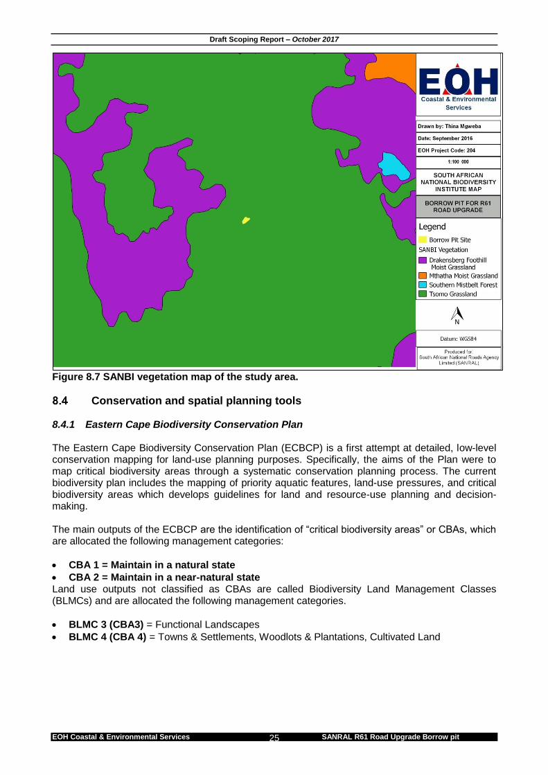
Vegetation 8.3.1 Mucina and Rutherford Mucina and Rutherford (2006) have developed the National Vegetation map as part of a South African National Biodiversity Institute (SANBI) funded project: “to provide floristically based vegetation units of South Africa, Lesotho and Swaziland at a greater level of detail than had been available before.” The map was developed using a wealth of data from several contributors and has resulted in the best national vegetation map to date, the previous being that of Adcocks developed over 50 years ago. This map forms the base of finer scale bioregional plans such as Sub-tropical Thicket Ecosystem Plan (STEP). The map and accompanying book describe each vegetation type in detail, along with the most important species including endemic species and those that are biogeographically important and is the most comprehensive data for vegetation types in South Africa. Mucina and Rutherford (2006) define the vegetation type that occurs within the project area as Tsomo Grassland Biome (Figure 8.7).
Tsomo Grassland usually occurs in the region to the east of Queenstown in the Eastern Cape, including Engcobo. This vegetation is a grassland or open thornveld, often grazed short or replaced by dwarf shrub. Mucina and Rutherford (2006) classify the Tsomo Grassland as having a vulnerable conservation status. According to the National Spatial Biodiversity Assessment (NSBA) 50% of this vegetation is conserved.
A site visit was conducted on the 22nd of September 2016, this visit revealed that the site is already transformed due to over-grazing and human impacts.
Figure 8.7 SANBI vegetation map of the study area.
Conservation and spatial planning tools 8.4.1 Eastern Cape Biodiversity Conservation Plan The Eastern Cape Biodiversity Conservation Plan (ECBCP) is a first attempt at detailed, low-level conservation mapping for land-use planning purposes. Specifically, the aims of the Plan were to map critical biodiversity areas through a systematic conservation planning process. The current biodiversity plan includes the mapping of priority aquatic features, land-use pressures, and critical biodiversity areas which develops guidelines for land and resource-use planning and decision-making. The main outputs of the ECBCP are the identification of “critical biodiversity areas” or CBAs, which are allocated the following management categories:
CBA 1 = Maintain in a natural state
CBA 2 = Maintain in a near-natural state Land use outputs not classified as CBAs are called Biodiversity Land Management Classes (BLMCs) and are allocated the following management categories.
The ECBCP maps CBAs based on extensive biological data and input from key stakeholders. Critical Biodiversity Areas (CBA 1 and 2), as defined by the ECBCP, form the foundation areas where conservation is priority. These areas provide essential ecosystem services. CBA Areas provide the spatial framework for future spatial development planning, particularly indicating those areas where development needs to be avoided or at best, carefully managed. The ECBCP, although mapped at a finer scale than the National Spatial Biodiversity Assessment (Driver et al., 2005) is still, for the large part, inaccurate and "coarse". Therefore it is imperative that the status of the environment, for any proposed development MUST first be verified before the management recommendations associated with the ECBCP are considered (Berliner and Desmet, 2007). In spite of these short-comings, the ECBCP has been adopted by the provincial department of Economic Development, Environmental Affairs and Tourism (DEDEAT) as a strategic biodiversity plan for the Eastern Cape. Figure 8.8 illustrates that the proposed borrow pit site falls within an area classified as BLMC 3 (CBA 3). The site can be considered to have a low sensitivity. This was also confirmed at the site visit which revealed that the site is already transformed by over-grazing and human impacts.
Figure 8.8. ECBCP map of the study area. 8.4.2 Protected Areas (NEMPAA & NPAES) There are no known National, Provincial or locally protected areas found within the general study area. There are no National Environmental Management Biodiversity Act (NEMBA) (National list or ecosystems that are threatened and in need of protection; 2014) classified ecosystems found within the study area.
Socio-Economic Profile The borrow pit falls within the Engcobo Local Municipality (ELM) in the Chris Hani District Municipality (CHDM). The ELM consists of 20 wards and covers an area of approximately 2 259 km2. 8.5.1 Population According to StatsSA (2011) the total population in the ELM is 155 513 and comprises predominantly black African people of which the majority is Xhosa speaking. 56% of the population is female. The average household size is 4 people and 57.7% of the households are female headed. 8.5.2 Employment According to StatsSA (2011), 40% of the ELM population is not economically active and therefore depends on the 60% of the economically active population. The wholesale and retail trade sector employs the majority of people (3 318) followed by community services (3 076). Mining and quarrying is reported to be declining over the years and has an insignificant contribution to the ELM’s economy, employing just 33 people (ELM, IDP 2014/2015).
Figure 8.9. Employment figures for the ELM (ELM IDP, 2014/2015). 8.5.3 Education According to StatsSA (2011) 19.7% of the population aged over 20 years and older have no form of education. Approximately 9.6 % of the population have completed Matric. 5.2% of the population have received Higher Education.
Possible Environmental Issues and Impacts Table 9.1 to 9.4 lists the environmental issues that have been identified in the following phases of mining: planning and design, construction, operation and closure/decommissioning. A full impact assessment (which will include specialist impact assessments) will take place during the EIA phase once the Plan of Study and Final Scoping Report has been accepted by the competent authority. Table 9.1: Issues and impacts identified in the planning and design phase of the proposed borrow pit.
PLANNING AND DESIGN PHASE
Issue Impact Significance Further
Assessment
Compliance with relevant policy and legislation
Failure to adhere to existing policies and legal obligations could lead to the project conflicting with local, provincial and national policies, legislation etc. This could result in a lack of institutional support for the project, overall project failure or delays in mining and undue disturbance to the natural environment.
HIGH NEGATIVE EIA
Design of the borrow pit
An inappropriately designed borrow pit can lead to subsidence, face collapses, erosion and stormwater issues.
HIGH NEGATIVE EIA
Inappropriate location of stockpiles and processing area
Inappropriate location of stockpiles, and processing area within the mining site can negatively impact on the surrounding environment
HIGH NEGATIVE EIA
Topography – disturbance to
Permanent disturbance to the topography of the study area due to mining activity.
MODERATE NEGATIVE
EIA
In terms of Section APPENDIX 2(2)(1) of the EIA Regulations (2014) (amended 2017), a Scoping Report must include –
g) A full description of the process followed to reach the proposed preferred activity, site and location of the development footprint within the site, including –
(v) The impacts and risks which have informed the identification of each alternative, including the nature, significance, consequence, extent, duration and probability of such identified impacts, including the degree to which these impacts –
Can be reversed;
May cause irreplaceable loss of resources; and
Can be avoided, managed or mitigated; (vi) The methodology used in identifying and ranking the nature, significance,
consequences, extent, duration and probability of potential environmental impacts and risks associated with the alternatives;
(vii) Positive and negative impacts that the proposed activity and alternatives will have on the environment and on the community that may be affected focusing on the geographical, physical, biological, social, economic, heritage and cultural aspects;
(viii) The possible mitigation measures that could be applied and level of residual risk; (ix) The outcome of the site selection matrix; (x) If no alternatives, including alternative locations for the activity were investigated, the
motivation for not considering such; and (xi) A concluding statement indicating the preferred alternatives, including preferred
Table 9.2: Issues and impacts identified in the construction phase of the proposed borrow pit.
CONSTRUCTION PHASE
Issue Impact Significance Further
Assessment
Visual intrusion associated with the establishment of the mining area
Construction activity on site and the presence and use of large machinery on site and along access roads will result in a visual disturbance of the landscape.
MODERATE NEGATIVE
EIA
Location of sanitation facilities
Inappropriate siting of sanitation facilities could result in contamination of surface and ground water.
MODERATE NEGATIVE
EIA
Table 9.3: Issues and impacts identified in the operation phase of the proposed borrow pit.
OPERATION PHASE
Issue Impact Significance Further
Assessment
Visual intrusion associated with mining activities
The mining activities could result in a negative impact on the aesthetic value of the study area and immediate surrounds.
MODERATE NEGATIVE
EIA
Storm water run-off related issues
Surface water runoff due to mining activities can result in soil erosion and impact surface water quality.
MODERATE NEGATIVE
EIA
Demarcation of borrow pit site
Inadequate demarcation and fencing off of the borrow pit could lead to unnecessary environmental impacts.
HIGH NEGATIVE EIA
Spillage of hazardous substances such as fuel, chemicals, paint, etc.
Spillage of any hazardous substances such as fuel, chemicals, etc. can lead to the contamination of surface and groundwater.
MODERATE NEGATIVE
EIA
Dust control
Dust will be generated from mining activities and from vehicles travelling on dirt roads. This might be a nuisance during windy conditions.
HIGH NEGATIVE EIA
Noise Mining activities and movement of heavy vehicles could result in an increase in ambient noise levels on site and on
In terms of Section APPENDIX 2(2)(1) of the EIA Regulations (2014) (amended 2017), a Scoping Report must include:
h) a plan of study for undertaking the environmental impact assessment process, including–
(i) a description of the alternatives to be considered and assessed within the preferred site, including the option of not proceeding with the activity.;
(ii) a description of the aspects to be assessed as part of the environmental impact assessment process;
(iii) aspects to be assessed by specialists; (iv) a description of the proposed method of assessing the environmental aspects,
including aspects to be assessed by specialists; (v) a description of the proposed method of assessing duration and significance; (vi) an indication of the stages at which the competent authority will be consulted; (vii) particulars of the public participation process that will be conducted during the
environmental impact assessment process; and (viii) a description of the tasks that will be undertaken as part of the environmental impact
assessment process; (ix) identify suitable measures to avoid, reverse, mitigate or manage identified impacts and
to determine the extent of the residual risks that need to be managed and monitored.
In line with the above-mentioned legislative requirement, this Chapter sets out the Plan of Study (PoS) for the EIA phase of the assessment. Consultation with DMR will be on going throughout this EIA. However, it is anticipated that DMR will provide relevant comment with respect to the adequacy of this Plan of Study for the EIA, as it informs the content of the EIR and sufficiency thereof.
Scope and Intent of the EIA Phase This phase includes the following steps: 10.1.1 Specialist Studies Specialist studies include the specialist assessments identified in the Scoping Report and any additional studies required by the authorities. This requires the appointment of specialists to gather baseline information in their fields of expertise, and to assess the impacts and make recommendations to mitigate negative impacts and optimise benefits. The resulting information is synthesised into the Environmental Impact Report (EIR). 10.1.2 Environmental Impact Report.
The main purpose of this report is to gather and evaluate environmental information, so as to provide sufficient supporting arguments to evaluate overall impacts, consider mitigation measures and alternative options, and make a valued judgement in choosing the best development alternative. The EIR is made available for public and authority review. The availability of the report is advertised in the local newspaper and is situated at an easily accessible location. 10.1.3 Issues and Response Trail The issues and response trail consists of the compilation of comments, issues and concerns raised by I&APs and the authorities and the relevant responses to these comments.
10.1.4 Environmental Management Programme The EMPr informs the client and the technical team of the guidelines which will need to be followed during construction and operation to ensure that there are no lasting or cumulative negative impacts of the construction/operation process on the environment.
The standards and guidelines that must be achieved in terms of environmental legislation.
Mitigation measures and environmental specifications which must be implemented for all phases of the project in order to minimise the extent of environmental impacts, to manage environmental impacts and where possible to improve the condition of the environment.
Provide guidance through method statements that are required to be implemented to achieve the environmental specifications.
Define corrective action that must be taken in the event of non-compliance with the specifications of the EMPr.
Prevent long-term or permanent environmental degradation.
In addition to this, the Public Participation Process is continued. As for the Scoping Phase, opportunity is provided for I&APs to voice concerns and issues regarding the project. At this stage the project details may have changed in response to the preliminary findings of the Draft Scoping Report. I&APs and key stakeholders are also given the opportunity to review the Environmental Impact Report before it is submitted to the authorities.
10.1.5 Record of Decision of Environmental Authorisation and Appeals Process. Upon thorough examination of the EIR, the competent authority will either issue an authorisation or rejection, or will require further details to clarify certain issues. Should authorisation be granted, it usually carries Conditions of Approval. The proponent is obliged to adhere to these conditions. Once the authorisation has been issued, it is publicised and the public are given 20 calendar days from the notification of authorisation to issue an appeal to the authorities.
The Public Participation Process 10.2.1 Public Review Of The Draft Scoping Report All I&APs on the Register of I&APs will be notified in writing of the availability of the Draft Scoping Report (DSR) for public review. The notification letter will provide details of the 30-day public comment period, the venues and websites where the report could be viewed, the contact details of the PPP consultant and how written comments on the DSR should be submitted, and details of the public meeting to present the DSR (if applicable). 10.2.2 Public Review Of The Draft Environmental Impact Report All I&APs on the I&AP database will be notified in writing of the availability of the Draft Environmental Impact Report (DEIR) for public review. The notification letter will provide details of the 30-day public comment period, the venues and websites where the report can be viewed, the contact details of the PPP consultant and how written comments on the DEIR should be submitted, and details of the public meeting to present the DEIR (if applicable). 10.2.3 Notification Of Environmental Authorisation Advertisements announcing the Environmental Authorisation (EA) will be placed in the same regional and local newspapers used to announce the project and the EIA. The adverts will be placed in the Daily Dispatch. The adverts will inform I&APs of the decision and where the decision can be accessed and will draw their attention to their right to appeal the decision and set out the appeal procedures.
Environmental Impact Report The Specialist Studies described below will inform the Environmental Impact Report (EIR). In addition, the EIR will gather any comments received from I&APs and determine whether it is necessary to increase the scope of work or amend the Terms of Reference for the specialists. The EIR will examine the ‘No Go’ alternative along with the proposed borrow pit, as required in the EIA regulations. 10.3.1 Structure of the EIA Report In broad terms, the Environmental Impact Report (EIR) will have the following Table of Contents: PART ONE: INTRODUCTION AND DESCRIPTION OF ENVIRONMENTAL IMPACT ASSESSMENT PROCESS 1. Brief Description of The Proposed Project 2. Environmental Impact Assessment Process 3 Activities triggering the EIA process 4 The environmental study team 5 The environmental assessment process followed 6 Structure of the Report PART TWO: THE PROPOSED BORROW PIT 1 Project Overview 2 Alternatives 3 Technical Description of Preferred Options PART THREE: DESCRIPTION OF THE AFFECTED ENVIRONMENT 1. The Natural Environment 2. Socio-Economic Environment 3. The Policy, Legal And Administrative Environment
PART FOUR: PUBLIC PARTICIPATION 1. Public Participation Process followed PART FIVE: ASSESSMENT OF THE ENVIRONMENTAL IMPACTS ASSOCIATED WITH THE BORROW PIT 1. Impacts Associated with the borrow pit 2. Conclusion
PART FIVE: ENVIRONMENTAL MANAGEMENT PLAN AND OVERALL RECOMMENDATIONS AND CONCLUSIONS
Specialist Studies 10.4.1 Paleontological Assessment The Paleontological Assessment will be undertaken for the proposed borrow pit. The findings of the study will be included in the EIR. The Assessment includes the following objectives and terms of reference:
Identifying exposed and subsurface rock formations that are considered to be paleontologically significant;
Assessing the level of paleontological significance of these formations;
To comment on the impact of the development on these exposed and/or potential fossil resources and
To make recommendations as to how the developer should conserve or mitigate damage to these resources
10.4.2 Heritage Assessment A Phase 1 archaeological and historical survey will be undertaken to fulfil SAHRAs requirements in accordance with the National Heritage Resources Act (25 of 1999). The National Heritage Resources Act requires that “…any development or other activity which will change the character of a site exceeding 5 000 m², or the rezoning or change of land use of a site exceeding 10 000 m², requires an archaeological impact assessment”. The terms of reference for the Phase 1 heritage study are:
Provide a summary of the relevant legislation;
Conduct a site inspection as required by national legislation;
Determine the likelihood of archaeological remains of significance in the proposed site;
Identify and map (where applicable) the location of any significant archaeological remains;
Assess the sensitivity and significance of archaeological remains in the site;
Assess the significance of direct and cumulative impacts of the proposed development and viable alternatives on archaeological and heritage resources;
Identify mitigation measures to protect and maintain any valuable archaeological sites and remains that may exist within the proposed site; and
Prepare and submit any permit applications and the Heritage Report to the South African Heritage Resources Authority (SAHRA) and the Eastern Cape Provincial Heritage Resources Authority (ECPHRA).
The findings of the heritage assessment will be incorporated into the borrow pit EIA.
Methodology for assessing the significance of impacts
To ensure a direct comparison between various specialist studies, a standard rating scale has been defined and will be used to assess and quantify the identified impacts. This is necessary since impacts have a number of parameters that need to be assessed. Five factors need to be considered when assessing the significance of impacts, namely: Identified impacts will be assessed against the following criteria:
Significance The relationship of the issue to the temporal scale, spatial scale and the severity are combined to describe the overall importance rating, namely the significance of the assessed impact. Table 10.1. Significance Rating Table Temporal Scale (The duration of the impact)
Short term Less than 5 years (many construction phase impacts are of a short duration).
Medium term Between 5 and 20 years.
Long term Between 20 and 40 years (from a human perspective almost permanent).
Permanent Over 40 years or resulting in a permanent and lasting change that will always be there.
Spatial Scale (The area in which any impact will have an affect)
Individual Impacts affect an individual.
Localised Impacts affect a small area of a few hectares in extent. Often only a portion of the project area.
Project Level Impacts affect the entire project area.
Surrounding Areas Impacts that affect the area surrounding the development
Municipal Impacts affect either the Local Municipality, or any towns within them.
Regional Impacts affect the wider district municipality or the province as a whole.
National Impacts affect the entire country.
International/Global Impacts affect other countries or have a global influence.
Will definitely occur Impacts will definitely occur.
Degree of Confidence or Certainty (The confidence with which one has predicted the significance of an impact)
Definite More than 90% sure of a particular fact. Should have substantial supportive data.
Probable Over 70% sure of a particular fact, or of the likelihood of that impact occurring.
Possible Only over 40% sure of a particular fact, or of the likelihood of an impact occurring.
Unsure Less than 40% sure of a particular fact, or of the likelihood of an impact occurring.
Table 10.2. Impact Severity Rating Impact severity (The severity of negative impacts or how beneficial positive impacts would be on a particular affected system or affected party)
An irreversible and permanent change to the affected system(s) or party(ies) which cannot be mitigated. For example the permanent loss of land.
A permanent and very substantial benefit to the affected system(s) or party(ies), with no real alternative to achieving this benefit. For example the vast improvement of sewage effluent quality.
Severe Beneficial
Long term impacts on the affected system(s) or party(ies) that could be mitigated. However, this mitigation would be difficult, expensive or time consuming, or some combination of these. For example, the clearing of forest vegetation.
A long term impact and substantial benefit to the affected system(s) or party(ies). Alternative ways of achieving this benefit would be difficult, expensive or time consuming, or some combination of these. For example an increase in the local economy.
Moderately severe Moderately beneficial
Medium to long term impacts on the affected system(s) or party(ies), which could be mitigated. For example constructing the sewage treatment facility where there was vegetation with a low conservation value.
A medium to long term impact of real benefit to the affected system(s) or party(ies). Other ways of optimising the beneficial effects are equally difficult, expensive and time consuming (or some combination of these), as achieving them in this way. For example a ‘slight’ improvement in sewage effluent quality.
Slight Slightly beneficial
Medium or short term impacts on the affected system(s) or party(ies). Mitigation is very easy, cheap, less time consuming or not necessary. For example a temporary fluctuation in the water table due to water abstraction.
A short to medium term impact and negligible benefit to the affected system(s) or party(ies). Other ways of optimising the beneficial effects are easier, cheaper and quicker, or some combination of these.
No effect Don’t know/Can’t know
The system(s) or party(ies) is not affected by the proposed development.
In certain cases it may not be possible to determine the severity of an impact.
Table 10.3. Overall Significance Rating Overall Significance (The combination of all the above criteria as an overall significance)
VERY HIGH NEGATIVE VERY BENEFICIAL
These impacts would be considered by society as constituting a major and usually permanent change to the (natural and/or social) environment, and usually result in severe or very severe effects, or beneficial or very beneficial effects. Example: The loss of a species would be viewed by informed society as being of VERY HIGH significance. Example: The establishment of a large amount of infrastructure in a rural area, which previously had very few services, would be regarded by the affected parties as resulting in benefits with VERY HIGH significance.
HIGH NEGATIVE BENEFICIAL
These impacts will usually result in long term effects on the social and/or natural environment. Impacts rated as HIGH will need to be considered by society as constituting an important and usually long term change to the (natural and/or social) environment. Society would probably view these impacts in a serious light. Example: The loss of a diverse vegetation type, which is fairly common elsewhere, would have a significance rating of HIGH over the long term, as the area could be rehabilitated. Example: The change to soil conditions will impact the natural system, and the impact on affected parties (such as people growing crops in the soil) would be HIGH.
MODERATE NEGATIVE SOME BENEFITS
These impacts will usually result in medium to long term effects on the social and/or natural environment. Impacts rated as MODERATE will need to be considered by society as constituting a fairly important and usually medium term change to the (natural and/or social) environment. These impacts are real but not substantial. Example: The loss of a sparse, open vegetation type of low diversity may be regarded as MODERATELY significant.
LOW NEGATIVE FEW BENEFITS
These impacts will usually result in medium to short term effects on the social and/or natural environment. Impacts rated as LOW will need to be considered by the public and/or the specialist as constituting a fairly
unimportant and usually short term change to the (natural and/or social) environment. These impacts are not substantial and are likely to have little real effect. Example: The temporary changes in the water table of a wetland habitat, as these systems are adapted to fluctuating water levels. Example: The increased earning potential of people employed as a result of a development would only result in benefits of LOW significance to people who live some distance away.
NO SIGNIFICANCE
There are no primary or secondary effects at all that are important to scientists or the public. Example: A change to the geology of a particular formation may be regarded as severe from a geological perspective, but is of NO significance in the overall context.
DON’T KNOW
In certain cases it may not be possible to determine the significance of an impact. For example, the primary or secondary impacts on the social or natural environment given the available information. Example: The effect of a particular development on people’s psychological perspective of the environment.
All feasible alternatives and the “no-go option” will be equally assessed in order to evaluate the significance of the “as predicted” impacts (prior to mitigation) and the “residual” impacts (that remain after mitigation measures are taken into account). Reason for the judgement will be provided when necessary.
Activity and Possible Impacts The South African National Roads Agency Ltd. (SANRAL) will be constructing various safety improvements on Section 6 of the R61 National Route from (KM 52.6) in the Engcobo Local Municipality in the Eastern Cape Province. A mudstone borrow pit is required to supply the necessary hard rock material for road construction. A suitable borrow pit has been identified approximately 750m off the R61 Section at Km 52.6 in the Beyele Administrative Area in the Engcobo Local Municipality, Eastern Cape. The proposed borrow pit is located on rural grazing/cultivated land. However, the activity raises issues pertaining to:
Visual intrusion of the landscape.
Dust impacts on surrounding land inhabitants.
Noise impacts on surrounding land inhabitants.
Stormwater impacts.
Heritage site impact (close proximity to heritage sites).
Socio-economic impacts and benefits.
Fatal Flaws The Scoping Phase has not identified any fatal flaws and there is no reason why the proposed activity should not proceed to the EIA phase for further assessment.
The EIA Phase The following activities will form part of the EIA phase:
Public participation: public review of documentation, engagement with stakeholders/I&APs;
Specialist studies as described in the Plan of Study;
Evaluation of impacts prior to mitigation;
Compilation of practicable and effective mitigation measures;
Provision of an opinion as to whether or not the activity should be authorised;
Compilation of an environmental impact statement;
Compilation of a draft Environmental Management Programme (EMPr).
REFERENCES Constitution Act (No. 108 of 1996). Eastern Cape Vision 2030 Provincial Development Plan. Hazardous Substances Act (No. 15 of 1973). Integrated Development Plan (2014/2015). Engcobo Local Municipality. Mineral and Petroleum Resources Development Act (No. 28 of 2002). Mucina, L. & Rutherford, M.C. (eds). 2006. The vegetation of South Africa, Lesotho and Swaziland. Strelitzia 19. South African National Biodiversity Institute, Pretoria. NPC National Development Plan 2030. National Environmental Management Act (No. 107 of 1998). National Environmental Management: Air Quality Act (No. 39 of 2004). National Environmental Management: Biodiversity Act (No. 10 of 2004). National Environmental Management: Protected Areas Act (No. 57 of 2003). National Environmental Management: Waste Management Act (No. 59 of 2008). National Forests Act (No. 84 of 1998). National Heritage Resource Act (No. 25 of 1999). National Water Act (No. 36 of 1998). Occupational Health and Safety Act (No. 85 of 1993). StatsSA (http://www.statssa.gov.za/).