Indian Journal of Marine Sciences Vol. 30(4), December 2001, pp. 195-213 Application of remote sensing data to monitor mangroves and other coastal vegetation of India Shailesh Nayak & Anjali Bahuguna Marine and Water Resources Group, Space Applications Centre, Ahmedabad-380 015, Gujarat, India Received 10 May 2000, revised 30 May 2001 Remote sensing data, because of its repetitive, synoptic and multi-spectral nature, has proved to be of an immense value in monitoring of coastal vegetation. Indian Remote Sensing Satellite (IRS) data have been extensively used to map mangroves and other coastal vegetation for the entire country’s coastline. Large database on spatial extent of mangroves and their condition has been created on 1:250,000, 1:50,000 and 1:25,000 scale using IRS data (the database provides information for the first time on the mangrove areas of the entire Indian coast). Based on this study, it was observed that the Kori creek, Gujarat, has large area under mangroves. The repetitive nature of the data has helped in monitoring vital and critical areas, periodically. In one such study, on the Marine National Park, in the Gulf of Kachchh, mangrove areas were monitored for the last 25 years. The degradation of mangroves continued up to 1985 and the condition significantly improved due to the adoption of conservation measures. This has helped in planning various management actions to conserve this vital ecosystem. IRS data have been used in identifying dominant plant communities in many mangrove areas such as Bhitarkanika, Coringa, Mandovi estuary in Goa and the Gulf of Kachchh, etc. This is a unique approach for providing spatial information at plant community level and can be seen as a first step towards bio-diversity assessment. Along with the mangroves, seaweed, seagrass beds and dune vegetation have also been mapped with reasonable accuracy. With the better sensors planned for future, remote sensing-based information is going to be one of the major inputs in the preparation of management action plans. Habitats of the marine environment such as mangroves, sea-grass meadows, seaweeds/algae associated with coral reefs, etc., are among the most highly diverse and productive of the Earth's ecosystems. They help in the production of detritus, organic matter, recycling of nutrients and thus enrich the coastal waters and support benthic population of the sea. They also serve as nursery grounds for the larvae and juveniles of marine denizens. Coastal vegetation develops certain unique characteristics as the biota are constantly under physiological stress caused by extreme environmental conditions, such as saline conditions, periods of inundation and exposure, etc. The most dominating coastal vegetation is the mangroves in the tropical regions and marsh vegetation in temperate countries. Today mangrove forests comprise 15.8 million hectares, roughly less than half the original mangrove forest cover and are fast declining further at an assumed rate of 2-8% per year, or 0.6% of all inland forests in the world 1 . The word mangrove has traditionally been used to describe either the total community or the individual tree/bushes, growing in the clayey, silty, inter-tidal coastal zones, deltaic and estuarine coasts and backwaters/sheltered regions, in the tropical/subtropical belts of the world. The most favourable mangrove habitats are those having sheltered environment, estuarine and basin muddy soils, good rainfall and temperature ranging from 26-28˚C. Under favourable conditions, mangroves have high rates of primary productivity, growth and rich species diversity (equivalent to tropical evergreen forests). There are approximately 60-65 species of mangroves present throughout the world with the majority occurring in the Southeast Asian/Western Pacific region. There is a marked decrease in species richness with increasing latitudes 2 . Uses and values of mangroves are many and varied, for e.g., habitat as well as spawning and nursery ground for various marine species, e.g., fish, shellfish, crustaceans, etc.; enriches the near-shore environment; acts as windbreakers and protects the shoreline from storms; stabilises the shoreline and decreases coastal erosion. The mangrove forests are being exploited for their resources in an unsustainable way today, resulting in endangering of the ecosystem. The main threats on the ecosystem are due to cutting for fuel wood, areas converted to agricultural land, aquaculture use, urban and industrial development, tourist spots, dumping of sewage, solid and toxic wastes, oil pollution due to oil spillage from pipelines or ships, and salt manufacture.
Transcript
Indian Journal of Marine Sciences Vol. 30(4), December 2001, pp. 195-213
Application of remote sensing data to monitor mangroves and other coastal vegetation of India
Shailesh Nayak & Anjali Bahuguna Marine and Water Resources Group, Space Applications Centre, Ahmedabad-380 015, Gujarat, India
Received 10 May 2000, revised 30 May 2001
Remote sensing data, because of its repetitive, synoptic and multi-spectral nature, has proved to be of an immense value in monitoring of coastal vegetation. Indian Remote Sensing Satellite (IRS) data have been extensively used to map mangroves and other coastal vegetation for the entire country’s coastline. Large database on spatial extent of mangroves and their condition has been created on 1:250,000, 1:50,000 and 1:25,000 scale using IRS data (the database provides information for the first time on the mangrove areas of the entire Indian coast). Based on this study, it was observed that the Kori creek, Gujarat, has large area under mangroves. The repetitive nature of the data has helped in monitoring vital and critical areas, periodically. In one such study, on the Marine National Park, in the Gulf of Kachchh, mangrove areas were monitored for the last 25 years. The degradation of mangroves continued up to 1985 and the condition significantly improved due to the adoption of conservation measures. This has helped in planning various management actions to conserve this vital ecosystem. IRS data have been used in identifying dominant plant communities in many mangrove areas such as Bhitarkanika, Coringa, Mandovi estuary in Goa and the Gulf of Kachchh, etc. This is a unique approach for providing spatial information at plant community level and can be seen as a first step towards bio-diversity assessment. Along with the mangroves, seaweed, seagrass beds and dune vegetation have also been mapped with reasonable accuracy. With the better sensors planned for future, remote sensing-based information is going to be one of the major inputs in the preparation of management action plans.
Habitats of the marine environment such as mangroves, sea-grass meadows, seaweeds/algae associated with coral reefs, etc., are among the most highly diverse and productive of the Earth's ecosystems. They help in the production of detritus, organic matter, recycling of nutrients and thus enrich the coastal waters and support benthic population of the sea. They also serve as nursery grounds for the larvae and juveniles of marine denizens. Coastal vegetation develops certain unique characteristics as the biota are constantly under physiological stress caused by extreme environmental conditions, such as saline conditions, periods of inundation and exposure, etc. The most dominating coastal vegetation is the mangroves in the tropical regions and marsh vegetation in temperate countries. Today mangrove forests comprise 15.8 million hectares, roughly less than half the original mangrove forest cover and are fast declining further at an assumed rate of 2-8% per year, or 0.6% of all inland forests in the world1.
The word mangrove has traditionally been used to describe either the total community or the individual tree/bushes, growing in the clayey, silty, inter-tidal coastal zones, deltaic and estuarine coasts and backwaters/sheltered regions, in the tropical/subtropical belts of the world. The most favourable mangrove
habitats are those having sheltered environment, estuarine and basin muddy soils, good rainfall and temperature ranging from 26-28˚C. Under favourable conditions, mangroves have high rates of primary productivity, growth and rich species diversity (equivalent to tropical evergreen forests). There are approximately 60-65 species of mangroves present throughout the world with the majority occurring in the Southeast Asian/Western Pacific region. There is a marked decrease in species richness with increasing latitudes2.
Uses and values of mangroves are many and varied, for e.g., habitat as well as spawning and nursery ground for various marine species, e.g., fish, shellfish, crustaceans, etc.; enriches the near-shore environment; acts as windbreakers and protects the shoreline from storms; stabilises the shoreline and decreases coastal erosion. The mangrove forests are being exploited for their resources in an unsustainable way today, resulting in endangering of the ecosystem. The main threats on the ecosystem are due to cutting for fuel wood, areas converted to agricultural land, aquaculture use, urban and industrial development, tourist spots, dumping of sewage, solid and toxic wastes, oil pollution due to oil spillage from pipelines or ships, and salt manufacture.
INDIAN J. MAR. SCI., VOL. 30, No. 4, DECEMBER 2001
196
The complexity of the data requirement for decision-making and planning for management of the mangrove ecosystem and other coastal vegetation makes the conventional method of collecting data rather difficult. It is for this reason that information on the entire country’s mangroves was not available. On the other hand, orbital remote sensing technique provides synoptic, multi-spectral and repetitive coverage, which is very useful for studying the coastal zone. The components that can be observed through remote sensing include spatial distribution of coastal vegetation areas, their ecological status and changes in their conditions through time and space.
Importance of remotely sensed data for inventory-ing, mapping, monitoring and recently for the management and development planning of the optimum sustainable utilization of natural resources has been well established. Remote sensing data (especially IRS-1A, 1B, Landsat TM and SPOT) has proved to be extremely useful in providing information on various components of the coastal environment, viz., coastal wetland conditions, density-wise mapping of mangroves and their condition, coastal landforms and shoreline changes, tidal boundaries, brackish water areas, suspended sediment dynamics, coastal currents, pollution, etc.3-10. Efforts have also been made to monitor some of the critical habitats (such as mangroves and coral reefs). Some of the recent studies also focus on zoning the dominant mangrove communities based on their ability to grow under varying tidal conditions, substrate, and salinity5.
The spectral properties of canopies of different plants are produced by a combination of optical properties of individual vegetative components, effects of growth forms, density, height, tidal stage and soil type11. Vegetation has different optical properties in the visible, near infrared (NIR) and middle infrared (MIR) regions. It has low reflectance in the blue and red region of the electromagnetic spectrum due to pigment absorption. The NIR region is the region of high reflectance as multiple scattering takes place between intercellular air spaces of spongy mesophyll. High NIR reflectance is associated with pure stands of red mangroves having dense crowns of canopies, high stand density and flattened leaves. Low NIR reflectance associated with pure stands of black mangroves was deemed to be due to the canopies sparse crowns, lower stand density and smaller leaves12. The reflectance in MIR band is influenced by water content and also bark reflectance13. As the
canopy moisture variation is quite prominent in vegetation types14, the role of MIR assumes importance in discriminating vegetation types.
Number of studies have been carried out to differentiate mangroves from other terrestrial forest type, old and new mangroves and to identify changes in mangrove vegetation12,14-17. A study carried out using ground-based Exotech spectro-radiometer in MSS, TM and IRS bands, for Pichavaram mangroves in Tamil Nadu showed that all the mangrove species showed similar radiance pattern with variations in intensity of radiance. Rhizophora lamarckii showed highest radiance values in 0.5-0.6 µm, 0.6-0.7 µm and 0.7-0.8 µm wavelengths, R. apiculata peaked at 0.8-1.1µm and Avicennia marina showed higher values in 0.7-0.8 µm and 0.8-1.1µm wavelengths18. There are very few studies highlighting the species-wise identification of mangroves using satellite data19-21. IRS-1C/1D band combination Red, NIR, MIR has helped in separating tree and shrub mangroves of a part of the Gulf of Kachchh6 and zoning various dominant mangrove communities of Bhitarkanika5 and selected areas of India4.
The spatial information on mangroves and other coastal vegetation of India and their condition is being presented in this paper. The objectives of this study are:
i) to generate baseline information on the extent of mangroves and other coastal vegetation (like algae/seaweeds, seagrass, salt marsh vegetation and vegetation on sand) along with their densities (if possible) using satellite (IRS and Landsat) data of 1986-1993
ii) monitoring and change detection studies (1986-1993 period)
iii) to make an attempt at zoning the dominant communities of selected mangrove habitats using higher resolution IRS-1C/1D LISS III and PAN data.
Materials and Methods Coastal habitats have been studied using satellite
data under different projects at Space Applications Centre. The maps generated, using satellite data, were mainly coastal wetland maps at 1:250,000, 1:50,000 and 1:25,000 scales.
Based on remote sensing data, mangroves of the Indian coast (Fig. 1) have been assessed in terms of, (i) extent (areal extent), (ii) density of the community, (iii) condition, and (iv) diversity. The requirement of the theme defines the scale at which the mapping of
NAYAK & BAHUGUNA: APPLICATION OF REMOTE SENSING DATA TO MONITOR MANGROVES
197
mangroves is to be done and details to be extracted from a remote sensing data. Presence/absence of mangroves and its areal extent can be mapped at 1:250,000 scale using a coarse resolution satellite data [e.g., Linear Imaging Self Scanner (LISS)-I data of Indian Remote Sensing Satellite-1A/1B with a resolution of 70 m]. Density-wise classification details can be obtained from a medium resolution data (e.g., LISS II data of Indian Remote Sensing Satellite-1A/1B with a resolution of 36 m) at 1:50,000 scale. Density-wise classification gives an idea about the condition of the mangrove habitat. Mangroves having >40% crown density are termed as dense (closed forest), those having 10-40% crown density are termed as sparse (open forest) and degraded mangroves have <10% crown density.
For extracting information on coastal vegetation, satellite data of low tide period was selected as during low tide maximum coastal zone gets exposed. There is also a preference of data in the months of Oct-February (the coastal vegetation like algae/seaweeds bloom during these months). In order to generate information on the coastal zone on a regional (1:50,000 scale) or national level (1:250,000 scale), a classification system primarily based on remote sensing data has been evolved, which takes into consideration the requirement of a particular theme. The units evolved in the classification system for mapping coastal zone are normally based on the
nature of vegetation, nature of landforms, and degree of exposure during different phases of tides, material of the landform, and associated features, if any. For mapping the critical/vital habitat like coral reef and mangrove ecosystems, the conservation of these habitats and habitat evaluation was also considered in evolving the classification system. The categories are then interpreted from the satellite data based on the interpretation key which taken into account the inherent elements like tone, texture shape, location, association, etc. (Table 1). Mangroves are differentiated from other coastal vegetation as well as terrestrial vegetation based on its tone (red/pale red), association (in warm waters, on mudflat substrate and low energy coast) location (in intertidal area and near high tidal area), etc. Sufficient ground truth was carried out to establish signatures of the categories.
The maps were validated on ground for classification accuracy estimations. The accuracy estimation involves testing the maps on a sample basis, assuming binomial distribution for the probability of success/failures of sample tests22. Sample size segment was decided using look-up table, which was prepared using binomial distribution model. Each segment was chosen of size 500 m × 500 m. This ensures that there is only one predominant class in each segment to satisfy binomial condition. These points were plotted on the final maps and on the corresponding topographical maps to assess the approachability of the areas. The selected points were verified in the field. Finally confusion matrix (error of omission and error of commission) was drawn and the accuracy estimated based on the number of failures and the number of points verified on ground.
High-resolution data (e.g., 23 m LISS III data of IRS-1C merged with 5.8 m panchromatic (PAN) data, gives a multi-spectral product at 5.8 m) helps in getting information on the dominant community zones of mangroves. The diversity is then assessed in terms of habitat evaluation and heterogeneity in ecologically rich areas, which leads to identification of pure and homogeneous communities and heterogeneous or mixed communities.
Using satellite data, mangroves of the entire Indian coast have been classified based on density ⎯ as dense, sparse and degraded. Community-wise studies have been carried out on selected critical mangrove habitats.
Fig. 1 ⎯ Map of India, showing major mangrove regions on the Indian coast, studied using satellite data.
INDIAN J. MAR. SCI., VOL. 30, No. 4, DECEMBER 2001
198
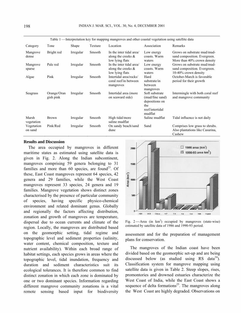
Results and Discussion The area occupied by mangroves in different
maritime states as estimated using satellite data is given in Fig. 2. Along the Indian subcontinent, mangroves comprising 59 genera belonging to 31 families and more than 60 species, are found23. Of these, East Coast mangroves represent 64 species, 42 genera and 29 families, while the West Coast mangroves represent 33 species, 24 genera and 19 families. Mangrove vegetation shows distinct zones characterised by the presence of particular community of species, having specific physico-chemical environment and related dominant genus. Globally and regionally the factors affecting distribution, zonation and growth of mangroves are temperature, dispersal due to ocean currents and climate of the region. Locally, the mangroves are distributed based on the geomorphic setting, tidal regime and topographic level and sediment properties (salinity, water content, chemical composition, texture and nutrient availability). Within each broad range of habitat settings, each species grows in areas where the topographic level, tidal inundation, frequency and duration and sediment characteristics suit its ecological tolerances. It is therefore common to find distinct zonation in which each zone is dominated by one or two dominant species. Information regarding different mangrove community zonations is a vital remote sensing based input for biodiversity
assessment and for the preparation of management plans for conservation.
The mangroves of the Indian coast have been divided based on the geomorphic set-up and are being discussed below (as studied using RS data24). Classification system for mangrove mapping using satellite data is given in Table 2. Steep slopes, rises, promontories and drowned estuaries characterize the West Coast of India, while the East Coast shows a sequence of delta formations25. The mangroves along the West Coast are highly degraded. Observations on
Table 1 ⎯ Interpretation key for mapping mangroves and other coastal vegetation using satellite data
Category Tone Shape Texture Location Association Remarks
Mangrove dense
Bright red Irregular Smooth In the inter tidal area/ along the creeks & low lying flats
Low energy coasts. Warm waters
Grows on substrate mud/mud-sand composition. Evergreen. More than 40% crown density
Mangrove sparse
Pale red Irregular Smooth In the inter tidal area/ along the creeks & low lying flats
Low energy coasts. Warm waters
Grows on substrate mud/mud-sand composition. Evergreen. 10-40% crown density
Algae Pink Irregular Smooth Intertidal area/rocks/ coral reef/in between mangroves
Hard substrate/in between mangroves
October-March is favorable period for their growth
Seagrass Orange/Orangish pink
Irregular Smooth Intertidal area (more on seaward side)
Soft substrate (mud/fine sand) depositions on the reef/intertidal mudflat
Intermingle with both coral reef and mangrove community
Marsh vegetation
Brown Irregular Smooth High tidal/more saline mudflat
Saline mudflat Tidal influence is not daily
Vegetation on sand
Pink/Red Irregular Smooth On sandy beach/sand dune
Sand Comprises low grass to shrubs. Also plantations like Casurina, Cashew
Fig. 2 ⎯ Area (in km2) occupied by mangroves (state-wise) estimated by satellite data of 1986 and 1990-93 period.
NAYAK & BAHUGUNA: APPLICATION OF REMOTE SENSING DATA TO MONITOR MANGROVES
199
region-wise mangroves are described as below. It needs to be mentioned here that only high-resolution satellite data helps in identification of dominant species of mangroves. The classification of mangroves using this data is done up to genus level only. Therefore, the mangroves are described in the text up to the genus level only. The field checks provided species-level information and therefore, wherever, the species-level information is given, it should be noted that the information is ground-based.
Onshore mangroves Mangroves of the open coast of Balasore in Orissa
and Saurashtra in Gujarat generally comprise Avicennia sp. On the Balasore coast, Orissa, mangroves are present on the seaward side fringing the open coast from near Amarnagar to Karanjmal, Sona Habelisai and from Sons Nabilii to Nechanpur (Fig. 3, study area: 86º45′-87ºE long.; 20º45′-21ºN lat.). The seaward mangroves have higher density, for e.g., near Sona Habelisai. Large barren mudflat is present adjoining these mangroves that are suitable
Table 2 ⎯ Classification system for mapping mangrove community zones
Sonneratia (pure/mixed communities) ii) Salt marsh vegetation iii) Saline blanks
High-tidal mudflat i) Salt marsh vegetation ii) Saline blanks
Transitional areas Grass Deltaic complexes Seaward margin of inter-tidal mudflats A. marina, A. alba, A. officinalis (pure) Inter-tidal mudflats i) Pure communities of Rhizophora, Sonneratia,
Avicennia, Bruguiera, etc. ii) Mixed mangrove iii) Salt marsh vegetation iv) Saline blanks
High-tidal mudflats i) Salt marsh vegetation ii) Saline blanks
River mouths Sonneratia, Bruguiera, Excoecaria, Heritiera, Lymnitzera (pure/mixed communities)
INDIAN J. MAR. SCI., VOL. 30, No. 4, DECEMBER 2001
200
for afforestation. The shoreline of the Saurashtra coast, Gujarat, is less indented and appears moderately straight. Small patches of mangroves are mainly confined to the mudflats present along the creeks near Porbandar, Miyani, Mahuva, Diu, Jafarabad, Buthrani, Ghogha jetty, Pipavav bandar, Narera bet, etc. They mostly comprise sparsely distributed Avicennia sp. Significant number of industries have come up on this coast, which along with the jetties and their housing colonies may further degrade these mangroves.
Estuarine mangroves Estuarine mangroves are mainly found along the
coastal states of Maharashtra, Goa, Karnataka, Kerala and Pichavaram in Tamil Nadu.
Estuaries indent the Gulf of Khambhat coast of Gujarat. Mangroves are found growing on the intertidal mudflats in a very stunted and sparse form, near the Mahi, the Dhadhar, the Kim and the Sena estuaries. A small patch was observed on the Aliabet
Island at the mouth of the Narmada estuary. The southern coast of Gujarat is comparatively uniform and is broken by few indentations. Small patches of mangroves are found along the creek near Umargam and the Kolak estuary.
The Maharashtra coast is characterised by pocket beaches flanked by rocky cliffs and estuaries. Mangroves mostly occur along the estuaries ⎯ Amba, the Ulhas, the Savithri, the Kundalika and the Dhamratar and along the creeks ⎯ Panvel, the Vasai, the Thane, the Vaitrana, Vijay-Durg and Devgadh (Fig.4, study area: 73º15′-73º30′E long. and 16º15′-16º40′N lat.). Important species are Avicennia sp. and Rhizophora sp. The sediments on which mangroves thrive are fine silty to clayey in nature. The condition of mangroves is good except on the banks of Ucheli, Thane district, Patalganga and Kundalika rivers. Mangroves generally occur as linear patches and vary in size from 0.3 to 2 km in length and 250 to 400 m in width. Stunted growth of mangroves was noticed on the rocky shores of the Thane district. Dense mangroves cover about 125 km² area, while degraded mangroves cover about 100 km² area. The mangroves along the Thane estuarine region and the stretch between Diva and Dombivli in Greater Bombay district need protection from human interference.
In Goa, mangroves occur along the banks of rivers,
Fig. 3 ⎯ IRS 1D LISS III image (Feb. 28, 1999) showing fringing dense mangroves (1), on the open coast near Amarnagar-Karanjmal area (2), and the mainland east of Bhitarkanika forest (3).
Fig. 4 ⎯ IRS 1D LISS III image showing dense estuarine mangroves (1) along the Vijay-Durg & Devgadh creeks.
NAYAK & BAHUGUNA: APPLICATION OF REMOTE SENSING DATA TO MONITOR MANGROVES
201
viz., Chapora, Terekhol, Sal, Mandovi Mapuca and the Zuari. The Mandovi and Zuari estuaries along with the Cumbarjua canal form the largest estuarine complex in Goa. Dense mangroves are seen at the confluence of the Mapuca and the Mandovi rivers (Fig. 5, study area: 73º50′-73º55′ E long. and 15º30′-15º33′ N lat.), mostly comprising Avicennia sp., and Rhizophora sp. Area under mangroves is about 7 km². Mangroves near the mouth of the rivers are tall and dense, and those occurring in the upstream areas cover isolated patches26.
The coastal zone of Karnataka is narrow with long and straight beaches and indented by estuaries, shallow lagoons and mudflats along which mangroves are present. Dense mangroves are present in small patches along the Mulki, the Sita-Swarna Rivers, in the Chakra-Haldi-Kolluru estuarine complex and lagoon banks. Further north, small patches of mangroves are seen along the Sharavati estuarine complex, near Honavar, the Tadri creek, Aganashani estuarine complex near Kumta, and the Kalinadi estuarine complex. Rhizophora sp., Avicennia sp., Sonneratia alba and Acanthus ilicifolius are commonly occurring communities of mangroves.
Along the Kerala coast, there are practically no large tracts of land under mudflats and mangroves. Small patches of mangroves exist at Kumaragom, Chembu, Vallarpadam, Chettuva, Nadakuvu, Pappinisseri, Kunjimangalam, Dharmadom and Veli. Increase in population density, multidimensional developmental activities and the conversion of backwaters for agricultural purposes are the main reasons for the decline of mangroves.
Well-developed and densely distributed mangrove forests are present at Pichavaram (the sole remaining good mangrove area in Tamil Nadu). The Pichavaram mangrove forest consists of 51 islands and islets fed by Vellar estuary and separated by a complex network of creeks. A long sand bar separates the whole area from the sea. It represents 14 exclusive mangrove species with the commonly occurring species being Rhizophora and Avicennia, Ceriops and Bruguiera. Pichavaram mangrove forest has the Reserve Forest status. The existing levels of exploitation of Pichavaram mangroves far exceed the sustainable levels and the habitat is rapidly being degraded by the removal of Sonneratia apetala and Xylocarpus granatum27.
Deltaic mangroves The major deltas of India are the Ganges,
Mahanadi, Godavari, Krishna and Cauvery. The Sunderbans formed in the vast delta complex of the Ganga and the Brahmaputra rivers and located in the 24 Parganas district of the West Bengal. The Sundarbans are the largest single block mangrove formations in the world. It comprises 30 of the 50 species of the true mangroves in the world28.
Along the Orissa coast, mangroves are present on the Mahanadi delta and the Brahmani-Baitrani delta (Fig. 6, study area: 86º48′-86º58′ E long. and 20º40′-20º50′ N lat.). The Brahmani-Baitrani delta is enriched with rich mangrove genetic diversity and has been declared as the Bhitarkanika Wild Life Sanctuary (650 km² deltaic sprawl of major rivers like Brahmani, Baitrani and the Dhamra, creeks, mudflats and mangroves forest) in 1975. About 367 km² has been declared as the National Park in 1988. There are about 62-67 species of mangroves in this region, with the dominating species being Avicennia marina, A. officinalis, Rhizophora apiculata, Excoecaria agallocha, Phoenix and Sonneratia sp. Bhitarkanika has the second single largest block of mangrove formations in the country, after the Sunderbans.
Fig. 5 ⎯ IRS 1D LISS III (Dec. 23, 1998) and PAN (Feb 11, 1999) merged product of Mandovi estuary, Goa (1) showing estuarine mangroves. Rhizophora community (2) occupies the central portion (dark maroon colour), Avicennia community (3) is present on the northern side (bright red tone) and Sonneratia (4) community (dark red) is more dominant in the western portion. Intertidal mudflats (5), High tidal mudflats (6), Agricultural land (7) and urban area (8) are also observed on the image.
INDIAN J. MAR. SCI., VOL. 30, No. 4, DECEMBER 2001
202
Paddy cultivation, salinity increase and slow regeneration of mangroves have caused considerable damage. Mangroves are being cut down for fuel and building material. Creeks have been blocked, thereby, resulting in the sweetening of the water upstream killing the mangroves. Satellite data has revealed damage and cutting of mangroves for aquaculture, agriculture, etc. More than 30 km² of the Bhitarkanika area was cleared for prawn farming29. The mangroves near the mouth of the Mahanadi are formed along the creek network of the Luna, the Jambu, the Kharnasi, the Khola and the Batighar jora creeks, which are inundated by daily tides. These mangroves are being destroyed for illegal development of aquaculture ponds30.
For community zonation the entire Bhitarkanika region (Fig. 6) has been divided based on the variation in tidal inundation, into following regions5:
i) Main Bhitarkanika sanctuary (deltaic coast with frequent tidal influence – fed by Bhitarkanika river, network of creeks, daily inundation by tides and mixing of fresh water
ii) Southern bank of the Maipura river iii) Mainland area iv) Offshore islands
Based on satellite data the classification of mangroves is possible only up to genus level. The different spectral characteristics of the mangrove communities of the region are shown in Fig. 7. The main Bhitarkanika region comprises six community zones, viz., a) Heritiera forest occupying the central portion
along the Bhitarkanika River on the western side. Density of the forest is high.
b) Mixed forest comprising Excoecaria, Avicennia and Sonneratia makes up the zone along the river on the eastern side.
c) Pure community of dense Avicennia occupies the northeastern part on the landward side.
d) Pure Sonneratia apetala inhabits the southwestern region (on the landward side) after the Heritiera forest belt.
e) Mixed mangroves zone comprising Sonneratia and Heritiera is found making the innermost belt in the forest.
f) Pure Phoenix paludosa makes up the landward zone of the eastern mainland.
g) The outermost landward side consists of mostly sparse/degraded mangroves and saline blanks.
Fig. 6 ⎯ IRS 1D LISS III image (Feb. 28, 1999) of part of Brahmani-Baitrani deltaic complex showing mangroves of Bhitarkanika region (1), fed by the Dhamara river (2), Bhitarkanika river (3), and Maipura river (4). The Bhitarkanika forest is dominated by Heritiera dense community (5) on the west. Also present are Sonneratia dense (6) community, Sonneratia-Avicennia-Heritiera mix mangroves dense (7), Excoecaria-Avicennia dense community (8), and Rhizophora dense (9).
Fig.7 ⎯ Spectral characteristics (vis-à-vis IRS LISS III bands green, red, near infra-red and middle infra-red) of dominant communities and their density conditions of Bhitarkanika mangroves.
NAYAK & BAHUGUNA: APPLICATION OF REMOTE SENSING DATA TO MONITOR MANGROVES
203
Apart from these, Myriostachya grass meadows are present on the mudflats northeast of Bhitarkanika village and other areas.
Southern bank of the Maipura river (deltaic coast with less tidal influence-fed by small creeks, less fresh water, salinity is high) has pure Avicennia forest as the dominant mangrove zone of the region occupying most of the inward zone. Mixed mangroves (dense) make up the seaward-most zone (narrow). Pure and dense Sonneratia apetala lines the creeks. Mixed mangroves (sparse) occur after the mixed Avicennia forest belt on the landward side. Pure Avicennia occupies the north-eastern-most tip on seaward side. The outermost fringe has marsh vegetation on the saline area. Saline blanks are present in between the mixed Avicennia forest. Aquaculture ponds are located on the south-eastern edge of the forest on the landward side (near the dunes) and Casuarina plantation cover the sand dunes on the land ward side of the sandy beach.
Offshore islands comprise pure and dense Avicennia alba and forms a dominant zone in all the offshore islands. Mixed mangroves fringe the seaward-most edge of the islands, followed by Sonneratia apetala. The seaward-most zone of the mainland fringing mangroves is narrow and has mixed mangrove community. Few patches of Sonneratia apetala are present on the northwestern side. Mixed Avicennia forest follows the Avicennia alba pure zone. The outermost landward mangrove zone has densely distributed Phoenix paludosa. The high-tidal mudflat with marsh (Suaeda) and Myriostachya grass meadows make up the landward-fringing zone.
Large and dense mangroves are present on the Coringa (south of the Kakinada bay, Fig. 8, study area: 82º14.5′-82º25′E long. and 16º45′-16º50′N lat.), Gautami and Vashishta Godavari deltaic region, Goluleru creek and Krishna delta of Andhra Pradesh. Mangroves are more widespread on the western tidal flats of the Krishna delta-lobe rather than on the eastern side24. Dense mangroves have also been mapped on the ancient delta at Machilipatnam. Sparsely distributed mangroves occur on the inter-tidal mudflats at the mouth of the Sarada River. Small patches of mangroves are found in estuarine areas of Ramperu River and along the Panneru estuary. Thirteen species of true mangroves have been
reported from Coringa31. The mangroves are under pressure due to widespread development of aquaculture. About 380 km² areas are under mangroves.
Numerous creeks feed the Coringa wildlife sanctuary located in the northeast part of the Godavari delta. IRS-1D LISS III images (Fig.8) helped in delineating the following mangrove zones in this region. The seaward most fringing zone is of grass (Myriostachya wightiana) in most of the places. Grass also occurs in between the mangroves. Pure dense zone of Avicennia officinalis forms the dominant community zone on the western side of the Coringa mangroves. Pure and dense zone of Avicennia marina forms the dominant zone on northeast and southeast side. The central eastern zone is occupied by Sonneratia Fig. 8 ⎯ IRS 1D LISS III image of March 1999 showing deltaic mangroves of Coringa. The three communities of mangroves making up the Coringa creek forest are: (1) Excoecaria-Avicennia dense, (2) Avicennia-Sonneratia dense (3) Avicennia community dense. Saline blanks (4), aquaculture ponds (5) and agricultural area (6) are also observed in the image.
INDIAN J. MAR. SCI., VOL. 30, No. 4, DECEMBER 2001
204
apetala with Excoecaria agallocha along the creeks. Pure and dense community of Rhizophora mucronata occurs as small irregularly distributed patches on northwest side. On land ward side, the mangroves are in degraded condition due to mushrooming of aquaculture ponds. Saline blanks have increased recently. The central island has numerous small clearings of mangroves for aquaculture ponds. In some places, encroachment along the creeks (in between dense mangroves areas) is clearly visible.
In Tamil Nadu, mangroves occur on the Cauvery delta coastal strip from Cuddalore to Chatram near Point Calimere, and Pennar delta. Muthupet-Adhirampatinam dense mangrove forests are located further west to Point Calimere at the southern end of the Cauvery delta. They are in degraded condition. The proliferations of saltpans in the lagoonal area are responsible for the degradation of the mangroves of this region.
Around 95% of the mangrove cover of Gujarat is in the Kachchh district distributed along its 338 km of coastal stretch. The areas of the lower Indus deltaic plain, situated on the west of the Great Rann of Kachchh and north-west of the Gulf of Kachchh, Gujarat, are characterised by the tidal creeks and small over bank splays that are lined with mangroves. Kori creek mangroves were not studied in detail earlier. A detailed picture on their areal extent and condition was only obtained after studying them using remote sensing data. Dense growth has been mapped along the Pir Sonai, Sugar, Sir, Kharo, Ramaria, Kalichod, Sindhodic and Sethwara bet creeks, off the coast near Koteshwar, Narayan Sarovar, Jakhau, etc.
The Kori creek (Fig. 9, study area: 68º14.5′-68º45′E long. and 23º30’-23º50’N lat.) mangroves (studied using IRS-1C/1D LISS III data of 1998-1999) form four zones (species diversity is less), with the dominant species being only Rhizophora and Avicennia. Rhizophora occurs as pure community inhabiting mostly the seaward side. Dense (more than 40% crown density) mixed Avicennia forests occur along the creeks. Sparse (10-40% crown density) and degraded (less than 10% crown density) Avicennia mangroves occur more inward. Scattered mangroves are found landwards and also in between sparse mixed Avicennia. Increase in the salt encrustations on the intertidal mudflat seaward as well as inward in the entire region has been observed.
Mangroves of the Gulf The Gulf of Kachchh has an assemblage of
different ecologically sensitive ecosystems, viz. coral reefs, mangroves, sea grasses, algae/seaweeds, etc. It is the largest inlet (approx. 7350 km²) of the Arabian Sea, about 60 km wide at its widest and 170 km long. Dense mangroves have been mapped32 on the Pirotan, Jindra, and Munde-Dide ka bet (Fig. 10, study area: 69º46′-69º65′E long. and 22º30′-22º40′N lat.), Bhains bid, along Bedi Bandar and Mashuri creek, Bhaidar, Nora, Chank tapu and Kalubhar (Fig. 10, study area: 69º33′-69º40′ E long. and 22º23′-22º29′ N lat.). Sparse and degraded mangroves are present on the inter-tidal mudflats of the mainland near Poshitra, Pindhara, Dhani bet, Kalubhar, lining the saltpans of Narara and Singach and above Sikka. Very small
Fig. 9 ⎯ IRS 1D LISS III image of Kori creek, north-west of Gulf of Kachchh in Gujarat shows Indus deltaic mangroves. The region inhabits two dominant communities, viz., (1) Avicennia and (2) Rhizophora. Sparse Avicennia is indicated as (3). On the intertidal mudflats (4), salt encrustations (5) are also clearly visible.
NAYAK & BAHUGUNA: APPLICATION OF REMOTE SENSING DATA TO MONITOR MANGROVES
205
patches of mangroves line the creeks of the mudflats off Navlakhi, Kandla and Gandhidham. Mangroves fringe the inter-tidal mudflats situated south of Mundra town, east of Bocha and Navinal Island.
In the Gulf of Kachchh, dominant mangrove communities of the Marine National Park region (Fig.11, study area: 69º56′-70º02′ E long. and 22º32’-22º36’ N lat.) are ⎯ i) Avicennia officinalis (pure and 1 m height) and/or mixed Avicennia forest (1 m in height), ii) dense Avicennia marina (3 m in height) and Avicennia officinalis (forming the most seaward zone of the fringing mangroves as well as along the creeks), iii) dense Rhizophora (dominant in less disturbed areas and forms the second zone), iv) dense mix mangroves (Avicennia alba, Avicennia marina, Rhizophora mucronata, Ceriops tagal and very few trees of Aegiceras corniculatum) along the creeks adjacent to the mixed Avicennia zone), v) sparse mix mangroves (in more disturbed areas), and on certain islands, this region is occupied by sparse/degraded Avicennia marina, vi) dense pure Avicennia alba or pure zone of Ceriops tagal occupy the landward side of inter-tidal zones. Mangrove plantations mostly comprising Avicennia marina community have also been mapped.
Mangroves on offshore islands The deeply indented coastline of the Andaman and
Nicobar Islands results in innumerable creeks, bays
and estuaries and facilitates the development of mangroves. The basic requirement of soil type, topography along with temperature is favourable for their growth. Andaman and Nicobar mangroves are the second largest in India in terms of species diversity2. The mangroves mostly fringe the creeks (Fig. 12, study area: 92º40′-92º45.5′E long. and 11º45′-12º0′N lat.), lagoons and muddy as well as flat rocky shores. The dominant species are Rhizophora apiculata, R. mucronata, Brugeria gymnorrhiza, Heritiera littoralis, Nypa fruticans, Sonneratia caseolaris, Excoecaria agallocha (most commonly distributed throughout the islands). Avicennia sp., is present in the disturbed places in the Andamans and is absent in the Nicobar islands. Rhizophora apiculata and R. mucronata are the most dominant species towards the sea33. The total area under mangroves is about 680 km² in Andamans and 70 km² in Nicobars24.
Validation of maps The coastal wetland/landuse maps were validated
on ground mainly for estimating classification accuracy. The maps have an accuracy of 85-93% at 90% confidence level24. State-wise accuracy estimations are listed in Table 3.
Monitoring and change detection Changes in the condition of the mangroves
occurring in all the maritime states of India (Fig. 2), Fig. 10 ⎯ IRS 1D LISS III image (Oct 27, 1998) showing mangroves (1) distributed along the creeks on the Munde-ka-bet Island and Kalubhar island, situated in the core Marine National Park region in the Gulf of Kachchh. Marsh vegetation (2) inhabits the high tidal mudflats having more salinity; algae/seaweeds (3) grows on the reef flat region along with seagrass (4) on the mud deposits on the coral reefs; and sand vegetation (5). Algal ridge comprising calcareous algae (linear red) is also observed (3”).
Fig. 11 ⎯ Mangrove community zonation map of a part of the Gulf of Kachchh region along with corresponding IRS 1D LISS III image, showing dominant mangrove communities and habitat, (1) Avicennia dense, (2) Ceriops-Rhizophora dense, (3) Avicennia sparse, (4) Marsh vegetation, (5) Mix mangroves dense, (6) Standing dead, (7) Intertidal mudflat and (8) High tidal mudflat.
INDIAN J. MAR. SCI., VOL. 30, No. 4, DECEMBER 2001
206
were studied over the time using multi-temporal data (during 1986-93 period). Mangroves covered 6740 km² area according to an earlier estimate34. The present satellite-based estimate24 of mangroves is 4460 km², which indicates loss of about 2280 km² area. The study revealed that mangroves have mainly degraded in W. Bengal, Andaman & Nicobar islands, Tamil Nadu and Karnataka coastline and significant improvement in their conditions has been noted in Gujarat (+245 km²). Some significant observations made are as below.
Improvement: Sparsely distributed mangroves were mapped along
the Kori creek, occupying about 450 km² area, mostly in the form of narrow discontinuous patches, mainly bushy and mutilated with multiple vegetative shoots attaining a height of about 2 m and very few dense patches were delineated (about 150 km² area). There was, however, significant improvement in the condition of these mangroves from 1992 onwards.
Degradation: i) Maharashtra mangroves are the most threatened
along the west coast due to anthropogenic pressures. Mangroves are being reclaimed for agriculture, firewood, construction activities and pollution due to industrial discharge in creeks and rivers. Apart from this, there is a severe threat by the caterpillar of the teak defoliator moth, which feeds on the leaves of mangroves. Avicennia marina occupying 405 ha area have been affected by this caterpillar in the Thane creek region35.
ii) Marsh vegetation has replaced mangroves at most of the places near Amarnagar to Karanjmal, Sona Habelisai and from Sona Nabilii to Nechanpur in Orissa coast. Extensive aquaculture ponds have come up during the last ten years and are the most probable cause of mangrove degradation. Total loss of 16 km² of mangroves has been observed from 1986 to 1993.
iii) Loss of around 230 km² of mangroves was noticed in Sunderbans from 1986-92. This loss can be attributed to many factors such as: a) mixing of creek area and mangroves at 1:250,000 scale (1986). At larger scale, many more creeks can be mapped and thus mangrove area is apparently reduced, b) exploitation due to increasing population pressure, c) loss of flora and fauna including endangered species, d) conversion of mangroves for agriculture and aquaculture purposes24,36.
iv) Twenty-five years ago, the Aliabet Island in south Gujarat was full of mangroves. Today mangroves are found growing in the northeastern side occupying small patches only, which have grown recently. The degradation is mainly due to reduction in the influx of tidal waters due to emergence of the island7,24.
Table 3 ⎯ State-wise accuracy of coastal wetland/landuse maps
Maritime States Accuracy (in %) at 90% confidence level
Fig. 12 ⎯ Dense mangroves (1) growing along the Shoal bay creek in Middle Andamans (IRS-1D LISS III image).
NAYAK & BAHUGUNA: APPLICATION OF REMOTE SENSING DATA TO MONITOR MANGROVES
207
v) Earlier to 1950, mangrove forests were in very good condition in the Gulf of Kachchh, dense and often reaching up to 14 m or so, represented by Brugueria sp., along with species of Avicennia, Rhizophora, Aegiceras corniculatum, Ceriops tagal and Sonneratia apetala36. Today, Brugueria sp., is totally absent, Sonneratia apetala, Rhizophora mucronata and Ceriops tagal have become vulnerable species and Aegiceras corniculatum has become endangered. Mangroves fringing the southern coast are in more degraded condition, than those present on the islands. There has been a sharp decline in the area under dense mangroves8,32 from the year 1975 to 1982. The main destruction of dense mangroves has taken place near Bhaidar, Nora, Dhani, Kalubhar, Narara, Singach, Jindra, Dide ka bet and Pirotan. In Singach, Narara, Pindhara bay and Kalubhar.
vi) Monitoring of the mangroves of the Marine National Park, Gulf of Kachchh was carried out using satellite data4,32 during the last 25 years (1975-1998) period (Fig. 13). From 1985 onwards the degradation of mangroves and coral reef has significantly been controlled and their condition has improved particularly in the Marine National Park4, mainly due to the conservation measures taken by the Park Authorities. The main causes of degradation were use of mangroves for fuel and fodder, camel grazing, large-scale development of saltpans near Vadinar, Salaya, Bedi and Mithapur in the sanctuary area, industrial development, creation of harbours and ship-breaking yards. This large-scale destruction of mangroves also led to decline in catch of marine fish of the region.
vii) Mangroves situated on the southeast of Jindra bet have undergone severe degradation (loss of about 14.7 km² area) after October 1998. The area was then continuously monitored using satellite images of October 1998, March 1999, November 1999, December 1999 and March 2000. Defoliation (top-dying) of mangroves was first observed in March 1999. Some improvement was observed in November 1999, however there was again a decline in December 1999 and subsequently a marginal improvement
in March 2000. A ground survey was carried out in March 1999 wherein it was observed that the entire leaves of mangroves were shed off and only stems were remaining. Subsequently another ground survey was carried out in July 2000 and regeneration of mangroves was observed in certain places where the mangroves had defoliated. The possible explanation of this could be damage due to frequent oil spills (oil spills have occurred around March 99 and November 15-16, 1999).
viii) In 1975, large areas (about 700 km²) were under mangroves between Navalakhi and Kandla, near the head of the Gulf, which reduced significantly by 1982, mainly due to increase in salt deposits7. Thick salt encrustations were observed occupying most of the mangrove habitat areas.
ix) Degradation in the condition of the Navinal-Bocha mangroves (northern coast of Gulf of Kachchh) has also been noticed. Mangroves here were in good condition till 1988. Significant degradation was observed from 1992-1999 (3.96 km² area under mangroves has
Fig. 13 ⎯ Graph showing trend of changes in the condition of mangroves of the Marine National Park (Gulf of Kachchh), monitored using satellite data during 1975 to 1998 period.
INDIAN J. MAR. SCI., VOL. 30, No. 4, DECEMBER 2001
208
reduced). Construction of an 8 km road leading to a jetty on Navinal island led to the destruction
of mangroves covering about 1 km². Similarly loss of mangroves covering about 400 m was observed within and outside the Mundra port premises.
x) In the Krishna delta region the mangroves have depleted rapidly due to deforestation of mangroves mainly for the purpose of aquaculture development and agriculture. The mangroves of the Godavari and the Krishna river deltaic regions are under pressure mainly due to aquaculture activity37. The mangroves of the Coringa creek in Kakinada bay were critically studied from 1997-2000. Aquaculture pond development and clearing of mangroves has been observed within the mangrove areas during this period. Mangroves fringing the land in the southwestern region have also been cleared and reclaimed for aquaculture practices37.
xi) Kerala coast has serious problems due to reclamation. Only 8 km2 area is occupied by sparsely distributed mangroves (in Kochi and Kannoor areas). Mudflats have been converted to filtration ponds or reclaimed for paddy cultivation.
xii) Salt harvesting and aquaculture practices are on the increase on the Tamil Nadu coast resulting in severe degradation of mangroves and its habitats. Mangroves of Pichavaram are rich in diversity but are threatened due to aquaculture practices.
xiii) Mangroves have been cleared for the harbor activities near the Paradip port along the Orissa coast. The mangroves of the Mahanadi delta, which are protected under the Hatamundia Reserve Forest Act, have been gradually degrading from 1985 owing to the developments of aquaculture ponds. The mangroves of this region occupied 28 km² area in 1985, out of which dense mangroves covered 25 km² area. Gradual decline took place till 1989 wherein mangroves covered 22 km² area and dense mangroves occupied only 16 km² area. Some improvement was noted in February 1999 and dense mangroves were observed to be covering 26 km² area. However, in November
1999, just after the super cyclone, it was observed that mangroves degraded alarmingly with dense mangroves now covering only 0.71 km² area. Mangroves in degraded state were spread in 14 km² area and in the rest of the area mangroves had fallen down and inundated with water.
xiv) In the Andaman and Nicobar islands, the change in areal extent of mangroves can be mainly attributed to the difference in the scale of mapping. Maps at 1:250,000 scale were prepared in 1986, whereas in 1993 the maps were at 1:50,000 scales. At 1:250,000 scale, it is difficult to delineate separately small creeks from in between the mangroves areas, with the result that the area, which actually belongs to the creeks, gets estimated as mangroves9. This limitation is overcome when maps are prepared at 1:50,000 scales and therefore creek area gets differentiated separately from mangroves thereby reducing the area of mangroves as estimated in 1986.
Algae/seaweeds Algae/seaweeds that also form an integral part of
the mangrove ecosystem, grow as epiphytes on trunks, prop roots and pneumatophores as well as on pebbles or on sandy and muddy substratum. Marine algae are biologically important for their role in building calcareous banks and cementing coral reefs.
Earlier studies pertaining to mapping the algae/seaweeds around the world have been restricted to inventory using aerial photographs38-41. Studies have been conducted for algal beds on the Great Barrier Reef using Landsat TM, SPOT and aerial data, mostly for inventorying42,43. Jensen21 separated kelp from other habitats for a part of California coast using Landsat TM digital data. Zainal et al.44 classified various habitats including algae/seaweeds, of the coastal zone of Bahrain using Landsat TM data. It was possible to broadly differentiate a brown seaweed Sargassum from other members of algae, based on tonal variations and the density of algae/seaweeds. Brown and red algae are distinguished from other algae mainly by the presence of fucoxanthin (brown pigment) and phycoerythrin (red pigment), respectively, which mask the chlorophyll pigment. Zonation of algae in the mangrove environment is
NAYAK & BAHUGUNA: APPLICATION OF REMOTE SENSING DATA TO MONITOR MANGROVES
209
governed by tides45. In the region above high tide, where the tidal influence is negligible, no algae are found. In the inter-tidal zone (where the tidal influence is moderate), lesser number of algae (Chaetomorpha sp.) are present. In the inter-tidal and the sub-tidal zones, which are frequented by tides, algal vegetation is rich and is composed of mainly red algae such as Caloglossa, Catnella, Bostrychia and Polysiphonia45. Around 47 species representing 30 genera of algae are known to occur in the mangrove forests of India46,47. Using remote sensing data, there is often confusion in differentiating algae/seaweeds and seagrass, which is not unusual and has several causes48. Whilst the photosynthetic pigments in seagrass and algae (chlorophyll, phycoerythrin and fucxanthin) have different albedo characteristics, satellite spectral bands are generally unsuitable for distinguishing them49. This is because the range of wavelengths that penetrate is small (< 580 nm) and may not encompass the characteristic reflectance minima and maxima for a particular pigment50.
There are two prominent seaweed production areas in India, the Saurashtra peninsula in northwest and the Mandapam-Cape Comorin coast along the Gulf of Mannar in the southeast45. About 120 species of marine algae are reported to be occurring in the Gulf46,51. Dense algae (29.2 km² area) are mapped using satellite data on the reef area of Bet Shankodhar, on the patch reef above the Bet, Paga reef, Bural Chank, coral pinnacles, Kalubhar reef, Munde ka bet (Fig. 10) and Pirotan reef. Sparse algae (24.6 km2 area) are mapped on the Panero, Jindra, Sikka, southwest of the Kalubhar reef and Narara. The algae found on the reefs are rich in diversity consisting of Sargassum sp., Ulva sp., Enteromorpha sp., Cladophora sp., (commonly occurring species) and other members of green, red and brown algae51,52. Many species of marine algae are found in coral reef area. Areas having such algal occurrences are merged in this category only. Red algae, green algae and different coloured seaweeds are seen on Pirotan reef and Narara reef. Ecological as well as geomorpho-logical zonations of Gulf of Kahchchh reefs using higher resolution satellite data have revealed a prominent narrow algal ridge (Fig. 10) immediately after the reef crest that gets exposed during low tide and comprises mainly of seaweed Sargassum. The outer reef flat is undulating and has shallow pools
with the dominating algae (seaweed) being Sargassum. Other algae are mostly Gracilaria, Gelidiella, Padina, Codium, etc. Inner reef flat is almost flat and shallow and gets exposed during low tides with the dominating algae being green Ulva. Dead coral boulders are also present in this area covered with Ulva. The wide sandy zone is mostly barren, but occasionally has seasonal vegetation.
Algae like-Ulva, Gracilaria, Gelidium, Hypnea and Ceramium are present in small and scattered patches on the inner reef margins of the Cheriyapaniyam and Kiltan atolls of Lakshadweep.
Several species of green, brown and red algae with luxuriant growth occur along the Southeast coast of Tamil Nadu from Rameswaram to Kanyakumari (Gulf of Mannar). However, using satellite data only a small patch of algae (pure) was delineated on the southern reef flat of Muli Tivu. On other Gulf of Mannar reefs algae/seaweeds along with seagrass (mixed) has been mapped occupying extensive areas (13.7 km² area), especially on Pumurichan, Kurusadi, Hare and Manoli reefs10.
On the Andaman and Nicobar coast, the reef vegetation (~ 8.9 km² area) consisting of algae/seaweeds and seagrass have been mapped using satellite data on the Table island, Reef inlet, above Buchanan bay, NW of Anderson island, north of Interview island, north of Sound island and south of Nancowry island9,10. It was not possible to distinguish between algae/seaweeds and seagrass on this coast because of medium spatial and spectral resolutions and the narrow extremely coastal strip of these islands.
Seagrass Seagrasses are advanced flowering plants complete
with both vascular and root systems and intermingle with both mangroves and coral reef communities at their respective seaward and landward boundaries, frequently providing link between mangroves and coral reef ecotypes. They are known to reduce particulate pollutants of the sea by trapping and binding the sediments. On the reefs, seagrass mostly inhabits infra-littoral regions where fine sediments accumulate, e.g., on the reef edges. However, they are also found growing on reef flats where the substrate is fine sand mixed with mud, e.g., Syringodium isoetifolium, Halophila stipulacea, Cymodocea ciliata. Using RS data, the studies have been mainly
INDIAN J. MAR. SCI., VOL. 30, No. 4, DECEMBER 2001
210
confined in distinguishing exposed and submerged seagrass and density-wise classification53-55. Seagrass species identification appears beyond the capability of remote sensing50. In this study information pertaining to the presence/absence of the seagrass only could be achieved. It was also difficult to carry out density-wise mapping.
Six species of seagrass are reported from the Gulf of Kachchh46,51. Seagrass (Thalassia hemprichii) has been mapped along with algae on the inward side of almost all the reef flats of the Gulf. Seagrass Urochondra setulosa that has not been reported from any part of India grows on Pirotan island10. The common seagrass found growing on the muddy substrate are Halophila ovalis, H. beccarii and Zostrea marina. The seagrass species have also undergone degradation and decline due to the cutting of mangroves. Seacow (Dugong), which feeds on seagrass, has migrated elsewhere, because of loss of seagrass beds.
Seagrasses have been mapped along the shores facing the lagoons and occupy 12 km² area, on the Lakshadweep islands, specially, Bangaram (large patch covering about 5.57 km²) (Fig. 14, study area: 72º9′-72º20.5′E long. and 10º46′-10º59′N lat.), Kiltan, Minicoy, Agatti, Kalpeni and Kavaratti reefs10. They occur in regions from low tide mark up to 3 m depth, mostly comprising Thalassia hemprichii and Cymodocea isoetifolia. Cymodocea serrulata a rare seagrass occurs at Kavaratti56. Seagrass also occurs on the coasts of the Gulf of Mannar and Andaman & Nicobar islands, however it was not possible to map them using satellite during this study. Seagrass density as well as detailed mapping can now be done effectively using IRS-1C/1D LISS III and PAN merged data (having 5.8 m spatial resolution).
Salt marsh vegetation Maritime salt marsh is distinct from inland salt
marsh and is essentially confined to the temperate regions of the world. However, a type of salt marsh (herbaceous species) is found on some muddy shores within the tropics where mangroves have failed to colonise. They mainly comprise grass and low shrubs growing on greasy wetland areas in standing or slow moving water, frequently interspersed with channels or pools at open water. Salt marshes lying in the mangrove environment are subjected to partial inundation. On the Indian coast, apart from being in the mangrove environment they are also found to
inhabit salt impinged high tidal mudflats. Salt marshes lying in the mangrove environment are subjected to partial inundation. Sueda and Salicornia species are the most ubiquitous of tidal marsh genera and therefore, become overwhelmingly dominant on the large majority of the tropical coasts.
In Gujarat, marsh vegetation (comprising Sueda maritima, Tamarix dioica, Salicornia brachiata and Aleuropus sp.), was mapped using satellite data, on the inter-tidal and high tidal mudflats, near Lakhpat, near Varsana, Luni and Jakhau port in the Rann of Kachchh region, near Balachhadi and between Navlakhi-Kandla in the Gulf of Kachchh region. The high-tidal zone of the Gulf of Kachchh (highly saline area) is occupied by marsh vegetation, mostly comprising Salvadora, Sueda and Cyperus (Fig.10). On the coast of the Gulf of Khambhat, they are found to be growing between the Sabarmati and the Tapi estuaries. Along the Mahi and the Dhadhar estuaries in the Gulf of Khambhat and the Mindhola, the Purna, the Ambica, the Auranga, the Damanganga estuaries, dense salt marsh vegetation is present.
On the east coast, salt marsh vegetation occurs as either being interspersed within mangroves (Picharavam area), on the high tidal mudflats (Muttupet) and along the drainage channels within high tidal mudflats and paleomudflats of the Andhra Pradesh (east of Nizamapatnam, near Pedda Valsala and Valsapakala)37. A study on other Indian coasts needs to be carried out for getting information on the salt marsh vegetation using satellite data.
Vegetation on sand Vegetation that establishes on sandy relief beyond
the high tide line ranges from low grass to shrubs. Ipomoea pescaprae is one of the most widely distributed of Angiosperm plants and forms the dominant community on the sandy shore45. Other commonly found species include, Cyperus arenacius, Hydrophylax maritima, Launaea sarmentosa, Salvadora persica, Clerodendrum inerme, Tamarix troupie, Asparagus dumosus, etc. Sporadic sand vegetation is mapped using satellite data, on the Gulf of Kachchh, on the sandy beaches of the coral reef islands (Fig.10) and fringing reefs of the mainland. Vegetation on dunes was mapped on western and southern Saurashtra coasts, between the Narmada and Tapi and the south Gujarat coast. On these areas Sporobolus, Ipomoea, Spinifex, etc., and certain cultivated species, e.g., Casuarina, Prosopis, Acacia,
NAYAK & BAHUGUNA: APPLICATION OF REMOTE SENSING DATA TO MONITOR MANGROVES
211
coconut palm, etc., commonly occur. Sand vegetation has also been mapped in the northern Maharashtra and Goa coast, between Coondapur and Mangalore. Extensive plantations of Casuarina and Eucalyptus are present on the sand dunes along the southern Tamil Nadu coast. Plantations like coconut, cashew, Casuarina and betal gardens along with natural sand vegetation are found on the beach ridges of Orissa and the West Bengal coasts.
Conclusion Orbital remote sensing has proved its usefulness in
mapping and monitoring of vital and critical habitats of the Indian coast. The large database of IRS data available since late eighties is an excellent source of data for condition assessment of vital mangrove areas and identification of areas under stress. With the proliferation of industrial complexes, mangroves are under severe threat, and it is necessary that they are preserved and/or conserved. A routine monitoring, at least twice a year, is now possible with the state-of-art Indian Remote Sensing Satellite. In near future IRS satellite having sensor (LISS IV) with better spatial resolution (5.8 m) along with multi-spectral capability (green, red, and NIR) will increase our capability to identify dominant plant community having an area of about 0.04 ha. Cartosat I with 2.5 m spatial resolution and stereo capability will provide data on tree height with sufficient accuracy in inaccessible and in hospitable terrain. Data from such sensors will be extremely useful for assessment of bio-diversity as well as preparation of management action plans.
Acknowledgement The authors are grateful to Dr. R. R. Navalgund,
then Deputy Director, Remote Sensing Applications Area, Ahmedabad, for offering useful suggestions.
References 1 Spalding M D, The global distribution of status of mangrove
ecosystems, in: Intercoast Network (International Newsletter of Coastal Management), Mangrove Edition [Published Quarterly by the Coastal Resources Management Project of the University of Rhode Island’s Coastal Resources Centre and the U.S. Agency for International Development (USAID), Narragansett, Rhode Island, USA] (1997) 20-21.
2 Clough B F, Climatic impacts on mangrove ecosystems, in Conservation of mangrove forest genetic resources: A training manual, edited by S. Deshmukh & V. Balaji, [Centre for Research on Sustainable Agriculture & Rural Development, (CRSARD), M S Swaminathan Research Foundation, Chennai], (1994), pp. 39.
3 Bahuguna A, Ghosh A, Nayak S, Patel A & Aggarwal J P, Ecological status of the coral reefs of the Gulf of Kachchh and Lakshadweep, in: Proceedings of the National Symposium on Remote Sensing for Sustainable Development, edited by Sahai B, Kachhwaha T S, Ravindran K V, Roy A K, Sharma N D and Sharma P K, [Indian Soc Rem Sens, Lucknow/Indian Society of Remote Sensing] (1992) 57-61.
4 Navalgund R & Bahuguna A, Applications of remote sensing and GIS in coastal zone management and conservation: Indian experience, in: Proceedings of U.N. ESCAP/ISRO Science Symposium, On Space Technology for improving Quality of Life in Developing Countries: A perspective for the next millennium (UN-ESCAP) 1999, pp. 121-146.
5 Bahuguna A & Nayak S, Mangrove community discrimination using IRS-1C data, in: Proc. of the National Symposium on Remote Sensing for Natural Resources with special emphasis to Water Management. [Indian Soc of Remote Sensing/NNRMS, Banglore] 1996, pp. 311-319.
6 Nayak S R, Chauhan P, Chauhan H B, Bahuguna A & Narendra Nath A, IRS-1C applications for coastal zone management, Curr Sci, 70 (1996) 614-618.
7 Nayak S, Gupta M C & Chauhan H B, Monitoring of wetland and shoreline on the part of Gujarat coast using Landsat data, in: Proceeding of Sixth Asian Conf. on Remote Sensing, (National Remote Sensing Agency, Dept of Space, Govt of India) 1985, pp. 348-353.
8 Pandeya A, Nayak S R & Aggarwal J P, Monitoring of ecological changes in the Marine National Park using satellite data, Scientific Note, IRS-UP/SAC/MCE/SN/24/89 (Space Applications Centre, Ahmedabad) 1989, 12 p.
9 Bahuguna A, Chauhan H B & Nayak S R, Coastal landuse mapping for brackish water aquaculture site selection in Andaman and Nicobar group of islands, Scientific Note, RSAM/SAC/CMASS/SN/08/95, (Space Applications Centre, Ahmedabad) 1995, 11 p.
10 Bahuguna A & Nayak S, Coral reefs of the Indian coast, Scientific Note, SAC/RSA/RSAG/DOD-COS/SN/16/97 (Space Applications Centre, Ahmedabad) 1998, 56 p.
11 Johnson R W & Munday J C, The marine environment, in: Manual of remote sensing, V2, edited by R N Colwell, (American Soc of Photogrammetry, Falls Church, Virginia) 1983, pp. 1371-1496.
Fig. 14 ⎯ Seagrass (1) in the lagoonal area as observed in the IRS 1D LISS III image of Agatti and Bingaram coral islands in Lakshadweep. The seaward linear zone in red tone is Algal ridge (2) comprising calcareous al
INDIAN J. MAR. SCI., VOL. 30, No. 4, DECEMBER 2001
212
12 Patterson W G, Mangrove community boundary interpretation and detection of areal changes in Marco island, Florida: Application of digital image processing and remote sensing techniques, U. S. Fish & Wildlife Service, Biological Report, 86, 10 (1986), 87 p.
13 Guyot G & Guyon D, Factors affecting the spectral response of forest canopies: A review, Geocarto Int, 3 (1989) 3-18.
14 Roy P S, Ranganath B K, Diwakar P G, Vohra T P S, Bhan S K, Singh I J & Pandian V C, Tropical forest type mapping and monitoring using remote sensing. Ind J Rem Sens, 12, (1991) pp. 2205-2225.
15 Porwal M C, Roy P S, Singh S & Kurian A J, Importance of middle infrared band for classifying mangrove vegetation and plantation in Middle Andaman Islands, in: Proceeding Nat Symp on Remote Sensing for Sustainable Development, edited by Sahai B, Kachhwaha T S, Ravindran K V, Roy A K, Sharma N D and Sharma P K (Indian Soc of Remote Sensing/ Remote Sensing Applications Centre, Lucknow) 1992, pp. 30-36.
16 Benson A S & DeGloria S D, Interpretation of Landsat-4 thematic mapper and multi-spectral scanner data for forest surveys. Photogramm Eng & Remote Sensing, 51 (1985) 1281-1289.
17 Terchunian A, Klemas V, Segovia A, Vasconez B & Guerrero, Mangrove mapping of Equador: the impact of shrimp pond construction. Env Mgmt, 10 (1986): 345-350.
18 Ramachandran S, Sundaramoorthy S, Krishnamoorthy R, Devasenapathy J & Thanikachalam M, Application of remote sensing and GIS to coastal wetland ecology of Tamil Nadu and Andaman and Nicobar group of islands with special reference to mangroves, Curr Sci, 75 (1998) 236-244.
19 Gray D, Zisman S & Corves C, Mapping of the mangroves of Belize, Technical Report, (Edinburg Univ, Edinburg), 1990.
20 Panigrahi S & Parihar J S, Optimum spectral bands for identification of mangrove vegetation, Results from Joint Indo-Soviet Remote Sensing Experiment, TERRA. Special Publication. ISRO-SP-17-86 (ISRO, Bangalore) 1986, pp. 139-142.
22 Nayak S R, Bahuguna A, Shaikh M G, Rao R S, Trivedi C R, Prasad K N, Kadri S A, Vaidya P H, Patel V B, Oza S H, Patel S S, Rao TA, Sherieff A N & Suresh P V, Manual for mapping of coastal wetlands/landforms and shoreline changes using satellite data, Technical Note, IRS-UP/SAC/MCE/ TN/32/91 (Space Applications Centre, Ahmedabad), 1991, p. 63.
23 Banerjee L K & Gosh D, Species diversity and distribution of Mangroves in India, in: An Anthology of Indian Mangroves, Seshaiyana, ENVIS Publication, 5, 2 (1998) 20-24.
24 Nayak S R, Bahuguna A, Shaikh M G, Chauhan H B, Rao R S & Arya A S, Coastal Environment, Scientific Note, RSAM/SAC/COM/SN/11/92 (Space Applications Centre, Ahmedabad) 1992, 114p.
25 Ahmad E, Coastal geomorphology of India, (Orient Longman Ltd, New Delhi) 1972, pp. 117-131, 165.
26 Untawale A G, Wafar S & Jagtap T G, Application of remote sensing techniques to study the distribution of mangroves along the estuaries of Goa, in Wetlands: Ecology and management, edited by B Gopal, R E Turner, R G Wetzel & D F Whigham (Nat Inst of Ecology, Jaipur/International Scientific Publications, Jaipur) 1980, pp. 51-67.
27 Anon, Directory of Indian wetlands, (World Wide Fund for
Nature, India and Asian Wetlands Bureau), 1993, pp. 193-196.
28 Untawale A G & Jagtap T G, Mangrove ecosystems of India: A need for protection, in: Proceeding of C.A.M.P. Workshop for Indian Mangrove Species, Prioritisation of Endangered Species under the BCPP Goa, (Zoo Outreach Org. India), 1997, 252-254.
29 Natarajan R, The mangroves: A natural, renewable economic resources need conservation, in: An Anthology of Indian Mangroves, Seshaiyana, ENVIS Publication 5, 2 (1998) pp. 1-6.
30 Sarangi R K & Kathiresan K, The Bhitarkanika mangroves in distress, Seshaiyana, 4, 2 (1996) 203-204.
31 Anon, World’s mangrove forest genetic resources: current status and future needs for conservation, in: Proceeding of C.A.M.P. Workshop for Indian Mangrove Species, Prioritisation of Endangered Species under the BCPP Goa, (Zoo Outreach Org. India), 1997, pp. 1-36.
32 Nayak S, Pandeya A, Gupta M C, Trivedi C R, Prasad K N & Kadri S A, Application of satellite data for monitoring degradation of tidal wetlands of the Gulf of Kachchh, Western India, Acta Astronautica, 20 (1989) 171-178.
33 Bandhyopadhyay A K, Mangroves of Bay islands, in: Conservation of mangrove forest genetic resources: A training manual, edited by Sanjay V Deshmukh & V Balaji, [Centre for Research on Sustainable Agriculture & Rural Development (CRSARD), M S Swaminathan Research Foundation. Chennai], 1994, pp. 135-144.
34 Anon, Mangroves in India, Status Report. (Government of India, Min. of Environment and Forests, New Delhi, 1987, pp. 150.
35 Inamdar A B, Surendrakumar K M C, Behera B K, Chauhan H B & Nayak S R, Landuse mapping of the Maharashtra coastal regulation zone, Scientific Note, SAC/RESA/MWRD/ CRZ/SN/02/2000, (Space Applications Centre, Ahmedabad), 2000, 37 p.
36 Nayak S R, Bahuguna A, Shaikh M G, Chauhan H B & Rao R S, Application of IRS data for brackish water aquaculture site selection, in: Proceedings of the National Symposium on Remote Sensing for Sustainable Development, edited by Sahai B, Kachhwaha T S, Ravindran K V, Roy A K, Sharma N D and Sharma P K (Indian Soc of Remote Sensing/Remote Sensing Applications Centre, Lucknow) 1992,pp. 395-399.
37 Rao R S, Chauhan H B & Nayak S R, Coastal landuse mapping of the Andhra Pradesh coast for brackish water aquaculture site selection, Scientific Note, RSAM/SAC/ CMASS/SN/05/94, (Space Applications Centre, Ahmedabad), 1994, 16p.
38 Scolfield W L, History of kelp harvesting in California, (California Dept. of Fish and Game Bulletin) 1960, pp. 135-137.
39 North W J, An ecological study of Kelp beds in the vicinity of Canyon de las Encinas San Diego County, (State Water Quality Control Board), 1963, 26pp.
40 Welch R I, The use of colour aerial photography in water resource management, (New horizons in colour aerial photography: A Seminar, Amer Soc of Photogrr, Falls Church, Virginia) 1969, pp. 315-346.
41 Pirie D M & Murphy M J, California coastal processes study, SRT project X-098. Final Report, (NASA-Johnson Space Centre, Houston, Texas) 1975.
42 Kelly M G & Conrod A, Aerial photographic studies of shallow water benthic ecology, in: Remote sensing in ecology,
NAYAK & BAHUGUNA: APPLICATION OF REMOTE SENSING DATA TO MONITOR MANGROVES
213
edited by P L Johnson (Univ. of Georgia Press), 1969, pp. 173-184.
43 Blake S G, Coastal zone mapping using spatial information systems; with special reference to Australia and the Great Barrier Reef, UN-ESCAP Seminar on Geo-information systems for coastal zone development planning, Colombo, (UN-ESCAP) 1996, 6 p.
44 Zainal A J M, Dalby D H & Robinson I S, Monitoring marine ecological changes in the east coast of Bahrain with Landsat TM, Photogramm Engg & Remote Sensing (PE&RS), 59 (1993) 415-421.
45 Rao T A & Aggarwal K R, Ecological studies of Saurashtra coast and neighbouring islands: III. Okhamandal Point to Diu coastal areas, in: Proceedings of Symposium on Problems of Indian Arid Zone, (Jodhpur) 1971, pp. 31-42.
46 Anon, Biodiversity Conservation Prioritisation Project (BCPP) and Conservation Assessment and Management Plan (CAMP) on Selected Species of Mangrove Ecosystem, in: Proceeding of the CAMP, Workshop for Indian Mangrove Species, Prioritisation of Endangered Species under the BCPP Goa, Section 2: Mangrove Reference Section, (Zoo Outreach Org. India), 1997), pp. 324-326.
47 Umamahesewara, Rao M, Algae of Indian estuaries, J Mar Biol Ass India, 29 (1987) 1-9.
48 Kirkman H, Olive L & Digby B, Mapping of underwater seagrass meadows, in: Proceeding of the Symposium on Remote Sensing of the Coastal Zone, Gold Coast, Queensland, (Dept of Geographic Information, Brisbane) 1988, VA. 2.2-2.9.
49 Maritorena S, Morel A & Gentili B, Diffuse reflectance of oceanic shallow waters: influence of water depth and bottom albedo, Limnol Oceanogr, 37 (1994) 1689-1703.
50 Mumby P J, Green E P, Edwards J A & Clark C D, Remote sensing handbook for tropical coastal management, edited by Edwards J A, (UNESCO Publishing) Coastal Management, Sourcebooks 3, (2000), pp. 316.
51 Untawale A G, Marine biodiversity of Gulf of Kachchh: current status and threats. Paper presented in the Workshop on ICMAM Plan for Gulf of Kachchh, Ahmedabad, 1999, 6 p.
52 Wafar M V M, Study of coral reefs of Gulf of Kachchh and Andaman and Nicobar islands, Prepared for Dept of Environment and Forests, Govt of India, May (1992), 64.
53 Green E P, Mumby P J, Edwards A J & Clark C D, A review of remote sensing for the assessment and management of tropical coastal resources, Coastal Management, 24 (1996) 1-40.
54 Savastano K J, Faller K H & Iverson R L, Estimating vegetation coverage in St. Joseph bay, Florida with an airborne multispectral scanner, Photogramm Engg & Remote Sensing (PE&RS), 50 (1984) 1159-1170.
55 Roblee M B, Barber T R, Carlson P R, Jr. Durako M J, Fourqurean J W, Muehlstein L K, Porter D, Yarbro L A, Zieman R T & Zieman J C, 1991. Mass mortality of the tropical seagrass Thalassia testudinum in Florida Bay (USA), Mar Ecol Prog Ser, 71 (1991) 297-299.
56 Jagtap T G & Inamdar S N, Mapping of seagrass meadows from the Lakshadweep islands (India) using aerial photographs, J Indian Soc Remote Sensing, 19 (1991) 78.