Open Workshop 1st FREEWAT User and Developers International Workshop September 21 st 2017 IDAEA. CID - CSIC 16 Jordi Girona. 08034 Barcelona Application of the FREEWAT platform in Lavrio, Greece Christos Pouliaris, PetroKofakis, Andreas Kallioras (NTUA) Taken from: http://travessa - pirineus.blogspot.com.es/2014/08/dia - 15 - de - lospitalet - al - refugi - de - juclar.html
Transcript
Open Workshop
1st FREEWAT User and Developers International
WorkshopSeptember 21st 2017
IDAEA. CID - CSIC
16 Jordi Girona. 08034 Barcelona
Application of the FREEWAT platform in
Lavrio, Greece
Christos Pouliaris,
PetroKofakis, Andreas
Kallioras (NTUA)
Taken from: http://travessa-pirineus.blogspot.com.es/2014/08/dia-15-de-lospitalet-al-refugi-de-juclar.html
Presentation contents
Presentation of the study area. Conceptual model. Modelling structure. Results. Pros n’ Cons. Trainings. Further developments.
Introduction
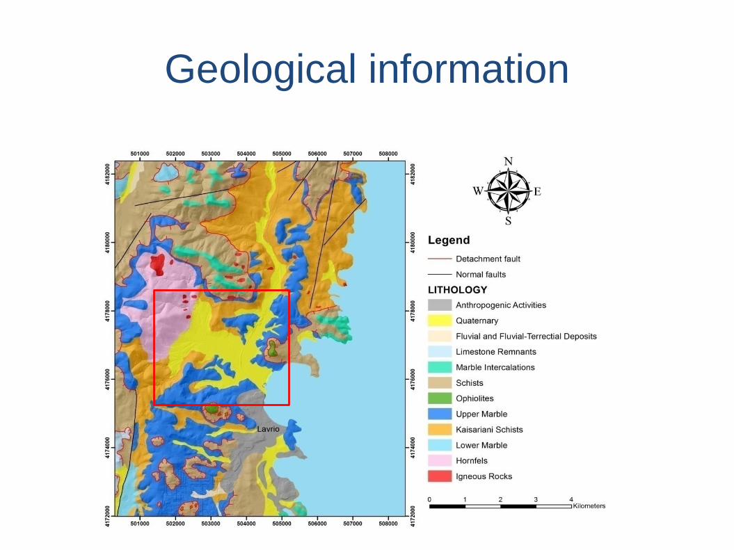
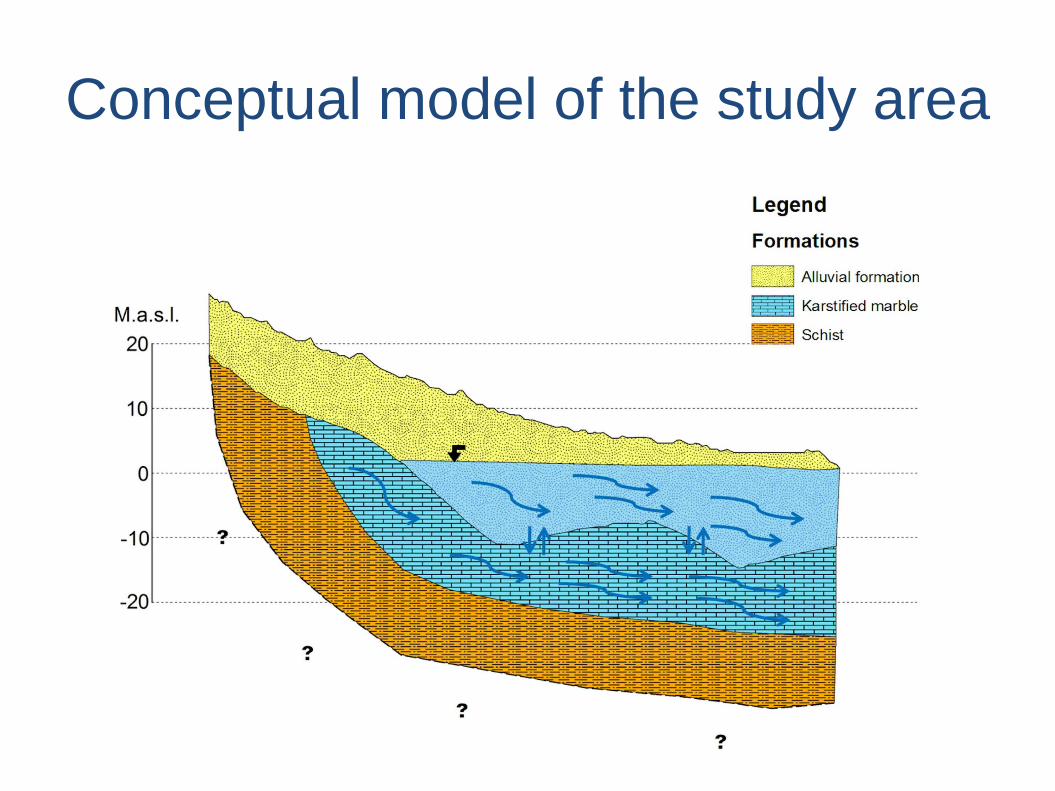
Lavrio is 50 km SE of the city of Athens. The geology consists mainly of alterations of schist and
marble formations, while igneous rocks are also present in the area. All these formations are covered
by Quaternary deposits. Two types of aquifers are developed, one in the Quaternary alluvial deposits
(granular aquifer) and one in the Upper Marble formation (karstic aquifer).
The site offers a typical hydrogeological setting for a Mediterranean coastal aquifer system. The
entire aquifer system suffers from:
(i) water shortage resulting from both anthropogenic activities (overexploitation) and
natural conditions (low precipitation records)
(ii) contamination due to the intrusion of seawater
and Managed Aquifer Recharge (MAR) applications are envisaged to combat all those.
The approach, as developed by the local Municipal Company for Water Supply and Sewerage of
Lavrion (DEYATIL S.A.), is to use the treated wastewater that is daily produced by the wastewater
treatment plant of the Municipality as a recharge water source in order to artificially recharge the
unconsolidated aquifer formation. The proposed SAT system is supported by the local wastewater
treatment plant (WWTP) which is capable of continuously providing recharge water with minimal
energy costs. The quality of the treated wastewater meets the requirements of the National
Legislation for wastewater reuse, through artificial recharge by applying Soil Aquifer Treatment
technologies in this specific area.
Geological information
MAR system
Conceptual model of the study area
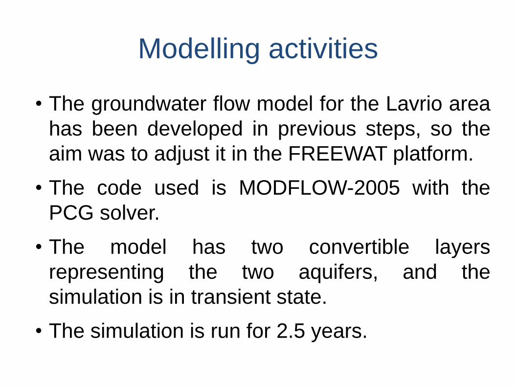
Modelling activities
• The groundwater flow model for the Lavrio area
has been developed in previous steps, so the
aim was to adjust it in the FREEWAT platform.
• The code used is MODFLOW-2005 with the
PCG solver.
• The model has two convertible layers
representing the two aquifers, and the
simulation is in transient state.
• The simulation is run for 2.5 years.
Layers and HOBS
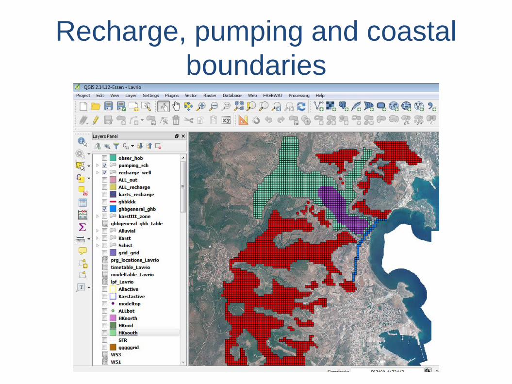
Recharge, pumping and coastal
boundaries
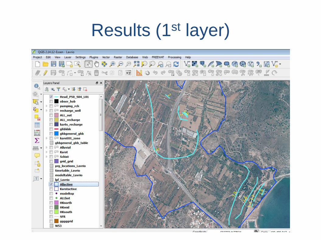
Results (1st layer)
Results (2nd layer)
Results (Obs vs. Sim Heads)
FREEWAT Pros n’ Cons – A user’s
perspectiveThe groundwaterflow model was succesfully transferred to the FREEWAT platform. The
following remarks could be made:
• Model building is fast and acurate.
• Large models (layers, cell number, boundary conditions) can be deat with without
problems.
• GIS capabilities can be used for pre – and post – processing.
• Model built was comparable to the original model in all aspects (water budgets,
simulated heads etc).
Yet, some more points should be mentioned:
• Bugs that are potentially still there.
• Local grid refinement.
• Model development might be problematic sometimes due to different
representation/structure between conventional MODFLOW GUIs and FREEWAT.
Training
Within FREEWAT almost 70 were trainined and 60
have seen a FREEWAT presentation in 2
international conference.
This has provided some experience and ideas on
how to improve the traning activities, both for
traners and traine
No installation alternatives –
FREEWAT portable• FREEWAT Portable is a packaged, ready to use FREEWAT
portable installation (you can run without having to run aninstaller).
• Intended for users that do not want to install QGIS, or createand keep any data folders (\user\.qgis2 folder) in their user(home) folder.
• It does not write to the Windows registry or store itsconfiguration files in the user's profile; instead, it stores itsconfiguration files in the portable directory.
• The FREEWAT Portable folder can be stored on any storagefacility, including internal mass storage, a file share, orexternal storage such as USB drives.
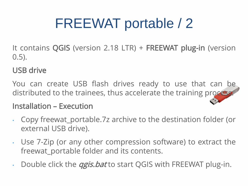
It contains QGIS (version 2.18 LTR) + FREEWAT plug-in (version0.5).
USB drive
You can create USB flash drives ready to use that can bedistributed to the trainees, thus accelerate the training process.
Installation – Execution
• Copy freewat_portable.7z archive to the destination folder (orexternal USB drive).
• Use 7-Zip (or any other compression software) to extract thefreewat_portable folder and its contents.
• Double click the qgis.bat to start QGIS with FREEWAT plug-in.
FREEWAT portable / 2
FREEWAT portable / 3
• The qgis.bat file that launches FREEWAT portable:
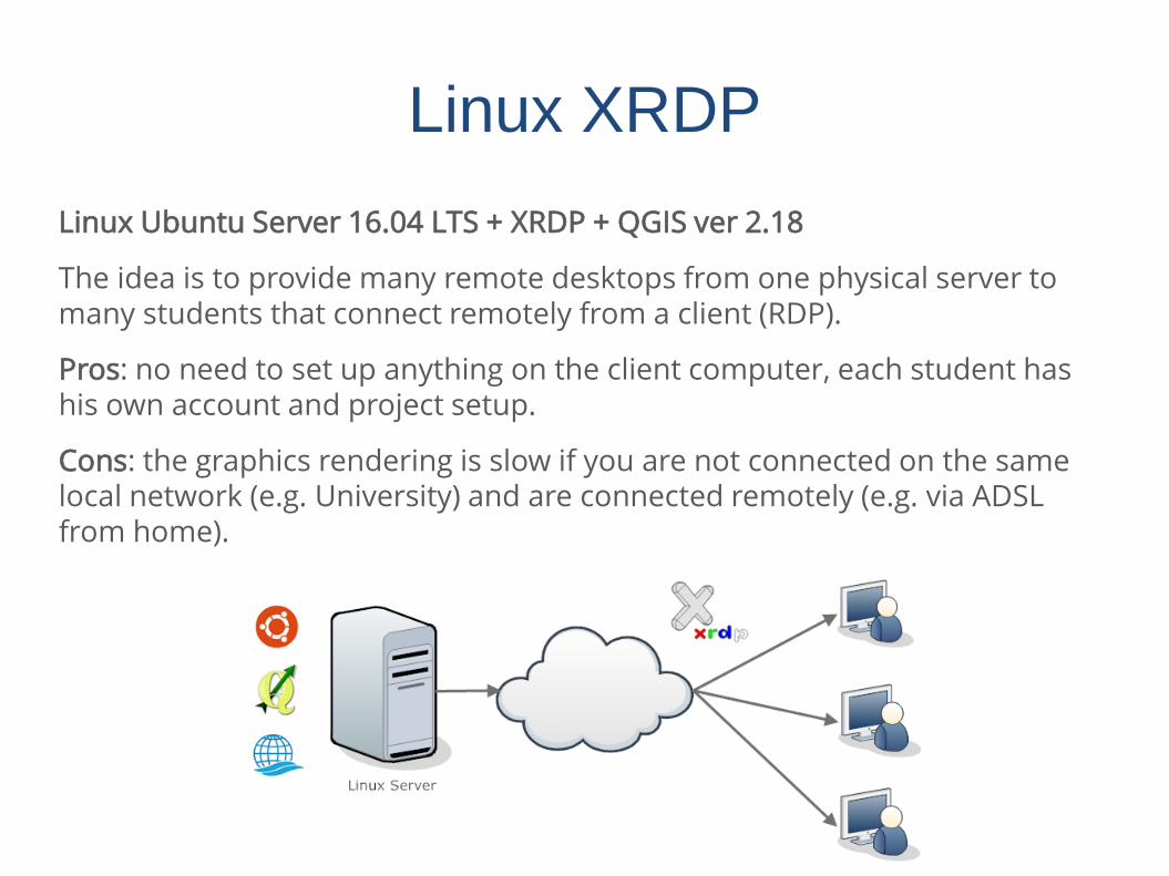
Linux XRDP
Linux Ubuntu Server 16.04 LTS + XRDP + QGIS ver 2.18
The idea is to provide many remote desktops from one physical server to many students that connect remotely from a client (RDP).
Pros: no need to set up anything on the client computer, each student has his own account and project setup.
Cons: the graphics rendering is slow if you are not connected on the same local network (e.g. University) and are connected remotely (e.g. via ADSL from home).
Mac OSX
One possible option for users that use Mac which will notreceive the support the FREEWAT group :
The preparation of a Linux virtual machine image (e.g.VirtualBox) that the user could run in his host computer
Pros: The user is working in his own environment (e.g. Mac OS).No need to install QGIS.
Cons: requires the installation of VirtualBox or othervirtualization software. Might be a bit slower, although we havenot noticed any performance problem running a VirtualBoxLinux image. The RAM memory use is low.
Mac OSX / 2
Another option is:
The preparation of a live Linux image that the user could bootand run e.g. from a USB memory stick.
Pros: The rendering of graphics should be faster. In the case ofa workshop you can distribute the USB flash memory sticks toeach participant/student.
Cons: The user is not working in his own environment.