Iolar Exploration Well – Appropriate Assessment Screening Report Document No: IE-EXP-52/04-IOLAR-HS-00016-RP-01 Rev: U2 Rev Date Reason for Revision U2 04/10/2018 Re-issued for use following PAD gate review U1 31/08/18 Issued for Use Authorisation Record Lead Environmental Consultant Environmental Specialist Environmental Specialist Xodus Signed Xodus Signed Xodus Signed U2 04/10/18 Polly Tarrant Iain Dixon Annette Woodham Rev Date Prepared by Checked by Approved by
Transcript
Iolar Exploration Well – Appropriate Assessment Screening Report
Document No: IE-EXP-52/04-IOLAR-HS-00016-RP-01
Rev: U2
Rev Date Reason for Revision
U2 04/10/2018 Re-issued for use following PAD gate review
U1 31/08/18 Issued for Use
Authorisation Record
Lead Environmental Consultant
Environmental Specialist Environmental Specialist
Xodus Signed
Xodus Signed
Xodus Signed
U2 04/10/18 Polly Tarrant Iain Dixon Annette Woodham
Rev Date Prepared by Checked by Approved by
Iolar Exploration Well Appropriate Assessment Screening Report
Nexen Petroleum UK Ltd Assignment Number: A100460-S00 Document Number: A-100460-S00-REPT-003
Xodus Group The Auction House, 63A George St Edinburgh, UK, EH2 2JG T +44 (0)131 510 1010 E [email protected] www.xodusgroup.com
Iolar Exploration Well – Appropriate Assessment Screening Report Assignment Number: A100460-S00 Document Number: A-100460-S00-REPT-003 ii
5 STAGE 1 APPROPRIATE ASSESSMENT SCREENING: ASSESSMENT OF LSE - PROTECTED SPECIES 44
Iolar Exploration Well – Appropriate Assessment Screening Report Assignment Number: A100460-S00 Document Number: A-100460-S00-REPT-003 iv
5.1 Overview of Relevant Protected Species 44 5.2 Detailed Information on Presence of Relevant Cetacean Species around the Project area. 45 5.3 Information on the Presence of European Otters along the west and south coast of Ireland 62 5.4 Description of Potential Impacts 63 5.5 Assessment of Potential Impacts 63
1.1 Background Nexen Petroleum U.K Ltd (Nexen) plans to drill a single exploration well in the Iolar prospect in Frontier Exploration Licence (FEL) 3/18 in the Porcupine Basin offshore west of Ireland (termed the ‘Project’).
This document presents information to support Stage 1 of an Appropriate Assessment (i.e. screening, as described in Section 3). This Stage 1 Appropriate Assessment Screening Report has been prepared to fulfil exploration drilling approval requirements under the Habitats Directive as set out by the Petroleum Affairs Division (PAD) of the Department of Communications, Climate Action and Environment (DCCAE) formally the Department of Communications Energy and Natural Resources (DCENR).
European Community (EC) Directive 92/43/EEC on the conservation of natural habitats and of wild flora and fauna, commonly known as the Habitats Directive, was established by the EC to meet its obligations under the 1979 Convention on the Conservation of European Wildlife and Natural Habitats. The Habitats Directive affords protection to habitats and species through the designation of protected sites; these sites are Special Areas of Conservation (SAC) and Special Protection Areas and are collectively termed Natura 2000 sites. Under Article 6(3) of the Habitats Directive, ‘any plan or project which is not directly connected with or necessary to the management of a European [Natura 2000] site but would be likely to have a significant effect on such a site, either individually or in-combination with other plans and projects, shall be subject to an appropriate assessment of its implications for the European [Natura 2000] site in view of the site’s conservation objectives.’
In line with these requirements, the purpose of this Stage 1 Appropriate Assessment Screening Report is to identify whether there is potential for the Project to have a Likely Significant Effect (LSE) on a Natura 2000 site (i.e. SAC or SPA, including draft, candidate and proposed sites). For those sites where it cannot be concluded that there will be no LSE, the Competent Authority (in this case PAD) is required to carry out an Appropriate Assessment the Project to ascertain whether or not it would have an adverse effect on the integrity of a Natura 2000 site. Such an Appropriate Assessment would be informed by information provided in a Natura Impact Statement.
In addition to the requirement to consider the potential effects of the Project on protected sites designated through the Habitats Directive, the Directive also requires consideration of the potential effects of the Project on a defined set of species (called Annex IV species) considered to require specific protection through Article 12. As such, it is necessary to consider whether or not the Project is likely to adversely affect the population status of Annex IV species that may be present in the Project area (i.e. whether there is an LSE).
Further information on the specific requirements of the Habitats Directive and the European Communities (Birds and Natural Habitats) Regulations 2011 is provided in Section 3.2 of this report.
1.2 Project Overview The Iolar Exploration well is in FEL 3/18 approximately 232 km west of the Irish mainland, in a water depth of approximately 2,200 m (Figure 1.1). The purpose of the proposed well is to gather data on the reservoir characteristics, hydrocarbon presence, pressures and temperatures. Once exploration drilling operations are complete, the well will be abandoned, whether or not commercially viable quantities of hydrocarbons are found.
The exploration well will be drilled by the IceMAX floating drill ship with drilling operations expected to start in April 2019. The total duration of the drilling and abandonment operations (on location) is expected to be around 100 to 150 days. The weather window for the drilling activities is between 1st April and 30th September.
1.3 The Applicant Nexen is a well-established upstream oil and gas company with a global portfolio. A key focus of Nexen is exploration and appraisal of interests in the North Sea, offshore West Africa and the north east Atlantic.
1.4 Structure of this Appropriate Assessment Screening Report The Appropriate Assessment Screening process that has been undertaken exercise is presented in the following sections:
Section 1 Introduction – provides a background to the project and to Nexen.
Section 2 Project Description – describes the operations associated with the Project.
Section 3 Approach to Meeting the Requirements of the Habitats Directive – describes the requirements of the Habitats Directive and the relevant Irish transposing legislation with respect to the Project and describes the methodology used to assess the potential for adverse effect
Section 4 Stage 1 Appropriate Assessment Screening: Assessment of LSE – Protected Sites – describes the environmental baseline in the context of protected sites, the potential for sites to be affected by the Project and concludes on the potential for an LSE on those sites.
Section 5 Stage 1 Appropriate Assessment Screening: Assessment of LSE – Protected Species – describes the environmental baseline in the context of Annex IV European Protected Species (EPS), the potential for EPS to be adversely affected by the Project and concludes on the potential for an LSE on those species.
2 PROJECT DESCRIPTION This section describes the proposed drilling programme and the alternatives considered for drilling a deep water, high pressure / high temperature (HP/HT) Note 1 exploration well in the Iolar prospect.
2.1 Purpose and objectives The purpose of the proposed well is to gather data on the reservoir characteristics, hydrocarbon presence, pressures and temperatures. This information will be used to help form decisions on any future development at the Iolar prospect. However, once exploration drilling operations are complete, the well will be abandoned, whether or not commercially viable quantities of hydrocarbons are found.
The primary objective of the Project is to verify and evaluate the hydrocarbon potential, fluid properties and reservoir quality in the Middle to Upper Jurassic age fault block, in the Iolar prospect, in FEL 3/18. The two secondary objectives are to verify and evaluate the hydrocarbon potential, fluid properties and reservoir quality in the interpreted J3L Top Oxfordian reservoir and to evaluate the hydrocarbon potential, fluid properties and reservoir potential of the Cretaceous succession in the FEL 3/18 area.
2.2 Project alternatives The various options for the Project have been evaluated in terms of technical feasibility, environmental impact, health and safety, reputation and cost. The Environmental Assessment process was initiated early in the planning stage in order to support the option selection process.
Whilst not drilling the well (the do-nothing option) would avoid any potential for environmental impact, it would prevent Nexen from investigating and confirming hydrocarbon reserves in the licence block and would not facilitate optimum utilisation of potential reserves that might be developed to the benefit of Nexen and the nation.
The following options have been considered by Nexen in planning the exploration well:
Selection of drilling rig;
Time of year for drilling;
Selection of mud system and cuttings disposal;
Selection of well logging and sampling operations including vertical seismic profiling (VSP); and
Suspension or abandonment.
The outcomes of the option selection are described below in the rest of Section 2 and form the basis for the assessment in this AA Screening Report.
Note 1 The Energy Institute defines a high pressure / high temperature (HP/HT) wells as: “High temperature in this context can be defined as when the undisturbed bottom hole temperature at prospective reservoir depth (or total depth) is greater than 300ºF (149ºC). High pressure can be defined as either when the maximum anticipated pore pressure of any porous formation to be drilled through exceeds a hydrostatic gradient of 0.8psi/ft. (representing an Equivalent Mud Weight (EMW) of 1.85SG or 15.4ppg) or, needing deployment of pressure control equipment with a rated working pressure in excess of 10,000psi (690bar, 69MPa). Note that areas of high pressure (abnormal pressure) need not necessarily be accompanied by high temperatures and vice versa.” The Iolar well can be considered a HP/HT well under this definition because the temperature and the surface wellhead pressure is above the designated 300°F and 10,000psi respectively. The Iolar well has a maximum bottom hole static temperature of 323°F and a base case wellhead pressure of 10,300psi; maximum wellhead pressure of +/-12,000psi.
2.3 Project Overview and Schedule The proposed Iolar 52/04-1 well is located in Irish FEL 3/18, 232.4 km west of the Irish mainland in the Porcupine Basin. Details of the likely well location are provided in Table 2.1.
Table 2.1 Iolar well details
Well name Surface coordinates (UTM28N ED50) Water depth (datum Lowest astronomical tide (LAT)1
Iolar 50° 53' 31.16"N 13° 21' 24.38"W 2,162 m
For the purposes of this assessment, a spud date of April 2019 has been assumed, since this is the earliest window of opportunity for drilling operations and is likely to be favourable in terms of weather conditions. The total duration of the drilling and suspension/abandonment operations (on location) is expected to be 100 to 150 days. The weather window for the drilling activities is between 1st April and 30th September.
2.3.1 Project size The overall size of the Project will be limited to the drill ship itself and the 500 m radius safety exclusion zone which will be place around the drill ship whilst on location. This safety exclusion zone will be approximately 0.8 km2.
2.4 Drill Ship The drill ship to be used to drill the Iolar exploration well will be the IceMAX. This is a drill ship with proven capability to drill HP / HT wells and to operate in the harsh environment west of Ireland. It will maintain position over the drilling location for the duration of exploration drilling activity using a dynamic positioning (DP) system (Figure 2.1).
Floating drill ships are specially built seagoing vessels that drill in deep waters. Drilling equipment is installed on the deck, with the derrick normally placed in the middle of the ship. The well is drilled through an opening (called a "moon pool") that extends to the water's surface below the derrick.
Computer-controlled thrusters will be operating more or less continuously to keep the drill ship precisely over the drilling location for the 100 to 150 days of operations.
Dynamically positioned drill ships are capable of navigating under their own steam and positioning themselves at the drilling location. In addition to the drill ship, the drilling operations will require other support vessels (for supply of materials and for safety standby duties) and helicopter transfer of personnel to and from the drill ship during the drilling period. Helicopters may be used occasionally to supply the drill ship with equipment required at short notice and will also be used in the event of an emergency situation. Otherwise, all transport of drilling equipment, supplies, water, fuel and food will be undertaken by supply vessels, which will also return waste and surplus equipment to shore. Table 2.2 shows an overview of the estimated fuel consumption of the drill ship and its associated support vessels and aircraft for the duration of the Project.
The drill ship is designed to withstand wind speeds that exceed the 100-year return extreme and highest significant wave heights up to the 100-year return. The design criteria for the drill ship were based around the metocean criteria in Fugro (2017); these criteria cover data from 1997 to 2015 and therefore include any changes in metocean conditions due to climate change up to this date.
2.6 Well Engineering The drilling activity proposed is a single deviated well. Should the well be deemed a success, there is potential to drill a short side track for coring purposes. . The Iolar well will be to a total depth of either 6,310 m total vertical depth subsea (TVDSS) in the success case and 5,923 m in the dry hole case. Figure 2.2. illustrates the well design and main dimensions.
The drilling of the exploration well will be conducted in a number of phases. The first is the drilling or jetting of a hole through the surface of the seabed, a process known as spudding. Well sections of decreasing diameter are then drilled using a drill string; this is a long section of pipe, or many pipes connected together, that terminates in a drill bit, which grinds through the seabed and formations beneath. The drill string also passes drilling fluid, called drilling mud, down into the well to keep the drill bit cool and lubricated during drilling and to aid in the suspension and removal of drill cuttings. This first section is the widest of all the sections that will be drilled; each subsequent section that is drilled will be of successively reduced diameter.
The first step in the sequence of drilling activities will be to jet the 36" diameter top hole section into the seabed, into which the 36 conductor pipe will be cemented. The second section (26") will then be drilled through the conductor and firmly cemented in place, will then provide a firm structural support for subsequent casing strings and the installation of the blowout preventer (BOP) safety equipment. Once the BOP has been installed, a surface riser will connect the wellhead and BOP with the drill ship, thus providing a conduit to return the mud and cuttings from the deeper sections of the well back to the drill ship.
x 13 and x in place for the third, fourth and fifth sections in the drilling sequence, respectively (Figure 2.2).
2.7 Mud System and Cuttings Discharge Drilling fluid/mud fulfils a number of functions such as lubrication and cooling of the drill bit, suspension and transport of rock cuttings to the surface, and the provision of ‘weight’ (hydrostatic pressure) to counter-balance formation pressure. The main options in the selection of drilling muds are water-based muds (WBM) and oil based mud (OBM). The selection of drilling muds is typically dictated by the anticipated down-hole geological conditions, and OBM types have a particular application for drilling e.g. water-soluble zones or high temperature wells that dehydrate WBMs. The planned Iolar exploration well will be drilled using both WBM and OBM
The first two sections of the well (36 and 26all drilling fluids, rock cuttings and residual cement returns from these sections will be discharged directly onto the seabed in the immediate vicinity of the well. These sections will be jetted/drilled using seawater and pre-hydrated bentonite sweeps (a type of WBM).
The deeper secti " and 8 ") will be drilled using OBM. The mud will be pumped downhole and then circulated back to the surface via the annulus (the space between the drill stem and the wall of the bore hole) and through the BOP stack and the marine riser back to the drill ship. All OBM drilling cuttings and associated residual OBM will then be skipped and shipped to shore for management and disposal.
Table 2.3 provides an estimate of the amounts of cuttings and WBM that will be generated/used and subsequently discharged into the sea, as was modelled to inform this AA. It is worth noting that what was modelled is now more than what is expected from the current well design, and therefore the values presented in Table 2.3 are a conservative, worst case estimate.
Table 2.3 Cuttings and mud generation and discharge volumes
Section Discharge point Cuttings discharged (te) Type of drilling mud
42" Seabed 941 WBM
26" Seabed 2,168 WBM
N/a 0 LTOBM
17 " N/a 0 LTOBM
12 " N/a 0 LTOBM
8 " N/a 0 LTOBM
2.8 Cementing and Other Chemicals The steel casings run into each of the well sections will be cemented in place by circulating cement through the gap between the casing and surrounding formation. During cementing operations, it is normal practice to use a certain amount of excess cement to ensure the integrity of the cement job. It is therefore likely that a small amount of cement will be deposited on the seabed around the wellhead when cementing in place the 36" conductor and the 20 ver, the amount discharged in this fashion will be minimised by the cementing method used and visual monitoring of the operation by a remotely operated vehicle (ROV).
During the subsequent cement jobs there will be no cement returns to seabed or surface. When cleaning up the cement unit after each of the cementing operations is completed, heavily diluted residual cement slurry will be discharged to sea.
The specific chemicals and additives used during drilling will be dependent upon the mud composition, which in turn will be determined by the down-hole conditions encountered whilst drilling. All chemicals will be selected on their technical specifications as well as for their potential environmental impacts, which will be assessed using the CHARM risk assessment model where appropriate. The results of this process are submitted in a PUDAC, 60 days prior to planned operations in line with the Rule and Procedures Manual. Additional chemicals will be stored on the drill ship to deal with any contingencies such as stuck drill pipe or loss of circulation.
2.9 Vertical Seismic Profiling Vertical seismic profiling (VSP) may be required for the exploration well. VSP is a survey technique used to establish the geological structure of the formations through which the well passes, and to confirm (or ground-truth) the information available from previous wider scale surface seismic survey data. The technique generates energy waves by compressed air from an airgun array (the source), these being directed at the geological strata downhole. The activity uses a small airgun array, comprising an air gun volume of similar to 250 cu inch, 2000 psi, and with a maximum shot rate of 10 secs. During VSP operations, four to five receivers are positioned in a section of the wellbore and the airgun array is discharged into the water column approximately five times at 20 second intervals. The generated sound pulses are reflected through the seabed and recorded by the receivers to generate a profile of the wellbore. This process is repeated as required for different stations in the wellbore and a typical VSP operation can take between 6 to 12 hours to complete, depending on the wellbore’s depth and number of stations being profiled. The VSP source is expected to generate a noise level around 220 dB re 1uPa (RMS SPL) @ 1 m, with the majority of the noise concentrated at low (<100 Hz) frequencies.
VSP activities will be undertaken from the drill ship at the end of the drilling and no additional VSP survey vessel is anticipated to be used during the planned activities. Once the survey is complete, the data can be used by reservoir engineers to firm up interpretations of formation structure and topography.
2.10 Well Abandonment Once drilling and VSP are complete, the exploration well will be permanently plugged and abandoned. Mechanical and cement plugs will be placed along the well, plugging off all points where hydrocarbons could possible enter the wellbore, thus isolating them from surface. The wellhead will be severed and pulled a minimum of 3 m below the seabed in accordance with the PAD Rules and Procedures Manual (PAD, 2014). Cutting and pulling of the 36 conductor, 20 will be required. Prior approval of the plugging and abandonment of the well will be obtained from PAD as per the Rules and Procedures Manual (PAD, 2014).
3 APPROACH TO MEETING THE REQUIREMENTS OF THE HABITATS DIRECTIVE
3.1 Introduction This section of the report summarises the requirements of the Habitats Directive (specifically in terms of Articles 6 and 12) and the relevant Irish transposing legislation with respect to the Project. It details the approach undertaken for the assessment of the potential of the Project to adversely affect relevant protected sites and species, as required as part of Stage 1 of an Appropriate Assessment (i.e. screening).
3.2 Overview of the Habitats Directive and Transposing Legislation European Community (EC) Directive 92/43/EEC on the conservation of natural habitats and of wild flora and fauna, commonly known as the Habitats Directive, was established by the EC to meet its obligations under the 1979 Convention on the Conservation of European Wildlife and Natural Habitats, commonly known as the Bern Convention, and to complement the provisions of the already established EC Directive 79/409/EEC on the conservation of wild birds (now replaced by EC Directive 2009/147/EC). The main aim of the Habitats Directive is to ‘contribute towards ensuring biodiversity through the conservation of natural habitats of wild fauna and flora’ by way of actions taken to ‘maintain or restore, at a favourable conservation status, natural habitats and species of wild fauna and flora of Community interest’. Habitats and species of Community interest are defined in a number of Annexes of both the Habitats and Birds Directives.
As part of the Habitats and Birds Directives, protection must be afforded to appropriate sites to assist in fulfilling the aims of the Directives. Specifically, Special Areas of Conservation (SACs) must be designated under the Habitats Directive for habitats and species listed on Annex I and Annex II of the Habitats Directive, whilst under the Birds Directive, Special Protection Areas (SPAs) must be designated for species listed on Annex I of the Directive. Collectively, these sites are referred to as Natura 2000 sites. Similarly, the Habitats Directive requires that Member States take the requisite measures to establish a system of strict protection within their natural range for a defined set of animal (and plant) species described in Annex IV of the Directive.
The Habitats Directive was initially transposed into Irish law in 1997 by the European Communities (Natural Habitats) Regulations, 1997, with later amendment regulations in 1998 and 2005. However, these regulations were revoked and replaced and it is now the European Communities (Birds and Natural Habitats) Regulations 2011 that implement both the Habitats and Birds Directives into Irish law. Under these Regulations, the effects of a project on the integrity of a Natura 2000 site are assessed and evaluated; the process by which this assessment takes place is described in Section 3.3. Similarly, consideration must also be given to the potential to capture, kill, disturb or interfere with the breeding sites or resting places of species listed in Annex IV of the Habitats Directive; the process by which this assessment takes place is described in Section 3.4
3.3 Article 6 Obligations Under Article 6(3) of the Habitats Directive, any plan or project which is not directly connected with or necessary to the management of a designated SAC but which would be likely to have a significant effect on such a site, either individually or in-combination with other plans and projects, shall be subject to an Appropriate Assessment of its implications for the Natura 2000 site in view of the site’s conservation objectives. Article 7 of the Habitats Directive makes the provisions of Article 6(3) applicable to Natura 2000 sites designated under the Birds Directive (i.e. SPAs).
The Habitats Directive applies the precautionary principle to Natura sites and projects can only be permitted when it is ascertained that there will be no adverse effect on the integrity of the site(s) in question. Where adverse effects are identified, a project may only be permitted in the absence of alternative solutions if there is an Imperative Reason of Overriding Public Interest for the project to go head. Where this is the case, Member States are required to take all compensatory measures necessary to ensure that the overall coherence of the Natura 2000 network is protected.
Since the Project is not directly connected with, or necessary for, the management of a Natura 2000 site for nature conservation, it is necessary to carry out Stage 1 Appropriate Assessment Screening to identify whether
there is potential for the Project to have an LSE on a Natura 2000 site (SAC or SPA including draft, candidate and proposed sites). For those sites where it cannot be concluded that there will be no LSE, an Appropriate Assessment will be required to ascertain whether the Project would have an adverse effect on the integrity of a Natura 2000 site.
The approach to meet Article 6 obligations for the Project is described below and illustrated in Figure 3.1. It is in line with Article 6 of the Habitats Directive, European Case Law and best practice guidance (e.g. The Department of Environment, Heritage and Local Government, DEHLG, 2010 guidance on Appropriate Assessment of Plans and Projects in Ireland).
Figure 3.1 Approach to obligations under Article 6 of the Habitats Directive
The main objective of Appropriate Assessment screening is to conclude whether there will or will not be LSEs on a Natura 2000 site. The assessment of LSE is based on a filtering of qualifying interests and associated Natura 2000 sites in a two-phase process based on:
Identifying the range of impacts that a project could have on qualifying interest(s) of a site (impact pathways)
Determining connectivity with Natura 2000 sites based on: o Evidence that qualifying interest(s) that could be adversely affected by a project are present
in the Project area/zone of impact associated with a project and likely use of the area (e.g. for foraging and breeding);
o Whether there is connectivity between a project and the qualifying interests of a Natura 2000 site based on:
Foraging distances from breeding colonies (seabirds) (e.g. Thaxter et al., 2012);
Proximity to foraging and breeding sites (marine mammals and fish);
Migration routes (migratory wildfowl, marine mammals and fish);
Influence of tidal flow/sediment dynamics on benthic/intertidal Annex I habitats; and
Indirect connectivity with other qualifying interests (e.g. fresh-water pearl mussel due to life cycle ecology of salmonids); and
o Whether that qualifying interest(s) would, by virtue of its behavioural and foraging characteristics, be affected by a particular impact (species sensitivity).
Assessment of LSE
o Where potential adverse effects on a qualifying interest are identified, further evaluation is undertaken to determine whether or not a project (alone or in-combination with other projects) will or will not have LSEs on the site taking into account appropriate mitigation2. Where it is obvious that there is no connectivity or impact pathway between a project and a site, it should be concluded that there is no LSE. No LSE should also be concluded for trivial effects (minor effects on qualifying interests that will not have a significant effect on a site) despite there being connectivity providing there is sufficient evidence to support this conclusion.
The Stage 1 Appropriate Assessment Screening process presented here has been informed by available information from the relevant impact assessment studies to determine with certainty whether or not the Project is likely to have a significant effect on a Natura 2000 site. These include:
Iolar Exploration Well Environmental Risk Assessment (EIA Screening) Report (Nexen, 2018), specifically the review and collation of key environmental baseline; and
Iolar Site Survey. Environmental Assessment Report (RPS group, 2017).
Utilising these supporting studies as part of Stage 1 Appropriate Assessment Screening ensures that sites and qualifying interests where significant effects are not likely to occur (i.e. conclusion of no LSE) are screened out of the Appropriate Assessment process, thereby reducing the total number of sites that could potentially be identified as requiring a Stage 2 Appropriate Assessment.
Section 4 provides the information necessary to satisfy the requirements of Article 6 in the context of the Project. 2 DEHLG (2011) states that ‘screening should be undertaken without the inclusion of mitigation, unless potential impacts clearly can be avoided through the modification or redesign of the plan or project’. The EIA Screening exercise (Nexen, 2018) that has been undertaken in support of the environmental approval process provides detail on the design, control and management measures that are built into the Project; these measures are inherent to how the Project will (and must) be executed to comply with applicable legislation, guidance and good industry practice and are thus given due consideration in this Appropriate Assessment Screening Report.
3.4 Article 12 Obligations In addition to the requirement to consider the potential impact of the Project on protected sites designated through the Habitats Directive, the Directive also requires consideration of the potential impacts of the Project on a defined set of species considered to require specific protection. This requirement is conferred via Article 12 of the Directive which states:
1. Member States shall take the requisite measures to establish a system of strict protection for the animal species listed in Annex IV (a) in their natural range, prohibiting:
(a) all forms of deliberate capture or killing of specimens of these species in the wild;
(b) deliberate disturbance of these species, particularly during the period of breeding, rearing, hibernation and migration;
(c) deliberate destruction or taking of eggs from the wild; and
(d) deterioration or destruction of breeding sites or resting places.
With respect to the aim of the Habitats Directive to ‘contribute towards ensuring biodiversity through the conservation of natural habitats of wild fauna and flora’ by way of actions taken to ‘maintain or restore, at a favourable conservation status, natural habitats and species of wild fauna and flora of Community interest’, it is necessary to consider whether or not the Project is likely to adversely affect the population status of Annex IV species that may be present in the Project area (i.e. whether there is an LSE). To this effect, supported by relevant studies outlined in Section 3.3, the following steps are followed:
Identify Annex IV species that may be present in the Project area and understand their geographic range and population status;
Identify potential impact mechanisms from the Project and understand the sensitivities of Annex IV species that may be present in the Project area;
Considering the in-built design, control and management measures for the execution the Project, assess whether or not there is likely to be an adverse effect upon Annex IV species sufficient to affect the conservation status of that species; and
Make a conclusion on the potential for adverse effect (i.e. LSE) for each relevant species.
Section 4.5.2 provides the information necessary to satisfy the requirements of Article 12 in the context of the Project.
4.1 Introduction This section of the Appropriate Assessment Screening Report presents the results of the assessment undertaken to fulfil the obligations of Schedule 6 of the Habitats Directive (detailed in Section 3.3). This section is structured as follows:
Section 4.2 - Description of potential impacts
o The potential sources of impact from the Project are described alongside the potential receptors.
Section 4.3 - Determining connectivity with protected sites
o The potential for receptors belonging to relevant protected sites to experience any of the potential impacts described in Section 4.2 is assessed (i.e. the ‘connectivity’ between protected sites and potential impact zones is considered). Where there is no mechanism to adversely affect a protected site or its features (i.e. no connectivity exists), a conclusion of no LSE is reached and the site is screened out of further assessment. For sites where there exists a potential for adverse effect (i.e. connectivity may exist), further assessment is required to understand whether LSE can be ruled out or not (and hence whether or not a Stage 2 Appropriate Assessment is required).
o This section is structured to consider each of the potential impacts outlined in Section 4.2.
Section 4.4 - Assessment of potential impacts
o For sites where LSE has not been ruled out due to connectivity, further assessment is undertaken to understand whether LSE can be ruled out or not.
4.2 Description of Potential Impacts Considering the Project (see Section 2) and the environmental baseline of the area within which the Project will occur (reported in Nexen, 2018), a number of receptors and potentially significant environmental impacts have been identified during the Environmental Impact Assessment (EIA) Screening process (reported in Nexen, 2018); these are summarised in Table 4.1 and described in Section 4.33.
3 Note that the EIA Screening process identified some receptors that would not be impacted by the Project and some impact mechanisms that were not relevant to the Project. As such, these receptors and mechanisms, detailed in Nexen (2018), are not covered within this Appropriate Assessment Screening Report.
Gaseous emissions affecting local air quality, emission of greenhouse gases, and resource use
None
Routine marine discharges
Discharge of oily water to sea (e.g. bilge water), organic enrichment from grey and black water
Fish, marine mammals, otters
Drilling discharges Disposal of drill cuttings, cement and water based muds, leading to an increase in turbidity, toxic effects to marine biota, and physical effects on benthic species and habitats.
Fish, marine mammals, marine habitats
Solid wastes Waste generation and disposal None
Accidental releases Accidental release of chemicals or hydrocarbons to the marine environment leading to toxic effects on species, smothering and reduction in water quality and degradation of habitats.
Birds, fish, marine mammals, marine habitats, otters, freshwater pearl mussels.
As there are no relevant receptors potentially impacted by atmospheric emissions and solid waste generation, these impact mechanisms are scoped out of this Stage 1 Appropriate Assessment Screening. Drill cuttings modelling concluded a likely environmental effect was not predicted to be achieved due to the discharge of drill cuttings impacting the water column or seabed at any designated conservation site (Xodus, 2018a), these impact mechanisms are therefore also scoped out of this Stage 1 Appropriate Assessment Screening. The remaining potential sources of impact are discussed in the following sections in the context of the potential receptors relevant to SPAs and SACs.
4 Note that interaction with, and potential impacts upon, a number of other receptors (e.g. fisheries, marine reptiles including turtles) are possible but these are not relevant to the requirements of the Habitats and Birds Directives and are not discussed in this Stage 1 Appropriate Assessment Screening report.
4.3.1 Underwater noise 4.3.1.1 SPAs – birds Popper and Hawkins (2012) report that, on average, birds hearing is most sensitive at 2 – 5 kilohertz (kHz) in air, with sensitivity dropping off greatly below 1 kHz and above 4 kHz. Whilst there is limited evidence for under water hearing ability in birds (e.g. Popper and Hawkins, 2012), based on comparison of human hearing underwater with current understanding of avian hearing physiology, hearing is not considered to be a useful mechanism for birds underwater. Injury or disturbance resulting from interaction with diving birds’ hearing is therefore considered not to be a mechanism for potential impact from the Project.
4.3.1.2 SACs – marine mammal
4.3.1.2.1 Seals
With regards to underwater noise emissions, given that the distance from the Project to the coast is 232.4 km and given that harbour seals usually forage within 40 – 50 km of their haul-out sites (SCOS, 2014), there is unlikely to be any interaction between the Project and harbour seals from SACs on the Irish coast. Grey seals, they may forage up to 200 km from haul-outs (e.g. McConnell et al., 1999) and mainly on the seabed at depths of up to 100 m (SCOS, 2014). However, after breeding, most grey seals at an SAC disperse away from the SAC, making it very difficult to assign an individual to a particular SAC out-with the breeding season. Grey seal usage of a SAC is therefore very time and location specific. On this basis, and reviewing available data on grey seal movements (e.g. Cronin et al., 2011; SMRU Ltd, 2011; Russell and McConnell, 2014), it is considered that a 20 km radius around SACs may be used as a guide to the potential for interactions with projects. Given the distance from the Project to the coast (232.4 km), there is unlikely to be any interaction between the Project and grey seals from SACs on the Irish coast in terms of underwater noise emissions.
4.3.1.2.2 Bottlenose dolphins
O’Brien et al. (2009) used photo-identification techniques to study the movements of bottlenose dolphins around the Irish coast. No dolphins from the Shannon Estuary were recorded outside that immediate area, suggesting that the dolphins identified from Shannon Estuary do not range far beyond the Lower River Shannon SAC and do not mix with other, more transient, populations found around the Irish coast. Bottlenose dolphins associated with the West Connacht Coast SAC are also considered to be resident with a coastal range (DAHG, 2015). Given the large distance from the Project to the coast (232.4 km), there is unlikely to be any interaction between the Project and bottlenose dolphins from either of the two SACs designated for this species on the Irish coast in terms of underwater noise emissions.
4.3.1.2.3 Harbour porpoise
Given the difficulty in determining the presence of individuals (i.e. by employing photo identification techniques) that may have travelled from a coastal protected site to the Project area, it is not possible to eliminate underwater noise as a potential impact mechanism with respect to harbour porpoise SACs on the Irish coast. Therefore, as a precautionary approach, the SACs along the Irish coast with harbour porpoise selected as key features have the potential for noise to result in an LSE on them and will be considered in Section 4.5. These sites are the Blasket Islands, Roaringwater Bay and Island and West Connacht Coast SACs which are displayed in Figure 4.1 and listed in Appendix A.1.
4.3.1.3 SACs – Otters Otter populations in coastal areas utilise shallow, inshore marine areas for feeding. Given the large distance from the Project to the coast (232.4 km), there is unlikely to be any interaction between the Project and otters from SACs on the Irish coast in terms of underwater noise emissions.
4.3.1.4 SACs – Fish There are four Annex II fish species for which SACs have been designated and which have the potential to be found in marine waters of Ireland: the sea lamprey Petromyzon marinus, Allis shad Alosa alosa, Twaite shad
Alosa fallax and Atlantic salmon Salmo salar. However, review of baseline data for the Project area suggests that these species are highly unlikely to be present. For example, evidence from modelling studies and tagging of individuals has shown that salmon typically migrate north and west from rivers on the west coast of Ireland into waters to the west of Greenland (e.g. Reddin et al., 2012; Windsor et al., 2012). For fish species, potential impact zones from the Project are likely to be limited to tens or hundreds of metres from the noise source (e.g. Schulze and Pettersen, 2007). Combined with the potential highly localised potential injury zones for fish species from noise and that any potential behavioural changes will only be spatially and temporally limited in nature noise emissions are considered not to be a mechanism for potential adverse effect on fish from the Project.
4.3.2 Physical presence 4.3.2.1 SPAs – Birds Given the limited number of birds from breeding SPA populations that are likely to be present in the Project area and the relatively short duration of the activities (100-150 days), the potential for disturbance resulting from the physical presence of the vessel is considered not to be a mechanism for potential adverse effects from the Project.
4.3.2.2 SACs – Fish and marine mammals The Project will involve one drilling rig, a support vessel and a standby vessel. Such additional vessel presence represents a very small increase against the current baseline in the area for a very limited time period, meaning that the additional potential for physical disturbance (including potential collision between animal and vessel) will be extremely limited and likely to present no significant additional obstacle to marine mammal and fish use of the Project area will occur. Given the that the drilling rig will remain largely stationary during drilling, disturbance resulting from the physical presence of the vessel is therefore considered not to be a mechanism for potential adverse effects from the Project with respect to marine mammals and fish.
4.3.2.3 SACs - Marine habitats Due to the use of a dynamic positioning system to maintain position over the drilling location for the duration of the Project, interaction between the MODU and the seabed will be highly localised and limited to the use of the drill bit to drill the tophole sections, the cementing of the 42" conductor pipe and the installation of the wellhead and BOP, and the severing of the wellhead below the seabed during well abandonment. Given the distance of the Project to the nearest site designated for seabed marine habitats and species is 119 km away, the potential for disturbance to SACs designated for marine habitats resulting from the physical presence of vessels is considered not to be a mechanism for potential adverse effects from the Project.
4.3.2.4 SACs - Otters Otter populations in coastal areas utilise shallow, inshore marine areas for feeding. Therefore, given the distance of the Project from the coastline (232.4 km) there will be no direct interaction between otters from SACs on the Irish coast and the Project. Therefore, the potential for disturbance of otters resulting from the physical presence of vessels is considered not to be a mechanism for potential adverse effects from the Project.
4.3.3 Routine marine discharges Marine discharges have the potential to impact upon the environment, depending upon the quantity discharged, the duration of discharge and the ecotoxicity of the chemicals it contains. Oily water that may be generated during routine cleaning and maintenance operations (called bilge water) will be either shipped to shore for onshore disposal or disposed of in line with MARPOL requirements, typically through the use of an approved oil/water separator. As such, marine discharges are considered not to be a mechanism for potential adverse effect from the Project with respect to marine mammals, fish and otters.
4.3.4 Drilling discharges The first two sections of the Iolar exploration well (42 and 26 ) will be drilled before a marine riser is installed. This means that all drilling fluids, rock cuttings and residual cement returns from these sections will be
discharged directly onto the seabed in the immediate vicinity of the exploration well. These sections will be drilled using seawater and pre-hydrated bentonite (PHB) sweeps a type of water based mud (WBM), so that the associated discharges at the seabed will consist of cuttings and PHB.
The deeper sections of the well be drilled using oil base mud (OBM). The mud and cuttings from these sections will circulated back to the surface then be skipped and shipped to the shore for treatment and recycling/disposal. Therefore, none of the OBM from the deeper sections are to be discharged to sea.
4.3.4.1 SACs – Fish and marine mammals Water column impacts relate to both the physical and chemical effects predominantly experienced by planktonic species. The use and discharge of drilling and cementing chemicals is regulated through a Permit to Use and Discharge Added Chemicals (PUDAC), the application for which requires a detailed chemical risk assessment to be undertaken. Drill cuttings dispersion modelling for all well sections was conducted for the Lolar well (Xodus, 2018a) and the results are reported in detail in Nexen (2018). The modelling indicates that the water column impact from the drilling will be transient and very short-lived (4.25 days). The maximum area over which the water column is modelled to be affected during this period with a risk to >5% of species is centred on the drilling location with a diameter of 5 km. Considering the relatively limited area over which the water column is modelled to be affected, and the transient nature of this effect, the discharge of cuttings and muds as part of the Project is not considered to represent a significant impact to the water column. Overall plankton productivity is not likely to be affected and there are not likely to be any effects to organisms higher in the food chain. Drilling discharges to the water column are therefore not considered to be a mechanism for potential adverse effects from the Project with respect to fish or marine mammals.
4.3.4.2 SACs –Marine habitats Drill cuttings dispersion modelling showed development of a cuttings pile along an approximate north east to south west direction and predicts that the cuttings nearest the well will be around 2,350 mm thick. Around 20 m south west of the discharge location, the thickness decreases to 80 mm and is then followed by another accumulation peak about 45 m south west of the discharge location around 280 mm thick. Overall there is a decrease in deposited material thickness with distance from the discharge location, such that within approximately 80 m the thickness has decreased to less than 15 mm (Xodus 2018a). Environmental effects from this deposition are expected to be negligible, where the model predicts that the deposition arising from the drilling further than 20 m from the well is less than 10 mm thick and below any thresholds for the burial of benthic organisms (TNO, 1994). Given that the nearest Natura 2000 site designated for seabed features is located over 100 km from the Project, the deposition of drilling discharges is not considered to be a mechanism for potential adverse effects on any sites.
4.3.5 Accidental releases 4.3.5.1 Likelihood of release There is a very low probability of a major accidental release of hydrocarbons occurring from the exploration well and associated planned vessel operations. The main potential source of an accidental spill would be either from a blowout scenario or a release of marine diesel fuel contained in the storage tanks, released through accidental vessel collision. Other small volume spills may also occur as a result of leaks during bunkering. The risk of a release occurring from a vessel collision is no greater than that occurring from any other ship in the area over the Project period. Marine fuel contains a high percentage of low molecular weight hydrocarbon compounds, known as 'light ends' and hence tends to disperse (usually via evaporation) within approximately eight to ten hours of being spilt. Given the relatively warm temperatures and the generally fast flowing currents, dispersion of marine fuel is likely to be rapid. A small spill may result in a sheen extending over a considerable area. However, this sheen can be broken up and reduced by wave action. Any marine fuel released in the survey area would disperse offshore. A release resulting from a blowout scenario at the exploration well may potentially spread over a wider area.
To put the accidental event scenarios relevant to the Project into context, the section below presents statistics on historical spill events which have occurred on the UK Continental Shelf (UKCS). These statistics are considered useful to support the risk assessment due to the relatively large number of wells drilled in the UKCS
and the similar geographical conditions between Ireland and the UK. Information is also used from the SINTEF Offshore Blowout Database which summarises worldwide blowout and well release incidents.
4.3.5.1.1 Blowouts and well releases Primary well control is the practice of maintaining a hydrostatic pressure in the wellbore greater than the pressure of the hydrocarbons in the producing formation being drilled (formation pressure), but less than the fracture pressure (the pressure at which the rock adjacent to the wellbore will begin to fracture). The wellbore hydrostatic pressure is maintained and adjusted by varying the density of the drilling fluid being injected into the well. If the hydrostatic pressure is allowed to fall below the producing formation pressure, the well will begin to flow, that is, hydrocarbons will enter the wellbore from the formation and begin to displace the fluid in the wellbore towards the surface. This constitutes a failure of primary well control.
In the event that primary well control fails, secondary well control is initiated by closing valves on the wellhead (known as blowout preventers or BOPs) to prevent uncontrolled flow of material out of the well. Secondary well control is completed by mixing a heavier fluid on the drilling platform and injecting this into the wellbore under controlled conditions, simultaneously circulating the material that has intruded into the wellbore out of the well to the platform where it can be contained and processed. Once secondary well control is successfully completed, drilling may resume if appropriate.
If secondary well control fails, for example due to a failure of the BOP, or due to extremely high pressure fracturing the well casing at some point below the BOP, a well blowout may occur at the surface or underground. A surface blowout constitutes an uncontrolled flow of formation hydrocarbons from the reservoir to the surface (note the release may occur at the seabed or from the infrastructure at the sea surface) and may lead to release of hydrocarbons to the environment. An underground blowout is when hydrocarbons entering the wellbore cause the wellbore pressure to exceed the fracture pressure at another level in the well, allowing hydrocarbons to flow from the producing formation into the wellbore, and then back into the weaker formation. There may be no release to the environment under these circumstances.
A well release, as opposed to a blowout, is an incident where hydrocarbons flow from a well when flow was not intended, but flow is subsequently stopped by the use of the barrier system that was available on the well at the time the incident started (during drilling operations this would be the BOP). Well releases may also result in release of hydrocarbons to the environment, but because they are stopped using the equipment that is already in place on the well, these events tend to be rapidly resolved and any release to the environment can be expected to be small.
Blowouts are extremely rare events in modern drilling (DTI, 2001), although deep water HPHT exploration wells such as the Project are the more challenging wells to drill because the HPHT environment is more challenging to control, and conditions in exploration wells are less predictable than development wells in previously explored formations. Table 4.1 shows the historical frequency of drilling blowouts and well releases for various types of well drilled to North Sea standards. Deep water HPHT exploration wells have a blowout and well release frequency approximately one order of magnitude greater than normally pressured exploration wells and HPHT development wells, and two orders of magnitude higher than normally pressured development wells. The historical frequency of incidents is still low however, equating to one blowout per 667 wells drilled, and one well release per 83 wells drilled.
The likelihood of a blowout is considered remote according to the definitions in Nexen (2018), and the likelihood of a well release is considered unlikely. Nevertheless, as the consequences from a hydrocarbon release of any nature is potentially significant, Nexen will implement rigorous measures to reduce the potential for a failure of well control during the Project and ensure an effective response should an incident occur.
Table 4.1 Historical frequency of blowouts and well releases (per well drilled) for various types of well in >200 m water depth (IOGP, 2010)
Well type Pressure regime
Historical frequency per well drilled (IOGP, 2010)5
Number of wells drilled per incident
Blowout Well release Blowout Well release
Exploration Normal 2.5 x 10⁻⁴ 2.0 x 10⁻³ 4000 500
HP/HT 1.5 x 10⁻³ 1.2 x 10⁻² 667 83
Development Normal 4.8 x 10⁻⁵ 3.9 x 10⁻⁴ 20833 2564
HP/HT 3.0 x 10⁻⁴ 2.4 x 10⁻³ 3333 417
4.3.5.1.2 MODU spills The Project will drill the Iolar prospect from a MODU (in this case a drill ship). Potential accidental releases from MODUs (excluding blowouts discussed above) may include fuel, drilling muds, small accidental oil and chemical releases and hydraulic fluids.
The most notable UK blowout from a MODU was in 1988 when an explosion led to a fire on a semi-submersible rig drilling a high pressure high temperature field in the central North Sea. Historical data for frequency of blowouts from MODUs on the UKCS between 1990 and 2007 is presented in Table 4.2. The data do not show the severity of each event or whether the blowout led to an oil spill. However, the data do provide an indication of overall frequency of blowouts on the UKCS. The frequency of blowouts declined by almost an order of magnitude from the period 1990-1999 to 2000-2007.
Table 4.2 Blowout frequency per unit per year on UKCS (OGUK, 2009)
Type of facility
Period
1990 to 1999 2000 to 2007 1990 to 2007
Number Frequency per year Number
Frequency per year Number
Frequency per year
MODU 13 0.020 3 0.0066 16 0.014
The information presented in Table 4.3 are based on data submitted to the UK Department of Energy and Climate Change (DECC)6 for the period 2001 to 2007. During this period, MODUs operating in the UKCS completed a total of 172 operation years. No accidental releases greater than 100 tonnes were recorded in the UKCS between 2001 and 2007 and the majority of accidental releases recorded were less than 1 tonne.
The most common cause of accidental releases from MODUs was drilling operations (42%); of these releases 94% were less than 1 tonne. The second most common cause was maintenance/operational activities (27%); 97% of these releases were also less than 1 tonne.
Review of PON1 data recorded between 2007 and 2017 confirms no releases of >100 tonnes have occurred in the intervening years (BEIS, 2018a; 2018b) and that the majority of MODU accidental releases remain <1 tonne.
5 Based on SINTEF international data for wells in water >200 m (OGP, 2010) 6 The UK government body that records accidental releases within the UKCS. In July 2016 DECC became part of the Department for Business, Energy & Industrial Strategy (BEIS).
Table 4.3 Number of accidental releases from MODUs, based on UKCS historical data by release size and source during the period 2001 to 2007 (TINA Consultants Ltd pers. Comm., 2013)
Accidental release cause <1 kg 1 to <10
kg 10 to <100 kg
0.1 to <1 tonnes
1 to <10 tonnes
10 to <100 tonnes
All accidental releasesi
Maintenance/operational activities
10 14 4 5 1 0 35
Bunkering 2 9 2 9 0 0 22
Subsea releases 1 3 3 1 2 1 12
Drilling 12 6 15 15 2 1 54
Remote Operated Vehicle (ROV) associated
1 3 1 0 0 0 5
Other production 0 0 0 1 0 0 1
All accidental releasesii 35 42 40 42 8 2 179 i Includes accidental releases of unknown size. ii Includes accidental releases of unknown cause and accidental releases that could not be categorised.
The total number of accidental releases from MODUs between 1990 and 2007 in the UKCS, and the frequency of releases per operational year is shown in Table 4.4. The frequency of incidents per operational year decreased by approximately 30% during the period 2000 to 2007 compared to the period 1990 to 1999.
Table 4.4 Number of accidental releases from MODUs on the UKCS from 1990 to 2007 and frequency per operational year (OGUK, 2009)
Type of facility
Period 1990 to 2007 (total)
1990 to 1999 2000 to 2007
Number Frequency per year
Number Frequency per year
Number Frequency per year
MODU 160 0.246 78 0.172 238 0.215
Apart from well blowouts, the MODU incident scenarios in which the greatest impact might be expected would include vessel grounding, collisions or explosions that lead to a total loss of hydrocarbon inventory (most likely to be marine diesel fuel) although this is unlikely as diesel/hydrocarbon stock is stored in multiple locations in separate tanks and containers. Table 4.5 highlights the number of explosions, collisions and vessel contacts for MODUs in the UKCS and the frequency of incidents per operational year. These data also indicate a general reduction in the frequency of incidents between the period 2000 to 2007 compared to the period 1990 to 1999. Whilst it is not indicated whether accidental releases occurred from each incident recorded, the data suggests that the frequency of incidents which could lead to an accidental release has decreased.
Table 4.5 Number of explosions, collisions and vessel contacts from MODUs in the UKCS from 1990 to 2007 and frequency of incidents per operational year (OGUK, 2009)
Type of incident Period
1990 to 1999 2000 to 2007 1990 to 2007 (total)
Number Frequency per operational year
Number Frequency per operational year
Number Frequency per operational year
Vessel contact 108 0.166 25 0.055 133 0.120
Collision 14 0.021 1 0.0022 15 0.014
Explosion 10 0.015 - - 10 0.009
4.3.5.2 OSCAR oil spill modelling Nexen’s risk assessment process identified three categories of accidental event that could potentially cause environmental damage:
Accidental release of fuel or chemicals from vessel decks or during bunkering;
Loss of containment of fuel storage tanks (marine diesel) due to vessel collision; and
Loss of well integrity resulting in a well blowout and release of crude oil.
The Oil Spill Contingency and Response model (OSCAR) was used to model the possible fate of oil from potential hydrocarbon release scenarios at the Iolar well location as shown in Table 4.6. Each scenario was modelled across three seasons: spring (March to May), summer (June to August) and autumn (September to November), to cover the entire possible drilling window of April to September.
Table 4.6 Summary of accidental hydrocarbon release model scenarios carried out for the Project
Well blowout using the predicted unconstrained well flow rate for 146 days
Iolar crude (OSCAR Gulfaks crude used as surrogate)
2,856,856 Seabed Stochastic
Well blowout using the predicted unconstrained well flow rate for 15 days
Iolar crude (OSCAR Gulfaks crude used as surrogate)
737,213 Seabed Stochastic
OSCAR stochastic modelling uses a minimum of 110 different runs per scenario, predicting the fate of the oil under the varying potential metocean conditions during each run. Mapped outputs can be produced showing the probability of contamination of the sea surface, or the probability of shoreline oiling, for the 110 runs combined (N.B. these probabilities are not representative of a single release).
A minimum threshold of 0.3 μm was applied to the sea surface oiling outputs in line with BEIS guidance (BEIS, 2017). No other thresholds were applied at this stage of the assessment.
An overview of the results of the OSCAR modelling is provided in Table 4.7; a full account is available in Xodus (2018b).
Table 4.7 Summary of accidental hydrocarbon release stochastic modelling results
Scenario Summary of OSCAR stochastic modelling results
Instantaneous drill ship diesel inventory spill
Stochastic modelling indicated a low probability of sea surface contamination across most of the affected area, with sea surface contamination probabilities of >10% restricted to an area of approximately 150 km diameter concentrated to the southeast of the release point. The thickness of diesel floating on the sea surface was predicted to remain <5 μm across most of the affected area, with simulations indicating that small slicks exceeding 10 μm thick could travel up to 200 km from the release point, although the probability of thick oil occurring decreased with distance from the release.
There was a low predicted probability of diesel reaching international waters. The highest probability occurred in Autumn, although the season with the fastest simulated arrival time was Spring (3 d 10 h). Diesel was not predicted to enter other national jurisdictions. The highest probability of diesel beaching was predicted in Summer (2.9%), the minimum predicted beaching time (7 d 13 h) also occurred in summer. The (unlikely) possibility of diesel beaching was predicted to be restricted to the southwest coast of Ireland and arrival time was predicted to be similar across all beaching locations.
Well blowout using the predicted unconstrained well flow rate for 146 days
Modelling indicated that there is a high probability of sea surface oiling across a large proportion of Irish territorial waters to the West of Ireland, with the location of the highest probability areas varying by season. A surface oil sheen exceeding 5 μm thick could travel hundreds of kilometres from the release point, although it should be noted that the total area of thick oil predicted in the modelling outputs represents over 100 individual spill simulations, and the area of thick oil produced by any single spill would be much smaller.
Modelling indicated that oil could reach international waters after approximately six days, and UK waters after approximately 30 days, although the probability of oil reaching UK waters was predicted to be <40%.
The area with the highest probability of beaching and the fastest minimum beaching time was predicted to be the southwest coast of Ireland, where there was predicted to be a maximum 98.1% probability of beaching for releases occurring during spring, and a minimum beaching time of approximately 18 days for releases occurring during summer. Probability of oil beaching in all other national jurisdictions was generally <5%, with the exception of the autumn season where there was predicted to be a maximum 7.1% probability of oil beaching in Argyll and Bute, Scotland. Minimum beaching time for the UK coastline was approximately 18 days, for a scenario with a 1% probability of beaching at Anglesey, Wales.
Well blowout using the predicted unconstrained well flow rate for 15 days
Modelling indicated that there is a high probability of sea surface oiling across a large area of sea to the west of southern Ireland, with the location of the highest probability areas varying by season. A surface oil sheen exceeding 5 μm thick could travel hundreds of kilometres from the release point, although it should be noted that the area of thick oil predicted in the modelling represents over 100 individual spill simulations, and the area of thick oil produced by any single spill would be much smaller.
Modelling indicated that oil could reach international waters after approximately six days, and UK waters after approximately 30 days (in the summer simulations), although the probability of oil reaching UK waters was predicted to be <5%.
Beaching was predicted to occur in Ireland only, with the highest probabilities and fastest minimum arrival times occurring on the southwest coast. Probability of beaching only exceeded 25% in the summer simulations, and the maximum probability of beaching was 51.9%. The minimum predicted arrival time was approximately 16 days.
4.3.5.3 Selection of sites requiring Appropriate Assessment screening Review of the OSCAR modelling results and historical accidental release events discussed above indicated that the release scenario associated with the greatest risk of significant impacts on Natura 2000 sites is Scenario 2 - Well blowout using the predicted unconstrained well flow rate for 146 days. As such, this scenario was used in the assessment of LSE.
Connectivity with Natura 2000 sites was established using the results of the oil spill modelling for Scenario 2. ArcGIS was used to compare the locations of Natura 2000 sites with the OSCAR modelling outputs for sea surface oiling probability and maximum thickness, and shoreline oiling probability and maximum thickness. Where surface or shoreline oiling probability and thickness exceeded defined thresholds within any part of a site boundary, connectivity was established, and screening was conducted for that site. Where oiling probability or thickness fell below the defined thresholds across the entire area of a site, it was concluded that there was no potential for LSE, and the site was excluded from screening. The oil thickness thresholds for used to establish the potential for LSE are presented in Table 4.7 and discussed below. The probability threshold was 10%, that is, any site with a maximum oiling probability of <10% across its entire extent was deemed unlikely to be at risk of LSE.
Table 4.8 Ecological thresholds applied to OSCAR output
Application Threshold Reference
Surface 10 g/m2 ( 10 μm) French et al. (1996) and French-McCay (2009)
Shoreline 0.1 litres/m2 ( 100 g/m2) ITOPF (2014) definition of light oiling, French et al. (1996) and French-McCay (2009)
For oil on the sea surface, ecological impact has been estimated to occur at 10 g/m2 (equating to an oil layer thickness of approximately 10 birds and other wildlife. This amount of oil on the sea surface would have the appearance of a metallic sheen according to the Bonn Agreement Oil Appearance Code (OSPAR, 2010).
Shoreline ecological impact has been defined at 100 g/m2 by French et al. (1996) and French-McCay (2009) for shorebirds and wildlife (including fur bearing aquatic mammals and marine reptiles), based on studies for sub-lethal and lethal impacts. It also corresponds approximately to the lower threshold for “light” shoreline oiling of 0.1 litres/m2, as defined by the International Tanker Owners Pollution Federation (ITOPF, 2014).
The sites identified as requiring AA screening are presented in Section 4.3.6.
While the site selection method presented here does account for the probability of oil reaching sites once a release has occurred, it does not account for the very low likelihood of a release occurring in the first place. This low likelihood does however form part of the discussion of potential impacts on Natura 2000 sites in Section 4.5.2.
4.3.5.4 Protected site receptor sensitivities
4.3.5.4.1 SPAs - Birds
Impacts of surface oiling on seabirds as one of the greatest environmental risks posed by accidental hydrocarbon release events. This is primarily due to the high affinity between hydrocarbons and seabird’s plumage. Once hydrocarbons become incorporated into the feathers, there is a high chance of death due to loss of body heat, starvation, drowning or oil ingestion. Plumage is essential to flight, waterproofing and heat insulation and even small effects on any of these functions can result in mortality. Seabirds do not exhibit avoidance of floating hydrocarbons and are therefore very likely to come into contact with any slick that enters their feeding or resting areas. Other bird species that do not habitually interact with the sea surface may be exposed to beached hydrocarbons, through direct contact whilst foraging on contaminated beaches, or through picking up contaminated food or nesting material. Secondary impacts such as reduced prey availability may occur, but these are expected to be minimal compared to the potential primary impacts.
There are no SPAs in the immediate vicinity of the Project. The closest SPA is Skelligs SPA located approximately 218 km east-northeast of the Project. The drilling activities are expected to start in April and last
up to 150 days, finishing at the end of August. The spring and summer is the breeding season for most seabirds (Thaxter et al., 2012) and during this period most species breeding at the coastal SPAs will forage closer to shore than they would outside the breeding season. There are however several species that are found offshore during the spring and summer months, and could be present in the area, including: northern gannet Morus bassanus, northern fulmar Fulmarus glacialis, European storm petrel Hydrobates pelagicus, Leech’s storm petrel Oceanodroma leucorhoa, great shearwater Puffinus gravis, Manx shearwater Puffinus puffinus and sooty shearwater Puffinus griseus (DCENR, 2015).
Rarer species found offshore include Wilson’s storm petrel Oceanites oceanicus and Cory’s shearwater Calonectris diomedea. Wilson’s storm petrels are likely to be observed along the shelf break between May and September. Great shearwater are likely to be sighted offshore in summer. Manx shearwater and sooty shearwater are typically observed around the Rockall Trough and Porcupine Bank to the north and north-west of FEL 3/18 (DCENR, 2015). In the event of a worst-case well blowout, these more northerly ranging species could also be exposed to surface oil.
In the unlikely event of a blowout scenario occurring, modelling indicates that there is potential for oil to reach coastal SPAs designated for the protection of various bird species and assemblages. SPAs designated for these features therefore require AA screening. A list of sites requiring assessment is presented in Section 4.3.6.
4.3.5.4.2 SACs – Fish
Modelling indicates that in a well blowout scenario there is potential for oil to reach coastal SACs designated for the protection of various fish species. SACs designated for these features therefore require AA screening. A list of sites requiring assessment is presented in Section 4.3.6.
4.3.5.4.3 SACs - Marine mammals and otters
If marine mammals come into contact with hydrocarbons potential impacts include: loss of insulation, damage to the digestive system, liver or kidneys through ingestion and possible impacts to the respiratory system through aspiration (Gubbay and Earll, 2000; SMRU, 2001). Following the Deepwater Horizon oil release, one major focus has been impacts on reproductive success (DHNRDAT, 2016).
Hydrocarbon exposure and potential impacts will vary between species. Most marine mammals depend on thick layers of subcutaneous fat (blubber) to insulate themselves, and these layers are not compromised by hydrocarbon contamination as birds’ feathers are. Consequently, most marine mammals are considered less vulnerable than seabirds to oiling (Geraci, 1990). A few species however, (including European otter Lutra lutra which are not strictly marine mammals but do utilise coastal waters), rely on thick fur for insulation, and these species are highly vulnerable to hypothermia if their fur is oiled (DHNRDAT, 2016). Baleen whales are thought to be particularly vulnerable whilst feeding close to surface slicks, as hydrocarbons may stick to the baleen.
Impacts may also vary between individuals of the same species based on their feeding strategies and behaviour. Impacts may depend partly on the baseline condition of individuals and the type of hydrocarbon.
All cetacean species occurring in European waters are afforded protection as Annex IV species under the EC Habitats Directive, meaning that these species require strict protection. Two common species, bottlenose dolphin Tursiops truncatus and harbour porpoise Phocoena phocoena, are also Annex II species, for which member states are required to designate SACs.
The harbour seal Phoca vitulina and the grey seal Halichoerus grypus are both Habitats Directive Annex II species whose conservation requires the designation of SACs.
The European otter is listed in Habitats Directive Annexes II (requiring designation of SACs) and IV (species requiring strict protection). The Irish coast is considered to hold one of the most important remaining populations of European otter in Western Europe.
Modelling indicates that in a well blowout scenario there is potential for oil to reach offshore and coastal SACs designated for the protection of marine mammals and European otters. SACs designated for these features therefore require AA screening. A list of sites requiring assessment is presented in Section 4.3.6.
All SACs designated for marine habitats are designated for benthic features. Following an accidental release, hydrocarbons can come into contact with the seabed via several pathways, including sedimentation of dispersed oil, dissolution in the water column and bio-deposition, where pelagic organisms that are contaminated with hydrocarbons die and fall to the seabed as marine snow.
The potential for impacts from hydrocarbon pollution on protected seabed habitats has not been well documented historically; however, the Deepwater Horizon incident at the Macondo well in the Gulf of Mexico has generated extensive research on the subject and found significant impacts to deep-water benthic communities from this large seabed release. The crude oil spilled during the Deepwater Horizon incident had an API gravity of 37.2°, less dense that seawater, and of a similar density to Iolar crude. Dispersant applied directly to the subsea leak source successfully dispersed large volumes of oil into horizontal deepwater plumes, which were detectable up to 400 km from the release site. These plumes contacted the benthos where seabed topography was raised up into the path of the plumes. Impacts on benthic faunal diversity were detectable above natural variation up to 15 km from the release site. Impacts were identified across soft- and hard-bottom communities including cold-water coral assemblages. Partial recovery of some receptors was recorded four years after the release, with populations of affected species beginning to increase, and tissue contamination beginning to reduce. Deep-sea red crabs, top benthic predators in the area were found to have Macondo oil compounds in their tissues more than four years after the incident. The timeframe required for full recovery is currently unknown, and for slow-growing coral species, may be measured in decades or longer (DHNRDAT, 2016).
There are 9 offshore SACs and 26 coastal SACs designated for marine habitats that modelling indicated could be exposed in the event of a well blowout scenario. These SACs therefore require AA screening. A list of sites requiring assessment is presented in Section 4.3.6.
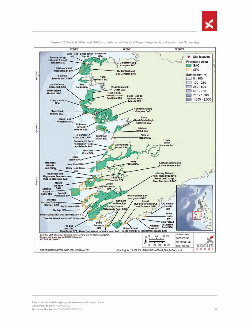
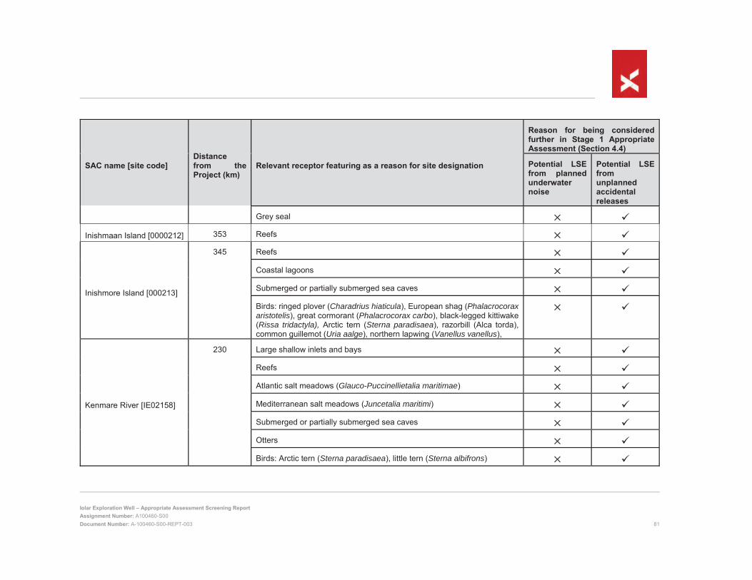
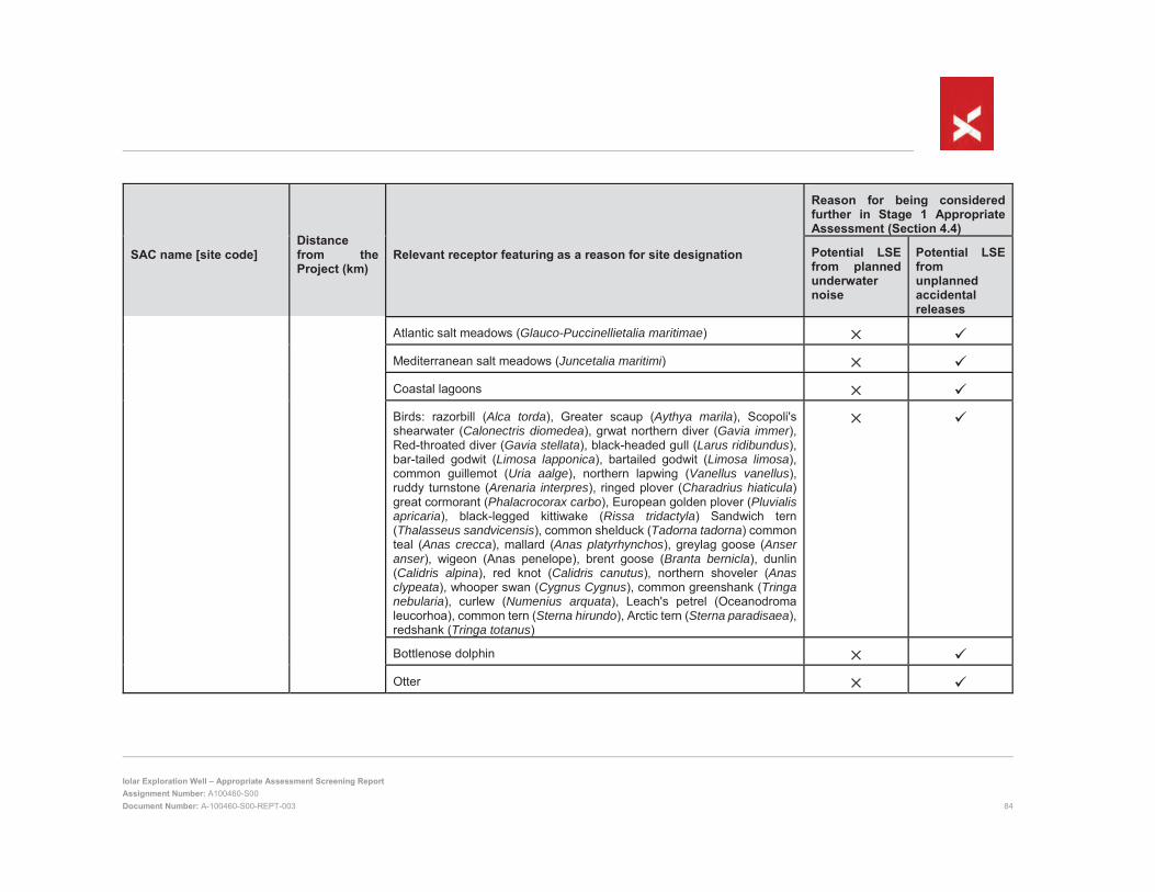
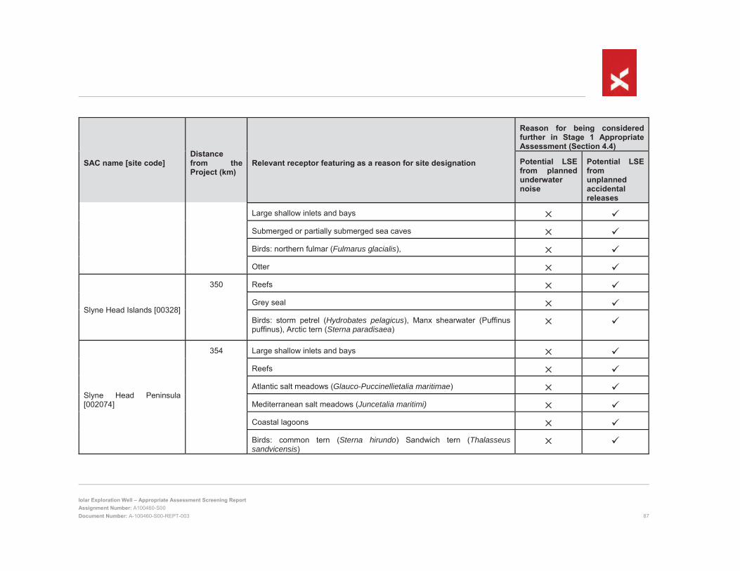
4.3.6 Summary SACs and SPAs that require Stage 1 AA screening are shown in Figure 4.1 (focused on offshore sites) and Figure 4.2 (focused on coastal sites). Each SAC and its designated features are presented in Appendix A.1, SPAs and designated features are presented in Appendix A.2. Note that while many SACs support important bird populations which are listed as features in Appendix A.1, birds are not designated features of SACs, and are instead designated features for the SPAs that often share or overlap the SAC boundaries.
Based on the information presented in Section 4.3, these sites require further consideration due to their connectivity to the Project as a result of the following two impact mechanisms:
Underwater noise; and
Accidental events.
Screening for LSE on each of the receptor groups identified is presented in Section 4.4.
Figure 4.1 All SPAs and SACs considered within this Stage 1 Appropriate Assessment Screening with focus on offshore sites (details of the coastal sites are displayed below in Figure 4.2)
4.4 Assessment of Potential Impacts Screening for LSE has been conducted on a receptor group basis. All sites designated for a specific receptor group have been assessed under a single heading, within which consideration is given to the degree of connectivity between each site and the potential worst-case impact scenario. In the accidental events section (Section 4.5.2) the screening assessment is preceded by a discussion of the measures that will be implemented to reduce the likelihood of an accidental event occurring and reduce the severity of impacts should an incident occur. The inclusion of such measures in the assessment of LSE is appropriate in line with the guidance in DEHLG (2010).
4.5 Assessment of Potential Impacts
4.5.1 Underwater noise 4.5.1.1 Harbour porpoise Blasket Islands, Roaringwater Bay and Islands and West Connacht Coast SACs
Whilst there is a lack of species specific information collected under controlled or well documented conditions, enough evidence exists for marine mammals to suggest that sound may have a potential biological impact and that noise from man-made sources may affect animals to varying degrees depending on the sound source, its characteristics and the susceptibility of the species present (e.g. Nowacek et al., 2007, report this specifically for cetaceans). Such a potential impact on the life activities of marine mammals is called ‘behavioural disturbance’. In addition to potential behavioural disturbance, marine mammals exposed to an adequately high sound source may experience physical effects, which may be a temporary shift in hearing ability (termed a temporary threshold shift; TTS) (e.g. Finneran et al., 2005) or, if the source level is sufficiently high, may be physical damage to the hearing apparatus which may not be reversed; in this case there may be a permanent threshold shift (PTS) (Southall et al., 2007), which is considered to be an ‘injury’ to the animal.
Sound propagation calculations have been undertaken to allow the received noise level at different distances from the source to be calculated. These calculations, outlined in detail in Nexen (2018), have followed guidance from the National Parks and Wildlife Service (NPWS, 2014) in respect of relevant thresholds for potential impact. The modelling has considered the requirement under Section 2.1 of the Rules and Procedures (PAD, 2014) for Operators to ensure that current best industry practice guidelines are applied with regard to impact mitigation and monitoring measures in relation to marine mammals. In line with this requirement, Nexen will adhere to the most recent guidance produced by NPWS (2014). These measures, which include during VSP a soft start (ramp up) of the airgun and use of a suitably trained marine mammal observer (MMO) to conduct a pre-start up search over a 60 minute period for 1,000 m around the sound source prior to the commencement of VSP, are outlined in full in Section 5.5.1. Considering these measures, the predicted potential injury zones and behavioural change zone for harbour porpoise are summarised in Table 4.8. Situation 1 describes the situation for the cumulative noise emissions from the drilling rig and vessels, situations 2 and 3 describe the situations for VSP and VSP where a soft start is implemented. Situation 4 and 5 describe the situation for potential behavioural change zones for cumulative noise emissions from the drilling rig and vessels and VSP. Full details of the noise calculations are presented in Nexen (2018).
As shown, although injury is possible up to approximately 7 m from the VSP airguns, a Monitored Zone will be in place, such that the airguns will not being firing (by way of soft start) if any animals are within 1,000 m of the airgun. Given that harbour porpoises will therefore not be within 7 m of the airguns, they will be out-with the potential injury zone and thus no injury is expected to occur.
To understand the residual impact on harbour porpoise that may be experiencing some disruption to normal behaviour (within the 590 and 2,795 m indicated in Table 4.8), it is important to consider a number of factors including the size and location of the potential disturbance zone (larger areas mean a greater potential to interact with a greater number of animals) and length of time for which the sound source will be present (the longer the period the greater potential to have significant effects). To determine the likelihood of impact in terms of actual number of animals, it is possible to calculate the number of animals that may experience some sort of behavioural impact using local density and population estimates. Based on the density estimate provided by Hammond et al. (2013), the likely maximum number of harbour porpoise that could be within the behavioural change impact zones at any one time are less than one for the continuous drilling and vessel noise to 1.81 for VSP (Table 4.9).
Table 4.9 Estimated number of harbour porpoise experiencing behavioural changes as a result of the Project (from Nexen 2018)
Situation Maximum number of animals predicted to be in the behavioural change impact zone at any one time
Percentage of reference population potentially affected
Continuous noise: Drilling / DP / support vessel <1 0.0001077043
Impulsive Noise: VSP 1.81 0.001731697
Given the biogeographical population for this species is considered to be 104,695 individuals and that known populations associated with two of the inshore SACs are estimated at 267 – 477 and 117 – 201 for Blasket Islands and Roaringwater Bay and Islands respectively (DAHG, 2013a; 2014)7, the likelihood of any animals from the SACs encountering the Project is very low. This is further demonstrated by the fact that harbour porpoise in Irish waters are largely resident (DAHG, 2014) and that the SACs are 220 km, 265 km and 357 km from the Project (for Blasket Islands, Roaringwater Bay and Islands and West Connacht Coast, respectively). Even if a very small number of animals that may be associated with either of the SACs were to encounter the noise emissions, temporarily affecting a small proportion of an SAC population, it would be unlikely to result in an impact to the integrity of the site, since behavioural changes including moving away from an area for short periods of time, reduced surfacing time, masking of communication signals or echolocation clicks, vocalisation
7 Note that the population of the West Connacht Coast SAC harbour porpoise population is currently described as ‘data deficient’ and is thus unknown, but it assumed to be equal or less than those of the Blasket Islands and Roaringwater Bay and Islands SACs (NPWS, 2017).
changes and separation of mothers from offspring for short periods do not necessarily imply that detrimental effects will result for the animals involved (e.g. JNCC, 2010).
With regards to cumulative impacts with other offshore projects, there are no existing projects in the Porcupine Basin nor are there any approved or known plans for future exploration or seismic activities during 2019 within the region. All future planned activities will be the subject of separate applications for approval submitted to DCCAE-PAD, during which any potential cumulative impacts would be considered. Any harbour porpoise from either of the three inshore SACs that encounters noise emissions from the Project which subsequently leaves the area of potential disturbance impact (as a continuation of normal behaviour) will have experienced no residual impact. As there is no ‘impact legacy’ in a harbour porpoise once it has left the potential impact area, that same marine mammal encountering noise emissions from another offshore or coastal activities emitting noise will be in the same position in terms of susceptibility to noise as an animal that has previously not experienced the noise emissions. As such, there is considered to be no likelihood of cumulative impact.
It has therefore been determined that, on the basis that there will be no injury to any harbour porpoise from either of the three inshore SACs and that very few, if any, animals from either of the three inshore SAC are likely to experience any disturbance from the noise emissions, it is highly unlikely that there would any adverse effect on harbour porpoise at a population level. It can therefore be concluded that there will be no LSE on either the Blasket Islands, Roaringwater Bay and Islands or West Connacht Coast SACs as a result of noise emissions from the Project. These sites do not therefore require any further consideration (i.e. Stage 2 Appropriate Assessment).
4.5.2 Accidental releases 4.5.2.1 Risk Reduction measures As discussed in Section 4.3.5.3, the worst-case well blowout scenario has been used for this Stage 1 Appropriate Assessment Screening. The following measures are proposed, in line with current legislation and industry best practice, to reduce the likelihood of a well blowout or other spill scenarios occurring, and to minimise the environmental impacts of any incident that does occur.
4.5.2.1.1 Prevention measures
A full risk assessment will be performed as part of well planning;
Nexen Engineering Standards will be implemented;
The well will be designed to NPUK well control standard ECN-DR-STD-00067;
The well will be designed to be killable with the penetration test wellbore being abandoned as per industry practices with the hole filled with a kill weight mud at the seabed surface. Once confirmed that the well is static, the bottom hole assembly8 shall be remove from the well hole;
While drilling, the primary well control barrier in the main conduit (i.e. the annulus immediately around the drill pipe) will be the hydrostatic pressure imparted by correctly weighted drilling fluid and secondary well control measures will include the BOP and cut-off valves on all machinery, pipelines and hoses;
Outside the main conduit, previous casings in the next annulus out also have barriers, i.e. seal assemblies in casing hangers, and cement isolation between reservoir and surface - there may be one or more cement seals set in each annulus;
Well design, materials and drilling procedures will combine to ensure that the surface environment can be isolated from the wellbore by at least two independent barriers during all stages of well construction and abandonment;
The BOP rated design pressure will comfortably exceed the anticipated reservoir pressures and the BOP will undergo maintenance and inspection prior to use;
8 The bottom hole assembly it is the lowest part of the drill string, extending from the bit to the drill pipe.
Barriers will be tested prior to use, during installation and post-installation;
Shallow hazards (from shallow gas or over-pressured shallow formation water) have been assessed by seismic survey prior to drilling, and the results have been incorporated into the well design;
The plug and abandonment plan will be reviewed and approved by Nexen;
The crew of the drill ship will undergo environmental awareness and safety training;
Incident response training will form part of the induction for any crew joining the drill ship or Project vessels; and
The drill ship will have a safety case and will be class certified by a recognised certifying authority. The safety case documents the design criteria which are based on recent metocean data (see Section 2.4).
Two barriers shall be in place at all times during the entire well life cycle in order to prevent any unintentional flow from the well. However, for top hole operations prior to the BOP installation, only one barrier shall be in place. In the event that only one barrier is available following BOP installation, a full risk assessment shall be performed and a dispensation against the standard put in place
4.5.2.1.2 Response measures
An Oil Spill Contingency Plan (OSCP) for the Project has been prepared, in accordance with the Sea Pollution (Amendment) Act 1999. The OSCP will be approved by the Irish Coast Guard prior to the commencement of the activity. The OSCP contains effective response strategies to minimise the impact from any hydrocarbon spill.
Shipboard Oil Pollution Emergency Plans (SOPEPs) will be in place for any vessels of greater that 400 gross tonnage used during the proposed operations in line with MARPOL 73/78 Annex I. This will include the IceMAX drill ship when it is sailing and not on location. Vessels will also hold International Oil Pollution Prevention Certificates and maintain Oil Record Books.
Small level 1 spills, which disperse quickly, and pose little threat to environmental sensitivities will generally be controlled by onsite resources. Level 2 or 3 spills with the potential to impact the surrounding environment will be managed by an onshore Nexen Incident Management Team (IMT). Detailed response arrangements for all levels of spill will be included in the OSCP.
4.5.2.2 Marine mammals Blasket Islands, Inishbofin and Inishshark, Inishkea Islands, Kenmare River, Kilkieran Bay and Islands, Lower River Shannon, Roaringwater Bay and Islands, Slyne Head Islands and West Connacht Coast SACs
Potential effects on marine mammals associated with the listed sites are considered below.
Some literature suggests that most cetaceans can probably detect surface hydrocarbons using vision, echolocation and touch (Geraci, 1990), although detection is not necessarily followed by avoidance. Some populations have a high affinity for specific feeding, breeding or migration locations which appears to override any tendency to avoid the presence of hydrocarbons. DHNRDAT (2016) contains accounts and photographs of dolphins of various species swimming through thick oil slicks produced by the Deepwater Horizon blowout.
Schwacke et al. (2014) reported that the resident bottlenose dolphin population in Barataria Bay, Louisiana that was exposed to oil from the Deepwater Horizon release showed common symptoms due to oil exposure including: lung disease, hypoadrenocorticism, and pulmonary consolidation as well as mortality rates higher than previously recorded. Lane et al. (2015) reported that the same population suffered a significant decrease in reproductive success as well as high mortality in 2011 and 2012 in the aftermath of the release. Eighty percent of pregnant dolphins failed to produce a viable calf over the monitoring period. Mortality rates over the same period were recorded at 13.2% for the Barataria Bay population, higher than the 3.8-4.9% rate for other populations previously studied in Charleston, South Carolina and Sarasota, Florida.
Venn-Watson et al. (2015) reported that increased strandings in northern coastal Louisiana and Mississippi (March-May 2010); Barataria Bay, Louisiana (August 2010-December 2011); Mississippi and Alabama (2011) overlapped in time and space with heavy oiling from the Deepwater Horizon oil release. There was also an unusually high stranding rate in March 2010, the month before the release started. This was identified as being due to a cold winter, which is a natural cause of occasional elevated strandings, but could not have been responsible for the very high numbers of strandings, failed pregnancies and sick dolphins observed over the subsequent four years.
Recovery of cetacean populations following large oil releases is not well understood, although the limited impacts expected on harbour porpoise and bottlenose dolphin and the existing favourable conservation status of these species in Irish waters are expected to allow a rapid recovery.
Pinnipeds are thought to be able to detect hydrocarbons because observation show that most are able to avoid it (St Aubin, 1990). Following the Esso Bernicia hydrocarbon release in Sullom Voe, the harbour seal population temporarily abandoned Yell Sound (Richardson, 1979) and returned a few weeks later. However, contradictory behaviour was seen following the Exxon Valdez release when harbour seals remained in the area and would surface through hydrocarbon slicks (Lowry et al., 1994).
Harbour seals do not groom and due to their pelagic feeding behaviour are able to feed away from any affected shoreline. Therefore, ingestion of hydrocarbons through grooming or consumption of contaminated prey is unlikely. Mucous membranes of the eyes in harbour seals are most sensitive to surface contact of hydrocarbons, with a common symptom being conjunctivitis (St Aubin, 1990; Lowry et al., 1994).
Inhalation of hydrocarbons in seals causes symptoms of nonspecific narcosis, which include lethargy, irritation to the eyes and lungs, and in harbour seals damage to the central nervous system (Lowry et al., 1994). For most pinnipeds, particularly in northern habitats, it is unlikely that petroleum vapours could become sufficiently concentrated to represent a threat (St Aubin, 1990).
Following the Braer release on the southern coast of the Shetland Islands, there were reports of acute respiratory distress in moulting grey seals hauled out on Lady’s Holm a few kilometres to the northwest. While the proportion of individuals exhibiting symptoms at this site was significantly higher than at control sites and was higher than impacts observed at Lady’s Holm the following year, the lack of baseline data from before the release occurred meant that it was not possible to attribute the effects to the release (Hall et al., 1996). Overall impacts to marine mammals from the Braer release were concluded to be negligible (ESGOSS, 1994), although it is possible that improved monitoring techniques that are now available may detect additional effects should such a scenario recur. Experience from the Exxon Valdez release showed high levels of oiling on the resident harbour seal population. The seals were contaminated with oil both in the water and via oiled haulout sites (Lowry et al., 1994). Concerns that pinniped pups might be reluctant to nurse on oiled mothers (St Aubin, 1990) appear to be unfounded from observations following the Exxon Valdez release that showed oiled harbour seal pups nursing on oiled mothers, and pups of oiled mothers apparently remaining in normal physical condition (Lowry et al., 1994).
There could be sub-lethal impacts leading to reduced pup survival or reproductive rates. Grey seal surveys following the Sea Empress release showed there to be no effects on pup production (Bullimore, 1998). Pathological examination of dead harbour seals following the Exxon Valdez showed only relatively mild damage, which was probably reversible in most cases and could not be unequivocally attributed to oiling. Symptoms of such pathological damage are likely only to be temporary disorientation and lethargy (Spraker et al, 1994).
In terms of recovery potential, pinnipeds are long-lived animals with slow reproductive rates. The rate of recovery of a seal population will depend on the segments of the population that are killed and could range from 2-40 years (McLaren, 1990). For example, the loss of a year’s offspring may be of little consequence in a population with many overlapping generations (McLaren, 1990). Loss of a large proportion of the mature breeding population may however lead to longer recovery times. Populations close to equilibrium may also respond to recovery at a slower rate than those populations that were already below equilibrium (McLaren, 1990). Harbour seals have only moderate vulnerability to an accidental hydrocarbon release and therefore the numbers of adult seals lost should only be a small percentage of the breeding population. Recovery rates should therefore be good.
The Project is open to the ocean on three sides, with modelling indicating that the majority of released oil will remain in the open ocean where it will undergo dilution and degradation, rather than approaching coastal sites and resident marine mammal populations. Impacts at coastal sites are likely to be limited by the relatively low probability of oil beaching at the majority of sites, and the high likelihood that the oil will have undergone substantial weathering at sea before approaching the coast. Impacts are not expected to be significant due to the relatively low sensitivity of marine mammals. It should also be noted that the likelihood of a blowout is considered remote according to the definitions in Nexen (2018). The release prevention measures that Nexen will have in place (summarised in Section 4.5.2.1) will further reduce the likelihood of a worst-case release occurring. As such it is considered that the Project will not have a LSE on the sites listed above, and there is no requirement for a Stage 2 Appropriate Assessment.
4.5.2.3 Marine habitats Achill Head, Akeragh, Banna and Barrow Harbour, Anton Dohrn Seamount, Ballinskelligs Bay and Inny Estuary, Barley Cove to Ballyrisode Point, Belgica Mound Province, Black Head-Poulsallagh Complex, Blasket Islands, Broadhaven Bay, Carrowmore Dunes, Carrowmore Point to Spanish Point and Island, East Rockall Bank, Haig Fras, Hovland Mound Province, Inishbofin and Inishshark, Inisheer Island, Inishmaan Island, Inishmore Island, Kenmare River, Kerry Head Shoal, Kilkee Reefs, Kilkeran Lake and Castlefreke Dunes, Kilkieran Bay and Islands, Lough Hyne Nature Reserve and Environs, Lower River Shannon, Magharee Islands, Mullet/Blacksod Bay Complex, North-West Porcupine Bank, Porcupine Bank Canyon, Roaringwater Bay and Islands, Slyne Head Islands, Slyne Head Peninsula, South East Rockall Bank, South-West Porcupine Bank, Tralee Bay and Magharees Peninsula, West to Cloghan and Valencia Harbour/Portmagee Channel SACs
The SACs listed above have been designated to protect a range of subtidal and intertidal marine habitats including reefs, sea caves, large shallow inlets and bays, mudflats, sandflats, plant assemblages, lagoons and estuaries. Potential impacts of a worst-case oil release on these features are considered below.
As noted in Section 4.3.5.4.4, modelling indicated that sea surface oil could potentially reach nine offshore SACs. Three of these offshore SACs (Haig Fras, Anton Dohrn Seamount and East Rockall Bank) are located in the UK Exclusive Economic Zone (EEZ). All nine offshore sites have been designated for benthic features (reefs) and are located over 100 km from the potential release point. These sites have therefore been excluded from further assessment on the basis that, while there is a possibility in some circumstances that some oil could contact the seabed, any impacts would be limited to within 15 km of the release site as observed for the Deepwater Horizon release (DHNRDAT, 2016).
The Iolar crude is expected to have a specific gravity of 0.85, which means it is expected to be less dense than seawater and should float on the sea surface. In the absence of offshore emergency response, oil will persist on the sea surface for a number of days, although its acute toxicity will be rapidly reduced through rapid evaporation of volatile components. Whilst the light fractions evaporate from the surface, the water soluble component of the oil mass will dissolve in the seawater. The immiscible components will either emulsify and disperse as small droplets in the water column (in oil-in-water emulsion) or under certain sea conditions, aggregate into tight water-in-oil emulsions (DCENR, 2007).
Ecologically-significant concentrations of dissolved or dispersed oil from surface slicks rarely reach below 10 metres water depth (IPIECA 2015a; IPIECA 2015b). Vulnerability of coastal habitats will therefore be restricted to the intertidal and infralittoral (the shallow subtidal zone). The arrival time of the oil, and the degree of weathering it has undergone will likely influence the degree of impact. The minimum arrival time to shore is expected to be 18 days. By this time the oil will have undergone substantial weathering, the more toxic volatile components are likely to have largely evaporated, reducing the toxicity of the remaining material. The season in which a potential release occurred would have an important bearing on the likely impacts. Higher water and air temperatures during the summer and autumn would increase evaporation from the sea surface. Higher wave and wind energy as may be expected during winter and spring would encourage the physical dispersion of the oil and minimise the formation of surface slicks.
Each habitat type will have a different sensitivity to oiling and a different ability to recover. Generally, highly exposed habitats such as stony reefs, rocky shores and cliffs are less sensitive to oiling. The high energy wave regimes associated with these habitats tend to prevent oil forming stable slicks, and once the supply of oil is stopped, residual oiling is usually rapidly cleaned by wave action. Much of the flora and fauna associated with
these environments is adapted to disturbance due to the high natural variation in environmental conditions such as the seasonal changes in the wave regime. As such, recovery is expected to be rapid. Even in a worst-case well blowout scenario, impacts on exposed habitats such as rocky reefs are expected to be limited and not significant.
Impacts are likely to be more severe and longer lasting in sheltered areas where oil can settle into stable slicks resulting in prolonged exposure to the flora and fauna. The lack of natural removal mechanisms such as wave action encourages the formation of persistent tars and the incorporation of oil into sediments where it can persist for many years. Examples of long-term persistence of oil include saltmarsh and muddy shores in Buzzards Bay, Massachusetts, oiled by the 1969 Florida barge spill; saltmarshes in the Magellan Strait, Chile, oiled by the 1974 Metula spill; and sheltered tidal flats and halophyte marsh on the Gulf coast of Saudi Arabia, oiled by the 1991 Gulf War spill. Some oil residues are still present in those areas today, particularly in Saudi Arabia, although the residues represent a small fraction of the initial volumes released and continue to affect only a small fraction of the initial impact zone. The remaining oil residues typically develop a highly weathered crust that is resistant to biodegradation, although this will typically display very limited toxicity as it is largely biologically unavailable.
Many of the sites listed above are designated both for high-energy habitats such as reefs and low-energy habitats such as intertidal mudflats and sandflats and large shallow inlets and bays. As such, it is likely that many sites could suffer impacts on some of their designated features, while other features of the same site remain largely unaffected. In the more sheltered habitats that are most at risk, impacts are likely to be limited by the relatively low probability of oil beaching at the majority of sites, and the high likelihood that the oil will have undergone substantial weathering at sea before approaching the coast. Impacts could nevertheless be significant in sheltered areas due to the possibility of heavy oiling and long-term exposure of the habitat. Impacts on sheltered features could therefore be significant in a worst-case scenario. It should be noted however that the likelihood of a blowout is considered remote according to the definitions in Nexen (2018). The release prevention measures that Nexen will have in place (summarised in Section 4.5.2.1) will further reduce the likelihood of a worst-case release occurring. As such it is considered that the Project will not have a LSE on the sites listed above, and there is no requirement for a Stage 2 Appropriate Assessment.
4.5.2.4 Fish and freshwater pearl mussel Connemara Bog Complex, Glenamoy Bog Complex, Killarney National Park, Macgillycuddy's Reeks and Caragh River Catchment, Lower River Shannon and Mount Brandon SACs
For the purposes of this AA screening, these SACs qualify for consideration due to the sites supporting sea lamprey, Atlantic salmon and freshwater pearl mussel. Potential effects on these protected features, in the very unlikely event of a worst-case release scenario, are considered below.
Adult fish are not generally affected by hydrocarbon slicks on the sea surface, and most species can tolerate water-soluble oil fraction concentrations of about 10 mg/l. Some species can survive much higher concentrations unless whole oil or dispersed oil droplets coat the gills and cause asphyxiation. Adult fish are generally more resistant than other marine organisms to hydrocarbons, because their surfaces are coated with oil-repellent mucus. Adult fish can be affected through the gills, by ingestion of eating oiled prey (JNCC, 1999). Although various development disorders as well as mortalities may occur to some degree under oil slicks, so far it has proved impossible to detect consequential effects on adult populations. Potential sub-lethal effects of hydrocarbons on fish include impairment of reproductive processes and increased susceptibility to disease and predators. An accidental hydrocarbon release could potentially result in the tainting of fish, and a concomitant reduction of its commercial value. Egg and juvenile stages are the most vulnerable to hydrocarbons. Consequently, it is the spawning and nursery grounds that are most sensitive.
The sites listed above are designated for three species of lamprey (sea, river and brook lamprey) and Atlantic salmon. The protected sites contain spawning and nursery grounds for all these species putting them at risk to the impacts of oiling noted above. If an accidental release had a significant effect on the salmon population, the freshwater pearl mussel population is also likely to be detrimentally affected. This is due to the species being hosted on the gills of juvenile fish during the larval stage of development. Freshwater pearl mussel, which is endangered and declining across its global range with many Irish populations suffering poor recruitment, is likely to also exhibit a direct negative response to oil pollution due to the changes this would be likely to cause in the nutrient and oxygen concentrations in the water.
The probability of oil reaching the majority of the sites listed in the event of a worst-case release is relatively low. However, considering the expected high sensitivity of the receptors, there could be significant impacts to the conservation objectives of these sites. It should be noted however that the likelihood of a blowout is considered remote according to the definitions in Nexen (2018). The release prevention measures that Nexen will have in place (summarised in Section 4.5.2.1) will further reduce the likelihood of a worst-case release occurring. As such it is considered that the Project will not have a LSE on the sites listed above, and there is no requirement for a Stage 2 Appropriate Assessment.
4.5.2.5 Otters Connemara Bog Complex, Kenmare River, Kilkieran Bay and Islands, Killarney National Park, Macgillycuddy's Reeks and Caragh River Catchment, Lower River Shannon, Mullet/Blacksod Bay Complex, Roaringwater Bay and Islands and Tralee Bay and Magharees Peninsula, West to Cloghane SACs
Potential effects on otters associated with these sites in the very unlikely event of a worst-case blowout scenario are considered below.
Observations of the Esso Bernicia oil spill at Sullom Voe in 1979 showed that, initially at least, otters did not recognise oil as being a threat and did not avoid the areas where oil was seen (Baker et al., 1981). Failure to avoid the oil was probably due in part to the necessity for the otters to cross oiled shorelines to access their usual inshore foraging grounds. At least 13 otters died in the aftermath of this incident with post-mortems conducted on five corpses showing death was due to causes associated with ingested oil. Otter activity in the Yell Sound and Sullom Voe area did not appear to decrease at the time of the spill (Richardson, 1979).
Otters may be vulnerable to inhalation of hydrocarbons evaporating from the surface. After the Exxon Valdez spill, inhalation of hydrocarbons was a major contributing factor to the death of sea otters (Geraci and Williams, 1990). In addition, otters rely on their thick coat for insulation, and are highly vulnerable to hypothermia if their fur is oiled (DHNRDAT, 2016). There may also be sub-lethal impacts leading to reduced pup survival or reproductive rates. Chronic effects were recorded in the sea otter population in Prince William Sound following the Exxon Valdez spill in 1989 with low juvenile survival in immediate post spill years. However, by 1993, evidence suggested that chronic damage was subsiding and population recovery was under way (Ballachey et al., 1994). Populations of river otter (Lontra canadensis) around Prince William Sound also exhibited chronic effects 2 years after the spill (Duffy et al., 1994). While European otters are in a different genus to both sea otters and river otters, their physiological and behavioural similarities are expected to result in similar sensitivity to oil exposure.
The sites designated for otters listed above are all more than 200 km from the Project. As such, in the event of a worst-case release, oil reaching otter habitat would likely be substantially weathered, and lack the more toxic volatile compounds that would be prone to harm otters through inhalation. The risk of fur oiling and hypothermia would likely remain however. The probability of oil reaching the majority of sites designated for otters was low (<40%), although one site (Kenmare river) had a predicted 98% probability of oiling above the ecological effect threshold. Impacts on otters and therefore the conservation objectives of some of the listed sites could therefore be significant in a worst-case scenario. It should be noted however that the likelihood of a blowout is considered remote according to the definitions in Nexen (2018). The release prevention measures that Nexen will have in place (summarised in Section 4.5.2.1) will further reduce the likelihood of a worst-case release occurring. As such it is considered that the Project will not have a LSE on the sites listed above, and there is no requirement for a Stage 2 Appropriate Assessment.
4.5.2.6 Birds Beara Peninsula, Bills Rocks, Blasket Islands, Cliffs of Moher, Cruagh Island, Deenish Island and Scariff Island, Dingle Peninsula, Galley Head to Duneen Point, High Island, Inishshark and Davillaun, Illanmaster, Inishglora and Inishkeeragh, Inishkea Islands, Inishmore, Iveragh Peninsula, Kerry Head, Loop Head, Magharee Islands, Mid-Clare Coast, Old Head of Kinsale, Puffin Island, Seven Heads, Sheep's Head to Toe Head, Skelligs, Slyne Head to Ardmore Point Islands, Termoncarragh Lake and Annagh Machair, The Bull and The Cow Rocks and Tralee Bay Complex SPAs
Potential effects on birds associated with the sites listed above are considered below.
The JNCC identifies impacts of surface oiling on seabirds as one of the greatest environmental risks posed by accidental hydrocarbon release events. This is primarily due to the high affinity between hydrocarbons and seabird’s plumage. Once hydrocarbons become incorporated into the feathers, there is a high chance of death due to loss of body heat, starvation, drowning or oil ingestion. Plumage is essential to flight, waterproofing and heat insulation and even small effects on any of these functions can result in mortality. Seabirds do not exhibit avoidance of floating hydrocarbons and are therefore very likely to come into contact with any slick that enters their feeding or resting areas. Other bird species that do not habitually interact with the sea surface may be exposed to beached hydrocarbons, through direct contact whilst foraging on contaminated beaches, or through picking up contaminated food or nesting material. Secondary impacts such as reduced prey availability may occur, but these are expected to be minimal compared to the potential primary impacts.
Sensitivity varies between species depending on a variety of factors including time spent on the water, total biogeographical population, reliance on the marine environment, and potential rate for population recovery. Species in the auk family spend much of their time on the sea surface and typically dive to avoid danger. Common guillemot Uria aalge males and flightless juveniles swim into offshore waters from breeding colonies in the post-breeding season. These types of behaviours render animals particularly sensitive to sea surface hydrocarbons.
The SPAs listed above support a wide range of bird species including many that are particularly sensitive to sea surface oil such as common guillemot, razorbill Alca torda, northern fulmar Fulmarus glacialis and northern gannet Sula bassana.
The drilling period is expected to cover spring and summer, coinciding with the most sensitive period for many species. While the modelled probability of oil exceeding the ecological effects threshold reaching the majority of listed sites was low, several sites supporting especially sensitive species had a probability of surface oiling in excess of 90%. These sites included the Beara Peninsula (which supports several species including northern fulmar), the Blasket Islands (razorbill, common guillemot, northern fulmar) and The Bull and The Cow Rocks (razorbill, northern fulmar and northern gannet). As such, in the event of a worst-case release it is likely that at least some of the sites under assessment would incur significant effects. It should be noted however that the likelihood of a blowout is considered remote according to the definitions in Nexen (2018). The release prevention measures that Nexen will have in place (summarised in Section 4.5.2.1) will further reduce the likelihood of a worst-case release occurring. As such it is considered that the Project will not have a LSE on the sites listed above, and there is no requirement for a Stage 2 Appropriate Assessment.
5 STAGE 1 APPROPRIATE ASSESSMENT SCREENING: ASSESSMENT OF LSE - PROTECTED SPECIES
5.1 Overview of Relevant Protected Species As required by Article 12 of the Habitats Directive, the potential impact on the favourable conservation status of species listed on Annex IV of the Habitats Directive must be assessed prior to a project receiving consent. The first step in this is to consider the Annex IV species that could be present in Irish offshore and coastal waters (within the area potentially affected by the Project); this list is presented below and has been derived from the environmental baseline and assessment developed by Nexen (2018):
Marine reptiles
o Marine turtles are the only reptiles which occur in Irish waters, where five species have been recorded. All five species of marine turtles are listed as Annex IV species but the leatherback turtle Dermochelys coriacea is the only species observed with enough regularity to be considered native to Irish waters (DCENR, 2015). Data from tagged turtles suggest that leatherback turtles move into Irish waters from the south and west before moving northward around the west coast of Ireland or through the Irish Sea (Pierpoint, 2000) following swarms of jellyfish (their main prey species) into Irish waters (Reeds, 2004). As such, abundance and occurrence rates will be low in the FEL 3/18 area (DCENR, 2015) and there will be no adverse impact upon the population status of this any turtle species and no further assessment is required.
Fish
o The European sea sturgeon Acipenser sturio is listed on Annex IV of the Habitats Directive and is found in some offshore waters. However, OSPAR (2009) report the offshore area west of Ireland to be outwith the range of this species. As a result, there will therefore be no adverse impact upon the population status of this species and no further assessment is required.
Marine mammals
o All cetacean species are listed on Annex IV of the Habitats Directive. Of these, 24 species of cetacean have been recorded in Irish waters. Reviewing the baseline data (presented in Nexen, 2018) on these 24 species, the pygmy sperm whale Kogia breviceps, beluga Delphinapterus leucas, northern right whale Eubalaena glacialis, and humpback whale Megaptera novaeangliae are considered not likely to be found in the FEL 3/18 area and there is thus no mechanism for impact. There will therefore be no adverse impact upon the population status of these species and no further assessment is required. The possibility of the remaining 20 species being present in the FEL 3/18 area cannot be ruled out and these species are thus reviewed in the remainder of this section.
Mammals
o The majority of other mammal species (in addition to the marine mammals mentioned above) listed on Annex IV of the Habitats Directive are terrestrial and therefore there will be no adverse impact upon the population status of these species as a result of the Project and no further assessment is required. However, the European otter Lutra lutra (although listed as a terrestrial mammal on Annex IV of the Habitats Directive) has marine habits and uses the nearshore coastal waters in some parts of Ireland. As presented in Section 4 there are a number of SACs along the west Ireland coast designated for the European otter which could potentially be exposed to an accidental release resulting from the Project. Therefore, the potential for the population status of the European otter being affected by the Project cannot be ruled out and this species is also reviewed in the remainder of this section.
5.2 Detailed Information on Presence of Relevant Cetacean Species around the Project area.
Information on occurrence for each of the 20 species that may be found around the Project area including FEL 3/18 is provided in Table 5.1; this information has been derived from a range of available sources as outlined in the table.
Table 5.1 Cetacean sightings within the vicinity of FEL 3/18 (DCENR, 20079, Reid et al., 2003; Wall et al., 2013)
Species Seasonality
Atlantic white-sided dolphin J F M A M J J A S O N D The Atlantic white-sided dolphins are mostly confined to the North Atlantic but have been observed in the North Sea in a number of surveys, particularly in the western part of the North Sea. Their presence is seasonal and peaks between May and September. They are usually observed in groups of tens to hundreds, sometimes up to 1,000 offshore, forming subgroups of 2-15 individuals. DCENR (2007) report that Atlantic white-sided dolphin occur along the edges of the continental shelf at depths of 100-500 m, and generally does not occur in coastal waters. O’Cadhla et al. (2004) have records of sightings during summer months all along the Irish Atlantic margin with one sighting in the Porcupine region.
Favourable conservation status 10:: Favourable
Distribution and relative abundance of Atlantic white-sided dolphin within the Irish EEZ 2005 – 2011 (Wall et al., 2013)
Key (number to individuals sighted per hour of effort) (Reid et al., 2003)
High (10 – 100) Medium (1 – 10) Low (0.01 – 1) Very low (0 – 0.01) No sightings
Presence reported in West of Ireland offshore waters (DCENR, 2007)
9 Reference is made to the IOSEA2 documents prepared by DCENR (2007) to assist in preparation of the baseline environment and not as basis for any environmental risk assessment work. 10 The favourable conservation statuses presented in this section have been derived from DAHG (2013b).
Table 5.1 (continued) Cetacean sightings within the vicinity of FEL 3/18 (DCENR, 2007, Reid et al., 2003; Wall et al., 2013)
Species Seasonality
Blue whale J F M A M J J A S O N D Blue whales occur in deep water, between 100 and 1,000 m water depth, although in some regions they have been recorded in shallower waters of less than 200 m. O’Cadhla et al. (2004) have recorded a single individual sighting in the north of the Porcupine Basin in May. They also report previous acoustic records using military sonar systems, and previous sparse sightings in the Irish Atlantic Margin.
Recent acoustic surveys have shown that deep-water individuals may occur between October and January, while previous sighting records suggest that they occur between July and September. This discrepancy between studies might be due to increased survey efforts during summer months
Favourable conservation status Unknown
Distribution and relative abundance of blue whale within the Irish EEZ 2005 – 2011 (Wall et al., 2013)
Key (number to individuals sighted per hour of effort) (Reid et al., 2003)
High (10 – 100) Medium (1 – 10) Low (0.01 – 1) Very low (0 – 0.01) No sightings
Presence reported in West of Ireland offshore waters (DCENR, 2007)
Table 5.1 (continued) Cetacean sightings within the vicinity of FEL 3/18 (DCENR, 2007, Reid et al., 2003; Wall et al., 2013)
Species Seasonality
Bottlenose dolphin J F M A M J J A S O N D Bottlenose dolphins are the third most frequently recorded species in Irish waters (Berrow et al., 2010). There is increasing evidence to suggest that an offshore ecotype of bottlenose dolphin exists in Irish waters (Wall et al., 2013), and during spring/summer months (April-August), and again in high numbers in November by O’Cadhla et al. (2004). This species has been recorded in the wider region all year round predominantly in the shelf break, and waters to the south and south-west of Ireland and further offshore in deep North Atlantic waters. Off the west coast of Ireland, the Shannon Estuary is also home to at least one resident bottlenose dolphin population year-round (DCENR, 2007)
.Favourable conservation status: Favourable Distribution and relative abundance of bottlenose dolphin within the Irish exclusive economic zone (EEZ) 2005 – 2011 (Wall et al., 2013)
Key (number to individuals sighted per hour of effort) (Reid et al., 2003)
High (10 – 100) Medium (1 – 10) Low (0.01 – 1) Very low (0 – 0.01) No sightings
Presence reported in West of Ireland offshore waters (DCENR, 2007)
Table 5.1 (continued) Cetacean sightings within the vicinity of FEL 3/18 (DCENR, 2007, Reid et al., 2003; Wall et al., 2013)
Species Seasonality
Common dolphin J F M A M J J A S O N D Common dolphins also known as the short beaked common dolphins, are the second most frequently recorded cetaceans in Irish waters (Reid et al., 2003). They have been observed over deeper waters across the continental shelf but rarely in water depths exceeding 200 m (Reid et al., 2003). Although the biggest concentrations in Ireland are over the continental shelf and in deeper waters, individuals are frequently observed in shallow inshore waters off the south and south-west coasts and around the Aran Islands (IWDG, 2017). There is evidence of a strong inshore winter peak in numbers along the south coast, possibly associated with movements of sprat (IWDG, 2018). They have been reported in high abundances around the edges of the Porcupine Basin and in the wider region year-round, with sightings being made in coastal waters, along the continental slope, as well as over deeper areas (DCENR, 2007).
Favourable conservation status: Favourable
Distribution and relative abundance of common dolphin within the Irish EEZ 2005 – 2011 (Wall et al., 2013)
Cuvier’s beaked whale J F M A M J J A S O N D Preliminary results from the recent mooring detection surveys undertaken as part of the ObSERVE programme have indicated that Cuviers beaked whales occur along the western and south edge of the Porcupine Bank including around the Project area (Kowarski et al, undated). Historically there have been only six confirmed sightings of Cuvier’s beaked whale in British and Irish waters, although strandings are not uncommon (DCENR, 2007). Strandings have mainly occurred along the western seaboard of Britain and Ireland (Berrow et al., 2010). O’Cadhla et al. (2004) recorded one individual over the Porcupine Basin.
Favourable conservation status: Unknown
See northern bottlenose dolphin entry for mapped distribution of beaked whales.
Key (number to individuals sighted per hour of effort) (Reid et al., 2003)
High (10 – 100) Medium (1 – 10) Low (0.01 – 1) Very low (0 – 0.01) No sightings
Presence reported in West of Ireland offshore waters (DCENR, 2007)
Table 5.1 (continued)Cetacean sightings within the vicinity of FEL 3/18 (DCENR, 2007, Reid et al., 2003; Wall et al., 2013)
Species Seasonality
False killer whale J F M A M J J A S O N D O’ Cadhla et al. (2004) reported false killer whale Pseudorca crassidens sightings in the southern region of the Porcupine Basin between June and November.
Favourable conservation status: Favourable
Sighting distribution and total numbers of false killer whales observed between July 1999 and September 2001 (O’ Cadhla et al., 2004)
Key (number to individuals sighted per hour of effort) (Reid et al., 2003)
High (10 – 100) Medium (1 – 10) Low (0.01 – 1) Very low (0 – 0.01) No sightings
Presence reported in West of Ireland offshore waters (DCENR, 2007)
Table 5.1 (continued) Cetacean sightings within the vicinity of FEL 3/18 (DCENR, 2007, Reid et al., 2003; Wall et al., 2013)
Species Seasonality
Fin whale J F M A M J J A S O N D Fin whales are seasonally abundant in shelf edge waters off the coast of Ireland; however, the species tend to prefer the deep waters beyond the edge of the continental shelf (Reid et al., 2003). The annual movements of fin whale remain largely unknown, although sightings have been made throughout the Irish Atlantic Margin. Wall et al. (2013) shows that fin whales appeared to be largely absent from Irish shelf waters during the winter and early spring, though a few animals remained foraging in inshore waters off the south-east coast during the early winter. Fin whale abundance and distribution increased in the waters of the Irish shelf slopes in late summer and autumn (Wall et al., 2013).
Favourable conservation status: Favourable
Distribution and relative abundance of fin whale within the Irish EEZ 2005 – 2011 (Wall et al., 2013)
Key (number to individuals sighted per hour of effort) (Reid et al., 2003)
High (10 – 100) Medium (1 – 10) Low (0.01 – 1) Very low (0 – 0.01) No sightings
Presence reported in West of Ireland offshore waters (DCENR, 2007)
Table 5.1 (continued) Cetacean sightings within the vicinity of FEL 3/18 (DCENR, 2007, Reid et al., 2003; Wall et al., 2013)
Species Seasonality
Harbour Porpoise J F M A M J J A S O N D The harbour porpoise is a predominantly coastal species. They typically occur in the European continental shelf in waters up to 200 km from the coast (DCENR, 2007). Although these are the smallest cetaceans in Irish waters, they are abundant and widespread. Sightings from established monitoring sites suggest that individuals move to breeding grounds offshore in spring (between March and June), before moving back towards their coastal feeding grounds with their calves (born in May) towards the end of the year (IWDG, 2018).
Favourable conservation status: Favourable
Distribution and relative abundance of harbour porpoise within the Irish EEZ 2005 – 2011 (Wall et al., 2013)
Key (number to individuals sighted per hour of effort) (Reid et al., 2003)
High (10 – 100) Medium (1 – 10) Low (0.01 – 1) Very low (0 – 0.01) No sightings
Presence reported in West of Ireland offshore waters (DCENR, 2007)
Table 5.1 (continued) Cetacean sightings within the vicinity of FEL 3/18 (DCENR, 2007, Reid et al., 2003; Wall et al., 2013)
Species Seasonality
Humpback whale J F M A M J J A S O N D Humpback whale sightings are relatively uncommon in the waters off the west coast of Ireland, and most of them have been observed during summer months. However, they appear to use the offshore waters of the British Isles as a migration corridor between November and March, including the Atlantic margin region of Ireland. While it is possible that the species is under-recorded in Ireland due to difficulties in distinguishing it from other large whale species in the open sea, it’s seasonal and mainly oceanic occurrence off western Europe may also explain why sighting records remain low compared to more wide-ranging whale species. In recent years however, records have increased close to the Irish coast and some individuals have been shown to return repeatedly to forage in waters off the southwest, south and southeast coasts (Wall et al., 2013).
Favourable conservation status: Unknown
Distribution and relative abundance of humpback whale within the Irish EEZ 2005 – 2011 (Wall et al., 2013)
Key (number to individuals sighted per hour of effort) (Reid et al., 2003)
High (10 – 100) Medium (1 – 10) Low (0.01 – 1) Very low (0 – 0.01) No sightings
Presence reported in West of Ireland offshore waters (DCENR, 2007)
Table 5.1 (continued) Cetacean sightings within the vicinity of FEL 3/18 (DCENR, 2007, Reid et al., 2003; Wall et al., 2013)
Species Seasonality
Killer whale J F M A M J J A S O N D It has been reported that this species is present in the West of Ireland region year-round, predominantly to the west and south of Ireland, as well as in the Irish Atlantic margin waters between spring and autumn (DCENR, 2007). No sightings were made near the Project by Wall et al., (2013).
Favourable conservation status: Unknown
Distribution and relative abundance of killer whale within the Irish EEZ 2005 – 2011 (Wall et al., 2013)
Key (number to individuals sighted per hour of effort) (Reid et al., 2003)
High (10 – 100) Medium (1 – 10) Low (0.01 – 1) Very low (0 – 0.01) No sightings
Presence reported in West of Ireland offshore waters (DCENR, 2007)
Table 5.1 (continued) Cetacean sightings within the vicinity of FEL 3/18 (DCENR, 2007, Reid et al., 2003; Wall et al., 2013)
Species Seasonality
Minke whale J F M A M J J A S O N D Minke whales Balaenoptera acutorostrata are the smallest and most frequently sighted and stranded baleen whale in Irish waters (Berrow et al., 2010). Minke whales were recorded as far offshore as the Project in June by Reid et al. (2003). DCENR (2007) report that this species is widely distributed along the Atlantic Irish seaboard and is present year-round, with most sightings occurring during summer months. O’Cadhla et al. (2004) also reported sightings of this species in the vicinity of FEL 3/18 during spring months. Peaks in the spring and summer months are thought to be linked to whales foraging on high concentrations of pelagic schooling fish (Wall et al., 2013)..
Favourable conservation status: Favourable
Distribution and relative abundance of minke whale within the Irish EEZ 2005 – 2011 (Wall et al., 2013)
Key (number to individuals sighted per hour of effort) (Reid et al., 2003)
High (10 – 100) Medium (1 – 10) Low (0.01 – 1) Very low (0 – 0.01) No sightings
Presence reported in West of Ireland offshore waters (DCENR, 2007)
Table 5.1 (continued) Cetacean sightings within the vicinity of FEL 3/18 (DCENR, 2007, Reid et al., 2003; Wall et al., 2013)
Species Seasonality
Northern bottlenose whale J F M A M J J A S O N D Northern bottlenose whales Hyperoodon ampullatus are a deep-diving species, typically found offshore in waters deeper than 1,000 m. Berrow et al (2010) reported sightings within the Porcupine Seabight. Most sightings are made to the north and west of Scotland and further south in the Bay of Biscay. They appear to be less common to the west of Ireland, although individuals have been recorded in areas during the summer months. It is believed these species migrate north in spring and south in autumn (DCENR, 2007).
Favourable conservation status: Unknown
Distribution and relative abundance of beaked whales within the Irish EEZ 2005 – 2011 (Wall et al., 2013)
True’s beaked whales J F M A M J J A S O N D Although there are very few confirmed sightings of True’s beaked whale Mesoplodon mirus, strandings have occurred along the West coast of Ireland. It is thought that this species may occur year round in the Irish Atlantic Margin (DCENR, 2007).
Favourable conservation status: Unknown
Sowerby’s beaked whale J F M A M J J A S O N D Preliminary results from the recent mooring detection surveys undertaken as part of the ObSERVE programme have indicated that Sowerby’s beaked whales occur along the western and south edge of the porcupine bank including around Project area (Kowarski et al, undated). Although there are very few confirmed sightings of true Sowerby’s whale, strandings have occurred along the west coast of Ireland. It is thought that this species may occur year-round in the Irish Atlantic Margin (DCENR, 2007).
Favourable conservation status: Unknown
See northern bottlenose dolphin entry for mapped distribution of beaked whales.
Key (number to individuals sighted per hour of effort) (Reid et al., 2003)
High (10 – 100) Medium (1 – 10) Low (0.01 – 1) Very low (0 – 0.01) No sightings
Presence reported in West of Ireland offshore waters (DCENR, 2007)
Table 5.1 (continued) Cetacean sightings within the vicinity of FEL 3/18 (DCENR, 2007, Reid et al., 2003; Wall et al., 2013)
Species Seasonality
Pilot whale J F M A M J J A S O N D Pilot whales Globicephala melas are predominantly found over the continental shelf and in coastal areas. It is thought that this species is present year-round in the wider Porcupine Basin (DCENR, 2007). Wall et al. (2013) noted that high relative abundances of pilot whales are recorded in the vicinity of deep water bathymetric features such as sea mounts. However, compared with the Rockall Trough and south of the Goban Spur, relative low densities of pilot whales have been observed in the Porcupine Basin and it is not known whether this is a small resident population or individuals transiting between areas of high density to the north and south. Pilot whales primarily occur in deep waters (500 m+) beyond the Irish Shelf edge (Wall et al., 2013).
Favourable conservation status: Favourable
Distribution and relative abundance of pilot whale within the Irish EEZ 2005 – 2011 (Wall et al., 2013)
Key (number to individuals sighted per hour of effort) (Reid et al., 2003)
High (10 – 100) Medium (1 – 10) Low (0.01 – 1) Very low (0 – 0.01) No sightings
Presence reported in West of Ireland offshore waters (DCENR, 2007)
Table 5.1 (continued) Cetacean sightings within the vicinity of FEL 3/18 (DCENR, 2007, Reid et al., 2003; Wall et al., 2013)
Species Seasonality
Risso’s dolphin J F M A M J J A S O N D Risso’s dolphins Grampus griseus are predominantly found over the continental shelf and in coastal areas. It is thought that this species is present year round in the West of Ireland region (DCENR, 2007). Risso’s dolphins in Irish waters do not occur in deep water habitats along the shelf slopes and this is in stark contrast to their reported preference for such habitats elsewhere in the world (Wall et al., 2013). No sightings have been made FEL 3/18 by Reid et al. (2003), Wall et al. (2013) or O’Cadhla et al. (2004).
Favourable conservation status: Unknown
Distribution and relative abundance of Risso’s dolphin within the Irish EEZ 2005 – 2011 (Wall et al., 2013)
Key (number to individuals sighted per hour of effort) (Reid et al., 2003)
High (10 – 100) Medium (1 – 10) Low (0.01 – 1) Very low (0 – 0.01) No sightings
Presence reported in West of Ireland offshore waters (DCENR, 2007)
Table 5.1 (continued) Cetacean sightings within the vicinity of FEL 3/18 (DCENR, 2007, Reid et al., 2003; Wall et al., 2013)
Species Seasonality
Sei whale J F M A M J J A S O N D It is thought that sei whale Balaenoptera borealis migrate through Irish waters in spring, before returning southward in autumn and winter. Subsequently, sei whale sightings have been made in the West of Ireland offshore area throughout the year (DCENR, 2007).
Favourable conservation status: Unknown
Seasonal sighting distribution and total numbers of sei whales observed between July 1999 and September 2001 (Ó Cadhla et al., 2004)
Key (number to individuals sighted per hour of effort) (Reid et al., 2003)
High (10 – 100) Medium (1 – 10) Low (0.01 – 1) Very low (0 – 0.01) No sightings
Presence reported in West of Ireland offshore waters (DCENR, 2007)
Table 5.1 (continued) Cetacean sightings within the vicinity of FEL 3/18 (DCENR, 2007, Reid et al., 2003; Wall et al., 2013)
Species Seasonality
Sperm whale J F M A M J J A S O N D Sperm whales are common in deep waters offshore Ireland (DCENR, 2007; 2015). While sightings and landings records show them to be most abundant during summer and autumn, stranding records suggest males may be present all year round (DCENR, 2007). O’Cadhla et al. (2004) recorded sightings in the vicinity of the Project during spring and summer.
Favourable conservation status: Unknown
Distribution and relative abundance of sperm whale within the Irish EEZ 2005 – 2011 (Wall et al., 2013)
Key (number to individuals sighted per hour of effort) (Reid et al., 2003)
High (10 – 100) Medium (1 – 10) Low (0.01 – 1) Very low (0 – 0.01) No sightings
Presence reported in West of Ireland offshore waters (DCENR, 2007)
Table 5.1 (continued) Cetacean sightings within the vicinity of FEL 3/18 (DCENR, 2007, Reid et al., 2003; Wall et al., 2013)
Species Seasonality
Striped dolphin J F M A M J J A S O N D Striped dolphin tend to reside beyond the continental shelf in depths of greater than 1,000 m. However, it occasionally occurs over the shelf into waters with depths of less than 60 m. O’Cadhla et al. (2004) recorded sightings of this species along the Irish Atlantic Margin in summer and early autumn with higher numbers of records in the southern part of the Porcupine Basin.
Favourable conservation status: Favourable
Distribution and relative abundance of striped dolphin within the Irish EEZ 2005 – 2011 (Wall et al., 2013)
Key (number to individuals sighted per hour of effort) (Reid et al., 2003)
High (10 – 100) Medium (1 – 10) Low (0.01 – 1) Very low (0 – 0.01) No sightings
Presence reported in West of Ireland offshore waters (DCENR, 2007)
Table 5.1 (continued) Cetacean sightings within the vicinity of FEL 3/18 (DCENR, 2007, Reid et al., 2003; Wall et al., 2013)
Species Seasonality
White beaked dolphin J F M A M J J A S O N D White-beaked dolphins occur widely over the northern European continental shelf with more frequent records in the western sector of the northern and central North Sea across to western Scotland and south to western Ireland. Although it has been recorded in the UK continental shelf all year-round, there are higher numbers of records between June and October (Reid et al., 2003). There are records of white-beaked dolphins between June and November in the IOSEA2 area (Wall et al., 2013).
Favourable conservation status: Favourable
Distribution and relative abundance of white beaked dolphin within the Irish EEZ 2005 – 2011 (Wall et al., 2013)
Key (number to individuals sighted per hour of effort) (Reid et al., 2003)
High (10 – 100) Medium (1 – 10) Low (0.01 – 1) Very low (0 – 0.01) No sightings
Presence reported in West of Ireland offshore waters (DCENR, 2007)
5.3 Information on the Presence of European Otters along the west and south coast of Ireland
Ireland has long been considered to hold one of the most important remaining populations of European otter Lutra lutra in Western Europe and surveys carried out in the early 1980’s and again in the early 1990s confirmed the species to be widespread throughout the country. Populations in coastal areas utilise shallow, inshore marine areas for feeding but also require fresh water for bathing and terrestrial areas for resting and breeding holts.
During 2010 and 2011 a national survey of otter populations was undertaken by NPWS and reported by Reid et al (2013). The outcomes of this national survey indicate that there are many locations along the Irish west and south coast that are habited by otters (Figure 5.1). The assessment of the diets of coastal otters in Ireland indicate that those individuals which inhabit the coastal marine waters of Ireland feed predominantly on marine species such as rocklings (Gadidae), wrasse (Labridae), Crustacea, Mollusca, Atlantic eel, goby (Gobiidae), sea scorpions (Cottidae) and blennies, but also travel inland to estuaries to feed on brackish or freshwater food resources as well (Reid et al., 2013). Figure 5.1 Otter survey results during the NPWS 2010 and 2011 national survey. Otter survey sites in the Republic of Ireland (during 2010/11) augmented by those surveyed Northern Ireland in 2010 showing otter occurrence as closed circles and absence of tracks or signs as open circles. (From Reid et al., 2013).
As outlined in Section 4.2 the south and west coast of Ireland has a 17 coastal SACs designated for the presence of otters namely. The presence of these designated sites for this species indicates the importance of the south and west Irish coastline for otters.
5.4 Description of Potential Impacts Considering the Project (see Section 2) and the environmental baseline of the area within which the Project is located (reported in Nexen, 2018), a number of potentially significant environmental impacts have been identified during the Environmental Impact Assessment (EIA) Screening process (reported in Nexen, 2018) on cetaceans and otters; these are summarised in Table 5.2.
Table 5.2 Potential environmental impacts on protected species
Source of impact Description of potential impact mechanism Relevant protected species
Underwater noise Acoustic disturbance resulting from VSP and vessel emissions
Cetaceans
Accidental releases Accidental release of chemicals or hydrocarbons to the marine environment leading to toxic effects on marine species, smothering and reduction in water quality.
Cetaceans and otters.
The assessment of these potential impacts on the relevant protected species is presented in Section 5.5 below.
5.5 Assessment of Potential Impacts
5.5.1 Underwater noise - cetaceans Many species found in the marine environment use sound to understand their surroundings, track prey and communicate with members of their own species. Some species, mostly toothed whales, dolphins and porpoise, also use sound to build up an image of their environment and to detect prey and predators through echolocation. Exposure to natural sounds in the marine environment may elicit responses in marine species; for example, harbour seals have been shown to respond to the calls of killer whales with anti-predator behaviour (Deecke et al., 2002). In addition to responding to natural sounds, marine mammals may also respond to man-made noise. The potential impacts of industrial noise on species may include impacts to hearing and displacement of the animals themselves and potential indirect impacts which may include displacement of prey species or stress.
As described in Section 4.5.1.1 sound propagation calculations were undertaken to understand the potential ranges at which injury or disturbance to an animal might occur as a result of the Project. These calculations, outlined in detail in Nexen (2018), have followed the NPWS guidance (NPWS, 2014) in respect of relevant thresholds for potential impact. The modelling has considered the requirement under Section 2.1 of the Rules and Procedures (PAD, 2014) for Operators to ensure that current best industry practices are applied with regard to impact management and monitoring measures in relation to marine mammals. In line with this requirement, Nexen will adhere to the most recent guidance produced by the DCENR; Guidance to Manage the Risk to Marine Mammals from Man-made Sound Sources in Irish Waters (NPWS, 2014). These measures will include:
During VSP:
A qualified and experienced marine mammal observer (MMO) shall be appointed to monitor for marine mammals and to log all relevant events using standardised data forms;
Sound-producing activities shall only commence in daylight hours where effective visual monitoring, as performed and determined by the MMO, has been achieved. Where effective visual monitoring, as determined by the MMO, is not possible, the sound-producing activities shall be postponed until effective visual monitoring is possible;
Pre-start-up monitoring shall be conducted at least 60 minutes before the activity is due to commence. Sound-producing activity shall not commence until at least 60 minutes have elapsed with no marine mammals detected within the Monitored Zone by the MMO.
Pre-Start Monitoring shall subsequently be followed by a Ramp-Up Procedure (where possible) which should include continued monitoring by the MMO. Airguns utilised in VSP generally fire for approximately
two minutes and then stop for 5 – 10 minutes before repeating the pattern. To ensure that marine mammals are given the opportunity to move away from the airguns as they commence firing, energy would be slowly increased to the maximum level over a period of 40 minutes, in a process called ‘soft-start’.
If there is a break in sound output for a period of 5-10 minutes (e.g., due to equipment failure, shut-down), MMO monitoring must be undertaken to check that no marine mammals are observed within the Monitored Zone prior to recommencement of the sound source at full power.
If there is a break in sound output for a period greater than 10 minutes (e.g., due to equipment failure, shut-down or station change) then all Pre-Start Monitoring and a subsequent Ramp-up Procedure (where appropriate following Pre-Start Monitoring) will be undertaken.
Considering these measures, the predicted potential injury zones and behavioural change zone are summarised in Table 5.3. Full details of the noise calculations are presented in Nexen (2018).
As shown in Table 5.3 for all cetacean species injury from the continuous noise emissions associated with the Project, assuming that the marine mammals move away from the source of the noise at onset, does not occur.
Table 5.3 shows that the zone of potential injury from VSP with the implementation of the soft start procedure for high frequency cetacean species is 6 m, 3 m for mid-frequency cetaceans and 2 m for low-frequency cetaceans. However, the possibility of injury to marine mammals from the VSP is significantly reduced (effectively eliminated) with the use of a 1,000 m Monitored Zone, since the start-up of the sound source would not occur until the visual monitoring showed that the area was clear of marine mammals.
To understand the residual impact on animals that may be experiencing some disruption to normal behaviour, it is important to consider a number of factors including the size and location of the potential disturbance zone (larger areas mean a greater potential to interact with a greater number of animals) and length of time for which the sound source will be present (the longer the period the greater potential to have significant effects). Behavioural changes such as moving away from an area for short periods of time, reduced surfacing time, 11 Southall et al. (2007) defined three distinct, functional hearing categories for cetaceans (a fourth and fifth was described for pinnipeds in water and air). These three categories are low-frequency cetaceans (including the sei whale, blue whale, minke whale and fin whale) with an estimated hearing range of 7 hertz to 22 kHz, mid-frequency cetaceans (including Risso’s dolphin, common dolphin, white-beaked dolphin, striped dolphin, bottlenose whale, True’s beaked whale, Atlantic white-sided dolphin, bottlenose dolphin, false killer whale, killer whale, pilot whale and sperm whale) with an estimated hearing range of 150 Hz to 160 kHz and high-frequency cetaceans (including harbour porpoise and pygmy sperm whale) with an estimated hearing range of 200 Hz to 180 kHz.
masking of communication signals or echolocation clicks, vocalisation changes and separation of mothers from offspring for short periods, do not necessarily imply that detrimental effects will result for the animals involved (JNCC, 2010). Temporarily affecting a small proportion of a population would be unlikely to result in population level effects and would not considered as non-trivial disturbance (i.e. would not be significant disturbance). In contrast, affecting a large proportion may be considered non-trivial disturbance (i.e. could be significant disturbance).
Based on the sound propagation calculations, the radius of the zone for the onset of behavioural change effects will be approximately:
590 m from the sound source for the continuous noise sources of drilling / DP / drilling support vessel. equating to an approximate area of 1.09 km2
2,795 m from the source array for VSP equating to an approximate area of 24.5 km2.
Behavioural changes such as moving away from an area for short periods of time, reduced surfacing time, masking of communication signals or echolocation clicks, vocalisation changes and separation of mothers from offspring for short periods, do not necessarily imply that detrimental effects will result for the animals involved (JNCC, 2010). Therefore. the zone of behavioural change will not be a zone from which animals are necessarily excluded, but rather one in which normal behaviour might be affected across a range of potential responses, from a simple noticing of the sound, to a startle response and return to normal behaviour, through to exclusion from an area.
To determine the likelihood of impact in terms of actual number of animals, it is possible to calculate the number of animals likely to experience some sort of behavioural impact using local density and population estimates. Density estimates from the area covering the West of Ireland and Celtic Seas are not well understood for many species, but estimates from SCANS-II (detailed in JNCC, 2010 and Hammond et al., 2013) and Cetacean Offshore Distribution and Abundance in the European Atlantic II (CODA) survey results (detailed in JNCC, 2010) provide regional density estimates for some of the species most regularly found in vicinity of the Project.
To understand how the number of animals that might be affected might constitute a non-trivial disturbance offence, it is important to understand what proportion of the population this number represents. Temporarily affecting a small proportion of a population would be highly unlikely to result in population level effects, thus not considered as being qualifying as non-trivial disturbance. In contrast, affecting a large proportion may be considered non-trivial disturbance. Determining this proportion is in itself not a simple task since it is not clear how north-east Atlantic marine mammal populations act at a local level. For example, minke whales are likely to make use of the entire north-east Atlantic, so the population can be viewed as one, whilst other species may display more local fidelity and be viewed as a series of sub-populations.
The Statutory Nature Conservation Bodies of the UK (SNCBs, 2013) note that marine mammals of almost all species found in UK waters are part of larger biological populations whose range extends into the waters of other States and/or the High Seas. In order to obtain the best conservation outcomes for many species, it is necessary to consider the division of populations into smaller management units. This requires an understanding of the geographical range of populations and sub-populations, in order to provide advice on impacts at the most appropriate spatial scale. The output of the SNCB exercise investigating how marine mammal populations may act (SNCBs, 2013) is the determination of Marine Mammal Management Units (MMMU) for species including bottlenose dolphins, common dolphins, harbour porpoise, white-beaked dolphin Atlantic white-sided dolphin and minke whale. These MMMUs and associated population estimates can be interpreted in the context of the potential disturbance zones to consider the potential for a significant impact to occur.
The number of individual animals potentially affected for species known to be present in the Project area (Atlantic white-sided dolphin, white beaked dolphin, bottlenose dolphin, common dolphin, harbour porpoise, striped dolphin, pilot whale sperm whale, minke whale and fin whale) is shown in Table 5.4. The numbers have been calculated for the criteria relative to the type of noise emission
Consequently, the behavioural disturbance zones should be viewed as the maximum likely extent within which behavioural change could occur. The fact that an animal is within this area does not necessarily mean that disturbance will occur.
Considering the percentages of the populations affected in Table 5.4 it is clear that, whilst the presence of these species in the potential disturbance area at the time of the Project cannot be ruled out, the number of individual animals that are likely to exhibit some form of change in behaviour for the period in which they encounter sound from the Project is so small that it would be largely undetectable against natural variation and would have no effect at the population level. Of those individuals that are potentially present in the disturbance area there is a very low likelihood of these individuals remaining within the Project area for the whole duration and given the relatively short duration of the Project (100 - 150 days) any change in their behaviour for the period in which they encounter sound from the Project will also be so small that it would also be largely undetectable against natural variation and would have no lasting effect at the population level.
For species not listed in Table 5.4 due to lack of sightings information (e.g. killer whale, blue whale, beaked whales), densities and population estimates would be expected to be lower than those in Table 5.4 and the percentage of population affected would be lower. Therefore, the overall magnitude of the impact on these species is thus considered to be similar.
The Porcupine Basin may lie along migration pathways for cetaceans given the north-south migration of many species in Irish waters. The small potential disturbance impact zone means that the noise emissions would not represent a barrier to wider, regional movements of marine mammals. Breeding zones have been confirmed in Irish waters for a number of cetacean species, including the harbour porpoise, common dolphin, bottlenose dolphin, Risso’s dolphin, white sided dolphin, white-beaked dolphin and pilot whale. Other species, such as the northern bottlenose whale and minke whale are also suspected of breeding in the region (DCENR, 2007). As with possible barrier to movement, the small potential disturbance impact zone and temporally restricted nature of the noise emissions means that it is improbable that there could be any effect on areas potentially favoured as cetacean breeding grounds.
Given the above, mortality or significant disturbance of the Annex IV cetacean species that may be present in the area (including during breeding and migration) or deterioration or destruction of breeding sites or resting places is not likely. Thus, in respect of noise emissions, the Project is unlikely to adversely affect the favourable conservation status of any of the Annex IV species that may be present.
12 Density estimates from JNCC Hammond et al. (2013) and JNCC (2010). 13 Population density estimates from SNCB (2013) management unit within which the Project sits, CODA estimates from JNCC (2010). For Atlantic white-sided & white-beaked dolphins, management unit population estimates of 69,293 & 15,895 respectively have been given combined since density estimates are for both species combined. 14 Calculated as the density estimate x behavioural change area. 15 JNCC (2010) presents the SCANS-II abundance estimates for these two species as a combined value, due to difficulty in distinguishing the two species in the field. When considering either of the two species individually, the values provided are there therefore an over-estimate.
5.5.2 Accidental releases 5.5.2.1 Cetaceans An overview of potential impacts released hydrocarbons can have on marine mammals is provided in Section 4.4.2.2.
There are many species of cetacean found in the waters west of Ireland as discussed in Nexen (2018). Cetaceans are not considered to be highly sensitive to accidentally released hydrocarbons, and in the event of cetaceans coming into contact with a large spill either in the open ocean or in coastal habitats, the predicted impacts are expected to be minor. Taking this into account, together with the remote likelihood of a large accidental hydrocarbon release from the Project, it is unlikely an accidental release will significantly adversely affect any of the cetacean populations present. It is therefore unlikely that the Project will adversely affect the conservation status of any of the Annex IV cetacean species that are present.
5.5.2.2 European otter An overview of potential impacts released hydrocarbons can have on otters is provided in Section 4.4.2.5.
Otters generally forage close to shore and would only be impacted if an accidental spill of significant quantity reached the coast. In the event that oil did reach the coast, there could be impacts on otters at the population level. The probability of a large accidental event occurring is remote however (Nexen, 2018), and as such it is concluded that the Project is unlikely to adversely affect the conservation status of otters in Ireland.
6 CONCLUSIONS The Project required a Stage 1 Appropriate Assessment Screening to identify whether there is potential for the Project to have a LSE on a Natura 2000 site (SAC or SPA including draft, candidate and proposed sites).
The only source events from the Project that had pathways with connectivity to the protected sites were underwater noise and a blowout scenario as part of an accidental event.
Harbour porpoise was identified as a relevant feature (receptor) of three SACs (Blasket Islands, Roaring Bay and Islands and West Connacht Coast SAC) that could potentially be impacted by underwater noise caused from the Project. When assessing the potential impacts from underwater noise, given the best practice measures that will be in place (e.g. soft start), it was determined that noise emissions did not cause a LSE and therefore these three sites do not require a Stage 2 Appropriate Assessment.
Modelling of the worst-case accidental release in the form of a prolonged well blowout resulted in oil reaching the west coast of Ireland, lead to connectivity between the Project and SPAs designated for marine seabirds and SACs designated for fish, marine mammals, otters, marine habitats and freshwater pearl mussels. Screening the modelled scenario based on surface probability and quantity of contamination identified 45 SACs and 27 SPAs that required further assessment. In the event of a worst-case well blowout occurring, there would likely be significant effects on at least some of the sites assessed, due particularly to the high sensitivity of birds to oiling. The occurrence likelihood of a sufficiently severe accidental event that would cause an effect on these protected sites is, however, considered remote based on historical event frequencies and the prevention measures that will be in place. As such, it is concluded that accidental events associated with the Project are not expected to have a LSE on any protected sites. A Stage 2 Appropriate Assessment is therefore not required.
Under Article 12 of the Habitats Directive, assessment of LSE was also conducted on protected species. Marine mammals and terrestrial mammals (otters) were deemed to require further assessment as part of this Stage 1 Appropriate Assessment Screening process. However, on assessing the likelihood of impact from underwater noise and accidental releases on these Annex IV species compared to their estimated Irish populations it was determined neither require further assessment as part a Stage 2 Appropriate Assessment.
7 REFERENCES Baker, J.M., Jones, A.M., Jones, T.P. and Watson, H.C., (1981). Otter Lutra lutra L. mortality and marine oil pollution. Biological Conservation, 20, 311 – 321.
Ballachey, B.E., Bodkin, J.L. and DeGange, A.R. (1994). An overview of sea otter studies. In: Loughlin TR (Ed). Marine Mammals and the Exxon Valdez. Academic Press, London.
BEIS (2017) Guidance notes for preparing oil pollution emergency plans for offshore oil and gas installations and relevant oil handling facilities. Issued October 2017. Available at http://www.hse.gov.uk/osdr/assets/docs/opep-guidance-rev4-oct-2017.pdf [Accessed 22/07/2018].
BEIS (2018a) PON1 data 2011 – 2017. Available at https://itportal.beis.gov.uk/eng/fox/pon1/PON1_PUBLICATION_EXTERNAL/viewCurrent [Accessed 25/04/2018].
BEIS (2018b) PON1 data 2007 – 2010 Available at https://www.gov.uk/guidance/oil-and-gas-environmental-alerts-and-incident-reporting#pon-1 [Accessed 25/04/2018].
Berrow, S.D., Whooley, P., O’Connell, M. and Wall, D. (2010). Irish Cetacean Review (2000-2009). Irish Whale and Dolphin Group, 60pp.
Bullimore B. (1998) Grey seal pup production and monitoring studies following the Sea Empress oil spill. Report to the Sea Empress Environmental Evaluation Committee.Cronin, M.A., Jessopp, M.J. and Del Villar, D., 2011. Tracking grey seals on Irelands’ continental shelf Report to National Parks & Wildlife Service, Department of Arts, Heritage and Gaeltacht. November 2011. Online at http://www.npws.ie/sites/default/files/publications/pdf/Tracking%20grey%20seals_Final%20report%202011.pdf [Accessed 22/01/2016].
DAHG (2013a). Blasket Islands SAC site synopsis. Online at http://www.npws.ie/sites/default/files/protected-sites/synopsis/SY002172.pdf [Accessed 11/07/2018]
DAHG, (2013b). The Status of EU Protected Habitats and Species in Ireland. Species Assessments Volume 3. Version 1.0. Unpublished Report, National Parks & Wildlife Services. Department of Arts, Heritage and the Gaeltacht, Dublin, Ireland. Department of Arts, Heritage and Gaeltacht
DAHG (2014). Roaringwater Bay and Islands SAC site synopsis. Online at http://www.npws.ie/sites/default/files/protected-sites/synopsis/SY000101.pdf [Accessed 11/07/2018]
DAHG (2015). Conservation objectives for West Connacht Coast SAC (site code: 2998). Online at http://www.npws.ie/sites/default/files/publications/pdf/West%20Connacht%20Coast%20SAC%20(002998)%20%20Conservation%20objectives%20supporting%20document%20-%20Marine%20habitats%20%5bVersion%201%5d.pdf [Accessed 11/07/2018]
DCENR (2007). Environmental Report and Technical Annexes for IOSEA2
DCENR (2015) Environmental Report and Technical Annexes for IOSEA5.
DEHLG (Department of Environment, Heritage and Local Government) (2010). Appropriate Assessment of Plans and Projects in Ireland, Guidance for Planning Authorities. Revised 11th February 2010. Available at https://www.npws.ie/sites/default/files/publications/pdf/NPWS_2009_AA_Guidance.pdf [accessed 25/07/2018].
DHNRDAT (Deepwater Horizon Natural Resource Damage Assessment Trustees). (2016) Deepwater Horizon oil spill: Final Programmatic Damage Assessment and Restoration Plan and Final Programmatic Environmental Impact Statement. Available at http://www.gulfspillrestoration.noaa.gov/restoration-planning/gulf-plan [Accessed 22/07/2018].
DTI (2001). Report to the Department of Trade and Industry. Strategic Environmental Assessment of the mature areas of the offshore North Sea SEA 2. Consultation document, September 2001. Available online at http://www.offshore-sea.org.uk/consultations/SEA_2/index.php [Accessed 27/02/2017].
Duffy, L.K., Bowyer, T.R., Testa, J.W. and Faro, J.B. (1994). Chronic effects of the Exxon Valdez oil spill on blood and enzyme chemistry of river otters. Environmental Toxicology and Chemistry, 13, 643 – 647.
ESGOSS (1994) The Environmental Impact of the Wreck of the Braer. H.M.S.O. 200pp.
Finneran, J.J., Carder, D.A., Schlundt, C.E. and Ridgway, S.H., (2005). Temporary threshold shift in bottlenose dolphins (Tursiops truncatus) exposed to mid-frequency tones. Journal of the Acoustical Society of America, 118(4), 2696 – 2705.
French, D. P., Reed M., Jayko K., Feng S., Rines H., Pavignano S., Isaji T., Puckett S., Keller S., French III F. W., Gifford D., McCue J., Brown G., MacDonald E., Quirk J., Natzke S, Bishop R., Welsh M., Phillips M. and B. S. Ingram. (1996). The CERCLA type A natural resource damage assessment model for coastal and marine environments (NRDAM/ CME), Technical Documentation, Vol. I—Model Description, Final Report: submitted to the Office of Environmental Policy and Compliance, Contract No. 14-0001-91-C-11. April, 1996. U.S. Dept. of the Interior, Washington, DC.
French-McCay, Deborah. (2009). "State-of-the-art and research needs for oil spill impact assessment modelling." Proceedings of the 32nd AMOP Technical Seminar on Environmental Contamination and Response, Emergencies Science Division, Environment Canada, Ottawa, ON, Canada. 2009.
Fugro (2017). Drilling Criteria for Porcupine Basin, Site 2. Fugro Document No. 162089-2-R0.
Geraci J.R. & Williams T.D. 1990 Physiologic and toxic effects on cetaceans. In sea mammals and oil: confronting the risks. Eds Geraci, J.R. and St Aubin, D.J. Academic Press, Inc. pp 167-197.
Gubbay S. & Earll R. 2000 Review of literature on the effects of oil spills on cetaceans. Scottish Natural Heritage Review No. 3. May 1999.
Hall, A.J., Watkins, J. and Hiby, L. (1996) The impact of the 1993 Braer oil spill on grey seals in Shetland. Science of The Total Environment 186, Issues 1–2, pp. 119-125. 16 July 1996
Hammond P. S., Macleod K., Berggren P., Borchers D. L., Burt L., Cañadas A., Desportes G., Donovan G. P., Gilles A., Gillespie D., Gordon J., Hiby L., Kuklik I., Leaper R., Lehnert K., Leopold M., Lovell P., Øien N., Paxton C. G. M., Ridoux V., Rogan E., Samarra F., Scheidat M., Sequeira M., Siebert U., Skov H., Swift R., Tasker M. L., Teilmann J., Van Canneyt O. and Vázquez J. A. (2013). Cetacean abundance and distribution in European Atlantic shelf waters to inform conservation and management. Biological Conservation, 164, 107-122.
International Association of Oil and Gas Producers (IOGP) (2010) Risk Assessment Data Directory. Report Number 434-2, published March 2010. Available at https://www.iogp.org/bookstore/product/risk-assessment-data-directory-blowout-frequencies/ [accessed 22/07/2018].
IPIECA. 2015a. Impacts of oil spills on shorelines. Good practice guidelines for incident management and emergency response. http://www.ipieca.org/resources/good-practice/impacts-of-oil-spills-on-shorelines-good-practice-guidelines-for-incident-management-and-emergency-response-personnel/ [Accessed 24/03/2017].
IPIECA. 2015b. Impacts of oil spills on marine ecology. Good practice guidelines for incident management and emergency response. http://www.ipieca.org/resources/good-practice/impacts-of-oil-spills-on-marine-ecology-good-practice-guidelines-for-incident-management-and-emergency-response-personnel/ [Accessed 24/03/2017].
ITOPF (International Tanker Owners Pollution Federation Limited) (2014) Technical Information Paper 6, Recognition of Oil on Shorelines. Available at http://www.itopf.com/knowledge-resources/documents-guides/document/tip-6-recognition-of-oil-on-shorelines/ [Accessed 25/04/2018].
IWDG, (2018). Species Profile. Online: http://www.iwdg.ie/conservation/ [Accessed 11/07/2018]. Irish Whale and Dolphin Conservation Group.
JNCC, 2010. The protection of marine European Protected Species from injury and disturbance. Guidance for the marine area in England and Wales and the UK offshore marine area. Prepared by the Joint Nature Conservation Committee, Natural England and Countryside Council for Wales. June, 2010.
Kowarski K, Delarue J, Martin B, O’Brien J, Meade R and Berrow S, (undated). Beaked Whales off Western Ireland. Available online at http://www.observe-acoustic.ie/results [Accessed 26/6/18]
Lane, S. M., Smith, C. R., Mitchell, J., Balmer, B. C., Barry, K. P., McDonald, T., Mori, C. S., Rosel, P. E., Rowles, T. K., Speakman, T. R.,Townsend, F. I., Tumlin, M. C., Wells, R. S., Zolman, E. S., Schwacke, L. H. (2015) Reproductive outcome and survival of common bottlenose dolphins sampled in Barataria Bay, Louisiana, USA, following the Deepwater Horizon oil spill. Proceedings of the Royal Society B-Biological Sciences, 282 (1818).
Lowry, L.F., K.J. Frost and K.W. Pitcher (1994) Observations of oiling of harbour seals in Prince William Sound. In: T.R. Loughlin (Ed.), Marine Mammals and the Exxon Valdez. Academic Press, Inc., San Diego, pp. 209-226. Neff, J.M., 1990. Composition and fate of petroleum.
McLaren I.A. (1990) Chapter 3: Pinnipeds and oil: ecological perspectives. In: Geraci JR and St Aubin DJ (Eds). Sea mammals and oil: confronting the risks. Academic press, New York.
McConnell, B.J., Fedak, M.A., Lovell, P. and Hammond, P.S. (1999). Movements and foraging areas of grey seals in the North Sea. Journal of Applied Ecology, 36, 573 – 590.
Nowacek D.P., Thorne L.H., Johnston D.W., and Tyack P.L. (2007). Responses of cetaceans to anthropogenic noise. Mammal Rev, 37: 81-115.
NPWS (2017). West Connacht Coast SAC, Natura 2000 standard data form. Last updated 09-2017.
NPWS (2014). Guidance to Manage the Risk to Marine Mammals from Man-made Sound Sources in Irish Waters. January 2014.
O’Brien JM, Berrow S., Ryan C and Pádraig Whooley (2009). A note on long-distance matches of bottlenose dolphins (Tursiops truncatus) around the Irish coast using photo-identification. Journal of Cetacean Research and Management 11(1):71-76
Ó Cadhla, O., Mackey, M., Aguilar de Soto, N., Rogan, E. and Connolly, N. (2004). Cetaceans and Seabirds of Ireland’s Atlantic Margin. Volume II – Cetacean distribution & abundance. Report on research carried out under the Irish Infrastructure Programme (PIP): Rockall Studies Group (RSG) projects 98/6 and 00/13, Porcupine Studies Group project P00/15 and Offshore Support Group (OSG) project 99/38. 82pp.
OGUK (2009) Accident statistics for offshore units on the UKCS 1990-2007 Issue 1 April 2009. Available at https://oilandgasuk.co.uk/wp-content/uploads/woocommerce_uploads/2015/10/HS029-2009-CURRENT-Accident-Statistics.pdf [accessed 22/07/2018].
OSPAR (2010) North Sea Manual on Maritime Oil Pollution Offences. OSPAR Commission. 18th June 2010.
PAD (2014). Rules and Procedures Manual for Offshore Petroleum Exploration and Appraisal Operations. Conducted under an Exploration Licence or other Authorisation. Petroleum Affairs Division. Department of Communications, Energy and Natural Resources. May 2014.
Pierpoint, C (2000). Bycatch of marine turtles in UK and Irish waters. JNCC Report No 310
Popper, A.N. and Hawkins, A.D., (2012). The effects of noise on aquatic life. Springer Science + Business Media, LLC, New York.
Reddin, D.G., Hansen, L.P., Bakkestuen, V., Russell, I., White, J., Potter, E. C. E., Dempson, J.B., Sheehan, T.F., Ó Maoiléidigh, N., Smith, G.W., Isaksson, A., Jacobsen, J.A., Fowler, M., Mork, K.A. and Amiro, P., (2012). Distribution and biological characteristics of Atlantic salmon (Salmo salar) at Greenland based on the analysis of historical tag recoveries. ICES Journal of Marine Science, 69(9), 1589 – 1597.
Reid J. B, Evans P. G. H. and Northridge S. P. (2003). Atlas of Cetacean distribution in north-west European waters. Joint Nature Conservation Committee, Peterborough.
Reid, N., Hayden, B., Lundy, M.G., Pietravalle, S., McDonald, R.A. & Montgomery, W.I. (2013). National Otter Survey of Ireland 2010/12. Irish Wildlife Manuals No. 76. National Parks and Wildlife Service, Department of Arts, Heritage and the Gaeltacht, Dublin, Ireland.
Richardson M.G. 1979 The Environmental effects of the Esso Bernica fuel oil spill, Sullom Voe, Shetland, January 1979. An interim report to the Nature Conservancy Council.
RPS group (2017) Nexen Petroleum Site Survey. Environmental Assessment Report. May 2017. Report No MGE0665Rp0009.
Russell, D. and McConnell, B. (2014). Seal at-sea distribution, movements and behaviour. Report to DECC. URN: 14D/085. March 2014 (final revision).
Schulze P E and Pettersen A R (2007). Offshore seismic surveys may impair hearing and cause ear damage in marine fish and mammals. Norges Naturvernforbund Friends of the Earth Norway. ISBN: 978-82-7478-261-7.
Schwacke, L. H., Smith, C. R., Townsend, F. I., Wells, R.S., Hart, L. B., Balmer, B. C., Collier, T. K., De Guise, S., Fry, M. M., Guillette, L. J., Jr.,Lamb, S. V., Lane, S. M., McFee, W. E., Place,N. J., Tumlin, M. C., Ylitalo, G. M., Zolman,E. S. and Rowles, T. K. (2014) Health of Common Bottlenose Dolphins (Tursiops Truncatus) in Barataria Bay, Louisiana Following the Deepwater Horizon Oil Spill. Environmental Science & Technology, 48, pp 10528-10528.
SCOS (2014). Scientific Advice on Matters Related to the Management of Seal Populations: 2014. Scientific Committee on Seals
Spraker T.R, Lowry L.F. and Frost K.J. 1994 Gross necropsy and histopathalogical lesions found in harbour seals. In Loughlin TR (Ed). Marine Mammals and the Exxon Valdez. Academic Press, London.
Southall, B., Bowles, E., Ellison, W., Finneran, J., Gentry, R.L., Greene, C.R., Kastak, D., Ketten, D.R., Miller, J.H., Nachtigall, P.E., Richardson, W.J., Thomas, J.A. and Tyack, P.L. (2007). Marine mammal noise exposure criteria: Initial scientific recommendations. Aquatic Mammals, 33(4), 411 – 521.
SMRU (Sea Mammal Research Unit) Ltd. (2001) Background information on Marine Mammals relevant to SEA2. Technical Report produced for Strategic Environmental Assessment- SEA2. Technical Report TR_006.
SMRU Ltd, (2011). Utilisation of space by grey and harbour seals in the Pentland Firth and Orkney waters. Scottish Natural Heritage Commissioned Report No. 441. Seal Mammal Research Unit.
SNCBs (2013). Management units for marine mammals in UK waters. Cover note prepared by the UK Statutory Nature Conservation Bodies.
St Aubin D.J. 1990 Chapter 4: Physiologic and toxic effects on pinnipeds. In: Geraci JR and St Aubin DJ (Eds). Sea mammals and oil: confronting the risks. Academic press, New York.
Thaxter, C.B., Lascelles, B., Sugar, K., Cook, A.S.C.P., Roos, S., Bolton, M., Langston, R.H.W. and Burton, N,H,K. (2012). Seabird foraging ranges as a tool for identifying candidate Marine Protected Areas. Biological Conservation 156: 53-61.
TINA Consultants Ltd (2013) Pers. comm.
TNO. (1994). Ecologische risicoanalyse op basis van overschrijding van kritische verstoringsniveaus. Een bijdrage aan het MER Proefboringen naar aardgas in de Noordzee-kustzone en op Ameland en het MER Proefboringen naar aardgas in de Waddenzee: DH94-015. TNO, Den Helder
Venn-Watson, S., Garrison, L., Litz, J., Fougeres, E., Mase, B., Rappucci, G., Stratton, E., Carmichael, R., Odell, D., Shannon, D., Shippee, S., Smith, S., Staggs, L., Tumlin, M., Whitehead, H., Rowles, T. (2015) Demographic clusters identified within the northern Gulf of Mexico common bottlenose dolphin (Tursiops truncates) unusual mortality event: January 2010 - June 2013. Plos One, 10 (2): e0117248. https://doi.org/10.1371/journal.pone.0117248 [Accessed 19/032018].
Windsor, M.L., Hutchinson, P., Hansen, L.P. and Reddin, D.G., (2012). Atlantic salmon at sea: Findings from recent research and their implications for management. NASCO document CNL(12)60. Edinburgh, UK. 20pp.
Wall D., Murray C., O'Brien J., Kavanagh L., Wilson C., Ryan C., Glanville B., Williams D., Enlander I., O'Connor I., McGrath D., Whooley P. and Berrow S. (2013). Atlas of the distribution and relative abundance of marine mammals in Irish offshore waters 2005 - 2011. Irish Whale and Dolphin Group, Merchants Quay, Kilrush, Co Clare.
Xodus (2018a). Environmental Support to Drilling in Irish Waters. ParTrack: Drill Cuttings Dispersion Modelling Report. Document number A-100460-S00-REPT-004
Xodus (2018b). OSCAR Hydrocarbon Release Modelling Report. Document number A-100460-S00-REPT-008
SAC name [site code] Distance from the Project (km)
Relevant receptor featuring as a reason for site designation
Reason for being considered further in Stage 1 Appropriate Assessment (Section 4.4)
Potential LSE from planned underwater noise
Potential LSE from unplanned accidental releases
Anton Dohrn Seamount [UK0030387]
713 Reefs
Ballinskelligs Bay and Inny Estuary [00335]
238 Atlantic salt meadows (Glauco-Puccinellietalia maritimae) Mediterranean salt meadows (Juncetalia maritimi) Mudflats and sandflats not covered by seawater at low tide Estuaries
Barley Cove to Ballyrisode Point [001040]
258 Salicornia and other annuals colonizing mud and sand Mudflats and sandflats not covered by seawater at low tide Atlantic salt meadows (Glauco-Puccinellietalia maritimae) Mediterranean salt meadows (Juncetalia maritimi) Birds common teal (Anas crecca), Eurasian oystercatcher (Haematopus ostralegus), Eurasian curlew (Numenius arquata), lesser black-backed gull (Larus fuscus), black-headed gull (Larus ridibundus), northern lapwing (Vanellus vanellus)
SAC name [site code] Distance from the Project (km)
Relevant receptor featuring as a reason for site designation
Reason for being considered further in Stage 1 Appropriate Assessment (Section 4.4)
Potential LSE from planned underwater noise
Potential LSE from unplanned accidental releases
Black Head-Poulsallagh Complex [00020] Submerged or partially submerged sea caves
Blasket Islands [002172]
224 Harbour porpoise Reefs Submerged or partially submerged sea caves Grey seal
Broadhaven Bay [000472]
435 Large shallow inlets and bays Mudflats and sandflats not covered by seawater at low tide Reefs Submerged or partially submerged sea caves Atlantic salt meadows (Glauco-Puccinellietalia maritimae)
SAC name [site code] Distance from the Project (km)
Relevant receptor featuring as a reason for site designation
Reason for being considered further in Stage 1 Appropriate Assessment (Section 4.4)
Potential LSE from planned underwater noise
Potential LSE from unplanned accidental releases
Harbour seal Kerry Head Shoal [02263] 278 Reefs
Kilkee Reefs [02264]
317 Reefs Submerged or partially submerged sea caves Large shallow inlets and bays
Kilkeran Lake and Castlefreke Dunes [01061]
315 Coastal lagoons
Kilkieran Bay and Islands [02111]
354 Mudflats and sandflats not covered by seawater at low tide Reefs Atlantic salt meadows (Glauco-Puccinellietalia maritimae) Mediterranean salt meadows (Juncetalia maritimi) Coastal lagoons Large shallow inlets and bays Birds: common tern (Sterna hirundo), Arctic tern (Sterna paradisaea), barnacle goose (Branta leucopsis), Little tern (Sterna albifrons)
291 Reefs Submerged or partially submerged sea caves Large shallow inlets and bays
Lower River Shannon [02165]
290 Large shallow inlets and bays Salicornia and other annuals colonizing mud and sand Spartina swards (Spartinion maritimae) Mudflats and sandflats not covered by seawater at low tide Sandbanks which are slightly covered by sea water all the time Reefs Estuaries
Mount Brandon [00375] 255 Birds: northern fulmar (Fulmarus glacialis),
Mullet/Blacksod Bay Complex [000470]
419 Large shallow inlets and bays Salicornia and other annuals colonizing mud and sand Mudflats and sandflats not covered by seawater at low tide Reefs
SAC name [site code] Distance from the Project (km)
Relevant receptor featuring as a reason for site designation
Reason for being considered further in Stage 1 Appropriate Assessment (Section 4.4)
Potential LSE from planned underwater noise
Potential LSE from unplanned accidental releases
South East Rockall Bank [03002]
533 Reefs
South-West Porcupine Bank [02329]
141 Reefs
Three Castle Head to Mizen Head [00109]
254 Birds: razorbill (Alca torda), great cormorant (Phalacrocorax carbo), northern fulmar (Fulmarus glacialis), common guillemot (Uria aalge)
Tralee Bay and Magharees Peninsula, West to Cloghan
266 Large shallow inlets and bays Salicornia and other annuals colonizing mud and sand Mudflats and sandflats not covered by seawater at low tide Reefs Estuaries Atlantic salt meadows (Glauco-Puccinellietalia maritimae Mediterranean salt meadows (Juncetalia maritimi) Coastal lagoons