GEOG3 H/Jun12/GEOG3 General Certificate of Education Advanced Level Examination June 2012 Geography GEOG3 Unit 3 Contemporary Geographical Issues Wednesday 13 June 2012 1.30 pm to 4.00 pm For this paper you must have: l an AQA 12-page answer book. You may use a calculator. Time allowed l 2 hours 30 minutes Instructions l Use black ink or black ball-point pen. Pencil should only be used for drawing. l Write the information required on the front of your answer book. The Examining Body for this paper is AQA. The Paper Reference is GEOG3. l Answer three options: one from each Section. In Section C, you must not answer the same option as those chosen in Sections A and B. l Use sketch maps, diagrams and specific examples, where appropriate. l Do all rough work in your answer book. Cross through any work that you do not want to be marked. Information l The marks for questions are shown in brackets. l The maximum mark for this paper is 90. l You will be marked on your ability to: – use good English – organise information clearly – use specialist vocabulary where appropriate. Advice l You are advised to spend about 45 minutes on each of Sections A and B and about 60 minutes on Section C.
Transcript
GEOG3H/Jun12/GEOG3
General Certificate of EducationAdvanced Level ExaminationJune 2012
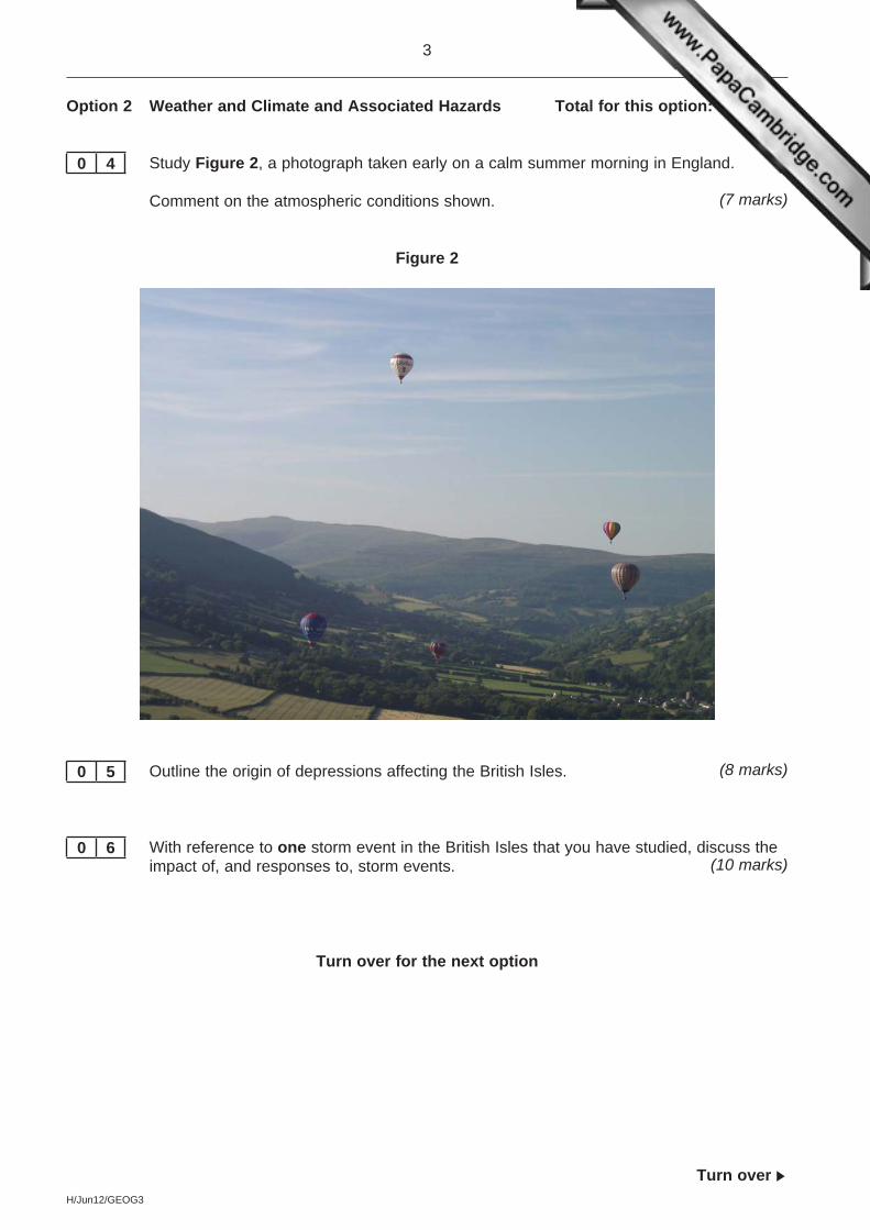
For this paper you must have:l an AQA 12-page answer book.You may use a calculator.
Time allowedl 2 hours 30 minutes
Instructionsl Use black ink or black ball-point pen. Pencil should only be used for drawing.l Write the information required on the front of your answer book. The Examining Body for this
paper is AQA. The Paper Reference is GEOG3.l Answer three options: one from each Section. In Section C, you must not answer the same option
as those chosen in Sections A and B.l Use sketch maps, diagrams and specific examples, where appropriate.l Do all rough work in your answer book. Cross through any work that you do not want to be marked.
Informationl The marks for questions are shown in brackets.l The maximum mark for this paper is 90.l You will be marked on your ability to: – use good English – organise information clearly – use specialist vocabulary where appropriate.
Advicel You are advised to spend about 45 minutes on each of Sections A and B and about 60 minutes on
You must not answer the option that you will answer in Section C.
Option 1 Plate Tectonics and Associated Hazards Total for this option: 25 marks
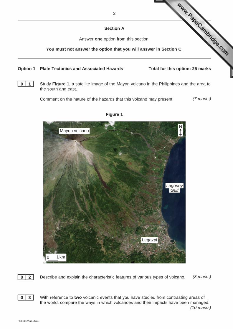
0 1 Study Figure 1, a satellite image of the Mayon volcano in the Philippines and the area to the south and east.
Comment on the nature of the hazards that this volcano may present. (7 marks)
Figure 1
Legazpi
1 km0
LagonoyGulf
Mayon volcanoN
0 2 Describe and explain the characteristic features of various types of volcano. (8 marks)
0 3 With reference to two volcanic events that you have studied from contrasting areas of the world, compare the ways in which volcanoes and their impacts have been managed.
You must not answer the option that you will answer in Section C.
Option 4 World Cities Total for this option: 25 marks
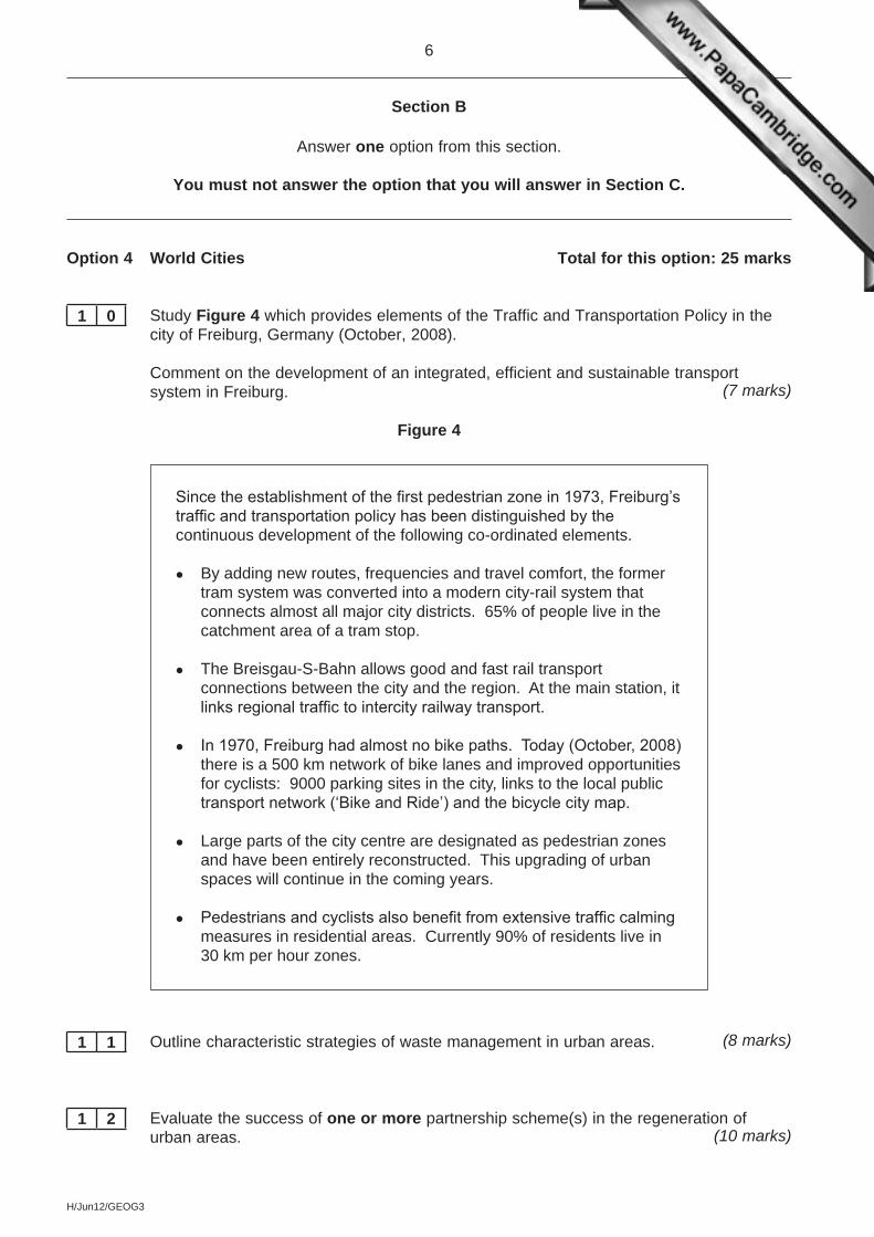
1 0 Study Figure 4 which provides elements of the Traffic and Transportation Policy in the city of Freiburg, Germany (October, 2008).
Comment on the development of an integrated, efficient and sustainable transport system in Freiburg. (7 marks)
Figure 4
Since the establishment of the first pedestrian zone in 1973, Freiburg’s traffic and transportation policy has been distinguished by the continuous development of the following co-ordinated elements.
l By adding new routes, frequencies and travel comfort, the former tram system was converted into a modern city-rail system that connects almost all major city districts. 65% of people live in the catchment area of a tram stop.
l The Breisgau-S-Bahn allows good and fast rail transport connections between the city and the region. At the main station, it links regional traffic to intercity railway transport.
l In 1970, Freiburg had almost no bike paths. Today (October, 2008) there is a 500 km network of bike lanes and improved opportunities for cyclists: 9000 parking sites in the city, links to the local public transport network (‘Bike and Ride’) and the bicycle city map.
l Large parts of the city centre are designated as pedestrian zones and have been entirely reconstructed. This upgrading of urban spaces will continue in the coming years.
l Pedestrians and cyclists also benefit from extensive traffic calming measures in residential areas. Currently 90% of residents live in 30 km per hour zones.
1 1 Outline characteristic strategies of waste management in urban areas. (8 marks)
1 2 Evaluate the success of one or more partnership scheme(s) in the regeneration of urban areas. (10 marks)
Option 5 Development and Globalisation Total for this option: 25 marks
1 3 Study Figure 5 which shows a development by the oil company Royal Dutch Shell in a remote part of Canada.
Comment on the possible socio-economic and environmental impacts of this development. (7 marks)
Figure 5
1 4 Outline the spatial organisation of transnational corporations (TNCs). (8 marks)
1 5 With reference to contrasting areas of the world, discuss the development issue: ‘Economic sustainability versus environmental sustainability’. (10 marks)
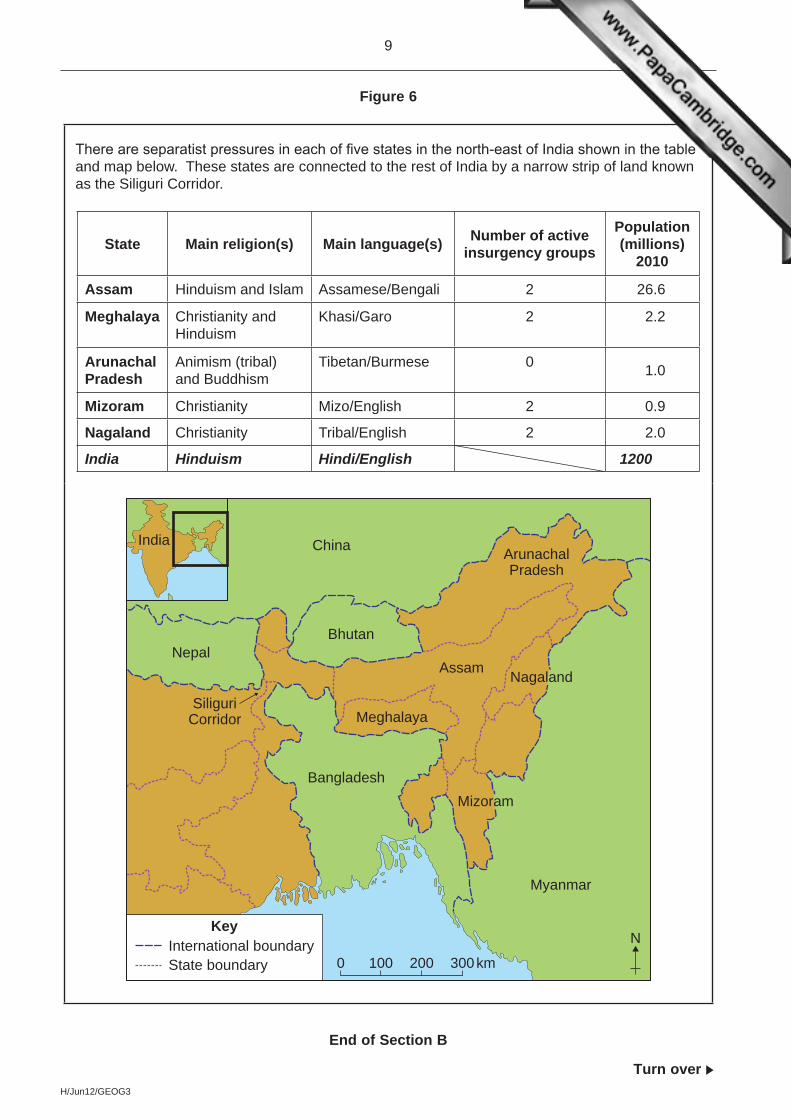
There are separatist pressures in each of five states in the north-east of India shown in the table and map below. These states are connected to the rest of India by a narrow strip of land known as the Siliguri Corridor.
State Main religion(s) Main language(s) Number of active insurgency groups
You must not answer the option answered in either Section A or Section B.
Note to CandidateYou should bear in mind that the essay questions below are synoptic in nature. In your response to these questions you are required to show your knowledge and understanding of different aspects of geography, the connections between these different aspects and, where relevant, of human perspectives upon geographical themes and issues.
Option 1 Plate Tectonics and Associated Hazards
1 9 Evaluate how plate tectonics theory helps our understanding of the distribution of seismic and volcanic events. (40 marks)
Option 2 Weather and Climate and Associated Hazards
2 0 Assess the relative roles of sub-tropical anticyclones and the inter-tropical convergence zone in creating the characteristic features of the climate of one tropical region that you have studied. (40 marks)
Option 3 Ecosystems: Change and Challenge
2 1 Evaluate the relative roles of natural succession and human activities in the creation of ecosystems within the British Isles. (40 marks)
Option 4 World Cities
2 2 ‘The decentralisation of retailing and other services has had a major impact on urban areas.’
To what extent do you agree with this statement? (40 marks)
Option 5 Development and Globalisation
2 3 ‘The global economy has moved on from the Asian Tigers; the present and the future of the global economy now lie elsewhere.’
To what extent do you agree with this statement? (40 marks)
Option 6 Contemporary Conflicts and Challenges
2 4 ‘Conflict has a significant geographical impact on the area(s) affected.’
To what extent do you agree with this statement? (40 marks)
ACKNOWLEDGEMENT OF COPYRIGHT-HOLDERS AND PUBLISHERS
Permission to reproduce all copyright material has been applied for. In some cases, efforts to contact copyright-holders have been unsuccessful and AQA will be happy to rectify any omissions of acknowledgements in future papers if notified.
Figure 1: Source: NASAFigure 2: Reproduced with the permission of Andy Freem from AQA Geography A2 Kerboodle Book – ‘The relationship between temperature and height


![INCPM Booklet Jun12[1]](https://static.documents.pub/doc/80x56/577cc7081a28aba7119fd1bf/incpm-booklet-jun121.jpg)


