ARABLE LAND IN THE UNITED STATES. By O. E. BAKER, Agriculturist, and H. M. STRONG, Assistant in Agricultural Geography, Office of Farm Management. THE PUKPOSE of this article is to describe, only in out- line, the location and extent of present arable, nonarable, and potentially arable land in the United States, with a view to providing those interested in land utilization with a broad, generalized conception of the subject. PRESENT ARABLE LAND. It will be seen from map 1 that most of the present arable land in the United States ("improved land " according to the Census terminology) lies east of the 100th meridian, and is concentrated in a triangular area roughly bounded by a line from southwestern Pennsylvania across Kentucky and Missouri to central Oklahoma, thence northerly to north central North Dakota, and thence southeasterly across Min- nesota, Wisconsin, and Michigan to the point of beginning. In this region, which includes only one-fifth of the land of the United States, are produced four-fifths of the corn, three- fourths of the wheat and oats, and three-fifths of the hay crop of the Nation. No region in the world of equal size af- fords so favorable natural conditions for the growth of corn, the most productive per acre of the food crops, and few regions possess so favorable conditions for the culture of the small grain and hay crops. Outside this region the only areas where more than half of the land area was improved farm land in 1910 were central and western New York, southeastern Pennsylvania and ad- joining sections of New Jersey, Maryland, and Virginia, the Nashville Basin and Tennessee Eiver Valley in Tennessee, a few counties in the Piedmont of Georgia and in the upper Coastal Plain of Georgia, Alabama, and Mississippi, two counties in the Delta of Louisiana, the Black Waxy Prairie of Texas, the valleys of California, and the plateau of south- eastern Washington, northeastern Oregon, and adjacent sec- tion of Idaho. Improved farm land constitutes less than 433
Transcript
ARABLE LAND IN THE UNITED STATES.
By O. E. BAKER, Agriculturist, and H. M. STRONG, Assistant in Agricultural Geography, Office of Farm Management.
THE PUKPOSE of this article is to describe, only in out- line, the location and extent of present arable, nonarable,
and potentially arable land in the United States, with a view to providing those interested in land utilization with a broad, generalized conception of the subject.
PRESENT ARABLE LAND.
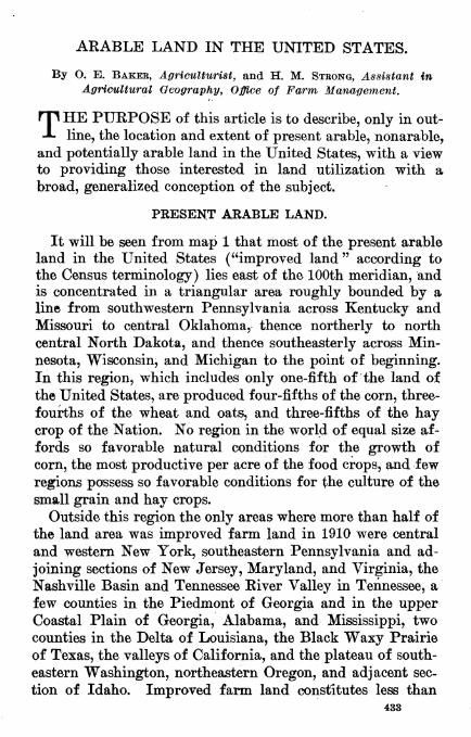
It will be seen from map 1 that most of the present arable land in the United States ("improved land " according to the Census terminology) lies east of the 100th meridian, and is concentrated in a triangular area roughly bounded by a line from southwestern Pennsylvania across Kentucky and Missouri to central Oklahoma, thence northerly to north central North Dakota, and thence southeasterly across Min- nesota, Wisconsin, and Michigan to the point of beginning. In this region, which includes only one-fifth of the land of the United States, are produced four-fifths of the corn, three- fourths of the wheat and oats, and three-fifths of the hay crop of the Nation. No region in the world of equal size af- fords so favorable natural conditions for the growth of corn, the most productive per acre of the food crops, and few regions possess so favorable conditions for the culture of the small grain and hay crops.
Outside this region the only areas where more than half of the land area was improved farm land in 1910 were central and western New York, southeastern Pennsylvania and ad- joining sections of New Jersey, Maryland, and Virginia, the Nashville Basin and Tennessee Eiver Valley in Tennessee, a few counties in the Piedmont of Georgia and in the upper Coastal Plain of Georgia, Alabama, and Mississippi, two counties in the Delta of Louisiana, the Black Waxy Prairie of Texas, the valleys of California, and the plateau of south- eastern Washington, northeastern Oregon, and adjacent sec- tion of Idaho. Improved farm land constitutes less than
433
434 Yearbook of the Department of Agriculture.
one-eighth of the total land area along the Gulf and South Atlantic Coasts, in the northern portion of the Lake States, and in most of the West.
NONARABLE LAND.
Map 2 shows the land not in farms in 1910, It is land which no one has thought it worth while trying to make into a farm, or, in certain localities, land which has been in farms and was abandoned. It includes much land scattered throughout the southern and eastern States, most of the land along the Canadian border from Maine to Minnesota, and nearly all the land in large areas of the West—in all, over half of the land area of the country. The question arises, Why is this vast domain unoccupied by farms?
Several conditions must be met in order that land may be adapted to the production of crops. First, in this country, land generally must not be so stony or hilly as to prevent the use of the plow and other farm machinery. Map 3 shows the topography of the United States in a generalized way, and explains that vast areas in the western part of the United States and smaller areas in the Appalachian Mountains of the East are not in farms because of their rough surface. Probably 350,000,000 acres, or nearly one-fifth of the land area of the United States, is too hilly or rough for the suc- cessful production of crops. This mountainous or stony land, where the rainfall is sufficient, is adapted to the growth of forests, and where the rainfall is light is grazed by roving flocks of sheep or by cattle.
Secondly, the rainfall must be sufficient for profitable pro- duction of crops. Map 4 shows the average annual precipi- tation (rain, melted snow, sleet, and hail) in the United States, and helps to explain why farms are absent from much of the land level enough for agriculture west of the 100th meridian. Where the average annual precipitation in Montana is less than 12 to 15 inches, or less than 18 iuches in eastern Colorado, 20 inches in the Panhandle of Texas, and 25 inches in the lower Kio Grande Valley of Texas, the pro- duction of crops without irrigation becomes a precarious business under present conditions. This minimum rainfall requirement for successful crop production ranges from 9 to 30 inches in different parts of the United States according
Yearbook U. S. Dept. of Agriculture. 1918. PLATE LV.
Map 3 shows the tupograohv of the United States in a generaUzed way. It is a photograph of a reUef model of the Uniteil States, and was courteously supplied by the U. S. t.eological burvey.
«4-3
»I' III
■5"gí £*« tr So" ë E?
R3 3
rp-
S n> °
MAP 4 «0 Í00"
11 B.o
SCALE OF SHADES
UNDER 10 INCHES
10 TO 15 INCHES
15 TO 20 INCHES
^/^ 20 TO 30 INCHES
30 TO 40 INCHES
40 TO 50 INCHES
50 TO 60 INCHES
60 TO 80 INCHES
SO TO 100 INCHES
100 TO 120 INCHE^
120 AND OVER
>
Arable Land in the United States, 435
to local climatic and soil conditions. In general, it increases from north to south with increasing evaporation and les$ fa- vorable type and seasonal distribution of precipitation. Probably 600,000,000 acres, or nearly one-third of the land area of the United States, receives ' insufficient rainfall for the profitable production of crops at normal prices, and pos- sesses no possibilities of irrigation. In occasional years of heavier rainfall, large profits may be made growing crops in these semiarid regions, but in the long run it pays better in most localities to use such land for grazing, and grow only a few acres of crops for supplementary feed in swales and seepage basins.
Thirdly, the amount of heat must be sufficient and the season between killing frosts long eiiough to mature crops. Map 5, "Length of the Growing Season," shows that over a large extent of elevated land in the West, and also in the Adirondacks and a portion of northern Maine, the average growing season is less than 90 days, and frosts may occur during the summer. Light frosts are not, however, seriously injurious to certain hardy crops, and there is very little area in the United States otherwise suitable for crops where the small amount of heat received or shortness of the growing season prevents the successful production of hay and cer- tain varieties of barley, oat^, spring wheat, and potatoes.
Lastly, there are in the United States considerable areas of land where the soil is too sandy or infertile for the profit- able production of crops at prevailing prices. Such soils are better adapted to forest, and when cleared for agricultural use are generally soon allowed to grow up again to brush and trees.
In all, about 1,000,000,000 acres, or more than one-half of the land area of the United States, is unfitted for the profit- able production of crops, owing either to rough topography, deficient rainfall, low temperature, or infertile soil. This land, except about 40,000,000 acres of absolute desert, is used, though often not as fully as it might be, for the production of wood and timber and for grazing live stock.
POTENTIALLY ARABLE LAND.
In addition to these largely irremediable conditions which limit the expansion of crop area in the United States, there
436 Yearbook of the Department of Agriculture,
are other natural conditions amenable to improvement which have retarded agricultural development over large areas.
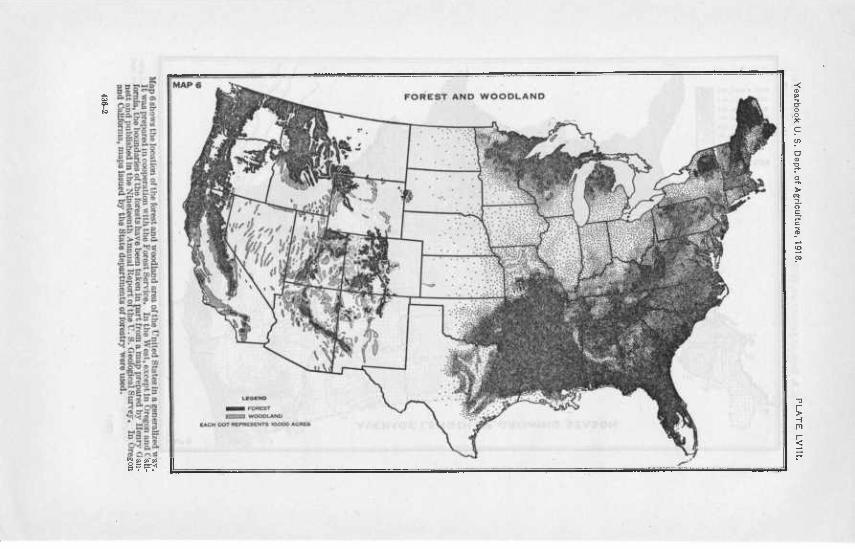
Map 7 shows the areas of forest and cut-over land suit- able for agricultural use where the cost of clearing has re- tarded utilization. In the northern sections of Michigan, Wisconsin, and Minnesota, and along the North Pacific coast, there is much forest and cut-over land which can be and is being made into farms, but at great expenditure of labor. In the South, from Virginia and the Carolinas to central Texas, a vast amount of cut-over land and wood- land is being redeemed gradually for agriculture. It may be estimated that about 200,000,000 acres of forest, " cut-over " land, and woodland in the United States, including that in farms, could be used for crops after clearing, or more than one-tenth of the land area of the country.
If all this agriculturally suitable forest and cut-over land were made into farms averaging 160 acres in size, it would provide 1,250,000 farms, an addition of about 20 per cent to the total number of farms in the country. These wooded areas constitute the greatest unreclaimed agricultural re- source of the Nation, but the development of these lands must necessarily be slow, and should be undertaken only by men accustomed to hard labor and willing to endure privation. It is unlikely that more than 50,000,000 acres, or enough for perhaps 300,000 farms, will be cleared by the present genera- tion of farmers, unless the Government assumes responsi- bility.
The next greatest undeveloped agricultural resource of the country is to be found in the swamps and other wet lands susceptible of drainage. It has been estimated that there are some 60,000,000 acres of such land suitable for the produc- tion of crops after reclamation, or enough to make 1,000,000 farms of 60 acres each of improved land. This land, as shown in map 8, is located largely in the Mississippi Eiver bottoms and other river bottoms of the Coastal Plain of the South, and in the peat bogs and muck lands of the glaciated Lake States and Northeastern States. It is for the most part potentially fertile land. But drainage is an expensive operation, often involving cooperative or capitalistic effort, and will require time, very likely a half century or more, for
FOREST AND WOODLAND. 360.000,000 ACRES IN FARMS. 60.000.000 ACRES
(EASTERN STATES. ISO.000.000 A NOT IN FARMS. (WESTERN STATES. 150.000.000 A
RANGE LAND AND UNIMPROVED PASTURE 615.000.000 ACRES
EASTERN STATES. 15.000.000 ACRES
WESTERN STATES. 600.000.000 ACRES
DESERT (NOT GRAZED) 38,000,000 ACRES
CITIES.ROADS,ETC..40,000,000 ACRES OR MORE
435-6
Arable Land in the United States. 437
the complete development of the 60,000,000 acres. Practically none of this land is available for settlement at present.
The third opportunity for expansion of our agricultural area is found in the potentially irrigable land awaiting de- velopment in the Western States, estimated at 30,000,000 acres if all available sources of water supply were fully utilized (see map 9). This is double the present area of irrigated land, and would provide 340,000 farms averaging 87 acres in size, which is the average acreage per farm of irrigated land as shown by the Census of 1910. But the cost of construction of dams in the mountains and of irrigation canals and ditches is very great and becomes progressively greater as the less favorable projects are developed. At pres- ent the supply of land under the ditch and ready for farm- ing in several Federal reclamation projects exceeds the de- mand at the price quoted, which in many cases includes only the cost of development. It appears likely, therefore, that the development of these potentially irrigable areas will re- quire many yearSj and in the end will provide fewer farms than either the forest and cut-over lands, or the swamp and overflow lands. In 1910, about 160,000 farms in the Western States were irrigated in whole or in part, and the slight in- crease since that date has been confined principally to the Federal reclamation projects, upon which there are now (1918) about 27,000 farmers.
A different type of land, some of which will be utilized gradually for the production of crops, is that in our eastern farms classified in the census reports as "unimproved land other than woodland." This land consists largely of unused fields, stony upland pastures in hilly regions, and parcels of waste land, and includes in all about 50,000,000 acres in our humid Eastern States. Some of this land has been in crops in the past, constituting in part the so-called abandoned farms, and if prices of farm products continue high and farm labor again becomes comparatively cheap, a portion of this land will undoubtedly be put into crops, though prob- ably never more than two-thirds, or perhaps 35,000,000 acres.
Finally, the further development of dry farming may make room for a few more farmers in the West. Under the 640 acres grazing homestead act passed in 1916, somewhat over
438 Yearbook of the Department of Agriculture.
45,000 applications had been made and approved by October 1, 1918. In the opinion of those best informed, most of these grazing homesteads which afford promise of support- ing a family have been applied for.
TOTAL ARABLE LAND.
According to the best information, we have in all about 850,000,000 acres of land at present in crops and potentially available for the production of crops (see PI. LXII). This is 45 per cent of the total land area of the United States, or about the same proportion the arable land of France is of the total area, and some 5 per cent less than the proportion of the land in Germany that is arable. In view of the fact that these countries have practically no semiarid area, such as covers about one-third of the United States, it seems prob- able that this estimate of the total arable land of the United States, although smaller than those made heretofore, is too high rather than too low.
Of these 850,000,000 acres, nearly 480,000,000 acres were ^' improved " in 1910. The remainder consists of about 200,- 000,000 acres of potentially arable forest and cut-over land, of which probably more than one-half is at present included in the 190,000,000 acres of woodland in farms; 60,000,000 acres of swamps and other wet lands awaiting reclamation by drainage ; 30,000,000 acres of potentially irrigable land ; and about 80,000,000 acres of other lands, mostly "unimproved land other than woodland" in eastern farms and dry-farm- ing land in the West.
These undeveloped lands may provide eventually about 3,000,000 farms, an increase of somewhat less than 50 per cent over the number of farms in the United States to-day. But unquestionably the better and the best land which it has been possible to develop by individual effort is now "im- proved " land in farms, and much of that which remains un- developed must await the gradual application of large amounts of capital to its development, supplied either by private initiative or by the Government.
The 1,000,000,000 acres or more of nonarable land consists of about 360,000,000 acres of absolute forest land; that is, land not adapted to crops but where climatic conditions per- mit the growth of forests; 615,000,000 acres of grazing land,
Arable Land in the united States. 439
practically all in the Western States ; and 40,000,000 acres of absolute desert land. In addition, there are about 40,000,000 acres of land at present in cities, rural highways, and rail- road rights of way, an amount which will gradually increase with increasing population.
ECONOMIC ASPECTS.
All these estimates refer merely to the potential fitness of the land for agriculture, and do not take into account eco- nomic aspects of the subject. It may be found, for instance, that 360,000,000 acres of forest will not be sufficient to supply the needs of the Nation for forest products, and that some of the lower grades of potentially arable land can be more profitably utilized for the production of timber. In fact, as- suming that the annual per capita consumption of forest products will gradually decrease to half that at present, a very conservative estimate, and allowing a very liberal esti- mate of the rate of growth of forests under intensive man- agement (33 cubic feet per acre per annum), the country will require a woodland area of at least 450 million acres for a population of 150 million people. It does not seem likely, therefore, that the forest area will ever be reduced to 360 million acres, but that there always will be considerable po- tentially arable land, mostly of poor quality, in forest, as is the case in the well-developed countries of Europe to-day.^ Similarly it is practically certain that an appreciable propor- tion of the land suitable for crops will be kept in pasture. At present the ratio of improved pasture to cropped land in the United States i^ about one to four, and in many older and more highly developed agricultural regions, especially those of England and northern France, the proportion in pasture is much greater.
Also it should be kept in mind that probably half of the 370,000,000 acres of reclaimable arable land is at present in farms, and that most of this land in farms is unlikely to need the assistance of the Government in its reclamation. Farm- ers who live in forested regions commonly clear off a few acres of timber each winter, and some who have poorly drained meadows or fields put in a few lines of tile each year. In this way, and also by plowing up pasture lands for crops, the area in staple crops increased 37,000,000 acres be-
440 Yearbook of the Dejyartment of Agriculture,
tween 1914 and 1918, according to a recent estimate of the Bureau of Crop Estimates, an increase of nearly 10 per cent, which is much greater than the percentage increase in the population of the Nation. This 4-year increase in acreage of the staple crops is equivalent to the acreage of all crops in 1910 in the New England States, New York, Pennsylvania, New Jersey, Delaware, Maryland, West Virginia, Virginia, and North Carolina.
Increased production of agricultural products may also be expected to come from more intensive farming. The yields per acre of the staple crops, with the possible exception of corn, have shown a general tendency upward during the last 25 years.
Yield per acre of 6 leading food crops in the united States, five-year averages for 1866-1870 to 1900-1915,
[Compiled from reports of Bureau of Crop Estimates, United States Depart- ment of Agriculture.]
High prices of agricultural products result in improved methods and increasing intensity of culture, as well as in making possible the cultivation of less desirable lands. Both methods of increasing production should be and will be used ; but in many cases the application of more capital and labor to land now in use will bring greater returns than the use^ of the same capital and labor in the development of new lands.
It appears probable, therefore, that the area in crops will never reach the estimated possible total of 850 million acres, but that with increasing cost of reclamation, the trend will be toward more intensive cultivation of the more fertile or
Arable Land in the United States. 441
favorably situated land and use of the lower grades of arable land for grazing or production of timber. This trend is illustrated in the Northeastern States by the well-cultivated lowlands and the so-called abandoned farms in the high- lands. Farms close to good markets can be bought in these States for less than the cost of the buildings. In the densely populated and highly developed countries of northwestern Europe, where an approximately stationary condition has been reached, about half the land area is arable, whereas in the humid portion of the United States about 38 per cent of the land area is " improved "—using the terminology of the Census. As geographic conditions in so far as they relate to the potential utilization of land in the two regions are somewhat similar, it may be anticipated that when the population of the United States becomes as dense as that of northwestern Europe the improved land will be about half of the humid area of th6 Nation, or 600 to 700 million acres.