Archaeological monitoring and recording along the Wivenhoe cycle path (phase 2), Colchester Road, Wivenhoe, Essex December 2015-March 2016 by Laura Pooley figures by Mark Baister and Emma Holloway fieldwork by Robin Mathieson commissioned by Adrian Gascoyne of Essex County Council Place Services on behalf of Ringway Jacobs Hedgerow removal application no.: 150700 CAT project ref.: 15/11g NGR: TM 0375 2383 (NW) to TM 0408 2315 (SE) Colchester Museum accession code: COLEM 2015.71 UAD event no.: ECC4295 OASIS reference: colchest3-245196 Colchester Archaeological Trust Roman Circus House Roman Circus Walk, Colchester, Essex CO2 7GZ tel.: 01206 501785 email: [email protected]CAT Report 925 March 2016
Transcript
Archaeological monitoring and recording along the Wivenhoe cycle path (phase 2),
Colchester Road, Wivenhoe, Essex
December 2015-March 2016
by Laura Pooley figures by Mark Baister and Emma Holloway
fieldwork by Robin Mathieson
commissioned by Adrian Gascoyne of Essex County Council
Cover: general site shot Photographs 1-2 Excavation of the service trench, looking S, and 2 representative section, looking E Photographs 3-4 F1 and F2, looking S 3 Photographs 5-6 Removal of pre-existing surface, looking S, and 3 stripping to natural, looking N Photographs 7-8 Construction of new road/cycle path surface, 4 looking N and S Photographs 9-10 Deep (3.2m) drainage trenches, looking N and S 4 Photographs 11-12 Soakaways associated with the drainage trenches, 5 looking W and E Photographs 13-14 Drainage ditch, looking S 5 Fig 1 Site location Fig 2 Areas monitored Fig 3 Sections
CAT Report 925: Archaeological Monitoring and Recording at Wivenhoe Cycle Path, Colchester Road, Wivenhoe – December 2015-March 2016
1
1 Summary Archaeological monitoring and recording was carried out during the construction of phase 2 of the Wivenhoe cycle path, Colchester Road, Wivenhoe, located between Boundary Road and Vine Road. Despite being located in an area of known cropmarks including ditched enclosures and trackways, no significant archaeological horizons were identified during the groundworks.
2 Introduction (Fig 1) This report presents the results of archaeological monitoring and recording carried out during the construction of the Wivenhoe cycle path (phase 2), Colchester Road, Wivenhoe, Essex which was carried out between December 2015 and March 2016. The work was commissioned by Adrian Gascoyne of Essex County Council Place Services on behalf of Ringway Jacobs, and was undertaken by Colchester Archaeological Trust (CAT).
In response to consultation with Colchester Borough Council Planning Services (CBCPS), Colchester Borough Council Archaeological Advisor Jess Tipper advised that in order to establish the archaeological implications of this application, the applicant should be required to commission a scheme of archaeological investigation in accordance with paragraphs 128, 129 and 132 of the National Planning Policy Framework (DCLG 2012). All archaeological work was carried out in accordance with a Brief for Continuous Archaeological Monitoring and Recording, detailing the required archaeological work, written by Jess Tipper (CBCPS 2015), and a written scheme of investigation (WSI) prepared by Adrian Gascoyne (Archaeological Advisor for Essex County Council Place Services) in response to the brief and agreed with CBCPS (CAT 2016) In addition to the brief and WSI, all fieldwork and reporting was done in accordance with English Heritage’s Management of Research Projects in the Historic Environment (MoRPHE) (English Heritage 2006), and with Standards for field archaeology in the East of England (EAA 14 and 24). This report mirrors standards and practices contained in the Institute for Archaeologists’ Standard and guidance for archaeological watching brief (CIfA 2014a) and Standard and guidance for the collection, documentation, conservation and research of archaeological materials (CIfA 2014b).
3 Archaeological background The following archaeological background draws on the major published sources for Colchester archaeology (listed below), and also on the Urban Archaeological Database (UAD) created by Colchester Borough Council, and the Essex Historic Environment Record (EHER). The EHER records two known archaeological sites within the close proximity of the cycle path, situated on both sides of Colchester Road. These are EHER 2420 and EHER 16727, which have been recorded as archaeological cropmarks. Both sites include the buried ditches of former linear field boundaries. To the west is a number of ditched enclosures and a possible double-ditched trackway. Phase 1 of the Wivenhoe cycle path was carried out in July 2015 and consisted of three permeation trial pits (1.5m long by 0.45m wide) laid out along the route of the cycle path (CAT Report 852). Modern topsoil sealed subsoil (an orangey-brown loamy sand), which overlaid natural sands and gravels. No significant archaeological horizons were identified.
CAT Report 925: Archaeological Monitoring and Recording at Wivenhoe Cycle Path, Colchester Road, Wivenhoe – December 2015-March 2016
2
4 Results (Figs 2-3) The Wivenhoe cycle path lies adjacent to the Colchester Road, Wivenhoe, between Boundary Road and Vine Road, TM 0375 2383 (NW) to TM 0408 2315 (SE). Groundworks included the excavation of a service trench, drainage trench with soakaways and drainage ditch, and the removal of the pre-existing road/footpath surface before the new one was laid. All work was undertaken under CAT supervision by a wheeled digger using a toothless bucket. Three layers were identified across the development area. Modern topsoil (L1, 340-380mm thick) sealed modern subsoil (L2, at least 400mm thick), which sealed natural sand (L3). Service Trench The service trench was located along the southern side of the cycle path. It measured 400mm wide and approximately 750mm deep, and was dug through L1 and L2. Two modern pits were recorded (F1 and F2) cut into L2.
Photographs 1-2 Excavation of the service trench, looking S, and representative section, looking E
CAT Report 925: Archaeological Monitoring and Recording at Wivenhoe Cycle Path, Colchester Road, Wivenhoe – December 2015-March 2016
3
Photographs 3-4 F1 and F2, looking S Stripping The pre-existing road/footpath surface was removed and stripped to natural sand. No significant archaeological horizons were identified.
Photographs 5-6 Removal of pre-existing surface, looking S, and stripping to natural, looking N
CAT Report 925: Archaeological Monitoring and Recording at Wivenhoe Cycle Path, Colchester Road, Wivenhoe – December 2015-March 2016
4
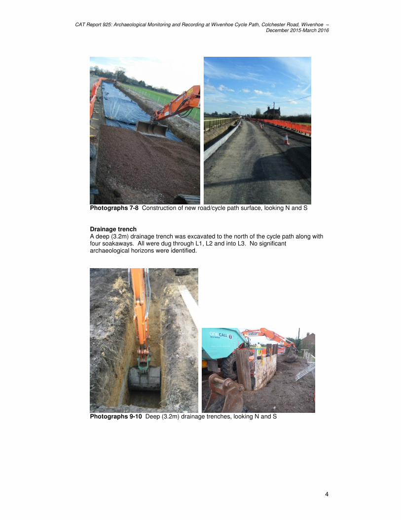
Photographs 7-8 Construction of new road/cycle path surface, looking N and S Drainage trench A deep (3.2m) drainage trench was excavated to the north of the cycle path along with four soakaways. All were dug through L1, L2 and into L3. No significant archaeological horizons were identified.
Photographs 9-10 Deep (3.2m) drainage trenches, looking N and S
CAT Report 925: Archaeological Monitoring and Recording at Wivenhoe Cycle Path, Colchester Road, Wivenhoe – December 2015-March 2016
5
Photographs 11-12 Soakaways associated with the drainage trenches, looking W and E Drainage ditch A drainage ditch (c 700mm deep) was also excavated along the northern edge of the cycle path. It was dug through L1, L2 and into L3. No significant archaeological horizons were identified.
Photographs 13-14 Drainage ditch, looking S
5 Finds Modern finds were noted in L1 and L2 but not retained. No significant archaeological finds were identified during any of the groundworks.
6 Discussion Despite being located within an area of archaeological importance no significant archaeological horizons were identified. Modern layers were recorded sealing natural across all the groundworks suggesting that the development site has been greatly disturbed by modern activity.
7 Acknowledgements CAT thanks Adrian Gascoyne on behalf of Ringway Jacobs for commissioning and funding the work. The project was managed by C Lister and carried out by R
CAT Report 925: Archaeological Monitoring and Recording at Wivenhoe Cycle Path, Colchester Road, Wivenhoe – December 2015-March 2016
6
Mathieson. Figures were prepared by M Baister and E Holloway. The project was monitored for the CBCPS by Jess Tipper.
8 References
Note: all CAT reports, except for DBAs, are available online in PDF format at http://cat.essex.ac.uk
Brown, D 2007 Archaeological Archives: A guide to best practice in creation, compilation, transfer and curation
CAT 2014 Health and Safety Policy CAT Report 852 2015 Archaeological monitoring and recording on a cycle path,
Colchester Road, Wivenhoe, Essex: July 2015 CBCPS 2016 Brief for Continuous Archaeological Monitoring and Recording
at Cycle Path, Colchester Road, Wivenhoe, by J Tipper CIfA 2014a Standard and guidance for archaeological watching brief CIfA 2014b Standard and guidance for the collection, documentation,
conservation and research of archaeological materials DCLG 2012 National Planning Policy Framework. Dept of Communities
and Local Government. EAA 14 2003 Standards for field archaeology in the East of England, East
Anglian Archaeology, Occasional Papers, 14. Ed. D Gurney EAA 24 2011 Research and archaeology revisited: A revised framework for
the East of England, East Anglian Archaeology Occasional Papers 24, by Maria Medlycott
ECCPS 2015
Written Scheme of Investigation (WSI) for continuous archaeological monitoring and recording on cycle path, Colchester Road, Wivenhoe,, Essex, by Adrian Gascoyne
English Heritage 2006 Management of Research Projects in the Historic Environment (English Heritage)
9 Abbreviations and glossary
CAT Colchester Archaeological Trust CBCPS Colchester Borough Council Planning Services CBM brick/tile (ceramic building material) CIfA Chartered Institute for Archaeologists CM Colchester Museum context specific location of finds on an archaeological site ECCPS Essex County Council Place Services feature (F) an identifiable thing like a pit, a wall, a drain: can contain ‘contexts’ layer (L) distinct or distinguishable deposit of soil modern period from c AD 1800 to the present natural geological deposit undisturbed by human activity UAD Urban Archaeological Database WSI Written Scheme of Investigation
10 Contents of archive Finds: none retained Paper and digital record
One A4 document wallet containing: The report (CAT Report 925)
CBCPS Evaluation Brief, ECCPS Written Scheme of Investigation Original site record (Feature and layer sheets, Finds record, plans) Site digital photos and log, Architectural plans, Attendance register, Risk assessment
CAT Report 925: Archaeological Monitoring and Recording at Wivenhoe Cycle Path, Colchester Road, Wivenhoe – December 2015-March 2016
7
11 Archive deposition The paper and digital archive is currently held by the Colchester Archaeological Trust at Roman Circus House, Roman Circus Walk, Colchester, Essex, CO2 7GZ, but will be permanently deposited with Colchester Museum under accession code: COLEM 2015.71.
Site director/group: Colchester Archaeological Trust
Date of work: December 2015 - March 2016
Size of area investigated:
Location of curating museum: Colchester museum accession code COLEM: 2015.71
Funding source: Developer
Further seasons anticipated? no
Related UAD/SMR number: EHER 2420, 16727
Final report: CAT Report 925
Periods represented: -
SS Summary of fieldwork results: Archaeological monitoring and recording was carried out during the construction of phase 2 of the Wivenhoe cycle path, Colchester Road, Wivenhoe, located between Boundary Road and Vine Road. Despite being located in an area of known cropmarks including ditched enclosures and trackways, no significant archaeological horizons were identified during the groundworks.
Previous summaries/reports: None
CBC monitor: Jess Tipper
Keywords: -
Significance: -
Author of summary: Laura Pooley
Date of summary: March 2016
Title: Written Scheme of Investigation for continuous archaeological monitoring and recording on
Cycle Path, Colchester Road, Wivenhoe, Essex
Planning Reference: Hedgerow Removal Application No.150700 re: works proposed under the
Hedgerow Regulations 1997
NGR: TM 0375 2383 (NW) to TM 0408 2315 (SE)
Prepared for: Ringway Jacobs | Essex County Council
Adrian Gascoyne l [email protected] l 03330136844 | Place Services at Essex County Council
1 Introduction
The Written Scheme of Investigation (WSI) has been prepared in response to a brief issued by
Colchester Borough Council's Archaeological Officer (Tippper 2015). The WSI provides for
archaeological work in relation to a proposed cycle path creation scheme along Colchester Road,
Wivenhoe, Essex, comprising continuous archaeological monitoring and recording.
The WSI is required by the local planning authority in order to detail the archaeological
requirements required to mitigate the impacts of the cycle path creation scheme and is specifically
designed to provide a sound basis for continuous archaeological monitoring and recording, and
post field work practice, including treatment of finds, production of a report, and deposition of the
associated archive to Colchester and Ipswich Museums.
2 Background
2.1 Site Description and Location
The location of the proposed cycle way lies adjacent to the Colchester Road, Wivenhoe, between Boundary Road and Vine Road - TM 0375 2383 (NW) to TM 0408 2315 (SE). The road is bordered to the south by farmland and a number of residential properties (Nos. 8, 19, 11 Colchester Road) and to the north by farmland and properties along Elmstead Road and Feedhams Close.
2.2 Reasons for Project
An application was submitted to Colchester Borough Council (CBC) on 9th April 2015 for the
removal of the hedgerow(s) at land opposite the Flag Inn Public House to the Essex University
entrance and land opposite no's 8, 10 &11) Colchester Road. In response to this application
Colchester Borough Council issued a Hedgerow Retention Notice (16th April 2015). Colchester
Borough Council subsequently (18th June 2015) agreed to grant consent for the removal of the
hedgerow(s) subject to a number of conditions including the following:
An potential damage to archaeological remains by the hedgerow removal is mitigated through an
appropriate programme of archaeological assessment to be agreed with Colchester Borough
Council's Archaeological Officer.
The proposed cycle path is located in an area of archaeological interest. Chapman & Andre’s map
of Essex, dating from 1777, shows that the current line of Colchester Road defines the west side of
Wivenhoe Heath. Wivenhoe Heath was a large (c.90 ha. in area) triangular-shaped heath (dry
pasture for common grazing). The heath had been enclosed by 1800, as shown by the field
boundaries on the 1st edition OS map. A patchwork of fields is marked on both sides of the roads
so it can be concluded that both the hedges, on either side of the road, were present at least in
1800.
Hedges 1 to 4 are located within the area of two archaeological sites, recorded in the Essex
Historic Environment Record (EHER nos. 2420 and 16727).
The proposed works would cause significant ground disturbance that has potential to damage any
archaeological deposit that exists, either fronting the heath or pre-dating the heath. Given the
Adrian Gascoyne l [email protected] l 03330136844 | Place Services at Essex County Council
potential for below ground archaeological remains it is required that a programme of continuous
archaeological monitoring and recording be undertaken as mitigation for this damage.
2.3 Project Description
The following elements of the cycle path creation scheme will be the subjected to the
archaeological work set out in this Written Scheme of Investigation.
· Ground disturbance resulting from the removal of the hedgerow(s) - see figure 1
· Ground disturbance resulting from the construction of the new cycle path
· Ground disturbance associated with road realignment
2.4 Historical and Archaeological Background and Significance
The following archaeological and historical background is based on information in the Essex
Historic Environment Record (EHER).
The EHER records two known archaeological site within the close proximity of the cycle path,
situated on both sides of Colchester Road. These are EHER 2420 and EHER 16727, which have
been recorded as archaeological cropmarks. Both sites include the buried ditches of former linear
field boundaries. To the west lies a number of ditched enclosures and a possible double-ditched
trackway.
The heritage assets that may be affected by the proposed development, comprising below ground
archaeological deposits, are likely to be of local significance, but have the potential to be of
regional significance through the contribution they could make to understanding the formation of
heathland in the East of England.
3 Aims and objectives
3.1 Aims
The general aim of the archaeological work, comprising a programme of continuous archaeological
monitoring during the vegetation removal and groundwork phases of the development, will be to
record and/or excavate any surviving archaeological remains exposed by the removal of the
hedgerow(s) and construction work connected with the creation of the new cycle path and
realignment of the road.
3.2 Objectives
The archaeological work will be designed to meet the following objectives:
· Identify and record evidence for activity pre-dating the formation of the heathland to north
west of Colchester
· Contribute to an understanding of the development and exploitation of the heathland that
once encircled the town of Colchester
· Identify and record evidence for rural settlement fronting onto the former heathland
· Identify and record evidence for the post medieval enclosure of the former heathland
Adrian Gascoyne l [email protected] l 03330136844 | Place Services at Essex County Council
4 Methodology
4.1 General Methodology and Standards
At the start of work an OASIS online record will be initiated and key fields completed on Details,
Location and Creator form.
The archaeological contractor will adhere to: the IfA Standard and Guidance: for archaeological
watching brief (2009); and IfA Code of Conduct (IfA 2008, 2011 & 2012) and the ALGAO
Standards for Field Archaeology in the East of England (Guerney 2003); and will be familiar with
and follow the Guidelines on Standards and Practices for Archaeological Fieldwork in the Borough
of Colchester (1999: Revised 2008), and the Guidelines on the Preparation and Transfer of
Archaeological Archives to Colchester & Ipswich Museums (1996. Revised 2008). throughout the
project.
Any ground works, and also the upcast soil, will be closely monitored during and after excavation by the archaeological contractor in order to ensure no damage occurs to any heritage assets. Adequate time will be allowed for archaeological recording of archaeological deposits during excavation, and of soil sections following excavation. The archaeological investigation will provide a record of archaeological deposits which are damaged or removed by any development [including services and landscaping] permitted by the current hedgerow removal consent. Opportunity will be given to the archaeological contractor to hand excavate and record any archaeological features which appear during earth moving operations. The method and form of development will also monitored to ensure that it conforms to previously
agreed locations and techniques upon which the brief (Tipper 2015) was based.
4.2 Archaeological Monitoring Methodology
All archaeological monitoring and recording will be undertaken by a qualified archaeologist. The
removal of topsoil and any recent overburden will be undertaken using a mechanical excavator
fitted with a toothless bucket. Any areas from which soil is removed will be taken down in spits to
the first significant archaeological horizon, formation levels or surface of the natural geology,
whichever is encountered first.
Should archaeological features or deposits be encountered then all works will be halted, and the
CBCAO will be informed, and given the opportunity of a site visit in order to assess the situation
and review the approach to dealing with any remains. The ground works will either be relocated if
possible, leaving the archaeology preserved in-situ, or the features/deposits will be excavated and
recorded before removal.
All features threatened by the development will be excavated to ensure, where possible, a full
understanding of the deposits. In the case of discreet features these will be half sectioned, for
linear features a minimum length of 1m or 20% of the length shall be excavated. All terminals will
be investigated. In the case of structural evidence a minimum of 50% of each feature will be
excavated. Due regard will be paid to the stratigraphic relationships between features and deposits
during excavation and recording. If important archaeological deposits are identified during the
monitoring, discussion with the CBCAO will take place before excavation commences, to ensure
compliance with the brief (2015) and planning consent.
Adrian Gascoyne l [email protected] l 03330136844 | Place Services at Essex County Council
Excavation of any archaeological feature will be undertaken by hand to fulfil the basic objective of
retrieval of archaeological data affected by the works. Each context will be excavated in sequence.
Occasionally further use of the mechanical excavator may be required. Such techniques are only
suitable for the removal of homogenous low-grade deposits that may give a ‘window’ into
underlying levels. They will not be used on complex stratigraphy and the deposits to be removed
must have been properly recorded first.
In the event that human remains are discovered, and their retrieval cannot be avoided, the
archaeological contractor will obtain the necessary burial licence from the Ministry of Justice and
remove the remains in accordance with best practice and with due care and respect . Wherever
possible, human remains will be located, planned and left in situ. The CBCAO and applicant will be
informed immediately of their discovery.
All features and deposits will be issued with context recording in accordance with the established
practices of the archaeological contractor. All contexts, and any small finds and samples will be
allocated unique numbers. Bulk finds will be collected by context. Digital and black-and white
negative photographs will be taken of all excavations and archaeological features.
Should extensive layered deposits, such as occupation spreads/palaeosoils be encountered, these
deposits will be characterised and appropriately sampled in order to identify the type of activity and
date the material. The results of this sampling strategy will determine whether the deposit requires
full hand excavation. Where full hand excavation of a deposit is not required, and the appropriate
hand excavated sample of the deposit has been completed; the remaining deposit may be stripped
by machine in order to check for any potential underlying features.
A photographic record will be made, comprising digital images with monochrome prints of significant features/feature groups, or in situ artefacts only. The photographic record will aim to provide a representative sample of the areas where archaeological remains have been uncovered. A representative sample of individual feature shots and sections will be taken, in addition to working shots and elements of interest (individual features and group shots). The photographic register will include: shot number, location of shot, direction of shot and a brief description of the subject photographed.
Site plans will be drawn at an appropriate scale (normally 1:20 or 1:50) with larger scale plans of
features as necessary. Section drawings of features and test pits will be drawn at a scale of 1:10.
Artefact assemblages will be recovered to assist in dating stratigraphic sequences and for obtaining ceramic assemblages for comparison with other sites. All artefacts will be retained from excavated contexts unless they are of recent origin. In these cases sufficient material will be retained to date and establish the function of any features. The sampling of eco-factual and palaeo-environmental remains will be developed and implemented with reference to English Heritage Guidelines on Environmental Archaeology (2011). Particular emphasis will be placed upon in-situ prehistoric deposits, in particular those that have potential to hold carbonised material or waterlogged domestic waste assemblages. Any deposits associated with industrial, agricultural or domestic features will be sampled in line with English Heritage recommendations and in accordance with the requirements of the brief and the project aims and objectives. Samples will be collected from suitable excavated contexts, including dated/datable buried soils, well-sealed slowly silting features, sealed hearths, sealed features containing evident carbonised remains, peats, and waterlogged or cess deposits. Advice may be sought from English Heritage’s Regional Scientific Advisor (Zoe Outram) if significant archaeological/environmental remains are uncovered.
Adrian Gascoyne l [email protected] l 03330136844 | Place Services at Essex County Council
The sediments will be described to include information about depth, texture, composition, colour, clast orientation, structure (bedding, ped characteristics etc) and contacts between deposits. Note will also be made of any visible ecofactual, or artefactual inclusions e.g. pottery, daub or charcoal fragments. Bulk soil samples (of 40 litres where possible or 50% of the context if smaller) will be taken to target the recovery of plant remains (including wood, charcoal and macrobotanicals), fish, bird, small mammal and amphibian bone, and small artefacts. Specialist samples may also be taken to target recovery of pollen (using monolith tins), fish and small bone, molluscs, foraminifera, parasites and insects (in small <20 litre samples) or large mammal bones and marine molluscs (in large samples of ~80-100 litres). When taken, large samples will be extracted wholesale from deposits to maximise the range of bone recovered. As a general rule waterlogged wood specimens will be photographed and recorded in detail in their original location prior to being lifted or sampled for more detailed assessment in accordance with English Heritage guidelines (2010). Other scientific dating and geo-archaeological techniques will be considered and employed where appropriate. In all instances deposits with clear intrusive material shall be avoided. Environmental samples will be processed using tank flotation unless considered detrimental to the samples or recovery rate (such as for waterlogged samples). Waterlogged samples will be wet sieved through nested sieves and stored in wet, cool conditions or dried if considered an appropriate form of conservation for the remains. The CBCAO will be kept informed as to the progress of the fieldwork; site visits for monitoring purposes will be arranged as required. 5 Reporting
The final product for this project will be documentation sufficient to the discharge the planning
condition for the development. The level of this documentation will be dependent on the
archaeological results of the project.
5.1 Client Report
Should the monitoring and recording prove largely negative, a short report may be sufficient to a level to be agreed with the CBCAO. If any significant archaeology is exposed and excavated, the report will include:
· A concise non-technical summary of the project results
· Contents list, explanation of the proposed development
· Aims and methods adopted in the course of the archaeological work
· Archaeological and historical background
· Location plan of the site(s) and areas of interest
· Text report giving detailed results with a suitable conclusion and discussion
· Sufficient plans and illustrations to back up the text report
· Sections and drawings of all excavated features showing depth of deposits including present ground level with Ordnance Datum and a scale
· All specialist reports
· Location of the archive and proposals for deposition
· Project timescales and staff structure
· Acknowledgements and references
· Tabulated list of contexts and finds
· A copy of the WSI as an appendix
· A copy of the completed OASIS form as an appendix
· A copy of completed EHER form as an appendix
· A plan of the development site in relation to known archaeological remains recorded in the EHER.
Adrian Gascoyne l [email protected] l 03330136844 | Place Services at Essex County Council
Where positive results are drawn from the project, the results will be related to the relevant known
archaeological information held in the Colchester Urban Archaeological Database (UAD) and
Essex Heritage & Environment Record (EHER).
A full digital copy of the final report will be supplied to the CBCAO for approval within 12 weeks of
the completion of fieldwork, unless other arrangements are negotiated with the client and
Colchester Borough Council in advance and as soon as such issues are identified e.g. it is possible
that the timescale may vary according to the workload and commitments of, for instance, finds
specialists and conservators.
Following approval, a digital copy of the final report will be presented to the client, to the EHER,
and to the CBCAO for inclusion in the Colchester UAD.
A form will be completed for the Online Access to Index of Archaeological Investigations (OASIS)
at http://ads.ahds.ac.uk/project/oasis/ in accordance with the guidelines provided by English
Heritage and the Archaeological Data Service.
5.2 Publication
A summary report in the established format that is suitable for inclusion in the annual ‘Archaeology
in Essex’ section of Essex Archaeology and History will be prepared and included within the final
report, or submitted to the Essex HER by the end of the calendar year in which the assessment
work takes place, whichever is the sooner.
The involvement of the local planning authority historic environment advisor will be acknowledged
in any report or publication generated by this project.
5.3 Archive
On completion of the fieldwork all retained finds will be cleaned, conserved and packaged in
accordance with the requirements and guidelines contained in Guidelines for the Preparation of
Excavation Archives for Long Term Storage (United Kingdom Institute for Conservation, 1990),
Standards in the Museum care of Archaeological Collections (Museums and Galleries Commission
1992), and Archaeological Archives: A guide to best practice in creation, compilation, transfer and
curation (Brown 2007).
The full archive will be deposited at Colchester and Ipswich Museums, subject to the landowner’s
consent, in a manner recommended by the Museum. Costs associated with the deposition of the
archive will be met by the client.
6 Health and Safety
6.1 Site Risk Assessment and Safety Measures
The archaeological monitoring and recording shall be carried out with proper regard to safety and in full compliance with all the relevant provisions contained within the Health &Safety at Work etc Act 1974 and all other Acts, Statutory Instruments, Regulations and Codes of Practice relating to Health and Safety relative to this work. The archaeological contractor will liaise with the client and/or their agent and will follow any additional Health and Safety instructions that are given/agreed.
Adrian Gascoyne l [email protected] l 03330136844 | Place Services at Essex County Council
Prior to and during field work the site will be subject to an on-going assessment of risk to assess all real and potential hazards. Site-specific risk assessments will be kept under review and amended wherever circumstances change which materially affect the level of risk. A written copy of the risk assessment will be made available to view at any time by those affected by the work. The archaeological contractor will provide any necessary protective footwear, high visibility jackets, and safety helmets. Safety helmets will be worn by personnel at all times. The archaeologist(s) will not enter any area under machine excavation without altering the machine driver to his/her intention. The archaeologist(s) shall remain alert and take due care not to impede the progress of moving machinery. He/she shall stand well back from the turning circle of an excavator’s bucket and cab. 7 Resources and Programming 7.1 Staffing and Equipment
The archaeological monitoring and recording will be undertaken by a professional team of
archaeologists from an IfA Registered Organisation (tbc).
Specialists (tbc) will be employed for consultation and analysis as necessary. Up-to-date CVs of all key staff will be made available, and an up-to-date list of specialists will be provided, prior to commencement of the project. Any changes in the staff list will be made known to the CBCAO for approval. 7.2 Timetable and Programme The monitoring and recording will take place during the duration of the ground works associated
with the removal of the hedgerow(s) and ground works associated with the constriction of the cycle
path. This is currently understood to be a period of one month for vegetation removal and advance
statutory undertaker's work, and three months construction phase. The CBCAO will be advised of
the precise start date at least five working days in advance of commencement, and will be kept
informed of changes to the overall programme.
The production of the report will take up to 12 weeks from the completion of the fieldwork. The
client is aware of the methods and provision has been made to allow access to the land to
undertake the monitoring and recording.
8 Finds
Unstratified finds will only be collected where they contribute significantly to the research aims or
are of intrinsic interest. All finds will be exposed, lifted, cleaned, conserved, marked, bagged and
boxed according to the UK Institute for Conservation’s Conservation Guidelines No.2, the Council
for British Archaeology’s First Aid for Finds (Third Edition, 1998) and the Institute for Institute of
Field Archaeologists Guidelines for Finds Work (1992). Iron finds may require X-rays prior to
conservation and similarly residues on pottery may require study ahead of any conservation which
may be appropriate.
All finds will be recorded, collected and labelled according to their individual stratigraphical context.
Finds from each archaeological context will be allocated an individual finds tray and waterproof
Adrian Gascoyne l [email protected] l 03330136844 | Place Services at Essex County Council
labels will be used for each tray to identify unique individual contexts. Each label will be marked
with the appropriate context number in waterproof ink and will be securely attached to each tray.
A policy for marking pottery and other finds will be agreed with Colchester and Ipswich Museums.
Marking will include the site code and context number.
All lifting, conservation or other on-site treatment of delicate finds will be done by appropriately
qualified and experienced conservation specialists. It is anticipated that robust items will be lifted
by site staff.
The site archive will be presented to Colchester and Ipswich Museums in accordance with its
requirements for conservation and storage.
Any other finds remain for the landowner to assess and dispose of. Any finds covered by the
Treasure Act (1996, amended 2003) and Treasure (Designation) Order 2002, including gold and
silver, will be moved to a safe place and reported to her coroner’s office according to the
procedures determined by the Act. They will also be reported to the local finds liaison officer from
the Portable Antiquities Scheme (based at Colchester and Ipswich Museums). Where removal
cannot be effected on the same working day as the discovery, suitable security measures will be
taken to protect the artefacts from theft or damage.
Under the Treasure Act 1996, all treasure finds must be reported to the Coroner in the relevant
district within 14 days of discovery, or within 14 days of the day on which it is realised it might be
treasure, for example after having it identified.
Finds work will be to accepted professional standards and adhere to the CIfA published booklet
Guidelines for Finds Work.
Agreement with the landowner will be sought for deposition of the finds and paper archive.
Arrangements for the finds to be viewed by the landowner will be made if it wishes.
9 Monitoring
The CBCAO will be responsible for monitoring progress and standards throughout the project.
Any variations to the WSI will be agreed with the CBCAO prior to these being carried out.
The CBCAO will be kept informed of progress throughout the project and will be contacted in the
event that significant archaeological/historic features are discovered.
The involvement of the CBCAO will be acknowledged in any report or publication by this project.
10 References
British Archaeology
1998 First Aid for Finds
Brown, D 2007 Archaeological Archives. A guide to best practice in creation, compilation,
transfer and creation. Archaeological Archives Forum and IFA.
Brown, N and
Glazebrook, J
2000 Research and Archaeology: A Framework for the Eastern Counties 2.
Research agenda and strategy East Anglian. Archaeol. Occ. Pap. 8
Chartered
Institute for
Archaeologists
2014 Standards and Guidance for the collection, documentation, conservation and research of archaeological materials
Adrian Gascoyne l [email protected] l 03330136844 | Place Services at Essex County Council
Chartered
Institute for
Archaeologists
2014 Standards and Guidance for an Archaeological Watching Brief
Chartered
Institute for
Archaeologists
2014 Standard and Guidance: for the creation, preparation, transfer and deposition
of archaeological archives
Chartered
Institute for
Archaeologists
2014 Code of Conduct
Colchester &
Ipswich Museums
1999 (rev
2008)
Guidelines on Standards and Practices for Archaeological Fieldwork in the
Borough of Colchester
Colchester &
Ipswich Museums
1996 (rev
2008)
Guidelines on the Preparation and Transfer of Archaeological Archives to
Colchester and Ipswich Museums
DCLG 2012 National Planning Policy Framework
English Heritage 2011 Environmental Archaeology
Guerney, D 2003 Standards for Field Archaeology in the East of England, E Anglian Archaeol.
Occ. Paper 14
Medlycott, M (ed) 2011 Research and Archaeology Revisited: A Revised Framework for the East of
England
Murphy, P and
Wiltshire, P
1994 A Guide to Sampling Archaeological Deposits for Environmental Analysis
Tipper, J 2015 Brief for Continuous Archaeological Monitoring and Recording at Cycle Path,


![Wivenhoe Management Group[2]](https://static.documents.pub/doc/80x56/5567bf84d8b42a944b8b5288/wivenhoe-management-group2.jpg)

