ANALYSIS OF CONTEXTS 31 ARTIFACT, CURATION & STORAGE: 32 SITE REHABILITATION AND CONSERVATION OF IN‐SITU REMAINS: 32 ONGOING INTERPRETATION AND PUBLIC ACCESS: 32 REPORTING REQUIREMENTS: 33 ACQUITTAL: 33
4
1. Oatlands Gaol – General DescriptionThe Oatlands Gaol is owned by Southern Midlands Council, having been transferred
from State Government ownership in 2007. The site comprises approximately
2500 square metres, the main above‐ground features are the Gaoler’s residence,
sandstone perimeter wall, the municipal swimming pool and ancillary pool‐related
structures.
Figure 1.1 ‐ Site plan, Oatlands Gaol.
The current site precincts are generally referred to as the Gaoler’s residence,
(which includes the approach driveway and the former Gaoler’s yard) and the gaol
yard itself, which is the area surrounded by the perimeter walls, now containing
the swimming pool. The Oatlands Gaoler’s Residence is a two‐storey classically
Georgian sandstone residence, in Mason Street, Oatlands. Comprising of twelve
rooms, being the focal point of the site entry, and a very prominent townscape
element.
Figure 1.2 ‐ The rear of the Oatlands Gaoler’s Residence.
5
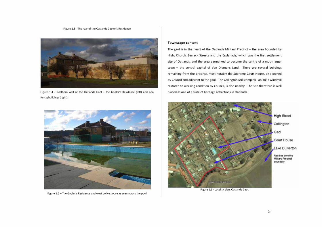
Figure 1.3 ‐ The rear of the Oatlands Gaoler’s Residence.
Figure 1.4 ‐ Northern wall of the Oatlands Gaol – the Gaoler’s Residence (left) and pool
fence/buildings (right).
Figure 1.5 – The Gaoler’s Residence and west police house as seen across the pool.
Townscape context
The gaol is in the heart of the Oatlands Military Precinct – the area bounded by
High, Church, Barrack Streets and the Esplanade, which was the first settlement
site of Oatlands, and the area earmarked to become the centre of a much larger
town – the central capital of Van Diemens Land. There are several buildings
remaining from the precinct, most notably the Supreme Court House, also owned
by Council and adjacent to the gaol. The Callington Mill complex ‐ an 1837 windmill
restored to working condition by Council, is also nearby. The site therefore is well
placed as one of a suite of heritage attractions in Oatlands.
Figure 1.6 ‐ Locality plan, Oatlands Gaol.
6
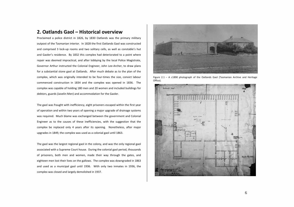
2. Oatlands Gaol – Historical overview Proclaimed a police district in 1826, by 1830 Oatlands was the primary military
outpost of the Tasmanian interior. In 1828 the first Oatlands Gaol was constructed
and comprised 3 lock‐up rooms and two solitary cells, as well as constable’s hut
and Gaoler’s residence. By 1832 this complex had deteriorated to a point where
repair was deemed impractical, and after lobbying by the local Police Magistrate,
Governor Arthur instructed the Colonial Engineer, John Lee‐Archer, to draw plans
for a substantial stone gaol at Oatlands. After much debate as to the plan of the
complex, which was originally intended to be four‐times the size, convict labour
commenced construction in 1834 and the complex was opened in 1836. The
complex was capable of holding 180 men and 20 women and included buildings for
debtors, guards (Javelin Men) and accommodation for the Gaoler.
The gaol was fraught with inefficiency, eight prisoners escaped within the first year
of operation and within two years of opening a major upgrade of drainage systems
was required. Much blame was exchanged between the government and Colonial
Engineer as to the causes of these inefficiencies, with the suggestion that the
complex be replaced only 4 years after its opening. Nonetheless, after major
upgrades in 1849, the complex was used as a colonial gaol until 1863.
The gaol was the largest regional gaol in the colony, and was the only regional gaol
associated with a Supreme Court house. During the colonial gaol period, thousands
of prisoners, both men and women, made their way through the gates, and
eighteen men lost their lives on the gallows. The complex was downgraded in 1863
and used as a municipal gaol until 1936. With only two inmates in 1936, the
complex was closed and largely demolished in 1937.
Figure 2.1 – A c1890 photograph of the Oatlands Gaol (Tasmanian Archive and Heritage Office).
7
Figure 2.2 ‐ An 1849 layout plan of the Oatlands Gaol (Tasmanian Archive & Heritage Office)
Figure 2.3 ‐ The Oatlands Military Precinct 1846, showing the Gaol (Department of Primary
Industry, Parks, Water & Environment).
Figure 2.4 – The Men’s Division showing solitary cells with the Debtor’s ward above, early
1900’s (State Library of Tasmania).
Figure 2.5 – The Men’s Division, showing solitary cells with chapel above c1926 (State Library
of Victoria Heritage Collections).
8
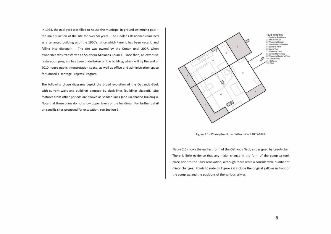
In 1954, the gaol yard was filled to house the municipal in‐ground swimming pool –
the main function of the site for over 50 years. The Gaoler’s Residence remained
as a tenanted building until the 1960’s, since which time it has been vacant, and
falling into disrepair. The site was owned by the Crown until 2007, when
ownership was transferred to Southern Midlands Council. Since then, an extensive
restoration program has been undertaken on the building, which will by the end of
2010 house public interpretation space, as well as office and administration space
for Council’s Heritage Projects Program.
The following phase diagrams depict the broad evolution of the Oatlands Gaol,
with current walls and buildings denoted by black lines (buildings shaded). Site
features from other periods are shown as shaded lines (and un‐shaded buildings).
Note that these plans do not show upper levels of the buildings. For further detail
on specific sites proposed for excavation, see Section 6.
Figure 2.6 – Phase plan of the Oatlands Gaol 1835‐1849.
Figure 2.6 shows the earliest form of the Oatlands Gaol, as designed by Lee‐Archer.
There is little evidence that any major change in the form of the complex took
place prior to the 1849 renovation, although there were a considerable number of
minor changes. Points to note on Figure 2.6 include the original gallows in front of
the complex, and the positions of the various privies.
9
Figure 2.7– Phase plan of the Oatlands Gaol 1849‐c1855
Figure 2.7 shows the ground plan of the Oatlands Gaol following the 1849
renovations. Note the new locations of privies and the addition of the condemned
cells and internal gallows yard.
Figure 2.8 – Phase plan of the Oatlands Gaol c1855‐1937.
Figure 2.8 shows the Oatlands Gaol at the height of its use as a colonial gaol, a form
which continued with only minor modification (i.e. addition of new sheds and
partial demolition of some walls) throughout the Municipal Gaol period. The c1855
major upgrade is evident in the establishment of the debtors shed, partitioning of
the women’s yard, addition of more privies throughout, and the erection of gallows
inside the walls of the gaol. Walling of the men’s yard to form the well, gallows and
debtors yard also occurred c1855.
10
Figure 2.9 – Phase plan of the Oatlands Gaol following the 1937 demolition.
Figure 2.9 depicts the site shortly after the 1937 demolition, with the Gaoler’s
Residence, much of the outer wall and a remnant of the Men’s Division cells
remaining of the original gaol. Some more modern sheds and porches attached to
the Gaoler’s Residence remained at that time (the porches were not removed until
the 1980s).
Figure 2.10 – Phase plan of the Oatlands Gaol 1955‐present
Figure 2.10 depicts the Oatlands Gaol site following the 1955 construction of the
Oatlands Municipal Swimming Pool. Only the Gaoler’s Residence, the lower
portion of the outer wall and one of the entrance wingwalls remain as above
ground evidence of the Gaol. Only minor modifications have been made to the site
during this period, and include addition of ancillary sheds for the pool, addition of
an entry to the southern side of the former gaol yard, and erection of colourbond
pool fencing.
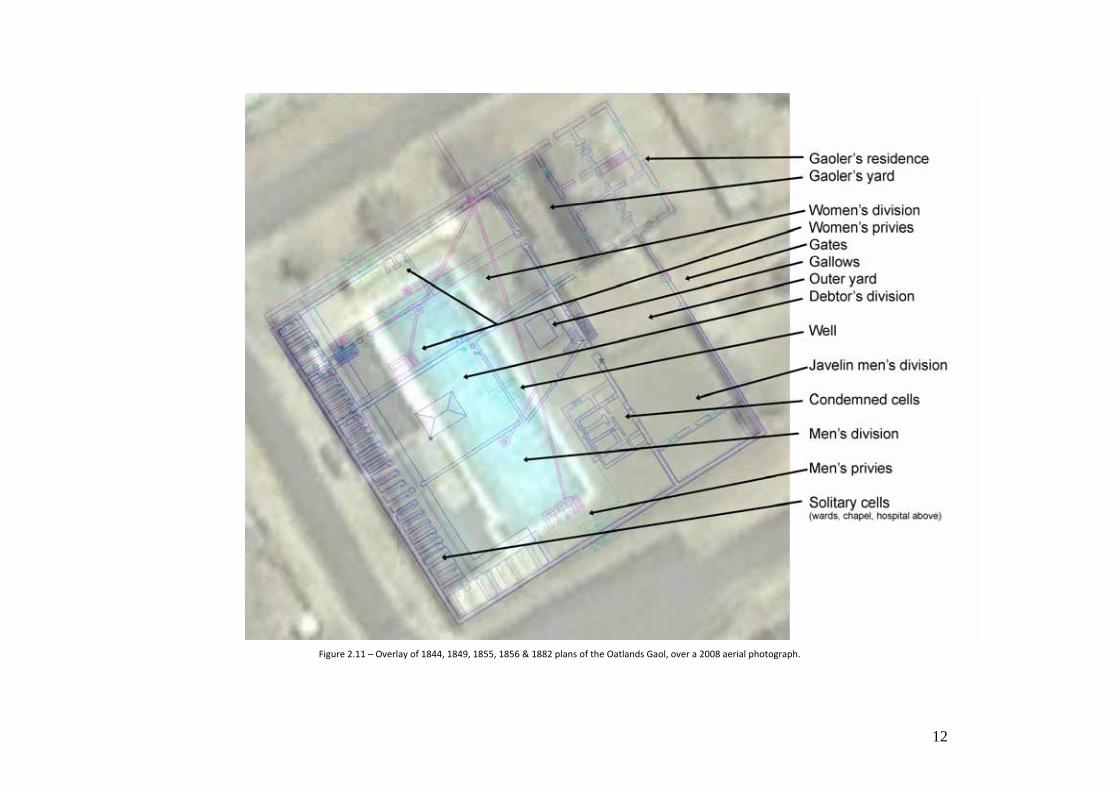
Figure 2.11 provides an overlay of all known site plans (excluding those with a
known low degree of accuracy). This overlay includes the 1844, 1849, 1855, 1856
11
and 1882 surveys of the site ‐ as further detailed in the Conservation Management
Plan1.
1 Williams, B. 2006: Oatlands Gaol Conservation Management Plan 2006. Southern Midlands
Council.
12
Figure 2.11 – Overlay of 1844, 1849, 1855, 1856 & 1882 plans of the Oatlands Gaol, over a 2008 aerial photograph.
13
3. Oatlands Gaol – Conservation Planning
Background & previous archaeological works
In 2004, Southern Midlands Council commissioned an historical report and
archaeological survey of the Oatlands Gaol2 , which included details of the
archaeological potential of the site based on the history of development and
disturbance. This document also provided an analysis of the significance of that
archaeological potential within wider regional and thematic contexts, and set
broad policies for future archaeological management.
In 2005 a ‘stage 2’ archaeological project was planned by Southern Midlands
Council3 and approved by the Tasmanian Heritage Council the following year. This
project sought to undertake a series of test excavations across the site, as a means
of better understanding the nature of archaeological remains, and better
calibrating the spatial information deduced from the 2004 (non‐invasive) survey.
These excavations were commenced in 2006 with the excavation of the Gaoler’s
privy site. Resource constraints have thus far prohibited the implementation of the
remainder of the test‐trenching; however it is planned that some of these trenches
be excavated alongside the currently proposed project.
2 Williams, B. 2004: Oatlands Gaol Historical Report and Archaeological Survey. Southern
Midlands Council. 3 Williams, B. 2005: Oatlands Gaol, Proposed Stage II Archaeological Investigations, Rationale
and Project Plan. Southern Midlands Council
The above documents were used to inform the 2006 conservation management
plan for the Oatlands Gaol 4 which developed more specific statements of
significance for the site, as well as expanding and refining the archaeological
polices from the 2004 document and formulating a works plan for the conservation
and restoration of the site.
In 2008, alongside endorsement of the Southern Midlands Historic Heritage
Strategy 2009‐20135, the Oatlands Gaol Master Plan6 was endorsed, which brought
together the conservation and restoration of the gaol, with other related initiatives,
such as pool removal, within the context of the historic heritage strategy, Council’s
Strategic Plan, and the Oatlands Integrated Development Strategy7.
With the partial implementation of the conservation management plan, i.e. the full
restoration of the Gaoler’s Residence, a use and development strategy for that
building, and part of the site outside the immediate pool area, was endorsed by
Council. This document included broad landscaping concepts, as well as the basic
concept for the currently proposed archaeological works.
These documents are available on the Southern Midlands Council website
Council, pursuant to the SMC/State Government Partnership Agreement. 6 Williams, B. 2009: Oatlands Gaol Master Plan. Southern Midlands Council. 7 Farley, M. 2008: Oatlands Integrated Development Strategy. Creating Preferred Futures.
14
Previous archaeological works at the Oatlands Gaol have concentrated on the
Gaoler’s Privy8 , and more recently on the Javelin Men’s Division and outer yard9.
No archaeological work has thus far been undertaken on the gallows or solitary
cells.
8Williams, B. 2006: For the Governor’s Convenience – Excavation of the Gaole’rs Privy, Oatlands Gaol. Southern Midlands Council 9 Results of 2011 excavation season – report forthcoming.
15
4. Statutory heritage requirements
The following heritage listings and overarching legislative provisions are relevant to
the management of the historic cultural heritage values (including archaeological
values) of the Oatlands Gaol:
Southern Midlands Planning Scheme 1998
The Oatlands Gaol and Gaoler’s Residence are listed on Schedule 4 (Buildings and
Works of Historical Significance) of the Southern Midlands Planning Scheme 1998
(the Scheme). This makes the site subject to the provisions of Part 10 of the
Scheme, which sets the planning guidelines for works on the place.
The Oatlands Gaol and Gaoler’s residence are also included in the Oatlands Historic
precinct Special Area, therefore subject to the provisions of Part 9 of the Scheme.
The Scheme requires that all works on that site, including archaeological
investigations, require planning approval as a Discretionary planning assessment.
Only those works which are considered to be essential maintenance, and which do
not significantly alter the appearance of the place, are exempt from the
requirement of a planning application.
Historic cultural heritage Act 1995
The Oatlands Gaol is listed on the Tasmanian Heritage Register as part of the
consolidated entry for the Oatlands Military Complex (ref 5513). Accordingly, the
place is subject to the provisions of the Historic Cultural Heritage Act 1995 (HCHA).
Under Part 6 of the HCHA, any works (including invasive archaeological works) will
require the approval of the Tasmanian Heritage Council – who would assess any
proposal against the impact that such proposal may have on identified (or possible)
historic cultural heritage values.
Invasive archaeological investigations, or works which might have an impact upon
significant archaeological remains would also require approval, and be in‐line with
the requirements of the Tasmanian Heritage Council’s Practice Note 2 (Managing
Historical Archaeological Significance in the Works Application Process) and/or the
Tasmanian Heritage Council’s Guidelines for Historical Archaeological Research
Projects on Registered Places.
Non invasive archaeological investigations (i.e. survey or geophysical investigations),
as well as investigations which do not impact upon significant archaeological
remains (i.e. exposing but not disturbing remains to test or confirm an
archaeological theory), would not require the approval of the Tasmanian Heritage
Council. Nonetheless, it is recommended that any archaeological findings be
reported to the Tasmanian Heritage Council (or Heritage Tasmania) as a means of
supporting and centralising the collection of Tasmanian archaeological data.
Note that the excavation in the gallows yard was approved by Southern Midlands
Council and the Tasmanian Heritage Council in December 2010. The test trench
in the solitary cells was approved by those bodies in 2006 (the permit still being
valid due to substantial commencement of other works approved at that time).
How thorough was demolition of the solitary cells? E.g. were
the walls removed to historic ground level before filling?
How much modern fill is present on the site of the solitary cells.
What damage has the leakage of chlorinated water from the
current swimming pool had on the archaeological fabric?
Answers to these questions provide a foundation of information about the
structure, layout and use and duration of these parts of the site, which allows a
comparison of what is known historically, and enables the researcher to consider a
second tier of questions.
Tier 2 Questions: Conclusions that can be drawn about a site that connect the
material remains found on a site to specific behavior. For instance, how do
artifacts relate to the lifeways of the people that lived on the site? For instance,
do any artifacts represent class, gender, taste and health/hygiene of those living on
the site? Particularly if artifacts can be specifically dated, and with supplementary
historical research, artifact assemblages from this site may contribute knowledge
and provide tangible connectedness to known prisoners and others at the site, and
how they lived.
Tier 3 Questions: These questions represent the highest level of inquiry. Such
questions associate the activities and behavior at individual sites with broad social,
technological and cultural developments – which can be of interest on local,
national or global lines of enquiry. Whilst these questions posed for a single site
may not reach conclusions in the short term (as Tier 1 and 2 questions might) – the
collection of data can contribute to future research by the provision of a
comparable dataset. The goal of such research is to develop increasingly refined
and tested understandings of human cultures within broader theoretical or
18
comparative contexts. Lines of wider enquiry that findings from investigations at
the Oatlands Gaol may contribute to are:
How do the conclusions on gender, class, economic and social status of
the prisoners and those living/working in the gaol compare to other
colonial gaols, comparable institutions or general Victorian lifeways?
Does the archaeological signature demonstrate gender differences
between the male and female solitary cells in either structure or material
culture?
How does the form, fabric and function of the gallows compare to other
gallows sites? Is there regional variation or variation through time?
(noting the Public Executions Act of 1855).
Did any changes in material culture within the gaol coincide with wider
Tasmanian or local events or technology?
More specifically:
The Oatlands Gaol was part of a network of penal infrastructure
constructed during the 1830s in Tasmania, as part of Governor Arthur’s
revolutionisation of the Tasmanian penal system, following the late
1820s division of the colony into separate police districts. Built by
convict labour, to the design of Colonial Engineer/Architect John Lee‐
Archer, the Oatlands Gaol was the largest regional gaol, and was the
only gaol associated with a Supreme Court House, and it was intended
that the complex was to expand to four times its initial size.
Archaeological investigation of the Oatlands Gaol may yield
information which will contribute to understanding the wave of
government (and penal) infrastructure which marked the reign of
Governor Arthur, and the great wave of substantial government
building projects lead by prominent Colonial Engineers/Architects
including John Lee‐Archer. Archaeological investigation may yield
information about the construction methods and design detail of John
Lee‐Archer which is not available through historical documentation for
this building, and provide a comparative dataset for other buildings of
this function and convict‐built Lee‐Archer buildings in general.
Oatlands was the site of a number of convict and penal ‘experiences’.
Within the Oatlands Military Precinct, there were a number of forms of
incarceration, including
- The Oatlands Gaol ‐ both the ‘old’ (1827) and ‘new’
(1837) gaols
- The Oatlands Road Station
- The Oatlands Probation Station
- The Oatlands Watch House
- The Supreme Court House holding cells
- The Oatlands Guard House
All of these sites have largely undisturbed archaeology11 and have the
potential to yield structural and artefactual remains which may assist
in understanding the different experience and material culture
associated with those different types of incarceration – and provide a
dataset for the comparison of penal archaeology in other regional
11 See Tasmanian Heritage Register listing for the Oatlands Military Precinct (THR ID 5513),
particularly Criterion C entries.
19
contexts. Archaeological investigation of the Oatlands Gaol may
provide data on that building, contributing to a comparative dataset
for future investigation of other sites (both locally and regionally) of
which might yield different archaeological signatures of the convict
experience.
Aside from the archaeology of the ‘bonded’ convict experience,
archaeological information yielded from these sites may form a
comparable dataset to both free settlement and post‐convict
emancipist experience in the colony.
The Oatlands Gaol was largely an experiment in penal reform design by
Governor Arthur, through John Lee‐Archer. The squabbles during
construction between the Governor and Architect are well documented,
with examples of design changes being executed part way through
works on a number of occasions.
Are these changes archaeologically visible?12 Does this compare to
other sites which Arthur commissioned Lee‐Archer to design?
12 Similarly, design changes during construction resulting from disagreement between Arthur and
Lee-Archer are evident in the sub-floor space of the Oatlands Supreme Court House – see Lister,
A. 1977: Archaeological Investigations in the West Police Magistrates Room, Oatlands Court
House. For further discussion on the Lee-Arthur and Arthur ‘friction’, see Smith, R. 1962: John
Lee Archer, Tasmanian Architect & Engineer, Tasmanian Historical Research Association.
Whilst it is not expected that the currently proposed excavations will fully answer
all of the questions posed above, it is expected that substantive information will be
yielded which will form a basis for further investigation of this and other sites in
fulfillment of those questions.
The following lines of enquiry might include the use of comparable datasets and
collections deriving from archaeological projects/sites such as:
- Port Arthur
- Hyde Park Barracks
- Ross Female Factory
- Elsewhere within the Oatlands Gaol (in particular gaoler’s residence
underfloor deposits)
- Hobart Penitentiary
- Melbourne Gaol
20
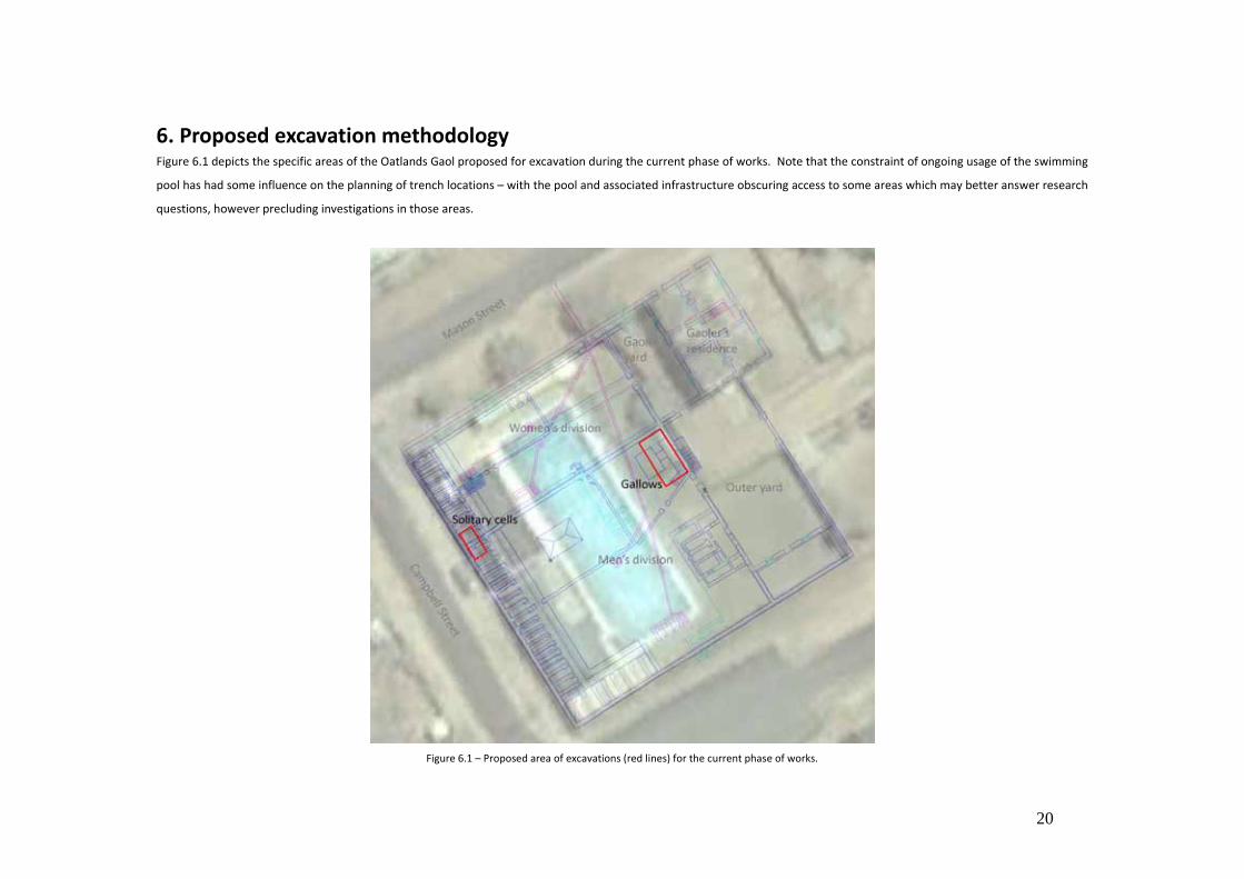
6. Proposed excavation methodology Figure 6.1 depicts the specific areas of the Oatlands Gaol proposed for excavation during the current phase of works. Note that the constraint of ongoing usage of the swimming
pool has had some influence on the planning of trench locations – with the pool and associated infrastructure obscuring access to some areas which may better answer research
questions, however precluding investigations in those areas.
Figure 6.1 – Proposed area of excavations (red lines) for the current phase of works.
21
The Gallows
Figure 6.2 – Overlay tracing of the only known plan of the gallows (1855) over a current aerial photograph. The proposed excavation area outlined in red.
22
Rationale - To expose approximately 2.3 of the footprint of the gallows site and to investigate extent, nature and layout of that structure.
- To gain a better knowledge of the gallows to assist with interpretation planning (note that an interpretation project is currently underway for the gaol).
Likely archaeological remains Apart from the 1855 survey of the gaol, from which the footprint of the gallows depicted in Figure 6.2 is taken, nothing is known about the nature and layout of the gallows.
With the exception of the partially re‐created Hobart Penitentiary gallows, little is known of the nature of comparative sites in Tasmania at least. Figure 6.2 suggests that the
gallows were a high platform (possible 2‐3 metres off the ground as indicated by the number of steps to reach the platform), as opposed to the Hobart example which is semi‐
sunken into a pit. Accordingly, the Oatlands gallows may have left a more scant archaeological trace. There may be indications of the structure which supported the platform,
for example postholes or masonry – the construction material of the gallows is not known. Figure 6.2 indicates two sets of steps to the gallows, one within the gallows yard,
and one leading from the outer yard to what appears to be a viewing (or executioner’s) platform.
The assumption of layout is based on the 1855 plan of the gallows, however it is not known how accurate this plan is (although it seems to be accurate in other areas of the site).
Despite the first impression that there would not be any occupational debris associated with the gallows, there may be occupational debris associated with the earlier and other
use of that area. The gallows were used only six times in their 16 or so years of ‘active’ use – therefore it is possible that the gallows yard was used for other purposes (e.g.
storage) at other times. The gallows were constructed in this location in 1855 – 19 years after the opening of the gaol – the area formerly being a part of the Men’s division yard,
therefore earlier occupation layers may be associated with that use (and may also yield information on the ground surface in that yard).
It is not known when the gallows were demolished (although they may have survived up to the 1937 demolition). It is likely that there has been little disturbance to the area
since demolition, with the area having been covered by fill, and distant to the pool itself. Previous excavations have revealed that there is no trace remaining of the steps to the
viewing platform from the outer yard ‐ that yard having been subject to more disturbance.
Excavation Methodology This trench is proposed to be approximately 4 metres by 6 metres, running adjacent and parallel to the foundations of the wall which divided the inner and outer yards. It is
proposed to remove by archaeologically supervised mechanical excavator all non‐significant overburden to a level approximately 200mm above historic ground level (or higher if
necessary). Historic ground level is known in this area – however it is only assumed that any structure was removed to ground level, therefore a cautious approach is necessary.
It is expected that there is approximately 700mm of fill in this area.
23
Following the clearance of overburden, it is proposed to excavate approximately 2/3 of the footprint of the gallows structure (approximately 24 square metres) from the corner
of the foundations which represent the extreme northern corner of the Men’s division yard. The area of excavation is limited due to the need to retain access to the pool yard
via the driveway, as well as remaining a sufficient distance away from the pool edge. The area will be gridded in horizontal control units not exceeding 1 square metre and
excavation will be undertaken by hand, using trowels and brushes (as appropriate) in arbitrary spits not exceeding 50mm. It is not considered feasible to use mechanical
excavation in historic layers, owing to the unknown (and potentially fragile) nature of structural remains and artifacts. Excavation will cease when either a significant floor or
ground finish is found (e.g. flagstones), or when it is considered that sufficient information to address research questions has been yielded. Excavation will also cease should it
be found that structural remains are not of sufficient integrity that exposure will be feasible without the possibility of damage or structural failure through exposure.
All excavated spoil will be sieved through mesh of a gauge of no greater than 10mm, and all significant artifacts retrieved and managed as per the methodology outlined below
and in Appendix A.
Field notes will be hand‐written in field notebooks, and transcribed digitally at the end of each day of fieldwork. Context sheets will be kept for all context, and all photographs
will be logged. The location of the trench will be tied into the master grid system established across the gaol site, and added to Council’s GIS heritage layer. The excavations will
be thoroughly recorded (both photographically and sketched at a scale of no smaller than 1:20), as per requirements of Section 4.2 of the Tasmanian Heritage Council’s Practice
Note 2 Managing Historical Archaeological Significance in the Works Application Process.
Following excavation and recording, the site will be covered in geofabric and backfilled until such time as the pool is removed and an adequate interpretation/conservation plan
is developed for the gallows.
24
The Men’s and Women’s Divisions solitary cells
Figure 6.3 – Overlay tracing of the solitary cells (not the dividing wall between the Men’s and Women’s divisions) over a current aerial photograph. The proposed excavation area outlined in red.
25
Rationale - To expose a strip approximately 1.5 metres wide across four solitary cells and the wall dividing the Men’s and Women’s Divisions and gain a better knowledge of the
integrity of those parts of the site.
- To investigate the nature of the floor of the solitary cells which will assist in predicting the archaeological potential across the site.
Likely archaeological remains The Men’s and Women’s Division buildings were the most substantial buildings in the Oatlands Gaol complex and can be interpreted as the true ‘gaol’. It is known to have been
largely intact prior to 1937, however was mostly demolished in late 1937. The extent of demolition is however uncertain. Photographic evidence shows the buildings in the
process of destruction during November 1937 however, it is unknown how much more demolition occurred after these photographs were taken.
26
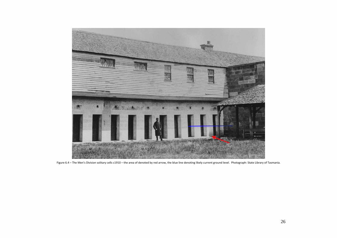
Figure 6.4 – The Men’s Division solitary cells c1910 – the area of denoted by red arrow, the blue line denoting likely current ground level. Photograph: State Library of Tasmania.
27
Figure 6.5 – Demolition of the Men’s Division, late 1937 – the area of excavation will cover the two right‐most cells. Photograph: Oatlands District Historical Society.
The form and size of these cells are well‐known from documentary records, and it seems that they were constructed of sandstone with brick dividing walls. Whilst early
photographs show a chimney in this location, it is likely that this was a first floor chimney (i.e. in the upstairs wards) and that there were no ground floor fireplaces (although
foundations of a chimney may remain at ground level, however this is unlikely as it would unreasonably impede space in the two solitary cells below). The nature of their floor is
unknown, and has important consequences for understanding the archaeological potential of the remaining solitary cells – for instance, a flagged floor is less likely to have
substantial underfloor deposits than a timber floor, however a flagged floor is more likely to survive and have longer‐term interpretive potential.
Figure 6.5 shows the western end of the Men’s Division in late 1937. The Warden of the Oatlands council had written to the Commissioner of Police on December 3rd, 1937
requesting that the gaol arch and four remaining cells be preserved (AOT MCC 24/39). The gaol arch was subsequently relocated and preserved, although the 13 cells shown in
Plate 1 survived until at least April 1938, more demolition, of an unknown quantity, was later undertaken.
28
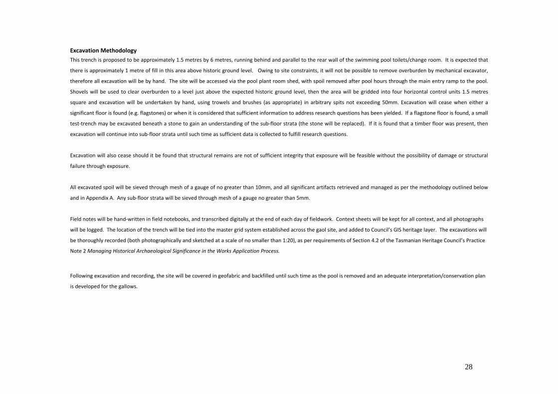
Excavation Methodology This trench is proposed to be approximately 1.5 metres by 6 metres, running behind and parallel to the rear wall of the swimming pool toilets/change room. It is expected that
there is approximately 1 metre of fill in this area above historic ground level. Owing to site constraints, it will not be possible to remove overburden by mechanical excavator,
therefore all excavation will be by hand. The site will be accessed via the pool plant room shed, with spoil removed after pool hours through the main entry ramp to the pool.
Shovels will be used to clear overburden to a level just above the expected historic ground level, then the area will be gridded into four horizontal control units 1.5 metres
square and excavation will be undertaken by hand, using trowels and brushes (as appropriate) in arbitrary spits not exceeding 50mm. Excavation will cease when either a
significant floor is found (e.g. flagstones) or when it is considered that sufficient information to address research questions has been yielded. If a flagstone floor is found, a small
test‐trench may be excavated beneath a stone to gain an understanding of the sub‐floor strata (the stone will be replaced). If it is found that a timber floor was present, then
excavation will continue into sub‐floor strata until such time as sufficient data is collected to fulfill research questions.
Excavation will also cease should it be found that structural remains are not of sufficient integrity that exposure will be feasible without the possibility of damage or structural
failure through exposure.
All excavated spoil will be sieved through mesh of a gauge of no greater than 10mm, and all significant artifacts retrieved and managed as per the methodology outlined below
and in Appendix A. Any sub‐floor strata will be sieved through mesh of a gauge no greater than 5mm.
Field notes will be hand‐written in field notebooks, and transcribed digitally at the end of each day of fieldwork. Context sheets will be kept for all context, and all photographs
will be logged. The location of the trench will be tied into the master grid system established across the gaol site, and added to Council’s GIS heritage layer. The excavations will
be thoroughly recorded (both photographically and sketched at a scale of no smaller than 1:20), as per requirements of Section 4.2 of the Tasmanian Heritage Council’s Practice
Note 2 Managing Historical Archaeological Significance in the Works Application Process.
Following excavation and recording, the site will be covered in geofabric and backfilled until such time as the pool is removed and an adequate interpretation/conservation plan
is developed for the gallows.
29
7. Logistics Overall logistics: Logistics of the project are described further in the document Oatlands Gaol Yard Project presented here as Appendix A.
Contaminants: There is no reason to believe that the site contains any harmful contaminants.
Personnel:
The project personnel will be as follows:
Principal archaeologist and Project Manager:
Manager – Heritage Projects, Southern Midlands Council ‐ Brad Williams BA(hons.) archaeology, MA (Cultural Heritage Management).
Archaeological field supervisors:
Dr. Kate Quirk
Angela McGowan
Jennifer Jones
Field assistants:
Alan Townsend – Heritage Project Officer, Southern Midlands Council.
Artifact curation (if required):
Karen Bramich – Collections Officer, Southern Midlands Council
Veronica Macno ‐ Roving Curator, Arts Tasmania.
A team of 12 students ranging from 1st year archaeology undergraduates through to post‐graduates has been assembled and are to be supervised by the above personnel.
Timeframe of implementation:
Undertake excavations: 13th Jan 2012 ‐ 10th Feb 2012.
30
All artifacts curated by: 31st April 2012
Interpretation installed by: 30thJune 2012
Provision of final report by: 30th September 2012
31
8. Post excavation procedures
Analysis of contexts The Oatlands Gaol has several phases of usage relevant to conservation management, understanding of site formation processes, and the interpretation of the archaeological
record:
- Indigenous/pre European period (pre 1820’s)
- First gaol (1827‐c1837)
- Colonial gaol (1834‐1863), including phases of;
o Construction (1834‐36)
o Pre major renovation (1836‐1849)
o Post renovation (1849‐1863)
- Municipal gaol (1863‐1936)
With the decommissioning of the Gaol in 1936 and the continued use of the Gaoler’s Residence, since 1936 these parts of the site have had separate histories since then. In the
case of the gaol, these phases can be summarised as:
- Demolition (1937‐1954)
- Swimming pool (1954‐present)
Analysis of structure, fill and artifacts will be undertaken within the contexts of those periods, utilising supplementary histories deriving form those associations where
appropriate, an in‐line with the key research questions as outlined above.
The gallows will also be analysed within the context of the Public Executions Act of 1847, as that was the Act which resulted in that structure being built to replace to former
public gallows in front of the gaol.
32
The thematic analysis and interpretation of artifacts will be guided by the research question framework as outlined in Section 5. Depending on the types and quantities of
artifacts excavated, post‐ excavation analysis of artifacts is expected to be done both within the contexts of the above research questions, as well as comparison against other
available artifact assemblages of relevant type, or from comparative sites nationally (and/or internationally).
Artifact, curation & storage:
All artifacts will be managed in accordance with the requirements of Part 6 of the Tasmanian Heritage Council’s PN2, and the provisions of the Southern Midlands Council
Heritage Collections Policy, as well as any other relevant professional standard. A student internship program is being run with Deakin University postgraduate students
expressing interest in assisting with curation. Assistance is also to be provided by Arts Tasmania Curators, therefore promoting the best‐practice post‐field analysis, curation and
storage of excavated material.
Once excavated, ceramic and glass artifacts will be washed, dried, bagged and tagged as soon as practicable. Organics will be dry brushed, then bagged and tagged also. All
artifact processing (except any necessary special curation) will be undertaken at the Southern Midlands Council artifact lab, and storage will be in Council’s archaeological
material store at Oatlands.
Should any artifacts be deemed to require specialist conservation treatment, a professional conservator will be consulted on an as‐needs basis.
Site rehabilitation and conservation of in‐situ remains:
Following excavation, it is intended to cover any structural remains and ground/floor surfaces with geofabric, and backfill with clean fill (i.e. rehabilitating the pool yard). Subject
to the future usage of the site (if the pool is removed) there may be the potential for exposure and in‐situ interpretation of structure – that future consideration will be guided
by the current findings. Any necessary conservation works to structural remains (e.g stone repairs) will be done in consultation with Heritage Tasmania’s Heritage Advisory
Team.
Ongoing interpretation and public access: Further to Part 8 of the Tasmanian Heritage Council’s Practice Note 2, and as detailed through this document, one of the aims of these excavations is to provide an enhanced
level of interpretation of the Oatlands Gaol and improved public benefit arising from the restoration of the site – as best as possible whilst is remains an operating swimming
pool. AN interpretation plan has been developed for the site which has a strong focus in archaeology, and these proposed investigations will support the implementation of that
plan.
33
Also, further to the requirements of Part 8 of that practice note, a communications strategy will be developed to deliver publicity throughout the excavation phase, in order to
enhance the public benefit arising from these excavations. It is expected that, during excavation works, a public archaeology program will be facilitated by Council’s Tourism
Centre, as part of the Oatlands Town Tour (which includes the Gaol and Supreme Court House). Arts Tasmania has been providing assistance in the preliminary planning of the
communications strategy. A public open day has been scheduled for February 11th 2012, and press releases will occur ahead of that day.
Reporting requirements:
A report on the excavations, artifacts and structural conservation aspects of this project will be completed within 6 months of the completion of fieldwork, to the standards
prescribed in Section 4.2 of the Tasmanian Heritage Council’s Practice Note 2, and lodged with Heritage Tasmania. A copy of the report will also be submitted to the Tasmanian
Archive and Heritage Office, as well as an electronic copy lodged with STORS service of the State Library of Tasmania.
The project archive will be accessioned into the Southern Midlands Council Corporate Library. An electronic project archive will be provided to Heritage Tasmania with the
lodgment of the final report.
Unless otherwise waived by the Works Manager of Heritage Tasmania (i.e. if results do not warrant), a conference paper and/or journal article will be developed from the
excavations, and other researchers will be encouraged to use these results in wider thematic comparisons.
A copy of the report, and any other relevant documentation, photographs etc. will be made available through the Heritage Projects page of the Southern Midlands Council
website.
Acquittal:
Upon completion of the excavations, the following acquittals will be completed:
- All obligations to permit authorities (Heritage Tasmania) outlined in this document, and pursuant to any permit conditions.
- Funding acquittal to Southern Midlands Council and other relevant funding (and in‐kind) supporters.