ARCHAEOLOGICAL SURVEY OF THE CANDOR 115 kV TAP LINE IN MONTGOMERY NORTH CAROLINA by H. Trawick Ward R. P. Stephen Davis, Jr. Research Laboratorie3 of Anthropology University of North Carolina Chapel Hill October 1988
Transcript
ARCHAEOLOGICAL SURVEY OF THE CANDOR 115 kV TAP LINE IN MONTGOMERY COUN1~, NORTH CAROLINA
by
H. Trawick Ward R. P. Stephen Davis, Jr.
Research Laboratorie3 of Anthropology University of North Carolina
Chapel Hill
October 1988
MANAGEMENT SUMMARY
During October 1988, H. Trawick Ward and R. P. Stephen Davis, Jr.
spent three person-days SQTVeying five miles of the proposed Candor 115
kV Tap Line corridor (Clearinghouse Nrunber ER 88-7361) in eastern
Montgomery County, between Candor and Biscoe, N.C. The project was
initiated at the request of Carolina Power and Light Company and
resulted in the recording of three ne\v archaeological sites. Two of the
sites contained assemblages dating primarily to the Middle Archaic
perioti. One site consisted of a lithic scatter without tiiagnostic
artifacts. All the sites have been severely disturbed by erosion and
Jeflation. Because the construction of the transmission line will not
adversely affect any significant archaeological resources, clearance is
recommended for the project.
i
INTRODUCTION
At the request of Carolina Power and Light Company, H. Trawick Ward
and R. P. Stephen Davis, Jr. of the Research Laboratories of
Anthropology at the University of North Carolina spent three
person-days, between October 6 and October 12, surveying 4:.97 mi of the
proposed Candor 115 kV Tap Line corridor. The proposed corridor extends
from the Candor substation, just east of the town of Candor, no-rthward
to connect with the existing Cape Fear-Biscoe 115 kV Line, northeast of
Biscoe in Montgomery County (Figure 1). The corridor is 100ft wide;
areas surveyed consist of all segments exhibiting any ground surface
visibility, or approximately 34:% of the total corrido-r.
The objectives of the survey were to locate and evaluate the
research potential of as many archaeological sites as possible within
the corridor. A "site", as defined here, refers to at least two
spatially -related artifacts or features that are indicative of
prehistoric or historic activities. This somewhat broad definition only
excludes the isolated "spot-find" which could -result from ari almost
infinite variety of idiosyncratic or fortuituous events.
Sites were located by surface in::;pection, and the evaluation of a
site's potential or significance was guided by criteria of the National
Register which state that archaeological resources are considered '
significant or potentially eligible for inclusion in the National
Register of Historic Places if they have "yielded, or may be likely to
yield, information important to prehistory or history" (36 CFR Part
800.1). Although this guideline is vague, it seems that, minimally, a
site should have spatial or depositional context sufficiently preserved
to allow some level of behavioral infer ence beyond s :i.rnple chronological
placement.
Figure 1. Map Locating the Candor 115kV Tap Line (1 in= 0.6 mi).
3
As a result of the survey, three new prehistoric sites were
recorded. Although one contained evidence of a small Woodland
component, the major occupations appear to date to the Archaic period.
In addition, the precise locations of nine previously recorded sites in
the Candor area were carefully examined to determine if they would be
impacted by the construction of the transmission line. The ground
survey and records search reveal that no significant archaeological
resources will be affected by the project.
PREHISTORIC AND HISTORIC BACKGROUND
ArchaeolGgists usually divide tlle archaeological cultures of North
Carolina into four periods: Paleoind.ian, Archaic, Woodland, anJ
Historic. The Archaic period is further broken -down into three
subperiods--Early, Middle, and Late--which are based on the forms and
rnethods of manufacturing chipped- stone tools, particularily projectile
points. The Woodland perioJ is divided into several phases. Along the
northern Fall Line, the Vincent, Clements, Dan River, and Gaston phages
have been defined (Coe 196~). These are related to the Deep Creek, Mt.
Pleasant, and Cashie phases of the northeast Coastal Plain (Phelps
1983). In the central Piedmont, the Badin, Yadkin, Uwharrie, Dan River ,
and Pee Dee phases have been identified (Coe 1952, 196~). The Historic
period is represented in the northern piedmont by the Early, Middle, and
Late Saratown phases while in the central piedmont, the Hillsboro,
Mitchum, and Fredricks phases describe the archaeological remains of the
historic Siouan tribes. Styles of pottery, as well as other material
culture traits, provide indices for differentiating these Woodland and
Historic period cultures.
The Paleoindian period is represented by the Hardaway complex,
which is characterized in its earliest form by a lanceolate projectile
point with a thin concave base. This early variety evolved into a
Dalton-like point with broad, shallow side notches and serrated edges .
The terminal Hardaway phase is represented by a projectile point with
narrow side notches and a concave recuTVed base. Hardaway peoples
occupied central north Carolina perhaps as early as 12,000 B.C. {Coe
1964-) .
The Late Paleoindian and Early Archaic periods are represent ed
respectively by the Palmer and Kirk complexes, which also are
distinguished by projectile point styles. Palmer points are r ather
small, averaging 35 mm long and 20 mm wide. These points typically have
serrated triangular blades, notched corners, and a straight ground base.
Kirk specimens are ldrger, with some varieties averaging 100 mm long and
35 mm wide. Although blades are again triangular and serrated, the
bases are straight to slightly rounded but never ground. Corner
notching, characteristic of early Kirk ~pecimens, i s replaced by broad
square stems in later varieties. Palmer may date as early as 10,000
B. C., while the Kirk complex appears to span the millennia between 6000
and 9000 B.C.
The beginning of the Middle Archaic is marked by the appearance of
the Stanly complex, which displays the continued evolution of stemmed
projectile points. During the Stanly phase, blades become wider and
stems narrower, although the basic form still resembles the later Kirk
types. The Stanly complex also contains the first evidence for
extensive use of polished stone implements.
A continuity of projectile point styles was interrupted at the end
5
of the Stanly phase by the introduction of two new types, both of which
appear sty 1 is·tically to be unrelated to the previous sequence. The
earliest type is represented by the Morrow Mountain point which has a
small blade and short tapering stem. Following the Morrow Mountain
phase, a long thick lanceolate point, the Guilford, was introduced.
This type is wide-spread over central North Carolina but not frquently
found outside the area. Stanly dates from 5000 to 6000 B.C.; the
Morrow Mountain phase dates from 5000 to ~500 B.C. (Coe 196~:122-125).
The Late Achaic period began wilh a return to the manufacture of
broad bladed, stemmed projectile points, charaterized by the Savanah
River complex. During this phase, full-grooved axes and soapstone bowls
made their first appearance. The Savannah River complex, which began
about ~000 B.C., may have persisted in some areas of North Carolina
unt il about 500 B.C. (Coe 196~:123-124).
The Woodland period began with the introduction of pottery and
horticulture and lasted in most areas of North Carolina until European
contact. The Badin and Vincent complexes represent the earliest
Woodland occupations in the Piedmont. The pottery of both phases is
well made , with a fine sand or non-tempered paste, and usually has a
cord-marked or fabric-impressed exterioe surEace. Little is known about
these Early Woodland cultures (ca. 500 B.C. to A.D. 500) except that
horticulture became increasingly .important, and small villages or
hamlets probably were occupied on a semi-permanent basis.
In the survey area, the Middle and Late Woodland periods (ca.
A.D. 500 to 1500) are defined by the Yadkin, Uwharrie, Dan River and
Pee Dee phases. The shift from Early to Middle Woodland, though not
abrupt, i~ rnost apparent in the respective ceramic traditions. The fine
sand-tempered Early Woodland sherds were gradually replaced by
6
crushed-quartz tempered types of the Yadkin and Uwharrie phases.
However, during the middle part of the Late Woodland period, ca. A.D.
1350, dramatic changes took place in the immediate vicintiy of the
survey area (DePratter and Judge 1987).
People from the south, perhaps from as far away as northern
Georgia, pushed into south-central North Carolina, bringing with tl1em an
entirely different culture. Not only did they introduce a totally
different ceramic tradition but more importantly, they built temple
mounds and elaborate ceremonial centers reminiscent of the complex
Mississippian societies of the greater Southeast (Coe 1952). These Pee
Dee people lived in stratified societies with warrior, priest, and
chiefly classes controlling and organizing the daily lives of the common
farmers. The most elaborate of their sites has been preserved in Town
Creek Indian Mound State Park, located near Mt. Gilead.
The triumphant invasion of Pee Dee culture was shortlived, however,
and by A.D. 1500, continuity r-eturned to the Late Woodland period with
the Caraway phase. The only Pee Dee tr~it to survive was a modified
form of the distinctive complicated stamped pottery, but even this was
blended with a more traditional Piedmont ceramic dssembldge of net
impressed and plain wares.
By this time, agriculture was finnly established. Corn, beans,
and squash were being grown to support tribal populations that lived in
established villages along the major rivers and tributaries. Hunting,
however, continued to be important and would remain so as long as Native
Americans occupied the region.
During the Historic period, the project area was probably occupied
by Siouan-speaking Catawba and Sara Indi.aus living in dose proximity to
the Iroquois-speaking Tuscarora of the Coastal Plain. Shortly after the
7
end of the Tuscarora War in 171~, most of the former moved into South
Carolina, whereas the latter migrated to join their linguistic cousins
in New York.
Several archaeological sites have Leen recorded in the vicinity of
the transmission line corridor. Most are located just east of Candor
along the Montgomery-Moore County line. All nine sites in this area are
situated on hill tops or hill slopes and have been subjected to severe
erosion. All were occupied during the Middle Archaic period with
Guilford and Morrow Mountain components occuring most frequently. One
site (31Mr55) produced a Paleoindian blade and two others (31Mr57 and
31Mg626) also contained evidence of a Late Archaic Savannah River
occupation. In addition, a Kirk projectile point was recovered from
31Mg626, indicating repeated encampments at this site throughout the
Archaic period. The Late Woodland period was represented by a single
Caraway projectile point from 31Mg212. Although some quartz debitage
was recovered from these sites, felsic raw material appears to have been
favored for tool manufacture (Cooper and Patterson 1982).
John Lawson, during his epic journey from Charleston to Pamlico
Sound in 1700-1701, was one of the first Europeans to explore the survey
area. Lawson's keen eye and consu~nate literary talent provide us with
a vivid uescription of the land anu its native inhabitants. As he
journeyed from South Carolina into present-day North Carolina, near the
survey area, Lawson stated that the land was "thick" with Indian towns
with "no uarren Land Leing found amongst them." He spent the night with
the "Esaw" and "Kadapau" Indians, who were no doubt Catawbas, anu met a
trader named Stewart who had heard of his coming 20 days earlier .
Lawson was duly jmpressed that news u( hi.s journey shoulu "Ely so
swiftly among these People" (Lefler 196 7: ~9) .
8
Some ~0 years elapsed after Lawson's journey before the first
permanent settlers moved into what was to become Montgomery County. By
this time, the Indians had left, and except for a few overgrown fields ,
few traces remained of their once "thit:k" settlements. These early
settlers were Scotch Highlanders fr01n t he Carolina coast and l ater
Scotch Ir i sh from Pennsylvania. They es tablished small subsistence
farms along the fertile bottoms of the Pee Dee and Little rivers where
their descendents remain today (Lassiter 1976).
In 18 2 3, a German, Dr. F. J. Krone, !.milt a house on the west side
of the Pee Dee River in what is today Morrow Mountain State Park. Dr.
Krone was apparently one of the first amateur archaeologists in t he
state. He described extensive deposits of artifacts along the Uwharrie
and Pee Dee rivers, and observed that when he first arrived:
bands of ten or more (Indians) wer e frequently met with and on their way to Fayetteville, armed with bows and arrows, and reaJ.y f or a reward to display their dexterity in hitting , before it came down, a piece of coin tossed in the air (Krone 1874:390).
SURVEY METHODS, CONDITIONS, AND RESULTS
The Candor 115 kV Tap Line crosses an environmental seam where the
clay-capped ridges of the Piedmont blend into the relic dunes of t he
Sandhills r egion. Topographically, both areas are characterized by
hills with moderate relief; however, the surface soils and vegetation
are very different. In the Candor area, sandy soils support communities
of longleaf pine, turkey oak, and wire grass. In contrast, the northern
portion of the transmission corridor i s characterized by clay and clay
loam soils growing stands of mixed hardwoods and hardwood-pine forests.
The areas surrounding the transmi ssion line corridor provide some
of the best wildlife habitats in south-central North Carolina. Because
9
the Great Pee Dee basin is a major fly -way, migratory birds,
particularly mallard and black d~ck, are attracted to the area in
abundance each year. Bobwhite quail and morning doves are other
important avian species. Mammals also enjoy a prime habitat, and the
and wide spatial distribution do not suggest the presence of undisturbed
cultural deposits; and 2) the type of linpact resulting from transmission
line construction (i.e., digging holes for power poles) is minimal.
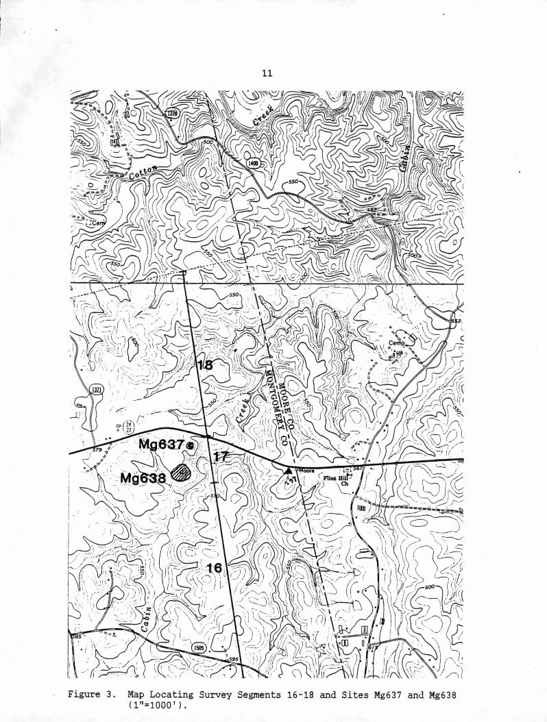
Mg 637 (Figure 3)
This site is located within Survey Segment 17, atop a low,
heavily-eroded knoll overlooking Cabin Creek. The site was
characterized by a light scatter of lithic artifacts over a 200x200-ft
area. All visible artifacts were collected from the site and include
one retouched flake, one utilized flake, and eight unmodified flakes.
One flake was made of quartz; the remaining specimens were of
metavolcanic material. No culturally diagnostic artifacts were found.
This site lies outside the transmi::~sion line corridor and will not be
affected by the project.
Mg 638 (Figure 3)
This site also is located withiH Survey Segment 17, atop a low,
heavily-e r.oded knoll overlooking Cabin Creek and just south of Mg 637.
The site was defined by a moderately dense concentration of lithic
artifacts over a 500x500 -ft area. Again, all visible artifacts were
collected, and include: three Guilford projectile points, one Savannah
River projectile point, one small stemmed projectile point, five
unidentifiable projectile point fragwents, six bifaces, one large core,
two end scr-apers, four side scrapers, two retouched flakes, two utilized
flakes, and 54. unmodified flakes. All specimens were made of
metavolcanic material. These remains snggest that this site served as a
campsite for Middle and Late Archaic peoples. As with Mg 637, this site
· lies outside the transmission line co.nidor and will not be affected by
19
the project. Given extensive soil erosion, however, it is unlikely that
either site contains intact cul~ural deposits.
CONCLUSIONS AND RECOMMENDATIONS
Although many sites are known in Montgomery County, only three
were disuovered during the course of the transmission line survey. All
have low research potential, and two lie outside any areas of possible
impact. Clearance is therefore reconunended for the project.
20
REFERENCES CITED
Coe, Joffre L. 1952 The Cultural Sequence of the Carolina Piedmont. In
Archaeology of __ the Eastern United States, edited by J. B. Griffin, University of Chicago Press.
196q. The Fonnative Cultures of the Carolina Pjedmont. American Philosophical __ So_ciety Transactions sq. ( 5 l.
DePratter, C.B. and Chris Judge 1987 The Pee Dee Pottery Tradition: From Town Creek to the
Wateree. Paper presented at Town Creek Indian Mound 50th Anniversary.
Cooper, Peter P., II and Johnnie Patterson 1982 An Archaeological Survey of the Pr-oposed Wastewater
Treatment Sites for the Town of Candor, Montgomery and Moore counties, N.C. Ms. on file, Office of State Archaeology, Raleigh.
Krone, F. S. 18n Antiquities of Stanly and Montgomery Counties. Ms. on file,
The North Carolina Collection, University of North Carolina, Chapel Hill.
Lassiter, Mable S. 1976 Patterns of Timeless r~oment5 _ ,H _g_J-Jistory of MQntgomery County.
Published by the Board of County Commissioners, Montgomery County, N.C.
Lefler, Hugh T. (editor) 1967 A New Voyage to Carolina. University of North Carolina
Press, Chapel Hill.
Phelps, DavidS. 1983 Archaeology of the North Carolina Coast and Coastal Plain:
Problems and Hypotheses. In The Prehistory of North Carolina., an Archaeolo_g_i~al SYmposium, Edited by Mark Mathis and Jeffrey Crow, North Carolina Division of Archives and History, Raleigh.