2 nd INQUA-IGCP-567 International Workshop on Active Tectonics, Earthquake Geology, Archaeology and Engineering, Corinth, Greece (2011) INQUA PALEOSEISMOLOGY AND ACTIVE TECTONICS EARTHQUAKE ARCHAEOLOGY 102 ARCHAEOSEISMOLOGY OF THE AD 1545 EARTHQUAKE IN CHIANG MAI, NORTHERN THAILAND Kázmér, M. (1), Kamol Sanittham (2), Punya Charusiri (3), Santi Pailoplee (3) (1) Department of Palaeontology, Eötvös University, Pázmány sétány 1/c, Hungary. Email: [email protected](2). Department of Mathematics and Statistics, Chiangmai Rajabhat University, Chiang Mai, Thailand (3) Department of Geology, Chulalongkorn University, Bangkok, Thailand Abstract (Archaeoseismology of the A.D. 1545 earthquake in Chiang Mai, northern Thailand): The A.D. 1545 Chiang Mai earthquake in northern Thailand was studied by historical and archaeological sources.The temple Wat Chedi Luang has lost about half of the original 80-metres height due to southward-directed collapse. Twenty-one temple sites – out of 74 visited – has tilted pagodas, up to 5° in various directions, dominated by a SE trend. All damaged temples were built before the 1545 earthquake. We suggest that a city-wide liquefaction event caused tilting. The responsible earthquake possibly occurred along the Doi Suthep Fault within city limits. Possible activity of distant faults is assessed. Key words: palaeoseismology, Thailand, liquefaction, Wat Chedi Luang INTRODUCTION An important obstacle to the assessment of earthquake hazard at present is the lack of information about old earthquakes (Ambraseys, 2009: xii). The locations of larger historical earthquakes have been found to be known well enough to guide field studies for further in situ investigations. Properly run field studies provide reliable observations for the assessment of damage, intensity, and its distribution, ground effects and surface faulting. Field studies of old earthquakes are time-consuming and often present subtle problems but they are essential (Ambraseys 2009: 16). Here we provide a brief description of traces of a significant earthquake in Northern Thailand, and provide assessment of seismic parameters of the event. Fig. 1: Wat Chedi Luang in Chiang Mai, Thailand, seen from the southeast. Damaged during the AD 1546 earthquake, the upper half of the stupa fell to the south. Fig. 2: Archaeological reconstruction of the pre-earthquake dimensions of Wat Chedi Luang as seen from the east. Total height was approx. 80 m. The portion above the heavy line is the art historian’s vision about its looks. Both historical documents and archaeological data are available describing the A.D. 1545 earthquake in Northern Thailand. We studied the Buddhist temples in and around the old city of Chiang Mai (Kázmér &
Transcript
2nd INQUA-IGCP-567 International Workshop on Active Tectonics, Earthquake Geology, Archaeology and Engineering, Corinth, Greece (2011)
INQUA PALEOSEISMOLOGY AND ACTIVE TECTONICS
EARTHQUAKE
ARCHAEOLOGY
102
ARCHAEOSEISMOLOGY OF THE AD 1545 EARTHQUAKE IN CHIANG MAI, NORTHERN THAILAND
(1) Department of Palaeontology, Eötvös University, Pázmány sétány 1/c, Hungary. Email: [email protected] (2). Department of Mathematics and Statistics, Chiangmai Rajabhat University, Chiang Mai, Thailand (3) Department of Geology, Chulalongkorn University, Bangkok, Thailand Abstract (Archaeoseismology of the A.D. 1545 earthquake in Chiang Mai, northern Thailand): The A.D. 1545 Chiang Mai earthquake in northern Thailand was studied by historical and archaeological sources.The temple Wat Chedi Luang has lost about half of the original 80-metres height due to southward-directed collapse. Twenty-one temple sites – out of 74 visited – has tilted pagodas, up to 5° in various directions, dominated by a SE trend. All damaged temples were built before the 1545 earthquake. We suggest that a city-wide liquefaction event caused tilting. The responsible earthquake possibly occurred along the Doi Suthep Fault within city limits. Possible activity of distant faults is assessed. Key words: palaeoseismology, Thailand, liquefaction, Wat Chedi Luang INTRODUCTION An important obstacle to the assessment of earthquake hazard at present is the lack of information about old earthquakes (Ambraseys, 2009: xii). The locations of larger historical earthquakes have been found to be known well enough to guide field studies for further in situ investigations. Properly run field studies provide reliable observations for the assessment of damage, intensity, and its distribution, ground effects and surface faulting. Field studies of old earthquakes are time-consuming and often present subtle problems but they are essential (Ambraseys 2009: 16). Here we provide a brief description of traces of a significant earthquake in Northern Thailand, and provide assessment of seismic parameters of the event.
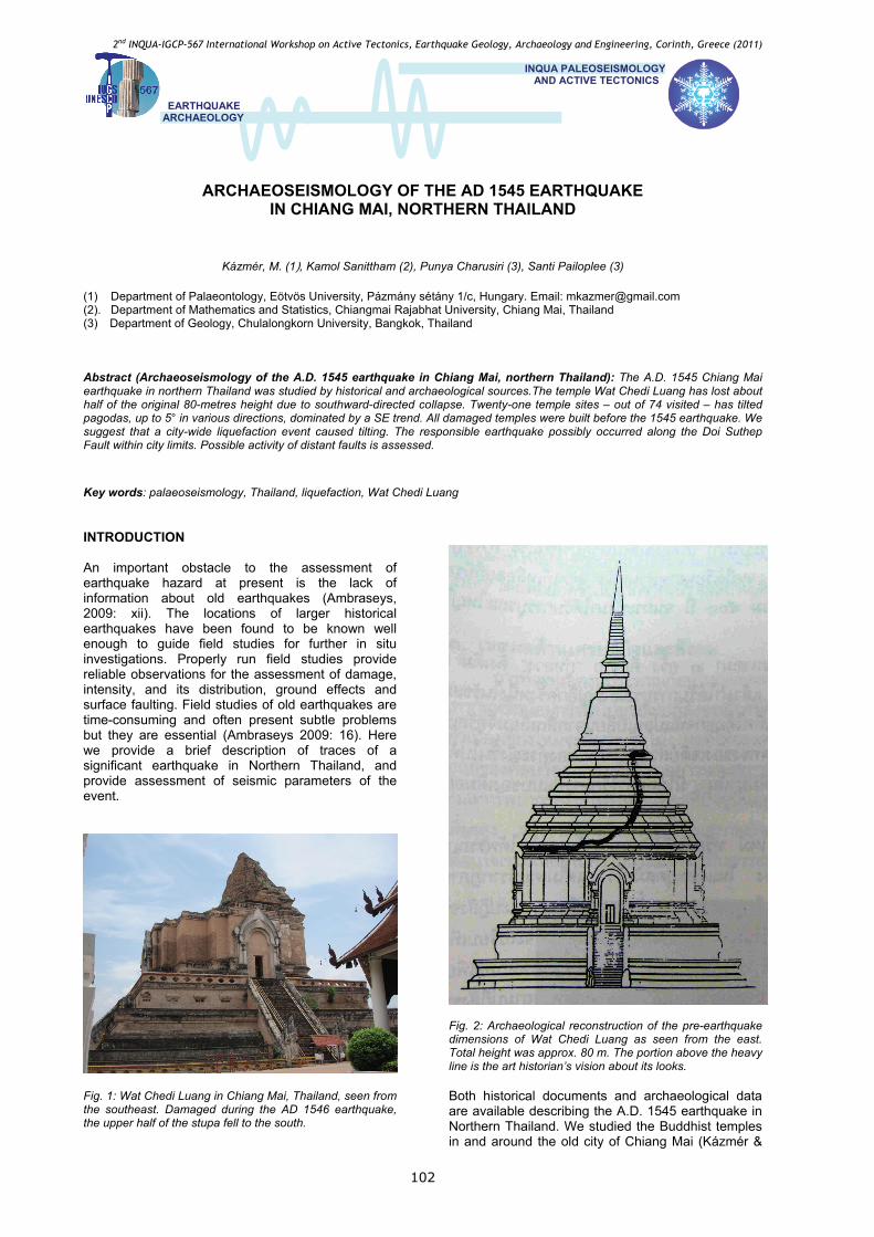
Fig. 1: Wat Chedi Luang in Chiang Mai, Thailand, seen from the southeast. Damaged during the AD 1546 earthquake, the upper half of the stupa fell to the south.
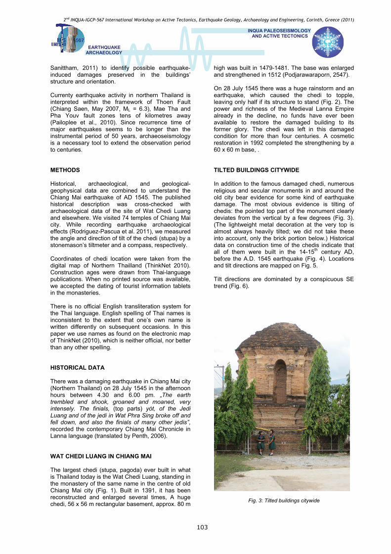
Fig. 2: Archaeological reconstruction of the pre-earthquake dimensions of Wat Chedi Luang as seen from the east. Total height was approx. 80 m. The portion above the heavy line is the art historian’s vision about its looks. Both historical documents and archaeological data are available describing the A.D. 1545 earthquake in Northern Thailand. We studied the Buddhist temples in and around the old city of Chiang Mai (Kázmér &
2nd INQUA-IGCP-567 International Workshop on Active Tectonics, Earthquake Geology, Archaeology and Engineering, Corinth, Greece (2011)
INQUA PALEOSEISMOLOGY AND ACTIVE TECTONICS
EARTHQUAKE
ARCHAEOLOGY
103
Sanittham, 2011) to identify possible earthquake-induced damages preserved in the buildings’ structure and orientation. Currenty earthquake activity in northern Thailand is interpreted within the framework of Thoen Fault (Chiang Saen, May 2007, ML = 6.3), Mae Tha and Pha Youv fault zones tens of kilometres away (Pailoplee et al., 2010). Since recurrence time of major earthquakes seems to be longer than the instrumental period of 50 years, archaeoseismology is a necessary tool to extend the observation period to centuries. METHODS Historical, archaeological, and geological- geophysical data are combined to understand the Chiang Mai earthquake of AD 1545. The published historical description was cross-checked with archaeological data of the site of Wat Chedi Luang and elsewhere. We visited 74 temples of Chiang Mai city. While recording earthquake archaeological effects (Rodriguez-Pascua et al. 2011), we measured the angle and direction of tilt of the chedi (stupa) by a stonemason’s tiltmeter and a compass, respectively. Coordinates of chedi location were taken from the digital map of Northern Thailland (ThinkNet 2010). Construction ages were drawn from Thai-language publications. When no printed source was available, we accepted the dating of tourist information tablets in the monasteries. There is no official English transliteration system for the Thai language. English spelling of Thai names is inconsistent to the extent that one’s own name is written differently on subsequent occasions. In this paper we use names as found on the electronic map of ThinkNet (2010), which is neither official, nor better than any other spelling. HISTORICAL DATA There was a damaging earthquake in Chiang Mai city (Northern Thailand) on 28 July 1545 in the afternoon hours between 4.30 and 6.00 pm. „The earth trembled and shook, groaned and moaned, very intensely. The finials, (top parts) yòt, of the Jedi Luang and of the jedi in Wat Phra Sing broke off and fell down, and also the finials of many other jedis”, recorded the contemporary Chiang Mai Chronicle in Lanna language (translated by Penth, 2006). WAT CHEDI LUANG IN CHIANG MAI The largest chedi (stupa, pagoda) ever built in what is Thailand today is the Wat Chedi Luang, standing in the monastery of the same name in the centre of old Chiang Mai city (Fig. 1). Built in 1391, it has been reconstructed and enlarged several times, A huge chedi, 56 x 56 m rectangular basement, approx. 80 m
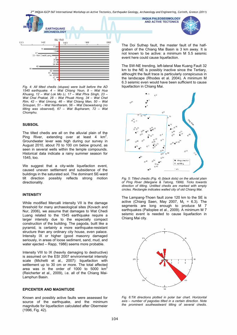
high was built in 1479-1481. The base was enlarged and strengthened in 1512 (Podjarawaraporn, 2547). On 28 July 1545 there was a huge rainstorm and an earthquake, which caused the chedi to topple, leaving only half if its structure to stand (Fig. 2). The power and richness of the Medieval Lanna Empire already in the decline, no funds have ever been available to restore the damaged building to its former glory. The chedi was left in this damaged condition for more than four centuries. A cosmetic restoration in 1992 completed the strengthening by a 60 x 60 m base, . TILTED BUILDINGS CITYWIDE In addition to the famous damaged chedi, numerous religious and secular monuments in and around the old city bear evidence for some kind of earthquake damage. The most obvious evidence is tilting of chedis: the pointed top part of the monument clearly deviates from the vertical by a few degrees (Fig. 3). (The lightweight metal decoration at the very top is almost always heavily tilted; we did not take these into account, only the brick portion below.) Historical data on construction time of the chedis indicate that all of them were built in the 14-15th century AD, before the A.D. 1545 earthquake (Fig. 4). Locations and tilt directions are mapped on Fig. 5. Tilt directions are dominated by a conspicuous SE trend (Fig. 6).
Fig. 3: Tilted buildings citywide
2nd INQUA-IGCP-567 International Workshop on Active Tectonics, Earthquake Geology, Archaeology and Engineering, Corinth, Greece (2011)
INQUA PALEOSEISMOLOGY AND ACTIVE TECTONICS
EARTHQUAKE
ARCHAEOLOGY
104
The Doi Suthep fault, the master fault of the half-graben of the Chiang Mai Basin is 3 km away. It is not known to be active: a minimum M 5.5 seismic event here could cause liquefaction. The SW-NE trending, left-lateral Mae Kuang Fault 32 km to the NE is possibly inactive since the Tertiary, althought the fault trace is particularly conspicuous in the landscape (Rhodes et al. 2004). A minimum M 6.3 seismic even would have been sufficient to cause liquefaction in Chiang Mai.
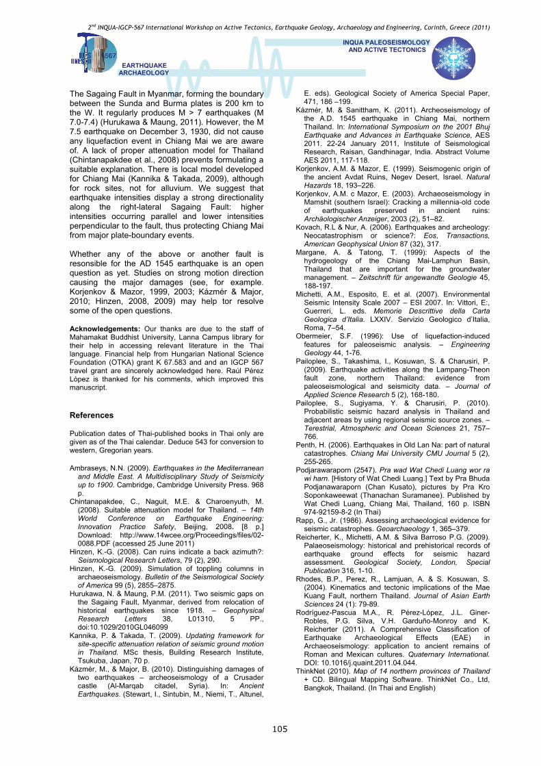
Fig. 4: All tilted chedis (stupas) were built before the AD 1545 earthquake. 4 – Wat Chiang Yeun, 8 – Wat Hua Khuang, 12 – Wat Lok Mo Li, 17 – Wat Phra SIngh, 23 – Wat Chai Prakiat, 28 – Wat Phuak Hong, 34 – Wat Chet Rim, 42 – Wat Umong, 46 – Wat Chiang Man, 50 – Wat Srisupan, 51 – Wat Nantharam, 56 – Wat Daowadueng (no tilting was observed), 67 – Wat Bupharam, 72 – Wat Chomphu.
SUBSOIL The tilted chedis are all on the alluvial plain of the Ping River, extending over at least 4 km2. Groundwater lever was high during our survey in August 2010, about 70 to 100 cm below ground, as seen in several wells within the temple compounds. Historical data indicate a rainy summer season for 1545, too. We suggest that a city-wide liquefaction event, caused uneven settlement and subsidence of the buildings in the saturated soil. The dominant SE-ward tilt direction possibly reflects strong motion directionality.
Fig. 5: Tilted chedis (Fig. 4) (black dots) on the alluvial plain of Ping River (Margane & Tatong, 1999). Ticks towards direction of tilting. Untilted chedis are marked with empty circles. Rectangle indicates walled city of old Chiang Mai.
INTENSITY The Lampang-Thoen fault zone 120 km to the SE is active (Chiang Saen, May 2007, ML = 6.3). The segments are long enough to produce M 7 earthquakes (Pailoplee et al., 2009). A minimum M 7 seismic event is needed to cause liquefaction in Chiang Mai city.
While modified Mercalli intensity VII is the damage threshold for many archaeological sites (Kovach and Nur, 2006), we assume that damages to Wat Chedi Luang related to the 1545 earthquake require a larger intensity due to the especially compact construction of the building. The pagoda, built like a pyramid, is certainly a more earthquake-resistant structure than any ordinary city house, even palace. Intensity IX or higher (good masonry damaged seriously, in areas of loose sediment, sand, mud, and water ejected – Rapp, 1986) seems more probable.
Intensity VIII to IX (heavily damaging to destructive) is assumed on the ESI 2007 environmental intensity scale (Michetti et al., 2007): liquefaction with settlement up to 30 cm or more. The total affected area was in the order of 1000 to 5000 km2 (Reicherter et al., 2009), i.e. all of the Chiang Mai-Lamphun Basin. EPICENTER AND MAGNITUDE
Fig. 6:Tilt directions plotted in polar bar chart. Horizontal axis – number of pagodas tilted in a certain direction. Note the prominent southeastward tilting of several chedis.
Known and possibly active faults were assessed for source of the earthquake, and the minimum magnitude for liquefaction calculated after Obermeier (1996, Fig. 42).
2nd INQUA-IGCP-567 International Workshop on Active Tectonics, Earthquake Geology, Archaeology and Engineering, Corinth, Greece (2011)
INQUA PALEOSEISMOLOGY AND ACTIVE TECTONICS
EARTHQUAKE
ARCHAEOLOGY
105
The Sagaing Fault in Myanmar, forming the boundary between the Sunda and Burma plates is 200 km to the W. It regularly produces M > 7 earthquakes (M 7.0-7.4) (Hurukawa & Maung, 2011). However, the M 7.5 earthquake on December 3, 1930, did not cause any liquefaction event in Chiang Mai we are aware of. A lack of proper attenuation model for Thailand (Chintanapakdee et al., 2008) prevents formulating a suitable explanation. There is local model developed for Chiang Mai (Kannika & Takada, 2009), although for rock sites, not for alluvium. We suggest that earthquake intensities display a strong directionality along the right-lateral Sagaing Fault: higher intensities occurring parallel and lower intensities perpendicular to the fault, thus protecting Chiang Mai from major plate-boundary events. Whether any of the above or another fault is resonsible for the AD 1545 earthquake is an open question as yet. Studies on strong motion direction causing the major damages (see, for example. Korjenkov & Mazor, 1999, 2003; Kázmér & Major, 2010; Hinzen, 2008, 2009) may help tor resolve some of the open questions. Acknowledgements: Our thanks are due to the staff of Mahamakat Buddhist University, Lanna Campus library for their help in accessing relevant literature in the Thai language. Financial help from Hungarian National Science Foundation (OTKA) grant K 67.583 and and an IGCP 567 travel grant are sincerely acknowledged here. Raúl Pérez López is thanked for his comments, which improved this manuscript. References Publication dates of Thai-published books in Thai only are given as of the Thai calendar. Deduce 543 for conversion to western, Gregorian years. Ambraseys, N.N. (2009). Earthquakes in the Mediterranean
and Middle East. A Multidisciplinary Study of Seismicity up to 1900. Cambridge, Cambridge University Press. 968 p.
Chintanapakdee, C., Naguit, M.E. & Charoenyuth, M. (2008). Suitable attenuation model for Thailand. – 14th World Conference on Earthquake Engineering: Innovation Practice Safety, Beijing, 2008. [8 p.] Download: http://www.14wcee.org/Proceedings/files/02-0088.PDF (accessed 25 June 2011)
Hinzen, K.-G. (2008). Can ruins indicate a back azimuth?: Seismological Research Letters, 79 (2), 290.
Hinzen, K.-G. (2009). Simulation of toppling columns in archaeoseismology. Bulletin of the Seismological Society of America 99 (5), 2855–2875.
Hurukawa, N. & Maung, P.M. (2011). Two seismic gaps on the Sagaing Fault, Myanmar, derived from relocation of historical earthquakes since 1918. – Geophysical Research Letters 38, L01310, 5 PP., doi:10.1029/2010GL046099
Kannika, P. & Takada, T. (2009). Updating framework for site-specific attenuation relation of seismic ground motion in Thailand. MSc thesis, Building Research Institute, Tsukuba, Japan, 70 p.
Kázmér, M., & Major, B. (2010). Distinguishing damages of two earthquakes – archeoseismology of a Crusader castle (Al-Marqab citadel, Syria). In: Ancient Earthquakes. (Stewart, I., Sintubin, M., Niemi, T., Altunel,
E. eds). Geological Society of America Special Paper, 471, 186 –199.
Kázmér, M. & Sanittham, K. (2011). Archeoseismology of the A.D. 1545 earthquake in Chiang Mai, northern Thailand. In: International Symposium on the 2001 Bhuj Earthquake and Advances in Earthquake Science, AES 2011. 22-24 January 2011, Institute of Seismological Research, Raisan, Gandhinagar, India. Abstract Volume AES 2011, 117-118.
Korjenkov, A.M. & Mazor, E. (1999). Seismogenic origin of the ancient Avdat Ruins, Negev Desert, Israel. Natural Hazards 18, 193–226.
Korjenkov, A.M. c Mazor, E. (2003). Archaeoseismology in Mamshit (southern Israel): Cracking a millennia-old code of earthquakes preserved in ancient ruins: Archäologischer Anzeiger, 2003 (2), 51–82.
Kovach, R.L & Nur, A. (2006). Earthquakes and archeology: Neocatastrophism or science?: Eos, Transactions, American Geophysical Union 87 (32), 317.
Margane, A. & Tatong, T. (1999): Aspects of the hydrogeology of the Chiang Mai-Lamphun Basin, Thailand that are important for the groundwater management. – Zeitschrift für angewandte Geologie 45, 188-197.
Michetti, A.M., Esposito, E. et al. (2007). Environmental Seismic Intensity Scale 2007 – ESI 2007. In: Vittori, E:, Guerreri, L. eds. Memorie Descrittive della Carta Geologica d’Italia. LXXIV. Servizio Geologico d’Italia, Roma, 7–54.
Obermeier, S.F. (1996): Use of liquefaction-induced features for paleoseismic analysis. – Engineering Geology 44, 1-76.
Pailoplee, S., Takashima, I., Kosuwan, S. & Charusiri, P. (2009). Earthquake activities along the Lampang-Theon fault zone, northern Thailand: evidence from paleoseismological and seismicity data. – Journal of Applied Science Research 5 (2), 168-180.
Pailoplee, S., Sugiyama, Y. & Charusiri, P. (2010). Probabilistic seismic hazard analysis in Thailand and adjacent areas by using regional seismic source zones. – Terestrial, Atmospheric and Ocean Sciences 21, 757–766.
Penth, H. (2006). Earthquakes in Old Lan Na: part of natural catastrophes. Chiang Mai University CMU Journal 5 (2), 255-265.
Podjarawaraporn (2547). Pra wad Wat Chedi Luang wor ra wi harn. [History of Wat Chedi Luang.] Text by Pra Bhuda Podjanawaraporn (Chan Kusato), pictures by Pra Kro Soponkaweewat (Thanachan Suramanee). Published by Wat Chedi Luang, Chiang Mai, Thailand, 160 p. ISBN 974-92159-8-2 (In Thai)
Rapp, G., Jr. (1986). Assessing archaeological evidence for seismic catastrophes. Geoarchaeology 1, 365–379.
Reicherter, K., Michetti, A.M. & Silva Barroso P.G. (2009). Palaeoseismology: historical and prehistorical records of earthquake ground effects for seismic hazard assessment. Geological Society, London, Special Publication 316, 1-10.
Rhodes, B.P., Perez, R., Lamjuan, A. & S. Kosuwan, S. (2004). Kinematics and tectonic implications of the Mae Kuang Fault, northern Thailand. Journal of Asian Earth Sciences 24 (1): 79-89.
Rodríguez-Pascua M.A., R. Pérez-López, J.L. Giner-Robles, P.G. Silva, V.H. Garduño-Monroy and K. Reicherter (2011). A Comprehensive Classification of Earthquake Archaeological Effects (EAE) in Archaeoseismology: application to ancient remains of Roman and Mexican cultures. Quaternary International. DOI: 10.1016/j.quaint.2011.04.044.
ThinkNet (2010). Map of 14 northern provinces of Thailand + CD. Bilingual Mapping Software. ThinkNet Co., Ltd, Bangkok, Thailand. (In Thai and English)