449 ' 2004 - AllInsegna del Giglio s.a.s. - www.edigiglio.it DIGITAL SPACES: POMPEII, THE INTERNET, AND BEYOND 1. INTRODUCTION Archaeologists of the future will perhaps look back at our era and call it the Early Digital Age. Not since the development of the printing press has our ability to exchange information with others been so greatly augmented. Simultaneously, digital recording and storage have expanded the possibilities for recording and preserving information on a scale that must be compared with the invention of writing itself. While it is easy to get wrapped up in the new opportunities presented by the Internet, global communication digital recording, processing and preservation, we must not forget that new abilities also bring new responsibilities. Writing itself could not have functioned with- out the development of relatively consistent symbols, and printing also brought about standardised spellings, calligraphic simplifications and the develop- ment of a ready-made book trade and supply market. While advent of the “digital age” and the growth of the Internet have revolutionised the world in less than ten years, we have not yet witnessed the growth of the requisite standards and regulations that must attend these changes. This is not the end, but rather the beginning, when much work remains to be done, both in making new technology useful to archaeology, and understanding the changes that have been brought about. Perhaps the first step towards coming to terms with the changes wrought in archaeology by advances in digital and Internet technology for communication is to realise that for the most part these changes are at once spatial and visual in focus; a quality I call spatio-visual. One example of this is Internet publication. Traditional archaeological publication has been in the form of books and journals. Whilst computers and the web can be used to communicate in the manner of a book (the first intention of HTML was, in fact, to coordinate and format text in this way), this is not the form that has flourished. JavaScript, Flash and other web enhancements quickly developed in order to enable the computing world to create a more excit- ing virtual “space” inside the computer. Today, hyperlinks often illuminate as the cursor is placed over them, and frequently one is meant to interact with imitations of real, physical objects that cast shadows and depress when clicked. This is particularly common in the commercially-driven segment of the Internet, but is true in all aspects of communication represented by the World Wide Web and computer technologies. Almost unconsciously, academic com- Archeologia e Calcolatori 15, 2004, 449-464
Archaeologists of the future will perhaps look back at our era and callit the Early Digital Age. Not since the development of the printing press hasour ability to exchange information with others been so greatly augmented.Simultaneously, digital recording and storage have expanded the possibilitiesfor recording and preserving information on a scale that must be comparedwith the invention of writing itself. While it is easy to get wrapped up in thenew opportunities presented by the Internet, global communication digitalrecording, processing and preservation, we must not forget that new abilitiesalso bring new responsibilities. Writing itself could not have functioned with-out the development of relatively consistent symbols, and printing also broughtabout standardised spellings, calligraphic simplifications and the develop-ment of a ready-made book trade and supply market.
While advent of the “digital age” and the growth of the Internet haverevolutionised the world in less than ten years, we have not yet witnessed thegrowth of the requisite standards and regulations that must attend thesechanges. This is not the end, but rather the beginning, when much workremains to be done, both in making new technology useful to archaeology,and understanding the changes that have been brought about.
Perhaps the first step towards coming to terms with the changeswrought in archaeology by advances in digital and Internet technology forcommunication is to realise that for the most part these changes are at oncespatial and visual in focus; a quality I call spatio-visual. One example ofthis is Internet publication. Traditional archaeological publication has beenin the form of books and journals. Whilst computers and the web can beused to communicate in the manner of a book (the first intention of HTMLwas, in fact, to coordinate and format text in this way), this is not the formthat has flourished. JavaScript, Flash and other web enhancements quicklydeveloped in order to enable the computing world to create a more excit-ing virtual “space” inside the computer. Today, hyperlinks often illuminateas the cursor is placed over them, and frequently one is meant to interactwith imitations of real, physical objects that cast shadows and depress whenclicked.
This is particularly common in the commercially-driven segment of theInternet, but is true in all aspects of communication represented by the WorldWide Web and computer technologies. Almost unconsciously, academic com-
munication has also shifted significantly towards spatial and visual cues inthe communication, analysis and presentation of research.
Even the terminology we use reveals a mental overlay of space andvisibility. We speak of website addresses, email inboxes and spending time inchat rooms. We organise our computer files in folders placed on a desktop inan analogy that bears no relation to the actual way in which the computerstores our information. These attempts to anchor the intangible world ofcomputers to a more concrete and physical world are a form of mental map;a crutch created by computer users to help navigate a confusing new me-dium. As the acquisition, processing and storage of information become in-creasingly abstract (after all, what is a digital photograph but a unique se-quence of zeros and ones?), it is only natural that an artificial spatiality pat-terned after our own physical experiences in a spatio-visual world should beapplied in order to make it acceptable to human users.
While on the one hand spatial and visual cues have begun to dominatethe way in which academia interfaces with computers, spatio-visual informa-tion itself has increasingly become a focus of academic research and has alsobegun to drive the questions we ask. This is particularly true in the field ofarchaeology, which has always had a geographical and spatial bent of mind.Dramatic expansion in the number of projects using Geographical InformationSystems (GIS), three-dimensional reconstruction or other means of visualisa-tion in their research is indicative of this change. Motivation for these projectsis not limited to landscape analysis or the examination of site resources, but hasalso begun to include ideological and phenomenological interpretations ofspatio-visual information1. It has been observed that current two-dimensionalarchaeological recording techniques such as drawing plans and sections areinadequate given our ability to digitally record in three dimensions (AVERN
2004; BARCELÓ, VICENTE 2004; MERLO 2004). Increasingly, the questions weask require detailed spatial or visual knowledge in order to find answers, andthe production of such resources will be the work of many future years.
It is clear then, that space and visibility are the new currency of com-munication in computing and academia, presenting at once a new source ofresearch and also a means of presentation, preservation and documentation.This paper will examine both sides of this aspect of the digital revolutionfrom the perspective of two projects that deliberately set out to preserve andpresent spatio-visual information in archaeology through digital means2. Thefirst was dedicated to preserving an endangered area of Pompeii (ANDERSON
1 T.G. Whitley’s work on the ideologically patterned landscape of colonial slaveplantations is particularly effective in this regard (WHITLEY 2003).
2 There are other similar projects in Pompeii as well (DOBBINS 1997; TRONCHIN,BONILLA 2002; SCAGLIARINI CORLÀITA et al. 2003; SCAGLIARINI CORLÀITA, CORALLINI, VECCHIETTIforthcoming.).
2003), and the second used the Quake III computer game engine to create animmersive virtual reality reconstruction of a Pompeian house: that of P. PaquiusProculus (Regio I, vii, 1: ANDERSON 2004). The aims, process, and results ofeach project will be presented as well as potential benefits and challengesencountered during the course of research.
While neither project was envisioned as an experiment testing the depthand meaning of the digital age, they do provide actual examples of attemptsto apply the advantages of computers, the Internet and the digital revolutionto academic research. Problems encountered and realised during the courseof these projects have significant and far-reaching implications for the stand-ards and conventions that, like those that surrounded the development ofwriting or printing, must be established for the digital age to reach its truepotential.
2. QUICKTIME VIRTUAL POMPEII
QuickTime Virtual Reality (QTVR) presents unique possibilities forthe preservation and presentation of archaeological sites. It can recreate thephysical experience of spatial relationships by presenting interactive 360-degree views that immerse the user in the surrounding environment as thoughactually at the site. Using a mouse, the user manipulates the view as thoughturning within the site itself. Because a complete panorama is recorded, theprocess preserves aspects of ancient monuments that are lost by recordingwith plans and still photographs alone, and is particularly good at document-ing spatial relationships. Due to its computer medium, QTVR also has cer-tain advantages over standard text and photographs (KITCHENS 1998;KRAZNIEWICZ 2000). QTVR can be coordinated though HTML in order tolink with databases, other types of interactive content, records and docu-mentation. In this way, it can provide three-dimensional spatial informationto tie together disparate archaeological information into a cohesive whole.
In the summer of 2000 I began a project to use QTVR to document arapidly disintegrating area of Pompeii: the northern parts of Regio VI. Thiswas one of the first areas of Pompeii to have been excavated and was uncov-ered as the early excavations of Bourbon treasure hunters moved from theHerculaneum gate towards the forum during the eighteenth century. Afterexcavation, it remained exposed to the elements so that for many houses,only a few panels preserved in the Museo Archeologico Nazionale in Naplesremain of the once fine wall paintings. This is in addition to the loss of thesmall finds that were long ago whisked away to private collections. The areaalso suffered from Allied bombing during World War II and, with the excep-tion of a few lucky houses, stands largely abandoned due to chronic lack offunding for its care. For Pompeianists, Regio VI presents one of the largest
contiguous areas of the city available for regional study and also containsmany of the largest and grandest houses in the city. Because the wall struc-tures have not been reconsolidated, as is the case on the eastern side of thecity, the area also presents the opportunity to trace building history throughwall construction events. For this reason, it is very important that the areashould be available for study.
My project created a multi-purpose resource of linked QTVR panoramicviews, coordinated through HTML and prepared for presentation and publica-tion over the Internet (Figs. 1, 2). The finished product provides a resource forfuture study of the region, and if placed on the World Wide Web could allow thisimportant area of the city to be studied by scholars or “virtually” visited bytourists from around the world without further damage to the actual remains.This archive could also be coordinated through PHP and Perl to a database ofadditional resources for each house, including detail photographs of salient fea-tures, further scholarly research and bibliography, observations and excavationreports3. The QTVR data clarifies currently available documentation such ascitywide house plans, which are often quite ambiguous in terms of conventionsfor windows, built platforms and thresholds4. It also supplements higher-qualitypublications, which because of the expense of publication, must often be selec-tive in their photographic coverage5. QTVR captures and coordinates such infor-mation in an interactive, dynamic and inherently spatial manner.
2.1 Digital advantages
The process of data collection and coordination was a clear demonstra-tion of the power of digital recording. The Olympus D-600L digital camerawas used to capture the images at a resolution of 640×480 pixels. This is not avery high resolution but it is certainly adequate for QTVR and for Internetpresentation. Since an average of about eight hundred photos were taken eachday, it was vital that a digital camera be used. The most important additionalpiece of equipment was a tripod and mount designed for rotating on the centreof the lens with stops at 20 different intervals on the rotation. With these toolstaking the photographs necessary for a QTVR 360-degree image was simply amatter of levelling the tripod and then quickly rotating the camera through eachstop and depressing the shutter release. The project acquired over seven thou-
3 PHP, MySQL and Perl present viable methods for connecting and coordinatingdata, and have already been used to great effect in this regard. Cfr. http://www.oxarchdigital.com/.
4 The plans of Pompeii such as the Corpus Topographicum Pompeianum and thatproduced by H. ESCHEBACH (1970) can be quite unclear at times owing to their two di-mensional nature.
5 Even excellent publications like the Häuser in Pompeji series or The insula of theMenander at Pompeii by LING (1997) are limited to a certain number of photographs.
sand digital images of the northern part of Regio VI during 65 hours of field-work at very little expense6. This would never have been possible with conven-tional film nor would it have facilitated the production of QTVR movies.
The interface for the presentation and use of the QTVR resource alsodemonstrates the strengths of digital media for data presentation. It was care-fully designed to enable the user to gain as much information as possiblethrough interactive exploration encouraging users to “navigate” the housesand streets of Regio VI by clicking on links embedded into the 360-degreeimages themselves, simulating the experience of walking through the ruins.At each step, a plan reveals the user’s location and each link that the userfollows loads HTML web pages that are designed to contain supplementalinformation or links to database material. These could consist of descrip-tions, publications, or a visitor’s tour.
2.2 Digital disadvantages. Longevity of image quality
That the project successfully produced a useful, Internet-ready resourcefor the spatial and architectural study of Regio VI demonstrates the power ofdigital technologies for archaeology. However, it has also brought to light a numberof problems that need to be addressed. Perhaps the most immediate problem isthe archival quality of the images and the longevity of the digital resource. Theresolution of the QTVR panoramas is sufficient to convey the spatial organisa-tion and much of the archaeological detail of the houses preserved, but becausethe resource was designed for the Internet, compromises had to be made be-tween image quality and download speed. Future researchers running more pow-erful computers may find the images to be small and of low quality by currentstandards. In fact, in the three years since the completion of photography, digitaltechnology has far outpaced the resolutions of the images taken for this project.
However, no academically-accepted standard exists to indicate whethera given resolution is sufficient for archival documentation. At the moment,higher resolutions would simply hinder the use of this archive but futureusers will almost certainly not experience the same technological restrictionsthat we currently do. It is very difficult to solve this problem because we donot know to what extent future technologies will expand our capabilities,making current image qualities seem insufficient.
Resolution will always be a weakness of digital images that can onlytruly be solved by supplementing a digital record with traditional film re-cording as well. For a database of seven thousand images it is neither feasiblenor cost-effective to duplicate every image on film raising questions regard-ing how useful any digital resource is likely to be in the future. Decisions will
6 All relevant equipment was provided by the UCLA Digital Archaeology Lab.
need to be made about archival resolution standards, especially as archaeo-logical projects increasingly incorporate digital imaging into their work.
2.3 Instability of digital data
To make matters worse, digital data is inherently unstable. It may feelreassuring to see one’s data recorded securely on a CD-ROM. However whenwe remember that these may begin to degrade after 50 years, and even morequickly if frequently used, print suddenly seems a more durable option7. Thejournals of well over a hundred years ago can still be found in universitylibraries everywhere, but finding a CD-ROM written today that still func-tions a hundred years from now might be more difficult.
This problem may be solved through the migration of data into moremodern formats. However, it is a simple matter to estimate when the effortspent in transferring old information will take up so much time as to renderit impossible to collect new data (ZEMANEK 2004). The computing and digitalrevolution has made it possible for us to collect astronomic amounts of infor-mation and spatial and visual data tends to take up a lot of space. We can nowrecord more on one CD-ROM than could be stored on forty computers likethe one I had twelve years ago, and yet it took five CDs to store the imagesused for my QTVR project alone. It must be assumed that this sort of expo-nential growth will continue in the foreseeable future.
Is there a point when we will know that we have collected enoughinformation, or will new abilities continue to expand the expectations ofarchaeological recording indefinitely? Even more importantly, how will thisinformation migrate, where will it be preserved, and who will take care of itand who will pay for it? The choices we make now will have a definite impacton the future, particularly in the creation of databases and archives.
2.4 Internet destination problems
Worries over permanency are not limited to the images themselves,and the Internet as a proposed destination for my QTVR resource raised acompletely different set of concerns. Website publications do not have thesame feeling of authority as do the print versions of the same material andthis is with good reason. Information found on the Internet varies consider-ably in quality, and rarely are there easy ways of evaluating its reliability.
7 Considerable debate exists over longevity of optical storage media such as CD-ROMs. Manufacturers quote tests that simulate the effects of age through intense heatand light, indicating life spans of over two hundred years, but others, including myself,are more sceptical, especially if a given CD-ROM will be in active use and subject toscratches. Cfr. http://www.cd-info.com/CDIC/Technology/CD-R/Media/Longevity.html orthe website of the Optical Storage Technology Association http://www.osta.org/technol-ogy/pdf/mo_disk_life.pdf.
The number of broken or dead-end links encountered on even thesimplest web search hints at the underlying problem. There is no perma-nency on the web. Once a paper publication has been printed, no matterhow limited the distribution or how poor the publication, the informationcontained within it is relatively permanent and will remain stored in a li-brary somewhere for future use. However, it is impossible to publish cer-tain types of spatio-visual data (like QTVR panoramas) through traditionalmethods. Although web journals such as Internet Archaeology (http://intarch.ac.uk/) work hard to present the same degree of permanency to theacademic world, and have achieved some success, they cannot alter theinherently temporary nature of the Internet. A compromise will have to bereached that solves this dichotomy.
2.5 Copyright concerns
A second problem with the use of the Internet for academic publicationis that of copyright. What meaning can the concept of copyright have in thedigital age, when information is exchanged at lightning speeds across the globe?The original and naive goal of my QTVR project was to place image data-bases, QuickTime files, and copyrighted text on the net for use by anyone.However, it should be noted that to date the resource has never reached thatdestination. The Soprintendenza di Pompei is quite rightly very concernedabout releasing such a resource over the Internet and is mindful of its poten-tial for abuse. Since QuickTime loads its files into a computer’s memory,there is no way to ensure that it is not being captured by the computer savvyand put to other uses.
In my project the image quality was not high enough for any practicaluse other than Internet transmission, but nevertheless copyright is not easyto maintain, and other images attached via future databases might be of muchhigher quality. It would be undesirable for these images to be unlawfullycopied. An easy answer would be to strictly control access to copyrightedmaterial, but this is harder than it sounds, and undermines the democraticgoal of the project. One possible solution would be to distribute the databasevia CD-ROMs on sale on the site, which would license the images for per-sonal use. This has already been done for rock art sites in South Africa8.However, this would severely limit access and would fail to take advantage ofthe positive aspects of having such a resource available on the web.
Multi-million dollar lawsuits currently revolve around the issue of intel-lectual property and are currently driven by the music industry. The dream of
8 The “Cederberg Rock Art Survey Project” of C. MEISTER and B. ASMUS (2004)produced a linked QTVR database of rock art sites that has been produced for sale at themonument site.
complete access to information, the democracy of education and knowledgecannot be fully realised without abandoning or altering current views towardsintellectual property. Ultimately it will not be for archaeologists to decide, butrather to be prepared to make the best use of the new shape of the Internet thatresults from these actions.
3. QUAKE III
In 2003 I began a second project as a component of my PhD researchthat aimed at fully engaging with the spatial potentials of the digital age9.This project used tools designed for the computer game Quake III to create areal-time, three-dimensional reconstruction of the house of P. Paquius Proculus,a relatively high-status house in Pompeii (Regio I, vii, 1; Tav. XII, a-b; Figs. 3-5). The purpose of this project was to access the use of computer game ren-dering engines for scientific visualisation and reconstruction, and to considerwhether they could provide a low-end option for projects that wished tobenefit from virtual reconstruction without paying the often-prohibitive costsincurred by cutting-edge technology. I felt that since computer games, and inparticular what is called in the industry the “first-person shooter” aim tocreate dynamic, real-time three-dimensional immersive environments thattransport the viewer to another place or time, they might indeed possessmany of the required aspects but at a fraction of the cost.
Furthermore, these games almost universally provide editing softwareso that their users can create additional “levels” or even complete modifica-tions of the games’ source code. This means that the tools already exist forarchaeologists to begin to create complicated three-dimensional reconstruc-tions of archaeological and architectural environments at very low cost. Sincethese games are designed to run on personal computers, the hardware re-quired by any project wishing to begin such work is rather minimal. Finally,game engines are often designed to run over Internet connections. This pro-vides a set of abilities not found in any other three-dimensional renderingsoftware, including the ability for multiple users to interact with each otherwhilst simultaneously experiencing the same virtual space. They offer a highdegree of immersion in the virtual environment: sound, animations, and re-alistic movement restrictions (e.g. gravity) that mimic the real world. Manyhigh-end virtual reality projects result in “fly-throughs”, and rarely considerthe movement capabilities of real human beings. Game engines, however, aredesigned to reproduce reality as closely as possible, so as to immerse the userin the world of the game.
9 Inspiration for this project is owed to the Martin Centre for Architecture at theUniversity of Cambridge (http://www.arct.cam.ac.uk/research/pubs/pdfs/rich00a.pdf).
Fig. 3 – Peristyle of the virtual Casa di P. PaquiusProculus (I, vii, 1) showing fountain and outdoortriclinium.
In the use of visualisation and three-dimensional reconstruction, ar-chaeology begins to incorporate the nature of communication in the digitalage. Shape, volume, visibility and area are all expressed within a computermodel. Their very creation tests hypotheses by forcing the modeller to con-sider every angle and each join between objects. When simply imagining pastarchitecture from excavated remains and plans it is a simple matter to over-look such details in favour of the bigger picture. This is also true of artisticreconstructions that are not actively forced to come to terms with measure-ments or scale. A computer model itself therefore provides a degree of errorchecking. Additionally, just like QTVR, the use of spatial presentation soft-ware enables users to interact with the data on a spatial level, without theabstraction of plans or sections, so that the archaeological remains can beconsidered in their true contexts. Linked databases would therefore meanthat the data could be analysed in a dynamic and holistic manner not previ-ously possible.
3.1 Disadvantages
Of course, there are drawbacks. Virtual reconstructions suffer from allof the same concerns as QTVR projects and generate a host of new problemsas well. In order for the digital age of computer and Internet presentationand publication to reach its potential, it is necessary to develop the tools andstandards that will overcome and manage these challenges. Perhaps the mostworrying aspect of the use of computer game engines as low-cost and low-end three-dimensional rendering engines is that they were not specificallydesigned for use as scientific tools. The code for much of this software hasbeen released so that we can actually see how it works, but in some cases,notably, the light rendering and ray-tracing and radiosity methods, it is not so
Fig. 4 – View from the upper storey of the virtualCasa di P. Paquius Proculus (I, vii, 1) overperistyle towards southern mountains.
straightforward. Additionally, the tools provided by the software manufac-turers do not include accurate scales or means of measuring in real-worldunits. This means that for reconstructions to be scientifically credible, it willbe necessary either to produce complementary software components or todocument the existing software more carefully.
This lack of adequate documentation is another major concern, as aca-demic use will require expert and knowledgeable application of software togain credibility. Unfortunately, such documentation that is available is oftendeeply buried in discussion boards and on-line forums filled with largely ir-relevant material. This makes the search for useful information or assistancea time-consuming and frustrating process and aptly displays the double-edgednature of the Internet. While on the one hand, free high-quality editing soft-ware and compilers are available because the Internet gaming communityexists and experienced and expert programmers are willing to donate theirtime for these projects, this also means that there is often little time for com-plete or coherent documentation. The notable lack of references on this topicin the current paper is symptomatic of the situation.
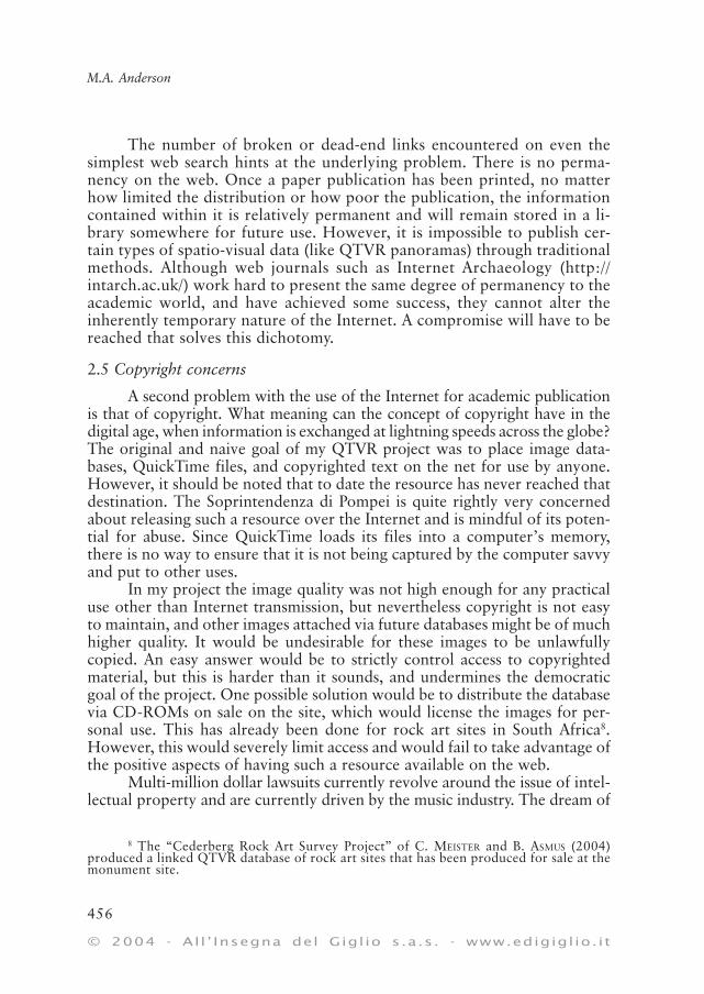
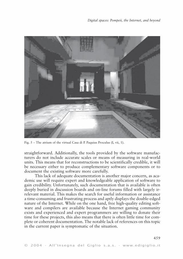
Fig. 5 – The atrium of the virtual Casa di P. Paquius Proculus (I, vii, 1).
3.2 The power of imagesOn a more general level, computer reconstruction, three-dimensional
immersive environments and ray-traced images have opened exciting newavenues of research allowing one to “see” into the past and to draw conclu-sions about how the environment (either natural or man-made) patternedlife and cultural development. Visualisation can be a great tool of researchand is of at least equal use for the presentation of theories, both to otherarchaeologists and the public.
However, it also presents a superficially complete and convincing pic-ture of the past that may not represent true facts. The power of an image isvery great. If a picture is worth a thousand words, then how many is a three-dimensional visualisation or QTVR movie worth? We must be careful lestthe visual impact of our visualisations create a more powerful impressionthan the words that accompany it. This is especially true when the assump-tions and theories that are encapsulated in the reconstruction are not clearlycited or detailed. Complete transparency in documentation of reconstruc-tion has long been the goal of certain projects, such as UCLA’s Cultural Vir-tual Reality Lab (http://www.cvrlab.org/) and the Cultural Virtual Reality Or-ganization (http://www.cs.kent.ac.uk/people/staff/nsr/cvro/workshop.html). Itis much more difficult to give the wrong impression in print than it is usingcomputer generated virtual reality and images. Since it is the goal of VRresearch to achieve photo-realism in images and to recreate ancient environ-ments accurately, we should realise that it will always generate images thatare far more convincing than our words could ever be, and which may implyconclusions we did not intend or knowledge we do not have. My three-dimensional reconstruction of the house of P. Paquius Proculus presents aparticular view of the ancient environment, and is not without flaws. Wemust be cautious that we do not convey more than we intend with our spatio-visual communication.
3.3 The role of businessThe software used in digital projects itself raises questions regard-
ing the role of businesses in the academic world. It is ironic that academiainitially designed and developed the Internet, when today the majority ofacademic work present on the Internet depends heavily upon commercialsoftware. Although in most cases, academia can opt for open-source oracademically developed software, such as that based in Linux, most de-cide not to do so. Academic projects frequently purchase licensed soft-ware in order to complete, present, or publish their results, or even togather the data in the first place. The implications surrounding the de-pendence of academia on commercial products are severe and my projectsare not free from this concern. My QTVR project depends upon propri-
etary software designed by Apple and stitching software designed byVRWorx, while the Quake III project requires the purchase of the compu-ter game in order to run.
What set the Quake III project apart is its reliance on low-cost andfreely available software that was in a sense subsidised by the computer gamesindustry. In this case, I decided to embrace the relationship between businessand academia by exploiting the growth and development of computer gam-ing technology. The results of the project indicate that the relationship be-tween proprietary software developers and academia can be a fruitful one(Tav. XII, a-b). This is certainly the case for computer game engines, since theamount of funding and expertise directed at the production of realistic three-dimensional games could never be matched by academic pursuits. In thistime of rapidly shrinking research budgets, academics should not considerthemselves to be above collaboration with business and the use of “less seri-ous” types of software.
However, since the goals of business and academia are often consider-ably different, the reliance on “proprietary” software generates difficultiesthat must be considered. Perhaps most important is the issue of hidden orunpublished aspects of the functioning of certain programs. Because propri-etary software is created for profit, its rights are carefully protected. Thesoftware use agreement for almost every major piece of software makes itillegal to reverse-engineer and release its code, even as an attempt to under-stand and evaluate the processes at work in it. While from a legal standpointthis is completely understandable, it does mean that the manner in whichcode functions can be completely occluded.
Consider the number of archaeological projects in the world that main-tain Excel-calculated spreadsheets when it is a fact that the actual functioningof these calculations has been called into serious scientific doubt (MCCULLOUGH,WILSON 1998; this work has also been confirmed and further detailed by othersources). The problem becomes even more acute when one is performing aleast-cost path analysis on a terrain map with GIS software. How many of usstop to consider whether or even how the software is making the correct calcu-lations? This “black box” situation is unlikely to be resolved any time soon, butarchaeologists need to be aware of what black boxes they are dealing with intheir work, and attempt to explain them, or at least test them for reliability.
Secondly, reliance on proprietary software presents its own set of is-sues related to the preservation and longevity of data. As industry standardschange, and certain companies succeed whilst others fail, data preserved us-ing less popular standards will face serious longevity problems in a relativelyshort period of time. For a telling analogy, simply consider the Laser disk:how could anyone have known during the height of its success that the DVDwould quickly render it obsolete? (NEWMAN 2003)
This problem is even more acute in the case of software. While in theory,once a given piece of software is installed, it can continue to read its own filesindefinitely. But this assumes that it can be installed and made to function prop-erly. Many programs written for DOS fail entirely under Windows platforms.The problem is less acute for Apple – or Linux – based systems, but the develop-ment of Mac OS X means that earlier software may soon become obsolete. Simi-larly, Microsoft has recently phased out the MS-DOS mode and the MS-DOSbased native operation from all future versions of Windows. Progress determinesthat changes such as this will and must continue, but ensuring that data is stillaccessible in the future often means that it must be constantly migrated. Such hasbeen much of the work of the ADS (Archaeological Data Service) which runs outof the University of York with the express goal of maintaining resources andaddressing the problems of digital heritage (http://ads.ahds.ac.uk/); but the fu-ture of digital data must be considered by all projects that create it.
4. CONCLUSIONS
I have argued that the interactive, multi-user nature of the Internet andcomputer publication means that spatio-visual information can be presented ina way unlike ever before. This does not simply present us with unique possibili-ties. Rather, it presents new standards, new directives and new obligations. It isno longer sufficient to publish two-dimensional plans or sections, databases ofdescriptive terms or site reports that give only the general details and no pho-tographs. Instead, we must begin to examine new ways for the presentation ofspatial information. Much more than impressive pictures, flashy interactivityor crowd-pleasing visualisation, the coordination of information through meansof visual and spatial tools means that an extra dimension of information isrecorded, considered and conveyed. Spatio-visual information not only opensa new dialogue with the non-archaeologist, but is increasingly a tool allowingarchaeologists to communicate with each other, to record and preserve data,and to coordinate, analyse and understand the diverse material culture whichwe as archaeologists use to understand the ancient cultures we study.
However, these new directions do not come without new challenges,and the relative youth of this medium means that many problems are yet tobe overcome. The results and self-critical analysis of two of my own projectshave pointed out some far-reaching theoretical obstacles, which I believe canbe summarized as a general lack of paradigms. Academia must outline ac-ceptable publication standards and regulations for digital media. These mustprovide guidelines for issues of archival resolution quality and longevity, mi-gration and data preservation, publication and intellectual property rights,acceptable documentation and citation and the role of non-scientific, com-mercial and proprietary software. The advantages and opportunities presented
by the digital revolution and the growth of the Internet are considerable, andthey will only increase in the future. Spatio-visual information is the cur-rency of modern communication. The academic and archaeological spheremust now consider exactly how to take advantage of it.
MICHAEL ANDREW ANDERSON
Department of ArchaeologyUniversity of Cambridge
REFERENCES
ANDERSON M.A. 2003, QTVR and the preservation of Pompeii Regio VI: Using digital tech-nologies to document and preserve archaeological sites, in DOERR, SARRIS 2003, 21-28.
ANDERSON M.A. 2004, Computer games and archaeological reconstruction: the low costVR, in FISCHER AUSSERER et al. 2004, 521-524.
AVERN G. 2003, Small- and medium- scale 3D modelling in archaeology, Workshop heldat Vienna, CAA 2003 (unpublished).
AVERN G. 2004, The orthographic approximation – A simple geometrical model for avoid-ing perspective error in construction photomosaics, in FISCHER AUSSERER et al. 2004,405-408.
BARCELÓ J.A., VICENTE O. 2004, Some problems in archaeological excavation 3D model-ling, in FISCHER AUSSERER et al. 2004, 400-404.
CANTONE F. 2002, 3D standards for scientific communication, in G. BURENHULT, J. ARVIDSSON,Archaeological Informatics: Pushing the Envelope. Computer Applications andQuantitative Methods in Archaeology. Proceedings of the 29th Conference (Gotland2001), Oxford, Archaeopress.
Corpus Topographicum Pompeianum 1986, Ricca Maps, Roma, H. Van der Poel.COX N. 2000, Use of Excel for Statistical Analysis (http://www.agresearch.cri.nz/Science/
Statistics/exceluse1.htm, retrieved on 2nd June 2004).DOBBINS J. 1997, Pompeii Forum Project Website (http://pompeii.virginia.edu/pompeii/,
retrieved on 2nd June, 2004).DOERR M., SARRIS A. (eds.) 2003, The Digital Heritage of Archaeology. Computer Applications
and Quantitative Methods in Archaeology. Proceedings of the 30th Conference (Heraklion2002), Archive of Monuments and Publications, Hellenic Ministry of Culture.
ESCHEBACH H. 1970, Stadtplan von Pompeji im Maßstab 1:1000, Mainz, P. von Zabern.FISCHER AUSSERER K., BÖRNER W., GORIANY M., KARLHUBER-VÖCKL L. (eds.) 2004, Enter the
Past. The E-way into the Four Dimensions of Cultural Heritage. Proceedings of the 31stCAA Conference (Vienna 2003), BAR International Series 1227, Oxford, Archaeopress.
FORTE M., PESCARIN S., PIETRONI E., RUFA C., BACILIERI D., BORRA D. 2004, The multimediaroom of the Scrovegni Chapel: a virtual heritage project, in FISCHER AUSSERER et al.2004, 529-532.
Game Studies = The international journal of computer game research (http://gamestudies.org/).KITCHENS S.A. 1998, The QuickTime VR Book: Creating Immersive Imaging on your Desk-
top, Berkeley, Peachpit.KNUSEL L. 1998, On the accuracy of statistical distributions in Microsoft Excel 97,
«Computational Statistics & Data Analysis», 26, 375-377.KRAZNIEWICZ L. 2000, Immersive imaging technologies for archaeological research, in J.A.
BARCELÓ, M. FORTE, D.H. SANDERS (eds.), Virtual Reality in Archaeology, BAR In-ternational Series 843, Oxford, Archaeopress.
LING R. 1997, The Insula of the Menander at Pompeii, Oxford, Clarendon Press.MCCULLOUGH B.D., WILSON B. 1998, On the accuracy of statistical distributions in Micro-
soft Excel 97, «Computational Statistics & Data Analysis», 26, 375-377.MEISTER C., ASMUS B. 2004, QuickTime Virtual Reality (QTVR) and the documentation of
rock art localities, in FISCHER AUSSERER et al. 2004, 548-551.MEISTER M., BOSS M. 2004, On using state of the art computer game engines to visualize
archaeological structures in interactive teaching and research, in FISCHER AUSSERERet al. 2004, 505-509.
MERLO S. 2004, The “Contemporary Mind” 3D GIS as a challenge in excavation practice,in FISCHER AUSSERER et al. 2004, 276-280.
MURRY W.P., MAEKAWA K. 1996, Reliability evaluation of 3M magneto-optic media (http://www.osta.org/technology/pdf/mo_disk_life.pdf, retrieved on 10th September 2003).
NEWMAN M. 2003, Auditing Heritage Data – Ensuring Quality, in DOERR, SARRIS 2003,385-390.
Oxford ArchDigital Ltd. 2002, OAD projects online (http://www.oxarchdigital.com/, re-trieved on 30th September 2003).
RICHENS P. (no date), Playing Games (http://www.arct.cam.ac.uk/research/pubs/pdfs/rich00a.pdf), retrieved on 22nd December 2002.
SCAGLIARINI CORLÀITA D., GUIDAZZOLI A., SALMON CINOTTI T. et al. 2003, Archeologia virtualee supporti informatici nella ricostruzione di una domus di Pompei, «Archeologia eCalcolatori», 14, 237-274.
SCAGLIARINI CORLÀITA D., CORALLINI A., VECCHIETTI E. (forthcoming), The role of scientificreconstruction in Virtual Archaeology: education, communication and valorization.The “Pompei – Insula del Centenario (IX 8) Project”, in Proceedings of the 32nd
CAA Conference (Prato 2004).The CD-Info Company Website 1998, CD-R Media Longevity (http://www.cd-info.com/
CDIC/Technology/CD-R/Media/Longevity.html), retrieved on 10th September 2003.TRONCHIN F., BONILLA D. 2002, Quick Time VR tour of Pompeii Website (http://
hypergraphia.com/francesca/QTVR.htm), retrieved on 2nd June 2004.WINTERS J.C. 2003, Towards Sustainable Electronic Publishing for Archaeology, in DOERR,
SARRIS 2003, 415-420.The CD-Info Company Website 1998, CD-R Media Longevity, http://www.cd-info.com/
CDIC/Technology/CD-R/Media/Longevity.html, retrieved on 10th September 2003.WHITLEY T.G. 2003, GIS as an Interpretive Tool for Addressing Risk Management and Cogni-
tive Spatial Dynamics in a Slave Society, in DOERR, SARRIS 2003, 209-218.ZEMANEK H. 2004, Archaeological Information – An Information Scientist Looks on Ar-
chaeology, in FISCHER AUSSERER et al. 2004, 16-29.
ABSTRACT
The emphasis of archaeological communication is no longer simply text on paper, buthas moved on to encompass the expression of space and visibility. This paper discusses thesenew phenomena from the perspective of two recent projects, both of which presented spatialresearch material for dissemination on the World Wide Web. The first created a QuickTimevirtual reality of Pompeii, Regio VI, and the second used an Internet based game engine tocreate a real-time virtual reconstruction a Pompeian house. The paper also examines issuescentral to the integration of academia with the Internet and computing technology such asthe advantages and disadvantages of using proprietary software and the opportunities andresponsibilities presented by communication in the global community.