VOKU ¥XPO"Y^v> Y<X^\ -g£-l\JrVe>"P- CANYONLANDS NATIONAL PARK, ARCHES NATIONAL PARK, AND NATURAL BRIDGES NATIONAL MONUMENT WATER RESOURCES SCOPING REPORT Kevin Berghoff and David Vana-Miller Technical Report NPS/NRWRS/NRTR-97/94 WATER RESOURCES DIVISION National Park Service - Department ofthe Interior Fort Collins - Denver - Washington WAT&4^54SERVICfc-
Transcript
VOKU ¥XPO"Y^v> Y<X^\-g£-l\JrVe>"P-
CANYONLANDS NATIONAL PARK,
ARCHES NATIONAL PARK, AND
NATURAL BRIDGES NATIONAL MONUMENT
WATER RESOURCES SCOPING REPORT
Kevin Berghoff and David Vana-Miller
Technical Report NPS/NRWRS/NRTR-97/94
WATER RESOURCES DIVISION
National Park Service - Department of the Interior
Fort Collins - Denver - Washington
WAT&4^54SERVICfc-
United States Department of the Interior • National Park Service
The National Park Service Water Resources Division is responsible for providing water
resources management policy and guidelines, planning, technical assistance, training, and
operational support to units of the National Park System. Program areas include water
rights, water resources planning, regulatory guidance and review, hydrology, water
quality, watershed management, watershed studies, and aquatic ecology.
Technical Reports
The National Park Service disseminates the results of biological, physical, and social
research through the Natural Resources Technical Report Series. Natural resources
inventories and monitoring activities, scientific literature reviews, bibliographies, and
proceedings of technical workshops and conferences are also disseminated through this
series.
Mention of trade names or commercial products does not constitute endorsement or
recommendation for use by the National Park Service.
Copies of this report are available from the following:
National Park Service (970) 225-3500
Water Resources Division
1201 Oak Ridge Drive, Suite 250
Fort Collins, CO 80525
National Park Service (303) 969-2130
Technical Information Center
Denver Service Center
P.O. Box 25287
Denver, CO 80225-0287
WATER RESOURCES SCOPING REPORT
for
CANYONLANDS NATIONAL PARK
ARCHES NATIONAL PARK, AND
NATURAL BRIDGES NATIONAL MONUMENT
Kevin Berghoff !
and
David Vana-Miller 2
Technical Report NPS/NRWRS/NRTR-97/94
January 1997
'Hydrologist, U.S. Department of the Interior, National Park Service, Glen Canyon
National Recreation Area, Page, Arizona
^ydrologist, U.S. Department of the Interior, National Park Service, Water Resources
Division, Lakewood, Colorado
United States Department of the Interior
National Park Service
NATIONAL PARK SERVICEWATER RESOURCES DIVISIONFORT COLLINS, COLORADORESOURCE ROOM PROPERTY
Digitized by the Internet Archive
in 2012 with funding from
LYRASIS Members and Sloan Foundation
http://archive.org/details/waterresourcesscOOberg
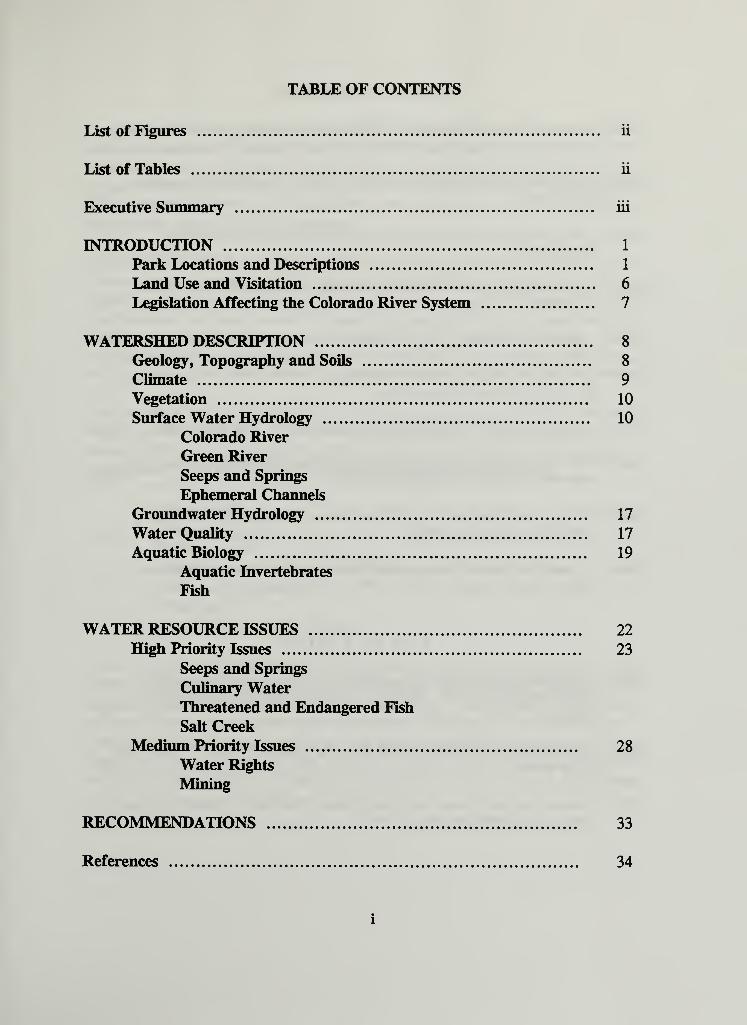
TABLE OF CONTENTS
List of Figures ii
List of Tables ii
Executive Summary iii
INTRODUCTION 1
Park Locations and Descriptions 1
Land Use and Visitation 6
Legislation Affecting the Colorado River System 7
WATERSHED DESCRIPTION 8
Geology, Topography and Soils 8
Climate 9
Vegetation 10
Surface Water Hydrology 10
Colorado River
Green River
Seeps and Springs
Ephemeral Channels
Groundwater Hydrology 17
Water Quality 17
Aquatic Biology 19
Aquatic Invertebrates
Fish
WATER RESOURCE ISSUES 22
High Priority Issues 23
Seeps and Springs
Culinary WaterThreatened and Endangered Fish
Salt Creek
Medium Priority Issues 28
Water Rights
Mining
RECOMMENDATIONS 33
References 34
LIST OF FIGURES
Figure 1 . Location of Canyonlands, Arches and Natural Bridges in relation to the surrounding
area and major hydrography (modified from Long and Smith, 1996) 2
Figure 2. Canyonlands National Park and associated hydrograpy (modified from Long and
Smith, 1966) 3
Figure 3 . Arches National Park and associated hydrography (modified from Long and
Smith, 1966) 4
Figure 4. Natural Bridges National Monument and associated hydrography (modified from
Long and Smith, 1966) 5
Figure 5. Annual peak discharge at the Colorado River at Cisco, Utah, station 12
Figure 6. Pre- and post-1966 flow duration curves for the Colorado River near Cisco, Utah,
for 1930-1982 (from Thompson, 1984a) 13
Figure 7. Annual peak discharge at the Green River at Green River, Utah, gaging station.... 15
Figure 8. Pre- and post-1963 flow duration curves for the Green River at Green River, Utah
station for 1930-1982 (from Thompson, 1984b) 16
Figure 9. Well and landfill locations in the Needles District ofCanyonlands National Park
(from Mesa State College, 1996) 25
Figure 10. Location ofthe Atlas Corporation Mill and tailings pile in relation to Moab and
Arches National Park (from USNRC, 1996) 31
LIST OF TABLES
Table 1 . USGS long term monitoring stations upstream from Canyonlands National Park.
Parameters collected include: Discharge, various water chemistry and suspended
sediment 11
Table 2. Suspended sediment load in millions oftons at the Colorado River near Cisco, Utah
gaging station 14
Table 3 . Common and scientific names ofthe native fishes ofthe Upper Colorado River Basin
(modified from Behnke and Benson 1980) 21
EXECUTIVE SUMMARY
Canyonlands and Arches National Parks and Natural Bridges National Monument,
collectively called the Southeast Utah Group Parks, are located in the high desert ofthe
Colorado Plateau in southeast Utah. All three park units were established due to the
unique scenic, scientific, and archeological features found within their boundaries. Due to
the arid environment ofthe Colorado Plateau, water resources are a critical concern of
National Park Service (NPS) management.
The Group Parks are located in the Upper Colorado River Basin as designated by the
Colorado River Compact of 1922. The operation of all reservoirs and apportionment of all
water throughout the upper basin is dictated in accordance with the "Law ofthe River."
Legislation and operating criteria for the water storage facilities in the upper basin have
significantly altered the flow regime ofthe Colorado and Green rivers through
Canyonlands National Park. Subsequent effects of altered flow regime include impacts on
water quality, endemic fish habitat, adjacent riparian/wetland areas and associated biota.
The purpose of this scoping report is to describe the existing condition ofthe watershed,
identify specific water resource issues of concern to park management, and provide
recommendations on future actions. Initial meetings with the Group Parks Resource
Management staff identified the following issues to address in this report:
Water quality
Seeps and springs
Culinary water
Threatened and endangered fish (Canyonlands)
Salt Creek (Canyonlands)
Water rights
Mining (Canyonlands, Arches)
Water resource issues affecting the Southeast Utah Group Parks are far reaching with
activity impacting park resources often originating far beyond the park boundaries in the
headwater areas ofthe Colorado and Green river basins. The complexity ofthe issues
facing the Group Parks warrants the development of a comprehensive water resource
management plan. Since so many federal and non-governmental organizations have a
significant interest in the upper basin, input from water resource professionals outside of
the NPS will be crucial for successful implementation of a water resource management
plan.
111
INTRODUCTION
Water is an important resource for areas administered by the National Park Service (NPS)
and is of critical concern for those parks located in the arid environments ofthe
southwestern United States. Its scarce nature makes even small sources ofwater, such as
seeps and springs or ephemeral streams, potentially crucial to maintaining the riparian and
aquatic habitat that supports the local desert flora and fauna.
This Water Resources Scoping Report identifies a number ofwater related concerns for
Canyonlands National Park, Arches National Park, and Natural Bridges National
Monument. Existing resource status is discussed and a number ofwater resource issues
identified as key concerns by park management, are considered. These three parks share a
common Resource Management Division and are collectively known as the Southeast
Utah Group. Information generated from this scoping report can be incorporated into the
parks' resource management plan and will provide necessary information for a
comprehensive water resources management plan.
PARK LOCATIONS AND DESCRIPTIONS
All three parks are located in southeast Utah in the Canyon Lands Section ofthe Colorado
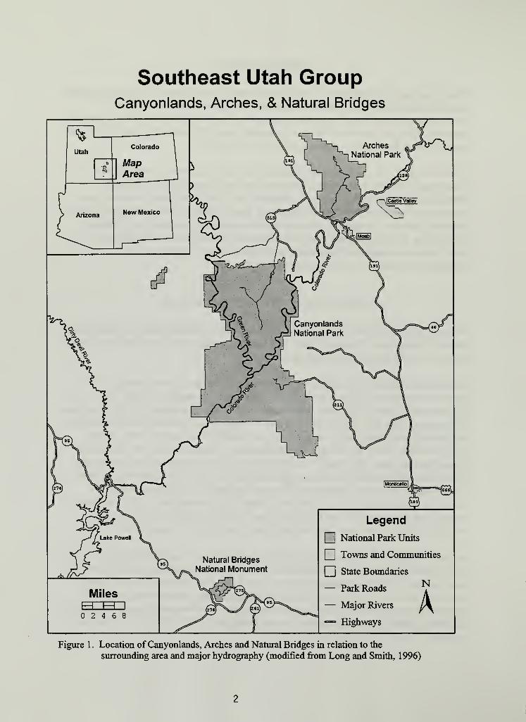
Plateau Physiographic Province. Figure 1 shows the location ofthe Southeast Utah Group
Parks in relation to the surrounding states.
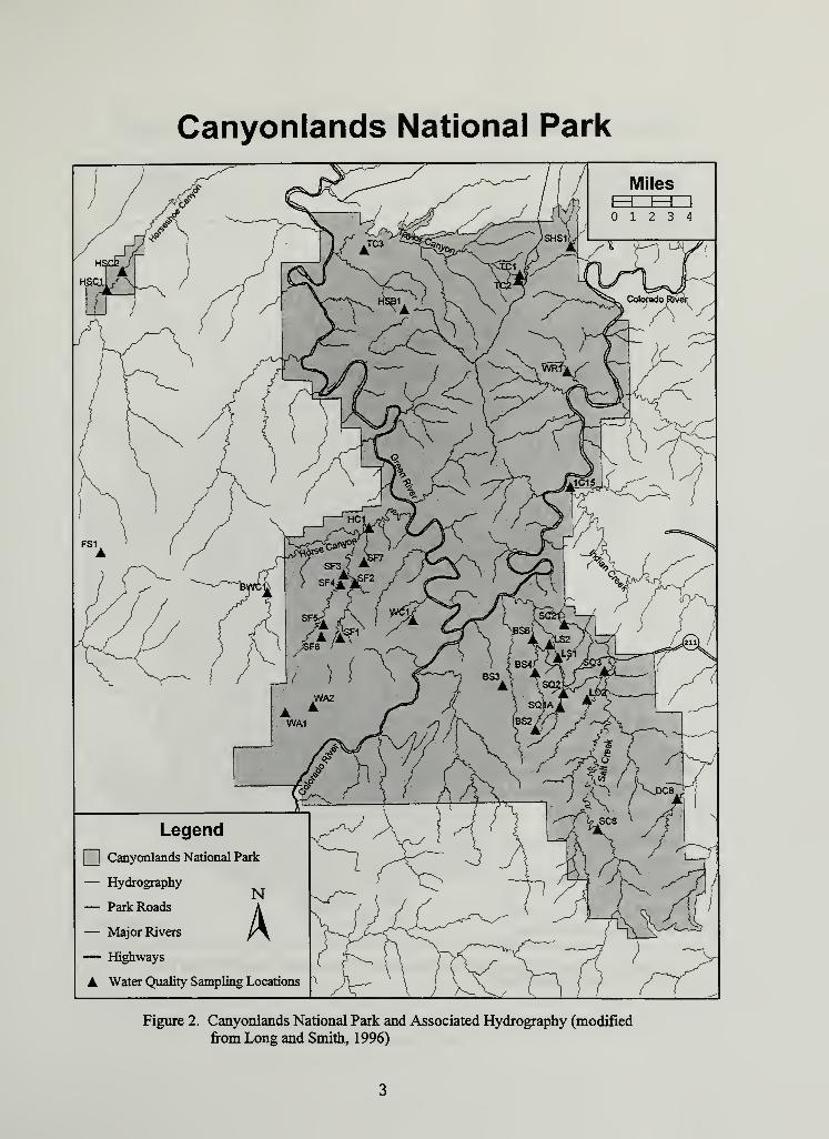
Canyonlands National Park (Figure 2) is the largest ofthe three, encompassing 337,570
acres. The confluence of the Green and Colorado rivers is located in the heart of
Canyonlands. Enabling legislation for the park (PL85-590), established in 1964, states that
the purpose ofthe park is to preserve an area "... possessing superlative scenic, scientific,
and archeological features for the inspiration and benefit ofthe public" (NPS, 1985).
Canyonlands is further divided into four management subunits based on the boundaries
created by the rivers. The Island in the Sky District lies on the plateau area between the
Green and Colorado rivers and covers approximately 132,437 acres. The Maze District
(76,285 acres) includes the Horseshoe Canyon Detached Unit of Canyonlands and is
located to the west and adjacent to the two rivers. The Needles District (128,848 acres) is
located east and adjacent to the Colorado River. The River District occupies a narrow
corridor along the two rivers and was established specifically to manage river activities.
Arches National Park (Figure 3) was originally established as a national monument in 1929
by Presidential Proclamation. The purpose was to "... protect extraordinary examples of
wind erosion in the form of gigantic arches, natural bridges, 'windows', spires, balanced
rocks and other unique wind-worn sandstone formations the preservation ofwhich is
desirable because of their educational and scenic value." Arches went through a number of
boundary changes and was designated as a national park in 1971 (PL92-155). The park
Figure 1. Location of Canyonlands, Arches and Natural Bridges in relation to the
surrounding area and major hydrography (modified from Long and Smith, 1996)
Canyonlands National Park
Figure 2. Canyonlands National Park and Associated Hydrography (modified
from Long and Smith, 1996)
Arches National Park
Legend
I Arches National Park
— Hydrographyj^j
— Park Roads A
— Major Rivers r \
= Highways
A Water Quality Sampling Locations
Figure 3. Arches National Park and Associated Hydrography (modified from Longand Smith, 1996)
Natural Bridges National Monument
Figure 4. Natural Bridges National Monument and Associated Hydrography(modified from Long and Smith, 1996)
Natural Bridges National Monument (Figure 4) is Utah's oldest NPS unit and was
established in 1908 by Presidential Proclamation (No. 804, 35 Stat. 2183). This park was
created to protect the natural bridges contained within its' boundaries considered "...of
greatest scientific interest." Significant importance was also placed on "...reserving these
extraordinary examples of stream erosion with as much land as may be necessary" (NPS,
1996). The park underwent a series ofboundary changes and currently contains 7445
acres.
LAND USE AND VISITATION
The entire Colorado Plateau covers approximately 108 million acres and includes portions
of Colorado, New Mexico, Arizona and Utah. A majority ofthe land, approximately 55%,
is managed by numerous federal agencies, 24% ofthe land is Native American
Reservation, 6% is controlled by state governments, and 15% is in private ownership
(Hecox and Ack, 1996).
Agriculture has been limited to those areas where water can be diverted for irrigation and
for open range livestock grazing. The amount of irrigated agricultural land in the Upper
Colorado River Basin increased rapidly in the early 1900's and is currently estimated at
about 1.4 million acres. Total irrigated area has not increased significantly since about
1920 due to physical, environmental, and economic limitations (USDI, 1995). A majority
ofthe irrigated land is located in river valleys or on plateaus and is supplied by various
irrigation canals and ditches. Irrigated crops include fruit, vegetables, and livestock feed.
Consumptive use has been estimated at 1.8 million acre-feet annually (Liebermann et al.,
1986). Return flows from irrigated lands typically have a higher concentration of dissolved
solids than the river water and contribute significantly to salt loading. Irrigated agriculture
is considered the largest human induced contributor of dissolved solids in the Upper
Colorado River Basin.
Mining and energy exploration initially brought many people to the region, although a
recent study showed decreasing employment trends in the mining industry (Hecox and
Ack, 1996). Minerals such as molybdenum, vanadium, copper, nickel, lead, uranium, and
zinc, as well as energy reserves in oil shale, coal, and oil and gas resources all exist in the
Upper Colorado River Basin. Many ofthe formations that contain these energy resources
were deposited in marine environments. Aquifers that occur in these formations are
confined and often saline. Abandoned oil and gas wells provide a flow path for saline
water to move to the surface. Leachate from active or abandoned mine spoils can
contribute dissolved solids and other contaminants to surface streams.
Visitation to all three parks has increased dramatically since 1980. Canyonlands had less
than 60,000 visitors in 1980 compared to 125,000 in 1985 and 434,834 in 1993. Arches
increased from 150,000 visitors in 1965 to 350,000 in 1985 and 700,000 in 1991. Natural
Bridges visitation increased 12% in 1993 to 152,304 (NPS, 1994). Management ofthe
Southeast Utah Parks has had difficulty keeping pace with the rapid rise in visitation.
NPS units on the Colorado Plateau increased staffing by 48% between 1981-1994. During
the same period, budgets for NPS Plateau Parks increased 3 1%. In 1993, 15% of park
visits were to the Plateau Parks, while only 4.2% ofthe total NPS expenditures went to
those parks (Hecox and Ack, 1996).
LEGISLATION AFFECTING THE COLORADO RIVER SYSTEM
The waters ofthe Colorado River have been one ofthe most legislated and fought over
water resources in the United States. Apportionment ofColorado River water among
basin states, instream flows, and operation of all reservoirs in the Colorado River Basin is
dictated by a complex series of interstate compacts, international treaties, statutes, and
regulations collectively known as the "Law ofthe River." The Colorado River Compact of
1922 divided the Colorado River into the Upper and Lower basins at Lees Ferry, Arizona,
approximately 200 miles below Canyonlands. It was established that the Upper Basin was
obligated to deliver 75 million acre-feet (maf) ofwater, averaged over a 10 year period, to
the Lower Basin states. None ofthe existing treaties and compacts specifically address the
total amount ofwater available. They only authorize the Upper Basin to consumptively
use 7.5 maf ofwater per year (on average), provided it is available and delivery
requirements to Lees Ferry are met. The Water Treaty of 1944 guaranteed 1.5 maf ofwater annually to Mexico; the obligation for delivery being "...equally borne by the Upper
Basin and the Lower Basin" during times of insufficient flow. Initially, representatives
from the seven basin states assumed they were dividing an average annual flow of 16.4
mafmeasured at Lees Ferry (MacDonnell et al., 1995). Subsequent research based on tree
ring dendochronology has indicated the mean annual flow ofthe Colorado River is
actually substantially less, approximately 13.5 maf (Stockton and Jacoby, 1976). The
Upper Colorado River Basin Compact of 1948 divided the water apportioned to the
Upper Basin among the five states with drainages above Lees Ferry. The annual amount of
water use was allocated as follows: 50,000 acre-feet to Arizona, and ofthe remaining
portion, 51.75% to Colorado, 1 1.25% to New Mexico, 23% to Utah, and 14% to
Wyoming. The Colorado River Storage Project Act of 1956 had a major affect on the
flow regime ofthe entire Upper Basin by authorizing construction of Glen Canyon Dam,Flaming Gorge Dam, Navajo Dam, and the Aspinall Unit Dams consisting ofBlue Mesa,
Morrow Point and Crystal Reservoirs (Liebermann et al., 1986).
In addition to these legislative acts, an Annual Operating Plan (AOP) is developed each
year to coordinate the operation of all the reservoirs on the Colorado River system.
Development ofthe AOP is based on projected hydrologic and climatic conditions and is
generated in accordance with the "Law ofthe River." The AOP is developed in
consultation with various federal and state agencies, environmental organizations, and the
general public through the Colorado River Management Work Group (USDI, 1996). All
of these laws and operating criteria have a direct effect on the flow regime ofthe rivers
through Canyonlands National Park.
WATERSHED DESCRIPTION
GEOLOGY, TOPOGRAPHY AND SOILS
The area consists ofnumerous red rock canyons carved into layer cakes of sedimentary
rock formations that have been deformed by a variety ofuplifting and erosional processes.
The geologic strata exposed in the three NPS units range from the Paradox Formation
(Pennsylvanian Period) to the Mancos Shale Formation (Cretaceous Period). These
formations consist ofmany intermixed layers ofmarine, fresh water and eolian deposition
that are collectively several thousand feet thick. Regionally, these depositional layers are
nearly horizontal with a slight dip to the north.
In Arches National Park, the central features are the spectacular rock arches formed in the
Entrada sandstone. The 2000 arches located in the park represent one ofthe highest
concentrations ofthese formations in the world. A number ofmajor sedimentary
formations exposed in the park originate from the Pennsylvanian Period to the Cretaceous
Group (includes Cedar Mesa, Organ Rock and White Rim), Moenkopi, Chinle, Glen
Canyon Group (includes Wingate, Kayenta and Navajo sandstones), Entrada, Morrison,
Cedar Mountain, Dakota Sandstone and Mancos Shale. A major structural feature ofthe
park is the collapsed salt anticline ofthe Paradox Formation located in Salt Valley. The
crystalline salts ofthis formation are of marine origin and have accumulated to great
depths through the process of precipitation and evaporation of stagnant seawater.
Subsequent rock overburden as well as regional uplifting and mountain building activities
caused a plastic deformation in the Paradox Formation, resulting in the salt layers
"flowing" to the southwest. As the uplifting and erosional processes entrenched the rivers
and streams ofthe surrounding plateaus, groundwater dissolved the more soluble salts.
This resulted in a collapse of the underground salt anticlinal structure forming the Salt
Valley in Arches, along with numerous other salt valleys around the Paradox Basin area
(Barnes, 1978). Sediments and evaporites from the Paradox Formation have a significant
effect on water quality. The majority ofthe geologic surface expressions within Arches
consists ofthe Navajo and Entrada sandstones. The Chinle, Wingate, and Kayenta
formations create vertical 800 foot cliffs along the Colorado River at the south boundary
ofthe park.
The primary features of Canyonlands National Park are the immense canyons that have
been cut into the Colorado Plateau by the Green and Colorado rivers. The park is
characterized by the horizontal sedimentary formations typical ofthe Plateau region. The
Colorado and Green rivers cross the park generally from north to south, progressively
cutting into older geologic formations (McKnight, 1940). The great canyons ofthe
Colorado Plateau were created by the downcutting action ofthe rivers during the period
that the surrounding Plateau region uplifted. Underlying geologic formations include:
Paradox, Honaker Trail, Lower Cutler, Organ Rock Shale, White Rim, Moenkopi, Chinle
and Glen Canyon Group.
The topography ofNatural Bridges National Monument consists of a high plateau with
two main deeply incised canyons, White and Armstrong, which join in the western region
ofthe park. The key features ofthe park are the massive natural bridges that were a result
of stream erosion (different from arches that are formed by a combination ofwind erosion,
groundwater and frost action). The principle geologic formation ofthe park is the Cedar
Mesa sandstone, a member ofthe Cutler Formation, which ranges between 500 and 1000
feet thick.
The area encompassing the Southeast Utah Group Parks is an erosional landscape with
over a quarter ofthe area being exposed bedrock. The soils vary widely on the Colorado
Plateau and resemble the parent material from which they are derived. Vegetation
boundaries are usually abrupt, corresponding to sharp changes in substrate or available soil
moisture. Soils located in the lower elevations and canyon floors are typically hot and dry
and are poorly developed, while those at higher elevations are cool and moist. Soils found
in recent eolian deposits, derived from sandstone, range from sandy loam to sand. Those
derived from the shale parent material range from clay loam to clay. Deeper soils are
found in the mountains and valley alluvial fills, while shallow soils and exposed sandstone
are found on rims, benches, and slopes associated with anticlines and synclines (Lammars,
1991).
Precipitation runoff and erodability of soils have increased over much ofthe surrounding
watersheds due to overgrazing of domestic livestock. Excessive removal of plant and litter
cover has lead to increased erosion, causing the down cutting ofnumerous stream
channels and loss ofthe A-horizon from some soils profiles. When these alterations are
combined with the introduction of several exotic species, changes in species composition,
overall productivity, and hydrology can be expected to remain for a period extending into
the geologic time scale.
CLIMATE
Elevations at the parks range from a low of3720 feet at the Colorado River near Cataract
Canyon to a maximum of 6987 feet on Cedar Mesa. The climate ofthe area is arid,
characterized by hot, dry summers and cold winters. Average precipitation varies from
approximately 8 inches in Arches, 8.6 inches in Canyonlands to 13.2 inches in Natural
Bridges. Temperature varies widely with elevation and latitude with extremes ranging
from -16 °F to 1 1 1 °F. Mean annual temperature varies from 56 °F in Arches, 53 °F in
Canyonlands to 50 °F in Natural Bridges. Precipitation in the higher elevations ofthe
Plateau can occur as snowfall from November through March (NPS, 1994). Summerprecipitation consists almost exclusively of brief, intense thunderstorms which can present
a substantial hazard in the form of flash floods. Potential evapotranspiration is
approximately 50 inches annually and greatly exceeds total precipitation amounts.
VEGETATION
Vegetation in the Southeast Utah Group Parks varies depending on elevation,
precipitation and soil type. There are a number of plant communities in the parks including
The riparian vegetation community consists ofFremont cottonwood, yellow willow, box
elder, phragmites, and horsetail. The hanging garden communities are typically
characterized by water dependent plants that are unique to a desert environment. These
include maidenhair fern, monkey flower, death camus, and alcove bog-orchid.
Water resources in the form of riparian areas, seeps and springs, and hanging gardens form
critical habitat for fish, amphibians, aquatic insects as well as other terrestrial and avian
fauna. These locations are often the only source of surface water for large areas in the arid
high desert ofthe plateau. Invasion of exotic plant species such as tamarisk, Russian olive,
cheatgrass, and Russian knapweed has significantly altered the natural vegetation in these
riparian areas. The impacts ofintroduced exotic plants have placed large portions ofthese
ecosystems at risk (NPS, 1994).
SURFACE WATERHYDROLOGY
Arches and Canyonlands National Parks and Natural Bridges National Monument are
centrally located on the Colorado Plateau (Figure 1) in the Upper Colorado River Basin as
designated by the Colorado River Compact of 1922. The major drainages ofthe Plateau
Province are the Colorado and Green rivers which originate in the mountains to the north
and east beyond the perimeter ofthe Colorado Plateau. Flow records show a great deal of
monthly and annual variability. Local intermittent tributary streams can quickly become
raging torrents during summer thunderstorms. Seasonal hydrographs for the Green and
Colorado rivers display a typical snowmelt runoff peak, with a majority ofthe discharge
occurring in May and June.
The U.S. Geological Survey (USGS) collects daily streamflow and water quality data at
long-term monitoring stations on both the Green and Colorado rivers. Both ofthese
stations are located upstream from Canyonlands. (Station information is included in
Table 1.) The Colorado River has no major tributaries between the Cisco station and
Canyonlands, while the San Rafael River joins the Green between the Green River station
and the park.
10
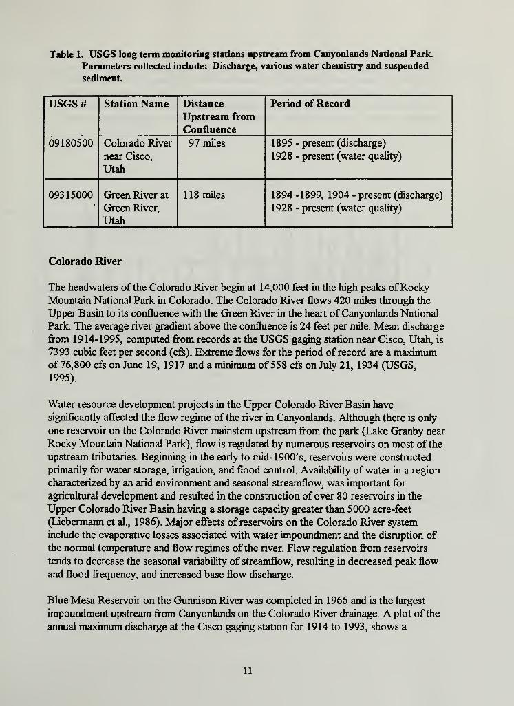
Table 1. USGS long term monitoring stations upstream from Canyonlands National Park.
Parameters collected include: Discharge, various water chemistry and suspended
sediment
USGS# Station Name Distance
Upstream from
Confluence
Period ofRecord
09180500 Colorado River
near Cisco,
Utah
97 miles 1895 - present (discharge)
1928 - present (water quality)
09315000 Green River at
Green River,
Utah
118 miles 1894 -1899, 1904 - present (discharge)
1928 - present (water quality)
Colorado River
The headwaters ofthe Colorado River begin at 14,000 feet in the high peaks ofRockyMountain National Park in Colorado. The Colorado River flows 420 miles through the
Upper Basin to its confluence with the Green River in the heart ofCanyonlands National
Park. The average river gradient above the confluence is 24 feet per mile. Mean discharge
from 1914-1995, computed from records at the USGS gaging station near Cisco, Utah, is
7393 cubic feet per second (cfs). Extreme flows for the period ofrecord are a maximumof 76,800 cfs on June 19, 1917 and a minimum of 558 cfs on July 21, 1934 (USGS,
1995).
Water resource development projects in the Upper Colorado River Basin have
significantly affected the flow regime ofthe river in Canyonlands. Although there is only
one reservoir on the Colorado River mainstem upstream from the park (Lake Granby near
Rocky Mountain National Park), flow is regulated by numerous reservoirs on most ofthe
upstream tributaries. Beginning in the early to mid- 1900' s, reservoirs were constructed
primarily for water storage, irrigation, and flood control. Availability ofwater in a region
characterized by an arid environment and seasonal streamflow, was important for
agricultural development and resulted in the construction of over 80 reservoirs in the
Upper Colorado River Basin having a storage capacity greater than 5000 acre-feet
(Liebermann et al., 1986). Major effects of reservoirs on the Colorado River system
include the evaporative losses associated with water impoundment and the disruption of
the normal temperature and flow regimes ofthe river. Flow regulation from reservoirs
tends to decrease the seasonal variability of streamflow, resulting in decreased peak flow
and flood frequency, and increased base flow discharge.
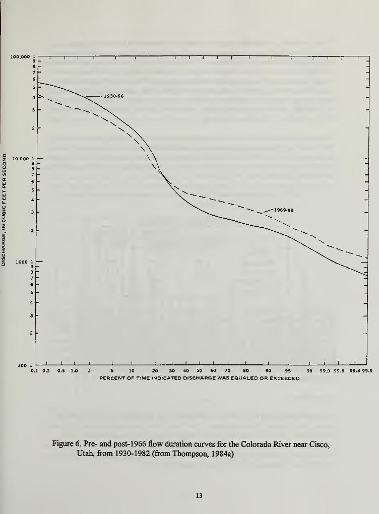
Blue Mesa Reservoir on the Gunnison River was completed in 1966 and is the largest
impoundment upstream from Canyonlands on the Colorado River drainage. A plot ofthe
annual maximum discharge at the Cisco gaging station for 1914 to 1993, shows a
11
substantial decrease in the mean annual peak discharge when comparing the pre- and post-
1966 record (Figure 5). In addition, flow duration curves for the same periods show the
effects of decreased peak flows and increased base flows (Figure 6). Alterations in the
flow regime have been shown to have a significant affect on channel morphology and
width leading to encroachment of exotic vegetation and reduction offish habitat
(Andrews, 1986; Gellis et al., 1991; Pemberton, 1976; Williams and Wolman, 1984).
Pre-1966 Mean Annual PeakDischarge- 41027 eft
60000
50000
Post 1966 Mean AnnualPeak Dljcharge-28607 cfs
10000
iH
lHiHiH^i UiH ill iaiB illiHilliH^ illiHiH^ i
H igiBiM^ iyiHiHiHiH^ i
BiH iHiHiH iB iBill^ il iHiljBiHiaill
iH^ iBiH iBilliH
ia iH^iBiBiH iBill^illiHill^ iBiH i
Hi niHi
H iHiH i
a> 8
Figure 5. Annual peak discharge at the Colorado River at Cisco, Utah, station
12
100 1-L _L I
0.1 0.2 0.5 1.0 S 10 20 30 40 SO 60 70 80 90 95
PERCENT OF TIME INDICATED DISCHARGE WAS EQUALED OR EXCEEDED98 99.0 99.5 99.8 99.9
Figure 6. Pre- and post-1966 flow duration curves for the Colorado River near Cisco,
Utah, from 1930-1982 (from Thompson, 1984a)
13
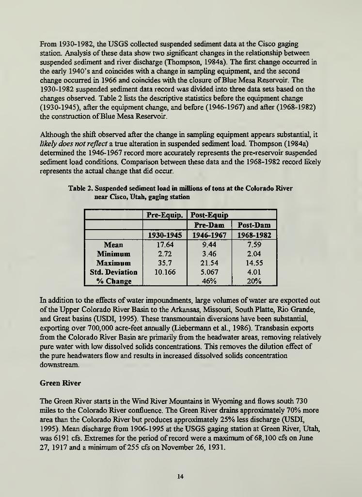
From 1930-1982, the USGS collected suspended sediment data at the Cisco gaging
station. Analysis ofthese data show two significant changes in the relationship between
suspended sediment and river discharge (Thompson, 1984a). The first change occurred in
the early 1940's and coincides with a change in sampling equipment, and the second
change occurred in 1966 and coincides with the closure ofBlue Mesa Reservoir. The
1930-1982 suspended sediment data record was divided into three data sets based on the
changes observed. Table 2 lists the descriptive statistics before the equipment change
(1930-1945), after the equipment change, and before (1946-1967) and after (1968-1982)
the construction ofBlue Mesa Reservoir.
Although the shift observed after the change in sampling equipment appears substantial, it
likely does not reflect a true alteration in suspended sediment load. Thompson (1984a)
determined the 1946-1967 record more accurately represents the pre-reservoir suspended
sediment load conditions. Comparison between these data and the 1968-1982 record likely
represents the actual change that did occur.
Table 2. Suspended sediment load in millions of tons at the Colorado River
near Cisco, Utah, gaging station
Pre-Equip. Post-Equip
Pre-Dam Post-Dam
1930-1945 1946-1967 1968-1982
Mean 17.64 9.44 7.59
Minimum 2.72 3.46 2.04
Maximum 35.7 21.54 14.55
Std. Deviation 10.166 5.067 4.01
% Change 46% 20%
In addition to the effects ofwater impoundments, large volumes ofwater are exported out
ofthe Upper Colorado River Basin to the Arkansas, Missouri, South Platte, Rio Grande,
and Great basins (USDI, 1995). These transmountain diversions have been substantial,
exporting over 700,000 acre-feet annually (Liebermann et al., 1986). Transbasin exports
from the Colorado River Basin are primarily from the headwater areas, removing relatively
pure water with low dissolved solids concentrations. This removes the dilution effect of
the pure headwaters flow and results in increased dissolved solids concentration
downstream.
Green River
The Green River starts in the Wind River Mountains in Wyoming and flows south 730
miles to the Colorado River confluence. The Green River drains approximately 70% more
area than the Colorado River but produces approximately 25% less discharge (USDI,
1995). Mean discharge from 1906-1995 at the USGS gaging station at Green River, Utah,
was 6191 cfs. Extremes for the period ofrecord were a maximum of68,100 cfs on June
27, 1917 and a minimum of255 cfs on November 26, 193 1.
14
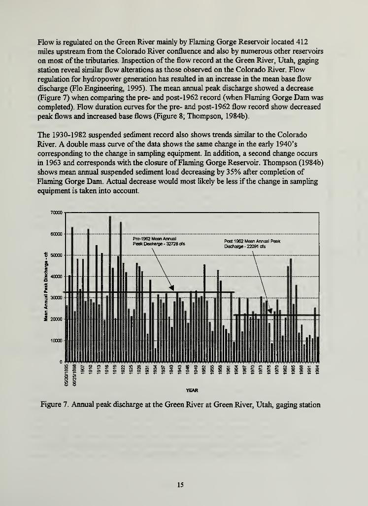
Flow is regulated on the Green River mainly by Flaming Gorge Reservoir located 412
miles upstream from the Colorado River confluence and also by numerous other reservoirs
on most ofthe tributaries. Inspection ofthe flow record at the Green River, Utah, gaging
station reveal similar flow alterations as those observed on the Colorado River. Flow
regulation for hydropower generation has resulted in an increase in the mean base flow
discharge (Flo Engineering, 1995). The mean annual peak discharge showed a decrease
(Figure 7) when comparing the pre- and post-1962 record (when Flaming Gorge Dam was
completed). Flow duration curves for the pre- and post-1962 flow record show decreased
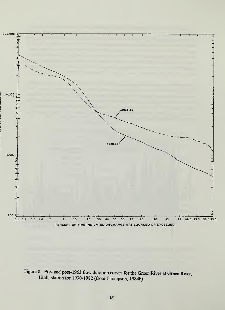
peak flows and increased base flows (Figure 8; Thompson, 1984b).
The 1930-1982 suspended sediment record also shows trends similar to the Colorado
River. A double mass curve ofthe data shows the same change in the early 1940's
corresponding to the change in sampling equipment. In addition, a second change occurs
in 1963 and corresponds with the closure ofFlaming Gorge Reservoir. Thompson (1984b)
shows mean annual suspended sediment load decreasing by 35% after completion of
Flaming Gorge Dam. Actual decrease would most likely be less ifthe change in sampling
Figure 7. Annual peak discharge at the Green River at Green River, Utah, gaging station
15
100.000 li r91-
81-
i r T i i I I I i i1 1 j 1 r
1000 1
9-8-7-6-
3-
2-
100 1- X 4- X _L I _L J. J-0.1 0.2 0.5 1.0 5 10 20 30 40 50 60 70 80 90 95 98 99.0 99.5 99.8 99.9
PERCENT OF TIME INDICATED DISCHARGE WAS EQUALED OR EXCEEDED
Figure 8. Pre- and post-1963 flow duration curves for the Green River at Green River,Utah, station for 1930-1982 (from Thompson, 1984b)
16
Seeps and Springs
Despite the arid environment ofthe Group Parks, there are a large number of seeps,
springs and potholes within NPS boundaries. A previous study identified the Navajo,
Wingate, and White Rim sandstones as water bearing formations based on the presence of
seeps and springs at the base ofthese formations (Huntoon, 1977). Many ofthese springs
produce a small quantity ofwater and are ephemeral in nature. Despite this fact, they
collectively represent the largest volume ofbackcountry surface water available (except
for the Green and Colorado rivers) and are critical for wildlife, vegetation, and other
aquatic biota.
Ephemeral Channels
The Colorado Plateau is dissected by a maze of canyons and channels leading to the main
drainage ofthe Green and Colorado rivers. Although these canyons were the result of
fluvial processes, a large majority ofthem do not contain perennial water. Ephemeral
channels are not actually considered a surface water resource, yet they often support
riparian vegetation and are major sources of sediment input to the major river systems.
During summer thunderstorms, these channels carry dramatic flash floods and debris
flows. It is important to consider the destructive power of flash floods when considering
development activities in associated floodplains.
GROUNDWATERHYDROLOGY
Huntoon (1977) identifies three water bearing aquifers in the northern Canyonlands area
based on the presence of springs that discharge from the base ofthe Navajo, Wingate and
White Rim sandstones. Groundwater may also occur in perched aquifers and alluvial
material in washes and canyon bottoms. Seeps and springs associated with the Navajo and
Wingate formations are often found along bedding planes and fractured joints with flow
amounting to a few gallons per minute or less. The White Rim sandstone has an almost
continuous series of small seeps at some locations along its lower contact. These are also
small discharge springs that individually amount to a few gallons per minute. While these
aquifers may lack the ability to produce water in sufficient quantity and quality for humanconsumption, they represent an important source ofwater for vegetation and wildlife.
WATER QUALITY
Water quality in the Upper Colorado River Basin is affected by local geology and
upstream human impacts. Salinity is one ofthe major and most pervasive water quality
problems in the entire Colorado River Basin. Nearly half (47%) ofthe salinity load in the
Colorado River is from natural sources such as saline springs, erosion of geologic
formation, and soils with a high degree of soluble minerals and surface runoff. The
naturally high salt levels ofthe Green and Colorado rivers have been increased by water
developments in a number ofways. Net evaporative losses from reservoirs tend to
increase the dissolved solids concentration ofthe released water. In addition, when the
17
reservoir is drawn down, water in bank storage may have a high concentration of
dissolved solids if it has been in contact with soluble minerals that are typical for soils in
the Upper Basin. Transbasin exports ofwater from the headwaters area remove the
dilution effect ofwater, low in dissolved solids, and result in increased dissolved solids
downstream. Irrigated agriculture is the second largest use ofwater in the Colorado River
Basin and is also the second greatest contributor of salinity to the system (37%). Surface
runofffrom irrigated areas contribute approximately 3.4 tons of salt annually to the river
system (USDI,1995). Concern over the affects of elevated levels of salinity to agricultural
and municipal water industries led the Colorado River Basin states and the Federal
Government to adopt numeric salinity standards to limit further increases in salt loading
(PL 92-500; Federal Water Pollution Control Act of 1972).
Many ofthe geologic formations in the region were deposited in marine environments and
therefore have a naturally high concentration of dissolved solids. Energy resource
development for coal, oil and gas, and oil shale can contribute to the salt loading problem.
Fossil fuels are generally located in association with marine shales and extraction ofthese
resources results in increased dissolving of soluble minerals. Increased salinity can be
caused by leaching of spoils material, discharge of saline groundwater, and increased
erosion from surface disturbances. Total dissolved solids from mining spoils leachate have
been recorded as high as 3900 mg/1 in northwestern Colorado (Parker and Norris, 1983).
In addition to fossil fuel extraction, there has been a substantial amount ofuranium mining
in areas surrounding NPS lands on the Colorado Plateau. Surface runoff and pollution
from uranium mines can result in elevated levels ofheavy metals, radionuclides and other
toxic elements.
The concentration of dissolved solids typically increases in a downstream direction. The
mean annual dissolved solids concentrations increase from less than 100 mg/1 in the
headwaters area to greater than 500 mg/1 at the bottom ofthe Upper Colorado River
Basin. All major tributaries that have high concentrations of dissolved solids are
downstream from extensive areas ofirrigated agricultural land (Liebermann et al., 1986).
In the early 1980's, the Department ofEnergy identified a possible site for a nuclear waste
repository within a mile ofthe Canyonlands National Park boundary. Park management
expressed concerns over the potential impacts to water quality at springs near the
proposed site. In response, the Southeast Utah Group Parks have initiated a water quality
monitoring program at varying levels of effort at a number of seep and spring sites since
1983. In 1992, the NPS Water Resources Division (WRD) assisted the Group Parks by
analyzing the existing data and providing recommendations regarding the revision ofthe
monitoring plan (Long and Smith, 1996). The monitoring plan was revised from
approximately 50 sites annually to 10 - 15 sites sampled two to three times per year.
Results from these analyses show median values for most water quality parameters to be
within normal levels for typical small springs on the Colorado Plateau. The data displayed
a wide range and large degree ofvariability, possibly due to ambient conditions and
sampling errors. Analyses were performed for several trace elements with most ofthe
18
results being reported as values below the lab detection limit. Several different spring
types were identified based on location and physical characteristics. Many parameters such
as pH, dissolved oxygen, and phosphorus remain relatively consistent among the different
spring types. Other parameters such as water temperature, filterable residue or ionic
content, nitrogen, turbidity, and bacteria were highly variable among the different spring
types.
Although concerns were raised by Long and Smith (1996) regarding quality control
factors, some trends were visible. Elevated levels ofcopper and iron were observed at
many ofthe springs at least once. There were 30 springs at Canyonlands, 7 at Arches, and
3 at Natural Bridges that showed concentrations ofcopper in excess ofthe state standard
at least once, and sometimes several times. The Environmental Protection Agency (EPA)
has listed copper as one of 129 priority pollutants (Irwin, Pers. comm., 1996). Since
elevated levels of copper are considered toxic to many aquatic species, concentrations of
this element should be observed closely in future monitoring.
There are a number of potential sources of selenium in the Upper Colorado River Basin
from natural and anthropogenic origins. Mancos shale and soils derived from this parent
material are naturally high in selenium, containing levels as high as 1 100 ug/kg (Stephens
et al., 1992). Surface irrigation flow and shallow groundwater flow through the Mancos
shale mobilize the soluble selenium and transport it to the rivers and adjacent
wetland/riparian areas. Median concentrations in drainwater discharged to Stewart Lake in
the middle Green River Basin have been detected as high as 140 mg/1, greatly exceeding
the Utah state standard of 5 ug/1. Studies have shown that selenium bioaccumulates
through the food chain, with elevated levels found in fish (Hamilton and Waddell, 1994)
and waterfowl (Stephens, 1994). There is concern that agricultural activities are increasing
contaminants to levels that are detrimental to aquatic biota. Currently, there are several
agencies, including the U.S. Fish and Wildlife Service, Bureau ofReclamation, and U.S.
Geological Survey, conducting studies on selenium levels that impair reproduction and
larval survival ofrazorback suckers.
AQUATIC BIOLOGY
Aquatic Invertebrates
The parks have a variety of other natural water sources. There are potholes, pools fed
from seeplines in canyon alcoves, pools fed by below ground percolation, plunge pools,
springs that gush from rock walls and streams that flow continuously. Currently, little
information exists on the aquatic invertebrate and plant/algae populations ofthese water
resources. This is somewhat surprising considering the opportunities for biological
discovery. For example, springs tend toward a uniform temperature, usually the meanannual air temperature ofthe region (Hynes, 1970). Therefore, springs provide uniform
conditions in areas that are subject to seasonal changes. In these spring environments,
relictual species may have survived and many crenobionts (species confined to springs)
can occur far outside their normal geographical range (Hynes, 1970).
19
The madicolous habitat consists ofthin sheets ofwater flowing over rock faces (Hynes,
1970). In these parks, this habitat is referred to as "hanging gardens." This unique habitat
can provide for some unusual species and associated biological adaptations. For example,
the Diptera are usually the most numerous madicoles, and in contrast to the truly stream-
dwelling families of insects, they are all air-breathing (Hynes, 1970).
Recently, some attempts have been made to rectify this paucity of information on aquatic
invertebrates. Researchers from Brigham Young University are attempting to quantify
aquatic invertebrates in selected habitats ofthe Colorado and Green rivers in Canyonlands.
Preliminary results indicate significant differences in densities of nematodes, copepods,
and rotifers for both sites and habitats, suggesting that artificial substrates may provide
one ofthe most easily monitored databases. These substrates, if placed appropriately, can
be monitored every few months over the year to generate information on the water
quality. In addition, Dr. Lawrence Stevens and staffofthe Grand Canyon Monitoring and
Science Center are studying the benthic ecology ofthe Green and Colorado rivers in
Canyonlands. The group of species sampled appears representative of large, low-gradient
Colorado Plateau streams. Quantification of density and standing crop will reveal howcomparable these assemblages are with regulated reaches ofthe Colorado River
downstream.
Fish
The present Colorado River drainage was established when two separate river systems
forged a connection by cutting through the present Grand Canyon several million years
ago in the Pliocene (McKee et al., 1967). Except for mainstream species, there has always
been a sharp faunistic separation between Upper and Lower Basin fishes (above and below
the Grand Canyon). The Colorado River Basin probably lacked direct connections with
any other major drainage for millions ofyears. This resulted in long isolation ofthe fish
fauna. Except for species inhabiting headwater streams such as trout, sculpins, speckled
dace, and mountain suckers, which can be transferred between drainage basins by stream
capture, the majority ofthe native species ofthe Colorado River Basin are endemic, that
is, they have been so long isolated from their nearest relatives they have evolved into
species now restricted to the Colorado basin. The Colorado basin fish fauna exhibit the
highest degree ofendemism ofany major drainage in North America (Behnke and Benson,
1980). The minnows (Cyprinidae) and suckers (Catostomidae) comprise about 70% of
the freshwater fish species native to the Colorado River Basin. Miller (1958) claimed 87%ofthe 23 species ofminnows and suckers known to be native to the basin at that time
were endemic to the basin. Ofthe over 35 species offreshwater fishes native to the
Colorado River Basin, 14 are native to the Upper Basin (Table 3). Almost 42 introduced
fishes are presently reported in the upper Colorado River.
Prior to human induced alterations, the Colorado River system was characterized by
tremendous fluctuations in flow and turbidity. Miller (1961) cites flows recorded in the
Colorado River at Yuma, Arizona, ranging from 18 cfs in 1934 to 250,000 cfs in 1916.
The drainage basin lacked large natural lakes, so the native fishes never adapted
20
evolutionary specializations for lacustrine environments. For millions ofyears, the unique
environment ofthe Colorado River with its great diversity and torrential flows through
canyon areas, directed the evolutionary pathways followed by the native fishes. It molded
the bizarre morphologies ofthe razorback sucker, the humpback and bonytail chubs, and
produced the largest of all North American minnows, the squawfish. Behnke and Benson
(1980) provide a good overview of distribution, life history, causes of decline for these
unique, and in one case (razorback sucker) monotypic species.
The construction ofmainstream dams, forming large lakes, regulating flow regimes,
precipitating out the silt load and releasing cold, clear water, created new environments
for which the native mainstream fishes were ill adapted (Minckley et al., 1991; Moddeet al., 1995; Tyus, 1991; Holden and Wick, 1982; Seethaler, 1978; Vanicek, 1967). In
addition, predation and competition from normative fishes (Behnke and Benson, 1980) and
toxic metal contamination (Stephens et al., 1992) have contributed to the decline ofthese
species. These factors have impaired the ability ofthese species to recruit throughout
their ranges (McAda and Wydoski, 1980; Tyus, 1992). Consequently, it is not surprising
that the Colorado River squawfish, humpback chub, bonytail chub, and razorback sucker
are federally-listed endangered species. In addition, two other native species, the
flannelmouth sucker and roundtail chub, are candidate species for potential future
inclusion on the Federal Threatened and Endangered Species List.
Table 3. Common and scientific names of the native fishes of the Upper Colorado River
Basin (modified from Behnke and Benson 1980)
Family FamilyCommon Scientific Common Scientific
Salmonidae (trout) Catostomidae (suckers)
Colorado River Onchoryncus clarki Razorback sucker Xyrauchen texanus
Research on the status ofthe four endangered fish species in the Upper Colorado River
Basin has been conducted by the U.S. Fish and Wildlife Service, Utah Division of Wildlife
Resources, Bureau ofReclamation, and National Park Service. The Colorado and Green
rivers through Canyonlands National Park contain significant habitat for these endangered
species (Valdez, 1990; Valdez and Williams, 1993).
Given the limited information available, it appears that recruitment ofthese species is
likely associated with high-flow events, most notably with the availability of flooded
bottomlands (Modde et al, 1995). Riverside wetlands provide important and perhaps
critical habitat for young fish. Water development projects (dams, levees, and other flood-
control structures) often prevent the rivers from overflowing their banks and flooding the
bottomlands. These wetlands can be provided by removing barriers to historic
bottomlands and by providing sufficient flow to inundate bottomlands in a manner that
approximates the natural hydrograph.
The U.S. Fish and Wildlife Service has been in consultation with other federal agencies in
the Upper Colorado River Basin under provisions ofthe Endangered Species Act of 1973
as amended, and has issued over 100 Biological Opinions pursuant to Section 7 ofthe Act
(Tyus, 1991). In general, the U.S. Fish and Wildlife Service has determined that water
depletion and dam operations would likely jeopardize the continued existence ofsome
listed fishes. An interagency program has been established in the Upper Colorado River
Basin in an effort to recover listed fishes without violating existing state and federal water
agreements. This program oversees recovery activities in the upper Colorado River,
provides funds for evaluating habitat requirements ofthe fishes, and seeks ways to obtain
water needed by the fishes (Tyus, 1991).
WATERRESOURCE ISSUES
All the NPS units on the Colorado Plateau are located in the arid environment ofthe high
desert. Water is such a scarce resource that even intermittent and ephemeral sources can
be critical for sustaining the natural floral and faunal ecosystems ofthe Group Parks.
Impacts to water quality, riparian habitat and aquatic biota are key concerns ofthe
Southeast Utah Group.
The use of certain water resources within Canyonlands for recreation is also considered
important. The Green and Colorado rivers form the heart ofCanyonlands and represent a
major drainage for the southwestern United States. Recreational boating in the form of
kayaking and rafting, are very popular and have established themselves as a significant
aspect ofthe local tourist economy.
Water quality issues were identified as the number one priority during the initial meeting
with the Southeast Utah Group staff. Since water quality is a component ofmost ofthe
issues identified, it will be addressed under each relevant topic.
22
HIGH PRIORITY ISSUES
Seeps and Springs
The seeps and springs represent one ofthe few riparian and aquatic habitats away from the
main river drainages. Visitation was identified as the primary threat to non-river water
sources in the Southeast Utah Group Parks. The impacts to water quality due to the
effects of sunscreen, insect repellent, body oil and salts, in backcountry water sources
frequently used for bathing and swimming, are unknown. Although the current
Backcountry Management Plan (NPS, 1995) prohibits "swimming, bathing and immersing
human bodies in water sources..." a detailed study may be necessary to develop a basis for
these restrictions. The increased impact due to human visitation may drive away wildlife
that depend on the springs as a water source. Trampling of surrounding vegetation and
soils, and increased sedimentation are also concerns that may impact water quality and
benthic aquatic organisms existing in the seeps and springs.
Salt Valley Wash is a tributary of Salt Wash (in Arches) and was formed as a result of
collapsed salt anticlines in the Paradox Formation. Salt Valley Spring is a perennial water
source located in the headwaters ofthe wash and has been developed in the past for stock
watering. The spring has been at risk of completely drying up due to invasion oftamarisk
(Tamarix ramosissima). The NPS has been involved in a tamarisk eradication project at
the spring in an attempt to control this exotic species. This effort has involved routinely
cutting down the tamarisk and applying the herbicide Garlon 4 to inhibit resprouting.
Removal ofthe tamarisk would reduce evapotranspiration and rejuvenate the spring by
increasing discharge back to natural levels. In the past, this area has been considered for
antelope re-introduction if a sufficient water source could be found. Arches staffinvolved
with the project have expressed concern over the effects of exposure to the herbicide and
the impacts to surface and groundwater quality.
Trespass cattle also affect springs in Arches and Canyonlands. Impacts include trampled
soil and vegetation, increased sedimentation, and elevated levels of fecal contamination. In
addition, a full biotic assessment is needed to determine if rare or threatened and
endangered vegetation and aquatic species are present at the seep and spring sites. In
1996, Natural Bridges will complete the last segment offencing that will effectively
exclude cattle from the water resources ofthe monument.
Culinary Water
NPS units on the Colorado Plateau have become a major destination for millions of
tourists annually. Average visitation to Plateau Parks has increased 94% between 1981
and 1994. The South East Utah Group Parks are even outpacing the average Plateau
visitation increase. For example, Canyonlands experienced a growth of 160% in visitor
days between 1981 and 1993 (Hecox and Ack, 1996).
23
Accompanying the increased visitation is an increased need to provide visitor services. All
districts administered by Canyonlands have experienced significant increases in visitation
which at times overtaxes the existing culinary water systems. Currently, water is trucked
into the Maze and Island Districts, limiting the amount of potable water available.
Previous studies to determine groundwater availability indicate poor water quality and
excessive aquifer depth in the northern regions ofCanyonlands (Huntoon, 1977). In some
areas, perched aquifers discharge directly to local springs. Some ofthe underlying strata
(i.e., sandstones) are considered water bearing formations, but hydraulic conductivity of
these consolidated rock formations is generally quite low and results in low well yields,
although in some areas of localized fracturing and faulting, well yields may increase
significantly (USGS, 1984). One previous study noted two wells that are relatively close
to existing developments at Hans Flat (Hand, 1979). Discharge from these wells appear
quite low but may be increased by development work and augmented by storage options.
Water quality is also a concern. Dissolved solids are routinely greater than 1000 mg/1
where the top ofthe Navajo Sandstone is more than 500 feet below the surface
(Blanchard, 1987). A water treatment process, such as a reverse osmosis system, may be
necessary to deal with high levels of dissolved solids. A detailed engineering and economic
feasibility study would be necessary to determine the potential for local groundwater
development.
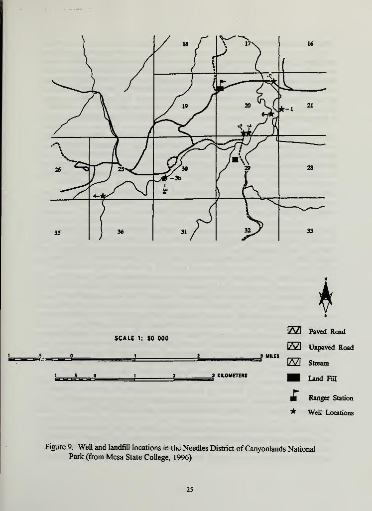
The Needles District of Canyonlands contains an abandoned landfill that was reportedly in
use from 1966-1987 (Figure 9). A preliminary assessment was done on the site, and it
determined that potential contaminants may include: paints and thinners, batteries,
pesticides, aerosol cans, human waste, oils, construction debris and household waste
(Mesa State College, 1996). It is unknown at this time whether leachate from this landfill
is a potential threat to the well currently being used for domestic water. Impact to the
culinary water system should be determined and a site remediation plan designed. Also,
there are numerous abandoned wells in the general area ofthe Needles Ranger Station
(Figure 9). If a decision is made to terminate the use ofthese wells, they should be
officially abandoned and properly sealed. Unplugged wells can be a conduit for
contaminants to move between aquifers. This is especially a concern ifthe abandoned
wells intercept groundwater flow carrying leachate from the abandoned landfill, possibly
transmitting contaminants to the aquifer used for the domestic water supply.
24
1 5l-l L-l l-l l-l L-l t-
SCALE 1: 50 000
M
J MILES
3 KILOMETERS
[53 Paved Road
E3 Unpaved Road
El Stream
Land Fill
Ranger Station
* Well Locations
Figure 9. Well and landfill locations in the Needles District ofCanyonlands NationalPark (from Mesa State College, 1996)
25
Threatened and Endangered Fish
The Colorado River in Arches and Canyonlands, and the Green River in Canyonlands
were designated by the U.S. Fish and Wildlife Service as critical habitat for the four
federally endangered fish species. Critical habitat is a regulatory term describing the areas
of land, water, and air space containing the physical and biological features essential for
the survival and recovery ofthreatened and endangered species. Section 7 ofthe
Endangered Species Act requires federal agencies to ensure that their actions are not likely
to jeopardize the survival of a listed species or adversely modify its critical habitat.
The lower 50 miles ofthe Green River constitutes one ofthe most important nursery areas
for Colorado River squawfish in the basin, due to relatively high densities in backwater
habitats. Similarly, the Colorado River in Cataract Canyon contains the most recently
discovered reproducing population ofhumpback chub. It is also one of only three areas in
the Upper Colorado River Basin where bonytail chub have recently been reported (Valdez
and Williams, 1993). In 1996, more than 170 razorback sucker larvae were documented
from the lower Green River near Canyonlands (U.S. Fish and Wildlife, 1996). This
confirms that spawning is occurring in this stretch of river and suggests the presence of
another population of razorback sucker in the lower Green.
Flow regime and channel geomorphology have changed dramatically over time. Flow in
the Green River has been regulated by various water development projects and the
Flaming Gorge Dam since 1963. The mean annual peak discharge at the Green River
gaging station at Green River, Utah, (USGS station 093 15000) has decreased 33% from
32,728 cfs to 22,091 cfs between the pre- and post-1963 streamflow data. While the pre-
and post-1963 mean annual flow data remain relatively unchanged at 5800 cfs and 5600
cfs, the mean base flow (represented by flow records from September 1 to March 1) for
the same period of record increased 64% from 2150 cfs to 3380 cfs (Flo Engineering,
1995). Riparian vegetation has been shown to be sensitive to changes in maximum and
minimum flows, but substantial changes in riparian areas can occur without changing meanannual flow (Auble et al., 1994). This flow alteration likely reflects the operation of
Flaming Gorge Dam for storage and hydropower generation. Reservoirs will typically act
as sediment traps, blocking all sediment transport downstream. However, on the Green
River below Flaming Gorge Dam, the decrease in sediment transport at the Green River
gage far exceeds the amount of sediment trapped by the reservoir. Flaming Gorge
Reservoir is located in the upper reaches ofGreen River Basin where a majority ofthe
basin runoff is generated, while the principle area of sediment contribution is farther
downstream. The results ofthe study by Andrews (1986) indicate the decrease in sediment
transport at the lower end ofthe Green River Basin is primarily due to a decrease in the
magnitude ofthe river flows and not necessarily a decrease in available sediment.
The reduction in magnitude and frequency ofpeak discharges and the decrease in sediment
transport have resulted in significant changes to channel morphology. The result ofthese
changes has been extensive vegetation encroachment, stabilization and bank attachment of
sandbars within the active river channel, and narrowing ofthe river channel. Comparison
26
of historic photos in specific reaches on the Green River in Canyonlands clearly show
some large sandbars have become so densely vegetated that inundation results in sediment
deposition and vertical development ofthe bars (Flo Engineering, 1995). Eventually, this
process results in the loss of side channels which are considered key spawning habitat for
some ofthe native fish species. Erosional processes on unregulated rivers have been
observed that do not occur on regulated rivers (Cluer, 1996). These processes may be
significant due to their impacts on aquatic biota and habitat in the river channels.
Flaming Gorge Reservoir, as well as all other reservoirs in the Upper and Lower Colorado
River basins, is operated in accordance with the "Law ofthe River." The 1997 Annual
Operating Plan for the Colorado River Reservoirs states, "All operations will be
undertaken subject to the primary water storage and delivery requirements established by
the "Law ofthe River"... including enhancement offish and wildlife, and other
environmental factors." Flaming Gorge has been operated under the criteria specified in
the Biological Opinion on the Operation ofFlaming Gorge since 1992.
The 1996 water year is the final year of a five year study plan called for in the Biological
Opinion initiated to determine river flows necessary to maintain native endangered fish
populations. The Bureau ofReclamation and the Western Area Power Administration are
expected to release a revised Biological Opinion in 1997 which may modify specific
constraints regarding flow releases for the entire annual cycle. It will be necessary for the
NPS to stay current regarding decisions made on operating criteria for Flaming Gorge
Dam. Releases from Flaming Gorge will determine future changes in channel
geomorphology as far downstream as Canyonlands National Park.
Effective management practices have not been developed for native Colorado River fishes,
nor have endangered fishes been recovered. To do so would require many years of
research and management work. However, the Interagency Recovery Program is assisting
the development and testing ofmanagement practices for the fishes. This was madepossible by funds provided by a coalition of federal, state, and private agencies, and
interests wishing to recover listed endangered fishes and at the same time, allow for some
water development. It is the cooperation ofvarious agencies that are charged with
protection ofthe fishes and management ofthe water upon which they depend, that will
permit the development and testing ofmanagement procedures and practices for recovery
of listed fishes; presumably to the benefit ofthe entire fish fauna.
Salt Creek
Salt Creek is a very popular spot located in the southern area of Canyonlands Needles
District. Other than the Colorado and Green rivers, Salt Creek is the only other perennial
stream in the park. This makes Salt Creek a significant riparian resource that forms
important habitat for aquatic and terrestrial wildlife. A four-wheel drive road runs in the
bottom ofthe wash and accesses popular backcountry hiking areas in the upper reaches of
Salt Creek. Several archeological sites accessible from the wash make it a culturally
important area as well.
27
The Salt Creek area has experienced a dramatic increase in visitation in the form of four-
wheel drive vehicles. Salt Creek Road is located directly through the wash and causes a
substantial impact to the riparian habitat. Impacts to aquatic and terrestrial wildlife are
unknown. The riparian area along Salt Creek has not been fully assessed regarding the
presence of rare or threatened and endangered vegetation. Determinations should be madespecifying whether areas in Salt Creek meet the criteria for designated wetlands.
Due to the increased adverse impacts observed on Salt Creek Road, the current
Backcountry Management Plan has limited access to this area. Four-wheel drive roads are
remaining open to vehicle traffic, but travel on Salt Creek Road will be allowed by permit
only. It is hoped that the effort to limit traffic will serve as a starting point to resource
protection in this area. In addition, the Backcountry Management Plan states that a
monitoring program will evaluate the effectiveness of this restriction.
MEDIUM PRIORITY ISSUES
Water Rights
A system of allocating water for beneficial use was developed because ofthe arid climate
and limited available water in the western United States. This system is known as the prior
appropriation doctrine and is the primary philosophy regarding allocating water resources
in the west. The concept of "first in time, first in right" applies in western water rights,
meaning the date of appropriation determines the users priority to use water. Ifthere is
insufficient water to meet all needs, the senior appropriators (those with earlier
appropriation dates) will obtain all of their allocated water before junior appropriators
(those with later appropriation dates) obtain any oftheirs. The prior appropriation system
ofwater rights is under the jurisdiction ofthe individual states in the western United States
(Getches, 1984).
In addition to the prior appropriation doctrine, water allocation and use in the western
United States is governed by the Federal reserve water rights doctrine (also known as the
Winters Doctrine). This doctrine asserts that the U.S. reserves, by implication, the right to
enough ofthe unappropriated water on or adjacent to the reserved lands to fulfill the
purpose ofthe reservation (Newberry, 1995). Reserve water rights institute a priority date
back to when the reservation was established and are not subject to state water law except
when properly joined in a general adjudication. This concept of federal primacy over state
control ofwater is ofgreat concern to states' water rights holders. Federal reserve rights
are often unused and unquantified. Water users with state rights established after the
creation date ofthe reservation have a lower priority than that ofthe reservation. Ifthe
federal government asserts its water rights claim after a stream has been fully appropriated
under the state system, junior rights filed under the state system may subsequently go
unfilled (Getches, 1984). This could potentially disrupt a state's water rights system and
displace any junior water users, yet it can also have the effect of protecting instream flows,
thus protecting existing downstream users from new diversions. The National Park
28
Service has used both the federal reserve and prior appropriation doctrine to protect water
rights interests ofNational Park units (Newberry, 1995).
Water allocation in the Upper Colorado River Basin is dictated by states' rights, federal
reserve rights, and the "Law ofthe River." The McCarran Amendment (1952, 66 stat.
560) grants a limited waiver of Sovereign Immunity to allow the United States to be
joined as a defendant in suits involving the adjudication ofwater rights. This amendment
requires the United States to assert its claim to water rights when general adjudication is
occurring in the pertinent river system. Failure to assert a claim to water rights in such a
proceedings may result in forfeiture ofthese rights. Portions ofthe Colorado River
drainage system through Utah are currently undergoing water rights adjudication, and the
federal government is expected to be a part ofthis adjudication procedure sometime in the
future. The Southeast Utah Group Parks are a part of this system by nature of their
location in the heart ofthe Upper Basin. Water rights issues that were identified during
initial meetings with park staff are discussed below.
In the Horseshoe Canyon detached unit of Canyonlands, active grazing allotments
exist adjacent to park boundaries. There is currently a water right conflict over stock
watering at a nearby spring. The NPS Water Rights Branch and the Department of
Interior Solicitors Office is currently investigating this situation.
The Lost Spring Canyon is a tributary of Salt Wash in Arches National Park. This
spring is located in a designated Wilderness Study Area (WSA) outside of park
boundaries, but consideration has been given to include the WSA into the NPS system.
In the past, the Lost Spring has been developed for cattle stock watering and may have
an existing water right associated with it. This claim should be investigated for validity
or status regarding forfeiture or abandonment.
In initial meetings with Arches staf£ concern was expressed over a spring located
within park boundaries in the upper reaches ofCourthouse Wash. This spring has
been used for stock watering in the past. A staffmember referred to a letter written by
a previous Arches superintendent, which gave a local rancher permission to use the
spring for stock watering. The administrative files were searched, but a copy ofthe
letter has not been found. Questions were raised over whether a water right was
established by the local rancher due to abandonment or forfeiture by the Park Service.
Arches currently has a good relationship with the local rancher but occasionally has
trespass cattle in the area.
In December of 1996, Utah and the Department of Interior reached a final agreement
on water rights at Zion National Park. This agreement is paving the way for future
negotiations ofNPS units in Utah. A water rights assessment ofthe Southeast Utah
Group Parks is appropriate at this time to take advantage ofthe 'settlement
momentum' initiated by the Zion decision. This will ensure that the NPS will pursue
water rights filings where appropriate and adjudicate existing water rights if necessary.
29
Mining
Much ofMoab's history and early growth center around the boom and bust cycle ofthe
mining industry. Extensive mining activity has occurred in the recent past concentrating
primarily on uranium, oil and gas exploration, and oil shale extraction.
The Atlas Moab Mill and associated uranium tailings pile are located approximately 3
miles northwest ofMoab on the west bank ofthe Colorado River (Figure 10). Arches
National Park Headquarters and Visitor Center are located approximately 1.5 miles
northeast ofthe tailings pile. The Atlas Mill is no longer in operation and is currently being
dismantled. As required by the Nuclear Regulatory Commission (NRC), the 10.5 million
ton, 130 acre uranium mill tailings pile will be reclaimed by the Atlas Corporation. The
criteria specified by the NRC for reclaiming uranium tailings provides flexibility on a site
specific basis to determine optimum disposal. The current reclamation proposal preferred
by the Atlas Corporation and recommended by the draft environmental impact statement
(DEIS) specifies reclaiming the tailings for permanent disposal at its current location
(USNRC, 1996). This process would involve reducing the sideslopes ofthe pile to 30%and capping the pile with an earth and rock system to minimize radon outgassing,
rainwater infiltration, movement of tailings leachate into the groundwater and adjacent
Colorado River, and natural and flood-induced surface erosion ofthe tailings pile. Arejected alternative plan required transporting the spoils pile to a remote site away from
Moab and the Colorado River. The DEIS final recommendation appears to be based on
the high cost oftransporting the tailings to the alternative location. The Atlas Corporation
has publicly stated that ifforced to transport the spoils pile from its present location, the
company will declare bankruptcy and walk away from the situation (ENR, 1984).
The proper reclamation ofthe Atlas tailings pile is of critical concern to the National Park
Service. The DEIS acknowledges the potential impacts to downstream resources but
considers the impacts insignificant. A catastrophic failure ofthe tailings pile adjacent to the
river would result in contaminated sediments deposited all along the downstream channel
margins through the river section of Canyonlands. The subsequent chronic effects of
elevated levels of radionuclides, heavy metals, and other toxic contaminants can only be
detrimental, especially to the recovery efforts ofthe threatened and endangered fishes.
Water samples collected by the Utah Department ofEnvironmental Quality in 1995,
showed elevated levels oftotal and dissolved manganese, ammonia as nitrogen, and
molybdenum. When comparing samples collected above and below the tailings pile, the
Department found concentrations below the pile exceeded state water quality standards
Figure 10. Location ofthe Atlas Corporation Mill and tailings pile in relation to Moaband Arches National Park (from USNRC, 1996)
31
Another concern is the potential for off-site groundwater contamination. The Atlas tailings
pile has been in place since 1956. Possible hydraulic connection to the alluvial aquifer and
rainfall infiltration to the pile over an extended period of time, may have altered the
groundwater flow direction. Radial flow away from the pile could carry contaminants in
many directions including toward Arches (UDEQ, 1996). While analysis of a water sample
taken from the Arches culinary well on January 18, 1996, did not show any indication of
radionuclide contamination, well samples taken during the summer of 1996 show gross
alpha levels near the maximum threshold (Rogers, pers. comm., 1996). Sampling should
be continued to periodically monitor the well for possible contamination. The NPS is
currently waiting for the U.S. Fish and Wildlife Service final opinion on the DEIS and
should be kept current ofany decisions made regarding the Atlas tailings pile reclamation.
Abandoned uranium mines are located in the headwaters area of Salt Wash and Seven
Mile Canyon near Arches and in locations near Canyonlands. Spoils from these
abandoned mines have never been reclaimed. There is a potential for mine drainage to
enter the parks during surface runoff events. Contamination from mine waste has not been
documented, but there is potential for this to occur.
Oil and gas exploration has occurred in the Salt Valley area near Arches. Numerousexploratory wells have been drilled but were never developed due to economic reasons.
Using new technology, a producing oil well located approximately 10 miles southwest of
the park, was established in the early 1990's. This successful operation has resulted in an
increase of oil and gas lease applications on surrounding Bureau ofLand Management(BLM) lands. Saline water is a by product of oil and gas production with active wells
commonly producing several times the amount of saline water as oil. Disposal techniques
for excess saline water include evaporation, injection and discharge to local streams
(USDI, 1995).
32
RECOMMENDATIONS
The complexity ofthe water resource issues facing the Southeast Utah Group Parks
justifies the development of a comprehensive Water Resource Management Plan. The
emphasis of this scoping report has been to identify issues that will be explored in greater
detail in the management plan. These issues were identified during initial meetings with the
Resource Management staffand personal contacts with park rangers at Arches and
Natural Bridges. It will be important to solicit input from water resource professionals
affiliated with other local federal and non-governmental organizations concerned with
regional water resource issues. This may be accomplished through an issues scoping
workshop at the beginning ofthe water resource management planning process, an event
designed to bring together a group ofpeople with specialized knowledge ofwater
resource issues of concern to the Southeast Utah Group Parks.
The water resource issues affecting the Southeast Utah Group Parks are complex and far
reaching. Impacts to water resources ofthe Group Parks quite often originate far beyond
the park boundaries in the upper Green and Colorado river basins. Activities of private and
federal entities can affect the aquatic resources and associated biota all along both river
systems. The dual, and sometimes contradictory, mandate oftheNPS to "...provide for
their (visitors) enjoyment..." while leaving the natural resources "...unimpaired for future
generations" has become difficult under the explosive growth in visitation the Colorado
Plateau parks have experienced in the last 10 to 15 years. The NPS is continually placed in
a controversial arena when attempting to initiate restrictions in popular areas. The
management decision to implement restrictions on the Salt Creek Road (Needles District,
Canyonlands) as specified by the Canyonlands Backcountry Management Plan is being
legally challenged due to conflicting opinions and uses of this area. Creative management
and careful monitoring ofthe natural resources will be necessary to maintain the parks in a
relatively pristine state.
33
REFERENCES CITED
Andrews, E.D. 1986. Downstream effects ofFlaming Gorge Reservoir on the Green River,
Colorado and Utah. Geol. Soc. ofAmer. Bulletin 97:1012-1023.
Auble, G.T., J.M. Friedman, and M.L. Scott. 1994. Relating riparian vegetation to present
and future streamflows. Ecological Applications 4(3):544-554.
Barnes, F.A. 1978. Canyon Country Geology. Wasatch Publishers, Inc., Salt Lake City, Utah.
Behnke R., and D. Benson. 1980. Endangered and Threatened Fishes ofthe Upper Colorado River
Basin. Colorado State University, Cooperative Extension Service, Fort Collins, Colo.
Bulletin 503A.
Blanchard, P.J. 1987. Hydrology ofthe Navajo Sandstone in Southwestern and Southern Utah,
in J.S.McLean and A.I. Johnson (eds.). 1988. Regional Aquifer Systems ofthe United
States, Aquifers ofthe Western U.S. AWRA Monograph Series 14, Bethesda, Md.
Cluer, B.L. 1996. Lessons from an unregulated reach ofthe Colorado River: Processes of erosion
and deposition and comparison with the regulated river in Grand Canyon. NPS, Water
MacDonnelL L.J., D.H. Getches, and W.C. Hugenberg, Jr. 1995. The Law ofthe Colorado River:
Coping with Severe Sustained Drought. Water Resources Bulletin 31(5):825-836.
McAda, C, and R. Wydoski. 1980. The razorback sucker, Xyrauchen texanus, in the upper
Colorado River. U.S. Fish and Wildlife Service Technical Papers 99:1-15.
McKee, E., R. Wilson, W. Breed, and C. Breed (eds.). 1967. Evolution ofthe Colorado River in
Arizona. Bull. Mus. North. Ariz. 44: 1-67.
McKnight, E.T. 1940. Geology ofArea Between Green and Colorado rivers, Grand and San Juan
Counties, Utah. USGS. Government Printing Office, Washington, D.C.
Mesa State College. 1996. Preliminary Assessment at Canyonlands National Park Project WorkPlan, Durango, Colo.
Miller, R. 1958. Origin and affinities ofthe freshwater fish fauna ofwestern North America.
Pages 187-222 in C. Hubbs (ed.). Zoogeography. Amer. Assoc. Adv. Sci. 41: 1-509.
Miller, R. 1961. Man and the changing fish fauna ofthe American Southwest. Pap. Mich. Acad.
Sci. Arts Letters 46:365-404.
Minckley, W., P. Marsh, J. Brooks, J. Johnson, and B. Jensen. 1991. Management toward
recovery ofthe razorback sucker. Pages 303-358 in W. Minckley and J. Deacon, (eds.).
Battle against extinction. University ofArizona Press, Tuscon, Ariz.
35
Modde, T., A. Scholz, J. Williamson, G. Haines, B. Burdick, and F. Pfeifer. 1995. Anaugmentation plan for razorback sucker in the Upper Colorado River Basin.
Pages 102-111 in H. Schramm and R. Piper, (eds.). Uses and effects of cultured fishes in
aquatic ecosystems. Symposium No. 15. American Fisheries Society, Bethesda, Md.
National Park Service. 1985. Natural Resource Management Plan and Environmental
Assessment for Canyonlands National Park, Utah. NPS, Moab, Utah.
National Park Service. 1989. General Management Plan/ Development Concept Plan and
Environmental Assessment for Arches National Park, Utah. NPS, Moab, Utah.
National Park Service. 1994. Southeast Utah Group Research Plan, Arches National Park,
Canyonlands National Park, Natural Bridges National Monument. NPS, Moab, Utah.
National Park Service. 1995. Canyonlands National Park and Orange Cliffs Unit of Glen Canyon
National Recreation Area, Backcountry Management Plan.
National Park Service. 1996. Draft Environmental Impact Statement for General Management
Plan/Development Concept Plan for Natural Bridges Nat. Monument. NPS, Moab, Utah.
Newberry, D.L. 1995. Liquid Treasure, Water Rights and the National Park Service, Colo. State
University, Department ofRangeland Ecosystem Science, Ft. Collins, Colo.
Parker, R.S., and J.M. Norris. 1983. Simulated Effects ofAnticipated Coal Mining on Dissolved
Solids in Selected Tributaries ofthe Yampa River, Northwestern Colorado. USGS, Water