19
Kumutoto Site 10 Architectural Design Report for Resource Consent Submission 25 September 2014

Kumutoto Site 10Architectural Design Report for Resource Consent Submission
25 September 2014

12 September 2014 | 13-09_Kumutoto Site 10
P1
Contents
PROJECT TEAM
1.0 IntroductionBackground
2.0 ContextGeneralThe Existing SiteHistoric ContextStatutory Context
3.0 The ProposalForm and ArticulationThe Proposed ActivitiesBuilding StructureBuilding Services and Environmental ServicesArchitectural Articulation & MaterialsIntegration with the LandscapeServicing and ParkingHeritage and Contemporary Culture

12 September 2014 | 13-09_Kumutoto Site 10
P2
PROJECT TEAMDEVELOPER: Willis Bond & Co Limited
CONTRACTOR: LT McGuinness Limited
ARCHITECTURE: Athfield Architects Limited
STRUCTURE: Dunning Thornton Consultants Limited
BUILDING SERVICES: AECOM

12 September 2014 | 13-09_Kumutoto Site 10
P3
1.0 Introduction
This report outlines the design of the proposed building located on Site 10 Kumutoto, Wellington. It forms part of the Resource Consent application and AEE prepared by Urban Perspectives Limited, on behalf of Site 10 Redevelopment Limited Partnership (Site 10 RLP).
The scope of this proposal is the new building proposed for ‘Site 10’ site and associated enabling and infrastructure and landscape ground works within the footprint of the building site indicated on drawing RC1.00-A
The proposed building is a 5 story (Ground +4) new building housing commercial office use on upper floors, Retail/ Gallery, small business, Foyers, and servicing on Ground floor, and car/ cycle parking, building user amenities and services within the basement.
Although this proposal is designed as an integrated landscape and building, the landscape works (outside of the building perimeter) are covered under a separate parallel consent application.
Background
This proposal is a development of the design proposal that was submitted by developers, Willis Bond & Co, in response to a public Expressions of Interest process, and subsequent design competition run by Wellington Waterfront Ltd (WWL) for Site 9 and Site 10, Kumutoto, in late 2013. The Athfield Architects Ltd designed Willis Bond entry was selected on the basis of assessment against multiple criteria, including design excellence, and best fit to the design brief and draft Kumutoto design guidelines.
Since this selection, the proposal has undergone design development and further testing in architecture, building structure, services, and construction feasibility, with cognisance of design review and input from independent experts, from WWL/ Technical Advisory Group (TAG)/ Wellington City Council (WCC), engagement with key stakeholders and with the market.
This is a Developer-led proposal by Site 10 RLP. Their vision for the project is:
“Our vision for Sites 9 and 10 is to create a truly exceptional public setting through integrated design and holistic thinking.We have formulated a multi-faceted design with the primary focus of engaging the public which is underpinned by a sustainable commercial model. These places and their architecture will both invite and delight.We have a world-class team which can deliver another exemplar outcome for the city.”
This report outlines the design description, analysis and assessment of the proposal in relation to its context, and includes consideration of inputs and review by WCC officers as well as from urban design and planning specialists engaged by Willis Bond.
This report should be read in conjunction with the appended design drawings.
Fig 1. View from Queens Wharf Outer T looking North towards North Kumutoto
12 September 2014 | 13-09_Kumutoto Site 10
P4
Site 10
Fig 2. Aerial view from the Outer T Fig 7. Aerial view of Centreport, Wellington
Fig 8. Aerial view of Railway Station and Parliament
Fig 3. Aerial view from NZ Post building podium
Fig 4. Te Raukura & Taranaki St West landscape Fig 9. Lambton Quay
Fig 5. Te Papa Tongarewa entry plaza Fig 10. Kumutoto Landscape
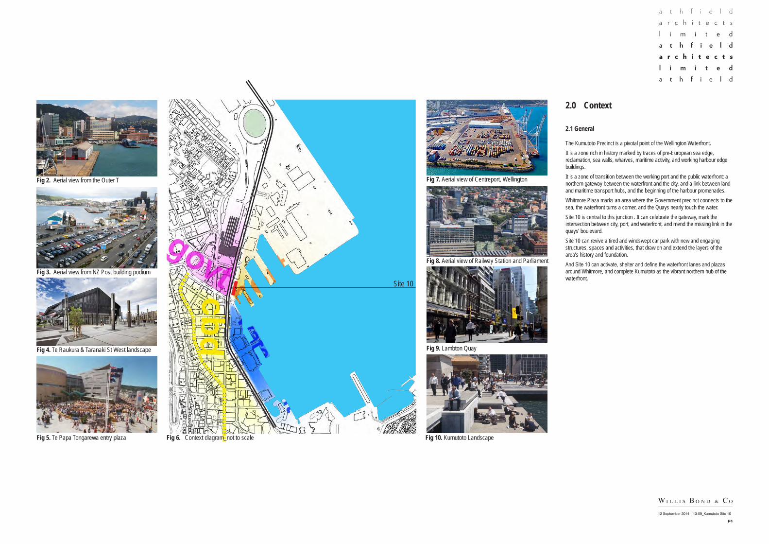
2.0 Context
2.1 General
The Kumutoto Precinct is a pivotal point of the Wellington Waterfront.It is a zone rich in history marked by traces of pre-European sea edge, reclamation, sea walls, wharves, maritime activity, and working harbour edge buildings. It is a zone of transition between the working port and the public waterfront; a northern gateway between the waterfront and the city, and a link between land and maritime transport hubs, and the beginning of the harbour promenades.Whitmore Plaza marks an area where the Government precinct connects to the sea, the waterfront turns a corner, and the Quays nearly touch the water.Site 10 is central to this junction . It can celebrate the gateway, mark the intersection between city, port, and waterfront, and mend the missing link in the quays’ boulevard.Site 10 can revive a tired and windswept car park with new and engaging structures, spaces and activities, that draw on and extend the layers of the area’s history and foundation. And Site 10 can activate, shelter and define the waterfront lanes and plazas around Whitmore, and complete Kumutoto as the vibrant northern hub of the waterfront.
Fig 6. Context diagram_not to scale

12 September 2014 | 13-09_Kumutoto Site 10
P5
2.0 Context
2.2 The Existing Site
The site is a rectangular site in the northern Kumutoto precinct of the Wellington Waterfront, adjacent to the east side of Waterloo Quay, and situated between Shed 21 and the Whitmore Street gates between the Whitmore Street/ Waterloo Quay intersection and the waterfront.To the east of the site is an area of mixed pedestrian and vehicle movement and parking, and beyond that the constructed harbour edge, including the Harbour wharf, with the former Eastbourne Ferry Building at its base, beyond that within the port land, the Waterloo Quay Wharf, with its two story wharf sheds structure, and the Railway Wharf. The historical sea wall, currently buried from sight, runs along between these wharves and the subject site. The subject site and its immediate surrounds is currently used as a temporary campervan and car park, and includes a temporary amenities block to service this activity.
Fig 11. Aerial Image_not to scale - Wellington City Aerial Imagery (2011)
Fig 12. View from Corner of Whitmore St and Waterloo Quay
Shed 21
Railway Station
NZ Post Building
Whitmore Street Gates
Amenities block
Former Eastbourne Ferry Terminal
Building
Waterloo Quay W
harf
Railway Wharf
Harbour WharfTug W
harf
WATER
LOO QUAY
CUST
OMHO
USE Q
UAY
WHITMORE STREET
Fig 13. View looking north from the Tug Wharf
Fig 14. View looking south along Kumutoto Lane
Fig 15. Aerial View looking north toward Site 10
12 September 2014 | 13-09_Kumutoto Site 10
P6
2.0 Context
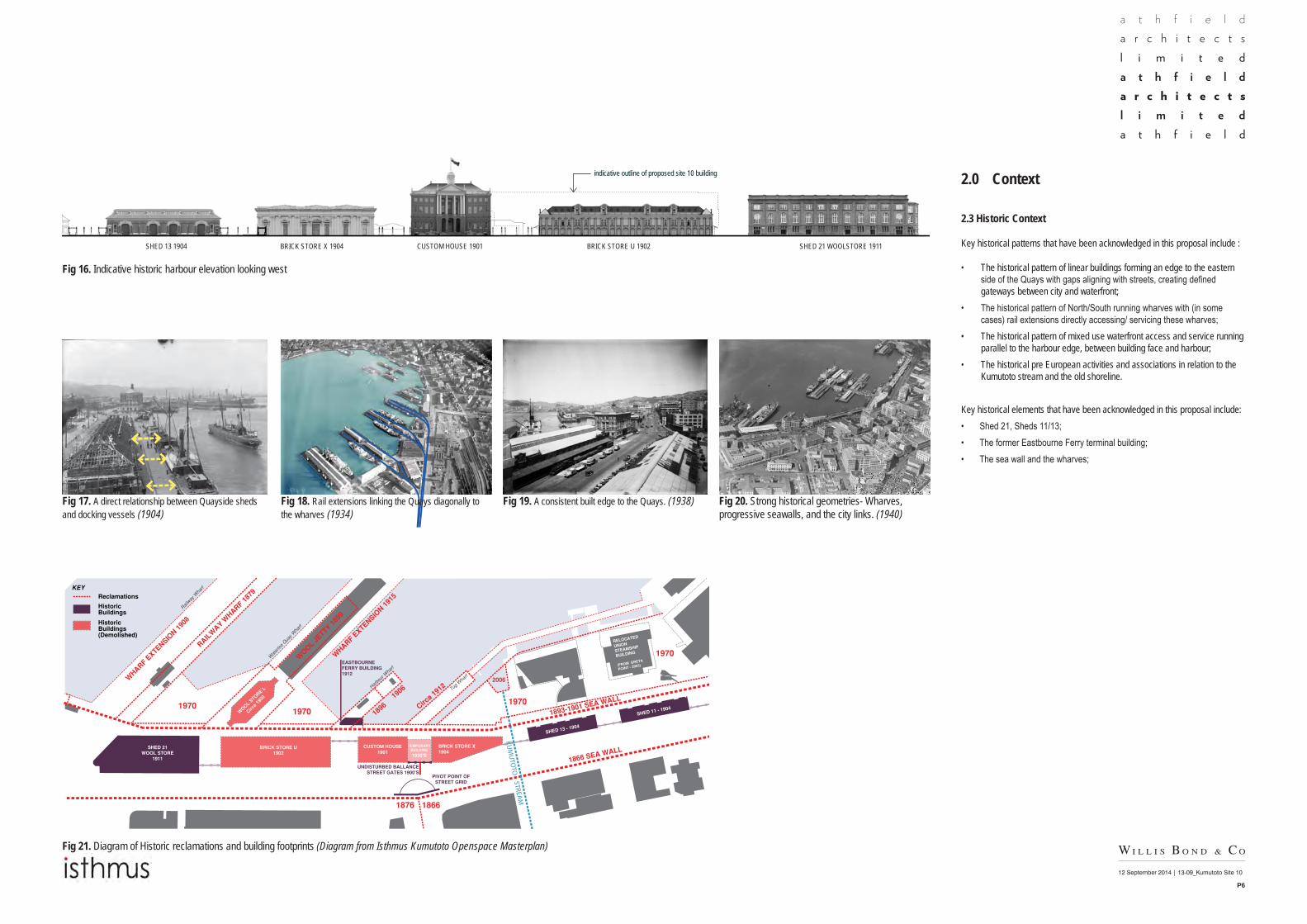
2.3 Historic Context
Key historical patterns that have been acknowledged in this proposal include :
• The historical pattern of linear buildings forming an edge to the eastern side of the Quays with gaps aligning with streets, creating defined gateways between city and waterfront;
• The historical pattern of North/South running wharves with (in some cases) rail extensions directly accessing/ servicing these wharves;
• The historical pattern of mixed use waterfront access and service running parallel to the harbour edge, between building face and harbour;
• The historical pre European activities and associations in relation to the Kumutoto stream and the old shoreline.
Key historical elements that have been acknowledged in this proposal include:• Shed 21, Sheds 11/13;• The former Eastbourne Ferry terminal building;• The sea wall and the wharves;
SHED 13 1904 BRICK STORE U 1902BRICK STORE X 1904 CUSTOM HOUSE 1901 SHED 21 WOOLSTORE 1911
Fig 17. A direct relationship between Quayside sheds and docking vessels (1904)
Fig 16. Indicative historic harbour elevation looking west
Fig 21. Diagram of Historic reclamations and building footprints (Diagram from Isthmus Kumutoto Openspace Masterplan)
Fig 18. Rail extensions linking the Quays diagonally to the wharves (1934)
Fig 19. A consistent built edge to the Quays. (1938) Fig 20. Strong historical geometries- Wharves, progressive seawalls, and the city links. (1940)
indicative outline of proposed site 10 building
KUM
UTO
TO STREAM

12 September 2014 | 13-09_Kumutoto Site 10
P7
WATERLOO QUAY
FORMER EASTBOURNEFERRY BUILDING
KUMUTOTO LANE
SHED 21
Fig 23. WCC District Plan - Viewshaft 4 Fig 24. Viewshaft 4 down Whitmore StExisting and Proposed
Fig 25. Site 10 proposed footprint and Viewshaft 4
Fig 22. Site 10 Plan
Fig 21. Waterloo Quay Elevation
22M AMSL - shown dashed21.1M AMSL
Alignment with Shed 21
Woolstore Plaza
Woolstore Plaza
Property Boundary
Viewshaft 4
Viewshaft 4 alignment
14M
14M
2.0 Context
2.4 Statutory Context
North Kumutoto Design Brief
The planning context
Plan constraints
Height & Mass
View Shafts
789101112131415161718
WATERLOO QUAYWHITM
ORE
STRE
ET BALLANCE STREET
NZ POST BUILDING
KUMUTOTO LANE
HARBOUR WHARF
VIEW SHAFT 4
TUG WHARF
PROPOSED BUILDING OUTLINESHOWN DASHED
UP
OFFICE
DECK
OFFICE
KEY:STRUCTURAL ENGINEER:NAME : Dunning Thornton Consultants LtdPHFAXPO BOXEMAIL
SERVICES ENGINEER:NAME : AECOMPHFAXPO BOXEMAIL
FIRE ENGINEER:NAME : Holmes FirePHFAXPO BOXEMAIL 1 : 250 @ A1
Levels 3 & 4
13-09Kumutoto - Site 10
P1.03-D
N
1 : 250Level 3
1 : 250Level 4
No. Description DateA FOR PRICING 28.02.14B MARKETING 12.06.14C FOR INFO 13.06.14D CONSULTANT CO-ORDINATION 30.06.14
SITE 10
SITE 10

12 September 2014 | 13-09_Kumutoto Site 10
P8
3.0 The Proposal
3.1 The proposed form and articulation.
The design approach in this proposal is to develop a strong architectural framework to celebrate this part of the waterfront, clearly respond to the many existing and historical cues in the precinct, and to provide for a range of contemporary forms and integrated spaces for a developing range of contemporary uses. The building is robust, but playful in character, acknowledging the primary role in contributing to a stage for a diverse range of activity and event on this part of the waterfront.
The proposal is conceived as an assemblage of complementary components, spaces, and functions overlapping with adjacent waterfront landscape.
Although a single building, the mass is broken into two lower podium forms, split by the cross-site Harbour Wharf link, with a third continuous upper level form spanning over the top, like a working waterfront gantry. While the scale and form of this flying gantry is celebrated at the southern end as a gateway marker and civic portico to Whitmore Plaza, it transitions at the North end to meet the scale, elevational orders, and modulation of Shed 21.
These three inter-linked forms combine to form a cohesive whole that integrates with the various conditions of open space, water’s edge, street, existing and anticipated built form in the area.
Fig 26. Aerial diagram of North Kumutoto Landscape
The Working GantryThe extended portico to Whitmore Plaza, housing high-quality office work space. The commercial spine for the development. The visual link to the working port, and the functional link to the CBD.
Future Development on Site 9 Creative Business Hub‘Start-up’ innovation cluster. Fine grained studio/retail creative spaces fronting the lane and Wool Store Plaza.
Whitmore Plaza PodiumThe mid level mixed use office space providing flexible high quality potential multi-unit office space
The Harbour Wharf LinkA break in the building. A sheltered public link (and view) between the Quayside Colonnade and the waterfront, tracking the lines of the old rail extensions servicing the harbour wharf.
Whitmore Plaza ExtensionA plaza that extends from open space to the ground floor tenancy. A public foyer to the city gateway. A place for event, exhibition, installation and nourishment.
Whitmore Plaza Site 8 Landscape
See Isthmus Resource Consent Drawings and Design report

12 September 2014 | 13-09_Kumutoto Site 10
P9
3.0 The Proposal
The southern-most podium form is conceived as an extension of the Whitmore Plaza in that the continuous portico roof integrates exterior and interior space under it (like a veranda), and the ground of the plaza extends into the café/ gallery tenancy space at Ground floor, and through to the cross-site link. This portion of the podium is visually permeable, highly glazed, and set back under the portico, to enhance the sense of integration with the Whitmore Plaza open space, the former Eastbourne Ferry Terminal frontage and wharf space to the south east. The southwest corner incorporates large diagonally orientated window boxes, reflecting the orientation of the wharf structures, and addressing the Whitmore Gateway and the corridor extending eastward toward Parliament.
The northern-most podium form is more regular in form, and proposed to house managed small business/ retail outlets as part of a creative business hub at Ground floor predominantly facing the waterfront lane and the Woolstore Plaza, with office activity above. This form incorporates a long box window extension on the eastern side, that provides shelter to the promenade interface below, and provides open deck space for upper levels above.
The north and west elevations of this form comprises a more solid frame and ‘hit and miss’ façade system around levels 1 and 2 that provide a level of solar mitigation on these exposed sides, a more solid/ substantial edge to the Quays, and sense transition toward the brick mass of Shed 21. The texture and scale of façade elements on the upper west elevation (above the colonnade) are more substantial and robust than other parts of the building in response to the scale and predominantly vehicular use of the Quays. The rhythm of façade elements is considered in relation to the often oblique and dynamic reading the building will have from people moving along the Quays, as well as the more static mid to distant views.
The colonnade along the western side of Shed 21 is extended along the western Quays side of this new building, and the ‘gap’ between these forms forms a public cross-site link for pedestrians to deliver them from sheltered quay-side route to sheltered harbour-side route along the promenade, with direct links to the office foyers, and to the Whitmore Plaza extension spaces.To formally accentuate the reading of this gap between the two podium forms, and to signal the public cross-link from oblique approaches, glazed box window is proposed to protrude 1.2m beyond the face of the building frame in this location.
Whitmore Plaza Extension Cross Site Link
Cross Site Link & Colonnade
Creative Business Hub
Creative Business Hub
Shed 21 Apartments
Shed 21 Apartments
Deck Northern PodiumThe Working GantryWhitmore Plaza Podium
The Working Gantry
Window Boxes Whitmore Street GatesWhitmore Plaza extension
Glazed Box Window
Fig 27. South East Elevation
Fig 28. North West Elevation
12 September 2014 | 13-09_Kumutoto Site 10
P10
3.0 The Proposal
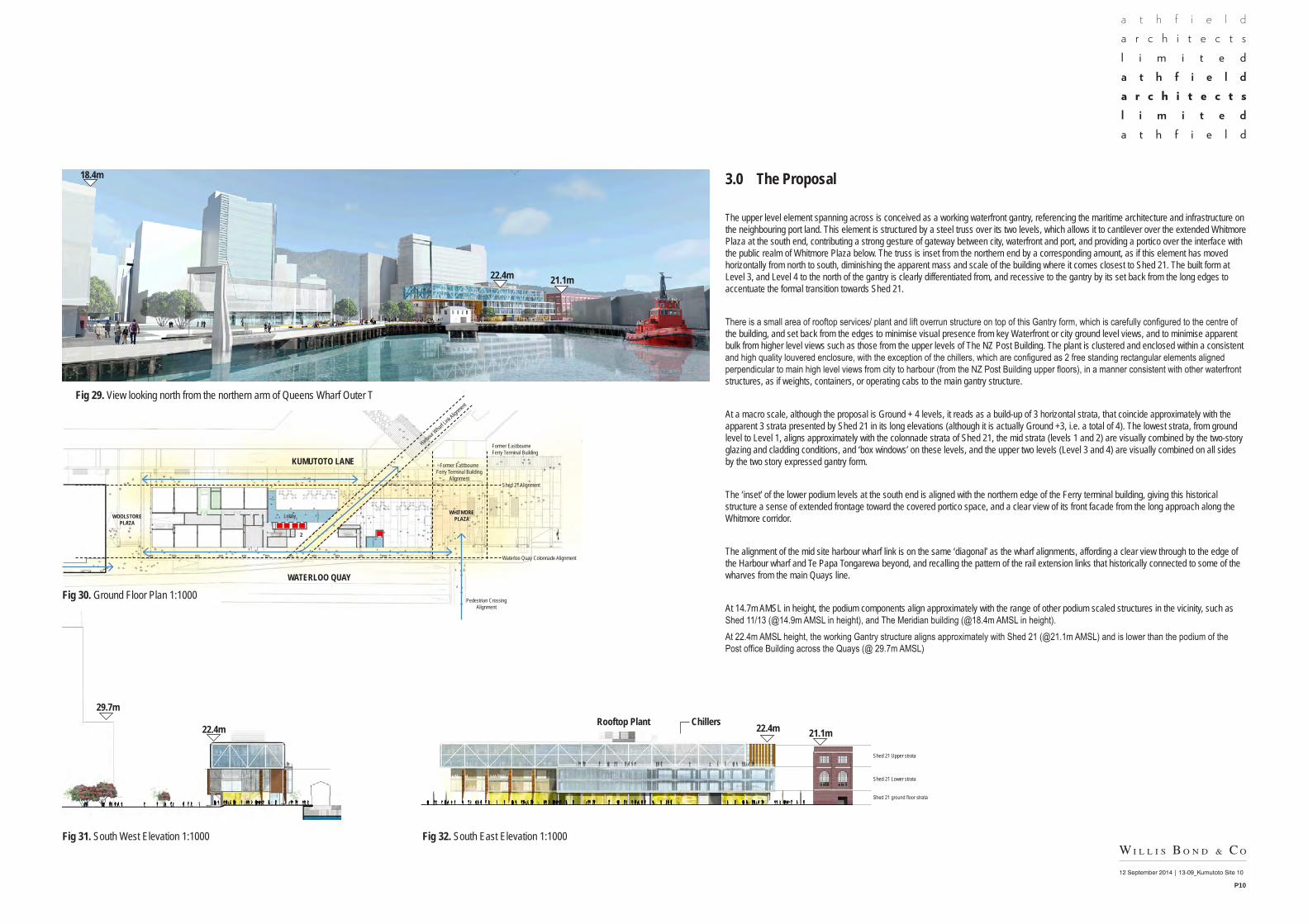
The upper level element spanning across is conceived as a working waterfront gantry, referencing the maritime architecture and infrastructure on the neighbouring port land. This element is structured by a steel truss over its two levels, which allows it to cantilever over the extended Whitmore Plaza at the south end, contributing a strong gesture of gateway between city, waterfront and port, and providing a portico over the interface with the public realm of Whitmore Plaza below. The truss is inset from the northern end by a corresponding amount, as if this element has moved horizontally from north to south, diminishing the apparent mass and scale of the building where it comes closest to Shed 21. The built form at Level 3, and Level 4 to the north of the gantry is clearly differentiated from, and recessive to the gantry by its set back from the long edges to accentuate the formal transition towards Shed 21.
There is a small area of rooftop services/ plant and lift overrun structure on top of this Gantry form, which is carefully configured to the centre of the building, and set back from the edges to minimise visual presence from key Waterfront or city ground level views, and to minimise apparent bulk from higher level views such as those from the upper levels of The NZ Post Building. The plant is clustered and enclosed within a consistent and high quality louvered enclosure, with the exception of the chillers, which are configured as 2 free standing rectangular elements aligned perpendicular to main high level views from city to harbour (from the NZ Post Building upper floors), in a manner consistent with other waterfront structures, as if weights, containers, or operating cabs to the main gantry structure.
At a macro scale, although the proposal is Ground + 4 levels, it reads as a build-up of 3 horizontal strata, that coincide approximately with the apparent 3 strata presented by Shed 21 in its long elevations (although it is actually Ground +3, i.e. a total of 4). The lowest strata, from ground level to Level 1, aligns approximately with the colonnade strata of Shed 21, the mid strata (levels 1 and 2) are visually combined by the two-story glazing and cladding conditions, and ‘box windows’ on these levels, and the upper two levels (Level 3 and 4) are visually combined on all sides by the two story expressed gantry form. The ‘inset’ of the lower podium levels at the south end is aligned with the northern edge of the Ferry terminal building, giving this historical structure a sense of extended frontage toward the covered portico space, and a clear view of its front facade from the long approach along the Whitmore corridor.
The alignment of the mid site harbour wharf link is on the same ‘diagonal’ as the wharf alignments, affording a clear view through to the edge of the Harbour wharf and Te Papa Tongarewa beyond, and recalling the pattern of the rail extension links that historically connected to some of the wharves from the main Quays line.
At 14.7m AMSL in height, the podium components align approximately with the range of other podium scaled structures in the vicinity, such as Shed 11/13 (@14.9m AMSL in height), and The Meridian building (@18.4m AMSL in height).At 22.4m AMSL height, the working Gantry structure aligns approximately with Shed 21 (@21.1m AMSL) and is lower than the podium of the Post office Building across the Quays (@ 29.7m AMSL)
Fig 29. View looking north from the northern arm of Queens Wharf Outer T
Fig 31. South West Elevation 1:1000 Fig 32. South East Elevation 1:1000
WOOLSTORE PLAZA
WHITMORE PLAZA
KUMUTOTO LANE
WATERLOO QUAY
29.7m
22.4m
18.4m
22.4mRooftop Plant Chillers21.1m
Former Eastbourne Ferry Terminal Building
Former Eastbourne Ferry Terminal Building
Alignment
Pedestrian CrossingAlignment
Waterloo Quay Colonnade Alignment
Shed 21 Alignment
Shed 21 Upper strata
Shed 21 Lower strata
Shed 21 ground floor strata
Lobby
Harbour
Wharf Li
nk Align
ment
2
22.4m 21.1m
Fig 30. Ground Floor Plan 1:1000

12 September 2014 | 13-09_Kumutoto Site 10
P11
3.0 The Proposal
3.2 Proposed Activities
On the Ground Floor, the proposal will provide for a range of retail/ café tenants, small creative business units, servicing, and the primary Entry/ Foyer for the upper levels. The main lobby is addressed primarily eastward towards the waterfront, but incorporates clear connections to both Whitmore Plaza and Waterloo Quay. The café tenancies open out toward Whitmore Plaza to the south, and to the waterfront promenade on the east side. The tenancies around the north east, north and west sides are at this stage directed towards small creative business/ innovation cluster tenancies, to complement the existing tenancies in the adjacent south end Shed 21. All of these tenancies are capable of alternative uses and a range of configurations should the demand change over time.
The Proposal also incorporates a new colonnade along the Waterloo Quay edge and a harbour wharf link from the Quays to the waterfront promenade. Both these routes are public sheltered, accessible routes on established and new desire lines, connecting to key interface points within the new building as well between key city and waterfront movements and spaces. In addition the upper level Gantry structure provides a new civic scaled portico structure sheltering the northern side of Whitmore Plaza.
The Basement, which is accessed from a ramp at the north of the building, provides for car parking, cycle parking, and building user amenities, along with some building services plant.
UP
OFFICE
DECK
OFFICE
KEY:STRUCTURAL ENGINEER:NAME : Dunning Thornton Consultants LtdPHFAXPO BOXEMAIL
SERVICES ENGINEER:NAME : AECOMPHFAXPO BOXEMAIL
FIRE ENGINEER:NAME : Holmes FirePHFAXPO BOXEMAIL 1 : 250 @ A1
Levels 3 & 4
13-09Kumutoto - Site 10
P1.03-D
N
1 : 250Level 3
1 : 250Level 4
No. Description DateA FOR PRICING 28.02.14B MARKETING 12.06.14C FOR INFO 13.06.14D CONSULTANT CO-ORDINATION 30.06.14
Fig 33. Ground Floor Plan 1:500
• Primary building entries
• Service access
1. Creative Business Hub
2. Retail/Exhibition/Cafe
3. Whitmore Plaza extension - Retail/Exhibition/Cafe
Colonnade
Apartment Entry
Entry
Carpark Entry
WOOLSTORE PLAZA
WHITMORE PLAZA
Truck Dock Entry Lobby Entry
Sub- station
KUMUTOTO LANE
WATERLOO QUAY
Former Eastbourne Ferry Terminal Building
Lobby
Lobby
Lobby Entry
Harbour
Wharf Li
nk
1
1 1 1 1
1 1 1 2
22
3
12 September 2014 | 13-09_Kumutoto Site 10
P12
3.0 The Proposal
3.2 Proposed Activities
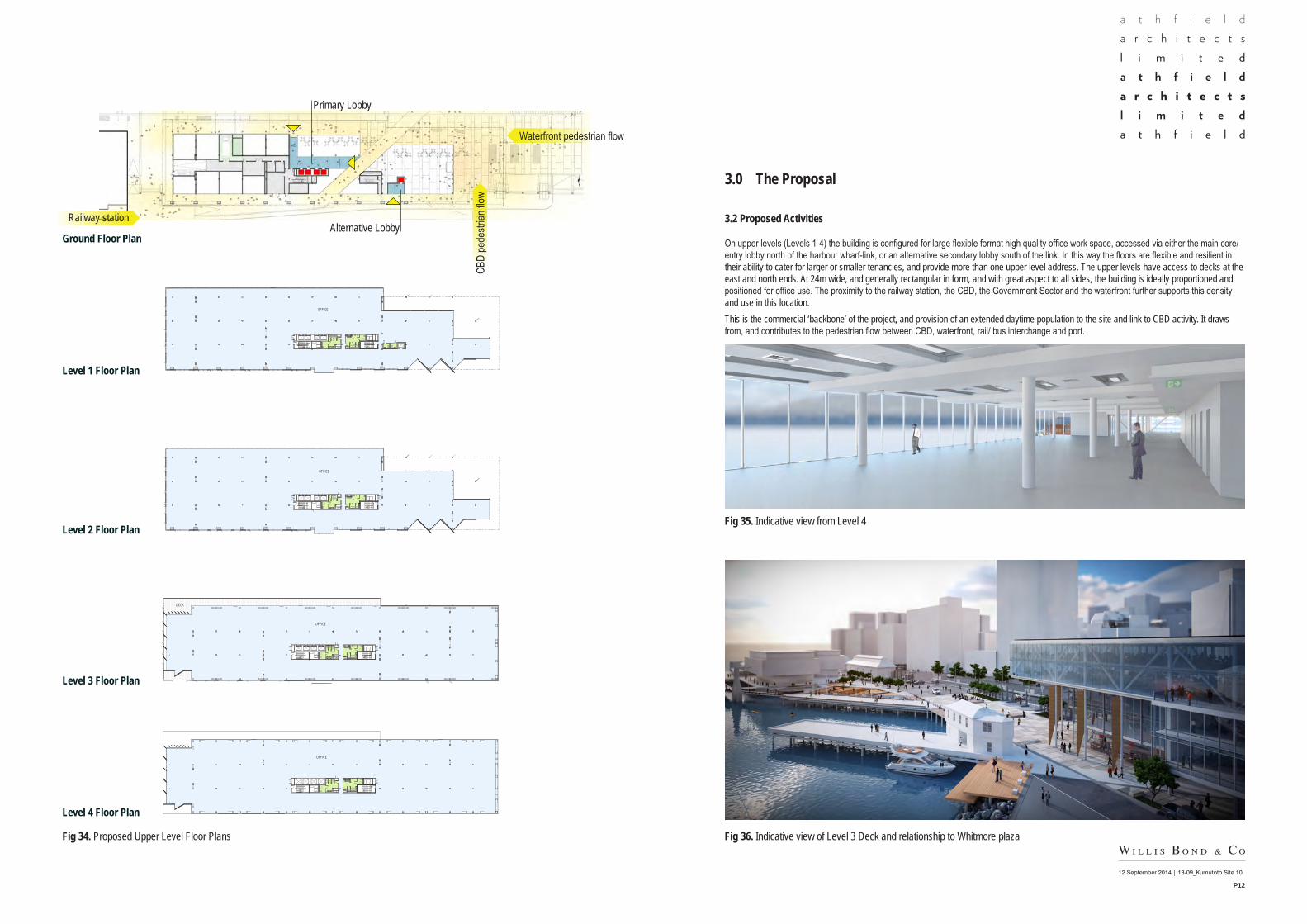
On upper levels (Levels 1-4) the building is configured for large flexible format high quality office work space, accessed via either the main core/ entry lobby north of the harbour wharf-link, or an alternative secondary lobby south of the link. In this way the floors are flexible and resilient in their ability to cater for larger or smaller tenancies, and provide more than one upper level address. The upper levels have access to decks at the east and north ends. At 24m wide, and generally rectangular in form, and with great aspect to all sides, the building is ideally proportioned and positioned for office use. The proximity to the railway station, the CBD, the Government Sector and the waterfront further supports this density and use in this location.This is the commercial ‘backbone’ of the project, and provision of an extended daytime population to the site and link to CBD activity. It draws from, and contributes to the pedestrian flow between CBD, waterfront, rail/ bus interchange and port.
UP UP
OFFICE
OFFICE
KEY:STRUCTURAL ENGINEER:NAME : Dunning Thornton Consultants LtdPHFAXPO BOXEMAIL
SERVICES ENGINEER:NAME : AECOMPHFAXPO BOXEMAIL
FIRE ENGINEER:NAME : Holmes FirePHFAXPO BOXEMAIL 1 : 250 @ A1
Levels 1 & 2
13-09Kumutoto - Site 10
P1.02-D
N
1 : 250Level 1
1 : 250Level 2
No. Description DateA FOR PRICING 28.02.14B MARKETING 12.06.14C FOR INFO 13.06.14D CONSULTANT CO-ORDINATION 30.06.14
UP
OFFICE
DECK
OFFICE
KEY:STRUCTURAL ENGINEER:NAME : Dunning Thornton Consultants LtdPHFAXPO BOXEMAIL
SERVICES ENGINEER:NAME : AECOMPHFAXPO BOXEMAIL
FIRE ENGINEER:NAME : Holmes FirePHFAXPO BOXEMAIL 1 : 250 @ A1
Levels 3 & 4
13-09Kumutoto - Site 10
P1.03-D
N
1 : 250Level 3
1 : 250Level 4
No. Description DateA FOR PRICING 28.02.14B MARKETING 12.06.14C FOR INFO 13.06.14D CONSULTANT CO-ORDINATION 30.06.14
Fig 34. Proposed Upper Level Floor Plans
Fig 35. Indicative view from Level 4
Fig 36. Indicative view of Level 3 Deck and relationship to Whitmore plaza
UP UP
OFFICE
OFFICE
KEY:STRUCTURAL ENGINEER:NAME : Dunning Thornton Consultants LtdPHFAXPO BOXEMAIL
SERVICES ENGINEER:NAME : AECOMPHFAXPO BOXEMAIL
FIRE ENGINEER:NAME : Holmes FirePHFAXPO BOXEMAIL 1 : 250 @ A1
Levels 1 & 2
13-09Kumutoto - Site 10
P1.02-D
N
1 : 250Level 1
1 : 250Level 2
No. Description DateA FOR PRICING 28.02.14B MARKETING 12.06.14C FOR INFO 13.06.14D CONSULTANT CO-ORDINATION 30.06.14
UP
OFFICE
DECK
OFFICE
KEY:STRUCTURAL ENGINEER:NAME : Dunning Thornton Consultants LtdPHFAXPO BOXEMAIL
SERVICES ENGINEER:NAME : AECOMPHFAXPO BOXEMAIL
FIRE ENGINEER:NAME : Holmes FirePHFAXPO BOXEMAIL 1 : 250 @ A1
Levels 3 & 4
13-09Kumutoto - Site 10
P1.03-D
N
1 : 250Level 3
1 : 250Level 4
No. Description DateA FOR PRICING 28.02.14B MARKETING 12.06.14C FOR INFO 13.06.14D CONSULTANT CO-ORDINATION 30.06.14
Level 1 Floor Plan
Ground Floor Plan
Level 2 Floor Plan
Level 3 Floor Plan
Level 4 Floor Plan
Primary Lobby
Alternative LobbyRailway station
Waterfront pedestrian flow
CBD
pede
strian
flow

12 September 2014 | 13-09_Kumutoto Site 10
P13
3.0 The Proposal
3.4 Proposed Building Structure
Site 10 presents a reasonably significant challenge from a natural hazard perspective with its high shaking hazard, liquefaction/lateral spreading potential and susceptibility to Tsunami/Seiching waves. The site is also relatively low and could be subject to potential, occasional, future inundation, particularly as a consequence of prolonged sea-level rise. The structural and architectural design mitigates these issues with a high-performance structure expected to perform well in excess of code minimum requirements. In addition the development will result in the remediation of existing in-ground contamination.
The liquefaction and lateral spreading arises through the relatively un-compacted reclamation fill dating from 1900. As part of the development significant sub-ground mitigation will be provided to address the liquefaction/lateral spreading potential through the use of Deep-Soil-Mixing a technology that uses a deep drilling auger to mix cement with the underlying soils to form a grid of weak-concrete walls, spaced at around 4m centres, over the whole site. This grid of walls provides five functions; confinement of the liquefiable soils, lateral bracing down to the non-liquefiable sub-strata, a platform on which to found the new structure, encapsulation of contaminated material and effective cut-off of contaminated ground-water flow towards the harbour.
Above the foundation the building superstructure will be base-isolated to provide an extremely high-level of seismic life-safety protection coupled with damage avoidance, business continuity and protection of contents. Base isolation will provide seismic, life-safety performance in excess of Importance Level 3 [IL3]. Above the base isolators the structure will be predominantly steel-framed to provide the strength and resilience at the least weight. The upper floor slabs will be reinforced concrete.
Below the isolation plane will be a single-level, tanked basement to provide space for services and off-waterfront parking. Excavated material from the basement will be tested for contamination and treated/disposed as appropriate.
The new building ground floor will be set as high as practicable while also providing access from existing waterfront levels. This means that the ground floor and basement levels may become susceptible to occasional inundation as a result of sea-level rise after approximately 100 years. Future mitigation will be possible by simply raising the building at the isolator level and the corresponding raising of the surrounding ground surface levels. Lifting technologies capable of raising the building structure are already in existence.
As with other low-lying properties around the Wellington region, ground floor spaces may be inundated during Tsunami or Seiching waves. The first floor level has been set sufficiently high to avoid damage, based on maximum wave height predictions. While significant damage could be expected to the ground floor non-structural elements, the primary structure will have sufficient resilience to resist the wave actions.
UP
OFFICE
DECK
OFFICE
KEY:STRUCTURAL ENGINEER:NAME : Dunning Thornton Consultants LtdPHFAXPO BOXEMAIL
SERVICES ENGINEER:NAME : AECOMPHFAXPO BOXEMAIL
FIRE ENGINEER:NAME : Holmes FirePHFAXPO BOXEMAIL 1 : 250 @ A1
Levels 3 & 4
13-09Kumutoto - Site 10
P1.03-D
N
1 : 250Level 3
1 : 250Level 4
No. Description DateA FOR PRICING 28.02.14B MARKETING 12.06.14C FOR INFO 13.06.14D CONSULTANT CO-ORDINATION 30.06.14
3.0 The Proposal
3.5 Proposed Building Services and environmental systems
The buildings have been designed to balance the heating and cooling energy profiles of each facade with a combination of double glazing, performance solar coating and the incorporation of solid panels . This enables greater transparency through the façade on the southern and eastern harbour outlooks, with resulting benefits in passive heating and daylight penetration. The interior design conditions have been selected with consideration to reducing the building’s energy use and carbon emissions, whilst providing an optimal internal environment. The large floor plate and exposed slab create a stable thermal environment with perimeter zones served via remote services to reduce noise levels. Primary incoming services and main power and comms distribution hubs will be located on the ground floor with primary mechanical plant located on the roof. Space for future tenant plant at roof has been provided in the basement. Services are distributed through the building via a service riser formed as part of the central lift core with either floor by floor or roof top plant situated within the height envelope at the northern end recess. On each floor services will typically be distributed at high level within service bulkheads with exposed final runs being integrated at high level with the structural slab.
The building will be designed to achieve a 5 Star Green Star Certified Rating which is recognized by the NZ Green Building council as ‘New Zealand Excellence’.
12 September 2014 | 13-09_Kumutoto Site 10
P14
3.0 The Proposal
3.6 Proposed architectural articulation and materials
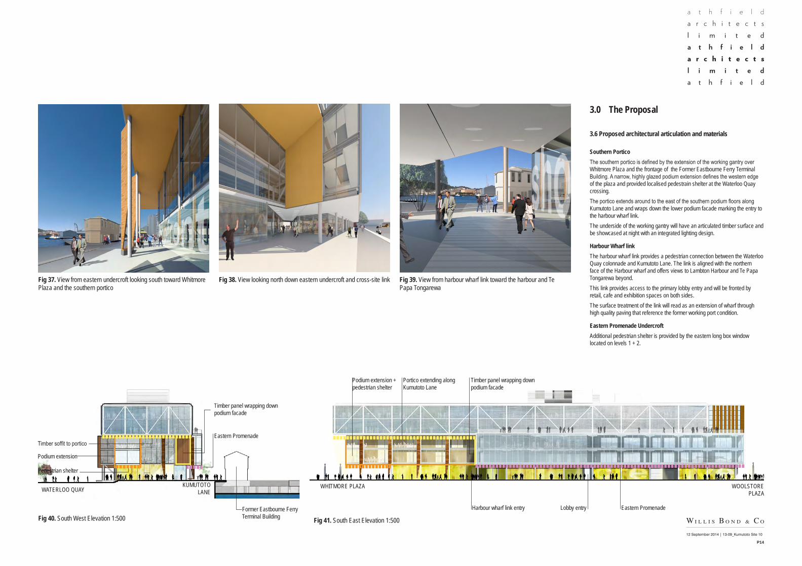
Southern PorticoThe southern portico is defined by the extension of the working gantry over Whitmore Plaza and the frontage of the Former Eastbourne Ferry Terminal Building. A narrow, highly glazed podium extension defines the western edge of the plaza and provided localised pedestrain shelter at the Waterloo Quay crossing. The portico extends around to the east of the southern podium floors along Kumutoto Lane and wraps down the lower podium facade marking the entry to the harbour wharf link. The underside of the working gantry will have an articulated timber surface and be showcased at night with an integrated lighting design.
Harbour Wharf linkThe harbour wharf link provides a pedestrian connection between the Waterloo Quay colonnade and Kumutoto Lane. The link is aligned with the northern face of the Harbour wharf and offers views to Lambton Harbour and Te Papa Tongarewa beyond.This link provides access to the primary lobby entry and will be fronted by retail, cafe and exhibition spaces on both sides.The surface treatment of the link will read as an extension of wharf through high quality paving that reference the former working port condition.
Eastern Promenade UndercroftAdditional pedestrian shelter is provided by the eastern long box window located on levels 1 + 2.
Fig 39. View from harbour wharf link toward the harbour and Te Papa Tongarewa
Fig 37. View from eastern undercroft looking south toward Whitmore Plaza and the southern portico
Fig 38. View looking north down eastern undercroft and cross-site link
Fig 40. South West Elevation 1:500 Fig 41. South East Elevation 1:500Former Eastbourne Ferry Terminal Building
Timber soffit to portico
Timber panel wrapping down podium facade
Eastern Promenade
Timber panel wrapping down podium facade
Harbour wharf link entry
Portico extending along Kumutoto Lane
Podium extension
Pedestrian shelter
WATERLOO QUAY WHITMORE PLAZA WOOLSTORE PLAZA
KUMUTOTO LANE
Podium extension +pedestrian shelter
Eastern PromenadeLobby entry
12 September 2014 | 13-09_Kumutoto Site 10
P15
3.0 The Proposal
3.6 Proposed architectural articulation and materials
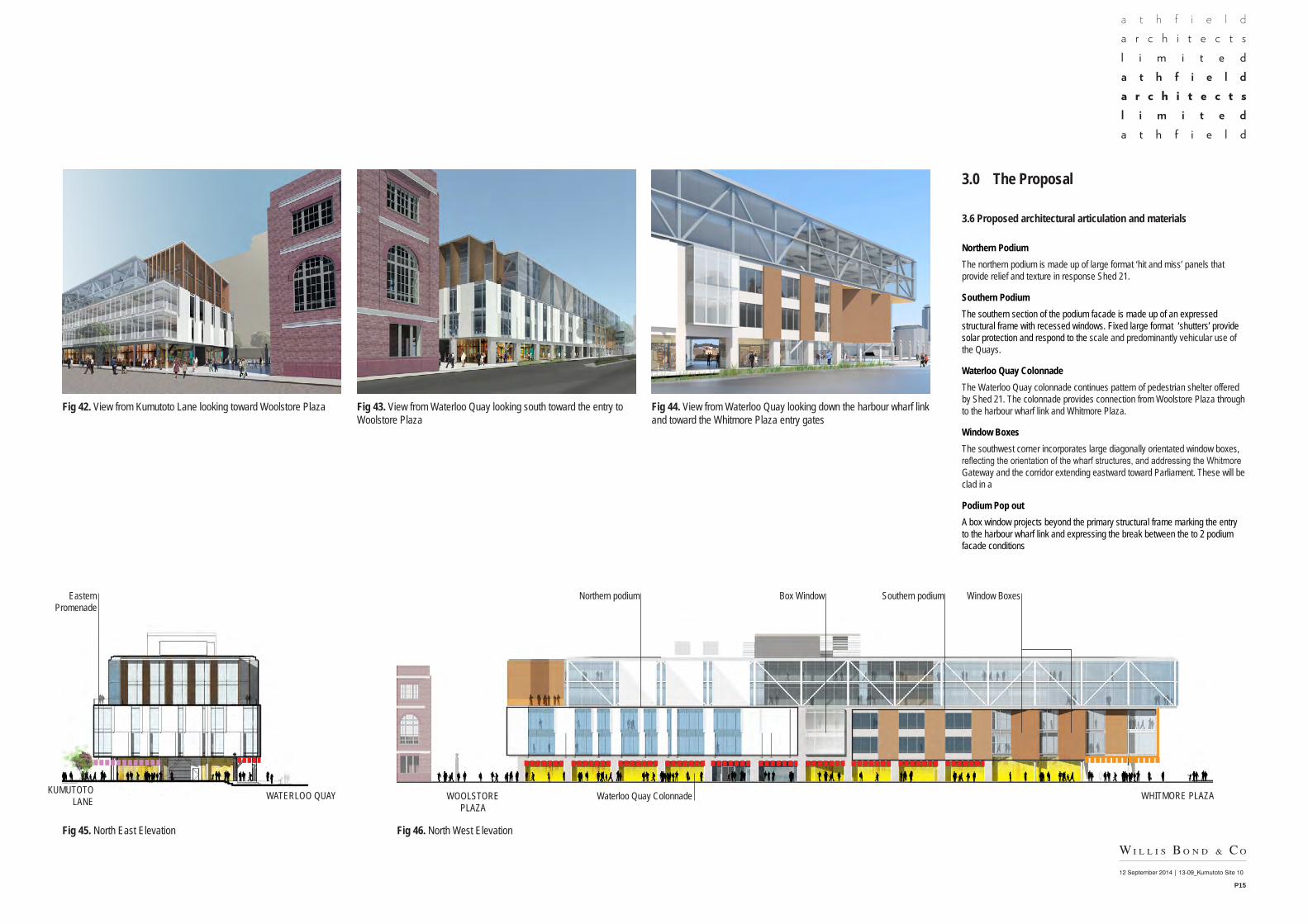
Northern PodiumThe northern podium is made up of large format ‘hit and miss’ panels that provide relief and texture in response Shed 21.
Southern PodiumThe southern section of the podium facade is made up of an expressed structural frame with recessed windows. Fixed large format ‘shutters’ provide solar protection and respond to the scale and predominantly vehicular use of the Quays.
Waterloo Quay ColonnadeThe Waterloo Quay colonnade continues pattern of pedestrian shelter offered by Shed 21. The colonnade provides connection from Woolstore Plaza through to the harbour wharf link and Whitmore Plaza.
Window BoxesThe southwest corner incorporates large diagonally orientated window boxes, reflecting the orientation of the wharf structures, and addressing the Whitmore Gateway and the corridor extending eastward toward Parliament. These will be clad in a
Podium Pop outA box window projects beyond the primary structural frame marking the entry to the harbour wharf link and expressing the break between the to 2 podium facade conditions
Fig 45. North East Elevation Fig 46. North West Elevation
Fig 42. View from Kumutoto Lane looking toward Woolstore Plaza Fig 43. View from Waterloo Quay looking south toward the entry to Woolstore Plaza
Fig 44. View from Waterloo Quay looking down the harbour wharf link and toward the Whitmore Plaza entry gates
Eastern Promenade
Box WindowNorthern podium Southern podium
Waterloo Quay Colonnade
Window Boxes
WATERLOO QUAYKUMUTOTO LANE WHITMORE PLAZAWOOLSTORE
PLAZA
12 September 2014 | 13-09_Kumutoto Site 10
P16
3.0 The Proposal
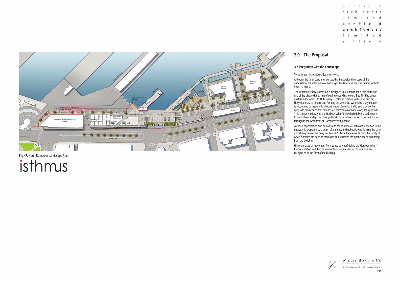
3.7 Integration with the Landscape
To be written in relation to Isthmus worksAlthough the landscape is understood to be outside the scope of this submission, the integration of building to landscape is seen as critical for both Sites 10 and 9.The Whitmore Plaza extension is designed in relation to the scale, form and use of the plaza with its mat of paving extending toward Site 10. The south eastern edge othe Site 10 buildingis scaled in relation to the lane and the likely open space in port land fronting this area; the Waterlooy Quay facade is modulated to respond to oblique views of moving traffic and provide the quayside promenade that extends a sheltered colonnade along the quayside. This connects midway to the Harbour Wharf Link which delivers pedestrians to the lobbies and ground floor publically accessible spaces of the building or through to the waterfront at Harbour Wharf junction.A sense of protection and enclosure to the Whitmore Plaza and definition to the gateway is proposed by a seam of planting, and pohutukawas framing the gate and strengthening the quay boulevard. Substantial elements from the family of wharf furniture are seen to modulate and structure the open spaces extending from the building.Historical axes of movement from quays to wharf define the Harbour Wharf Link orientation and the old sea wall and geometries of the wharves are recognised in the form of the building.
Fig 47. North Kumutoto Landscape Plan
UP
OFFICE
DECK
OFFICE
KEY:STRUCTURAL ENGINEER:NAME : Dunning Thornton Consultants LtdPHFAXPO BOXEMAIL
SERVICES ENGINEER:NAME : AECOMPHFAXPO BOXEMAIL
FIRE ENGINEER:NAME : Holmes FirePHFAXPO BOXEMAIL 1 : 250 @ A1
Levels 3 & 4
13-09Kumutoto - Site 10
P1.03-D
N
1 : 250Level 3
1 : 250Level 4
No. Description DateA FOR PRICING 28.02.14B MARKETING 12.06.14C FOR INFO 13.06.14D CONSULTANT CO-ORDINATION 30.06.14
12 September 2014 | 13-09_Kumutoto Site 10
P17
3.0 The Proposal
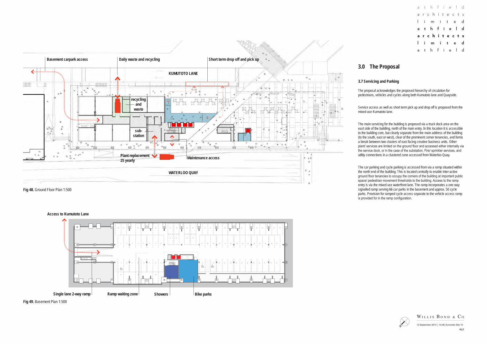
3.7 Servicing and Parking
The proposal acknowledges the proposed hierarchy of circulation for pedestrians, vehicles and cycles along both Kumutoto lane and Quayside.
Service access as well as short term pick up and drop off is proposed from the mixed use Kumutoto lane.
The main servicing for the building is proposed via a truck dock area on the east side of the building, north of the main entry. In this location it is accessible to the building core, but clearly separate from the main address of the building (to the south, east or west), clear of the prominent corner tenancies, and forms a break between two clusters of east facing creative business units. Other plant/ services are limited on the ground floor and accessed either internally via the service dock, or in the case of the substation, Fire/ sprinkler services, and utility connections in a clustered zone accessed from Waterloo Quay.
The car parking and cycle parking is accessed from via a ramp situated within the north end of the building. This is located centrally to enable inter-active ground floor tenancies to occupy the corners of the building at important public space/ pedestrian movement thresholds to the building. Access to the ramp entry is via the mixed use waterfront lane. The ramp incorporates a one way signalled ramp serving 66 car parks in the basement and approx. 50 cycle parks. Provision for ramped cycle access separate to the vehicle access ramp is provided for in the ramp configuration.
Fig 48. Ground Floor Plan 1:500
Fig 49. Basement Plan 1:500
UP
OFFICE
DECK
OFFICE
KEY:STRUCTURAL ENGINEER:NAME : Dunning Thornton Consultants LtdPHFAXPO BOXEMAIL
SERVICES ENGINEER:NAME : AECOMPHFAXPO BOXEMAIL
FIRE ENGINEER:NAME : Holmes FirePHFAXPO BOXEMAIL 1 : 250 @ A1
Levels 3 & 4
13-09Kumutoto - Site 10
P1.03-D
N
1 : 250Level 3
1 : 250Level 4
No. Description DateA FOR PRICING 28.02.14B MARKETING 12.06.14C FOR INFO 13.06.14D CONSULTANT CO-ORDINATION 30.06.14
recycling and
waste
sub-station
Daily waste and recyclingBasement carpark access Short term drop off and pick up
Plant replacement25 yearly
Bike parksShowersRamp waiting zoneSingle lane 2-way ramp
Access to Kumutoto Lane
Maintenance access
KUMUTOTO LANE
WATERLOO QUAY
ShowersandLockers
48 Bike Parks
21 3 4 5 6 7 8
9 10 11 12 13 14 15
18 19 20 21 22 23 24 30
31 32 33 34 35 36 37
17
16
25 26 27 28 29
38 39 40 41 42 43
44 45 46 47
51 52 53 54 55 56 57 58 59 60 61 6248 49 50
64 65 66
63
KEY:
1 : 200 @ A1 ; 1 : 400 @ A3Basement Plan
13-09Kumutoto - Site 10
RC1.01-A
N
No. Description DateA Resource Consent 12.09.2014
1 : 200 @ A1 ; 1 : 400 @ A3RC_Basement Level
12 September 2014 | 13-09_Kumutoto Site 10
P18
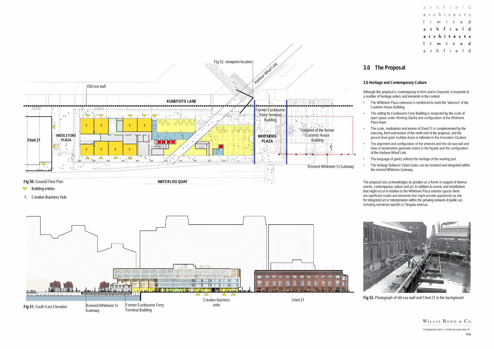
3.0 The Proposal
3.8 Heritage and Contemporary Culture
Although this proposal is contemporary in form and in character, it responds to a number of heritage orders and elements in the context:• The Whitmore Plaza extension is reinforced to mark the ‘absence’ of the
Customs House Building.• The setting for Eastbourne Ferry Building is respected by the scale of
open space under Working Gantry and configuration of the Whitmore Plaza foyer.
• The scale, modulation and texture of Shed 21 is complemented by the massing, form and texture of the north end of the proposal, and the ground level grain multiple doors is reflected in the Innovation Clusters.
• The alignment and configuration of the wharves and the old sea wall and lines of declamation generate orders in the façade and the configuration of the Harbour Wharf Link.
• The language of gantry reflects the heritage of the working port.• The heritage Ballance Street Gates can be restored and integrated within
the revived Whitmore Gateway.
The proposal also acknowledges its position as a frame in support of diverse events, contemporary culture and art. In addition to events and installations that might occur in relation to the Whitmore Plaza exterior spaces there are significant routes and elements that might provide opportunity as site for integrated art or interpretation within the growing network of public art, including narratives specific to Tangata whenua.
Fig 50. Ground Floor Plan
Fig 51. South East Elevation
Fig 52. Photograph of old sea wall and Shed 21 in the background
• Building entries
1. Creative Business Hub
WOOLSTORE PLAZAShed 21
WHITMORE PLAZA
KUMUTOTO LANE
WATERLOO QUAY
Former Eastbourne Ferry Terminal
Building
Old sea wall
Fig 52. viewpoint location
Former Eastbourne Ferry Terminal Building
Creative business units
Shed 21
Footprint of the former Customs House
Building
Revived Whitmore St Gateway
Revived Whitmore St Gateway
Harbour
Wharf Li
nk
1
1 1 1 1
1 1 1


