A R C H I V E S & A R C H I T E C T U R E , L L C www.archivesandarchitecture.com PO Box 1332 San Jose CA 95109-1332 1.408.297.2684 OFFICE 1.408.228.0762 FAX April Halberstadt, Chair Santa Clara County Historical Heritage Commission C/o Michele Napier, Clerk County of Santa Clara 70 West Hedding Street, 7 th Floor San José, CA 95110 Re: Mount Umunhum Radar Tower Honorable Chair and Members of the Commission: ARCHIVES & ARCHITECTURE, LLC is pleased to have had the opportunity to investigate the possibility of designating the Radar Tower at Mount Umunhum as a Santa Clara County Landmark. Attached to this letter is a narrative report documenting our findings, and DPR523 series recording forms that detail the physical aspects of the AN/FPS‐24 Radar Tower sitting at the crest of Mount Umunhum in the Sierra Azul Open Space Preserve. ARCHIVES & ARCHITECTURE, LLC is a local Cultural Resources Management firm with a long history of serving the citizens of Santa Clara County and its public agencies. Founded in 1989 by the late Glory Anne Laffey, the firm’s principals today include Franklin Maggi, Architectural Historian, Leslie A.G. Dill, Historic Architect, and Charlene Duval, Public Historian. Our firm is well versed in the evaluation of local historic resources. About 10 years ago, we assisted the County Planning Office in updating to current standards nearly 200 listed properties on the Santa Clara County Heritage Resources Inventory, and preparing the County’s first Historic Context Statement. Many of the inventoried properties are now designated landmarks. Since then we have also prepared County landmark nominations for Rhoades Ranch near Morgan Hill and the Bacigalupi House near Los Gatos. Concurrently during this same time period, within Santa Clara County we prepared National Register nominations for the Donner‐Houghton House and Earnest Renzel House in San Jose, Seven Springs Ranch in Cupertino, and the John Colpitts Ainsley House in Campbell. In San Jose and other local cities, we have prepared local landmark nominations for over 50 individual properties during the last decade, while providing documentation through survey work for more than 150 eligible properties, many now so designated.
Transcript
A R C H I V E S & A R C H I T E C T U R E , L L C
www.archivesandarchitecture.com
PO Box 1332 San Jose CA 95109-1332 1.408.297.2684 OFFICE 1.408.228.0762 FAX
April Halberstadt, Chair
Santa Clara County Historical Heritage Commission
C/o Michele Napier, Clerk
County of Santa Clara
70 West Hedding Street, 7th Floor
San José, CA 95110
Re: Mount Umunhum Radar Tower
Honorable Chair and Members of the Commission:
ARCHIVES & ARCHITECTURE, LLC is pleased to have had the opportunity to
investigate the possibility of designating the Radar Tower at Mount Umunhum as a Santa
Clara County Landmark. Attached to this letter is a narrative report documenting our
findings, and DPR523 series recording forms that detail the physical aspects of the
AN/FPS‐24 Radar Tower sitting at the crest of Mount Umunhum in the Sierra Azul Open
Space Preserve.
ARCHIVES & ARCHITECTURE, LLC is a local Cultural Resources Management firm with
a long history of serving the citizens of Santa Clara County and its public agencies.
Founded in 1989 by the late Glory Anne Laffey, the firm’s principals today include
Franklin Maggi, Architectural Historian, Leslie A.G. Dill, Historic Architect, and Charlene
Duval, Public Historian.
Our firm is well versed in the evaluation of local historic resources. About 10 years ago,
we assisted the County Planning Office in updating to current standards nearly 200 listed
properties on the Santa Clara County Heritage Resources Inventory, and preparing the
County’s first Historic Context Statement. Many of the inventoried properties are now
designated landmarks. Since then we have also prepared County landmark nominations
for Rhoades Ranch near Morgan Hill and the Bacigalupi House near Los Gatos. Concurrently
during this same time period, within Santa Clara County we prepared National Register
nominations for the Donner‐Houghton House and Earnest Renzel House in San Jose, Seven
Springs Ranch in Cupertino, and the John Colpitts Ainsley House in Campbell. In San Jose
and other local cities, we have prepared local landmark nominations for over 50
individual properties during the last decade, while providing documentation through
survey work for more than 150 eligible properties, many now so designated.
A R C H I V E S & A R C H I T E C T U R E
As part of this investigation, Basim Jaber made available to us his extensive collection of
resource material on the former Almaden Air Force Station. He also put us into contact
with some of the preeminent military historians knowledgeable about Cold War military
efforts and related technology. These included Mark Morgan, Phil Gioia, and David B.
Leeson. Beth Wyman, Historian, provided peer review of our draft report and evaluation.
Beth previously served on the County’s Historical Heritage Commission, and her valued
input stems from a detailed knowledge of County history, including her work in updating
the County’s Heritage Resources Inventory in the late 1990s.
We have worked on a number of projects with strong public interest similar to that of the
Radar Tower at Mount Umunhum. We approach our work in two steps: intensive
background, and thorough investigation into the history and character of
objects/structures/building/and places, necessary to adequately conduct proper
evaluations for historical significance. Additionally, significance evaluations must bring
into consideration an understanding of local values, as are often defined in General Plans
and preservation ordinances. Heritage Commissions are an important step in ensuring
that the work is inclusive, as they bring the broad areas of community interests and
cultural values to the process of determining significance.
Many would have us bury and forget the aspects of our collective past that represent the
darker areas in American History. As a teenager growing up in Santa Clara Valley during
the era of the Cold War, I have only now begun to truly understand the gravity of this
conflict, and the risk to the continued existence of mankind that unfolded during the
Cuban Missile Crisis and other critical moments during this period. Mount Umunhum
and the Radar Tower is the most vivid reminder of that era, and today remains a beacon to
local history, serving a purpose that has continued uninterrupted since the AN/FPS‐24
and its radar sail was decommissioned in 1980.
It is my professional opinion as an Architectural Historian that the Mount Umunhum
Radar Tower qualifies as a Santa Clara County Landmark, and as a life‐long resident and
prior member of the Santa Clara County Historical Heritage Commission, I encourage the
Commission to forward a recommendation to the Board of Supervisors that the structure
be designated a Landmark under Ordinance NS‐1100.96.
Franklin Maggi, Architectural Historian
May 14, 2014
A R C H I V E S & A R C H I T E C T U R E , L L C
PO Box 1332 San José, CA 95109-1332 http://www.archivesandarchitecture.com
HISTORICAL EVALUATION Mount Umunhum Radar Tower
Sierra Azul Open Space Preserve
Santa Clara County, California
(APN #562-08-003)
Prepared for:
Santa Clara County Historical Heritage Commission
C/o Michele Napier, Clerk
County of Santa Clara
70 West Hedding Street, 7th Floor
San José, CA 95110
Revised: 05.14.2014
Mount Umunhum Radar Tower
HISTORICAL EVALUATION
A R C H I V E S & A R C H I T E C T U R E 2
Table of Contents Table of Contents .............................................................................................................. 2
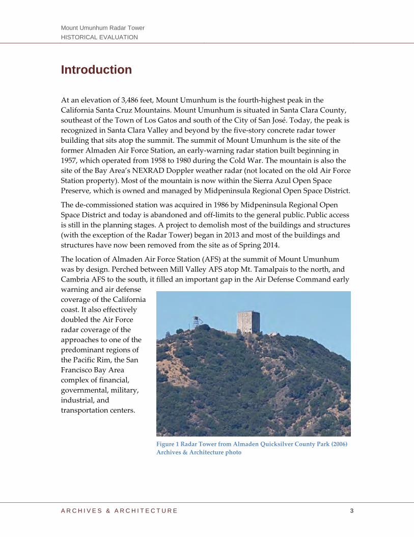
At an elevation of 3,486 feet, Mount Umunhum is the fourth‐highest peak in the
California Santa Cruz Mountains. Mount Umunhum is situated in Santa Clara County,
southeast of the Town of Los Gatos and south of the City of San José. Today, the peak is
recognized in Santa Clara Valley and beyond by the five‐story concrete radar tower
building that sits atop the summit. The summit of Mount Umunhum is the site of the
former Almaden Air Force Station, an early‐warning radar station built beginning in
1957, which operated from 1958 to 1980 during the Cold War. The mountain is also the
site of the Bay Area’s NEXRAD Doppler weather radar (not located on the old Air Force
Station property). Most of the mountain is now within the Sierra Azul Open Space
Preserve, which is owned and managed by Midpeninsula Regional Open Space District.
The de‐commissioned station was acquired in 1986 by Midpeninsula Regional Open
Space District and today is abandoned and off‐limits to the general public. Public access
is still in the planning stages. A project to demolish most of the buildings and structures
(with the exception of the Radar Tower) began in 2013 and most of the buildings and
structures have now been removed from the site as of Spring 2014.
The location of Almaden Air Force Station (AFS) at the summit of Mount Umunhum
was by design. Perched between Mill Valley AFS atop Mt. Tamalpais to the north, and
Cambria AFS to the south, it filled an important gap in the Air Defense Command early
warning and air defense
coverage of the California
coast. It also effectively
doubled the Air Force
radar coverage of the
approaches to one of the
predominant regions of
the Pacific Rim, the San
Francisco Bay Area
complex of financial,
governmental, military,
industrial, and
transportation centers.
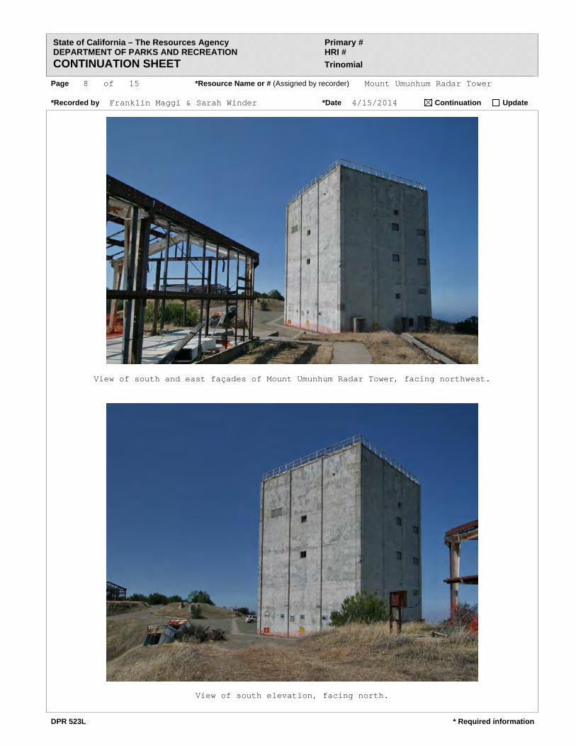
Figure 1 Radar Tower from Almaden Quicksilver County Park (2006)
Archives & Architecture photo
Mount Umunhum Radar Tower
HISTORICAL EVALUATION
A R C H I V E S & A R C H I T E C T U R E 4
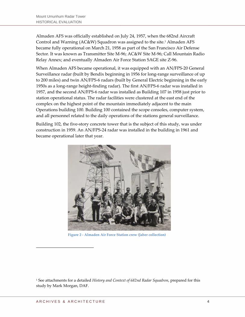
Almaden AFS was officially established on July 24, 1957, when the 682nd Aircraft
Control and Warning (AC&W) Squadron was assigned to the site.1 Almaden AFS
became fully operational on March 21, 1958 as part of the San Francisco Air Defense
Sector. It was known as Transmitter Site M‐96; AC&W Site M‐96; Call Mountain Radio
Relay Annex; and eventually Almaden Air Force Station SAGE site Z‐96.
When Almaden AFS became operational, it was equipped with an AN/FPS‐20 General
Surveillance radar (built by Bendix beginning in 1956 for long‐range surveillance of up
to 200 miles) and twin AN/FPS‐6 radars (built by General Electric beginning in the early
1950s as a long‐range height‐finding radar). The first AN/FPS‐6 radar was installed in
1957, and the second AN/FPS‐6 radar was installed as Building 107 in 1958 just prior to
station operational status. The radar facilities were clustered at the east end of the
complex on the highest point of the mountain immediately adjacent to the main
Operations building 100. Building 100 contained the scope consoles, computer system,
and all personnel related to the daily operations of the stations general surveillance.
Building 102, the five‐story concrete tower that is the subject of this study, was under
construction in 1959. An AN/FPS‐24 radar was installed in the building in 1961 and
became operational later that year.
1 See attachments for a detailed History and Context of 682nd Radar Squadron, prepared for this
study by Mark Morgan, DAF.
Figure 2 ‐ Almaden Air Force Station crew (Jaber collection)
Mount Umunhum Radar Tower
HISTORICAL EVALUATION
A R C H I V E S & A R C H I T E C T U R E 5
Summary of Findings Air Force facilities such as Almaden AFS were an essential aspect of the Cold War effort
by the military in the 1950s and 1960s. Many residents of Santa Clara County played a
pivotal role in national security during the Cold War, and Building 102, atop Mt.
Umunhum at the now de‐commissioned Almaden AFS, remains today as an important
and significant reminder of this effort. The contributions made by the local community
help tell the story of modern Santa Clara County, and those who have lived in the valley
these last 50 years continue to reflect upon this troubling period in national and local
history. Many of the residents of the valley were employed by defense‐contractor
corporations in the Bay Area (Santa Clara County, specifically), which all thrived under
the security of a blanket of defense provided by Almaden AFS.
While local residents who had a direct relationship with the operation can recall its
legacy in detail, to the larger community, the Radar Tower known as Building 102
remains today as a reminder of the threat to their security brought on by the Cold War,
and as such is the only means to physically convey this memory in the context of the
county at large. When Almaden AFS closed, the remote nature of the site and lack of
access caused the closure to go relatively unnoticed by the general public. One visible
reminder remained, however‐‐the Radar Tower, which has now loomed over the valley
for over half a century. Most locals can identify this peak as Mount Umunhum due to
the presence of the tower, and can likely remind you that the word Umunhum derives
from the Ohlone Indian name for “resting place of the hummingbird.”
With a continuous strong visual presence, the tower continues to serve as a regional
historic landmark and a cultural icon in Santa Clara County, and as such the tower
qualifies for designation as a Santa Clara County Landmark pursuant to criteria defined
under Division C17 of the Santa Clara County Code.
Figure 3 – Aerial view of Mount Umunhum (San Jose Mercury News)
Mount Umunhum Radar Tower
HISTORICAL EVALUATION
A R C H I V E S & A R C H I T E C T U R E 6
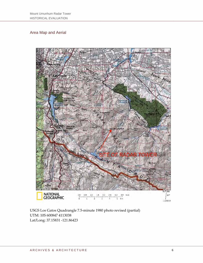
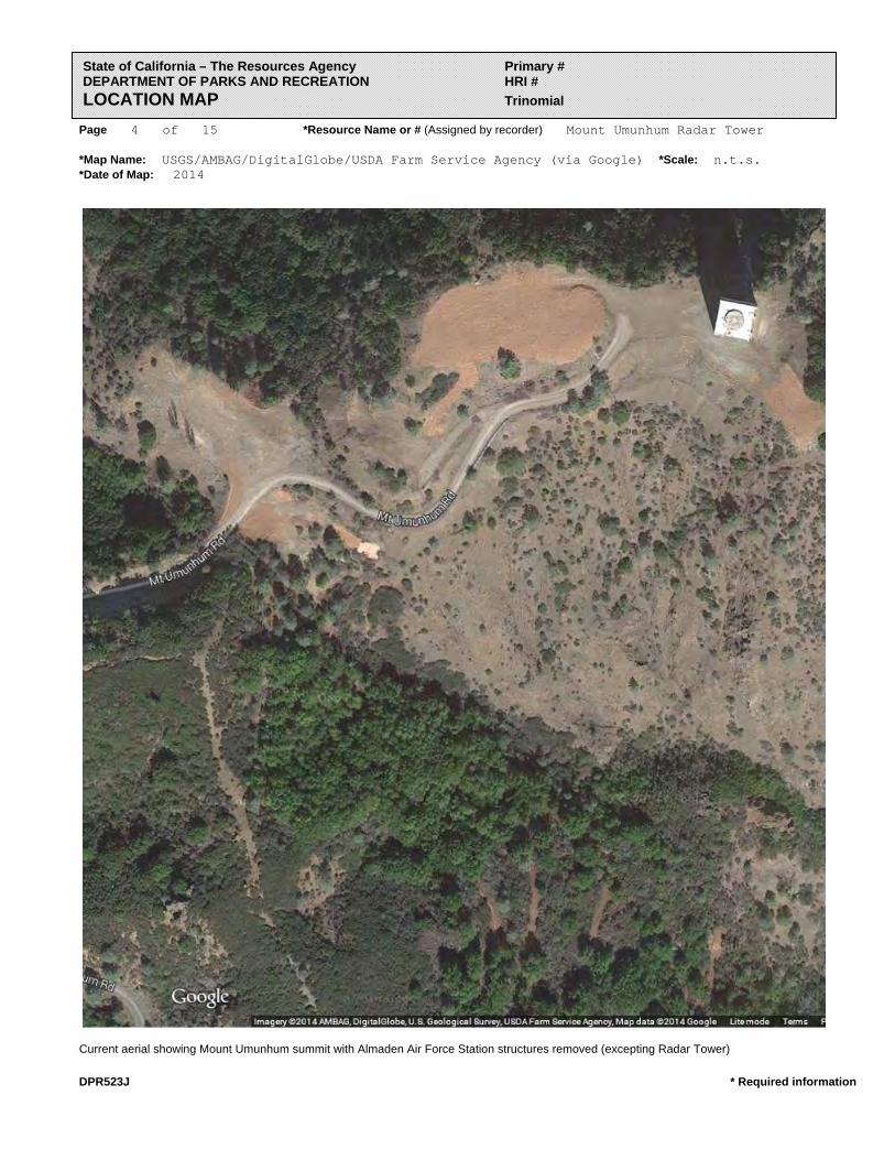
Area Map and Aerial
USGS Los Gatos Quadrangle 7.5‐minute 1980 photo revised (partial)
UTM: 10S 600847 4113038
Lat/Long: 37.15831 ‐121.86423
Mount Umunhum Radar Tower
HISTORICAL EVALUATION
A R C H I V E S & A R C H I T E C T U R E 7
Satellite View (ACME Mapper)
Mount Umunhum Radar Tower
HISTORICAL EVALUATION
A R C H I V E S & A R C H I T E C T U R E 8
Historical Information Shortly after the end of World War II, it became apparent that tensions between the
United States and the Soviet Union could not be contained, and they quickly spilled over
into an all‐out global conflict. With the outbreak of the Cold War in the late 1940s, and
then the Korean War in 1950, the U.S. Army and the U.S. Air Force quickly began
reestablishing air defenses to protect the United States against manned bomber attacks
from the Soviet Union and other enemies. Some air defense radar sites that were used in
World War II were reactivated, and many new sites were established, creating a network
of bases and warning systems along the United States borders.
The west coast was no exception to this, and California, more specifically the Bay Area,
was a part of this network of defense. One of 28 stations built as part of the second
segment of the Air Defense Command permanent radar network, Mount Umunhum’s
Almaden Air Force Station was a U.S. Air Force early warning radar base that operated
from 1958 to 1980.
The base was constructed as part of the North American Aerospace Defense Command
(NORAD) to keep watch over Northern California’s airspace during the Cold War. To
develop the site, the U.S. Air Force acquired, between 1957 and 1962, a total of 118.36
acres from several private individuals and the San Jose Water Works (SJWW), a local
public utility company.
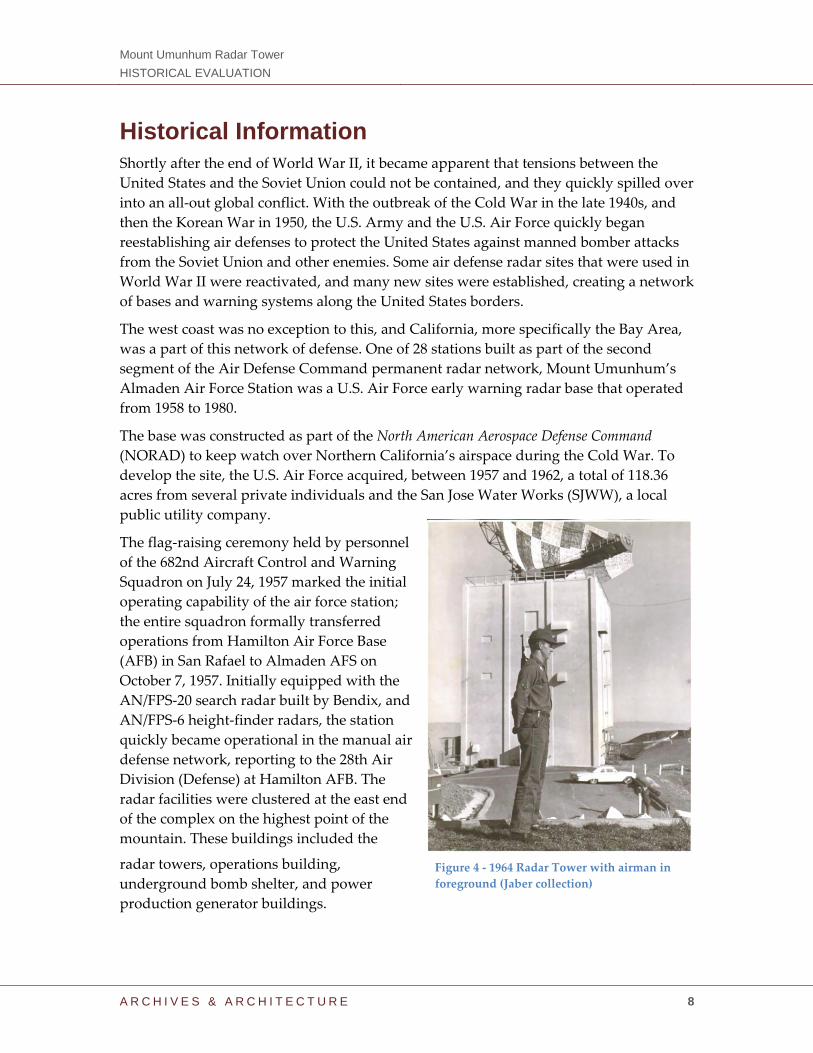
The flag‐raising ceremony held by personnel
of the 682nd Aircraft Control and Warning
Squadron on July 24, 1957 marked the initial
operating capability of the air force station;
the entire squadron formally transferred
operations from Hamilton Air Force Base
(AFB) in San Rafael to Almaden AFS on
October 7, 1957. Initially equipped with the
AN/FPS‐20 search radar built by Bendix, and
AN/FPS‐6 height‐finder radars, the station
quickly became operational in the manual air
defense network, reporting to the 28th Air
Division (Defense) at Hamilton AFB. The
radar facilities were clustered at the east end
of the complex on the highest point of the
mountain. These buildings included the
radar towers, operations building,
underground bomb shelter, and power
production generator buildings.
Figure 4 ‐ 1964 Radar Tower with airman in
foreground (Jaber collection)
Mount Umunhum Radar Tower
HISTORICAL EVALUATION
A R C H I V E S & A R C H I T E C T U R E 9
As part of the conversion to the Semi‐Automatic Ground Environment (SAGE) network,
the site subsequently gained an upgraded height‐finder radar, an AN/FPS‐90, as well as
an upgraded Ground‐Air Transmit‐Receive (GATR) facility, in 1958 and 1962
respectively. The conversion to SAGE resulted in the squadron’s reassignment to the San
Francisco Air Defense Sector, which operated from SAGE Direction Center DC‐18 at Beale
AFB, California, which is located
40 miles north of Sacramento.
The AN/FPS‐20 radar was
replaced by a massive 85.5 ton
AN/FPS‐24 search radar
(manufactured by General
Electric) atop Building 102, the
five‐story concrete tower
constructed between 1959 and
1961, visible from the valley floor,
known today simply as the
Mount Umunhum Radar Tower.
The site served as the second
production AN/FPS‐24 in Air
Defense Command, following a
similar installation at Point Arena
AFS (located 150 miles north of
San Francisco near California’s
coastline), and was one of seven
constructed of masonry and
reinforced concrete. It functioned
as a frequency diverse (FD) long‐
range search radar designed to
operate in the Very High
Frequency (VHF) and was the second of only 12 production models built between 1958
and 1962.
The AN/FPS‐24 radars at Point Arena AFS and Almaden AFS were constructed at nearly
the same time, but due to the funding cutbacks, Almaden’s was completed later. Due to
the remote location of the initial production AN/FPS‐24 at Point Arena AFS, the Air
Force (in conjunction with General Electric) decided to use the Almaden AFS FPS‐24
radar for the initial 1,000‐hour test run. This initial testing was vital to the benchmarking
of the elaborate AN/FPS‐24 radar to be used for all subsequent installations, and
effectively rendered the Almaden AN/FPS‐24 radar as the “gold standard” for this
model.
The AN/FPS‐24 radar had a 250‐mile range designed to detect incoming hostile aircraft,
and was considerably stronger than the 200‐mile range of the Air Force radars at Mill
Figure 5 ‐ 1962; AN/FPS‐24 radar and tower (Jaber collection)
Mount Umunhum Radar Tower
HISTORICAL EVALUATION
A R C H I V E S & A R C H I T E C T U R E 10
Valley and Cambria. Manned by personnel of the 682nd Squadron, the big radar
maintained a constant, unblinking watch on the western and southwestern approaches
to San Francisco Bay for over two decades.
Building 102 was designed and engineered by the firm of Burns and Roe and the site
was engineered by Indenco Engineers of San Leandro, California.2 For detailed
information on contents of each floor of the AN/FPS‐24 radar tower, see the attachments
section of this report.
Previously, the station operated a Ground‐to‐Air Transmitter‐Receiver (GATR) atop the
summit of Mount Umunhum until the completion of the AN/FPS‐24 radar. To eliminate
radio frequency interference from the AN/FPS‐24 radar, the GATR was then moved one
mile west to the summit of nearby Mount Thayer (elevation 3,483 feet).
In 1961, Almaden AFS joined the SAGE system, feeding computer data to a data center
at Beale AFB, California. The SAGE Direction Center at Beale AFB was known as DC‐18.
After joining SAGE, the squadron was re‐designated as the ʺ682nd Radar Squadron
(SAGE).ʺ In 1963, the SAGE site information was switched to DC‐17 at Norton AFB,
located near San Bernardino. That same year on July 31, 1963, the Mount Umunhum site
was re‐designated as NORAD ID Z‐96.
2 The engineering firm of Burns and Roe was first founded in New York in 1932 by Ralph C. Roe
and Allen E. Burns. By the mid‐1950s, Burns and Roe was heavily involved with the defense
industry in the United States as the Cold War progressed. The firm was at the forefront of the
design of the developing missile defense system, and the government installations that supported
it. Burns and Roe became experts in defense systems, and worked on several projects during this
period, including the Nike‐Zeus Missile Tracking Radar Project, the “Bull Goose” Missile Shelter
Project, and the Semi‐Automated Ground Environment (SAGE) Systems of Air Defense Network.
Figure 6 ‐ 1978 Bicentennial logo and Squadron welcome message on
Operations Building (Jaber collection)
Mount Umunhum Radar Tower
HISTORICAL EVALUATION
A R C H I V E S & A R C H I T E C T U R E 11
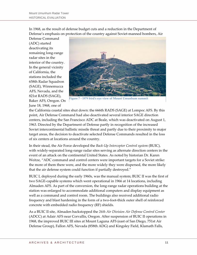
In 1968, as the result of defense budget cuts and a reduction in the Department of
Defense’s emphasis on protection of the country against Soviet‐manned bombers, Air
Defense Command
(ADC) started
deactivating its
remaining long‐range
radar sites in the
interior of the country.
In the general vicinity
of California, the
stations included the
658th Radar Squadron
(SAGE), Winnemucca
AFS, Nevada, and the
821st RADS (SAGE),
Baker AFS, Oregon. On
June 18, 1968, one of
the California coastal sites shut down: the 666th RADS (SAGE) at Lompoc AFS. By this
point, Air Defense Command had also deactivated several interior SAGE direction
centers, including the San Francisco ADC at Beale, which was deactivated on August 1,
1963. Directed by the Department of Defense partly in recognition of the increased
Soviet intercontinental ballistic missile threat and partly due to their proximity to major
target areas, the decision to deactivate selected Defense Commands resulted in the loss
of six centers at locations around the country.
In their stead, the Air Force developed the Back‐Up Interceptor Control system (BUIC),
with widely‐separated long‐range radar sites serving as alternate direction centers in the
event of an attack on the continental United States. As noted by historian Dr. Karen
Weitze, “ADC command and control centers were important targets for a Soviet strike:
the more of them there were, and the more widely they were dispersed, the more likely
that the air defense system could function if partially destroyed.”
BUIC I, deployed during the early 1960s, was the manual system; BUIC II was the first of
two SAGE‐capable systems which went operational in 1966 at 14 locations, including
Almaden AFS. As part of the conversion, the long‐range radar operations building at the
station was enlarged to accommodate additional computers and display equipment as
well as a command and control room. The buildings also received additional radio
frequency and blast hardening in the form of a two‐foot‐thick outer shell of reinforced
concrete with embedded radio frequency (RF) shields.
As a BUIC II site, Almaden backstopped the 26th Air Division Air Defense Control Center
(ADCC) at Adair AFS near Corvallis, Oregon. After suspension of BUIC II operations in
1968, the improved BUIC III sites at Mount Laguna AFS (east of San Diego, 751st Air
Defense Group), Fallon AFS, Nevada (858th ADG) and Kingsley Field, Klamath Falls,
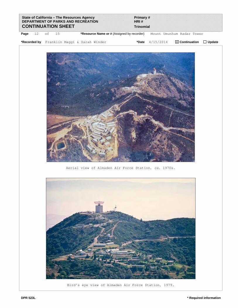
Figure 7 ‐ 1979 birdʹs eye view of Mount Umunhum summit
HISTORICAL EVALUATION
A R C H I V E S & A R C H I T E C T U R E 12
Oregon (827th ADG) assumed backup command and control responsibilities for the
West Coast, and Almaden reverted to an air defense detection and surveillance mission.
In 1979, Almaden AFS came under Tactical Air Command (TAC) jurisdiction with the
inactivation of Aerospace Defense Command and the creation of Air Defense‐Tactical
Air Command (ADTAC). On June 30, 1980, the 682nd Radar Squadron was rendered
inactive at Almaden AFS. Its “retirement” left ADTAC with only four Air Force‐manned
and operated long‐range radar stations guarding the Pacific Coast. From the north, they
were the 758th RADS, Makah AFS, Washington; 777th RADS, Klamath AFS, California;
666th RADS, Mill Valley AFS, California; and 775th RADS, Cambria AFS, California. Air
Force personnel manned height‐finder radar detachments at several Federal Aviation
Administration (FAA) radar sites up and down the coast. The AN/FPS‐24 radar antenna
“sail” was removed in June 1980 with the height‐finder radars at Almaden AFS removed
about the same time.
Figure 8 ‐ 1980 removal of sail (Jaber collection)
HISTORICAL EVALUATION
A R C H I V E S & A R C H I T E C T U R E 13
Cold War Context – Santa Clara County Following World War II, the United States Air Defense Command (ADC) began
dismantling the existing air defense radar, filter (fighter direction) centers and HF/DF
(high‐frequency/direction finder) sites around the perimeter of the country network that
had been put in place during the war. This deactivation, however, was short‐lived. As
the U.S.S.R. consolidated its control over the states of the Eastern Bloc, the United States
began a strategy of global containment to challenge Soviet power, extending military
and financial aid to the countries of Western Europe and creating the NATO alliance.
In response to increasingly heightened international tensionschief among them a
Soviet coup in Czechoslovakia in February 1948, followed by the Berlin Blockade in
April of that same yearthe newly independent U.S. Air Force directed ADC to reverse
the shutdown of the radar and command and control sites and to start manning them
again. ADC immediately responded to this order on both the west and the east coasts of
the country. Almaden Air Force Station was the last of Air Defense Command’s long‐
range radar sites to go “on watch” in California and would serve as one of last Air
Force‐manned and operated radar sites in the Golden State.
The radar sites located along the United States west coast provided peace and security to
the American population at a time in history when life was anything but peaceful. It is
difficult for those who did not live through the Cold War to understand the immense
psychological effect the constant threat of possible nuclear attack had on all aspects of
society, from the economy, to politics, and especially to the technological development
that occurred in the United States during this time period. Until the development and
deployment of reliable intercontinental ballistic missiles (ICBMs) and submarine‐
launched ballistic missiles (SLBMs), the main threat of foreign attack on the United
States was from the air, particularly by long‐range Soviet aircraft carrying nuclear
weapons. This made the early‐detection radar systems crucial to the nation’s defense
strategy.
Silicon Valley’s initial development beginning in the early part of the twentieth century
is a legacy that comes from a combination of defense‐funded companies and a
university that focused on early radio and then radar technology during two world wars
and the Cold War conflicts.
Historians trace the Valley’s roots back over 100 years, to the first decade of the
twentieth century, when the electrification of California was in full swing and radio
communications technology, controlled by Marconi patents, was in its infancy. The
shipping fleets and navies of the world were among the first to fund radio
communications. Since the San Francisco Bay Area was home to major Pacific shipping
companies, the need for affordable and independent radio systems sparked the
founding of local radio manufacturers. Radio and vacuum tubes, and then the defense
radar of the World War II and Cold War eras, set the stage for the emergence of Stanford
HISTORICAL EVALUATION
A R C H I V E S & A R C H I T E C T U R E 14
University, the venture capital business and the successive waves of semiconductor,
computer, network, cell‐phone and software companies to form a ground zero for
technological development unmatched anywhere else in the world.
The Bay Area has long been a major site of military research and technology, originating
with the U.S. Navy at the turn of the century. In 1909, Charles Herrold started the first
radio station in the United States with regularly scheduled programming in San José.
Later that year, Stanford University graduate Cyril Elwell purchased the U.S. patents for
Poulsen arc radio transmission technology and founded the Federal Telegraph
Corporation (FTC) in Palo Alto. Over the next decade, the FTC created the worldʹs first
global radio communication system, and signed a contract with the Navy in 1912.
In 1933, Air Base Sunnyvale, California, was commissioned by the United States
Government for use as a Naval Air Station (NAS) to house the airship USS Macon in
Hangar One. The station was renamed NAS Moffett Field, and between 1933 and 1947,
U.S. Navy blimps were based there. A number of technology firms had set up shop in
the area around Moffett Field to serve the Navy. When the Navy gave up its airship
ambitions and moved most of its west coast operations to San Diego, the National
Advisory Committee for Aeronautics (NACA, forerunner of NASA) took over portions
of Moffett Field for aeronautics research. Many of the original companies stayed, while
new ones moved in. The immediate area was soon filled with aerospace firms, such as
Lockheed.
Lee de Forest, an American inventor with over 180 patents to his credit and the self‐
proclaimed ʺFather of Radioʺ, invented the Audion in 1906, the first triode vacuum tube
and the first electrical device that could amplify a weak electrical signal and make it
stronger. The Audion, and vacuum tubes developed from it, founded the field of
electronics and dominated it for 40 years, making radio broadcasting, television, and
long‐distance telephone service possible, among many other applications. For this
reason De Forest has been credited as one of the founders of the ʺelectronic age.ʺ He is
also credited with one of the principal inventions that brought sound to motion pictures.
De Forest came to San Francisco in 1910, and worked for the Federal Telegraph
Company, which began developing the first global radio communications system in
1912. California Historical Landmark No. 836 is a bronze plaque at the eastern corner of
Channing Street and Emerson Avenue in Palo Alto, California, which memorializes the
Electronics Research Laboratory at that location and De Forest for the invention of the
three‐element radio vacuum tube.
Stanford University in Palo Alto, California, its affiliates, and its graduates have played
a major role in the development of military research and technology. From its founding
in the 1890s, Stanford Universityʹs leaders saw its mission as service to the West and
shaped the school accordingly.
During the 1940s and 1950s, Frederick Terman (often called the “father of Silicon
Valley”), Stanfordʹs Dean of Engineering and Provost, encouraged faculty and graduates
HISTORICAL EVALUATION
A R C H I V E S & A R C H I T E C T U R E 15
to start their own companies. Terman is credited with nurturing companies like
Hewlett‐Packard, Varian Associates, and other high‐tech firms, until what would
become Silicon Valley grew up around the Stanford campus. After World War II,
universities were experiencing enormous demand due to returning students. To address
the financial demands of Stanfordʹs growth requirements, and to provide local
employment opportunities for graduating students, Terman proposed the leasing of
Stanfordʹs lands for use as an office park, named the Stanford Industrial Park (later
Stanford Research Park). Leases were limited to high technology companies. The Park’s
first tenant was Varian Associates, founded by Stanford alumni in the 1930s to build
military radar components.
Between 1955 and 1988, solid state technology research and development at Stanford
University followed three waves of industrial innovation made possible by support
from private corporations, mainly Bell Telephone Laboratories, Shockley
Semiconductor, Fairchild Semiconductor, and Xerox PARC. In 1964, Terman had
brought William Shockley to Palo Alto to form a commercial venture in semiconductors.
Unlike many other researchers who used germanium as the semiconductor material,
Shockley believed that silicon was the better material for making transistors. Shockley
intended to replace the current transistor with a new three‐element design (today
known as the Shockley diode), but the design was considerably more difficult to build
than the ʺsimpleʺ transistor. In 1957, Shockley decided to end research on the silicon
transistor. Eight engineers left the company to form Fairchild Semiconductor; two of the
original employees of Fairchild Semiconductor, Robert Noyce and Gordon Moore,
would go on to found Intel.
In 1957, Dean Watkins and R. H. Johnson had co‐founded Watkins‐Johnson, with a
venture capital investment from Tommy Davis at Kern County Land Development
Corporation. Watkins had been a research leader at Stanford University’s Electronic
Laboratory, while Johnson was the head of Hughes Aircraft’s microwave tube
department. Watkins‐Johnson was the first defense‐oriented venture capital investment,
and set the bar for many more to follow, as technology corporations with defense
contracts became the basis for the Bay Area’s burgeoning aerospace‐defense sector
during the Cold War era. The growing list of other defense firms in the Valley included
Eitel‐McCullough, Varian, and Litton Industries. Others would soon join them.
By the early 1960s, one‐third of the nation’s defense microwave business was located in
the Santa Clara Valley. Watkins‐Johnson became the cornerstone for the immense
network of venture capital, human intellectual potential, and entrepreneurial drive that
later become known as Silicon Valley (even though the firm was based on microwave
technology).
The growth of the venture capital industry was fueled by the emergence of the
independent investment firms on Sand Hill Road in Menlo Park, California, beginning
with Kleiner Perkins Caufield & Byers and Sequoia Capital in 1972. These and other
venture capital firms would have access to the many semiconductor companies based in
HISTORICAL EVALUATION
A R C H I V E S & A R C H I T E C T U R E 16
the Santa Clara Valley as well as early computer firms using their devices and
programming and service companies. In the 1970s and 1980s, the majority of technology
and products developed by firms in Silicon Valley were incorporated in some form or
another into defense systems designed to protect the United States from the Soviet
threat. The protected environment located in the shadow of Mout Umunhum, made
possible by Almaden Air Force Station, in which this development and growth could
take place, was a critical necessity to the development of Silicon Valley.
Figure 9 1968 view of Mt. Umunhum from Almaden Valley (Alexander Dewey)
HISTORICAL EVALUATION
A R C H I V E S & A R C H I T E C T U R E 17
Evaluation for Significance
Policy and Regulatory Context
County of Santa Clara
The County of Santa Clara, through its General Plan, considers heritage resources as
those particular types of resources, both natural and man‐made, which due to their
vulnerability or irreplaceable nature deserve special protection if they are to be
preserved for current and future generations. Heritage resources are considered
important for a variety of reasons, including potential scientific value, cultural and
historical value, and “place” value, in addition to their irreplaceability. Knowledge of
the natural world, understanding of cultural origins, continuity with the past, and the
sense of place that defines us and distinguishes Santa Clara County from all other places
are all enhanced through heritage resource preservation. In the face of increasing
homogenization, urbanization, and anonymity of American culture and places,
resources unique to each region and locality become even more significant. More than
curiosities, landmarks by which to navigate, or tourist attractions, heritage resources
should be considered the birthright of successive generations of residents. If preserved
and integrated with the new, our historic buildings, groves of trees, and other resources
immeasurably enrich the experience of urban and rural landscapes. Rehabilitation and
restoration for new uses or for commemoration, especially within older, central urban
communities can also help revitalize economies and reverse urban decline in ways
urban “renewal” programs of the recent past often failed to do.
Cultural heritage resource protection consists of three basic strategies in the County of
Santa Clara General Plan; Inventory and Evaluate Heritage Resources, Prevent or
Minimize Adverse Impacts on Heritage Resources, and Restore, Enhance and
Commemorate Resources.
In keeping with the General Plan policies on cultural resources, the County of Santa
Clara has adopted a Historical Preservation Ordinance (Division C17 of the Santa Clara
County Code, ordinance No. NS‐1100.96, 10‐17‐06). The purpose of the ordinance is for
the preservation, protection, enhancement, and perpetuation of resources of
architectural, historical, and cultural merit within Santa Clara County and to benefit the
social and cultural enrichment, and general welfare of the people. The County mains a
Heritage Resource Inventory and list of designated Landmarks. Historic resources are
evaluated according to criteria in Article II of the Division C17, Chapter 3.50 of the
Zoning Ordinance, or division C16 of the County Code. The Board of Supervisors has
the authority to designate as Landmarks, properties which meet the following criteria:
A. Fifty years or older. If less than 50 years old, sufficient time must have passed to
obtain a scholarly perspective on the events or individuals associated with the
historic resource and/or the historic resource is a distinctive or important example of
its type or style; and
HISTORICAL EVALUATION
A R C H I V E S & A R C H I T E C T U R E 18
B. Retains historic integrity. California Code of Regulations Section 4852(c) addresses
the issue of “integrity” which is necessary for eligibility for the California Register.
Integrity is defined as “the authenticity of an historical resource’s physical identity
evidenced by the survival of characteristics that existed during the resource’s period
of significance.” Section 4852(c) provides that historical resources eligible for listing
in the California Register must meet one of the criteria for significance defined by
4852(b)(1 through 4), and retain enough of their historic character of appearance to
be recognizable as historical resources and to convey the reasons for their
significance. Integrity is evaluated with regard to the retention of location, design,
setting, materials, workmanship, feeling, and association. It must also be judged
with reference to the particular criteria under which a resource is proposed for
eligibility. Alterations over time to a resource or historic changes in its use may
themselves have historical, cultural, or architectural significance; and
C. Meets one or more of the following criteria of significance:
1. Associated with events that have made a significant contribution to the broad
patterns of local or regional history, or the cultural heritage of California or the
United States;
2. Associated with the lives of persons important to local, California or national
history;
3. Embodies the distinctive characteristics of a type, period, region, or method of
construction, or represents the work of a master or possesses high artistic values;
or
4. Yielded or has the potential to yield information important to the pre‐history or
history of the local area, California, or the nation.
Evaluation The intent of this evaluation is to determine the eligibility of the Mount Umunhum
tower for designation as a County of Santa Clara Landmark.
Under Division C17 of the Santa Clara County Code, the Board of Supervisors has
adopted a Historic Preservation Ordinance that regulates the identification, designation,
and treatment of historic properties. The Ordinance is for the preservation, protection,
enhancement, and perpetuation of resources of architectural, historical, and cultural
merit within Santa Clara County and to benefit the social and cultural enrichment, and
general welfare of the people.
The Board of Supervisors may designate those historic resources as ʺlandmarksʺ which
meet the following designation criteria:
A. Fifty years or older. If less than 50 years old, sufficient time must have passed to obtain a scholarly perspective on the events or individuals associated with the historic resource and/or
HISTORICAL EVALUATION
A R C H I V E S & A R C H I T E C T U R E 19
the historic resource is a distinctive or important example of its type or style; and of the local
area, California, or the nation.
The Mt. Umunhum Radar Tower was constructed beginning in 1959, and meets the
minimum 50 years requirement.
B. Retains historic integrity. If a historic resource was moved to prevent demolition at its former location, it may still be considered eligible if the new location is compatible with the original
character of the property;
The Mount Umunhum Radar Tower possesses integrity of location and setting. The
building has not been moved, although the surrounding buildings are in the process
of being demolished at the time of the beginning of this study. Integrity of design,
materials, workmanship, feeling, and association had been compromised somewhat
because the radar sail and related equipment on the roof has long been removed,
and technical machinery to operate the radar no longer exists. Like all
decommissioned radar installations in the United States, the radar equipment was
removed from the site following decommission, but the building itself retains its
original appearance. The structure remains an important representation of the
historic background of the former base, and has sufficient integrity to convey its
history.
Meets one or more of the following criteria of significance:
1. Associated with events that have made a significant contribution to the broad patterns of local or regional history, or the cultural heritage of California or the United States;
The Mount Umunhum Radar Tower is individually significant at the local level
within the former Almaden Air Force Station under Criterion 1 as a prominent
example of radar operation at the site and within the Santa Clara County itself.
Though not the first or only radar erected at the Almaden Air Force Station, it best
represents the overall mission and purpose of Almaden AFS, and has served as a
visual symbol of an important era in county history to the county due to its
prominent perch above the valley.
Of all the remaining artifacts of the Cold War era from 1959 to 1980, the Radar Tower
at Mount Umunhum remains the most visual and memorable icon, easily
recognizable to the entire population of Santa Clara County. It is of historic
significance within the county due to its prominent, distinctive image, its important
associations, and the expansive understanding of what it represents to the local
population. The property meets Criterion 1 under the County’s ordinance for
landmark designation.
2. Associated with the lives of persons important to local, California or national history;
The Mount Umunhum Radar Tower is not individually significant under Criterion 2
because it is not associated with the lives of individual persons significant in our
past. No individuals were identified as being instrumental to the function of the
HISTORICAL EVALUATION
A R C H I V E S & A R C H I T E C T U R E 20
radar system at Almaden AFS. The property does not meet Criterion 2 under the
County’s ordinance for landmark designation.
3. Embodies the distinctive characteristics of a type, period, region, or method of construction, or represents the work of a master or possesses high artistic values;
The Mount Umunhum Radar Tower is individually significant locally under
Criterion 3 as a unique concrete radar tower in Santa Clara County, that once
supported the highest‐powered radar antenna at the now decommissioned Almaden
Air Force Station site. The Radar Tower is a distinctive architectural specimen, both
for its unique construction as a military radar tower during the Cold War, as well as
its prominent location high about the valley floor in Santa Clara County. The radar
tower is a distinguished and locally well‐known example of utilitarian military
architecture. It is a distinctive local monument of this type, associated directly with
an important period in military history. The property meets Criterion 3 under the
County’s ordinance for landmark designation.
4. Yielded or has the potential to yield information important to the pre‐history or history.
The pre‐history of the site was not investigated for its potential to yield important
information. The site of the Mount Umunhum Radar Tower was subject to a
different process for eligibility under National Register Criterion D (Information
Potential) under Section 106 of the National Historic Preservation Act, and is not a
part of this evaluation. The evaluation of potential archeological resources is beyond
the scope of this report.
Qualifications of the Consultants
Franklin Maggi, Architectural Historian
Franklin Maggi is the Managing Partner for ARCHIVES & ARCHITECTURE. As a
preservation planner and historian, he has prepared intensive‐level project assessments
involving historic resources for a large and diverse range of properties in the region. His
early experience as an urban planner provided him with a background in regulatory
procedures and entitlements. As the lead historian on the Santa Clara County Inventory
Update project in 2004, prepared by Archives & Architecture for the County Planning
Office, he updated and re‐evaluated a broad range of historic resources in the
unincorporated areas of the county, and was the key author on the Santa Clara Historic
Context Statement, adopted by the Board of Supervisors in 2012. In the 1990s, Franklin
Maggi served the County as a Historical Heritage Commissioner, as well as full‐filling
two terms on the San Jose Historic Landmarks Commission. He presently is a board
member of the Sourisseau Academy for State and Local History, SJSU.
HISTORICAL EVALUATION
A R C H I V E S & A R C H I T E C T U R E 21
Franklin Maggi has a professional degree in Architecture with an area of concentration
in Architectural History from the University of California, Berkeley. He is listed with
California Historical Resources Information System (CHRIS) as Architectural Historian,
and meets the Secretary of the Interior’s Standards within his profession.
Sarah Winder, Historian
Sarah Winder is a staff historian for ARCHIVES & ARCHITECTURE. Working with the
firm since graduating from San Jose State University, she has prepared local landmark
and National Register nominations such as the large multi‐thematic cultural landscape
known as Rhoades Ranch, and prepared historical reports for properties within most of
the cities in Santa Clara County. She prepared the historical narrative for the 3,000 acre
Kaiser Permanente Quarry, and has conducted research for a number of projects for
special purpose agencies such as Caltrans and the Santa Clara Valley Water District.
Sarah Winder has a Master of Arts in History from San Jose State University and a
Bachelor of Arts in History and Anthropology from the University of Colorado, Boulder.
Her coursework focused on Modern European history and the Cold War. She is listed
with CHRIS as Historian, and meets the Secretary of the Interior’s Standards within her
profession.
In addition to the two staff members of Archives & Architecture, LLC, Mark Morgan,
Phil Gioia, David Leeson, and Basim Jaber contributed to the content of this report.
Mark Morgan’s biography is not included, but he is currently a civilian Air Force
historian and aviation writer with 30+ years experience who recently published Rings of
Supersonic Steel: An Introduction & Site Guide Air Defenses of the United States Army 1950‐
1979, 2010. He was formally a historian for the Western Air Defense Sector, whose
operational area incorporates California.
Phil Gioia, Military Historian
Contributing to this report was Phil Gioia, General Partner of Pathfinder Partners LLC.
Gioia served ten years active military service as a Regular Army officer in Infantry,
Airborne, Ranger, and Pathfinder, including two combat Infantry command tours in
Vietnam in the 505th Parachute Infantry Regiment of 82d Airborne Division, and 5th
Cavalry Regiment of First Cavalry Division (Airmobile). Following Vietnam, Mr. Gioia
took the Advanced Course at the Armor School and graduate work at the School of
Foreign Service, Georgetown University, and served within the Sixth Army General
Staff at the Presidio of San Francisco. Following graduate work at the Stanford
University School of Business, he spent thirty‐three years in technology investment,
management, and entrepreneurship, in and around Silicon Valley. He is founder and
CEO of two technology companies, and is co‐founder and Partner of Pathfinder Partners
at the Presidio of San Francisco, California, providing directed advisory services to
clients in the defense and national security sectors.
Phil Gioia is a noted Military Historian; a frequent commentator on the History and
Military Channels, and a writer on topics of military history.
HISTORICAL EVALUATION
A R C H I V E S & A R C H I T E C T U R E 22
Dave Leeson
David B. Leeson has been Professor of Electrical Engineering of Stanford University,
Palo Alto, California since 1994. He holds a Bachelor of Science from California Institute
of Technology, a Master of Science from Massachusetts Institute of Technology (NSF
Fellow) and Ph.D. from Stanford University (Hughes Fellow).
He served as Chief Executive Officer and Founding Chairman of California Microwave,
Inc. from1968 to 1993, and currently serves as Executive Officer of Leeson Foundation
while also owning a communications tower business. His Specific Research Interests
include satellite and microwave communications, ionospheric propagation, personal
wireless communications, organizational life cycles and the dependence of success upon
nonlinear and second‐order phenomena.
Corporate directorships include that of Morphics Technology Inc., Stanford
Telecommunications, Inc., Advanced Radio Cells, Inc. and Reflectivity, Inc. Public
service positions have included being a member of IEEE 802.11 (wireless data
networking standards), Governor of Electronic Industries Alliance (EIA/TIA), and
Director of American Electronics Association (AEA). He has served as Founding
Chairman of WINForum (personal wireless industry association) since 1993, and is an
IEEE Life Fellow, receiving the IEEE Cady Award, Stanford Graduate School of Business
Entrepreneur of the Year, and MIT Distinguished Alumnus Award. Dave Leeson is
author of IEEE papers on nonlinear frequency multipliers, radar, oscillator stability
(“Leesonʹs model of oscillator noise“), and a book on Yagi antennas.
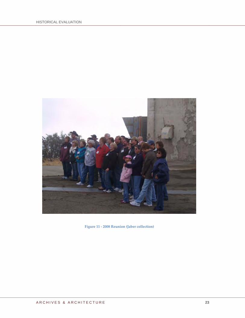
Basim Jaber
A lifelong South Bay native and freelance photographer, Basim Jaber has researched the
history and geography of Mt. Umunhum and the Almaden Air Force Station since 2006.
He has organized and hosted several veteransʹ reunions for the USAF 682nd Radar
Squadron who manned the radar station atop Mt. Umunhum between 1957 and 1980.
He continues to archive historic images and artifacts from Almaden Air Force Station to
help preserve the memories and history of this Bay Area Cold War relic. His relationship
with over 200 veterans and dependents who lived and served on the site has earned him
status as their official historian and archivist. Basim has assisted several media agencies
in producing newspaper, TV, and web media coverage of the site and its fascinating
past. These include CBS‐5 KPIX ʺEye on the Bayʺ, NBC KRON‐4 News, San Jose Mercury
News, Patch.com online, KQED ʺQUESTʺ TV, and Almaden Times Weekly. His photo
documentary work of the entire site has proven invaluable to preserving the history and
memories of Almaden Air Force Station (see http://www.almadenafs.org ). Basim also
serves as a board director on the Umunhum Conservancy, a non‐profit organization
with a mission to save and preserve the iconic radar tower atop Mt. Umunhum (see
http://www.umunhumconservancy.org ).
HISTORICAL EVALUATION
A R C H I V E S & A R C H I T E C T U R E 23
Figure 11 ‐ 2008 Reunion (Jaber collection)
HISTORICAL EVALUATION
A R C H I V E S & A R C H I T E C T U R E 24
Sources of Information Archives & Architecture, LLC. County of Santa Clara Historic Context Statement. County of
Santa Clara, Department of Planning and Development, 2012.
California (State of), Public Resources Code, Section 21000, et. seq. and The California
Environmental Quality Act (CEQA) Guidelines, California Administrative Code, Section
15000, et. seq., 1970 (as amended).
California (State of), Department of Parks and Recreation, Office of Historic Preservation
(CAL/OHP). California Points of Historical Interest. Sacramento: California Department of
Parks and Recreation, 1992.
‐‐‐‐‐. Instructions for Recording Historic Resources, 1995.
‐‐‐‐‐. Title 14 Chapter 11.5. Regulations for California Register of Historical Resources, 1997.
‐‐‐‐‐. Directory of Properties (Santa Clara County) in the Historic Property Data File, 2013.
(Includes National Register of Historic Places status codes, California Historical
Landmarks and California Points of Historical Interest listings, etc.)
‐‐‐‐‐. Technical Assistance Series #6: California Register and National Register: A Comparison
(for purposes of determining eligibility for the California Register), 2002.
‐‐‐‐‐. Title 14 Chapter 11.5. Regulations for California Register of Historical Resources.
Effective January 1, 1998.
Cornett, Lloyd H., Jr. and Mildred W. Johnson. A Handbook of Aerospace Defense
Organization, 1946‐1980. Peterson AFB, Colorado: Office of History, Aerospace Defense
Center, 1980.
Department of Defense. Coming in from the Cold: Military Heritage in the Cold War, Report
on f the Department of Defense Legacy Cold War Project. Washington D.C. publisher GPO,
1994.
Hylkema, Mark G. Negative Archaeological Survey Report (NASR): A Finding of No Effect to
Archaeological Resources, Mount Umunhum Restoration and Public Access Project. Mid‐
Peninsula Regional Open Space District, 2011.
Gregory, Carrie, and Martyn Tagg. Recording the Cold War: Identifying and Collecting Cold
War Resource Data on Military Installations. Department of Defense Legacy Resource
Management Project No. 07‐285, 2008.
HISTORICAL EVALUATION
A R C H I V E S & A R C H I T E C T U R E 25
Gudde, Erwin G. California Place Names: The Origin and Etymology of Current Geographical
Names. Berkeley: University of California Press, 1965.
Jackson, J. B. The Necessity for Ruins and Other Topics. Amherst: University of
Massachusetts, 1980.
Leeson, David. “The Role of Defense Funding in the Making of Silicon Valley.” Palo
Alto: David Leeson, 2014.
Leslie, Stuart W. “How the West Was Won: The Military and the Making of Silicon
Valley,” in Technological Competitiveness and Historical Perspectives on the Electrical,
Electronics, and Computer Industries, edited by William Aspray. New York: IEEE Press,
1993.
Lewis, Karen, and Paul Boyer, Joseph S. Murphy, Lori E. Rhodes, and Katherine J.
Roxlau. A Systematic Study of Air Combat Command Cold War Material Culture. Volume I:
Historic Context and Methodology for Assessment. Mariah Associates, Inc., Fort Worth,
Texas, 1995.
Page & Turnbull, Inc. Final Historic Resource Study of Former Almaden Air Force Station,
Mt. Umunhum, Santa Clara County, CA. Mid‐Peninsula Regional Open Space District,
2010. Including DPR523 recording of Building 102: Radar Tower FPS‐24, 9/011.
Salmon, John S. Protecting America: Cold War Defensive Sites, A National Historic Landmark
Theme Study. National Historic Landmarks Program, Cultural Resources, National Park
Service, U.S. Department of the Interior, Washington D.C., 2011.
Shiman, Philip. Forging the Sword: Defense Production in the Cold War. U.S. Army Corps of
Engineers, Engineering Research Laboratory, Special Report 97/77, sponsored by U.S.
Air Force Air Combat Command and the Department of Defense Legacy Program, 1995.
United States Air Force. Interim Guidance: Treatment of Cold War Historic Properties of U.S.
Air Force Installations. On file at Department of Defense Legacy Program Office,
Washington, D.C., 1993.
Williams, James C. The Rise of Silicon Valley. Cupertino: California History Center
Foundation, 1993.
Winkler, David F. Searching the Skies: The Legacy of the United States Cold War Defense
Radar Program. Champaign, IL: United States Air Force Headquarters Air Combat
Command, 1997.
HISTORICAL EVALUATION
A R C H I V E S & A R C H I T E C T U R E 26
Interview
Mark, Morgan. Telephone interview with Franklin Maggi and Basim Jaber, August 22,
2013.
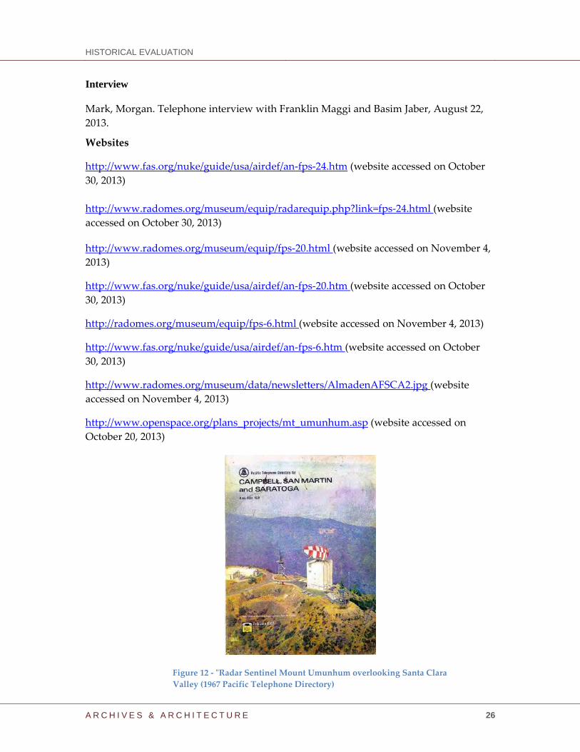
Websites
http://www.fas.org/nuke/guide/usa/airdef/an‐fps‐24.htm (website accessed on October
(This website contains extensive technical information on the AN/FPS‐24. For
the purposes of this report, the information is referenced as an attachment, but
must be viewed online by clicking the above hyperlink).
HISTORICAL EVALUATION
A R C H I V E S & A R C H I T E C T U R E 28
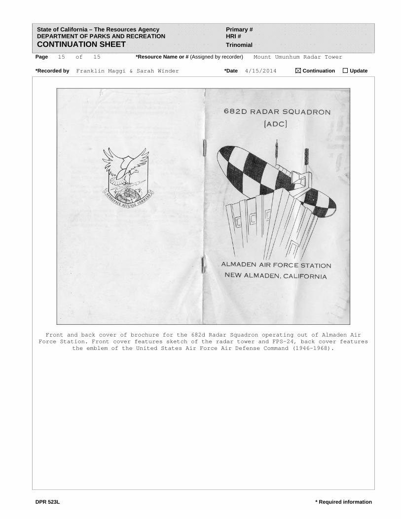
682nd Radar Squadron
The following History and Context of the 682nd Radar Squadron was provided by Mark Morgan, DAF, for use with this report. It is followed by his timeline for the Geiger Field/Kirtland AFB/Hamilton AFB/Almaden AFS (M-96/Z-96).Both have been reformatted for this evaluation.
On 5 March 1946, former British Prime Minister Winston Spencer Churchill gave a speech at Westminster College in Fulton, Mo. During the course of his presentation he stated, “From Stettin in the Baltic to Trieste in the Adriatic, an iron curtain has descended across the Continent.” His use of the phrase “Iron Curtain” in describing the political and military situation in Europe marked the beginning of the Cold War.
However, in the United States the Army Air Forces and War Department remained in their post-World War II stand-down mode. Millions of men had demobilized at the end of the war and returned to their civilian lives while aircraft either went into storage, were scrapped or, in the case of the US Navy, were literally dumped over the sides of ships. Air defense? Not important; the United States had a monopoly on nuclear weapons and could handle all comers.
On 21 March 1946, roughly two weeks after Churchill‘s speech at the small college town in America‘s heartland, the Army Air Forces established Strategic Air Command and tasked it with developing the nation‘s nuclear deterrent using a few groups of B-29 bombers. Concurrently, Tactical Air Command stood up at Langley Field, VA; six days later, Air Defense Command activated at Mitchel Field, Long Island, NY.
Despite its “air defense” title, ADC‘s initial efforts revolved around closing down, packing and shipping out the remaining World War II-era radar, filter (fighter direction) centers and HF/DF (high-frequency/direction finder) sites around the perimeter of the country. In the Bay Area, these sites included WWII-era installations in Berkeley, Carmel, Half Moon Bay (two facilities), Mill Valley, Point Reyes, Olema, Gualala, Birds Landing and Point Montara.
Along the same lines, upon activation ADC inherited operational responsibility for five numbered air forces. While First Air Force at Mitchel Field and Fourth Air Force in San Francisco for the most part continued their World War II mission of continental air defense, the others – Tenth AF, Brooks Field, Texas; Eleventh AF, Olmstead Field, Pa.; and Fourteenth AF, Orlando Army Air Base, Fla. – wholly busied themselves with training and administration of the air reserve components, including National Guard aviation.
On 21 May 1947, Fourth Air Force activated the 636th Aircraft Control & Warning Squadron at Hamilton Field in Marine County, under assignment to the 505th Aircraft Control & Warning Group at McChord Field, Washington. The activation and assignment were described as temporary duty for “…the duration of time necessary to deactivate the former radar sites of the old San Francisco Control Group…” The squadron quickly closed out the remaining operations and equipment at Point Sur, Half Moon Bay, Point Reyes, Gualala and Birds Landing. On 21 December 1947, the squadron moved to Half Moon Bay Early Warning Station; by 31 March 1948, it had completed the dismantling of Olema, Gualala and Carmel.
However, the circumstances driving Air Defense Command’s dismantling of the existing air defense network changed in March 1948. In response to heightened international tensions – chief among them a Soviet coup in Czechoslovakia in February, followed by the Berlin Blockade in April – the newly independent US Air Force directed Air Defense Command to reverse the shut-down of the radar and command and control sites and start manning them again. ADC immediately responded at the opposite ends of the country.
At McChord Field, the 505th Aircraft Control & Warning Group (AC&WG) – the only air defense command and control organization in the entire western United States – received orders from Fourth Air Force to go on 24-hour operations with the intention of providing an “air defense radar net” in the Pacific Northwest (in other words, protect the Hanford Works). The group responded
HISTORICAL EVALUATION
A R C H I V E S & A R C H I T E C T U R E 29
quickly with the personnel it had and within a few days the 505th operated a limited surveillance capability from sites in Neah Bay, Spokane, Pasco, Seaside, Walla Walla and Portland manned by personnel of the 634th Air Control Squadron and 635th Aircraft Control & Warning Squadron. Concurrently the 505th AC&WG’s 636th and 637th Aircraft Control & Warning Squadrons took similar actions to guard the San Francisco Bay area and Los Angeles, respectively.
By 2 August 1948, the regional Air Defense Direction Center at Silver Lake (Everett), Wash. was up and operating, with responsibility for operations along the entire Pacific coast. However, at the end of the year a major reorganization of air defense duties took place with the 1 December establishment of Continental Air Command (CONAC), which assumed jurisdiction of Air Defense Command’s air sovereignty and air reserve training missions.
The detonation of the Soviet Union’s first atomic bomb on 29 August 1949 precipitated a massive expansion of US early warning and air defense infrastructure. The reorganization of the West Coast defensive laydown included the 1 December 1949 activation of the Western Air Defense Force (WADF) at Hamilton AFB, followed a week later by the activation of the 28th Air Division (Defense) and 542nd Aircraft Control and Warning Group at Hamilton AFB. The latter organization, tasked with both the command and control and early warning missions, assumed operational control of the newly activated 668th Aircraft Control & Warning Squadron at the Half Moon Bay Air Defense Control Center as well as the LASHUP program radar sites at Half Moon Bay and Mather AFB.
Briefly, LASHUP, the first truly operational postwar air defense radar system, replaced the arguably stillborn SUPREMACY radar program of 1947. The program called for the emplacement of 300 radar sites around the 48 United States, employing a mix of older AN/CPS-1 early warning and CPS-5 search radars as well as more modern CPS-6B (combined search and height finder functions) and FPS-3 search radars. Due to technical difficulties, siting issues and budget restrictions, the Air Force downgraded the planned SUPREMACY deployment to 61 radars and then halted deployment at 13 sets.
The PERMANENT network served as the planned follow-on to SUPREMACY; planning and site surveys commenced in December 1949. The initial plans involved 75 sites equipped with the CPS-5, with emphasis on coverage of the population and industrial centers of the northeast and west, followed by emplacement in the southeastern and central sections of the United States. The Air Force planned 10 centers for command and control purposes with an operational date no later than 1 July 1951.
However, while development of the PERMANENT network continued, the Air Force decided to get an interim air defense radar system up and operating with the equipment on hand, deploying AN/CPS-5s under the designation LASHUP (for many analysts, “lashup” served as the perfect description as it brought images of an obsolescent radar lashed with frayed rope to the top of an old pole). Imagery aside, deployment occurred through three phases: Phase I, with initial emergency deployment around high-value locations primarily in the northeast, northwest and in the vicinity of the US’s nuclear development centers; Phase II, the northeastern United States; and Phase III, the Pacific extension south into California. By the end of 1950, 43 LASHUP radar sites were operational. Whatever its limitations, LASHUP at least constituted an initial radar network for the defense of the United States and the timing proved fortunate, as developmental problems pushed the PERMANENT deployment until early 1952.
Concurrent with PERMANENT, the Air Force initiated research and development of the follow-on system, designated the MOBILE network. Planned for installation at 44 additional locations including a growing number of Strategic Air Command bases, the MOBILE network incorporated the AN/MPS-7 search, AN/MPS-11 search and AN/MPS-14 height-finder radars. They were in fact mobile radars, developed from fixed radar designs; in advance of the development of the new network, Headquarters US Air Force decreed that all radars would indeed by mobile, mounted on trailers or similar and ready for immediate deployment elsewhere in the world in the event of an emergency. Air defense commanders fought this edict and won out, receiving permission to mount the mobile radars on fixed towers at the desired locations.
HISTORICAL EVALUATION
A R C H I V E S & A R C H I T E C T U R E 30
By June 1951, Air Defense Command teams completed site surveys for 44 (now) SEMI MOBILE program sites (designated M) nationwide. The Air Force subsequently approved a second phase of construction at 35 locations (sites designated SM), followed by a third and final laydown of 29 radars (designated TM).
In California, the PERMANENT network started taking form in October 1950, when the 668th AC&WS received orders to establish detachments on top of Marin County’s Mount Tamalpais and at Point Arena, between San Francisco and Crescent City. On 5 May 1950, at the south end of the Golden State, the Air Force activated the following aircraft control and warning squadrons for manning and operation of PERMANENT program long-range radar sites:
669th AC&WS – Fort MacArthur, LASHUP site L-43, moved to Santa Rosa Island (PERMANENT site P-15) in February 1952
670th AC&WS – Camp Cooke, site L-41, moved to San Clemente Island (P-39) in August 1951
750th AC&WS – Edwards AFB, site L-40, moved to Atolia (P-59) in January 1952
751st AC&WS – NCBC Port Hueneme, site L-42, moved to Mount Laguna (P-76) in February 1952
Up north, the PERMANENT program sites started operations towards the end of the year, continuing into the spring of 1951. The first to occupy its site was the 668th AC&WS, which had transferred to the Mather AFB LASHUP facility (L-37) in March 1950; it began operating Mather’s replacement PERMANENT radar site (P-58) in October 1951. Elsewhere, four squadrons stood up on 27 November 1950:
666th AC&WS – Mount Tamalpais (P-38)
774th AC&WS – Hamilton AFB, moved to Madera (P-74) in March 1951
776th AC&WS – Hamilton AFB, moved to Point Arena (P-37) almost immediately
777th AC&WS – Klamath (P-33)
The activation of the 775th Aircraft Control & Warning Squadron at Cambria (P-2) on 7 March 1951 concluded the PERMANENT program deployment in California.
Air Defense Command subsequently manned and equipped two additional long-range radar sites as inland backups to the coastal. In mid-1956 the 856th AC&WS (activated at Hamilton AFB on 8 September 1955) occupied the state’s only SEMI MOBILE Phase II installation at Red Bluff Air
Force Station (site designation SM-157). Roughly a year later, the 682nd AC&WS fully manned California’s only Phase I site at Almaden AFS (M-96). Almaden was the last of Air Defense Command’s long-range radar sites to go “on watch” in California and, as fate would have it, would
serve as one of last Air Force-manned and operated radar sites in the Golden State.
1 Dec 53 – 682nd Aircraft Control & Warning Squadron activated at Geiger Field, WA, with the equipment and some of the personnel of the Alabama ANG 115th AC&WS. Upon activation the squadron came under assignment of the 4702nd Defense Wing (Geiger Field),
Jan 54 – The 682nd AC&WS transferred to Kirtland AFB, NM for reassignment to the 34th Air Division (Defense)
13 Jul 54 – The 682nd AC&WS was reassigned to the 28th Air Division (Defense) (Hamilton AFB)
1 Aug 54 – The 682nd AC&WS transferred to Hamilton AFB, CA.
24 Jul 57 – Initial operating capability of the 682nd AC&WS at Almaden AFS
31 Sept 57 – The 682nd AC&WS formally transferred to Almaden AFS, CA, station M-96 in the Manual Radar Program (M-96/Z-96)
21 Mar 58 – The 682nd assumed full operational capability at Almaden with AN/FPS-20 search and AN/MPS-14 height finder radars
1 Jul 60 – The 682nd AC&WS was reassigned to the San Francisco Air Defense Sector (Beale AFB, CA)
15 Jan 61 – The 682nd redesignated as a radar squadron (SAGE)
1 Aug 63 – The 682nd RADS(SAGE) was reassigned to the Los Angeles ADS (Norton AFB, CA)
1 Apr 66 – The 682nd was reassigned to the 26th Air Division (Adair AFS, OR)
30 Sept 69 – The 682nd was reassigned to the 27th Air Division (Luke AFB, AZ)
10 Nov 69 – The 682nd was reassigned to the 26th Air Division (Luke AFB, AZ)
1 Feb 74 – The 682nd redesignated as a radar squadron
30 Jun 1980 – The 682nd deactivated at Almaden AFS.
The Role of Defense Funding in the Making of Silicon Valley
D. B. Leeson
Abstract—Silicon Valley today is seen as the modern paragon of technology-based economic success, based on venture-backed startups that have brought successive waves of semiconductor, computer, networking and software products to an eager public. But Silicon Valley is not a new phenomenon; its initial development from the early 1900's can be seen as the legacy of defense funding of companies and a university that focused on radio, and then radar technology during two world wars and the Cold War conflicts.
I. INTRODUCTION ilicon Valley is rightly hailed as one of the economic and technologic miracles of our time. The progress from the
early days of radio to the latest Internet, mobile and software products can lead one to think that consumers have always been principal customers of Silicon Valley startups and successful companies.
But scholarly authors espouse the consensus that Silicon Valley is not a new phenomenon. They trace its roots back over 100 years to the first decade of the Twentieth Century, when the electrification of California was in full swing and radio communications technology, controlled by Marconi patents, was in its infancy. The shipping fleets and navies of the world were among the first to fund radio communications. The San Francisco area was home to major Pacific shipping companies whose needs for affordable and independent radio systems sparked the founding of local radio manufacturers.
Radio and vacuum tubes, and then the defense radar of WWII and especially the Cold War, set the stage for the emergence of Stanford University, the venture capital business and the successive waves of semiconductor, computer, network, cell-phone and software companies that employ our local population. A close examination reveals the essential role of defense and other government funding that ultimately made possible the emergence of today's world-famous companies and local universities. We will see that the most vigorous elements of modern technology economy ultimately trace their existence to defense funding, the aim of which was to strengthen our nation during two world wars and the Cold War conflicts.
II. ORIGINS IN RADIO In 1909, funded by faculty and San Francisco investors,
Stanford graduate Cyril Elwell founded the company that became the Federal Telegraph Corporation, with a license in the arc transmitter of the Danish inventor Poulsen as a technological edge to win contracts from the US Navy. The US effort in World War I employed radio equipment from Federal, and the company grew to prominence. Oakland's Magnavox and other startups were spin-offs of Federal.
When WWI ended, foreign-owned radio companies operating in the US, such as Marconi and Telefunken, were appropriated at the insistence of the Navy into a new corporation, Radio Corporation of America (RCA). As a side effect, this created monopoly patent pools in radio (RCA) and telephony (AT&T). Key among the patents were those for the DeForest vacuum tube, which underlay the next advances in electronics. The next stage of the development of Western technology companies centered on devising new vacuum-tube designs that could circumvent patent litigation.
Ralph Heintz, a 1919 Stanford graduate, founded a company that became Heintz & Kaufman to manufacture vacuum tubes of a novel design using Tantalum electrodes in a non-infringing geometry. These were used in radio systems to equip the fleet of his sponsor, Dollar Steamship Company of San Francisco. Out of caution for exposure to patent litigation, Dollar discouraged Heintz from other markets.
Two of his young employees, William Eitel and Jack McCullough, radio amateurs like Heintz, had adapted the Heintz tube for the amateur use. But with the disinterest of Dollar in that market, in 1934 in the depths of the Great Depression, they left to found their own company, Eitel-McCullough (Eimac). Their tubes exhibited durability superior to others, and soon became the de facto standard for high-power amateur radio. This brought Eimac to the attention of Army and Navy engineers (many of whom were also radio amateurs) who were designing the first military radars. Their insistence on Eimac-design tubes elevated the company to the position of one of the principal suppliers of vacuum tubes in World War II.
The Depression also impacted Federal Electric, which was acquired by ITT and moved to New Jersey. A key vacuum-tube engineer, Stanford graduate Charles Litton, was determined to stay in California. He founded his own company, Litton Engineering Laboratories, to make improved glass lathes and vacuum pumps of his own design for vacuum-tube manufacturing. Litton, also a generous member of the amateur radio community, was personally supportive of Eitel and McCullough as well fostering a vacuum-tube laboratory for another radio amateur, Stanford's Prof. Fred Terman, also a consultant to his former classmate Heintz.
III. RADAR AND MICROWAVES During this same period, Sigurd Varian, a Pan American
pilot, foresaw the need for a radio means of landing safely through night, cloud and fog, and even for detecting airplanes for defense. His elder brother, Stanford physicist Russell Varian, was aware that very short wavelengths would permit the highly directive antennas required for such a system. But he also recognized that the vacuum tubes of the time were
S
2
limited in their ability to generate sufficient power at short enough wavelengths to do the job.
At Stanford, Russell Varian had been a roommate, and later shared an office with, William Hansen. In 1935, spurred by his interest in accelerating electrons, Prof. Hansen, after extensive discussions with Varian, had invented the microwave cavity resonator. Devoted to invention and schooled in patents, Varian advised Hansen to secure what would become a valuable patent.
The Varian brothers were determined to create a microwave source that would meet their needs. They returned to their central California home and, with a third brother Eric, set up a laboratory for the project. By 1937 the Varians needed the support of an established physics laboratory and Hansen's expertise, and in May Russell returned to Stanford to share Hansen's office again, bringing Sigurd, an excellent machinist. They became unpaid research assistants with a $100 budget for materials, and by July the three men had conceived the idea for the klystron, which was demonstrated in October. The resulting patent was to be one of the most valuable properties of the University, yielding royalties and recognition. It would also make possible the development of microwave radar, which would prove to be one of the decisive technologies of the coming war.
Stanford was then still a regional college, and was also experiencing the financial difficulties of the Depression. It welcomed the offer of multi-year research funding and ongoing royalties from the Sperry Gyroscope Company of New York, a manufacturer with defense experience in aircraft instruments. In 1940, when WWII appeared inevitable, Hansen, the three Varian brothers and Hansen’s protégé students Edward Ginzton and John Woodyard moved to Long Island to continue their radar work at Sperry for the duration.
IV. HEWLETT-PACKARD Charles Litton had been generous in his mentoring of
Stanford's vacuum tube work, and would make one additional contribution that would have lasting effect. In connection with its funding of Stanford's klystron development, Sperry paid an additional $1,000 for the rights to a patentable idea that Litton had donated to Stanford. In the hands of Prof. Terman, now the head of the Electrical Engineering Department, this money played a key role in the founding of the company that would become a flagship of the area, the Hewlett-Packard Company.
David Packard, yet another of the radio amateurs educated at Stanford, graduated in 1934 and, finding work scarce in those Depression days, departed east for an engineering job at General Electric in New York. His good friend William Hewlett also graduated at the same time, but was able to afford to continue his education at M.I.T. and then again at Stanford. Terman had taken Packard and Hewlett to visit local companies, and the three had talked about forming a company. But without funding, and with Packard just married, the GE job was precious in the Depression and the prospects for a return to California did not look bright.
But in 1938, with the Sperry money in hand, Terman was able to bring Packard back for a paid research assistantship. Having become a capable vacuum-tube researcher at GE,
Packard was put to work on the Litton concept, spending mornings in class, afternoons in the lab under the tutelage of Varian and evenings working with Litton at his company. A patent application was filed naming Varian and Packard as inventors.
During this time, at Terman's suggestion, Hewlett was exploring a unique audio oscillator instrument for his Engineer's thesis. Hewlett made a breakthrough in July 1938 and had a working instrument to show by August. Because he had worked without University funding, the resulting patent was in Hewlett's name. This became the foundation on which Hewlett and Packard built their company, which became a legendary success. Although it was not a defense contractor, its instruments were largely bought by companies that were, and by the time of the Korean War, Hewlett-Packard had grown to be a major company.
V. RADAR, STANFORD AND VARIAN In late 1940, the government's Radiation Laboratory was
established at M.I.T. to develop microwave radar for the coming war. The secret RadLab was staffed with academic cyclotron physicists. Hansen, already recognized as the founder of microwave electronics, was asked to educate them in the practice of microwave radar. A year later, Terman was called to head the secret Radio Research Laboratory at Harvard, tasked with developing countermeasures against enemy radars. Along with the atom-bomb project, these were major government investments in defense science and technology.
As WWII came to a close, Terman foresaw that this funding could be continued at Stanford if he assembled suitable research staff. Stanford set up a Microwave Laboratory for the returning Hansen, and an Electronics Laboratory was staffed by returning RRL scientists to continue their work on countermeasures. His strategy for distinction focused on attracting scientific talent in key areas – "Steeples of Excellence" – capable of winning federal funding. Over the next two decades, the majority of funding received by these two labs and their progeny came from the government, and even in recent times Stanford was raising some 90% of its research budget from federal sources.
In the same period, the returning Hansen-Varian group founded the company Varian Associates, which quickly found its early business in defense applications of the klystron. The success of Varian Associates and Eimac encouraged the creation of other local companies in the microwave tube business, largely funded by the defense imperatives of the Cold War. At the same time, the work in countermeasures led to the founding nearby to Stanford of a number of successful defense contractors in the applications of that technology. Hansen's development of the linear accelerator, coupled with the realization of high-power klystrons in his laboratory, led directly to the accomplish–ments of the Stanford Linear Accelerator Center (SLAC).
VI. VENTURE CAPITAL AND SEMICONDUCTORS This, then, was the environment of the 1960's, when
Terman was able to attract the beginnings of the semiconductor industry to the area. The realization that
3
startup companies could be remarkably rewarding investments had been amply demonstrated by the companies that had relied largely on government customers, and the success of Terman's strategy for Stanford had elevated it to the level of an international research university.
The transistor, a solid-state replacement for many of the functions of the vacuum tube without many of its drawbacks, was invented at the Bell Telephone Laboratories in 1947. This development flowed directly from WWII work on Silicon radar diodes.
In 1964, Terman brought William Shockley to Palo Alto to form a commercial venture in semiconductors. Shockley recruited a cadre of scientists who subsequently left to found Fairchild Semiconductor, and then the gamut of later semiconductor companies that gave rise to the name "Silicon Valley" in 1971.
The invention of the planar process and then the integrated circuit created new possibilities for miniaturization that soon found application in ever-smaller and more powerful computers. Initially, only the government could afford the premium cost of these products, and the first years of the semiconductor business were largely a partnership among the device manufacturers, Cold-War funded defense contractors and the government itself. Fairchild, National Semiconductor and Intel were all dependent on this defense spending to launch their later commercial successes.
VII. COMPUTERS, NETWORKS AND SOFTWARE The subsequent stages of the Silicon Valley story have
progressed through the introduction of personal computers, the creation of the Internet (itself initially a defense-funded concept), mobile devices and the software for the use of that infrastructure for news, research and social networking. The rise of businesses such as Apple, Google and Facebook has created vast fortunes, as well as a frenzy of imitators.
At the same time, the ability to compress millions of devices into a single integrated circuit has given rise to great successes in cellular telephony, WiFi, Bluetooth and satellites, all wireless technologies that owe their very existence to the radio and radar developments of the previous century.
All of these advances can be traced back to defense-funded initiatives of the two world wars, but particularly to the expansion of government technology investments during the Cold War. The contribution of this funding to the emergence of Silicon Valley should be appreciated.
VIII. CONCLUSION The entrepreneurial spirit of Silicon Valley developed over
an extended period, facilitated by the concentration in the San Francisco Bay Area of requirements, visionary technologists, a responsive university and ready capital. The unique attitudes of mutual support and cooperation arose early in the close-knit radio community, and have served the industry well even with the recent rise of the more heated competition.
The great expansion of government funding, particularly significant during the period of the Cold War, was key to the emergence of Silicon Valley. Since before WWII the majority of research funding at Stanford, especially in
connection with the Linear Accelerator, has come from government sources. The successes of the defense companies that arose from Stanford's developments gave encouragement to the rise of venture capital. The area continues to benefit today from the legacy of the government's role as the initial sponsor of new and high-risk technology.
REFERENCES Steve Blank, “Hidden in Plain Sight: The Secret History of Silicon Valley,” http://steveblank.com/secret-history/ Robert Buderi, The Invention that Changed the World: How a Small Group of Radar Pioneers Won The Second World War, Simon & Schuster, 1996. C. Stewart Gillmor, Fred Terman at Stanford: Building a Discipline, a University, and Silicon Valley, Stanford University Press, 2004 E. L. Ginzton, " The $100 Idea: How Russell and Sigurd Varian, With the Help of William Hansen and a $100 Appropriation, Invented the Klystron," IEEE Spectrum, Vol. 12, No. 2, February 1975, pg. 30-39; also see Dorothy Varian, “The Klystron Invention,” Ch. 13 in The Inventor and the Pilot: Russell and Sigurd Varian, Pacific Books, 1983. Christophe Lécuyer, Making Silicon Valley: Innovation and the Growth of High Tech, 1930-1970, MIT Press, 2005. Timothy Lenoir, "Myths about Stanford's Interaction with Industry," http://iis-db.stanford.edu/evnts/4097/TLenoir_Myths_about_Stanford.pdf Stuart W. Leslie, The Cold War and American Science: The Military-Industrial-Academic Complex at MIT and Stanford, Columbia University Press, 1993; see also S. W. Leslie and B. Hevly, “Steeple Building at Stanford: Electrical Engineering, Physics, and Microwave Research,” Proc. IEEE, vol. 73, No. 7, July 1985, pg. 1169-80. Rebecca S. Lowen, Creating the Cold War University: The Transformation of Stanford, University of California Press, 1997. Jane Morgan, Electronics in the West: The First Fifty Years, National Press Books, 1967 Arthur L. Norberg, "The Origins of the Electronics Industry on the Pacific Coast," Proc. IEEE, Vol. 64, No. 9, September 1976, pg. 1314-1322. Norman Pond, The Tube Guys, Russ Cochran Publisher, 2008. Arun Rao, "Partners: Bill Hewlett, Dave Packard and Fred Terman at HP and Stanford (1930-1970)" in Arun Rao and Piero Scaruffi, A History of Silicon Valley: The Greatest Creation of Wealth in the History of the Planet, Omniware 2011 http://scaruffi.com/svhistory/sv/chap76.html Timothy Sturgeon, "How Silicon Valley Came to Be," in Martin Kenney (ed.), Understanding Silicon Valley: The Anatomy of an Entrepreneurial Region, Stanford University Press, 2000. From 1968-1993, David B. Leeson was the founding CEO and Chairman of California Microwave, Inc. Since 1994 he has been a Consulting Professor at Stanford University.
Page 1 of 15 *Resource Name or #: (Assigned by recorder) Mount Umunhum Radar Tower
P1. Other Identifier: Almaden Air Force Station (closed)/ Building 102: Radar Tower AN/FPS-24
*P2. Location: Not for Publication Unrestricted *a. County Santa Clara and (P2b and P2c or P2d. Attach a Location Map as necessary.) *b. USGS 7.5’ Quad Los Gatos Date 1980 photorevised T.9S. ; R.1E.; Mount Diablo B.M. c. Address none (former Almaden Air Force Station, Mount Umunhum City Los Gatos Zip 94033 d. UTM: (Give more than one for large and/or linear resources) Zone 10S; 600847 mE/ 4113038mN e. Other Locational Data: (e.g., parcel #, directions to resource, elevation, etc., as appropriate) Assessor’s Parcel Number: 562-08-003
*P3a Description: (Describe resource and its major elements. Include design, materials, condition, alterations, size, setting, and boundaries)
*P3b. Resource Attributes: (List attributes and codes) HP34. Military Property
*P4 Resources Present: Building Structure Object Site District Element of District Other (Isolates, etc.)
P5b. Description of Photo: (View, date, accession #)
*P6. Date Constructed/Age & Sources: Historic Prehistoric Both
*P7. Owner and Address:
*P8. Recorded by: (Name, affiliation, and address) Franklin Maggi & Sarah Winder Archives & Architecture PO Box 1332 San Jose CA 95109-1332 *P9. Date Recorded: May 9, 2014
*P10. Survey Type: (Describe) Intensive
*P11. Report Citation: (Cite survey report and other sources, or enter “none”.)
*Attachments: NONE Location Map Sketch Map Continuation Sheet Building, Structure and Object Record Archaeological Record District Record Linear Feature Record Milling State Record Rock Art Record Artifact Record Photograph Record Other (List)
DPR 523A * Required information
State of California – The Resources Agency Primary # DEPARTMENT OF PARKS AND RECREATION HRI #
PRIMARY RECORD Trinomial NRHP Status Code Other Listings Review Code Reviewer Date
View facing northwest, Sept. 2013
1959-1961/53+ years old.
Midpeninsula Regional Open Space District 330 Distel Circle Los Altos, CA 94022-1404
Archives & Architecture, LLC, Historical Evaluation, Mount Umunhum Radar Tower, Sierra Azul Open Space Preserve, Santa Clara County, California, 2014.
Located on the flat peak of Mount Umunhum in the Santa Cruz Mountains, the 5 story concrete radar tower that once operated at Almaden Air Force Station remains a prominent structure at the edge of Santa Clara County. Built within a large complex of buildings and structures that constituted this manned radar surveillance site during the Cold War, the iconic nature of the structure has instills a sense of time and place to valley residents who lived their lives during the emergence of Silicon Valley as a major military and technological innovation center during the latter part of the twentieth century. The mountain top, now devoid of most of the physical remainders of the station following demolition of the complex of buildings in 2013, is today a significant physical reminder of an important period in Santa Clara County history. (Continued on page 2, DPR523L)
Page 2 of 15 *Resource Name or # (Assigned by recorder) Mount Umunhum Radar Tower *Recorded by Franklin Maggi & Sarah Winder *Date 4/15/2014 Continuation Update
DPR523L * Required information
(Continued from page 1, DPR523a, P3a Description) Building 102 is about 65 feet square and about 19,845 square feet in size. It was designed as a utilitarian structure and consists of poured-in-place concrete walls and floors with an integral vertical structural frame of concrete, visible at the exterior where they break the surface profile into three sections. The parapet at the top provides a base for metal railings. The roof contains the original base for the FPS-24 and sail.
View of Mount Umunhum summit prior to removal of structures (Basim Jaber) Upon approach from Mount Umunhum Road, the building as a wide entry at the ground level at the center of the façade containing steel doors within a projecting vestibule. Similar but smaller entries (3) exist at the opposite side of the building, all protected by concrete block enclosures and having varying glazed, vented, and flush surfaces. Additional openings are located above the entry of the main façade, the lower containing an original door, and those above currently open and unprotected. Other wall penetrations exist throughout the structure for fenestration and ventilation. Within the interior are large rooms previous utilized for equipment and other supporting purposes. Large concrete columns evenly spaced within the interiors provided interior support for the rooftop equipment and sail. Space dividers composed of concrete blocks still exist, while those constructed of drywall were removed as a part of asbestos abatement. The exterior walls remain unfinished, painted, pour-in-place concrete. The ceilings are a waffle-like grid of concrete showing the exposed grid of structural system designed to support heavy equipment loading. Within the structure are the remains of mechanical and electrical systems including light fixtures, air handlers, plumbing, and equipment platforms. The building is in fair condition and shows exterior deterioration due to removal of the exterior coating and some unrepaired structural distress. Hazardous materials appear to have been remediated.
State of California – The Resources Agency Primary # DEPARTMENT OF PARKS AND RECREATION HRI #
CONTINUATION SHEET Trinomial
Page 3 of 15 *Resource Name or # (Assigned by recorder) Mount Umunhum Radar Tower *Recorded by Franklin Maggi & Sarah Winder *Date 4/15/2014 Continuation Update
DPR523L * Required information
Typical third floor interior as shown at Mt Hebo AFS, from Steve Weatherly’s radomes.org. The angled console is the control console, and to the rear is the Transmitter.
State of California – The Resources Agency Primary # DEPARTMENT OF PARKS AND RECREATION HRI #
CONTINUATION SHEET Trinomial
Page 4 of 15 *Resource Name or # (Assigned by recorder) Mount Umunhum Radar Tower *Map Name: USGS/AMBAG/DigitalGlobe/USDA Farm Service Agency (via Google) *Scale: n.t.s. *Date of Map: 2014
Current aerial showing Mount Umunhum summit with Almaden Air Force Station structures removed (excepting Radar Tower)
DPR523J * Required information
State of California – The Resources Agency Primary # DEPARTMENT OF PARKS AND RECREATION HRI #
LOCATION MAP Trinomial
Page 5 of 15 *NRHP Status Code n/a *Resource Name or # (Assigned by recorder) Mount Umunhum Radar Tower
B1. Historic Name: Building 102, Almaden Air Force Station B2. Common Name: Mount Umunhum Radar Tower B3. Original use: Radar Tower B4. Present Use: vacant *B5. Architectural Style: Utilitarian *B6. Construction History: (Construction date, alterations, and date of alterations)
*B7. Moved? No Yes Unknown Date: Original Location: *B8. Related Features:
B9a Architect: Burns & Roe b. Builder: Indenco Engineers *B10. Significance: Cold War Military Theme Area Sierra Azul Open Space Preserve Period of Significance 1959-1980 Property Type Military Applicable Criteria 1 and 3 (Discuss importance in terms of historical or architectural context as defined by theme, period, and geographic scope. Also address integrity.)
B13. Remarks: Proposed landmark nomination *B14. Evaluator: Franklin Maggi *Date of Evaluation: 5/9/2014
DPR 523B * Required information
From From Page & Turnbull, 2011.
(This space reserved for official comments.)
State of California – The Resources Agency Primary # DEPARTMENT OF PARKS AND RECREATION HRI #
BUILDING, STRUCTURE, AND OBJECT RECORD
(See related report bibliography)
Constructed 1959-1961. Radar sail and radar equipment removed in June 1980. Hazardous materials abatement in 2011.
Almaden Air Force Station buildings (no longer extant).
Shortly after the end of World War II, it became apparent that tensions between the United States and the Soviet Union could not be contained, and they quickly spilled over into an all-out global conflict. With the outbreak of the Cold War in the late 1940s, and then the Korean War in 1950, the U.S. Army and the U.S. Air Force quickly began reestablishing air defenses to protect the United States against manned bomber attacks from the Soviet Union and other enemies. Some air defense radar sites that were used in World War II were reactivated, and many new sites were established, creating a network of bases and warning systems along the United States borders. California, more specifically the Bay Area, was a part of this network of defense. One of 28 stations built as part of the second segment of the Air Defense Command permanent radar network, Mount Umunhum’s Almaden Air Force Station was a U.S. Air Force early warning radar base that operated from 1958 to 1980. The base was constructed as part of the North American Aerospace Defense Command (NORAD) to keep watch over Northern California’s airspace during the Cold War. (Continued on next page, DPR523L)
DPR 523L * Required information
Page 6 of 15 *Resource Name or # (Assigned by recorder) Mount Umunhum Radar Tower *Recorded by Franklin Maggi & Sarah Winder *Date 4/15/2014 Continuation Update
State of California – The Resources Agency Primary # DEPARTMENT OF PARKS AND RECREATION HRI #
CONTINUATION SHEET Trinomial
(Continued from previous page, DPR523b, B10 Significance) As part of the conversion to the Semi-Automatic Ground Environment (SAGE) network, the site subsequently gained an upgraded height-finder radar, an AN/FPS-90, as well as an upgraded Ground-Air Transmit-Receive (GATR) facility, in 1958 and 1962 respectively. The conversion to SAGE resulted in the squadron’s reassignment to the San Francisco Air Defense Sector, which operated from SAGE Direction Center DC-18 at Beale AFB, California, which is located 40 miles north of Sacramento. The AN/FPS-20 radar was replaced by a massive 85.5 ton AN/FPS-24 search radar (manufactured by General Electric) atop Building 102, the five-story concrete tower constructed between 1959 and 1961, visible from the valley floor, known today simply as the Mount Umunhum Radar Tower. The site served as the second production AN/FPS-24 in Air Defense Command, following a similar installation at Point Arena AFS (located 150 miles north of San Francisco near California’s coastline), and was one of seven constructed of masonry and reinforced concrete. It functioned as a frequency diverse (FD) long-range search radar designed to operate in the Very High Frequency (VHF) and was the second of only 12 production models built between 1958 and 1962. In 1961, Almaden AFS joined the SAGE system, feeding computer data to a data center at Beale AFB, California. The SAGE Direction Center at Beale AFB was known as DC-18. After joining SAGE, the squadron was re-designated as the "682nd Radar Squadron (SAGE)." In 1963, the SAGE site information was switched to DC-17 at Norton AFB, located near San Bernardino. That same year on July 31, 1963, the Mount Umunhum site was re-designated as NORAD ID Z-96. In 1968, as the result of defense budget cuts and a reduction in the Department of Defense’s emphasis on protection of the country against Soviet-manned bombers, Air Defense Command (ADC) started deactivating its remaining long-range radar sites in the interior of the country. Directed by the Department of Defense partly in recognition of the increased Soviet intercontinental ballistic missile threat and partly due to their proximity to major target areas, the decision to deactivate selected Defense Commands resulted in the loss of six centers at locations around the country. In their stead, the Air Force developed the Back-Up Interceptor Control system (BUIC), with widely-separated long-range radar sites serving as alternate direction centers in the event of an attack on the continental United States. BUIC I, deployed during the early 1960s, was the manual system; BUIC II was the first of two SAGE-capable systems which went operational in 1966 at 14 locations, including Almaden AFS. As part of the conversion, the long-range radar operations building at the station was enlarged to accommodate additional computers and display equipment as well as a command and control room. The buildings also received additional radio frequency and blast hardening in the form of a two-foot-thick outer shell of reinforced concrete with embedded radio frequency (RF) shields. As a BUIC II site, Almaden backstopped the 26th Air Division Air Defense Control Center (ADCC) at Adair AFS near Corvallis, Oregon. After suspension of BUIC II operations in 1968, the improved BUIC III sites at Mount Laguna AFS (east of San Diego, 751st Air Defense Group), Fallon AFS, Nevada (858th ADG) and Kingsley Field, Klamath Falls, Oregon (827th ADG) assumed backup command and control responsibilities for the West Coast, and Almaden reverted to an air defense detection and surveillance mission. In 1979, Almaden AFS came under Tactical Air Command (TAC) jurisdiction with the inactivation of Aerospace Defense Command and the creation of Air Defense-Tactical Air Command (ADTAC). On June 30, 1980, the 682nd Radar Squadron was rendered inactive at Almaden AFS. Its “retirement” left ADTAC with only four Air Force-manned and operated long-range radar stations guarding the Pacific Coast. From the north, they were the 758th RADS, Makah AFS, Washington; 777th RADS, Klamath AFS, California; 666th RADS, Mill Valley AFS, California; and 775th RADS, Cambria AFS, California. The AN/FPS-24 radar antenna “sail” was removed in June 1980 with the height-finder radars at Almaden AFS removed about the same time. (Continued on next page)
DPR 523L * Required information
Page 7 of 15 *Resource Name or # (Assigned by recorder) Mount Umunhum Radar Tower *Recorded by Franklin Maggi & Sarah Winder *Date 4/15/2014 Continuation Update
State of California – The Resources Agency Primary # DEPARTMENT OF PARKS AND RECREATION HRI #
CONTINUATION SHEET Trinomial
(Continued from previous page) EVALUATION The Mount Umunhum Radar Tower is individually significant at the local level within the former Almaden Air Force Station under Criterion 1 as a prominent and pertinent example of radar operation at the site and within the Santa Clara County itself. Though not the first or only radar erected at the Almaden Air Force Station, it best represents the overall mission and purpose of the Almaden Air Force Station, and has served as a visual symbol of an important era in county history to the county due to its prominent perch above the valley. The Radar Tower remains the most visual and memorable icon, easily recognizable to the entire population of Santa Clara County. It is of historic significance within the county due to its prominent, distinctive image, its important associations, and the expansive understanding of what it represents to the local population. The Mount Umunhum Radar Tower is individually significant locally under Criterion 3 as a unique concrete structure in Santa Clara County that once supported the highest-powered radar antenna at the now decommissioned Almaden Air Force Station site. The Radar Tower is a distinctive architectural specimen for its unique construction as a military radar tower during the Cold War. The radar tower is a distinguished and locally well-known example of utilitarian military architecture. It is a distinctive local monument of this type, associated directly with an important period in military history. The Mount Umunhum Radar Tower possesses integrity of location and setting. The building has not been moved, although the surrounding buildings are in the process of being demolished at the time of the beginning of this study. Integrity of design, materials, workmanship, feeling, and association had been compromised somewhat because the radar sail and related equipment on the roof has long been removed, and technical machinery to operate the radar no longer exists. Like all decommissioned radar installations in the United States, the radar equipment was removed from the site following decommission, but the building itself retains its original appearance.
JRP Historical Consulting Services’ California Historic Military Buildings and Structures Inventory, Volume III: Historic Context: Property Types and Registration Requirements (2000) includes a theme of “Early Warning Systems and Electronic Warfare” and a property type of “Major Radar Arrays.” Registration requirements for this property type state that “If the building is found to have supported an important radar set and the building itself retains integrity to its original appearance, the possibility exists that the building could be found to qualify for the National Register.” Nevertheless, the report suggests that “it is unlikely that a major radar [structure] would be intact, including the radar unit itself.”
According to the Page and Turnbull Final Historic Resource Study of Former Almaden Air Force Station, Mt. Umunhum (2010), Building 102 (the extant radar tower) was one of three buildings that were determined to best represent the historic function of the former Almaden Air Force Station. It was also determined to be the most impressive structure on the site. Page & Turnbull found the tower historically significant under National Register in a DPR523 recording dated September 2011, but indicated that it lacked sufficient integrity to be listed. The reasons presented failed to address local context, or the fact that it was unlikely that in any situation the radar sail and equipment for this type of facility would be intact, and that the building itself could adequately convey the reason for significance, as it does in Santa Clara County.
The structure remains an important representation of the historic background of the former base, and has sufficient integrity to convey its history.
DPR 523L * Required information
Page 8 of 15 *Resource Name or # (Assigned by recorder) Mount Umunhum Radar Tower *Recorded by Franklin Maggi & Sarah Winder *Date 4/15/2014 Continuation Update
State of California – The Resources Agency Primary # DEPARTMENT OF PARKS AND RECREATION HRI #
CONTINUATION SHEET Trinomial
View of south and east façades of Mount Umunhum Radar Tower, facing northwest.
View of south elevation, facing north.
DPR 523L * Required information
Page 9 of 15 *Resource Name or # (Assigned by recorder) Mount Umunhum Radar Tower *Recorded by Franklin Maggi & Sarah Winder *Date 4/15/2014 Continuation Update
State of California – The Resources Agency Primary # DEPARTMENT OF PARKS AND RECREATION HRI #
CONTINUATION SHEET Trinomial
View of west elevation from Mount Umunhum Road, facing east.
Detailed view of door openings with block wrap-arounds, located on north elevation.
DPR 523L * Required information
Page 10 of 15 *Resource Name or # (Assigned by recorder) Mount Umunhum Radar Tower *Recorded by Franklin Maggi & Sarah Winder *Date 4/15/2014 Continuation Update
Detailed view of north elevation, facing east.
Upwards view of tower from ground.
State of California – The Resources Agency Primary # DEPARTMENT OF PARKS AND RECREATION HRI #
CONTINUATION SHEET Trinomial
DPR 523L * Required information
Page 11 of 15 *Resource Name or # (Assigned by recorder) Mount Umunhum Radar Tower *Recorded by Franklin Maggi & Sarah Winder *Date 4/15/2014 Continuation Update
Interior view of boiler equipment – ground floor of radar tower.
Interior view of view of electrical panels – ground floor of radar tower.
State of California – The Resources Agency Primary # DEPARTMENT OF PARKS AND RECREATION HRI #
CONTINUATION SHEET Trinomial
DPR 523L * Required information
Page 12 of 15 *Resource Name or # (Assigned by recorder) Mount Umunhum Radar Tower *Recorded by Franklin Maggi & Sarah Winder *Date 4/15/2014 Continuation Update
Aerial view of Almaden Air Force Station, ca. 1970s.
Bird’s eye view of Almaden Air Force Station, 1979.
State of California – The Resources Agency Primary # DEPARTMENT OF PARKS AND RECREATION HRI #
CONTINUATION SHEET Trinomial
DPR 523L * Required information
Page 13 of 15 *Resource Name or # (Assigned by recorder) Mount Umunhum Radar Tower *Recorded by Franklin Maggi & Sarah Winder *Date 4/15/2014 Continuation Update
View of FPS-24 radar sail, 1975. Photo courtesy of John Beach.
Maintenance being performed on FPS-24 radar sail, 1975. Photo courtesy of John Beach.
State of California – The Resources Agency Primary # DEPARTMENT OF PARKS AND RECREATION HRI #
CONTINUATION SHEET Trinomial
DPR 523L * Required information
Page 14 of 15 *Resource Name or # (Assigned by recorder) Mount Umunhum Radar Tower *Recorded by Franklin Maggi & Sarah Winder *Date 4/15/2014 Continuation Update
View of radar tower and FPS-24 radar in operation, ca. 1970s.
State of California – The Resources Agency Primary # DEPARTMENT OF PARKS AND RECREATION HRI #
CONTINUATION SHEET Trinomial
DPR 523L * Required information
Page 15 of 15 *Resource Name or # (Assigned by recorder) Mount Umunhum Radar Tower *Recorded by Franklin Maggi & Sarah Winder *Date 4/15/2014 Continuation Update
Front and back cover of brochure for the 682d Radar Squadron operating out of Almaden Air Force Station. Front cover features sketch of the radar tower and FPS-24, back cover features
the emblem of the United States Air Force Air Defense Command (1946-1968).
State of California – The Resources Agency Primary # DEPARTMENT OF PARKS AND RECREATION HRI #