Arizona Geological Survey www.azgs.az.gov | repository.azgs.az.gov OPEN-FILE REPORT OFR-13-07 A REVIEW OF LATE CENOZOIC VOLCANIC ACTIVITY IN THE GILA BEND – BUCKEYE AREA OF WESTERN MARICOPA COUNTY, ARIZONA Jon E. Spencer Arizona Geological Survey July 2013 Gila River channel between lava flows of the Sennel Volcanic Field and Oatman Mountain (top) of south-central Arizona.
A review of lAte CenozoiC volCAniC ACtivity in the GilA Bend – BuCkeye AreA of western
MAriCopA County, ArizonA
Jon E. SpencerArizona Geological Survey
July 2013
Gila River channel between lava flows of the Sentinel Volcanic Field and Oatman Mountain (top) of south-central Arizona.
Arizona Geological Survey
M. Lee Allison, State Geologist and Director
Manuscript approved for publication in July 2013Printed by the Arizona Geological Survey
All rights reserved
For an electronic copy of this publication: www.repository.azgs.az.govPrinted copies are on sale at the Arizona Experience Store
416 W. Congress, Tucson, AZ 85701 (520.770.3500)
For information on the mission, objectives or geologic products of the Arizona Geological Survey visit www.azgs.az.gov.
This publication was prepared by an agency of the State of Arizona. The State of Arizona, or any agency thereof, or any of their employees, makes no warranty, expressed or implied, or assumes any legal liability or responsibility for the accuracy, completeness, or usefulness of any information, apparatus, product, or process disclosed in this report. Any use of trade,
product, or firm names in this publication is for descriptive purposes only and does not imply endorsement by the State of Arizona.
___________________________
Recommended Citation: Spencer, J.E., 2013, A review of late Cenozoic volcanic activity in the Gila Bend – Buckeye area of western Maricopa County, Arizona. Arizona Geological Survey Open File Report, OFR-13-07, 32 p.
1
A review of late Cenozoic volcanic activity in the
Gila Bend – Buckeye area of western Maricopa
County, Arizona
July 2013
Arizona Geological Survey
Open-File Report OFR-13-07, version1.0, 32 p.
Jon E. Spencer
Senior Geologist
Arizona Geological Survey
416 W. Congress St., #100
Tucson, Arizona 85701
2
Introduction
The Arlington and Gillespie volcanoes west of Buckeye in western Maricopa County, Arizona,
form the northeastern part of a string of basaltic volcanoes that include the extensive Sentinel
volcanic field west of Gila Bend (Fig. 1). Potassium-argon geochronologic age determinations
indicate that basaltic volcanic activity occurred between about 1 and 4 Ma, with significant
variation between different eruptive centers. This review is intended to provide basic
information regarding geologically recent volcanic activity near the Palo Verde Nuclear
Generating Station, and is intended to contribute to a re-evaluation of geologic hazards in the
general area.
The Sentinel – Arlington volcanic field
The Sentinel – Arlington volcanic field extends over about 80 km from Sentinel volcanic field
west of Gila Bend northeastward to Arlington volcano west of Buckeye (Richard et al., 2000;
Cave and Greeley, 2004). Volcanic rocks in the field are olivine-clinopyroxene basalts that form
low relief lava flows and low shield volcanoes, with little evidence of pyroclastic activity (Lynch,
1989; Nealey and Sheridan, 1989; Cave and Greeley, 2007). SiO2 content is ~45-52% (Leeman,
1970; Cave et al., 2007), and 87Sr/86Sr of one sample is 0.7035 (Leeman, 1970). It does not
appear that any intermediate or felsic volcanic rocks were erupted in the field.
Age of the Sentinel – Arlington volcanic field
Arlington volcano, a small, basaltic, low shield volcano at the northeastern end of the Sentinel –
Arlington volcanic field, is located approximately 10 km southeast of the Palo Verde Nuclear
Generating Station (Fig. 1; Cave and Greeley, 2004). Six potassium-argon radiometric dates of
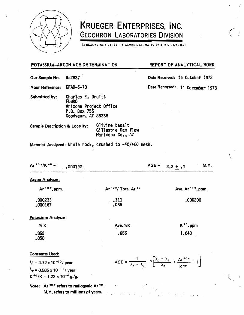
basalt rock samples from Arlington volcano range from 1.28±0.25 to 3.28±0.27 Ma (Fig. 1;
Appendix 1; “Ma” = “mega-annum” or, equivalently, age in millions of years; uncertainty is one
standard deviation), and one 40Ar/39Ar incremental release date yielded a plateau age of
2.37±0.02 Ma (Table 1; Shelby Cave, written commun., 2013). The volcano is geologically
simple, consisting of a single, small, low-relief volcano with no soil horizons between flows
(Cave and Greeley, 2004). Most likely it was erupted in a single volcanic episode of short
geologic duration (<10,000 years), and was not erupted over a 1-2 million year period as
suggested by the range of radiometric dates (Cave and Greeley, 2004). Four of the six
potassium-argon dates from the volcano range from 1.92±0.42 to 2.28±0.21 Ma (Fig. 1), and
suggest that age of the volcano is about 2.1 Ma. The 2.37±0.02 Ma 40Ar/39Ar date suggests that
the volcano is slightly older.
3
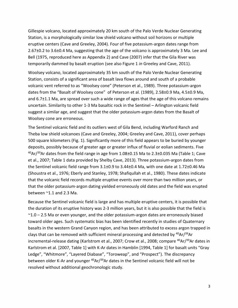
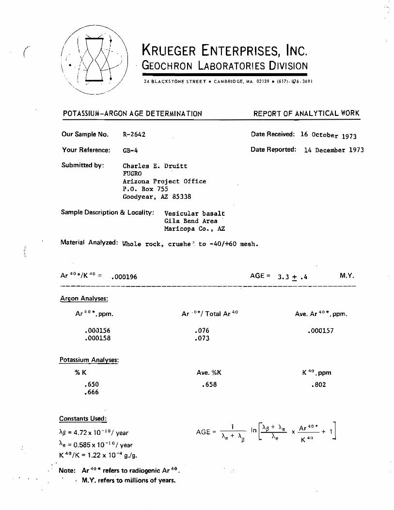
Gillespie volcano, located approximately 20 km south of the Palo Verde Nuclear Generating
Station, is a morphologically similar low shield volcano without soil horizons or multiple
eruptive centers (Cave and Greeley, 2004). Four of five potassium-argon dates range from
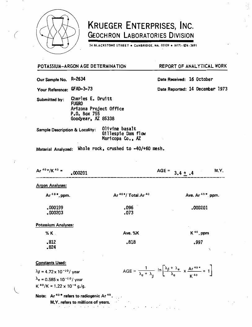
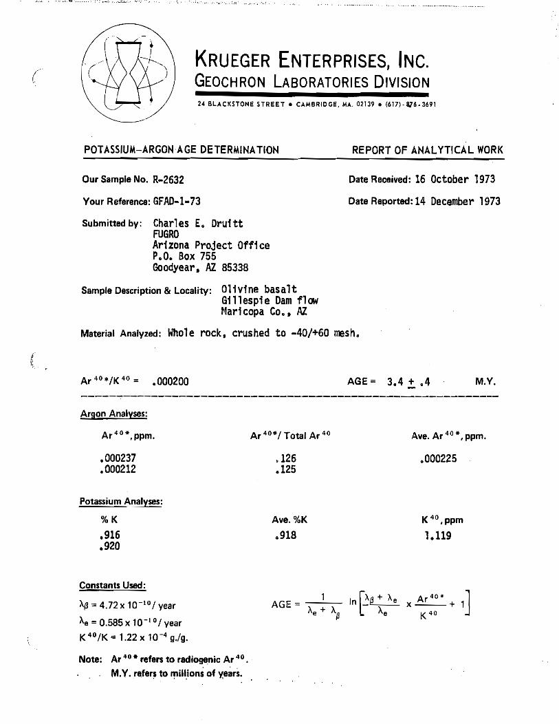
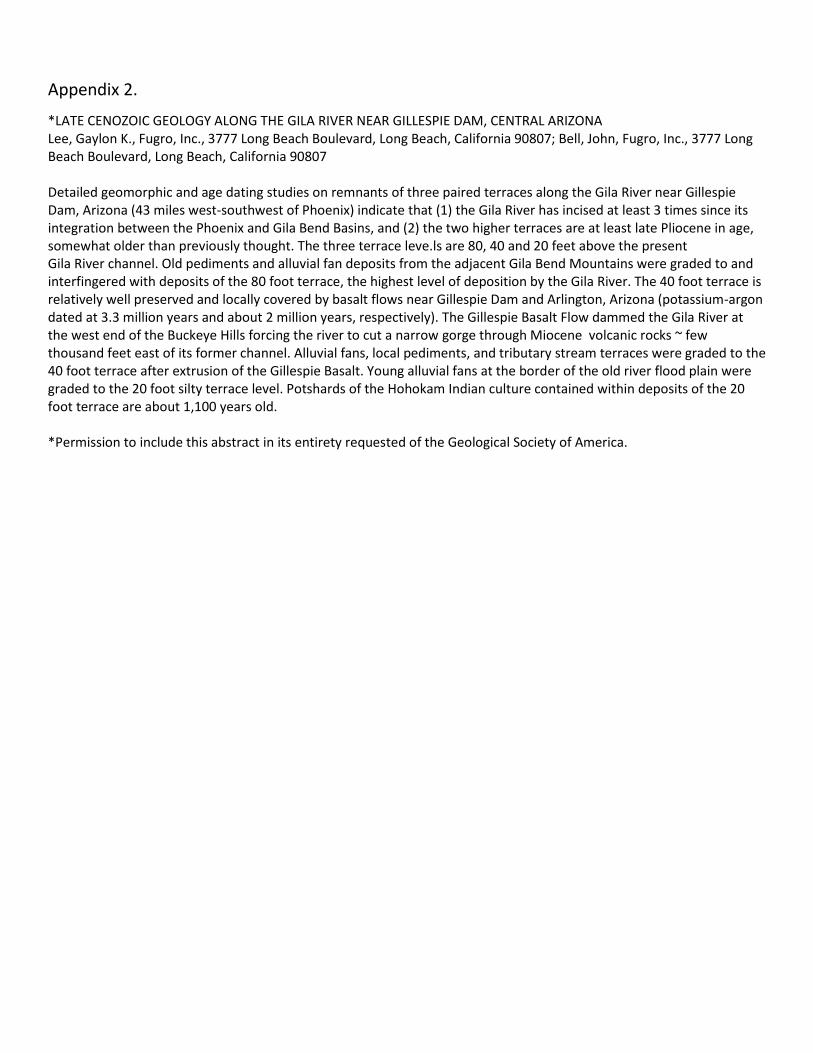
2.67±0.2 to 3.6±0.4 Ma, suggesting that the age of the volcano is approximately 3 Ma. Lee and
Bell (1975, reproduced here as Appendix 2) and Cave (2007) infer that the Gila River was
temporarily dammed by basalt eruption (see also Figure 1 in Greeley and Cave, 2011).
Woolsey volcano, located approximately 35 km south of the Palo Verde Nuclear Generating
Station, consists of a significant area of basalt lava flows around and south of a probable
volcanic vent referred to as “Woolsey cone” (Peterson et al., 1989). Three potassium-argon
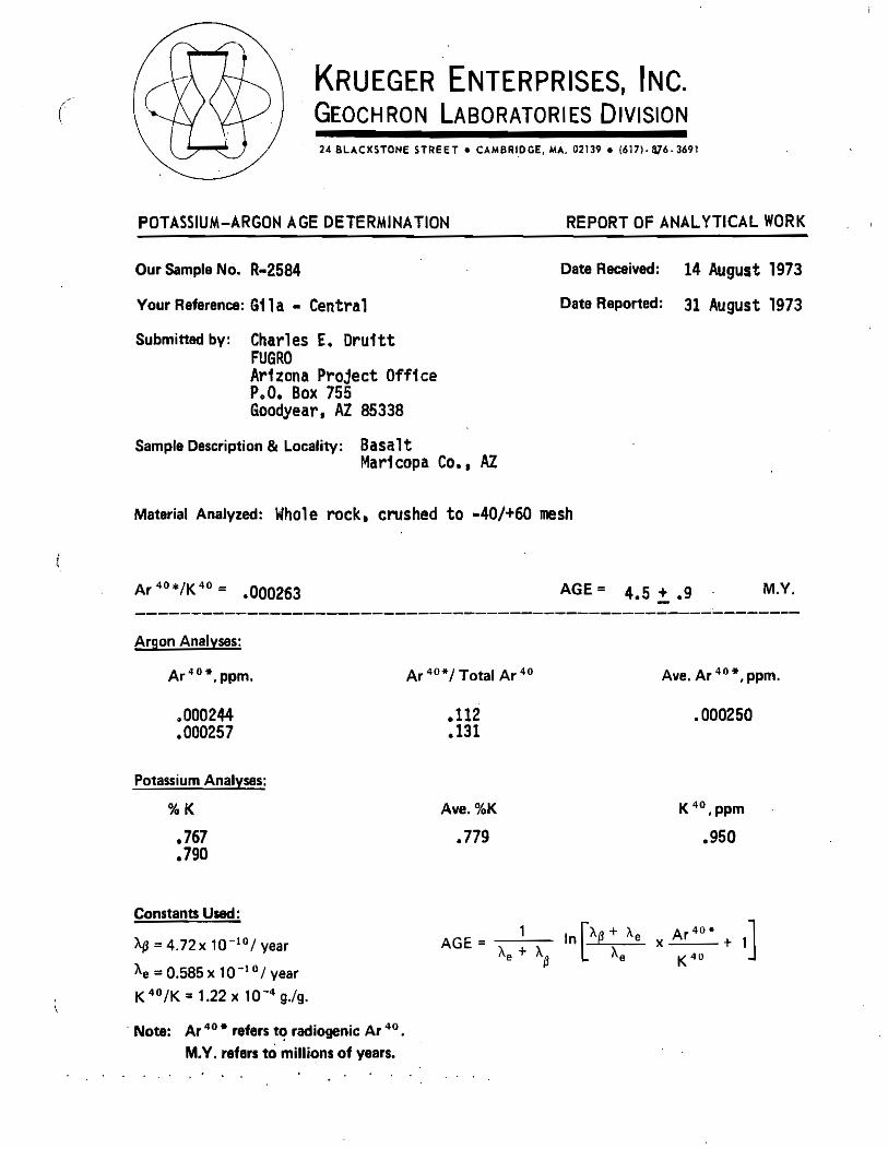
dates from the “Basalt of Woolsey cone” of Peterson et al. (1989), 2.58±0.9 Ma, 4.5±0.9 Ma,
and 6.7±1.1 Ma, are spread over such a wide range of ages that the age of this volcano remains
uncertain. Similarity to other 1-3 Ma basaltic rock in the Sentinel – Arlington volcanic field
suggest a similar age, and suggest that the older potassium-argon dates from the Basalt of
Woolsey cone are erroneous.
The Sentinel volcanic field and its outliers west of Gila Bend, including Warford Ranch and
Theba low shield volcanoes (Cave and Greeley, 2004; Greeley and Cave, 2011), cover perhaps
500 square kilometers (Fig. 1). Significantly more of this field appears to be buried by younger
deposits, possibly because of greater age or greater influx of fluvial or eolian sediments. Five 40Ar/39Ar dates from the field range in age from 1.08±0.15 Ma to 2.3±0.035 Ma (Table 1; Cave
et al., 2007; Table 1 data provided by Shelby Cave, 2013). Three potassium-argon dates from
the Sentinel volcanic field range from 3.1±0.9 to 3.44±0.4 Ma, with one date at 1.72±0.46 Ma
(Shoustra et al., 1976; Eberly and Stanley, 1978; Shafiqullah et al., 1980). These dates indicate
that the volcanic field records multiple eruptive events over more than two million years, or
that the older potassium-argon dating yielded erroneously old dates and the field was erupted
between ~1.1 and 2.3 Ma.
Because the Sentinel volcanic field is large and has multiple eruptive centers, it is possible that
the duration of its eruptive history was 2-3 million years, but it is also possible that the field is
~1.0 – 2.5 Ma or even younger, and the older potassium-argon dates are erroneously biased
toward older ages. Such systematic bias has been identified recently in studies of Quaternary
basalts in the western Grand Canyon region, and has been attributed to excess argon trapped in
clays that can be removed with sufficient mineral processing and detected by 40Ar/39Ar
incremental-release dating (Karlstrom et al., 2007; Crow et al., 2008; compare 40Ar/39Ar dates in
Karlstrom et al. [2007, Table 1] with K-Ar dates in Hamblin [1994, Table 1] for basalt units “Gray
Ledge”, “Whitmore”, “Layered Diabase”, “Toroweap”, and “Prospect”). The discrepancy
between older K-Ar and younger 40Ar/39Ar dates in the Sentinel volcanic field will not be
resolved without additional geochronologic study.
4
Conclusion
The Sentinel – Arlington volcanic field produced extensive, low relief basalt lava flows and
small, gently sloping basalt shield volcanoes. Available geochronologic data suggest that the
Sentinel – Arlington volcanic field has erupted intermittently over the past 1.1-3.5 Ma, with no
clear migration of volcanic activity within the field. Although there is no geochronologic
evidence for eruptions during the past one million years, the large range of geochronologic
dates from the Sentinel volcanic field, the uncertainties inherent in many of the older
potassium-argon dates, and the large number of eruptive centers, allow for the possibility of
more recent activity that is as yet undocumented.
References Cited
Cave, S.R., 2007, Paleohydrology of the lower Gila River preserved by late Cenozoic lava flows in
southwestern Arizona: Geological Society of America Abstracts with Programs, v. 39, n. 5, p. 44.
Cave, S., and Greeley, R., 2004, The geology of two small Cenozoic volcanoes in southwestern
Arizona: Journal of the Arizona-Nevada Academy of Science, v 37, n. 2, p. 105-110.
Cave, S.R., and Greeley, R., 2007, Topographic analysis of low shield volcanoes in southwestern Arizona:
Geological Society of America Abstracts with Programs, v. 39, n. 6, p. 124, abstract 46-9.
Cave, S.R., Greeley, R., Champion, D.E., and Turrin, B.D., 2007, 40Ar/39Ar ages for the Sentinel-Arlington
Field, southwestern Arizona: Eos, Transactions American Geophysical Union, v. 88, n. 52, Abstract
V23B-1439.
Crow, R., Karlstrom, K.E., McIntosh, W., Peters, L, Dunbar, N., 2008, History of Quaternary volcanism and
lava dams in western Grand Canyon based on LIDAR analysis, 49Ar/39Ar dating, and field studies:
Implications for flow stratigraphy, timing of volcanic events, and lava dams: Geosphere, v. 4, no. 1,
doi 10.1130/geo00133.1.
Eberly, L.D., and Stanley, T.B., Jr., 1978, Cenozoic stratigraphy and geologic history of
southwestern Arizona: Geological Society of America Bulletin, v. 89, p. 921-940.
Greeley, R., and Cave, S., 2011, Warford Ranch Volcano, Arizona, field exercise, in Garry, W.B., and
Bleacher, J.E., eds., Analogs for Planetary Exploration: Geological Society of America Special Paper
483, p. 393–400, doi:10.1130/2011.2483(24).
Hamblin, W.K., 1994, Late Cenozoic lava dams in the western Grand Canyon: Geological Society of America Memoir 183, 139 p.
Karlstrom, K.E., Crow, R., McIntosh, W., Peters, L., Pederson, J., Raucci, J., Crossey, L.J., Umhoefer, P.,
Dunbar, N., 2007, 40Ar/39Ar and field studies of Quaternary basalts in Grand Canyon and model for
carving Grand Canyon: quantifying the interaction of river incision and normal faulting across the
western edge of the Colorado Plateau: Geological Society of America Bulletin, v. 119, p. 1283-1312.
Lee, G.K., and Bell, J., 1975, Late Cenozoic geology along the Gila River near Gillespie Dam,
central Arizona: Geological Society of America Abstracts with Programs, v. 7, n. 3, p. 340-
351.
5
Leeman, W.P., 1970, The isotopic composition of strontium in late-Cenozoic basalts from the Basin-
Range province, western United States: Geochimica et Cosmochimica Acta, v. 34, p. 857-872.
Lynch, D.J., 1989, Neogene volcanism in Arizona: The recognizable volcanoes, in Jenny, J.P., and
Reynolds, S.J., eds., Geologic Evolution of Arizona: Arizona Geological Society Digest, v. 17, p.681-
700.
Nealey, L.D., and Sheridan, M.F., 1989, Post-Laramide volcanic rocks of Arizona and northern Sonora,
Mexico, and their inclusions, in Jenney, J.P., and Reynolds, S.J., eds., Geologic evolution of Arizona:
Arizona Geological Society Digest, v. 17, p. 609-647.
Peterson, J.A., Miller, R.J., and Jones, S.L., 1989, Geologic map of the Woolsey Peak Wilderness
Study Area, Maricopa County, Arizona: U.S. Geological Survey Miscellaneous Field Studies
Map MF-2044, scale 1:48,000.
Reynolds, S.J., Florence, F. P., Welty, J. W., Roddy, M. S., Currier, D. A., Anderson, A. V., and
Keith, S.B., 1986, Compilation of radiometric age determinations in Arizona: Tucson,
Arizona Bureau of Geology and Mineral Technology Bulletin 197, 258 p.
Richard, S.M., Reynolds, S.J., Spencer, J.E., and Pearthree, P.A., 2000, Geologic map of Arizona:
Shafiqullah, M., Damon, P.E., Lynch, D.J., Reynolds, S.J., Rehrig, W.A., and Raymond, R.H., 1980,
K-Ar geochronology and geologic history of southwestern Arizona and adjacent areas, in
Jenny, J.P. and Stone, C., eds., Studies in Western Arizona: Arizona Geological Society
Digest, v. 12, p. 201-260.
Shoustra, J.J., Smith, J.L., Scott, J.D., Strand, R.L., and Duff, D., 1976, Radiometric age dating:
Palo Verde Nuclear Generating Station 1, 2, and 3, Preliminary safety analysis report:
Arizona Public Service Commission, v. 8, Appendix 2Q.
Spencer, J.E., Richard, S.M., Reynolds, S.J., Miller, R.J., Shafiqullah, M., Grubensky, M.J., and
Gilbert, W.G., 1995, Spatial and temporal relationships between mid-Tertiary magmatism
and extension in southwestern Arizona: Journal of Geophysical Research, v. 100, p. 10,321-
10,351.
6
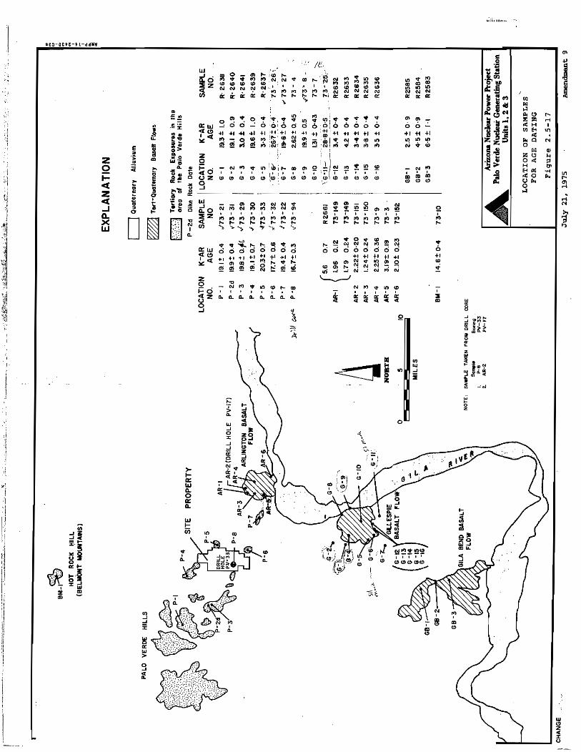
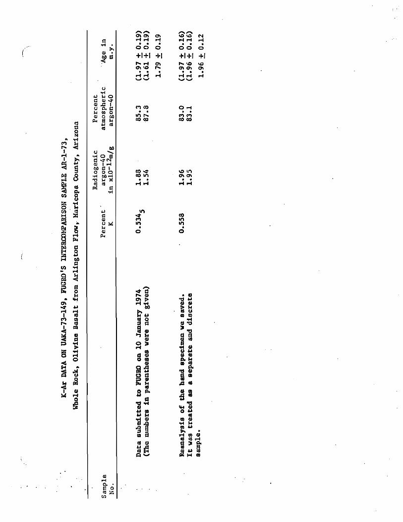
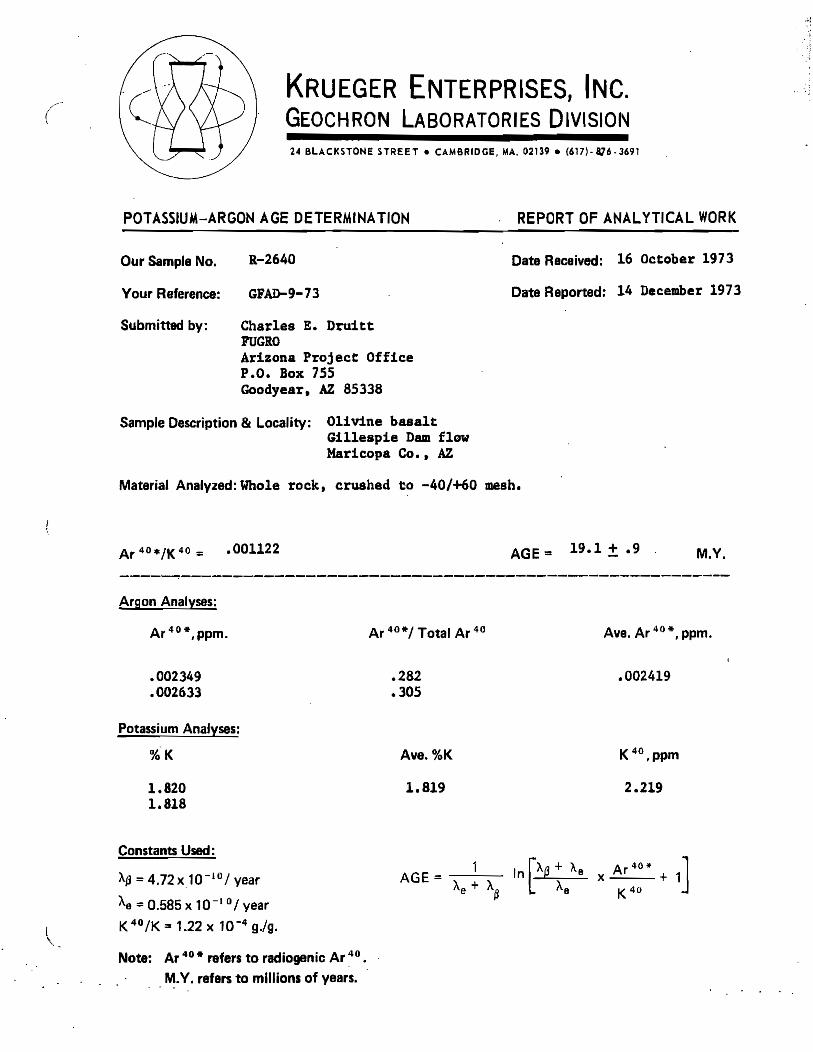
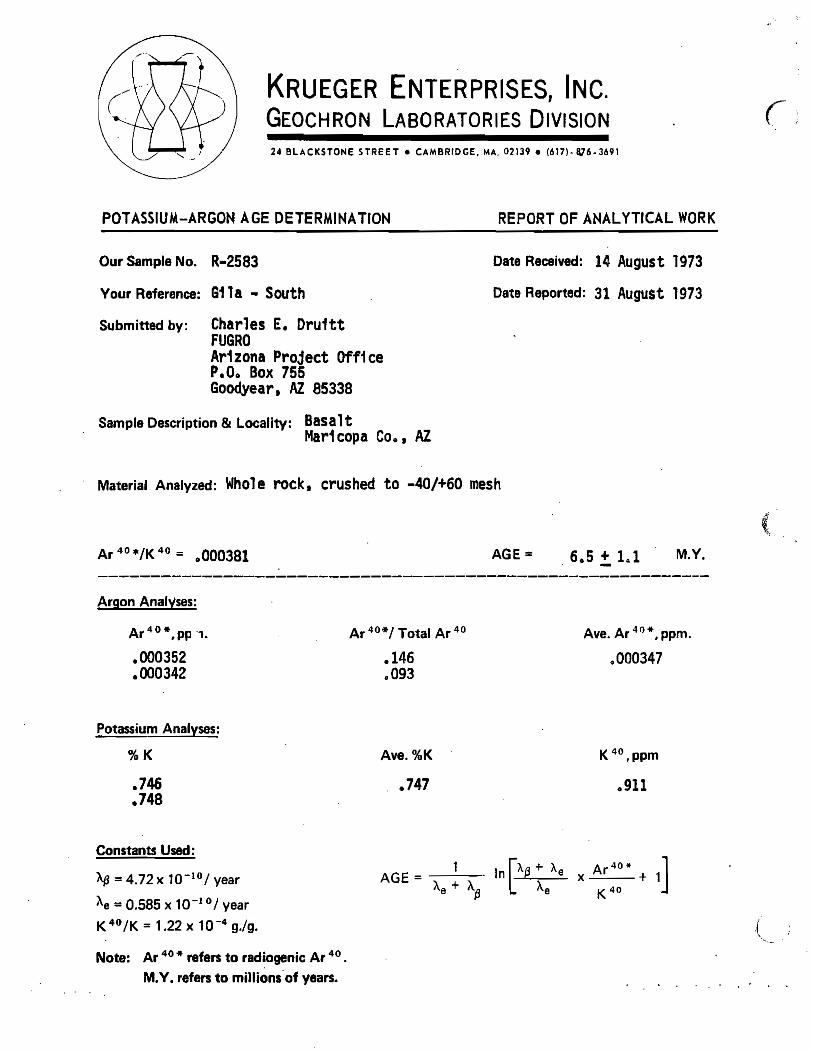
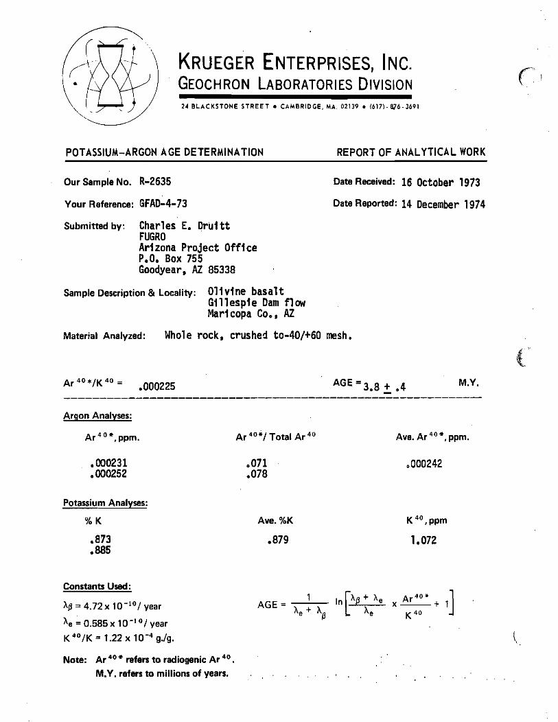
Figure 1. Geologic map of the Gila Bend – Buckeye area showing major rock units (from Richard et al., 2000) and potassium-argon radiometric dates (in millions of years, with analytical uncertainty at one standard deviation). K-Ar dates from late Cenozoic volcanic rocks (<10 Ma) are from Reynolds et al. (1986). Sample locations are shown as indicated by coordinates reported by Reynolds et al. (1986), but many of these are probably slightly mislocated because coordinates were not provided with sufficient accuracy. Six samples were dated by the 40Ar/39Ar method (Cave et al., 2007; Table 1; data from S. Cave and D. Champion, written comm., 2013). Late Cenozoic K-Ar dates were originally reported by Shoustra et al. (1976, included here as Appendix 1), Eberly and Stanley (1978), and Shafiqullah et al. (1980). Also shown are dates from middle Tertiary igneous rocks (15-30 Ma), as originally reported by the sources listed above and by Spencer et al. (1995).
7
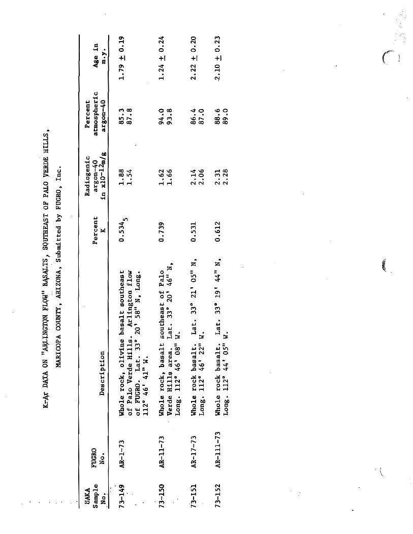
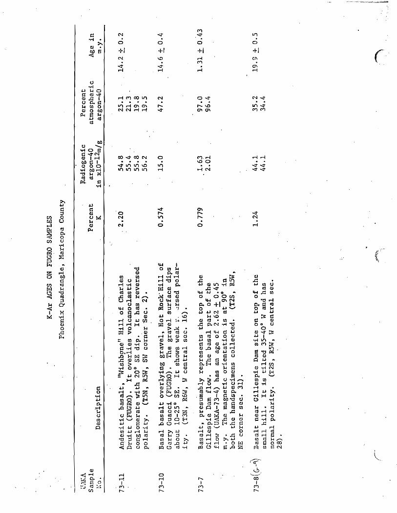
Appendix 1
Geochronology of the Sentinel Volcanic Field
Originally Published as
Appendix 2Q Radiometric Age Dating
Dr. Paul Damon (Univ. of Arizona) Tucson, Arizona
And Geochron Laboratories Division
Krueger Enterprises, Inc. Cambridge, Massachusetts
In: Shoustra, J.J., Smith, J.L., Scott, J.D., Strand, R.L. and Duff, D., 1976, Geology and seismicity, site lithologic conditions and Appendix 2Q (radiometric dating in Palo Verde Nuclear Generating Station 1, 2, and 3, Preliminary safety analysis report: Arizona Public Service Commission, v. 2, p. 2.5-60, 2.5-76 and v. 8, Appendix 2Q.
Appendix 2.
*LATE CENOZOIC GEOLOGY ALONG THE GILA RIVER NEAR GILLESPIE DAM, CENTRAL ARIZONA Lee, Gaylon K., Fugro, Inc., 3777 Long Beach Boulevard, Long Beach, California 90807; Bell, John, Fugro, Inc., 3777 Long Beach Boulevard, Long Beach, California 90807 Detailed geomorphic and age dating studies on remnants of three paired terraces along the Gila River near Gillespie Dam, Arizona (43 miles west-southwest of Phoenix) indicate that (1) the Gila River has incised at least 3 times since its integration between the Phoenix and Gila Bend Basins, and (2) the two higher terraces are at least late Pliocene in age, somewhat older than previously thought. The three terrace leve.ls are 80, 40 and 20 feet above the present Gila River channel. Old pediments and alluvial fan deposits from the adjacent Gila Bend Mountains were graded to and interfingered with deposits of the 80 foot terrace, the highest level of deposition by the Gila River. The 40 foot terrace is relatively well preserved and locally covered by basalt flows near Gillespie Dam and Arlington, Arizona (potassium-argon dated at 3.3 million years and about 2 million years, respectively). The Gillespie Basalt Flow dammed the Gila River at the west end of the Buckeye Hills forcing the river to cut a narrow gorge through Miocene volcanic rocks ~ few thousand feet east of its former channel. Alluvial fans, local pediments, and tributary stream terraces were graded to the 40 foot terrace after extrusion of the Gillespie Basalt. Young alluvial fans at the border of the old river flood plain were graded to the 20 foot silty terrace level. Potshards of the Hohokam Indian culture contained within deposits of the 20 foot terrace are about 1,100 years old. *Permission to include this abstract in its entirety requested of the Geological Society of America.