Doncaster Metropolitan Borough Council Armthorpe Neighbourhood Development Plan Addendum to the Armthorpe Neighbourhood Plan Submission Draft Sustainability Appraisal October 2016 Amec Foster Wheeler Environment & Infrastructure UK Limited
Transcript
Doncaster Metropolitan Borough Council
Armthorpe Neighbourhood Development Plan Addendum to the Armthorpe Neighbourhood Plan Submission Draft Sustainability Appraisal
October 2016
Amec Foster Wheeler Environment & Infrastructure UK Limited
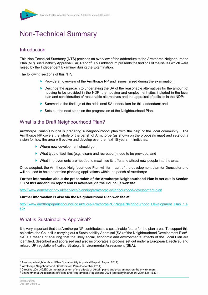
This Non-Technical Summary (NTS) provides an overview of the addendum to the Armthorpe Neighbourhood Plan (NP) Sustainability Appraisal (SA) Report1. This addendum presents the findings of the issues which were raised by the Independent Examiner during the Examination.
The following sections of this NTS:
Provide an overview of the Armthorpe NP and issues raised during the examination;
Describe the approach to undertaking the SA of the reasonable alternatives for the amount of housing to be provided in the NDP, the housing and employment sites included in the local plan and consideration of reasonable alternatives and the appraisal of policies in the NDP;
Summarise the findings of the additional SA undertaken for this addendum; and
Sets out the next steps on the progression of the Neighbourhood Plan.
What is the Draft Neighbourhood Plan?
Armthorpe Parish Council is preparing a neighbourhood plan with the help of the local community. The Armthorpe NP covers the whole of the parish of Armthorpe (as shown on the proposals map) and sets out a vision for how the area will evolve and develop over the next 15 years. It indicates:
Where new development should go;
What type of facilities (e.g. leisure and recreation) need to be provided; and
What improvements are needed to maximise its offer and attract new people into the area.
Once adopted, the Armthorpe Neighbourhood Plan will form part of the development plan for Doncaster and will be used to help determine planning applications within the parish of Armthorpe
Further information about the preparation of the Armthorpe Neighbourhood Plan is set out in Section 1.3 of this addendum report and is available via the Council’s website:
It is very important that the Armthorpe NP contributes to a sustainable future for the plan area. To support this objective, the Council is carrying out a Sustainability Appraisal (SA) of the Neighbourhood Development Plan2. SA is a means of ensuring that the likely social, economic and environmental effects of the Local Plan are identified, described and appraised and also incorporates a process set out under a European Directive3 and related UK regulations4 called Strategic Environmental Assessment (SEA).
1 Armthorpe Neighbourhood Plan Sustainability Appraisal Report (August 2014) 2 Armthorpe Neighbourhood Development Plan (December 2014) 3 Directive 2001/42/EC on the assessment of the effects of certain plans and programmes on the environment. 4 Environmental Assessment of Plans and Programmes Regulations 2004 (statutory instrument 2004 No. 1633).
SA has been undertaken of the emerging NP in August 2014. To ensure that the final, adopted NP takes into account sustainability considerations, and to meet the Council’s responsibilities under the SEA Directive, it is necessary to appraise the policy changes and sites and to take address the issues raised by the Inspector during the examination.
Section 1.4 of the addendum describes in further detail the requirement for SA and the SA process in respect of the Armthorpe Neighbourhood Development Plan.
How Have the Proposed Policies, Sites and Consideration of Alternatives Been Appraised?
To support the appraisal of the Neighbourhood Development Plan, a SA Framework has been developed. This contains a series of sustainability objectives and guide questions that reflect both the current socio-economic and environmental issues which may affect (or be affected by) the Neighbourhood Plan. The objectives are based upon those which have been used for the Local Plan Core Strategy. The SA objectives are shown in Table NTS 1.
Table NTS 1 SA Objectives Used to Appraise the Policies and Sites
Economic impacts Social impacts Impacts on the environment and resources acts on the environment and resources
1. Employment Opportunities Available to Everyone.
2. Conditions which enable business success, economic growth and investment, and a diverse economy.
3. Education and Training Opportunities which build the skills and capacity of the population.
4. Quality housing provided this is available to everyone including vulnerable people, disadvantaged groups and rural communities.
5. Conditions and services which minimise noise, dust, light and air pollution.
6. Safety and security for people and property.
7. Access to culture, leisure and recreation activities will be available to all.
8. Efficient land use patterns that minimise the need to travel and local needs met locally.
9. An efficient transport network which maximises access and minimises detrimental impacts.
10. Reuse of previously developed sites and buildings.
11. An attractive place.
12. Cultural heritage conserved and enhanced.
13. To protect, enhance and increase the borough’s biodiversity and geodiversity.
14. Conservation of soil and mineral resource, including prevention of soil pollution and sterilisation of minerals.
15. Quality and quantity of groundwater, ponds, lakes and water courses conserved and enhanced in accordance with the Water Framework Directive.
16. Greenhouse gas emissions minimised and a managed response to the effects of climate change.
17. Flood risk minimised.
18. Prudent and efficient use of energy and natural resources (including water) by developments without unnecessary production of waste and promotion of both waste minimisation and recycling techniques.
19. Efficient use of physical infrastructure.
20. Protect, enhance and increase green infrastructure within the borough.
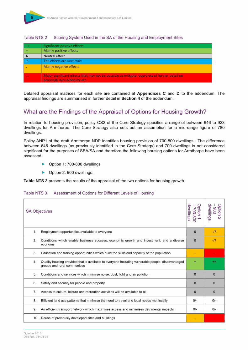
The housing and employment sites have been appraised against the scoring system shown in Table NTS 2 below and using the questions in Appendices B and C respectively.
‐‐ Major significant effects that may not be possible to mitigate regardless of further detail on proposal/layout/density etc.
Detailed appraisal matrices for each site are contained at Appendices C and D to the addendum. The appraisal findings are summarised in further detail in Section 4 of the addendum.
What are the Findings of the Appraisal of Options for Housing Growth?
In relation to housing provision, policy CS2 of the Core Strategy specifies a range of between 646 to 923 dwellings for Armthorpe. The Core Strategy also sets out an assumption for a mid-range figure of 780 dwellings.
Policy ANP1 of the draft Armthorpe NDP identifies housing provision of 700-800 dwellings. The difference between 646 dwellings (as previously identified in the Core Strategy) and 700 dwellings is not considered significant for the purposes of SEA/SA and therefore the following housing options for Armthorpe have been assessed.
Option 1: 700-800 dwellings
Option 2: 900 dwellings.
Table NTS 3 presents the results of the appraisal of the two options for housing growth.
Table NTS 3 Assessment of Options for Different Levels of Housing
SA Objectives
Option 1
– 700-800 dw
ellings
Option 2
– 900 dw
ellings
1. Employment opportunities available to everyone 0 -/?
2. Conditions which enable business success, economic growth and investment, and a diverse economy
0 -/?
3. Education and training opportunities which build the skills and capacity of the population - --
4. Quality housing provided that is available to everyone including vulnerable people, disadvantaged groups and rural communities
+ ++
5. Conditions and services which minimise noise, dust, light and air pollution 0 0
6. Safety and security for people and property 0 0
7. Access to culture, leisure and recreation activities will be available to all 0 0
8. Efficient land use patterns that minimise the need to travel and local needs met locally 0/- 0/-
9. An efficient transport network which maximises access and minimises detrimental impacts 0/- 0/-
10. Reuse of previously developed sites and buildings - --
Table NTS 3 (continued) Assessment of Options for Different Levels of Housing
SA Objectives
Option 1 –
700-800 dw
ellings
Option 2 –
900 dw
ellings
11. An attractive place 0/- -/--
12. Cultural heritage conserved and enhanced 0 0
13. To protect, enhance and increase the borough’s biodiversity and geodiversity 0/- -/--
14. Conservation of soil and minerals resource, including prevention of soil pollution and sterilisation of minerals
0 0
15. Quality and quantity of groundwater, ponds, lakes and water courses conserved and enhanced in accordance with the Water Directive Framework
? ?
16. Greenhouse gas emissions minimised and a managed response to the effects of climate change 0 0
17. Flood risk minimised +/- +/--
18. Prudent and efficient use of energy and natural resources (including water) by developments without unnecessary production of waste and promotion of both waste minimisation and recycling techniques
0 0
19. Efficient use of physical infrastructure + +
20. Protect, enhance and increase green infrastructure within the borough. +/- +/-
As shown in Table NTS 3 above, the performance of each housing option is assessed as having similar impacts on a number of the objectives, although option 2 (900 dwellings) would have a significant positive impact in relation to affordable housing (SA objective 4) compared to option 1, which was assessed as having a mainly positive impact and there would be some additional negative impacts from option 2. The potential for a greater number of negative effects is identified in relation to option 2, for example in relation to use of previously developed land (objective 10), biodiversity (objective 13) and flood risk (objective 17).
Whilst the difference between the effects identified in the SA for the two options is marginal overall, the likelihood of negative effects increases with the scale of development. In consequence, given that both alternatives are in conformity with the Core Strategy, at this stage, in order to reduce the likelihood of any negative effects, in terms of the SA, the alternative for 700-800 houses is preferable.
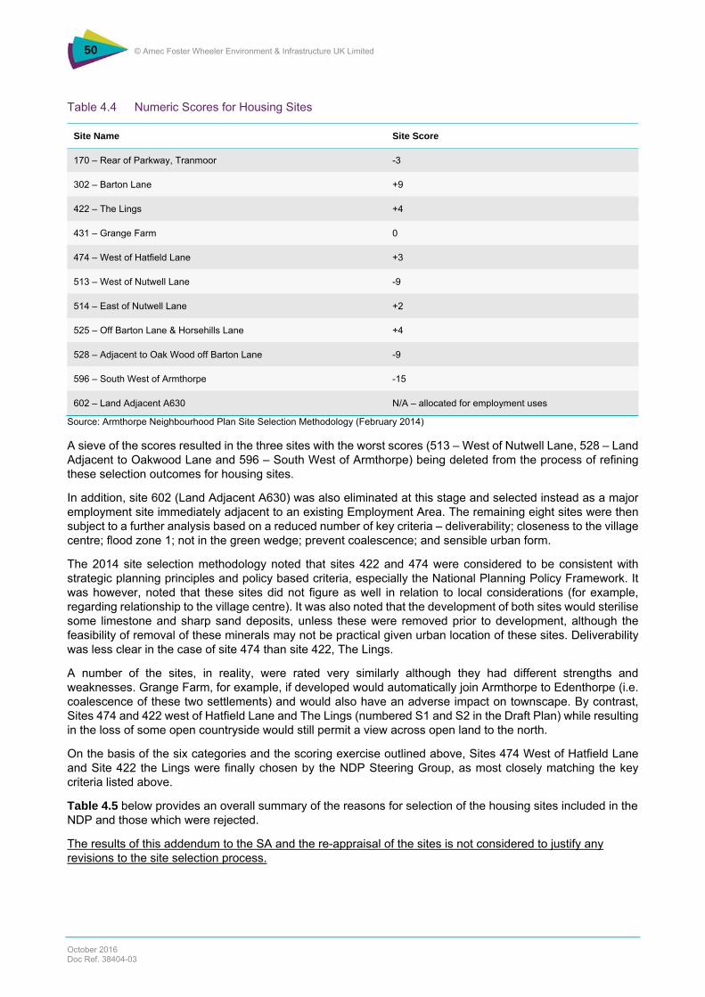
What are the Findings of the Appraisal of the Housing Sites?
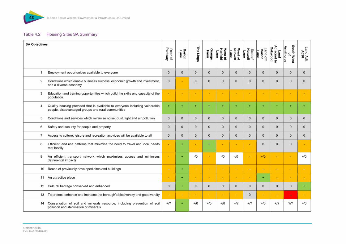
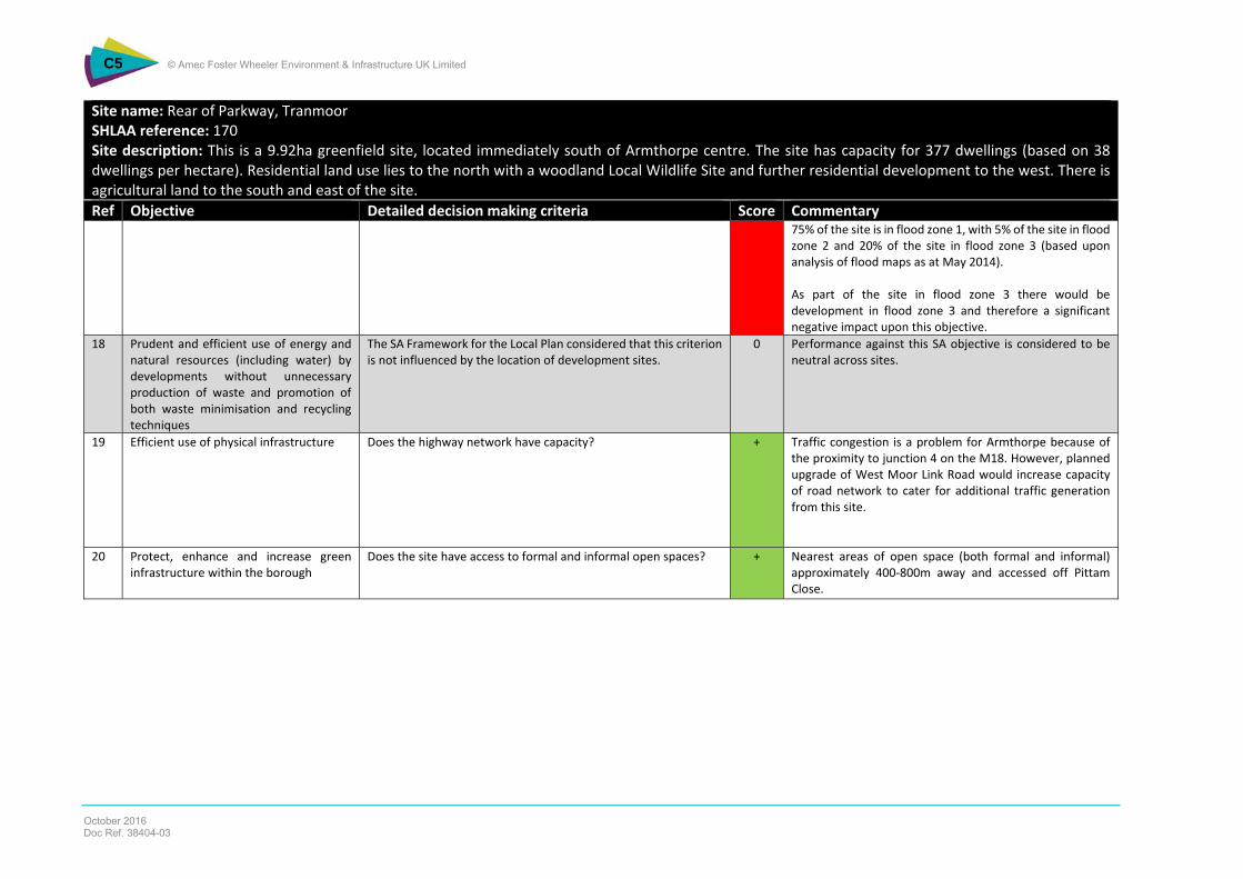
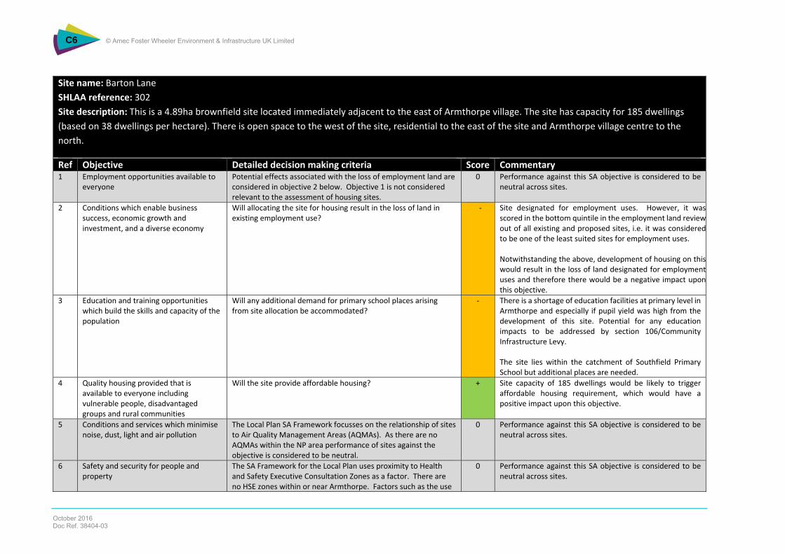
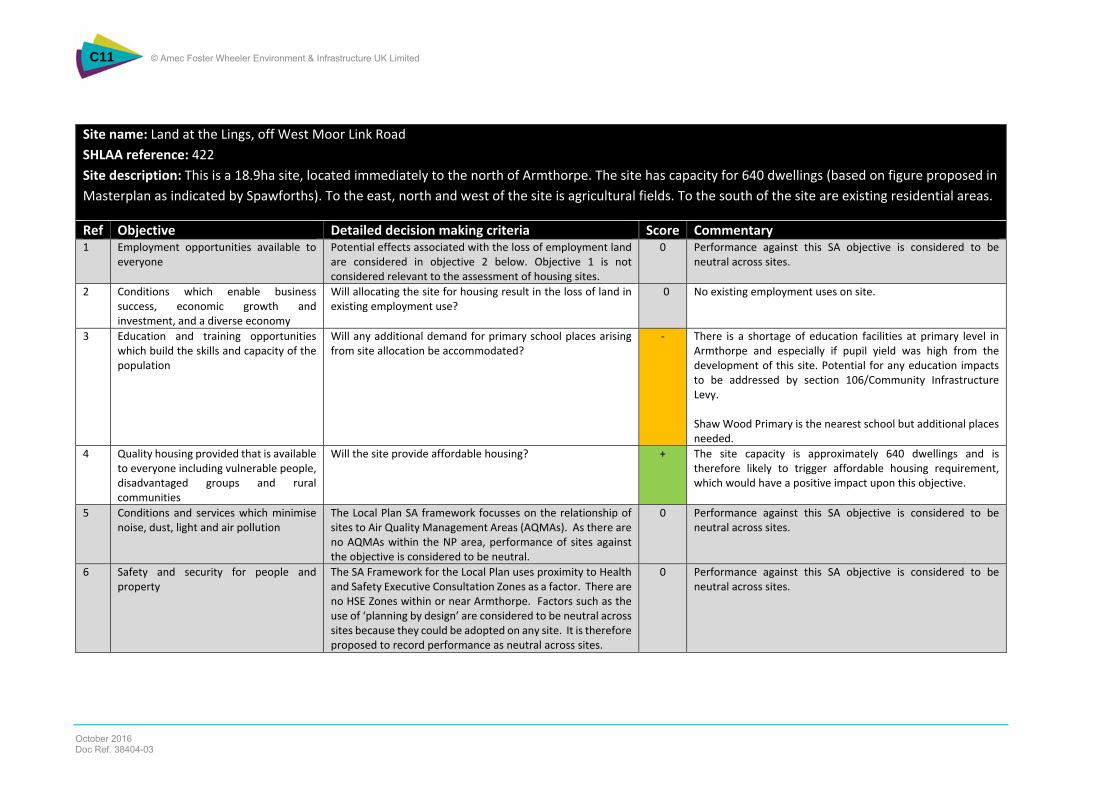
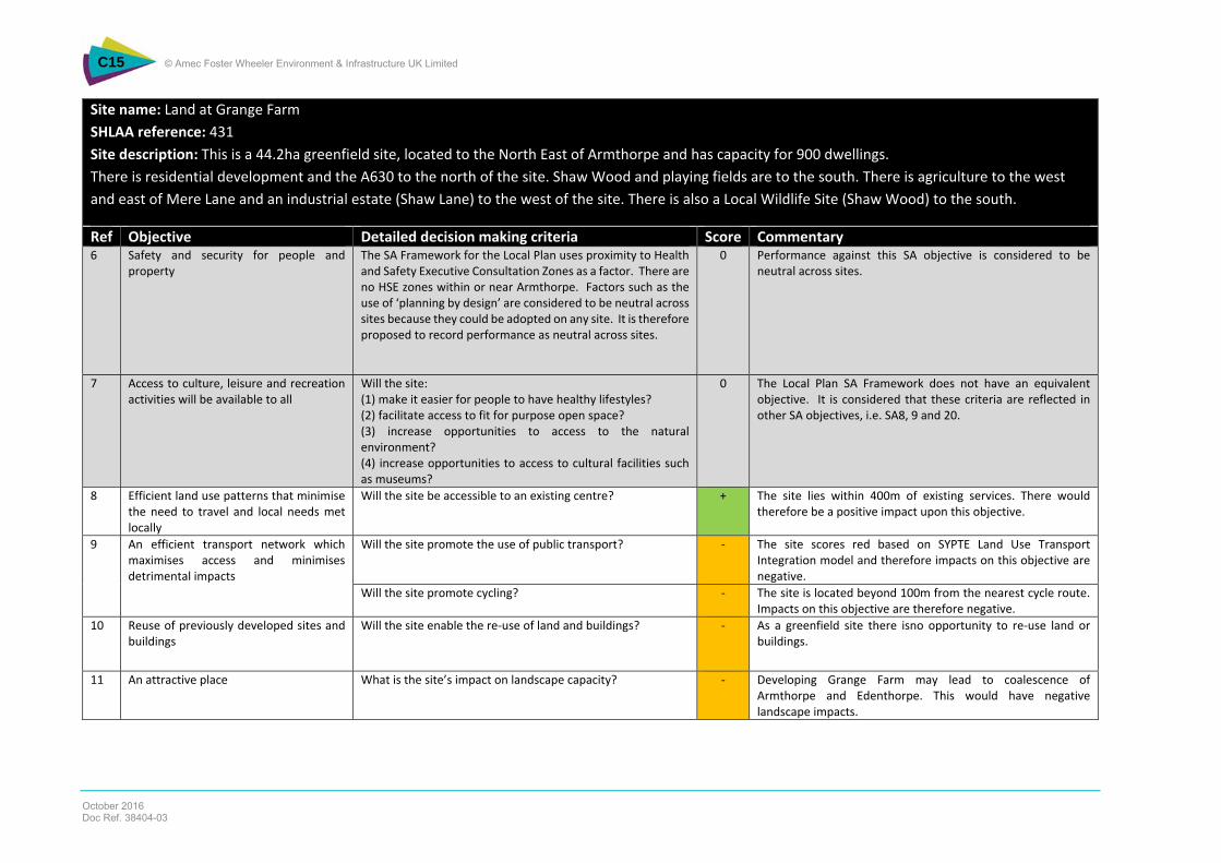
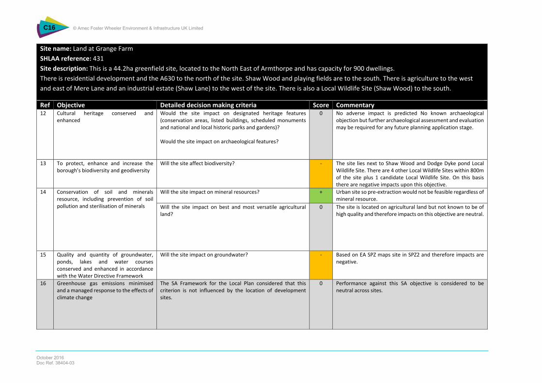
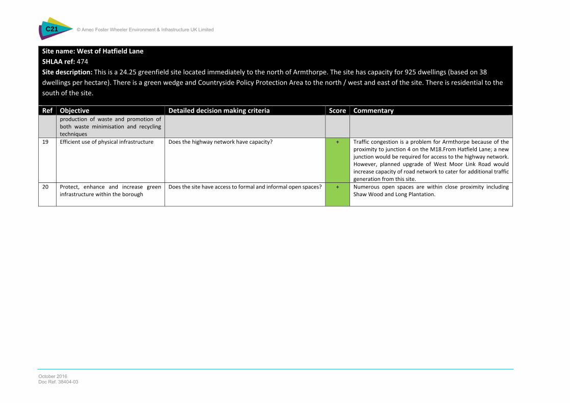
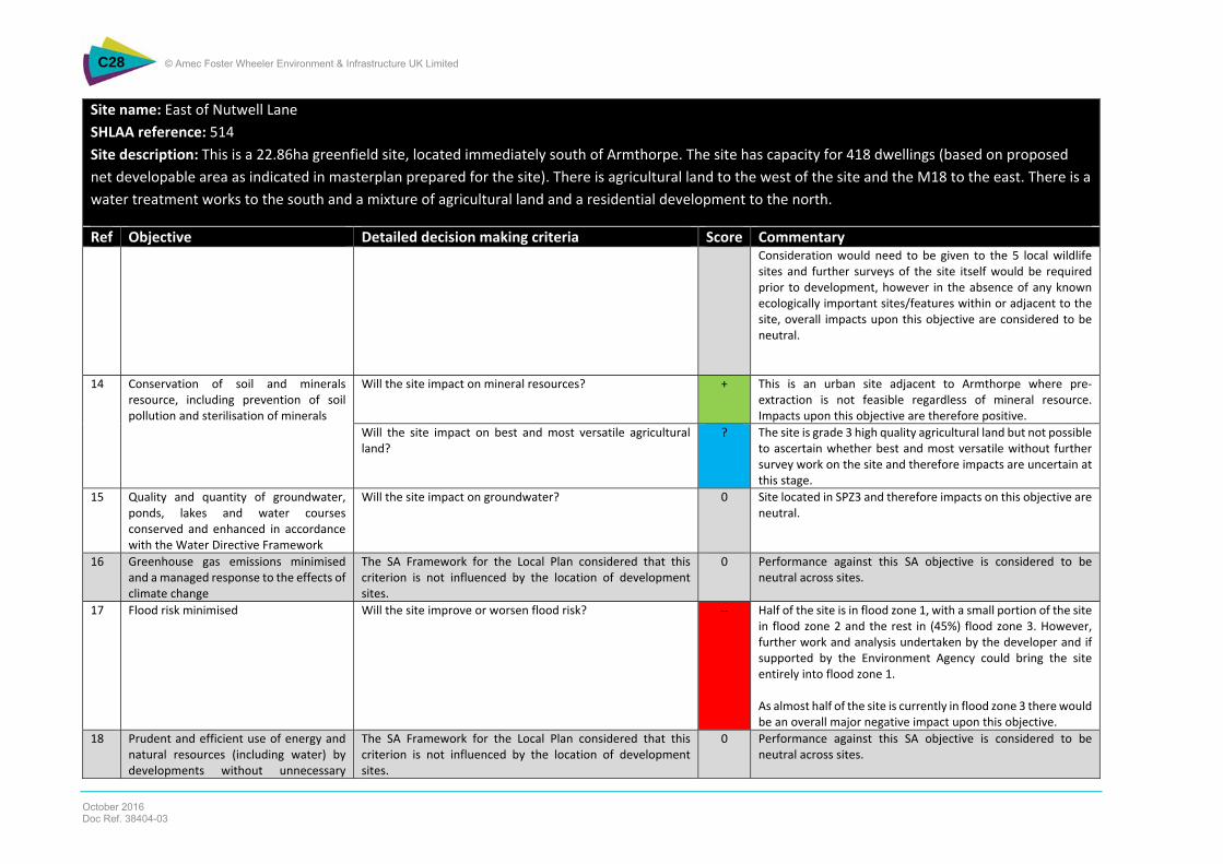
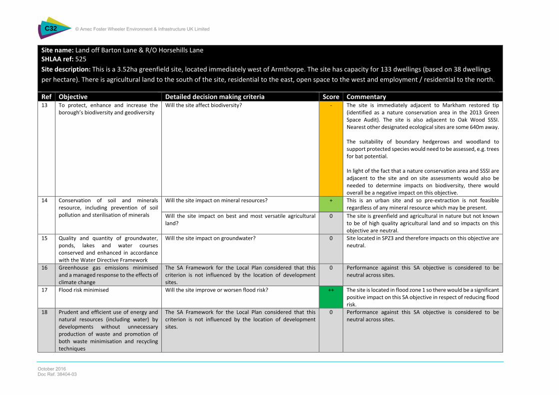
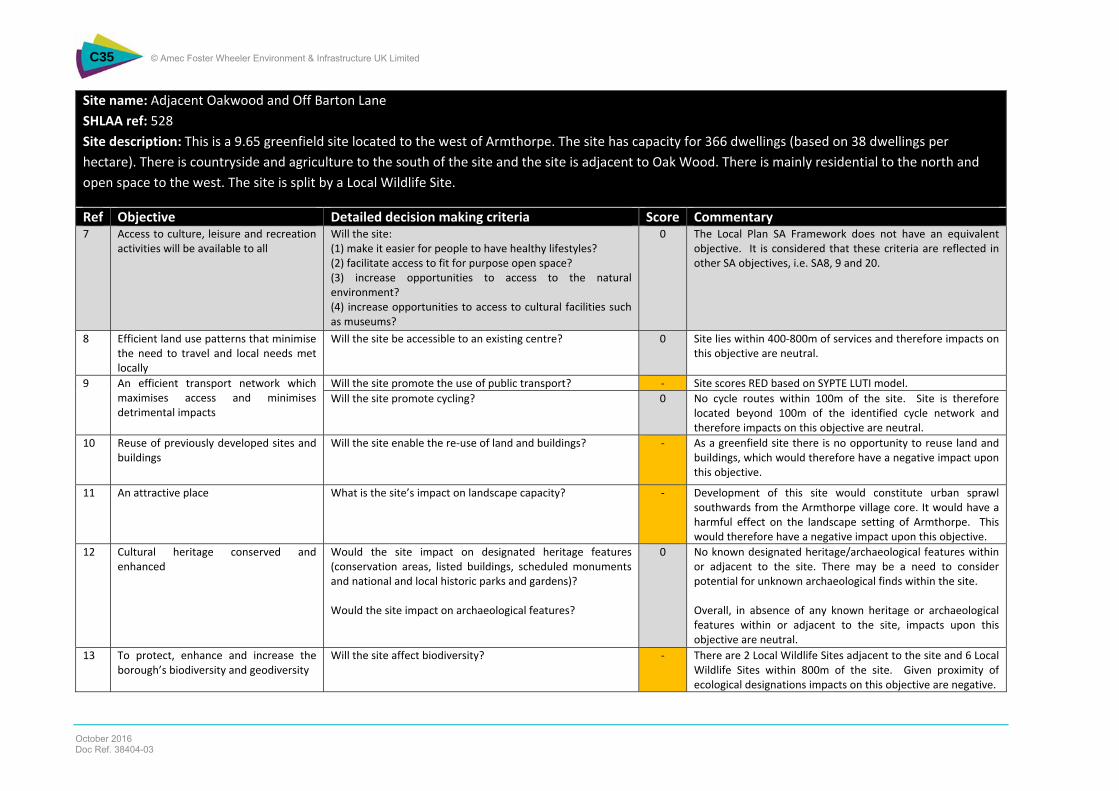
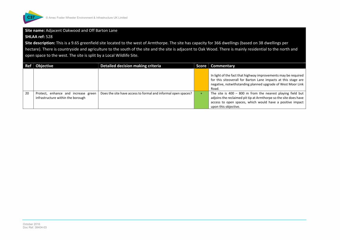
Table NTS 4 below presents the summary of the appraisal of housing sites. All of the sites presented a mixed performance against the SA objectives. There are positive impacts particularly in relation to affordable housing as all of the sites would be likely to trigger the affordable housing requirement and would have positive impacts on SA objective 19 as it is considered that the proposals to upgrade West Moor Link Road would cater for additional traffic generation from these housing, notwithstanding two of the sites (land off Barton Lane and land adjacent Oakwood) where negative impacts have been identified due to local highways issues with Barton Lane. There are mainly negative impacts in relation to re-use of previously developed land and buildings given that the majority of the sites are on greenfield land, along with adverse impacts on landscape (SA objective 11) and on SA objective 13 due to proximity of sites to sensitive ecological designations. Detailed appraisal matrices are provided at Appendix C.
18. Prudent and efficient use of energy and natural resources (including water) by developments without unnecessary production of waste and promotion of both waste minimisation and recycling techniques
0 0 0 0 0 0 0 0 0 0 0
19. Efficient Use of Physical Infrastructure + + + + + + + - - + +
20. Protect, enhance and increase green infrastructure within the borough. + + + 0 + - 0 + + + -
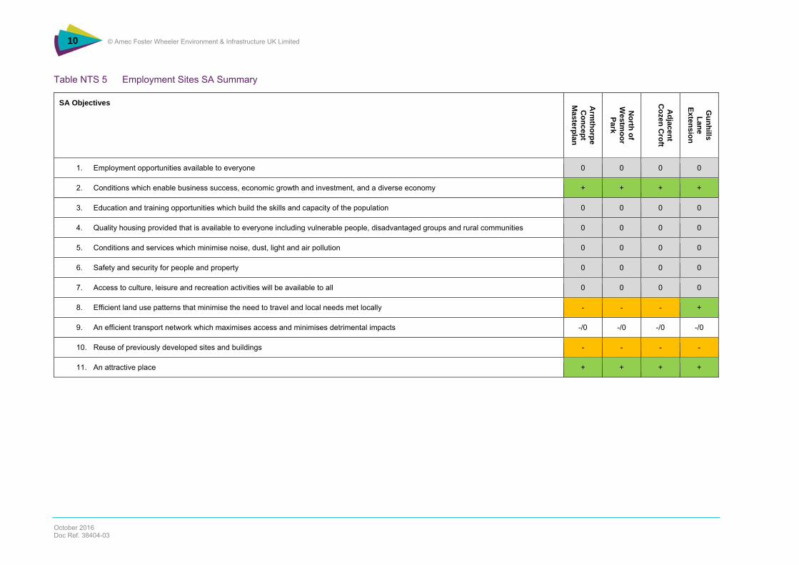
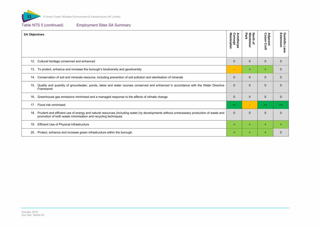
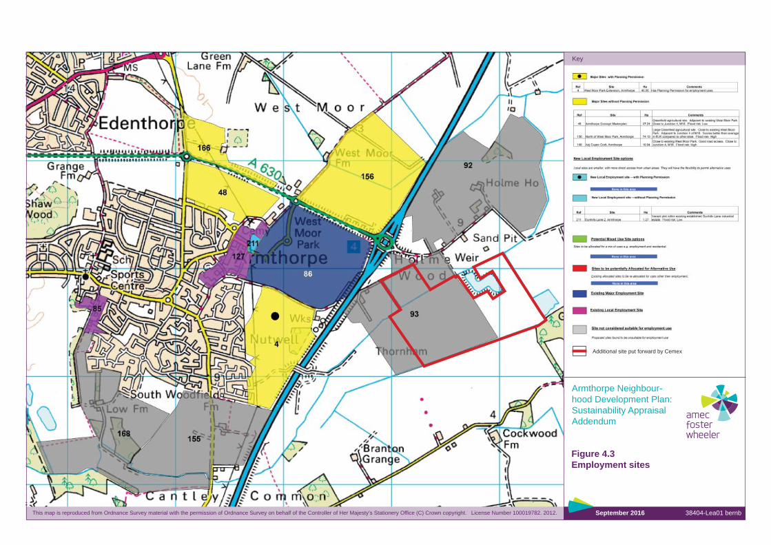
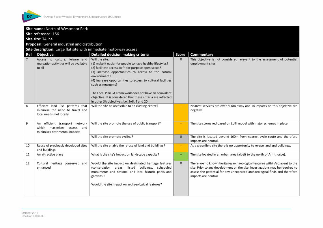
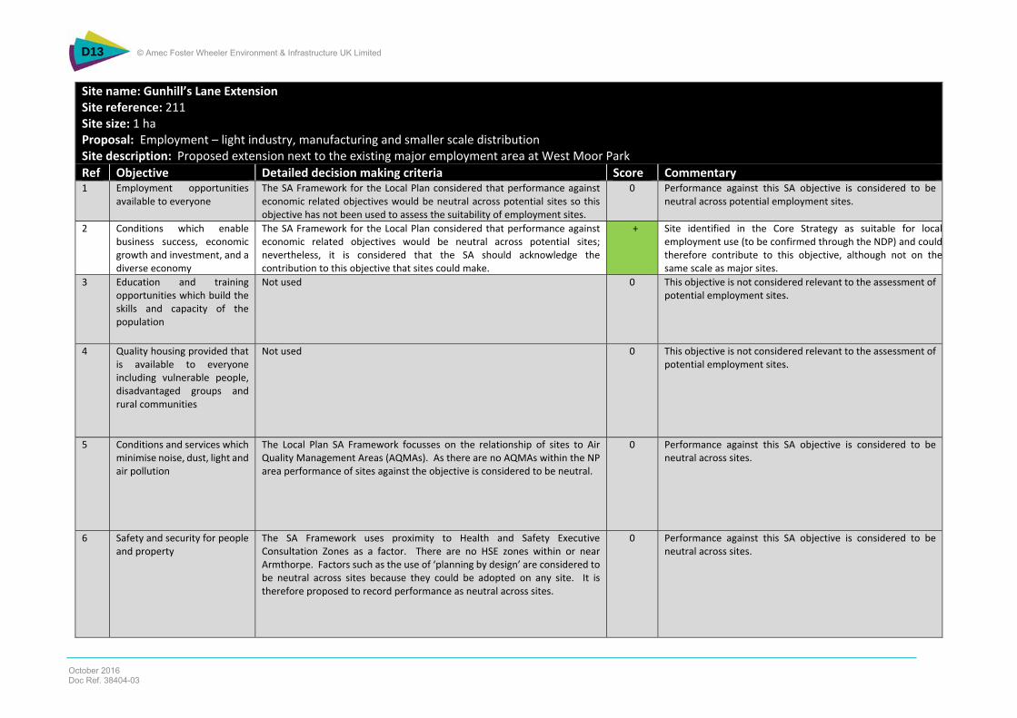
What are the Findings of the Appraisal of the Employment Sites?
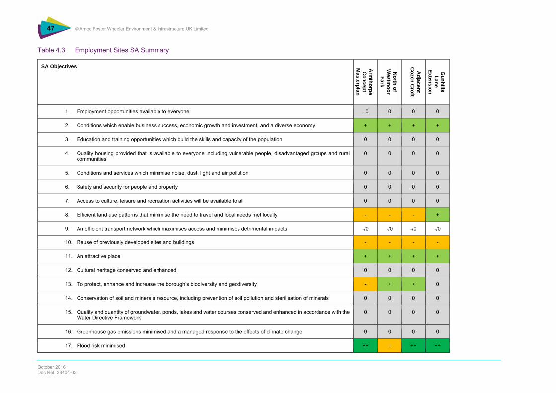
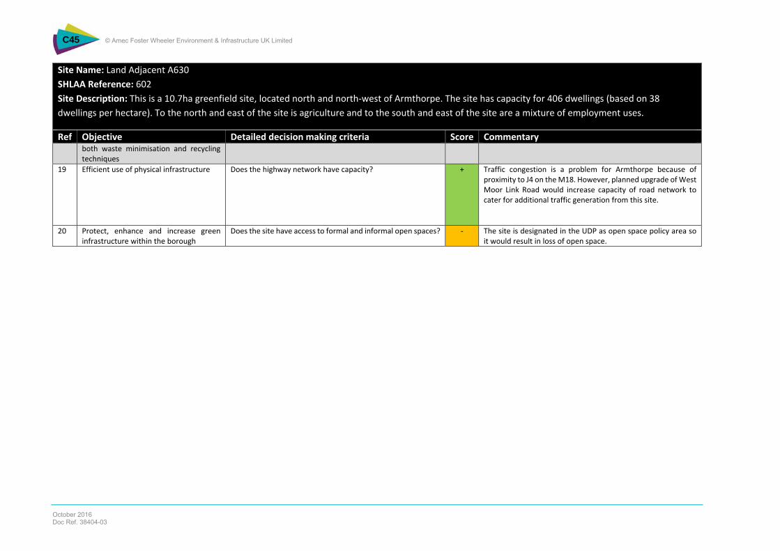
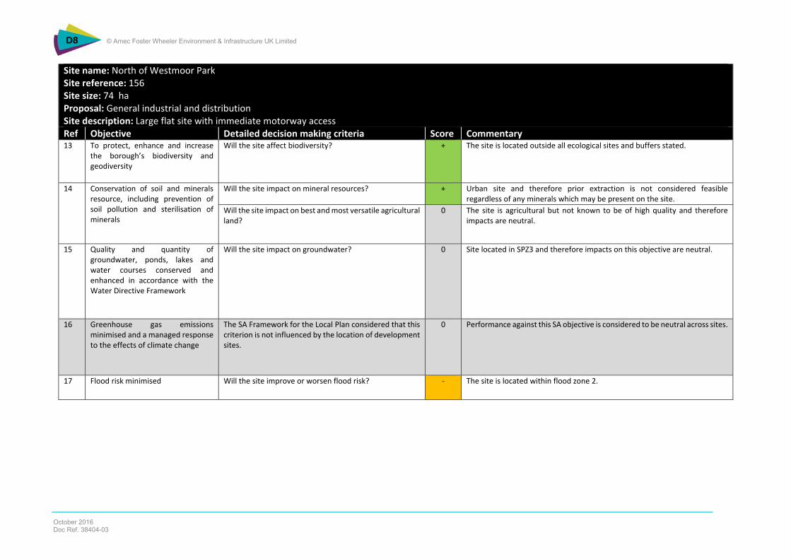
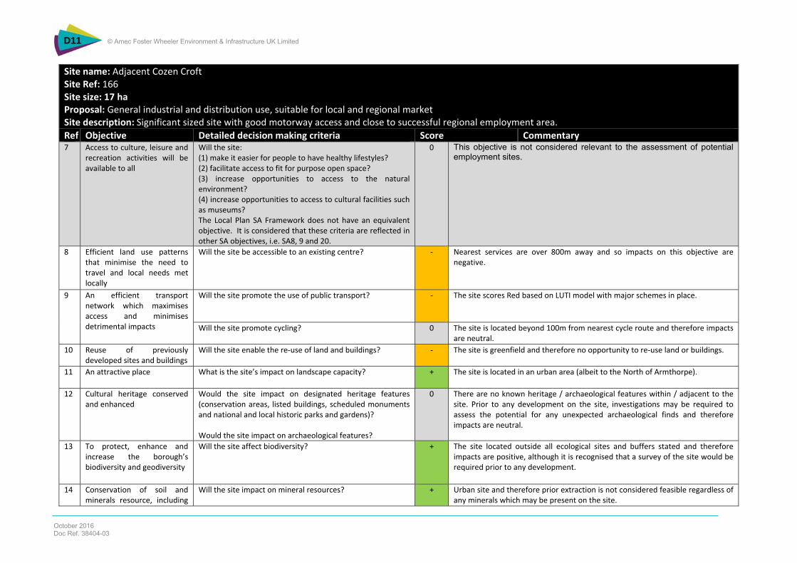
Table NTS 5 presents the results of the appraisal of employment sites. All the employment sites have a mix of positive, negative and uncertain impacts on the SA objectives. All of the four employment sites will have positive impacts on objective 2 as they could help to create conditions which enable business success, economic growth and investment, and a diverse economy. There are positive landscape impacts as these are all urban sites and 3 of the four sites would have significant positive impacts in relation to flood risk. As there are proposals to upgrade West Moor Link Road, it is considered that this would cater for additional traffic growth generated from the development of these employment sites and therefore there would be positive impacts on SA objective 19. Three of the four sites also have positive impacts on objective 20 given proximity to areas of open space. All of the sites are greenfield and so there is no opportunity to re-use previously developed land or buildings and therefore negative impacts on objective 10. There are also negative impacts from three of the sites on objective 8 based on South Yorkshire Passenger Transport Executive (SYPTE) Land Use and Transport Integration (LUTI) scores (a measure of how accessible a site is by public transport) for these sites. Impacts on the other objectives are neutral. Detailed matrices are provided in Appendix D.
Table NTS 5 (continued) Employment Sites SA Summary
SA Objectives
Arm
thorpe C
oncept M
asterplan
North of
Westm
oor Park
Adjacent
Cozen C
roft
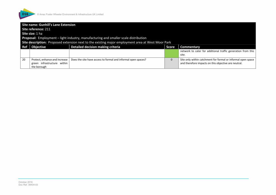
Gunhills Lane
Extension
12. Cultural heritage conserved and enhanced 0 0 0 0
13. To protect, enhance and increase the borough’s biodiversity and geodiversity - + + 0
14. Conservation of soil and minerals resource, including prevention of soil pollution and sterilisation of minerals 0 0 0 0
15. Quality and quantity of groundwater, ponds, lakes and water courses conserved and enhanced in accordance with the Water Directive Framework
0 0 0 0
16. Greenhouse gas emissions minimised and a managed response to the effects of climate change 0 0 0 0
17. Flood risk minimised ++ - ++ ++
18. Prudent and efficient use of energy and natural resources (including water) by developments without unnecessary production of waste and promotion of both waste minimisation and recycling techniques
0 0 0 0
19. Efficient Use of Physical Infrastructure + + + +
20. Protect, enhance and increase green infrastructure within the borough. + + + 0
What are the Findings of the Appraisal of the Revised Policies?
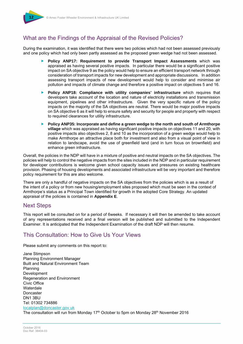
During the examination, it was identified that there were two policies which had not been assessed previously and one policy which had only been partly assessed as the proposed green wedge had not been assessed.
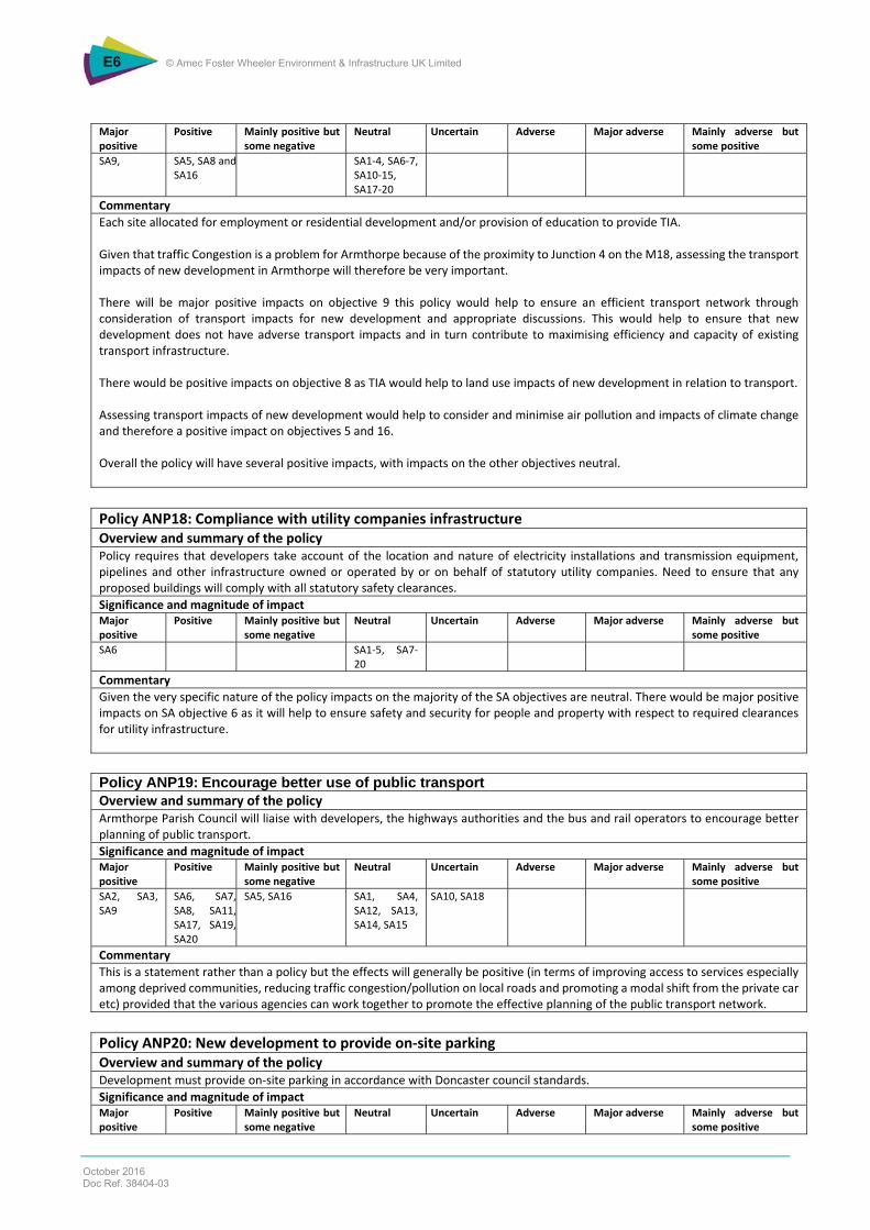
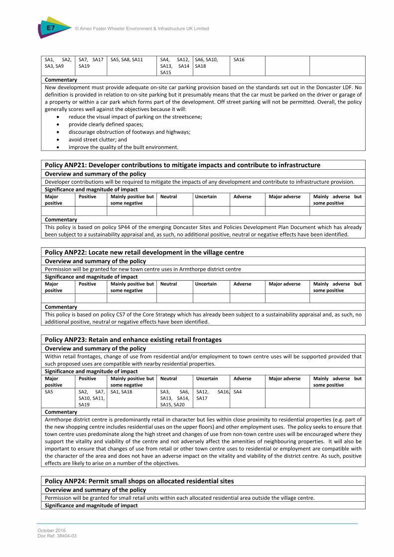
Policy ANP17: Requirement to provide Transport Impact Assessments which was appraised as having several positive impacts. In particular there would be a significant positive impact on SA objective 9 as the policy would help to ensure an efficient transport network through consideration of transport impacts for new development and appropriate discussions. In addition assessing transport impacts of new development would help to consider and minimise air pollution and impacts of climate change and therefore a positive impact on objectives 5 and 16.
Policy ANP18: Compliance with utility companies’ infrastructure which requires that developers take account of the location and nature of electricity installations and transmission equipment, pipelines and other infrastructure. Given the very specific nature of the policy impacts on the majority of the SA objectives are neutral. There would be major positive impacts on SA objective 6 as it will help to ensure safety and security for people and property with respect to required clearances for utility infrastructure.
Policy ANP35: Incorporate and define a green wedge to the north and south of Armthorpe village which was appraised as having significant positive impacts on objectives 11 and 20, with positive impacts also objectives 2, 8 and 10 as the incorporation of a green wedge would help to make Armthorpe an attractive place both for investment and also from a visual point of view in relation to landscape, avoid the use of greenfield land (and in turn focus on brownfield) and enhance green infrastructure.
Overall, the policies in the NDP will have in a mixture of positive and neutral impacts on the SA objectives. The policies will help to control the negative impacts from the sites included in the NDP and in particular requirement for developer contributions is welcome given school capacity issues and pressures on existing healthcare provision. Phasing of housing developments and associated infrastructure will be very important and therefore policy requirement for this are also welcome.
There are only a handful of negative impacts on the SA objectives from the policies which is as a result of the intent of a policy or from new housing/employment sites proposed which must be seen in the context of Armthorpe’s status as a Principal Town identified for growth in the adopted Core Strategy. An updated appraisal of the policies is contained in Appendix E.
Next Steps This report will be consulted on for a period of 6weeks. If necessary it will then be amended to take account of any representations received and a final version will be published and submitted to the Independent Examiner. It is anticipated that the Independent Examination of the draft NDP will then resume.
This Consultation: How to Give Us Your Views
Please submit any comments on this report to:
Jane Stimpson Planning Environment Manager Built and Natural Environment Team Planning Development Regeneration and Environment Civic Office Waterdale Doncaster DN1 3BU Tel: 01302 734886 [email protected] The consultation will run from Monday 17th October to 5pm on Monday 28th November 2016
1. Introduction 15 1.1 Background 15 1.2 Purpose of this Report 16 1.3 Armthorpe Neighbourhood Development Plan 16 1.4 Sustainability Appraisal 19 1.5 Structure of This Addendum 20
2. Approach to Sustainability Appraisal 21
2.1 Introduction 21 2.2 Sustainability Appraisal Framework 21 2.3 When the SA was Undertaken and by Whom 24 2.4 Technical Difficulties 24
3. Supplementary Baseline Information 25
3.1 Introduction 25 3.2 School and Childcare Capacity 25 3.3 Healthcare Provision 27 3.4 Other Issues 29
4. Appraisal Findings 33
4.1 Introduction 33 4.2 Consideration of Reasonable Alternatives 33 4.3 Site Appraisals 36 4.4 Justification for the Selection of Preferred Sites 49 4.5 Revision and Amendment of Policy Appraisals 53 4.6 Cumulative Effects 53
5. Conclusions and Next Steps 55
5.1 Conclusions 55 5.2 Next Steps 58
Table NTS 1 SA Objectives Used to Appraise the Policies and Sites 4 Table NTS 2 Scoring System Used in the SA of the Housing and Employment Sites 5 Table NTS 3 Assessment of Options for Different Levels of Housing 5 Table NTS 4 Housing Sites SA Summary 7 Table NTS 5 Employment Sites SA Summary 10 Table 2.1: SA Framework 21 Table 3.1 Primary School Capacity in Armthorpe 25 Table 3.2 Secondary School Capacity in Armthorpe 26 Table 4.1 Assessment of Options for Different Levels of HousingSA Objectives 34 Table 4.2 Housing Sites SA Summary 43 Table 4.3 Employment Sites SA Summary 47 Table 4.4 Numeric Scores for Housing Sites 50 Table 4.5 Reasons for Selection and Rejection of Housing Sites 51
Table 4.6 Justification for the Selection of the Preferred Employment Sites 52 Table 5.1 Potential Monitoring Indicators 55 Table 5.2 Requirements of the SEA Directive 57
Figure 4.1 Draft proposals map After page 54 Figure 4.2 Housing sites After page 54 Figure 4.3 Employment sites After page 54
Appendix A Appraisal Framework for Housing Sites Appendix B Appraisal Framework for Employment Sites Appendix C Housing Site Appraisals Appendix D Employment Site Appraisals Appendix E Policy Appraisals
Armthorpe Parish Council is developing a Neighbourhood Development Plan5 (NDP).
The Armthorpe NDP covers the whole of the parish of Armthorpe (as shown on the proposals map) and sets out a vision for how the area will evolve and develop to 2028. It outlines:
Where new development (e.g. housing and employment) should go;
What type of facilities (e.g. leisure and recreation) need to be provided; and
What improvements are needed to maximise its offer and attract new people into the area.
Once adopted, the Armthorpe NDP will form part of Doncaster’s development plan (which consists of several documents, including the Core Strategy6 which was adopted in 2012). The NDP will be used to help determine planning applications within the parish of Armthorpe.
The Armthorpe NDP has been developed through evidence gathering, assessments and consultation with the local community and stakeholders. Two rounds of consultation have taken place, as follows:
A pre-submission version of the NDP (dated January 2014) which was consulted on from February to March 2014; and
A revised draft NDP (dated August 2014) which was consulted upon from August 2014 to October 2014.
Following the second round of consultation, a final version of the NDP (dated December 2014) was completed and approved by the Parish Council on the 16th December 2014. The Parish Council then submitted this version and the accompany documentation to Doncaster MBC, as the Local Planning Authority for examination under Part 5 of the Neighbourhood Planning (General) Regulations 2012. This included a Sustainability Appraisal (SA) which incorporated the requirements of the Strategic Environmental Assessment (SEA) Directive7.
Jeremy Edge BSc FRICS MRTPI was appointed as the independent examiner to undertake the examination into the NDP.
Representations were invited on the NDP and associated documents.
In response to one representation, the examiner recommended8 that the independent examination should be ‘paused to allow SEA to be undertaken covering the plan as a whole and in relation to the proposed policy changes and the inclusion of reasonable alternatives within the SEA, having regard to the adopted Core Strategy’.
In order to address these issues, an addendum to the SA of the NDP9 has been completed.
5 Available to view at http://www.armthorpeparishcouncil.co.uk [Accessed 10/05/16] 6 Doncaster MBC (2012), Core Strategy 2011-2028, adopted May 2012 Doncaster Local Development Framework 7 European Directive 2001/42/EC on the assessment of the effects of certain plans and programmes on the environment, Official Journal L 197 , 21/07/2001 P. 0030 - 0037 8 Email from Jeremy Edge to Jane Stimpson, dated 11th April 2016. 9 Armthorpe Neighbourhood Development Plan (December 2014)
This document is an addendum to the Armthorpe NDP Sustainability Appraisal Report (August 2014). It provides the information requested by the examiner to ensure that the SA identifies, describes and assesses the effects of proposed policy changes, the development sites and the reasonable alternatives to the proposed NDP. It provides:
An update of baseline information to include local community service and infrastructure capacity where known (e.g. education and health facilities);
An explicit site SA methodology, aligned with Doncaster Metropolitan Borough Council’s emerging Local Plan Housing and Employment Site Selection Methodology (which is a working draft and based on the consultation version published in November 2015 but also includes additional criteria in relation to education and flood risk);
A full appraisal of the 21 housing and employment sites (and validation of the earlier SA of the sites);
A review of the SA of the policies. This includes addressing any gaps such as policies ANP17 and 18 as well as the amendments to policy ANP35; and
An assessment of the reasonable alternatives to the NDP.
The use of an addendum has been accepted following the case, Cogent Land LLP v Rochford District Council [2012] EWHC 2542 (Admin) (21 September 2012), in which the judge held that a July 2011 addendum addressed any defects in the earlier stages of the process.
This addendum should be read in conjunction with the Armthorpe NDP Sustainability Appraisal Report, which can be found at:
Requirement to Prepare a Neighbourhood Plan There is no formal requirement to prepare a Neighbourhood Plan. However, there is a requirement that any neighbourhood plans which are produced must be in conformity with the National Planning Policy Framework (NPPF) and the strategic policies of the Doncaster Local Development Framework (i.e. the adopted Core Strategy and any relevant work on the emerging Local Plan).
In addition, National Planning Guidance10 states that:
‘While there are prescribed documents that must be submitted with a neighbourhood plan or Order there is no ‘tick box’ list of evidence required for neighbourhood planning. Proportionate, robust evidence should support the choices made and the approach taken. The evidence should be drawn upon to explain succinctly the intention and rationale of the policies in the draft neighbourhood plan or the proposals in an Order.
A local planning authority should share relevant evidence, including that gathered to support its own plan-making, with a qualifying body.’
Designation of the Neighbourhood Area for the Armthorpe Neighbourhood Plan In April 2012, Armthorpe Parish Council applied to Doncaster MBC to designate the entire the parish of Armthorpe as a neighbourhood plan area. Doncaster MBC consulted on the proposals over a 6-week period and invited representations.
The designation of the neighbourhood area for Armthorpe was approved on 2 November 2012. Copies of the documents associated with the designation of the neighbourhood area can be found from Doncaster MBC’s website at https://planning.doncaster.gov.uk/online-applications/ (see reference 12/01235/NPLAN).
Designation meant that the parish council had approval to progress a neighbourhood plan for the parish of Armthorpe.
Following a comprehensive evidence gathering and consultation process, Armthorpe Parish Council approved the Armthorpe NDP (16th December 2014) and submitted it (including the accompanying documentation) to Doncaster MBC to undergo an independent examination.
Armthorpe Neighbourhood Plan - Scope The Armthorpe NDP provides a vision for the future of the parish and sets out clear planning policies to realise this vision.
These policies accord with higher level planning policies (as set out in the adopted Doncaster Core Strategy and National Planning Policy Framework) as required by the Localism Act.
The NDP has the following vision:
‘Armthorpe aims to be a place where all residents continue to be proud to live, where businesses can prosper and where visitors have a pleasing experience. It values a clean environment, access to the surrounding countryside, together with its role as a gateway to Doncaster town centre and nearby attractions.
It will manage growth and ensure that development is built with quality and has good access to local services. It will strive to be a village that keeps the heritage and traditions of the past, its mining legacy, the farming and rural pursuits and the vibrancy of the local community to the fore in securing a successful future for all its residents and businesses’.
It has the following aims:
‘Armthorpe is a gateway to Doncaster and provides access to the town centre and the attractions and facilities that are located in it, notably the Racecourse, Lakeside, the mainline railway station and major shopping centres. It also has a role as a provider of housing, leisure, local shopping and community facilities.
Policies and proposals that seek to enhance and have regard to this gateway role are to be encouraged. Developments on the outskirts of the village need to reflect on how best to address this and Armthorpe will continue to play a significant part in the regeneration and growth of Doncaster.
Armthorpe will promote itself and prosper as a beacon for sustainable growth and expect the development being proposed to be based on the highest quality sustainable principles.
Growth in the village and parish is being managed but must be in line with the leading sustainability measures and doctrines. Policies which look to cater for this are set out in the plan.
Armthorpe village is surrounded by attractive and open countryside and seeks to enhance the quality and role of the natural environment and its many features.
One of the many attractive features of the parish is the rural setting enjoyed by the residents and businesses of Armthorpe. This is particularly important when considered along with the proximity to local services and facilities and policies to connect the village to the surrounding natural environment are promoted within the plan.
Armthorpe will ensure wider access to a range of quality, local and affordable housing. Operating within a rapidly evolving housing market and development pressures puts affordable housing into sharp focus and the policies set out later in the plan reflect this situation. Specifically they seek to maintain a realistic degree of flexibility while setting down individual requirements which developers are expected to deliver in partnership with other agencies and organisations as appropriate.
Armthorpe will endeavour to make the village centre an attractive and safe environment. As the heart of the parish, the village seeks to become a more attractive and safer place and while planning policies are only one component in this, policies set out in the plan contain measures to work with all parties to deliver improvements.
Armthorpe will press for and expect proposals for improved traffic management throughout the parish to be delivered. Consultation on the preparation of the plan has continually highlighted the need to minimise, improve and ensure any new developments satisfactorily address traffic congestion in the parish. Continued close liaison with the highway authority needs to be a priority and the Parish Council expects to be a fully engaged in any future transport and highway related issues, activities and proposals.
Armthorpe will expect to secure the appropriate level of education provision. Providing the right level of education impacts as much on existing residents as it will on future ones living in the expected new housing schemes in the parish. As a clear priority, the planning impacts need to be assessed and accommodated in what is an increasingly difficult area to resolve in terms of resources and funding.’
To realise the vision and aims, the Armthorpe NDP has a total of 36 policies. These are structured around the following topics.
Housing;
Economy, Skills and Jobs;
Transport, Highways and Utilities;
Development Contributions;
Shopping, the Village Centre and the High Street;
Leisure and Community Facilities; and
Natural and Built Environment, Sustainability and Environmental Protection.
The NDP also allocates sites to accommodate future development and growth. These are shown on Figure 4.1 of this report.
Representations & Examination Following submission of the Armthorpe NDP to Doncaster MBC, representations were invited on the NDP and associated documents (which included the Sustainability Appraisal Report).
Doncaster MBC received a representation from LB and Co Limited on behalf of Yeoman Endeavours Limited, dated 1st May 2015. This highlighted a number of concerns with the SA of the NDP, namely:
The site selection methodology did not include a methodology to complete the SA of the housing and employment sites;
No alternatives to the 700-800 figure (as set out under policy ANP1) had been identified, characterised and assessed;
Policies ANP17 and 18 of the submission NDP had not been assessed;
The appraisal of policy ANP35 was incomplete. It did not include evidence that the effects of the proposed green wedges to the south of the village had been assessed; and
Because the SA did not specify the version of the NPD to which it applies it cannot be certain that it related to the submitted version.
Reflecting on this representation, the examiner of the Armthorpe NDP has recommended11 that the independent examination “be paused to allow the SEA can be undertaken thoroughly, covering the Plan as a
11 Email from Jeremy Edge to Jane Stimpson, dated 11th April 2016.
whole and in relation to the proposed policies and the inclusion of reasonable alternatives within the SEA, having regard to the adopted Core Strategy”.
In particular, the examiner states that:
“The Plan should be properly tested concerning reasonable alternatives. In relation to housing and employment, I would expect the reasonable alternatives to closely follow the range assessed for the settlement in the recently adopted Core Strategy.
I believe that it may be helpful, as part of the SEA process, if the housing densities that might reasonably be assumed for the sites included in the assessment have regard to the housing numbers expected to be delivered over the life of the Core Strategy within the Plan area covering the Parish of Armthorpe.
It would also be helpful if the physical and social infrastructure needs of the housing sites that were the subject of the sieve analysis, performed earlier by the Parish, could be assessed at high level at least to obtain a broad indication of any constraints that may have to be overcome in relation to delivery, cost and phasing of those sites. For example, expected school capacities over the next 5 years would be useful. The Examiner also highlights the potential for consideration of the likely highways impact of the development sites on the local network.
All of the housing sites which were considered by the Council’s sieve assessment should be considered as part of the SEA of the draft Plan.”
The examiner summarises in a further email, dated 13th April 2016, that: “The “pause period” during which the intention is that the SA/SEA process undertaken will be thoroughly reviewed and any deficiencies made good, should also include an assessment for SA/SEA purposes of all new policies introduced in the Plan, subsequent to the earlier SA/SEA being carried out. This assessment will plainly need to thoroughly consider, for example, the likely impact of development on the proposed green wedges and reasonable alternatives. This assessment may give rise to different conclusions than hitherto and therefore may give rise to the Qualifying Body seeking to modify the Submission Version of the draft Plan in some respects.”
1.4 Sustainability Appraisal
Whilst there is no legal requirement for the Armthorpe NDP to have a SA, the parish council must demonstrate how the plan will contribute to achieving sustainable development, as defined by the Planning and Compulsory Purchase Act 200412. An SA is a useful approach for doing this. Furthermore, government guidance13 states that “In some limited circumstances, where a neighbourhood plan could have significant environmental effects, it may fall within the scope of the Environmental Assessment of Plans and Programmes Regulations 2004 and so require a strategic environmental assessment”14.
An initial screening opinion provided by Doncaster MBC in January 2014 concluded that an SEA would not be required. A revised opinion was provided in May 2014, noting changed circumstances and the potential for significant effects, based upon the proximity of proposed site allocations to sensitive areas (e.g. nightjar habitat, ancient woodland, historic hedgerows and mature trees).
In consequence, a SA (which was intended to meet the requirements of the SEA Directive15) was completed in July 2014 on the Armthorpe NDP, dated January 2014.
12 http://www.legislation.gov.uk/ukpga/2004/5/contents 13 DCLG (2014) Planning Practice Guidance, Is strategic environmental assessment required in addition to sustainability appraisal? Paragraph: 007 Reference ID: 11-007-20140306 14 The role of the Strategic Environmental Assessment (SEA) is to predict and assess the environmental effects that are likely to arise from plans, policies and strategies. In the UK, the SEA process has been incorporated into the sustainability appraisal (SA) process. Where this report refers to the SA, it can be assumed this also means the SEA. 15 Available from http://eur-lex.europa.eu/legal-content/EN/TXT/HTML/?uri=CELEX:32001L0042&from=EN [Accessed May 2016].
Selected contextual sustainability baseline information for the following topics: historic environment; biodiversity and geodiversity; flood risk, landscape and geology; air and climate; green infrastructure; retail, leisure and community facilities; transport and accessibility; and socio-economic characteristics;
Identification of relevant sustainability issues, based on an analysis of other plans and programmes relevant to the Neighbourhood Development Plan;
Detail of the SA framework used to undertake the SA of the Neighbourhood Development Plan;
Conclusions from the appraisal of the policies with recommendations to improve the performance of the policies;
An appendix containing appraisal of 11 housing sites, 9 employment sites and 1 local employment site; and
An appendix containing appraisal of 35 policies.
A Non-Technical Summary accompanied the report which included reference to the SEA Directive and the extent to which the SA (in conjunction with the 2014 Scoping Report) met the requirements of the SEA Directive.
1.5 Structure of This Addendum
This addendum to the Armthorpe NDP SA Report is structured to address the examiners’ issues and contains the following.
Section 1: Introduction. This includes a summary of the issues considered in this addendum.
Section 2: Approach to the Sustainability Appraisal. This outlines the approach to the SA of the issues picked up by the inspector during the examination and the SA framework (which includes a series of objectives against which the effects of the NDP have been assessed).
Section 3: Baseline. This provides supplementary baseline information, including information on infrastructure and school capacity.
Section 4: Appraisal of Effects. This summarises the findings of the appraisal of the proposed policy changes, sites, consideration of reasonable alternatives and the other issues identified by the examiner during the examination; and
Section 5: Conclusions and Next Steps. This presents the conclusions of this SA Addendum and the next steps in the SA process.
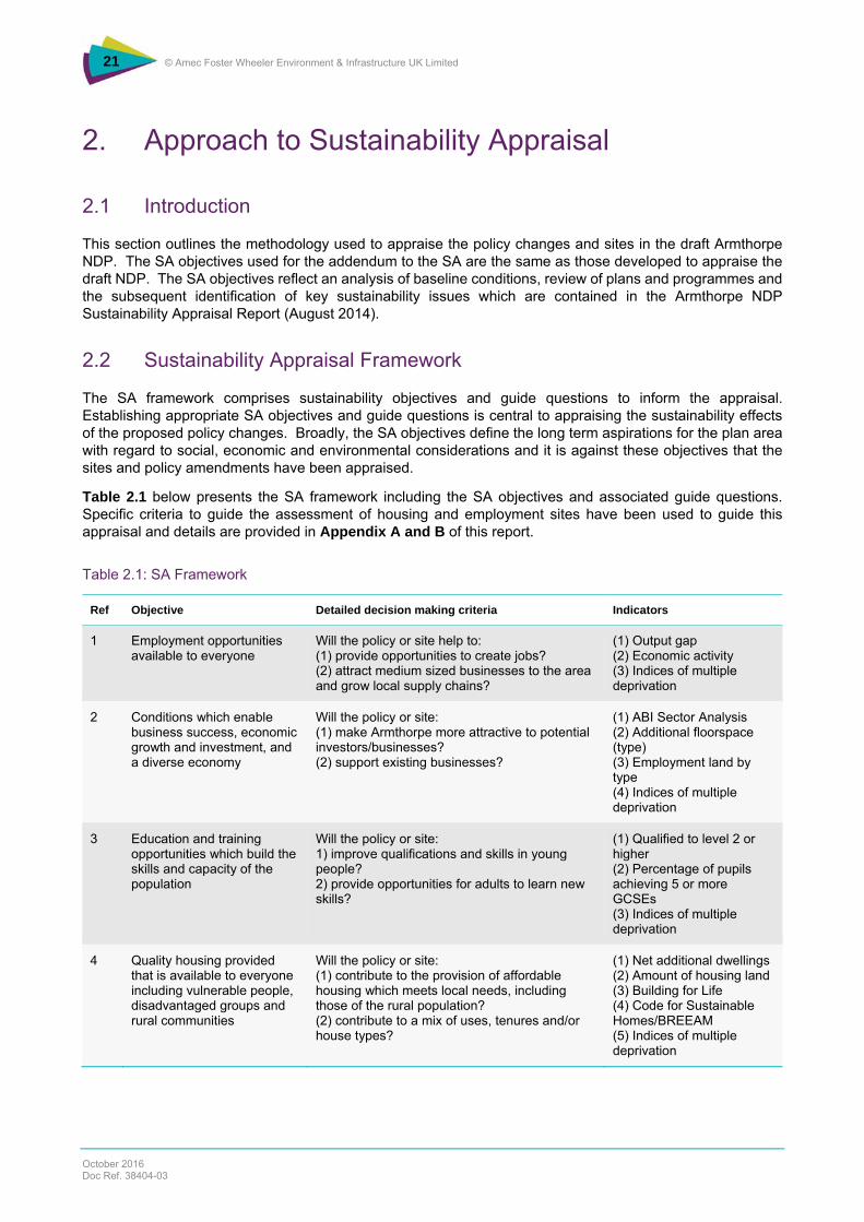
This section outlines the methodology used to appraise the policy changes and sites in the draft Armthorpe NDP. The SA objectives used for the addendum to the SA are the same as those developed to appraise the draft NDP. The SA objectives reflect an analysis of baseline conditions, review of plans and programmes and the subsequent identification of key sustainability issues which are contained in the Armthorpe NDP Sustainability Appraisal Report (August 2014).
2.2 Sustainability Appraisal Framework
The SA framework comprises sustainability objectives and guide questions to inform the appraisal. Establishing appropriate SA objectives and guide questions is central to appraising the sustainability effects of the proposed policy changes. Broadly, the SA objectives define the long term aspirations for the plan area with regard to social, economic and environmental considerations and it is against these objectives that the sites and policy amendments have been appraised.
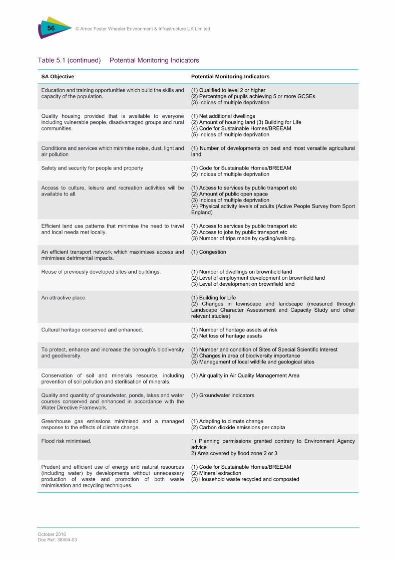
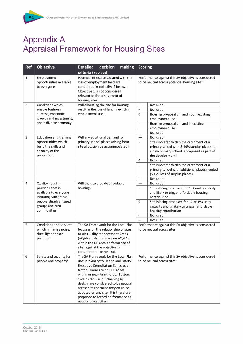
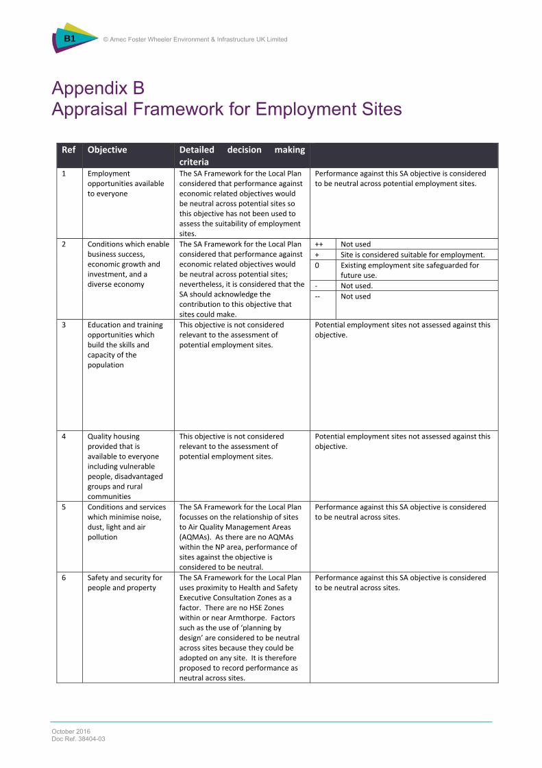
Table 2.1 below presents the SA framework including the SA objectives and associated guide questions. Specific criteria to guide the assessment of housing and employment sites have been used to guide this appraisal and details are provided in Appendix A and B of this report.
Table 2.1: SA Framework
Ref Objective Detailed decision making criteria Indicators
1 Employment opportunities available to everyone
Will the policy or site help to: (1) provide opportunities to create jobs? (2) attract medium sized businesses to the area and grow local supply chains?
(1) Output gap (2) Economic activity (3) Indices of multiple deprivation
2 Conditions which enable business success, economic growth and investment, and a diverse economy
Will the policy or site: (1) make Armthorpe more attractive to potential investors/businesses? (2) support existing businesses?
(1) ABI Sector Analysis (2) Additional floorspace (type) (3) Employment land by type (4) Indices of multiple deprivation
3 Education and training opportunities which build the skills and capacity of the population
Will the policy or site: 1) improve qualifications and skills in young people? 2) provide opportunities for adults to learn new skills?
(1) Qualified to level 2 or higher (2) Percentage of pupils achieving 5 or more GCSEs (3) Indices of multiple deprivation
4 Quality housing provided that is available to everyone including vulnerable people, disadvantaged groups and rural communities
Will the policy or site: (1) contribute to the provision of affordable housing which meets local needs, including those of the rural population? (2) contribute to a mix of uses, tenures and/or house types?
(1) Net additional dwellings (2) Amount of housing land (3) Building for Life (4) Code for Sustainable Homes/BREEAM (5) Indices of multiple deprivation
Ref Objective Detailed decision making criteria Indicators
5 Conditions and services which minimise noise, dust, light and air pollution
Will the policy or site: (1) reduce direct pollution? (2) reduce indirect pollution (e.g. increased traffic)?
(1) Number of developments on best and most versatile agricultural land
6 Safety and security for people and property
Will the policy or site: (1) promote buildings and developments which are ‘secure by design’? (2) address anti-social behaviour?
(1) Code for Sustainable Homes/BREEAM (2) Indices of multiple deprivation
7 Access to culture, leisure and recreation activities will be available to all
Will the policy or site: (1) make it easier for people to have healthy lifestyles? (2) facilitate access to fit for purpose open space? (3) increase opportunities to access to the natural environment? (4) increase opportunities to access to cultural facilities such as museums?
(1) Access to services by public transport etc (2) Amount of public open space (3) Indices of multiple deprivation (4) Physical activity levels of adults (Active People Survey from Sport England)
8 Efficient land use patterns that minimise the need to travel and local needs met locally
Will the policy or site: (1) result in new developments being located in accordance with the settlement hierarchy? (2) facilitate access to services such as health, education, retail etc (including in rural areas)?
(1) Access to services by public transport etc (2) Access to jobs by public transport etc (3) Number of trips made by cycling/walking.
9 An efficient transport network which maximises access and minimises detrimental impacts
Will the policy or site: (1) result in new developments being located in areas served by public transport? (2) facilitate walking and cycling? (3) maximise the efficiency and capacity of existing transport infrastructure? (4) facilitate the transport of freight by canal or rail?
(1) Congestion
10 Reuse of previously developed sites and buildings
Will the policy or site: (1) provide opportunities for existing buildings to be reused? (2) provide the opportunities to redevelop existing brownfield or contaminated land? (3) avoid the use of greenfield sites?
(1) Number of dwellings on brownfield land (2) Level of employment development on brownfield land (3) Level of development on brownfield land
11 An attractive place
Will the policy or site positively contribute to: (1) a high quality built environment? (2) the overall townscape? (3) landscape character?
(1) Building for Life (2) Changes in townscape and landscape (measured through Landscape Character Assessment and Capacity Study and other relevant studies)
12 Cultural heritage conserved and enhanced
Will the policy or site conserve or enhance those elements which contribute to the significance of designated or non-designated heritage assets and their settings?
(1) Number of heritage assets at risk (2) Net loss of heritage assets
Ref Objective Detailed decision making criteria Indicators
13 To protect, enhance and increase the borough’s biodiversity and geodiversity
Will the policy or site facilitate: the protection and enhancement of designated sites? the protection and enhancement of other non-designated features of interest? the creation of new features of biodiversity value?
(1) Number and condition of Sites of Special Scientific Interest (2) Changes in area of biodiversity importance (3) Management of local wildlife and geological sites
14 Conservation of soil and minerals resource, including prevention of soil pollution and sterilisation of minerals
Will the policy or site: result in the protection/retention of the best and most versatile agricultural land (grades 1-3a)? avoid the sterilisation of mineral resources? facilitate the use of recycled rather than primary aggregates?
(1) Air quality in Air Quality Management Area
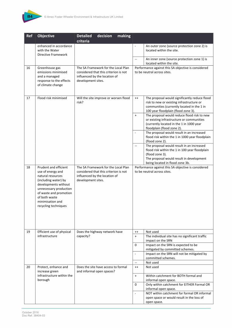
15 Quality and quantity of groundwater, ponds, lakes and water courses conserved and enhanced in accordance with the Water Directive Framework
Will the policy or site: (1) increase the quality and quantity of the water environment? (2) reduce direct or indirect pollution of the water environment?
(1) Groundwater indicators
16 Greenhouse gas emissions minimised and a managed response to the effects of climate change
Will the policy or site: (1) result in the reduction of greenhouse gas emissions? (2) result in development that is able to withstand the effects of climate change?
(1) Adapting to climate change (2) Carbon dioxide emissions per capita
17 Flood risk minimised Will the policy or site: (1) help to address the flood risk of existing properties? (2) help to avoid development within flood zones 2 and 3? (3) ensure that where development in flood zones 2 and 3 is necessary that the flood risk will be addressed?
1) Planning permissions granted contrary to Environment Agency advice 2) Area covered by flood zone 2 or 3
18 Prudent and efficient use of energy and natural resources (including water) by developments without unnecessary production of waste and promotion of both waste minimisation and recycling techniques
Will the policy or site reduce the amount of natural resources required in the construction, use and decommissioning of development?
(1) Code for Sustainable Homes/BREEAM (2) Mineral extraction (3) Household waste recycled and composted
19 Efficient use of physical infrastructure
Will the policy or site: (1) support proposals within the capacity of existing infrastructure or; (2) where there is no existing capacity will the policy facilitate the development of new sustainable infrastructure for the benefit of the parish and the borough as a whole?
(1) Percentage of applications approved as departures from the LDF
Ref Objective Detailed decision making criteria Indicators
20 Protect, enhance and increase green infrastructure within the borough
Will the policy or site: (1) protect the borough’s green infrastructure? (2) enhance the borough’s green infrastructure? (3) facilitate the creation of new green infrastructure which will improve links and corridors between open space?
(1) Management of local wildlife and geological sites (2) Changes in townscape and landscape (measured through Landscape Character Assessment and Capacity Study other relevant studies) (3) Amount of public open space
The Armthorpe NDP SA Report contains an appraisal of the 21 sites with reference to major and minor positive or adverse effects on SA objectives. However, in order to make explicit how the assessment against SA objectives relates to the completed site appraisals, a methodology has been developed that relates the site appraisal methodology criteria to the SA objectives. This is contained in Appendix A and B.
2.3 When the SA was Undertaken and by Whom
This SA of the supplementary information for the Armthorpe NDP was undertaken by Amec Foster Wheeler in Spring 2016, informed by the input of council officers and NDP team members.
2.4 Technical Difficulties
The SEA Directive requires the identification of any difficulties (such as technical deficiencies or lack of knowledge) encountered during the appraisal process. Any uncertainties encountered and assumptions made as part of this SA addendum are detailed below.
Uncertainties:
No uncertainties have been identified which could affect this SA addendum.
Assumptions:
It is assumed that for the housing sites with larger capacities that this would trigger the affordable housing requirement (subject to viability considerations) set out in the adopted Core Strategy policy CS12;
It is assumed that a dwelling density of 38 dwellings per hectare could be achieved on proposed housing sites;
It is assumed that current energy mix will continue (and associated carbon emissions will be largely similar to current levels), although it is noted that against carbon trajectories provided by the Department of Business, Energy and Industrial Strategy (formerly Department of Energy & Climate Change), this may lead to an overestimate of carbon emissions;
It is assumed that there will be no new technological leaps that will substantially alter current patterns of movement and activities, or significantly reduce environmental effects; and
It assumed that the proposed upgrade of West Moor Link Road will cater for additional traffic generation from the allocated housing and employment sites.
The examiner has identified that additional baseline information was needed in respect of school capacity and infrastructure in Armthorpe. This section provides additional baseline information on these issues to supplement that previously presented in chapter 3 of the 2014 SA report.
A settlement audit was undertaken by Doncaster MBC in February 2011 and a more recent audit was undertaken in December 2015. These provide a range of further information about Armthorpe. This information has been reviewed, and where appropriate has been presented here to aid the context for subsequent appraisal.
This supplementary baseline information covers the following areas: schools capacity, childcare provision, health, retail provision, highways, open space provision, community facilities and utilities.
3.2 School and Childcare Capacity
Primary and Secondary School Capacity Doncaster has a poor skills profile and there is a pressing need to improve the quality of education provision in the borough. Ofsted’s recent inspection of primary and secondary schools reported that more than half of pupils in the borough attend a school that is inadequate or requires improvement16. In some parts of the borough, schools have limited capacity to accommodate needs arising from the intake of new pupils as a result of new housing developments.
New development provides the opportunity to ensure that identified and anticipated shortfalls in capacity can be addressed, with development funding the required expansion.
Government statistics show that there are 15 schools in Doncaster which have one or more pupils in excess of primary school capacity and that there are 302 pupils in excess of school capacity, which is 1.1% of total primary school places.17 However, statistics also show that there are 84 schools in Doncaster with one or more unfilled places, with the number of unfulfilled places totalling 3,486 which amounts to 12.6% of the total places.
There are four primary schools in Armthorpe: Tranmoor, Southfield, Shaw Wood and Our Lady of Sorrows. Table 3.1 below shows the capacity of these primary schools in Armthorpe. Three of the four primary schools are very close to exceeding capacity, with only Tranmoor having any real spare capacity. It is likely therefore that without any increase in capacity at these schools or the provision of any new schools, that capacity would be exceeded following the completion of new housing developments in Armthorpe.
Table 3.1 Primary School Capacity in Armthorpe
Primary School Name Number of Places Number Pupils
Doncaster MBC uses a nationally recognised formula of 3 school places created for each year group per 100 new residential created. This aggregates to a multiplier of 0.21 (7 year groups) for the primary age range and 0.15 (5 year groups) for the secondary age range. Each year group is ideally organised into classes of 30 so that a one form primary school would have 210 places and a two form primary 420. The Council also seeks to have between 5% and 10% spare capacity, primarily to accommodate 'in year' admissions. This spare capacity also provides for a little more parental choice as well as the variability from the formula that occurs in reality across year groups.
In Armthorpe there is already pressure on the places in the existing primary schools, such that additional places have been created and more are planned. This is without the addition of the planned housing estates.
Table 3.2 shows that there is some secondary school capacity at Armthorpe Academy, with 339 vacant places (as at 2014) in which case some demand for secondary school places arising from new housing developments in Armthorpe could be accommodated at this school.
Table 3.2 Secondary School Capacity in Armthorpe
Secondary School Name Number of Places Number of Pupils
Armthorpe Academy 1042 703
Source: https://www.gov.uk/government/publications/school-capacity-academic-year-2013-to-2014 In addition, Danum and Hungerhill academies are in relatively close proximity to Armthorpe and may be able to take some secondary school pupils subject to catchment areas and capacity at these schools.
Doncaster Council’s Access to Learning Manager has indicated that 800 houses would generate the need for 168 new primary school places and advised that a new primary school would be needed, ideally a one form entry expandable to 2 form entry (2 hectares of land).
Under policy ANP28 of the Armthorpe NDP, land for either a one form entry school (1.09 ha of land) and/or a two form entry school (2 hectares of land) is to be set aside and provided on the housing allocation sites set out in policy ANP1 of the NDP.
Childcare Capacity The latest childcare sufficiency assessment18 from 2014 showed that there was a total of 217 vacant childcare places across the age ranges from 0-14 years within Armthorpe, with more vacancies in the older rather than younger age ranges. The vacancy rate is therefore approximately 25% of the total childcare places available in Armthorpe. There is more limited capacity in childcare places outside of school term times and no places available after 6pm or on weekends, with greatest capacity for childcare between 6pm and 8am. Given that there is a vacancy rate of 25% (as at 2014), this suggests there is room for additional childcare places in Armthorpe within existing provision.
However, the sufficiency assessment shows that for Armthorpe there is a shortfall of early education places for 3 and 4 year olds. Total maximum places are currently 15 below actual numbers of children. Armthorpe was identified as one of the locations where there is a childcare gap for playgroup.
The assessment identified that for the different age ranges of childcare Armthorpe is identified in the category of ‘maintain’. This means that the following actions are required.
Schools and childcare providers consider undertaking local consultation to identify if their services continue to meet the current demands of the area; and
Current childcare providers for the identified age-groups, are prioritised to receive targeted support to ensure a sufficient supply of places are maintained with regard to:
The sustainability of the childcare business; and
The childcare provider achieving a “Good‟ or “Outstanding‟ Ofsted grade.
The above conclusion suggests that careful monitoring will be required of childcare provision against demand to ensure that future needs are met in Armthorpe.
In terms of affordability of childcare, the assessment identified that Armthorpe is in an area where the indices of multiple deprivation percentage is higher and that therefore no action is required in respect of costs of childcare in Armthorpe.
Overall, Armthorpe is ranked as green, which is for an area where overall supply is considered sufficient to meet demand, though as noted above future monitoring of supply against demand would be required.
3.3 Healthcare Provision
Health, Well-being and Life Expectancy The population of Doncaster is predicted to grow overall by 0.4% between 2015 and 202, with biggest growth (3.1%) in the 85 plus age range. There is also growth predicted for the 65-75 and 75-84 age ranges. There will be an overall decrease in the younger population (15-44)19. These population projections suggest that there will be an overall increase in the ageing population of Doncaster, which is consistent with wider trends in respect of Britain’s ageing population. This ageing population is likely to put additional pressures on healthcare provision in Doncaster.
Doncaster is identified as an area where life expectancy for men is lower than many other areas of England, with life expectancy for women lower though not as bad as men. The health related quality of life for people with long term conditions is also lower in Doncaster than other areas of England. There are also a range of other statistics including life expectancy at birth, adult social care related quality of life and overall satisfaction levels of people who use residential and nursing care homes which places Doncaster worse than national averages.
Whilst Doncaster’s health has improved greatly over recent decades in line with the rest of the UK to overall rising living standards and changing lifestyles, there still a persistent gap between the most disadvantaged people and most affluent people in terms of life expectancy and mortality rates20. Life expectancy is lower than the national average and mortality rates are rising faster than the national or regional average. This is largely due to deaths amongst men. Doncaster has significantly higher death rates from circulatory diseases (including coronary heart disease) and cancer/chronic lung disease than other parts of the UK.
Adult obesity rates in Doncaster are high compared to national figures with 44% of adults classed as overweight and 30.4% as obese (33). Around a quarter of Doncaster’s adult population (58,000) are considered to be obese or overweight although self-reported obesity is lower than average (18%). Levels of sport and physical activity, whilst increasing, are low compared to the national and regional average.
For Armthorpe the latest Index of Multiple Deprivation (IMD) shows that this area was ranked 15,880 out of 32,844 in England, where 1 was the most deprived and 32,844 the least deprived. This is broken down further by various categories including health where the score for Armthorpe is 29%, i.e. Armthorpe is better than 29%21 of areas in England. In addition the ward profile22 for Armthorpe shows that life expectancy in Armthorpe is slightly lower than the equivalent figures for Doncaster. However rates of cancer are in general lower in Armthorpe than for Doncaster as a whole. The percentage of children in poverty is lower than for Doncaster as a whole.
Doncaster has a higher percentage of residents who are classed as inactive (32.9%) in comparison to national (28.9%) and regional averages (29%). A conservative estimate of the health costs of physical inactivity for Doncaster is approximately £5 million.
19 Figures from CCG data for Doncaster, available at https://www.england.nhs.uk/la-ccg-data/ [Accessed 23/05/16] 20 Doncaster Local Plan Sustainability Appraisal Scoping Report (March 2016) 21 Figures from http://www.uklocalarea.com/index.php?lsoa=E01007486&q=Armthorpe&wc=00CEFB [Accessed 20/05/16] 22 Available at http://www.teamdoncaster.org.uk/Images/Armthorpe_tcm33-111213.pdf [Accessed 20/05/16]
There are two general practitioner (GP) practices / medical centres in Armthorpe – the Village Practice23 and the Whitehouse Farm24. The Whitehouse Farm practice currently 25 serves a population of approximately 6,424 patients with three General Practioner’s (GP’s), so there is a GP to patient ratio of some 1:2,141, which is higher compared to the average for Doncaster which is a ratio of 1:165026. The Village Practice has three GP’s and serves a population of approximately 5,44927 patients, with a GP to patient ratio of some 1: 1816 which is slightly higher than the average for Doncaster. With the GP to patient ratio higher in Armthorpe than the average for Doncaster and demand likely to increase with new housing developments, there is likely to be additional pressure on the two existing practices in Armthorpe.
In addition, the settlement study for Armthorpe28 notes that medical provision would benefit from improved capacity.
Based upon the range of housing options identified for Armthorpe (700/800 dwellings and 900 dwellings) and information from the 2011 census29 which shows that on the average household size of 2.3 persons there could be an additional 1,725 to 2,07030 residents in Armthorpe over the period to 2028. The worst case scenario is that this is either a 26% or 32% increase (assuming all are new residents) in the total population currently served by the Whitehouse Practice. This would increase the GP to patient ratio at this practice which would be an issue, given that the ratio is already higher than the average for Doncaster and would require further health care professionals resourcing to address the anticipated increase in demand.
There is a Life Line Screening clinic in Armthorpe (a privately run health clinic) in addition to the two GP practices identified above.
A pharmaceutical needs assessment31 was undertaken by Doncaster’s health and wellbeing board. This assessment found that existing pharmacy provision in Doncaster comprised of the following:
79 community pharmacies;
65 providers on 40 hour contracts;
12 providers on 100 hour contracts;
2 distance selling providers;
1 appliance contractor; and
2 dispensing General Practices.
This needs assessment confirmed that on the whole the pharmacy provision in Doncaster is of a good standard but highlighted that there are some gaps and areas for future development.
This study has also looked at pharmacies per head of population in Doncaster. In relation to the East neighbourhood area (within which Armthorpe falls) and there are 17 pharmacies serving a population of 70,963 which equates to 2.4 pharmacies per 1,000 population and is lower than the figure of 2.6 for Doncaster as a whole but slightly higher than the figure of 2.2 for England.
23 http://www.nhs.uk/Services/GP/Overview/DefaultView.aspx?id=42759 [Accessed 20/05/16] 24 http://www.whitehousefarmmedical.nhs.uk/ [Accessed 20/05/16] 25 https://www.cqc.org.uk/location/1-549089807 [Accessed 20/05/16] 26 Figure calculated from interactive map in http://www.gponline.com/exclusive-huge-variation-gp-patient-ratio-across-england-revealed/article/1327390 27 Figure from CQC 2015 Report, available at https://www.cqc.org.uk/location/1-572884671 [Accessed 22/06/16] 28 Doncaster Settlement Study Review (February 2011) 29http://www.ons.gov.uk/peoplepopulationandcommunity/populationandmigration/populationestimates/bulletins/populationandhouseholdestimatesfortheunitedkingdom/2011-03-21 [Accessed 25/05/16] 30 750 (mid-point between lower estimate of 700/800) x 2.3 = 1725 and 900 x 2.3= 2070 31 Doncaster Health and Wellbeing Board Pharmaceutical Needs Assessment (2015 – 2018) [Accessed 15/06/15]
The study shows that 94.9% of residents in the East area of Doncaster live within 1 mile of a pharmacy. This is reinforced by the fact that there are three pharmacies in Armthorpe.
This information suggests that Armthorpe is overall well served by pharmaceutical provision, although careful monitoring of this will be required in the future to ensure that provision continues to meet demand.
Dental Surgeries
There are three dentists in Armthorpe.
Armthorpe Dental Centre;
My Dentist32; and
Dr J Herrington.
All of these surgeries appear to run from the same clinic on Church Street in Armthorpe. It is not known if there are any specific capacity issues with the existing dental surgeries, however it has been previously identified that medical provision in Armthorpe would benefit from improved capacity and that dental health in Armthorpe is poor. It is likely that pressure on these existing dental surgeries would increase with the development of new housing in Armthorpe and therefore may require further dental care professionals resourcing to address the anticipated increase in demand from the new residents in Armthorpe.
Hospitals
There are a number of hospitals in Doncaster though none are located within the Neighbourhood Plan boundary area. The nearest hospital is the Doncaster and Bassetlaw NHS Trust hospital (Doncaster Royal Infirmary) which is located on Armthorpe Road/Thorne Road, some 2.5 miles from the centre of Armthorpe. There is also Park Hill Hospital (also on Thorne Road) and other private medical facilities located in the centre of Doncaster which are within 10 minutes driving distance of Armthorpe.
Future Healthcare Provision
With regards to future healthcare provision, Doncaster Clinical Commissioning Group (DCCG) has developed a 5-year commissioning strategy for the period 2014/15-2018/19 and has identified the following priorities.
1. Care out of hospital.
2. Care of the frail and co-ordinated care.
3. Co-ordinated care.
The Armthorpe NP provides an opportunity to address a number of health related planning policy issues including the opportunity to improve access to green space, secure new health facilities, and improve infrastructure for active travel through new community infrastructure levy and section 106 agreements, especially within areas suffering from poor health or poor access to services.
3.4 Other Issues
Highways Capacity Traffic congestion is a problem for Armthorpe because of the proximity to junction 4 on the M18. However, there are proposals for link road upgrading works at West Moor33 from junction 4 of the M18 to Sainsbury’s roundabout. This proposal has initial Sheffield City Region Infrastructure Fund approval and an outline business case was recently submitted. The proposed highway works for this link road would include the following:
Dualling between A18 and A630 Wheatley Hall Road including the removal of a rail bridge pinch point. Junction improvements to facilitate housing development at Sainsbury’s roundabout junction; and
A park and ride site at the A18\A630 roundabout.
Construction work on the new road is due to start in 2019. A full option analysis is still outstanding, however, some feasibility work is currently being undertaken and a capacity report by ACOM is due to be published in the near future which will provide further information about these highway upgrade works.
Retail Armthorpe is identified as a district centre within the Core Strategy (as set out under policy CS7 and summarised below).
District centres are ranked third in the retail hierarchy below the sub-regional centre of Doncaster and the town centres of Mexborough.
Sub-Regional Centre: Doncaster Town Centre;
Town Centres: Thorne and Mexborough;
District Centres: Adwick, Armthorpe, Askern, Bawtry, Conisbrough and Tickhill; and
Local Centres: Woodfield Plantation, Rossington, Carcroft, Skellow, Bentley, Hatfield, Dunscroft, Intake, Balby, Moorends, Edlington, Stainforth, Edenthorpe and Denaby Main.
District centres provide retail and non-retail services such as banks, building societies, cafes and restaurants. Armthorpe’s position within the hierarchy is based on a number of factors, including the scale of floorspace, the proportion of retail and non-retail services, the particular characteristics of the centre, the size of the catchment area and its proximity to other centres.
Armthorpe is a relatively healthy and thriving local centre with a variety of uses and facilities (including over 60 shopping units) and very low vacancy rates34.
At present, Armthorpe has relatively a good range of convenience provision. The largest stores are currently ‘Morrisons’ (804 square metres) and Co-op (474 square metres). These are also a number of smaller format convenience national retailers, including ‘Londis’ (110 square metres), ‘Fulton Foods’ (165 square metres), ‘Tesco Express’ (149 square metres) and a ‘Mace’ (70 square metres), which is part of the Jet petrol station. Alongside these are a variety of independent convenience traders, including five bakers, two off licenses and a newsagent. The centre also includes a relatively new shopping parade.
Armthorpe also has a higher proportion of comparison units than the national average35. This includes several nationally and regionally based charity shops and pharmacies and a range of independent retailers that sell household goods, furnishings, clothes, computer repairs, picture framing, florists and pet supplies.
Armthorpe has a decent range of services such as high street banks, bookmakers and independent providers such as hair and beauty traders, solicitors, letting agencies and dry cleaners. This equates to around a fifth of the total floorspace in the centre, which exceeds the national average. Independent takeaways, cafes and restaurants are also dispersed within the centre. These occupy around 16% of the units which is in line with the national average36.
The above information therefore suggests that the retail offer in Armthorpe is adequate to serve the day-to-day needs of local residents and workers during the plan period. Monitoring of retail provision against demand would be required to ensure that local needs continue to be met.
34 Further details on the relative health and performance of the centre can be found within the Doncaster Settlement Audit (December 2014) and the Sustainability Appraisal Report of the Armthorpe Neighbourhood Plan and relevant planning application submissions. 35 In February 2014, comparison raders occupied 29% of the total outlets in the district centre, which is well below the UK national average (41.29%). 36 All information taken from Supporting Planning Statement for Planning Application Ref 14/00799/FULM, which can be downloaded via http://planning.doncaster.gov.uk/online-applications
Open Space and Leisure Provision Armthorpe offers a range of uses and facilities which generally serve the day-to-day needs of the area such as playgrounds, social clubs, a rugby ground (Doncaster Knights Rugby Football Club) and a leisure centre. There are a number of golf clubs and parks nearby such as Sandall Park, Town Moor and Wheatley Golf Club.
Armthorpe leisure centre lies in the heart of the centre (off Mere Lane) and includes a swimming pool and health and fitness facilities. .
This suggests that there are adequate sports and recreational facilities in Armthorpe and the surrounding area.
As explained in the previous SA report, Armthorpe is one of the most deficient areas in Doncaster for open space and that there is an undersupply of both public parks and allotments although Cantley Park (the largest park in Doncaster) lies within close proximity to the area between Bessacarr and Sandall Park Wood. The previous SA also highlighted a severe shortage of formal open space in the form of outdoor sport pitches such as bowling greens, courts and tracks. Armthorpe has a relatively small amount of open space (approximately 23 hectares) relative to the size of the settlement.
In addition, there is a need to secure appropriate and good quality open space provision within new development to address deficiencies/unmet needs and to encourage increased participation in sport and active recreation within Armthorpe.
The greenspace audit was completed in 2013, which shows the location and accessibility of Doncaster’s greenspaces. The quality and value of greenspaces within Armthorpe will be considered through the determination of individual planning applications.
Community Facilities and Services Armthorpe has a range of community facilities, including a library, community centre, training and conference centre and three churches.
There is no railway station but frequent bus services are available from West Moor Park and Armthorpe to Doncaster (81, 82 and 84) and surrounding communities.
However, there has been no comprehensive audit of community facilities and services in Armthorpe in terms of quality, accessibility and value. There is therefore an absence of up-to-date information about whether the community facilities in Armthorpe meet current needs.
Water Supply and Treatment DMBCs Infrastructure Delivery Plan considers the need for infrastructure, at the settlement level, across a range of topics. No issues in relation to water supply and waste water treatment are identified in relation to Armthorpe.37
37 Doncaster Infrastructure Strategy, Meeting Our Long Term Investment Needs, DMBC,May 2016
The examiner has requested that the SA includes consideration of the reasonable alternatives to the NDP, an appraisal of the proposed policy changes and an appraisal of the sites for housing and employment. This section presents the findings of the appraisal of these issues.
4.2 Consideration of Reasonable Alternatives
Armthorpe is identified as a Principal Town in the settlement hierarchy in the adopted Core Strategy (see policy CS1). The Core Strategy states that outside of the main Doncaster Urban Area, the Principal Towns will be the focus for growth and regeneration.
The Armthorpe NDP must be in conformity with the adopted development plan. The Core Strategy therefore provides the overarching framework for the broad location and quantum of growth for the NDP.
The opportunity to consider alternative growth options outside those established by the Core Strategy is therefore limited by the need to be in conformity with the Core Strategy.
Housing In relation to housing provision, policy CS2 of the Core Strategy specifies a range of between 646 to 923 dwellings for Armthorpe.
The Core Strategy also sets out an assumption for a mid-range figure of 780 dwellings. Appendix 5 from the Core Strategy details indicative housing allocations in each phase and sets out broad timings for the delivery of housing in Armthorpe as follows:
Phase 1 - 2011 onwards
Existing housing commitments - up to 30 permissions and up to 15 Unitary Development Plan allocations; and
New allocations – none.
Phase 2 - 2016 onwards
Urban extensions – 400 dwellings
Phase 3 - 2021 onwards
Urban extensions – 335 dwellings.
This phasing approach suggests that the majority of the housing in Armthorpe would be delivered in the latter years of the Core Strategy plan period.
Policy ANP1 of the draft Armthorpe NDP identifies housing provision of 700-800 dwellings. The difference between 646 dwellings (as previously identified in the Core Strategy) and 700 dwellings is not considered significant for the purposes of SEA/SA and therefore the following housing options for Armthorpe have been assessed.
Table 4.1 Assessment of Options for Different Levels of Housing
SA Objectives
Option 1 –
700/800 dw
ellings
Option 2 –
900 dw
ellings
1. Employment opportunities available to everyone 0 -/?
2. 2 Conditions which enable business success, economic growth and investment, and a diverse economy
0 -/?
3. Education and training opportunities which build the skills and capacity of the population - --
4. Quality housing provided that is available to everyone including vulnerable people, disadvantaged groups and rural communities
+ ++
5. Conditions and services which minimise noise, dust, light and air pollution 0 0
6. Safety and security for people and property 0 0
7. Access to culture, leisure and recreation activities will be available to all 0 0
8. Efficient land use patterns that minimise the need to travel and local needs met locally 0/- 0/-
9. An efficient transport network which maximises access and minimises detrimental impacts 0/- 0/-
10. Reuse of previously developed sites and buildings - --
11. An attractive place 0/- -/--
12. Cultural heritage conserved and enhanced 0 0
13. To protect, enhance and increase the borough’s biodiversity and geodiversity 0/- -/--
14. Conservation of soil and minerals resource, including prevention of soil pollution and sterilisation of minerals
0 0
15. Quality and quantity of groundwater, ponds, lakes and water courses conserved and enhanced in accordance with the Water Directive Framework
? ?
16. Greenhouse gas emissions minimised and a managed response to the effects of climate change
0 0
17. Flood risk minimised +/- +/--
18. Prudent and efficient use of energy and natural resources (including water) by developments without unnecessary production of waste and promotion of both waste minimisation and recycling techniques
0 0
19. Efficient use of physical infrastructure + +
20. Protect, enhance and increase green infrastructure within the borough. +/- +/-
As shown in Table 4.1 above, the performance of each housing option is assessed as having similar impacts on a number of the objectives, although option 2 (900 dwellings) would have a significant positive impact in relation to affordable housing (SA objective 4) compared to option 1, which was assessed as having a mainly positive impact and there would be some additional negative impacts from option 2.
As identified in section 3 above, there is very limited primary school capacity in Armthorpe and without additional investment to increase capacity then existing capacity would be exceeded even with a phased approach to the delivery of new housing in Armthorpe. This has led to negative impacts being identified against SA objective 3 and is common across both options, although it is considered that the higher housing option would exacerbate primary school capacity issues and have greater negative impacts in the absence of mitigation.
Similarly, the two existing GP practices and one dental surgery would also face additional pressures with an increase in patient to GP ratio at the GP practices, which would be a problem given as previously highlighted the ratio is higher than the average for Doncaster.
There is likely to be less slightly less pressures on school capacity and healthcare services if option 1 were taken forward rather than option 2. However, either option, if taken forward would need to address these issues.
Section 106 contributions from developers could help to provide additional school places and increase healthcare provision and potentially through Community Infrastructure Levy. There would be a need to ensure that these contributions were introduced in a phased way commensurate with the completion and occupation of the new housing in order to avoid an overcapacity issue for the four primary schools in Armthorpe and to reduce pressures on existing health services. In this regard, there are policies in the NDP which seek to ensure that developers meet the requirements for new and additional education facilities.
There could be higher negative impacts in respect of re-use of previously developed land and buildings (SA objective 10) given the likely additional amount of greenfield land required for new housing, although this will be dependent on the location of the development. Similarly there could be higher negative impacts in respect of biodiversity (SA objective 13) given proximity to sensitive ecological designations, although this would also be dependent on the location of development.
If the higher housing figure is realised, then there could be an increase in the likelihood of potential impacts associated with flood risk (SA objective 17) and therefore a greater negative impact, although this will be dependent on the location of the development. Similarly, the increased housing figure could lead to an increase in the demand for open space (SA objective 19); however, depending on the sites involved, could also present opportunities for further development of green infrastructure and public open space.
The higher housing option could have a greater impact upon the openness of the green wedge and could potentially reduce the gap between Armthorpe and the main urban area of Doncaster and similarly could reduce the gap between Armthorpe and Edenthorpe depending upon which sites are developed.
Whilst the difference between the effects identified in the SA for the two options is marginal overall, the likelihood of negative effects increases with the scale of development. In consequence, given that both alternatives are in conformity with the Core Strategy, at this stage, in order to reduce the likelihood of any negative effects, in terms of the SA, the alternative for 700-800 houses is preferable.
In order to minimise any potentially negative effects, careful consideration will need to be given to the location of proposed development envisaged in order to avoid sensitive sites, optimise community benefits and to realise the opportunities for innovative sustainable design (by ensuring efficient use of land and resources). This has been achieved through the site assessment and selection process (see section 4.3 and 4.4).
In addition to considering alternative levels of housing development there is a need to consider alternatives for accommodating new housing. Details on the other housing sites which were considered for inclusion in the local plan but discounted as part of a sieving process previously undertaken are set out in section 4.4 below.
Employment The adopted Core Strategy identified broad locations for employment. This included:
Retail, leisure and catering (including tourism) in accordance with the retail hierarchy (see section on retail above);
Distribution warehousing on the M18 / M180 motorway corridor at junctions close to Armthorpe; and
Light industry and manufacturing in accordance with the settlement hierarchy (including replacing current sites which are unsuitable for modern business needs).
There is therefore no overall quantum of employment land specifically for Armthorpe, but the Core Strategy sets out broad quantums for the entire borough. However, due to its location on the M18 and the proposed dualling of West Moor Link Road, Armthorpe will accommodate relatively high levels of employment land compared to most other settlements.
A previous consultation exercise discussed the options for employment provision in the NDP area (Armthorpe NDP Issues Report, January 2013). Information on employment sites was provided in Appendix 2 of that document.
This addendum assesses reasonable alternatives for the provision of employment land. The following sites were not considered to be reasonable alternatives (as identified in Appendix 2 of the Issues Report) because the Doncaster Employment Land Review38 had previously identified them as unsuitable for employment.
Site reference 92: Holme Wood Farm 1, 103 ha site on the eastern side of junction 4 of the M18, The Doncaster Employment Land Review also notes that permission was granted for leisure use;
Site reference 93: Holme Wood Farm 2, 93 ha site on the eastern side of the M18. The Employment Land Review also notes that permission was granted for leisure use;
Site reference 168: Armthorpe South, 78.2ha site; and
Site reference 155: Westfield Farm, 64.7 ha site.
In addition, West Moor Park is identified in the NDP. This site has planning permission and implementation has commenced. It is not therefore considered appropriate or necessary to assess this site. The policy in the NDP relating to the site (ANP12) has been assessed.
Representations on an omission employment site were also made on behalf of Cemex. The site is located on the eastern side of the M18 and the District Council has confirmed that this site is not considered suitable because of its location. It is not therefore considered to be a reasonable alternative and has not been assessed.
4.3 Site Appraisals
Appraisals of the housing and employment sites identified in the NDP and also the reasonable alternatives to the preferred sites have been undertaken in accordance with the SA frameworks contained in Appendix A and B of this addendum and directly responds to issues raised by the independent examiner during the examination. Further information in respect of the housing and employment sites is set out below.
Housing Sites Site ARM01 in Armthorpe already has planning permission and development is well advanced on the site. In consequence, it has not been assessed in this SA addendum.
38 Doncaster Metropolitan Borough Council, Employment Land Review, Schedule 2 – Site Sheet Key 92-95, 2010.
The paragraphs below present a summary of the findings of the appraisal of the housing sites included in the NDP. Appendix C contains the detailed appraisals of each site. Sites are shown in Figure 4.2.
Rear of Parkway (SHLAA Ref 170)
This is a 9.92ha greenfield site, located immediately south of Armthorpe centre. The site has capacity for 377 dwellings (based on 38 dwellings per hectare). Residential land use lies to the north with a woodland Local Wildlife Site and further residential development to the west. There is agricultural land to the South and east of the site.
The capacity of the site would be likely to trigger affordable housing requirement and thus a positive impact upon SA objective 4. The site also has positive impacts upon SA objectives 8, 12 and 20 given proximity to existing services and areas of existing open space. Given that there are proposals to upgrade West Moor Link Road, it is considered that this would cater for additional traffic growth generated from the development of this site and therefore there would be also be positive impacts on SA objective 19.
Additional school capacity would be required and therefore impacts on objective 3 are negative. The site also has negative impacts on SA objectives 9, 10, 11 and 13 due to lack of proximity to public transport and cycling, negative landscape impacts in respect of extending into the open countryside, and proximity of the site to sensitive ecological designations.
As part of the site is located in flood zone 3 there is a significant negative impact on SA objective 17, though it is recognised that micrositing may be possible to direct any development of the site away from flood zone 3 and therefore reduce flood risk impacts.
Impacts on the other SA objectives are considered to be neutral.
Mitigation would be required to address the negative impacts on the SA objectives, for example contribution towards additional primary school places, a landscaping scheme for the site and biodiversity mitigation given proximity to sensitive ecological designations.
Barton Lane (SHLAA Ref 302)
This is a 4.89 ha brownfield site located immediately adjacent to the east of Armthorpe village. The site has capacity for 185 dwellings (based on 38 dwellings per hectare). There is open space to the west of the site, residential to the east of the site and Armthorpe village centre to the north and countryside to the south of the site.
This site is designated for employment uses so there would be a loss of this designation if this site is developed for housing and therefore a negative impact on SA objective 2, though it should be noted that this site was scored in the bottom quintile in the employment land review. There are also negative impacts on objective 13 due to the proximity of the site to a number of sensitive ecological designations.
There are positive impacts on SA objectives 8, 9, 10, 11, 12, 14, 17 and 20. The capacity of the site would be likely to trigger affordable housing requirement. The site is immediately adjacent to existing residential areas of Armthorpe so is in close proximity to existing services and public transport. The site would form a natural urban extension to Armthorpe and would therefore have positive landscape impacts. The site is brownfield and therefore there is an opportunity to re-use land and also avoids development on high quality agricultural land. Given that there are proposals to upgrade West Moor Link Road, it is considered that this would cater for additional traffic growth generated from the development of this site and therefore there would be also be positive impacts on SA objective 19.
Additional school capacity would be required and therefore impacts on objective 3 are negative. There are also negative impacts on objectives 2 (site in existing employment use) and 13 due to proximity to ecological designations.
Impacts on the other SA objectives are considered to be neutral.
Overall the site scores positively against the majority of the SA objectives although mitigation would be required to address the negative impacts on the SA objectives, including contribution towards new primary school places, and biodiversity mitigation due to proximity to sensitive ecological designations.
This is an 18.9ha site, located immediately to the north of Armthorpe. The site has capacity for 640 dwellings (based on the figure proposed in the masterplan as indicated by Spawforths). To the east, north and west of the site is agricultural land. To the south of the site are existing residential areas.
The capacity of the site would be likely to trigger affordable housing requirement and thus a positive impact upon SA objective 4. There would also be positive impacts on objectives 14 (in part), 17 and 20 due to the fact that as an urban site extraction of any mineral which may be present is not feasible, the site is in flood zone 1 and there are areas of open space in close proximity to the site. Given that there are proposals to upgrade West Moor Link Road, it is considered that this would cater for additional traffic growth generated from the development of this site and therefore there would be also be positive impacts on SA objective 19.
Additional school capacity would be required and therefore impacts on objective 3 are negative. There are also negative impacts on SA objectives 8, 9, 10, 11 and 13 due to the lack of proximity to services and public transport, greenfield site so no opportunity to re-use land/buildings, adverse landscape impacts and proximity to sensitive ecological designations.
Impacts on the other SA objectives are considered to be neutral.
Mitigation would be required to address the negative impacts on the SA objectives including the need to provide additional primary school places, improve access to public transport, a landscaping scheme for the site and biodiversity mitigation due to proximity to sensitive ecological designations.
Land at Grange Farm (SHLAA Ref 431)
This is a 44.2ha greenfield site, located to the north east of Armthorpe and has capacity for 900 dwellings.
There is a residential are and the A630 to the north of the site. Shaw Wood and playing fields are to the south. There is agriculture to west and east of Mere Lane and industrial (Shaw Lane) to the west of the site. There is a Local Wildlife Site (Shaw Wood) to the south.
The capacity of the site would be likely to trigger affordable housing requirement and thus a positive impact upon SA objective 4. There are also positive impacts on SA objective 8 and 14 (in part) due to the proximity of existing services and the fact that as an urban site extraction of any mineral which may be present is not feasible. Given that there are proposals to upgrade West Moor Link Road, it is considered that this would cater for additional traffic growth generated from the development of this site and therefore there would be also be positive impacts on SA objective 19.
Additional school capacity would be required and therefore impacts on objective 3 are negative. There is also a negative impact on SA objective 9 due to the lack of proximity to public transport. There are further negative impacts on SA objectives 10, 11 and 13 due (respectively to), it being a greenfield site so there is no opportunity to re-use land/buildings, adverse landscape impacts arising from the potential coalescence of of Armthorpe and Edenthorpe and proximity to sensitive ecological designations (the Shaw Wood LWS). There are also negative impacts on objective 15 due to the sites location in Groundwater Source Protection Zone 2.
As part of the site is located in flood zone 3, there is a significant negative impact on SA objective 17, though it is recognised that micrositing may be possible to direct any development of the site away from flood zone 3 and therefore reduce flood risk impacts.
Impacts on the other SA objectives are considered to be neutral.
Mitigation would be required to address the negative impacts on the SA objectives for example contribution to new primary school places, landscape proposals and biodiversity mitigation due to proximity to Shaw Wood LWS and flood risk mitigation.
West of Hatfield Lane (SLAA Ref 474)
This is a 24.25 greenfield site located immediately to the North of Armthorpe. The site has capacity for 925 dwellings (based on 38 dwellings per hectare). There is a Green Wedge, Agricultural Land and Countryside Policy Protection Area to the north / west and east of the site. There is a residential area to the south of the site.
The capacity of the site would be likely to trigger affordable housing requirement and thus a positive impact upon SA objective 4. There would also be positive impacts on objectives 14 (in part), 17 and 20 due to the fact that as an urban site extraction of any mineral which may be present is not feasible, the site is in flood zone 1 and there are areas of open space in close proximity to the site. Given that there are proposals to upgrade West Moor Link Road, it is considered that this would cater for additional traffic growth generated from the development of this site and therefore there would be also be positive impacts on SA objective 19.
Additional school capacity would be required and therefore impacts on objective 3 are negative. There is also a negative impact on SA objective 9 due to the lack of proximity to public transport. There are further negative impacts on SA objectives 10, 11 and 13 due to it being a greenfield site so there is no opportunity to re-use land/buildings, adverse landscape impacts and proximity to sensitive ecological designations (there is a SSSI site to the south of Barton Lane and there are 2 Local Wildlife Sites within 800 metres of the proposed site). There are also negative impacts on objective 15 due to the sites location in Groundwater Source Protection Zone 2.
Impacts on the other SA objectives are considered to be neutral.
Mitigation would be required to address the negative impacts on the SA objectives, for example contribution to new primary school places and biodiversity mitigation due to proximity to sensitive ecological designations.
West of Nutwell Lane (SHLAA Ref 513)
This is a 39.83ha greenfield site, located immediately to the south of Armthorpe. The site has capacity for 988 dwellings (based on proposed net developable area as indicated in masterplan prepared for the site). There is a residential area to the north of the site, with countryside to the south, east and west of the site. There is a Local Wildlife Site (Ox Carr Wood) to the south west of the site.
The capacity of the site would be likely to trigger affordable housing requirement and thus a positive impact upon SA objective 4. There are also positive impacts on SA objective 14 (in part) due to the proximity of existing services and the fact that as an urban site extraction of any mineral which may be present is not feasible. Given that there are proposals to upgrade West Moor Link Road, it is considered that this would cater for additional traffic growth generated from the development of this site and therefore there would be also be positive impacts on SA objective 19.
Additional school capacity would be required and therefore impacts on objective 3 are negative. There are also negative impacts on SA objectives 8 and 9 due to the lack of proximity to services and public transport. Furthermore, there are negative impacts on SA objectives 10, 11 and 13 due (respectively to), it being a greenfield site so there is no opportunity to re-use land/buildings, adverse landscape impacts and proximity to sensitive ecological designations (Ox Carr Wood is a SSSI adjacent to site and there are 5 additional LWS within 800m of site).
As the site is located in flood zone 3 there is a significant negative impact on SA objective 17.
Impacts on SA objective 14 are partly uncertain due to the fact that further survey would be required to determine if this site is the best and most versatile agricultural land.
Impacts on the other SA objectives are considered to be neutral.
Mitigation would be required to address the negative impacts on the SA objectives for example contribution to new primary school places and biodiversity mitigation due to proximity to sensitive ecological designations. .
East of Nutwell Lane (SHLAA Ref 514)
This is a 22.86ha greenfield site, located immediately south of Armthorpe. The site has capacity for 418 dwellings (based on proposed net developable area as indicated in masterplan prepared for the site). There is agricultural land to the west of the site and the M18 to the east. There is a water treatment works to the south and a mixture of agricultural land and a residential development to the north.
The capacity of the site would be likely to trigger affordable housing requirement and thus a positive impact upon SA objective 4. There are also positive impacts on SA objective 14 (in part) due to the proximity of existing services and the fact that as an urban site extraction of any mineral which may be present is not feasible. Given that there are proposals to upgrade West Moor Link Road, it is considered that this would cater for additional traffic growth generated from the development of this site and therefore there would be also be positive impacts on SA objective 19.
Additional school capacity would be required and therefore impacts on objective 3 are negative. There are also negative impacts on SA objectives 8 and 9 due to the lack of proximity to services and public transport. Furthermore, there are negative impacts on SA objectives 10 and 11 due to it being a greenfield site so there is no opportunity to re-use land/buildings and adverse landscape impacts.
There are also highways issues for this site and therefore negative impacts objective 19.
As almost half of the site is located in flood zone 3 there is a significant negative impact on SA objective 17, though it is recognised that micrositing may be possible to direct any development of the site away from flood zone 3 and therefore reduce flood risk impacts.
Impacts on the other SA objectives are considered to be neutral.
Mitigation would be required to address the negative impacts on the SA objectives, for example contribution to new primary school places, improvements to public transport services and contribution to highway improvements, fore
Land off Barton Lane & Rear of Horsehills Lane, Armthorpe (SHLAA Ref 525)
This is a 3.52ha greenfield site, located immediately west of Armthorpe. The site has capacity for 133 dwellings (based on 38 dwellings per hectare). There is agricultural land to the south of the site, residential areas to the east, open space to the west and mixed employment and residential areas to the north.
The capacity of the site would be likely to trigger affordable housing requirement and thus a positive impact upon SA objective 4. The site also has positive impacts on SA objectives 9, 14 and 20. Given that there are proposals to upgrade West Moor Link Road, it is considered that this would cater for additional traffic growth generated from the development of this site and therefore there would be also be positive impacts on SA objective 19.
There are significant positive impacts on SA objective 17 as the site is located entirely in flood zone 1.
Additional school capacity would be required and therefore impacts on objective 3 are negative. The site also has negative impacts on SA objectives 10, 13 and 19 due (respectively to), it being a greenfield site so there is no opportunity to re-use land/buildings, the site being adjacent to a nature conservation area and that there are site access issues associated with Barton Lane. However, in terms of the wider highway network it is considered that the proposals to upgrade West Moor Link Road would cater for additional traffic growth generated from the development of this site.
Impacts on the other SA objectives are considered to be neutral.
Mitigation would be required to address the negative impacts on the SA objectives, for example contribution to new primary school places, biodiversity mitigation due to proximity to adjacent nature conservation area and contribution to highway improvements.
Land Adjacent Oak Wood (SHLAA Ref: 528)
This is a 9.65 greenfield site located to the west of Armthorpe. The site has capacity for 366 dwellings (based on 38 dwellings per hectare). There is countryside and agriculture to south of the site and the site is adjacent to Oak Wood. There is mainly residential to north and open space to the west. The site is split by a Local Wildlife Site.
There are positive impacts on objectives 4 and 20 given site likely to trigger affordable housing requirement and proximity to open space.
Additional school capacity would be required and therefore impacts on objective 3 are negative.
The site also has negative impacts on SA objectives 10, 11, 13 and 19 due (respectively to), it being a greenfield site so there is no opportunity to re-use land/buildings, adverse landscape effects, proximity to ecological designations and that there are site access issues associated with Barton Lane. However, in terms of the wider highway network it is considered that the proposals to upgrade West Moor Link Road would cater for additional traffic growth generated from the development of this site.
There are negative impacts on flood risk given site located in flood zone 2.
Impacts on the other SA objectives are considered to be neutral.
Mitigation would be required to address the negative impacts on the SA objectives for example contribution to new primary school places, provision of a landscaping scheme, biodiversity mitigation due to proximity to adjacent nature conservation area, flood risk mitigation and contribution to highway improvements.
It is noted that the SHLAA identifies the site as not deliverable within the NDP period.
South West Armthorpe (SHLAA Ref 596)
This is a 63.6ha greenfield site, located south-west of Armthorpe. The site has capacity for 2,416 dwellings (based on 38 dwellings per hectare).
To the north and east of the site is Armthorpe and to the south, east and west are a mixture of greenfield land and South Moor Wood.
There are positive impacts on objectives 4 and 20 given site likely to trigger affordable housing requirement and proximity to open space. Given that there are proposals to upgrade West Moor Link Road, it is considered that this would cater for additional traffic growth generated from the development of this site and therefore there would be also be positive impacts on SA objective 19.
Additional school capacity would be required and therefore impacts on objective 3 are negative. The site also has negative impacts on SA objectives 10, 11 and 15 due to no opportunity to re-use land/buildings, adverse landscape impacts and potential effects on a Groundwater Source Protection Zone (SPZ) 2.
There are significant negative impacts on objectives 13 and 17 due to location of the site (occupying part of Ox Carr Wood SSSI and partly in flood zone 3).
Impacts on the other SA objectives are considered to be neutral.
Mitigation would be required to address the negative impacts on the SA objectives for example contribution to new primary school places, provision of a landscaping scheme, biodiversity and flood risk mitigation given part of site SSI and flood zone 3 and mitigation for groundwater protection zone.
Land Adjacent A630 (SHLAA Ref 602)
This is a 10.7ha greenfield site, located north north-west of Armthorpe. The site has capacity for 406 dwellings (based on 38 dwellings per hectare). To the north and east of the site is agricultural land and to the south and east of the site is a mix of employment uses.
The capacity of the site would be likely to trigger affordable housing requirement and thus a positive impact upon SA objective 4. SYPTE supports the development of this site so there are positive impacts on SA objective 9 (in part), SA objective 14 (in part) due to the proximity of existing services and the fact that as an urban site extraction of any mineral which may be present is not feasible. There are also positive impacts on objective 17 as the site is in flood zone 1. Given that there are proposals to upgrade West Moor Link Road, it is considered that this would cater for additional traffic growth generated from the development of this site and therefore there would be also be positive impacts on SA objective 19.
Additional school capacity would be required and therefore impacts on objective 3 are negative. There are also negative impacts on SA objectives 8, 10, 13 and 20 due to lack of proximity to services, no opportunity to re-use land/buildings, proximity to sensitive ecological designations and lack of proximity to areas of open space.
There are significant negative impacts on objective 15 as the site is in a Groundwater Source Protection Zone (SPZ) 1 and 2.
Impacts on the other SA objectives are considered to be neutral.
The site has a mixture of positive and negative impacts. Appropriate mitigation would be required to address the negative impacts on the SA objectives, for example contribution to new primary school places, biodiversity mitigation given proximity to sensitive ecological designations and in particular in relation to groundwater given site in SPZ1.
Summary of Appraisal of Housing Sites
Table 4.2 below provides a summary of the performance of the housing sites (including any sites considered for allocation in the NDP but subsequently rejected) against the SA objectives. Completed appraisal matrices for each of the housing sites are contained in Appendix C.
All of the sites presented a mixed performance against the SA objectives. There are positive impacts particularly in relation to affordable housing as all of the sites would be likely to trigger the affordable housing requirement and would have positive impacts on SA objective 19 as it is considered that the proposals to upgrade West Moor Link Road would cater for additional traffic generation from these housing, notwithstanding two of the sites (land off Barton Lane and land adjacent Oakwood) where negative impacts have been identified due to local highways issues with Barton Lane. There are mainly negative impacts in relation to re-use of previously developed land and buildings given that the majority of the sites are on greenfield land, along with adverse impacts on landscape (SA objective 11) and on SA objective 13 due to proximity of sites to sensitive ecological designations.
Barton Lane has positive impacts on the majority of the objectives and performs the best of the allocated sites against the SA objectives. The two other allocated sites (The Lings and West of Hatfield Lane) have a mixture of impacts on the objectives and overall perform in a similar way to the sites not allocated. However, the Lings site is in an area at lower risk of flooding making it more suitable for development than a number of the other sites. There are a number of neutral impacts on objectives, which is the same for the other sites not taken forward in the plan.
18 Prudent and efficient use of energy and natural resources (including water) by developments without unnecessary production of waste and promotion of both waste minimisation and recycling techniques
0 0 0 0 0 0 0 0 0 0 0
19 Efficient Use of Physical Infrastructure + + + + + + + - - + +
20 Protect, enhance and increase green infrastructure within the borough. + + + 0 + - 0 + + + -
Employment Sites The paragraphs below present a summary of the findings of the appraisal of the employment sites included in the NDP. Sites have been assessed in accordance with the framework at Appendix B, results are shown in Appendix D and the sites are shown on Figure 4.3.
Armthorpe Concept Masterplan
This is a 27.24ha flat regular shaped greenfield agricultural land site located immediately adjacent to the north of Armthorpe. It is an extension to West Moor Park, an existing business park. The site is well located, situated off Junction 4 of the M18 and the A630.
The site has positive impacts on several of the SA objectives (2, 11 and 20) as it could contribute to conditions which enable business success, is within an urban setting and has access to formal and informal open space. There is a significant positive impact on flood risk (SA objective 17) as the site is located in flood zone 1. Given that there are proposals to upgrade West Moor Link Road, it is considered that this would cater for additional traffic growth generated from the development of this site and therefore there would be also be positive impacts on SA objective 19.
Negative impacts on a number of the SA objectives (8, 10 and 13) were identified and therefore mitigation would be required to address these impacts, for example improved access to public services, and biodiversity mitigation due to proximity to sensitive ecological designations.
Impacts on the other objectives are neutral.
North of Westmoor Park
This is a 74ha greenfield site located to the north-west of Armthorpe. It is a large flat site with immediate motorway access. There is greenfield land to the north, east and west of the site and an existing major employment area to the south of the site on the other side of the A630.
The site has positive impacts on several of the SA objectives (2, 11, 13 and 20) as it could contribute to conditions which enable business success, is within an urban setting, is outside all of the buffer distances to ecological sensitive designated sites and has access to formal and informal open space. Given that there are proposals to upgrade West Moor Link Road, it is considered that this would cater for additional traffic growth generated from the development of this site and therefore there would be also be positive impacts on SA objective 19.
Negative impacts on several of the SA objectives (8, 10 and 17) were identified and therefore mitigation would be required to address these impacts, for example improved access to public services and mitigation for flood risk.
Impacts on the other objectives are neutral.
Adjacent Cozen Croft
This is a 16.94ha greenfield site located to the north Armthorpe and north of the A630. There is greenfield land surrounding the site on all sides. It is a significant sized site with good motorway access and close to successful regional employment area.
The site has positive impacts on several of the SA objectives (2, 11, 13 and 20) as it could contribute to conditions which enable business success, is within an urban setting, is outside all of the buffer distances to ecological sensitive designated sites and has access to formal and informal open space. Given that there are proposals to upgrade West Moor Link Road, it is considered that this would cater for additional traffic growth generated from the development of this site and therefore there would be also be positive impacts on SA objective 19.
There is a significant positive impact on flood risk (SA objective 17) as the site is located in flood zone 1.
Negative impacts on a couple of the SA objectives (8 and 10) were identified and therefore mitigation would be required to address these impacts, for example improved access to public transport.
Impacts on the other objectives are neutral.
Gunhill’s Lane Extension
This is a small 1ha site located next to the existing major employment area at West Moor Park. This site would form a small proposed extension to this existing established employment area.
The site has positive impacts on several of the SA objectives (2, 11 and 20) as it could contribute to conditions which enable business success, is within an urban setting and has access to formal and informal open space. There is a significant positive impact on flood risk (SA objective 17) as the site is located in flood zone 1. Given that there are proposals to upgrade West Moor Link Road, it is considered that this would cater for additional traffic growth generated from the development of this site and therefore there would be also be positive impacts on SA objective 19.
The site only has one negative impact in relation to re-use of brownfield land / buildings (SA objective 10) given that it is greenfield site which suggests that overall it would be a very suitable site for development for employment uses.
Impacts on the other objectives are neutral.
Summary of Appraisal of Employment Sites
Table 4.3 below provides a summary of the performance of the employment sites against the SA objectives. Completed appraisal matrices for each of the employment sites are contained in Appendix D.
All the employment sites have a mix of positive, negative and uncertain impacts on the SA objectives. All of the four employment sites will have positive impacts on objective 2 as they could help to create conditions which enable business success, economic growth and investment, and a diverse economy. There are positive landscape impacts as these are all urban sites and 3 of the four sites would have significant positive impacts in relation to flood risk. As there are proposals to upgrade West Moor Link Road, it is considered that this would cater for additional traffic growth generated from the development of these employment sites and therefore there would be positive impacts on SA objective 19. Three of the four sites also have positive impacts on objective 20 given proximity to areas of open space. All of the sites are greenfield and so there is no opportunity to re-use previously developed land or buildings and therefore negative impacts on objective 10. There are also negative impacts from three of the sites on objective 8 based on South Yorkshire Passenger Transport Executive (SYPTE) Land Use and Transport Integration (LUTI) scores for these sites.
18. Prudent and efficient use of energy and natural resources (including water) by developments without unnecessary production of waste and promotion of both waste minimisation and recycling techniques
0 0 0 0
19. Efficient Use of Physical Infrastructure + + + +
20. Protect, enhance and increase green infrastructure within the borough. + + + 0
4.4 Justification for the Selection of Preferred Sites
The selection of the housing and employment sites for development during the NDP period (2011 to 2028) is a critical factor when considering the contribution of the NDP toward sustainable development. The requirements of the SEA Directive (Article 5(1)) formalise this, requiring that the choices and resulting decisions be made explicit through their inclusion in the resulting environmental report (this report for the purposes of the SA of the NDP).
Housing Sites Consideration of the potential housing sites for Armthorpe by the parish council followed the basic approach used by Doncaster MBC in the Sites and Policies Development Plan Document39. This approach involved the parish council defining on a map the 11 potential housing sites in Armthorpe (which had come forward through the SHLAA). Positive and negative attributes for each site and basic information was captured about each site, including:
Site area;
Potential capacity in terms of numbers of dwellings;
Availability of public utilities; and
South Yorkshire Passenger Transport Executive’s preliminary view on public transport access for each site.
Subsequent to the above initial information gathering exercise, six categories were identified to assess the merits of each potential housing site. These categories were:
Strategic Planning Principles;
Policy Based Criteria;
Local Considerations;
Technical Issues;
Delivery Potential; and
Consultation Responses.
Each of the eleven sites were assessed against the six categories, which, in turn, were further broken down into twenty sub-categories all told. Scores (0, 1, x, xx) were allocated to each of the eleven sites and then converted into two digit numeric values for purposes of comparison.
The outcome of this assessment of the suitability of sites for allocation for housing purposes were numeric scores for each site (presented in Table 4.4). These assessments for each site then enabled later judgements to be made about which site should go forward in the draft plan and for the selection of these sites to be argued in a consistent manner.
602 – Land Adjacent A630 N/A – allocated for employment uses
Source: Armthorpe Neighbourhood Plan Site Selection Methodology (February 2014) A sieve of the scores resulted in the three sites with the worst scores (513 – West of Nutwell Lane, 528 – Land Adjacent to Oakwood Lane and 596 – South West of Armthorpe) being deleted from the process of refining these selection outcomes for housing sites.
In addition, site 602 (Land Adjacent A630) was also eliminated at this stage and selected instead as a major employment site immediately adjacent to an existing Employment Area. The remaining eight sites were then subject to a further analysis based on a reduced number of key criteria – deliverability; closeness to the village centre; flood zone 1; not in the green wedge; prevent coalescence; and sensible urban form.
The 2014 site selection methodology noted that sites 422 and 474 were considered to be consistent with strategic planning principles and policy based criteria, especially the National Planning Policy Framework. It was however, noted that these sites did not figure as well in relation to local considerations (for example, regarding relationship to the village centre). It was also noted that the development of both sites would sterilise some limestone and sharp sand deposits, unless these were removed prior to development, although the feasibility of removal of these minerals may not be practical given urban location of these sites. Deliverability was less clear in the case of site 474 than site 422, The Lings.
A number of the sites, in reality, were rated very similarly although they had different strengths and weaknesses. Grange Farm, for example, if developed would automatically join Armthorpe to Edenthorpe (i.e. coalescence of these two settlements) and would also have an adverse impact on townscape. By contrast, Sites 474 and 422 west of Hatfield Lane and The Lings (numbered S1 and S2 in the Draft Plan) while resulting in the loss of some open countryside would still permit a view across open land to the north.
On the basis of the six categories and the scoring exercise outlined above, Sites 474 West of Hatfield Lane and Site 422 the Lings were finally chosen by the NDP Steering Group, as most closely matching the key criteria listed above.
Table 4.5 below provides an overall summary of the reasons for selection of the housing sites included in the NDP and those which were rejected.
The results of this addendum to the SA and the re-appraisal of the sites is not considered to justify any revisions to the site selection process.
Table 4.5 Reasons for Selection and Rejection of Housing Sites
Site Reason for Inclusion in NDP Reason for Rejection from NDP
170 - Rear of Parkway, Tranmoor
The site scored negatively in the numeric site selection process. Site was predicted to have more negative than positive impacts on the SA objectives and was therefore discounted from the NDP.
302 – Barton Lane As the site was generally scored well against the SA objectives it was therefore included for allocation in the NDP. It was however noted that the number of different owners of the site may prohibit early development of the site.
422 – The Lings Whilst some adverse impacts on the SA objectives were noted, it was considered overall that the majority of landscape impacts can be mitigated e.g. through high quality design and landscaping to mitigate adverse landscape impacts and therefore this site was included in the NDP.
431 – Grange Farm The site scored neutrally in the numeric site selection process. It was considered that new housing on this site would have a significant adverse impact on the setting and character of Armthorpe due to its location within a sensitive part of the Green Wedge and therefore this site was discounted from inclusion in the NDP.
474 – West of Hatfield Lane
It was considered that the majority of negative impacts identified could mitigated through high quality design and landscaping and landscaping and therefore the site was included in the NDP.
513 – West of Nutwell Lane
The site scored negatively in the numeric site selection process. It was considered likely that the development of this site would be likely to give rise to significant adverse impacts on the character of the townscape and landscape and this site was therefore discounted from inclusion in the NDP.
514 – East of Nutwell Lane
The site scored a low positive in the numeric site selection process. As for site 513 West of Nutwell Lane, it was considered that there would be significant adverse impacts on the character of the townscape and landscape and this site was therefore discounted from inclusion in the NDP.
525 - Land off Barton Lane and Rear of Horsehills Lane
The site scored a low positive in the numeric site selection process. It was considered that there are a number of cumulative impacts (including proximity of local wildlife site and overhead power lines) which may be potentially significant as feasibility may not be feasible. Whilst it was noted that this site may be less visually intrusive it was discounted due to the cumulative adverse impacts.
528 – Land Adjacent to Oak Wood off Barton Lane
The site scored negatively in the numeric site selection process. A number of negative impacts were identified for this site including proximity of a wildlife site (which almost completely surrounds this site) including highways issues and limited public transport access. For these reasons the site was not considered to be deliverable during the plan period and was therefore discounted from inclusion in the NDP.
Table 4.5 (continued) Reasons for Selection and Rejection of Housing Sites
Site Reason for Inclusion in NDP Reason for Rejection from NDP
596 – South West of Armthorpe
It was considered overall that development in this location would have significantly adverse impacts on landscape and townscape character, biodiversity and efficient use of land and resources. For these reasons the site was not considered to be deliverable during the plan period and was therefore discounted from inclusion in the NDP.
602 - Land Adjacent A630
The site scored negatively in the numeric site selection process. Site selected as a major employment site located next to existing employment area and therefore discounted for inclusion as a housing site.
Source: Amended Site Assessment and Selection Methodology for Armthorpe Neighbourhood Development Plan (February 2015)
Employment Sites Table 4.6 below provides further information about the justification for the selection of the preferred sites included in the Neighbourhood Plan and the reason for rejection of remaining sites.
Table 4.6 Justification for the Selection of the Preferred Employment Sites
Site Reason for Inclusion in NDP Reason for Rejection from NDP
48 – Armthorpe Concept Masterplan
This site was allocated for both housing and employment. The housing site has an application pending. The employment site was granted planning permission in June 2014 and was allocated for such use on the basis of the recommendation of the Inspector in the planning appeal relating to this site in 2012, when he stated that considerable weight should be given to the opportunity which the appeal site would provide for economic development, in accordance with one of the core planning principles in the Local Development Framework.
92 - Holme Wood Farm 1 The Employment Land Review considered the site to be unsuitable for employment use
93 - Holme Wood Farm 2 The Employment Land Review considered the site to be unsuitable for employment use
155 – Westfield Farm The Employment Land Review considered the site to be unsuitable for employment use
156 – North Westmoor Park
This is not in the area of Armthorpe Parish Council. It is in the area of Hatfield Parish Council.
166 – Adjacent Cozen Croft
This is not in the area of Armthorpe Parish Council. It is in the area of Hatfield Parish Council.
168 - Armthorpe South The Employment Land Review considered the site to be unsuitable for employment use
211 – Gunhills Extension The site complements the adjacent existing local employment site, the location of which allows residents and workforces to benefit from easy access to employment providers close to a residential area and a bus route.
DMBC has advised that the site is not considered suitable for employment use.
As identified in section 4.2 above, West Moor Park is identified in the NDP. As previously noted this site has planning permission and implementation has commenced and therefore this site was not assessed any further.
4.5 Revision and Amendment of Policy Appraisals
During the examination, it was identified that there were two policies which had not been assessed previously and one policy which had only been partly assessed as the proposed green wedge had not been assessed.
Policy ANP17: Requirement to provide Transport Impact Assessments which was appraised as having several positive impacts. In particular there would be a significant positive impact on SA objective 9 as the policy would help to ensure an efficient transport network through consideration of transport impacts for new development and appropriate discussions. In addition assessing transport impacts of new development would help to consider and minimise air pollution and impacts of climate change and therefore a positive impact on objectives 5 and 16.
Policy ANP18: Compliance with utility companies’ infrastructure which requires that developers take account of the location and nature of electricity installations and transmission equipment, pipelines and other infrastructure. Given the very specific nature of the policy impacts on the majority of the SA objectives are neutral. There would be major positive impacts on SA objective 6 as it will help to ensure safety and security for people and property with respect to required clearances for utility infrastructure.
Policy ANP35: Incorporate and define a green wedge to the north and south of Armthorpe village which was appraised as having significant positive impacts on objectives 11 and 20, with positive impacts also objectives 2, 8 and 10 as the incorporation of a green wedge would help to make Armthorpe an attractive place both for investment and also from a visual point of view in relation to landscape, avoid the use of greenfield land (and in turn focus on brownfield) and enhance green infrastructure. The identification of Green Wedges accords with policy CS3 of the Adopted Core Strategy.
Overall, the policies in the NDP will have in a mixture of positive and neutral impacts on the SA objectives. The policies will help to control the negative impacts from the sites included in the NDP and in particular requirement for developer contributions is welcome given school capacity issues and pressures on existing healthcare provision. Phasing of housing developments and associated infrastructure will be very important and therefore policy requirement for this are also welcome.
There are only a handful of negative impacts on the SA objectives from the policies which is as a result of the intent of a policy or from new housing/employment sites proposed which must be seen in the context of Armthorpe’s status as a Principal Town identified for growth in the adopted Core Strategy.
An updated appraisal of the policies is contained in Appendix E.
4.6 Cumulative Effects
As previously identified there are capacity issues at the four primary schools and pressure on existing healthcare services and traffic congestion problems in Armthorpe, so there is potential for negative cumulative effects on relevant objectives, e.g. Objective 3 relating to education and Objective 8 in relation to meeting needs locally associated with housing and employment related development.
Without mitigation the cumulative effects of development of the housing and employment sites could exacerbate these problems, notwithstanding efforts of policies in the plan requiring developer contributions and potential to secure Section 106 contributions on a site by site basis to offset any negative impacts.
This map is reproduced from Ordnance Survey material with the permission of Ordnance Survey on behalf of the Controller of Her Majesty’s Stationery Offi ce (c) Crown copyright. License Number 100019782. 2012. September 2016 38404-Lea03 bernb
Key
Armthorpe Neighbour-
hood Development Plan:
Sustainability Appraisal
Addendum
Figure 4.3Employment sites
This map is reproduced from Ordnance Survey material with the permission of Ordnance Survey on behalf of the Controller of Her Majesty’s Stationery Offi ce (C) Crown copyright. License Number 100019782. 2012. September 2016 38404-Lea01 bernb
This addendum has been prepared to address a number of issues raised by the examiner for the Armthorpe NDP including the need for some additional baseline information, full assessment of all the sites considered for inclusion in the plan, assessment of the range of options for housing and employment development and consideration of reasonable alternatives.
Following the supplementary baseline evidence set out in this plan, it is clear that there are capacity issues at all of the primary schools in Armthorpe and that there are pressures on existing health services in the town. In addition, traffic congestion in Armthorpe is a problem and is likely to be exacerbated by new housing and employment development in the area, notwithstanding consideration of the feasibility of providing a relief road and potential for contributions from developers to fund highway improvements and other measures.
This report has assessed the potential effects associated with options for housing and employment considered during the development of the NDP, including a more comprehensive / full assessment against all of the sustainability objectives and has provided an outline of the reasons why the preferred options were selected and why others were not taken forward. The results of the assessment do not suggest that there is a need to revisit the NDP. Environmental impacts are unavoidable given need for development in context of Armthorpe’s status as Principal Town identified for growth in the Core Strategy. Growth will also deliver a range of economic and social benefits, provided that the mitigation described above takes place.
Mitigation Measures It has been previously identified that traffic congestion is a problem in Armthorpe given proximity to junction 4 on the M18. The dualling of the A630 West Moor Link between junction 4 of the M18 motorway and the A18 Thorne Road and between the A18 and A630 Wheatley Hall Road will benefit from over £9million of funding through the Sheffield City Region Infrastructure Fund (SCRIF). The scheme will facilitate housing development and employment land along the route and also help relieve congestion and traffic within Armthorpe. Developers along the route will be expected to contribute towards the costs of the scheme.
It is noted that there are a number of policies in the Neighbourhood Plan that require the need for developer contributions, which would be very important in the context of addressing the need for additional primary school capacity and relieving pressures on existing health services in the town. Developer contributions could also help in respect of addressing congestion and highway improvements which would be needed for some of the housing sites.
Monitoring Measures Potential monitoring measures which could be used to monitor the effects of the NDP once adopted are outlined in Table 5.1 below and are based upon the SA framework set out in section 2.2 earlier..
Table 5.1 Potential Monitoring Indicators
SA Objective Potential Monitoring Indicators
Employment opportunities available to everyone. (1) Output gap (2) Economic activity (3) Indices of multiple deprivation
Conditions which enable business success, economic growth and investment, and a diverse economy.
(1) ABI Sector Analysis (2) Additional floorspace (type) (3) Employment land by type (4) Indices of multiple deprivation
Education and training opportunities which build the skills and capacity of the population.
(1) Qualified to level 2 or higher (2) Percentage of pupils achieving 5 or more GCSEs (3) Indices of multiple deprivation
Quality housing provided that is available to everyone including vulnerable people, disadvantaged groups and rural communities.
(1) Net additional dwellings (2) Amount of housing land (3) Building for Life (4) Code for Sustainable Homes/BREEAM (5) Indices of multiple deprivation
Conditions and services which minimise noise, dust, light and air pollution
(1) Number of developments on best and most versatile agricultural land
Safety and security for people and property (1) Code for Sustainable Homes/BREEAM (2) Indices of multiple deprivation
Access to culture, leisure and recreation activities will be available to all.
(1) Access to services by public transport etc (2) Amount of public open space (3) Indices of multiple deprivation (4) Physical activity levels of adults (Active People Survey from Sport England)
Efficient land use patterns that minimise the need to travel and local needs met locally.
(1) Access to services by public transport etc (2) Access to jobs by public transport etc (3) Number of trips made by cycling/walking.
An efficient transport network which maximises access and minimises detrimental impacts.
(1) Congestion
Reuse of previously developed sites and buildings. (1) Number of dwellings on brownfield land (2) Level of employment development on brownfield land (3) Level of development on brownfield land
An attractive place. (1) Building for Life (2) Changes in townscape and landscape (measured through Landscape Character Assessment and Capacity Study and other relevant studies)
Cultural heritage conserved and enhanced. (1) Number of heritage assets at risk (2) Net loss of heritage assets
To protect, enhance and increase the borough’s biodiversity and geodiversity.
(1) Number and condition of Sites of Special Scientific Interest (2) Changes in area of biodiversity importance (3) Management of local wildlife and geological sites
Conservation of soil and minerals resource, including prevention of soil pollution and sterilisation of minerals.
(1) Air quality in Air Quality Management Area
Quality and quantity of groundwater, ponds, lakes and water courses conserved and enhanced in accordance with the Water Directive Framework.
(1) Groundwater indicators
Greenhouse gas emissions minimised and a managed response to the effects of climate change.
(1) Adapting to climate change (2) Carbon dioxide emissions per capita
Flood risk minimised. 1) Planning permissions granted contrary to Environment Agency advice 2) Area covered by flood zone 2 or 3
Prudent and efficient use of energy and natural resources (including water) by developments without unnecessary production of waste and promotion of both waste minimisation and recycling techniques.
(1) Code for Sustainable Homes/BREEAM (2) Mineral extraction (3) Household waste recycled and composted
Efficient use of physical infrastructure. (1) Percentage of applications approved as departures from the LDF
Protect, enhance and increase green infrastructure within the borough.
(1) Management of local wildlife and geological sites (2) Changes in townscape and landscape (measured through Landscape Character Assessment and Capacity Study other relevant studies) (3) Amount of public open space
Quality Assurance Table 5.2 below sets out how the requirements of the SEA Directive, either in this SA addendum or in the previously prepared SA report from 2014.
Table 5.2 Requirements of the SEA Directive
Requirements of the SEA Directive Where Met
Preparation of an environmental report in which the likely significant effects on the environment of implementing the plan or programme, and reasonable alternatives taking into account the objectives and geographical scope of the plan or programme, are identified, described and evaluated.
See the 2014 Sustainability Appraisal Report and this addendum.
a) An outline of the contents, main objectives of the plan or programme, and relationship with other relevant plans and programmes.
See the 2014 Sustainability Appraisal Report and this addendum.
b) The relevant aspects of the current state of the environment and the likely evolution thereof without implementation of the plan or programme.
See chapter 3 of the 2014 Sustainability Appraisal Report and section 3 of this addendum.
c) The environmental characteristics of areas likely to be significantly affected.
See chapter 3 of the 2014 Sustainability Appraisal Report and section 3 of this addendum.
d) Any existing environmental problems which are relevant to the plan or programme including, in particular, those relating to any areas of a particular environmental importance, such as areas designated pursuant to Directives 79/409/EEC and 92/43/EEC.
See chapter 3 of the 2014 Sustainability Appraisal Report and section 3 of this addendum.
e) The environmental protection objectives established at international, Community or national level, which are relevant to the plan or programme and the way those objectives and any environmental, considerations have been taken into account during its preparation.
See Table 7 in the 2014 Sustainability Appraisal Report.
f) The likely significant effects on the environment, including on issues such as biodiversity, population, human health, fauna, flora, soil, water, air, climatic factors, material assets, cultural heritage including architectural and archaeological heritage, landscape and the interrelationship between the above factors. (Footnote: These effects should include secondary, cumulative, synergistic, short, medium and long-term permanent and temporary, positive and negative effects).
Analysis of effects – see chapter 5 of the 2014 Sustainability Appraisal and section 4 of this addendum (and Appendix C and D)
g) The measures envisaged to prevent, reduce and as fully as possible offset any significant adverse effects on the environment of implementing the plan or programme.
Mitigation – see section 5 of this addendum.
h) An outline of the reasons for selecting the alternatives dealt with, and a description of how the assessment was undertaken including any difficulties (such as technical deficiencies or lack of know-how) encountered in compiling the required information.
See chapter 4 of the 2014 SA report and section 4.2 of this addendum report. Uncertainties – see section 2.4 of this addendum.
Table 5.2 (continued) Requirements of the SEA Directive
Requirements of the SEA Directive Where Met
i) A description of measures envisaged concerning monitoring in accordance with Art. 10.
See Table 5.1 of this addendum report.
j) A non-technical summary of the information provided under the above headings.
See Non-Technical Summary in the August 2014 Sustainability Appraisal Report and Non-Technical Summary in this SA Addendum.
The report shall include the information that may reasonably be required taking into account current knowledge and methods of assessment, the contents and level of detail in the plan or programme, its stage in the decision-making process and the extent to which certain matters are more appropriately assessed at different levels in that process to avoid duplication of the assessment (Art. 5.2).
The approach taken in this Addendum is considered appropriate to the stage in the decision making process.
5.2 Next Steps
This report will be consulted on for a period of 6 weeks. If necessary it will then be amended to take account of any representations received and a final version will be published and submitted to the Independent Examiner. It is anticipated that the Independent Examination of the draft NDP will then resume.
Please submit any comments on this report to:
Jane Stimpson Planning Environment Manager Built and Natural Environment Team Planning Development Regeneration and Environment Civic Office Waterdale Doncaster DN1 3BU Tel: 01302 734886 [email protected] The consultation will run from Monday 17th October to 5pm on Monday 28th November 2016.
Ref Objective Detailed decision making criteria (revised)
Scoring
1 Employment opportunities available to everyone
Potential effects associated with the loss of employment land are considered in objective 2 below. Objective 1 is not considered relevant to the assessment of housing sites.
Performance against this SA objective is considered to be neutral across potential housing sites.
2 Conditions which enable business success, economic growth and investment, and a diverse economy
Will allocating the site for housing result in the loss of land in existing employment use?
++ Not used + Not used 0 Housing proposal on land not in existing
employment use ‐ Housing proposal on land in existing
employment use ‐‐ Not used
3 Education and training opportunities which build the skills and capacity of the population
Will any additional demand for primary school places arising from site allocation be accommodated?
++ Not used + Site is located within the catchment of a
primary school with 5‐10% surplus places [or a new primary school is proposed as part of the development]
0 Not used ‐ Site is located within the catchment of a
primary school with additional places needed (5% or less of surplus places)
‐‐ Not used 4 Quality housing
provided that is available to everyone including vulnerable people, disadvantaged groups and rural communities
Will the site provide affordable housing?
++ Not used + Site is being proposed for 15+ units capacity
and likely to trigger affordable housing contribution.
0 Site is being proposed for 14 or less units capacity and unlikely to trigger affordable housing contribution.
‐ Not used ‐‐ Not used
5 Conditions and services which minimise noise, dust, light and air pollution
The SA Framework for the Local Plan focusses on the relationship of sites to Air Quality Management Areas (AQMAs). As there are no AQMAs within the NP area performance of sites against the objective is considered to be neutral.
Performance against this SA objective is considered to be neutral across sites.
6 Safety and security for people and property
The SA Framework for the Local Plan uses proximity to Health and Safety Executive Consultation Zones as a factor. There are no HSE zones within or near Armthorpe. Factors such as the use of ‘planning by design’ are considered to be neutral across sites because they could be adopted on any site. It is therefore proposed to record performance as neutral across sites.
Performance against this SA objective is considered to be neutral across sites.
Ref Objective Detailed decision making criteria (revised)
Scoring
7 Access to culture, leisure and recreation activities will be available to all
Will the site: (1) make it easier for people to have healthy lifestyles? (2) facilitate access to fit for purpose open space? (3) increase opportunities to access to the natural environment? (4) increase opportunities to access to cultural facilities such as museums? The SA Framework for the Local Plan does not have an equivalent objective. It is considered that these criteria are reflected in other SA objectives, i.e. SA8, 9 and 20.
Not used.
8 Efficient land use patterns that minimise the need to travel and local needs met locally
Will the site be accessible to an existing centre?
++ Not used + Site lies within 400m of a town, district, local
centre or neighbourhood shopping parade 0 Site lies within 400m‐800m of a town,
district, local centre, or neighbourhood shopping parade.
‐ Site lies over 800m away from a town, district, local centre, or neighbourhood shopping parade.
‐‐ Not used 9 An efficient transport
network which maximises access and minimises detrimental impacts
Will the site promote the use of public transport?
++ Not used + Site scores green based on SYPTE Land Use
Transport integration model. 0 Site scores amber based on SYPTE Land Use
Transport Integration model. ‐ Site scores red based on SYPTE Land Use
Transport Integration model ‐‐ Not used
Will the site promote cycling? ++ Not used + Site is within 100m of the identified cycle
network. 0 Site is located beyond 100m of the identified
cycle network. ‐ Not used. ‐‐ Not used.
10 Reuse of previously developed sites and buildings
Will the site enable the re‐use of land and buildings?
++ Not used + Site is located on brownfield land and would
bring back into effective use previously developed land and/or buildings and/or Site is located on an area with known contamination where development would incorporate suitable remedial measures to remove contaminated land bringing the site back into effective use.
0 Site is not located on an area with known contamination.
‐ Greenfield site ‐‐ Not used
11 An attractive place
What is the site’s impact on landscape capacity?
++ Not used + Site located in urban area (landscape
character not assessed for this development type).
Ref Objective Detailed decision making criteria (revised)
Scoring
0 Site located in a broad area assessed as having ‘moderate’ landscape capacity.
‐ Site located in an area assessed as having ‘low’ to ‘no’ landscape capacity.
‐‐ Not used 12 Cultural heritage
conserved and enhanced
Would the site impact on designated heritage features (conservation areas, listed buildings, scheduled monuments and national and local historic parks and gardens)? Would the site impact on archaeological features?
++ Not used + Opportunity to enhance character/setting of
a historic site or reuse a listed building at risk.
0 No adverse impact. ‐ Adverse impact ‐‐ Significant adverse impact ++ Not used + No archaeological objection to the allocation
of the site. 0 No known archaeological objection to the
proposed allocation of the site but that further archaeological assessment and evaluation would be required for any future planning application stage.
‐ Not used. ‐‐ Major archaeological objection to the
allocation of the site. 13 To protect, enhance
and increase the borough’s biodiversity and geodiversity
Will the site affect biodiversity?
++ Not used. + Not used. 0 Site located outside all sites and buffers
stated. ‐ Site is within 500m of a SPA/SAC or, Site is
within 100m of a SSSI or site is within 25m of a LWS/LGS/Ancient Woodland or, Site is within 3km of Thorne and Hatfield Mores SPA and contains nightjar foraging habitat; or Site overlaps UK BAP priority habitat as listed by NE.
‐‐ Site overlaps with a designated site (SSSI, SPA, SAC, LNR, LWS, LGS (includes candidates) and Ancient Woodland.
14 Conservation of soil and minerals resource, including prevention of soil pollution and sterilisation of minerals
Will the site impact on mineral resources?
++ Not used.
+ Urban site where pre‐extraction is not feasible regardless of mineral resource.
0 Shallow or deep coal underlies the site.
‐ Limestone underlies the site. ? Sand and/or gravel underlies the site but not
possible to distinguish whether soft sand, sharp sand and gravel.
Will the site impact on Best and Most Versatile Agricultural Land?
++ Not used.
+ Site is located on urban or non‐agricultural land.
0 Site is located on grade 5 or 4 agricultural land
‐ Site is located on grade 2 agricultural land. ? Site is located on grade 3 agricultural land
and it is not possible to ascertain whether best or most versatile (3a) without survey work on the site.
15 Quality and quantity of groundwater, ponds,
Will the site impact on groundwater? ++ Not used + Not used
Ref Objective Detailed decision making criteria (revised)
Scoring
lakes and water courses conserved and enhanced in accordance with the Water Directive Framework
0 Site located within total catchment (Source Protection Zone 3) or further from source.
‐ An outer zone (source protection zone 2) is located within the site
‐‐ An inner zone (source protection zone 1) is located within the site.
16 Greenhouse gas emissions minimised and a managed response to the effects of climate change
The SA Framework for the Local Plan considered that this criterion is not influenced by the location of development sites.
Performance against this SA objective is considered to be neutral across sites.
17 Flood risk minimised Will the site improve or worsen flood risk?
++ The proposal would significantly reduce flood risk to new or existing infrastructure or communities (currently located in the 1 in 100 year floodplain (flood zone 3).
+ The proposal would reduce flood risk to new or existing infrastructure or communities (currently located in the 1 in 1000 year floodplain (flood zone 2).
‐ The proposal would result in an increased flood risk within the 1 in 1000 year floodplain (flood zone 2). The proposal would result in development being located in flood zone 2.
‐‐ The proposal would result in an increased flood risk within the 1 in 100 year floodplain (flood zone 3). The proposal would result in development being located in flood zone 3.
18 Prudent and efficient use of energy and natural resources (including water) by developments without unnecessary production of waste and promotion of both waste minimisation and recycling techniques
The SA Framework for the Local Plan considered that this criterion is not influenced by the location of development sites.
Performance against this SA objective is considered to be neutral across sites.
19 Efficient use of physical infrastructure
Does the highway network have capacity?
++ Not used
+ The individual site has no significant traffic impact on the SRN
0 Impact on the SRN is expected to be mitigated by committed schemes.
‐ Impact on the SRN will not be mitigated by committed schemes.
‐‐ Not used 20 Protect, enhance and
increase green infrastructure within the borough
Does the site have access to formal and informal open spaces?
++ Not used
+ Within catchment for BOTH formal and informal open space.
Appendix B Appraisal Framework for Employment Sites
Ref Objective Detailed decision making criteria
1 Employment opportunities available to everyone
The SA Framework for the Local Plan considered that performance against economic related objectives would be neutral across potential sites so this objective has not been used to assess the suitability of employment sites.
Performance against this SA objective is considered to be neutral across potential employment sites.
2 Conditions which enable business success, economic growth and investment, and a diverse economy
The SA Framework for the Local Plan considered that performance against economic related objectives would be neutral across potential sites; nevertheless, it is considered that the SA should acknowledge the contribution to this objective that sites could make.
++ Not used + Site is considered suitable for employment. 0 Existing employment site safeguarded for
future use. ‐ Not used. ‐‐ Not used
3 Education and training opportunities which build the skills and capacity of the population
This objective is not considered relevant to the assessment of potential employment sites.
Potential employment sites not assessed against this objective.
4 Quality housing provided that is available to everyone including vulnerable people, disadvantaged groups and rural communities
This objective is not considered relevant to the assessment of potential employment sites.
Potential employment sites not assessed against this objective.
5 Conditions and services which minimise noise, dust, light and air pollution
The SA Framework for the Local Plan focusses on the relationship of sites to Air Quality Management Areas (AQMAs). As there are no AQMAs within the NP area, performance of sites against the objective is considered to be neutral.
Performance against this SA objective is considered to be neutral across sites.
6 Safety and security for people and property
The SA Framework for the Local Plan uses proximity to Health and Safety Executive Consultation Zones as a factor. There are no HSE Zones within or near Armthorpe. Factors such as the use of ‘planning by design’ are considered to be neutral across sites because they could be adopted on any site. It is therefore proposed to record performance as neutral across sites.
Performance against this SA objective is considered to be neutral across sites.
7 Access to culture, leisure and recreation activities will be available to all
Will the site: (1) make it easier for people to have healthy lifestyles? (2) facilitate access to fit for purpose open space? (3) increase opportunities to access to the natural environment? (4) increase opportunities to access to cultural facilities such as museums? The Local Plan SA Framework does not have an equivalent objective. It is considered that these criteria are reflected in other SA objectives, i.e. SA8, 9 and 20.
Not used.
8 Efficient land use patterns that minimise the need to travel and local needs met locally
Will the site be accessible to an existing centre?
++ Not used
+ Site lies within 400m of a town, district, local centre or neighbourhood shopping parade
0 Site lies within 400m‐800m of a town, district, local centre, or neighbourhood shopping parade.
‐ Site lies over 800m away from a town, district, local centre, or neighbourhood shopping parade.
‐‐ Not used 9 An efficient transport
network which maximises access and minimises detrimental impacts
Will the site promote the use of public transport?
++ Not used
+ Site scores green based on SYPTE Land Use Transport integration model.
0 Site scores amber based on SYPTE Land Use Transport Integration model.
‐ Site scores red based on SYPTE Land Use Transport Integration model
‐‐ Not used Will the site promote cycling? ++ Not used
+ Site is within 100m of the identified cycle network.
0 Site is located beyond 100m of the identified cycle network.
‐ Not used. ‐‐ Not used.
10 Reuse of previously developed sites and buildings
Will the site enable the re‐use of land and buildings?
++ Not used + Site is located on brownfield land and would
bring back into effective use previously developed land and/or buildings and/or Site is located on an area with known contamination where development would incorporate suitable remedial measures to remove contaminated land bringing the site back into effective use
0 Site is not located on an area with known contamination.
‐ Greenfield site ‐‐ Not used
11 An attractive place
What is the site’s impact on landscape capacity?
++ Not used + Site located in urban area (landscape
character not assessed for this development type).
0 Site located in a broad area assessed as having ‘moderate’ landscape capacity.
‐ Site located in an area assessed as having ‘low’ to ‘no’ landscape capacity.
‐‐ Not used 12 Cultural heritage
conserved and enhanced
Would the site impact on designated heritage features (conservation areas, listed buildings, scheduled monuments and national and local historic parks and gardens)? Would the site impact on archaeological features?
++ Not used + Opportunity to enhance character/setting of
a historic site or reuse a listed building at risk. 0 No adverse impact. ‐ Adverse impact ‐‐ Significant adverse impact ++ Not used + No archaeological objection to the allocation
of the site. 0 No known archaeological objection to the
proposed allocation of the site but that further archaeological assessment and evaluation would be required for any future planning application stage.
‐ Not used. ‐‐ Major archaeological objection to the
allocation of the site. 13 To protect, enhance and
increase the borough’s biodiversity and geodiversity
Will the site affect biodiversity?
++ Not used. + Not used. 0 Site located outside all sites and buffers
stated. ‐ Site is within 500m of a SPA/SAC or
Site is within 100m of a SSSI or site is within 25m of a LWS/LGS/Ancient Woodland or Site is within 3km of Thorne and Hatfield Mores SPA and contains nightjar foraging habitat; or Site overlaps UK BAP priority habitat as listed by Natural England.
‐‐ Site overlaps with a designated site (SSSI, SPA, SAC, LNR, LWS, LGS (includes candidates) and ancient woodland.
14 Conservation of soil and minerals resource, including prevention of soil pollution and sterilisation of minerals
Will the site impact on mineral resources?
++ Not used. + Urban site where pre‐extraction is not
feasible regardless of mineral resource. 0 Shallow or deep coal underlies the site. ‐ Limestone underlies the site. ? Sand and/or gravel underlies the site but not
possible to distinguish whether soft sand, sharp sand and gravel.
Will the site impact on ‘ebst and most versatile agricultural land’?
++ Not used. + Site is located on urban or non‐agricultural
land. 0 Site is located on grade 5 or 4 agricultural
land ‐ Site is located on grade 2 agricultural land. ? Site is located on grade 3 agricultural land
and it is not possible to ascertain whether best or most versatile (3a) without survey work on the site.
15 Quality and quantity of groundwater, ponds, lakes and water courses conserved and
Will the site impact on groundwater? ++ Not used + Not used 0 Site located within total catchment (Source
enhanced in accordance with the Water Directive Framework
‐ An outer zone (source protection zone 2) is located within the site.
‐‐ An inner zone (source protection zone 1) is located within the site.
16 Greenhouse gas emissions minimised and a managed response to the effects of climate change
The SA Framework for the Local Plan considered that this criterion is not influenced by the location of development sites.
Performance against this SA objective is considered to be neutral across sites.
17 Flood risk minimised Will the site improve or worsen flood risk?
++ The proposal would significantly reduce flood risk to new or existing infrastructure or communities (currently located in the 1 in 100 year floodplain (flood zone 3).
+ The proposal would reduce flood risk to new or existing infrastructure or communities (currently located in the 1 in 1000 year floodplain (flood zone 2).
‐ The proposal would result in an increased flood risk within the 1 in 1000 year floodplain (flood zone 2).
‐‐ The proposal would result in an increased flood risk within the 1 in 100 year floodplain (flood zone 3). The proposal would result in development being located in flood zone 3b.
18 Prudent and efficient use of energy and natural resources (including water) by developments without unnecessary production of waste and promotion of both waste minimisation and recycling techniques
The SA Framework for the Local Plan considered that this criterion is not influenced by the location of development sites.
Performance against this SA objective is considered to be neutral across sites.
19 Efficient use of physical infrastructure
Does the highway network have capacity?
++ Not used + The individual site has no significant traffic
impact on the SRN 0 Impact on the SRN is expected to be
mitigated by committed schemes. ‐ Impact on the SRN will not be mitigated by
committed schemes. ‐‐ Not used
20 Protect, enhance and increase green infrastructure within the borough
Does the site have access to formal and informal open spaces?
++ Not used
+ Within catchment for BOTH formal and informal open space.
0 Only within catchment for EITHER Formal OR informal open space.
‐ NOT within catchment for formal OR informal open space or would result in the loss of open space.
Site name: Rear of Parkway, Tranmoor SHLAA reference: 170 Site description: This is a 9.92ha greenfield site, located immediately south of Armthorpe centre. The site has capacity for 377 dwellings (based on 38 dwellings per hectare). Residential land use lies to the north with a woodland Local Wildlife Site and further residential development to the west. There is agricultural land to the south and east of the site. Ref Objective Detailed decision making criteria Score Commentary 1 Employment opportunities available to
everyone Potential effects associated with the loss of employment land are considered in objective 2 below. Objective 1 is not considered relevant to the assessment of housing sites.
0 Performance against this SA objective is considered to be neutral across sites.
2 Conditions which enable business success, economic growth and investment, and a diverse economy
Will allocating the site for housing result in the loss of land in existing employment use?
0 Site not in existing employment use and therefore impactson this objective are neutral.
3 Education and training opportunities which build the skills and capacity of the population
Will any additional demand for primary school places arising from site allocation be accommodated?
‐ There is a shortage of education facilities at primary level in Armthorpe and especially if pupil yield was high from the development of this site. Potential for any education impacts to be addressed by section 106/Community Infrastructure Levy. Southfield Primary School is the nearest primary school but additional places required.
4 Quality housing provided that is available to everyone including vulnerable people, disadvantaged groups and rural communities
Will the site provide affordable housing? + As site capacity is 377 site would be likely to trigger affordable housing requirement which would have a positive impact upon this objective.
5 Conditions and services which minimise noise, dust, light and air pollution
The Local Plan SA framework focusses on the relationship of sites to Air Quality Management Areas (AQMAs). As there are no AQMAs within the NP area performance of sites against the objective is considered to be neutral.
0 Performance against this SA objective is considered to be neutral across sites.
6 Safety and security for people and property
The SA Framework for the Local Plan uses proximity to Health and Safety Executive Consultation Zones as a factor. There are no HSE zones within or near Armthorpe. Factors such as the use of ‘planning by design’ are considered to be neutral across sites because they could be adopted on any site. It is therefore proposed to record performance as neutral across sites.
0 Performance against this SA objective is considered to be neutral across sites.
7 Access to culture, leisure and recreation activities will be available to all
Will the site: (1) make it easier for people to have healthy lifestyles? (2) facilitate access to fit for purpose open space? (3) increase opportunities to access to the natural environment?
The Local Plan SA Framework does not have an equivalent objective. It is considered that these criteria are reflected in other SA objectives, i.e. SA8, 9 and 20.
Site name: Rear of Parkway, Tranmoor SHLAA reference: 170 Site description: This is a 9.92ha greenfield site, located immediately south of Armthorpe centre. The site has capacity for 377 dwellings (based on 38 dwellings per hectare). Residential land use lies to the north with a woodland Local Wildlife Site and further residential development to the west. There is agricultural land to the south and east of the site. Ref Objective Detailed decision making criteria Score Commentary
(4) increase opportunities to access to cultural facilities such as museums?
8 Efficient land use patterns that minimise the need to travel and local needs met locally
Will the site be accessible to an existing centre? + The site lies adjacent to existing centre, so opportunities to use services and facilities in existing centre and avoid the need to travel elsewhere. On this basis, it is considered that impacts on this objective are positive.
9 An efficient transport network which maximises access and minimises detrimental impacts
Will the site promote the use of public transport? ‐ The site scores red based on SYPTE Land Use Transport Integration model and therefore impacts on this objective are negative.
Will the site promote cycling? 0 No cycle routes within 100m of the site. The site is therefore located beyond 100m of the identified cycle network and therefore impacts on this objective are neutral.
10 Reuse of previously developed sites and buildings
Will the site enable the re‐use of land and buildings? ‐ Currently an agricultural site and therefore greenfield and so no opportunity to re‐use previously developed land and buildings.
11 An attractive place
What is the site’s impact on landscape capacity? ‐ Development of this site would extend Armthorpe southwards into open countryside. Its development would, therefore have a negative impact on the landscape setting of Armthorpe. The townscape character/landscape setting would be adversely affected due to the site extending into the countryside. For the above reasons, it is considered that overall the site would have negative effects upon this objective.
12 Cultural heritage conserved and enhanced
Would the site impact on designated heritage features (conservation areas, listed buildings, scheduled monuments and national and local historic parks and gardens)? Would the site impact on archaeological features?
0 There are no known heritage/archaeological features within/adjacent to the site. Prior to any development on the site, investigations may be required to assess the potential for any unexpected archaeological finds and therefore impacts are neutral.
Site name: Rear of Parkway, Tranmoor SHLAA reference: 170 Site description: This is a 9.92ha greenfield site, located immediately south of Armthorpe centre. The site has capacity for 377 dwellings (based on 38 dwellings per hectare). Residential land use lies to the north with a woodland Local Wildlife Site and further residential development to the west. There is agricultural land to the south and east of the site. Ref Objective Detailed decision making criteria Score Commentary 13 To protect, enhance and increase the
borough’s biodiversity and geodiversity Will the site affect biodiversity?
‐ The site is adjacent to a SSSI, Tranmoor Wood. This may limit development on part of the site and appropriate mitigation may be required subject to discussions with Natural England. There are four local wildlife sites within 800m of the site. Further assessment would be required of the likely impacts on adjacent SSSI and to devise appropriate mitigation if required (which could only be determined at the detailed planning application stage). There is also one tree preservation order on site which would need to be factored into any development proposals which may come forward for the site. Overall impacts on this objective are negative.
14 Conservation of soil and minerals resource, including prevention of soil pollution and sterilisation of minerals
Will the site impact on mineral resources?
+ No known mineral resources. However, an urban site where mineral extraction would not be considered feasible.
Will the site impact on best and most versatile agricultural land? ? The site is classed as high quality agricultural land but it is not possible to ascertain whether best or most versatile (3a) without further survey work on the site and therefore impacts are uncertain at this stage.
15 Quality and quantity of groundwater, ponds, lakes and water courses conserved and enhanced in accordance with the Water Directive Framework
Will the site impact on groundwater? 0 Based on EA SPZ maps site in SPZ3 and therefore impacts are neutral.
16 Greenhouse gas emissions minimised and a managed response to the effects of climate change
The SA Framework for the Local Plan considered that this criterion is not influenced by the location of development sites.
0 Performance against this SA objective is considered to be neutral across sites.
17 Flood risk minimised Will the site improve or worsen flood risk? ‐‐ The site is partly in flood zone 3 and partly in zone 1, with a small area in flood zone 2.
Site name: Rear of Parkway, Tranmoor SHLAA reference: 170 Site description: This is a 9.92ha greenfield site, located immediately south of Armthorpe centre. The site has capacity for 377 dwellings (based on 38 dwellings per hectare). Residential land use lies to the north with a woodland Local Wildlife Site and further residential development to the west. There is agricultural land to the south and east of the site. Ref Objective Detailed decision making criteria Score Commentary
75% of the site is in flood zone 1, with 5% of the site in flood zone 2 and 20% of the site in flood zone 3 (based upon analysis of flood maps as at May 2014). As part of the site in flood zone 3 there would be development in flood zone 3 and therefore a significant negative impact upon this objective.
18 Prudent and efficient use of energy and natural resources (including water) by developments without unnecessary production of waste and promotion of both waste minimisation and recycling techniques
The SA Framework for the Local Plan considered that this criterion is not influenced by the location of development sites.
0 Performance against this SA objective is considered to be neutral across sites.
19 Efficient use of physical infrastructure Does the highway network have capacity? + Traffic congestion is a problem for Armthorpe because of the proximity to junction 4 on the M18. However, planned upgrade of West Moor Link Road would increase capacity of road network to cater for additional traffic generation from this site.
20 Protect, enhance and increase green infrastructure within the borough
Does the site have access to formal and informal open spaces?
+ Nearest areas of open space (both formal and informal) approximately 400‐800m away and accessed off Pittam Close.
Site name: Barton Lane SHLAA reference: 302 Site description: This is a 4.89ha brownfield site located immediately adjacent to the east of Armthorpe village. The site has capacity for 185 dwellings (based on 38 dwellings per hectare). There is open space to the west of the site, residential to the east of the site and Armthorpe village centre to the north.
Ref Objective Detailed decision making criteria Score Commentary 1 Employment opportunities available to
everyone Potential effects associated with the loss of employment land are considered in objective 2 below. Objective 1 is not considered relevant to the assessment of housing sites.
0 Performance against this SA objective is considered to be neutral across sites.
2 Conditions which enable business success, economic growth and investment, and a diverse economy
Will allocating the site for housing result in the loss of land in existing employment use?
‐ Site designated for employment uses. However, it wasscored in the bottom quintile in the employment land reviewout of all existing and proposed sites, i.e. it was consideredto be one of the least suited sites for employment uses. Notwithstanding the above, development of housing on thiswould result in the loss of land designated for employmentuses and therefore there would be a negative impact uponthis objective.
3 Education and training opportunities which build the skills and capacity of the population
Will any additional demand for primary school places arising from site allocation be accommodated?
‐ There is a shortage of education facilities at primary level in Armthorpe and especially if pupil yield was high from the development of this site. Potential for any education impacts to be addressed by section 106/Community Infrastructure Levy. The site lies within the catchment of Southfield Primary School but additional places are needed.
4 Quality housing provided that is available to everyone including vulnerable people, disadvantaged groups and rural communities
Will the site provide affordable housing? + Site capacity of 185 dwellings would be likely to trigger affordable housing requirement, which would have a positive impact upon this objective.
5 Conditions and services which minimise noise, dust, light and air pollution
The Local Plan SA Framework focusses on the relationship of sites to Air Quality Management Areas (AQMAs). As there are no AQMAs within the NP area performance of sites against the objective is considered to be neutral.
0 Performance against this SA objective is considered to be neutral across sites.
6 Safety and security for people and property
The SA Framework for the Local Plan uses proximity to Health and Safety Executive Consultation Zones as a factor. There are no HSE zones within or near Armthorpe. Factors such as the use
0 Performance against this SA objective is considered to be neutral across sites.
Site name: Barton Lane SHLAA reference: 302 Site description: This is a 4.89ha brownfield site located immediately adjacent to the east of Armthorpe village. The site has capacity for 185 dwellings (based on 38 dwellings per hectare). There is open space to the west of the site, residential to the east of the site and Armthorpe village centre to the north.
Ref Objective Detailed decision making criteria Score Commentary of ‘planning by design’ are considered to be neutral across sites because they could be adopted on any site. It is therefore proposed to record performance as neutral across sites.
7 Access to culture, leisure and recreation activities will be available to all
Will the site: (1) make it easier for people to have healthy lifestyles? (2) facilitate access to fit for purpose open space? (3) increase opportunities to access to the natural environment? (4) increase opportunities to access to cultural facilities such as museums?
0 The Local Plan SA Framework does not have an equivalent objective. It is considered that these criteria are reflected in other SA objectives, i.e. SA8, 9 and 20.
8 Efficient land use patterns that minimise the need to travel and local needs met locally
Will the site be accessible to an existing centre? + The site lies within 400m of an existing centre (Armthorpe district centre) and therefore impacts upon this objective are positive.
9 An efficient transport network which maximises access and minimises detrimental impacts
Will the site promote the use of public transport? + Bus services 81 and 82 pass within 400 m of the site. There would therefore be opportunities to use public transport. The site scores green based on SYPTE Land Use Transport Integration Model. On this basis, there would be a positive impact upon this objective.
Will the site promote cycling? 0 The cycle route from Armthorpe to Doncaster is approximately 800m away. The site is beyond 100m from this cycle route and therefore impacts are neutral.
10 Reuse of previously developed sites and buildings
Will the site enable the re‐use of land and buildings? + This is a brownfield site so the opportunity to re‐use land would have a positive impact upon this objective.
11 An attractive place
What is the site’s impact on landscape capacity? + Development of the Barton Lane site for housing would considerably improve its appearance. It was noted in the SHLAA that there is an opportunity to make a positive impact on townscape character/landscape setting within this site. Views out of the site are wide and
Site name: Barton Lane SHLAA reference: 302 Site description: This is a 4.89ha brownfield site located immediately adjacent to the east of Armthorpe village. The site has capacity for 185 dwellings (based on 38 dwellings per hectare). There is open space to the west of the site, residential to the east of the site and Armthorpe village centre to the north.
Ref Objective Detailed decision making criteria Score Commentary therefore a well‐developed site could have positive impacts and avoid any overall adverse impact on landscape capacity. Given the site lies within the urban area and in view of the above comments, impacts on this objective are positive overall.
12 Cultural heritage conserved and enhanced
Would the site impact on designated heritage features (conservation areas, listed buildings, scheduled monuments and national and local historic parks and gardens)? Would the site impact on archaeological features?
+ There is one designated heritage asset next to the site – grade II listed St Leonard and St Mary’s church. There would be opportunities to enhance the setting / character of this church which would have a positive impact upon this objective. Consideration would need to be given to the potential for any unexpected archaeological finds.
13 To protect, enhance and increase the borough’s biodiversity and geodiversity
Will the site affect biodiversity? ‐ The site is adjacent to a SSSI woodland and there are 4 local wildlife sites within 800m of the site. Impacts on the SSSI and the wildlife sites could only be fully determined at the detailed planning application stage. The SSSI may limit development on part of the site, subject to discussions with Natural England. The suitability of semi‐natural boundary habitats (i.e. hedgerows, drains and woodland) to support protected species would need to be assessed. There is also the potential for manmade features within the site to support bats and GCN. Further surveys of the site would therefore be required. In light of the above, overall impacts on this objective are considered to be negative.
14 Will the site impact on mineral resources?
+ There are no known mineral resources on the site. In any case this is an urban site where pre‐extraction would not be
Site name: Barton Lane SHLAA reference: 302 Site description: This is a 4.89ha brownfield site located immediately adjacent to the east of Armthorpe village. The site has capacity for 185 dwellings (based on 38 dwellings per hectare). There is open space to the west of the site, residential to the east of the site and Armthorpe village centre to the north.
Ref Objective Detailed decision making criteria Score Commentary Conservation of soil and minerals resource, including prevention of soil pollution and sterilisation of minerals
feasible regardless of any mineral resource which may or may not be present.
Will the site impact on best and most versatile agricultural land? + The site is brownfield so there would be no impacts upon agricultural land. This would have a positive impact upon this objective. There would be a need to undertake surveys of industrial plots to check for the possible signs of any contamination in soil.
15 Quality and quantity of groundwater, ponds, lakes and water courses conserved and enhanced in accordance with the Water Directive Framework
Will the site impact on groundwater? 0 Based on EA SPZ maps site in SPZ3 and therefore impacts are neutral.
16 Greenhouse gas emissions minimised and a managed response to the effects of climate change
The SA Framework for the Local Plan considered that this criterion is not influenced by the location of development sites.
0 Performance against this SA objective is considered to be neutral across sites.
17 Flood risk minimised Will the site improve or worsen flood risk? + The site is located entirely within flood zone 1 and would therefore reduce flood risk to new or existing infrastructure/communities and therefore impacts upon this objective would be positive.
18 Prudent and efficient use of energy and natural resources (including water) by developments without unnecessary production of waste and promotion of both waste minimisation and recycling techniques
The SA Framework for the Local Plan considered that this criterion is not influenced by the location of development sites.
0 Performance against this SA objective is considered to be neutral across sites.
19 Efficient use of physical infrastructure Does the highway network have capacity? + Traffic congestion is a problem for Armthorpe because of the proximity to junction 4 of the M18.
Site name: Barton Lane SHLAA reference: 302 Site description: This is a 4.89ha brownfield site located immediately adjacent to the east of Armthorpe village. The site has capacity for 185 dwellings (based on 38 dwellings per hectare). There is open space to the west of the site, residential to the east of the site and Armthorpe village centre to the north.
Ref Objective Detailed decision making criteria Score Commentary One suggestion to alleviate this congestion has been the construction of a through road from Doncaster Road down Barton Lane to Nutwell Lane. Such a through road may well restrict development along Barton Lane itself. It was noted in the SHLAA that further investigation will need to be given to the capacity the various access points can provide for this site. However, planned upgrade of West Moor Link Road would increase capacity of road network to cater for additional traffic generation from this site, which would have a positive impact upon this objective.
20 Protect, enhance and increase green infrastructure within the borough
Does the site have access to formal and informal open spaces?
+ There is an area of open space which abuts Barton Lane, so there is access to open space in very close proximity to the site.
Site name: Land at the Lings, off West Moor Link Road SHLAA reference: 422 Site description: This is a 18.9ha site, located immediately to the north of Armthorpe. The site has capacity for 640 dwellings (based on figure proposed in Masterplan as indicated by Spawforths). To the east, north and west of the site is agricultural fields. To the south of the site are existing residential areas.
Ref Objective Detailed decision making criteria Score Commentary 1 Employment opportunities available to
everyone Potential effects associated with the loss of employment land are considered in objective 2 below. Objective 1 is not considered relevant to the assessment of housing sites.
0 Performance against this SA objective is considered to be neutral across sites.
2 Conditions which enable business success, economic growth and investment, and a diverse economy
Will allocating the site for housing result in the loss of land in existing employment use?
0 No existing employment uses on site.
3 Education and training opportunities which build the skills and capacity of the population
Will any additional demand for primary school places arising from site allocation be accommodated?
‐ There is a shortage of education facilities at primary level in Armthorpe and especially if pupil yield was high from the development of this site. Potential for any education impacts to be addressed by section 106/Community Infrastructure Levy. Shaw Wood Primary is the nearest school but additional places needed.
4 Quality housing provided that is available to everyone including vulnerable people, disadvantaged groups and rural communities
Will the site provide affordable housing? + The site capacity is approximately 640 dwellings and is therefore likely to trigger affordable housing requirement, which would have a positive impact upon this objective.
5 Conditions and services which minimise noise, dust, light and air pollution
The Local Plan SA framework focusses on the relationship of sites to Air Quality Management Areas (AQMAs). As there are no AQMAs within the NP area, performance of sites against the objective is considered to be neutral.
0 Performance against this SA objective is considered to be neutral across sites.
6 Safety and security for people and property
The SA Framework for the Local Plan uses proximity to Health and Safety Executive Consultation Zones as a factor. There are no HSE Zones within or near Armthorpe. Factors such as the use of ‘planning by design’ are considered to be neutral across sites because they could be adopted on any site. It is therefore proposed to record performance as neutral across sites.
0 Performance against this SA objective is considered to be neutral across sites.
Site name: Land at the Lings, off West Moor Link Road SHLAA reference: 422 Site description: This is a 18.9ha site, located immediately to the north of Armthorpe. The site has capacity for 640 dwellings (based on figure proposed in Masterplan as indicated by Spawforths). To the east, north and west of the site is agricultural fields. To the south of the site are existing residential areas.
Ref Objective Detailed decision making criteria Score Commentary 7 Access to culture, leisure and recreation
activities will be available to all
Will the site: (1) make it easier for people to have healthy lifestyles? (2) facilitate access to fit for purpose open space? (3)increase opportunities to access to the natural environment? (4) increase opportunities to access to cultural facilities such as museums?
0 The Local Plan SA Framework does not have an equivalent objective. It is considered that these criteria are reflected in other SA objectives, i.e. SA8, 9 and 20.
8 Efficient land use patterns that minimise the need to travel and local needs met locally
Will the site be accessible to an existing centre? ‐ Nearest services lie over 800m away and so impacts on this objective are negative.
9 An efficient transport network which maximises access and minimises detrimental impacts
Will the site promote the use of public transport? ‐ The site scores red based on SYPTE land use transport integration model. Impacts on this objective are therefore negative.
Will the site promote cycling? 0 The site is located beyond 100m from nearest cycle route and therefore impacts are neutral.
10 Reuse of previously developed sites and buildings
Will the site enable the re‐use of land and buildings? ‐ As a greenfield site there is no opportunity to re‐use land and buildings.
11 An attractive place
What is the site’s impact on landscape capacity? ‐ The SHLAA notes that development would have a significant adverse impact on townscape character/landscape setting due to the size of site and its gateway location. Impacts on this objective are therefore negative.
12 Cultural heritage conserved and enhanced
Would the site impact on designated heritage features (conservation aeas, listed buildings, scheduled monuments and national and local historic parks and gardens)? Would the site impact on archaeological features?
0 There are no known heritage/archaeological features within/adjacent to the site. Prior to any development on the site, investigations may be required to assess the potential for any unexpected archaeological finds and therefore impacts are neutral.
13 To protect, enhance and increase the borough’s biodiversity and geodiversity
Will the site affect biodiversity?
‐ The boundary features of the site may have the suitability to support protected species and would therefore need to be assessed e.g. trees for bat potential. There is a SSSI site (South
Site name: Land at the Lings, off West Moor Link Road SHLAA reference: 422 Site description: This is a 18.9ha site, located immediately to the north of Armthorpe. The site has capacity for 640 dwellings (based on figure proposed in Masterplan as indicated by Spawforths). To the east, north and west of the site is agricultural fields. To the south of the site are existing residential areas.
Ref Objective Detailed decision making criteria Score Commentary of Barton Lane) and there are 2 Local Wildlife Sites within 800m of the site. However, as site within 3km of Thorne and Hatfield Moors SPA, overall impacts on this objective are negative.
14 Conservation of soil and minerals resource, including prevention of soil pollution and sterilisation of minerals
Will the site impact on mineral resources?
+ The SHLAA notes that sharp sand underlies the site. However, this is an urban site where pre‐extraction is not considered feasible regardless of the mineral resource. Impacts upon this objective are therefore positive.
Will the site impact on best and most versatile agricultural land?
0 Site is agricultural but not known to be of high quality and therefore impacts are neutral.
15 Quality and quantity of groundwater, ponds, lakes and water courses conserved and enhanced in accordance with the Water Directive Framework
Will the site impact on groundwater? 0 Based on EA SPZ maps site in SPZ3 and therefore impacts are neutral.
16 Greenhouse gas emissions minimised and a managed response to the effects of climate change
The SA Framework for the Local Plan considered that this criterion is not influenced by the location of development sites.
0 Performance against this SA objective is considered to be neutral across sites.
17 Flood risk minimised Will the site improve or worsen flood risk? ++ Site in flood zone 1 and would therefore help to improve flood risk which would have a positive impact upon this objective.
18 Prudent and efficient use of energy and natural resources (including water) by developments without unnecessary production of waste and promotion of both waste minimisation and recycling techniques
The SA Framework for the Local Plan considered that this criterion is not influenced by the location of development sites.
0 Performance against this SA objective is considered to be neutral across sites.
19 Efficient use of physical infrastructure Does the highway network have capacity? + Traffic congestion is a problem for Armthorpe because of proximity to J4 on M18. However, planned upgrade of West Moor Link Road would increase capacity of road network to cater for additional traffic generation from this site.
20 Protect, enhance and increase green infrastructure within the borough
Does the site have access to formal and informal open spaces?
+ Numerous open spaces in close proximity including Shaw Wood and Long Plantation.
Site name: Land at Grange Farm SHLAA reference: 431 Site description: This is a 44.2ha greenfield site, located to the North East of Armthorpe and has capacity for 900 dwellings. There is residential development and the A630 to the north of the site. Shaw Wood and playing fields are to the south. There is agriculture to the west and east of Mere Lane and an industrial estate (Shaw Lane) to the west of the site. There is also a Local Wildlife Site (Shaw Wood) to the south.
Ref Objective Detailed decision making criteria Score Commentary 1 Employment opportunities available to
everyone Potential effects associated with the loss of employment land are considered in objective 2 below. Objective 1 is not considered relevant to the assessment of housing sites.
0 Performance against this SA objective is considered to be neutral across sites.
2 Conditions which enable business success, economic growth and investment, and a diverse economy
Will allocating the site for housing result in the loss of land in existing employment use?
0 The site not in existing employment use and therefore impactson this objective are neutral.
3 Education and training opportunities which build the skills and capacity of the population
Will any additional demand for primary school places arising from site allocation be accommodated?
‐ There is a shortage of education facilities at primary level in Armthorpe and especially if pupil yield was high from the development of this site. Potential for any education impacts to be addressed by section 106/Community Infrastructure Levy. Shaw Wood Primary is the nearest school but additional places needed.
4 Quality housing provided that is available to everyone including vulnerable people, disadvantaged groups and rural communities
Will the site provide affordable housing? + The site has capacity for approximately 900 dwellings and would therefore be likely to trigger affordable housing requirement which would have a positive impact upon this objective.
5 Conditions and services which minimise noise, dust, light and air pollution
The Local Plan SA framework focusses on the relationship of sites to Air Quality Management Areas (AQMAs). As there are no AQMAs within the NP Area performance of sites against the objective is considered to be neutral.
0 Performance against this SA objective is considered to be neutral across sites.
Site name: Land at Grange Farm SHLAA reference: 431 Site description: This is a 44.2ha greenfield site, located to the North East of Armthorpe and has capacity for 900 dwellings. There is residential development and the A630 to the north of the site. Shaw Wood and playing fields are to the south. There is agriculture to the west and east of Mere Lane and an industrial estate (Shaw Lane) to the west of the site. There is also a Local Wildlife Site (Shaw Wood) to the south.
Ref Objective Detailed decision making criteria Score Commentary 6 Safety and security for people and
property The SA Framework for the Local Plan uses proximity to Health and Safety Executive Consultation Zones as a factor. There are no HSE zones within or near Armthorpe. Factors such as the use of ‘planning by design’ are considered to be neutral across sites because they could be adopted on any site. It is therefore proposed to record performance as neutral across sites.
0 Performance against this SA objective is considered to be neutral across sites.
7 Access to culture, leisure and recreation activities will be available to all
Will the site: (1) make it easier for people to have healthy lifestyles? (2) facilitate access to fit for purpose open space? (3) increase opportunities to access to the natural environment? (4) increase opportunities to access to cultural facilities such as museums?
0 The Local Plan SA Framework does not have an equivalent objective. It is considered that these criteria are reflected in other SA objectives, i.e. SA8, 9 and 20.
8 Efficient land use patterns that minimise the need to travel and local needs met locally
Will the site be accessible to an existing centre? + The site lies within 400m of existing services. There would therefore be a positive impact upon this objective.
9 An efficient transport network which maximises access and minimises detrimental impacts
Will the site promote the use of public transport? ‐ The site scores red based on SYPTE Land Use Transport Integration model and therefore impacts on this objective are negative.
Will the site promote cycling? ‐ The site is located beyond 100m from the nearest cycle route. Impacts on this objective are therefore negative.
10 Reuse of previously developed sites and buildings
Will the site enable the re‐use of land and buildings? ‐ As a greenfield site there isno opportunity to re‐use land or buildings.
11 An attractive place
What is the site’s impact on landscape capacity? ‐ Developing Grange Farm may lead to coalescence of Armthorpe and Edenthorpe. This would have negative landscape impacts.
Site name: Land at Grange Farm SHLAA reference: 431 Site description: This is a 44.2ha greenfield site, located to the North East of Armthorpe and has capacity for 900 dwellings. There is residential development and the A630 to the north of the site. Shaw Wood and playing fields are to the south. There is agriculture to the west and east of Mere Lane and an industrial estate (Shaw Lane) to the west of the site. There is also a Local Wildlife Site (Shaw Wood) to the south.
Ref Objective Detailed decision making criteria Score Commentary 12 Cultural heritage conserved and
enhanced Would the site impact on designated heritage features (conservation areas, listed buildings, scheduled monuments and national and local historic parks and gardens)? Would the site impact on archaeological features?
0 No adverse impact is predicted No known archaeological objection but further archaeological assessment and evaluation may be required for any future planning application stage.
13 To protect, enhance and increase the borough’s biodiversity and geodiversity
Will the site affect biodiversity?
‐ The site lies next to Shaw Wood and Dodge Dyke pond Local Wildlife Site. There are 4 other Local Wildlife Sites within 800m of the site plus 1 candidate Local Wildlife Site. On this basis there are negative impacts upon this objective.
14 Conservation of soil and minerals resource, including prevention of soil pollution and sterilisation of minerals
Will the site impact on mineral resources?
+ Urban site so pre‐extraction would not be feasible regardless of mineral resource.
Will the site impact on best and most versatile agricultural land?
0 The site is located on agricultural land but not known to be of high quality and therefore impacts on this objective are neutral.
15 Quality and quantity of groundwater, ponds, lakes and water courses conserved and enhanced in accordance with the Water Directive Framework
Will the site impact on groundwater? ‐ Based on EA SPZ maps site in SPZ2 and therefore impacts are negative.
16 Greenhouse gas emissions minimised and a managed response to the effects of climate change
The SA Framework for the Local Plan considered that this criterion is not influenced by the location of development sites.
0 Performance against this SA objective is considered to be neutral across sites.
Site name: Land at Grange Farm SHLAA reference: 431 Site description: This is a 44.2ha greenfield site, located to the North East of Armthorpe and has capacity for 900 dwellings. There is residential development and the A630 to the north of the site. Shaw Wood and playing fields are to the south. There is agriculture to the west and east of Mere Lane and an industrial estate (Shaw Lane) to the west of the site. There is also a Local Wildlife Site (Shaw Wood) to the south.
Ref Objective Detailed decision making criteria Score Commentary 17 Flood risk minimised Will the site improve or worsen flood risk? ‐‐ Approximately 85% of the site in flood risk zone 1 (based on the
Environment Agency’s Flood Map as at May 2014), with 10% flood riskzone 3 and 5% Flood Risk Zone 2. As part of the site is in flood zone 3 there are significant negative impacts upon this objective.
18 Prudent and efficient use of energy and natural resources (including water) by developments without unnecessary production of waste and promotion of both waste minimisation and recycling techniques
The SA Framework for the Local Plan considered that this criterion is not influenced by the location of development sites.
0 Performance against this SA objective is considered to be neutral across sites.
19 Efficient use of physical infrastructure Does the highway network have capacity? + Traffic congestion is a problem for Armthorpe because of proximity to J4 on the M18. However, planned upgrade of West Moor Link Road would increase capacity of road network to cater for additional traffic generation from this site.
20 Protect, enhance and increase green infrastructure within the borough
Does the site have access to formal and informal open spaces?
0 Nearest area of open space at Briar Road which is within 400m of the site. However, only informal open space so overall impacts on this objective are neutral.
Site name: West of Hatfield Lane SHLAA ref: 474 Site description: This is a 24.25 greenfield site located immediately to the north of Armthorpe. The site has capacity for 925 dwellings (based on 38 dwellings per hectare). There is a green wedge and Countryside Policy Protection Area to the north / west and east of the site. There is residential to the south of the site.
Ref Objective Detailed decision making criteria Score Commentary 1 Employment opportunities available to
everyone Potential effects associated with the loss of employment land are considered in objective 2 below. Objective 1 is not considered relevant to the assessment of housing sites.
Performance against this SA objective is considered to be neutral across sites.
2 Conditions which enable business success, economic growth and investment, and a diverse economy
Will allocating the site for housing result in the loss of land in existing employment use?
0 The site is not in existing employment use and therefore impactson this objective are neutral.
3 Education and training opportunities which build the skills and capacity of the population
Will any additional demand for primary school places arising from site allocation be accommodated?
‐ There is a shortage of education facilities at primary level in Armthorpe and especially if pupil yield was high from the development of this site. Potential for any education impacts to be addressed by section 106/Community Infrastructure Levy. Shaw Wood is the nearest primary school but additional places needed.
4 Quality housing provided that is available to everyone including vulnerable people, disadvantaged groups and rural communities
Will the site provide affordable housing? + The site capacity is over 900 dwellings and therefore would be likely to trigger affordable housing contribution which would have a positive impact upon this objective.
5 Conditions and services which minimise noise, dust, light and air pollution
The Local Plan SA framework focusses on the relationship of sites to Air Quality Management Areas (AQMAs). As there are no AQMAs within the NP area performance of sites against the objective is considered to be neutral.
0 Performance against this SA objective is considered to be neutral across sites.
6 Safety and security for people and property
The SA Framework for the Local Plan uses proximity to Health and Safety Executive Consultation Zones as a factor. There are no HSE Zones within or near Armthorpe. Factors such as the use of ‘planning by design’ are considered to be neutral across sites because they could be adopted on any site. It is therefore proposed to record performance as neutral across sites.
0 Performance against this SA objective is considered to be neutral across sites.
Site name: West of Hatfield Lane SHLAA ref: 474 Site description: This is a 24.25 greenfield site located immediately to the north of Armthorpe. The site has capacity for 925 dwellings (based on 38 dwellings per hectare). There is a green wedge and Countryside Policy Protection Area to the north / west and east of the site. There is residential to the south of the site.
Ref Objective Detailed decision making criteria Score Commentary 7 Access to culture, leisure and recreation
activities will be available to all
Will the site: (1) make it easier for people to have healthy lifestyles? (2) facilitate access to fit for purpose open space? (3)increase opportunities to access to the natural environment? (4) increase opportunities to access to cultural facilities such as museums?
0 The Local Plan SA Framework does not have an equivalent objective. It is considered that these criteria are reflected in other SA objectives, i.e. SA8, 9 and 20.
8 Efficient land use patterns that minimise the need to travel and local needs met locally
Will the site be accessible to an existing centre? ‐ Nearest services are over 800m away and so impacts on this objective are negative.
9 An efficient transport network which maximises access and minimises detrimental impacts
Will the site promote the use of public transport? ‐ The site scores red based on SYPTE Land Use Transport Integration model and therefore impacts on this objective are negative.
Will the site promote cycling? 0 The site is located beyond 100m from nearest cycle route and therefore impacts are neutral.
10 Reuse of previously developed sites and buildings
Will the site enable the re‐use of land and buildings? ‐ This is a greenfield site and therefore there is no opportunity to re‐use land or buildings. There would therefore be a minor negative impact upon this objective.
11 An attractive place
What is the site’s impact on landscape capacity? ‐ The SHLAA notes that development of this site would reduce the gap between Edenthorpe and Armthorpe. The SHLAA also notes that development would have a significant adverse impact on townscape character/ landscape setting due to prominent gateway location and size of the site. For the above reason, there would be a significant negative impact upon this objective.
12 Cultural heritage conserved and enhanced
Would the site impact on designated heritage features (conservation areas, listed buildings, scheduled monuments and national and local historic parks and gardens)? Would the site impact on archaeological features?
0 There are no known heritage/archaeological features within/adjacent to the site. Prior to any development on the site, investigations may be required to assess the potential for any unexpected archaeological finds and therefore impacts are neutral.
Site name: West of Hatfield Lane SHLAA ref: 474 Site description: This is a 24.25 greenfield site located immediately to the north of Armthorpe. The site has capacity for 925 dwellings (based on 38 dwellings per hectare). There is a green wedge and Countryside Policy Protection Area to the north / west and east of the site. There is residential to the south of the site.
Ref Objective Detailed decision making criteria Score Commentary 13 To protect, enhance and increase the
borough’s biodiversity and geodiversity Will the site affect biodiversity?
‐ The boundary features of the site may have the suitability to support protected species and would therefore need to be assessed e.g. trees for bat potential. There is a SSSI site (South of Barton Lane) and there are 2 Local Wildlife Sites within 800m. However, as site within 3km of Thorne and Hatfield Moors SPA overall impacts on this objective are negative.
14 Conservation of soil and minerals resource, including prevention of soil pollution and sterilisation of minerals
Will the site impact on mineral resources?
+ The SHLAA notes that sharp sand underlies 80% of the site. However, this is an urban site and so pre‐extraction is not feasible regardless of any mineral resource which may be present.
Will the site impact on best and most versatile agricultural land?
0 The site is agricultural but not known to be of high quality and therefore impacts are likely to be neutral.
15 Quality and quantity of groundwater, ponds, lakes and water courses conserved and enhanced in accordance with the Water Directive Framework
Will the site impact on groundwater? ‐ Site partly in SPZ 2, with remainder of site in SPZ 3. Due to part of site being in SPZ2 there are negative impacts upon this objective.
16 Greenhouse gas emissions minimised and a managed response to the effects of climate change
The SA Framework for the Local Plan considered that this criterion is not influenced by the location of development sites.
0 Performance against this SA objective is considered to be neutral across sites.
17 Flood risk minimised Will the site improve or worsen flood risk? + The site lies in flood zone 1, which would have a positive impact upon this objective. However, part of the site is known to flood which would need to be investigated further as it may be a constraint for development of the site. Overall, given that the site is in flood zone 1 (although part of the site is known to flood), there would be positive impacts on this objective.
18 Prudent and efficient use of energy and natural resources (including water) by developments without unnecessary
The SA Framework for the Local Plan considered that this criterion is not influenced by the location of development sites.
0 Performance against this SA objective is considered to be neutral across sites.
Site name: West of Hatfield Lane SHLAA ref: 474 Site description: This is a 24.25 greenfield site located immediately to the north of Armthorpe. The site has capacity for 925 dwellings (based on 38 dwellings per hectare). There is a green wedge and Countryside Policy Protection Area to the north / west and east of the site. There is residential to the south of the site.
Ref Objective Detailed decision making criteria Score Commentary production of waste and promotion of both waste minimisation and recycling techniques
19 Efficient use of physical infrastructure Does the highway network have capacity? + Traffic congestion is a problem for Armthorpe because of the proximity to junction 4 on the M18.From Hatfield Lane; a new junction would be required for access to the highway network. However, planned upgrade of West Moor Link Road would increase capacity of road network to cater for additional traffic generation from this site.
20 Protect, enhance and increase green infrastructure within the borough
Does the site have access to formal and informal open spaces?
+ Numerous open spaces are within close proximity including Shaw Wood and Long Plantation.
Site name: West of Nutwell Lane SHLAA reference: 513 Site description: This is a 39.83ha greenfield site, located immediately to the south of Armthorpe. The site has capacity for 988 dwellings (based on proposed net developable area as indicated in masterplan prepared for the site). There is residential to the north of the site, with countryside to the south, east and west of the site. There is a Local Wildlife Site (Ox Carr Wood) to the south west of the site.
Ref Objective Detailed decision making criteria Score Commentary 1 Employment opportunities available to
everyone Potential effects associated with the loss of employment land are considered in objective 2 below. Objective 1 is not considered relevant to the assessment of housing sites.
0 Performance against this SA objective is considered to be neutral across sites.
2 Conditions which enable business success, economic growth and investment, and a diverse economy
Will allocating the site for housing result in the loss of land in existing employment use?
0 The site is not in existing employment use and therefore impactson this objective are neutral.
3 Education and training opportunities which build the skills and capacity of the population
Will any additional demand for primary school places arising from site allocation be accommodated?
‐ There is a shortage of education facilities at primary level in Armthorpe and especially if pupil yield was high from the development of this site. Potential for any education impacts to be addressed by section 106/Community Infrastructure Levy. Tranmoor Primary is the nearest school but additional places needed.
4 Quality housing provided that is available to everyone including vulnerable people, disadvantaged groups and rural communities
Will the site provide affordable housing? + Site capacity (over 980 dwellings) would be likely to trigger affordable housing requirement which would have a positive impact on this objective.
5 Conditions and services which minimise noise, dust, light and air pollution
The Local Plan SA Framework focusses on the relationship of sites to Air Quality Management Areas (AQMAs). As there are no AQMAs within the NP area performance of sites against the objective is considered to be neutral.
0 Performance against this SA objective is considered to be neutral across sites.
6 Safety and security for people and property
The SA Framework for the Local Plan uses proximity to Health and Safety Executive Consultation Zones as a factor. There are no HSE zones within or near Armthorpe. Factors such as the use of ‘planning by design’ are considered to be neutral across sites because they could be adopted on any site. It is therefore proposed to record performance as neutral across sites.
0 Performance against this SA objective is considered to be neutral across sites.
Site name: West of Nutwell Lane SHLAA reference: 513 Site description: This is a 39.83ha greenfield site, located immediately to the south of Armthorpe. The site has capacity for 988 dwellings (based on proposed net developable area as indicated in masterplan prepared for the site). There is residential to the north of the site, with countryside to the south, east and west of the site. There is a Local Wildlife Site (Ox Carr Wood) to the south west of the site.
Ref Objective Detailed decision making criteria Score Commentary 7 Access to culture, leisure and recreation
activities will be available to all
Will the site: (1) make it easier for people to have healthy lifestyles? (2) facilitate access to fit for purpose open space? (3)increase opportunities to access to the natural environment? (4) increase opportunities to access to cultural facilities such as museums?
0 The Local Plan SA Framework does not have an equivalent objective. It is considered that these criteria are reflected in other SA objectives, i.e. SA8, 9 and 20.
8 Efficient land use patterns that minimise the need to travel and local needs met locally
Will the site be accessible to an existing centre? ‐ The majority of local services and facilities are located over 800m from the site so there is no immediate access to an existing centre. This site would therefore have a minor negative impact upon this objective.
9 An efficient transport network which maximises access and minimises detrimental impacts
Will the site promote the use of public transport? ‐ The site scores red based on SYPTE Land Use Transport Integration model and therefore impacts on this objective are negative.
Will the site promote cycling? 0 The site is located beyond 100m from nearest cycle route and therefore impacts are neutral.
10 Reuse of previously developed sites and buildings
Will the site enable the re‐use of land and buildings? ‐ As a greenfield site there is no opportunity to re‐use land or buildings.
11 An attractive place
What is the site’s impact on landscape capacity? ‐ Development of this site would extend Armthorpe into the countryside, which would result in urban sprawl. This would have harmful landscape impacts. There would be visual intrusion from a large pumping station across from the site. For these reasons overall impacts are negative.
12 Cultural heritage conserved and enhanced
Would the site impact on designated heritage features (Conservation Areas, Listed buildings, scheduled monuments and national and local historic parks and gardens)? Would the site impact on archaeological features?
0 There are no known heritage/archaeological features within/adjacent to the site. Prior to any development on the site, investigations may be required to assess the potential for any unexpected archaeological finds and therefore impacts are neutral.
Site name: West of Nutwell Lane SHLAA reference: 513 Site description: This is a 39.83ha greenfield site, located immediately to the south of Armthorpe. The site has capacity for 988 dwellings (based on proposed net developable area as indicated in masterplan prepared for the site). There is residential to the north of the site, with countryside to the south, east and west of the site. There is a Local Wildlife Site (Ox Carr Wood) to the south west of the site.
Ref Objective Detailed decision making criteria Score Commentary 13 To protect, enhance and increase the
borough’s biodiversity and geodiversity Will the site affect biodiversity?
‐ Ox Carr Wood is a local SSSI adjacent to the site. There are 5 additional local wildlife sites within 800m of the site. Agricultural land generally has low ecological value. However, the suitability of the site boundary features to support protected species would need to be assessed, i.e. trees for bat potential, drains for GCN and water vole and the adjacent woodland for badger setts. In light of the fact that there is a SSSI adjacent to the site and other local sites within 800m of the site, together with the need for further surveys of the site itself to determine its ecological value, overall impact on this objective are negative.
14 Conservation of soil and minerals resource, including prevention of soil pollution and sterilisation of minerals
Will the site impact on mineral resources?
+ This is an urban site and so pre‐extraction is not feasible regardless of any mineral resource which may be present.
Will the site impact on best and most versatile agricultural land?
? High quality agricultural land would be lost if this site is developed for housing. However, not possible to ascertain without further survey if best or most versatile and therefore impacts are uncertain.
15 Quality and quantity of groundwater, ponds, lakes and water courses conserved and enhanced in accordance with the Water Directive Framework
Will the site impact on groundwater? 0 Site located in SPZ3 and therefore impacts on this objective are neutral.
16 Greenhouse gas emissions minimised and a managed response to the effects of climate change
The SA Framework for the Local Plan considered that this criterion is not influenced by the location of development sites.
0 Performance against this SA objective is considered to be neutral across sites.
17 Flood risk minimised Will the site improve or worsen flood risk? ‐‐ Based on the Environment Agency’s flood maps the site is currently in flood zone 3 (as at May 2014). However, further flood risk work undertaken for the site may, if supported by the EA, bring a large part of the site into flood zone 1 (circa 60%) with around 40% in flood zone 3.
Site name: West of Nutwell Lane SHLAA reference: 513 Site description: This is a 39.83ha greenfield site, located immediately to the south of Armthorpe. The site has capacity for 988 dwellings (based on proposed net developable area as indicated in masterplan prepared for the site). There is residential to the north of the site, with countryside to the south, east and west of the site. There is a Local Wildlife Site (Ox Carr Wood) to the south west of the site.
Ref Objective Detailed decision making criteria Score Commentary Overall, in light of the above, there would be a significant negative impact upon this objective.
18 Prudent and efficient use of energy and natural resources (including water) by developments without unnecessary production of waste and promotion of both waste minimisation and recycling techniques
The SA Framework for the Local Plan considered that this criterion is not influenced by the location of development sites.
0 Performance against this SA objective is considered to be neutral across sites.
19 Efficient use of physical infrastructure Does the highway network have capacity? + Traffic congestion is a problem for Armthorpe because of proximity to J4 on the M18. However, planned upgrade of West Moor Link Road would increase capacity of road network to cater for additional traffic generation from this site. Significant infrastructure will be required. A new road running through to Barton Lane may relieve traffic congestion through the village centre.However, in light of planned upgrade to West Moor link road, overall impacts are considered to be positive.
20 Protect, enhance and increase green infrastructure within the borough
Does the site have access to formal and informal open spaces?
‐ Nearest areas of open space are located over 800m away from the site.
Site name: East of Nutwell Lane SHLAA reference: 514 Site description: This is a 22.86ha greenfield site, located immediately south of Armthorpe. The site has capacity for 418 dwellings (based on proposed net developable area as indicated in masterplan prepared for the site). There is agricultural land to the west of the site and the M18 to the east. There is a water treatment works to the south and a mixture of agricultural land and a residential development to the north.
Ref Objective Detailed decision making criteria Score Commentary 1 Employment opportunities available to
everyone Potential effects associated with the loss of employment land are considered in objective 2 below. Objective 1 is not considered relevant to the assessment of housing sites.
0 Performance against this SA objective is considered to be neutral across sites.
2 Conditions which enable business success, economic growth and investment, and a diverse economy
Will allocating the site for housing result in the loss of land in existing employment use?
0 The site is greenfield in nature so there are no impacts on anyemployment uses.
3 Education and training opportunities which build the skills and capacity of the population
Will any additional demand for primary school places arising from site allocation be accommodated?
‐ There is a shortage of education facilities at primary level in Armthorpe and especially if pupil yield is high from the development of this site. Potential for any education impacts to be addressed by section 106/Community Infrastructure Levy. Tranmoor is the nearest primary school and there is a need for additional school capacity.
4 Quality housing provided that is available to everyone including vulnerable people, disadvantaged groups and rural communities
Will the site provide affordable housing? + Site capacity (over 400 dwellings) would be likely to trigger affordable housing requirement which would have a positive impact upon this objective.
5 Conditions and services which minimise noise, dust, light and air pollution
The Local Plan SA framework focusses on the relationship of sites to Air Quality Management Areas (AQMAs). As there are no AQMAs within the NP area performance of sites against the objective is considered to be neutral.
0 Performance against this SA objective is considered to be neutral across sites.
6 Safety and security for people and property
The SA Framework for the Local Plan uses proximity to Health and Safety Executive Consultation Zones as a factor. There are no HSE zones within or near Armthorpe. Factors such as the use of ‘planning by design’ are considered to be neutral across sites because they could be adopted on any site. It is therefore proposed to record performance as neutral across sites.
0 Performance against this SA objective is considered to be neutral across sites.
7 Access to culture, leisure and recreation activities will be available to all
Will the site: (1) make it easier for people to have healthy lifestyles? (2) facilitate access to fit for purpose open space?
0 The Local Plan SA Framework does not have an equivalent objective. It is considered that these criteria are reflected in other SA objectives, i.e. SA8, 9 and 20.
Site name: East of Nutwell Lane SHLAA reference: 514 Site description: This is a 22.86ha greenfield site, located immediately south of Armthorpe. The site has capacity for 418 dwellings (based on proposed net developable area as indicated in masterplan prepared for the site). There is agricultural land to the west of the site and the M18 to the east. There is a water treatment works to the south and a mixture of agricultural land and a residential development to the north.
Ref Objective Detailed decision making criteria Score Commentary (3) increase opportunities to access to the natural environment? (4) increase opportunities to access to cultural facilities such as museums?
8 Efficient land use patterns that minimise the need to travel and local needs met locally
Will the site be accessible to an existing centre? ‐ Nearest services are over 800m away so there is limited opportunity to use services in immediate vicinity and avoid the need to travel. In consequence there would be a negative impact upon this objective.
9 An efficient transport network which maximises access and minimises detrimental impacts
Will the site promote the use of public transport? ‐ The site scores red based on SYPTE Land Use Transport Integration model and therefore impacts on this objective are negative.
Will the site promote cycling? ‐ Nearest cycle route is over 800m away so there would be no opportunities to promote cycling unless new cycling routes were provided as part of any development. As the site is located beyond 100m from cycle network impacts on this objective are negative.
10 Reuse of previously developed sites and buildings
Will the site enable the re‐use of land and buildings? ‐ As a greenfield site there is no opportunity to re‐use land or buildings.
11 An attractive place
What is the site’s impact on landscape capacity? ‐ This site would constitute a large and obtrusive development in the rural landscape south of Armthorpe, which would have negative landscape impacts and therefore a negative impact upon this objective.
12 Cultural heritage conserved and enhanced
Would the site impact on designated heritage features (Conservation Areas, Listed buildings, scheduled monuments and national and local historic parks and gardens)? Would the site impact on archaeological features?
0 There are no known heritage/archaeological features within/adjacent to the site. Prior to any development on the site, investigations may be required to assess the potential for any unexpected archaeological finds and therefore impacts are neutral.
13 To protect, enhance and increase the borough’s biodiversity and geodiversity
Will the site affect biodiversity?
0 There are 5 local wildlife sites within 800m of the site. There are no important ecological sites within or immediately adjacent to the site.
Site name: East of Nutwell Lane SHLAA reference: 514 Site description: This is a 22.86ha greenfield site, located immediately south of Armthorpe. The site has capacity for 418 dwellings (based on proposed net developable area as indicated in masterplan prepared for the site). There is agricultural land to the west of the site and the M18 to the east. There is a water treatment works to the south and a mixture of agricultural land and a residential development to the north.
Ref Objective Detailed decision making criteria Score Commentary Consideration would need to be given to the 5 local wildlife sites and further surveys of the site itself would be required prior to development, however in the absence of any known ecologically important sites/features within or adjacent to the site, overall impacts upon this objective are considered to be neutral.
14 Conservation of soil and minerals resource, including prevention of soil pollution and sterilisation of minerals
Will the site impact on mineral resources?
+ This is an urban site adjacent to Armthorpe where pre‐extraction is not feasible regardless of mineral resource. Impacts upon this objective are therefore positive.
Will the site impact on best and most versatile agricultural land?
? The site is grade 3 high quality agricultural land but not possible to ascertain whether best and most versatile without further survey work on the site and therefore impacts are uncertain at this stage.
15 Quality and quantity of groundwater, ponds, lakes and water courses conserved and enhanced in accordance with the Water Directive Framework
Will the site impact on groundwater? 0 Site located in SPZ3 and therefore impacts on this objective are neutral.
16 Greenhouse gas emissions minimised and a managed response to the effects of climate change
The SA Framework for the Local Plan considered that this criterion is not influenced by the location of development sites.
0 Performance against this SA objective is considered to be neutral across sites.
17 Flood risk minimised Will the site improve or worsen flood risk? ‐‐ Half of the site is in flood zone 1, with a small portion of the site in flood zone 2 and the rest in (45%) flood zone 3. However, further work and analysis undertaken by the developer and if supported by the Environment Agency could bring the site entirely into flood zone 1. As almost half of the site is currently in flood zone 3 there would be an overall major negative impact upon this objective.
18 Prudent and efficient use of energy and natural resources (including water) by developments without unnecessary
The SA Framework for the Local Plan considered that this criterion is not influenced by the location of development sites.
0 Performance against this SA objective is considered to be neutral across sites.
Site name: East of Nutwell Lane SHLAA reference: 514 Site description: This is a 22.86ha greenfield site, located immediately south of Armthorpe. The site has capacity for 418 dwellings (based on proposed net developable area as indicated in masterplan prepared for the site). There is agricultural land to the west of the site and the M18 to the east. There is a water treatment works to the south and a mixture of agricultural land and a residential development to the north.
Ref Objective Detailed decision making criteria Score Commentary production of waste and promotion of both waste minimisation and recycling techniques
19 Efficient use of physical infrastructure Does the highway network have capacity? + Traffic congestion is a problem for Armthorpe because of proximity to J4 on the M18. However, planned upgrade of West Moor Link Road would increase capacity of road network to cater for additional traffic generation from this site, which would have a positive impact upon this objective.
20 Protect, enhance and increase green infrastructure within the borough
Does the site have access to formal and informal open spaces?
0 Holme Wood Playing Field is more than 800m away from this site. Fiddlers Drive open space is in close proximity to the site, which therefore means that there is access to open space. However, as only nearby access to informal open space impacts on this objective are neutral.
Site name: Land off Barton Lane & R/O Horsehills Lane SHLAA ref: 525 Site description: This is a 3.52ha greenfield site, located immediately west of Armthorpe. The site has capacity for 133 dwellings (based on 38 dwellings per hectare). There is agricultural land to the south of the site, residential to the east, open space to the west and employment / residential to the north.
Ref Objective Detailed decision making criteria Score Commentary 1 Employment opportunities available to
everyone Potential effects associated with the loss of employment land are considered in objective 2 below. Objective 1 is not considered relevant to the assessment of housing sites.
0 Performance against this SA objective is considered to be neutral across sites.
2 Conditions which enable business success, economic growth and investment, and a diverse economy
Will allocating the site for housing result in the loss of land in existing employment use?
0 The site is not in existing employment use and therefore impactson this objective are neutral.
3 Education and training opportunities which build the skills and capacity of the population
Will any additional demand for primary school places arising from site allocation be accommodated?
‐ There is a shortage of education facilities at primary level in Armthorpe and especially if pupil yield was high from the development of this site. Potential for any education impacts to be addressed by section 106/Community Infrastructure Levy. The nearest school is Southfield Primary but additional places needed.
4 Quality housing provided that is available to everyone including vulnerable people, disadvantaged groups and rural communities
Will the site provide affordable housing? + Site capacity is 133 dwellings so would be likely to trigger affordable housing requirement, which would have a positive impact upon this objective.
5 Conditions and services which minimise noise, dust, light and air pollution
The Local Plan SA framework focusses on the relationship of sites to Air Quality Management Areas (AQMAs). As there are no AQMAs within the NP area performance of sites against the objective is considered to be neutral.
0 Performance against this SA objective is considered to be neutral across sites.
6 Safety and security for people and property
The SA Framework for the Local Plan uses proximity to Health and Safety Executive Consultation Zones as a factor. There are no HSE zones within or near Armthorpe. Factors such as the use of ‘planning by design’ are considered to be neutral across sites because they could be adopted on any site. It is therefore proposed to record performance as neutral across sites.
0 Performance against this SA objective is considered to be neutral across sites.
Site name: Land off Barton Lane & R/O Horsehills Lane SHLAA ref: 525 Site description: This is a 3.52ha greenfield site, located immediately west of Armthorpe. The site has capacity for 133 dwellings (based on 38 dwellings per hectare). There is agricultural land to the south of the site, residential to the east, open space to the west and employment / residential to the north.
Ref Objective Detailed decision making criteria Score Commentary 7 Access to culture, leisure and recreation
activities will be available to all
Will the site: (1) make it easier for people to have healthy lifestyles? (2) facilitate access to fit for purpose open space? (3) increase opportunities to access to the natural environment? (4) increase opportunities to access to cultural facilities such as museums?
0 The Local Plan SA Framework does not have an equivalent objective. It is considered that these criteria are reflected in other SA objectives, i.e. SA8, 9 and 20.
8 Efficient land use patterns that minimise the need to travel and local needs met locally
Will the site be accessible to an existing centre? 0 This site is nearly 800m from the Armthorpe village centre with its extensive range of retail / services and facilities. There are therefore no services in the immediate vicinity of the site so overall impacts on this objective are neutral.
9 An efficient transport network which maximises access and minimises detrimental impacts
Will the site promote the use of public transport? + Bus services 80 and 81 are approximately 700‐950m away from the site. SHLAA notes that SYPTE have stated little or no likelihood of extending bus services to serve the site. However, SYPTE Land Use Transport Integration model scores green which would have a positive impact on this objective.
Will the site promote cycling? 0 The site is located beyond 100m from nearest cycle route and therefore impacts are neutral.
10 Reuse of previously developed sites and buildings
Will the site enable the re‐use of land and buildings? ‐ Site greenfield so no opportunity to re‐use land or buildings and therefore a negative impact upon this objective.
11 An attractive place
What is the site’s impact on landscape capacity? + It was identified that development of the adjacent Barton Lane site would considerably improve its appearance. It is assumed that there could be similar potential for positive visual impacts with the development of this site.
12 Cultural heritage conserved and enhanced
Would the site impact on designated heritage features (conservation areas, listed buildings, scheduled monuments and national and local historic parks and gardens)? Would the site impact on archaeological features?
0 St. Leonard & St. Mary’s Church, Grade II listed is adjacent to the site. There are no known other heritage / archaeological features within or adjacent to the site. Careful consideration would need to be given to any potential impacts on the grade II listed church. However, there is no known archaeological objection to the allocation of the site but that further archaeological assessment may be required. Overall impacts on this objective are neutral.
Site name: Land off Barton Lane & R/O Horsehills Lane SHLAA ref: 525 Site description: This is a 3.52ha greenfield site, located immediately west of Armthorpe. The site has capacity for 133 dwellings (based on 38 dwellings per hectare). There is agricultural land to the south of the site, residential to the east, open space to the west and employment / residential to the north.
Ref Objective Detailed decision making criteria Score Commentary 13 To protect, enhance and increase the
borough’s biodiversity and geodiversity Will the site affect biodiversity?
‐ The site is immediately adjacent to Markham restored tip (identified as a nature conservation area in the 2013 Green Space Audit). The site is also adjacent to Oak Wood SSSI. Nearest other designated ecological sites are some 640m away. The suitability of boundary hedgerows and woodland to support protected species would need to be assessed, e.g. trees for bat potential. In light of the fact that a nature conservation area and SSSI are adjacent to the site and on site assessments would also be needed to determine impacts on biodiversity, there would overall be a negative impact on this objective.
14 Conservation of soil and minerals resource, including prevention of soil pollution and sterilisation of minerals
Will the site impact on mineral resources?
+ This is an urban site and so pre‐extraction is not feasible regardless of any mineral resource which may be present.
Will the site impact on best and most versatile agricultural land?
0 The site is greenfield and agricultural in nature but not known to be of high quality agricultural land and so impacts on this objective are neutral.
15 Quality and quantity of groundwater, ponds, lakes and water courses conserved and enhanced in accordance with the Water Directive Framework
Will the site impact on groundwater? 0 Site located in SPZ3 and therefore impacts on this objective are neutral.
16 Greenhouse gas emissions minimised and a managed response to the effects of climate change
The SA Framework for the Local Plan considered that this criterion is not influenced by the location of development sites.
0 Performance against this SA objective is considered to be neutral across sites.
17 Flood risk minimised Will the site improve or worsen flood risk? ++ The site is located in flood zone 1 so there would be a significant positive impact on this SA objective in respect of reducing flood risk.
18 Prudent and efficient use of energy and natural resources (including water) by developments without unnecessary production of waste and promotion of both waste minimisation and recycling techniques
The SA Framework for the Local Plan considered that this criterion is not influenced by the location of development sites.
0 Performance against this SA objective is considered to be neutral across sites.
Site name: Land off Barton Lane & R/O Horsehills Lane SHLAA ref: 525 Site description: This is a 3.52ha greenfield site, located immediately west of Armthorpe. The site has capacity for 133 dwellings (based on 38 dwellings per hectare). There is agricultural land to the south of the site, residential to the east, open space to the west and employment / residential to the north.
Ref Objective Detailed decision making criteria Score Commentary 19 Efficient use of physical infrastructure Does the highway network have capacity? ‐ Traffic congestion is a problem for Armthorpe because of
proximity to junction 4 on M18. However, planned upgrade of West Moor Link Road would increase capacity of road network to cater for additional traffic generation from this site. Access is not straightforward as there is no easy access from built up areas. The distance to the nearest motorway / A road (M18 / A630) is at least 2 kilometres. On this basis, highway improvements may be required for this site. Furthermore, the SHLAA notes that Barton Lane is substandard to provide access to a new residential development. In light of the fact that highway improvements may be required for this site and that traffic congestion is a problem for Armthorpe, impacts on this objective are negative, notwithstanding the planned upgrade of West Moor link road.
20 Protect, enhance and increase green infrastructure within the borough
Does the site have access to formal and informal open spaces?
+ There are areas of open space within 400m of the site so the site does have access to open space, which would have a positive impact upon this objective.
Site name: Adjacent Oakwood and Off Barton Lane SHLAA ref: 528 Site description: This is a 9.65 greenfield site located to the west of Armthorpe. The site has capacity for 366 dwellings (based on 38 dwellings per hectare). There is countryside and agriculture to the south of the site and the site is adjacent to Oak Wood. There is mainly residential to the north and open space to the west. The site is split by a Local Wildlife Site.
Ref Objective Detailed decision making criteria Score Commentary 1 Employment opportunities available to
everyone Potential effects associated with the loss of employment land are considered in objective 2 below. Objective 1 is not considered relevant to the assessment of housing sites.
0 Performance against this SA objective is considered to be neutral across sites.
2 Conditions which enable business success, economic growth and investment, and a diverse economy
Will allocating the site for housing result in the loss of land in existing employment use?
0 The site is not in existing employment use and therefore impactson this objective are neutral.
3 Education and training opportunities which build the skills and capacity of the population
Will any additional demand for primary school places arising from site allocation be accommodated?
‐ There is a shortage of education facilities at primary level in Armthorpe and especially if pupil yield was high from the development of this site. Potential for any education impacts to be addressed by section 106/Community Infrastructure Levy. Southfield nearest school and additional capacity is required.
4 Quality housing provided that is available to everyone including vulnerable people, disadvantaged groups and rural communities
Will the site provide affordable housing? + The capacity of the site is likely to trigger affordable housing requirement which would have a positive impact upon this objective.
5 Conditions and services which minimise noise, dust, light and air pollution
The Local Plan SA framework focusses on the relationship of sites to Air Quality Management Areas (AQMAs). As there are no AQMAs within the NP area performance of sites against the objective is considered to be neutral.
0 Performance against this SA objective is considered to be neutral across sites.
6 Safety and security for people and property
The SA Framework for the Local Plan uses proximity to Health and Safety Executive Consultation Zones as a factor. There are no HSE zones within or near Armthorpe. Factors such as the use of ‘planning by design’ are considered to be neutral across sites because they could be adopted on any site. It is therefore proposed to record performance as neutral across sites.
0 Performance against this SA objective is considered to be neutral across sites.
Site name: Adjacent Oakwood and Off Barton Lane SHLAA ref: 528 Site description: This is a 9.65 greenfield site located to the west of Armthorpe. The site has capacity for 366 dwellings (based on 38 dwellings per hectare). There is countryside and agriculture to the south of the site and the site is adjacent to Oak Wood. There is mainly residential to the north and open space to the west. The site is split by a Local Wildlife Site.
Ref Objective Detailed decision making criteria Score Commentary 7 Access to culture, leisure and recreation
activities will be available to all
Will the site: (1) make it easier for people to have healthy lifestyles? (2) facilitate access to fit for purpose open space? (3) increase opportunities to access to the natural environment? (4) increase opportunities to access to cultural facilities such as museums?
0 The Local Plan SA Framework does not have an equivalent objective. It is considered that these criteria are reflected in other SA objectives, i.e. SA8, 9 and 20.
8 Efficient land use patterns that minimise the need to travel and local needs met locally
Will the site be accessible to an existing centre? 0 Site lies within 400‐800m of services and therefore impacts on this objective are neutral.
9 An efficient transport network which maximises access and minimises detrimental impacts
Will the site promote the use of public transport? ‐ Site scores RED based on SYPTE LUTI model. Will the site promote cycling? 0 No cycle routes within 100m of the site. Site is therefore
located beyond 100m of the identified cycle network and therefore impacts on this objective are neutral.
10 Reuse of previously developed sites and buildings
Will the site enable the re‐use of land and buildings? ‐ As a greenfield site there is no opportunity to reuse land and buildings, which would therefore have a negative impact upon this objective.
11 An attractive place
What is the site’s impact on landscape capacity? ‐ Development of this site would constitute urban sprawl southwards from the Armthorpe village core. It would have a harmful effect on the landscape setting of Armthorpe. This would therefore have a negative impact upon this objective.
12 Cultural heritage conserved and enhanced
Would the site impact on designated heritage features (conservation areas, listed buildings, scheduled monuments and national and local historic parks and gardens)? Would the site impact on archaeological features?
0 No known designated heritage/archaeological features within or adjacent to the site. There may be a need to consider potential for unknown archaeological finds within the site. Overall, in absence of any known heritage or archaeological features within or adjacent to the site, impacts upon this objective are neutral.
13 To protect, enhance and increase the borough’s biodiversity and geodiversity
Will the site affect biodiversity?
‐ There are 2 Local Wildlife Sites adjacent to the site and 6 Local Wildlife Sites within 800m of the site. Given proximity of ecological designations impacts on this objective are negative.
Site name: Adjacent Oakwood and Off Barton Lane SHLAA ref: 528 Site description: This is a 9.65 greenfield site located to the west of Armthorpe. The site has capacity for 366 dwellings (based on 38 dwellings per hectare). There is countryside and agriculture to the south of the site and the site is adjacent to Oak Wood. There is mainly residential to the north and open space to the west. The site is split by a Local Wildlife Site.
Ref Objective Detailed decision making criteria Score Commentary 14 Conservation of soil and minerals
resource, including prevention of soil pollution and sterilisation of minerals
Will the site impact on mineral resources?
+ No known mineral resources. However urban site where mineral extraction would not be considered feasible.
Will the site impact on best and most versatile agricultural land?
? The site is classed as high quality agricultural land but not possible to ascertain whether best or most versatile (3a) without further survey work on the site and therefore impacts are uncertain at this stage.
15 Quality and quantity of groundwater, ponds, lakes and water courses conserved and enhanced in accordance with the Water Directive Framework
Will the site impact on groundwater? 0 Site located in SPZ3 and therefore impacts on this objective are neutral.
16 Greenhouse gas emissions minimised and a managed response to the effects of climate change
The SA Framework for the Local Plan considered that this criterion is not influenced by the location of development sites.
0 Performance against this SA objective is considered to be neutral across sites.
17 Flood risk minimised Will the site improve or worsen flood risk? ‐ Site wholly within flood zone 2.
18 Prudent and efficient use of energy and natural resources (including water) by developments without unnecessary production of waste and promotion of both waste minimisation and recycling techniques
The SA Framework for the Local Plan considered that this criterion is not influenced by the location of development sites.
0 Performance against this SA objective is considered to be neutral across sites.
19 Efficient use of physical infrastructure Does the highway network have capacity? ‐ Traffic congestion is a problem for Armthorpe because of proximity to junction 4 on the M18. However, planned upgrade of West Moor Link Road would increase capacity of road network to cater for additional traffic generation from this site. Furthermore, the SHLAA notes that Barton Lane is substandard to provide access to a new residential development.
Site name: Adjacent Oakwood and Off Barton Lane SHLAA ref: 528 Site description: This is a 9.65 greenfield site located to the west of Armthorpe. The site has capacity for 366 dwellings (based on 38 dwellings per hectare). There is countryside and agriculture to the south of the site and the site is adjacent to Oak Wood. There is mainly residential to the north and open space to the west. The site is split by a Local Wildlife Site.
Ref Objective Detailed decision making criteria Score Commentary In light of the fact that highway improvements may be required for this siteoverall for Barton Lane impacts at this stage are negative, notwithstanding planned upgrade of West Moor Link Road.
20 Protect, enhance and increase green infrastructure within the borough
Does the site have access to formal and informal open spaces?
+ The site is 400 – 800 m from the nearest playing field but adjoins the reclaimed pit tip at Armthorpe so the site does have access to open spaces, which would have a positive impact upon this objective.
Site name: South West of Armthorpe SHLAA reference: 596 Site description: This is a 63.6ha greenfield site, located south‐west of Armthorpe. The site has capacity for 2416 dwellings (based on 38 dwellings per hectare). To the north and east of the site is the built up area of Armthorpe and to the south, east and west are a mixture of greenfield land and South Moor Wood.
Ref Objective Detailed decision making criteria Score Commentary 1 Employment opportunities available to
everyone Potential effects associated with the loss of employment land are considered in objective 2 below. Objective 1 is not considered relevant to the assessment of housing sites.
0 Performance against this SA objective is considered to be neutral across sites.
2 Conditions which enable business success, economic growth and investment, and a diverse economy
Will allocating the site for housing result in the loss of land in existing employment use?
+ This is a greenfield agricultural site and not allocated for anyemployment uses, so there would be a positive impact upon thisobjective.
3 Education and training opportunities which build the skills and capacity of the population
Will any additional demand for primary school places arising from site allocation be accommodated?
‐ There is a shortage of education facilities at primary level in Armthorpe and especially if pupil yield was high from the development of this site. Potential for any education impacts to be addressed by section 106/Community Infrastructure Levy. Southfield is the nearest primary and needs more capacity.
4 Quality housing provided that is available to everyone including vulnerable people, disadvantaged groups and rural communities
Will the site provide affordable housing? + Site capacity (2420 dwellings) would be likely to trigger the affordable housing requirement.
5 Conditions and services which minimise noise, dust, light and air pollution
The Local Plan SA framework focusses on the relationship of sites to Air Quality Management Areas (AQMAs). As there are no AQMAs within the NP area performance of sites against the objective is considered to be neutral.
0 Performance against this SA objective is considered to be neutral across sites.
6 Safety and security for people and property
The SA Framework for the Local Plan uses proximity to Health and Safety Executive Consultation Zones as a factor. There are no HSE zones within or near Armthorpe. Factors such as the use of ‘planning by design’ are considered to be neutral across sites because they could be adopted on any site. It is therefore proposed to record performance as neutral across sites.
0 Performance against this SA objective is considered to be neutral across sites.
Site name: South West of Armthorpe SHLAA reference: 596 Site description: This is a 63.6ha greenfield site, located south‐west of Armthorpe. The site has capacity for 2416 dwellings (based on 38 dwellings per hectare). To the north and east of the site is the built up area of Armthorpe and to the south, east and west are a mixture of greenfield land and South Moor Wood.
Ref Objective Detailed decision making criteria Score Commentary 7 Access to culture, leisure and recreation
activities will be available to all
Will the site: (1) make it easier for people to have healthy lifestyles? (2) facilitate access to fit for purpose open space? (3) increase opportunities to access to the natural environment? (4) increase opportunities to access to cultural facilities such as museums?
0 The Local Plan SA Framework does not have an equivalent objective. It is considered that these criteria are reflected in other SA objectives, i.e. SA8, 9 and 20.
8 Efficient land use patterns that minimise the need to travel and local needs met locally
Will the site be accessible to an existing centre? 0 The site lies within 400‐800m of services and therefore impacts on this objective are neutral.
9 An efficient transport network which maximises access and minimises detrimental impacts
Will the site promote the use of public transport? ‐ Site scores RED based on SYPTE LUTI model. Will the site promote cycling? 0 No cycle routes are within 100m of the site. The site is
therefore located beyond 100m of the identified cycle network and therefore impacts on this objective are neutral.
10 Reuse of previously developed sites and buildings
Will the site enable the re‐use of land and buildings? ‐ As a greenfield site there is no opportunity to reuse land and buildings, which would therefore have a negative impact upon this objective.
11 An attractive place
What is the site’s impact on landscape capacity? ‐ Development of this site would constitute urban sprawl southwards from the village core. It would have a harmful effect on the landscape setting of Armthorpe and would therefore have a negative impact upon this objective.
12 Cultural heritage conserved and enhanced
Would the site impact on designated heritage features (conservation areas, listed buildings, scheduled monuments and national and local historic parks and gardens)? Would the site impact on archaeological features?
0 No known designated heritage / archaeological features within or adjacent to the site. There may be a need to consider potential for unknown archaeological finds within the site. Overall, in absence of any known heritage or archaeological features within or adjacent to the site, impacts upon this objective are neutral.
13 To protect, enhance and increase the borough’s biodiversity and geodiversity
Will the site affect biodiversity?
‐‐ Ox Carr Wood SSSI lies within this site. An Environmental Impact Assessment would likely be required for any development of this site.
Site name: South West of Armthorpe SHLAA reference: 596 Site description: This is a 63.6ha greenfield site, located south‐west of Armthorpe. The site has capacity for 2416 dwellings (based on 38 dwellings per hectare). To the north and east of the site is the built up area of Armthorpe and to the south, east and west are a mixture of greenfield land and South Moor Wood.
Ref Objective Detailed decision making criteria Score Commentary In light of the fact that a SSSI is within the site and further investigations / surveys would be required, there are significant negative impacts on this objective.
14 Conservation of soil and minerals resource, including prevention of soil pollution and sterilisation of minerals
Will the site impact on mineral resources?
? The site is located in a minerals safeguarding area. Unclear what mineral may be present and therefore impacts on this objective are uncertain.
Will the site impact on best and most versatile agricultural land?
? The site is high grade agricultural land but it is not possible to ascertain without further survey whether best or most versatile.
15 Quality and quantity of groundwater, ponds, lakes and water courses conserved and enhanced in accordance with the Water Directive Framework
Will the site impact on groundwater? ‐ The site is in a Groundwater Source Protection Zone (SPZ) 2. Therefore, any future development on the site would have to ensure there is no increased risk of pollution to the aquifer to ultimately protect the public water supply. Impacts on this objective are therefore uncertain. In light of location within SPZ 2 impacts on this objective are negative.
16 Greenhouse gas emissions minimised and a managed response to the effects of climate change
The SA Framework for the Local Plan considered that this criterion is not influenced by the location of development sites.
0 Performance against this SA objective is considered to be neutral across sites.
17 Flood risk minimised Will the site improve or worsen flood risk? ‐‐ The site is in a mixture of flood zones 1 and flood zone 3 (based on Environment Agency’s flood map as at May 2014). Further flood risk work undertaken by the developer in conjunction with the EA may bring the north eastern part of the site out of flood risk zone 3 and into flood risk zone 1 leaving a rough split of 50% of the site in flood zone 3 and 50% in flood zone 1. In light of the fact that part of the site is currently in flood zone 3 there would be significant negative impacts on this objective.
18 Prudent and efficient use of energy and natural resources (including water) by developments without unnecessary production of waste and promotion of both waste minimisation and recycling techniques
The SA Framework for the Local Plan considered that this criterion is not influenced by the location of development sites.
0 Performance against this SA objective is considered to be neutral across sites.
Site name: South West of Armthorpe SHLAA reference: 596 Site description: This is a 63.6ha greenfield site, located south‐west of Armthorpe. The site has capacity for 2416 dwellings (based on 38 dwellings per hectare). To the north and east of the site is the built up area of Armthorpe and to the south, east and west are a mixture of greenfield land and South Moor Wood.
Ref Objective Detailed decision making criteria Score Commentary 19 Efficient use of physical infrastructure Does the highway network have capacity? ‐ Traffic congestion is a problem for Armthorpe because of
proximity to J4 on the M18. However, planned upgrade of West Moor Link Road would increase capacity of road network to cater for additional traffic generation from this site. There is limited access from Barton Lane and Mulberry Way so highway improvements may be needed. In light of the fact that highway improvements may be required for this site there would be negative impacts on this objective, notwithstanding planned upgrade of West Moor link road.
20 Protect, enhance and increase green infrastructure within the borough
Does the site have access to formal and informal open spaces?
+ The site lies within catchment for formal and informal open space.
Site Name: Land Adjacent A630 SHLAA Reference: 602 Site Description: This is a 10.7ha greenfield site, located north and north‐west of Armthorpe. The site has capacity for 406 dwellings (based on 38 dwellings per hectare). To the north and east of the site is agriculture and to the south and east of the site are a mixture of employment uses.
Ref Objective Detailed decision making criteria Score Commentary 1 Employment opportunities available to
everyone Potential effects associated with the loss of employment land are considered in objective 2 below. Objective 1 is not considered relevant to the assessment of housing sites.
0 Performance against this SA objective is considered to be neutral across sites.
2 Conditions which enable business success, economic growth and investment, and a diverse economy
Will allocating the site for housing result in the loss of land in existing employment use?
0 The site is not in existing employment use and therefore impactson this objective are neutral.
3 Education and training opportunities which build the skills and capacity of the population
Will any additional demand for primary school places arising from site allocation be accommodated?
‐ There is a shortage of education facilities at primary level in Armthorpe and especially if pupil yield was high from the development of this site. Potential for any education impacts to be addressed by section 106/Community Infrastructure Levy. Shaw Wood is the nearest primary school but additional places needed.
4 Quality housing provided that is available to everyone including vulnerable people, disadvantaged groups and rural communities
Will the site provide affordable housing? + The site has capacity to accommodate 406 dwellings so would be likely to trigger affordable housing requirement which would have a positive impact upon this objective.
5 Conditions and services which minimise noise, dust, light and air pollution
The Local Plan SA framework focusses on the relationship of sites to Air Quality Management Areas (AQMAs). As there are no AQMAs within the NP Area performance of sites against the objective is considered to be neutral.
0 Performance against this SA objective is considered to be neutral across sites.
6 Safety and security for people and property
The SA Framework for the Local Plan uses proximity to Health and Safety Executive Consultation Zones as a factor. There are no HSE Zones within or near Armthorpe. Factors such as the use of ‘planning by design’ are considered to be neutral across sites because they could be adopted on any site. It is therefore proposed to record performance as neutral across sites.
0 Performance against this SA objective is considered to be neutral across sites.
Site Name: Land Adjacent A630 SHLAA Reference: 602 Site Description: This is a 10.7ha greenfield site, located north and north‐west of Armthorpe. The site has capacity for 406 dwellings (based on 38 dwellings per hectare). To the north and east of the site is agriculture and to the south and east of the site are a mixture of employment uses.
Ref Objective Detailed decision making criteria Score Commentary 7 Access to culture, leisure and recreation
activities will be available to all
Will the site: (1) make it easier for people to have healthy lifestyles? (2) facilitate access to fit for purpose open space? (3)increase opportunities to access to the natural environment? (4) increase opportunities to access to cultural facilities such as museums?
0 The Local Plan SA Framework does not have an equivalent objective. It is considered that these criteria are reflected in other SA objectives, i.e. SA8, 9 and 20.
8 Efficient land use patterns that minimise the need to travel and local needs met locally
Will the site be accessible to an existing centre? ‐ Nearest services are over 800m away and so impacts on this objective are negative.
9 An efficient transport network which maximises access and minimises detrimental impacts
Will the site promote the use of public transport? + The SHLAA notes that SYPTE supports the development of this site, however to ensure that public transport accessibility is secured walk routes must be connected to Mercel Road (south of the site). It is unlikely that bus service would divert to serve the site (SYPTE). The site scores green based on SYPTE land use transport integration model. Impacts on this objective are therefore positive.
Will the site promote cycling? 0 The site is located beyond 100m from the nearest cycle route and therefore impacts are neutral.
10 Reuse of previously developed sites and buildings
Will the site enable the re‐use of land and buildings? ‐ Greenfield site so there is no opportunity to re‐use land and buildings.
11 An attractive place What is the site’s impact on landscape capacity? ‐ The SHLAA noted that fpr the adjacent site 422 (The Lings) that development would have a significant adverse impact on townscape character/landscape setting due to the size of site and its gateway location. It is assumed that this site would have similar impacts and therefore impacts on this objective are therefore negative.
12 Cultural heritage conserved and enhanced
Would the site impact on designated heritage features (conservation areas, listed buildings, scheduled monuments and national and local historic parks and gardens)? Would the site impact on archaeological features?
0 There are no known heritage archaeological features within / adjacent to the site. Prior to any development on the site, investigations may be required to assess the potential for any unexpected archaeological finds and therefore impacts are neutral.
Site Name: Land Adjacent A630 SHLAA Reference: 602 Site Description: This is a 10.7ha greenfield site, located north and north‐west of Armthorpe. The site has capacity for 406 dwellings (based on 38 dwellings per hectare). To the north and east of the site is agriculture and to the south and east of the site are a mixture of employment uses.
Ref Objective Detailed decision making criteria Score Commentary 13 To protect, enhance and increase the
borough’s biodiversity and geodiversity Will the site affect biodiversity?
‐ The boundary features of the site may have the suitability to support protected species and would therefore need to be assessed e.g. trees for bat potential. There is a SSSI site (South of Barton Lane) and there are 2 Local Wildlife Sites within 800m. However, as site within 3km of Thorne and Hatfield Moors SPA overall impacts on this objective are negative.
14 Conservation of soil and minerals resource, including prevention of soil pollution and sterilisation of minerals
Will the site impact on mineral resources?
+ This is an urban site where pre‐extraction is not considered feasible regardless of the mineral resource. Impacts upon this objective are therefore positive.
Will the site impact on best and most versatile agricultural land?
0 The site is agricultural but not known to be of high quality and therefore impacts are neutral.
15 Quality and quantity of groundwater, ponds, lakes and water courses conserved and enhanced in accordance with the Water Directive Framework
Will the site impact on groundwater? ‐‐ The site is in a Groundwater Source Protection Zone (SPZ 1 and 2). Therefore, any future development on the site would have to ensure there is no increased risk of pollution to the aquifer to ultimately protect the public water supply. SPZ1 offers the highest level of protection to the aquifer and both the Environment Agency and Yorkshire Water may object to houses being located in this zone. There would be a significant negative impact upon this objective.
16 Greenhouse gas emissions minimised and a managed response to the effects of climate change
The SA Framework for the Local Plan considered that this criterion is not influenced by the location of development sites.
0 Performance against this SA objective is considered to be neutral across sites.
17 Flood risk minimised Will the site improve or worsen flood risk? + The site lies in flood zone 1 and would therefore help to improve flood risk which would have a positive impact upon this objective.
18 Prudent and efficient use of energy and natural resources (including water) by developments without unnecessary production of waste and promotion of
The SA Framework for the Local Plan considered that this criterion is not influenced by the location of development sites.
0 Performance against this SA objective is considered to be neutral across sites.
Site Name: Land Adjacent A630 SHLAA Reference: 602 Site Description: This is a 10.7ha greenfield site, located north and north‐west of Armthorpe. The site has capacity for 406 dwellings (based on 38 dwellings per hectare). To the north and east of the site is agriculture and to the south and east of the site are a mixture of employment uses.
Ref Objective Detailed decision making criteria Score Commentary both waste minimisation and recycling techniques
19 Efficient use of physical infrastructure Does the highway network have capacity? + Traffic congestion is a problem for Armthorpe because of proximity to J4 on the M18. However, planned upgrade of West Moor Link Road would increase capacity of road network to cater for additional traffic generation from this site.
20 Protect, enhance and increase green infrastructure within the borough
Does the site have access to formal and informal open spaces?
‐ The site is designated in the UDP as open space policy area so it would result in loss of open space.
Site name: Armthorpe Concept Masterplan Site reference: 48: Site size: 27.24ha Proposal: Employment – general industrial or distribution Site description: Flat regular shaped greenfield agricultural site. Overhead power lines on site. Well located site for local and regional demand. As an extension to West Moor Park and with good motorway access likely to attract regional demand. Good access off Junction 4 M18 and A630. Ref Objective Detailed decision‐making criteria Score Commentary 1 Employment opportunities available
to everyone The SA Framework for the Local Plan considered that performance against economic related objectives would be neutral across potential sites so this objective has not been used to assess the suitability of employment sites.
0 Performance against this SA objective is considered to be neutral across potential employment sites.
2 Conditions which enable business success, economic growth and investment, and a diverse economy
The SA Framework for the Local Plan considered that performance against economic related objectives would be neutral across potential sites; nevertheless it is considered that the SA should acknowledge the contribution to this objective that sites could make.
+ The site is identified in the Employment Land Review as suitable foremployment use and could therefore contribute to this objective.
3 Education and training opportunities which build the skills and capacity of the population
Not used 0 This objective is not considered relevant to the assessment of potentialemployment sites.
4 Quality housing provided that is available to everyone including vulnerable people, disadvantaged groups and rural communities
Not used 0 This objective is not considered relevant to the assessment of potentialemployment sites.
5 Conditions and services which minimise noise, dust, light and air pollution
The SA Framework focusses on the relationship of sites to Air Quality Management Areas (AQMAs). As there are no AQMAs within the NP Area performance of sites against the objective is considered to be neutral.
0 Performance against this SA objective is considered to be neutral across sites.
6 Safety and security for people and property
The SA Framework uses proximity to Health and Safety Executive Consultation Zones as a factor. There are no HSE Zones within or near Armthorpe. Factors such as the use of ‘planning by design’ are considered to be neutral across sites because they could be adopted on any site. It is therefore proposed to record performance as neutral across sites.
0 Performance against this SA objective is considered to be neutral across sites.
Site name: Armthorpe Concept Masterplan Site reference: 48: Site size: 27.24ha Proposal: Employment – general industrial or distribution Site description: Flat regular shaped greenfield agricultural site. Overhead power lines on site. Well located site for local and regional demand. As an extension to West Moor Park and with good motorway access likely to attract regional demand. Good access off Junction 4 M18 and A630. Ref Objective Detailed decision‐making criteria Score Commentary 7 Access to culture, leisure and
recreation activities will be available to all
Will the site: (1) make it easier for people to have healthy lifestyles? (2) facilitate access to fit for purpose open space? (3) increase opportunities to access to the natural environment? (4) increase opportunities to access to cultural facilities such as museums? The SA Framework does not have an equivalent objective. It is considered that these criteria are reflected in other SA objectives, i.e. SA8, 9 and 20.
0 This objective is not considered relevant to the assessment of potential employment sites.
8 Efficient land use patterns that minimise the need to travel and local needs met locally
Will the site be accessible to an existing centre? ‐ Nearest services lie over 800m away and so impacts on this objective are negative.
9 An efficient transport network which maximises access and minimises detrimental impacts
Will the site promote the use of public transport? ‐ The site scores red based on LUTI model with major schemes in place. Will the site promote cycling? 0 The site is located beyond 100m from nearest cycle route and therefore
impacts are neutral. 10 Reuse of previously developed sites
and buildings Will the site enable the re‐use of land and buildings? ‐ As a greenfield site thereis no opportunity to re‐use land or buildings.
11 An attractive place What is the site’s impact on landscape capacity? + The site is located in an urban area adjacent to existing settlement of Armthorpe.
12 Cultural heritage conserved and enhanced
Would the site impact on designated heritage features (conservation areas, listed buildings, scheduled monuments and national and local historic parks and gardens)? Would the site impact on archaeological features?
0 There are no known heritage/archaeological features within/adjacent to the site. Prior to any development on the site, investigations may be required to assess the potential for any unexpected archaeological finds and therefore impacts are neutral.
13 To protect, enhance and increase the borough’s biodiversity and geodiversity
Will the site affect biodiversity? ‐ The boundary features of the site may have the suitability to support protected species and would therefore need to be assessed e.g. trees for bat potential. There is a SSSI site (South of Barton Lane) and there are 2 Local Wildlife Sites within 800m.
Site name: Armthorpe Concept Masterplan Site reference: 48: Site size: 27.24ha Proposal: Employment – general industrial or distribution Site description: Flat regular shaped greenfield agricultural site. Overhead power lines on site. Well located site for local and regional demand. As an extension to West Moor Park and with good motorway access likely to attract regional demand. Good access off Junction 4 M18 and A630. Ref Objective Detailed decision‐making criteria Score Commentary
However, as the site in within 3km of Thorne and Hatfield Moors SPA overall impacts on this objective are negative
14 Conservation of soil and minerals resource, including prevention of soil pollution and sterilisation of minerals
Will the site impact on mineral resources? + Urban site and therefore prior extraction is not considered feasible regardless of any minerals which may be present on the site.
Will the site impact on best and most versatile agricultural land?
0 The site is agricultural but not known to be of high quality and therefore impacts are neutral.
15 Quality and quantity of groundwater, ponds, lakes and water courses conserved and enhanced in accordance with the Water Directive Framework
Will the site impact on groundwater? 0 Site located in SPZ3 and therefore impacts on this objective are neutral.
16 Greenhouse gas emissions minimised and a managed response to the effects of climate change
The SA Framework for the Local Plan considered that this criterion is not influenced by the location of development sites.
0 Performance against this SA objective is considered to be neutral across sites.
17 Flood risk minimised Will the site improve or worsen flood risk? + Site is located within flood zone 1 and therefore there are positive impacts upon this objective.
18 Prudent and efficient use of energy and natural resources (including water) by developments without unnecessary production of waste and promotion of both waste minimisation and recycling techniques
The SA Framework for the Local Plan considered that this criterion is not influenced by the location of development sites.
0 Performance against this SA objective is considered to be neutral across sites.
19 Efficient use of physical infrastructure
Does the highway network have capacity? + Traffic congestion is a problem for Armthorpe because of the proximity to junction 4 on the M18. However, planned upgrade of West Moor Link Road would increase capacity of road network to cater for additional traffic generation from this site.
Site name: Armthorpe Concept Masterplan Site reference: 48: Site size: 27.24ha Proposal: Employment – general industrial or distribution Site description: Flat regular shaped greenfield agricultural site. Overhead power lines on site. Well located site for local and regional demand. As an extension to West Moor Park and with good motorway access likely to attract regional demand. Good access off Junction 4 M18 and A630. Ref Objective Detailed decision‐making criteria Score Commentary 20 Protect, enhance and increase green
infrastructure within the borough Does the site have access to formal and informal open spaces?
+ Numerous open spaces are within close proximity including Shaw Wood and Long Plantation.
Site name: North of Westmoor Park Site reference: 156 Site size: 74 ha Proposal: General industrial and distribution Site description: Large flat site with immediate motorway access Ref Objective Detailed decision making criteria Score Commentary 1 Employment opportunities
available to everyone The SA Framework for the Local Plan considered that performance against economic related objectives would be neutral across potential sites so this objective has not been used to assess the suitability of employment sites.
0 Performance against this SA objective is considered to be neutral across potential employment sites.
2 Conditions which enable business success, economic growth and investment, and a diverse economy
The SA Framework for the Local Plan considered that performance against economic related objectives would be neutral across potential sites; nevertheless, it is considered that the SA should acknowledge the contribution to this objective that sites could make.
+ The site identified in the Employment Land Review as suitable for employmentuse and could therefore contribute to this objective.
3 Education and training opportunities which build the skills and capacity of the population
Not used 0 This objective is not considered relevant to the assessment of potential employment sites.
4 Quality housing provided that is available to everyone including vulnerable people, disadvantaged groups and rural communities
Not used 0 This objective is not considered relevant to the assessment of potential employment sites.
5 Conditions and services which minimise noise, dust, light and air pollution
The SA Framework focusses on the relationship of sites to Air Quality Management Areas (AQMAs). As there are no AQMAs within the NP area performance of sites against the objective is considered to be neutral.
0 Performance against this SA objective is considered to be neutral across sites.
6 Safety and security for people and property
The SA Framework uses proximity to Health and Safety Executive Consultation Zones as a factor. There are no HSE zones within or near Armthorpe. Factors such as the use of ‘planning by design’ are considered to be neutral across sites because they could be adopted on any site. It is therefore proposed to record performance as neutral across sites.
0 Performance against this SA objective is considered to be neutral across sites.
Site name: North of Westmoor Park Site reference: 156 Site size: 74 ha Proposal: General industrial and distribution Site description: Large flat site with immediate motorway access Ref Objective Detailed decision making criteria Score Commentary 7 Access to culture, leisure and
recreation activities will be available to all
Will the site: (1) make it easier for people to have healthy lifestyles? (2) facilitate access to fit for purpose open space? (3) increase opportunities to access to the natural environment? (4) increase opportunities to access to cultural facilities such as museums? The Local Plan SA Framework does not have an equivalent objective. It is considered that these criteria are reflected in other SA objectives, i.e. SA8, 9 and 20.
0 This objective is not considered relevant to the assessment of potential employment sites.
8 Efficient land use patterns that minimise the need to travel and local needs met locally
Will the site be accessible to an existing centre? ‐ Nearest services are over 800m away and so impacts on this objective are negative.
9 An efficient transport network which maximises access and minimises detrimental impacts
Will the site promote the use of public transport? ‐ The site scores red based on LUTI model with major schemes in place.
Will the site promote cycling? 0 The site is located beyond 100m from nearest cycle route and therefore impacts are neutral.
10 Reuse of previously developed sites and buildings
Will the site enable the re‐use of land and buildings? ‐ As a greenfield site there is no opportunity to re‐use land and buildings.
11 An attractive place What is the site’s impact on landscape capacity? + The site located in an urban area (albeit to the north of Armthorpe).
12 Cultural heritage conserved and enhanced
Would the site impact on designated heritage features (conservation areas, listed buildings, scheduled monuments and national and local historic parks and gardens)? Would the site impact on archaeological features?
0 There are no known heritage/archaeological features within/adjacent to the site. Prior to any development on the site, investigations may be required to assess the potential for any unexpected archaeological finds and therefore impacts are neutral.
Site name: North of Westmoor Park Site reference: 156 Site size: 74 ha Proposal: General industrial and distribution Site description: Large flat site with immediate motorway access Ref Objective Detailed decision making criteria Score Commentary 13 To protect, enhance and increase
the borough’s biodiversity and geodiversity
Will the site affect biodiversity? + The site is located outside all ecological sites and buffers stated.
14 Conservation of soil and minerals resource, including prevention of soil pollution and sterilisation of minerals
Will the site impact on mineral resources? + Urban site and therefore prior extraction is not considered feasible regardless of any minerals which may be present on the site.
Will the site impact on best and most versatile agricultural land?
0 The site is agricultural but not known to be of high quality and therefore impacts are neutral.
15 Quality and quantity of groundwater, ponds, lakes and water courses conserved and enhanced in accordance with the Water Directive Framework
Will the site impact on groundwater? 0 Site located in SPZ3 and therefore impacts on this objective are neutral.
16 Greenhouse gas emissions minimised and a managed response to the effects of climate change
The SA Framework for the Local Plan considered that this criterion is not influenced by the location of development sites.
0 Performance against this SA objective is considered to be neutral across sites.
17 Flood risk minimised Will the site improve or worsen flood risk? ‐ The site is located within flood zone 2.
Site name: North of Westmoor Park Site reference: 156 Site size: 74 ha Proposal: General industrial and distribution Site description: Large flat site with immediate motorway access Ref Objective Detailed decision making criteria Score Commentary 18 Prudent and efficient use of energy
and natural resources (including water) by developments without unnecessary production of waste and promotion of both waste minimisation and recycling techniques
The SA Framework for the Local Plan considered that this criterion is not influenced by the location of development sites.
0 Performance against this SA objective is considered to be neutral across sites.
19 Efficient use of physical infrastructure
Does the highway network have capacity? + Traffic congestion is a problem for Armthorpe because of proximity to J4 on the M18. However, planned upgrade of West Moor Link Road would increase capacity of road network to cater for additional traffic generation from this site.
20 Protect, enhance and increase green infrastructure within the borough
Does the site have access to formal and informal open spaces?
+ Adjacent site to the south is located within catchment for formal and informal open space so assumed that this site is as well in which case there would be positive impacts upon this objective.
Site name: Adjacent Cozen Croft Site Ref: 166 Site size: 17 ha Proposal: General industrial and distribution use, suitable for local and regional market Site description: Significant sized site with good motorway access and close to successful regional employment area. Ref Objective Detailed decision making criteria Score Commentary 1 Employment opportunities
available to everyone The SA Framework for the Local Plan considered that performance against economic related objectives would be neutral across potential sites so this objective has not been used to assess the suitability of employment sites.
0 Performance against this SA objective is considered to be neutral across potential employment sites.
2 Conditions which enable business success, economic growth and investment, and a diverse economy
The SA Framework for the Local Plan considered that performance against economic related objectives would be neutral across potential sites; nevertheless, it is considered that the SA should acknowledge the contribution to this objective that sites could make.
+ Site identified in the Employment Land Review as suitable for employment use andcould therefore contribute to this objective.
3 Education and training opportunities which build the skills and capacity of the population
Not used 0 This objective is not considered relevant to the assessment of potential employment sites.
4 Quality housing provided that is available to everyone including vulnerable people, disadvantaged groups and rural communities
Not used 0 This objective is not considered relevant to the assessment of potential employment sites.
5 Conditions and services which minimise noise, dust, light and air pollution
The Local Plan SA framework focusses on the relationship of sites to Air Quality Management Areas (AQMAs). As there are no AQMAs within the NP area performance of sites against the objective is considered to be neutral.
0 Performance against this SA objective is considered to be neutral across sites.
6 Safety and security for people and property
The SA Framework for the Local Plan uses proximity to Health and Safety Executive Consultation Zones as a factor. There are no HSE zones within or near Armthorpe. Factors such as the use of ‘planning by design’ are considered to be neutral across sites because they could be adopted on any site. It is therefore proposed to record performance as neutral across sites.
0 Performance against this SA objective is considered to be neutral across sites.
Site name: Adjacent Cozen Croft Site Ref: 166 Site size: 17 ha Proposal: General industrial and distribution use, suitable for local and regional market Site description: Significant sized site with good motorway access and close to successful regional employment area. Ref Objective Detailed decision making criteria Score Commentary 7 Access to culture, leisure and
recreation activities will be available to all
Will the site: (1) make it easier for people to have healthy lifestyles? (2) facilitate access to fit for purpose open space? (3) increase opportunities to access to the natural environment? (4) increase opportunities to access to cultural facilities such as museums? The Local Plan SA Framework does not have an equivalent objective. It is considered that these criteria are reflected in other SA objectives, i.e. SA8, 9 and 20.
0 This objective is not considered relevant to the assessment of potential employment sites.
8 Efficient land use patterns that minimise the need to travel and local needs met locally
Will the site be accessible to an existing centre? ‐ Nearest services are over 800m away and so impacts on this objective are negative.
9 An efficient transport network which maximises access and minimises detrimental impacts
Will the site promote the use of public transport? ‐ The site scores Red based on LUTI model with major schemes in place.
Will the site promote cycling? 0 The site is located beyond 100m from nearest cycle route and therefore impacts are neutral.
10 Reuse of previously developed sites and buildings
Will the site enable the re‐use of land and buildings? ‐ The site is greenfield and therefore no opportunity to re‐use land or buildings.
11 An attractive place What is the site’s impact on landscape capacity? + The site is located in an urban area (albeit to the North of Armthorpe).
12 Cultural heritage conserved and enhanced
Would the site impact on designated heritage features (conservation areas, listed buildings, scheduled monuments and national and local historic parks and gardens)? Would the site impact on archaeological features?
0 There are no known heritage / archaeological features within / adjacent to the site. Prior to any development on the site, investigations may be required to assess the potential for any unexpected archaeological finds and therefore impacts are neutral.
13 To protect, enhance and increase the borough’s biodiversity and geodiversity
Will the site affect biodiversity? + The site located outside all ecological sites and buffers stated and therefore impacts are positive, although it is recognised that a survey of the site would be required prior to any development.
14 Conservation of soil and minerals resource, including
Will the site impact on mineral resources? + Urban site and therefore prior extraction is not considered feasible regardless of any minerals which may be present on the site.
Site name: Adjacent Cozen Croft Site Ref: 166 Site size: 17 ha Proposal: General industrial and distribution use, suitable for local and regional market Site description: Significant sized site with good motorway access and close to successful regional employment area. Ref Objective Detailed decision making criteria Score Commentary
prevention of soil pollution and sterilisation of minerals
Will the site impact onbest and most versatile agricultural land?
0 The site is agricultural but not known to be of high quality and therefore impacts are neutral.
15 Quality and quantity of groundwater, ponds, lakes and water courses conserved and enhanced in accordance with the Water Directive Framework
Will the site impact on groundwater? 0 Site located in SPZ3 and therefore impacts on this objective are neutral.
16 Greenhouse gas emissions minimised and a managed response to the effects of climate change
The SA Framework for the Local Plan considered that this criterion is not influenced by the location of development sites.
0 Performance against this SA objective is considered to be neutral across sites.
17 Flood risk minimised Will the site improve or worsen flood risk? + The site is within Flood Risk Zone 1 and therefore there are positive impacts on this objective.
18 Prudent and efficient use of energy and natural resources (including water) by developments without unnecessary production of waste and promotion of both waste minimisation and recycling techniques
The SA Framework for the Local Plan considered that this criterion is not influenced by the location of development sites.
0 Performance against this SA objective is considered to be neutral across sites.
19 Efficient use of physical infrastructure
Does the highway network have capacity? + Traffic congestion is a problem for Armthorpe because of proximity to J4 on M18. However, planned upgrade of West Moor Link Road would increase capacity of road network to cater for additional traffic generation from this site.
20 Protect, enhance and increase green infrastructure within the borough
Does the site have access to formal and informal open spaces?
+ Adjacent sites to the south located within catchment for formal and informal open space so assumed that this site is as well in which case there would be positive impacts upon this objective.
Site name: Gunhill’s Lane Extension Site reference: 211 Site size: 1 ha Proposal: Employment – light industry, manufacturing and smaller scale distribution Site description: Proposed extension next to the existing major employment area at West Moor Park Ref Objective Detailed decision making criteria Score Commentary 1 Employment opportunities
available to everyone The SA Framework for the Local Plan considered that performance against economic related objectives would be neutral across potential sites so this objective has not been used to assess the suitability of employment sites.
0 Performance against this SA objective is considered to be neutral across potential employment sites.
2 Conditions which enable business success, economic growth and investment, and a diverse economy
The SA Framework for the Local Plan considered that performance against economic related objectives would be neutral across potential sites; nevertheless, it is considered that the SA should acknowledge the contribution to this objective that sites could make.
+ Site identified in the Core Strategy as suitable for localemployment use (to be confirmed through the NDP) and couldtherefore contribute to this objective, although not on thesame scale as major sites.
3 Education and training opportunities which build the skills and capacity of the population
Not used 0 This objective is not considered relevant to the assessment of potential employment sites.
4 Quality housing provided that is available to everyone including vulnerable people, disadvantaged groups and rural communities
Not used 0 This objective is not considered relevant to the assessment of potential employment sites.
5 Conditions and services which minimise noise, dust, light and air pollution
The Local Plan SA Framework focusses on the relationship of sites to Air Quality Management Areas (AQMAs). As there are no AQMAs within the NP area performance of sites against the objective is considered to be neutral.
0 Performance against this SA objective is considered to be neutral across sites.
6 Safety and security for people and property
The SA Framework uses proximity to Health and Safety Executive Consultation Zones as a factor. There are no HSE zones within or near Armthorpe. Factors such as the use of ‘planning by design’ are considered to be neutral across sites because they could be adopted on any site. It is therefore proposed to record performance as neutral across sites.
0 Performance against this SA objective is considered to be neutral across sites.
Site name: Gunhill’s Lane Extension Site reference: 211 Site size: 1 ha Proposal: Employment – light industry, manufacturing and smaller scale distribution Site description: Proposed extension next to the existing major employment area at West Moor Park Ref Objective Detailed decision making criteria Score Commentary 7 Access to culture, leisure and
recreation activities will be available to all
Will the site: (1) make it easier for people to have healthy lifestyles? (2) facilitate access to fit for purpose open space? (3) increase opportunities to access to the natural environment? (4) increase opportunities to access to cultural facilities such as museums? The Local Plan SA Framework does not have an equivalent objective. It is considered that these criteria are reflected in other SA objectives, i.e. SA8, 9 and 20.
0 This objective is not considered relevant to the assessment of potential employment sites.
8 Efficient land use patterns that minimise the need to travel and local needs met locally
Will the site be accessible to an existing centre? + The site is located within 400m of services in Armthorpe.
9 An efficient transport network which maximises access and minimises detrimental impacts
Will the site promote the use of public transport? ‐ The site scores red based on LUTI model with major schemes in place.
Will the site promote cycling? 0 The site is located beyond 100m from nearest cycle route and therefore impacts are neutral.
10 Reuse of previously developed sites and buildings
Will the site enable the re‐use of land and buildings? ‐ As a greenfield site there is no opportunity to re‐use land or buildings.
11 An attractive place What is the site’s impact on landscape capacity? + Site is located within an urban area
12 Cultural heritage conserved and enhanced
Would the site impact on designated heritage features (conservation areas, listed buildings, scheduled monuments and national and local historic parks and gardens)? Would the site impact on archaeological features?
0 No adverse impact
13 To protect, enhance and increase the borough’s biodiversity and geodiversity
Will the site affect biodiversity? 0 The site is located outside of all buffers stated.
Site name: Gunhill’s Lane Extension Site reference: 211 Site size: 1 ha Proposal: Employment – light industry, manufacturing and smaller scale distribution Site description: Proposed extension next to the existing major employment area at West Moor Park Ref Objective Detailed decision making criteria Score Commentary 14 Conservation of soil and
minerals resource, including prevention of soil pollution and sterilisation of minerals
Will the site impact on mineral resources? + Urban site and therefore prior extraction of any mineral which may be present not considered feasible.
Will the site impact on best and most versatile agricultural land? + Urban site.
15 Quality and quantity of groundwater, ponds, lakes and water courses conserved and enhanced in accordance with the Water Directive Framework
Will the site impact on groundwater? 0 Site located in SPZ3 and therefore impacts on this objective are neutral.
16 Greenhouse gas emissions minimised and a managed response to the effects of climate change
The SA Framework for the Local Plan considered that this criterion is not influenced by the location of development sites.
0 Performance against this SA objective is considered to be neutral across sites.
17 Flood risk minimised Will the site improve or worsen flood risk? ++ Site in flood zone 1 and therefore there are significant positive impacts on this objective.
18 Prudent and efficient use of energy and natural resources (including water) by developments without unnecessary production of waste and promotion of both waste minimisation and recycling techniques
The SA Framework for the Local Plan considered that this criterion is not influenced by the location of development sites.
0 Performance against this SA objective is considered to be neutral across sites.
19 Efficient use of physical infrastructure
Does the highway network have capacity? + Traffic congestion is a problem for Armthorpe because of proximity to J4 on the M18. However, planned upgrade of West Moor Link Road would increase capacity of road
Site name: Gunhill’s Lane Extension Site reference: 211 Site size: 1 ha Proposal: Employment – light industry, manufacturing and smaller scale distribution Site description: Proposed extension next to the existing major employment area at West Moor Park Ref Objective Detailed decision making criteria Score Commentary
network to cater for additional traffic generation from this site.
20 Protect, enhance and increase green infrastructure within the borough
Does the site have access to formal and informal open spaces?
0 Site only within catchment for formal or informal open space and therefore impacts on this objective are neutral.
Policy ANP1 ‐ Land allocation total and site allocations Overview and summary of the policy Policy ANP1 allocates land for a total between 700 and 800 new homes during the period to 2028. Housing sites will be allocated at the Lings, West Moor Link Road (site 1) and west of Hatfield Lane (site 2) and each will provide between 350 and 400 dwellings subject to residential site briefs. Significance and magnitude of impact Major positive
Positive Mainly positive but some negative
Neutral Uncertain Adverse Major adverse Mainly adverse but some positive
SA4 SA1, SA7, SA17, SA19
SA8, SA9 SA4, SA13, SA14, SA15
SA3, SA6, SA11, SA12, SA18,SA20
SA5, SA10,SA16
Commentary The Core Strategy identifies Armthorpe as a “Principal Town” within the settlement hierarchy for Doncaster and requires an indicative housing allocation of between 644 and 923 units to be provided over the plan period. The proposed policy is in general conformity with the Core Strategy. However, development in this location would clearly reduce the openness of the green wedge between the A630 (Westmoor Link) and existing housing on the northern edge of Armthorpe which is likely to have an adverse cumulative impact (see policies AP10 and AP11 below) on the character of the landscape/townscape, subject to mitigation.
Policy ANP2 ‐ Integrating housing sites Overview and summary of the policy Proposals for new housing in Armthorpe must ensure that the new homes are well integrated with the existing village and surrounding environment and services. Significance and magnitude of impact Major positive
Positive Mainly positive but some negative
Neutral Uncertain Adverse Major adverse Mainly adverse but some positive
SA4, SA8, SA20
SA1,SA7, SA9, SA17, SA19
SA11 SA2, SA3, SA4, SA12, SA13, SA14 SA15
SA5, SA6, SA18 SA10 SA16
Commentary Overall, the policy is predicted to have positive impacts on several of the sustainability objectives in terms of enhancing property values, improving the character and quality of the built and natural environment (e.g. legibility, urban form etc), promoting settlement identity and improving the transition between built‐up‐area and open countryside, although many of the effects are uncertain at this stage as the magnitude and significance of these effects will depend on the detailed design of the new housing development.
Policy ANP3:Windfall sites Overview and summary of the policy Permission will be granted for small housing developments on infill and redevelopment sites beyond Countryside Policy Protection Areas. Proposals should be well designed and meet relevant requirements set out in other policies in this plan and the LDF. Significance and magnitude of impact Major positive
Positive Mainly positive but some negative
Neutral Uncertain Adverse Major adverse Mainly adverse but some positive
Commentary This policy is based on the requirements set out in policy CS10 of the Core Strategy and paragraph 48 of the National Planning Policy Framework. Windfalls count as additional supply to provide additional flexibility in the provision of new homes (see paragraph 5.10 of the Core Strategy). As such, it is not considered that the policy will give rise to additional effects which have not already been appraised.
Policy ANP4: Barton Lane Overview and summary of the policy Barton Lane is identified on the proposals map as a Residential Policy Area and has the potential to accommodate around 185 dwellings Significance and magnitude of impact Major positive
Positive Mainly positive but some negative
Neutral Uncertain Adverse Major adverse Mainly adverse but some positive
SA4, SA9 SA1, SA2, SA7, SA10, SA17
SP8 SA3, SA4, SA12, SA13, SA14, SA15
SA6, SA11, SA18, SA19, SA20
SP5, SP16
Commentary Barton Lane has been identified to help meet Armthorpe’s housing requirement. The site has already been subject to sustainability appraisal (see appendix 1) and scores well against the objectives due to its brownfield nature and proximity to shops and services in the village centre. The parish council favour a comprehensive approach to the delivery of the site to avoid piecemeal development, and this should be reflected within the policy to more effectively mitigate or offset the access, residential amenity and ownership issues which have been identified through the site selection process.
Policy ANP5: Design of new development Overview and summary of the policy Proposals for new housing on the allocated sites must be of high quality and designed to reflect local character in line with Core Strategy and national planning policies. Significance and magnitude of impact Major positive
Positive Mainly positive but some negative
Neutral Uncertain Adverse Major adverse Mainly adverse but some positive
Commentary This policy is based on the Core Strategy which seeks to achieve high quality design in all new development (see policies CS2 and CS14) and, as such, no additional effects have been identified in the sustainability appraisal.
Policy ANP6: Provision of new facilities Overview and summary of the policy Housing developments must secure an appropriate level of facilities that contribute towards an increase in the development needs of the parish of Armthorpe. All housing development should be assessed against the needs of Armthorpe in terms of new facilities. Significance and magnitude of impact Major positive
Positive Mainly positive but some negative
Neutral Uncertain Adverse Major adverse Mainly adverse but some positive
SA3, SA8, SA9, SA11
SA1, SA2, SA4, SA7, SA19, SA20
SA6, SA12, SA13, SA14 SA15, SA16, SA17, SA18
SA5, SA10,SA16
Commentary This policy has the potential to contribute positively to a number of the sustainability objectives, although the policy is relatively broad brush in nature and many of the impacts are uncertain at this stage. Chapter 3 of this report highlights the need for a comprehensive audit of existing community facilities and an assessment of future needs arising from new development during the plan period. However, it would be useful to clarify who will be expected to collate or analysis this information.
Policy ANP7: Provision of affordable housing Overview and summary of the policy All proposals for new housing of 15 or more homes should provide affordable housing as required by policy CS12 of the Core Strategy. Affordable homes should be well integrated with market housing. The type and size of affordable homes should meet the specific needs identified for Armthorpe. Affordable housing should wherever possible be provided on‐site and must be fully integrated with the market housing throughout the development. Affordable housing must be visually indistinguishable from the market housing. Significance and magnitude of impact Major positive
Positive Mainly positive but some negative
Neutral Uncertain Adverse Major adverse Mainly adverse but some positive
Commentary This policy is based on the affordable housing requirements set out in the Core Strategy (policies CS2 and CS15) which have already been subjected to sustainability appraisal and, as such, no additional effects have been identified.
Policy ANP8: Provision of a mix of housing types Overview and summary of the policy On schemes of more than 15 dwellings, a mix of dwelling types and sizes to meet the needs of current and future households in Armthorpe will be sought. Significance and magnitude of impact Major positive
Positive Mainly positive but some negative
Neutral Uncertain Adverse Major adverse Mainly adverse but some positive
Commentary In general, the policy performs well against the objectives, especially in terms of creating mixed, integrated and vibrant residential communities; enhancing the quality of place; facilitating social interaction between different sections of the community; reducing social exclusion; and providing housing choice. However, the policy does not apply to windfall developments under 15 units. As such, potential negative impacts could arise where smaller scale housing development is proposed within areas where there is a shortage of specific dwelling types and tenures, and it could lead to unsympathetic layouts which do not fit into the character of the surrounding area.
Policy ANP9: Phasing of housing development Overview and summary of the policy The allocated sites will be phased in line with the specific infrastructure requirements outlined in the residential site briefs which accompany each site. The provision of affordable housing will be included in each stage of the planned development. Significance and magnitude of impact Major positive
Positive Mainly positive but some negative
Neutral Uncertain Adverse Major adverse Mainly adverse but some positive
SA4, SA19 SA3, SA7, SA8, SA9, SA11, SA17, SA18
SA5, SA6 SA1, SA2, SA34, SA12, SA13, SA15
SA14, SA16, SA18
SA10 SA5
Commentary These sites are classed as urban extension sites, being located outside of the settlement envelope. Policy CS15 of the Core Strategy states that urban extension sites within Armthorpe will come forward during phase 2 of the plan period, from 2016 onwards. The precise timing of housing development on these sites will be determined through the planning application process in line with the specific infrastructure requirements set out in policies ANP10 and ANP11, which will mitigate, offset or reduce the effects arising from traffic congestion and the loss of open countryside, views and other features of local importance, as well as protect the residential amenity of existing and future residents.
Policies ANP10 and ANP11: Residential site briefs for the allocated sites Overview and summary of the policy The above policies have been subject to a composite assessment because they essentially cover the same issues. The plan allocates land at “The Lings”, West Moor Link Road (site 1) and land to the west of Hatfield Lane (site 2) to accommodate between 350 and 400 dwellings on each site and addresses various policy requirements (e.g. affordable housing, education needs, open space) as set out in the Local Development Framework. Some of the requirements are site specific and have not been subject to appraisal (e.g. gateway location). Significance and magnitude of impact Major positive
Positive Mainly positive but some negative
Neutral Uncertain Adverse Major adverse Mainly adverse but some positive
SA4, SA19 SA3, SA7, SA8, SA9, SA17, SA18, SA20
SA5, SA6, SA11 SA1, SA2, SA12, SA13, SA15
SA14, SA16,SA18
SA10
Commentary The appraisal suggests that the above policies will generally have positive effects on the quality and character of housing development on these sites. In addition, the policy requirements will make a significant contribution towards mitigating or reducing
the effects arising from the development in terms of the highway network, access, landscape, residential amenity, education, drainage and green wedge etc. In particular, it seeks to ensure that new development is sensitively integrated into the sites and surrounding area in a way that protects the character and amenity of the area (including the green wedge) and minimises its potential impact on the landscape, whilst addressing the needs arising from the development, such as open space and additional school places. The policy also requires the identification of a substantial area of continuous open landscape to protect the integrity of the existing green wedge (as defined on map 8 of the Core Strategy)to provide an attractive, continuous landscaped buffer between housing and the wider countryside and prevent the coalescence of settlements. This new open space will have positive impacts on the character and distinctiveness of the area as recommended in the landscape character assessment. It provides an opportunity to provide an attractive and continuous green boulevard incorporating a belt of trees along the perimeter of the A630, with sufficient gaps to allow views across the open space and new housing.
Policies ANP12: Major Employment Sites Overview and summary of the policy The policy allocates the following sites as Major Employment Sites.
• Site 1: West Moor Park Extension (only B1, B2 and B8 uses will be permitted on the site unless the proposal is ancillary to the employment use).
• Site 2: West Moor Park (existing). • Site 3: Land south of the West Moor Link Road (only B1 and B2 uses will be permitted on the site unless the proposal is
ancillary to the employment use). Significance and magnitude of impact Major positive
Positive Mainly positive but some negative
Neutral Uncertain Adverse Major adverse Mainly adverse but some positive
SA1, SA2 SA3, SA8, SA9, SA19
SA10, SA11, SA20 SA4, SA7, SA12
SA6, SA15, SA17, SA18
SA5, SA16 SA13, SA14
Commentary The proposed sites score well against the sustainability appraisal objectives (see appendix 1) and form part of an established cluster of employment uses within close proximity to the motorway network. The landscape has capacity to absorb the development and there are relatively few sensitive receptors. In view of their close proximity, it will be important to consider the potential cumulative effects arising from the interaction of the sites and new employment uses on the transport network and existing amenity of the area as part of the planning application process. At this stage, the potential cumulative effects on the highway network are uncertain in the absence of a detailed traffic impact assessment.
Policy ANP13: Local Employment Sites Overview and summary of the policy The policy identifies two sites along Gunhills Lane to accommodate smaller‐scale employment uses: Gunhills Lane (existing site) and Gunhills Lane extension (new site). Alternative uses to B1b/c, B2 and B8 will be considered on their merits in accordance with other relevant policies. Significance and magnitude of impact Major positive
Positive Mainly positive but some negative
Neutral Uncertain Adverse Major adverse Mainly adverse but some positive
SA1, SA2 SA3, SA8, SA9, SA19
SA10, SA11, SA20 SA4, SA7, SA12
SA6, SA15, SA16, SA18
SA5,SA17 SA13, SA14
Commentary The proposed sites are well‐contained within the built‐up‐area close to existing businesses and industrial premises, offering good access to the strategic highway network. There are no sensitive receptors within the sites or within the surrounding area. As the sites are located within close proximity to each other there is likely to be cumulative impacts arising from the provision of new employment uses and replacement or enhanced facilities (e.g. increased risk of flooding). Most of these impacts will be positive (e.g. job creation and retention etc) but the potential effects arising from increased traffic/intensification of uses and air pollution will require careful investigation during the detailed planning application stage. The aim of the policy is to ensure that a range of employment sites and premises are available across the parish to address the current and future needs of the workforce.
Policy ANP14: Retain existing employment land and use Overview and summary of the policy Existing employment sites must remain in employment use (B1, B2 or B8).Proposals to redevelop or change of use of redundant land or buildings in employment or service trade use to non‐employment uses will only be permitted if the existing use is no longer economically viable and the site has been marketed at a reasonable price for at least a year for that and any other suitable employment or service trade uses. Significance and magnitude of impact
Neutral Uncertain Adverse Major adverse Mainly adverse but some positive
SA1, SA2 SA3, SA8, SA9, SA19
SA10, SA11, SA20 SA4, SA5, SA7, SA12
SA6, SA15, SA16, SA17, SA18
SA13, SA14
Commentary The policy is expected to have a significant positive impact on the sustainability objectives in terms of stimulating employment opportunities, preventing the use of greenfield sites, reducing the need to travel, facilitating access to jobs and services, promoting a more diverse economy and tackling deprivation (e.g. through job creation and training). No significant adverse effects have been identified.
Policy ANP15: Support improvements to existing employment areas Overview and summary of the policy Proposals to upgrade or redevelop existing employment buildings and the surrounding area will be supported provided that there would be no adverse impacts on the amenities of surrounding uses and the improvements maintain or enhance pedestrian and cycle access; enhance access to bus stops and enhance the safety and security of users and neighbouring users. Significance and magnitude of impact Major positive
Positive Mainly positive but some negative
Neutral Uncertain Adverse Major adverse Mainly adverse but some positive
SA1, SA2, SA9
SA3, SA8, SA10, SA11, SA14, SA19, SA20
SA4, SA5, SA7, SA12
SA6, SA13, SA15, SA16, SA17, SA18
Commentary Overall, the policy is expected to have mostly positive impacts on the objectives as it seeks to improve the quality of existing public transport provision (e.g. bus access), facilitate a modal shift from private transport and enhance the safety and security of existing users in response to the changing demands of the workforce. Mitigation has already been built into the wording of the policy to ensure that redevelopment proposals and/or improvements to existing facilities within existing employment areas do not have adverse impacts on people, property and the surrounding environment. No additional adverse effects have been identified
Policy ANP16: Requirement for pedestrian and cycle connections Overview and summary of the policy Proposals to develop allocated sites should deliver good pedestrian and cycle connections as part of a comprehensive approach to movement that aims to encourage walking and cycling and reduce reliance on vehicles. Employment sites and housing sites must provide good pedestrian and cycle connections to the village centre and other local destinations. Significance and magnitude of impact Major positive
Positive Mainly positive but some negative
Neutral Uncertain Adverse Major adverse Mainly adverse but some positive
SA7, SA8 SA9, SA20
SA1, SA4, SA5, SA6, SA11, SA16, SA19
SA3, SA12, SA17
SA13, SA14, SA15, SA18
SA10
Commentary This policy provides a clear steer on the need to ensure good pedestrian and cycle connections to the village centre and other local destinations. It places the onus on the developer to demonstrate how the development will enhance existing connections, provide new routes (where access to the centre or other local designations is restricted) and effectively integrate it into the public rights of way and cycle network. The remit of the policy could be expanded to include non‐allocated sites. Opportunities also exist to improve connections to other important designations within the wider green infrastructure network (e.g. Sandall Beat Wood, Doncaster Racecourse, Cantley Park and the town centre) via the Trans Pennine Trail and national cycle network to the south of the parish. Overall, the policy will have a positive impact on the vast majority of objectives in terms of providing local access to jobs, reducing reliance on the highway network and improving connections to local services and facilities, notably schools, shops and leisure facilities.
Policy ANP17: Requirement to provide Transport Impact Assessments Overview and summary of the policy Each site allocated for employment or residential development and/or the provision of education facilities will need to provide a full Transport Impact Assessment (TIA) for discussion with the Parish Council, Doncaster Council and relevant highway organisations. Significance and magnitude of impact
Neutral Uncertain Adverse Major adverse Mainly adverse but some positive
SA9, SA5, SA8 andSA16
SA1‐4, SA6‐7, SA10‐15, SA17‐20
Commentary Each site allocated for employment or residential development and/or provision of education to provide TIA. Given that traffic Congestion is a problem for Armthorpe because of the proximity to Junction 4 on the M18, assessing the transport impacts of new development in Armthorpe will therefore be very important. There will be major positive impacts on objective 9 this policy would help to ensure an efficient transport network through consideration of transport impacts for new development and appropriate discussions. This would help to ensure that new development does not have adverse transport impacts and in turn contribute to maximising efficiency and capacity of existing transport infrastructure. There would be positive impacts on objective 8 as TIA would help to land use impacts of new development in relation to transport. Assessing transport impacts of new development would help to consider and minimise air pollution and impacts of climate change and therefore a positive impact on objectives 5 and 16. Overall the policy will have several positive impacts, with impacts on the other objectives neutral.
Policy ANP18: Compliance with utility companies infrastructure Overview and summary of the policy Policy requires that developers take account of the location and nature of electricity installations and transmission equipment, pipelines and other infrastructure owned or operated by or on behalf of statutory utility companies. Need to ensure that any proposed buildings will comply with all statutory safety clearances.Significance and magnitude of impact Major positive
Positive Mainly positive but some negative
Neutral Uncertain Adverse Major adverse Mainly adverse but some positive
SA6 SA1‐5, SA7‐20
Commentary Given the very specific nature of the policy impacts on the majority of the SA objectives are neutral. There would be major positive impacts on SA objective 6 as it will help to ensure safety and security for people and property with respect to required clearances for utility infrastructure.
Policy ANP19: Encourage better use of public transportOverview and summary of the policy Armthorpe Parish Council will liaise with developers, the highways authorities and the bus and rail operators to encourage better planning of public transport. Significance and magnitude of impact Major positive
Positive Mainly positive but some negative
Neutral Uncertain Adverse Major adverse Mainly adverse but some positive
SA2, SA3, SA9
SA6, SA7,SA8, SA11,SA17, SA19,SA20
SA5, SA16 SA1, SA4, SA12, SA13, SA14, SA15
SA10, SA18
Commentary This is a statement rather than a policy but the effects will generally be positive (in terms of improving access to services especially among deprived communities, reducing traffic congestion/pollution on local roads and promoting a modal shift from the private car etc) provided that the various agencies can work together to promote the effective planning of the public transport network.
Policy ANP20: New development to provide on‐site parking Overview and summary of the policy Development must provide on‐site parking in accordance with Doncaster council standards. Significance and magnitude of impact Major positive
Positive Mainly positive but some negative
Neutral Uncertain Adverse Major adverse Mainly adverse but some positive
Commentary New development must provide adequate on‐site car parking provision based on the standards set out in the Doncaster LDF. No definition is provided in relation to on‐site parking but it presumably means that the car must be parked on the driver or garage of a property or within a car park which forms part of the development. Off street parking will not be permitted. Overall, the policy generally scores well against the objectives because it will:
• reduce the visual impact of parking on the streetscene; • provide clearly defined spaces; • discourage obstruction of footways and highways; • avoid street clutter; and • improve the quality of the built environment.
Policy ANP21: Developer contributions to mitigate impacts and contribute to infrastructure Overview and summary of the policy Developer contributions will be required to mitigate the impacts of any development and contribute to infrastructure provision. Significance and magnitude of impact Major positive
Positive Mainly positive but some negative
Neutral Uncertain Adverse Major adverse Mainly adverse but some positive
Commentary This policy is based on policy SP44 of the emerging Doncaster Sites and Policies Development Plan Document which has already been subject to a sustainability appraisal and, as such, no additional positive, neutral or negative effects have been identified.
Policy ANP22: Locate new retail development in the village centre Overview and summary of the policy Permission will be granted for new town centre uses in Armthorpe district centre Significance and magnitude of impact Major positive
Positive Mainly positive but some negative
Neutral Uncertain Adverse Major adverse Mainly adverse but some positive
Commentary This policy is based on policy CS7 of the Core Strategy which has already been subject to a sustainability appraisal and, as such, no additional positive, neutral or negative effects have been identified.
Policy ANP23: Retain and enhance existing retail frontages Overview and summary of the policy Within retail frontages, change of use from residential and/or employment to town centre uses will be supported provided that such proposed uses are compatible with nearby residential properties. Significance and magnitude of impact Major positive
Positive Mainly positive but some negative
Neutral Uncertain Adverse Major adverse Mainly adverse but some positive
SA5 SA2, SA7, SA10, SA11, SA19
SA1, SA18 SA3, SA6, SA13, SA14, SA15, SA20
SA12, SA16,SA17
SA4
Commentary Armthorpe district centre is predominantly retail in character but lies within close proximity to residential properties (e.g. part of the new shopping centre includes residential uses on the upper floors) and other employment uses. The policy seeks to ensure that town centre uses predominate along the high street and changes of use from non‐town centre uses will be encouraged where they support the vitality and viability of the centre and not adversely affect the amenities of neighbouring properties. It will also be important to ensure that changes of use from retail or other town centre uses to residential or employment are compatible with the character of the area and does not have an adverse impact on the vitality and viability of the district centre. As such, positive effects are likely to arise on a number of the objectives.
Policy ANP24: Permit small shops on allocated residential sites Overview and summary of the policy Permission will be granted for small retail units within each allocated residential area outside the village centre. Significance and magnitude of impact
Neutral Uncertain Adverse Major adverse Mainly adverse but some positive
SA7, SA8 SA1, SA4, SA6, SA9, SA19
SA3, SA12, SA13, SA14, SA15, SA18, SA20
SA2, SA12, SA16, SA17
SA10
Commentary This policy relates to housing site allocations and there is no equivalent policy within the Core Strategy or the Sites and Policies Development Plan Document, although it is broadly compatible with these higher level documents. Overall, the policy will have a positive impact on travel patterns (e.g. improve access to shops and services, maximise on‐street surveillance and reduce car journeys) provided that the new shops and services are located within convenient and accessible locations within the site which all users and groups can access via a range of transport means. New development will be of sufficient scale to support and sustain new services such as new shops within these sites. The nearest shops and services are located over 1km away (along Church Street) from the district centre.
Policy ANP25: Retain small scale employment in the village centre Overview and summary of the policy Proposals to redevelop or change of use of the ground floor of redundant land/buildings in employment or service trade use to non‐employment uses will only be permitted if the existing use is no longer economically viable and the site has been marketed for freehold or leasehold at a reasonable price for at least a year without restriction. Small scale employment uses (Use Class B1) contribute to the liveliness and activity of the village centre and should be retained. Significance and magnitude of impact Major positive
Positive Mainly positive but some negative
Neutral Uncertain Adverse Major adverse Mainly adverse but some positive
Commentary In general, the policy is market driven and provides flexibility to permit other uses within redundant or underused employment sites such as housing in line with government guidance so long as it no longer fulfils a useful purpose and it has been actively marketed for at least one year, although this is a relatively short period of time in the current economic circumstances, and greater flexibility could be provided. In all cases, it will be important to ensure that changes of use from employment to housing and other uses are compatible with surrounding area and do not have an adverse impact on the amenities of the area.
Policy ANP26: Support residential use on upper floors in the village centre Within the village centre, office and retail uses will be permitted in upper floor accommodation above existing commercial premises provided that:
• the viability of any ground floor commercial use would not be adversely affected; • the site is well integrated with retail frontages; and • there would be no adverse impact on the amenities of neighbouring uses.
Significance and magnitude of impact Major positive
Positive Mainly positive but some negative
Neutral Uncertain Adverse Major adverse Mainly adverse but some positive
SA1, SA2, SA6, SA8, SA9, SA10, SA11, SA18, SA19
SA3, SA7, SA13, SA14, SA15, SA17, SA20
SA16 SA4
Commentary The policy seeks to encourage a more diverse range of uses especially on the upper floors of buildings (e.g. new office and retail uses) in the interests of creating a more viable and attractive centre. Most impacts will be neutral or positive although the re‐use of the upper floors could potentially reduce the amount of residential accommodation within the centre contrary to SA4 and SP18. There is also scope to expand the village centre through the redevelopment of sites and changes of use.
Policy ANP27: Avoid loss of residential accommodation in the village centre Residential accommodation in the village centre should be retained except in cases of upper floor accommodation where an independent access does not exist and cannot be provided; or in cases where there are insurmountable environmental factors, which mitigate against or where an employment or retail use is proposed, providing that use would enhance the vitality and viability of the village centre. Significance and magnitude of impact
Commentary Most impacts will be neutral or positive. No adverse effects have been identified as these will be addressed through the policy criteria (e.g. environmental mitigation) although it will restrict the ability of developers to change the use of the property or site to office or retail uses. Armthorpe includes a relatively diverse range of uses for a centre of its size, including residential accommodation alongside commercial floorspace.
Policy ANP28 – Contributions from new housing developers to fund additional education facilities Developers will meet the requirements for new and additional education facilities brought about by the need for increased provision, resulting from their residential development. This can take the form of new development and facilities; refurbished or replacement, extended or enhanced facilities; commuted payments and an appropriate combination of any or all the above. Land for either a one form entry school (1.09 ha of land) and/or a two form entry school (2 hectares of land) is to be set aside and provided on the housing allocation sites set out in policy ANP1. Significance and magnitude of impact Major positive
Positive Mainly positive but some negative
Neutral Uncertain Adverse Major adverse Mainly adverse but some positive
Commentary The findings of the appraisal indicates that the above policies will have significant positive effects on the objectives relating to education and training, employment, business conditions and land use objectives in terms of facilitating access to education facilities, raising aspirations, enhancing training and new learning opportunities and reducing the need to travel over long distances. Some minor negative effects have been identified (e.g. loss of greenfield/agricultural land/views). Policy AN28 provides flexibility in terms of the nature, form, layout and location of new education facilities and delivery arrangements (e.g. commuted payments) relating to the provision of new education facilities in association with new housing development although the majority of effects are uncertain or not known at this stage pending further details on how these facilities will be provided. Overall the policy will mainly have a mixture of positive and uncertain impacts.
Policy ANP29: Armthorpe Miners’ Welfare The sites under the ownership of the trust will be protected and allocated as open space and ancillary leisure and community facilities. Alternative uses (e.g. commercial/district centre uses) may be supported on the site near to the former Markham Main Sports and Social Club, so long as such uses will contribute to both (a) the vitality and viability of the centre and (b) the long term maintenance and enhancement of the existing open space/sports fields. Significance and magnitude of impact Major positive
Positive Mainly positive but some negative
Neutral Uncertain Adverse Major adverse Mainly adverse but some positive
SA20 SA2, SA7, SA8, SA9, SA10, SA11 SA13
SA4 SA12, SA14, SA17, SA18
SA1, SA4, SA6, SA15, SA19
Commentary The policy seeks to protect and maintain the character and setting of existing areas of open space near the centre of the village which have a strong historical association with the mining industry and play a key role in the life of the village. Given the shortfall of open space within the village there is a continuing need to retain and, where possible, enhance the provision of recreational greenspace as highlighted in the baseline data. The sites will be protected from built development except in the case of the former sports and social club which remains derelict and lies within the boundary of the district centre as shown on the proposals map. In the event the site comes forward, it will be important to ensure that new development is well integrated into the district centre and provides a frontage to Church Street, given its prominent location at the gateway into the centre from the west. Overall, the policy scores well against the quality of life, access and land use objectives, reflecting the multifunctional nature of these spaces.
Policy ANP30: Briar Road Playing Field and Sports Centre Land at the Briar Road Playing Field is allocated for a sports centre Significance and magnitude of impact Major positive
Positive Mainly positive but some negative
Neutral Uncertain Adverse Major adverse Mainly adverse but some positive
SA7, SA8 SA2, SA9, SA11
SA20 SA4, SA12, SA14, SA17, SA18
SA1, SA6, SA11, SA13, SA15, SA19
SA10
Commentary The provision of a new sports centre will provide much needed improved recreational provision in an area of significant deficiency as highlighted in the baseline review, which will make a positive contribution to people’s well being and quality of life. Overall, the policy will generally have significant positive effects in terms of improving access to services, promoting social interaction, encouraging healthier lifestyles and job creation, although it will reduce the amount of open space within the site given that the site is a large formal football pitch. Loss of playing fields would be contrary to Sport England guidelines and therefore there would be positive and negative impacts on SA objective 20.
Policy ANP31: Protect existing open spaces Open spaces within the parish will be protected and retained. Significance and magnitude of impact Major positive
Positive Mainly positive but some negative
Neutral Uncertain Adverse Major adverse Mainly adverse but some positive
Commentary The policy is based on the open space policies set out in the Local Development Framework which have already been subject to sustainability appraisal. No additional effects have been identified.
Policy ANP32: Provide public open space on housing and windfall sites Developers must provide publicly accessible open space in the locations required in the site‐specific policies in housing allocations and windfall sites. This open space must connect to other open spaces. Significance and magnitude of impact Major positive
Positive Mainly positive but some negative
Neutral Uncertain Adverse Major adverse Mainly adverse but some positive
Commentary Around the edge of the settlement are a number of important open spaces including woodlands, allotments, parks and sites of scientific interests which connect with the wedges of open land between Armthorpe and the main urban area. New housing development provides an opportunity to significantly improve the connectivity and accessibility of this network to create a continuous ring of open space around the settlement (including a suitable landscape buffer within the proposed urban extension sites to preserve the open character and integrity of the green wedge) which, in turn, will have positive effects on landscape/townscape character and land use patterns. Positive effects are also predicted to occur in relation to access (e.g. linkages between open spaces), safety and security (e.g. increased surveillance), residential amenity, wildlife connectivity and physical infrastructure.
Policy ANP33: Improve parks and open spaces Existing parks and open spaces in the parish are to be improved and enhanced as opportunities arise. Significance and magnitude of impact Major positive
Positive Mainly positive but some negative
Neutral Uncertain Adverse Major adverse Mainly adverse but some positive
Commentary The policy is based on the open space policies set out in the Local Development Framework which have already been subject to a sustainability appraisal. No additional effects have been identified through the appraisal.
Policy ANP34: Sustainable urban drainage Proposals for sustainable urban drainage are to be incorporated into new development and considered as part of the overall proposals for drainage. Significance and magnitude of impact Major positive
Positive Mainly positive but some negative
Neutral Uncertain Adverse Major adverse Mainly adverse but some positive
Commentary The policy aligns with policies CS4 and CS17 of the Core Strategy which have already been subject to a sustainability appraisal. No additional effects have been identified through the appraisal.
Policy ANP35: Incorporate and define a green wedge to the north and south of Armthorpe village Armthorpe’s green infrastructure network will be protected, maintained, enhanced and, where possible, extended and a green wedge to the north of the village has been identified based on the principles set out in policy CS17. No development shall be permitted within the green wedge except where it is in accordance with the Core Strategy.Significance and magnitude of impact Major positive
Positive Mainly positive but some negative
Neutral Uncertain Adverse Major adverse Mainly adverse but some positive
SA11, SA20 SA2, SA8, SA10
SA1, SA3‐5, SA7‐9, SA12, SA13‐16, SA19
SA17
Commentary The land to the north and south of the village forms part of a green wedge (otherwise known as a “strategic rural gap”) which extends from the main urban area (Edenthorpe) to the open countryside to the east of the A630, as shown on map 9 of the Core Strategy. Within this area, it is proposed to accommodate new housing development in the form of a large urban extension (sites 1 and 2). While the Core Strategy does not preclude development within green wedges, it seeks to maintain the openness of the strategic gap between settlements in the interests of avoiding coalescence and undermining the physical identity of self‐contained settlements such as Armthorpe. The policy requires the identification of a large area of open space to the north of the proposed housing sites. This will help protect and maintain the integrity of the green wedge in this location in line with policies CS2 and CS17. There would be major positive impacts on objectives 11 and 20, with positive impacts also objectives 2, 8 and 10 as the incorporation of a green wedge would help to make Armthorpe an attractive place both for investment and also from a visual point of view in relation to landscape, avoid the use of greenfield land (and in turn focus on brownfield) and enhance green infrastructure. There uncertain impacts on flood risk. A new green wedge may help to protect existing properties from flood risk by increasing flood storage capacity.
Policy ANP36: Visual connections with the countryside Development on the edge of Armthorpe should maintain and where possible make allowances for the visual openness and connections with and to the surrounding countryside. The visual impact of new development on views from the countryside must be minimised. Significance and magnitude of impact Major positive
Positive Mainly positive but some negative
Neutral Uncertain Adverse Major adverse Mainly adverse but some positive
Commentary The generally flat and open nature of the landscape means that new development on the edge of the built‐up‐area will have an impact on views across the open countryside, especially to the north, south and south east. Development would be highly visible from the south and east (see paragraph 76 of the updated Doncaster Landscape Character Assessment and Capacity Study, March 2010). The policy aims to ensure that new development in Armthorpe respects and maintains the visual sensitivity and openness of the landscape as far as possible, whilst minimising the loss of views and landscape features, especially within the green wedge, and, as such, it will make a positive contribution to the character and the distinctiveness of the area and surrounding landscape.