Army Corps Section 404/Section 10 SECTION 404 PERMITS INDOT construction activity often requires excavation and/or discharge of dredged or fill material in waters of the U.S. The federal Clean Water Act (CWA) was written to protect and restore the quality of the United State’s surface waters. To help in attaining this goal, filling, grading, mechanized land clearing, ditching, other excavation activity, and piling installation in waters of the U.S. require a U.S. Army Corps of Engineers Section 404 Permit prior to the commencement of construction. For non-tidal waters, the limits of jurisdiction are as follows: 1. No wetlands* present - jurisdiction is between the limit of the ordinary high water elevation on each bank. 2. When adjacent wetlands are present - the jurisdiction extends beyond the ordinary high water mark to the limits of the adjacent wetlands. 3. When only wetlands are present, the limits of jurisdiction extends to the limits of the wetlands. Waters of the United States include rivers, streams, creeks, intermittent tributaries, natural ponds, prairie potholes, impoundments, lakes and wetlands. They do not include land that was converted from wetland to cropland prior to December 23, 1985, nor do they include waste treatment systems such as treatment ponds or lagoons designed to meet the requirement of the Clean Water Act. * Wetlands here means jurisdictional wetlands. A jurisdictional wetlands is an area that has undergone the process of identification and delineation as laid out in the January 1987 Final Report by the Corps of Engineers Wetlands Delineation Manual, Technical Report Y-87-1, and found to be consistent with the wetlands requirements of the manual. SECTION 10 PERMITS Section 10 of the Rivers and Harbors Act of 1899 requires that regulated activities conducted below the Ordinary High Water (OHW) elevation of navigable waters of the United States be approved/permitted by the U.S. Army Corps of Engineers. Regulated activities include the placement/removal of structures, work involving dredging, disposal of dredged material, filling, excavation, or any other disturbance of soils/sediments or modification of a navigable waterway. Navigable waters of the United States are those waters of the U.S. that are subject to the ebb and flow of the tide shoreward to the mean high water mark and/or are presently used, or have been used in the past or may be susceptible to use to transport interstate or foreign commerce [see attached list]. Navigable waters of the U.S. are not necessarily the same as state navigable waterways. Tributaries and backwater areas associated with navigable waters of the U.S., and located below the OHW elevation of the adjacent navigable waterway, are also regulated under Section 10. APPLICATION FOR PERMITS
Transcript
Army Corps Section 404/Section 10
SECTION 404 PERMITS
INDOT construction activity often requires excavation and/or discharge of dredged or fill material in waters of the U.S. The federal Clean Water Act (CWA) was written to protect and restore the quality of the United State’s surface waters. To help in attaining this goal, filling, grading, mechanized land clearing, ditching, other excavation activity, and piling installation in waters of the U.S. require a U.S. Army Corps of Engineers Section 404 Permit prior to the commencement of construction. For non-tidal waters, the limits of jurisdiction are as follows:
1. No wetlands* present - jurisdiction is between the limit of the ordinary high water elevation on each bank.
2. When adjacent wetlands are present - the jurisdiction extends beyond the ordinary high water mark to the limits of the adjacent wetlands.
3. When only wetlands are present, the limits of jurisdiction extends to the limits of the wetlands.
Waters of the United States include rivers, streams, creeks, intermittent tributaries, natural ponds, prairie potholes, impoundments, lakes and wetlands. They do not include land that was converted from wetland to cropland prior to December 23, 1985, nor do they include waste treatment systems such as treatment ponds or lagoons designed to meet the requirement of the Clean Water Act. * Wetlands here means jurisdictional wetlands. A jurisdictional wetlands is an area that has undergone the process of identification and delineation as laid out in the January 1987 Final Report by the Corps of Engineers Wetlands Delineation Manual, Technical Report Y-87-1, and found to be consistent with the wetlands requirements of the manual.
SECTION 10 PERMITS Section 10 of the Rivers and Harbors Act of 1899 requires that regulated activities conducted below the Ordinary High Water (OHW) elevation of navigable waters of the United States be approved/permitted by the U.S. Army Corps of Engineers. Regulated activities include the placement/removal of structures, work involving dredging, disposal of dredged material, filling, excavation, or any other disturbance of soils/sediments or modification of a navigable waterway. Navigable waters of the United States are those waters of the U.S. that are subject to the ebb and flow of the tide shoreward to the mean high water mark and/or are presently used, or have been used in the past or may be susceptible to use to transport interstate or foreign commerce [see attached list]. Navigable waters of the U.S. are not necessarily the same as state navigable waterways. Tributaries and backwater areas associated with navigable waters of the U.S., and located below the OHW elevation of the adjacent navigable waterway, are also regulated under Section 10.
APPLICATION FOR PERMITS
Application for a permit/letter of permission for work regulated under Section 404
(CWA) and Section 10 (Rivers and Harbors Act) can be made by completing and submitting one application form. An application for a Department of Army Permit will serve as an application for both Section 404 and Section 10 Permits. Use Engineer Form 4345, Application for a Department of Army Permit, to apply for these permits. A copy of this form and its instructions are attached. Routine permit applications take about 60 days to process. More complicated/ controversial applications may take considerably longer. Information submitted with the application includes descriptions of the proposed project’s purpose, reasons for the proposed discharge of dredged/fill material, type and amount of material being discharged (yds3), surface areas of wetlands/waters filled, and the names and addresses of adjacent property owners. Three types of illustrations must also be submitted with the application: vicinity map, plan view, or a typical cross section map. Several nationwide permits authorize work under both Section 404 and Section 10. However, not all nationwide permits grant approval under both Section 10 and Section 404. A letter of approval from the U.S. Army Corps of Engineers may be required for work within navigable waters of the U.S. or dredging and filling within waters of the U.S. when this work is not covered under an existing nationwide or regional/general Corps Permit.
EXEMPTIONS
Emergency Procedures
A few activities are exempt from permitting. For example, emergency reconstruction of
recently damaged parts of currently serviceable structures such as dikes, dams, levees, groins, riprap, breakwaters, causeways, bridge abutments or approaches, and transportation structures. In order to qualify for this exemption, emergency reconstruction must occur within a reasonable period of time after damage occurs. An emergency situation is one that would result in an unacceptable hazard to life, a significant loss of property, or an immediate, unforeseen, and significant economic hardship if corrective action requiring a permit is not undertaken within a time period less than the normal time needed to process the application under standard procedures. If faced with such an emergency, FAX information regarding the emergency situation to the appropriate U.S. Army Corps of Engineers district as soon as possible (include the exact location of the emergency, sketch/cross section of the proposed repair). Explain why this situation constitutes an emergency and give an estimation of the quantity of fill material that will be deposited into the waters of the United States as a result of the repair. The Corps of Engineers will then contact you to let you know if you will be allowed to proceed under the emergency exemption.
Construction of Temporary Sedimentation Basins The construction of a temporary sedimentation basin on a construction site which does not include the placement of fill material into waters of the U.S. is also exempted from a Section 404 Permit. However, if a temporary sedimentation basin is placed below the ordinary high water elevation of a navigable waterway, then a Section 10 permit or letter of permission is required from the Corps of Engineers.
CORPS DISTRICTS
Indiana lies within the jurisdiction of three U.S. Army Corps of Engineers Districts - Louisville, Detroit, and Chicago. See the attached map for the boundaries of the districts. Be sure to contact the appropriate Corps district when referring to a project. Likewise, be aware that each Corps district regulates somewhat differently. Activities that one district may allow, another may not.
TYPES OF PERMITS There are two basic types of Section 404 and Section 10 permits: Individual and General. Individual Permits
1. Standard permits. A standard permit (SP) is one which has been processed through the public interest review procedures, including public notice and receipt of comments, described throughout this Part. The standard individual permit shall be issued using ENG Form 1721.
2. Letters of permission. A letter of permission (LOP) will be issued where procedures of paragraph 325.2(e)(1) have been followed. It will be in letter form and will identify the permittee, the authorized work and location of the work, the statutory authority, any limitations on the work, a construction time limit and a requirement for a report of completed work. A copy of the relevant general conditions from ENG Form 1721 will be attached and will be incorporated by reference into the letter of permission.
General Permits
1. Regional permits. Regional permits (RGP) are a type of general permit (GP). They may be issued by a division or district engineer after compliance with the other procedures of this regulation. If the public interest so requires, the issuing authority may condition the regional permit to require a case-by-case reporting and acknowledgment system. However, no separate applications or other authorization documents will be required.
2. Nationwide permits. Nationwide permits (NWP) are a type of GP and represent Department of the Army (DA) authorizations that have been issued by the regulation (33 CFR Part 330) for certain specified activities nationwide. If certain conditions are met, the specified activities can take place without the need for an individual or regional permit. See list of Nationwide Permits at the end of this section.
3. Programmatic permits. Programmatic permits are a type of general permit founded on an existing state, local or other Federal agency program and designed to avoid duplication with that program.
Individual Permits
For projects involving excavation and/or discharges of dredged or fill material into waters of the U.S., or placement of structures or any activity that disturbs soil/sediments below the ordinary high water elevation of a navigable waterway, and not authorized under either a general or a nationwide permit, an Individual U.S. Army Corps of Engineer’s Section 404/Section 10 Permit or letter of permission must be obtained prior to the commencement of construction. Individual permits are issued for a specific project or activity at a specified site on a case by case basis.
Regional General Permits
The Louisville District has suspended 16 of the 44 Nationwide Permits, these are 7, 11, 13, 14, 15, 19, 20, 25, 29, 36, 39, 40, 41, 42, 43, and 44. The District covers all of these categories of activities under a Regional General Permit (RGP). Although the Detroit District also recognizes this RGP, this District has not suspended any NWP's. The RGP is effective as of February 11, 2000, and will be in effect for a period of five (5) years. The following Maximum Limitations must be met for the use of the RGP:
1. Discharges of dredged or fill material are limited to one (1) acre or less of "waters of the United States," including wetlands;
2. Dredging in navigable waters is limited to 10,000 cubic yards; 3. Structures and fills for docking and mooring are limited to similar permitted
structures and fills in the vicinity; 4. Discharges of dredged or fill material into Lake Michigan are limited to 0.10 acre
except for bank stabilization. Impacts resulting from filling greater than 0.10 acre of special aquatic sites or work causing more than minimal effects will require mitigation to compensate for impacts to the stream, special aquatic sites or wetlands affected. Other work or structures in navigable waters will be evaluated and must include mitigation to reduce impacts to minimum levels. There are twenty-two (22) General Conditions that are a part of the RGP.
Nationwide Permits
Nationwide permits are a type of general permit issued nationwide by the U.S. Army Corps of Engineers. They are established to minimize paperwork and delays for activities that have minimal environmental impacts. The nationwide permits are issued from time to time after an opportunity for public notice. Currently there are 44 nationwide permits (one number is reserved, #26). Not all of these nationwide permits are applicable to the type of work INDOT does. For example, there is a nationwide permit for fish and wildlife harvesting, cranberry production, and one for surface mining activities. Any activity that falls under a nationwide permit can only be authorized as long as it does not exceed the limitations stipulated in the permit, and it complies with all of the Nationwide Permit Section 404 and/or Section 10 conditions. Attached is a complete list of the nationwide permits and their conditions. Following is a listing of those Nationwide Permits that INDOT might use. Those permits indicating they have been pre-authorized may still require submittal to the Corps sufficient data
so the Corps can verify that the activity truly does fall under the specific nationwide permit. The Detroit Corps of Engineers requires the submittal of an application form with complete drawings on an 8½” x 11” format in order to verify compliance with any given nationwide permit. The Louisville Corps does not require notification for pre-authorized nationwide activities prior to commencement unless “notification” is specified or the permittee wants written verification. INDOT has been submitting notification to both Corps districts as a policy. 3. MAINTENANCE - The repair, rehabilitation, or replacement of any previously
authorized, currently serviceable, structure or fill, or of any currently serviceable structure or fill authorized by 33 CFR 330.3, provided that the structure or fill is not to be put to uses differing from those uses specified or contemplated for it in the original permit or the most recently authorized modification. Minor deviations in the structure's configuration or filled area including those due to changes in materials, construction techniques, or current construction codes or safety standards which are necessary to make repair, rehabilitation, or replacement are permitted, provided the environmental effects resulting from such repair, rehabilitation, or replacement are minimal. Currently serviceable means useable as is or with some maintenance, but not so degraded as to essentially require reconstruction. This NWP authorizes the repair, rehabilitation, or replacement of those structures destroyed by storms, floods, fire, or other discrete events, provided the repair, rehabilitation, or replacement is commenced or under contract to commence within two years of the date of their destruction or damage. In cases of catastrophic events, such as hurricanes or tornados, this two-year limit may be waived by the District Engineer, provided the permitee can demonstrate funding, contract, or other similar delays. Maintenance dredging and beach restoration are not authorized by this NWP. Section 404/Section 10 Nationwide.
13. BANK STABILIZATION - Bank stabilization activities necessary for erosion prevention
provided the activity meets all of the following criteria: a. No material is placed in excess of the minimum needed for erosion protection; b. The bank stabilization activity is less than 500 feet in length; c. The activity will not exceed an average of one cubic yard per running foot placed
along the bank below the plane of the ordinary high water mark or the high tide line; d. No material is placed in any special aquatic site, including wetlands; e. No material is of the type, or is placed in any location, or in any manner, so as to
impair surface water flow into or out of any wetland area; f. No material is placed in a manner that will be eroded by normal or expected high
flows (properly anchored trees and treetops may be used in low energy areas); and, g. The activity is part of a single and complete project. Bank stabilization activities in excess of 500 feet in length or greater than an average of one cubic yard per running foot may be authorized if the permittee notifies the District Engineer in accordance with the "Notification" general condition and the District Engineer determines the activity complies with the other terms and conditions of the NWP and the adverse environmental effects are minimal both individually and cumulatively. This NWP may not be used for the channelization of a water of the United
States. CHECK ATTACHED LIST TO DETERMINE IF A 401 WATER QUALITY CERTIFICATE IS REQUIRED Section 404/Section 10 Nationwide.
Conditions All Section 404 and Section 10 Permits include conditions. These conditions will be either dependent upon the type of permit authorizing the work or will be individually listed as conditions on the permit. These conditions have the force of law. They must be understood and complied with. The permits are currently being included in the letting package, and also must be posted at the construction site at all times. It is the project engineer’s responsibility to be familiar with the permits and its conditions, and comply with them at all times. If there are conditions that INDOT cannot feasibly adhere to, contact the Division of Operations Support for assistance. Do not ignore any conditions. The Corps will consider modification of the terms and conditions of the permit if requested to do so. If they agreed to the changes, the Corps of Engineers will give the permittee (INDOT) written notice of the modification, which will become effective on the date established by the Corps of Engineers. Remember, if you have one permit for an activity, you are not exempted from obtaining all other required permits for the same work. Make sure you have obtained all other required permits for the same work.
Definitions Activity: This includes structures (for example a pier, wharf, bulkhead, or jetty) and work (which includes dredging, disposal of dredged material, filling, excavation or other modification of a navigable water of the United States). Categorical Exclusion (CE): The following types of projects are typically considered as CE’s - bridge rehabilitation, bridge replacement, intersection improvement, sight distance correction, improving railroad crossing, guardrail and lighting, access control, safety improvement, signalization and signing, small structure improvement, drainage correction, erosion and landslide control, RRR, weigh station and rest area modernization and construction, and added travel lanes with little or no additional right-of-way. Draft/Final Environmental Impact Statements (DEIS/FEIS): The following types of projects are usually considered DEIS’s/FEIS’s, construction of a new controlled access freeway, construction of four or more lanes on new location, any project that has a significant adverse impact on the human environment. Environmental Assessment/Finding of No Significant Impact (EA/FONSI): The following types of projects are normally considered as EA/FONSI’s - added travel lanes involving acquisition of large amounts of right-of-way and considerable number of relocation, construction of new roadways. Headwaters of the United States: Rivers, streams, and their lakes and impoundments, including adjacent wetlands, that are part of a surface tributary system of navigable water of the U.S. upstream of that point on the river or stream at which average flow is less than 5 cfs. Navigable Waters of the United States: Those waters of the United States that are subject to the ebb and flow of the tide shoreward to the mean high water mark and/or are presently used, or have been used in the past or may be susceptible to use to transport interstate or foreign commerce. These are waters that are navigable in the traditional sense where permits are required for certain activities pursuant to Section 10 of the Rivers and Harbors Act. This term should not be confused with the term waters of the United States below. Notification: Where required by the terms of the nationwide permit, the applicant for a nationwide permit must notify the Corps of Engineers in writing as early as possible prior to the construction of the project. Specific information concerning the proposed project must be included in the notification. Ordinary High Water (OHW): That line showing on the shore which is established by fluctuations of water and indicated by physical characteristics such as clear, natural lines impressed on the waterway bank, shelving, changes in the character of the soil, destruction of terrestrial plants, the presence of litter and debris, or other appropriate means that consider the characteristics of the surrounding area.
Public Notice: The primary method of advising interested public agencies and private parties of the proposed activity and of soliciting comments and information necessary to evaluate the probable impact on the public interest. Upon request, anyone’s name will be added to the distribution list to receive public notices. Special Aquatic Sites: This means wetlands, mudflats, vegetated shallows, riffle and pool complexes, sanctuaries, and refuges. Waters of the United Sates: Waters of the United States is a broader term than navigable waters of the United States defined above. Included are adjacent wetlands and tributaries to navigable waters of the United States and other waters where the degradation or destruction of which could affect interstate or foreign commerce. These are the waters where permits are required for the discharge of dredged or fill material pursuant to Section 404 of the Clean Water Act. Generally speaking any river, stream, creek, intermittent tributary, pond, impoundment, lake or wetlands should be considered waters of the United States. The Louisville Corps District does not consider side ditches to be waters of the United States unless the ditches replace a naturally occurring waterway. The Detroit Corps District considers side ditches to be waters of the United States.
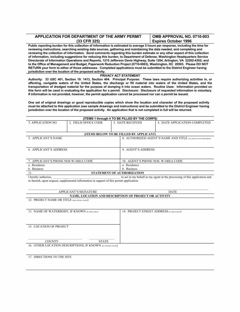
APPLICATION FOR DEPARTMENT OF THE ARMY PERMIT
(33 CFR 325) OMB APPROVAL NO. 0710-003 Expires October 1996
Public reporting burden for this collection of information is estimated to average 5 hours per response, including the time for reviewing instructions, searching existing data sources, gathering and maintaining the data needed, and completing and reviewing the collection of information. Send comments regarding this burden estimate or any other aspect of this collection of information, including suggestions for reducing this burden, to Department of Defense, Washington Headquarters Service Directorate of Information Operations and Reports, 1215 Jefferson Davis Highway, Suite 1204, Arlington, VA 22202-4302; and to the Office of Management and Budget, Paperwork Reduction Project (0710-0003), Washington, DC 20503. Please DO NOT RETURN your form to either of those addresses. Completed applications must be submitted to the District Engineer having jurisdiction over the location of the proposed activity.
PRIVACY ACT STATEMENT Authority: 33 USC 401, Section 10: 1413, Section 404. Principal Purpose: These laws require authorizing activities in, or affecting, navigable waters of the United States, the discharge or fill material into waters of the United States, and the transportation of dredged material for the purpose of dumping it into ocean waters. Routine Uses: Information provided on this form will be used in evaluating the application for a permit. Disclosure: Disclosure of requested information is voluntary. If information is not provided, however, the permit application cannot be processed nor can a permit be issued. One set of original drawings or good reproducible copies which show the location and character of the proposed activity must be attached to this application (see sample drawings and instructions) and be submitted to the District Engineer having jurisdiction over the location of the proposed activity. An application that is not completed in full will be returned.
(ITEMS 1 through 4 TO BE FILLED BY THE CORPS) 1. APPLICATION NO 2. FIELD OFFICE CODE 3. DATE RECEIVED 4. DATE APPLICATION COMPLETED
(ITEMS BELOW TO BE FILLED BY APPLICANT) 5. APPLICANT’S NAME
8. AUTHORIZED AGENT’S NAME AND TITLE (AN AGENT IS NOT REQUIRED)
6. APPLICANT’S ADDRESS 9. AGENT’S ADDRESS
7. APPLICANT’S PHONE NOS W/AREA CODE 10. AGENT’S PHONE NOS. W/AREA CODE a. Residence b. Business
a. Residence b. Business
11. STATEMENT OF AUTHORIZATION I hereby authorize, ___________________________________________ to act in my behalf as my agent in the processing of this application and to furnish, upon request, supplemental information in support of this permit application. __________________________________________________________________________________________________________________ APPLICANT’S SIGNATURE DATE
NAME, LOCATION AND DESCRIPTION OF PROJECT OR ACTIVITY 12. PROJECT NAME OR TITLE (SEE INSTRUCTIONS) 13. NAME OF WATERBODY, IF KNOWN (IF APPLICABLE)
14. PROJECT STREET ADDRESS (IF APPLICABLE)
15. LOCATION OF PROJECT __________________________________ ________________ COUNTY STATE
16. OTHER LOCATION DESCRIPTIONS, IF KNOWN (SEE INSTRUCTIONS) 17. DIRECTIONS TO THE SITE
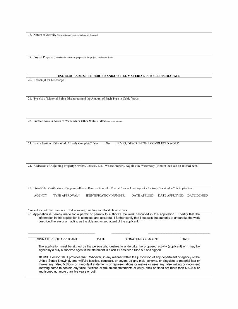
18. Nature of Activity (Description of project, include all features) 19. Project Purpose (Describe the reason or purpose of the project, see instructions)
USE BLOCKS 20-22 IF DREDGED AND/OR FILL MATERIAL IS TO BE DISCHARGED 20. Reason(s) for Discharge 21. Type(s) of Material Being Discharges and the Amount of Each Type in Cubic Yards 22. Surface Area in Acres of Wetlands or Other Waters Filled (see instructions) 23. Is any Portion of the Work Already Complete? Yes ___ No ___ IF YES, DESCRIBE THE COMPLETED WORK 24. Addresses of Adjoining Property Owners, Lessees, Etc., Whose Property Adjoins the Waterbody (If more than can be entered here. 25. List of Other Certifications of Approvals/Denials Received from other Federal, State or Local Agencies for Work Described in This Application. AGENCY TYPE APPROVAL* IDENTIFICATION NUMBER DATE APPLIED DATE APPROVED DATE DENIED *Would include but is not restricted to zoning, building and flood plain permits 26. Application is hereby made for a permit or permits to authorize the work described in this application. I certify that the
information in this application is complete and accurate. I further certify that I possess the authority to undertake the work described herein or am acting as the duly authorized agent of the applicant.
________________________________________ ___________ _____________________________________ _____________ SIGNATURE OF APPLICANT DATE SIGNATURE OF AGENT DATE The application must be signed by the person who desires to undertake the proposed activity (applicant) or it may be
signed by a duly authorized agent if the statement in block 11 has been filled out and signed. 18 USC Section 1001 provides that: Whoever, in any manner within the jurisdiction of any department or agency of the
United States knowingly and willfully falsifies, conceals, or covers up any trick, scheme, or disguises a material fact or makes any false, fictitious or fraudulent statements or representations or makes or uses any false writing or document knowing same to contain any false, fictitious or fraudulent statements or entry, shall be fined not more than $10,000 or imprisoned not more than five years or both.
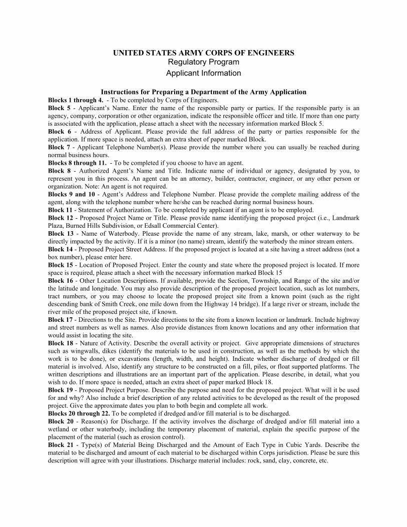
UNITED STATES ARMY CORPS OF ENGINEERS Regulatory Program Applicant Information
Instructions for Preparing a Department of the Army Application
Blocks 1 through 4. - To be completed by Corps of Engineers. Block 5 - Applicant’s Name. Enter the name of the responsible party or parties. If the responsible party is an agency, company, corporation or other organization, indicate the responsible officer and title. If more than one party is associated with the application, please attach a sheet with the necessary information marked Block 5. Block 6 - Address of Applicant. Please provide the full address of the party or parties responsible for the application. If more space is needed, attach an extra sheet of paper marked Block. Block 7 - Applicant Telephone Number(s). Please provide the number where you can usually be reached during normal business hours. Blocks 8 through 11. - To be completed if you choose to have an agent. Block 8 - Authorized Agent’s Name and Title. Indicate name of individual or agency, designated by you, to represent you in this process. An agent can be an attorney, builder, contractor, engineer, or any other person or organization. Note: An agent is not required. Blocks 9 and 10 - Agent’s Address and Telephone Number. Please provide the complete mailing address of the agent, along with the telephone number where he/she can be reached during normal business hours. Block 11 - Statement of Authorization. To be completed by applicant if an agent is to be employed. Block 12 - Proposed Project Name or Title. Please provide name identifying the proposed project (i.e., Landmark Plaza, Burned Hills Subdivision, or Edsall Commercial Center). Block 13 - Name of Waterbody. Please provide the name of any stream, lake, marsh, or other waterway to be directly impacted by the activity. If it is a minor (no name) stream, identify the waterbody the minor stream enters. Block 14 - Proposed Project Street Address. If the proposed project is located at a site having a street address (not a box number), please enter here. Block 15 - Location of Proposed Project. Enter the county and state where the proposed project is located. If more space is required, please attach a sheet with the necessary information marked Block 15 Block 16 - Other Location Descriptions. If available, provide the Section, Township, and Range of the site and/or the latitude and longitude. You may also provide description of the proposed project location, such as lot numbers, tract numbers, or you may choose to locate the proposed project site from a known point (such as the right descending bank of Smith Creek, one mile down from the Highway 14 bridge). If a large river or stream, include the river mile of the proposed project site, if known. Block 17 - Directions to the Site. Provide directions to the site from a known location or landmark. Include highway and street numbers as well as names. Also provide distances from known locations and any other information that would assist in locating the site. Block 18 - Nature of Activity. Describe the overall activity or project. Give appropriate dimensions of structures such as wingwalls, dikes (identify the materials to be used in construction, as well as the methods by which the work is to be done), or excavations (length, width, and height). Indicate whether discharge of dredged or fill material is involved. Also, identify any structure to be constructed on a fill, piles, or float supported platforms. The written descriptions and illustrations are an important part of the application. Please describe, in detail, what you wish to do. If more space is needed, attach an extra sheet of paper marked Block 18. Block 19 - Proposed Project Purpose. Describe the purpose and need for the proposed project. What will it be used for and why? Also include a brief description of any related activities to be developed as the result of the proposed project. Give the approximate dates you plan to both begin and complete all work. Blocks 20 through 22. To be completed if dredged and/or fill material is to be discharged. Block 20 - Reason(s) for Discharge. If the activity involves the discharge of dredged and/or fill material into a wetland or other waterbody, including the temporary placement of material, explain the specific purpose of the placement of the material (such as erosion control). Block 21 - Type(s) of Material Being Discharged and the Amount of Each Type in Cubic Yards. Describe the material to be discharged and amount of each material to be discharged within Corps jurisdiction. Please be sure this description will agree with your illustrations. Discharge material includes: rock, sand, clay, concrete, etc.
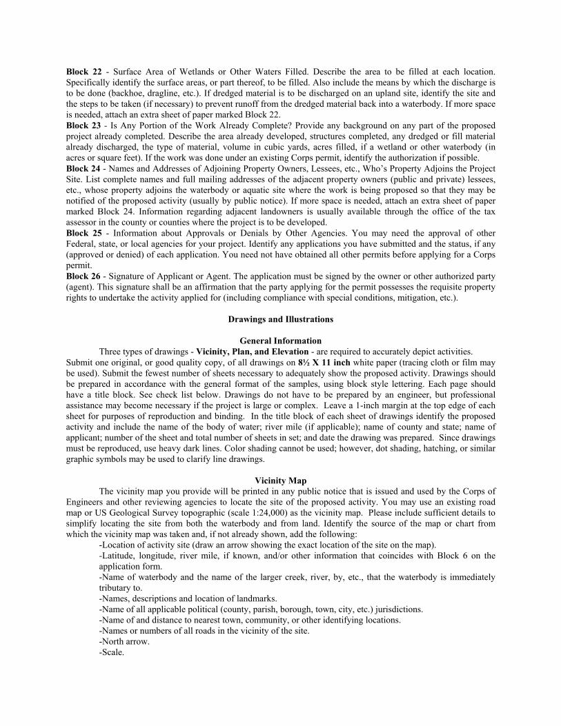
Block 22 - Surface Area of Wetlands or Other Waters Filled. Describe the area to be filled at each location. Specifically identify the surface areas, or part thereof, to be filled. Also include the means by which the discharge is to be done (backhoe, dragline, etc.). If dredged material is to be discharged on an upland site, identify the site and the steps to be taken (if necessary) to prevent runoff from the dredged material back into a waterbody. If more space is needed, attach an extra sheet of paper marked Block 22. Block 23 - Is Any Portion of the Work Already Complete? Provide any background on any part of the proposed project already completed. Describe the area already developed, structures completed, any dredged or fill material already discharged, the type of material, volume in cubic yards, acres filled, if a wetland or other waterbody (in acres or square feet). If the work was done under an existing Corps permit, identify the authorization if possible. Block 24 - Names and Addresses of Adjoining Property Owners, Lessees, etc., Who’s Property Adjoins the Project Site. List complete names and full mailing addresses of the adjacent property owners (public and private) lessees, etc., whose property adjoins the waterbody or aquatic site where the work is being proposed so that they may be notified of the proposed activity (usually by public notice). If more space is needed, attach an extra sheet of paper marked Block 24. Information regarding adjacent landowners is usually available through the office of the tax assessor in the county or counties where the project is to be developed. Block 25 - Information about Approvals or Denials by Other Agencies. You may need the approval of other Federal, state, or local agencies for your project. Identify any applications you have submitted and the status, if any (approved or denied) of each application. You need not have obtained all other permits before applying for a Corps permit. Block 26 - Signature of Applicant or Agent. The application must be signed by the owner or other authorized party (agent). This signature shall be an affirmation that the party applying for the permit possesses the requisite property rights to undertake the activity applied for (including compliance with special conditions, mitigation, etc.).
Drawings and Illustrations
General Information Three types of drawings - Vicinity, Plan, and Elevation - are required to accurately depict activities. Submit one original, or good quality copy, of all drawings on 8½ X 11 inch white paper (tracing cloth or film may be used). Submit the fewest number of sheets necessary to adequately show the proposed activity. Drawings should be prepared in accordance with the general format of the samples, using block style lettering. Each page should have a title block. See check list below. Drawings do not have to be prepared by an engineer, but professional assistance may become necessary if the project is large or complex. Leave a 1-inch margin at the top edge of each sheet for purposes of reproduction and binding. In the title block of each sheet of drawings identify the proposed activity and include the name of the body of water; river mile (if applicable); name of county and state; name of applicant; number of the sheet and total number of sheets in set; and date the drawing was prepared. Since drawings must be reproduced, use heavy dark lines. Color shading cannot be used; however, dot shading, hatching, or similar graphic symbols may be used to clarify line drawings.
Vicinity Map The vicinity map you provide will be printed in any public notice that is issued and used by the Corps of Engineers and other reviewing agencies to locate the site of the proposed activity. You may use an existing road map or US Geological Survey topographic (scale 1:24,000) as the vicinity map. Please include sufficient details to simplify locating the site from both the waterbody and from land. Identify the source of the map or chart from which the vicinity map was taken and, if not already shown, add the following: -Location of activity site (draw an arrow showing the exact location of the site on the map). -Latitude, longitude, river mile, if known, and/or other information that coincides with Block 6 on the
application form. -Name of waterbody and the name of the larger creek, river, by, etc., that the waterbody is immediately
tributary to. -Names, descriptions and location of landmarks. -Name of all applicable political (county, parish, borough, town, city, etc.) jurisdictions. -Name of and distance to nearest town, community, or other identifying locations. -Names or numbers of all roads in the vicinity of the site. -North arrow. -Scale.
Plan View The plan view shows the proposed activity as if you were looking straight down on it from above. your plan view should clearly show the following: -Name of waterbody (river, creek, lake, wetland, etc.) and river mile (if known) at location of activity. -Existing shorelines. -Mean high and mean low water lines and maximum (spring) high tide line in tidal areas. -Ordinary high water line and ordinary low water line if the proposed activity is located on a non-tidal
waterbody. -Average water depths around the activity. -Dimensions of the activity and distance it extends from the high water line into the water. -Distances to nearby Federal projects, if applicable. -Distance between proposed activity and navigation channel, where applicable. -Location of structures, if any, in navigable waters immediately adjacent to the proposed activity. -Location of any wetlands (marshes, swamps, tidal flats, etc.) -North arrow. -Scale. If dredged material is involved, you must describe the type of material, number of cubic yards, method of handling, and the location of fill and spoil disposal area. The drawing should show proposed retention levees, weirs, and/or other means for retaining hydraulically placed materials. Mark the drawing to indicate previously completed portions of the activity.
Elevation and/or Cross Section View The elevation and/or cross section view is a scale drawing that shows the side, front, or rear of the proposed activity. If a section view is shown, it represents the proposed structure as it would appear if cut internally for display. Your elevation should clearly show the following: -Water elevations as shown in the plan view. -Water depth at waterward face of proposed activity or, if dredging is proposed, dredging and estimated
disposal grades. -Dimensions from mean high water line (in tidal waters) of proposed fill or float, or high tide line for pile
supported platform. Describe any structures to be built on the platform. -Cross section of excavation or fill, including approximate side slopes. -Graphic or numerical scale. -Principal dimensions of the activity.
Notes on Drawings
Names of adjacent property owners who may be affected. Complete names and addresses should be shown in Block 5 on ENG Form 4345.
Legal property description: Number, name of subdivision, block, and lot number. Section, Township, and Range (if applicable) from plot, deed, or tax assessment.
Photographs of the site of the proposed activity are not required; however, pictures are helpful and may be submitted as part of any application.
While illustrations need not be professional (many small, private project illustrations are prepared by hand), they should be clear, accurate, and contain all necessary information.
Drawings should be as clear and simple as possible (i.e., not too “busy”).
General Information
Authority for the Regulatory Program The US Army Corps of Engineers has been regulating activities in the nation’s waters since 1890. Until the 1960’s the primary purpose of the regulatory program was to protect navigation. Since then, as a result of laws and court decisions, the program has been broadened so that it now considers the full public interest for both the protection and utilization of water resources. The regulatory authorities and responsibilities of the Corps of Engineers are based on the following laws:
Section 10 of the Rivers and Harbors Act of 1899 (33 USC 403) prohibits the obstruction or alteration of navigable waters of the United States without a permit from the Corps of Engineers.
Section 404 of the Clean Water Act (33 USC 1344). Section 301 of this Act prohibits the discharge of dredged or fill material into waters of the United States without a permit from the Corps of Engineers.
Section 103 of the Marine Protection, Research, and Sanctuaries Act of 1972, as amended (33 USC 1413) authorizes the Corps of Engineers to issue permits for the transportation of dredged material for the purpose of dumping it into ocean waters.
Other laws may also affect the processing of applications for Corps of Engineers permits. Among these are the National Environmental Policy Act, the Coastal Zone Management Act, the Fish and Wildlife Coordination Act, the Endangered Species Act, the National Historic Preservation Act, the Deepwater Port Act, the Federal Power Act, the Marine Mammal Protection Act, the Wild and Scenic Rivers Act, and the National Fishing Enhancement Act of 1984.
Commonly Used Terms Certain terms which are closely associated with the regulatory program are explained briefly in this section. If you need more detailed definitions, refer to the Code of Federal Regulations (33 CFR Parts 320 through 330) or contact a Corps district regulatory office. Pre-application Consultation is one or more meetings between members of the district engineer’s staff and an applicant and his agent or his consultant. A pre-application consultation is usually related to applications for major activities and may involve discussion of alternatives, environmental documents, National Environmental Policy Act procedures, and development of the scope of the data required when an environmental impact statement is required. Public Hearings may be held to acquire information and give the public the opportunity to present views and opinions. The Corps may hold a hearing or participate in joint public hearings with other Federal or state agencies. The district engineer may specify in the public notice that a hearing will be held. In addition, any person may request in writing during the comment period that a hearing be held. Specific reasons must be given as to the need for a hearing. The district engineer may attempt to resolve the issue informally or he may set the date for a public hearing. Hearings are held at times and places that are convenient for the interested public. Very few applications involve a public hearing. The Public Interest Review is the term which refers to the evaluation of a proposed activity to determine probable impacts. Expected benefits are balanced against reasonably foreseeable detriments. All relevant factors are weighed. Corps policy is to provide applicants with a timely and carefully weighed decision which reflects the public interest.
Questions That Are Frequently Asked Q. When should I apply for a Corps permit? A. Since two to three months is normally required to process a routine application involving a public notice, you should apply as early as possible to be sure you have all required approvals before your planned commencement date. For a large or complex activity that may take longer, it is often helpful to have a “pre-application consultation” or informal meeting with the Corps during the early planning phase of your project. You may receive helpful information at this point which could prevent delays later. When in doubt as to whether a permit may be required or what you need to do, don’t hesitate to call a district regulatory office. Q. I have obtained permits from local and state governments. Why do I have to get a permit from the Corps of Engineers? A. It is possible you may not have to obtain an individual permit, depending on the type or location of work. The Corps has many general permits which authorize minor activities without the need for individual processing. Check with your Corps district regulatory office for information on general permits. When a general permit does not apply, you may still be required to obtain an individual permit. Q. What will happen if I do work without getting a permit from the Corps? A. Performing unauthorized work in waters of the United States or failure to comply with the terms of a valid permit can have serious consequences. You would be in violation of Federal law and could face stiff penalties, including fines and/or requirements to restore the area. Enforcement is an important part of the Corps regulatory program. Corps surveillance and monitoring activities are often aided by various agencies, groups, and individuals, who report suspected violations. When in doubt as to whether a planned activity needs a permit, contact the nearest district regulatory office. It could save a lot of unnecessary trouble later. Q. How can I obtain further information about permit requirements? A. Information about the regulatory program is available from any Corps district regulatory office.
Q. Why should I waste my time and yours by applying for a permit when you probably won’t let me do the work anyway? A. Nationwide, only three percent of all requests for permits are denied. Those few applicants who have been denied permits usually have refused to change the design, timing, or location of the proposed activity. When a permit is denied, an applicant may redesign the project and submit a new application. To avoid unnecessary delays pre-application conferences, particularly for applications for major activities, are recommended. The Corps will endeavor to give you helpful information, including factors which will be considered during the public interest review, and alternatives to consider that may prove to be useful in designing a project. Q. What is a wetland and what is its value? A. Wetlands are areas that are periodically or permanently inundated by surface or ground water and support vegetation adapted for life in saturated soil. Wetlands include swamps, marshes, bogs and similar areas. A significant natural resource, wetlands serve important functions relating to fish and wildlife; food chain production; habitat; nesting; spawning; rearing and resting sites for aquatic and land species; protection of other areas from wave action and erosion; storage areas for storm and flood waters; natural recharge areas where ground and surface water are interconnected; and natural water filtration and purification functions. Although individual alterations of wetlands may constitute a minor change, the cumulative effect of numerous changes often results in major damage to wetland resources. The review of applications for alteration of wetlands will include consideration of whether the proposed activity is dependent upon being located in an aquatic environment. Q. How can I design my project to eliminate the need for a Corps permit? A. Stay above ordinary high water and avoid wetlands adjacent to the stream or lake. Also, it is possible that your activity is exempt and does not need a Corps permit or that it has been authorized by a nationwide or regional general permit. So, before you build, dredge or fill, contact the Corps district regulatory office in your area for specific information about location, exemptions, and regional and nationwide general permits.
General The application form used to apply for a permit is Engineer Form 4345, Application of a Department of the Army Permit. You can obtain the application from one of the Corps of Engineers district regulatory offices or download one. Some offices may use a slightly modified form for joint processing with a state agency; however, the required information is basically the same. It is important that you provide the complete information in the requested format. This information will be used to determine the appropriate form of authorization, and to evaluate your proposal. Some categories of activities have been previously authorized by nationwide or regional permits, and no further Corps approvals are required. Others may qualify for abbreviated permit processing, with authorizations in the form of letters of permission, in which a permit decision can usually be reached in less than 30 days. For other activities, a Public Notice may be required to notify Federal, state, and local agencies, adjacent property owners, and the general public of the proposal to allow an opportunity for review and comment or to request a public hearing. Most applications involving Public Notices are completed within four months and many are completed within 60 days. The district engineer will begin to process your application immediately upon receipt of all required information. You will be sent an acknowledgment of its receipt and the application number assigned to your file. you should refer to this number when inquiring about your application. Your proposal will be reviewed, balancing the need and expected benefits against the probable impacts of the work, taking into consideration all comments received and other relevant factors. This process is called the public interest review. The Corps goal is to reach a decision regarding permit issuance or denial within 60 days of receipt of a complete application. However, some complex activities, issues, or requirements of law may prevent the district engineer from meeting this goal. For any specific information on the evaluation process, filling out the application forms, or the status or your application, you should contact the regulatory branch of the Corps of Engineers district office which has jurisdiction over the area where you plan to do the work.
Typical Processing Procedure for a Standard Individual Permit 1. Pre-application consultation (optional) 2. Applicant submits ENG Form 4345 to district regulatory office 3. Application received and assigned identification number 4. Public notice issued (within 15 days of receiving all information) 5. 15 to 30 day comment period depending upon nature of activity
6. Proposal is reviewed** by Corps and: o Public o Special interest groups o Local agencies o State agencies o Federal agencies 7. Corps considers all comments 8. Other Federal agencies consulted, if appropriate 9. District engineer may ask applicant to provide additional information 10. Public hearing held, if needed 11. District engineer makes decision 12. Permit issued or Permit denied and applicant advised of reason ** Review period may be extended if applicant fails to submit information or due to requirements of certain laws.
Evaluation Factors The decision whether to grant or deny a permit is based on a public interest review of the probable impact of the proposed activity and its intended use. The following general criteria will be considered in the evaluation of every application:
the relative extent of the public and private need for the proposed activity; the practicability of using reasonable alternative locations and methods to accomplish the objective of the proposed activity; and the extent and permanence of the beneficial and/or detrimental effects which the proposed activity is likely to have on the public and private uses to which the area is suited.
Section 404(b)(1) of the Clean Water Act If your project involves the discharge of dredged or fill material, it will be necessary for the Corps to evaluate your proposed activity under the Section 404(b)(1) guidelines prepared by the Environmental Protection Agency. The guidelines restrict discharges into aquatic areas where less environmentally damaging, practicable alternatives exist.
Forms and Permits The following forms apply to the permit process: Application - The form that you will need to initiate the review process is ENG Form 4345 (see above). The appropriate form may be obtained from the district regulatory office which has jurisdiction in the area where your proposed project is located. Individual Permits - An individual permit may be issued as either ENG Form 1721, the standard permit, or as a Letter of Permission. A standard permit is one processed through the typical review procedures, which include public notice, opportunity for a public hearing, and receipt of comments. It is issued following a case-by-case evaluation of a specific activity. If work is minor or routine with minimum impacts and objections are unlikely, then it may qualify for a Letter of Permission (LOP). An LOP can be issued much more quickly than a standard permit since an individual public notice is not required. The District Engineer will notify you if your proposed activity qualifies for an LOP. General Permits - In many cases the formal processing of a permit application is not required because of general permits already issued to the public at large by the Corps of Engineers. These are issued on a regional and nationwide basis. Separate applications may not be required for activities authorized by a general permit; nevertheless, reporting may be required. For specific information on general permits, contact a district regulatory office. ENG Form 4336 - The third form, ENG Form 4336, is used to assist with surveillance for unauthorized activities. The form, which contains a description of authorized work, should be posted at the site of an authorized activity. If the Corps decides it is appropriate for you to post this form, it will be furnished to you when you receive your permit. Fees - Fees are required for most permits. $10.00 will be charged for a permit for a non-commercial activity; $100.00 will be charged for a permit for a commercial or industrial activity. The district engineer will make the final
decision as to the amount of the fee. Do not send a fee when you submit an application. When the Corps issues a permit, you will be notified and asked to submit the required fee payable to the Treasurer of the United States. No fees are charged for transferring a permit from one property owner to another, for Letters of Permission, or for nay activities authorized by a general permit or for permits to governmental agencies. Completed applications must be submitted to the District Engineer having jurisdiction over the location of the proposed activity.
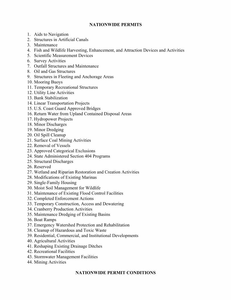
NATIONWIDE PERMITS 1. Aids to Navigation 2. Structures in Artificial Canals 3. Maintenance 4. Fish and Wildlife Harvesting, Enhancement, and Attraction Devices and Activities 5. Scientific Measurement Devices 6. Survey Activities 7. Outfall Structures and Maintenance 8. Oil and Gas Structures 9. Structures in Fleeting and Anchorage Areas 10. Mooring Buoys 11. Temporary Recreational Structures 12. Utility Line Activities 13. Bank Stabilization 14. Linear Transportation Projects 15. U.S. Coast Guard Approved Bridges 16. Return Water from Upland Contained Disposal Areas 17. Hydropower Projects 18. Minor Discharges 19. Minor Dredging 20. Oil Spill Cleanup 21. Surface Coal Mining Activities 22. Removal of Vessels 23. Approved Categorical Exclusions 24. State Administered Section 404 Programs 25. Structural Discharges 26. Reserved 27. Wetland and Riparian Restoration and Creation Activities 28. Modifications of Existing Marinas 29. Single-Family Housing 30. Moist Soil Management for Wildlife 31. Maintenance of Existing Flood Control Facilities 32. Completed Enforcement Actions 33. Temporary Construction, Access and Dewatering 34. Cranberry Production Activities 35. Maintenance Dredging of Existing Basins 36. Boat Ramps 37. Emergency Watershed Protection and Rehabilitation 38. Cleanup of Hazardous and Toxic Waste 39. Residential, Commercial, and Institutional Developments 40. Agricultural Activities 41. Reshaping Existing Drainage Ditches 42. Recreational Facilities 43. Stormwater Management Facilities 44. Mining Activities
NATIONWIDE PERMIT CONDITIONS
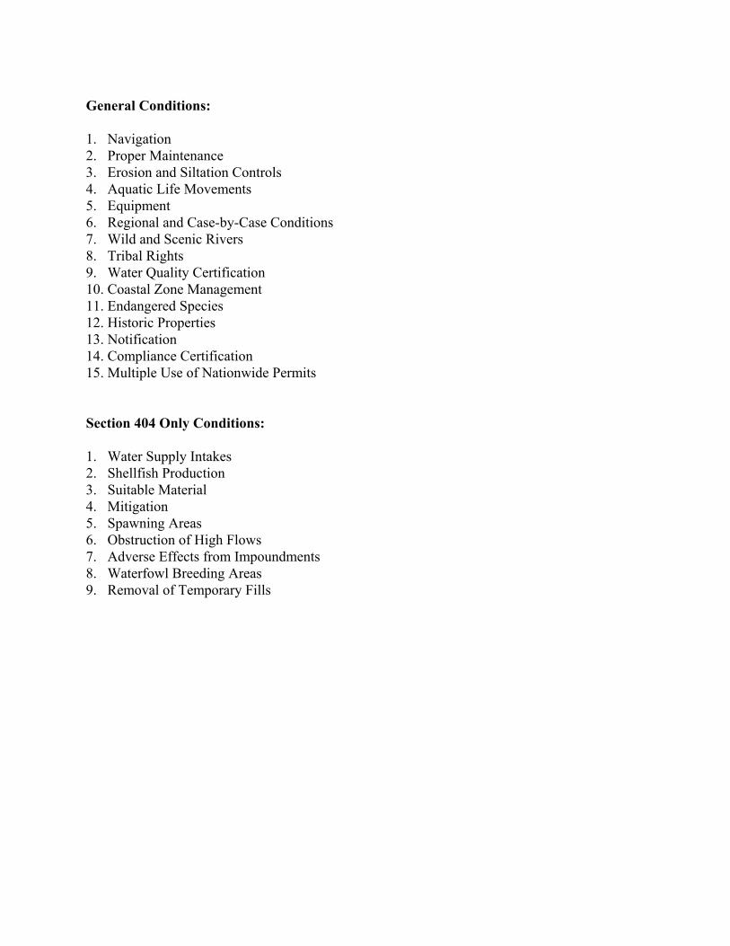
General Conditions: 1. Navigation 2. Proper Maintenance 3. Erosion and Siltation Controls 4. Aquatic Life Movements 5. Equipment 6. Regional and Case-by-Case Conditions 7. Wild and Scenic Rivers 8. Tribal Rights 9. Water Quality Certification 10. Coastal Zone Management 11. Endangered Species 12. Historic Properties 13. Notification 14. Compliance Certification 15. Multiple Use of Nationwide Permits Section 404 Only Conditions: 1. Water Supply Intakes 2. Shellfish Production 3. Suitable Material 4. Mitigation 5. Spawning Areas 6. Obstruction of High Flows 7. Adverse Effects from Impoundments 8. Waterfowl Breeding Areas 9. Removal of Temporary Fills
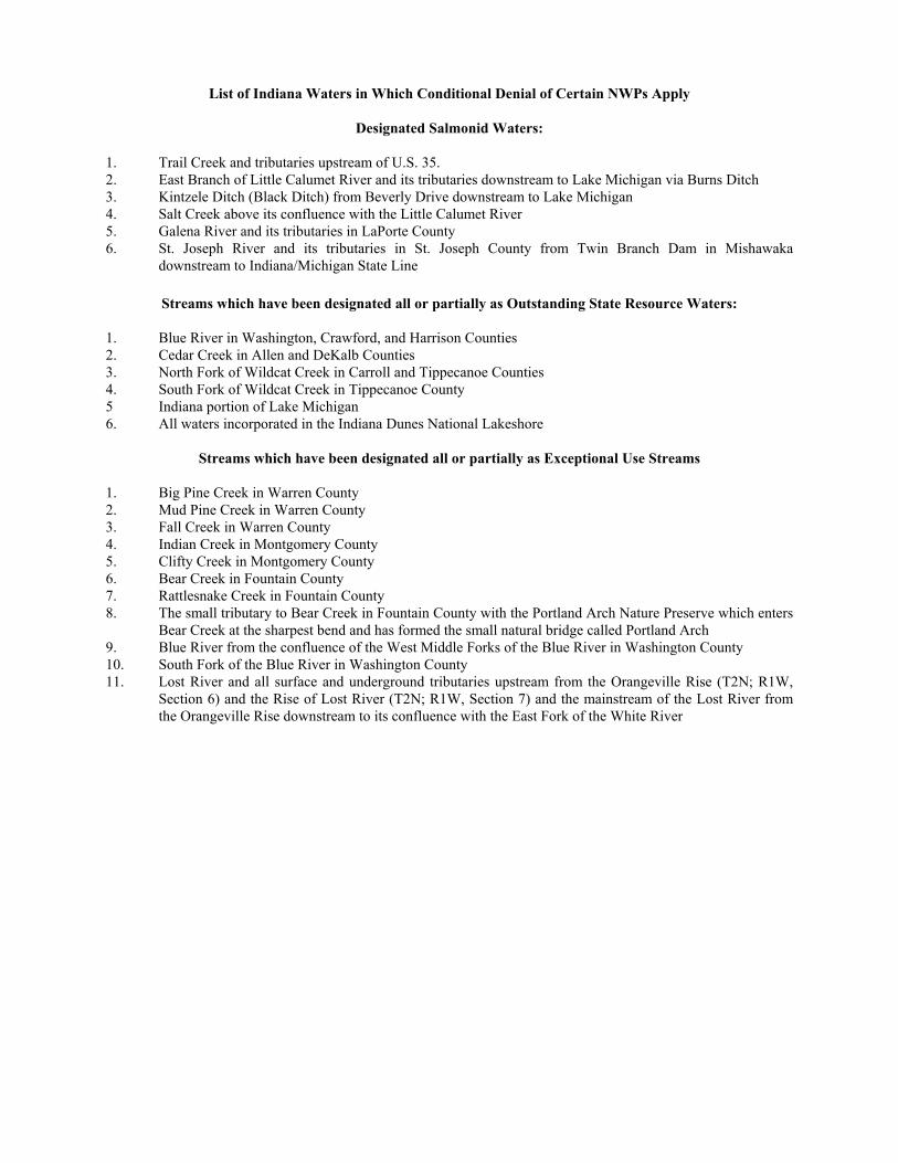
List of Indiana Waters in Which Conditional Denial of Certain NWPs Apply
Designated Salmonid Waters: 1. Trail Creek and tributaries upstream of U.S. 35. 2. East Branch of Little Calumet River and its tributaries downstream to Lake Michigan via Burns Ditch 3. Kintzele Ditch (Black Ditch) from Beverly Drive downstream to Lake Michigan 4. Salt Creek above its confluence with the Little Calumet River 5. Galena River and its tributaries in LaPorte County 6. St. Joseph River and its tributaries in St. Joseph County from Twin Branch Dam in Mishawaka
downstream to Indiana/Michigan State Line
Streams which have been designated all or partially as Outstanding State Resource Waters:
1. Blue River in Washington, Crawford, and Harrison Counties 2. Cedar Creek in Allen and DeKalb Counties 3. North Fork of Wildcat Creek in Carroll and Tippecanoe Counties 4. South Fork of Wildcat Creek in Tippecanoe County 5 Indiana portion of Lake Michigan 6. All waters incorporated in the Indiana Dunes National Lakeshore
Streams which have been designated all or partially as Exceptional Use Streams
1. Big Pine Creek in Warren County 2. Mud Pine Creek in Warren County 3. Fall Creek in Warren County 4. Indian Creek in Montgomery County 5. Clifty Creek in Montgomery County 6. Bear Creek in Fountain County 7. Rattlesnake Creek in Fountain County 8. The small tributary to Bear Creek in Fountain County with the Portland Arch Nature Preserve which enters
Bear Creek at the sharpest bend and has formed the small natural bridge called Portland Arch 9. Blue River from the confluence of the West Middle Forks of the Blue River in Washington County 10. South Fork of the Blue River in Washington County 11. Lost River and all surface and underground tributaries upstream from the Orangeville Rise (T2N; R1W,
Section 6) and the Rise of Lost River (T2N; R1W, Section 7) and the mainstream of the Lost River from the Orangeville Rise downstream to its confluence with the East Fork of the White River
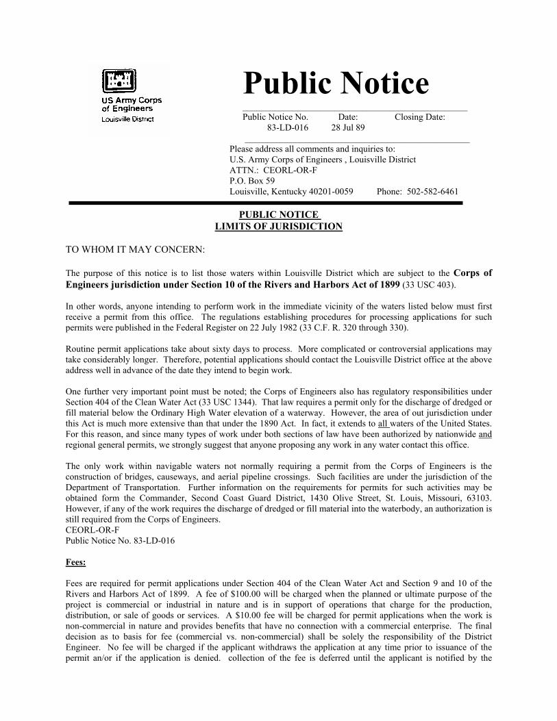
Public Notice _________________________________________________ Public Notice No. Date: Closing Date: 83-LD-016 28 Jul 89 _________________________________________________
Please address all comments and inquiries to: U.S. Army Corps of Engineers , Louisville District ATTN.: CEORL-OR-F P.O. Box 59 Louisville, Kentucky 40201-0059 Phone: 502-582-6461
PUBLIC NOTICE
LIMITS OF JURISDICTION TO WHOM IT MAY CONCERN: The purpose of this notice is to list those waters within Louisville District which are subject to the Corps of Engineers jurisdiction under Section 10 of the Rivers and Harbors Act of 1899 (33 USC 403). In other words, anyone intending to perform work in the immediate vicinity of the waters listed below must first receive a permit from this office. The regulations establishing procedures for processing applications for such permits were published in the Federal Register on 22 July 1982 (33 C.F. R. 320 through 330). Routine permit applications take about sixty days to process. More complicated or controversial applications may take considerably longer. Therefore, potential applications should contact the Louisville District office at the above address well in advance of the date they intend to begin work. One further very important point must be noted; the Corps of Engineers also has regulatory responsibilities under Section 404 of the Clean Water Act (33 USC 1344). That law requires a permit only for the discharge of dredged or fill material below the Ordinary High Water elevation of a waterway. However, the area of out jurisdiction under this Act is much more extensive than that under the 1890 Act. In fact, it extends to all waters of the United States. For this reason, and since many types of work under both sections of law have been authorized by nationwide and regional general permits, we strongly suggest that anyone proposing any work in any water contact this office. The only work within navigable waters not normally requiring a permit from the Corps of Engineers is the construction of bridges, causeways, and aerial pipeline crossings. Such facilities are under the jurisdiction of the Department of Transportation. Further information on the requirements for permits for such activities may be obtained form the Commander, Second Coast Guard District, 1430 Olive Street, St. Louis, Missouri, 63103. However, if any of the work requires the discharge of dredged or fill material into the waterbody, an authorization is still required from the Corps of Engineers. CEORL-OR-F Public Notice No. 83-LD-016 Fees: Fees are required for permit applications under Section 404 of the Clean Water Act and Section 9 and 10 of the Rivers and Harbors Act of 1899. A fee of $100.00 will be charged when the planned or ultimate purpose of the project is commercial or industrial in nature and is in support of operations that charge for the production, distribution, or sale of goods or services. A $10.00 fee will be charged for permit applications when the work is non-commercial in nature and provides benefits that have no connection with a commercial enterprise. The final decision as to basis for fee (commercial vs. non-commercial) shall be solely the responsibility of the District Engineer. No fee will be charged if the applicant withdraws the application at any time prior to issuance of the permit an/or if the application is denied. collection of the fee is deferred until the applicant is notified by the
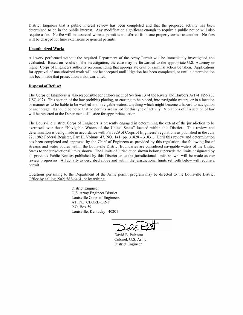
District Engineer that a public interest review has been completed and that the proposed activity has been determined to be in the public interest. Any modification significant enough to require a public notice will also require a fee. No fee will be assessed when a permit is transferred from one property owner to another. No fees will be charged for time extensions or general permits. Unauthorized Work: All work performed without the required Department of the Army Permit will be immediately investigated and evaluated. Based on results of the investigation, the case may be forwarded to the appropriate U.S. Attorney or higher Corps of Engineers authority recommending that appropriate civil or criminal action be taken. Applications for approval of unauthorized work will not be accepted until litigation has been completed, or until a determination has been made that prosecution is not warranted. Disposal of Refuse: The Corps of Engineers is also responsible for enforcement of Section 13 of the Rivers and Harbors Act of 1899 (33 USC 407). This section of the law prohibits placing, or causing to be placed, into navigable waters, or in a location or manner as to be liable to be washed into navigable waters, anything which might become a hazard to navigation or anchorage. It should be noted that no permits are issued for this type of activity. Violations of this section of law will be reported to the Department of Justice for appropriate action. The Louisville District Corps of Engineers is presently engaged in determining the extent of the jurisdiction to be exercised over those “Navigable Waters of the United States” located within this District. This review and determination is being made in accordance with Part 329 of Corps of Engineers’ regulations as published in the July 22, 1982 Federal Register, Part II, Volume 47, NO. 141, pp. 31828 - 31831. Until this review and determination has been completed and approved by the Chief of Engineers as provided by this regulation, the following list of streams and water bodies within the Louisville District Boundaries are considered navigable waters of the United States to the jurisdictional limits shown. The Limits of Jurisdiction shown below supersede the limits designated by all previous Public Notices published by this District or to the jurisdictional limits shown, will be made as our review progresses. All activity as described above and within the jurisdictional limits set forth below will require a permit. Questions pertaining to the Department of the Army permit program may be directed to the Louisville District Office by calling (502) 582-6461, or by writing: District Engineer U.S. Army Engineer District Louisville Corps of Engineers ATTN.: CEORL-OR-F P.O. Box 59 Louisville, Kentucky 40201 David E. Peixotto Colonel, U.S. Army District Engineer
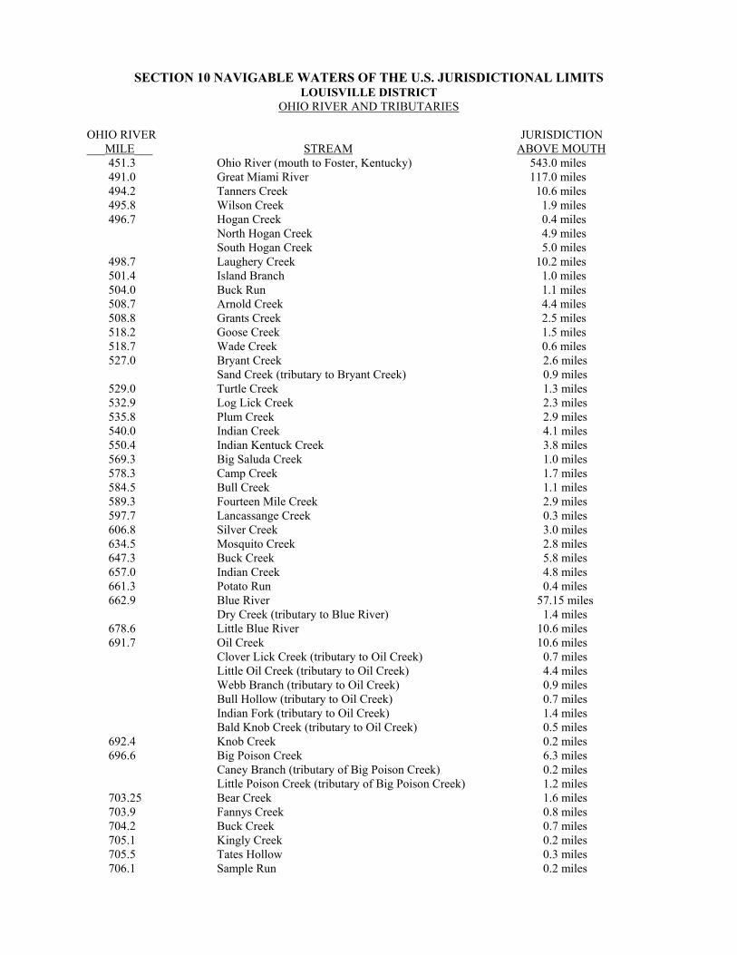
SECTION 10 NAVIGABLE WATERS OF THE U.S. JURISDICTIONAL LIMITS LOUISVILLE DISTRICT
OHIO RIVER AND TRIBUTARIES
OHIO RIVER JURISDICTION ___MILE___ STREAM ABOVE MOUTH
451.3 Ohio River (mouth to Foster, Kentucky) 543.0 miles 491.0 Great Miami River 117.0 miles 494.2 Tanners Creek 10.6 miles 495.8 Wilson Creek 1.9 miles 496.7 Hogan Creek 0.4 miles North Hogan Creek 4.9 miles South Hogan Creek 5.0 miles 498.7 Laughery Creek 10.2 miles 501.4 Island Branch 1.0 miles 504.0 Buck Run 1.1 miles 508.7 Arnold Creek 4.4 miles 508.8 Grants Creek 2.5 miles 518.2 Goose Creek 1.5 miles 518.7 Wade Creek 0.6 miles 527.0 Bryant Creek 2.6 miles Sand Creek (tributary to Bryant Creek) 0.9 miles
529.0 Turtle Creek 1.3 miles 532.9 Log Lick Creek 2.3 miles 535.8 Plum Creek 2.9 miles 540.0 Indian Creek 4.1 miles 550.4 Indian Kentuck Creek 3.8 miles 569.3 Big Saluda Creek 1.0 miles 578.3 Camp Creek 1.7 miles 584.5 Bull Creek 1.1 miles 589.3 Fourteen Mile Creek 2.9 miles 597.7 Lancassange Creek 0.3 miles 606.8 Silver Creek 3.0 miles 634.5 Mosquito Creek 2.8 miles 647.3 Buck Creek 5.8 miles 657.0 Indian Creek 4.8 miles 661.3 Potato Run 0.4 miles 662.9 Blue River 57.15 miles Dry Creek (tributary to Blue River) 1.4 miles 678.6 Little Blue River 10.6 miles 691.7 Oil Creek 10.6 miles Clover Lick Creek (tributary to Oil Creek) 0.7 miles Little Oil Creek (tributary to Oil Creek) 4.4 miles Webb Branch (tributary to Oil Creek) 0.9 miles Bull Hollow (tributary to Oil Creek) 0.7 miles Indian Fork (tributary to Oil Creek) 1.4 miles Bald Knob Creek (tributary to Oil Creek) 0.5 miles 692.4 Knob Creek 0.2 miles 696.6 Big Poison Creek 6.3 miles Caney Branch (tributary of Big Poison Creek) 0.2 miles Little Poison Creek (tributary of Big Poison Creek) 1.2 miles 703.25 Bear Creek 1.6 miles 703.9 Fannys Creek 0.8 miles 704.2 Buck Creek 0.7 miles 705.1 Kingly Creek 0.2 miles 705.5 Tates Hollow 0.3 miles 706.1 Sample Run 0.2 miles
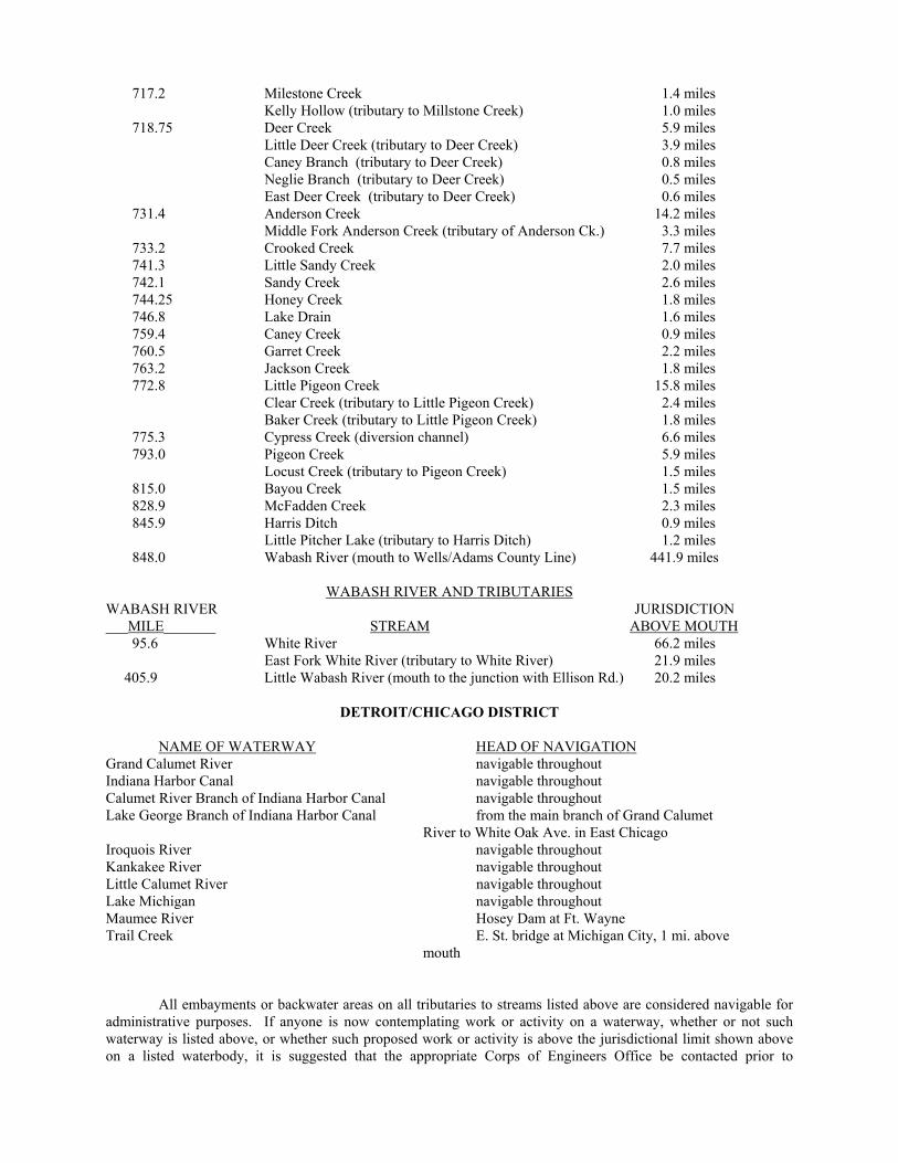
717.2 Milestone Creek 1.4 miles Kelly Hollow (tributary to Millstone Creek) 1.0 miles 718.75 Deer Creek 5.9 miles Little Deer Creek (tributary to Deer Creek) 3.9 miles Caney Branch (tributary to Deer Creek) 0.8 miles Neglie Branch (tributary to Deer Creek) 0.5 miles East Deer Creek (tributary to Deer Creek) 0.6 miles 731.4 Anderson Creek 14.2 miles Middle Fork Anderson Creek (tributary of Anderson Ck.) 3.3 miles 733.2 Crooked Creek 7.7 miles 741.3 Little Sandy Creek 2.0 miles 742.1 Sandy Creek 2.6 miles 744.25 Honey Creek 1.8 miles 746.8 Lake Drain 1.6 miles 759.4 Caney Creek 0.9 miles 760.5 Garret Creek 2.2 miles 763.2 Jackson Creek 1.8 miles 772.8 Little Pigeon Creek 15.8 miles Clear Creek (tributary to Little Pigeon Creek) 2.4 miles Baker Creek (tributary to Little Pigeon Creek) 1.8 miles 775.3 Cypress Creek (diversion channel) 6.6 miles 793.0 Pigeon Creek 5.9 miles Locust Creek (tributary to Pigeon Creek) 1.5 miles 815.0 Bayou Creek 1.5 miles 828.9 McFadden Creek 2.3 miles 845.9 Harris Ditch 0.9 miles Little Pitcher Lake (tributary to Harris Ditch) 1.2 miles 848.0 Wabash River (mouth to Wells/Adams County Line) 441.9 miles
WABASH RIVER AND TRIBUTARIES WABASH RIVER JURISDICTION ___MILE_______ STREAM ABOVE MOUTH 95.6 White River 66.2 miles East Fork White River (tributary to White River) 21.9 miles 405.9 Little Wabash River (mouth to the junction with Ellison Rd.) 20.2 miles
DETROIT/CHICAGO DISTRICT
NAME OF WATERWAY HEAD OF NAVIGATION Grand Calumet River navigable throughout Indiana Harbor Canal navigable throughout Calumet River Branch of Indiana Harbor Canal navigable throughout Lake George Branch of Indiana Harbor Canal from the main branch of Grand Calumet River to White Oak Ave. in East Chicago Iroquois River navigable throughout Kankakee River navigable throughout Little Calumet River navigable throughout Lake Michigan navigable throughout Maumee River Hosey Dam at Ft. Wayne Trail Creek E. St. bridge at Michigan City, 1 mi. above mouth All embayments or backwater areas on all tributaries to streams listed above are considered navigable for administrative purposes. If anyone is now contemplating work or activity on a waterway, whether or not such waterway is listed above, or whether such proposed work or activity is above the jurisdictional limit shown above on a listed waterbody, it is suggested that the appropriate Corps of Engineers Office be contacted prior to
commencement of such work or activity. Such contact may prevent a subsequent determination that such work or activity is illegal based upon a final determination of navigability. As mentioned before, the above listed stream limits define where permits are required, for work or construction, under Section 10 of the River and Harbor Act of 1899. The Corps of Engineers has permitting jurisdiction pursuant to Section 404 of the Clean Water Act for all waters of the United States. Section 404 regulates the placement of dredged or fill material into streams and their adjacent wetlands areas. Therefore, should you anticipate placing material into any streams, lakes, wetlands you should contact the Corps of Engineers to determine the authorization required prior to the placement of the dredged or fill material.