1 Article 304 Maricopa Station Overlay Sections: 304.01 Purpose 304.02 Boundaries 304.03 General Design Standards 304.05 Design Standards Intent 304.06 Transect-Based Zoning Sub-Districts 304.07 Land Use Regulations 304.08 Allocation and Structure of Transect Zoning Sub-Districts 304.09 Allocation and Structure of Blocks and Lots 304.10 Private Realm: General Design Standards to T4 and T5 304.11 T4 and T5 Zones Design and Development Standards 304.12 Signage 304.13 Public Realm: CD – Civic District Design Standards 304.14 Review of Plans 304.15 Definitions 304.01 Purpose The purpose of the Maricopa Station Overlay is to: A. To implement the goals, policies, and principles of the General Plan and the Heritage District Redevelopment Area Plan; B. To enable and encourage new development in the Maricopa Station Overlay area within the Heritage District; C. To support a blend of higher density residential, higher intensity employment/office, civic entertainment, and institutional uses, as well as retail uses that are pedestrian friendly; D. Encourage investment in adequate public facilities through quality redevelopment and improvements; E. Offer additional housing opportunities for residents seeking to live and work in an urban environment; and, July 1, 2020 DRAFT 4
Transcript
1
Article 304 Maricopa Station Overlay Sections:
304.01 Purpose 304.02 Boundaries 304.03 General Design Standards 304.05 Design Standards Intent 304.06 Transect-Based Zoning Sub-Districts 304.07 Land Use Regulations 304.08 Allocation and Structure of Transect Zoning Sub-Districts 304.09 Allocation and Structure of Blocks and Lots 304.10 Private Realm: General Design Standards to T4 and T5 304.11 T4 and T5 Zones Design and Development Standards 304.12 Signage 304.13 Public Realm: CD – Civic District Design Standards 304.14 Review of Plans 304.15 Definitions
304.01 Purpose The purpose of the Maricopa Station Overlay is to:
A. To implement the goals, policies, and principles of the General Plan and the Heritage District Redevelopment Area Plan;
B. To enable and encourage new development in the Maricopa Station Overlay area within the Heritage District;
C. To support a blend of higher density residential, higher intensity employment/office, civic entertainment, and institutional uses, as well as retail uses that are pedestrian friendly;
D. Encourage investment in adequate public facilities through quality redevelopment and improvements;
E. Offer additional housing opportunities for residents seeking to live and work in an urban environment; and,
July 1, 2020
DRAFT 4
F. Ensure that new development and redevelopment are designed to minimize traffic, parking and impacts on surrounding residential neighborhoods, and create walkable environments.
304.02 Boundaries The Maricopa Station Overlay (the “District”) is located within the Heritage District, and is bound to the west by North John Wayne Parkway (SR-347), to the north by Honeycutt Road, to the south by Mercado Street, and to the east by the western boundary of “Senita,” a master planned community.
304.03 Applicability The District shall be subject to the requirements of this Article in the areas established by the Zoning Map. The design guidelines set forth in Article 304-APPENDIX for Public Thoroughfares, Civic Spaces, Architectural Design, Landscape Design, Lighting, and Signage shall be applicable to any development or redevelopment within any portion of the District.
304.04 Authority The authority of the District Article is as follows:
A. The design standards set forth in this Article shall be applicable to any development or redevelopment using any portion of the District;
B. The District’s Transect-Based Zoning Sub-Districts areas, CD, T4, and T5 (Table 304.01), shall serve as the Zoning Districts for all lots designated as such within the District according to the Zoning Code;
C. Section 103.02 Rules for Construction of Language and Interpretation apply;
D. Maricopa Station Design Guidelines.
304.05 Design Standards Intent The intent of the Transect-Based Zoning Sub-District’s Design Standards are the following:
A. To develop and redevelop compact, mixed-use, and walkable places and buildings;
B. to provide convenient access to rail and bus stations to facilitate the location of higher density development in support of transit services;
C. to reinforce the image of a pedestrian-oriented historic town center, and;
D. to provide open spaces and public buildings that serve as necessary public amenities for citizens, residents, and visitors.
304.06 Transect-Based Zoning Sub-Districts The intent of the Maricopa Station Overlay Map is to designate the form of the district block-by-block using Transect-Based Zoning Sub-Districts. Establishing Transect-Based Zoning Sub-Districts further define distinctive physical environments of varying degrees of urbanity, development intensity, and mix of uses in the following manner:
A. The “T” and “C” designation represents each District’s relative place on a continuum of low intensity to high intensity known as the Rural-to-Urban Transect, with the character and associated regulations of “T5” being more urban than those of “T4,” and “CD” being more public than those of “T4” and “T5” private development;
B. The T and C Zones set forth in this Article shall serve as the “Zoning Districts” for all lots designated within the District according to the adopted Maricopa Station Overlay Map;
C. The following Transect-Based Zoning Sub-Districts are established by this Article and illustrated on Table 304.01:
D. Transect Districts organize the individual characteristics of infrastructure, landscape and buildings into distinct physical environments, with the overall character of each differing from one another.
TABLE 304.01: TRANSECT-BASED ZONING SUB-DISTRICTS Zoning District District Description CD – Civic Public Open Space: Organized as greens, squares, and plazas. T4 – General General Urban: A multifunctional social hub of a neighborhood that is
mixed in function, but principally residential. It is the general transition area from the center to the edge of the District.
T5 – Center Urban Center: The densest mix of uses including business, service, institutional, and residential center. It is usually at a central location, within walking distance of transit and the surrounding residential areas.
Bulk and Scale Illustration
E. Mixed Uses within Transect Districts and individual buildings provides access to daily needs within close proximity to dwellings so that residents may choose to work, recreate, and shop within walking distance to their home.
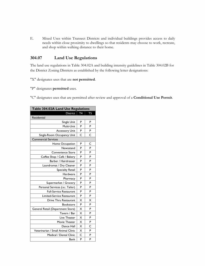
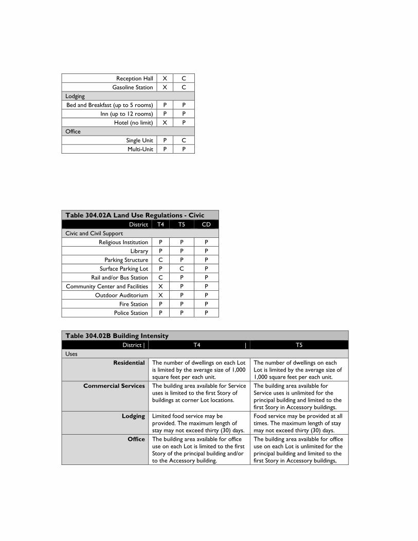
304.07 Land Use Regulations The land use regulations in Table 304.02A and building intensity guidelines in Table 304.02B for the District Zoning Districts as established by the following letter designations:
"X" designates uses that are not permitted.
"P" designates permitted uses.
"C" designates uses that are permitted after review and approval of a Conditional Use Permit.
Table 304.02A Land Use Regulations District T4 T5
Residential Single Unit P P Multi-Unit P P
Accessory Unit P P Single-Room Occupancy Unit C C
Commercial Services Home Occupation P C
Newsstand P P Convenience Store P P
Coffee Shop / Café / Bakery P P Barber / Hairdresser P P
Laundromat / Dry Cleaner P P Specialty Retail P P
Hardware P P Pharmacy P P
Supermarket / Grocery P P Personal Services (i.e.: Tailor) P P
Full-Service Restaurant P P Limited-Service Restaurant P P
Drive Thru Restaurant X X Bookstore P P
General Retail (Department Store) X P Tavern / Bar X P Live Theater X P
Movie Theater X P Dance Hall X C
Veterinarian / Small Animal Clinic X P Medical / Dental Clinic C P
Bank P P
Reception Hall X C Gasoline Station X C
Lodging Bed and Breakfast (up to 5 rooms) P P
Inn (up to 12 rooms) P P Hotel (no limit) X P
Office Single Unit P C Multi-Unit P P
Table 304.02B Building Intensity District | T4 | T5
Uses Residential The number of dwellings on each Lot
is limited by the average size of 1,000 square feet per each unit.
The number of dwellings on each Lot is limited by the average size of 1,000 square feet per each unit.
Commercial Services The building area available for Service uses is limited to the first Story of buildings at corner Lot locations.
The building area available for Service uses is unlimited for the principal building and limited to the first Story in Accessory buildings.
Lodging Limited food service may be provided. The maximum length of stay may not exceed thirty (30) days.
Food service may be provided at all times. The maximum length of stay may not exceed thirty (30) days.
Office The building area available for office use on each Lot is limited to the first Story of the principal building and/or to the Accessory building.
The building area available for office use on each Lot is unlimited for the principal building and limited to the first Story in Accessory buildings,
Table 304.02A Land Use Regulations - Civic District T4 T5 CD
Civic and Civil Support Religious Institution P P P
Library P P P Parking Structure C P P
Surface Parking Lot P C P Rail and/or Bus Station C P P
Community Center and Facilities X P P Outdoor Auditorium X P P
Fire Station P P P Police Station P P P
A. Outdoor Retail Sales and Merchandise Display.
1. Location. Outdoor retail sales and merchandise displays shall not obstruct ingress and egress to a building, obstruct fire lanes, interfere with vehicular circulation or sight distance, or be located in landscaped areas. Outdoor display areas for retail and merchandise sales shall be located within proximity to the primary business.
2. Maximum Area. Outdoor retail sales and merchandise displays shall not exceed five percent of the total gross floor area of the business, or 200 square feet, whichever is less.
3. Height. Display merchandise shall not exceed a height of six feet above finished grade.
B. Temporary Use of Parking Area. The temporary use of a parking area for sales and display is permitted, subject to Section 410.26 of this Code.
C. Home-based Business. Home-based businesses may be permitted administratively within the T4 and T5 Sub-Districts. Home-based businesses are not home occupations and may consist of on-site employees and a limited number of visits from clients, patrons, and deliveries related to the business. The business operation is not limited to a certain amount of floor or lot area unless conditionally approved with such limitations. The Zoning Administrator (ZA) may approve or conditionally approve a home-based business, subject to providing minimum necessary site improvements necessary to accommodate and serve the proposed home-based business.
1. All home-based business uses are subject to land uses in Table 304.02A.
2. The owner or operator of the home-based business is not required to be a full-time resident of the home.
3. The ZA shall consider the nature of the proposed use, the number of proposed on-site employees, and the proposed hours of operation to determine necessary conditions of approval and may require neighbor notification when outdoor business activities are proposed or if it is determined the proposed use has the potential to disrupt the existing character of the surrounding properties.
4. Home-based businesses are permitted to have one professionally made ground mounted sign not to exceed 3.5 feet in height and 12 square feet in area and is in conformance with Section 304.12 Signage. No back or box lit signage is allowed.
304.8 Allocation & Structure of Transect-Based Zoning Sub-Districts This District is assigned areas allocated to the establishment of Zoning Sub-Districts:
A. CD – Civic: Public spaces and buildings; T4 – General: Private development spaces and buildings, and; T5 – Center: Private development spaces and buildings;
Side Street – Secondary Frontage
Side Street – Secondary Frontage
B. Lots fronting the same side of a Block shall be assigned to a single CD or T4 of T5 - Zoning District according to the adopted Maricopa Station Overlay Map. Transitions from one Zoning District to another on the same Block, if present, shall occur at the rear Lot Line internal to any Block;
C. Zones may transition between adjacent Lot Lines by Exception to accommodate for specific site conditions (see Table 304.03).
TABLE 304.03: TRANSECT-BASED ZONING DISTRICT DESIGNATIONS
Main Street – Primary Street Frontage
304.9 Allocation and Structure of Blocks and Lots Within each Zoning District, Lots shall be (re)platted to have the following minimum and maximum Lot Widths, as measured at the Frontage Line (see Table 304.04A):
A. Within T4, 150 feet maximum Lot Width;
B. Within T5, 200 feet maximum Lot Width;
C. Each Lot shall have a Primary Frontage abutting a vehicular Thoroughfare, except for the Lots that designate their Primary Frontage along a publicly accessible Passage, such as a Pedestrian Court or Walkway;
D. Each Lot is divided into regulatory Layers, 1 – 3, to control development as illustrated on Table 304.04A. Design standards for the 1st Layer pertain to both Primary and Secondary Frontages;
Side Street – Primary Street Frontage
Alley
E. Each Block face may have multiple Frontages as illustrated on Table 304.04B. One Frontage Line is designated the Primary Frontage Line and all remaining Frontage Lines are designated as Secondary Frontage Lines;
F. Rear access may be provided for all Lots within the District through the provision of a Rear Alley and/or Lane.
304.10 Private Realm: General Design Standards to T4 and T5 Development located in the T4 and T5 Zones may be subject to the following requirements:
A. Lots and buildings may be regulated according to private frontage, building type, building placement, building height, and parking placement (see Tables 304.04A-B and Article 304 - Appendix for landscaping and other design guidelines);
B. Building Placement: Principal Buildings may be positioned on a Lot in accordance with Table 304.104A Lot Structure, Table 304.04B Private Frontage, and Table 304.04C Building Types. Tables are for illustrative purposes only;
C. Lot Occupation: Two buildings may be built on each Lot, one Principal Building and one Accessory Building;
D. Setbacks: Principal and Accessory Buildings shall be setback in relation to the boundaries on their lots. Rear Setbacks for Accessory Buildings shall be minimum of 15-feet measured from the centerline of the Rear Alley Easement. In the absence of a Rear Alley, the rear setback shall be 3-feet minimum;
E. Building Height: Building heights may be measured in number of Stories.
1. Height limits do not apply to Attics or raised basements, masts, belfries, clock towers, chimney flutes, water tanks, or elevator bulkheads.
2. Floor to finished ceiling height, except for ground or first floor Commercial Use, may be a minimum of 12 feet with a maximum of 25 feet and meet the City’s Building Code height requirements for habitable space.
F. Private Frontage: The Façade of the Principal Building shall be built parallel to the Principal Frontage Line or to the tangent of a curved Principal Frontage Line of a Lot, and along a minimum percentage of the Frontage width at the Setback (see Table 304.04B.a - i).
1. Permitted Encroachments into the Setbacks of any Lot are may range from 80% to 100%.
2. Buildings with first Floor Commercial Use may be glazed with clear glass no less than 70% of the first Story.
3. Openings above the first Story may not exceed 50% of the total building front wall, with each Façade being calculated independently.
4. All opening, including porches, Galleries, Arcades, and windows, with the exception of Shopfronts, may be oriented in a square or vertical proportion.
TABLE 304.04A: PRIVATE REALM LOT STRUCTURE
Buildings Principal Building The main building on a Lot, and its configuration is based on its Frontage Type.
Accessory Building A secondary building usually located toward the rear of the same Lot as the Principal Building, such as a garage, carport, or workshop, and may include an Accessory Dwelling Unit.
Setbacks Primary Front Setback The area of a Lot measured from the Primary Frontage Line to the nearest permissible
Principal Building, excluding Encroachments. Secondary Front Setback Corner Lots have more than one Frontage Line. One is designated the Primary Frontage
Line and all remaining Frontage Lines are designated as Secondary Frontage Lines. Side Setback The area of a Lot measured from either side Lot Line to the nearest permissible building. Rear Setback The area of a Lot measured from a rear Lot Line to the nearest permissible building.
Lot Layers 1st Layer The area of a Lot from the Frontage Line to the Façade of the Principal Building.
2nd Layer The area of a Lot set behind the 1st Layer to a depth of 20 feet in all Lots. 3rd Layer The area of a Lot set behind the 2nd Layer and extending to the rear Lot Line.
Lot Size Lot Width The length of the Principal Frontage Line of a Lot.
Principal Building Accessory Building
Rear Lot Line
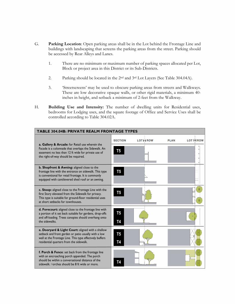
G. Parking Location: Open parking areas shall be in the Lot behind the Frontage Line and buildings with landscaping that screens the parking areas from the street. Parking should be accessed by Rear Alleys and Lanes.
1. There are no minimum or maximum number of parking spaces allocated per Lot, Block or project area in this District or its Sub-Districts.
2. Parking should be located in the 2nd and 3rd Lot Layers (See Table 304.04A).
3. ‘Streetscreens’ may be used to obscure parking areas from streets and Walkways. These are low decorative opaque walls, or other rigid materials, a minimum 40-inches in height, and setback a minimum of 2-feet from the Walkway.
H. Building Use and Intensity: The number of dwelling units for Residential uses, bedrooms for Lodging uses, and the square footage of Office and Service Uses shall be controlled according to Table 304.02A.
TABLE 304.04B: PRIVATE REALM FRONTAGE TYPES
a. Gallery & Arcade: for Retail use wherein the Facade is a colonnade that overlaps the Sidewalk. An easement no less than 12 ft wide for private use of the right-of-way should be required.
b. Shopfront & Awning: aligned close to the frontage line with the entrance on sidewalk. This type is conventional for retail frontage. It is commonly equipped with cantilevered shed roof or an awning.
c. Stoop: aligned close to the Frontage Line with the first Story elevated from the Sidewalk for privacy. This type is suitable for ground-floor residential uses at short setbacks for townhouses.
d. Forecourt: aligned close to the frontage line with a portion of it set back suitable for gardens, drop-offs and off-loading. Trees canopies should overhang onto the sidewalks.
e. Dooryard & Light Court: aligned with a shallow setback and front garden or patio usually with a low wall at the Frontage Line. This type effectvely buffers residential quarters from the sidewalk.
f. Porch & Fence: set back from the frontage line with an encroaching porch appended. The porch should be within a conversational distance of the sidewalk. Porches should be 8 ft wide or more.
T5
T5
T5
T5
T5
T4
T4
T4
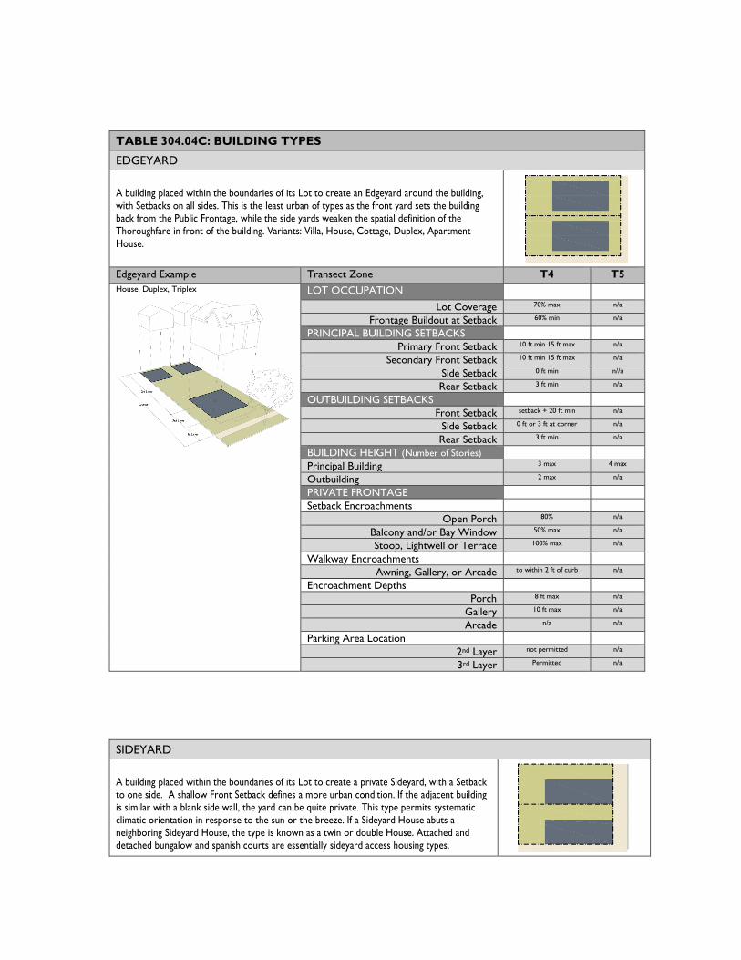
TABLE 304.04C: BUILDING TYPES
EDGEYARD
A building placed within the boundaries of its Lot to create an Edgeyard around the building, with Setbacks on all sides. This is the least urban of types as the front yard sets the building back from the Public Frontage, while the side yards weaken the spatial definition of the Thoroughfare in front of the building. Variants: Villa, House, Cottage, Duplex, Apartment House.
Edgeyard Example Transect Zone T4 T5 House, Duplex, Triplex
LOT OCCUPATION
Lot Coverage 70% max n/a
Frontage Buildout at Setback 60% min n/a
PRINCIPAL BUILDING SETBACKS
Primary Front Setback 10 ft min 15 ft max n/a
Secondary Front Setback 10 ft min 15 ft max n/a
Side Setback 0 ft min n//a
Rear Setback 3 ft min n/a
OUTBUILDING SETBACKS
Front Setback setback + 20 ft min n/a
Side Setback 0 ft or 3 ft at corner n/a
Rear Setback 3 ft min n/a
BUILDING HEIGHT (Number of Stories)
Principal Building 3 max 4 max
Outbuilding 2 max n/a
PRIVATE FRONTAGE
Setback Encroachments
Open Porch 80% n/a
Balcony and/or Bay Window 50% max n/a
Stoop, Lightwell or Terrace 100% max n/a
Walkway Encroachments
Awning, Gallery, or Arcade to within 2 ft of curb n/a
Encroachment Depths
Porch 8 ft max n/a
Gallery 10 ft max n/a
Arcade n/a n/a
Parking Area Location
2nd Layer not permitted n/a
3rd Layer Permitted n/a
SIDEYARD
A building placed within the boundaries of its Lot to create a private Sideyard, with a Setback to one side. A shallow Front Setback defines a more urban condition. If the adjacent building is similar with a blank side wall, the yard can be quite private. This type permits systematic climatic orientation in response to the sun or the breeze. If a Sideyard House abuts a neighboring Sideyard House, the type is known as a twin or double House. Attached and detached bungalow and spanish courts are essentially sideyard access housing types.
Sideyard Example Transect Zone T4 T5 Sideyard House
LOT OCCUPATION Lot Coverage 70% max 80% max
Frontage Buildout at Setback 60% min 80% min
PRINCIPAL BUILDING SETBACKS
Primary Front Setback 10 ft min 15 ft max 2 ft min 15 ft max
Secondary Front Setback 10 ft min 15 ft max 2 ft min 15 ft max
Side Setback 0 ft min 15 ft max 0 ft min 24 ft max
Rear Setback 3 ft min 3 ft min
OUTBUILDING SETBACKS
Front Setback setback + 20 ft min 40 ft max from rear
Side Setback 0 ft or 3 ft at corner 0 ft or 3 ft at corner
Rear Setback 3 ft min 3 ft max
BUILDING HEIGHT (Number of Stories)
Principal Building 3 max 4 max
Outbuilding 3 max 3 max
PRIVATE FRONTAGE
Setback Encroachments
Open Porch 80% n/a
Balcony and/or Bay Window 50% max 100% max
Stoop, Lightwell or Terrace 100% max 100% max
Walkway Encroachments
Awning, Gallery, or Arcade to within 2 ft of curb to within 2 ft of curb
Encroachment Depths
Porch 8 ft max n/a
Gallery 10 ft max 10 ft min
Arcade n/a 12 ft min
Parking Area Location
2nd Layer permitted not permitted
3rd Layer permitted permitted
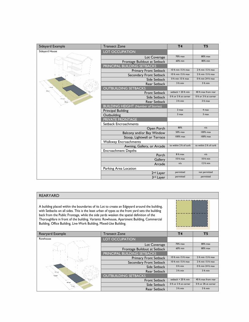
REARYARD
A building placed within the boundaries of its Lot to create an Edgeyard around the building, with Setbacks on all sides. This is the least urban of types as the front yard sets the building back from the Public Frontage, while the side yards weaken the spatial definition of the Thoroughfare in front of the building. Variants: Rowhouse, Apartment Building, Commercial Building, Office Building, Live-Work Building, Mixed-Use Building.
Rearyard Example Transect Zone T4 T5 Rowhouse
LOT OCCUPATION
Lot Coverage 70% max 80% max
Frontage Buildout at Setback 60% min 80% max
PRINCIPAL BUILDING SETBACKS
Primary Front Setback 10 ft min 15 ft max 2 ft min 15 ft max
Secondary Front Setback 10 ft min 15 ft max 2 ft min 15 ft max
Side Setback 0 ft min 0 ft min 24 ft max
Rear Setback 3 ft min 3 ft min
OUTBUILDING SETBACKS
Front Setback setback + 20 ft min 40 ft max from rear
Side Setback 0 ft or 3 ft at corner 0 ft or 3ft at corner
Rear Setback 3 ft min 3 ft min
Apartment Building Commercial Building
BUILDING HEIGHT (Number of Stories)
Principal Building 5 max 4 max
Outbuilding 3 max 3 max
PRIVATE FRONTAGE
Setback Encroachments
Open Porch 80% n/a
Balcony and/or Bay Window 50% max 100% max
Stoop, Lightwell or Terrace 100% max 100% max
Walkway Encroachments
Awning, Gallery, or Arcade to within 2 ft of curb to within 2 ft of curb
Encroachment Depths
Porch 8 ft max n/a
Gallery 10 ft max 10 ft min
Arcade n/a 12 ft min
Parking Area Location
2nd Layer not permitted not permitted
3rd Layer permitted permitted
COURTYARD
A building placed within the boundaries of its Lot to create a private Courtyard, while internally defining one or more private patios. Common walls shared with adjacent buildings create a continuous Facade along the Frontage Line that steadily defines the public Thoroughfare in front of the building. This is the most urban of types, as it is able to shield the private realm from all sides. Variants: Courtyard House, Courtyard Apartment Building.
Couartyard Example Transect Zone T4 T5 Courtyard House
LOT OCCUPATION
Lot Coverage 70% max 80% max
Frontage Buildout at Setback 60% min 80% max
PRINCIPAL BUILDING SETBACKS
Primary Front Setback 10 ft min 15 ft max 2 ft min 15 ft max
Secondary Front Setback 10 ft min 15 ft max 2 ft min 15 ft max
Side Setback 0 ft min 0 ft min 24 ft max
Rear Setback 3 ft min 3 ft min
OUTBUILDING SETBACKS
Front Setback setback + 20 ft min 40 ft max from rear
Side Setback 0 ft or 3 ft at corner 0 ft or 3 ft at corner
Rear Setback 3 ft min 3 ft min
BUILDING HEIGHT (Number of Stories)
Principal Building 4 max 5 max
Outbuilding 3 max 3 max
PRIVATE FRONTAGE
Setback Encroachments
Open Porch 80% n/a
Balcony and/or Bay Window 50% max n/a
Stoop, Lightwell or Terrace 100% max n/a
Walkway Encroachments
Awning, Gallery, or Arcade to within 2 ft of curb to within 2 ft of curb
Encroachment Depths
Porch 8 ft max n/a
Gallery 10 ft max 10 ft min
Arcade n/a 12 ft min
Parking Area Location
2nd Layer not permitted not permitted
3rd Layer permitted permitted
304.11 T4 and T5 Zones Development Standards Table 304.05, below, prescribes design and development regulations for the District:
"x" designates S that are not permitted in the Zone column.
"P" designates permitted uses in the Zone column.
“Numbers” designated Design Standards metrics in the Zone column.
“Y” in the Zone column means that the Detailed Standard applies. Letters in parenthesis in the “Additional Standards” column refer to regulations following Table 304.05.
“#” column corresponds with the numbers in illustration to regulations in the associated table.
TABLE 304.05: DEVELOPMENT STANDARDS
General Standards
Zone
Detailed Standards (see sections below) # T4 / T5
Lot and Density Standards Minimum Lot Width (ft.) 25 / 25 Maximum Floor Area Ratio (FAR) 2.0 / 4.0 (A)
Building Form and Location Building Height - Primary Building (Stories) 3 / 5 T5 Maximum 75-foot Height Building Height – Accessory Building (Stories) 2 / 3 T5 Maximum 45-foot Height Minimum Building Height (Number of Stories) 2 Minimum 1st Floor Ceiling Height, Non-Residential Uses (ft. clear) - Exceptions for unique operational characteristics
12 Meet City’s Building Code height requirements
Frontage Types (Table 304.10B.a-f) Y (B) Gallery & Arcade (More Urban – More Retail) x / P See Table 304.04B.a Shopfront & Awning x / P See Table 304.04B.b Stoop x / P See Table 304.04B.c Forecourt x / P See Table 304.04B.d Dooryard & Light Court P / P See Table 304.04B.e Porch & Fence (Least Urban – More Residential) P / x See Table 304.04B.f Build-to Lines and Setbacks (ft.)
Front (Principal Building) Minimum 10 / 0 - Y (D) Front (Principal Building) Maximum 15 – Y (D) Interior Side Minimum 0 – Y (D) Interior Side Maximum 10 - Y (D) Street Side (Principal) Maximum 10 / 10 - Y (C) Street Side (Secondary) Minimum 15 / 0 (C)
TABLE 304.05: DEVELOPMENT STANDARDS Rear Minimum 3 - Y (D)
Location of Parking Areas Y (E)
Other Standards Building Design and Signage Y (F) Upper Floor Outdoor Living Area (s/f per unit min.) 40 / 20 - Y (G) Outdoor Storage Y (H) Sewer Service and Adequate Public Facility Participation Agreements
Y (I)
Transitions Y (J) Transparency for Ground-floor Frontages, Non-Residential Uses
Y (K)
Additional Standards Accessory Structures Section 401.02, Accessory Building or Structures Exceptions to Height Limits Section 401.08, Exceptions to Height Limits Fences and Walls Section 401.09, Fences and Freestanding Walls Landscaping Section 404, Landscaping Lighting Article 405, Lighting Off-Street Parking No Parking Requirements unless granted by Exception. Loading Areas Section 401.03. Truck Dock, Loading, and Service Areas Outdoor Storage Section 401.10, Outdoor Storage Projections into Required Setbacks Section 401.04, Building Projections into Yards Screening Section 401.11, Screening Signs Article 409, Signs Swimming Pools Section 401.12, Swimming Pools and Spas Visibility at Driveways Section 401.15, Visibility at Intersections and Driveways
(Y) DETAILED STANDARDS – Zones T4 and T5
A. FAR for Mixed Use Buildings. The maximum allowable FAR is for buildings that contain a mix of residential and non-residential uses.
B. Principal Building Frontage Types. The Principal Building fronts onto the Primary Thoroughfare. This is the area between the private Building Facade and the public sidewalk, inclusive of its varying built and planted components. Frontage is divided into Private Frontage and Public Frontage. The combination of the private frontage, the public streetscape, and the types of thoroughfare defines the character of the majority of the public realm. The front of the building defines the building’s placement on the Lot, and how it is orientation towards the street includes the following types as specified on Table 304.04B Private Realm Frontage Types:
2. T4 General: Dooryards, Light Court, Porch and Fence.
C. Required Side and Rear Yards for Residential Uses. In order to provide light and air for residential units and additional separation for rooms that contain areas that require additional privacy considerations, the following minimum setbacks apply to any new building wall containing windows and facing an interior side or rear yard. The required setbacks apply to that portion of the building wall.
D. Maximum Building Setbacks. The street-facing facades of buildings must be located no farther from street-facing property lines than the maximum setback distance specified in Table 304.05. The following additional provisions apply:
1. Corner Properties. Where a property fronts on two or more streets, the maximum setback shall be met according to the following provisions.
a. Frontage on Two Primary Streets. New buildings on sites with frontage on two streets may be constructed to the maximum setback line on both frontages.
b. Frontage on Three or More Streets. Properties with frontage on three or more streets must build to the maximum Build-to Lines of at least two of the streets.
2. Building Additions. For any addition to a building that increases the width of a street-facing facade, 100 percent of the addition should be located on or within the maximum setback until the maximum setback standard for the entire building is met, or to meet the intent section, §304.5, of this Article.
3. Exceptions to Building Placement Requirements. The following exceptions to the Build-to Lines requirement are permitted.
a. Outdoor Eating Areas. Where an outdoor eating area will be installed on the street frontage, a portion of the building may be set back up to 12 feet farther than the maximum setback line, if at least 40 percent of the building facade is at the Primary frontage Build-to Line.
E. Location of Parking. In this District, §304.10.G and Tables 304.04A-C apply, as off-street parking areas should be set in the 2nd and 3rd Lot Layers, in the rear of the Lot and set back a minimum of 25 feet from the Primary Street Frontage.
1. There are no minimum or maximum number of parking spaces allocated per Lot, Block or project area in this District or its Sub-Districts.
2. Streetscreens should be used for any parking spaces located in the 1st Lot Layer.
3. Exceptions may be granted for short-term customer parking and drop-off spaces.
4. Exceptions may be granted for participating in a public-private partnership car share program focusing on providing access to/from the train depot area.
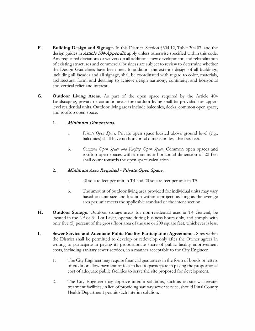
F. Building Design and Signage. In this District, Section §304.12, Table 304.07, and the design guides in Article 304-Appendix apply unless otherwise specified within this code. Any requested deviations or waivers on all additions, new development, and rehabilitation of existing structures and commercial business are subject to review to determine whether the Design Guidelines have been met. In addition, the exterior design of all buildings, including all facades and all signage, shall be coordinated with regard to color, materials, architectural form, and detailing to achieve design harmony, continuity, and horizontal and vertical relief and interest.
G. Outdoor Living Areas. As part of the open space required by the Article 404 Landscaping, private or common areas for outdoor living shall be provided for upper-level residential units. Outdoor living areas include balconies, decks, common open space, and rooftop open space.
1. Minimum Dimensions.
a. Private Open Space. Private open space located above ground level (e.g., balconies) shall have no horizontal dimension less than six feet.
b. Common Open Space and Rooftop Open Space. Common open spaces and rooftop open spaces with a minimum horizontal dimension of 20 feet shall count towards the open space calculation.
2. Minimum Area Required - Private Open Space.
a. 40 square feet per unit in T4 and 20 square feet per unit in T5.
b. The amount of outdoor living area provided for individual units may vary based on unit size and location within a project, as long as the average area per unit meets the applicable standard or the intent section.
H. Outdoor Storage. Outdoor storage areas for non-residential uses in T4 General, be located in the 2nd or 3rd Lot Layer, operate during business hours only, and comply with only five (5) percent of the gross floor area of the use or 200 square feet, whichever is less.
I. Sewer Service and Adequate Pubic Facility Participation Agreements. Sites within the District shall be permitted to develop or redevelop only after the Owner agrees in writing to participate in paying its proportionate share of public facility improvement costs, including sanitary sewer services, in a manner acceptable to the City Engineer.
1. The City Engineer may require financial guarantees in the form of bonds or letters of credit or allow payment of fees in lieu to participate in paying the proportional cost of adequate public facilities to serve the site proposed for development.
2. The City Engineer may approve interim solutions, such as on-site wastewater treatment facilities, in lieu of providing sanitary sewer service, should Pinal County Health Department permit such interim solution.
3. All requests for improvements to existing residential properties within the District that do not include a commitment or assurance to participate in a proportionate share of the public facility improvements shall conform to the Base Zoning District development standards for setbacks, lot coverage and other requirements.
a. The City may approve a waiver to encroach into the required setback area or exceed the lot coverage for additions and improvements which:
i) Conform to Maricopa Station Design Guidelines;
ii) Comply with current Pinal County Health requirements for improving existing septic systems to accommodate the proposed improvements;
iii) Meet outdoor screening and storage requirements of this Code;
iv) Comply with the minimum development standards of the most comparable residential zone of this Code based on existing lot size and dimensions.
J. Transitional Standards. Where this T4 General Sub-District adjoins an RS District, the following standards apply:
1. The maximum height within 20 feet of an RS District is 30 feet. From this point, the building height may be increased to the maximum building height.
2. The building setback from an RS District boundary shall be 25 feet for interior side and rear yards.
K. Transparency on Ground Floor Frontages for Non-Residential Uses. Windows, doors, or other openings should be provided for at least 50 percent of the building wall area located between three and seven feet above the elevation of the sidewalk. No wall may run in a continuous plane for more than 20 feet maximum without an opening or an exception (see number three (#3) listed below). Openings fulfilling this requirement shall have transparent glazing and provide views into work areas, display areas, sales areas, lobbies, or similar active spaces, or into window displays that are at least three feet deep.
1. Exception for Structured Parking Facilities. Multi-level parking garages, where permitted, are not required to meet the ground-floor transparency requirement.
2. Sites with Multiple Buildings. On sites that contain multiple buildings, the building ground-floor transparency requirement does not need to be met in buildings located in Lot Layers two (2) or three (3) or behind other buildings and not visible from the adjacent public street.
3. Reduction through Development Plan Review. The transparency requirement may be reduced or waived for proposed uses that have unique operational
characteristics with which providing the required windows and openings is incompatible, such as in the case of a theater.
L. Truck Docks, Loading, and Service Areas. Truck docks, loading, and service areas are permitted within the 3rd Lot Layer on Rear Alley and Lanes. In addition, such loading and service areas must be located on the side or rear of buildings and may not face a public street or a private street functioning as a public road.
M. Pedestrian Access. A system of pedestrian walkways shall connect all buildings on a site to each other, to on-site automobile and bicycle parking areas, to sidewalks, and to any on-site open space areas or pedestrian amenities. Direct and convenient access shall be provided to adjoining blocks to the maximum extent feasible while still providing for safety and security.
1. Walkways shall be a minimum of six feet wide, hard-surfaced, and paved with concrete, stone, tile, brick, or comparable material.
2. Where required walkways cross driveways, parking areas, or loading areas, it must be clearly identifiable through the use of a raised crosswalk, a different paving material, or similar method.
3. Where a required walkway is parallel and immediately adjacent to an auto travel lane, it must be raised or separated from the auto travel lane by a raised curb, bollards, or other physical barrier.
304.12 Signage Signage shall be designed according to City Code, §2204 General Sign Regulations, with design standards in Table 304.07 per specific sign types permitted by-right or by Exception as indicated for each T4 and T5 Sub-District, unless otherwise specified in this code:
A. All signage should not exceed 30 square feet total per each Primary Building frontage per every 50-linear feet;
B. No back or box lit signage is allowed throughout the District. Goose neck, down lit lighting is encouraged;
C. Address Signs (Table 304.07.a) should be made easily visible through the use of colors or materials that contrast with their background and should be attached to the Facade or Principal Entrance of the unit they identify;
D. Awning Signage (Table 304.07.b) should be limited to no more than seventy percent (70%) of the Valance of the awning or the vertical portion of a dome awning. The height of the Valance should not exceed twelve (12) inches;
E. One (1) Blade Sign (Table 304.07.c) are permitted for each business if the Facade is no more than five (5) feet from the Principal Frontage Line. Blade Signs may encroach into the Public Frontage up to four (4) feet, shall clear the Sidewalk by at least eight (8) feet,
and shall not encroach above the bottom of any second Story windows. Blade Signs are permitted only for businesses that have a Principal Entrance on the first Story;
F. One (1) Nameplate (Table 304.07.d) per address limited to three (3) square feet and consisting of either a panel or individual letters applied to a building wall, may be attached to a building wall within ten (10) feet of a Principal Entrance
G. Outdoor Display Cases (Table 304.07.e) shall not exceed six (6) square feet with use of colors, materials that contrast with their background and/or down lit lighting should be used for illumination;
H. One (1) Wall Sign (Table 304.07.f) limited to 90% of the width of the building Facade shall be permitted for each building;
I. Window Signs (Table 304.07.g) shall not interfere with the primary function of windows, which is to enable passersby and public safety personnel to see through windows into premises and view product displays;
J. Murals Signs (Table 304.07.h) allowed only by Exception, are intended to promote community pride and celebrate Maricopa’s rich cultural heritage through an outdoor visual arts program. Murals should not contain the business name, logo, and/or other branding;
K. One (1) single- or double-post Yard Sign (Table 304.07.i) may be temporarily placed with the Private Frontage of each business. Yard Signs shall be set back from the Frontage Line six (6) feet for less than 60-days per year;
M. Rooftop Signage, allowed only by Exception, should not exceed six (6) feet in height above the maximum Primary Building height.
TABLE 304.07: SIGNAGE TYPES a. Address Sign: Quantity: 1 per address; Area: 2 sf Max; Width: 24 in Max; Height: 12 in Max; Apex: N/A; Depth/Projection: 3 in Max; Clearance: 4.5 ft Min; Letter Height: 6 in Max.
b. Awning Sign: Quantity: 1 per Window.; Area: N/A; Width: Width of Awning; Height: N/A; Apex: N/A; Depth/Projection: 4 ft Max; Clearance: 8 ft Min; Letter Height: 5 in Min / 10 in Max.
c. Blade Sign: Quantity: 1 per Façade, 2 Max; Area: T4 - 13 sf / T5 6 sf Max; Width: 4 ft Max; Height: 4 ft Max; Apex: N/A; Depth/Projection: 3 in Max; Clearance: 8 ft Min; Letter Height: 8 in Max.
d. Nameplate Sign: Quantity: 1 per Facade; Area: 3 sf Max; Width: 18 in Max; Height: 2 ft Max; Apex: 7 ft Max; Depth/Projection: 3 in Max; Clearance: 4 ft Min; Letter Height: N/A.
e. Outdoor Displace Case: Quantity: 1 per Facade; Area: 6 sf Max; Width: 3.5 ft Max; Height: 3.5 ft Max; Apex: N/A; Depth/Projection: 5 in Max; Clearance: 4 ft Min; Letter Height: N/A.
f. Wall Sign: Quantity: 1 per Façade/2 for Corner.; Area: 1.5 sq ft per Linear ft of Facade; Width: 90% of Façade Max.; Height: 3 ft Max; Apex: N/A; Depth/Projection: 7 in Max; Clearance: 7 ft Min; Letter Height: 18 in Max. (By Exception in T4)
g. Window Sign: Quantity: 1 per Window; Area: 25% of Glass Max; Width: Varies; Height: Varies; Apex: N/A; Depth/Projection: N/A; Clearance: 4 ft Min; Letter Height: 8 in Max. (By Exception in T4)
h. Mural Sign – Visual Arts Exhibit: Quantity: 1 per Story Wall Face; Area: 75% of a Single Story Wall Max; Width: Varies; Height: Varies; Apex: First Story; Depth/Projection: N/A; Clearance: N/A; Letter Height: 8 in Max. (Intended to Promote a Cultural Arts Program and Not Advertisement. Allowed By Exception Only)
i. Yard Sign - Temporary:.Quantity: 1 per Lot Max.; Area: 6 sf Max; Width: 24 in Max; Height: 12 in Max; Apex: N/A; Depth/Projection: 3 in Max; Clearance: 4.5 ft Min; Letter Height: 6 in Max. (Limited to 60 Days per Year. No Internal Lighting. Allowed By Exception Only)
T5
T5
T5
T5
T5
T5
T4
T4
T4
T4
T4
T4
T5
T4
T5
T4
T4
T5
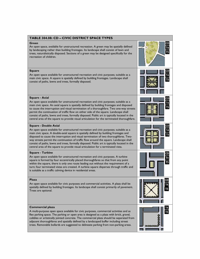
304.13 Public Realm: CD – Civic District Design Standards Civic Districts may be developed as public open spaces or public buildings as follows:
A. Civic Spaces may be designed as generally described and diagrammed on Table 304.08. These are provided for illustrative purposes only. Specific designs may be prepared in accordance to the descriptions for each type;
B. Civic Space designed as a Green, Square, or Plaza shall have a minimum of 50% of its perimeter fronting onto a Thoroughfare. Other configurations may be exempt.
C. Civic Building Uses may be determined by the intent of the abutting Transect-Based Zoning District intent.
TABLE 304.08: CD – CIVIC DISTRICT SPACE TYPES Green An open space, available for unstructured recreation. A green may be spatially defined by landscaping rather than building frontages. Its landscape shall consist of lawn and trees, naturalistically disposed. Sections of a green may be designed specifically for the recreation of children.
Square An open space available for unstructured recreation and civic purposes; suitable as a main civic space. A square is spatially defined by building frontages. Landscape shall consist of paths, lawns and trees, formally disposed.
Square - Axial An open space available for unstructured recreation and civic purposes; suitable as a main civic space. An axial square is spatially defined by building frontages and disposed to cause the interruption and visual termination of a thoroughfare. Two one-way streets permit the continuation of traffic flow on either side of the square. Landscape shall consist of paths, lawns and trees, formally disposed. Public art is typically located in the central area of the square to provide visual articulation for the terminated thoroughfare.
Square - Double Axial An open space available for unstructured recreation and civic purposes; suitable as a main civic space. A double-axial square is spatially defined by building frontages and disposed to cause the interruption and visual termination of two thoroughfares. Two-way streets permit the continuation of traffic flow around the square. Landscape shall consist of paths, lawns and trees, formally disposed. Public art is typically located in the central area of the square to provide visual articulation for a terminated vista. Square - Turbine An open space available for unstructured recreation and civic purposes. A turbine square is formed by four eccentrically placed thoroughfares so that from any point within the square, there is only one route leading out without the requirement of a turn; four terminated vistas are created. A turbine square disperses through traffic and is suitable as a traffic calming device in residential areas.
Plaza An open space available for civic purposes and commercial activities. A plaza shall be spatially defined by building frontages. Its landscape shall consist primarily of pavement. Trees are optional.
Commercial plaza A multi-purpose open space available for civic purposes, commercial activities and as flex parking space. The parking or open area is designed as a plaza with brick, gravel, cobbles or artistically jointed concrete. The commercial plaza should be separated from adjacent thoroughfares and spatially defined by a landscaped buffer including street trees. Removable bollards are suggested to delineate parking from non-parking areas.
Playground or Pocket Park An open space, available for unstructured recreation. A pocket park provides greenery and a place to sit outdoors and is typically spatially defined by buildings because in most cases it is located within a block. Pocket parks may be created around a monument, historic marker or art project and/or may be designed specifically for the recreation of children.
Court A semi-public open space available for unstructured recreation by those occupying the adjacent buildings. Access to abutting residential lots is from a sidewalk that circumnavigates a central landscaped area. Landscaping consists of lawn and trees, formally disposed. May include ornamental species.
Close A semi-public open space available for unstructured recreation by those occupying the adjacent buildings. A close is circumnavigated by a one-way thoroughfare with parking on one side. Landscape includes lawn and trees, formally disposed. May include ornamental species.
304.14 Review of Plans Permit and review procedures should follow the standards in this Article, and design and approval criteria listed in the APPENDIX, Maricopa Station Overlay section. There are two types of permitted deviations from the requirements:
A. Exception and Variance
1. Exception
a. Requests for Exception(s) shall only be permitted as specifically indicated in this Chapter.
b. To apply for an Exception, the applicant shall provide the following:
i. The specific Exception(s) requested including citation from this Chapter and why the Exception(s) is being sought.
ii. Maps, text, drawings, and/or statistical data related to the requested Exception(s).
c. No Exception(s) shall be approved unless the Zoning Administrator finds the approval would:
i. Be consistent with Section §304.05 Intent section of this Chapter,
ii. And be consistent with the goals, objectives, and policies of the General Plan, Redevelopment Area Plan and the Appendix Design Guidelines for Maricopa Station.
d. Any decision regarding an approval or denial of an Exception shall state, in writing, the reasons for the approval or denial.
e. If the Zoning Administrator denies any requested Exception, the applicant may appeal, refer to Section §502.14.
2. Variance
a. A Variance shall be processed pursuant to City Code.
b. The following standards and requirements shall not be available for Variances:
i. The maximum dimensions of traffic lanes;
ii. the required provision of Rear Alleys or Lanes and/or;
iii. the maximum dimensions for parking lanes, spaces, and lots.
B. Administrative Adjustment. The Zoning Administrator has the discretion to approve any Regulating Plan conformance review, Streetscape, Site and/or Building Plan that deviates less than ten (10) percent from any specific numerical standard prescribed in this Article.
1. The following development or activities shall be exempt from the provisions of this Article:
a. Ordinary repairs for the purpose of building, signage, lighting or premises maintenance.
b. Construction within the interior of the structure not visible from the exterior of the building.
c. Emergency repairs ordered by any code enforcements official in order to protect health and safety.
304.15 Definitions This list of definitions is in addition to Article 101.01 List of Definitions and apply to this Article 304 unless otherwise specified in this code:
Address Sign: a sign, generally applied to a building wall, that displays a building’s address.
Administrative Review: the process by which the Community Development Department reviews submitted Regulating, streetscape, site and/or building plans to determine compliance with this regulating document and design guidelines.
Allee: a regularly spaced and aligned row of trees usually planted along a Thoroughfare or Path.
Apex: the highest point of a sign as measured from the point on the ground where its structure is located, or, if no sign structure is present, from the point on the ground directly below the sign itself.
Arcade: a Private Frontage conventional for Retail use wherein the Facade is a colonnade supporting habitable space that overlaps the Sidewalk, while the Facade of the First Story remains at the Frontage Line.
Avenue: a Thoroughfare of high vehicular capacity and low to moderate speed, acting as a short distance connector between urban centers, and usually equipped with a landscaped median.
Awning: an ancillary lightweight structure of wood, metal, or canvas, cantilevered from a building facade and providing shade to the fenestration and spatial containment to the pedestrian.
Band Sign: a sign that is attached flat on the exterior front, rear or side wall of any building or other structure. (Syn: wall-mounted sign, fascia sign)
Bed and Breakfast: an owner-occupied Lodging type offering 1 to 5 bedrooms, permitted to serve breakfast in the morning to guests.
Blade Sign: a sign mounted on the building Facade, projecting at a 90-degree angle.
Block: an aggregate land area circumscribed by Thoroughfares.
Block Face: the aggregate of all the Principal Frontage Lines, or alternatively the building Facades, on one side of a Block.
Canopy: the extent of the outer layer of leaves of an individual tree or group of trees.
Canopy Density: the general permeability of a Tree Canopy to light as a characteristic of branch number and structure; Canopy Density can either be Full (>50%) or Open (<50%).
Canopy Shape: the general shape of the outer layer of leaves of an individual tree as structured by the tree’s branches.
Civic: the term defining not-for-profit organizations dedicated to arts, culture, education, recreation, government, transit, religious, and municipal parking.
Civic Building: a building operated by not-for-profit organizations dedicated to arts, culture, education, recreation, government, transit, and municipal parking, or for use approved by Development Services. A Civic Building is owned by a municipal or governmental body.
Civic Space: an outdoor area permanently dedicated for public use. Civic Space types are defined by the combination of certain physical constants including the relationships among their intended use, size, landscaping and surrounding buildings.
Civic Sub-District: designation for public sites dedicated for Civic Buildings and/or Civic Space.
Clearance: the height above the walkway, or other surface if specified, of the bottom edge of an element.
Common Yard: a planted Private Frontage wherein the Facade is set back from the Frontage Line. The yard is visually continuous with adjacent yards.
Coordinated Frontage: a condition where the landscape and paving of Public Frontage and Private Frontage are coordinated as a single, coherent design.
Court: an open space enclosed wholly or partly by buildings or circumscribed by a single building.
Courtyard: a building placed within the boundaries of its Lot to create a private Courtyard, while internally defining one or more private patios.
Cultivar: a cultivated variety of Street Tree; deliberately selected for its desirable physical characteristics.
Dooryard: a private Frontage type with a shallow setback and front garden or patio usually with a low wall at the Frontage Line to effectively buffer residential quarters from the sidewalk while removing the private yard from public encroachment.
Duplex: a building with two (2) side by side units on a Lot.
Edgeyard: a building placed within the boundaries of its Lot to create an Edgeyard around the building, with Setbacks on all sides.
Effective Turning Radius: the measurement of the turning radius at a corner taking parked cars into account.
Elevation: an exterior wall of a building not along a Frontage Line. See Façade in §101.01.
Encroach: to break the plane of a vertical or horizontal regulatory limit with a structural element, so that it extends into a Setback, into the Public Frontage, or above a height limit.
Forecourt: a Private Frontage wherein a portion of the Facade is close to the Frontage Line and the central portion is set back.
Frontage, Space: the area between a building Facade and the vehicular lanes of a Thoroughfare, inclusive of its built and planted components. Frontage is divided into Private Frontage and Public Frontage.
Frontage Line: a Lot line bordering the Public Frontage and where minimum Lot Width is measured. Facades facing Frontage lines define the public realm and are therefore more regulated than the Elevations facing other Lot Lines.
Gallery: a Private Frontage conventional for Retail use wherein the Facade is aligned close to the Frontage Line with an attached cantilevered shed or lightweight colonnade overlapping the Sidewalk.
Goosneck Lighting: a down-lit illumination of signage set on an outpost usually attached to a wall or post.
Green: a Civic Space type available for unstructured recreation, spatially defined by landscaping.
Greenway: an Open Space Corridor in largely natural conditions which may include trails for bicycles and pedestrians.
Inn: a Lodging type, offering 6 to 12 bedrooms, permitted to serve breakfast in the mornings to guests.
Light Court: a Private Frontage type that is a below-grade entrance or recess designed to allow light into basements.
Liner Building: a building specifically designed to mask a Parking Structure from a Frontage.
Live-Work, Building: a Mixed-Use unit consisting of a Commercial and Residential Use. The Commercial Use may be anywhere in the unit. It is intended to be occupied by a business operator who lives in the same structure that contains the Commercial activity. (Syn: shophouse)
Lodging: premises available for daily and weekly renting of bedrooms.
Longitudinal: a type of pavement marking with lines set parallel to the Public Frontage, repeating in a sequence across the entire width of the vehicular lanes of a Thoroughfare to demarcate a pedestrian Crosswalk.
Lot Layer: a range, 1 – 3, of depth of a Lot within which certain elements are permitted.
Main Civic Space: the primary outdoor gathering place for a community. The Main Civic Space is often, but not always, associated with an important Civic Building.
Outbuilding: a secondary building usually located toward the rear of the same Lot as a Principal Building such as a garage, carport, or workshop and may include an Accessory Unit.
Outdoor Display Case: a sign consisting of a lockable metal or wood framed cabinet with a transparent window or windows, mounted onto a building wall or freestanding support. It allows the contents, such as menus or maps, to be maintained and kept current.
Park Strip: the section of the Public Frontage accommodating Street Trees and other landscape, Public Infrastructure, and Public Furniture.
Parking Structure: a building containing one or more Stories of parking above grade.
Passage: a pedestrian connector, open or roofed, that passes between buildings to provide shortcuts through long Blocks and connect rear parking areas to Frontages.
Path: a pedestrian way traversing a Greenway or rural area, with landscape matching the contiguous Open Space, ideally connecting directly with the urban Sidewalk network.
Paver: a masonry block of various material and/or size.
Planter: a three (3) foot deep recessed soil bed provided for the planting of Street Trees and kept open to air and water flow through landscaping or permeable Pavers.
Planting Technique: the prescribed method for planting Streets Trees; either in a continuous Planter or Tree Pit.
Plaza: a Civic space type designed for Civic purposes and Commercial activities in the more urban Sub-Districts, generally paved, spatially defined by buildings, and internal to or part of a Block.
Pocket Park: a Civic Space type of limited size available for unstructured recreation and may be designed as a playground; normally located internal to a Block.
Porch and Fence: a facade is set back from the frontage line with an encroaching porch appended. The porch should be within a conversational distance of the sidewalk while a fence at the frontage line maintains the demarcation of the yard.
Primary Frontage: the Private Frontage designed to bear the address and Principal Entrance(s) of a building.
Principal Building: the main building on a Lot.
Principal Entrance: the main point(s) of access for pedestrians into a building or unit within a building.
Private Frontage: the first Lot Layer and the Facade of a building.
Public Frontage: the area between the edge of the vehicular lanes of a Thoroughfare and the Frontage Line of private Lots and Civic Spaces.
Public Furniture: equipment provided by City of Maricopa for the comfort or convenience of pedestrians.
Public Lighting: a type of Public Infrastructure necessary for the illumination of Public Frontages and Thoroughfare intersections.
Rear Alley: a vehicular way located to the rear of Lots providing access to service areas, parking and Outbuildings and containing utility easements. Rear Alleys should be paved from building face to building face., with an inverted crown for drainage at the center.
Rear Lane: a vehicular way located to the rear of Lots providing access to service areas, parking and Outbuildings and containing utility easements. Rear Lanes may be lightly paved to Driveway standards. The streetscape consists of gravel or landscaped edges, has no raised Curb, and is drained by percolation.
Rearyard: A building placed within the boundaries of its Lot to create a Rearyard, leaving the rear of the Lot as private space or available for dedicated parking.
Regulating Plan: a Zoning Map or set of maps that shows the Sub-Districts, Thoroughfares, and Block Lengths subject to regulation under the Maricopa Station Overlay District.
Rowhouse: a single or multi-unit building that shares a party wall with another of the same type and a Facade along 100% of the Frontage Line.
Shared Parking: an accounting for parking spaces that are available to more than one Function.
Shopfront: a commercial store entrance aligned close to the frontage line with the entrance on sidewalk. It is commonly equipped with cantilevered shed roof or an awning.
Sidewalk Sign: a movable freestanding sign that is typically double-sided, placed at the entrance to a business to attract pedestrians. (Var: sandwich board, A-frame sign.
Square: a Civic Space designed for unstructured recreation and Civic purposes, circumscribed by Thoroughfares, spatially defined by building Frontages, and consisting of Paths and/or Sidewalks, lawn and trees, formally disposed.
Stoop: a Private Frontage wherein the Facade is aligned close to the Frontage Line with the first Story elevated from the Sidewalk for privacy, with an exterior stair and landing at the entrance.
Sub-District: one of several areas on the Zoning Map regulated as part of the Heritage Overlay District. Sub-Districts are administratively similar to the land use zones in conventional codes, except that in addition to the usual building use, Density, height, and Setback requirements, other elements of the intended habitat are integrated, including those of the private Lot and building and Public Frontage.
Streetscreen: a freestanding barrier built along the Frontage Line, or coplanar with the Façade to mask a parking lot from a Thoroughfare, provide privacy to a sideyard, and/or strengthen the spatial definition of the public realm. These are opaque and may be a combination of materials, landscaping, and/or architectural structures.
Terminated Vista: a location at the axial conclusion of a Thoroughfare. A building located at a Terminated Vista designated should be designed in response to its unique position at a visual termination point.
Transect: a cross-section of the environment showing a range of different habitats. The Transect of human habitat types used in this Code is divided into four Transect Zones. These zones describe the physical form and character of a place, according to the Density and intensity of its land use and Urbanism.
Transverse: a type of pavement marking consisting of two (2) parallel lines set perpendicular to the Public Frontage extending across the entire width of the vehicular lanes of a Thoroughfare to demarcate a pedestrian Crosswalk.
Triplex: a building with three (3) side by side units on a Lot.
Valance: the portion of an awning that hangs perpendicular to the Sidewalk.
Walkway: the section of the Public Frontage dedicated exclusively to pedestrian activity.
Window Sign: a sign placed or painted on the interior of a Shopfront window or the window of a business door.
Yield Street: characterizing a Thoroughfare that has two-way traffic but only one effective travel lane because of parked cars, necessitating slow movement and driver negotiation.