A Semantic INSPIRE-Conform Transformation of A Cadastre Conform 3D Building Model of Bavaria Robert Roschlaub 1 , Joachim Batscheider 2 1 Bavarian Agency for Digitisation, High-Speed Internet and Surveying, Germany - [email protected]2 [email protected]Abstract With the directive 2007/2/EC of the European Parliament and of the Council establishing an Infrastructure for Spatial Information in the European Community (INSPIRE) spatial data are to provide in an interoperable way. The dataset of 3D- Building Models created in the federal states is assigned to annex III of the INSPIRE Directive for the data specification of buildings (INSPIRE-BU). In Germany the dataset of 3D-Building Models is created in two levels of detail, based on nationwide standards of the AdV. This work is done by the German federal states. So This work is licensed under the Creative Commons Attribution-Non commercial Works 3.0 License. To view a copy of this license, visit http://creativecommons.org/licenses/by-nc-nd/3.0/ or send a letter to Creative Commons, 543 Howard Street, 5 th Floor, San Francisco, California, 94105, USA.
Transcript
A Semantic INSPIRE-Conform Transformation of A Cadastre Conform 3D Building Model of Bavaria
Robert Roschlaub1, Joachim Batscheider2
1Bavarian Agency for Digitisation, High-Speed Internet and Surveying, Germany - [email protected]
With the directive 2007/2/EC of the European Parliament and of the Council establishing an Infrastructure for Spatial Information in the European Community (INSPIRE) spatial data are to provide in an interoperable way. The dataset of 3D-Building Models created in the federal states is assigned to annex III of the INSPIRE Directive for the data specification of buildings (INSPIRE-BU).
In Germany the dataset of 3D-Building Models is created in two levels of detail, based on nationwide standards of the AdV. This work is done by the German federal states. So there are some special details in the datasets. For example in Bavaria the building ground plans are taken from the official cadastral map.
Both models are based on the OGC-CityGML standard. So it was obvious to check the possibility to convert the data to an INSPIRE conform schema. For the conversion of the 3D-Building Models in Level of Detail 2 to INSPIRE, the project Group “3D-Geobasisdaten” of the AdV created an initial mapping table on the basis of AdV-CityGML-profile and GeoInfoDok 7.0 beta. To make the schematic transformation operational, the 100 percent compliance of the source data to the source schema is required. The AdV-project group “3D-Geobasisdaten” and the
This work is licensed under the Creative Commons Attribution-Non commercial Works 3.0 License. To view a copy of this license, visit http://creativecommons.org/licenses/by-nc-nd/3.0/ or send a letter to Creative Commons, 543 Howard Street, 5th Floor, San Francisco, California, 94105, USA.
“Central Office for House Coordinates, Building Polygons and 3D Building Models” (ZSHH) jointly developed the respective criteria for data in LoD1 and LoD2. The tests for 3D Building-Models in the levels of detail one and two to check conformity of schema and profile as well as geometric and semantic data checks defined by the AdV have been implemented. During the operational work at the Bavarian Agency for Digitisation, High-Speed Internet and Surveying it was shown, that errors are detected reliably. In extension of this work a joint research project of the Bavarian State Agency for Surveying and Geoinformation and the technical university of munich (TUM), Chair of Geoinformatics, provided proof of convertibility of 3D-Building Models on AdV-Standards to INSPIRE specifications by converting a sample dataset.
Keywords: Cadastre, INSPIRE, CityGML, LoD2
1. INTRODUCTION
In Germany surveying and mapping is assigned to the states. Therefore, nationwide projects need close cooperation and commitment by the states. “The Cadastral and Surveying Authorities of the states, which are responsible for the real estate cadastre and state survey (Official German Surveying and Mapping), cooperate within the Working Committee of the Surveying Authorities of the States of the Federal Republic of Germany (AdV, URL: http://www.adv-online.de) to discuss technical issues of fundamental and nationwide importance targeting standardized regulations.” This includes the determination of common standards for the acquisition of 3D Building Models across Germany.
The surveying authorities of the states intend to build up a nationwide dataset of 3D Building Models based on a specialized schema (Gruber et al., 2014). In 2010, the AdV intended to offer a nationwide and uniform so called first detailed level (Level of Detail 1 – LoD1) dataset of Building-Models from 2013 on. In the LoD1 data model, buildings are uniformly represented as blocks with a flat roof. The so called Level of Detail 2 (LoD2) is showing the buildings with standardized prototype roofs (figure 1).
In 2012, AdV decided a product standard for 3D Building Models. According to that, the building ground plans are derived from the official digital cadastral map and the buildings are uniformly represented as blocks with a flat roof in LoD1.
Since mid-2013, a German-wide dataset of LoD1 objects is built up and offered to clients at the Central Office for House Coordinates, Building Polygons and 3D Building Models (ZSHH), which is a central cross-national distribution agency. This central distribution agency is located at the government of the district Köln of North Rhine-Westphalia (LA Geobasis, 2011). From 2019 on the ZSHH will be situated at the Bavarian Agency for Digitisation, High-Speed Internet and Surveying in Munich.
Meanwhile, all federal states of Germany finished the production of 3D-Building-Models in LoD1. Currently, almost all of the states are establishing 3D-Building-Models in LoD2. The declared goal is to complete the first calculation of the LoD2 for the whole of Germany on 1. January 2019.
The data exchange between the states and the central service center uses a nationwide uniform profile of the AdV based on the City Geography Markup Language (CityGML) encoding standards from OpenGIS® and the Open Geospatial Consortium (OGC) Specification CityGML 1.0.0. (AdV, 2015a).
This AdV-CityGML-profile is also designed for the delivery of building data with standardized roof shapes in LoD2 with optional photo-realistic textures (figure 2).
Figure 1: 3D Building Models in LoD2 with the cadastre map from Augsburg
Figure 2: LoD2 with photo-realistic textures and a Digital Orthophoto from Augsburg
Independently from the data collection method and the underlying dataset an update after the first acquisition of a 3D-Building Model has to be ensured. This requires a comprehensive concept containing the first acquisition, the data management and the update process combined in one workflow.
With the directive 2007/2/EC of the European Parliament and of the Council establishing an Infrastructure for Spatial Information in the European Community (INSPIRE) coming to effect in the year 2007 and its nationwide implementation in the federal states, there are to provide digital geospatial data in an interoperable way (Janowsky et al., 2010). The dataset of 3D-Building Models created in the federal states is assigned to annex III of the INSPIRE Directive for the data specification of buildings (INSPIRE-BU).
In addition to the own target of the states to create a uniform dataset of 3D-Building Models in two levels of detail, based on nationwide standards of the AdV, it is obvious to check the possibility to convert the data to an INSPIRE conform schema early.
For the conversion of the 3D-Building Models in LoD2 to INSPIRE, the project Group “3D-Geobasisdaten” of the AdV created a first mapping table on the basis of AdV-CityGML-profile and GeoInfoDok 7.0 beta. In extension of this work a joint research project of the Bavarian State Agency for Surveying and Geoinformation and the technical university of munich (TUM), Chair of Geoinformatics, provided proof of convertibility of 3D-BuildingModels on AdV-standards to INSPIRE by a sample (Aringer et al. 2015). The test plan and test specifications committed by the project Group “3D-Gebasisdaten” of the AdV together with the ZSHH was to be examined and applied as well.
The task is to map the 3D-Building Models, based on AdV-CityGML-profile considering GeoInfoDok 7.0 to an INSPIRE compliant schema. The review of GeoInfoDok 7.0 beta was finished in April 2014. Nevertheless it will be necessary to continue analyzing these documents to discover bugs or ambiguities in the INSPIRE specifications, the AdV-CityGML profile or the GeoInfoDok in terms of the coming transformation of the schemata in order to initiate an update of such a document if necessary. The production of 3D-Building Models in the LoD2 has already started in most of the federal states in Germany. If an inconsistency would have been found it would have been useful to cause an update of the software in use without changing documents to reduce faulty 3D Building Models. In the joint research project the special mapping table of the AdV was examined and a concept for the transformation was developed and implemented as a prototype. First, the extraction of the data and the concept of updating and data management will be described. Later on the elements of the semantic transformation to INSIRE will be explained.
2. CONCEPT FOR A SEMANTIC TRANSFORMATION OF 3D BUILDINGS TO INSPIRE
The basics for changing the aquired 3D-Building Models to INSPIRE by schematic transformation (Aringer et al., 2015) are (figure 3):
A necessary precondition is the availability of documentation about the schemata of source and target and the rules for transformation between these schemata. On the basis of these documents the schematic transformation can be implemented or can be generated automatically (e.g. (Staub et al., 2008), (Kutzner and Eisenhut, 2010), (Fichtinger, 2011)) if machine-interpretable schemata and transformation rules exist. The transformation tool will produce target data and a report with statistical information about the dataset transformed from the source data.
Another request for a correct transformation is the compliance of the source data to the source schema and sometimes to further quality criteria. Such quality criteria can be a test specification. On the basis of this specification a test tool for the source data can be implemented or can be created automatically if machine-interpretable test criteria exist (Donaubauer et al., 2010). The test tool creates a report with information about faulty objects and statistics about the tested data. So only correct data are passed to the schematic transformation tool.
Assuming that only correct data are passed to the schematic transformation tool and the transformation rules are correct it is not necessary to have a complex test tool for the target data or a complex event handler within the schematic transformation tool. The correct coding of the target data is ensured by a validation of the schema. Based on this concept a joint research project transformed an AdV-CityGML-Profile-based test data set of Bavarian LoD2 Building Models into an INSPIRE-compliant schema. The components of the concept will be shown in the following text.
Figure 3: Concept of schematic transformation of 3D Building Models to INSPIRE
2.1. AdV CityGML for Building Models
Source schema of the shown transformation of 3D Building Models is the AdV CityGML standard in the recent version (AdV, 2015a). The AdV CityGML is limiting the general CityGML specification version 1.0 (Gröger et al., 2008) to represent the standard of the AdV Building Model (AdV, 2013). This means, among other things that only the CityGML modules Building, Generics (some extension of Attributes not covered by CityGML standard) and Appearance is allowed. All the other CityGML modules for representation of e.g. vegetation, water or traffic are not part of the AdV CityGML schema. There are also further restrictions in the allowed CityGML Modules. In the module Building of the AdV-Profile only LoD1 and LoD2 are allowed. The attributes function and measuredHeight are not optional but obliged. Further on the elements of the building envelope have to be grouped to RoofSurface-, WallSurface-, GroundSurface- and ClosureSurface-Objects. The AdV profile defines not only
limitations of standard CityGML but also some extensions. These extensions are Application Domain Extensions (ADE) (see 2.2) but with fix generic attributes. The aim of this extension is to keep quality information for single building objects. The generic attributes like origins of the roof height, address and ground level as well as the reference point of the roof is stored as codes defined in the AdV profile.
2.2. Target schema: INSPIRE Data Specification on Buildings / CityGML INSPIRE ADE
The INSPIRE-directive defines deadlines for providing INSPIRE conform data coming from the Implementing Rules on interoperability of spatial data sets and services. But there is no specification for a data-model of specific themes. For providing INSPIRE conform data additional regulations are applicable. These regulations give detailed information about nature and scope of the data content e.g. by definition of object types or mandatory attributes. There is also the “Technical Guidance” for each theme. The Technical Guidance is not legally binding but contains e.g. complete data models and technical details. For 3D Building Models combined with the digital terrain model (DTM) the INSPIRE Technical Guidelines for height (annex II) and Building Models (Annex III) have to be considered. The documents “D2.8.II.1 Data Specification on Elevation” and “D2.8.III.2 Data Specification on Buildings” are relevant as well. This specification was published on December 13th 2013 and came to effect retroactively as of October 2013. For the directive new gathered or updated data defined in annex II or III were to be provided in an interoperable way until 2015. The other data have to be provided until 2020. Actually the German nationwide dataset of Building Models in LoD1 would have to be provided in an interoperable way for the requirements of the INSPIRE directive until 2020.
To deal with various applications for the use of building information as well as with different types of building data for the European Union, four profiles were defined, which are different in the scope of semantically and geometrically representable information (figure 4).
Figure 4: Profiles of the INSPIRE specifcation for Building Models. Figure modified from (Gröger and Plümer, 2014)
The profile “Core 2D” for 2D- and 2.5D-Building data is only containing basic semantic information. These are defined in the abstract application schema BuildingsBase. The profile “Core 3D” is based on the semantic of BuildingsBase as well, but it is extending BuildingBase by concepts for three dimensional representation of building envelope in the levels of detail from one to four which are matching the definition of CityGML. The profiles “Core 2D” and “Core 3D” constitute the normative part of the INSPIRE Building Model.
The application schema BuildingsExtendedBase and the derived schemata BuildingsExtended2D and BuildingsExtended3D are capable for modelling much more comprehensive semantic information (Gröger and Plümer ,2014).
The INSPIRE specification does not require a special data format for the transfer of data, but it defines GML (ISO 19136) as default coding and provides XML schema files for validation. That format is called “INSPIRE BU”. Specifically, (Gröger and Plümer, 2014) since the two 3D profiles of the specification of Building Models are based strongly on CityGML and many tools for processing CityGML data already exist, the INSPIRE specification provides an extension of the CityGML standard as an option for coding. This is done by a so called CityGML Application Domain Extension (ADE). For all concepts (classes, attributes, geometries and constraints) in this CityGML INSPIRE ADE (Gröger et al., 2013) which are as well part of CityGML as part of INSPIRE the concepts of CityGML are used. Those concepts from the INSPIRE Building Model which are not existing in CityGML for the ADE the elements from INSPIRE are taken. For example there is the INSPIRE specific common attribute inspireID which is a unique identifier for objects. The attributes beginLifespanVersion and endLifespanVersion are defined to represent timestamps of transactions. Also
the conditionOfConstruction is defined to store the condition of buildings like planned, under construction, in use etc. An important difference to CityGML is the use of complex data types for thematic attributes. For example, by the use of the complex data type elevation besides the scalar height value it is possible to specify at which part of the building the height was measured (e.g., highestEave for the highest part of the eave of a building or generalRoof for the average height of the roof).
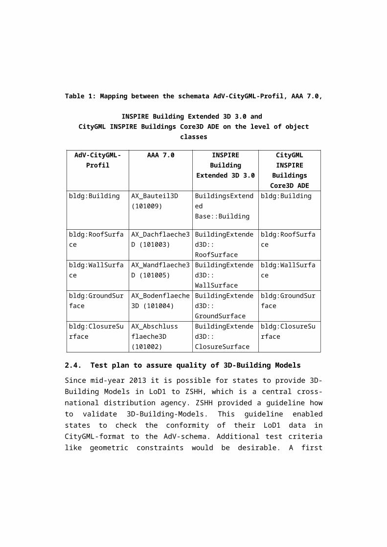
The basis for a model-based transformation of the schema is the availability of transformation rules on the level of the underlying schemata. To transform 3D-BuildingModels in LoD2 to INSPIRE, the AdV-project group “3D-geo base data” developed a mapping table based on the AdV-CityGML-profile and GeoInfoDok 7.0 beta (AdV, 2015b). Originally, the mapping table included all classes of the CityGML building module and their correlates in the AAA-model according to the GeoInfoDok 7.0 and to the INSPIRE Data Specification on Buildings (Profil BuildingsExtended3D) and was expanded with a mapping to the CityGML INSPIRE ADE Core 3D standard within the research project described in this paper. Table 2 shows exemplary the mapping between schemata on the level of the most important object classes. Important to note is 1:1 mapping between the classes of the schema. One consequence is the resulting low complexity of the schema transformation.
Table 1: Mapping between the schemata AdV-CityGML-Profil, AAA 7.0, INSPIRE Building Extended 3D 3.0 and
CityGML INSPIRE Buildings Core3D ADE on the level of object classes
2.4. Test plan to assure quality of 3D-Building Models
Since mid-year 2013 it is possible for states to provide 3D-Building Models in LoD1 to ZSHH, which is a central cross-national distribution agency. ZSHH provided a guideline how to validate 3D-Building-Models. This guideline enabled states to check the conformity of their LoD1 data in CityGML-format to the AdV-schema. Additional test criteria like geometric constraints would be desirable. A first approach to test CityGML city models is provided by the validation software CityDoctor of the University of Applied Science in Stuttgart (Wagner et al., 2014).
The LA Geobasis commissioned the state North-Rhine Westphalia to provide a quality assurance plan for the data in LoD1 and 2 of the German states. This measure was to ensure conformity between the data of the different states and to enable the transfer into the database at ZSHH. The software component should allow for quality assurance at the level of the states providing data as well as at ZSHH receiving data.
The AdV-project group “Geobasisdaten” and ZSHH jointly developed the respective criteria for data at LoD1 and 2. The test criteria defined in the test plan were developed based on experience in building the data bases and the experience in cooperating within ZSHH. The test criteria can be categorized as follows:
Test of schema: Conformity of the dataset with the XML-schema. Profile conformity: Conformity of the dataset with the profiles of AdV, i.e. e.g.
existence and correct configuration of the generic attributes defined in the AdV-CityGML-profile, non-redundant saving of geometry, no fragmentation of building parts in further parts.
Geometry: Check of geometry, is the frame closed (waterproof)? Are the height specified in the attribute “measuredHeight” and the height of the building geometry the same?
Semantics: Are all vertical surfaces modelled as wall surfaces (WallSurface-object)?
All criteria are listed in (AdV, 2015c). The test plan version 1.2 dated from 28.01.2015 was included in the statement of work in the tender of ZSHH for a testing software, after the decision of LA Geobasis to tender the software. Since September 2015, the test software for quality assurance of 3D-Building-Models is available for at ZSHH before data enter the database as well as for the states to check data. In the meantime, the test plan was updated to version 1.3; it is expected that the extended test procedure will be implemented.
Unified tests for semantic and geometry are currently defined by OGC in the “CityGML Quality Interoperability Experiment”. The AdV project group “Geobaisdaten” will be required to implement the results into the test protocol and eventually enhance with the specifics of the AdV-CityGML-profile.
The test protocol is discussed in the working group quality of the SIG-3D. As the discussions of the working group quality of the SIG-3D regarding test protocols are used in the “CityGML Quality Interoperability Experiment” of the OGC, that itself is responsible for the definition of unified test criteria, e.g. for semantic and geometry.
2.5. The test routine
The tests for 3D Building-Models in the LoD1 and 2 to check conformity of schema and profile as well as geometric and semantic data checks defined by the AdV have been implemented with FME software (FME 2017) as so called FME Workbenches In FME software transforming data is organized as so called „FME-Workspace“ which integrates reading, writing and a sequence of analyzing and transforming processes (con terra, 2015). Result of the test routine is an Excel file with one sheet listing all faulty elements per test criteria. On an additional sheet there is an error statistic as well. The next table is showing excerpts of the error statistic for a dataset of LoD2 Building models produced by the Bavarian Agency for Digitisation, High-Speed Internet and Surveying. The column “error type” is showing numbers defined in the proof plan of the AdV. In the column “Filename” there is the dataset where the error was found. The shown numbers of the proof plan represent geometric tests like:
Are all Building-Model solids water proof? Are all Building models free of self intersections? Are all surfaces planar? Are all normal vectors directed to outside?
Are all wall surfaces vertical?
The column “Errors (percent)” is showing the percentage of objects with the particular error. In this example 6.6 % of the 424 Building Models or 0.3 % of the 2655 wall surfaces in the tested dataset are faulty in that way.
Table 2: Example for an error statistic for a LoD2 dataset
File name
FeatureType Error type code
Errors(perce
nt)4485_5490 Building
3110_3120_3140_3310.. 6.6
4485_5490
WallSurface Error code 3150 0.3
All tests could be implemented with FME software. During the operational work at the Bavarian Agency for Digitisation, High-Speed Internet and Surveying it was shown, that errors are detected reliably but the runtime for testing big data should be improved.
2.6. Transformation of the schema
Before implementing the transformation of the schema was possible, the mapping table provided by the AdV was reviewed for completeness and accuracy of the transformation rules between CityGML 1.0 AdV profile and INSPIRE by a joint research project of the Bavarian State Agency for Surveying and Geoinformation and the TUM, Chair of Geoinformatics. It turned out, that the rules were not described machine-interpretable. For example it was not clear, whether the table contents meant the UML data model or the derived XML schemata.
Also the transformation rules were not precise enough for some attributes. This applies to some attributes, in which simple data types from the source schema must be mapped to complex data types from the INSPIRE schema. For example the CityGML-name attribute which type is CharacterString has to be mapped to the INSPIRE-name attribute that is GeographicalName-type which is quite complex. Also it is necessary for some attributes to create mapping lists for values because of different value ranges between the schemata. Exemplarily this
applies to the attributes “verticalGeometryEstimatedAccuracy” and “hori-zontalGeometryEstimatedAccuracy” in the target schema which is a scalar value with the type length but in the source schema it is a code describing the estimated accuracy. The following table shows an example of a corresponding part from source-data and target-data. In that example the source-data are providing the code “1000” which means data gathered by LiDAR. The target-schema is requesting a scalar value. In the example it is set to 0.2m. This is done by a value assignment list.
Table 3: Code example to compare attributes for geometric accuracy.
Additional value assignment lists are required to complete the transformation rules for following attributes or coded lists:
“DatenquelleBodenhoehe” is mapped to “verticalGeometry Reference3DBottom” and it is not clear whether the attributes “Lowest Floor Above Ground” or “Bottom of Construction” would be not be the better choice. The attribute “function” is mapped to “currentUse”. The attribute “RoofTypeTypeAdV” corresponds to ”roofType Value” and “Datenquelle Bodenhoehe” is mapped to “ElevationReferenceValue”.
The rules coming from the mapping tables were implemented as FME-Workbench. The FME-Workbench can read CityGML data in LoD1 and LoD2, which comply to the CityGML 1.0 AdV profile and the proof plan for Building-Models. Also the FME-Workbench is transforming the read data to CityGML INSPIRE ADE BuildingsCore3D. Since the mapping table, as described above, is not complete, it was necessary to make some assumptions for a correct mapping or, in case of missing value mapping lists dummy-values were set. In the practical work of the transformation an inconsistency in the XML-files of the INSPIRE-schema was detected. The INSPIRE BU XML-schema is importing other INSPIRE XML schemata, which import additional INSPIRE XML schemata that
are based on different versions of the INSPIRE Data Specification. The different versions of the schema have different namespace URIs abbreviations. But in INSPIRE instance documents they should have identical namespace prefixes. To work around this problem, the INSPIRE-schemata were modified. The FME-Workbench only works correctly with this modified INSPIRE-schema. For validating the XML-files of the transformed data the original INSPIRE-schema was used. Using the XML-schema files of the “CityGML INSPIRE ADE” did not cause further problems for the standard component to export CityGML with the FME software.
At the same time with the research cooperation reported here, there was a Bachelor thesis (Popp, 2015) at TU München. in which the default coding „INSPIRE BU“ instead of CityGML INSPIRE ADE was tested. The FME-Workbench was more complex because not only semantic but also geometric transformations had to be done. This was necessary because the Building-Models of the source data consist not only of the building-envelope, but also the terrain intersecting line (lod2TerrainIntersection). The CityGML-Writer component of the FME software can handle that. The INSPIRE-GML component of FME software cannot.
2.7. Storage of the 3D Buildings
The data is stored centrally on a relational database with the open source database solution “3D City Database (3DCityDB)”. With a database schema (profile) the user has the possibility to create a CityGML conformal data model in the database. The general CityGML profile was further specified by the AdV for a German-wide standardized acquisition of 3D-Building Models. 3D-Building models created with these specifications in the AdV-CityGML-profile can be imported with a Java based im- and exporter into the database and exported and visualized in KML and COLLADA format. Additionally, in Bavaria a FME Workbench is used to offer the customers more data export formats like 3D shape, dxf, 3ds and Trimble SketchUp format skp. Since CityGML is an international standard and several software companies have implemented products and interfaces for the geoinformation market a longtime sustainability of this interface can be expected.
3. CONCLUSION
It could be shown that the transformation to the INSPIRE schema „INSPIRE BU“ and „CityGML INSPIRE ADE“ of 3D-Building-Models from those provided by the German States based on LiDAR, Dense Image Matching or the cadastre is possible with the mapping table from the AdV and commercial software tools. The concept developed aims at analyzing the source data to the corresponding test specification. As a consequence, the transformation can be quite simple because complex handling of errors and exceptions is obsolete.
The evidence from the research on schematic transformation exemplarily shows the required clarifications of mapping table results in the update of mapping table and FME-Worksbench by the AdV “Projektgruppe 3D-Geobasisdaten”. Especially mappings for simple data types in the source schema to complex data types in the target schema were added. Also missing value assignment lists for some attributes and code lists were created. The FME-Workbench based on “CityGML INSPIRE ADE” was adapted and checked using data from some German states. The surveying administrations of the German states started early in applying international standards to capture nationwide semantic 3D-Building-Models. The studies described herein show that using the international standardized data format CityGML as well by the AdV for the national schema as by the INSPIRE working group for defining the INSPIRE specification for Building Models, is supporting the ability to transform the data. The chosen process ensures that the INSPIRE for 2020 requirements can be achieved. The necessary actions for a nationwide application still need to be decided by the AdV.
4. REFERENCES
AdV (2015). Produktstandard für 3D-Gebäudemodelle 1071R3, at http://www.adv-online.de/AdV-Produkte/Standards-und-Produktblaetter/Standards-der-Geotopographie/, [accessed 14 March 2017].
AdV (2014). Dokumentation zur Modellierung der Geoinformationen des amtlichen Vermessungswesens (GeoInfoDok), Version 7.0 beta, data on file.
AdV (2015a). AdV-CityGML-Profile für 3D-Gebäudemodelle Ergebnisse der PG 3D-Gebäudemodelle der AdV, 17.01.2015, at http://www.adv-online.de/AdV-Produkte/Standards-und-Produktblaetter/Standards-der-Geotopographie/, [accessed 14 March 2017].
AdV (2015b). Mapping-Tabelle für AAA-CityGML1.0, 22.05.2015, at http://www.adv-online.de/AdV-Produkte/Standards-und-Produktblaetter/Beispielsammlungen/, [accessed 14 March 2017].
AdV (2015c). Prüfplan 3D-Gebäudemodelle in der Version 1.4, at http://www.adv-online.de/AdV-Produkte/Standards-und-Produktblaetter/Beispielsammlungen/, [accessed 14 March 2017].
Aringer, K., Donaubauer, A.; Kolbe, T.H., Roschlaub, R. (2016). Modellbasierte Transformation von 3D-Gebäudemodellen nach INSPIRE – erste Ergebnisse, In: zfv - Zeitschrift für Geodäsie, Geoinformation und Landmanagement, 141(3), pp. 184-191.
con terra (2015). FME Desktop, Wichmann.
Donaubauer, A., Kutzner, T., Gnägi, H. R., Henrich, S., Fichtinger, A. (2010). Webbasierte Modelltransformation in der Geoinformatik, Modellierung 2010, Gesellschaft für Informatik, pp. 269-284.
Fichtinger, A. (2011). Semantische Transformation im Kontext von INSPIRE – dargestellt am Beispiel der grenzüberschreitenden Bodenseeregion, Dissertation, Technische Universität München.
FME (2017). http://www.safe.com/fme/fme-desktop/, [accessed 16 March 2017].
Gröger, G., Kolbe, T.H., Czerwinski, A., Nagel, C. (2008). OpenGIS City Geography Markup Language (CityGML) Encoding Standard, Open Geospatial Consortium.
Gröger, G.; Kutzner, T.; Kolbe, T.H. (2013). A CityGML-based encoding for the INSPIRE Data Specification on Buildings, INSPIRE Conference 2013.
Gröger, G., Plümer, L. (2014). Das Gebäudemodell der Initiative INSPIRE, In: zfv - Zeitschrift für Geodäsie, Geoinformation und Landmanagement, 139(2), pp. 90-102.
Gruber, U., Riecken, J., Seifert, M. (2014). Germany on the Way to 3D-Cadastre. In: zfv - Zeitschrift für Geodäsie, Geoinformation und Landmanagement, 139(4), pp. 223-228.
INSPIRE (2013). INSPIRE Thematic Working Group Buildings: D2.8.III.2 Data Specification on Buildings – Draft Technical Guidelines, Version 3.0rc3, 2013.
Janowsky von, D., Ludwig, R., Roschlaub, R., Streuff, H. (2010). Geodateninfrastrukturrecht in Bund und Ländern, Kommunal- und Schulbuchverlag, Wiesbaden.
Kutzner, T., Eisenhut, C. (2010). Vergleichende Untersuchungen zur Modellierung und Modelltransformation in der Region Bodensee im Kontext von INSPIRE, Technische Universität München, at http://mediatum.ub.tum.de/doc/1223763/166974.pdf, [accessed 14 March 2017].
LA Geobasis (2011). Anlage zum Beschluss 2/4 des Lenkungsausschusses Geobasis vom 12.04.2011 über die Einrichtung einer Zentralen Stelle für die Bereitstellung von Hauskoordinaten und Hausumringen, geändert durch Beschluss 4/1 des Lenkungsausschuss Geobasis vom 01.12.2011.
Popp, L. (2015). Semantische Transformation von 3DGebäudedaten nach INSPIRE, Bachelorarbeit im Studiengang Geodäsie und Geoinformation, Technische Universität München.
Roschlaub, R., Batscheider, J (2016). An INSPIRE-conform 3D Building Model of Bavaria using Cadastre Information, LiDAR and Image Matching, ISPRS - International Archives of the Photogrammetry, Remote Sensing and Spatial Information Sciences, Volume XLI-B4, pp.747-754.
Staub, P., Gnägi, H.R., Morf, A. (2008). Semantic Interoperability through the Definition of Conceptual Model Transformations, Transactions in GIS 12, pp. 193-207.
Wagner, D., Kolbe, T.H., Coors, V. (2014). Spezifikation von Prüfplänen und Prüfergebnissen zur Validierung von 3D-Stadtmodellen. In: DGPF Tagungsband 23.