Lyell, the Geikies and Croll’s observations on terrestrialglacial sediments and landforms
James ROSE1,2
1 Department of Geography, Royal Holloway University of London, Egham TW20 0EX, UK.2 British Geological Survey, Keyworth, Nottingham, NG12 5GG, UK.Corresponding author. Email: [email protected]
ABSTRACT: Within the context of the work and achievements of James Croll, this paper reviews therecords of direct observations of glacial landforms and sediments made by Charles Lyell, Archibald andJames Geikie and James Croll himself, in order to evaluate their contributions to the sciences of glacialgeologyandQuaternary environmental change. The paperoutlines the social and physical environment ofCroll’s youth and contrasts thiswith the status and experiences of Lyell and theGeikies. It also outlines thecharacter and role of the ‘Glasgow School’ of geologists, who stimulated Croll’s interest into the causes ofclimate change and directed his focus to the glacial and ‘interglacial’ deposits of central Scotland. Con-tributions are outlined in chronological order, drawing attention to: (i) Lyell’s high-quality observationsand interpretations of glacial features in Glen Clova and Strathmore and his subsequent rejection of theglacial theory in favourof processes attributed to floating icebergs; (ii) the significant impact of ArchibaldGeikie’s 1863 paper on the ‘glacial drift of Scotland’, which firmly established the land-ice theory; (iii) thefact that, despite JamesCroll’s inherent dislike of geologyand fieldwork, he provided high-quality descrip-tions and interpretations of the landforms and sediments of central Scotland in order to test his theory ofclimate change; and (iv) the great communication skills of James Geikie, enhanced by contacts andevidence from around the world. It is concluded that whilst direct observations of glacial landformsand sediments were critical to the long-term development of the study of glaciation, the acceptance ofthis theory was dependent also upon the skills, personality and status of the Geikies and Croll, who devel-oped and promoted the concepts. Sadly, the subsequent rejection of the land-ice concept by Lyell resultedin the same factors challenging the acceptance of the glacial theory.
James Croll’s life (1821–1890) spanned a periodwhich sawmajordevelopments in our understanding of the science of the Earth,and he, Charles Lyell (1797–1875), Archibald Geikie (1835–1924) and James Geikie (1839–1915) all made significantcontributions to these developments, especially with respect toglaciation. Briefly, Charles Lyell initially gave his reputationand status to the concept of land-ice glaciation (Lyell 1840) asproposed by Louis Agassiz in 1840 (although Lyell subsequentlyrejected this view and reverted to the belief that icebergs andfloods could produce evidence now attributed to glaciation;Lyell 1875); Archibald Geikie wrote the first clear, coherent andauthoritative reviewof glacial deposits in theBritish Isles (Geikie,A. 1863) and subsequently steered this science through his profes-sorship in Geology at Edinburgh University and Director, thenDirector General of the British Geological Survey; James Crollintroduced physical principles to our understanding of climatechange (as opposed to biblical and geological mechanisms) andJames Geikie gave the glacial theory global status and authoritythroughhis definitive (for the time) text onTheGreat IceAge (Gei-kie, J. 1894), his role in establishing the Scottish GeographicalSociety in 1884 (given Royal status by Queen Victoria in 1887)and his activities as President of the Society from 1904 to 1910.
The background, connections, experience and knowledge ofthese individuals varied. Lyell and the Geikies inherited a privi-leged education and travelledwidely (including visits to currentlyglaciated areas). In contrast, Croll attended the local villageschool and was largely self-educated. Croll was initiallyemployed as a wheelwright, tea merchant and temperancehotelier before becoming janitor at the Andersonian Institutein Glasgow in 1859 and then administrator at the GeologicalSurvey in Edinburgh in 1867. Furthermore, their achievementswere variously acknowledged. Both Lyell and Archibald Geikiereceived knighthoods and JamesGeikiewas appointed to the dis-tinguished Murchison Chair of Geology at the University ofEdinburgh and President of the Royal Scottish GeographicalSociety, whereas James Croll, although he was elected a Fellowof the Royal Society, had a career that was diminished by illhealth and acute modesty. He ended his life in virtual povertyhaving been refused an appropriate pension by the Civil Service.Nevertheless, all valued the landscape and geology (althoughCroll actually denied an interest in geology; Irons 1896, p. 14,see below), and this shaped their thoughts and provided the evi-dence to test of their concepts. Common to all is the region ofcentral Scotland, especially the Glasgow area and the region
Earth and Environmental Science Transactions of the Royal Society of Edinburgh, 1–14, 2021
https://doi.org/10.1017/S1755691021000116Downloaded from https://www.cambridge.org/core. IP address: 65.21.228.167, on 14 Nov 2021 at 16:33:08, subject to the Cambridge Core terms of use, available at https://www.cambridge.org/core/terms.
that extends E of Glasgow to Edinburgh and NE to the Vale ofStrathmore.
5wThis paper explores theways that JamesCroll, theGeikies andCharles Lyell related to the field evidence (glacial sediments andlandforms) for glaciation and Quaternary climate change. It placestheir work in the context of: (i) Croll’s cultural, geographical andgeological heritage, and (ii) the little acknowledged, but very distin-guished ‘Glasgow School’ of glacial geologists who influencedCroll’s geological thinking. It then examines the records of field evi-dence presented by Croll, the Geikies and Lyell for the existence of‘land-ice’ glaciation and interglacials, and the ways this evidencewas used to develop an acceptable concept for Quaternary glaci-ation, glacial geomorphology and Quaternary Science.
Croll’s contribution to the glacial theorywas the introduction ofa theory of climate variability based on changes in the Earth’sorbit. This allowed predictions of the frequency and timing of cli-matic changes with glacial episodes interrupted by interglacialperiods (Croll 1875; Imbrie & Imbrie 1986). Over the time whenCroll and colleagues did their work there was little discussion ofthe concept of an interglacial other than a period of time inwhich the climate, environment, fauna and flora were not glacial,and the sea level was different from the present. It was not until thepublication of the third edition of James Geikie’s The Great IceAge (Geikie, J. 1894) that the concept of glaciation and interglacialwas given a structure that would be considered applicable today.
1. Croll’s cultural, geographical and geologicalheritage
James Croll’s early history iswell reported because it was unusualfor such a distinguished scientist (Irons 1896). He grew up in the
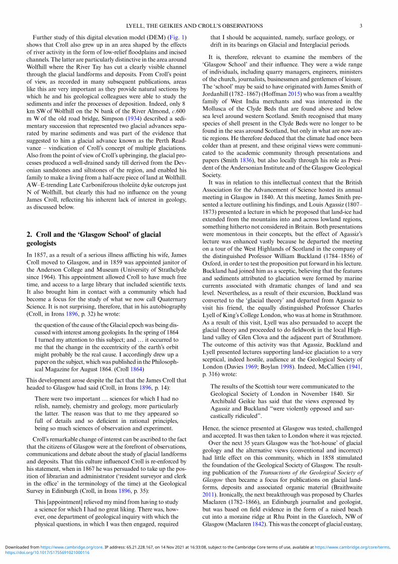
village of Wolfhill, N of Perth, in the Vale of Strathmore, in anarea that contains a fascinating glacial history (Fig. 1). Althoughthere is no direct evidence to suggest that he was directly influ-enced by this glacial landscape, it is interesting to reflect thatso much of what he believed has since been demonstrated fromthe area of his upbringing.
Around Wolfhill, the Vale of Strathmore is an area of very lowrelief. To the E it shows SW–NE trending lineaments which arelow-relief glacier bedforms/elongate drumlins, demonstrating theSW to NE flow of a powerful ice stream across this part of theregion. To the Wof Wolfhill the texture of the landscape is alsolineated, but in this case the lineaments are less elongate andhave a SW–NE trend in the S, changing gradually to an E–Wtrend further N. These are also glacier bedforms, but in this casethey form classic, if relatively small and low relief, drumlins, indi-cating less dynamic ice movement. At the northern margin ofStrathmore, and in the adjacent Highland boundary region, thelineaments show both elongate and rounded forms. Here, theytrend NW–SE at the N, changing progressively to E–W furtherS. Many have a promontory at the W end, indicating a bedrockhill. Similar forms exist in the Sidlaw Hills at the S side of theVale of Strathmore, alsowith abedrock hill at theWend and a dis-tinctive ‘tail’ to the E. These also are glacier bedforms but with aresistant bedrock obstruction allowing them to be defined as cragand tail, and indicate that ice moved out of the southern Gram-pian Highlands from the NW then eastwards towards themouth of the River Tay. Croll, therefore, grew up in an area ofcomplex glacial activity with, at the later stages of glaciation bythe last Scottish ice sheet, Highland ice streaming from the NWto the E to be replaced as the ice thinned, by western central Scot-tish ice streaming N-eastwards towards the Aberdeenshire coast.
Figure 1 ADEM (NEXTMap Britain data from Intermap technologies Inc. were provided courtesy of NERC via the NERC Earth Observation DataCentre) of the western end of Strathmore and the lower Tay valley and firth. The figure shows the location of Wolfhill where James Croll spent his child-hood, and Perth, which was his nearest town. The glacial landforms of the area of Croll’s upbringing are illustrated by a northern light source showingglacial lineaments across the entire region except the lowlands around the Firth of Tay. The lineaments in Strathmore consist of elongate and squat drum-lins formed by a SW–NE ice movement, and the lineaments in the Highland Boundary region and the Sidlaw Hills are crag-and-tail relating to resistantbedrockobstructions. The channel and floodplain of the rivers TayandAlmond are also shown, alongwithAlmondbankwhere a succession of glacial andmarine deposits provide evidence for two episodes of glaciation and the designation of the Perth Readvance (see text for further details).
2 JAMES ROSE
https://doi.org/10.1017/S1755691021000116Downloaded from https://www.cambridge.org/core. IP address: 65.21.228.167, on 14 Nov 2021 at 16:33:08, subject to the Cambridge Core terms of use, available at https://www.cambridge.org/core/terms.
Further study of this digital elevation model (DEM) (Fig. 1)shows that Croll also grew up in an area shaped by the effectsof river activity in the form of low-relief floodplains and incisedchannels. The latter are particularly distinctive in the area aroundWolfhill where the River Tay has cut a clearly visible channelthrough the glacial landforms and deposits. From Croll’s pointof view, as recorded in many subsequent publications, areaslike this are very important as they provide natural sections bywhich he and his geological colleagues were able to study thesediments and infer the processes of deposition. Indeed, only 8km SWof Wolfhill on the N bank of the River Almond, c.600m W of the old road bridge, Simpson (1934) described a sedi-mentary succession that represented two glacial advances sepa-rated by marine sediments and was part of the evidence thatsuggested to him a glacial advance known as the Perth Read-vance – vindication of Croll’s concept of multiple glaciations.Also from the point of viewof Croll’s upbringing, the glacial pro-cesses produced a well-drained sandy till derived from the Dev-onian sandstones and siltstones of the region, and enabled hisfamily to make a living from a half-acre piece of land at Wolfhill.AW–E-trending Late Carboniferous tholeiite dyke outcrops justN of Wolfhill, but clearly this had no influence on the youngJames Croll, reflecting his inherent lack of interest in geology,as discussed below.
2. Croll and the ‘Glasgow School’ of glacialgeologists
In 1857, as a result of a serious illness afflicting his wife, JamesCroll moved to Glasgow, and in 1859 was appointed janitor ofthe Anderson College and Museum (University of Strathclydesince 1964). This appointment allowed Croll to have much freetime, and access to a large library that included scientific texts.It also brought him in contact with a community which hadbecome a focus for the study of what we now call QuaternaryScience. It is not surprising, therefore, that in his autobiography(Croll, in Irons 1896, p. 32) he wrote:
the question of the cause of theGlacial epochwas being dis-cussedwith interest among geologists. In the spring of 1864I turned my attention to this subject; and … it occurred tome that the change in the eccentricity of the earth’s orbitmight probably be the real cause. I accordingly drew up apaperon the subject, whichwas published in the Philosoph-ical Magazine for August 1864. (Croll 1864)
This development arose despite the fact that the James Croll thatheaded to Glasgow had said (Croll, in Irons 1896, p. 14):
There were two important … sciences for which I had norelish, namely, chemistry and geology, more particularlythe latter. The reason was that to me they appeared sofull of details and so deficient in rational principles,being so much sciences of observation and experiment.
Croll’s remarkable change of interest can be ascribed to the factthat the citizens of Glasgow were at the forefront of observations,communications and debate about the study of glacial landformsand deposits. That this culture influenced Croll is re-enforced byhis statement, when in 1867 he was persuaded to take up the pos-ition of librarian and administrator (‘resident surveyor and clerkin the office’ in the terminology of the time) at the GeologicalSurvey in Edinburgh (Croll, in Irons 1896, p. 35):
This [appointment] relieved mymind from having to studya science for which I had no great liking. There was, how-ever, one department of geological inquiry with which thephysical questions, in which I was then engaged, required
that I should be acquainted, namely, surface geology, ordrift in its bearings on Glacial and Interglacial periods.
It is, therefore, relevant to examine the members of the‘Glasgow School’ and their influence. They were a wide rangeof individuals, including quarry managers, engineers, ministersof the church, journalists, businessmen and gentlemen of leisure.The ‘school’may be said to have originated with James Smith ofJordanhill (1782–1867) (Hoffman 2015) whowas from awealthyfamily of West India merchants and was interested in theMollusca of the Clyde Beds that are found above and belowsea level around western Scotland. Smith recognised that manyspecies of shell present in the Clyde Beds were no longer to befound in the seas around Scotland, but only in what are now arc-tic regions. He therefore deduced that the climate had once beencolder than at present, and these original views were communi-cated to the academic community through presentations andpapers (Smith 1836), but also locally through his role as Presi-dent of theAndersonian Institute and of theGlasgowGeologicalSociety.
It was in relation to this intellectual context that the BritishAssociation for the Advancement of Science hosted its annualmeeting in Glasgow in 1840. At this meeting, James Smith pre-sented a lecture outlining his findings, and Louis Agassiz (1807–1873) presented a lecture in which he proposed that land-ice hadextended from the mountains into and across lowland regions,something hitherto not considered in Britain. Both presentationswere momentous in their concepts, but the effect of Agassiz’slecture was enhanced vastly because he departed the meetingon a tour of the West Highlands of Scotland in the company ofthe distinguished Professor William Buckland (1784–1856) ofOxford, in order to test the proposition put forward in his lecture.Buckland had joined him as a sceptic, believing that the featuresand sediments attributed to glaciation were formed by marinecurrents associated with dramatic changes of land and sealevel. Nevertheless, as a result of their excursion, Buckland wasconverted to the ‘glacial theory’ and departed from Agassiz tovisit his friend, the equally distinguished Professor CharlesLyell of King’s College London, whowas at home in Strathmore.As a result of this visit, Lyell was also persuaded to accept theglacial theory and proceeded to do fieldwork in the local High-land valley of Glen Clova and the adjacent part of Strathmore.The outcome of this activity was that Agassiz, Buckland andLyell presented lectures supporting land-ice glaciation to a verysceptical, indeed hostile, audience at the Geological Society ofLondon (Davies 1969; Boylan 1998). Indeed, McCallien (1941,p. 316) wrote:
The results of the Scottish tour were communicated to theGeological Society of London in November 1840. SirArchibald Geikie has said that the views expressed byAgassiz and Buckland “were violently opposed and sar-castically ridiculed”.
Hence, the science presented at Glasgow was tested, challengedand accepted. It was then taken to London where it was rejected.
Over the next 35 years Glasgow was the ‘hot-house’ of glacialgeology and the alternative views (conventional and incorrect)had little effect on this community, which in 1858 stimulatedthe foundation of the Geological Society of Glasgow. The result-ing publication of the Transactions of the Geological Society ofGlasgow then became a focus for publications on glacial land-forms, deposits and associated organic material (Braithwaite2011). Ironically, the next breakthrough was proposed by CharlesMaclaren (1782–1866), an Edinburgh journalist and geologist,but was based on field evidence in the form of a raised beachcut into a moraine ridge at Rhu Point in the Gareloch, NWofGlasgow (Maclaren 1842). Thiswas the concept of glacial eustasy,
3LYELL, THE GEIKIES AND CROLL’S OBSERVATIONS
https://doi.org/10.1017/S1755691021000116Downloaded from https://www.cambridge.org/core. IP address: 65.21.228.167, on 14 Nov 2021 at 16:33:08, subject to the Cambridge Core terms of use, available at https://www.cambridge.org/core/terms.
by which the volume of ice over the Earth determines global sealevel, and changes in ice volume cause changes of sea level.
At this time also, excavations in the Glasgow district for thecreation of canals, docks, railways, mines, quarries and buildingfoundations resulted in the creation of excellent exposures in gla-cial deposits and in the discovery of plant and animal remainswithin and between these deposits. This is clearly reflected inArchibaldGeikie’s seminal paper, ‘On the phenomena of the gla-cial drift of Scotland’ (Geikie, A., 1863), and the importance oforganic materials associated with these deposits is indicated by a14-page appendix at the end of the text. These studies were repli-cated by the work of many and reported in the Transactions.Those who influenced Croll whilst he was resident in Glasgowand subsequently in Edinburgh are cited below. They includeDavid Robertson (1806–1896) who began life as a ‘herd laddie’on a farm in Ayrshire, and the Rev Henry Crosskey (1826–1893) who was born in southern England but became a Uni-formitarian Minister in Glasgow from 1852 to 1869. Robertsonand Crosskey were authors of numerous publications relating tothe glacial and associated organic deposits of the region aroundGlasgow and the Firth of Clyde. Robertson was a pioneer in thestudy of marine and freshwater shells and provided carefuldescriptions of the Quaternary deposits of the Glasgow area(Brady et al. 1874), and Crosskey published high-quality descrip-tions of glacial and associated organic deposits (Crosskey 1865,1868). Likewise, quarrymaster Robert Craig (1822–1901) ofBeith in Ayrshire, and James Bennie (1821–1901) of Glasgow,a former handloom weaver and subsequently an officer of theGeological Survey in Edinburgh, published papers on similartopics within the Transactions of the Geological Society of Glas-gow – descriptions that still remain important for Earth Science(Bennie 1868; Young & Craig 1869; Craig 1871). Bennie workedclosely with James Croll, providing himwith results from his geo-logical surveys and joining him in the field to study evidence crit-ical to their thoughts. In many ways the work of Robert Jack(1845–1921) of Irvine, Ayrshire, brings together the importanceof this type of study and gives authority to Croll’s climate changescience. In 1875, whilst working for the Geological Survey, Jackreported on the already known (Geikie, A. 1863, p. 70) organicmaterial between glacial deposits at Croftamie, SE of LochLomond and NWof Glasgow, and proposed that ‘[t]his depositis interglacial, or preglacial – most probably interglacial’ (Jack1875, p. 25), spelling out specifically, with clear unambiguousevidence, the case for glaciation and climate change so necessaryfor Croll’s orbital forcing model. This site subsequently contrib-uted to the understanding, timing and dating of the period asso-ciated with the last advance of glaciers in Scotland (Rose et al.1988; Coope & Rose 2008; MacLeod et al. 2011).
It is also worth referring to Dugald Bell (1827–1896) who wasborn in Lanarkshire and employed as a cashier in businesses intheValeofLevenandGlasgow.Bellalsoprovidedexcellentdescrip-tions of glacial deposits and landforms (Bell 1874, 1885), but he isknown best for his scathing critiques of the submergence conceptconsidered by many, and David Milne-Home (1805–1890) in par-ticular, to be responsible for the formation of unsorted deposits,striatedboulders and rockoutcrops, and the entrainmentoforganicfragments from a pre-existing landscape. These critiques wereenhanced by linguistic skills developed as a Free Church preacher.
Finally, it is critical to stress the very great importance ofArchibald Geikie in the development of these ideas. Althoughnot of Glasgow, and not really part of the ‘Glasgow School’,he valued Croll’s concept of climate change and was responsiblefor Croll’s move to the Geological Survey in Edinburgh in 1867.Geikie’s paper in the Transactions of the Geological Society ofGlasgow in 1863 gave clarity and authority to the ‘glacial theory’in a form that had not previously existed, and in his autobiog-raphy Croll stated:
The director [of the Geological Survey], Mr. Geikie, Ifound to be a most agreeable person. This was all alonga great comfort to me. During the thirteen years we weretogether in the office, never so much as an angry wordpassed between us. (Croll, in Irons 1896, p. 35)
3. Lyell, the Geikies and Croll’s observations onterrestrial glacial sediments and landforms
The field observations published by Lyell, the Geikies and Crollwill be dealt with in chronological order as they are largely stimu-lated by the concepts and intellectual challenges of the time.Actually, the sum total of field work in the form of surveys,field mapping and descriptive papers is not great. In the caseof Charles Lyell and the Geikies, their thoughts weregreatly influenced by travel, and observations made duringthese travels are reflected in the contents and frequent revisionof their important books (Lyell, Principles of Geology, 12th edi-tion, two volumes, 1875; Elements of Geology, sixth edition,1865; Geikie, A., The Scenery of Scotland, third edition, 1901;Geikie, J., The Great Ice Age, third edition, 1894; Antiquity ofMan in Europe, 1914).
3.1. Charles LyellThe views of Charles Lyell on what are now known as ‘terrestrialglacial sediments and landforms’ can be found in the early edi-tions of ‘Principles of Geology’ first edition (1830–1833) and‘Elements of Geology’ first edition (1838). In these, he outlinedhis ‘uniformitarian’ principles in which he attributed these sedi-ments and landforms to processes that can currently be observedoperating on the Earth’s surface, and he specifically stated thatunsorted deposits (diluvium, drift) were the product of depos-ition on a seabed following submergence, and that their subse-quent position above sea level was due to changes in the levelof the land caused by tectonic forces. Striations, that hadattracted much attention, were considered to be due to bouldersin the icebergs rubbing against bedrock, or rubbing against oneanother. However, as a result of his travels to Switzerland, andhis association with Louis Agassiz, Lyell had been introducedto the consequences of glacial activity (land-ice, in the termin-ology of the time), and it was with this background he receivedWilliam Buckland, newly converted to the glacial theory, at hisfamily home at Kinordy near Kirriemuir in Strathmore (seeabove).
As a result of the ideas proposed by Agassiz at the Glasgowmeeting of the British Association for the Advancement ofScience, and the visit of Buckland, Lyell carried out fieldworkin the region of Glen Clova, N of the town of Kirriemuir inthe area of the SE Grampians and eastern Strathmore (Fig. 2),an area not too distant from where James Croll grew up(Figs 1, 2). Arising from this fieldwork, Lyell presented a paperto the Geological Society of London that provided clear descrip-tions of glacial landforms and sediments and attributed thesefeatures, without qualification, to:
glaciers [that] not only existed a long time in the Gram-pians, but extended even into the low country; and, further,that in his (sic) opinion, immediately antecedent to the pre-sent epoch, theremay have been great oscillations of climatein the Northern Hemisphere. (Lyell 1840, p. 199)
This paper is published in two outlets (Proceedings of the Geo-logical Society of London and The Edinburgh New Philosoph-ical Journal), and the document appears to be a report ofLyell’s lecture rather than a paper written directly by him(hence the use of third person in the above quotation). Appar-ently Lyell did write and submit a full paper on the subject,but subsequently withdrew it following the hostile response
4 JAMES ROSE
https://doi.org/10.1017/S1755691021000116Downloaded from https://www.cambridge.org/core. IP address: 65.21.228.167, on 14 Nov 2021 at 16:33:08, subject to the Cambridge Core terms of use, available at https://www.cambridge.org/core/terms.
of the learned society and respected colleagues (Boylan 1998,p. 156).
In his lecture, Lyell compares the Grampian highlands withthe Alps, Strathmore with the great valley of Switzerland andthe Sidlaw Hills with the Jura. He also draws analogy betweenGrampian erratics found on the Sidlaw Hills with the Alpineerratic blocks observed in the Jura. Description of all the glacialdeposits and features in the area is remarkably clear and percep-tive and borne out by recent field studies (Mitchell & Guild2019). For instance, he refers to corrie landforms near the headof Glen Clova (Fig. 2) and explains the origin of the LochBrandy corrie and the associated moraine ridge:
if the cavity occupied now by water was once filled with abody of ice it is easy to account for the transport of large
boulders from the northern to the southern side of the cav-ity, and their mode of distribution beyond it. (Lyell 1840,p. 200)
Also in Glen Clova (Fig. 2), in the area of Glenarm (Glenairn),he identifies features that would now be interpreted as an ice-tongue basin, moraine ridge and outwash accumulation to beformed by ‘a retreating glacier’ (Lyell 1840, p. 201). Likewise, inthe Cortachy (Cortachie) area, where a number of valleys joinStrathmore (Fig. 2) and there are extensive superficial depositsand dead-ice landforms caused by the convergence and decay ofthe juxtaposed Grampian and Strathmore glaciers, he clearlydescribes ‘a great amount of unstratified detritus, full ofGrampianboulders deposits, and covered, for the most part, with stratified
Figure 2 ADEM (NEXTMap Britain data from Intermap technologies Inc. were provided courtesy of NERC via the NERC Earth Observation DataCentre) of the middle and lower part of Glen Clova in the southeastern Grampian Highlands, areas described by Charles Lyell in his paper, ‘On the geo-logical evidence of the former existence of glaciers in Forfarshire’ (Lyell 1840). Loch Brandy, Glenarm (Glenairn in Lyell 1840) and Cortachy (Cortachiein Lyell 1840) are referred to in the text and show, respectively: (i) a glacially eroded basin; (ii) an ice-tongue basin, moraine ridge and outwash accumu-lation; and (iii) an area of extensive superficial deposits and dead-ice landforms. All of these were attributed by Lyell to the effects of land-ice glaciationmoving NNW to SSE from the highest parts of the Grampian Highlands. Even the longitudinal ridges in Strathmore are related to transported matterformed by a glacier moving from SW to NE.
5LYELL, THE GEIKIES AND CROLL’S OBSERVATIONS
https://doi.org/10.1017/S1755691021000116Downloaded from https://www.cambridge.org/core. IP address: 65.21.228.167, on 14 Nov 2021 at 16:33:08, subject to the Cambridge Core terms of use, available at https://www.cambridge.org/core/terms.
sand and gravel’ (Lyell 1840, p. 201) and attributes this to the‘union of three or four large glaciers’ (Lyell 1840, p. 201).
Evenwithin Strathmore, where the evidence is more subtle andindeed best shown on digital imagery such as the NEXTMapDEM (Figs 1, 2), he describes:
many longitudinal ridges, some of which are 200 or 300feet above the adjacent valleys. They are generally coveredwith till and erratics, derived from the Grampians, andpartly from the subjacent old red sandstone [sic] …. Thisboulder till … forms invariably the lowest part of thetransported matter in the Strath. (Lyell 1840, p. 201)
In terms of our present understanding, these features are eitherlarge, elongate drumlins or bedrock controlled lineaments alongthe Highland Boundary Fault zone (Fig. 2), but the glacial pro-cess responsible for their formation is clearly implied by Lyelland does his science great credit.
It is unfortunate that the views expressed above were soonabandoned by Lyell. In subsequent publications he reverts tohis uniformitarian concept, although in a modified form (Chor-ley et al. 1964; Boylan 1998). This modification required theinvolvement of icebergs derived from regionswhere high-latitudeglaciers entered the seas. His concept invoked that these icebergscontained material within and on their surfaces and transportedthese materials over the region covered by the drifting icebergs.Boulders within the icebergs thus striated the bedrock surfacesand the release of the material, as an iceberg melted, contributedto the formation of the unsorted superficial deposits (drift). Fur-ther, the action of icebergs on the drift caused clasts to rubagainst one another and become striated, and the effects of cur-rents within the submerged zone caused the formation of bodiesof sorted sand and gravel. These views persisted through toLyell’s later publications and in Elements of Geology the Stu-dent’s Series (1871) he returns to field observations at Cortachieand includes a drawing and written description of localiseddeformation structures in drift that would now be interpretedas loading structures. Although acknowledging that they mayhave been produced by ‘the mechanical pressure of an advancingglacier’ (Lyell 1871, p. 179), he prefers to attribute them to theeffects of icebergs deforming seabed sediments, because ‘the side-way thrust of huge islands of ice running aground against sand-banks…[means that] the banks may not be at all disturbed by theshock’ (Lyell 1871, p. 180).
As a consequence of his observations and interpretations in his1840 reports, Lyell deserves to be acknowledged as a pioneer inglacial geology. However, this status is much diminished by hisreversion to the iceberg theory within the uniformitarian con-cept, and the long-term rejection of his 1840 land-ice concepts.Indeed, within the sphere of geological thinking, there is a casefor suggesting that Lyell should be known for holding back theacceptance of the glacial theory.
3.2. Archibald GeikieArchibald Geikie’s observations on terrestrial glacial sedimentsand landforms are to be found in ‘On the phenomena of theglacial drift of Scotland’ (1863), The Scenery of Scotland(1865) and in ‘Memoirs of the Geological Survey (Scotland)’,of which Sheets 22 (Geikie, A. et al. 1871), 23 (Geikie, J. et al.1873) and 31 (Geikie, J. et al. 1879) are the most relevant. Archi-bald Geikie was concerned with the whole scope of glacial geol-ogy as then understood, and his relevant observations, based onhis own fieldwork or by the acknowledged reference to the workof Charles Maclaren (of glacial eustasy, see above), RobertChambers (1802–1871) and T. F. (Thomas) Jamieson (1829–1913), are numerous and cover the whole of Scotland. Here,attention will be given primarily to the observations from theareas relevant to the work of James Croll.
Archibald Geikie’s observations are focused on the issues(as he saw them) of: (i) the initial ice cover of the whole of Scot-land; (ii) the submergence of Scotland up to a level of c.2000 ft(c.700 m); and (iii) the renewed glaciation of the mountainsand valleys of Scotland. The first is particularly important tothis paper.
Pages 13 to 100 of the ‘glacial drift of Scotland’ paper are amost powerful scientific evaluation of the case for land-ice glaci-ation of Scotland. The first part of this section (pp. 13–73) isentirely descriptive (clearly stated by the author) without any ten-dency towards interpretation and circular arguments. It drawsattention to: (i) striations on pebbles, boulders and bedrockand their regional directions; (ii) the rounding of bedrock sur-faces in the direction facing the mountain regions of the country;(iii) crag-and-tail landforms with notice of the bedrock core ofthe tail; (iv) rock basins; and (v) glacial deposits located betweenbedrock strata or below far-travelled slabs of bedrock. He evenidentified the existence of ‘long, smooth-backed ridges [that] fol-low each other in endless succession’ (Geikie, A. 1863, p. 32).
In the next part of the descriptive section (pp. 34–73) heconcentrates on the properties of the unsorted deposits (till,boulder-clay) that cover so much of Scotland and, in particular,the Central Lowlands. He draws attention to the colour of thematrix in relation to the underlying bedrock, the frequency ofclast lithologies relative to the proximity to the underlying lith-ology (even providing quantitative data, p. 44) and the roundnessof the clasts in relation to source rocks. He notes also that thereare striations on all sides of the clasts, and that there are sortedsediments below and within the tills. Of particular interest tohim is the Chapelhall area to the E of Glasgow where an exten-sive body of sand, 20–30 ft (6–9m) thick, within the till, wasbeing mined for the creation of moulds needed by the localcast-iron industry. His descriptions from within the mine are lim-ited because of the poor lighting, but he highlights the fact that insome places the sand is totally undisturbed and typical of depos-ition bya river, and that within the contact zones, the sand can bedeformed and mixed with the till (pp. 58–63). He also notes thatin the Chapelhall area there are records of shelly red-clay (at analtitude of 510 ft (155.5 m) above sea level), and also organicdeposits, although he was not able to observe them himself.The issue of organic remains in the form of shells, mammalbones and plant remains is also given attention, including refer-ence to the deposits at Croftamie subsequently described andinterpreted by Robert Jack (see above, Jack 1875), at Kilmaursin N Ayrshire (Young & Craig 1869) and in the tills of Caithness(see below, Peach 1863).
These relationships lead him to conclude that ‘ice existed, notas mere local glaciers descending the chief valleys, but as onewide sheet covering the whole country…’ (Geikie, A. 1863p. 78), and that this ice ‘must have been a plastic agent thatcould adapt itself to the crevices of a cliff or of a ravine, pressingequally on a hollow and prominence, everywhere rounding offand smoothing even the hardest rocks’ (p. 76). He goes on tosay that ‘when a direction of transport is indicated by the materi-als of the boulder-clay, it [is] found to coincide with the trend ofthe striation on the rocks of the district’ (p. 89). He emphasisesthe relationships between the till and the underlying bedrock,and the correspondence between the orientation of the longaxis of larger clasts in the till and the direction of striations,attributing this to ‘a natural tendency to arrange themselves inthe position in which they would undergo the least friction’(p. 89). To explain the presence of sorted sediments such as thesands and clays of Chapelhall, he states that ‘[t]he stratifiedbeds in the till indicate, apparently beyond a doubt, the existenceof streams and lakes during that period’ (p. 92). All of the con-clusions based upon the evidence outlined above lead him to con-clude that ‘[f]ew now seriously hold the belief, that the
6 JAMES ROSE
https://doi.org/10.1017/S1755691021000116Downloaded from https://www.cambridge.org/core. IP address: 65.21.228.167, on 14 Nov 2021 at 16:33:08, subject to the Cambridge Core terms of use, available at https://www.cambridge.org/core/terms.
phenomena of the Drift are due to a vast cataclysmal deluge, orto any number of deluges’ (p. 73).
In the subsequent section of the 1863 paper (pp. 100–54)Archibald Geikie is far less confident about his science (some-thing he acknowledges), and indeed has a tendency to mix obser-vation and interpretation and invoke untested processes. Theissue under consideration is the ‘stratified drift’ and stonelessclays, and the belief that these deposits, along with the associatedlandforms, formed after Scotland had been submerged beneaththe sea to a level c.2000 ft (c.700 m) above the present sea level.This is assumed to have occurred after the glaciers, so clearly vin-dicated above, had retreated to higher parts of the mountains(p. 144). The crux of the argument is that stratified depositswere formed by coastal processes as sea level subsided, andthat the deposits and landforms become younger as they becomelower. The key reason for this interpretation is that Geikie wasnot aware of the concept of ‘ice-contact sedimentation’ andwas seeking alternative processes for these deposits that coveredlarge areas of the surface of Scotland.
In the main, descriptions in this section are not as clear asthose that precede them, but this is not the case for theCarnwath-Carstairs area in the central southern part of theMid-land Valley (Fig. 3). Here (pp. 112–15), he describes the features,which are widely known as the Carstairs Kames (see Huddart &Bennett (1997) and Thomas & Montague (1997) and referencestherein), as:
[a ridge] running in a sinuous course, with here and there ashort spur running out on either side, and with one or twolateral basins, merges into a group of confluent ridges,which continue in the same direction for more thanthree miles farther. Those ridges are connected togetherby transverse bars at irregular intervals. Hence thereresults a net-workof anastomosing sand bars and mounts,enclosing an endless succession of basins, from two tothree feet, up to two or three hundred yards in diameter,and their bottoms some sometimes sixty or eighty feetbelow the crest of the surrounding ridge. (Geikie, A.1863, pp. 113–14) (Fig. 3)
He then states that:
A kame consists almost entirely of sand and gravel, vary-ing in texture from the finest grain to a coarse aggregate ofboulders. These materials, except in rare cases, are strati-fied. They often alternate with each other in rapid succes-sion; thin layers or laminae of sand are intercalated in thegravel beds, and occasional seams of gravel vary the strati-fication of the well-bedded masses of sand. The sands,moreover, are as a rule full of diagonal lamination or cur-rent bedding. It seems plain, therefore, that the currents ofwater must have played some part in the accumulation ofthese sedimentary deposits. (Geikie, A. 1863, p. 114)
The difficulties challenging Geikie in this area of science areneatly summarised in his own assessment of the processes offormation:
When the true solution of the origin of these perplexingridges is discovered, we shall probably find it a complexone, involving not only the tides and currents of the sea,but of drifting ice; perhaps, too, in some cases, of thefloods caused by melting snows, and possibly of someother agent of whose concurrencewe do not at present sus-pect. (Geikie, A. 1863, pp. 115–16)
With the benefit of modern understanding of glacial processes,Huddart & Bennett (1997, p. 467) suggest that the CarstairsKames were formed by glacial meltwater ‘sedimentation in asupraglacial environment, controlled by a topography ofice-cored ridges’.
Elsewhere, Archibald Geikie’s work is not so relevant to thetopic of this paper. In particular, the section of his 1863 paperon renewed glaciation of the mountains and valleys of Scotlandis concerned with regions largely beyond those studied by JamesCroll.
3.3. James CrollAs explained above, James Croll had no inherent love of geology,but he was determined to test his concept of climate change(Croll 1864), and with this in mind he compelled himself toexamine the drift and associated landforms of Scotland. Follow-ing Archibald Geikie (1863), he was a firm believer in the land-ice concept, but he felt that there was still a need to validate the
Figure 3 ADEM (NEXTMap Britain data from Intermap technologies Inc. were provided courtesy of NERC via the NERC Earth Observation DataCentre) of the Carstairs Kames near Lanark, central Scotland. These landformswere described in detail in Geikie’s (1863) paper and ascribed to processesoperating during the fall of sea level after the submergence of Scotland following land-ice cover, although he is far from happy about this interpretation,saying that they could have been formed by ‘some other agent of whose concurrence we do not at present suspect’ (Geikie 1863, p. 116). In this case he iscorrect, because the concept of ice-contact sedimentation was not yet understood. These highly distinctive ridges are considered to have been formed by ananastomosing networkof meltwater rivers flowing in a supraglacial environment and the intervening depressions are interpreted as the position of isolatedblocks of glacier ice.
7LYELL, THE GEIKIES AND CROLL’S OBSERVATIONS
https://doi.org/10.1017/S1755691021000116Downloaded from https://www.cambridge.org/core. IP address: 65.21.228.167, on 14 Nov 2021 at 16:33:08, subject to the Cambridge Core terms of use, available at https://www.cambridge.org/core/terms.
interglacial concept and his believe that there had been a numberof glaciations. However, fieldwork did not come easy to JamesCroll. As his friend and field colleague James Bennie stated, ona visit to Blairdardie Clayfields in NW Glasgow on 20 April1867: ‘Mr. Croll had a horror of rain, and would not go out init’ (Irons 1896, p. 155). Nevertheless, Irons (1896) reports thatwhilst at the Andersonian Institute:
Croll had for many years beenmaking frequent excursionsinto the country in search of glacial phenomena, and hadthus acquired an extensive and accurate knowledge of sur-face geology, or drift in its bearings on Glacial and Inter-glacial periods. (p. 148)
Irons (1896) goes on to say that ‘[h]e visited and inspected allthe glens, river banks, and seashores in the neighbourhood ofGlasgow’ (p. 153). Apart from some passing references to thedeposits and landforms around the western end of the KelvinValley in NWGlasgow and around the area of Kilsyth betweenthe firths of Clyde and Forth, there are very few records of hisobservations and many of the descriptions that relate to hisfield activities are better provided by James Bennie (1868) thanby Croll himself. This is something that Croll encouraged whenhe wrote a letter to Bennie on 14 January 1868, requesting that:
A short paper, or a long one if you can find time, on thesubject [of the drift deposits around Glasgow] might bethe means of interesting some of the able and energeticmembers of the Glasgow Geological Society to directtheir attention more exclusively to the surface geology ofthe neighbourhood. Certainly there is not a spot in thekingdom where the surface deposit may be studied tobetter advantage than aroundGlasgow. (Irons 1896, p. 178)
The observations of Croll (1869) and Bennie (1868) in theKilsyth area remain of interest, providing a description of theglacial deposits and landforms in that area. The best account isreported in a letter to Bennie on 13 August 1868 (Irons 1896,p. 193), where he notes that:
I have gone over the ground from Kilsyth to Castlecary,and I find it very interesting. The district is covered withsand and gravel knolls… and the mounds are almost cov-ered in some places with huge blocks of trap [basic igne-ous] rocks. The quantity of boulders lying on the face ofthe country here is something remarkable. The followingare the dimensions of one measured yesterday: length,13 feet; breadth, 12 feet; height, 9 feet. I have measured,I suppose, nearly 100 with the tape line; 30 feet in circum-ference, and from 6 to 8 feet in diameter, is quite a com-mon size.
He does not take these observations any further, other than toascribe them to land-ice processes. The form and compositionof the knolls and mounds are shown in Figure 4 along with aNEXTMap Britain DEM that shows the landforms of the area,and, in particular, the position and character of the Kelvin Valley.
Despite these references to the surface geology, Croll is fru-strated by the absence of longer sequences, which he feels arenecessary to test his interglacial hypothesis. Thus, whilst he wasat the Andersonian Institute he is reported as stating that:
the short sections, were of little use in giving an idea of thetime represented by the surface deposits, were, in fact, tooshort for any estimate to be founded on them, and that theentire thickness could only be found out by the study ofbores, or pit shafts, which went to the rock-head. (Irons1896, p. 153)
With his attention turned to the records provided by the dril-ling of boreholes, the construction of mine shafts and the
observations from within mines, he discovered that in the areaof the present valleys of the rivers Kelvin and Bonny, there existsa ‘trough [which is] the channel of two rivers which, starting fromnear the middle of Scotland, ran the one into the Firth of Forthand the other into the Firth of Clyde’ (Irons 1896, p. 153)(Fig. 5). This buried trough was of immense importance toCroll and he states that ‘[d]uring the latter part of the summerof 1868 I spent two or three weeks of my holidays in tracingthe course of this buried trough from Kilsyth to the river Forthat Grangemouth’ (Croll 1869, p. 335) (Figs 4, 5), with furtherdetails given in Bennie (1868). Both the Croll and Bennie papersreport the collection of about 250 records of boreholes and shaftsand state, almost with excitement, that:
Twenty of these bores have one boulder-clay, with beds ofstratified sand or gravel beneath the clay; 25 have twoboulder-clays, with stratified beds of sand and gravelbetween; 10 have three boulder-clays; 1 has four boulder-clays; 2 have five boulder-clays; and 1 has no fewer than sixseparate masses of boulder-clay, with stratified beds ofsand and gravel between; 16 have two or three separateboulder-clays, differing altogether in colour and hardness,without any stratified beds between. (Croll 1869, p. 331)
This, to Croll, is a vindication of multiple glaciations and hisinterglacial concept, as the stratified beds are considered tohave formed during interglacial periods.
In his 1869 paper, Croll gives little attention to the geology ofthe buried channel and sediments, but engages in a detailed dis-cussion of the hydrodynamics necessary to produce the buriedchannel using, as appropriate, clearly stated assumptions relatingto catchment size, channel gradient, river discharge and velocity.This is a clear expression of his conceptual, as opposed to geo-logical, thinking (see above). Using hydrodynamic conclusions,and dismissing the effects of ice and the sea (Croll 1869,p. 338), he states that ‘[t]here is no other wayof explaining the ori-gin of this hollow, but upon the supposition of its being an oldriver bed’ (Croll 1869, p. 339). Consequently, hemakes inferencesabout the level of the sea during the glacial/interglacial periodand in a letter to James Bennie on 11 September 1868 concludesthat at the time the bottom of the trough was formed, ‘the landstood at least 260 feet higher in relation to the sea than at present’(Irons 1896, p. 196).
Most of this work was done while Croll was living in Glasgowand employed at the Andersonian Institute, but in November1867 he moved to Edinburgh to work for the Geological Survey.With this move, Croll expressed in a letter to James Bennie on 11November 1867 that ‘I purpose to begin outdoor work on thesurface deposit around Edinburgh’ (Irons 1896, p. 175), and,indeed, in a subsequent letter to Bennie on 24 July 1868 he stated:
In one of my evening strolls, which have been rather few oflate, I met in with a most interesting example of stratifiedbed of sand and mud in the Boulder Clay. The sand bed isbetween two tills and contains wood fragments. (Irons1896, p. 191)
However, his interpretation that the organic material representsan interglacial period was challenged by Ben Peach (1842–1926) of the Geological Survey, based on concepts that includesubmergence and icebergs (Irons 1896, pp. 191–92).
Even though he was in poor health, Croll continued to bedetermined to prove his concepts and, specifically, that thewhole of Scotland was covered by land-ice. For this purpose,he made a journey to the top of Allermuir Hill (elevation493 m) SW of Edinburgh, where he observed, at the summit,the presence of striations on bedrock beneath a thin layer oftill, and concluded that ‘land ice in the form of a sheet, cover[ed] the whole face of the country’ (report by James Bennie in
8 JAMES ROSE
https://doi.org/10.1017/S1755691021000116Downloaded from https://www.cambridge.org/core. IP address: 65.21.228.167, on 14 Nov 2021 at 16:33:08, subject to the Cambridge Core terms of use, available at https://www.cambridge.org/core/terms.
Figure 4 Landforms and sediments in the area of Kilsyth and the Kelvin Valley, central Scotland, observed and recorded by James Croll in 1868. (A)Location of Kilsyth within Scotland. (B) Aview from Croy Hill towards the NWand across the Kelvin Valley to Kilsyth and the Campsie Fells in 1967.The hills aboveKilsyth that face southwards and form part of the Campsie Fells are known as theKilsythHills (see (C)). TheKelvin Valley was recognisedby Croll, as a result of his studyof borehole records, to be the location of a buried valley. The deposits infilling this buried valley provided for him evidencefor multiple glaciations. (C) A DEM (NEXTMap Britain data from Intermap technologies Inc. were provided courtesy of NERC via the NERC EarthObservationData Centre) of the Kelvin Valley in thewatershed areabetweenKilsyth and Banknock. As a result of mapping in 1967, the area of alluvium,which identifies the buried valley in this area, is shown in yellow; and the area of ‘sand and gravel knolls; and the mounds [which] are almost covered insome placeswith huge blocks of trap [basic igneous] rocks’ (Croll in Irons 1896, p. 193) is shown in brown. Also shown are glaciofluvial meltwater channelsand drumlins on theKilsythHills. It should also be noted that there is much disturbance to the landscape by quarrying and the creation of spoil heaps. (D)The boulder-covered mounds NE of Kilsyth. (E) A section in the boulder-rich till of the Kilsyth area. At other locations in the area the till has largerboulders and a sandier matrix, and the hummocks are formed of sand and gravel (Rose & Smith 2008).
9LYELL, THE GEIKIES AND CROLL’S OBSERVATIONS
https://doi.org/10.1017/S1755691021000116Downloaded from https://www.cambridge.org/core. IP address: 65.21.228.167, on 14 Nov 2021 at 16:33:08, subject to the Cambridge Core terms of use, available at https://www.cambridge.org/core/terms.
a paper read to the Physical Society of Edinburgh, on 18 April1883, in Irons 1896, p. 254).
This determination to prove the glacial theory, and indeed hisbelief that British and Scandinavian ice filled the whole of theGerman Ocean (North Sea), led Croll to write a two-partpaper (Croll 1870) on the ‘boulderclay of Caithness’. In this, heuses the high-quality field observations of T. F. Jamieson andBen Peach and concludes that the shelly till that covers parts ofCaithness was deposited by land-ice that moved N-westwardsfrom the Moray Firth after originating in the Highlands of Scot-land. Such a pattern of ice movement explained the shells withinthe till and the lithological and fabric properties of this deposit,as provided by the field records. Detailed seabed imagery carriedout by Bradwell et al. (2008), recent detailed fieldwork (Merrittet al. 2019) and a substantial long-term study of the glaciationof Great Britain and Ireland (Clark et al. 2018) have vindicatedCroll’s interpretation.
3.4. James GeikieThere is relatively little overlap between the field areas studied byJames Croll and JamesGeikie, althoughGeikie spent six years ofhis life living in Perth (1876–1882), close to the area of Wolfhilland Croll’s youth. However, James Geikie travelled widely in theBritish Isles, continental Europe and North America, andrecorded the glacial geology seen during his travels. He alsospoke, or was able to translate, several languages so that the find-ings from other nations contributed to his concepts, either bypersonal observation or by correspondence (Newbigin & Flett1917). These observations, publications and concepts are docu-mented, often in some detail, in his books (Geikie, J. 1894, 1909,
1914) and significantly influenced his thinking on the subject.Indeed, the pattern that emerges is that the scientific interests ofJames Geikie extend far beyond conventional glacial geology butinclude other aspects of geology, geography, geomorphology, biol-ogy, zoology and archaeology, and he was conscious of the manyproxies these sciences use to determine past climates, biodiversity,humanactivityandsurfaceprocesses.Hewasalsoawareof the rele-vance of these sciences to society and, indeed, applied his skills toissues such as water supply in Gibraltar (Ramsay & Geikie, J.1878). Hewas, in every sense, a ‘Quaternary Scientist’.
Like his brother Archie, James Geikie worked for the Geo-logical Survey from1861 until 1882, when he followed his brotherto become Professor of Geology at the University of Edinburgh.Following this appointment he had to curtail routine field map-ping, but took the opportunity to expand his interests in otherregions and other parts of Earth Science. He also communicatedhis interests to students through entertaining lectures and field-work, andhe showedwisdom in1890by ‘add[ing] tohis universitywork proper a course for women, who were as yet excluded fromclasses within the building’ (Newbigin & Flett 1917, p. 116).
His appointment as an officerof theGeological Survey fortuit-ously coincided with a:
change in the policy of the Survey …. Previous[ly] … theloose superficial deposits in Scotland had been ignoredby the surveyors …. It was decided, chiefly on economicgrounds, especially in connection with agriculture, thatnot only should the … superficial deposits be in futuremapped along with the solid geology, but that the areasalready surveyed should be re-mapped, with the objectof adding the omitted beds. (Newbigin & Flett 1917, p. 20)
Figure 5 The buried valleys of central Scotland. (A) This is part of a figure published in Croll (1869, fig. 1). The area extends from the Firth of Clyde intheW to the Firth of Forth in the E, and is N of the centre of Glasgow. In the caption on this figure: ‘The stippled parts represent the areawhich would becovered by seawere the land submerged to the extent of 200 Feet’; and ‘The heavy black lines A [and] B… represent buried River Channels’. (B) A recon-struction of the buried landscape of central Scotland, N of the centre of Glasgow. The area extends from Bowling in theW to Bonnybridge in the E, and isbased on the borehole records available in the region up to 1968. Work based on more recent data (Kearsey et al. 2019) gives much more detailed infor-mation than that shown above, but does not include a reconstruction of the buried topography. Here, (B) clearly shows the buried valley first identified byJames Croll. It does, however, suggest that the valley has an irregular ‘up-and-down’ thalweg andwas most probably eroded by glacial meltwater flowingunder an eastward moving ice sheet, or by direct glacial erosion.
10 JAMES ROSE
https://doi.org/10.1017/S1755691021000116Downloaded from https://www.cambridge.org/core. IP address: 65.21.228.167, on 14 Nov 2021 at 16:33:08, subject to the Cambridge Core terms of use, available at https://www.cambridge.org/core/terms.
With this new requirement in operation, he was directed to Fifeand the Lothians, the Ayrshire and Lanarkshire coalfield regionsand the Borderlands of Peebleshire and the Cheviots, and it washere that he made his observation on terrestrial glacial sedimentsand landforms (Geikie, A. et al. 1871; Geikie, J. et al. 1873, 1879).He did so fully conversant and in agreement with the conceptsput forward by his brother (see above, Geikie, A. 1863) and JamesCroll (seeabove,Croll 1864),buthepublished fewfieldobservationsthat added to their concepts. What he did publish, he did with vig-our, engaging in debate with those who held contradictory viewsand,more importantly, he added other scientific proxies to the reso-lution of glacial processes, the historyof glaciation andQuaternaryclimate change.
James Geikie’s first publication relevant to this paper is not con-cernedwithrocksor landforms,butwithpeat.Heseesthisasaproxyfor climate and topographic change and relevant to his concept ofthe ice age and to Croll’s concept of climate change. This paper issubsequently noted and valued by Lewis (1907) as a major botan-ical work on Scottish peat mosses. Essentially, James Geikie notesthat ‘peat mosses appear to contain the record of certain changesof climate,whichhavenothitherto fullyengagedattention’ (Geikie,J. 1867, p. 363), and records that many peat deposits includeremains of trees. He also notes that peat grows in locations suchas ‘along the sea-coast, [where]observershavenoted theoccurrencebelow high-water markof tree-roots fixed in a soil, and frequentlycovered over with peat moss’ (p. 365). Elaborating on these obser-vations, using basic ecological and geological concepts, he con-cludes that:
(i) at some period in the past our islandmust have been exceed-ingly well wooded (p. 365);
(ii) ‘there has been: a general loss of land …. Thus, over a verylarge area, we have proofs of a process of submergence
which … has materially diminished the extent of dry landin the north-west of Europe’ (p. 366); and
(iii) ‘that the death of the trees, instead of being succeeded by theappearance of another generation, should invariably giverise to a peat moss. The explanation of this anomalyought to be attributed to a change of climate. [This] contin-ental condition of Britain… followed upon the close of theglacial epoch’ (p. 375).
With respect to the growth of peat, he also concludes that ‘thepresent aspect of our peat mosseswill convince any geologist thatthis formation has not only ceased to spread, but is in most casesrapidly disappearing’ (Geikie, J. 1867, p. 381) and ‘[i]t can beshown that the destruction of our ancient forests has not beenprimarily due to man, although in the later stages of the processhe certainly played an important part’ (p. 384).
JamesGeikie’s publications on the glacial deposits of the areasrelevant to this paper are restricted to one site, although othersites, the consequence of research by others in Scotland, arerecorded in The Great Ice Age (Geikie, J. 1894, pp. 89–160).This site is at Crofthead, near Neilston in the Cowdon valleySWof Glasgow. The exposures were observed during the excava-tion of a railway cutting. They reveal two tills with interveninglaminated clays and sand containing mammal and plant remains(Fig. 6), andwere, therefore, relevant to the ongoing debate aboutglaciation and interglacials (Geikie, J. 1868a, b, 1869). Geikie’sdescriptions are detailed, clear and relevant, and include, in add-ition to the usual lithological properties indicating the far-travelled provenance of clasts within the tills, a description ofthe presence of deformation structures on the upper part of thelaminated sediments. He concludes with the statement that ‘thecrumpling had been caused by pressure from above, for under-neath the crumpled beds (which were confined to the top of the
Figure 6 Field sketches of sections at Crofthead, SWof Glasgow, showing sorted sediments with the remains of Bos primigenius between two tills in thevalley of the Cowdon Burn. These sketches form figures 1 and 2 in Geikie, J. (1868a). Other versions of these figures are shown as figures 1 and 2 in Geikie(1870) and as figure 36 ofTheGreat Ice Age (Geikie, J. 1894), and a figure showing the deformation structures at the top of the sorted sediments is shown inGeikie, J. (1869). James Geikie considered these sections to be clear evidence of multiple glaciations and intervening interglacials and was concerned todemonstrate that the two tills were formed by two separate glaciations rather than the upper till being the product of amarine submergence and depositionfrom icebergs, or by mass movement from the adjacent hillside.
11LYELL, THE GEIKIES AND CROLL’S OBSERVATIONS
https://doi.org/10.1017/S1755691021000116Downloaded from https://www.cambridge.org/core. IP address: 65.21.228.167, on 14 Nov 2021 at 16:33:08, subject to the Cambridge Core terms of use, available at https://www.cambridge.org/core/terms.
section), the clay and sand were quite undisturbed’ (Geikie, J.1868b, p. 74).
Although James Geikie, like his brother and James Croll, hadno doubts about the former presence of land-ice and interglacialintervals, others were not convinced, and the fact that membersof the Geological Society of Glasgow considered the uppermosttill to be a landslip deposit (Geikie, J. 1870) elicited the responsethat ‘the force which squeezed and puckered [the laminated sedi-ments containing the mammal and plant remains] must haveacted in a direction down and not across the valley’ (Geikie, J.1870, p. 55). Debate continued, and the issue of:
How … such loose stuff as gravel, sand, and silt [could]withstand the grinding action of a superincumbentice-sheet…. And how, if these deposits have been thus tra-versed by ice, can we reconcile that with our belief in theexcavating power of an ice-sheet? (Geikie, J. 1878a, p. 74)
continued to challenge James Geikie (Geikie, J. 1871, 1878a, b).The crux of his riposte is based on a geomorphological analogyobserving that the ‘denuding powers of running water is opposedto the belief that the same water also deposits and accumulatesdetritus while it flows’ (Geikie, J. 1878a, p. 74). This debate per-sisted, to the extent that in 1895 he delivered a scathing andscientifically wide-ranging attack on the distinguished geologistand palaeobotanist Clement Reid who had challenged the insitu origin of the Crofthead beds (Reid 1895; Geikie, J. 1895).
The geomorphological observations of James Geikie extendthroughout his work and underpin his interpretations of the gla-cial deposits and landforms. In 1868, at a time when many stillrejected the concept of land-ice, he wrote:
by reference to what is taking place in arctic and alpineregions [we can understand that] the rounded contour ofour hills, the flutings and sculpturings of our valleys, thescratched and polished rock-surfaces that everywhereabound, bear emphatic testimony to the former passageof a great sheet of moving ice. (Geikie, J. 1868c, p. 56)
Within this context, he explained the origin of drumlins: ‘thebroad backed undulations of the boulder clay are… irregularitiesproduced by the varying pressure and movements of the old ice-sheet’ (Geikie, J. 1868c, p. 73); and the imbricate pattern of peb-bles deposited by rivers, which are ‘arranged precisely as weshould expect them to have been by streams and rivers’ (Geikie,J. 1871, p. 551). Although itmust be stressed that at the time theseobservationswere published he still believed that ‘there can be nodoubt whatever that the vast bulk of the upper drift deposits hasbeen amassed below the level of the sea’ (Geikie, J. 1868c, p. 62).Consequently, he had to state that ‘surface arrangement into par-allel mounds [drumlins] is not unfrequently due to marinedenudation during a period of submergence’ (Geikie, J. 1868c,p. 61); and
[that] it is not uncommon to meet with large erratics andsporadic heaps of moraine-like matter in the very heartof beautifully false-bedded sand and fine gravel. Some-times, indeed, the sand and gravel seem to pass into akind of earthy till. This latter, which is undoubtedly thedroppings from floating ice. (Geikie, J. 1868c, p. 62)
Nevertheless, it is clear that he is challenged by this issue, andcould not but observe ‘[h]ow ridges and mounds of sand andgravel, for instance, came to retain so perfectly their peculiaroutline during the re-elevation of the land is, to say the least, mys-terious’ (Geikie, J. 1868c, p. 67).
All of the above explanations and challenges persist through tohis review of the Quaternary history of Europe (Geikie, J. 1892),but these explanations changewith the third edition of The GreatIce Age (Geikie, J. 1894, pp. 607–61). In this text, he has no
reservation in stating that the ice age was a time of frequent cli-mate changes that were reflected in multiple glaciations, changesof sea level as seen by raised shoreline landforms and depositsaround present coastal margins and changes in atmosphericdust production and deposition. He describes how these changesof climate resulted in associated changes in the fauna and flora ofthe Earth and associated human presence and activities. In orderto explain these changes of climate he uses the mechanisms speltout by James Croll, but he is aware of debate arising from otherphysicists, and makes the qualification that ‘[t]he theory, Ibelieve, will stand or fall according as it explains or fails toexplain the geological evidence’ (Geikie, J. 1894, p. 797). Putbriefly, The Great Ice Age heralds the birth of modern Quater-nary Science.
4. Summary and conclusions
Over the lifetimes of Lyell, the Geikies and Croll, our under-standing of the climate and surface of the Earth changed funda-mentally, from the belief that changes could be explained interms of biblical events and the consequences of global flooding,to a recognition that such changes are explained by frequentchanges of climate, driven by heat sources, regulated by varia-tions in the Earth’s orbit in space. Lyell, the Geikies and Crollall contributed through the development of new concepts, newobservations, prolific and effective communication, and aca-demic and societal contacts, although Lyell’s contribution tothe glacial theory was very short-lived.
In terms of the scope of this paper, it is only the Geikies whocan be called field scientists, having started their careers as Offi-cers of the Geological Survey in Scotland, with their prime dutybeing to record the geology, including the superficial deposits, ofdesignated parts of the country. Lyell’s contribution to the studyof terrestrial deposits and landforms is almost accidental, arisingfrom a stimulus given by Louis Agassiz andWilliam Buckland in1840, and the interpretations arising from this work were subse-quently refuted for the rest of his career. Nevertheless, Lyell’sfield observations and interpretations are of the highest orderand survive the test of time, although his main contribution toEarth Science was his ability to write accessible books. All thiswas enhanced by his status within the academic communityand within society.
Those who took forward the views expressed in Lyell’s fieldobservations were different from him in every way, and can begrouped as the ‘Glasgow School’. This group were, withoutexception, concentrated on observation, with motivation arisingeither from leisure interests or the outcomes of employment intrade or industry. The availability of natural and manmadesections in the area provided ready data with which to test forthe glacial theory and the observations of this group, presentedthrough personal contacts, or at the Geological Society of Glas-gow, were the foundations upon which the thoughts of both theGeikies and James Croll developed. The early views and experi-ence of both of the Geikies were also aided by their ability to tra-vel to areas of contemporary glaciation (Worsley 2019) and,especially in the case of James Geikie, this persisted throughoutthis lifetime and invigorated his stimulus to understand thescience. The outcome of this activity is seen in ArchibaldGeikie’s(1863) paper, appropriately published within the Transactions ofthe Geological Society of Glasgow. This paper set a benchmarkfor the subject and a challenge and intellectual framework forJames Croll, then janitor at the Andersonian Institute in Glas-gow, resulting in the publication of ‘On the physical cause ofthe change of climate during geological epochs’ in thePhilosoph-ical Magazine (Croll 1864).
Subsequent work focused on testing the glacial theory. Thus,James Geikie examined evidence for climate change in peat
12 JAMES ROSE
https://doi.org/10.1017/S1755691021000116Downloaded from https://www.cambridge.org/core. IP address: 65.21.228.167, on 14 Nov 2021 at 16:33:08, subject to the Cambridge Core terms of use, available at https://www.cambridge.org/core/terms.
and at sites with interbedded organic remains, and James Crollresolved the issue of lowland glaciation versus submergence, bypresenting critical evidence for river activity down to manymetres below present sea level and glacial abrasion at the sum-mits of isolated mountains distant from the Scottish Highlands.Letters and published papers indicate that both James Geikieand Croll were vigorous in the defence of their observationsand concepts, and both progressed to enhance their work withtime-honoured publications respectively in the form of thethird edition of The Great Ice Age (Geikie, J. 1894) and Climateand Time in Their Geological Relations (Croll 1875; Hamlin1982). Whilst Croll’s work remained to be refined by Milanko-vitch (Fleming 2006), James Geikie’s Great Ice Age expandedits scope to cover all aspects of the environmental consequencesof global climate change and established a foundation forpresent-day Quaternary Science.
The take-home message from this account is that whilst obser-vations of fundamental evidence were critical to the long-termcredibility of the studyof glaciation, the acceptance of the glacialtheory was facilitated by the personality and status of those pro-moting the concepts. Thus, Lyell failed to make his mark in thestudy of glaciation despite excellent pioneering observations.Archibald Geikie gave status to the ‘Glasgow School’ by hisexcellent review of the subject, and enhanced the glacial theoryby his status and influence in science and society. This influenceextended to the appointment of James Croll to the GeologicalSurvey, and enabled Croll, who, sad to state, inherited no status,to allow his personality and determination to achieve a mark onthe subject that remains exceptional, even to this day. James Gei-kie had the personality in terms of field ability, presentationalskills and a determination and energy to take the science of Gla-cial Geology to another dimension and provide an intellectualframework that would allow the birth of Quaternary Science.
5. Acknowledgements
I would like to thank Kevin Edwards for inviting me towrite thispaper, allowing me to bring back memories of my PhD fieldworkaround Glasgow, to Dave Evans and Jon Lee for providing mewith access to NEXTMap Britain DEMs of Central Scotland,and to Kevin Edwards and Peter Worsley for providing copiesof relevant papers. I would also like to thank John Gordonand Dave Evans for their thorough and helpful reviews of thepaper, and Richard Preece and Kevin Edwards for commentsafter reading an early draft of the text.
6. ReferencesBell, D. 1874. Notes on the glaciation of the west of Scotland, with ref-
erence to some recently-observed instances of cross-striation. Trans-actions of the Geological Society of Glasgow 4, 300–10.
Bell, D. 1885. Among the rocks round Glasgow: a series ofexcursion-sketches and other papers. Glasgow: J. Maclehose & Sons.
Bennie, J. 1868. On the surface geologyof the district aroundGlasgow, asindicated by the journals of certain Bores. Transactions of theGeological Society of Glasgow 3, 133–48.
Boylan, P. J. 1998. Lyell and the dilemma of Quaternary glaciation.Geological Society of London Special Publication 143, 145–59.
Bradwell, T., Stoker,M. S., Golledge, N. R.,Wilson, C. K.,Merritt, J.W.,Long, D., Everest, J. D., Hestvik, O. B., Stevenson, A. G., Hubbard,A. L. & Finlayson, A. G. 2008. The northern sector of the last Brit-ish Ice sheet: maximum extent and demise. Earth-Science Reviews88, 207–26.
Brady, G. S., Crosskey, H.W. &Robertson, D. 1874. Amonograph of thepost-tertiary Entomostraca of Scotland: including species fromEngland and Ireland. Palæontographical Society 28, 1–272.
Braithwaite, C. J. R. 2011. Transactions and neglected data. ScottishJournal of Geology 47, 179–88.
Chorley, R. J., Dunn, A. J. & Beckinsale, R. P. 1964. History of the studyof landforms, or, the development of geomorphology. Vol. 1, Geo-morphology before Davis, Methuen and Co., London, 678 pp.
Clark, C. D., Ely, J. C., Greenwood, S. L., Hughes, A. L., Meehan, R.,Barr, I. D., Bateman, M. D., Bradwell, T., Doole, J., Evans, D. J.& Jordan, C. J. 2018. BRITICE glacial map, version 2: a map andGIS database of glacial landforms of the last British–Irish Icesheet. Boreas 47, 11–e8.
Coope, G. R. & Rose, J. 2008. Palaeotemperatures and palaeoenviron-ments during the Younger Dryas – arthropod evidence from Crofta-mie at the type site of the Loch Lomond Readvance, Scotland.Scottish Journal of Geology 44, 43–49.
Craig, R. 1871. On the boulders found in cuttings on the Beith Branchrailway, in relation to their parent rock; with remarks on the localcharacter of the boulder clay. Transactions of the Geological Societyof Glasgow 4, 45–56.
Croll, J. 1864. On the physical cause of the change of climate during geo-logical epochs. Philosophical Magazine 28, 121–137
Croll, J. 1869. On two river channels (between Forth and Clyde) buriedunder drift belonging to a period when the land stood several hun-dred feet higher than at present. Transactions of the Geological Soci-ety, Edinburgh 1, 330–46.
Croll, J. 1870. The boulder-clay of Caithness a product of land-ice. Geo-logical Magazine 7, 209–14, 271–78
Croll, J. 1875. Climate and time in their geological relations: a theory ofsecularchanges of the Earth’s climate. London: Daldy, Isbister &Co.
Crosskey, H.W. 1865. Glacial deposits of the ClydeDistrict.Transactionsof the Geological Society of Glasgow 2, 45–51.
Crosskey, H. W. 1868. On boulder clay. Transactions of the GeologicalSociety of Glasgow 3, 149–53.
Davies, G. L. 1969.The earth in decay: a historyof British geomorphology.London: Macdonald Technical and Scientific.
Fleming, J. R. 2006. James Croll in context: the encounter between cli-mate dynamics and geology in the second half of the nineteenth cen-tury. History of Meteorology 3, 43–54.
Geikie, A. 1863. On the phenomena of the glacial drift of Scotland.Transactions of the Geological Society of Glasgow 1, 1–190.
Geikie, A. 1901. The scenery of Scotland. London and Cambridge:MacMillan and Co, 360 pp.
Geikie, A., Geikie, J., Jack, R. L. & Etheridge, R. 1871. Ayrshire (northpart) with parts of Renfrewshire and Lanarkshire. Memoirs of theGeological Survey of Great Britain (Scotland) (Sheet 22). HerMajesty’s Stationary Office, Edinburgh, 50 pp.
Geikie, J. 1867. On the buried forests and peat mosses of Scotland, andthe changes of climate which they indicate. Transactions of theRoyal Society of Edinburgh 24, 363–84.
Geikie, J. 1868a. Note on the discovery of Bos primigenius in the lowerBoulder-clay of Scotland. Geological Magazine 5, 393–95.
Geikie, J. 1868b. Note on the discovery of Bos primigenius in the lowerboulder-clay of Scotland. Geological Magazine 5, 535–36.
Geikie, J. 1868c. On denudation in Scotland since glacial times. Transac-tions of the Geological Society of Glasgow 3, 54–74.
Geikie, J. 1869. Additional note on the discovery of Bos primigenius, inthe lower Boulder-clay at Crofthead, near Glasgow. GeologicalMagazine 6, 73–75.
Geikie, J. 1870. On the age of the stratified deposits, with mammalremains, at Crofthead, near Glasgow. Geological Magazine 7,53–57.
Geikie, J. 1871. On changes of climate during the glacial epoch.Geological Magazine 8, 545–53.
Geikie, J. 1878a. On the preservation of deposits of incoherent materialsunder till or boulder-clay. Geological Magazine 5, 73–79.
Geikie, J. 1878b. On the preservation of deposits of incoherent materialsunder till or boulder-clay. Geological Magazine 5, 287–88.
Geikie, J. 1892. On the glacial succession in Europe. Transactions of theRoyal Society of Edinburgh 37, 127–49.
Geikie, J. 1894. The great Ice Age and its relation to the antiquity of man.London: Edward Stanford, 850 pp.
Geikie, J. 1895. Scottish inter-glacial beds. Geological Magazine 2, 283–284.
Geikie, J. 1909.Earth sculpture, or the origin of land-forms. 2nd edn. Lon-don: G. P. Putnam’s Sons.
Geikie, J. 1914. Antiquity of man in Europe. Edinburgh: Oliver & Boyd317 pp.
Geikie, J., Peach, B. N. & Geikie, A. 1873. Lanarkshire: central dis-tricts. Memoirs of the Geological Survey of Great Britain (Scot-land) (Sheet 23). Her Majesty’s Stationary Office, Edinburgh,107 pp.
Geikie, J., Peach, B. N. & Geikie, A. 1879. Stirling (southern part),Lanarkshire (northern part), Linlithgowshire (western borders).Memoirs of the Geological Survey of Great Britain (Scotland)(Sheet 31). Her Majesty’s Stationary Office, Edinburgh, 87 pp.
Hamlin, C. 1982. James Geikie, James Croll, and the eventful Ice Age.Annals of Science 39, 565–83.
13LYELL, THE GEIKIES AND CROLL’S OBSERVATIONS
https://doi.org/10.1017/S1755691021000116Downloaded from https://www.cambridge.org/core. IP address: 65.21.228.167, on 14 Nov 2021 at 16:33:08, subject to the Cambridge Core terms of use, available at https://www.cambridge.org/core/terms.
Hoffman, P. F. 2015. The tooth of time: James Smith of Jordanhill.Geoscience Canada 42, 7–26.
Huddart, D. & Bennett, M. R. 1997. The Carstairs kames (Lanarkshire,Scotland): morphology, sedimentology and formation. Journal ofQuaternary Science 12, 467–84.
Imbrie, J. & Imbrie, K. P. 1986. Ice ages: solving the mystery. MacmillanPress, London, 224 pp.
Irons, J. 1896.Autobiographical sketch of James Croll with a memoir of hislife and work. London: Edward Stanford.
Jack, R. L. 1875. Notes on a till or boulder clay with broken shells, in thelower valley of the River Endrick, near Loch Lomond, and its rela-tion to certain other glacial deposits. Transactions of the GeologicalSociety of Glasgow 5, 5–25.
Kearsey, T. I., Lee, J. R., Finlayson, A., Garcia-Bajo, M. & Irving, A. A.2019. Examining the geometry, age and genesis of buried quater-nary valley systems in the Midland Valley of Scotland, UK. Boreas48, 658–77.
Lewis, F. J. 1907. The plant remains in the Scottish peat mosses. Earthand Environmental Science Transactions of The Royal Society ofEdinburgh 45, 335–60.
Lyell, C. 1830–1833. Principles of geology. 1st edn. London: Murray.Lyell, C. 1838. Elements of geology. 1st edn. London: Murray.Lyell, C. 1840. On the geological evidence of the former existence of
glaciers in Forfarshire. Edinburgh New Philosophical Journal 30,199–202.
Lyell, C. 1865. Elements of geology. 6th edn. London: Murray.Lyell, C. 1871. Elements of geology – the student’s series. London:
Murray.Lyell, C. 1875. Principles of geology. 12th edn, 2 vols. London: Murray.Maclaren, C. 1842. The glacial theoryof Prof. Agassiz.American Journal
of Science and the Arts 42, 346–65.MacLeod, A., Palmer, A., Lowe, J., Rose, J., Bryant, C. & Merritt, J.
2011. Timing of glacier response to younger Dryas climatic coolingin Scotland. Global and Planetary Change 79, 264–76.
McCallien, W. J. 1941. The birth of glacial geology. Nature 147, 316–18.
Merritt, J. W., Hall, A. M., Gordon, J. E. & Connell, E. R. 2019. LatePleistocene sediments, landforms and events in Scotland: a reviewof the terrestrial record. Transactions of the Royal Society of Edin-burgh. Earth and Environmental Science 110, 39–91.
Mitchell,W.A.&Guild,A. (eds). 2019.TheQuaternaryofGlenClova andStrathmore: field guide. London: Quaternary Research Association.
Newbigin, M. I. & Flett, J. S. 1917. James Geikie: the man and the geolo-gist. Edinburgh: Oliver and Boyd, 228 pp.
Peach, C.W. 1863. Furtherobservations on the boulder clayof Caithness,with an additional list of fossils. Transactions of the Royal PhysicalSociety of Edinburgh 3, 396–403.
Ramsay, A. C. & Geikie, J. 1878. Quarterly Journal of the GeologicalSociety 34, 505–41.
Reid, C. 1895. On Scottish inter-glacial deposits.Geological Magazine 2,217–19.
Rose, J., Lowe, J. J. & Switzur, R. 1988. A radiocarbon date on plantdetritus beneath till from the type area of the Loch Lomond Read-vance. Scottish Journal of Geology 24, 113–24.
Rose, J. & Smith, M. J. 2008. Glacial geomorphological maps of the Glas-gow region, western central Scotland. Journal ofMaps 2008, 399–416.
Simpson, J. B. 1934. The late-glacial readvance moraines of theHighlandBorder west of the River Tay. Transactions of the Royal Society ofEdinburgh 57, 633–46.
Smith, J. 1836. On indications of changes in the relative levels of sea andland in thewest of Scotland.Proceedings of the Geological SocietyofLondon 2, 427–29.
Thomas, G. S. P. & Montague, E. 1997. The morphology, stratigraphyand sedimentology of the Carstairs Esker, Scotland, UK. Quater-nary Science Reviews 16, 661–74.
Worsley, P. 2019. ArchibaldGeikie as a glacial geologist.Geological Soci-ety, London, Special Publications 480, 191–212.
Young, J. & Craig, R. 1869. Notes on the occurrence of seeds of fresh-water plants and Arctic shells, along with the remains of the Mam-moth and Reindeer, in beds under the Boulder-Clay at Kilmaurs.Transactions of the Geological Society of Glasgow 3, 310–21.
MS received 3 January 2021. Accepted for publication 5 February 2021
14 JAMES ROSE
https://doi.org/10.1017/S1755691021000116Downloaded from https://www.cambridge.org/core. IP address: 65.21.228.167, on 14 Nov 2021 at 16:33:08, subject to the Cambridge Core terms of use, available at https://www.cambridge.org/core/terms.