Page 1
Developments in Quaternary Science. Vol. 15, doi: 10.1016/B978-0-444-53447-7.00010-6
ISSN: 1571-0866, # 2011 Elsevier B.V. All rights reserved.
Chapter 10
Quaternary Glaciations inthe French Alps and Jura
Jean-Francois Buoncristiani* and Michel CampyLaboratoire Biogeosciences, Universite de Bourgogne, UMR CNRS 5561, 6 Boulevard Gabriel, 21000 Dijon, France
*Correspondence and requests for materials should be addressed to Jean-Francois Buoncristiani. E-mail: [email protected]
10.1. INTRODUCTION
Today in France the large glaciated areas are only present in
the Alps, and they represent approximately 600 km2 of gla-
ciers (Vivian, 1975). However, during the past two cold
periods of the Quaternary, both the Jura and the Alps were
covered by major ice sheets. Since Penck and Bruckner
(1909–1911), two morainic complexes have been recognised
in the marginal zone around the Alpine chain and the Jura
Mountains (Bourdier, 1961;Monjuvent, 1978, 1984; Campy,
1982; Mandier, 1984). The sedimentary record of the glacial
advances is discontinuous. The complexity of the readvance
phases caused only the most extensive to be preserved, and
there are problems to date these phase. Thus, it was decided
to present here the palaeogeography that corresponds to the
maximum of the glaciation during each stage. The ‘external
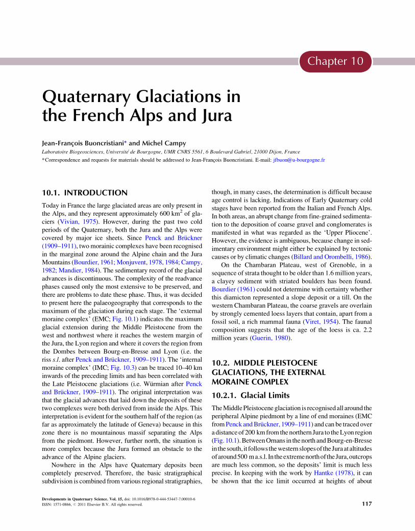
moraine complex’ (EMC; Fig. 10.1) indicates the maximum
glacial extension during the Middle Pleistocene from the
west and northwest where it reaches the western margin of
the Jura, the Lyon region and where it covers the region from
the Dombes between Bourg-en-Bresse and Lyon (i.e. the
riss s.l. after Penck and Bruckner, 1909–1911). The ‘internalmoraine complex’ (IMC; Fig. 10.3) can be traced 10–40 km
inwards of the preceding limits and has been correlated with
the Late Pleistocene glaciations (i.e. Wurmian after Penck
and Bruckner, 1909–1911). The original interpretation was
that the glacial advances that laid down the deposits of these
two complexes were both derived from inside the Alps. This
interpretation is evident for the southern half of the region (as
far as approximately the latitude of Geneva) because in this
zone there is no mountainous massif separating the Alps
from the piedmont. However, further north, the situation is
more complex because the Jura formed an obstacle to the
advance of the Alpine glaciers.
Nowhere in the Alps have Quaternary deposits been
completely preserved. Therefore, the basic stratigraphical
subdivision is combined from various regional stratigraphies,
though, in many cases, the determination is difficult because
age control is lacking. Indications of Early Quaternary cold
stages have been reported from the Italian and French Alps.
In both areas, an abrupt change from fine-grained sedimenta-
tion to the deposition of coarse gravel and conglomerates is
manifested in what was regarded as the ‘Upper Pliocene’.
However, the evidence is ambiguous, because change in sed-
imentary environment might either be explained by tectonic
causes or by climatic changes (Billard and Orombelli, 1986).
On the Chambaran Plateau, west of Grenoble, in a
sequence of strata thought to be older than 1.6 million years,
a clayey sediment with striated boulders has been found.
Bourdier (1961) could not determine with certainty whether
this diamicton represented a slope deposit or a till. On the
western Chambaran Plateau, the coarse gravels are overlain
by strongly cemented loess layers that contain, apart from a
fossil soil, a rich mammal fauna (Viret, 1954). The faunal
composition suggests that the age of the loess is ca. 2.2
million years (Guerin, 1980).
10.2. MIDDLE PLEISTOCENEGLACIATIONS, THE EXTERNALMORAINE COMPLEX
10.2.1. Glacial Limits
TheMiddlePleistoceneglaciation is recognisedall around the
peripheral Alpine piedmont by a line of end moraines (EMC
fromPenck andBruckner, 1909–1911) and can be traced over
a distanceof200 kmfromthenorthern Jura to theLyon region
(Fig. 10.1).BetweenOrnans in thenorth andBourg-en-Bresse
in thesouth, it followsthewesternslopesof theJuraataltitudes
ofaround500 ma.s.l. In theextremenorthoftheJura,outcrops
are much less common, so the deposits’ limit is much less
precise. In keeping with the work by Hantke (1978), it can
be shown that the ice limit occurred at heights of about
117
Page 2
FIGURE 10.1 Middle Pleistocene glacial deposits from the Alps and from the Jura: internal morainic complexes (ICM).
Quaternary Glaciations-Extent and Chronology118
800 m a.s.l., bending towards the east. In the central area,
betweenBourg-en-BresseandLyon, theEMCglacialdeposits
are very common. There, they have been mapped and recog-
nised by many previous authors, for example, Falsan and
Chantre (1879), Delafond and Deperet (1893), Penck and
Bruckner (1909–1911) and classically termed Glaciaire delaDombes. These deposits consist of sediment severalmetres
thick overlying Pliocene alluviumof the River Bresse (Fleury
and Monjuvent, 1984). Studies of these deposits have shown
that they were laid down by a vast ice lobe from the Alps
(Fleury and Monjuvent, 1984; Mandier, 1984; Monjuvent,
1984). In the south, theDuranceglacier advancedas far asSis-
teron (Tiercelin, 1974). In the Alpes provencales, the glaciersfailed to leave verywell-developed frontal morainic systems.
The main valleys were glaciated, and traces of this glaciation
are found in the valleys of theVar, theBleone and theVerdon.
Page 3
Chapter 10 Quaternary Glaciations in the French Alps and Jura 119
10.2.2. Morphological Features
In the northwest of the Alps (Fig. 10.2), the Middle Pleis-
tocene glaciation is represented by lines of strongly eroded
end moraines sufficiently well preserved to indicate a max-
imum glacial limit. The main deposits of these moraines are
basal tills, ablation tills and glacio-lacustrine deltas identi-
fied from outcrops and borehole information (Campy,
1982). The results of field mapping and the petrography
of the EMC from the northern Jura to the Lyon region
are shown schematically in Fig. 10.2. In the northern and
southern zones, where Alpine ice deposited the EMC, it
must have crossed the Jura. The central Jura, between Salins
in the north and Bourg-en-Bresse in the south, was not over-
ridden by Alpine ice. However, the occurrence of clear
frontal moraines in this zone demonstrates that local gla-
ciers from the Jura glaciers were present here.
The limit of these glacial deposits occurs as lobes devel-
oped towards the west opposite the main outer Jura valleys,
in the Ornans, Salins, Poligny, Voiteur and Lons-le-Saunier
regions. Reconstruction of the EMC is sometimes difficult
because the moraines are eroded and degraded. However,
the available information allows a coherent reconstruction
of the Middle Pleistocene glaciation that formed the EMC
deposits (Fig. 10.2). In the Geneva basin, the upper limit of
the Middle Pleistocene glaciation ice indicates that the gla-
cier was able to partially override the Jura in the relatively
lower areas, that is, to the north towards the Ornans and in
the south as far as Bourg-en-Bresse and as far as Lyon
(Monjuvent, 1984). However, in the central part of the Jura,
the petrography of the EMC deposits indicates that this sec-
tor had only been occupied by Jura ice (Fig. 10.2).
A large development of the glaciers during the Middle
Pleistocene are related to the influence of the mountain bar-
rier witch decrease and allowed convergence between Isere
glacier, Arc glacier and Rhone glacier. This increase in the
watershed of the Rhone glacier would thus imply an addi-
tional alimentation, which could explain the expansion of
the lobe of Piedmont resulting from these glaciers conflu-
ence during the Middle Pleistocene.
10.2.3. Key Sites
The petrography of the EMC deposits varies from north to
south. In the north, in the Ornans and Pontarlier regions, a
dozenoutcropshavebeenstudied.Theyexpose thatbasal till,
ablation till and glacio-lacustrine delta deposits contain all
limestone material from the Jura (40–90%), associated with
boulders of Alpine origin (10–60%). In the central zone
between Salins and Bourg-en-Bresse, over a distance of
about 100 km, the EMC contains onlymaterial derived from
the Jura (Campy, 1982). South of Bourg-en-Bresse, the
Dombes glacial deposits contain Jura limestone material
with or without an admixture of Alpine material (20–60%;
Fleury and Monjuvent, 1984; Mandier, 1984). The topogra-
phy of the Jura does explain this separation of glacier flows
(Fig. 10.2): In the central zone of the Jura, the eastern slope
rises to a height of 1250 mwhichmust have formed a barrier
to theAlpine glaciers.However, in the southern and northern
zones, the altitudes are lower. Some peaks are over 1250 m
high, but there aremanycols between themat altitudesof less
than 1000 m. In these zones, the Jura would not represent a
significant barrier to the advance of the Alpine ice.
10.2.4. Problems
Until the 1980s, most authors, for example, Tricart (1961,
1965) and Jackli (1962, 1970), considered that also the
two morainic complexes present west of the Jura were
emplaced under the dominant influence of Alpine glaciers.
This hypothesis was based upon the occurrence of erratic
boulders of Alpine origin (granite, gneiss, etc.) in certain
moraine deposits in the Jura. It was also thought that the
Jura Mountains were too small to have supported their
own ice-cap. Thus, it was thought that the Alpine glaciers
overrode the entire Swiss plain, occupied the Lake Geneva
basin and penetrated the Jura through depressions on their
eastern side. This question has been partly re-examined in
the course of precise mapping and detailed investigation of
the glacial deposits on the margin of the Jura massif: The
morainic complexes of the western slopes (Campy, 1982,
1992), the glacial deposits of the Geneva Basin and the east-
ern slope (Arn, 1984; Campy and Arn, 1991) and the
moraines south of the Jura (Sbaı, 1986; Monjuvent, 1988).
The palaeogeographic reconstruction shown in the maps
is largely based on the EMC (from Penck and Bruckner,
1909–1911). However, each morainic complex corresponds
to several glacial advances out of the mountain (Billard and
Derbyshire, 1985) and has been rearranged each time in the
course of numerous climatic fluctuations. Consequently,
the maps represent a synthesis of various climatic oscilla-
tions during the cold periods. Also, it must be taken into
account that the maxima of the glacial advances may not
necessarily have been synchronous in all the valleys.
According to palynological studies, most of the deposits
date from the period immediately before Eemian intergla-
cial (Beaulieu de, 1984; Beaulieu de and Reille, 1989). It
therefore seems that the classic ‘Complexe des MorainesExternes’ is of Middle Pleistocene (¼ riss s.l.) age.
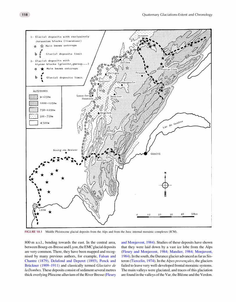
10.3. LATE PLEISTOCENE GLACIATIONS,THE INTERNAL MORAINE COMPLEX
10.3.1. Glacial Limits
From south of the Alps to the extreme northeast of the Jura
Mountains, the IMC has been traced with great precision for
over 400 km. It comprises a series of frontal moraines,
Page 4
FIGURE 10.2 Middle Pleistocene Alpine and Jura ice sheet extension and ice flow directions.
Quaternary Glaciations-Extent and Chronology120
particularly north of Grenoble. The limit of glacier deposits
marking the maximum position of the associated glacial
advance is clearly defined (Fig. 10.3). The configuration
of the Alpine glacier in the Geneva Basin at the maximum
of the Pleistocene was investigated by Swiss geologists
since the end of the nineteenth century. The size and surface
level of the ice were clearly determined by Jackli (1962),
and his interpretation is still valid today and confirmed
Page 5
FIGURE 10.3 Late Pleistocene glacial deposits from the Alps and from the Jura: external morainic complexes (ECM).
Chapter 10 Quaternary Glaciations in the French Alps and Jura 121
by recent work in the Valais area valleys (Kelly et al.,
2004). The maximum height reached by the Alpine ice at
its contact with the Jura during the Pleistocene was about
1200 m a.s.l. It descended gradually from this maximum
to ca. 400 m a.s.l. at the terminal moraines in the Rhone val-
ley in the southern Jura. In the north and northeast, the ice
thinned towards the terminal moraines in the Soleure region
to an altitude of about 600 m a.s.l. The level of the Alpine
ice-surface only very rarely exceeded that of the Jura mas-
sif. Only the valleys were lower than the ice-surface. How-
ever, their entrance was blocked by morainic deposits
which prevented the Alpine ice from penetrating the Jura.
Page 6
Quaternary Glaciations-Extent and Chronology122
It was never able to gain sufficient strength to supply sed-
iment to the CMI on the western side of the Jura.
On the inner part of theAlps in theMont-Blanc area, ero-
sion features allow to reconstruct the palaeogeography of the
Late Pleistocene glaciation. The method used here consists
to define and map the limit between glacial erosion and
atmospheric processes erosion forms, which correspond to
the ‘trimline’. The cartography of these trimlines and then
the interpolation of these data allow the reconstitution of
the maximum ice-surface about 2000–2300 m a.s.l. in this
area (Coutterand and Buoncristiani, 2006).
10.3.2. Morphological Features
The Pleistocene glacial maximum is well defined by termi-
nal moraines. In North Alps, all the valleys and trans-
fluences were filled by glaciers which receive flow from
local glaciers, forming a continuous network (Fig. 10.4).
At the glacial maximum, the ice flows from the central
Alpine zone and forms a vast piedmont glacier when it
entered the Swiss plain. This lobe collided with the Jura
at the latitude of Lake Geneva and was forced to flow
towards both to the north and south. The southern glacial
front stabilised as a piedmont lobe (Lyonnais ice lobe)
about 20 km from Lyon.
At the maximum advance of the Late Pleistocene, the
Alpine ice did not enter the Jura Mountains, which were
covered by a local ice-cap (Fig. 10.4). The assumption of
a discrete Jura ice-cap is based on the following evidence.
The presence of exclusively local material in the morainic
complex on the western slope of the Jura demonstrates that
the associated ice flow originated only in the Jura. This
morainic complex is particularly developed in the central
zone of the western slopes right behind the highest parts
of the Jura massif. This is the region where the Alpine
ice would have met the greatest obstacle to crossing the
mountains. The stratigraphical relationships of the Alpine
and Jura tills at the eastern border of the mountains
(Fig. 10.3) clearly show that two opposing ice flows
occurred in this zone. And finally, the surface level of the
ice that overrode the Swiss Basin during the glacial maxi-
mum did not allow it to advance far into the Jura massif,
even though the Jura was not buried by ice at the same time.
It must be considered, however, that the general form of
the Jura ice-cap shown in Fig. 10.4 is more certain in the cen-
tral zone than further to the north and south. In the latter
regions, themoraines are not sufficiently clear to allow a reli-
able reconstruction but there is no evidence conflicting with
the general outline shown in the maps (Campy, 1982; Sbaı,
1986). In the Isere valley, the IMC corresponds to the Bank
moraines which result from the confluent glacier of Isere gla-
cier andArc glacier, in the external area, these glaciersmerge
together and form a large piedmont glacier. While progres-
sing towards the south, only the valleys become gradually
ice field and we find little glaciers: the Bleone glacier, the
Verdon glacier and the Var glacier (Fig. 10.4).
10.3.3. Key Sites
Examination of the Combe d’Ain Lake (Fig.10.4) infilling
provides insight into the history of the Jura Mountains dur-
ing the last glacial maximum (Campy, 1982; Buoncristiani
and Campy, 2004). By mapping glacial and proglacial
deposits on the western slopes and, more particularly, in this
area, it has been possible to reconstruct the palaeogeogra-
phy of the glacial front. Sediments were transported by gla-
cial meltwater and were deposited as different sedimentary
complexes in the lake filling. A number of coarse delta-type
deposits are in contact with the moraines on the eastern edge
of Combe d’A in area, and these form a topographic marker
level at 525 m a.s.l. and indicate the former lake level. Lam-
inated fine sediments ranging between 466 and 509 m a.s.l
occupy the remainder of Combe d’Ain.
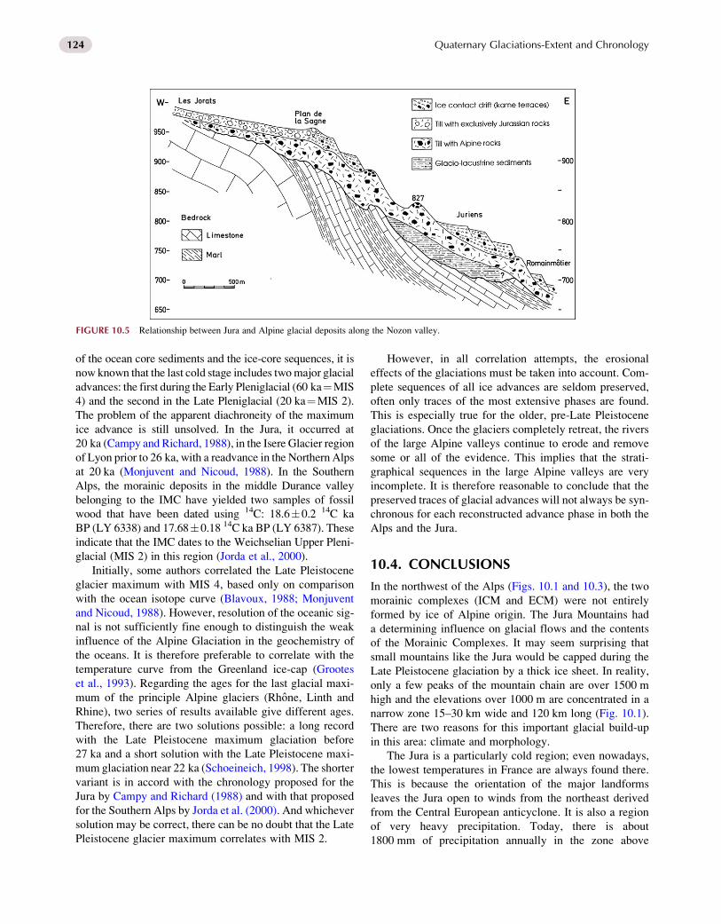
The synthetic section from the Nozon valley (Arn and
Aubert, 1984) shows the relations of the two complexes
(Fig. 10.5). Resting on tectonised Upper Jurassic and Cre-
taceous bedrock, the glacial formations reach from an alti-
tude of 650–1000 m a.s.l. In stratigraphical order from the
base upwards, four main formations can be described. At
the base, horizontally bedded clayey silts with rare stones
are present, which are interpreted as glacio-lacustrine sed-
iments. This is overlain by a basal till of essentially Alpine
material, very thick in the central part of the section (over
50 m) and thinning up-valley. In the upper part of the sec-
tion from 950 to 1000 m a.s.l., this Alpine till is overlain by
a basal till of exclusively Jura material, 20 m thick, ending
in a small morainic ridge at Plan de la Sagne. A number of
terraces composed of mixed Jura and Alpine material
spread between 950 and 700 m a.s.l. They are interpreted
as ice-contact landforms (kame terraces) emplaced during
the progressive retreat of the Alpine glacier (Arn, 1984).
This sequence is repeatedly found on the eastern side of
the Jura and demonstrates that during the Late Pleistocene
glaciation the two ice flows were in contact. Alpine ice occu-
pied the Swiss plain, and a second ice flow from the Jura
brought materials that were deposited onto the Alpine sedi-
ments. However, the Jura ice sheet did not pass beyond the
foot of the Jura chain. The stratigraphical relationship of the
two till types shows that the Jura Mountain did support their
own ice-cap independent from Alpine glaciers during the
Late Pleistocene glaciation, confirming the views of Agassiz
(1843), Nussbaum and Gygax (1935) and Aubert (1965).
10.3.4. Problems
The palaeogeographical reconstruction shown in the map
(Fig. 10.4) is largely based on IMCs (cf. Penck and
Bruckner, 1909–1911). However, each morainic complex
Page 7
FIGURE 10.4 Late Pleistocene Alpine and Jura ice sheet
extension and ice flow directions.
Chapter 10 Quaternary Glaciations in the French Alps and Jura 123
corresponds to several glacial advances out of the mountain
massifs and has been rearranged each time in the course of
numerous climatic fluctuations. Consequently, the maps
represent a synthesis of various climatic oscillations during
the Late Pleistocene cold periods. Also, it must be taken into
account that the maxima of the glacial advances may not
necessarily have been synchronous in all the valleys.
Because of the ‘freshness’ of the deposits and the large
number of exposures available, identification of the Late
Pleistocene ice advance is easily achieved. On the basis
Page 8
FIGURE 10.5 Relationship between Jura and Alpine glacial deposits along the Nozon valley.
Quaternary Glaciations-Extent and Chronology124
of the ocean core sediments and the ice-core sequences, it is
now known that the last cold stage includes twomajor glacial
advances: the first during the Early Pleniglacial (60 ka¼MIS
4) and the second in the Late Pleniglacial (20 ka¼MIS 2).
The problem of the apparent diachroneity of the maximum
ice advance is still unsolved. In the Jura, it occurred at
20 ka (Campy and Richard, 1988), in the Isere Glacier region
of Lyon prior to 26 ka, with a readvance in the Northern Alps
at 20 ka (Monjuvent and Nicoud, 1988). In the Southern
Alps, the morainic deposits in the middle Durance valley
belonging to the IMC have yielded two samples of fossil
wood that have been dated using 14C: 18.6�0.2 14C ka
BP (LY 6338) and 17.68�0.18 14C ka BP (LY 6387). These
indicate that the IMC dates to the Weichselian Upper Pleni-
glacial (MIS 2) in this region (Jorda et al., 2000).
Initially, some authors correlated the Late Pleistocene
glacier maximum with MIS 4, based only on comparison
with the ocean isotope curve (Blavoux, 1988; Monjuvent
and Nicoud, 1988). However, resolution of the oceanic sig-
nal is not sufficiently fine enough to distinguish the weak
influence of the Alpine Glaciation in the geochemistry of
the oceans. It is therefore preferable to correlate with the
temperature curve from the Greenland ice-cap (Grootes
et al., 1993). Regarding the ages for the last glacial maxi-
mum of the principle Alpine glaciers (Rhone, Linth and
Rhine), two series of results available give different ages.
Therefore, there are two solutions possible: a long record
with the Late Pleistocene maximum glaciation before
27 ka and a short solution with the Late Pleistocene maxi-
mum glaciation near 22 ka (Schoeineich, 1998). The shorter
variant is in accord with the chronology proposed for the
Jura by Campy and Richard (1988) and with that proposed
for the Southern Alps by Jorda et al. (2000). And whichever
solution may be correct, there can be no doubt that the Late
Pleistocene glacier maximum correlates with MIS 2.
However, in all correlation attempts, the erosional
effects of the glaciations must be taken into account. Com-
plete sequences of all ice advances are seldom preserved,
often only traces of the most extensive phases are found.
This is especially true for the older, pre-Late Pleistocene
glaciations. Once the glaciers completely retreat, the rivers
of the large Alpine valleys continue to erode and remove
some or all of the evidence. This implies that the strati-
graphical sequences in the large Alpine valleys are very
incomplete. It is therefore reasonable to conclude that the
preserved traces of glacial advances will not always be syn-
chronous for each reconstructed advance phase in both the
Alps and the Jura.
10.4. CONCLUSIONS
In the northwest of the Alps (Figs. 10.1 and 10.3), the two
morainic complexes (ICM and ECM) were not entirely
formed by ice of Alpine origin. The Jura Mountains had
a determining influence on glacial flows and the contents
of the Morainic Complexes. It may seem surprising that
small mountains like the Jura would be capped during the
Late Pleistocene glaciation by a thick ice sheet. In reality,
only a few peaks of the mountain chain are over 1500 m
high and the elevations over 1000 m are concentrated in a
narrow zone 15–30 km wide and 120 km long (Fig. 10.1).
There are two reasons for this important glacial build-up
in this area: climate and morphology.
The Jura is a particularly cold region; even nowadays,
the lowest temperatures in France are always found there.
This is because the orientation of the major landforms
leaves the Jura open to winds from the northeast derived
from the Central European anticyclone. It is also a region
of very heavy precipitation. Today, there is about
1800 mm of precipitation annually in the zone above
Page 9
Chapter 10 Quaternary Glaciations in the French Alps and Jura 125
1000 m a.s.l. which falls as snow between September and
June. It seems reasonable to assume that these characteris-
tics also applied during the recent last glacial periods.
The central part of the Jura Mountains is not incised by
deep valleys, and the highest zone is characterised by long,
synclinal valleys at heights of 900–1000 m a.s.l., flanked by
smooth higher ground at altitudes of 1200–1600 m a.s.l. As
a result of this morphology, the Jura Mountains can retain
snow because of inhibited melting (Aubert, 1965). The
poorly drained valley forms efficient traps in which great
thicknesses of snow can accumulate and then spring melt-
ing is considerably slowed in these closed areas. During full
glacial times, the balance between accumulation and abla-
tion would have been positive here and an ice sheet could
have formed. From this ice sheet, outlet glaciers formed
and flowed down the western and eastern flanks of the Jura
chain.
In the Alps, a topographic gradient exists between the
north and the south whereby the highest mountains in North
Alps sustain glaciers today (Mont Blanc, Vanoise) whilst
the lower mountains in the South Alps are cut by steep-
sided valleys (the Verdon, Var, Bleone). This north–south
topographic gradient can partly explain the limit of the
glaciers in the North Alps during Pleistocene ice ages. How-
ever, the different positions of the glacier in the North Alps
between the Late and the Middle Pleistocene are also
functions of the variations of the palaeo-glacial watershed
between these glacial periods. During the last cold period
of the Late Pleistocene, the Alpine glaciers were less
developed than for the cold periods of Middle Pleistocene
as illustrated by the theoretical calculation of the Isere
glacial topography in Grenoble which was 1100 m a.s.l.
during Late Pleistocene and 1500 m a.s.l. during Middle
Pleistocene (Monjuvent, 1978). Therefore, the topographic
barrier formed by the Western Alps—the Chartreuse, the
Bauges, the Bornes and the Aravis—probably controls
the configuration of ice masses during Pleistocene
glaciations.
REFERENCES
Agassiz, L., 1843. Le Jura a eu ses glaciers propres. Act. Soc. Helv. Sci.
Nat. 284–285, 28th session, Lausanne.
Arn, R., 1984. Contribution a l’etude stratigraphique du Pleistocene de la
region lemanique. Universite de Lausanne, thesis, 307 pp.
Arn, R., Aubert, D., 1984. Les formations quaternaires de l’Orbe et du
Nozon, au pied du Jura. Bull. Soc. Vaudoise Sci. Nat. 76 (2), 203–214.
Aubert, D., 1965. Calotte glaciaire et morphologie jurassienne. Eclogae
Geol. Helv. 58 (1), 555–578.
Beaulieu de, J.L., 1984. A long upper Pleistocene pollen record from Les
Echets, near Lyon, France. Boreas 13, 111–132.
Beaulieu de, J.L., Reille, M., 1989. The transition from temperate phases to
stadials in the long upper Pleistocene sequence from Les Echets
(France). Palaeogeogr. Palaeoclimatol. Palaeoecol. 72, 147–159.
Billard, A., Derbyshire, E., 1985. Pleistocene stratigraphy and morphogen-
esis of la Dombes: an alternative hypothesis. Bull. Assoc. Fr. Etude
Quatern. 1985/2–3, 85–96.
Billard, A., Orombelli, G., 1986. Quaternary glaciations in the French and
Italian piedmonts of the Alps. Quatern. Sci. Rev. 5, 407–411.
Blavoux, B., 1988. L’occupation de la cuvette Lemanique par le glacier du
Rhone au cours du Wurm. Bull. Assoc. Fr. Etude Quatern. 2/3, 69–81.
Bourdier, F., 1961. Le Bassin du Rhone au Quaternaire. Editions du Centre
National de la Recherche Scientifique, Paris, 364 pp.
Buoncristiani, J.F., Campy, M., 2004. Expansion and retreat of the Jura Ice
sheet (France) during the last glacial maximum. Sed. Geol. 165,
253–264.
Campy, M., 1982. Le Quaternaire Franc-Comtois. Essai chronologique et
paleoclimatique. Universite de Besancon, thesis 159, 575 pp.
Campy, M., 1992. Palaeogeographical relationships between Alpine and
Jura glaciers during the two last Pleistocene glaciations. Palaeogeogr.
Palaeoclimatol. Palaeoecol. 93, 1–12.
Campy, M., Arn, R., 1991. A case study of glacial paleogeography
at the wurmien circum-alpine zone: the Jura glacier. Boreas 20, 17–27.
Campy, M., Richard, H., 1988. Modalite et chronologie de la deglaciaition
wurmienne dans la chaine Jurassienne. Bull. Assoc. Fr. Etude Quatern.
2/3, 81–91.
Coutterand, S., Buoncristiani, J.F., 2006. Paleogeographie du dernier max-
imum glaciaire du pleistocene recentde la region du massif du mont
blanc, france. Quaternaire 17 (1), 35–43.
Delafond, F., Deperet, C., 1893. Les terrains tertiaires de la Bresse et leurs
gıtes de lignite et de minerais de fer, 1 vol. Mines et travaux publics,
Paris, 332 pp.
Falsan, A., Chantre, E., 1879. Monographie geologique des anciens gla-
ciers et du terrain erratique de la partie moyenne du Bassin du Rhone.
Annales Societe Agrege Histoire Naturelle Univervite Lyon, 2 vol.
1394 pp.
Fleury, R., Monjuvent, G., 1984. Le glacier alpin et ses implications en
Bresse. Geol. Fr. 3, 231–240.
Grootes, P.M., Stuiver, M., White, J.W.C., Johnsen, S.J., Jouzel, J., 1993.
Comparison of oxygen isotope records from the GISP2 and GRIP
Greenland ice cores. Nature 366, 552–554.
Guerin, C., 1980. Les Rhinoceros (Mammalia perissodactyla) du
Miocene terminal au Pleistocene superieur en Europe Occidentale.
Comparaison avec les especes Actuelles. Doc. Lab. Geol. Lyon 79,
1185 pp.
Hantke, R., 1978. Quartargeologische Karten in Eiszeitalter, 1 Ott, Thun,
468 pp.
Jackli, A., 1962. Die Vergletscherung der Schweiz im Wurm maximum.
Eclogae Geol. Helv. 55 (2), 285–294.
Jackli, A., 1970. La Suisse durant la derniere periode glaciaire. Carte in
Atlas de la Suisse, Service topographique federal, Wabern-Berne.
Jorda, M., Rosique, T., Evin, J., 2000. Premieres datations 14C de depots
morainiques du Pleniglaciaire superieur de la moyenne Durance
(Alpes meridionales, France), lmplications geomorphologiques,
paleoclimatiques et chronostratigraphiques. Compte rendue Acad.
Des Sci. 331/3, 187–188.
Kelly, M.A., Buoncristiani, J.F., Schluchter, C., 2004. A reconstruction of
the last glacial maximum (LGM) ice-surface geometry in the western
Swiss Alps and contiguous Alpine regions in Italy and France. Eclogae
Geol. Helv. 97, 57–75.
Mandier, P., 1984. Le relief de la moyenne vallee du Rhone au Tertiare et
au Quaternaire: essai de synthese paleogeographique, 3 vols. Thesis,
Lyon II, 860 pp.
Page 10
Quaternary Glaciations-Extent and Chronology126
Monjuvent, G., 1978. Le Drac. Morphologie, stratigraphie et chronologie.
Edition du CNRS, Grenoble, 431 pp.
Monjuvent, G., 1984. Quaternaire in Debrand-Passard, Synthese geologi-
que du Sud-Est de la France. Memoire B.R.G.M. Fr., n� 125, 230 pp.
Monjuvent, G., 1988. La deglaciaition rhodanienne entre les moraines
internes et le Val du Bourget. Geol. Alpine 64, 61–104.
Monjuvent, G., Nicoud, G., 1988. Interpretation de la deglaciation rhoda-
nienne au Wurm, des moraines internes a la cuvette lemanique. Bull.
Assoc. Fr. Etude Quatern. 2/3, 129–140.
Nussbaum, F., Gygax, F., 1935. Zur Ausdehnung des risseiszeitlichen Rho-
negletschers im franzosischen Jura. Eclogae Geol. Helv. 28 (2),
659–665.
Penck, A., Bruckner, E., 1909–1911. Die Alpen im Eiszeitalter, 3 vols.
Tauschnitz, Leipzig, 1199 pp.
Sbaı, A., 1986. Contribution a l’etude geomorphologique de la region
d’Oyonnax (Ain-Jura meridional). Lille, These 56, 552 pp.
Schoeineich, P., 1998. Correlation du dernier maximum glaciaire et de la
deglaciation alpine avec l’enregistrement isotopique du Groenland.
Quaternaire 9, 203–217.
Tiercelin, J.J., 1974. Le bassin de Larange-Sisteron. Stratigraphieet sedimen-
tologie desdepots Pleistocenes. Thesis, l’universite deProvence, 150pp.
Tricart, J., 1961. Apercu sur les formations quaternaires des feuilles de
Saint-Claude et Moirans en Montagne. Bull. Serv. Carte Geol. Fr.
58–264, 73–97.
Tricart, J., 1965. Quelques aspects particuliers des glaciations quaternaires
du Jura. Rev. geographique Est 4, 499–527.
Viret, J., 1954. Les Loess a banc durcis de Saint-Vallier (Drome) et sa
faune mammiferes villafranchiens avec une analyse granulometrique
Par E. Schmid et une analyse pollinique par C. Krachenbuchl. Nou-
velle Archives du Museum d’histoire naturelle de Lyon 4, 200 pp.
Vivian, R., 1975. Les Glaciers des Alpes Occiedentales. Universite de
Grenoble, thesis, 575 pp.